EXPLANATORY NOTES TO THE MAP OF PROTEROZOIC …fac.ksu.edu.sa/sites/default/files/Explanatory notes...
76
EXPLANATORY NOTES TO THE MAP OF PROTEROZOIC GEOLOGY OF WESTERN SAUDI ARABIA BY PETER R. J OHNSON TECHNICAL REPORT SGS-TR-2006-4 1427 H 2006 G
Transcript of EXPLANATORY NOTES TO THE MAP OF PROTEROZOIC …fac.ksu.edu.sa/sites/default/files/Explanatory notes...

EXPLANATORY NOTES TO THE MAP OF PROTEROZOIC GEOLOGY OF
WESTERN SAUDI ARABIA
BY
PETER R. JOHNSON
TECHNICAL REPORT
SGS-TR-2006-4
1427 H 2006 G

A Technical Report prepared by the
Saudi Geological Survey, Jeddah, Kingdom of Saudi Arabia
The work on which this report is based was performed in support of Saudi Geological Survey Subproject 4.1.1.1.6 — Compilation and updating of the Arabian shield digital map. It has been edited and reviewed by staff of the Saudi Geological Survey. Product names used in this report are for descriptive purposes and in no way imply endorsement by SGS.
This report is a product of the Saudi Geological Survey; if the information herein is used in any form, either quoted or paraphrased, this report should be properly cited using the full serial number, the author's name(s), and the year of publication. The correct citation for this report is:
Johnson, P.R., 2006, Explanatory notes to the map of Proterozoic geology of western Saudi Arabia: Saudi Geological Survey Technical Report SGS-TR-2006-4, 62 p., 22 figs., 2 plates.
In common with most reports produced by the Saudi Geological Survey, this report is available for sale to the public in hard copy format or on CD in PDF format. Please contact the SGS Publications Center at the address in Jeddah below for more information.
Index map of the Arabian Peninsula For more information about the Saudi Geological Survey visit our website www.sgs.org.sa or write to or visit our headquarters in Jeddah or our office in Riyadh.
Saudi Geological Survey Saudi Geological Survey-Riyadh Office Post Office Box 54141, Jeddah 21514 Post Office Box 6955, Riyadh 11452 Tel. (966-2) 619-5000 Tel. (966-1) 476-5000

TABLE OF CONTENTS
ABSTRACT (ARABIC/ENGLISH)......................................................................................................................... 1
INTRODUCTION (ARABIC) ............................................................................................................................... 2
INTRODUCTION................................................................................................................................................. 3
COMPILATION PROCESS................................................................................................................................... 4
LITHOSTRATIGRAPHY AND GEOCHRONOLOGY ....................................................................................... 5
LITHOSTRATIGRAPHIC REVISION ................................................................................................................. 6
GEOLOGIC OVERVIEW.................................................................................................................................... 10
PALEOPROTEROZOIC...................................................................................................................................... 12 SOUTH LIBAB ORTHOGNEISS, ~1800 Ma ............................................................................................................................................. 12
MUHAYIL SUITE, 1850-1670 Ma............................................................................................................................................................... 13
TONIAN............................................................................................................................................................... 13 MAKKAH SUITE, AGE UNCERTAIN ....................................................................................................................................................... 13
CRYOGENIAN .................................................................................................................................................... 14 LAYERED CRYOGENIAN LITHOSTRATIGRAPHIC UNITS................................................................................................................ 14
Bidah belt volcanic and sedimentary rocks, ~855-815 Ma.............................................................................. 14 Al Lith belt volcanic and sedimentary rocks, ~850-810 Ma............................................................................ 14 Isamah formation, ~840 Ma .......................................................................................................................... 15 Sumayir formation, ~830 Ma ........................................................................................................................ 15 Samran group, 825-745 Ma........................................................................................................................... 15 Shwas belt volcanic and sedimentary rocks, >815 Ma .................................................................................... 16 Tayyah belt volcanic and sedimentary rocks, >815 Ma................................................................................... 16 Muwayh formation, age uncertain ................................................................................................................. 17 At Ta’if group, >815 Ma ............................................................................................................................... 17 Tamran formation, >810 Ma......................................................................................................................... 17 Birak group, >805 Ma ................................................................................................................................... 18 Tays formation and Kabid paragneiss, ~800 Ma ............................................................................................ 18 Mughah complex, age uncertain .................................................................................................................... 19 Hali group, 795-780 Ma ............................................................................................................................... 19 Arj and Mahd groups, ~785-775 Ma ............................................................................................................. 19 Zibarah group, age uncertain ......................................................................................................................... 20 Zaam group, 760-710 Ma ............................................................................................................................. 21 Bayda group, age uncertain............................................................................................................................ 21 Ghamr group, ~750 Ma ................................................................................................................................ 22 Siham group, 750-685 Ma ............................................................................................................................ 22 Al Qunnah formation, >745 Ma.................................................................................................................... 22 Khadra belt volcanic and sedimentary rocks, ~745-730 Ma ........................................................................... 22 Al Ays group, <745->700 Ma ........................................................................................................................ 23 Banana and Sufran formations, >740 Ma....................................................................................................... 23 Malahah belt volcanic and sedimentary rocks, >730 Ma ................................................................................ 23 Sarjuj formation, age uncertain...................................................................................................................... 24 Hulayfah group, >720 Ma ............................................................................................................................. 24 Milhah formation, >715 Ma.......................................................................................................................... 24 Ghawjah formation, >710 Ma ....................................................................................................................... 24 Hegaf formation, >710 Ma............................................................................................................................ 24 Silasia formation, >710 Ma............................................................................................................................ 25 Zaytah formation, age uncertain .................................................................................................................... 25 Amlas formation, age uncertain ..................................................................................................................... 25 Hinshan formation, age uncertain ................................................................................................................. 25 Ash Sha’ib group, age uncertain..................................................................................................................... 25 Furayh group, age uncertain .......................................................................................................................... 26 Ar Rika formation, >700 Ma ......................................................................................................................... 26 Abu Dhira’ah and Ar Ridaniyah formations, ~695 Ma................................................................................... 26
i

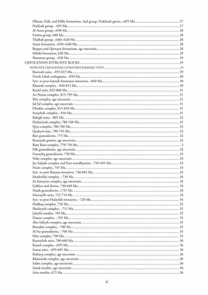
Dhiran, Nafi, and Hillit formations, Ajal group, Dukhnah gneiss, >695 Ma.................................................. 27 Hadiyah group, ~695 Ma .............................................................................................................................. 27 Al Amar group, >690 Ma .............................................................................................................................. 28 Fatima group, 680 Ma................................................................................................................................... 28 Thalbah group, <660->620 Ma ..................................................................................................................... 28 Atura formation, <650->640 Ma ................................................................................................................... 28 Buqaya and Qarnayn formations, age uncertain ............................................................................................. 28 Hibshi formation, 630 Ma............................................................................................................................. 29 Shammar group, ~630 Ma............................................................................................................................. 29
CRYOGENIAN INTRUSIVE ROCKS ................................................................................................................ 29 INTRUSIVE CRYOGENIAN LITHOSTRATIGRAPHIC UNITS ............................................................................................................. 29
Buwwah suite, ~855-815 Ma......................................................................................................................... 29 North Libab orthogneiss, ~850 Ma................................................................................................................ 30 Syn- to post-Isamah formation intrusives, <840 Ma....................................................................................... 30 Khasrah complex, ~840-815 Ma.................................................................................................................... 30 Kamil suite, 825-800 Ma............................................................................................................................... 31 An Nimas complex, 815-795 Ma................................................................................................................... 31 Shir complex, age uncertain ........................................................................................................................... 31 Jaf Jaf complex, age uncertain ........................................................................................................................ 31 Dhukhr complex, 815-810 Ma...................................................................................................................... 31 Surayhah complex, ~810 Ma ......................................................................................................................... 31 Rabigh suite, ~805 Ma .................................................................................................................................. 32 Hufayriyah complex, 780-760 Ma................................................................................................................. 32 Qiya complex, 780-760 Ma........................................................................................................................... 32 Qudayd suite, 780-745 Ma............................................................................................................................ 32 Bari granodiorite, 775 Ma ............................................................................................................................. 32 Rumayda granite, age uncertain ..................................................................................................................... 32 Ram Ram complex, 770-750 Ma..................................................................................................................... 3 Filh granodiorite, age uncertain ..................................................................................................................... 33 Fuwayliq granodiorite, 750 Ma...................................................................................................................... 33 Nabt complex, age uncertain ......................................................................................................................... 33 Jar-Salajah complex and Fara trondhjemite, ~745-695 Ma............................................................................. 33 Naim complex, 745 Ma................................................................................................................................. 33 Syn- to post-Banana intrusives, 740-685 Ma ................................................................................................. 33 Mushrifah complex, ~730 Ma ....................................................................................................................... 34 As Sutayyan complex, age uncertain............................................................................................................... 34 Gabbro and diorite, 730-640 Ma................................................................................................................... 34 Najah granodiorite, >725 Ma ........................................................................................................................ 34 Muwaylih suite, 725-710 Ma ........................................................................................................................ 34 Syn- to post-Hulayfah intrusives, ~720 Ma.................................................................................................... 34 Hadhaq complex, 720 Ma ............................................................................................................................. 35 Shufayyah complex, ~715 Ma........................................................................................................................ 35 Julayhi tonalite, 705 Ma ................................................................................................................................ 35 Damar complex, ~705 Ma............................................................................................................................. 35 Abu Safiyah complex, age uncertain............................................................................................................... 35 Burudan complex, ~700 Ma .......................................................................................................................... 35 Al Far granodiorite, ~700 Ma ........................................................................................................................ 35 Misr complex, 700 Ma .................................................................................................................................. 35 Ruwayhah suite, 700-660 Ma........................................................................................................................ 36 Kamal complex, <695 Ma.............................................................................................................................. 36 Suwaj suite, ~695-685 Ma............................................................................................................................. 36 Rubayq complex, age uncertain ..................................................................................................................... 36 Khanzirah complex, age uncertain ................................................................................................................. 36 Salim complex, age uncertain......................................................................................................................... 36 Samd tonalite, age uncertain.......................................................................................................................... 36 Arin tonalite, 675 Ma.................................................................................................................................... 36
ii

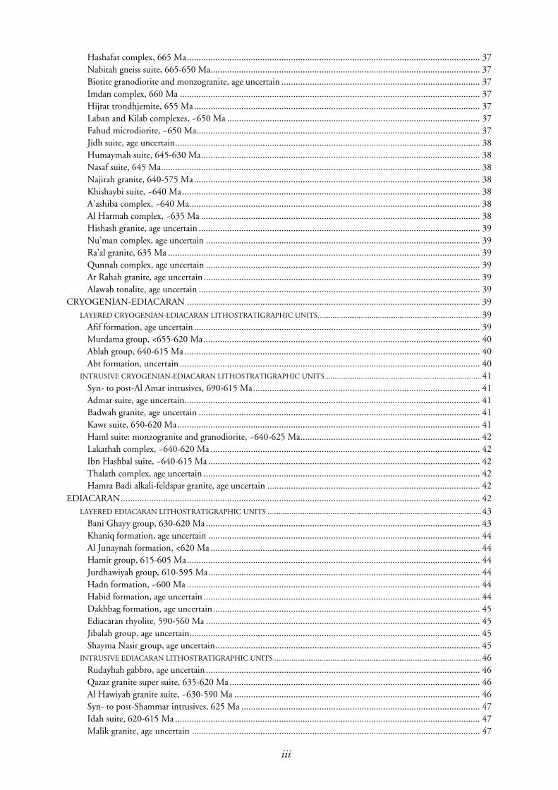
Hashafat complex, 665 Ma............................................................................................................................ 37 Nabitah gneiss suite, 665-650 Ma.................................................................................................................. 37 Biotite granodiorite and monzogranite, age uncertain .................................................................................... 37 Imdan complex, 660 Ma ............................................................................................................................... 37 Hijrat trondhjemite, 655 Ma......................................................................................................................... 37 Laban and Kilab complexes, ~650 Ma ........................................................................................................... 37 Fahud microdiorite, ~650 Ma........................................................................................................................ 37 Jidh suite, age uncertain................................................................................................................................. 38 Humaymah suite, 645-630 Ma...................................................................................................................... 38 Nasaf suite, 645 Ma....................................................................................................................................... 38 Najirah granite, 640-575 Ma......................................................................................................................... 38 Khishaybi suite, ~640 Ma.............................................................................................................................. 38 A’ashiba complex, ~640 Ma........................................................................................................................... 38 Al Harmah complex, ~635 Ma ...................................................................................................................... 38 Hishash granite, age uncertain ....................................................................................................................... 39 Nu’man complex, age uncertain .................................................................................................................... 39 Ra’al granite, 635 Ma .................................................................................................................................... 39 Qunnah complex, age uncertain .................................................................................................................... 39 Ar Rahah granite, age uncertain ..................................................................................................................... 39 Alawah tonalite, age uncertain ....................................................................................................................... 39
CRYOGENIAN-EDIACARAN ............................................................................................................................ 39 LAYERED CRYOGENIAN-EDIACARAN LITHOSTRATIGRAPHIC UNITS........................................................................................ 39
Afif formation, age uncertain ......................................................................................................................... 39 Murdama group, <655-620 Ma..................................................................................................................... 40 Ablah group, 640-615 Ma ............................................................................................................................. 40 Abt formation, uncertain ............................................................................................................................... 40
INTRUSIVE CRYOGENIAN-EDIACARAN LITHOSTRATIGRAPHIC UNITS.................................................................................... 41
Syn- to post-Al Amar intrusives, 690-615 Ma................................................................................................ 41 Admar suite, age uncertain............................................................................................................................. 41 Badwah granite, age uncertain ....................................................................................................................... 41 Kawr suite, 650-620 Ma................................................................................................................................ 41 Haml suite: monzogranite and granodiorite, ~640-625 Ma............................................................................ 42 Lakathah complex, ~640-620 Ma .................................................................................................................. 42 Ibn Hashbal suite, ~640-615 Ma ................................................................................................................... 42 Thalath complex, age uncertain ..................................................................................................................... 42 Hamra Badi alkali-feldspar granite, age uncertain .......................................................................................... 42
EDIACARAN........................................................................................................................................................ 42 LAYERED EDIACARAN LITHOSTRATIGRAPHIC UNITS ................................................................................................................... 43
Bani Ghayy group, 630-620 Ma .................................................................................................................... 43 Khaniq formation, age uncertain ................................................................................................................... 44 Al Junaynah formation, <620 Ma .................................................................................................................. 44 Hamir group, 615-605 Ma............................................................................................................................ 44 Jurdhawiyah group, 610-595 Ma................................................................................................................... 44 Hadn formation, ~600 Ma ............................................................................................................................ 44 Habid formation, age uncertain ..................................................................................................................... 44 Dakhbag formation, age uncertain................................................................................................................. 45 Ediacaran rhyolite, 590-560 Ma .................................................................................................................... 45 Jibalah group, age uncertain........................................................................................................................... 45 Shayma Nasir group, age uncertain................................................................................................................ 45
INTRUSIVE EDIACARAN LITHOSTRATIGRAPHIC UNITS................................................................................................................ 46
Rudayhah gabbro, age uncertain .................................................................................................................... 46 Qazaz granite super suite, 635-620 Ma.......................................................................................................... 46 Al Hawiyah granite suite, ~630-590 Ma ........................................................................................................ 46 Syn- to post-Shammar intrusives, 625 Ma ..................................................................................................... 47 Idah suite, 620-615 Ma ................................................................................................................................. 47 Malik granite, age uncertain .......................................................................................................................... 47
iii
Thurayban granodiorite, <615 Ma................................................................................................................. 47 Haml suite: alkali-feldspar granite, 615-600 Ma ............................................................................................ 47 Al Khushaymiyah suite, 610-595 Ma............................................................................................................. 47 Wadbah suite, 605 Ma .................................................................................................................................. 47 Abanat suite, 585-570 Ma ............................................................................................................................. 48 Gharamil monzogranite, age uncertain .......................................................................................................... 48 Umm Gerad granite, 585 Ma ........................................................................................................................ 48 Ar Ruwaydah suite, 605-565 Ma ................................................................................................................... 48 Hadb ash Sharar suite, ~580-575 Ma............................................................................................................. 48 Al Bad granite super suite, 575-570 Ma......................................................................................................... 48 Al Hafoor suite, age uncertain ....................................................................................................................... 49 Khuls granite, ~565 Ma................................................................................................................................. 49 Rithmah complex, age uncertain.................................................................................................................... 49 Mardabah complex, age uncertain ................................................................................................................. 49 Radwa granite, ~560 Ma................................................................................................................................ 49 Subh suite, age uncertain ............................................................................................................................... 50 Abbasiyah granodiorite, age uncertain............................................................................................................ 50 Post-Hamir intrusives, age uncertain.............................................................................................................. 50 Uraynibi syenogranite, age uncertain ............................................................................................................. 50 Suwaylih suite, age uncertain ......................................................................................................................... 50
UNASSIGNED NEOPROTEROZOIC ROCKS ................................................................................................. 51
ACKNOWLEDGMENTS .................................................................................................................................... 51
DATABASE ARCHIVE ........................................................................................................................................ 51
REFERENCES ...................................................................................................................................................... 51
Figures Figure 1 Stratigraphic intervals in the Proterozoic and upper Archean ................................................................. 4
Figure 2 Distribution of Tonian, Cryogenian, Ediacaran, Paleoproterozoic, and unassigned rocks in the Arabian shield in Saudi Arabia............................................................................................................... 5
Figure3 Age data for the Arabian-Nubian shield................................................................................................. 6
Figure 4 Lithostratigraphic correlation diagram, Arabian shield........................................................................... 7
Figure 5 Tectonostratigraphic terranes in the Arabian shield ............................................................................... 9
Figure 6 Distribution of exposed Precambrian rocks in the Arabian Peninsula and northeast Africa................... 10
Figure 7 Pb and Nd isotope and neodymium model age data for the Arabian-Nubian shield............................. 11
Figure 8 Flow diagram of tectonic evolution of the northeastern Arabian shield ................................................ 13
Figure 9 Nida formation, Samran group: subvertical dipping Nida formation quartz-feldspar metasandstone, with a moderately northeast plunging lineation that is folded about a steeply plunging later fold............................................................................................................................... 15
Figure 10 Open, upright fold in Khutnah formation thinly bedded sandstone at the northern end of the Shwas belt, plunging gently north ....................................................................................................... 16
Figure 11 Tight folds in paragneiss of the Tays formation, east-central part of the Arabian shield........................ 18
Figure 12 Diamictite at the base of the Mahd group, 12 km southwest of Mahd adh Dhahab. ............................ 20
Figure 13 Pillow basalt, Zaam group. Photograph of an exposure of steeply dipping basalt (looking south) in which the pillow shape indicates stratigraphic top is to the left (east) ............................................... 21
Figure 14 Thinly bedded, moderately folded sandstone of the Cryogenian Bayda group (middle distance), in the northwestern part of the Arabian shield, intruded by granite of the Ediacaran Qazaz granite super suite (background).......................................................................................................... 21
Figure 15 Ripple marks on two bedding surfaces in sandstone of the Al Ays group.............................................. 23
Figure 16 Hadiyah group, sharp contact between basalt (to left) and thinly bedded sandstone-siltstone (to right)................................................................................................................................................... 27
Figure 17 Two views of the Shammar group, exposed east of the Hanakiyah-Hulayfah highway ......................... 29
Figure 18 Early Cryogenian gneisses in the Asir terrane, southern part of the Arabian shield ............................... 30
Figure 19 Thinly bedded Abt formation dipping steeply west in exposures in the eastern part of the Abt basin, close to the Al Quwayyiyah-Hasat Qahtan road......................................................................... 41
iv

Figure 20 Northeast-dipping, thinly bedded, variegated Bani Ghayy group limestone, exposed along the Ruwah fault zone in the eastern part of the shield................................................................................ 43
Figure 21 Views of Ediacaran, Jibalah group rocks .............................................................................................. 45
Figure 22 The Radwa granite, forming one of the highest mountains in the northwestern part of the shield........ 50
Plates Plate 1A Proterozoic geology of western Saudi Arabia, scale 1:1,000,000 (Northern Sheet)
Plate 1B Proterozoic geology of western Saudi Arabia, scale 1:1,000,000 (Southern Sheet)
v

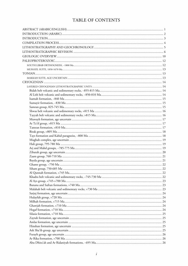
TABLE OF CONTENTS
ABSTRACT (ARABIC/ENGLISH)......................................................................................................................... 1
INTRODUCTION (ARABIC) ............................................................................................................................... 2
INTRODUCTION................................................................................................................................................. 3
COMPILATION PROCESS................................................................................................................................... 4
LITHOSTRATIGRAPHY AND GEOCHRONOLOGY ....................................................................................... 5
LITHOSTRATIGRAPHIC REVISION ................................................................................................................. 6
GEOLOGIC OVERVIEW.................................................................................................................................... 10
PALEOPROTEROZOIC...................................................................................................................................... 12 SOUTH LIBAB ORTHOGNEISS, ~1800 Ma ............................................................................................................................................. 12
MUHAYIL SUITE, 1850-1670 Ma............................................................................................................................................................... 13
TONIAN............................................................................................................................................................... 13 MAKKAH SUITE, AGE UNCERTAIN ....................................................................................................................................................... 13
CRYOGENIAN .................................................................................................................................................... 14 LAYERED CRYOGENIAN LITHOSTRATIGRAPHIC UNITS................................................................................................................ 14
Bidah belt volcanic and sedimentary rocks, ~855-815 Ma.............................................................................. 14 Al Lith belt volcanic and sedimentary rocks, ~850-810 Ma............................................................................ 14 Isamah formation, ~840 Ma .......................................................................................................................... 15 Sumayir formation, ~830 Ma ........................................................................................................................ 15 Samran group, 825-745 Ma........................................................................................................................... 15 Shwas belt volcanic and sedimentary rocks, >815 Ma .................................................................................... 16 Tayyah belt volcanic and sedimentary rocks, >815 Ma................................................................................... 16 Muwayh formation, age uncertain ................................................................................................................. 17 At Ta’if group, >815 Ma ............................................................................................................................... 17 Tamran formation, >810 Ma......................................................................................................................... 17 Birak group, >805 Ma ................................................................................................................................... 18 Tays formation and Kabid paragneiss, ~800 Ma ............................................................................................ 18 Mughah complex, age uncertain .................................................................................................................... 19 Hali group, 795-780 Ma ............................................................................................................................... 19 Arj and Mahd groups, ~785-775 Ma ............................................................................................................. 19 Zibarah group, age uncertain ......................................................................................................................... 20 Zaam group, 760-710 Ma ............................................................................................................................. 21 Bayda group, age uncertain............................................................................................................................ 21 Ghamr group, ~750 Ma ................................................................................................................................ 22 Siham group, 750-685 Ma ............................................................................................................................ 22 Al Qunnah formation, >745 Ma.................................................................................................................... 22 Khadra belt volcanic and sedimentary rocks, ~745-730 Ma ........................................................................... 22 Al Ays group, <745->700 Ma ........................................................................................................................ 23 Banana and Sufran formations, >740 Ma....................................................................................................... 23 Malahah belt volcanic and sedimentary rocks, >730 Ma ................................................................................ 23 Sarjuj formation, age uncertain...................................................................................................................... 24 Hulayfah group, >720 Ma ............................................................................................................................. 24 Milhah formation, >715 Ma.......................................................................................................................... 24 Ghawjah formation, >710 Ma ....................................................................................................................... 24 Hegaf formation, >710 Ma............................................................................................................................ 24 Silasia formation, >710 Ma............................................................................................................................ 25 Zaytah formation, age uncertain .................................................................................................................... 25 Amlas formation, age uncertain ..................................................................................................................... 25 Hinshan formation, age uncertain ................................................................................................................. 25 Ash Sha’ib group, age uncertain..................................................................................................................... 25 Furayh group, age uncertain .......................................................................................................................... 26 Ar Rika formation, >700 Ma ......................................................................................................................... 26 Abu Dhira’ah and Ar Ridaniyah formations, ~695 Ma................................................................................... 26
i
Dhiran, Nafi, and Hillit formations, Ajal group, Dukhnah gneiss, >695 Ma.................................................. 27 Hadiyah group, ~695 Ma .............................................................................................................................. 27 Al Amar group, >690 Ma .............................................................................................................................. 28 Fatima group, 680 Ma................................................................................................................................... 28 Thalbah group, <660->620 Ma ..................................................................................................................... 28 Atura formation, <650->640 Ma ................................................................................................................... 28 Buqaya and Qarnayn formations, age uncertain ............................................................................................. 28 Hibshi formation, 630 Ma............................................................................................................................. 29 Shammar group, ~630 Ma............................................................................................................................. 29
CRYOGENIAN INTRUSIVE ROCKS ................................................................................................................ 29 INTRUSIVE CRYOGENIAN LITHOSTRATIGRAPHIC UNITS ............................................................................................................. 29
Buwwah suite, ~855-815 Ma......................................................................................................................... 29 North Libab orthogneiss, ~850 Ma................................................................................................................ 30 Syn- to post-Isamah formation intrusives, <840 Ma....................................................................................... 30 Khasrah complex, ~840-815 Ma.................................................................................................................... 30 Kamil suite, 825-800 Ma............................................................................................................................... 31 An Nimas complex, 815-795 Ma................................................................................................................... 31 Shir complex, age uncertain ........................................................................................................................... 31 Jaf Jaf complex, age uncertain ........................................................................................................................ 31 Dhukhr complex, 815-810 Ma...................................................................................................................... 31 Surayhah complex, ~810 Ma ......................................................................................................................... 31 Rabigh suite, ~805 Ma .................................................................................................................................. 32 Hufayriyah complex, 780-760 Ma................................................................................................................. 32 Qiya complex, 780-760 Ma........................................................................................................................... 32 Qudayd suite, 780-745 Ma............................................................................................................................ 32 Bari granodiorite, 775 Ma ............................................................................................................................. 32 Rumayda granite, age uncertain ..................................................................................................................... 32 Ram Ram complex, 770-750 Ma..................................................................................................................... 3 Filh granodiorite, age uncertain ..................................................................................................................... 33 Fuwayliq granodiorite, 750 Ma...................................................................................................................... 33 Nabt complex, age uncertain ......................................................................................................................... 33 Jar-Salajah complex and Fara trondhjemite, ~745-695 Ma............................................................................. 33 Naim complex, 745 Ma................................................................................................................................. 33 Syn- to post-Banana intrusives, 740-685 Ma ................................................................................................. 33 Mushrifah complex, ~730 Ma ....................................................................................................................... 34 As Sutayyan complex, age uncertain............................................................................................................... 34 Gabbro and diorite, 730-640 Ma................................................................................................................... 34 Najah granodiorite, >725 Ma ........................................................................................................................ 34 Muwaylih suite, 725-710 Ma ........................................................................................................................ 34 Syn- to post-Hulayfah intrusives, ~720 Ma.................................................................................................... 34 Hadhaq complex, 720 Ma ............................................................................................................................. 35 Shufayyah complex, ~715 Ma........................................................................................................................ 35 Julayhi tonalite, 705 Ma ................................................................................................................................ 35 Damar complex, ~705 Ma............................................................................................................................. 35 Abu Safiyah complex, age uncertain............................................................................................................... 35 Burudan complex, ~700 Ma .......................................................................................................................... 35 Al Far granodiorite, ~700 Ma ........................................................................................................................ 35 Misr complex, 700 Ma .................................................................................................................................. 35 Ruwayhah suite, 700-660 Ma........................................................................................................................ 36 Kamal complex, <695 Ma.............................................................................................................................. 36 Suwaj suite, ~695-685 Ma............................................................................................................................. 36 Rubayq complex, age uncertain ..................................................................................................................... 36 Khanzirah complex, age uncertain ................................................................................................................. 36 Salim complex, age uncertain......................................................................................................................... 36 Samd tonalite, age uncertain.......................................................................................................................... 36 Arin tonalite, 675 Ma.................................................................................................................................... 36
ii
Hashafat complex, 665 Ma............................................................................................................................ 37 Nabitah gneiss suite, 665-650 Ma.................................................................................................................. 37 Biotite granodiorite and monzogranite, age uncertain .................................................................................... 37 Imdan complex, 660 Ma ............................................................................................................................... 37 Hijrat trondhjemite, 655 Ma......................................................................................................................... 37 Laban and Kilab complexes, ~650 Ma ........................................................................................................... 37 Fahud microdiorite, ~650 Ma........................................................................................................................ 37 Jidh suite, age uncertain................................................................................................................................. 38 Humaymah suite, 645-630 Ma...................................................................................................................... 38 Nasaf suite, 645 Ma....................................................................................................................................... 38 Najirah granite, 640-575 Ma......................................................................................................................... 38 Khishaybi suite, ~640 Ma.............................................................................................................................. 38 A’ashiba complex, ~640 Ma........................................................................................................................... 38 Al Harmah complex, ~635 Ma ...................................................................................................................... 38 Hishash granite, age uncertain ....................................................................................................................... 39 Nu’man complex, age uncertain .................................................................................................................... 39 Ra’al granite, 635 Ma .................................................................................................................................... 39 Qunnah complex, age uncertain .................................................................................................................... 39 Ar Rahah granite, age uncertain ..................................................................................................................... 39 Alawah tonalite, age uncertain ....................................................................................................................... 39
CRYOGENIAN-EDIACARAN ............................................................................................................................ 39 LAYERED CRYOGENIAN-EDIACARAN LITHOSTRATIGRAPHIC UNITS........................................................................................ 39
Afif formation, age uncertain ......................................................................................................................... 39 Murdama group, <655-620 Ma..................................................................................................................... 40 Ablah group, 640-615 Ma ............................................................................................................................. 40 Abt formation, uncertain ............................................................................................................................... 40
INTRUSIVE CRYOGENIAN-EDIACARAN LITHOSTRATIGRAPHIC UNITS.................................................................................... 41
Syn- to post-Al Amar intrusives, 690-615 Ma................................................................................................ 41 Admar suite, age uncertain............................................................................................................................. 41 Badwah granite, age uncertain ....................................................................................................................... 41 Kawr suite, 650-620 Ma................................................................................................................................ 41 Haml suite: monzogranite and granodiorite, ~640-625 Ma............................................................................ 42 Lakathah complex, ~640-620 Ma .................................................................................................................. 42 Ibn Hashbal suite, ~640-615 Ma ................................................................................................................... 42 Thalath complex, age uncertain ..................................................................................................................... 42 Hamra Badi alkali-feldspar granite, age uncertain .......................................................................................... 42
EDIACARAN........................................................................................................................................................ 42 LAYERED EDIACARAN LITHOSTRATIGRAPHIC UNITS ................................................................................................................... 43
Bani Ghayy group, 630-620 Ma .................................................................................................................... 43 Khaniq formation, age uncertain ................................................................................................................... 44 Al Junaynah formation, <620 Ma .................................................................................................................. 44 Hamir group, 615-605 Ma............................................................................................................................ 44 Jurdhawiyah group, 610-595 Ma................................................................................................................... 44 Hadn formation, ~600 Ma ............................................................................................................................ 44 Habid formation, age uncertain ..................................................................................................................... 44 Dakhbag formation, age uncertain................................................................................................................. 45 Ediacaran rhyolite, 590-560 Ma .................................................................................................................... 45 Jibalah group, age uncertain........................................................................................................................... 45 Shayma Nasir group, age uncertain................................................................................................................ 45
INTRUSIVE EDIACARAN LITHOSTRATIGRAPHIC UNITS................................................................................................................ 46
Rudayhah gabbro, age uncertain .................................................................................................................... 46 Qazaz granite super suite, 635-620 Ma.......................................................................................................... 46 Al Hawiyah granite suite, ~630-590 Ma ........................................................................................................ 46 Syn- to post-Shammar intrusives, 625 Ma ..................................................................................................... 47 Idah suite, 620-615 Ma ................................................................................................................................. 47 Malik granite, age uncertain .......................................................................................................................... 47
iii

Thurayban granodiorite, <615 Ma................................................................................................................. 47 Haml suite: alkali-feldspar granite, 615-600 Ma ............................................................................................ 47 Al Khushaymiyah suite, 610-595 Ma............................................................................................................. 47 Wadbah suite, 605 Ma .................................................................................................................................. 47 Abanat suite, 585-570 Ma ............................................................................................................................. 48 Gharamil monzogranite, age uncertain .......................................................................................................... 48 Umm Gerad granite, 585 Ma ........................................................................................................................ 48 Ar Ruwaydah suite, 605-565 Ma ................................................................................................................... 48 Hadb ash Sharar suite, ~580-575 Ma............................................................................................................. 48 Al Bad granite super suite, 575-570 Ma......................................................................................................... 48 Al Hafoor suite, age uncertain ....................................................................................................................... 49 Khuls granite, ~565 Ma................................................................................................................................. 49 Rithmah complex, age uncertain.................................................................................................................... 49 Mardabah complex, age uncertain ................................................................................................................. 49 Radwa granite, ~560 Ma................................................................................................................................ 49 Subh suite, age uncertain ............................................................................................................................... 50 Abbasiyah granodiorite, age uncertain............................................................................................................ 50 Post-Hamir intrusives, age uncertain.............................................................................................................. 50 Uraynibi syenogranite, age uncertain ............................................................................................................. 50 Suwaylih suite, age uncertain ......................................................................................................................... 50
UNASSIGNED NEOPROTEROZOIC ROCKS ................................................................................................. 51
ACKNOWLEDGMENTS .................................................................................................................................... 51
DATABASE ARCHIVE ........................................................................................................................................ 51
REFERENCES ...................................................................................................................................................... 51
Figures Figure 1 Stratigraphic intervals in the Proterozoic and upper Archean ................................................................. 4
Figure 2 Distribution of Tonian, Cryogenian, Ediacaran, Paleoproterozoic, and unassigned rocks in the Arabian shield in Saudi Arabia............................................................................................................... 5
Figure3 Age data for the Arabian-Nubian shield................................................................................................. 6
Figure 4 Lithostratigraphic correlation diagram, Arabian shield........................................................................... 7
Figure 5 Tectonostratigraphic terranes in the Arabian shield ............................................................................... 9
Figure 6 Distribution of exposed Precambrian rocks in the Arabian Peninsula and northeast Africa................... 10
Figure 7 Pb and Nd isotope and neodymium model age data for the Arabian-Nubian shield............................. 11
Figure 8 Flow diagram of tectonic evolution of the northeastern Arabian shield ................................................ 13
Figure 9 Nida formation, Samran group: subvertical dipping Nida formation quartz-feldspar metasandstone, with a moderately northeast plunging lineation that is folded about a steeply plunging later fold............................................................................................................................... 15
Figure 10 Open, upright fold in Khutnah formation thinly bedded sandstone at the northern end of the Shwas belt, plunging gently north ....................................................................................................... 16
Figure 11 Tight folds in paragneiss of the Tays formation, east-central part of the Arabian shield........................ 18
Figure 12 Diamictite at the base of the Mahd group, 12 km southwest of Mahd adh Dhahab. ............................ 20
Figure 13 Pillow basalt, Zaam group. Photograph of an exposure of steeply dipping basalt (looking south) in which the pillow shape indicates stratigraphic top is to the left (east) ............................................... 21
Figure 14 Thinly bedded, moderately folded sandstone of the Cryogenian Bayda group (middle distance), in the northwestern part of the Arabian shield, intruded by granite of the Ediacaran Qazaz granite super suite (background).......................................................................................................... 21
Figure 15 Ripple marks on two bedding surfaces in sandstone of the Al Ays group.............................................. 23
Figure 16 Hadiyah group, sharp contact between basalt (to left) and thinly bedded sandstone-siltstone (to right)................................................................................................................................................... 27
Figure 17 Two views of the Shammar group, exposed east of the Hanakiyah-Hulayfah highway ......................... 29
Figure 18 Early Cryogenian gneisses in the Asir terrane, southern part of the Arabian shield ............................... 30
Figure 19 Thinly bedded Abt formation dipping steeply west in exposures in the eastern part of the Abt basin, close to the Al Quwayyiyah-Hasat Qahtan road......................................................................... 41
iv

Figure 20 Northeast-dipping, thinly bedded, variegated Bani Ghayy group limestone, exposed along the Ruwah fault zone in the eastern part of the shield................................................................................ 43
Figure 21 Views of Ediacaran, Jibalah group rocks .............................................................................................. 45
Figure 22 The Radwa granite, forming one of the highest mountains in the northwestern part of the shield........ 50
Plates Plate 1A Proterozoic geology of western Saudi Arabia, scale 1:1,000,000 (Northern Sheet)
Plate 1B Proterozoic geology of western Saudi Arabia, scale 1:1,000,000 (Southern Sheet)
v

�Explanatory notes to the map of Proterozoic geology of western Saudi Arabia
EXPLANATORY NOTES TO THE MAP OF PROTEROZOIC
GEOLOGY OF WESTERN SAUDI ARABIA
By
Peter R. Johnson
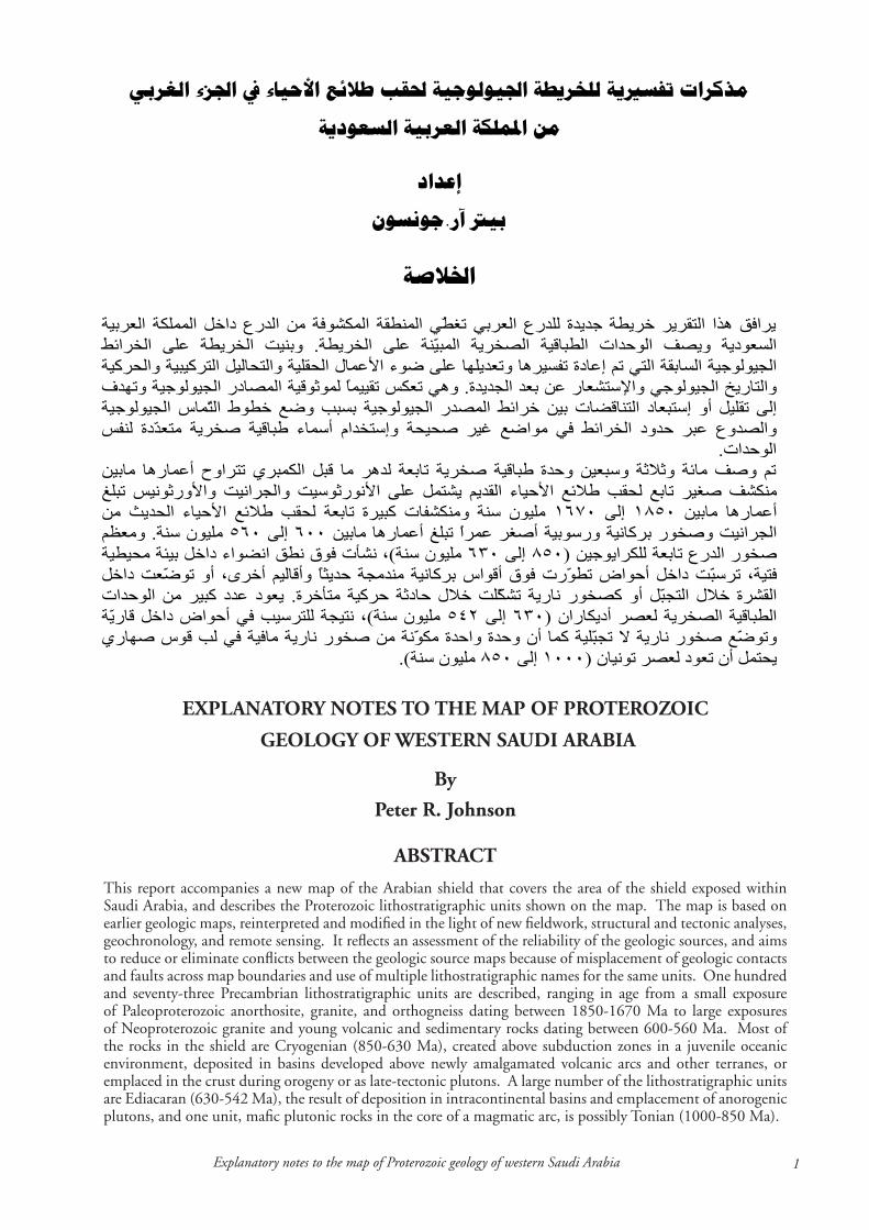
ABSTRACT
This report accompanies a new map of the Arabian shield that covers the area of the shield exposed within Saudi Arabia, and describes the Proterozoic lithostratigraphic units shown on the map. The map is based on earlier geologic maps, reinterpreted and modified in the light of new fieldwork, structural and tectonic analyses, geochronology, and remote sensing. It reflects an assessment of the reliability of the geologic sources, and aims to reduce or eliminate conflicts between the geologic source maps because of misplacement of geologic contacts and faults across map boundaries and use of multiple lithostratigraphic names for the same units. One hundred and seventy-three Precambrian lithostratigraphic units are described, ranging in age from a small exposure of Paleoproterozoic anorthosite, granite, and orthogneiss dating between 1850-1670 Ma to large exposures of Neoproterozoic granite and young volcanic and sedimentary rocks dating between 600-560 Ma. Most of the rocks in the shield are Cryogenian (850-630 Ma), created above subduction zones in a juvenile oceanic environment, deposited in basins developed above newly amalgamated volcanic arcs and other terranes, or emplaced in the crust during orogeny or as late-tectonic plutons. A large number of the lithostratigraphic units are Ediacaran (630-542 Ma), the result of deposition in intracontinental basins and emplacement of anorogenic plutons, and one unit, mafic plutonic rocks in the core of a magmatic arc, is possibly Tonian (1000-850 Ma).
.
.
.
.) (
.) (
).(
� Johnson, P.R., �006
) . (
.
) .(
: ) (
:
.
.
.
.
)(
.
– –
.
. )
(– –
.
) (
. )(
.
) . ( )–
( ) – ( )
– ( ) – (
) ( ) . ( /
.
.
.
.
) ( .
) ( .
:: )USGS-
ARAMCO, . ( ) (
: ) . (
: ) – .(
)– ( )– ( )
– . (
: ). (
�Explanatory notes to the map of Proterozoic geology of western Saudi Arabia
INTRODUCTIONThis report is an explanatory note to accompany a newly compiled map of Proterozoic geology covering the Arabian shield in western Saudi Arabia (Plate). The main objective of the report is to present the known Proterozoic lithostratigraphy, and briefly describe the lithostratigraphic units shown on the compilation, but the report also describes the compilation process, outlines the structural, geochronologic, isotopic, and tectonic framework that underlies the compilation, and comments on how the compilation differs from earlier compilations of shield geology.
Map compilation is a complicated task that involves weighing-up the relative merits and reliabilities of geologic sources, and the careful application of new geologic concepts and mapping, the extrapolation of geologic interpretations from one area to another, and the interpretation of geochronologic data (absolute dating). This new map of the shield in Saudi Arabia is based, as far as possible, on earlier 1:250,000-scale geologic maps of the shield (the geologic source maps), but incorporates revisions and modifications, as well as newly introduced names, so as to:
• reduce conflicts about stratigraphic names and ages on the source maps
• take account of mapping completed since the source maps were published
• take account of geochronology done since the source maps were made
• maximize consistency between the lithostratigraphy and present-day tectonic interpretations of the shield.
Because the source maps were made by the three agencies of the precursor to the Saudi Geological Survey (Bureau de Recherches Géologiques et Minières; United States Geological Survey, and the Saudi Arabian Deputy Ministry for Mineral Resources), a variety of stratigraphic names are used, even in some cases for units that obviously extend from one map quadrangle to an adjacent quadrangle, and contacts and faults do not always join at map boundaries. During much of the mapping program, furthermore, conducted over a period of about 20 years between 1965 and 1985, only Rb-Sr and conventional U-Pb geochronology was available. It is now realized that both these methods are problematic and commonly yield spurious results, because of a lack of stability in the isotope systematics, with regard to Rb-Sr, and the effect of inheritance, with regard to U-Pb. However,
the problems are being addressed by new programs of SHRIMP dating and by careful reassessment of the Rb-Sr and conventional U-Pb results.
In terms of standard lithostratigraphic nomenclature, and in accordance with guidelines given in the Saudi Arabian Code of Lithostratigraphic Classification (Stratigraphic Committee, 1984), the lithostratigraphic units are divided into formations and groups, for volcanic, sedimentary, and low-grade metamorphic rocks, and complexes and suites, for intrusive and high-grade metamorphic rocks, except volcanic and sedimentary rocks in the southern part of the shield that are described, because of deformational complexity and the consequent difficulty of establishing lithostratigraphy, as assemblages within structural belts. Apart from the Kuara Formation (Kemp, 1996), the lithostratigraphic units of the shield are informal and are spelt with lowercase “f ”ormation and “g”roup. In the notes, the map units are arranged in broad categories of volcanic and sedimentary rocks and intrusive rocks, and are described from oldest to youngest according to measurements and estimates of the ages of their time of formation, using conventional divisions of Precambrian time (Fig. 1). Following the latest iteration of the International Stratigraphic Chart (Gradstein and others, 2004), Neoproterozoic rocks are divided into the Tonian (1000-850 Ma), Cryogenian (850-630 Ma) and Ediacaran (630-542 Ma) periods; older rocks are assigned to the Paleoproterozoic; some rocks (mainly schist and gneiss) are unassigned (Fig. 2). The Precambrian/Cambrian boundary is 542 Ma.
The map is printed from digital data archived in the Saudi Arabian Geoscience Database maintained by the Information Technology Section of the Saudi Geological Survey and is the outcome of a decade-long reinterpretation and recompilation of the shield geology done in the light of up-to-date geochronology, current tectonic analysis of the region, recent remote sensing imagery, and field work aimed at obtaining new lithologic and structural information about the rocks, geologic contacts, and shear zones.
The map is the most recent of a series of compilations and reinterpretations of geology done as new data and concepts become available in the region. The earliest regional geologic map of western Saudi Arabia dates from the late 19th century and represents a record of natural history observations made by Doughty (1888) during a two-year expedition between 1876 and 1878. The first modern compilation was done in the 1950s by geologists employed by Aramco (now Saudi Aramco) and the United States Geological Survey. Their results were published in a series of geologic maps at 1:500,000 scale and summarized in a geologic map of the Arabian Peninsula at 1:2 million scale (USGS-ARAMCO, 1963). The first overview of the tectonics of the region arose out of this work and resulted in a paper by Brown and Jackson (1960) and a 1:4 million-scale tectonic map (Brown, 1972). A 1:1 million-scale lithofacies map of Proterozoic rocks in western
) ( ) (
) (
.
.

� Johnson, P.R., �006
Figure 1. Stratigraphic intervals in the Proterozoic (after Gradstein and others, 2004), showing the periods represented by the Proterozoic rocks in Saudi Arabia.
Saudi Arabia was published in 1983 (Johnson, 1983) followed by a tectonic and metallogenic map (Smith and Johnson, 1986), an igneous-rock map (Stoeser and others, 1985), and a geologic map (Brown and others, 1989). Reinterpretations of geologic and mineral-deposit information in the 1990s resulted in a new 1:1 million-scale metallogenic map prepared by BRGM Geoscientists (1995).
The compilation presented here differs from these earlier compilations in important respects: 1) it is based on detailed digital data of the geology; 2) it incorporates the results of geochronology done since 1995; and 3) it reflects a reassessment of lithostratigraphic nomenclature and correlations
required by recognition of the terrane composition of the region. Most importantly, the map presents a lithostratigraphy of the shield more detailed than previous maps.
COMPILATION PROCESS
The map is plotted from digital geologic information contained in an ArcGIS polygon shape file representing geologic units, and two ArcGIS arcs files representing (1) faults and contacts and (2) dikes. (For further details, see below and Johnson, 2006). The project started in 1993 as a manual compilation of geologic information taken from standard 1:250,000-scale geologic quadrangles of the region (referred to here as “source-maps”). The base map was a specially prepared Landsat satellite image of the shield, and the scale of the image (1:500,000) controlled the amount of detail included in the compilation and the degree of simplification applied to the source material. The results were recorded in a series of 6 hand-drawn map sheets with explanatory notes (Cole, 1993; Johnson, 1993; 1995; 1996; 1999a, b).
Toward the end of the 1990s, when digital map-making became routine, a program was started to digitize the hand-drawn maps, and six maps were eventually printed in color from digital data (Johnson, 2005a-
f ). Merging the files of the six separate maps created a composite dataset of the Proterozoic geology of western Saudi Arabia, and was used to prepare the map presented here. The map is designed for examination and presentation at scales between 1:1 million and 1:2 million and is printed, for this report, at a scale of 1:1,000,000 in a Northern and Southern sheet. The data have been processed by ArcGIS™ software, and the map is printed from six shape files:
• a polygon shape file representing the geologic units (file name: � million scale Arabian shield map\Arabian shield �000k revised Sept �006 (SGS-TR-�006-�)\geology � million scale)
• four arc shape files representing the dikes,

�Explanatory notes to the map of Proterozoic geology of western Saudi Arabia
Figure 2. Distribution of Tonian, Cryogenian, Ediacaran, Paleoproterozoic, and unassigned rocks in the Arabian shield in Saudi Arabia.
contacts and faults, and roads (file names: � million scale Arabian shield map\Arabian shield �000k revised Sept �006 (SGS-TR-�006-�)\Dikes complete; � million scale Arabian shield map\Arabian shield �000k revised Sept �006 (SGS-TR-�006-�)\contacts; � million scale Arabian shield map\Arabian shield �000k revised Sept �006 (SGS-TR-�006-�)\Roads)
• two point files representing cities and metallic occurrences (file names: � million scale Arabian shield map\Arabian shield �000k revised Sept
�006 (SGS-TR-�006-�)\metals; � million scale Arabian shield map\Arabian shield �000k revised Sept �006 (SGS-TR-�006-�)\CITIES).
LITHOSTRATIGRAPHY AND GEOCHRONOLOGY
Lithostratigraphy is the scientific discipline that describes and organizes rocks into named units on the basis of their lithologic features and stratigraphic

6 Johnson, P.R., �006
relationships (Salvador, 1994). It is the primary tool used by geologists to make sense of and to bring order to geologic history. Where the rocks are little deformed, such as in the Phanerozoic succession in central and eastern Saudi Arabia, lithostratigraphy can be established relatively easily, based on changes in lithology and observed superimposition. In complex regions, such as in western Saudi Arabia, establishing the lithostratigraphy is much more difficult because the original sequences or intrusive relationships of the rocks are commonly obscured by folding and faulting. In such regions, the fundamental tool of lithostratigraphy is geochronology. Age information about the Proterozoic rocks in western Saudi Arabia is provided by a large geochronologic database (Fig. 3) accumulated over several decades, ranging from initial K-Ar dating programs in the 1950s to recent SHRIMP dating programs. Unfortunately, many results in this database derive from K-Ar, Rb-Sr and conventional U-Pb methods and are unreliable indicators of the time of formation of rock units because of limitations in the methods. K-Ar and Rb-Sr results are commonly reset, as the effect of thermal and mechanical stress on the samples media, so that the results tend to date metamorphic and deformation events rather than original crystallization events, and U-Pb results may be compromised because of inheritance issues, meaning that zircons in a given sample may be acquired from
Figure 3. Histograms of age data for the Arabian-Nubian shield. The data comprise geochronologic results from Jordan, Egypt, Eritrea, Ethiopia, and Yemen as well as Saudi Arabia, but reflect a tectonic history common to both the Arabian and Nubian segments of the shield. Data from sources listed in Johnson and others (1997).
older rocks as detrital grains in sediments or refractory grains in igneous melts, and therefore give skewed or false geochronologic results. As a consequence, relatively few robust rock-formation ages are known for the shield and a precise geochronologic framework of depositional, intrusive, tectonic, and metallogenic events have yet to be established. The lithostratigraphy presented here (Fig. 4) modifies the preliminary proposal by Johnson and Kattan (2005) and will be further revised as new geochronologic and structural data become available.
The formation ages used in these notes are based on numeric ages derived from geochronology, and(or) relative ages derived from intrusive and(or) structural relationships between adjacent rock units. The descriptions below discuss these age derivations, commenting on the level of reliability of the geochronologic data and pointing out situations in which new geochronologic information necessitates revision of earlier lithostratigraphic assignments. The reliability of the age assignments of the lithostratigraphic units is indicated as a field in the attribute table embedded in the digital data for the compilation, in which the ages are categorized in three levels of confidence: the greatest level of confidence belongs to age attributes based on robust geochronology; a moderate level of confidence derives from ages based on less robust geochronology
and(or) geological relationships; the weakest level of confidence is assigned to ages that are effectively inferences based on general geologic knowledge of the region.
LITHOSTRATIGRAPHIC REvISION
To the greatest extent possible, the source-map formation and group names were retained for the compilation presented here, but in many parts of the map lithostratigraphic changes have been made. Some changes are necessary because adjacent source maps use different formation names for the same rock unit, in which cases precedence is given to the earliest reported names. Other changes result from the merging of two or more formations to make larger undifferentiated units that correspond to groups or suites because limitations of scale restrict the amount of detail that can be shown.
Other revisions to the source-map lithostratigraphies are required as a result of the development of sensitive high-resolution ion micro-probe instruments that allow accurate dating of individual grains and parts of grains of zircon, the mineral preferably used for modern geochronology in Proterozoic rocks. Recent ion-probe dating programs that impact shield stratigraphy include work

�Explanatory notes to the map of Proterozoic geology of western Saudi Arabia
Figure 4. Lithostratigraphic correlation diagram of rocks in the Arabian shield.
� Johnson, P.R., �006
by Agar and others (1992), Whitehouse and others (2001) Hargrove (2006), and Hargrove and others (2006a), as well as the results of SHRIMP dating programs by SGS (Kennedy and others, 2004, 2005). Notable lithostratigraphic changes caused by such high-resolution dating include the recognition of Paleoproterozoic rather then Neoproterozoic rocks in the extreme eastern part of the map area; a reassignment of some rocks formerly treated as Paleoproterozoic to the Neoproterozoic; a more precise definition of the age of volcanic and intrusive rocks in the Samran-Shayban-Bi’r Umq area; and the realization that the Abt formation is considerably younger than previously thought.
In common with the analysis of orogenic belts elsewhere in the world, lithostratigraphic revisions have also been made as a result of advances in tectonic analysis, notably the recognition that the Arabian shield is a cluster of tectonostratigraphic terranes (Fig. 5). Details of this analysis – how many terranes and what structures constitute their boundaries – are the subject of ongoing debate among geologists working on the shield, but the terrane paradigm is widely accepted and provides a powerful tool for interpreting the geologic history of the region (e.g., Johnson and Woldehaimanot, 2003; Stoeser and Camp, 1985; Stern, 1994; Genna and others, 2002; Nehlig and others, 2002; Stoeser and Frost, 2006). When geologic mapping in the Arabian shield began, geologists worked with a relatively simple tectonic model of craton development, and the resulting stratigraphy was relatively simple, with correlations extending across vast regions of the shield. During the subsequent 40 years’ span of geologic mapping, supported by structural, geochronologic, and isotopic studies, simple models were replaced with more complex plate-tectonic and terrane models, leading to the mapping of separate tectonic domains (terranes) characterized by discrete assemblages of volcanic arcs, sedimentary basins, and intrusive rocks.
The foremost impact of terrane analysis on lithostratigraphic synthesis in the shield derives from the fundamental premise that each terrane has its own geologic history and its own set of distinct terrane-forming rock units. This means that “terrane-forming” formations, groups, complexes, and suites crop out only within, and do not extend beyond, the terrane to which they belong. Hence, formations, groups, complexes, and suites that make up one terrane do not cross over the terrane boundary to another terrane, and stratigraphic names of “terrane-forming” rocks will change at terrane boundaries. While recognizing the preliminary character of terrane analysis in the shield, tectonostratigraphic terranes have been adopted as a working tectonic model for the shield during the making of this map, and names of terrane-forming lithostratigraphic units have been limited to particular terranes. In several cases, this requires names in the literature and on the source maps to be modified and restricted areally. For example, (1) the Siham group
is limited to the Afif terrane, (2) the Al Amar group is confined to the Ar Rayn terrane, (3) the Al ‘Ays group characterizes the northern Hijaz terrane, and (4) the Zaam and Bayda groups are limited to the Midyan terrane.
A secondary implication of the terrane model is the necessity to abandon group names for rocks in one terrane that are based on reference areas located within another terrane, a restriction that leads, in this compilation, to the abandonment of the terms Baish group, Bahah group, Jiddah group, and Halaban group.
As conventionally defined, the Baish and Bahah groups crop out in the southern part of the shield, in several north-trending belts of mostly greenschist-facies layered rocks that extend from Wadi Baysh, in the south, as far as Turabah, in the north, and the names are applied across the boundaries of the structural belts. In detail, the layered rocks in these belts have a variety of names with conflicting geologic boundaries, and are not divided according to any agreed lithostratigraphy. Existing lithostratigraphic names include the Sharq, Bidah, and Gehab groups (Jackaman, 1971), the Jiddah group (Greenwood, 1975a), the Ablah group (Greenwood, 1975a; Cater and Johnson, 1986), Units 1-5 (Greene and Gonzalez, 1980), Units B-H (Ramsay and others, 1981), groups 1, 2, and 3 (Béziat and Donzeau, 1989), the Khumrah greenstone (Ziab and Ramsay, 1986), and the Hawiyah formation (Ziab and Ramsay, 1986), as well as the Baish group (Greenwood, 1975a, b), and the Bahah group (Greenwood, 1975a; b). Because of this confusion, and because the exact tectonic significance of the shear zones that bound the structural belts is uncertain, the terms Baish and Bahah are abandoned.
The term “Jiddah group” was introduced by Schmidt and others (1973) and Greenwood (1975a) for andesitic rocks exposed in Wadi Jirshah (Qirshah) in the Al ‘Aqiq quadrangle in the southern Arabian shield, on the basis that the rocks are “lithologically similar to rocks east of Jiddah mapped as Jiddah greenstone” (Greenwood, 1975a, pg. 4). However, rocks in the Wadi Jirshah area are part of the Asir terrane, whereas rocks in the Jiddah area belong to the Jiddah terrane. Furthermore, the so-called Jiddah group volcanic rocks in Wadi Jirshah are reassigned in mapping by Donzeau and others (1989) to the Ablah group (Donzeau and others, 1989), and greenstones in the Jiddah area that were used by Greenwood and Schmidt as Jiddah correlatives of the rocks in the Wadi Jirshah area are assigned by Moore and Al-Rehaili (1989) to the Samran group. As a consequence, there are no “Jiddah group” rocks in the Jiddah area with which to correlate the Wadi Jirshah rocks; the Wadi Jirshah rocks are much younger than traditional “Jiddah group” rocks; and the Wadi Jirshah and Jiddah areas are in different terranes. In terms of the stratigraphic guide (Stratigraphic Committee, 1984), therefore, it is inappropriate to apply the name “Jiddah” to rocks in the southern shield and the name

�Explanatory notes to the map of Proterozoic geology of western Saudi Arabia
Figure 5. Tectonostratigraphic terranes in the Arabian shield, including Saudi Arabia as well as Yemen (after Stoeser and Camp, 1985; Windley and others, 1996; and Johnson and Woldehaimanot, 2003).
“Jiddah group” is abandonned.Use of the term “Halaban group” is equally
problematic. The Halaban group was introduced by Schmidt and others (1973) following Brown and Jackson (1960) for andesitic rocks in the Halaban area, and was extensively applied during geologic mapping programs in the 1970s to rocks in the southern shield, as far south as Najran (Sable, 1985). However, since the late 1970s, the name has been abandoned for any rocks in the Halaban area itself (e.g., Delfour, 1979), which means that there is no “Halaban group” at Halaban village with which to correlate so-called Halaban group rocks elsewhere in the shield. Furthermore, the Halaban area and the southern shield are in different
terranes, which means that it is inappropriate to extend the name from the Halaban area across terrane boundaries to the south.
The extent of the Hulayfah group is also restricted in this compilation. The group is named after volcanic rocks in the vicinity of Hulayfah village in the north-central part of the shield. In some senses, it was used during the 1:250,000-scale mapping program in the 1970s and 1980s to replace the older term “Halaban group” and came to be applied to many volcanic assemblages in the north-central and eastern parts of the shield. However, the region across which the name is applied is divided currently into at least three terranes and several possible subterranes. The main Hulayfah outcrops are west of the Hulayfah fault zone, that is, west of the Afif terrane, and the name is restricted to rocks in this area in this report. Rocks in the Afif terrane and the Ar Rayn terrane, farther east, which are assigned in the 1:250,000-scale source maps to the Hulayfah group are here given different names.
The terms “Al Ays group” and “Bayda group” are similarly constrained by a tectonic boundary, in an attempt to resolve lithostratigraphic nomenclatural confusion. This confusion is caused by the use of different names on the 1:250,000-scale source maps for geologic units that obviously continue across the source-map boundaries. The Bayda group on the Al Wajh sheet (Davies and McEwan, 1985), for example, becomes the Al ‘Ays group on the Sahl al Matran sheet (Hadley, 1987); the Hijr and Jarash formations of the Bayda group on the Al Wajh sheet change to the Khawr and Amud formations on the Shaghab sheet (Grainger and Hanif, 1989). Johnson (2005f ) revised these lithostratigraphic names by taking into account,

�0 Johnson, P.R., �006
not the source-map boundaries, but the major tectonic boundary in the region – the Yanbu suture. Following Johnson (2005f ), the Al Ays group is restricted in this report to rocks around or in continuity with the Al Ays type area, in the Hijaz terrane, east and south of the suture: the Bayda group is restricted to rocks in the Midyan terrane, north and west of the suture.
GEOLOGIC OvERvIEWPrecambrian rocks extend throughout the Arabian Peninsula, exposed as the Arabian shield in the west in Saudi Arabia, Jordan, and Yemen; concealed beneath as much as 12 km of Phanerozoic sedimentary rocks in the central part of the peninsula; and exposed in small outcrops in Oman in the east (Fig. 6). Because of the Phanerozoic cover, the basement in central Arabia is poorly known but geophysical data indicate that the basement is unbroken across the region. The exposed basement in Oman is Neoproterozoic and has lithologies similar to parts of the Arabian shield, but appears to have a different geologic history and may represent a different geologic province than the shield (Mercolli and others, 2005).
The shield rocks are mainly Neoproterozoic, apart from a small area of Paleoproterozoic rocks in the extreme eastern part of the shield in Saudi Arabia, and Archean rocks structurally intercalated with Neoproterozoic rocks in Yemen. In Jordan, the oldest basement rocks are Neoproterozoic pelites between 800-750 Ma (Jarrar and others, 2004). Isotopic data, principally common lead, and neodymium model ages
Figure 6. Distribution of exposed Precambrian rocks in the Arabian Peninsula and adjacent parts of northeast Africa.
(Stacey and Stoeser, 1983; Stoeser and Frost, 2006; Stern, 2002, Hargrove and others, 2006b) divide the rocks of the shield into regions of continental, oceanic, and intermediate tectonic settings (Fig. 7), a tri-partite division that is approximately mirrored in the Nubian shield and reflects the general environments in which the rocks were formed. The oceanic domain contains magmatic-arc rocks formed by subduction in juvenile oceanic settings, consistent with Neoproterozoic Nd model ages and positive Nd initial ratios obtained from rocks in the western part of the Arabian shield; the continental domain contains Neoproterozoic and Paleoproterozoic rocks but appears to be underlain by Paleoproterozoic-Archean continental crust, consistent with Nd model ages, averaging 2.1 Ga, and negative Nd initial ratios obtained from rocks in the southeastern part of the shield (the Khida terrane) and in parts of Yemen. The intermediate domain is oceanic but is underlain by crust that is isotopically different from the oceanic domain in the west because either the mantle sources were less depleted or there was a mixing of cratonic and mantle material during magmagenesis (Stoeser and Frost, 2006). The boundary between the oceanic and intermediate domains, which approximates the suture between the Afif terrane to the east and oceanic terranes to the west, may well be the collisional contact between East and West Gondwana.
The Arabian shield represents a successful episode of continental-crust evolution, which began with the creation of ocean floor at the time of breakup of the Rodinian supercontinent about 850-750 Ma;

��Explanatory notes to the map of Proterozoic geology of western Saudi Arabia
Figure 7. Pb and Nd isotope data and neodymium model ages that divide the Arabian-Nubian shield into regions of oceanic, continental, and intermediate settings. The Pb-isotope classification, after Stoeser and Stacey (1986), is based on the ratios of 206Pb/204Pb, 207Pb/204Pb and 208Pb/204Pb from whole-rock, feldspar, and galena samples with respect to the orogen growth curve. Type III Pb plots above the curve and reflects the presence of evolved crustal material; Type I plots below the curve and reflects the presence of juvenile (oceanic and mantle) material. εNd(T) is the neodymium initial ratio; tDM(Ga) in the neodymium model age in Ga. For a recent discussion of the implications of Nd isotope data, see Hargrove and others (2006b). Data after sources listed in Johnson and Woldehaimanot (2003). Tectonostratigraphic terrane boundaries from Fig. 5 shown for reference.
continued through processes of subduction-related, island-arc formation (Al-Shanti and Mitchell, 1976; Camp, 1984), deposition of younger sedimentary and volcanic rocks, and younger magmatism; and ended with the convergence and compression of distant cratons and intervening Proterozoic rocks to form the Gondwana supercontinent at about 550 Ma. Overall, the Arabian shield and its counterpart, the Nubian shield, is the northern end (present-day orientation) of the Neoproterozoic orogenic belt of rocks, the East African Orogen (Stern, 1994), that was deformed and metamorphosed between the converging blocks of East and West Gondwana. To the south, the orogen comprises Mesoproterozoic, Paleoproterozoic, and Archean rocks that were intruded, and reworked by melting, metamorphism, and deformation during
the Neoproterozoic. To the north, the orogen comprises rocks that were emplaced in a collapsing Neoproterozoic ocean.
Terrane analysis of the shield (Fig. 5) is based on isotopic divisions; structural, geochronologic, and lithostratigraphic differences; and the presence of serpentinite-decorated and transcurrent shear zones. The terranes comprise the earliest formed rocks in any given part of the shield and mostly originated in the juvenile Neoproterozoic oceanic environment that characterized the northern end of the East African Orogen. As a result of ongoing subduction and the consumption of intervening oceanic crust, the terranes in the shield converged, amalgamated, and sutured, reflecting an orogenic process characterized by metamorphism, deformation, and syntectonic

�� Johnson, P.R., �006
intrusion. By dating the metamorphic and intrusive events in the terranes and along the suture zones between the terranes, it is evident that orogeny was not synchronous across the shield (see Fig. 6 in Johnson and Woldehaimanot, 2003). The oldest amalgamation events were along the Bi’r Umq suture (780-760 Ma); the youngest were along the Al Amar suture (Doebrich and others, 2005; Collins and Pisarevsky, 2005). It is also evident that orogenic events are not shield wide – they affect particular terranes and zones of amalgamation (suture zones) at different times in different parts of the shield. This means that deformational and metamorphic events must be viewed from a geographically and chronologically more restricted perspective than is done in the some of the earliest reports on the orogenic development of the shield, and is the reason why this report does not use such traditional terms in the Saudi geologic literature as the Hijaz tectonic cycle, Aqiq orogeny, Ranyah orogeny, and Yafikh orogeny (Greenwood and others, 1980).
The lithostratigraphic terranes of the shield are small to large crustal blocks bounded by major shear zones, some of which are sutures, namely shear zones that mark the loci of consumption of oceanic crust during the process of subduction and magmatic-arc convergence, others of which are transcurrent faults that may reflect the original locations of sutures but are predominantly zones of late Neoproterozoic strike-slip strain. Well-documented sutures in the shield include the Bi’r Umq suture between the Jiddah and Hijaz terranes (Johnson and others, 2003), the suture between the Afif and Hijaz-Jiddah-Asir terranes (Johnson and Kattan, 2001); and the Yanbu suture between the Hijaz and Midyan terranes (Stoeser and Camp, 1985). Terrane boundaries consisting of late Neoproterozoic strike-slip faults include the Ad Damm fault between the Asir and Jiddah terranes, and the Al Amar fault between the Ad Dawadimi and Ar Rayn terranes. Most of the terranes appear to be composite, that is, they consist of sub-units or sub-terranes and have their own internal amalgamation history. The structure of the Asir terrane is the least well known in the shield because it is dominated by late Neoproterozoic north-trending shear zones that in part may coincide with sutures between sub-terranes but effectively obscure the original relationships between these sub-terranes. The shear zones divide the terrane into structural belts (Greenwood and others, 1982), which are used as a means of grouping the layered rocks into the map units shown on the Plate.
The rocks that make up the terranes in the shield – the terrane prototypes, or “terrane-forming rocks” – are typically assemblages of calc-alkaline volcanic and intrusive rocks such as basalt, andesite, rhyolite, diorite, tonalite, and granodiorite, and developed as magmatic arcs at convergent boundaries. The Ad Dawadimi terrane is uniquely sedimentary in origin, and the Afif terrane contains a microplate of
Paleoproterozoic continental crust. The suture zones are characteristically linear belts of highly sheared rock, decorated with lenses of serpentinized peridotite and gabbro that represent obducted ophiolite, and intruded by syntectonic granite-granodiorite gneiss.
Younger rocks in the shield consist of volcanic and sedimentary assemblages deposited in postamalgamation basins and granitic rocks emplaced in a vast number of late-to-posttectonic intrusions. In some cases, the postamalgamation basins are unconformable on the amalgamated terranes or overlap terrane boundaries, and the late-to-posttectonic intrusions commonly intrude the suture zones and “stitch” terranes together. An example that illustrates the process of crustal accretion is the relationships in the northeastern part of the shield between the Murdama group, other young volcanic-sedimentary groups, and post-Murdama granites to the underlying magmatic-arc rocks (Fig. 8). These relationships can be analyzed as a type of flow chart involving converging crustal units, episodes of volcanism and sedimentation following amalgamation, and important phases of postamalgamation intrusion.
The interpretation of the geologic history of the Arabian shield and its counterpart, the Nubian shield, is dependent on field observations, laboratory studies, and remote sensing, and will be refined as mapping, geochronologic, and geochemical programs progress (e.g., Kennedy and others, 2005, 2004; Hargrove, 2006). The present map is a compilation of shield geology made in the light of stratigraphic and tectonic models current in 2006. Ongoing work will necessitate periodic revision, but the map is presented as a modern view of the lithostratigraphy of the shield with the aim of providing a working geologic framework for research and applied geologic programs.
PALEOPROTEROZOICPaleoproterozoic rocks are poorly exposed at the extreme eastern margin of the Arabian shield in an area centered about 21°15′N, 44°50′E (Fig. 2). As shown on the Jabal Khida 1:250,000-scale geologic source map (Thieme, 1988), the rocks were originally assigned relatively young Neoproterozoic ages, but U-Pb ion-microprobe data and Sm-Nd model ages indicate that they are Paleoproterozoic. The rocks are interpreted as Paleoproterozoic crust entrained in the Afif terrane, and are referred to in the literature as the Khida microplate or subterrane (Whitehouse and others, 2001; Stoeser and others, 2001, 2004).
South Libab orthogneiSS, ~1800 Ma
This is a small body of biotite granite gneiss (lbs) (Stoeser and others, 2001) that contains zircons with 2100-2400 Ma cores and abundant 1900-1750 Ma zircon rims (D.B. Stoeser, oral communication, 2001). It is a Paleoproterozoic rock that was affected by a metamorphic event contemporary with the adjacent

��Explanatory notes to the map of Proterozoic geology of western Saudi Arabia
Figure 8. Flow diagram showing the process of amalgamation that created the Afif and adjacent composite tectonostratigraphic terranes in the northeastern Arabian shield and postamalagamation deposition and magmatism (after Johnson and Woldehaimanot, 2003).
Muhayil suite.
MuhayiL Suite, 1850-1670 Ma
The Muhayil suite (uh) (Stoeser and others, 2001) consists of anorthosite and granite dated at 1675±11 Ma, 1668±10 Ma, 1660±97 Ma, and 1660±10 Ma that may have a late Archean-early Paleoproterozoic source (Agar and others, 1992; Whitehouse and others, 2001). It is assigned an age range of 1850-1670 Ma by Stoeser and others (2004). The rocks are the first reported example in the Arabian shield of a Paleoproterozoic anorthosite-alkali-feldspar granite assemblage (Stoeser and others, 2001). The northern part of the suite is metamorphosed anorthosite; the smaller southern part is coarse-grained biotite-rich quartz-poor metamorphosed alkali-feldspar granite.
TONIANTonian rocks are not well documented in the Arabian shield, but by analogy with the Nubian shield are suspected in the Makkah batholith, in the Jiddah terrane, in the west-central part of the shield (Fig. 2), where they are assigned to the Makkah suite.
Makkah Suite, age uncertain
The Makkah suite (dm) consists of amphibolite-
grade, deformed metamafic plutonic rocks and mostly crops out in the southern part of the Makkah batholith. On the Makkah quadrangle source map (Moore and Al-Rehaili, 1989), the rocks are assigned mainly to the Milh and Sharqah complexes. The suite has been dated between 817 Ma and 678 Ma by Rb-Sr and K-Ar methods (Fleck, 1985), but the results are unreliable because of metamorphism and deformation. A possibly more reliable estimate of the age of the complex derives from U-Pb zircon ages of 870±5 Ma, 854±9 Ma, and 852±30 Ma obtained from granodiorite, tonalite, and trondhjemite in the Erkowit pluton of the Haya terrane, in Sudan (Kröner and others, 1991; Reischmann and others 1992). Prior to Red Sea opening, these two areas of mafic plutonic rocks would have been as little as 100 km apart, which makes it reasonable to assume that the Erkowit pluton is the broad correlative of the early components of the Makkah batholith, suggesting that the Makkah suite is upper Tonian. The suite includes diorite, gabbro, quartz diorite, and tonalite. The rocks are fine-to medium-grained, locally pegmatitic rock, locally foliated, and mylonitized. Tonalite has a granular, well-foliated gneissic texture, with well-segregated layers of mafic and felsic minerals; it commonly grades into biotite-amphibole schist and, on the scale of meters, is interlayered with paraamphibolite and quartzofeldspathic schist. Gabbro is fine-to coarse-grained, and intercalated with anorthosite and norite.

�� Johnson, P.R., �006
CRYOGENIANCryogenian lithostratigraphic units are those that have measured or estimated formation ages between 850 Ma and 630 Ma. Parts of some formations may be older than 850 Ma, but the bulk of the formations are likely to be 850 Ma or younger. Cryogenian lithostratigraphic units are the most common rocks in the shield (Fig. 2), comprising most of the terrane protoliths of the shield, and many of the postamalgamation layered and intrusive assemblages. They are described here as layered lithostratigraphic units in order from older to younger, followed by intrusive units.
Layered cryogenian LithoStratigraphic unitS
Bidah-belt volcanic and sedimentary rocks, ~���-��� MaThis map unit (bb), named after the Bidah structural belt (Greenwood and others, 1982), consists of metamorphosed volcanic, volcaniclastic, and sedimentary rocks in the western part of the Asir terrane, located on either side of Wadi Bidah and extending south as far as Ad Darb. As commented in the section on Lithostratigraphic Revision above, the geologic literature gives a confusing lithostratigraphy for this part of the Arabian shield and the rocks are mapped here as a large unit of undifferentiated rocks confined to the Bidah structural belt, rather than mapped as the formations named in the literature. Establishing the precise lithostratigraphy for the belt is difficult because the rocks have steep dips, are polydeformed and metamorphosed to the greenschist and amphibolite facies, and are highly strained and transposed, so that the succession across the belt is likely to be a structural sequence rather than a stratigraphic assemblage.
The layered rocks of the Bidah belt are not directly dated but are intruded by and may be broadly coeval with the arc-related Buwwah suite plutonic rocks, which are approximately between 855-815 Ma. They include well-bedded to massive, fine-to-medium grained basaltic, andesitic, dacitic, and rhyolitic flows and tuffs, abundant volcaniclastic rocks, and significant amounts of epiclastic sedimentary rocks, and represent one or more volcanic arcs. Metasedimentary rocks include shale, phyllite, phyllitic quartzite, argillite, ferruginous quartzite, marble, graywacke, and limestone. Where strongly metamorphosed, the rocks consist of amphibolite, mica schist, and paragneiss and may be interlayered with orthogneiss. VMS and epithermal gold deposits characterize the northern part of the Bidah belt and have been explored by many agencies during the past decades. An unusual rock type at the southern end of the belt is a chaotic mixture of massive grunerite, pegmatite, garnet amphibolite, quartzite, calcareous schist, andesite, gabbro, and monzogranite that may have formed by
contact metamorphism of layered rocks during the intrusion of gabbro and monzogranite (Fairer, 1985).
Al Lith belt volcanic and sedimentary rocks, ~��0-��0 MaVolcanic and sedimentary rocks in the Al Lith belt (li) (Greenwood and others, 1982), a structural domain in the western part of the compilation area, inland from Al Lith and extending as far as At Ta’if, are strongly deformed and typically more strongly metamorphosed than layered rocks elsewhere in the shield. They commonly crop out as amphibolite, amphibolite schist, quartz-rich schist, and paragneiss interlayered with orthogneiss, and appear, overall, to be a succession of metamorphosed basaltic volcanic and volcaniclastic rocks, epiclastic sedimentary rocks, and subordinate rhyolite and marble. On the source maps (chiefly Pallister, 1986 and Cater and Johnson, 1986), the layered rocks are variously assigned to Baysh group metabasalt and amphibolite; the Qilak formation, the Sa’diyah formation, the Abbasah formation, and Metarhyolite, but these units are not differentiated for the purpose of this compilation.
Basaltic rocks are represented by massive to schistose, fine- to medium-grained amphibolite, epidote amphibolite, quartz amphibolite, hornblende hornfels, greenschist, and mafic paragneiss. Other rocks types are paraamphibolite, garnet-mica schist, metaandesite, metagraywacke, metamorphosed lithic, crystal, and ash-fall tuffs, minor agglomerate, hornblende schist, and hornblende gneiss, quartzo-feldspathic schist and gneiss, impure quartzite, rare magnetite-bearing quartzite, marble, and metarhyolite and rhyolite tuff. A distinctive rock type in the belt is kyanite-bearing quartz-rich metaarenite, present as andalusite-kyanite-muscovite quartzite, rutile-muscovite-kyanite quartzite, muscovite-kyanite quartzite, staurolite-biotite-albite-sericite-quartz-andalusite schist, and lazulite-andalusite quartzite. The protoliths of the sedimentary rocks were probably sandstone, shale, claystone, sandy limestone, interbedded limestone, graywacke, arkose, and pelite. Previous workers suggest that the high quartz and alumina content indicate a continental provenance (Ramsay and others, 1981; Kröner and Basahel, 1984, Pallister, 1986), although Beyth and others (1997), on the basis of geochemical and isotopic data obtained from correlative high-grade staurolite-kyanite-garnet schist in Eritrea, caution that such a provenance, if it existed, was juvenile, not old, continental crust.
The assemblage is directly dated by a 4-point whole-rock Rb-Sr isochron of 847±34 Ma, and by robust Pb/Pb zircon-evaporation ages of 842±17 Ma, 821±19 Ma, 834±7 Ma, and 812±6 Ma (Kröner and others 1984; 1992), which bracket volcanism and sedimentation in the region to between about 850 Ma and 810 Ma. An Rb-Sr whole-rock isochron of 590±20 Ma obtained from Qilakh-formation basalt about 40 km northeast of Al Lith (Kröner and others,

��Explanatory notes to the map of Proterozoic geology of western Saudi Arabia
1984) is too young to be a formation age, and must reflect resetting during an Ediacaran magmatic and deformational event. Fleck and others (1980) obtained a 3-point Rb-Sr whole-rock isochron of 1165±110 Ma from Qilakh-formation metabasalt, at a location immediately east of Jabal Bashamah, about 25 km north of Al Lith, which is widely cited in the literature as evidence of Mesoproterozoic rocks in the western Arabian shield. However, the result has a large error and is based on a limited range of Rb/Sr ratios caused by extremely low rubidium values in the samples. For these reasons, the result is not reliable, even though it has an acceptable analytic error (MSWD=0.08). The result is inconsistent with the Pb/Pb zircon-evaporation ages and is rejected as an indicator of a Mesoproterozoic formation age. A K-Ar muscovite mineral age of 595±12 Ma (Brown and others, 1978) presumably reflects Pan-African thermal resetting, as inferred for the 590±20 Ma Rb-Sr age.
Isamah formation, ~��0 MaIsamah formation (is) is a name introduced by Johnson (2005b) for volcanic and sedimentary rocks exposed in the northwestern part of the Afif terrane area between Nuqrah and the Hulayfah-Ad Dafinah fault zone. All are metamorphosed in the greenschist facies. For the reasons given by Johnson (2005b), the name is introduced to replace the terms “Hulayfah group”, “Nuqrah formation”, and “Afna formation” for rocks east of the Hulayfah fault zone. The Isamah formation is dated at about 840 Ma, on the basis of a U-Pb zircon age of 839±23 Ma obtained from rhyolite in the Nuqrah area (Calvez and others, 1983) and ages of 847-823 Ma obtained from the Bi’r Tuluhah ophiolite, which is structurally intercalated with the Isamah formation along the Hulayfah fault zone. The formation includes basalt, andesite, and subordinate rhyolite flows, abundant felsic and mafic tuffs, commonly well bedded and cherty, and subordinate epiclastic sedimentary rocks including conglomerate, sandstone, and siltstone. The formation is notable for polymetallic and nickel-copper-bearing sulfide deposits at Nuqrah and Jabal Mardah (Carten and Tayeb, 1989).
Sumayir formation, ~��0 MaThis formation (bi) (Kemp and others, 1982) is an assemblage of early Cryogenian mafic volcanic and fine-grained sedimentary rocks intercalated with the Bi’r Umq mafic-ultramafic complex in the northeastern part of the Jiddah terrane, and interpreted as pelagic deposits at the top of the Bi’r Umq ophiolite (Johnson and others, 2004). In the geologic source map (Kemp and others, 1982) the formation is treated as part of a layered-rock group unconformable below the Mahd group. However, the formation is not in contact with the Mahd group and its stratigraphic position with respect to the Madh group is unknown. The group is approximately dated by means of an Rb-Sr errorchron of 831±47 Ma (Dunlop and others, 1986),
consistent with the age of the associated Bi’r Umq mafic-ultramafic rocks (±835 Ma). The formation consists of undivided basalt, chert, carbonate-altered mafic rocks (listwaenite), tuffite, and siltstone, and subordinate mafic-ultramafic intrusive rocks and is locally structurally intercalated with serpentinite.
Samran group, ���-��� MaThe Samran group (sa), named by Skiba and Gilboy (1975) after “Samran series” (Nebert, 1969) and “Samran metavolcanic formation” (Rexworthy, 1972), underlies the northwestern part of the Jiddah terrane. The group is in a fault contact on the west with Cenozoic sedimentary rocks of the Red Sea basin, and is partly covered by tongues of flood basalt that descend from vents of Harrat Rahat along Miocene paleovalleys to the coastal plain. The group is deformed by isoclinal folding and dextral and sinistral brittle-ductile shearing, and stratigraphic relationships within the group are uncertain. In places, sedimentary-top indicators are present in sufficient abundance to allow the stratigraphy to be traced across folds, and lateral and vertical facies changes are documented around volcanic centers (Roobol, 1989). In its southern exposures, the group is present as screens or roof pendants in plutons of the Kamil suite. Layered rocks along the Fatima fault zone assigned to the Samran group in the Makkah source map (Moore and Ar-Rehaili, 1989) are withdrawn from the group in this compilation because of the unknown, but possibly great, tectonic significance of the fault zone in terms of the displacement and (or) telescoping of rock assemblages, and reassigned to the Zibarah group.
In the literature, the Samran group is divided into five formations. The northern two, the Nida (Fig. 9) and Shayban formations, are structurally concordant and may represent laterally equivalent distal and proximal volcanic assemblages deposited around paleovolcanic centers (Roobol, 1989). The Madrakah and Fayidah formations are isolated from other Samran-group rocks as roof pendants in the Kamil suite. Their stratigraphic positions in the group are unknown, but they are assigned to the Samran group because
Figure 9. Nida formation, Samran group: subvertical dipping Nida formation quartz-feldspar metasandstone, with a moderately northeast plunging lineation that is folded about a steeply plunging later fold.

�6 Johnson, P.R., �006
of their proximity and general similarity to the other units (Moore and Al-Rehaili, 1989). The Amudan formation is a younger formation. Recent SHRIMP analysis dates the Shayban formation between 825 Ma and 771 Ma, and Amudan formation between 753 Ma and 746 Ma (Hargrove, 2006). Where intruded by the Kamil suite, parts of the group may be as old as 840 Ma. The group is important as the host of base-metal and gold deposits in the Jabal Samran-Jabal Shayban area.
The group is metamorphosed in the greenschist and locally amphibolite facies. It includes mafic to felsic lavas and volcaniclastic rocks, graywacke, polymict conglomerate, shale, siltstone, chert, marble, and quartzofeldspathic schist, mica schist, amphibole schist. Chlorite schist and subordinate interlayered sericite schist and andesitic tuff are locally common, representing fine-grained distal volcanic deposits.
Shwas belt volcanic and sedimentary rocks, >��� MaThe Shwas belt is a narrow structural domain along the west side of the An Nimas batholith in the Asir terrane. It contains an assemblage of greenschist-facies moderately feformed (Fig. 10) volcanic and sedimentary rocks (sh), which are intruded by the batholith and are therefore older than about 815 Ma. On the 1:250,000-scale geologic source maps the rocks are assigned to the Khutnah and Qirshah formations of the Jiddah group (Cater and Johnson, 1987; Prinz, 1983), but for the reasons discussed above in the section on Lithostratigraphic Revision with regard to abandonment of the term “Jiddah group” and revision of the age of the type Qirshah rocks, the formation names are not used here. The rocks were earlier assigned to the Surgah and Shwas formations (Bokhari and Kramers. 1981) and to the
Figure 10. Open, upright fold in Khutnah formation thinly bedded sandstone at the northern end of the Shwas belt, plunging gently north. The structure is characterized by a well-developed, vertical, axial-plane cleavage.
Halaban group (Fujii and Kato, 1974). The rocks include flows and pyroclastic rocks of andesitic, dacitic, and basaltic compositions, green and red, feldspathic to lithic graywacke, tuff, flat-pebble-to-boulder conglomerate, and thin gray marble. They are metallogenically significant as the host rocks for VMS base metal and gold deposits, one of which (Al Hajar) is currently exploited.
The Shwas belt rocks are directly dated by an Rb-Sr errorchron of 721±55 Ma that, despite the large error, is believed by Bokhari and Kramers (1981) to be an approximate emplacement age for the assemblage and is in agreement with Pb model ages of about 730 Ma obtained from one of the Jadmah Cu-Zn sulfide prospects in the belt. However, the errorchron age is in conflict with contact relationships, which indicate that the layered rocks in the belt are intruded by the An Nimas batholith and are therefore older that 815 Ma, the minimum age of the batholith (see below). Sahl (1993) reports an Rb-Sr whole-rock 6-point isochron of 666±5 Ma for volcanic rocks in the Al Hajar area, immediately east of the compilation area. The result is believed by Sahl to be the formation age of a volcanic succession younger that other layered rockd in the belt. However, little field evidence supports Sahl’s stratigraphic interpretation, and the Rb-Sr isochron is likely to be a reset age. Giving weight to the An Nimas batholith contact relationship, the rocks are tentatively treated here as older than 815 Ma.
Tayyah belt volcanic and sedimentary rocks, >��� Ma The Tayyah belt (Greenwood and others, 1982) is a structural domain in the Asir terrane extending from north of Bishah to the Yemen border. It is situated between the Shwas belt, on the west, and the Junaynah fault zone, on the east. It is likely that the rocks in
the belt represent one or more volcanic centers (Greenwood, 1985a)) and the layered rocks and the An Nimas batholith, which intrudes the belt, are referred to by Stoeser and Stacey (1988) as the An Nimas arc. The layered rocks (tyv, tya) in the Tayyah belt are not directly dated, but on the basis of the An Nimas intrusive contact are treated here as older than 815 Ma or lower Cryogenian. The source maps (Greenwood, 1985a); Fairer, 1985; Simons, 1988) divide the rocks into a number of units such as the Baish group, Bahah group, the Sabya formation, and Jiddah group but for the reasons given above, these traditional names are abandoned in this report.
��Explanatory notes to the map of Proterozoic geology of western Saudi Arabia
Prominent rock types in the southern part of the belt include basalt in Wadi Baysh, and metasedimentary rocks in the vicinity of Sabya. The Wadi Baysh basalt, the type area for the Baish group referenced in the conventional literature on the shield, consists of tholeiitic basaltic flows and spilitic pillow basalt intercalated with minor discontinuous beds of metagraywacke, metachert, schist, and marble (Fairer, 1985). The rocks are regionally metamorphosed to the greenschist facies and locally metamorphosed to the amphibolite facies adjacent to intrusions. The metasedimentary rocks, which structurally underlie the basalt, are metamorphosed in the greenschist facies, but locally reach the amphibolite and granulite facies (Fairer, 1985). The rocks are highly strained and include quartz-sericite schist, quartz-biotite-sericite schist, quartz-siderite-sericite schist, quartz-calcite-sericite schist, black carbonaceous slate, red slate, quartzite, metagraywacke, marble, and locally, kyanite-topaz-lazulite gneiss and andalusite-bearing hornfels. Where less deformed, the rocks are mapped as quartzite, quartz-pebble conglomerate, argillite, limestone, dolomite, graywacke, and sparse basalt. Elsewhere, the Tayyah-belt layered rocks consist of basaltic and andesitic flow rocks, commonly as pillow lava, flow breccia, and pyroclastic rocks interbedded with dacitic pyroclastic rocks, volcaniclastic conglomerate, coarse- to fine-grained graywacke, and phyllite. The volcaniclastic rocks are commonly carbonaceous and include thin layers of dark gray or brown marble and black chert. Local exposures of dacite and rhyolite flows together with tuffs, agglomerate, and volcaniclastic sediments are present at the north end of the structural belt. Amphibolite (tya) is common on the flanks of, and as roof pendants in, the Khamis Mushayt gneiss complex and adjacent to the Yemen border, where the rock is associated with paragneiss located on the flanks of foliated Nabitah-orogeny granite domes.
Muwayh formation, age uncertainThe Muwayh formation (ma) (Al-Fotawi, 1982; Sahl and Smith, 1986) crops out in the north-central part of the Asir terrane in the vicinity of Al Muwayh. The lithostratigraphic position of the formation is uncertain because its contacts with other Precambrian rocks are obscured by Cenozoic cover. However, the formation is on strike with, and is lithologically and structurally similar to volcanic and sedimentary rocks in the Wadi Shwas structural belt, on which basis the formation is tentatively treated as lower Cryogenian. The formation consists of interbedded basaltic, andesitic, dacitic, and rhyolitic flows and tuffs, volcaniclastic conglomerate, sandstone, quartzite, calc-silicate rock, and ironstone metamorphosed to the greenschist facies. Intermediate to mafic lavas, agglomerate, breccia, and lithic-lapilli, crystal, and ash tuffs predominate (Sahl and Smith, 1986). Dacite, rhyodacite, rhyolite, and felsic tuff form subordinate interbeds in parts of the formation particularly along
its western margin. Rare white, blue, gray, and pink calcite-rich marble crops out as lenses of up to 200 m thick and as discontinuous hills surrounded by sabkhah 40 km west-northwest of Al Muwayh. Fine- to medium-grained quartzite is exposed in lenses as much as 500 m long and 50 m wide in the area west of the Ash Shakhtaliyah shear zone.
At Ta’if group, >��� MaThis name (tfv) was introduced by Johnson (2005e) as a group term for amphibolite-grade metavolcanic and mestasedimentary rocks in the At Ta’if area that are assigned, on the 1:250,000-scale source maps (Ziab and Ramsay, 1986; Moore and Ar-Rehaili, 1989) to the Abbasah, Wuhayt, Misarrah, Muwayh, and Muhrim formations. The Abbasah formation is mostly isolated from the other formations by intervening intrusions; the other three formations are in fault contacts with each other. The group is not directly dated, but it is intruded by the Khasrah complex (~840-815 Ma), and has a style and intensity of deformation and metamorphism that suggest it has been affected by the same orogenic events as other layered formations between Al Lith and At Ta’if. It is compiled here as lower Cryogenian, possibly older than 815 Ma.
The group includes metamorphosed mafic to felsic lavas and interbedded volcaniclastic rocks, amphibolite, albite-chlorite-epidote schist, garnetiferous quartzofeldspathic schist, chlorite schist, talc-chlorite schist, quartz-mica schist, and rare calc-silicate rocks, marble, and magnetite quartzite (Ziab and Ramsay, 1986; Moore and Al-Rehaili, 1989). Massive, schistose, and, locally, banded and gneissic amphibolite are the dominant rock types, but well-layered alternations of amphibolite and quartzofeldspathic schist and metabasalt are common. Porphyritic andesitic lava, massive porphyritic rhyodacitic lava, schistose rhyolite, and dacitic metatuff are locally present. Volcaniclastic rocks include mafic-to-felsic tuff and breccia.
The results of two analyses of amphibolite reported by Nasseef and Gass (1977) suggest a mafic igneous origin. Andreassen and others (1977) infer that some of the rocks are orthoamphibolites, but the presence of quartzose and calcareous rocks indicates that the sequence has a significant sedimentary component. Smith (1980) and Ziab and Ramsay (1986) prefer a volcanic origin. Reischmann and others (1984) present chemical data indicating that the amphibolite resembles a low-potassium island-arc tholeiite.
Tamran formation, >��0 MaThe Tamran formation (ta) (Agar, 1988) crops out in the structurally complicated region between the Jiddah and Afif terrane. On the Zalm and Mahd adh Dhahab 1:250,000-scale source maps (Agar, 1988; Kemp and others, 1982), the formation is variously assigned to the Bani Ghayy group, the Mahd group, and the Ghamr group. Field observations indicate that the rocks form a single map unit that is intruded

�� Johnson, P.R., �006
by the Furayhah batholith (Quick and Bosch, 1989), which is dated at 811±4 Ma (Stoeser and Stacey, 1988) and belongs to the Dhukhr complex (815-810 Ma), suggesting that the formation is at least >810 Ma or lower Cryogenian. The formation includes greenschist-facies andesitic agglomerate and lithic tuff, dacitic lithic-lapilli tuff, dacitic crystal tuff, and tuffaceous siltstone. Minor rock types include marble units as much as 100 m thick, jasper, and magnetite-bearing quartzite.
Birak group, >�0� MaThe Birak group (br) (Camp, 1986) crops out in the southern part of the Hijaz terrane, adjacent to the Bi’r Umq suture, and consists of metamorphosed volcanic and sedimentary rocks. It is shown on the Umm al Birak and Rabigh 1:250,000-scale source maps (Camp, 1986; Ramsay, 1986) where it is divided into the Suri, Qahah, and Labunah formations. The group is not directly dated, but is intruded by the Bustan complex (conventional U-Pb age of 807±8 Ma: personal communication C.E. Hedge, cited by Camp, 1986) and by microgabbro sills that yield imprecise SHRIMP ages of 854±15 Ma and 812±23 Ma (Hargrove, 2006) which suggest that the group is >805 Ma and possibly >850 Ma. Rock types include greenschist-facies basaltic, andesitic, dacitic, and rhyolitic flows and pyroclastic rocks (agglomerate, lapilli tuff, and ash tuff ), graywacke, marble, quartzite, and chert. In places, the rocks are schistose. Chert is thinly bedded to finely laminated. White to banded pale gray and white marble is conspicuous at Jabal Farasan. The formation may represent oceanic-floor to continental-slope deposits (Ramsay, 1986; Johnson and others, 2003).
Tays formation and Kabid paragneiss, ~�00 MaThis map unit (tk) consists of high-grade (almandine-sillimanite amphibolite facies) metavolcanic and metasedimentary rocks that discontinuously crop out in the southeastern part of the Afif terrane. The rocks are unconformably overlain by the Siham group (Agar, 1988). On the Jabal Khida (Thieme, 1988) and Zalm (Agar, 1988) geologic source maps, the high-grade rocks are assigned to the Tays formation and Kabid paragneiss. In the Wadi ar Rika source map (Delfour, 1980) they are schist and amphibolite assigned to the Ajal group and locally Hulayfah group. In the
central part of the compilation area, the rocks are exposed in east-trending roof pendants in the Haml batholith. The rocks contain structures that are interpreted by Thieme (1988) and Agar (1988) to predate Siham deformation (Fig. 11). Lithologically similar schist and amphibolite on the Wadi ar Rika source map also have pre-Siham structures (Agar and others, 1992), for which reason they are correlated with the high-grade rocks of Thieme (1988) and Agar (1988) and reassigned by Johnson (2005a) to the Tays/Kabid map unit.
Contacts between the Tays, Kabid, and other rocks in the area are commonly difficult to discern because of the poor quality of outcrop. In some cases, there appear to be complex interlayered relationships between the Tays and Kabid rocks and adjacent granite gneiss of the Surayhah complex (sy). The rocks likely represent a long period of geologic history and would probably be subdivided differently if new mapping were undertaken. Recent U-Pb zircon dating shows that the Kabid paragneiss contains inherited Archean and Paleoproterozoic clastic grains from a continental source (Agar and others, 1992). More importantly, the gneiss contains zircon igneous and detrital grains as young as about 800 Ma possibly derived from the Surayhah complex, and the unit therefore has an inferred maximum depositional age of about 800 Ma (Whitehouse and others, 2001; Stoeser and others, 2004). Agar and others (1992) earlier concluded that the Kabid was about 1.8 Ga, but this isotopic result is biased by what are now known to be inherited zircons. The rock represents Cryogenian, not Paleoproterozoic, crust.
The Tays and Kabid rocks include biotite-muscovite-quartz-oligoclase/andesine-garnet-sillimanite granoblastic pelitic gneiss, quartz-oligoclase-biotite felsic gneiss, quartz-oligoclase-microcline-
Figure 11. Tight folds in paragneiss of the Tays formation, east-central part of the Arabian shield. Such folds predate deformation in the Siham group and help to distinguish the Tays formation from adjacent rocks of the Siham group.
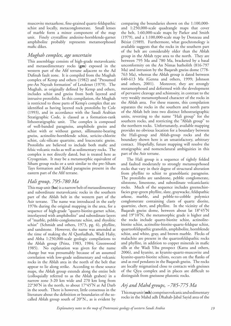
��Explanatory notes to the map of Proterozoic geology of western Saudi Arabia
muscovite metaarkose, fine-grained quartz-feldspathic schist and locally, metaconglomerate. Small lenses of marble form a minor component of the map unit. Finely crystalline andesine-hornblende-garnet amphibolite probably represents metamorphosed mafic dikes.
Mughah complex, age uncertainThis assemblage consists of high-grade metavolcanic and metasedimentary rocks (gm) exposed in the western part of the Afif terrane adjacent to the Ad Dafinah fault zone. It is compiled from the Mughah complex of Kemp and others (1982) and “Presumed pre-An Nayzah formation” of Letalenet (1979). The Mughah, as originally defined by Kemp and others, includes schist and gneiss from both layered and intrusive protoliths. In this compilation, the Mughah is restricted to those parts of Kemp’s complex that are identified as having layered rock protoliths by Cole (1993), and in accordance with the Saudi Arabian Stratigraphic Code, is classed as a formation-rank lithostratigraphic unit. The complex is composed of well-banded paragneiss, amphibole gneiss and schist with or without garnet, sillimanite-bearing gneiss, actinolite-hornblende schist, sericite-chlorite schist, calc-silicate quartzite, and leucocratic gneiss. Protoliths are believed to include both mafic and felsic volcanic rocks as well as sedimentary rocks. The complex is not directly dated, but is treated here as Cryogenian. It may be a metamorphic equivalent of Siham group rocks or a unit similar to the pre-Siham Tays formation and Kabid paragneiss present in the eastern part of the Afif terrane.
Hali group, ���-��0 MaThis map unit (ho) is a narrow belt of metasedimentary and subordinate metavolcanic rocks in the southern part of the Ablah belt in the western part of the Asir terrane. The name was introduced in the early 1970s during the original mapping in the area, for a sequence of high-grade “quartz-biotite-garnet schist, interlayered with amphibolite” and subordinate layers of “marble, pebble-conglomerate schist, and rhyolitic schist” (Schmidt and others, 1973, pg. 6), phyllite, and sandstone. However, the name was amended at the time of making the Al Qunfudhah, Wadi Haliy, and Abha 1:250,000-scale geologic compilations to the Ablah group (Prinz, 1983, 1984; Greenwood 1985). No explanation was given for the name change but was presumably because of an assumed correlation with low-grade sedimentary and volcanic rocks in the Ablah area in the north of the belt that appear to lie along strike. According to these source maps, the Ablah group extends along the entire belt (colloquially referred to as the Ablah graben) in a narrow zone 3-20 km wide and 270 km long from 22°30′N in the north, to about 17°45′N at Ad Darb in the south. There is however, little consensus in the literature about the definition or boundaries of the so-called Ablah group south of 20°N., as is evident by
comparing the boundaries shown on the 1:100,000- and 1:250,000-scale quadrangle maps that cover the belt, 1:60,000-scale maps by Parker and Smith (1979), and a 1:100,000-scale map by Donzeau and Béziat (1989). Furthermore, what geochronology is available suggests that the rocks in the southern part of the belt are considerably older than the Ablah group in the Ablah type area to the north. They are between 795 Ma and 780 Ma, bracketed by a basal unconformity on the An Nimas batholith (816-797 Ma) and intrusion by the Baqarah gneiss dome (778-763 Ma), whereas the Ablah group is dated between 640-613 Ma (Genna and others, 1999; Johnson and others, 2001). Moreover, they are strongly metamorphosed and deformed with the development of pervasive cleavage and schistosity, in contrast to the very weakly metamorphosed character of the rocks in the Ablah area. For these reasons, this compilation separates the rocks in the southern and north parts of the Ablah belt into two distinct lithostratigraphic units, reverting to the name “Hali group” for the southern rocks, and restricting the “Ablah group” to the northern rocks. Unfortunately, available mapping provides no obvious location for a boundary between the Hali-group and Ablah-group rocks and the boundary shown here is an unsatisfactory, arbitrary contact. Hopefully, future mapping will resolve the stratigraphic and nomenclatural ambiguities in this part of the Asir terrane.
The Hali group is a sequence of tightly folded and faulted moderately to strongly metamoprhosed rocks that vary in their degree of structural alteration from phyllite to schist to granoblastic paragneiss. The protoliths are sandstone, pebble conglomerate, silststone, limestone, and subordinate volcaniclastic rocks. Much of the sequence includes greenschist-facies gray-green phyllite, slate, graywacke, feldspathic arkose, marble, and pebble-to-cobble polymict conglomerate containing clasts of quartz diorite, quartzite, chert, and phyllite. In the vicinity of the Baqarah gneiss dome, between about lat 18°45′N and 19°10′N, the metamorphic grade is higher and the rocks include quartz-biotite schist, actinolite-biotite schist, actinolite-biotite-quartz-feldspar schist, quartzofeldspathic granofels, amphibolite, hornblende schist, and white, gray, and brown marble. Flecks of malachite are present in the quartzofeldspathic rocks and phyllite, in addition to copper minerals in mafic sills at the Wadi Yiba prospect (Kattu and others, 2006), and kyanite, as kyanite-quartz-muscovite and kyanite-quartz-biotite schists, occurs on the flanks of and as roof pendants in the Baqarah gneiss. The rocks are locally migmatized close to contacts with gneisses of the Qiya complex and in places are difficult to distinguish from gneissose plutonic rocks.
Arj and Mahd groups, ~���-��� MaThis map unit (mh) comprises volcanic and sedimentary rocks in the Mahd adh Dhahab-Jabal Sayid area of the
�0 Johnson, P.R., �006
Jiddah terrane. They are differentiated on the source map (Kemp and others, 1982) but combined here because of the map scale. The Arj group is probably the older of the two and is interpreted by Kemp and others (1982) to be unconformable beneath the Mahd group. The rocks are intruded by the Hufayriyah tonalite and Ram Ram complex, overthrust by the Bi’r Umq mafic-ultramafic complex, and yield a SHRIMP crystallization age of 775±5 Ma (Hargrove, 2006) consistent with an unreliable Rb-Sr age of 772±28 Ma obtained from Mahd group rhyolite (Calvez and Kemp, 1982) and with SHRIMP ages of 785±6 Ma, 769±6 Ma, and 749±10 Ma obtained from the Hufayriyah and Ram Ram rocks (Hargrove, 2006). The map unit is treated here as ~785-775 Ma.
The rocks include basaltic to andesitic lava and tuff, felsic tuff, quartz keratophyre and chert, limestone, sandstone, conglomerate, intrusive breccia , massive andesite, sandstone, siltstone, and conglomerate (Kemp and others, 1982; Afifi 1989). A distinctive polymict diamictite 1-5 m thick composed of matrix-supported angular to subangular clasts of Dhukhr-batholith, granitic, and felsic volcanic rocks in a dark-gray, immature, arkosic matrix type is at the base of the Mahd group south of Mahd adh Dhahab, and may be a Neoproterozoic glacial deposit (Stern and others, 2006) (Fig. 12). The rest of the group consists of tholeiitic to calc-alkalic basalt, basaltic andesite,
andesite, dacite, and rhyolite lavas and pyroclastic rocks, some of which were deposited in a subaerial environment, subordinate sandstone, siltstone, pebble conglomerate, and minor limestone. The rocks are economically important as the host for the Jabal Sayid and Umm ad Damar volcanic-massive sulfide deposits and the Mahd adh Dhahab epithermal gold deposit.
Figure 12. Diamictite at the base of the Mahd group, 12 km southwest of Mahd adh Dhahab. The diamictite consists of angular clasts of diorite, tonalite, granodiorite, felsic, flow-banded felsic lava, and felsic tuff supported in coarse-grained matrix of pebble and sand sized clasts. The diamictite is unconformable on the Dhukhr tonalite, and contains abundant tonalite clasts close to the contact. The diamictite is a possible candidate as a Sturtian glacial deposit.
Zibarah group, age uncertainThis name was used by Johnson (2005e) for five structurally conformable, isoclinally folded, schistose formations of greenschist- to amphibolite-grade metasedimentary and metavolcanic rocks that crop out along the Fatima shear zone, in the western part of the Jiddah terrane (zf). The lithologic layering in the rocks may reflect original bedding, but the intensity of deformation and the likelihood that the rocks were affected by bedding transposition preclude the simple assumption that the layering is primary bedding or that the sequence of the formations is the original stratigraphic sequence. On the Makkah quadrangle geologic source map (Moore and Al-Rehaili, 1989), only two of the formations (the Madiq and Jumum formations) are assigned to the Zibarah group, and the other three formations (Kashab, Bahrah, and Sulayman formations) are assigned to the Samran group because of lithologic similarities to layered rocks in the Jabal Samran area. However, the Fatima shear zone is a region of concentrated strain, which reflects unknown, but possibly significant, amounts of strike- and dip-slip displacement, and structurally isolates the shear-zone rocks from other layered rocks in the region. Because of this, correlation of the Kashab, Bahrah, and Sulayman formations with the Samran group is suspect, and all five formations along the fault zone are reassigned to the Zibarah group. The age of the group
is unknown and it is estimated here to beearly Cryogenian. The group includes massive, to well-bedded, to schistose basalt, andesite, and mafic tuffs; subordinate dacite, rhyolite, greenstone, greenschist; and schistose sedimentary rocks such as sericite-chlorite schist, chlorite schist, quartz-feldspar-sericite-chlorite schist, epidote-tremolite and actinolite-chlorite schist. Locally, the epiclastic rocks include poorly sorted, medium- to coarse-grained, cross-bedded and ripple-marked sandstone and massive graywacke containing pebbles and small cobbles of greenstone, beds of coarse-pebble to small-boulder conglomerate, and marble. The axis of the Fatima shear zone is characterized by amphibolite, quartzofeldspathic schist, and
paragneiss interlayered with calc-silicate rock, marble, garnetiferous metaquartzite, and banded biotite-quartz-feldspar paragneiss. These rocks grade into migmatite adjacent to intrusion of granite gneiss. Lavas in the group are calc-alkalic and subordinate tholeiitic, and are interpreted as products of a maturing island-arc (Tawfiq and Al-Shanti, 1983).

��Explanatory notes to the map of Proterozoic geology of western Saudi Arabia
Zaam group, �60-��0 MaThis group (za) (Davies and McEwen, 1985) crops out in the southwestern part of the Midyan terrane, south of the Qazaz shear zone. Neither base nor top of the group is known. The group is not precisely dated. It is intruded by the Muwaylih suite (725-710 Ma) and SHRIMP dating of clasts and matrix in Zaam group diamictite (A.A. Kamal, written communication, 2006) suggests that the group is younger than 760 Ma and SHRIMP dating of felsic tuffs close to the Yanbu suture (Kennedy and others, 2004, 2005) indicate crystallization ages of 711±10 Ma and 708±4 Ma. The group is treated here as a Cryogenian assemblage deposited between 760 and 710 Ma. The rocks are folded and faulted, locally strongly, and are metamorphosed to the greenschist facies. Typical rock types include crudely bedded to massive and pillowed basalt and andesite (Fig. 13), mafic tuff and agglomerate, dacitic and rhyolitic flows and tuffs, massive to well bedded volcaniclastic sandstone or lithic arenite, siltstone, shale, pyritic and graphitic shale, black chert, and minor limestone
Figure 13. Pillow basalt, Zaam group. Photograph of an exposure of steeply dipping basalt (looking south) in which the pillow shape indicates stratigraphic top is to the left (east).and marble. Graded bedding, load casts, and slump structures are common. A distinctive rock type is diamictite composed of small angular fragments of quartz and feldspar, isolated well-rounded pebbles, cobbles, and boulders of sandstone, rhyolite, limestone, and granite, and rafts up to several tens of meters across of sandstone, limestone and limestone breccia floating in massive argillaceous sediment. The formation is between 1000 m and 4500 m thick. It is interpreted by Davies and McEwen (1985) as an olistrostome, but is a strong candidate as a glacial diamictite (tillite) deposited during the Sturtian glacial event, comparable to the Atud formation diamictite in Egypt and similar rocks in Ethiopia (A.A.Kamal, written communication, 2006; Stern and others, 2006). Adjacent to the Qazaz shear zone, the group crops out as garnet-muscovite-sericite-quartz schist and garnet-amphibole-chlorite-quartz-feldspar schist.
Bayda group, age uncertainAs compiled here, the Bayda group (ba) (Frets and
others, 1981) refers to the volcanic and sedimentary assemblage exposed in the Midyan terrane, north of the Qazaz shear zone and northwest Hudayrah-Jabal Ess fault zone (the suture between the Midyan and Hijaz terranes). The group is not directly dated, but is inferred to be a Cryogenian assemblage younger than the Neoproterozoic oceanic crust in the area represented by the Jabal Ess ophiolites (about 780 Ma) and older than the Muwaylih suite of intrusive rocks (about 725-710 Ma). Neither base nor top of the group is exposed, and its thickness is unknown. The group is mostly moderately deformed, and weakly to moderately metamorphosed, reaching greenschist facies in places (Fig. 14).
The group contains an abundance of volcanic rocks.
Mafic volcanic rocks mostly crop out in the northwest, inland from Duba and between Shaghab and Harrat ‘Uwayrid; felsic volcanic rocks are common elsewhere. The mafic rocks consist of andesitic tuffs, breccias, and massive lavas, and basaltic sills and dikes. The felsic rocks include rhyolite porphyry, dacite, trachyte flows, thickly bedded lithic, lapilli, and welded ash-flow tuffs, and volcanic conglomerate and breccia. Sedimentary rocks are conspicuous in the central and eastern parts of the Bayda group outcrop area, and consist of interbedded sandstone and shale, in beds 1 cm-30 m thick, forming sandstone-shale units up to 1000 m thick, subordinate andesitic and felsic tuff, and purple sandstone, siltstone, and polymict conglomerate containing subrounded pebbles and cobbles of mafic and felsic volcanic rocks and granite. East and southeast of Bi’r al Bayda, the formation includes as much as 8000 m of lithic arenite and siltstone well-bedded in depositional units 10-30 cm thick, pebbly, well-bedded to massive volcaniclastic rocks, and local limestone. Sedimentary structures such as cross bedding, ripples, graded bedding, and mud cracks, and load casts are common. A magnetite-rich banded-iron formation is locally present in the vicinity of Shaghab.
Figure 14. Thinly bedded, moderately folded sandstone of the Cryogenian Bayda group (middle distance), in the northwestern part of the Arabian shield, intruded by granite of the Ediacaran Qazaz granite super suite (background).

�� Johnson, P.R., �006
Ghamr group, ~��0 MaThe Ghamr group (gk) (Kemp and others, 1982) consists of low-grade volcanic and sedimentary rocks in the eastern part of the Jiddah terrane. The rocks are unconformable on the Hufayriyah tonalite (760 Ma), and yield an Rb-Sr whole-rock isochron age of 748±22 Ma (Calvez and others, 1983) from a subvolcanic intrusion that is consistent with this relationship. They are treated here as middle Cryogenian. The tectonic setting of the group is uncertain. The geologic source map (Kemp and others, 1982) places a regionally extensive unconformity between the Mahd and Ghamr groups, which suggests that it may be a postamalgamation-basin deposit. However, Hopwood (1979) argues that observed unconformable contacts between the groups are of local extent only and the product of local instability in a volcanic basin, which implies that the group is one of the terrane-forming assemblages of the Jiddah terrane.
The group includes polymict conglomerate containing volcanic clasts supposedly derived from the Mahd group and granite clasts derived from the Ram Ram complex; coarse-grained epiclastic sandstones; rhyolite and dacite lava flows, tuffite, volcanic breccia, and conglomerate; and subordinate basalt, basaltic-andesite and andesite lava flows, breccia, and tuffite. The rocks are only moderately deformed, and stratigraphic relationships within the group are clearly evident.
Siham group, ��0-6�� MaThe Siham group (si) (Agar, 1985) is a low-grade (upper greenschist facies) assemblage of volcanic and sedimentary rocks in the southwestern and southern parts of the Afif terrane. It crops out as a north-trending belt of rocks east of Zalm (the reference area of the group; Agar, 1985), and as roof pendants in the Haml batholith (Thieme, 1988). As compiled here, it also includes layered rocks in the Wadi ar Rika quadrangle that were assigned by Delfour (1980) to the Hulayfah group but are reassigned to the Siham group on the basis of contacts extrapolated north from the Jabal Khida quadrangle. In common with many exposures of low-grade volcanosedimentary rocks in the Arabian shield, the rocks of the group were variously assigned, in earlier mapping projects, to the Halaban formation (USGS-ARAMCO, 1963), the Halaban group (Brown and others, 1989), and the Hulayfah group, but were renamed during compilation of the Zalm and Jabal Khida 1:250,000-scale source maps. The age of the group is not well constrained. Doebrich and others (2004) report a SHRIMP age of 685±3 Ma for rhyodacite porphyry in the Ad Duwayh area, but Agar and others (1992) concluded that Siham-arc magmatism ranged from 750 to about 695 Ma. Available geochronology indicates that possible Siham-arc related intrusive rocks are as old as 756±6 Ma (Whitehouse and others, 2001) with clusters of ages between 756-746 Ma and 706-696 Ma. Metamorphosed Siham-group rocks
are intruded by the Naim complex (746±10 Ma; Agar and others, 1992), suggesting that parts of the group may be older than 745 Ma. It is treated here as middle Cryogenian, between 750 Ma and 685 Ma. Future work may well divide the rocks into separate older (~754 Ma) and younger (~700 Ma) groups.
The Siham group consists of andesite, basalt, rhyolite, shale, lithic sandstone, conglomerate, quartzite, and marble. The proportions and thicknesses of these rocks vary from locality to locality, in a manner that is interpreted by Agar (1985) to reflect a cross-section from deep water in the west to a shallow continental margin in the east. He models the group as a volcanic assemblage deposited above an east-dipping subduction zone in an eastward shallowing basin that grades from oceanic and volcanic in the west to continental-margin and sedimentary in the east, abutting a continental plate made up of continental rocks of the Tays formation, Kabid paragneiss, and Surayhah complex.
The group is mostly moderately deformed, but is locally schistose and caught up in thrusting.
Al Qunnah formation, >��� MaThis is a unit of strongly deformed and schistose volcanic and volcaniclastic rocks (aq) (Pellaton, 1982a,b) in the southeastern part of the Midyan terrane that is possibly correlative to the Zaam group. It crops out as screens and roof pendants in the western part of the Jar-Salajah batholith (±745 Ma) and Nabt complex inland from Umm Lajj, and is therefore older than ±745 Ma. It includes massive and pillowed basalt and andesite flows; rhyolite tuff and breccia; subordinate volcanic sandstone (graywacke), and minor chert, and is locally metamorphosed to amphibolite and mica schist.
Khadra belt volcanic and sedimentary rocks, ~���-��0 MaThe Khadra belt (Greenwood and others, 1982) is a north-trending zone of highly strained and metamorphosed layered rocks exposed in the eastern part of the Asir terrane, between the Junaynah and Nabitah fault zones. The rocks in the belt are intruded by the Tarib batholith and, together with the batholith, are referred to as the Tarib arc (Stoeser and Stacey, 1988). They are directly dated by an Rb-Sr whole-rock isochron of 746±16 Ma (Fleck and others, 1980), which is consistent with their intrusion by the Tarib batholith (730 Ma), and they are treated here as middle Cryogenian, possibly 745-730 Ma.
The belt contains volcanic and sedimentary rocks (ktv) and amphibolite (kta) (Greenwood, 1985a); Greenwood and others, 1986). The former include andesite, dacite, pillow basalt, subordinate rhyolite, mafic and felsic tuffs, dioritic hypabyssal intrusions, polymict conglomerate with pebble to boulder clasts of plutonic as well as volcanic and sedimentary rocks, coarse-grained, pebbly volcaniclastic graywacke,
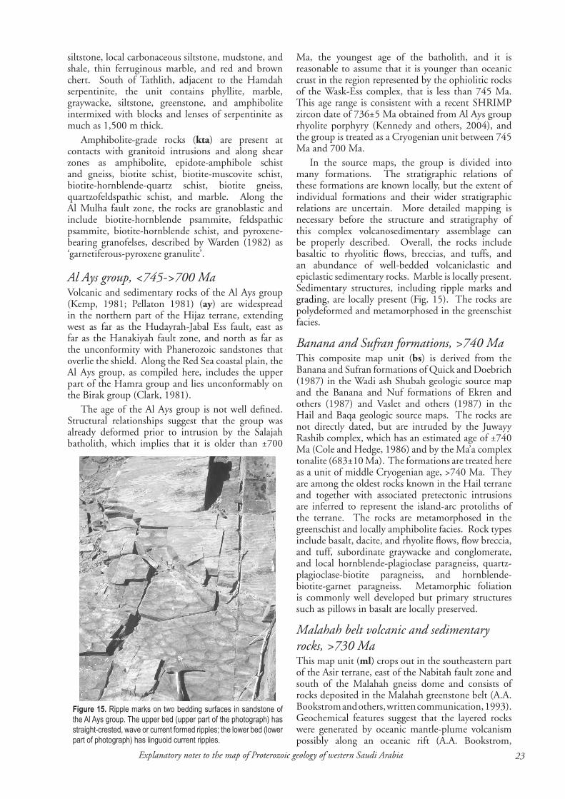
��Explanatory notes to the map of Proterozoic geology of western Saudi Arabia
siltstone, local carbonaceous siltstone, mudstone, and shale, thin ferruginous marble, and red and brown chert. South of Tathlith, adjacent to the Hamdah serpentinite, the unit contains phyllite, marble, graywacke, siltstone, greenstone, and amphibolite intermixed with blocks and lenses of serpentinite as much as 1,500 m thick.
Amphibolite-grade rocks (kta) are present at contacts with granitoid intrusions and along shear zones as amphibolite, epidote-amphibole schist and gneiss, biotite schist, biotite-muscovite schist, biotite-hornblende-quartz schist, biotite gneiss, quartzofeldspathic schist, and marble. Along the Al Mulha fault zone, the rocks are granoblastic and include biotite-hornblende psammite, feldspathic psammite, biotite-hornblende schist, and pyroxene-bearing granofelses, described by Warden (1982) as ‘garnetiferous-pyroxene granulite’.
Al Ays group, <���->�00 MaVolcanic and sedimentary rocks of the Al Ays group (Kemp, 1981; Pellaton 1981) (ay) are widespread in the northern part of the Hijaz terrane, extending west as far as the Hudayrah-Jabal Ess fault, east as far as the Hanakiyah fault zone, and north as far as the unconformity with Phanerozoic sandstones that overlie the shield. Along the Red Sea coastal plain, the Al Ays group, as compiled here, includes the upper part of the Hamra group and lies unconformably on the Birak group (Clark, 1981).
The age of the Al Ays group is not well defined. Structural relationships suggest that the group was already deformed prior to intrusion by the Salajah batholith, which implies that it is older than ±700
Figure 15. Ripple marks on two bedding surfaces in sandstone of the Al Ays group. The upper bed (upper part of the photograph) has straight-crested, wave or current formed ripples; the lower bed (lower part of photograph) has linguoid current ripples.
Ma, the youngest age of the batholith, and it is reasonable to assume that it is younger than oceanic crust in the region represented by the ophiolitic rocks of the Wask-Ess complex, that is less than 745 Ma. This age range is consistent with a recent SHRIMP zircon date of 736±5 Ma obtained from Al Ays group rhyolite porphyry (Kennedy and others, 2004), and the group is treated as a Cryogenian unit between 745 Ma and 700 Ma.
In the source maps, the group is divided into many formations. The stratigraphic relations of these formations are known locally, but the extent of individual formations and their wider stratigraphic relations are uncertain. More detailed mapping is necessary before the structure and stratigraphy of this complex volcanosedimentary assemblage can be properly described. Overall, the rocks include basaltic to rhyolitic flows, breccias, and tuffs, and an abundance of well-bedded volcaniclastic and epiclastic sedimentary rocks. Marble is locally present. Sedimentary structures, including ripple marks and grading, are locally present (Fig. 15). The rocks are polydeformed and metamorphosed in the greenschist facies.
Banana and Sufran formations, >��0 MaThis composite map unit (bs) is derived from the Banana and Sufran formations of Quick and Doebrich (1987) in the Wadi ash Shubah geologic source map and the Banana and Nuf formations of Ekren and others (1987) and Vaslet and others (1987) in the Hail and Baqa geologic source maps. The rocks are not directly dated, but are intruded by the Juwayy Rashib complex, which has an estimated age of ±740 Ma (Cole and Hedge, 1986) and by the Ma’a complex tonalite (683±10 Ma). The formations are treated here as a unit of middle Cryogenian age, >740 Ma. They are among the oldest rocks known in the Hail terrane and together with associated pretectonic intrusions are inferred to represent the island-arc protoliths of the terrane. The rocks are metamorphosed in the greenschist and locally amphibolite facies. Rock types include basalt, dacite, and rhyolite flows, flow breccia, and tuff, subordinate graywacke and conglomerate, and local hornblende-plagioclase paragneiss, quartz-plagioclase-biotite paragneiss, and hornblende-biotite-garnet paragneiss. Metamorphic foliation is commonly well developed but primary structures such as pillows in basalt are locally preserved.
Malahah belt volcanic and sedimentary rocks, >��0 MaThis map unit (ml) crops out in the southeastern part of the Asir terrane, east of the Nabitah fault zone and south of the Malahah gneiss dome and consists of rocks deposited in the Malahah greenstone belt (A.A. Bookstrom and others, written communication, 1993). Geochemical features suggest that the layered rocks were generated by oceanic mantle-plume volcanism possibly along an oceanic rift (A.A. Bookstrom,
�� Johnson, P.R., �006
written communication, 1993). Individual lithologic units in the belt have faulted contacts and their original stratigraphic relationships are uncertain. Bookstrom and others (1989) model a pseudostratigraphy in the southern part of the Malahah basin, created by bedding transposition, and a similar process likely affected the layered rocks elsewhere in the region. A.A. Bookstrom and his colleagues (written communication, 1993) are working on establishing a succession and introducing named formations and a Malahah Supergroup. The layered rocks in the Malahah belt are not directly dated but are indirectly dated by intrusion of the Tarib batholith, and they are therefore older than about 730 Ma.
Mafic volcanic rocks are common in the northeastern part of the belt, in the vicinity of Wadi Wassat, comprising a sequence of basaltic and andesitic flows, breccias, agglomerates, and tuffs, interbedded with volcaniclastic graywacke, sandstone, and shale. To the southwest, dacitic flows and pyroclastic rocks and diabase sills and dikes are significant components of the assemblage, and in the south felsic pyroclastic and volcaniclastic rocks, largely metamorphosed to quartzofeldspathic sericite schist and chlorite-sericite schist, interlayered with pyritic carbonaceous graywacke and phyllite are abundant. Locally the rocks form amphibolite-grade paraschist and paragneiss. The volcaniclastic beds are locally graded and probably many were deposited as turbidites. The Malahah-belt assemblage is important as the host of large massive pyrite deposits (e.g. Wadi Wassat) and polymetallic VMS deposits (e.g. Al Masane).
Sarjuj formation, age uncertainThe Sarjuj formation (sj) (Al-Muallem, 1987) crops out in the northern part of the Asir terrane, adjacent to the Ruwah fault zone at the contact with the Afif terrane. It is locally strongly deformed and contains S/C shear fabrics indicating a sinistral sense of movement (Johnson and Kattan, 2001). The formation is not directly dated and its relative age is uncertain because the formation only has fault contacts with other map units. It is estimated here to be middle Cryogenian or older. Basalt and andesite flows, agglomerate, and volcanic breccia predominate. The flow rocks are mainly fine grained; porphyritic lava is rare. Agglomerate consists of andesite, basalt, and dacite fragments as much as 25 cm across in an andesitic matrix. Subordinate interbeds consist of felsic ash tuff, siltstone, and volcanic cobble-clast conglomerate, and rare flow-banded rhyolite and dacite lava.
Hulayfah group, >��0 MaOn the source maps, this name (Delfour, 1977) is applied to volcanosedimentary rocks exposed across a large part of the northeastern Arabian shield. However, as discussed in the section on Lithostratigraphic Revision, the name is used here in a restricted sense, and is applied to an assemblage of
low-grade metavolcanic and metasedimentary rocks exposed between the Hulayfah fault zone and Harrat Khaybar (hu), west of the Afif terrane. The group is tentatively interpreted as a separate terrane between the Afif and Hijaz terranes. The age of the group is poorly constrained, but on the basis of intrusion of the group by granite and granodiorite is inferred to be older than 720 Ma (Calvez and others, 1983). The group consists of greenschist-facies basalt, andesite, dacite, rhyolite, tuffs, sandstone, shale, and small lenses of limestone.
Milhah formation, >��� MaThe Milhah formation (mz) (Camp, 1986) crops out in the southern part of the Hijaz terrane as a mafic volcanic unit that appears to unconformably overlie the Birak group. The contact between the Milhah formation and Birak group is not well exposed, and the two may be correlative, or superimposed or, alternatively, the Milhah formation may be part of the younger Furayh group. The formation is intruded by the Shufayyah complex (c. 715 Ma) and is therefore older than about 715 Ma. The formation consists of massive basalt, subordinate rhyolite subvolcanic intrusions, sandstone, shale, conglomerate, mafic tuff, and minor limestone.
Ghawjah formation, >��0 MaThe Ghawjah formation (gj) (Davies and Grainger, 1985) crops out in the northwestern part of the Midyan terrane as a succession of low-grade metavolcanic and metasedimentary rocks exposed on either side of Wadi Ghawjah, inland from Al Muwaylih. It is compiled by Davies and Grainger (1985) on the Al Muwaylih 1:250,000-scale geologic source map as part of the Zaam group, but the formation is not in contact with the Zaam group, and for the purpose of this compilation is shown as a separate formation. Neither base nor top of the formation is exposed. It is intruded by the Muwaylih suite (725-710 Ma), and is therefore at least older than 710 Ma, but its maximum age is unknown. The main rock types are massive porphyritic andesitic flows with interbeds of dacite, thin felsic tuffs and quartz latite, and wacke. Basaltic and andesitic breccia and agglomerate are subordinate. Layering and graded bedding in the wacke are well preserved although metamorphism has destroyed many diagnostic volcanic features. The rocks are metamorphosed to the greenschist facies, locally to amphibolite facies and, adjacent to some faults, are strongly foliated biotite-chlorite schist.
Hegaf formation, >��0 MaThe Hegaf formation (ga) (Sahl, 1981; Clark, 1987) crops out in the northwestern part of the Midyan terrane and, like the Ghawjah, Silasia, and Zaytah formations, is one of a number of discontinuous, though possibly broadly correlative, volcanosedimentary successions in the terrane. It is possibly equivalent to the Ghawjah

��Explanatory notes to the map of Proterozoic geology of western Saudi Arabia
formation, and is intruded by plutons of the Muwaylih suite (725-710 Ma, suggesting that it is 710 Ma or older. It is conformably overlain by the Silasia formation and unconformably overlain by the Amlas formation. The formation is a volcanic, volcaniclastic, and sedimentary succession that is predominantly volcanic in the south and mixed volcaniclastic and epiclastic in the north. Common rock types include mafic and felsic tuffs, andesite, basalt, minor rhyolite, agglomerate, siltstone, limestone, and chert. The rocks are folded and faulted, locally strongly, and are metamorphosed to the greenschist, and locally higher, facies represented by amphibolite, mafic schist, quartz-feldspathic mica schist, and calc-silicate rock. Pillow basalt is abundant in the eastern exposures and a minor iron formation occurs in the south.
Silasia formation, >��0 MaThe Silasia formation (sl) (Bouge, 1953) is a sedimentary-volcaniclastic succession in the northern Midyan terrane characterized by banded-iron formation. It appears to be conformable on the Ghawjah formation, to the south, and the Hegaf formation, to the north (Davies and Grainger, 1985; Clark, 1987). The formation is not directly dated, but is intruded by the Muwaylih suite (725-710 Ma) and is therefore inferred to be a Cryogenian assemblage, 710 Ma or older. The top of the formation is not exposed. The exposed thickness of the formation is estimated to be about 1160 m in the Wadi Sawawin reference area. The rocks are folded and faulted, locally strongly, and are metamorphosed to the greenschist facies. In Wadi Sawawin, the formation consists of tuffaceous sedimentary rocks and tuffs at the base; an intermediate unit of jaspilitic iron formation and ferruginous tuffs; and an upper sequence of tuffs, tuffite, and tuffaceous sedimentary rocks. The formation is intruded by subconcordant sills of metadiabase as much as 100 m thick and several kilometers long. The origin of the Silasia banded-iron formation is unresolved. It is noteworthy that the Silasia formation is middle Cryogenian, and is conceivably contemporary with the Sturtian “snowball” glaciation event (730 Ma), which elsewhere in the world is causally related to the Neoproterozoic reappearance of banded-iron formations (Goddéris and others, 2003; Hoffman and Schrag, 2002; Stern and others, 2006). Sedimentary structures such as grading and fluid-escape structures are abundant, and give unequivocal information about the stratigraphic top of the succession. At Wadi Sawawin, the banded-iron formation makes up a series of deposit containing as much as 428 million tones (Mt) iron-ore, the largest of which, Deposit 3, contains 96 Mt grading 42.5 percent Fe (Collenette and Grainger, 1994).
Zaytah formation, age uncertainThe Zaytah formation (zy) (Clark, 1987), which crops out in the northern part of the Midyan terrane, is a succession of metamorphosed felsic lava and
tuff, tuffite, graywacke, and mafic and felsic schist. Neither base nor top of the formation is exposed and its relationships with other layered rocks in the shield are obscured by intrusions. It is possibly broadly correlative with the Silasia and Hegaf formations, which if correct implies an age of >710 Ma. The rocks are metamorphosed to the greenschist facies and moderately to strongly folded and faulted.
Amlas formation, age uncertainThe Amlas formation (am) (Clark, 1987) crops out in the northern part of the Midyan terrane as a 60-km long belt of sedimentary and subordinate volcanic rocks partly bounded, north and south, by ultramafic-decorated fault zones. The formation is not directly dated. It unconformably overlies the Hegaf formation, is locally overlain by Ediacaran rhyolite, and is intruded by the Ifal suite and Atiyah monzogranite of the Marabit suite, which suggests that it was deposited some time between about 710 Ma and 625 Ma. It is treated here as a late Cryogenian rock unit. The formation comprises conglomerate and sedimentary breccia, immature sandstone, graywacke, siltstone, shale and minor amounts of quartzite. Subordinate lithologies, mainly developed toward the top of the succession, include andesite, felsic tuff, and porphyritic felsite. The sequence is about 200 m thick, and the rocks are metamorphosed to the lower to middle greenschist facies. Argillaceous rocks are commonly present as slate and phyllite, and locally as schist. The rocks are strongly folded and locally overturned. The tectonic setting of the formation is uncertain: it may be a late terrane-forming unit of the Midyan terrane or an early postamalgamation deposit.
Hinshan formation, age uncertainThe Hinshan formation (hs) (Rowaihy, 1985) crops out east of Haql in the extreme northwestern part of the Arabian shield. Neither top nor bottom is exposed and because of faulting, its stratigraphic relationship to other layered rocks in the shield is unknown. The formation is not directly dated, but is inferred to be younger than the Hegaf and Silasia formations and possibly equivalent to the Amlas formation (Rowaihy, 1985). Like the Amlas, the tectonic setting of the formation is uncertain; it may be terrane-forming or a postamalgamation-basin deposit. The formation consists of intermediate to felsic volcanic and sedimentary rocks, metamorphosed to the greenschist facies, and includes andesitic lava and tuffs, rhyolitic flow rock and welded tuff, subordinate basalt, and well-bedded and locally graded wacke, siltstone, and shale.
Ash Sha’ib group, age uncertainThis name was introduced by Johnson (2005a) as a composite lithostratigraphic term for metavolcanic and metasedimentary rocks (sb) east of the Nabitah fault zone exposed in a belt trending south from the Ruwah fault zone to the Ash Sha’ib area. The rocks
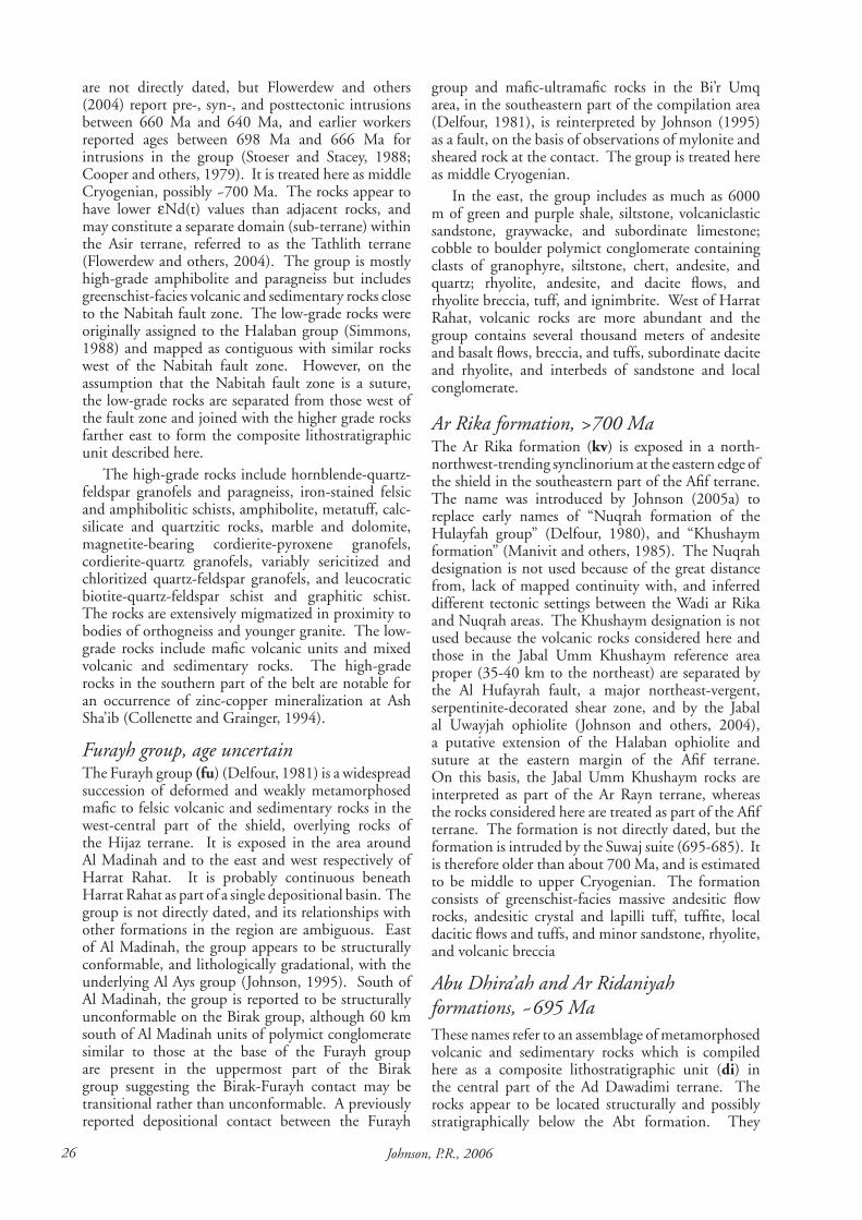
�6 Johnson, P.R., �006
are not directly dated, but Flowerdew and others (2004) report pre-, syn-, and posttectonic intrusions between 660 Ma and 640 Ma, and earlier workers reported ages between 698 Ma and 666 Ma for intrusions in the group (Stoeser and Stacey, 1988; Cooper and others, 1979). It is treated here as middle Cryogenian, possibly ~700 Ma. The rocks appear to have lower εNd(t) values than adjacent rocks, and may constitute a separate domain (sub-terrane) within the Asir terrane, referred to as the Tathlith terrane (Flowerdew and others, 2004). The group is mostly high-grade amphibolite and paragneiss but includes greenschist-facies volcanic and sedimentary rocks close to the Nabitah fault zone. The low-grade rocks were originally assigned to the Halaban group (Simmons, 1988) and mapped as contiguous with similar rocks west of the Nabitah fault zone. However, on the assumption that the Nabitah fault zone is a suture, the low-grade rocks are separated from those west of the fault zone and joined with the higher grade rocks farther east to form the composite lithostratigraphic unit described here.
The high-grade rocks include hornblende-quartz-feldspar granofels and paragneiss, iron-stained felsic and amphibolitic schists, amphibolite, metatuff, calc-silicate and quartzitic rocks, marble and dolomite, magnetite-bearing cordierite-pyroxene granofels, cordierite-quartz granofels, variably sericitized and chloritized quartz-feldspar granofels, and leucocratic biotite-quartz-feldspar schist and graphitic schist. The rocks are extensively migmatized in proximity to bodies of orthogneiss and younger granite. The low-grade rocks include mafic volcanic units and mixed volcanic and sedimentary rocks. The high-grade rocks in the southern part of the belt are notable for an occurrence of zinc-copper mineralization at Ash Sha’ib (Collenette and Grainger, 1994).
Furayh group, age uncertainThe Furayh group (fu) (Delfour, 1981) is a widespread succession of deformed and weakly metamorphosed mafic to felsic volcanic and sedimentary rocks in the west-central part of the shield, overlying rocks of the Hijaz terrane. It is exposed in the area around Al Madinah and to the east and west respectively of Harrat Rahat. It is probably continuous beneath Harrat Rahat as part of a single depositional basin. The group is not directly dated, and its relationships with other formations in the region are ambiguous. East of Al Madinah, the group appears to be structurally conformable, and lithologically gradational, with the underlying Al Ays group (Johnson, 1995). South of Al Madinah, the group is reported to be structurally unconformable on the Birak group, although 60 km south of Al Madinah units of polymict conglomerate similar to those at the base of the Furayh group are present in the uppermost part of the Birak group suggesting the Birak-Furayh contact may be transitional rather than unconformable. A previously reported depositional contact between the Furayh
group and mafic-ultramafic rocks in the Bi’r Umq area, in the southeastern part of the compilation area (Delfour, 1981), is reinterpreted by Johnson (1995) as a fault, on the basis of observations of mylonite and sheared rock at the contact. The group is treated here as middle Cryogenian.
In the east, the group includes as much as 6000 m of green and purple shale, siltstone, volcaniclastic sandstone, graywacke, and subordinate limestone; cobble to boulder polymict conglomerate containing clasts of granophyre, siltstone, chert, andesite, and quartz; rhyolite, andesite, and dacite flows, and rhyolite breccia, tuff, and ignimbrite. West of Harrat Rahat, volcanic rocks are more abundant and the group contains several thousand meters of andesite and basalt flows, breccia, and tuffs, subordinate dacite and rhyolite, and interbeds of sandstone and local conglomerate.
Ar Rika formation, >�00 MaThe Ar Rika formation (kv) is exposed in a north-northwest-trending synclinorium at the eastern edge of the shield in the southeastern part of the Afif terrane. The name was introduced by Johnson (2005a) to replace early names of “Nuqrah formation of the Hulayfah group” (Delfour, 1980), and “Khushaym formation” (Manivit and others, 1985). The Nuqrah designation is not used because of the great distance from, lack of mapped continuity with, and inferred different tectonic settings between the Wadi ar Rika and Nuqrah areas. The Khushaym designation is not used because the volcanic rocks considered here and those in the Jabal Umm Khushaym reference area proper (35-40 km to the northeast) are separated by the Al Hufayrah fault, a major northeast-vergent, serpentinite-decorated shear zone, and by the Jabal al Uwayjah ophiolite (Johnson and others, 2004), a putative extension of the Halaban ophiolite and suture at the eastern margin of the Afif terrane. On this basis, the Jabal Umm Khushaym rocks are interpreted as part of the Ar Rayn terrane, whereas the rocks considered here are treated as part of the Afif terrane. The formation is not directly dated, but the formation is intruded by the Suwaj suite (695-685). It is therefore older than about 700 Ma, and is estimated to be middle to upper Cryogenian. The formation consists of greenschist-facies massive andesitic flow rocks, andesitic crystal and lapilli tuff, tuffite, local dacitic flows and tuffs, and minor sandstone, rhyolite, and volcanic breccia
Abu Dhira’ah and Ar Ridaniyah formations, ~6�� MaThese names refer to an assemblage of metamorphosed volcanic and sedimentary rocks which is compiled here as a composite lithostratigraphic unit (di) in the central part of the Ad Dawadimi terrane. The rocks appear to be located structurally and possibly stratigraphically below the Abt formation. They
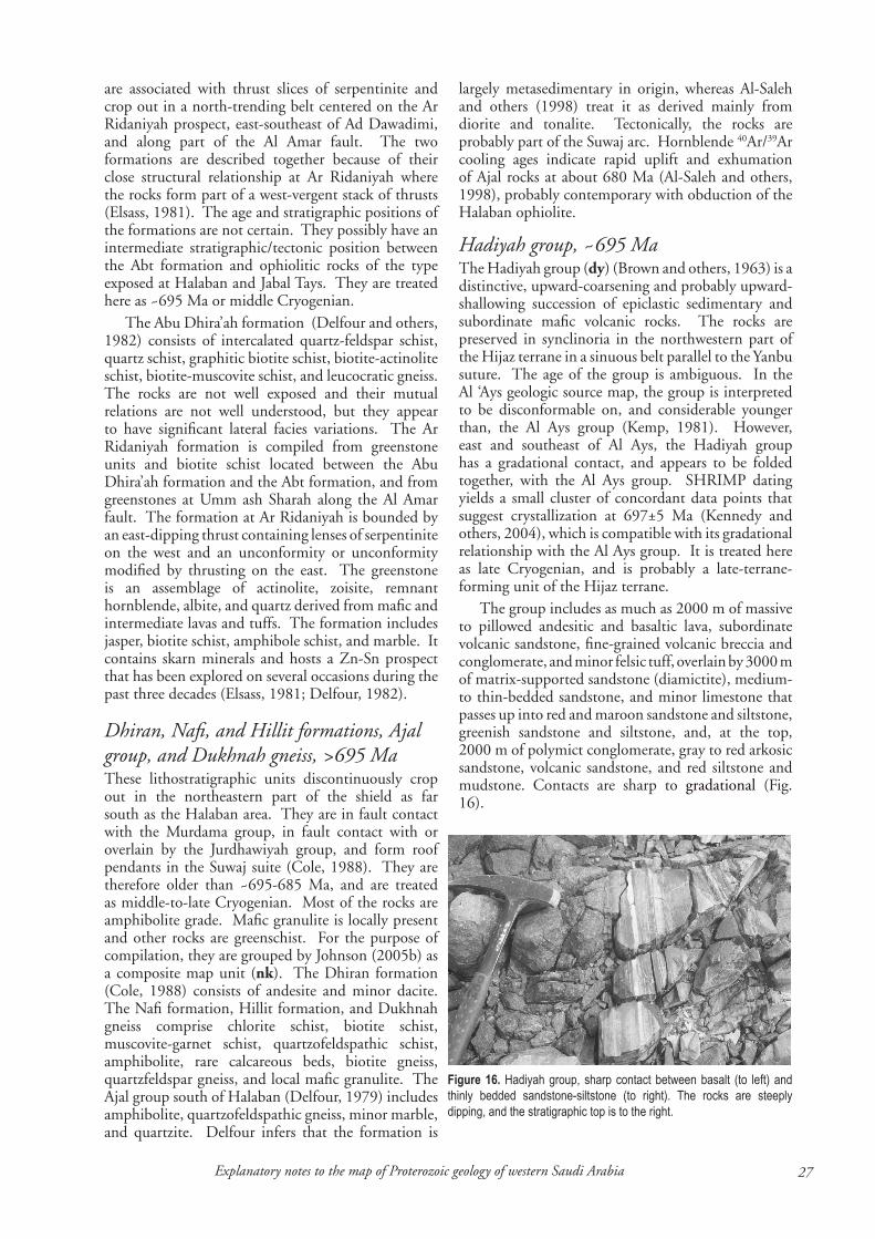
��Explanatory notes to the map of Proterozoic geology of western Saudi Arabia
are associated with thrust slices of serpentinite and crop out in a north-trending belt centered on the Ar Ridaniyah prospect, east-southeast of Ad Dawadimi, and along part of the Al Amar fault. The two formations are described together because of their close structural relationship at Ar Ridaniyah where the rocks form part of a west-vergent stack of thrusts (Elsass, 1981). The age and stratigraphic positions of the formations are not certain. They possibly have an intermediate stratigraphic/tectonic position between the Abt formation and ophiolitic rocks of the type exposed at Halaban and Jabal Tays. They are treated here as ~695 Ma or middle Cryogenian.
The Abu Dhira’ah formation (Delfour and others, 1982) consists of intercalated quartz-feldspar schist, quartz schist, graphitic biotite schist, biotite-actinolite schist, biotite-muscovite schist, and leucocratic gneiss. The rocks are not well exposed and their mutual relations are not well understood, but they appear to have significant lateral facies variations. The Ar Ridaniyah formation is compiled from greenstone units and biotite schist located between the Abu Dhira’ah formation and the Abt formation, and from greenstones at Umm ash Sharah along the Al Amar fault. The formation at Ar Ridaniyah is bounded by an east-dipping thrust containing lenses of serpentinite on the west and an unconformity or unconformity modified by thrusting on the east. The greenstone is an assemblage of actinolite, zoisite, remnant hornblende, albite, and quartz derived from mafic and intermediate lavas and tuffs. The formation includes jasper, biotite schist, amphibole schist, and marble. It contains skarn minerals and hosts a Zn-Sn prospect that has been explored on several occasions during the past three decades (Elsass, 1981; Delfour, 1982).
Dhiran, Nafi, and Hillit formations, Ajal group, and Dukhnah gneiss, >6�� MaThese lithostratigraphic units discontinuously crop out in the northeastern part of the shield as far south as the Halaban area. They are in fault contact with the Murdama group, in fault contact with or overlain by the Jurdhawiyah group, and form roof pendants in the Suwaj suite (Cole, 1988). They are therefore older than ~695-685 Ma, and are treated as middle-to-late Cryogenian. Most of the rocks are amphibolite grade. Mafic granulite is locally present and other rocks are greenschist. For the purpose of compilation, they are grouped by Johnson (2005b) as a composite map unit (nk). The Dhiran formation (Cole, 1988) consists of andesite and minor dacite. The Nafi formation, Hillit formation, and Dukhnah gneiss comprise chlorite schist, biotite schist, muscovite-garnet schist, quartzofeldspathic schist, amphibolite, rare calcareous beds, biotite gneiss, quartzfeldspar gneiss, and local mafic granulite. The Ajal group south of Halaban (Delfour, 1979) includes amphibolite, quartzofeldspathic gneiss, minor marble, and quartzite. Delfour infers that the formation is
largely metasedimentary in origin, whereas Al-Saleh and others (1998) treat it as derived mainly from diorite and tonalite. Tectonically, the rocks are probably part of the Suwaj arc. Hornblende 40Ar/39Ar cooling ages indicate rapid uplift and exhumation of Ajal rocks at about 680 Ma (Al-Saleh and others, 1998), probably contemporary with obduction of the Halaban ophiolite.
Hadiyah group, ~6�� MaThe Hadiyah group (dy) (Brown and others, 1963) is a distinctive, upward-coarsening and probably upward-shallowing succession of epiclastic sedimentary and subordinate mafic volcanic rocks. The rocks are preserved in synclinoria in the northwestern part of the Hijaz terrane in a sinuous belt parallel to the Yanbu suture. The age of the group is ambiguous. In the Al ‘Ays geologic source map, the group is interpreted to be disconformable on, and considerable younger than, the Al Ays group (Kemp, 1981). However, east and southeast of Al Ays, the Hadiyah group has a gradational contact, and appears to be folded together, with the Al Ays group. SHRIMP dating yields a small cluster of concordant data points that suggest crystallization at 697±5 Ma (Kennedy and others, 2004), which is compatible with its gradational relationship with the Al Ays group. It is treated here as late Cryogenian, and is probably a late-terrane-forming unit of the Hijaz terrane.
The group includes as much as 2000 m of massive to pillowed andesitic and basaltic lava, subordinate volcanic sandstone, fine-grained volcanic breccia and conglomerate, and minor felsic tuff, overlain by 3000 m of matrix-supported sandstone (diamictite), medium- to thin-bedded sandstone, and minor limestone that passes up into red and maroon sandstone and siltstone, greenish sandstone and siltstone, and, at the top, 2000 m of polymict conglomerate, gray to red arkosic sandstone, volcanic sandstone, and red siltstone and mudstone. Contacts are sharp to gradational (Fig. 16).
Figure 16. Hadiyah group, sharp contact between basalt (to left) and thinly bedded sandstone-siltstone (to right). The rocks are steeply dipping, and the stratigraphic top is to the right.

�� Johnson, P.R., �006
Al Amar group, >6�0 MaThe Al Amar group (al) crops out in the Ar Rayn terrane in the eastern part of the shield, bounded by the Al Amar fault on the west and the Phanerozoic unconformity on the east. The rocks are variously named in earlier mapping projects as the Al Amar-Idsas group (BRGM, 1966), the Halaban group (Nawab, 1979), and the Hulayfah group (Delfour, 1979), but are referred to as the Al Amar group on the Ar Rayn 1:250,000-scale geologic source map (Vaslet and others, 1983). Stacey and others (1984) and Stoeser and Stacey (1988) suggested that the group is >670 Ma. Attempts at direct dating by the SHRIMP method failed because the rocks failed to yield datable zircons (Doebrich and others, 2005), but geochronologic data for plutonic rocks that intrude the group imply that the group is >690 Ma. It is treated here as upper Cryogenian. A 651±43 Ma whole-rock Rb-Sr age reported by Calvez and Delfour (1986) for Al Amar rhyolite is not considered a robust formation age as it may have been affected by subsequent heating events (Doebrich and others, 2005). The group is notable as hosting small VMS occurrences, epithermal gold deposits (for example, Al Amar mine), and a significant Zn occurrence (Khnaighyiah) (Doebrich and others, 2005). The rocks are commonly greenschist facies, but in the east are amphibolite-facies schist and paragneiss. Typical rock types include andesitic tuff and breccia, andesite flow rock, well-bedded andesitic and rhyolitic tuff, welded rhyolitic tuff, minor calcareous dolomite and siltstone, and pyritic chert. The higher grade rocks are phyllite, quartz-feldspar schist, biotite-amphibole schist, calc schist, amphibolite, amphibole and garnet-bearing paragneiss, and leucocratic quartz-feldspar gneiss. In places the metamorphosed rocks have lit-par-lit intrusions of tonalite and granodiorite, and grade into orthogneiss.
Fatima group, 6�0 MaThe Fatima group (ff) (Skiba and others, 1977) consists of lower greenschist facies volcanic and sedimentary rocks exposed in block-faulted synclines immediately north of the Fatima shear zone in the western part of the shield. Folds are tight, but the rocks are neither cleaved nor affected by ductile shearing or high-grade metamorphism, implying that the Fatima group was deposited and deformed subsequent to the main period of ductile deformation along the fault zone. The age of the group is constrained by a 4-point Rb-Sr whole-rock isochron of 681±25 Ma (Darbyshire and others, 1983) obtained from basalt, andesite, and rhyolite, indicating a late Cryogenian origin. Less reliable determinations are Rb-Sr errorchrons of 704±34 Ma (Darbyshire and others, 1983) and 675±17 Ma (Duyverman and others, 1982). The preferred formation age of Darbyshire and others (1983) is a composite 13-point formation age of 688±30 Ma obtained by combining data from the 681 Ma and 704 Ma results. K-Ar whole-rock ages of 592±23
Ma and 576±28 Ma (Brown and others, 1978) likely reflect resetting during emplacement of Ediacaran intrusives. The group is nonconformable on already deformed and metamorphosed rocks of the Jiddah terrane, and is interpreted as an upper Cryogenian postamalgamation-basin deposit. The group is as much as 3000m thick, and comprises a basal polymict conglomerate overlain by a volcanic and sedimentary assemblage that includes rhyolitic breccia, tuff, and ignimbrite, basalt, arkosic sandstone, tuffaceous sandstone, shale, limestone, and conglomerate.
Thalbah group, <660->6�0 MaThe Thalbah group (th) (Davies, 1985) is an epiclastic succession over 4000 m thick in the northeastern part of the shield. The group is not directly dated, but its geologic relationships suggest that it is late Cryogenian, unconformable on the Zaam group and Imdan complex (660±4 Ma), and intruded by the Liban complex (621±7 Ma). The group is mostly unmetamorphosed, but moderately to strongly deformed by folding and faulting. Adjacent to the Qazaz shear zone, clasts within conglomerate in the group are extensively elongated and argillaceous rocks are altered to phyllite. The group includes abundant pebble to cobble polymict conglomerate at the base and higher in the succession, well-bedded purple and green lithic arenite and siltstone. The clasts are derived from the underlying terrane-forming rocks of the Midyan terrane, and the Thalbah is interpreted as a postamalgamation sedimentary basin.
Atura formation, <6�0->6�0 MaThe Atura formation (au) (Fairer, 1985) is a thick sequence of epiclastic and minor volcanic rocks exposed along the Tindahah shear zone, the southern extension of the Junaynah fault zone, in the southern part of the shield. The rocks are nonconformable on the Nabitah gneiss suite (660-650 Ma) and intruded by the Ibn Hashbal suite (640-615 Ma), which implies that they were deposited between 650-640 Ma. The unconformity at the base of the unit implies a significant amount of uplift and unroofing prior to deposition, and the formation is interpreted to be a postamalgamation basin deposit. However, the formation is folded and metamorphosed to the greenschist and amphibolite facies, and most of the rocks are schistose, indicating that strong deformation and metamorphism continued after about 640 Ma in the southern part of the shield. The formation consists of polymict conglomerate as much as 1 km thick with boulder-, cobble-, and pebble-clasts of the underlying rocks, overlain by arkose, pebbly sandstone or diamictite, mudstone, tuff, and minor carbonate (Fairer, 1985).
Buqaya and Qarnayn formations, age uncertainThese formations (Williams and others, 1986), shown
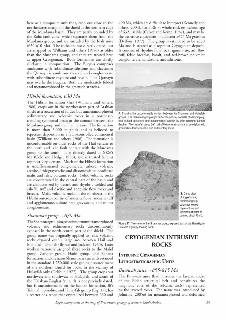
��Explanatory notes to the map of Proterozoic geology of western Saudi Arabia
here as a composite unit (bq), crop out close to the northeastern margin of the shield at the northern edge of the Murdama basin. They are partly bounded by the Raha fault zone, which separates them from the Murdama group, and are intruded by the Idah suite (630-610 Ma). The rocks are not directly dated, but are mapped by Williams and others (1986) as older than the Murdama group, and they are treated here as upper Cryogenian. Both formations are chiefly siliclastic in composition. The Buqaya comprises sandstone with subordinate siltstone and claystone; the Qarnayn is sandstone (wacke) and conglomerate with subordinate rhyolite and basalt. The Qarnayn may overlie the Buqaya. Both are moderately folded and metamorphosed in the greenschist facies.
Hibshi formation, 6�0 MaThe Hibshi formation (hz) (Williams and others, 1986) crops out in the northeastern part of Arabian shield as a succession of folded but unmetamorphosed sedimentary and volcanic rocks in a northeast-trending synformal basin at the contact between the Murdama group and the Hail terrane. The formation is more than 5,000 m thick and is believed to represent deposition in a fault-controlled continental basin (Williams and others, 1986). The formation is unconformable on older rocks of the Hail terrane to the north and is in fault contact with the Murdama group to the south. It is directly dated at 632±5 Ma (Cole and Hedge, 1986), and is treated here as topmost Cryogenian. Much of the Hibshi formation is undifferentiated conglomerate, arkose, volcanic arenite, lithic graywacke, and siltstone with subordinate mafic and felsic volcanic rocks. Felsic volcanic rocks are concentrated in the central part of the basin and are characterized by dacitic and rhyolitic welded and ash-fall tuff and dacitic and andesitic flow rocks and breccia. Mafic volcanic rocks in the northeast of the Hibshi outcrops consist of andesite flows, andesite tuff and agglomerate, subordinate graywacke, and minor conglomerate.
Shammar group, ~6�0 MaThe Shammar group (sz) consists of nonmetamorphosed volcanic and sedimentary rocks discontinuously exposed in the north-central part of the shield. The group name was originally applied to felsic volcanic rocks exposed over a large area between Hail and Mahd adh Dhahab (Brown and Jackson, 1960). Later workers variously assigned these rocks to the Mahd group, Zarghat group, Hadn group, and Banana formation, and the name Shammar is currently retained in the standard 1:250,000-scale geologic source maps of the northern shield for rocks in the vicinity of Hulayfah only (Delfour, 1977). The group crops out northwest and southwest of Hulayfah, and south of the Halaban-Zarghat fault. It is not precisely dated, but is unconformable on the Isamah formation, Bi’r Tuluhah ophiolite, and Hulayfah group (Fig. 17), has a scatter of zircons that crystallized between 630 and
490 Ma, which are difficult to interpret (Kennedy and others, 2004), has a Rb-Sr whole-rock errorchron age of 632±18 Ma (Calvez and Kemp, 1987), and may be the extrusive equivalent of adjacent ±625 Ma granites (Delfour, 1977). The group is estimated to be ±630 Ma and is treated as a topmost Cryogenian deposit. It consists of rhyolite flow rock, ignimbrite, ash flow tuff, felsic breccias, basalt, and red-brown polymict conglomerate, sandstone, and siltstone.
Figure 17. Two views of the Shammar group, exposed east of the Hanakiyah-Hulayfah highway, looking north.
B: Close view of ridge-forming Shammar group columnar jointed rhyolite flows and ignimbrite (height of outcrop about 75 m).
CRYOGENIAN INTRUSIvE ROCkS
intruSive cryogenian LithoStratigraphic unitS
Buwwah suite, ~���-��� Ma The Buwwah suite (bw) intrudes the layered rocks of the Bidah structural belt and constitutes the magmatic core of the volcanic arc(s) represented by the layered rocks. The name was introduced by Johnson (2005e) for metamorphosed and deformed
A: Showing the unconformable contact between the Shammar and Hulayfah groups. The Shammar group (right half of the picture) consists of east-dipping, well-bedded sandstone and conglomerate overlain by thick columnar jointed rhyolite. The Hulayfah group (left half of the picture) consists of polydeformed, greenschist-facies volcanic and sedimentary rocks.
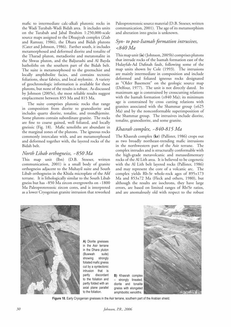
�0 Johnson, P.R., �006
A) Diorite gneisses in the Asir terrane in the Dhara pluton (Buwwah suite) showing strongly foliated mafic gneiss cut by a syntectonic intrusion that is partly discordant to the foliation and partly folded with an axial plane parallel to the foliation.
B) Khasrah complex – strongly lineated, diorite and tonalite gneiss with elongated amphibolitic xenoliths.
Figure 18. Early Cryogenian gneisses in the Asir terrane, southern part of the Arabian shield.
mafic to intermediate calc-alkali plutonic rocks in the Wadi Turabah-Wadi Bidah area. It includes units on the Turabah and Jabal Ibrahim 1:250,000-scale source maps assigned to the Dhuqiyah complex (Ziab and Ramsay, 1986), the Dhara and Bidah plutons (Cater and Johnson, 1986). Farther south, it includes metamorphosed and deformed diorite and tonalite of the Tharad pluton, metadiorite and metatonalite in the Shwas pluton, and the Baljurashi and Al Bayda batholiths on the southern part of the Bidah belt. The suite is metamorphosed to the greenschist and locally amphibolite facies, and contains tectonic foliations, shear fabrics, and local mylonite. A variety of geochronologic information is available for these plutons, but none of the results is robust. As discussed by Johnson (2005e), the most reliable results suggest emplacement between 855 Ma and 815 Ma.
The suite comprises plutonic rocks that range in composition from diorite to granodiorite and includes quartz diorite, tonalite, and trondhjemite. Some plutons contain subordinate granite. The rocks are fine to coarse gained, well foliated, and locally gneissic (Fig. 18). Mafic xenoliths are abundant in the marginal zones of the plutons. The igneous rocks commonly intercalate with, and are metamorphosed and deformed together with, the layered rocks of the Bidah belt.
North Libab orthogneiss, ~��0 MaThis map unit (lbn) (D.B. Stoeser, written communication, 2001) is a small body of granite orthogneiss adjacent to the Muhayil suite and South Libab orthogneiss in the Khida microplate of the Afif terrane. It is lithologically similar to the South Libab gneiss but has ~850 Ma zircon overgrowths on ~1800 Ma Paleoproterozoic zircon cores, and is interpreted as a lower Cryogenian granite intrusion that reworked
Paleoproterozoic source material (D.B. Stoeser, written communication, 2001). The age of its metamorphism and alteration into gneiss is unknown.
Syn- to post-Isamah formation intrusives, <��0 MaThis map unit (is) (Johnson, 2005b) comprises plutons that intrude rocks of the Isamah formation east of the Hulayfah-Ad Dafinah fault, following some of the map units shown by Cole (1993). The intrusions are mainly intermediate in composition and include deformed and foliated igneous rocks designated as “Older Basement” on the geologic source map (Delfour, 1977). The unit is not directly dated. Its maximum age is constrained by crosscutting relations with the Isamah formation (±840 Ma); its minimum age is constrained by cross cutting relations with granites associated with the Shammar group (±625 Ma) and by the nonconformable superimposition of the Shammar group. The intrusives include diorite, tonalite, granodiorite, and some granite.
Khasrah complex, ~��0-��� MaThe Khasrah complex (kr) (Pallister, 1986) crops out as two broadly northeast-trending mafic intrusions in the northwestern part of the Asir terrane. The complex intrudes and is structurally conformable with the high-grade metavolcanic and metasedimentary rocks of the Al Lith area. It is believed to be cogenetic with the Al Lith belt layered rocks (Pallister, 1986) and may represent the core of a volcanic arc. The complex yields Rb-Sr whole-rock ages of 895±173 Ma and 853±72 Ma (Fleck and others, 1980), but although the results are isochrons, they have large errors, are based on limited ranges of Rb/Sr ratios, and are anomalously old with respect to the robust

��Explanatory notes to the map of Proterozoic geology of western Saudi Arabia
Pb/Pb ages of 842 Ma, 834 Ma, and 812 Ma obtained from the layered rocks of the Al Lith belt (Kröner and others, 1992). The Rb-Sr isochrons are therefore suspect, and an age of ~840-815 Ma is preferred by Johnson (2005e). The complex consists of diorite, gabbro, tonalite, and trondhjemite, and subordinate granodiorite, quartz monzodiorite, anorthosite, and granite that are metamorphosed to the greenschist or amphibolite facies, variably deformed, and commonly present as mylonitic orthogneiss, orthoamphibolite, or hornblende hornfels.
Kamil suite, ���-�00 MaThis suite (km) (Ramsay, 1986; Moore and Al-Rehaili, 1989) consists of mafic, intermediate, and felsic plutonic rocks of calc-alkalic and locally trondhjemitic affinities widely exposed in the southwestern part of the Jiddah terrane between the Bi’r Umq suture on the north and the Makkah area on the south. The suite intrudes already deformed layered rocks of the Samran and Zibarah groups and plutonic rocks of the Makkah batholith. It has typically steep contacts that do not show significant contact-metamorphic effects; and gradational internal contacts between components of the suite. SHRIMP dating (Hargrove, 2006) yields crystallization ages of 824±7 Ma and 802±5 Ma for the suite, and it is compiled as lower Cryogenian. Earlier geochronology was done by the Rb-Sr and K-Ar methods, and the results are not reliable (Johnson, 2005e). The suite includes tonalite and trondhjemite, diorite and quartz diorite, lesser amounts of granodiorite and quartz monzonite, and minor monzogranite. The rocks are weakly metamorphosed and variably deformed, and tend to have a strongly developed foliation at, and parallel to, their external contacts.
An Nimas complex, ���-��� MaThe An Nimas complex (an), named by Johnson (2005c) after the An Nimas batholith, consists of pretectonic mafic to intermediate plutonic rocks that intrude the layered rocks of the Tayyah and Shwas belts in the Asir terrane. The largest exposure of the complex, the An Nimas batholith, is dated at 837±50 Ma by the Rb-Sr whole-rock method (Fleck, and others, 1980), and 816±4 Ma and 797±7 Ma by the U-Pb zircon method (Cooper and others, 1979). The batholith is deformed by the Tabalah and Tarj shear zones, unconformably overlain by the Hali group, and metamorphosed to the greenschist and locally amphibolite facies; it is inferred to be lower Cryogenian. The complex comprises tonalite, trondhjemite, granodiorite, diorite, gabbro, local bodies of diorite-tonalite agmatite, and amphibolite. Together with the adjacent layered rocks, the complex is part of what is referred to as the An Nimas arc (Stoeser and Stacey, 1988). Tonalite gneiss along the Tabalah shear zone in the northern part of the An Nimas batholith, developed as a result of dextral shear in the complex between 779 Ma and 765 Ma, and
documents the earliest known shearing event in the Asir terrane (Blasband, 2006).
Shir complex, age uncertainThe Shir complex (sr) (Ziab and Ramsay, 1986) consists of diorite, tonalite, quartz diorite and granodiorite exposed in north-south trending elongate plutons in the north-central part of the Asir terrane. The complex intrudes the Muwayh formation and is intruded by the posttectonic Abbasiyah granodiorite, but its relationships to other rocks in the shield are unknown. It is tentatively regarded here as an extension of the lower Cryogenian An Nimas arc.
Jaf Jaf complex, age uncertainThe Jaf Jaf complex (jj) (Ziab and Ramsay, 1986) crops out as elongate, north-trending plutons, sills, and dikes of diorite, tonalite, granodiorite, and monzogranite east of the Turabah fault in the northern part of the Asir terrane. The complex is weakly metamorphosed and has a weakly developed, steeply dipping foliation. It intrudes the Muwayh formation and is intruded by the posttectonic Ar Raha granite. The complex is lithologically and structurally similar to, and may belong to the same intrusive event as, the Shir complex and may constitute a northerly extension of the An Nimas arc. The complex is not directly dated, but is estimated to be lower Cryogenian.
Dhukhr complex, ���-��0 MaThe Dhukhr complex (dh) crops out in the northern part of the Jiddah terrane as tonalite, granodiorite, subordinate gabbro, and trondhjemite (Kemp and others, 1982). The complex is unconformable below the Mahd and Ghamr groups, and SHRIMP dating (Hargrove, 2006) indicates crystallization at 811±4 Ma, consistent with a U-Pb zircon age of 816±3 Ma obtained by Calvez and Kemp (1982). It is therefore treated as lower Cryogenian.
Surayhah complex, ~��0 MaThe Surayhah complex (sy) (Thieme, 1988) is an assemblage of amphibolite-grade orthogneiss, migmatite, and amphibolite in the Khida subterrane of the Afif terrane, poorly known because of its subdued, discontinuous exposure. The origin and age of the complex is uncertain. It is associated with the Kabid paragneiss and Tays formation and like them has a pre-Siham metamorphic fabric. The Kabid has igneous zircons dating 808±14 Ma (D.B. Stoeser, written communication, 2001) that may have been derived from the Surayhah complex, which implies a lower Cryogenian age for the Surayhah, although the Surayhah itself has inherited zircons dating from 2360 Ma, 2050 Ma and 2007 Ma (Agar and others, 1992). It is treated here as a ~810 Ma intrusion that underwent deformation, metamorphism, and migmatization at about 780-750 Ma (Agar and others, 1992). An ion-probe age of 642±8 Ma reported from the Surayhah
�� Johnson, P.R., �006
may represent a younger intrusion within the Surayhah rather than the Surayhah itself (D.B. Stoeser, written communication, 2001).
The complex includes biotite-garnet granite gneiss, amphibolite, and amphibolite-granite migmatite composed of amphibolite-rich melanosomes and granitic leucosomes. Extrapolating from the Jabal Khida and Zalm geologic source maps, and applying structural criteria used by Agar and others (1992) to identify pre-Siham rocks, areas of injection gneiss and granitic and dioritic migmatite in the Wadi ar Rika geologic source map previously designated “Older Basement” (Delfour, 1980) are reassigned here to the Surayhah complex.
Rabigh suite, ~�0� MaThe Rabigh suite (ra) (Ramsay, 1986; Camp, 1986) consists of tonalite, diorite, and gabbro emplaced in the Birak group in the southern part of the Hijaz terrane. Zircons from the complex yield a U-Pb age of 807±8 Ma (C.E. Hedge, cited by Camp, 1986) and quartz diorite and granodiorite yield a whole-rock Rb-Sr isochron of 945±28 Ma (Al-Shanti and others, 1983). The Rb-Sr isochron is anomalously old with respect to the U-Pb determination and its significance is uncertain; it is based on a narrow range of Sr/Sr and Rb/Sr ratios and is cited as 800±75 Ma in an earlier abstract (Al-Shanti and Abdel-Monem, 1982). Because of this ambiguity, the U-Pb result is the preferred emplacement age of the Bustan complex, on which basis the Rabigh suite is tentatively identified as lower Cryogenian.
Hufayriyah complex, ��0-�60 MaThis map unit (hf) (Kemp and others, 1982) consists of irregular plutons of tonalite that intrude already deformed, or are syntectonic with, Mahd group rocks, and are unconformably overlain by Ghamr group rocks. The map unit is dated at 760±10 Ma by the U-Pb zircon method (Calvez and others, 1983) and 785±68 Ma by the SHRIMP method (Hargrove, 2006).
Qiya complex, ��0-�60 MaThe Qiya complex (qg) consists of bodies of deformed tonalite, granodiorite, and granite in the western part of the Asir terrane. The complex was named by Ziab and Ramsay (1986) for a large batholith of orthogneiss at Qiya village, 75 km southeast of At Ta’if. Other antiforms or domes of massive to foliated granitoids assigned to the complex extend as far south as the Baqarah dome at about 18°50′N, 42°10′E, and together make up the Afaf gneiss belt. Only the Baqarah gneiss is directly dated, yielding U-Pb model crystallization ages of 778±9 Ma and 763±4 Ma (Cooper and others, 1979), on which basis the Qiyah complex is interpreted as Cryogenian. Structural conformity of the foliations inside and outside the domes and metamorphic gradients in the surrounding country rocks (greenschist increasing to amphibolite
facies toward the contact) suggest that the gneisses are syntectonic, and the complex is evidence of 780-760 Ma orogeny in the western Asir terrane. Most of the Qiya complex gneiss domes consist of monzogranite and granodiorite; some include tonalite. In some domes, granodiorite forms the core, monzogranite the margin. Foliation is most intense on the margins of the antiforms; the cores tend to be massive.
Qudayd suite, ��0-��� MaThe Qudayd suite (qd) (Ramsay, 1986) consists of elongate bodies of tonalitic orthogneiss that intrude the Samran group along the Bi’r Umq suture zone at the northern margin of the Jiddah terrane. The gneiss has a well-developed, steeply dipping foliation and is cut by steeply dipping shear zones. Contacts are mostly steep and and the suite is concordant with the Samran group. SHRIMP dating (Hargrove, 2006) yields crystallization ages of 782±7 Ma, 750±5 Ma, and 747±5 Ma. The textural and contact characteristics, general conformity with regional structure, and higher than normal metamorphic grade in Samran group rocks adjacent to the gneiss indicate that the Qudayd suite is syntectonic (Ramsay, 1986). In the literature this implied tectonic event is equated with amalgamation of the Jiddah and Hijaz terranes and development of the Bi’r Umq suture (Johnson and Woldehaimanot, 2003). A K-Ar hornblende age of 585±12 Ma reported by Brown and others (1978) is too young to be an intrusive age, and presumably reflects Pan-African thermal resetting. The suite includes tonalitic orthogneiss, garnet-hornblende-plagioclase-quartz orthogneiss, amphibole gneiss and amphibolite probably derived from the Samran group, garnetiferous amphibole gneiss, and garnet-mica schist interlayered with leucocratic quartzofeldspathic gneiss.
Bari granodiorite, ��� MaThe Bari granodiorite (ib) (Kemp and others, 1982) consists of medium -to-fine-grained biotite granodiorite that locally grades to tonalite and trondhjemite. It intrudes the Mahd group and the Dhukhr and Hufayriyah tonalites, and is overlain by unmetamorphosed rocks of the Ghamr group. It has a SHRIMP crystallization age of 776±6 Ma (Hargrove, 2006).
Rumayda granite, age uncertainThe Rumayda granite (ry) (Moore and Al-Rehaili, 1989) crops out in the west-central part of the Jiddah terrane, intruding diorite and tonalite of the Kamil suite and already deformed rocks of the Samran and Zibarah groups. It is disconformably overlain by the Fatima group. It is mostly massive and does not appear to have undergone penetrative ductile deformation and high-grade metamorphism of the type that affected other rocks in and adjacent to the Fatima shear zone. It therefore appears to be late-tectonic with respect to ductile deformation along the
��Explanatory notes to the map of Proterozoic geology of western Saudi Arabia
fault zone. A 4-point Rb/Sr errorchron of 773±16 Ma (MSWD=3.6) (Duyverman and others, 1982) is broadly consistent with the apparent age of the granite deduced from its geologic relationships, but the result only weakly constrains the emplacement age because of its analytic error. An older Rb-Sr biotite mineral age of 1025 Ma (Aldrich, 1978) is geologically meaningless. Compositionally, the granite varies from monzogranite to syenogranite.
Ram Ram complex, ��0-��0 Ma The Ram Ram complex (rr) (Kemp and others, 1982) is a small bimodal intrusion comprising ring dikes emplaced in Mahd group rocks in the northern part of the Jiddah terrane. SHRIMP dating yields crystallization ages of 769±6 Ma and 749±10 Ma (Hargrove, 2006), comparable to an age of 769±5 Ma obtained by the U-Pb zircon discordia method (Calvez and Kemp, 1982). The complex consists of granodiorite, red granite, granophyre, gabbro, and diorite.
Filh granodiorite, age uncertainThis map unit (ft), named by Johnson (2005e), consists of small, irregular plutons of hornblende-biotite granodiorite that intrude the Khasrah complex and metavolcanic and metasedimentary layered rocks in the Al Lith belt in the northwestern part of the Asir terrane. The plutons are metamorphosed and structurally conformable with the Khasrah complex. Pallister (1986) infers that the granodiorite is intermediate in age between syn-volcanic intrusive rocks such as the Khasrah complex and undeformed, posttectonic intrusive rocks such as the granite plutons that are common in the At Ta’if area. The granodiorite is estimated to be middle Cryogenian. The granodiorite locally grades into quartz monzonite, quartz diorite, and diorite.
Fuwayliq granodiorite, ��0 Ma The Fuwayliq granodiorite (fw) (Stoeser and others, 2001) is a small intrusion adjacent to the Muhayil suite in the southeastern part of the Afif terrane. Ion-probe dating reveals inherited 1700-1800 Ma Paleoproterozoic zircon cores and 750 Ma euhedral zircon grains and overgrowths (e.g., 756±6 Ma) (D.B. Stoeser and others, written communication, 2001) suggesting a crystallization age of about 750 Ma. The granodiorite is interpreted as a Cryogenian intrusion and is regarded as one of the oldest Siham-arc magmatic rocks in the Afif terrane.
Nabt complex, age uncertainThe Nabt complex (na) (Pellaton, 1979, 1982a,b) is a body of gabbro and subordinate diorite, tonalite, and trodhjemite that intrudes the Al Qunnah formation in the southeastern part of the Midyan terrane. The complex is not directly dated, but is intruded by the Jar-Salajah batholith (~745-695 Ma). The complex is predominantly layered gabbro, with younger phases
of diorite, quartz diorite, tonalite, and trondhjemite. Ultramafic differentiates are also locally present, now altered to soapstone. The rocks of the complex are metamorphosed and deformed by folding and faulting. In shear zones, there is a gradation to gabbroic gneiss.
Jar-Salajah complex and Fara’ trondhjemite, ~���-6�� MaThis map unit (js) is a composite term for rocks assigned on the 1:250,000-scale geological source maps to the Jar batholith, Salajah batholith, and the Fara’ trondhjemite (Kemp, 1981; Pellaton, 1979, 1982a, 1982b) in the northwestern part of the shield between Umm Lajj, Al ‘Ays, and Yanbu. The plutons are combined as a single lithostratigraphic unit because they are lithologically similar and, in the case of the Jar and Salajah batholiths, are juxtaposed with no obvious boundary or spatial separation between them. Unreliable U-Pb ages of 743±10 Ma, 720±5 Ma (Ledru and Augé, 1984), reliable U-Pb zircon model ages of 696±6 Ma and 696±5 Ma (Pallister and others, 1988), an Rb-Sr isochron of 731±29 Ma (Calvez and others, 1982), and a SHRIMP age of 713±9 Ma (Kennedy and others, 2004) suggest that the unit is between 745 Ma and 695 Ma. The complex both intrudes already deformed Zaam and Al ‘Ays groups and their equivalents, and is locally overlain by sedimentary rocks assigned to the Zaam group, which suggests a temporal overlap between emplacement of the complex and deposition of the Zaam group. Furthermore, the complex intrudes the Hudayrah-Jabal Ess fault zone and the associated Jabal Wask ophiolite, and therefore, at least in part, postdates the amalgamation and suturing of the Midyan and Hijaz terranes. Lithologically, the complex comprises gabbro, large amounts of granodiorite, tonalite, trondhjemite, and diorite, and small irregular massifs of biotite granite.
Naim complex, ��� Ma The Naim complex (nm) (Agar, 1988) is an orthogneiss assemblage in the central part of the Afif terrane. It appears to have been deformed together with the Siham group, is directly dated at 746±10 Ma (Agar and others, 1992), and may be the result of early-Siham-arc magmatism. The rocks are variably deformed and range from weakly to strongly foliated flaser and banded orthogneiss derived from granodioritic and subordinate tonalitic, dioritic, and monzogranitic protoliths.
Syn- to post-Banana intrusives, ��0-6�� MaThis is a composite term (bx) named by Johnson (2005b) for a heterogeneous group of syn- to post-Banana, Sufran, and Nuf formation-age intrusive rocks that crop out in the northeastern part of the shield making up part of the Ha’il terrane. Following Cole (1993), the group includes plutonic rocks assigned
�� Johnson, P.R., �006
earlier on the Jabal Habashi, Baqa, Wadi ash Shubah, and Hail 1:250,000-scale source maps to the Makhul complex, Juwway Rashib suite, Ma’a complex, and Baayith complex (Vaslet and others, 1987; Quick and Doebrich, 1987, Ekren and others, 1987; Williams and others, 1986). SHRIMP dating of a granodiorite to tonalite assigned to the Ma’a complex yields a tight grouping of concordant U-Pb zircon ages with a mean of 683±10 Ma interpreted as a robust middle to upper Cryogenian crystallization age (Kennedy and others, 2004). Cole and Hedge (1986) estimate syn- to post-Banana intrusive rocks elsewhere in the compilation to be about 740 Ma (based on a single unpublished date from quartz diorite by C.E. Hedge cited by Cole amd Hedge, 1986), and the intrusive rocks may have a significant spread of ages. The rocks are mainly diorite and quartz diorite grading to granodiorite. They also include tonalite, scattered exposures of gabbro, and local serpentinite.
Mushrifah complex, ~��0 MaThis name (sm) was introduced by Johnson (2005c) as a collective term for metamorphosed and deformed, pretectonic diorite, tonalite, and granodiorite exposed in the southeastern part of the Asir terrane in the Tarib batholith and part of the Malahah dome. The complex intrudes layered rocks in the Malahah and southern part of the Khadra structural belts. The rocks yield U-Pb model crystallization ages of 732±4 Ma and 727±5 Ma (Stoeser and others, 1982; 1984; Stoeser and Stacey, 1988), and an anomalously young U-Pb model age of 643±5 Ma. The 643 Ma result either reflects metamorphic recrystallization of Tarib-age zircons resulting in lead loss and a spurious young date, or an unrecognized post-Tarib intrusion within the Tarib batholith. The complex is interpreted here as approximately 730 Ma or middle Cryogenian and is inferred to be the magmatic core of the Tarib volcanic arc that makes up much of the southern Asir terrane (e.g., Stoeser and others, 1982). The complex comprises strongly foliated and gneissic amphibolite-facies tonalite and granodiorite, and subordinate diorite and gabbro.
As Sutayyan complex, age uncertainThis map unit (st), named by Johnson (2005a), consists of pretectonic mafic plutons that intrude layered rocks in the northern part of the Khadra belt in the Asir terrane. The rocks are not directly dated, but are interpreted to be part of the magmatic core of the Tarib arc (Stoeser and Stacey, 1988). They may correlate with the Mushrifah complex (732-727 Ma) and are tentatively treated as middle Cryogenian. The complex includes diorite, gabbro, tonalite, and granodiorite, and has abundant xenoliths of country rocks. The intrusions were deformed together with the layered rocks and locally grade into orthogneiss.
Gabbro and diorite, ��0-6�0 MaThis map unit (dg) is a collective term for small circular
to larger irregular mafic intrusions in the southeastern part of the Asir terrane. The rocks are heterogeneous, and include gabbro, diorite, tonalite, granodiorite, and minor anorthosite. They probably include rocks of different ages that should be separated on future maps. The unit intrudes the Abss granodiorite and tonalite (about 730 Ma?) and is intruded by the Arin tonalite, suggesting that it between 730 Ma and 675 Ma, although the rocks are directly dated at 641±3 Ma (Stoeser and Stacey, 1988) in the Najran source map (Sable, 1985), so that the minimum age of the unit may be as young as 640 Ma. Overall, the gabbro and diorite are interpreted to be late Cryogenian. Their common circular form and discordant contacts suggest that they were emplaced later in the structural history of the region. Some plutons have inward-dipping concentric gabbro and diorite layers 10-60 m thick and with concentric screens of country rock; others are irregular to domal.
Najah granodiorite, >��� MaThis unit (nj) (Grainger and Hanif, 1989) is part of the Midyan terrane north of the Qazaz shear zone, and may be a syntectonic intrusion in the Bayda group (Johnson, 2005f ). The granodiorite is cut by the Muwaylih suite, which suggests that it is older than 725 Ma. The granodiorite is light to dark gray, uniformly medium grained, and has a well-developed hypidiomorphic-granular texture. The rock is locally schistose and gneissic.
Muwaylih suite, ���-��0 MaThe Muwaylih suite (mw) (Ramsay and others, 1986) consists of mafic plutons that intrude the Zaam and Bayda groups and the Najah granodiorite in the central part of the Midyan terrane. The plutons are variably deformed and metamorphosed, and contacts vary from discordant in places where the rocks intrude already deformed layered host rocks, to concordant in places where the plutonic and layered rocks are deformed together. The suite is directly dated between 710 Ma and 725 Ma (Hedge, 1984). The main rock types are tonalite, trondhjemite, diorite, quartz diorite, gabbro, and norite, and probably represent part of the volcanic-arcs that make up the Midyan terrane. Some plutons contain layered gabbro and norite, with lenses and pods of magnetite and ilmenite; others contain layered gabbro and anorthosite. Granodiorite, monzogranite, and serpentinite are locally present.
Syn- to post-Hulayfah intrusives, ~��0 MaThis map unit (hx), named by Johnson (2005d), consists of plutons of monzogranite, syenogranite, and local alkali granite, granodiorite, and diorite that intrude the Hulayfah group and are unconformably overlain by the Shammar group in the area west of the Hulayfah-Ad Dafinah fault. The age of the unit is weakly constrained by an unreliable U-Pb zircon age of 720±10 Ma (Calvez and others, 1983) obtained from a granite-granodiorite pluton west of Bi’r Tuluhah.

��Explanatory notes to the map of Proterozoic geology of western Saudi Arabia
Hadhaq complex, ��0 MaThe Hadhaq complex (hd) (Al-Muallem and Smith, 1988) consists of monzogranite, diorite, tonalite, and granodiorite gneiss exposed in the northern part of the Asir terrane adjacent to the Ruwah fault zone (Al-Muallem and Smith, 1988; Simons, 1988). The complex is directly dated by a U-Pb model zircon age of 719±9 Ma obtained from tonalite west of Ranyah (Stoeser and Stacey, 1988). The geologic significance of a U-Pb zircon age of 782±4 Ma reported by Stacey and Agar (1985) from Hadhaq complex mylonitic gneiss along the Ruwah fault zone is not certain; it may reflect pre-Hadhaq material caught up in the complex along the fault zone. A U-Pb model age of 646±4 Ma (Stoeser and Stacey, 1988) obtained from monzogranite within Hadhaq complex rocks northeast of Ranyah probably reflects Nabitah orogeny reworking or a separate, younger pluton.
Shufayyah complex, ~��� Ma This map unit (su) (Camp, 1986) consists of irregularly shaped, concordant to discordant plutons emplaced in already folded rocks of the Birak and Al ‘Ays groups in the southern part of the Hijaz terrane. Granite in the complex is dated by an undocumented U-Pb zircon method at 715±7 Ma (C.E. Hedge, cited by Camp, 1986; also Jackson and others, 1984a), suggesting that it is broadly coeval with the Salajah batholith in the west of the terrane. The complex comprises granodiorite, tonalite, diorite, and gabbro.
Julayhi tonalite, �0� MaThe Julayhi tonalite (lt) (Thieme, 1988) crops out as a narrow, north-northwest-trending band of massive to weakly cleaved tonalite that intrudes the Siham group and the Damar complex in the southern part of the Afif terrane. It is directly dated at 706±11 Ma (Agar and others, 1992) and is probably part of the Siham magmatic arc, broadly contemporary with the Damar complex.
Damar complex, ~�0� MaThe Damar complex (Thieme, 1988) is a group of mafic to intermediate plutonic rocks in the southeastern part of the Afif terrane composed of diorite, gabbro, and granodiorite (da). Some diorite belonging to the complex may constitute subvolcanic intrusions in the Siham group, and Thieme (1988) interprets the complex as partly contemporary with and partly postdating the Siham group. A U-Pb age of 704±3 Ma constrains the age of the complex and, by implication, some of the Siham-arc magmatism (Agar and others, 1992). The geologic significance of younger ages obtained from rocks assigned to the complex, such as a U-Pb zircon age of 635±5 Ma (Stoeser and Stacey, 1988) and a Rb-Sr whole rock isochron of 535 Ma (R.J. Fleck, written comment, cited by Hadley, 1976) is uncertain; they may reflect younger plutonic events erroneously included in the Damar complex or metamorphic resetting.
Abu Safiyah complex, age uncertainThis map unit (as), originally named by Hadley (1974), crops out in the northern part of the Hijaz terrane as discordant to concordant syenitic and gabbroic plutons that intrude already folded Al ‘Ays group rocks, and are deformed together with other rocks in the Wajiyah gneiss belt. The one available Rb-Sr date for the complex has a large error (705±68 Ma) (Calvez and others, 1983), and is not reliable, but the complex is treated here as possibly 700 Ma or middle Cryogenian. In detail, the complex includes syenite, gabbro, alkali-feldspar granite, microgranite, granophyre, and monzonite.
Burudan complex, ~�00 MaThis name (bu) was introduced by Johnson (2005a) for a group of mafic and intermediate plutons in the easternmost part of the Afif terrane. The rocks appear to have been metamorphosed and deformed together, and may be part of the ±700 Ma Suwaj terrane. A U-Pb isotopic age of 743±5 Ma obtained from Burudan metagranodiorite (J.C. Calvez personal communication, cited by Manivit and others, 1985) would appear to be anomalously old for the observed geologic relationships and its geologic significance is uncertain. An Rb-Sr date of 676±42 Ma obtained from diorite and gabbro is an errorchron and unreliable because of a very low Rb/Sr ratio (Calvez and Delfour, 1986). The complex is mostly massive and layered diorite and gabbro but includes subordinate gabbronorite, quartz gabbro, diorite, tonalite, granodiorite, and plagioclase cumulates. The rocks were metamorphosed to the amphibolite facies but have undergone retrograde metamorphism, and have cataclastic and recrystallized fabrics.
Al Far granodiorite, ~�00 MaThis map unit (fx) (Hadley, 1987) crops out as homogeneous, medium-grained, light gray biotite-hornblende granodiorite in the northern part of the Hijaz terrane. The granodiorite intrudes already deformed Al ‘Ays group rocks. It also intrudes microgranite and granophyre assigned here to the Abu Safiyah complex and is probably broadly coeval with the complex (Hadley, 1987), suggesting that it is about 700 Ma.
Misr complex, �00 MaThis complex (gs), named by Johnson (1998), crops out as two east-striking dikes emplaced in rocks of the Samran group in the Jiddah terrane. The dikes comprise olivine syenite and syenogabbro, marginal zones of alkali-olivine gabbro, and monzogranite. The dikes have steeply dipping, parallel sides and sharp contacts that cut across the structural grain of the country rocks. These features suggested to Skiba and Gilboy (1975) that the dike was emplaced passively in a brittle, posttectonic environment. Ramsay (1986) speculated that the complex may be Tertiary. However, SHRIMP dating (Hargrove, 2006) gives a

�6 Johnson, P.R., �006
crystallization age of 699±7 Ma, and the complex is treated here as middle Cryogenian.
Ruwayhah suite, �00-660 MaThis term (yr) was introduced by Johnson (2005a) for an assemblage of mafic intrusions east of the Nabitah fault zone in the northeastern part of the Asir terrane. The suite intrudes layered rocks of the Ash Sha’ib group and is unconformably overlain by the Bani Ghayy group. It is interpreted by Schmidt and others (1979) to be the roots of a ‘Halaban arc’ but, as explained above, this terminology does not accord with present-day understanding of the evolution of the shield and is not retained here. Tonalite assigned to the suite yields U-Pb isotopic ages of 698±3 Ma and 666±8 Ma (Stoeser and Stacey, 1988; Cooper and others, 1979). The suite is considered here to be between 700 Ma and 660 Ma, and is treated as middle Cryogenian. Together with the Ash Sha’ib group, the rocks make up the putative Tathlith terrane (Flowerdew and others, 2004), a possible tectonostratigraphic subterrane within the Asir terrane.
Kamal complex, <6�� MaThe Kamal complex (ka) (Pellaton, 1979) comprises two arcuate to irregular mafic plutons and several small stocks that intrude the Jar-Salajah batholith northwest of Yanbu’ al Bahr. Because of its relationship with the Jar-Salajah rocks, the complex is inferred to be younger than about 695 Ma; its minimum age is unknown. The complex consists of gabbro and anorthosite, and has a peripheral zone of norite on the east and south.
Suwaj suite, ~6��-6�� MaThe Suwaj suite (sw), named by Cole and Hedge (1986), consists of mafic to intermediate plutonic rocks in the Jabal Suwaj area in the Afif terrane, and includes what are believed to be correlative rocks in the Miskah source map (Pellaton, 1985), so-called “Older basement” rocks exposed between the Murdama group and Halaban ophiolite in the Halaban source map (Delfour, 1979), and metamorphosed mafic to intermediate plutons in the eastern part of the Afif terrane south of the Hufayrah fault zone. The suite is directly dated at 685±5 Ma, 684±5 Ma, 683±5 Ma (Cole and Hedge, 1986), and 695±9 (Stacey and others, 1984), and is treated as a middle Cryogenian unit of ~695-685 Ma. Compatible 40Ar/39Ar-cooling ages are 681 Ma and 675 Ma (Al-Saleh and others, 1998). Common rock types include gabbro, diorite, granodiorite, tonalite.
Rubayq complex, age uncertainThis map unit (rq) (Vaslet and others, 1985) consists of strongly deformed granite and diorite exposed at the northeastern edge of the Arabian shield. Compositionally, the unit is zoned, with granite in the core and diorite toward the margin. The rocks intrude orthogneiss of the Suwaj suite, and are themselves intensely foliated and characterized by gneissic layering
and shear zones. The absolute age of the complex is unknown. It is younger than the Suwaj, but may have been deformed by the same event that deformed the Suwaj. It is inferred to be middle Cryogenian. The complex comprises biotite monzogranite grading to subordinate granodiorite, and amphibolite-biotite diorite with abundant small mafic inclusions.
Khanzirah complex, age uncertainThe Khanzirah complex (kh) was named by Fairer (1986) for bodies of biotite-muscovite monzogranite and granophyre exposed in the north-central part of the shield and was extended by Johnson (2005d) to include monzogranite and syenogranite in adjacent parts of the Khaybar and Wadi al ‘Ays geologic source maps. The plutons have sharp, discordant contacts and intrude already folded Al ‘Ays group rocks, but their relation to other plutonic rocks is not clear. They are not directly dated, but Fairer (1986) speculates that the granophyre may be a subvolcanic equivalent to Al ‘Ays group rhyolite. The complex is treated here as a set of middle Cryogenian intrusions of uncertain age. Some orthogneiss along the Wajiyah gneiss belt is believed to be derived from the complex (Kemp, 1981), which would imply that the complex is at least older then 630 Ma, the likely age of shearing along the gneiss belt.
Salim complex, age uncertainThe Salim complex (mm) (Ziab and Ramsay, 1986) consists of small discordant plutons of diorite and subordinate gabbro in the northern end of the Bidah structural belt of the Asir terrane. The plutons intrude metavolcanic and metasedimentary rocks of the Bidah belt and rocks of the Buwwah suit. The complex is weakly metamorphosed but is undeformed and appears to have been emplaced relatively later in the structural history of the region. It is not directly dated, but is inferred here to be middle Cryogenian.
Samd tonalite, age uncertainThe Samd tonalite (mt) (Skiba and others, 1977) forms an elliptical pluton emplaced in the Fatima shear zone east of Al Jumum. It intrudes deformed and metamorphosed rocks of the Zibarah group, and commonly contains folded and schistose xenoliths of these rocks. The pluton is weakly foliated and slightly metamorphosed but is noticeably less deformed than the fault-zone rocks. It has steep, sharp contacts and appears to have been emplaced diapirically, subsequent to the main period of ductile shearing along the Fatima shear. The tonalite is not directly dated, but is estimated to be a middle Cryogenian pluton.
Arin tonalite, 6�� MaThe Arin tonalite (rx), named by Johnson (2005c), crops out in the southern part of the Asir terrane on either side of the Nabitah fault zone and is emplaced in the Tarib batholith, the Malahah dome, and layered rocks of the Tayyah belt. The tonalite has a U-Pb age

��Explanatory notes to the map of Proterozoic geology of western Saudi Arabia
of 675±5 Ma (Stoeser and Stacey, 1988) and an Rb-Sr errorchron of 684±43 Ma (Fleck and others, 1980) and is interpreted to be an early product of Nabitah-orogeny magmatism. The tonalite consists of light- to medium-gray, medium-grained hornblende-biotite tonalite with subordinate granodiorite and monzogranite (Greenwood, 1985a)). The rocks are massive to weakly foliated, and form structural domes.
Hashafat complex, 66� MaThe Hashafat complex (ha) (Moore and Al-Rehaili, 1989) consists of granodiorite and monzogranite exposed in the Al Aqiq or Bahrah batholith (Moore and Al-Rehaili, 1989; Radain and others, 1989) in the southwestern part of the Jiddah terrane, adjacent to the Red Sea coastal plain. The complex intrudes the Makkah batholith and Zibarah group. Monzogranite yields an 11-point Rb-Sr isochron of 664±12 Ma (Radain and others, 1989), which is consistent with the geologic relationships of the complex and is a reasonable emplacement age.
Nabitah gneiss suite, 66�-6�0 MaThis name (nb) was introduced by Johnson (2005c) as a collective name for strongly deformed granitoids that crop out in the Asir terrane on either side of the Nabitah fault zone and are correlated on the basis of their shared compositional, geochronologic, and structural features. The rocks are the classic syntectonic gneisses of the Nabitah orogeny (Stoeser and Stacey, 1988) and intrude the older rocks of the Khadra and Malahah structural belts and the Ash Shai’b group. They range in composition between tonalite, granodiorite, and monzogranite and include granodiorite and monzogranite gneisses in the Tathlith area that have a preferred SHRIMP age of 652±2 Ma (Johnson and others, 2001), large expanses of granodiorite and tonalite gneisses and migmatite in the Jabal al Hasir area that make up the Al Qarah gneiss dome and are dated at 651±4 Ma and 654±3 Ma (Johnson and others, 2001), and granite gneisses in the Khamis Mushayt and Al Qa’ah areas that are dated at 667±4 Ma, 657±3 Ma, and 654±7 Ma (Stoeser and Stacey, 1988), and 664±9 Ma (Fleck and others, 1980). The gneisses consist of granodiorite, monzogranite and subordinate quartz diorite, tonalite, and amphibolite. Xenoliths of amphibolite and biotite schist are locally abundant, and external contacts of the gneisses vary from concordant to discordant.
Biotite granodiorite and monzogranite, age uncertainThis map unit (bg) crops out in the Tayyah and Khadra structural belts of the Asir terrane. It is not directly dated, but is tentatively interpreted as broadly syn- to late-tectonic with respect to the Nabitah orogeny. The map unit includes moderately to strongly foliated, elongate to sheet-like concordant bodies of biotite granodiorite to monzogranite and minor hornblende-
biotite tonalite (Greenwood and others, 1986).
Imdan complex, 660 MaThe Imdan complex (im) (Davies and McEwen, 1985) consists of mafic and intermediate plutonic rocks intruded into the Zaam group in the central part of the Midyan terrane. It is directly dated at 660±4 Ma by the U-Pb model zircon method (Hedge, 1984) and is unconformably overlain by the Thalbah group. The complex has an irregular outcrop pattern, largely the result of post-Thalbah faulting. Much of the complex is massive, but toward the Ajjaj shear zone, and in fault zones elsewhere, has a foliated to gneissic fabric. The complex consists of gabbro and rare serpentinized ultramafic rocks, diorite, tonalite, and granodiorite.
Hijrat trondhjemite, 6�� MaThe Hijrat trondhjemite (hj) (Stoeser and Stacey, 1988) crops out on either side of the southern part of the Nabitah fault zone. Trondhjemite predominates, but the map unit grades to granodiorite and monzogranite. The rock is massive to foliated and gneissic and locally comprises an intrusive breccia composed of large blocks of gneissic hornblende-biotite tonalite in a trondhjemite matrix. Screens of hornblende-biotite tonalite gneiss and amphibolite from the adjacent country rocks are common. The trondhjemite intrudes the Tarib batholith, and is dated at 654±3 Ma (Stacey and Stoeser, 1988). It is a typical Nabitah-orogeny intrusive unit, broadly contemporary with the Nabitah gneiss suite.
Laban and Kilab complexes, ~6�0 MaThis map unit (kb) is composed of two separate complexes mapped by Williams and others (1986) and Cole and Hedge (1986) in the northeastern part of the shield, one of which, the Laban complex, is more mafic than the other, the Kilab complex, but both of which appear to be about 650 Ma (Cole and Hedge, 1986). The map unit is a heterogeneous assemblage of biotite quartz diorite, lesser biotite and hornblende diorite, monzogabbro, and subordinate granodiorite, monzogranite, and syenogranite. The rocks intrude schist assigned to the Banana and Sufran formations, are overlain by the Hibshi formation, and contain abundant amphibolitic xenoliths and roof pendants. The map-unit boundaries shown on this map are based on Cole and Hedge (1986).
Fahud microdiorite, ~6�0 MaThe Fahud microdiorite (fh) (Agar, 1988) is a solitary pluton in the southern part of the Afif terrane that appears to intrude the As Siham and Bani Ghayy groups and is intruded by the Haml batholith. The microdiorite consists of porphyritic plagioclase, and subordinate interstitial hornblende and minor quartz. It is not directly dated, but is inferred to be ±650 Ma.

�� Johnson, P.R., �006
Jidh suite, age uncertainThe Jidh suite (jd) was named (Agar, 1988) for calc-alkalic intrusive rocks emplaced in the Siham group in the Zalm 1:250,000-scale source map, in the west-central part of the Afif terrane, and was tentatively extended northward by Johnson (2005d) to include what appear to be syn- to post-Siham intrusives as far as the Halaban-Zarghat fault. The rocks are not directly dated, but their structural relationships suggest that they predate the main deformation event in the Siham group and are possibly part of a calc-alkalic magmatic core to the Siham volcanic arc. The suite is treated here as middle Cryogenian. Compositionally, the suite includes granodiorite, monzogranite, tonalite, diorite, and quartz diorite. The plutons mainly have sharp, rectilinear external contacts and lack contact aureoles.
Humaymah suite, 6��-6�0 MaThis suite (hy) (Agar, 1988) is a group of post-Siham, possibly syn-Bani Ghayy intrusions in the west-central part of the Afif terrane. They are lithologically similar to some of the rocks assigned to the Jidh suite, but are differentiated from the Jidh suite because they postdate the D
2 event that deformed the Jidh (Agar, 1988).
The suite varies widely in composition, comprising cumulate- and non-cumulate-layered plutons of coarse grained, melanocratic gabbro, mesocratic diorite, tonalite, granodiorite, monzogranite, and alkali-feldspar granite. Alkali-feldspar granite belonging to the suite has a U-Pb conventional age of 632±3 Ma (Stacey and Agar, 1985). Leistel and berlé (1999) report a U-Pb zircon age of 647±6 Ma for granite at Zalm. The suite has a bimodal, tholeiitic to alkali character, and may have been emplaced in an extensional environment compatible with the graben setting envisaged for the coeval Bani Ghayy group (Agar, 1986, 1988).
Nasaf suite, 6�� MaThe Nasaf suite (nz) (Thieme, 1988) consists of circular to irregular mafic to intermediate plutons in the eastern part of the Afif terrane. Limited available isotopic data (646±4 Ma, Agar and others, 1992) and general field relationships suggest that the plutons are broadly contemporary with the granitoid rocks of the Haml suite and postdate the Bani Ghayy group. The suite was first defined for mafic plutons in the Jabal Khida quadrangle (Thieme, 1988) and was enlarged by Johnson (2005a) to include some of the mafic to intermediate plutons in Wadi ar Rika quadrangle previously assigned by Delfour (1980) to the Rharaba complex and the “Older Basement”. Common rock types include layered gabbro and subordinate peridotite, troctolite, olivine gabbro, and anorthosite. Other plutons include diorite, tonalite, and granodiorite.
Najirah granite, 6�0-���Johnson (2005b) named this map unit (nr) after the Najirah batholith in the Ad Dawadimi source map (Delfour and others, 1982). Conventional U-Pb zircon dating yields an age of 641±25 Ma (Stacey and others, 1984), but recent SHRIMP work gives an age of 576±6 Ma (Kennedy and others, 2005). Either the granite is younger than conventionally considered or the SHRIMP sample is from a separate granite body that is younger than the main mass of the granite. Here, the granite is treated as upper Cryogenian, and Delfour’s terminology of “Older basement” is abandoned. The granite intrudes the Abt formation along the axis of the Ad Dawadimi terrane as a heterogeneous body ranging in composition from tonalite to granodiorite to monzogranite.
Khishaybi suite, ~6�0 MaThe Khishaybi suite (ks) (Cole and Hedge, 1986) consists of granite, granodiorite, tonalite, and trondhjemite batholiths that intrude the Abt formation, Nafi and Hillit formations, and Dhuknah gneiss in the northeastern part of the shield, and smaller bodies emplaced in already folded Murdama-group rocks. The suite is not directly dated but is inferred to predate the Idah suite and to be older than the Jurdhawiyah group and is estimated by Cole and Hedge (1986) to be ~640 Ma, or late Cryogenian. It is an assemblage of typical postamalgamation intrusive rock.
A’ashiba complex, ~6�0 MaThis complex (ai) consists of orthogneiss exposed in the extreme southeastern part of Asir terrane, north and south of Wadi Najran (Sable, 1985). Quartz diorite gneiss of the complex yields a U-Pb zircon model age of 642±3 Ma (Stoeser and Stacey, 1988), suggesting that the complex originated as a result of late-Nabitah-orogeny magmatism. Compositionally, the rocks include tonalite, granodiorite, and monzogranite. The granite gneiss east of Najran, on the southern side of Wadi Najran, is associated with paragneiss, schist and amphibolite (not separately shown on the map because of scale), and D.B. Stoeser (oral communication, 1999) suggests that the protoliths of these rocks may prove to be pre-Neoproterozoic in age, forming an extension of the Archean-Paleoproterozoic terrane known in Yemen (Windley and others, 1996).
Al Harmah complex, ~6�� MaThe Al Harmah complex (at), named by Johnson (2005a), comprises a circular pluton of hornblende-biotite granodiorite and monzogranite and a small pluton of granodiorite and monzogranite emplaced in rocks of the Asir terrane between Al Lith and Wadi Shwas. The complex is generally undeformed and an Rb-Sr whole-rock isochron of 636±21 Ma (Fleck and others, 1980) indicates late Cryogenian emplacement. Rb-Sr ages of 617±10 Ma (Brown and others (1978)
��Explanatory notes to the map of Proterozoic geology of western Saudi Arabia
and K-Ar biotite mineral ages of 656±6 Ma and 587±7 Ma (Fleck and others, 1976) probably reflect metamorphic-thermal disturbances.
Hishash granite, age uncertainThe Hishash granite (ig) (Moore and Al-Rehaili, 1989) is an irregularly shaped pluton that intrudes the Kamil suite and Samran group in the western part of the Jiddah terrane. The complex is relatively massive and undeformed, and contacts are sharp, which suggest that the pluton is relatively young. It is not directly dated, but on the basis of its geologic relationships is inferred to be upper Cryogenian. The pluton is composed of monzogranite and subordinate granodiorite (Moore and Al-Rehaili, 1989).
Nu’man complex, age uncertainThe Nu’man complex (ng) (Moore and Al-Rehaili, 1989) consists of biotite monzogranite and hornblende-biotite monzogranite to granodiorite orthogneiss and subordinate massive granite. It crops out as an irregular batholith on either side of the Ad Damm fault zone at the contact between the Asir and Jiddah terranes and as irregular, isolated plutons farther north and east. The complex is not directly dated. Fleck and Hadley (1982) obtained a 9-point Rb-Sr whole-rock isochron of 542±23 Ma from sheared Nu’man granite gneiss in the Ad Damm fault zone, but this probably reflects the age of redistribution of strontium during Cambrian fault movement rather than the emplacement age, which is estimated by Fleck and Hadley to be slightly older than 620 Ma. Galena in a quartz vein in the Nu’man complex yields a model lead age of 540 Ma (Stacey and others, 1980), but the temporal relationship of the vein and complex is unknown. The complex is treated here as upper Cryogenian. Orthogneiss predominates in the southern half of the complex commonly showing S-C fabrics and rotated porphyroclasts; massive granite and subordinate gneiss are present elsewhere.
Ra’al granite, 6�� MaThis map unit (rn) (Pellaton, 1982a) consists of irregular, discordant to concordant plutons of upper Cryogenian granite in the northwestern part of the shield. The plutons are mainly undeformed but, in the vicinity of the Hamadat gneiss belt, are penetratively deformed and altered to orthogneiss. The granite yields an Rb-Sr whole-rock isochron of 636±23 Ma that Calvez and others (1982) interpret as the age of emplacement. Compositionally, the unit ranges from monzogranite to syenogranite; pegmatitic zones are locally common.
Qunnah complex, age uncertainThis complex (zg), named by Johnson (2005e) after the Qunnah gabbro (Ziab and Ramsay, 1986), consists of small plutons of undeformed and essentially unmetamorphosed gabbro and minor granite-syenite
emplaced in layered rocks of the Bidah and Al Lith structural belts in the Asir terrane. The complex is not directly dated but is interpreted to be uppermost Cryogenian. The plutons are layered, and include ultramafic rock, gabbro, norite, and local plagioclase-pyroxene pegmatite, partly surrounded by concentric, steeply inward-dipping granite-syenite ring dikes.
Ar Rahah granite, age uncertain The Ar Rahah monzogranite (ar), named by Johnson (2005e), crops out in the northern part of the Asir terrane as irregularly shaped plutons emplaced in the Muwayh formation, the Jaf Jaf complex, and the Kharzah formation. Contacts are sharp, marked only by minor hornfelsing, and the monzogranite is mostly undeformed, although a steeply dipping, north-striking foliation is weakly developed in places (Sahl and Smith, 1986). The monzogranite has not been dated, but is believed to be uppermost Cryogenian. Compositionally, the unit includes monzogranite and subordinate granodiorite, quartz diorite, and quartz monzonite.
Alawah tonalite, age uncertainThe Alawah tonalite (aw) (Ziab and Ramsay, 1986) crops out as a small pluton in and around the town of Turabah in the Asir terrane. The tonalite is not well known. It is partly obscured by Quaternary alluvium and Cenozoic sedimentary and volcanic rocks, and its contact relationships with other Precambrian rocks are unknown. The tonalite is not directly dated, but is estimated to be late Cryogenian.
CRYOGENIAN-EDIACARANCryogenian-Ediacaran lithostratigraphic units are those that have measured or estimated formation ages spanning the Cryogenian-Ediacaran boundary at 630 Ma. The ages of most of the units in this category are not well constrained, and the classification is very general; it is expected that further geochronology will give greater precision and allow the rocks to be more exactly assigned to either the Cryogenian or Ediacaran, or to narrow down the Cryogenian-Ediacaran transition. As presently known, Cryogenian-Ediacaran units are most abundant in the eastern part of the Arabian shield (Fig. 2), making up the Murdama basin, the Ad Dawadimi terrane, and much of the Al Amar terrane.
Layered cryogenian-ediacaran LithoStratigraphic unitS
Afif formation, age uncertainThis formation (af) (Letalenet, 1979) consists of mostly low-grade metavolcanic and metasedimentary rocks exposed in a north-northwest-trending belt in the east-central part of the shield at the western margin of the Murdama group. The formation
�0 Johnson, P.R., �006
is stratigraphically beneath the Murdama group, although the succession is locally overturned. The expected stratigraphic and structural sequence is observed west of Jabal Murdama, where the Afif dips east beneath the Murdama. However, the section that contains the Afif/Murdama contact along the Zalm-Halaban highway is overturned, and the Murdama dips west beneath the Afif, but sedimentary structures make the stratigraphic younging direction evident and demonstrate that the Afif is older than the Murdama. Equivalent rocks in the Miskah source map are referred to as the Urta and Madin formations of the Hulayfah group (Pellaton, 1985), but they are reassigned here to the Afif formation because the Afif name takes precedence. The formation yields a SHRIMP preliminary crystallization age of 623±6 Ma (Kennedy and others, 2005), and the formation is treated as an upper Cryogenian depositional unit, broadly contemporary with the Murdama group. The formation comprises basalt and andesite flows, andesitic, dacitic, and rhyolitic tuff, siltstone, volcanic wacke, volcanic breccia, tuffaceous chert, and local ignimbrite.
Murdama group, <6��-6�0 MaThe Murdama group (mu) (Murdama formation of Brown and Jackson, 1960) is a thick succession of epiclastic sandstone, siltstone, and conglomerate, subordinate limestone, and minor tuffaceous rocks metamorphosed to the lower greenschist facies. The group is exposed in post-amalgamation basins in the northeastern part of the Arabian shield developed above a profound regional unconformity (Cole and Hedge, 1986; Johnson, 2003). Folds and strike-slip faults deform the Murdama group, and later intrusions and younger basins interrupt continuity of exposure. The thickness of the group is uncertain, but is at least 8,000 m. The age of the Murdama group is poorly constrained. Murdama group volcanic rocks in a small outlier west of the main expanse of Murdama group in the central part of the shield yield a SHRIMP crystallization age of 630±7 Ma; Afif formation tuffs stratigraphically beneath the group in its southern exposure have a crystallization age of 623±6 Ma; tuffs of the Jurdhawiyah group that stratigraphically overlies the Murdama yield an age of 612±12 Ma; and rhyolite sills and dikes that intrude the group are dated at 631±4 Ma, 622±3 Ma (Kennedy and others, 2005). According to Cole (1993), the Murdama group in its northern outcrops ranges between 670 Ma and 655 Ma. The group is treated here as an upper Cryogenian-Ediacaran deposit of uncertain age, but about 655-620 Ma.
The most extensive Murdama rock types are fine- to medium-grained volcanic and arkosic sandstones, chlorite-rich siltstone, and local pebbly sandstone and conglomerate (Delfour, 1979; Pellaton, 1985). Bedding is well developed and continuous for hundreds of meters, and grading, cross bedding, and channeling provide information about the stratigraphic succession
despite the presence of moderate to tight folds. The conglomerate is mainly clast supported and is composed of subangular to subrounded pebbles, cobbles, and rare boulders of metaandesite, metadiorite, metadacite, marble, varied felsic metavolcanic rocks, granodiorite, granite, and mica schist. Felsic volcanic rocks are locally developed. A limestone unit is conspicuous at the base of the group, particularly along its eastern margin, comprising up to 1000 m of black and gray, stromatolitic dolomitic marble with chert lenses, and lenses and interbeds of marble breccia, epiclastic sandstone and polymict conglomerate. Rhyolite and basalt flows and tuffs are present at the southwestern base of the unit, grading up into the epiclastic rocks that characterize the group.
Ablah group, 6�0-6�� MaThe Ablah group (bl) crops out in the southwestern part of the Arabian shield and is named (Brown and Jackson, 1960) for a succession of sedimentary and volcanic rocks exposed in the northern part of the Ablah structural belt in the Asir terrane. As discussed above, the stratigraphic and geographic limits of the Ablah group have changed during mapping campaigns in the southern shield, in some maps extending almost to the Yemen border. The group is restricted here to volcanic and sedimentary rocks in the vicinity of the Ablah prospect. Rhyolite flow rocks in the Ablah succession near the type area have been dated by the Pb-Pb zircon evaporation method at 641±1 Ma (Genna and others, 1999) and by the SHRIMP method at 613±7 Ma (Johnson and others, 2001), indicating the group spans the Cryogenian-Ediacaran boundary. The group is cut on the east by the serpentinite-decorated Umm Farwah shear, and unconformably overlies the Tharad pluton and mafic volcanic rocks of the Bidah belt on the west. The group includes a bimodal sequence of basalt flows and rhyodacite/rhyolite ignimbrite, breccia, and tuff, calcitic and dolomitic marble, and red, brown, maroon, gray, and green polymict conglomerate, arkosic volcanic wacke, and siltstone. The rocks are strongly folded but are virtually unmetamorphosed, ranging from zeolite to lower greenschist facies (Cater and Johnson, 1986).
Abt formation, age uncertainThis map unit (bt) (Delfour, 1979) underlies a large part of the Ad Dawadimi terrane in the eastern part of the shield. The coincident western boundary of the Abt formation and Ad Dawadimi terrane is the ophiolite-decorated Halaban-Zarghat fault; the northern boundary is a suspect fault with Dhiran and other formation rocks (Johnson, 2005b); the eastern boundary is the Al Amar fault. The Abt formation is not directly dated. It is conventionally interpreted to be a terrane-forming depositional unit, younger than the Halaban ophiolite (~695 Ma) and older than 680 Ma 40Ar/39Ar cooling ages (Al-Saleh and others, 1998), or broadly correlative with the Murdama

��Explanatory notes to the map of Proterozoic geology of western Saudi Arabia
Figure 19. Thinly bedded Abt formation dipping steeply west in exposures in the eastern part of the Abt basin, close to the Al Quwayyiyah-Hasat Qahtan road.
group. However, SHRIMP dating (Kennedy and others, 2005) reveals that the Abt formation contains detrital zircon grains derived from sources between 750 Ma and 547 Ma, with a cluster of grains about 600 Ma. The 600 Ma cluster suggests that the formation is younger than the Murdama group, and the 547 Ma grain would appear to indicate a late Ediacaran minimum source-rock age, although such a minimum source-rock age is not compatible with intrusion of the formation by granite of the Ar Ruwaydah suite (605-565 Ma). The youngest sector zoned metamorphic detrital zircon grain obtained so far from the formation (578±12 Ma) is a possibly a more reasonable minimum source-rock age. Pending clarification of the geochronology, the formation is treated as upper Cryogenian-Ediacaran.
The formation consists of thin- to medium-bedded fine-grained sandstone and siltstone (Fig. 19), which are metamorphosed to the lower greenschist facies and are present as quartz-biotite-chlorite-rich rocks with granoblastic and phyllitic textures. Conglomerate has not been observed and the coarsest clastic rocks consist of very locally exposed matrix-supported pebbly beds (diamictite) south of Jabal Tays. Neither top nor bottom of the formation is known, and the depositional environment and tectonic setting of the formation are not certain. It is tentatively interpreted as a late terrane-forming rock unit, and may represent deposition in a forearc basin during the final convergence of East Gondwana (Collins and Pisarevsky, 2005).
intruSive cryogenian-ediacaran LithoStratigraphic unitS
Syn- to post-Al Amar intrusives, 6�0-6�� MaThis map unit (alx), named by Johnson (2005b), consists of igneous rocks exposed in the Ar Rayn terrane at the eastern margin of the shield. They intruded the Al Amar group during its deposition
or soon after and are directly dated between 689 Ma and 616 Ma (Doebrich and others, 2005). This age range is large, but the available geochronology does not allow finer divisions. The rocks include tonalite, quartz diorite, diorite, gabbro, and minor trondhjemite. Where strongly deformed, particularly close to the Phanerozoic unconformity at the edge of the shield, the intrusives are represented by interlayered amphibole orthogneiss and chlorite-epidote schist.
Admar suite, age uncertainThis suite (ad), named by Johnson (2005d), consists of a cluster of small to large, irregular, rectangular- to subcircular-shaped granitoid intrusions in the central part of the Hijaz terrane. The suite intrudes already folded rocks of the Al ‘Ays and Furayh group. It is directly dated by the Rb-Sr method at 602±57 Ma, 583±22 Ma, and 640±28 Ma (Kemp and others, 1980), suggesting a Cryogenian-Ediacaran age, but the results are not robust. The suite consists of granophyre, monzogranite, syenogranite, granodiorite, and subordinate tonalite and alkali-feldspar granite.
Badwah granite, age uncertainThe Badwah granite (bd) (Thieme, 1988) consists of lenticular plutons of alkali-feldspar granite exposed as roof pendants in the Haml batholith in the east-central part of the shield. The ages and stratigraphic relationships of the plutons are not fully established. The granite is relatively undeformed. It appears to postdate deformation of the Siham group and predate deposition of the Bani Ghayy group, and is intruded by the younger plutons of the Haml suite. It may be late Cryogenian to early Ediacaran.
Kawr suite, 6�0-6�0 MaThis name (kw) was proposed by Johnson (2005a) for the Kawr granite (Al-Muallem and Smith, 1988) and other posttectonic granites mapped on the Ar Rawdah geologic source map (Al-Muallem and Smith, 1988) and similar granites shown on the Wadi Bishah source map (Simons, 1988) in the southern part of the shield. The eastern and northeastern limits of the suite are arbitrarily the Nabitah and Ruwah fault zones; posttectonic granitoids farther east are assigned to the Al Hafoor suite, and farther northeast to the Haml suite. On the basis of U-Pb model ages of 635±4 Ma and 620±7 Ma (Stoeser and Stacey, 1988) and SHRIMP zircon ages of 646±10 Ma and 640±3 Ma (Johnson and others, 2001), the suite is dated 650-620 Ma. A U-Pb model age of 604±15 Ma obtained from Kawr granite a few kilometers south of Ar Rawdah (Stoeser and Stacey, 1988) would appear to be anomalously young, and its geologic significance is unknown. The suite is mostly monzogranite, syenogranite, and granodiorite, but includes a significant amount of alkali-feldspar and riebeckite- and aegerine-bearing alkali granite as well as more mafic components such as diabase and gabbro. Small plutons of undeformed granodiorite intrude the Hadhaq complex northeast of

�� Johnson, P.R., �006
Ar Rawdah. Tonalite is associated with the granodiorite and is locally dominant. Plutons of the Kawr suite are characteristically steep sided with high relief, and some plutons have a concentric structure composed of alternating layeres of syenogranite, diabase, and granodiorite.
Haml suite monzogranite and granodiorite, ~6�0-6�� MaThe Haml suite (Thieme, 1988) is a widespread assemblage of relatively undeformed granites that intrude the Siham and Bani Ghayy groups. Individual plutons of the suite coalesce and make up the large Haml batholith in the central part of the compilation. Thieme (1988) divided the suite in the Jabal Khida source map into Samim complex monzogranite to granodiorite and Himarah complex monzogranite, syenogranite, and alkali-feldspar granite, whereas Agar (1988) in the adjacent Zalm quadrangle divided the suite into five differently named units. The suite comprises post-amalgamation plutons emplaced in the Khida and Siham subterranes of the Afif terrane and, for the purpose of this compilation, includes a large expanse of granite in the Wadi ar Rika quadrangle, which is identified by Delfour (1980) as “Older Basement” but is assigned to the Haml suite by extrapolating Haml contacts north from the Jabal Khida quadrangle. The age of the suite is not fully established. Individual plutons have ages of ~650 Ma, ~630 Ma, ~620, ~615 Ma, and 610-600 Ma (Aleinikoff and Stoeser, 1988; Agar and others, 1992; Stacey and Agar, 1985, Stoeser and Stacey, 1988), but following Stoeser and others (2004) the suite is divided, for compilation purposes, into an older ~640-625 Ma Cryogenian-Ediacaran assemblage of monzogranite-granodiorite and a younger ~610 Ma Ediacaran assemblage of A-type syenogranite-alkali granite.
Undifferentiated Cryogenian-Ediacaran monzo-granite-granodiorite (hlg) is the most widespread rock of the Haml suite. Individual plutons have sharp contacts with one another, commonly contain xenoliths of other Haml-suite members and, in places, are nested in each other. Granodiorite and monzogranite contain as much as 1 percent accessory magnetite, and variation in magnetite possibly accounts for the different magnetic signatures of the plutons, some of which coincide with magnetic highs, others with magnetic lows, and others with annular anomalies caused by magnetite-rich contact aureoles.
Lakathah complex, ~6�0-6�0 MaThe Lakathah complex is a discordant circular intrusion that cuts the western margin of the An Nimas batholith and layered rocks of the Shwas belt in the southern part of the shield. It is nearly circular and has an older core of layered gabbro surrounded by a syenite ring dike complex (Prinz, 1983). Layers dip inward between 50° and 80°, and are mostly no more
than 1 m thick. The complex is not directly dated, but is possibly similar in age to the Thalath gabbro, which would imply that it is possibly 640-620 Ma. It is treated here as a late Cryogenian- Ediacaran rock unit.
Ibn Hashbal suite, ~6�0-6�� MaThis name (ih) was introduced by Johnson (2005c) for a group of post-Nabitah undeformed, discordant plutons in the southern part of the shield that range in composition from monzogranite, to alkali-feldpar granite, and alkali granite. The suite includes the Bani Thawr, Tindahah (638±18 Ma), Thairwah (641±10 Ma), and Najran (617±19 Ma) plutons, and the Jabal al Hasir (628±4 Ma) and Jabal Ashirah (637±7 Ma) ring complexes, and are typical post-tectonic intrusions. It is broadly contemporary with the Kawr suite, and reflects a major period of evolved post-amalgamation magmatism in the southern shield.
Thalath complex, age uncertainThis map unit (la), named by Johnson (2005a), consists of plutons and stocks of gabbro exposed in widely scattered outcrops in the eastern half of the Asir terrane. The gabbro is generally undeformed and unmetamorphosed, and occurs in discordant, subcircular, to elliptical, or irregular intrusions, some of which may be lopoliths. The unit intrudes, but is also intruded by, granites belonging to the Ibn Hashbal suite, and locally forms composite gabbro-granite intrusions. Based on these relations, the gabbro is interpreted as coeval with the Ibn Hasbal, suggesting an estimated age of 640-615 Ma. Common rock types include two-pyroxene gabbro, olivine gabbro, and norite, which form compositional layering in some plutons. Minor lithologies are granophyre and gabbro pegmatite.
Hamra Badi alkali feldspar granite, age uncertainThis map unit (hb) comprises two plutons at the north-central margin of the Arabian shield, partly covered by Lower Paleozoic sandstone and Cenozoic flood basalt. The plutons consist of coarse-grained pink hypidiomorphic granular biotite alkali-feldspar granite. The unit is not directly dated, but is undeformed and obviously emplaced late in the geologic history of the region. It intrudes rocks belonging to the Al ‘Ays group and is correlated by Fairer (1986) with rocks in the Khaybar quadrangle that are here compiled with the Khanzirah complex. The granite is treated here as late Cryogenian to Ediacaran.
EDIACARANEdiacaran rocks are abundant in the eastern, northeastern, and northwestern parts of the shield (Fig. 2). They are chiefly posttectonic granite but include numerous volcanic and sedimentary
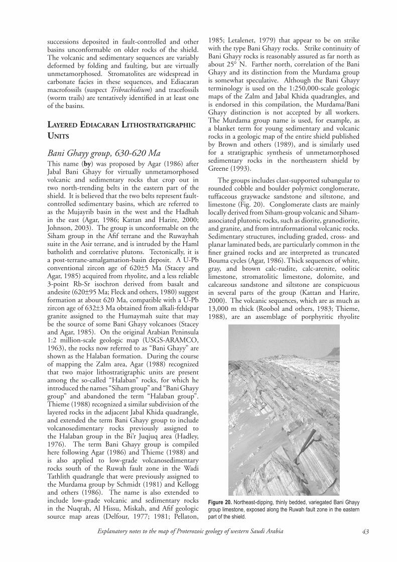
��Explanatory notes to the map of Proterozoic geology of western Saudi Arabia
Figure 20. Northeast-dipping, thinly bedded, variegated Bani Ghayy group limestone, exposed along the Ruwah fault zone in the eastern part of the shield.
successions deposited in fault-controlled and other basins unconformable on older rocks of the shield. The volcanic and sedimentary sequences are variably deformed by folding and faulting, but are virtually unmetamorphosed. Stromatolites are widespread in carbonate facies in these sequences, and Ediacaran macrofossils (suspect Tribrachidium) and tracefossils (worm trails) are tentatively identified in at least one of the basins.
Layered ediacaran LithoStratigraphic unitS
Bani Ghayy group, 6�0-6�0 MaThis name (by) was proposed by Agar (1986) after Jabal Bani Ghayy for virtually unmetamorphosed volcanic and sedimentary rocks that crop out in two north-trending belts in the eastern part of the shield. It is believed that the two belts represent fault-controlled sedimentary basins, which are referred to as the Mujayrib basin in the west and the Hadhah in the east (Agar, 1986; Kattan and Harire, 2000; Johnson, 2003). The group is unconformable on the Siham group in the Afif terrane and the Ruwayhah suite in the Asir terrane, and is intruded by the Haml batholith and correlative plutons. Tectonically, it is a post-terrane-amalgamation-basin deposit. A U-Pb conventional zircon age of 620±5 Ma (Stacey and Agar, 1985) acquired from rhyolite, and a less reliable 3-point Rb-Sr isochron derived from basalt and andesite (620±95 Ma; Fleck and others, 1980) suggest formation at about 620 Ma, compatible with a U-Pb zircon age of 632±3 Ma obtained from alkali-feldspar granite assigned to the Humaymah suite that may be the source of some Bani Ghayy volcanoes (Stacey and Agar, 1985). On the original Arabian Peninsula 1:2 million-scale geologic map (USGS-ARAMCO, 1963), the rocks now referred to as “Bani Ghayy” are shown as the Halaban formation. During the course of mapping the Zalm area, Agar (1988) recognized that two major lithostratigraphic units are present among the so-called “Halaban” rocks, for which he introduced the names “Siham group” and “Bani Ghayy group” and abandoned the term “Halaban group”. Thieme (1988) recognized a similar subdivision of the layered rocks in the adjacent Jabal Khida quadrangle, and extended the term Bani Ghayy group to include volcanosedimentary rocks previously assigned to the Halaban group in the Bi’r Juqjuq area (Hadley, 1976). The term Bani Ghayy group is compiled here following Agar (1986) and Thieme (1988) and is also applied to low-grade volcanosedimentary rocks south of the Ruwah fault zone in the Wadi Tathlith quadrangle that were previously assigned to the Murdama group by Schmidt (1981) and Kellogg and others (1986). The name is also extended to include low-grade volcanic and sedimentary rocks in the Nuqrah, Al Hissu, Miskah, and Afif geologic source map areas (Delfour, 1977; 1981; Pellaton,
1985; Letalenet, 1979) that appear to be on strike with the type Bani Ghayy rocks. Strike continuity of Bani Ghayy rocks is reasonably assured as far north as about 25° N. Farther north, correlation of the Bani Ghayy and its distinction from the Murdama group is somewhat speculative. Although the Bani Ghayy terminology is used on the 1:250,000-scale geologic maps of the Zalm and Jabal Khida quadrangles, and is endorsed in this compilation, the Murdama/Bani Ghayy distinction is not accepted by all workers. The Murdama group name is used, for example, as a blanket term for young sedimentary and volcanic rocks in a geologic map of the entire shield published by Brown and others (1989), and is similarly used for a stratigraphic synthesis of unmetamorphosed sedimentary rocks in the northeastern shield by Greene (1993).
The groups includes clast-supported subangular to rounded cobble and boulder polymict conglomerate, tuffaceous graywacke sandstone and siltstone, and limestone (Fig. 20). Conglomerate clasts are mainly locally derived from Siham-group volcanic and Siham-associated plutonic rocks, such as diorite, granodiorite, and granite, and from intraformational volcanic rocks. Sedimentary structures, including graded, cross- and planar laminated beds, are particularly common in the finer grained rocks and are interpreted as truncated Bouma cycles (Agar, 1986). Thick sequences of white, gray, and brown calc-rudite, calc-arenite, oolitic limestone, stromatolitic limestone, dolomite, and calcareous sandstone and siltstone are conspicuous in several parts of the group (Kattan and Harire, 2000). The volcanic sequences, which are as much as 13,000 m thick (Roobol and others, 1983; Thieme, 1988), are an assemblage of porphyritic rhyolite

�� Johnson, P.R., �006
flows, sills, and tuffs, dacite, basalt, and andesite that, chemically, resemble present-day tholeiitic, high-alumina, and alkali basalts (Agar, 1986) or calc-alkalic and high-K calc-alkalic lavas transitional between continental-margin arcs and island arcs (Roobol and others, 1983). Volcaniclastic rocks include welded tuff, crystal and lapilli tuff, breccia, and agglomerate that are locally interbedded with and transitional to volcanic conglomerate.
Khaniq formation, age uncertainThe Khaniq formation (kk) (Greene, 1980) is a sequence of massive, nonmetamorphosed rhyolite, dacite, and andesite lava and subordinate tuff and breccia exposed immediately west of Ranyah in the central part of the shield. The formation is not directly dated, but is spatially associated, and may be coeval, with alkali granite of the Kawr suite (650-620 Ma). It is estimated here to be an Ediacaran unit.
Al Junaynah formation, <6�0 MaThis map unit (aj) comprises small exposures of epiclastic rocks located along the Junaynah and Nabitah fault zones. They were assigned to the Murdama group during compilation of the 1:250,000-scale geologic source map (Greenwood and others, 1986; Simons, 1988) because it was routine at that time to assign all relatively young epiclastic rocks in the southern shield to the Murdama. This designation was abandoned by Johnson (2005c) because of the distance and separation of the rocks from the Murdama reference area in the northeastern part of the shield, and because they appear to be younger than the Murdama group. The epiclastic rocks consist of basal polymict conglomerate overlain by arkosic sandstone, siltstone, and slate. Along the Nabitah fault zone, the epiclastic rocks are unconformable on Kawr suite monzogranite. The rocks represent the infill of narrow orogenic basins along active shear zones, flanked by newly uplifted and unroofed late- to posttectonic bodies of granite. They are younger than the Kawr suite, and are treated here as Ediacaran, possibly younger than ~620 Ma.
Hamir group, 6��-60� MaThe Hamir group (mi) (Vaslet and others, 1983) crops out along the Al Amar fault in the eastern part of the shield. The exposures are discontinuous and probably represent separate small basins along the fault. Hamir rocks yield Rb-Sr isochrons of 594±31 Ma and 572±23 Ma (Darbyshire and others, 1983) but these are unreliable, possibly reset dates; SHRIMP dating constrains the group between 616 and 607 Ma (Doebrich and others, 2005), that is, Ediacaran. The group comprises basaltic and andesitic flows, tuffs, and breccia, rhyolitic welded tuff, polymict conglomerate, sandstone, and siltstone.
Jurdhawiyah group, 6�0-��� MaThe Jurdhawiyah group (jr) (Cole, 1988) crops out
in the northeastern part of the shield. It was first mapped in the Aban al Ahmar geologic source map, but following Cole (1993), the group is extended to include volcanic rocks in the Nir basin in parts of the Miskah and Halaban geologic source maps that were previously assigned to the Nir formation of the Murdama group (Pellaton, 1985; Delfour, 1979), and rocks in an unnamed basin centered on Jabal Shabah in the Miskah quadrangle that were previously assigned to the Shabah formation (Pellaton, 1985). The basins are unconformable on folded Murdama-group rocks and locally overstep the Murdama to rest directly on older rocks. The group is indirectly dated as 640-625 Ma (Cole and Hedge, 1986), but recent SHRIMP analysis gives preferred ages of 612±4 Ma (Kennedy and others, 2004) and 594±7 Ma (Kennedy and others, 2005). It is treated here as an Ediacaran formation. The rocks are virtually unmetamorphosed, although they are folded and cut by numerous faults. They include polymict conglomerate, volcanic arenite, and andesite, dacite, rhyodacite, and rhyolite flows, tuffs, and agglomerate.
Hadn formation, ~600 MaThe Hadn formation (hn) (Ekren and others, 1987; Quick and Doebrich, 1987) consists of nonmetamorphosed volcanic and epiclastic rocks in the northern part of the shield, deposited in one or more postamalgamation basins unconformably on layered and intrusive rocks of the Ha’il terrane. The formation unconformably overlies the Banana formation and associated intrusions, is unconformably overlain by the Jibalah group, and is intruded by plutonic rocks of the Idah suite. On the basis of these relations, Cole (1993) proposes that the formation was deposited sometime after 630 Ma and prior to 610 Ma, and suggests that is broadly coeval with the Shammar group. Recent SHRIMP dating of flow-banded Hadn rhyolite yield a coherent group of concordant zircons at ~598 Ma (Kennedy and others, 2004), which suggests that the group is younger than previously considered. It is treated here as ~600 Ma. The volcanic rocks are rhyolitic to rhyodacitic ash-flow tuff, lesser amounts of massive rhyolite and rhyodacite flows, and rare dacitic, andesitic, and basaltic flows. Epiclastic rocks include arkosic sandstone and polymict conglomerate.
Habid formation, age uncertainThe Habid formation (hb) (Khogandi, 1983) crops out between Harrat Rahat and Harrat Kishb at the northern end of Sahl Rukbah, in the west-central part of the shield. The formation is believed to unconformably overlie the Ghamr group and is intruded by granite of the posttectonic Habd ash Sharah suite (~580-575 Ma). It is inferred to be Ediacaran. The formation consists of nonmetamorphosed, gently dipping graywacke, siltstone, polymict conglomerate, and rare tuff (Sahl and Smith, 1986). Cross bedding, ripple marks, and mudcracks are common. Conglomerate
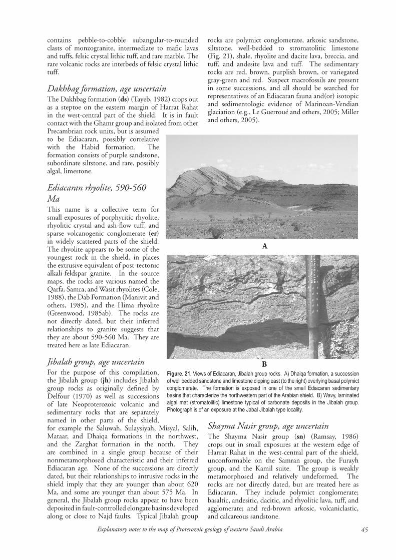
��Explanatory notes to the map of Proterozoic geology of western Saudi Arabia
contains pebble-to-cobble subangular-to-rounded clasts of monzogranite, intermediate to mafic lavas and tuffs, felsic crystal lithic tuff, and rare marble. The rare volcanic rocks are interbeds of felsic crystal lithic tuff.
Dakhbag formation, age uncertainThe Dakhbag formation (ds) (Tayeb, 1982) crops out as a steptoe on the eastern margin of Harrat Rahat in the west-central part of the shield. It is in fault contact with the Ghamr group and isolated from other Precambrian rock units, but is assumed to be Ediacaran, possibly correlative with the Habid formation. The formation consists of purple sandstone, subordinate siltstone, and rare, possibly algal, limestone.
Ediacaran rhyolite, ��0-�60 Ma This name is a collective term for small exposures of porphyritic rhyolite, rhyolitic crystal and ash-flow tuff, and sparse volcanogenic conglomerate (er) in widely scattered parts of the shield. The rhyolite appears to be some of the youngest rock in the shield, in places the extrusive equivalent of post-tectonic alkali-feldspar granite. In the source maps, the rocks are various named the Qarfa, Samra, and Wasit rhyolites (Cole, 1988), the Dab Formation (Manivit and others, 1985), and the Hima rhyolite (Greenwood, 1985ab). The rocks are not directly dated, but their inferred relationships to granite suggests that they are about 590-560 Ma. They are treated here as late Ediacaran.
Jibalah group, age uncertainFor the purpose of this compilation, the Jibalah group (jh) includes Jibalah group rocks as originally defined by Delfour (1970) as well as successions of late Neoproterozoic volcanic and sedimentary rocks that are separately named in other parts of the shield, for example the Saluwah, Sulaysiyah, Misyal, Salih, Mataar, and Dhaiqa formations in the northwest, and the Zarghat formation in the north. They are combined in a single group because of their nonmetamorphosed characteristic and their inferred Ediacaran age. None of the successions are directly dated, but their relationships to intrusive rocks in the shield imply that they are younger than about 620 Ma, and some are younger than about 575 Ma. In general, the Jibalah group rocks appear to have been deposited in fault-controlled elongate basins developed along or close to Najd faults. Typical Jibalah group
rocks are polymict conglomerate, arkosic sandstone, siltstone, well-bedded to stromatolitic limestone (Fig. 21), shale, rhyolite and dacite lava, breccia, and tuff, and andesite lava and tuff. The sedimentary rocks are red, brown, purplish brown, or variegated gray-green and red. Suspect macrofossils are present in some successions, and all should be searched for representatives of an Ediacaran fauna and(or) isotopic and sedimentologic evidence of Marinoan-Vendian glaciation (e.g., Le Guerroué and others, 2005; Miller and others, 2005).
Figure. 21. Views of Ediacaran, Jibalah group rocks. A) Dhaiqa formation, a succession of well bedded sandstone and limestone dipping east (to the right) overlying basal polymict conglomerate. The formation is exposed in one of the small Ediacaran sedimentary basins that characterize the northwestern part of the Arabian shield. B) Wavy, laminated algal mat (stromatolitic) limestone typical of carbonate deposits in the Jibalah group. Photograph is of an exposure at the Jabal Jibalah type locality.
A
B
Shayma Nasir group, age uncertainThe Shayma Nasir group (sn) (Ramsay, 1986) crops out in small exposures at the western edge of Harrat Rahat in the west-central part of the shield, unconformable on the Samran group, the Furayh group, and the Kamil suite. The group is weakly metamorphosed and relatively undeformed. The rocks are not directly dated, but are treated here as Ediacaran. They include polymict conglomerate; basaltic, andesitic, dacitic, and rhyolitic lava, tuff, and agglomerate; and red-brown arkosic, volcaniclastic, and calcareous sandstone.
�6 Johnson, P.R., �006
intruSive ediacaran LithoStratigraphic unitS
Rudayhah gabbro, age uncertainThis map unit (ru), named by Johnson (2005b), is compiled from a layered, inward-dipping gabbro about 2,500 m thick in the central part of the Ad Dawadimi terrane. Although not directly dated, the gabbro appears to intrude the Najirah granite and to be intruded by the Khurs granite of the Ar Ruwaydah suite, suggesting that it is younger than ~640 Ma and older than ~605 Ma, and is treated here as Ediacaran. Delfour and others (1982) regarded the gabbro as one of the oldest rock units in the Ad Dawadimi quadrangle and correlated it with the Rharabah complex, but this assignment is not compatible with its geologic relationships. The gabbro comprises cumulate layers of olivine gabbro, pyroxene gabbro, norite, and anorthosite.
Qazaz granite super suite, 6��-6�0 MaThis name (qa) was introduced by Johnson (2005f ) as a collective term for a large number of Ediacaran granite plutons that crop out in the Midyan terrane in the northwestern part of the Arabian shield. On the 1:250,000-scale source maps (Clark, 1987; Davies and McEwen, 1985) and as described by Ramsay and others (1986), the granites include separately named lithostratigraphic units such as the Shar alkali granophyre, the Ifal suite, the Marabat suite, Atiyah monzogranite, and the Liban and Khara Dakha complexes, but are grouped here as a super suite because of their common lithology, apparent age, and juxtaposition in the northwestern shield. The suite is predominantly monzogranite, but individual plutons also contain granodiorite, diorite, syenogranite, and local gabbro. Preliminary and model U-Pb zircon ages of 625±5 Ma, 625 Ma, and 621±7 Ma, and Rb-Sr whole-rock ages of 630±10 Ma and 638±10 Ma (Hedge, 1984; Clark, 1987 - citing C.E. Hedge, written communication, 1984) suggest emplacement between about 635 and 620 Ma. The intrusions commonly have sharp, discordant contacts, but in and adjacent to the Qazaz shear zone, the intrusions are deformed, cataclased and mylonitized, transform to gneisses, and have conformable contacts.
Al Hawiyah granite suite, ~6�0-��0 Ma This name was introduced by Johnson (2005e) as a collective term for Ediacaran granites in the area between At Ta’if and Jabal Ibrahim in the west-central part of the shield (hwg). They characteristically crop out as undeformed, discordant plutons, and have monzogranite and syenogranite compositions with transitions to alkali-feldspar granite and granodiorite. The granites are not well dated and the dates that are available are mainly Rb-Sr ages that appear to have undergone varying degrees of disturbance. Recent SHRIMP dating of one of the granite plutons assigned
to the suite indicates crystallization between 630 and 590 Ma (Kennedy and others, 2005), but the result is not precise.
Members of the suite, separately named on the 1:250,000-scale geologic source maps, include the Turabah granite, Layyah complex, Rahwah granite, and others. The Turabah granite is an almost complete monzogranite to granodiorite ring dike 50 km southwest of Turabah, which yields an Rb-Sr feldspar age of 635 Ma; an Rb-Sr biotite age of 515 Ma; and a K-Ar biotite age of 400 Ma (Aldrich, 1978). Radain and others (1988) report a four-point Rb-Sr whole-rock isochron of 117±0.4 Ma, but a single point with anomalously high 87Rb/86Sr and 87Sr/86Sr ratios controls the slope of the isochron regression line. Eliminating this point from the isochron regression slightly alters the result, but it would, nonetheless, remain a Mesozoic age. Radain and others (1988) interpret the isochron as an emplacement age, which if true implies Cretaceous igneous activity in the Arabian shield of the type known in Egypt and Sudan. However, a Mesozoic origin for the granite requires confirmation, and pending confirmation, the granite is interpreted here as an Ediacaran intrusion that may have had an isotopic open system during the Mesozoic.
The Layyah complex (Ziab and Ramsay, 1986) is granite and granodiorite exposed east of At Ta’if. It yields a K-Ar age of 605±18 Ma and an Rb-Sr age of 618±50 Ma (Sindi, 1976), but the accuracy and reliability of these results are uncertain. Nasseef and Gass (1977) report an Rb-Sr 3-point age of 520±15 Ma for the complex (termed by them the “G4 granite and adamellite”), but the result is based on a wide spread of Rb/Sr ratios. It has an unknown analytic accuracy (MSWD) and is of uncertain geologic significance. The Rahwah alkali-feldspar granite, about 40 km east-southeast of At Ta’if, is dated by the SHRIMP method, and the results suggest that crystallization was mainly about 628 Ma, with some crystallization as late as 592 Ma (Kennedy and others, 2005). The Qaym granite (Ziab and Ramsay, 1986; Moore and Al-Rehaili, 1989) comprises biotite-hornblende monzogranite centered on At Ta’if airport. Fleck and others (1980) report an unreliable Rb-Sr single-point model age of 657 Ma and a K-Ar biotite mineral age of 610±7 Ma (result recalculated by Gettings and Stoeser, 1981 using modern standards). The Halgah complex (Moore and Al-Rehaili, 1989) comprises discordant plutons of monzogranite and syenogranite northeast and north of At Ta’if. Al-Mishwt (1977) (cited by Moore and Al-Rehaili, 1989) reports a so-called Rb-Sr “isochron” of 635±50 Ma, but gives no analytic information, which means that the reliability and interpretation of the result are uncertain. Nasseef and Gass (1977) report a three-point Rb-Sr age of 595±20 Ma, but the analytic accuracy (MSWD) is not reported and the geologic meaning of this result is unknown. The Qazayel granite (French and Sindi, 1979) is dated by the Rb-Sr method at 641±76 Ma and 558±0.54 Ma, (Radain and others, 1987).
��Explanatory notes to the map of Proterozoic geology of western Saudi Arabia
Syn- to post-Shammar intrusives, 6�� Ma This map unit (szx) comprises Ediacaran granite plutons spatially related to, and probably coeval with, rhyolite in the Shammar group in the north-central part of the shield. The plutons were emplaced about 625 Ma, a figure derived from Rb-Sr granite whole-rock isochrons of 630±13 Ma; 628±4 Ma; 626±14 Ma; 623±17 Ma; and 617±7 Ma (Calvez and Kemp, 1987; Stuckless and others, 1984). The plutons appear to be broadly coeval with, although more felsic than, granitoid rocks of the Idah suite. They include alkali-feldspar granite, alkali granite, syenogranite, monzogranite, and granodiorite.
Idah suite, 6�0-6�� Ma The Idah suite (id) (Cole, 1993; Cole and Hedge, 1986) is an assemblage of Ediacaran calc-alkalic plutons widespread in the northeastern part of the Arabian shield. The plutons crop out as broadly elliptical intrusions that crosscut older rocks units, and are largely undeformed except where locally cataclased along fault zones. They may be surrounded by contact zones of hornfels, which cause annuli of high-amplitude, short-wavelength magnetic anomalies around the plutons. The suite is lithologically similar to but possibly slightly older than the Al Khushaymiyah suite. Idah suite rocks are associated with gold-bearing quartz veins, as at Sukhaybarat, and are a significant control on mesothermal gold mineralization in the northeastern shield. The suite is characterized by granodiorite, but overall is compositionally heterogeneous and includes gabbro, diorite, tonalite, alkali-feldspar granite, monzogranite, and syenogranite, although such lithologic differences are not differentiated in this compilation. The rocks are directly dated between 620 Ma and 615 Ma (Cole, 1993; Cole and Hedge, 1986).
Malik granite, age uncertainThe Malik granite (kg) (Vaslet and others, 1985) crops out at the northeastern margin of the Arabian shield as leucocratic medium-grained biotite monzogranite. It intrudes the Abt formation, Nafi and Hillit formations, and Dukhnah gneiss. The granite was compiled by Cole (1993) and Cole and Hedge (1986) as part of the 620-615 Ma Idah suite, but because of its distance from typical Idah-suite rocks is compiled here as a separate early Ediacaran lithostratigraphic unit. The granite is not directly dated, but may well be contemporary with the Idah. The granite is poorly exposed and its relationship with adjacent rock units is not clear. The boundaries plotted in this compilation are based on Vaslet and others (1985) with some modification from Cole (1993).
Thurayban granodiorite, <6�� Ma The Thurayban granodiorite (tt), named by Johnson (2005c), intrudes the western margin of the An Nimas batholith, metavolcanic and metasedimentary
rocks of the Shwas belt, and serpentinite of the Umm Farwah shear zone. It is a complex of nested ring-dikes composed of biotite-muscovite granodiorite and inward-dipping metasedimentary and metavolcanic septa. The complex is not directly dated but it is inferred to be younger than 615 Ma, because the granodiorite intrudes the Umm Farwah shear zone which deforms Ablah group rocks dated at 640-615 Ma.
Haml suite: Alkali-feldspar granite, 6��-600 MaAvailable evidence indicates that the Haml suite comprises a group of Cryogenian-Ediacaran plutons of monzogranite and syenogranite, described above, and younger Ediacaran plutons of alkali-feldspar granite (hla), considered here. The alkali-feldspar granite is directly dated at 614±10 Ma and 601±4 Ma and is younger than the monzogranite and syenogranite components of the suite. The plutons tend to be circular, and in some locations form rings of alkali granite around monzogranite cores. Contacts with the country rocks at most of these plutons are sharp and subvertical. The plutons represent specialized granites that have been explored for Sn, W, and Mo (Ramsay, 1985; du Bray and others, 1982; du Bray, 1983; Jackson and Al Yazidi, 1985).
Al Khushaymiyah suite, 6�0-��� MaThe Al Khushaymiyah suite (ky) (Johnson, 2005a) is a group of massive, relatively undeformed, circular to concentric plutons that intrude the Murdama group in the east-central part of the shield. Previous workers (e.g., Theobald and Allcott, 1973; Bois and others, 1975; Delfour, 1980) refer to the rocks by the names of individual intrusions, such as the Al Khushaymiyah batholith, the Uyaijah ring structure, the Fahwah batholith, the Umm Makh batholith, and Al Hawshah batholith. They are combined as a single suite here because their contact relationships indicate that the individual intrusions are coeval. The suite is directly dated at 611±3 Ma and 595±15 Ma (Agar and others, 1992; Fleck and Hadley, 1982).
The suite includes granodiorite, monzogranite, syenogranite, and minor gabbro and diorite. A north-northwest- to northwest-trending fault divides the main outcrops of the suite and separates a group of western plutons (Al Khushaymiyah batholith, Uyaijah ring structure, and Fahwah batholith) from a group of eastern plutons (the Umm Makh and Al Hawshah batholiths), that have markedly different magnetic signatures and possibly need to be differentiated in terms of their magnetite content. Screens of hornfelsed, greisenized, and scheelite-bearing Murdama group rocks are located on the margins of the Uyaijah ring structure.
Wadbah suite, 60� MaThis map unit (wb), named after Johnson (2005c),
�� Johnson, P.R., �006
consists of plutons of biotite-hornblende granodiorite and monzogranite and minor tonalite exposed in a north-south zone through the eastern part of the Asir terrane. It includes a pluton that discordantly cuts serpentinite schist along the Ibran shear zone, and sheared and mylonitic plutons along the Junaynah fault zone. The unit has a SHRIMP crystallization age of 606±2 Ma (Johnson and others, 2001), and is treated here as Ediacaran.
Abanat suite, ���-��0 MaThe Abanat suite (Cole, 1988) consists of Ediacaran alkali-rich, leucocratic, siliceous, high evolved, and undeformed granites exposed in the northern and northeastern parts of the Arabian shield. The suite was defined by Cole, (1988), for rocks in the Aban al Ahmar quadrangle geologic source map, in the northern part of the Afif terrane, and is extended here to include similar granite in the Hail terrane. Cole and Hedge (1986) also show the suite extending into much of the Ad Dawadimi terrane, but in this compilation, the Ad Dawadimi granites are separated out as the Ar Ruwaydah suite. Granites of the suite tend to form topographic highs, and are: (1) generally only weakly magnetic, (2) commonly anomalous in total-count radioactivity, (3) commonly pink, red, or orange, (4) locally emplaced as ring dikes or concentric-composite intrusions, (5) enriched in fluorine, lithium, rubidium, and distinctive trace-element groups, and (6) locally associated with tin-tungsten or niobium-lanthanum-rare-earth-element mineral occurrences. The suite is directly dated between 585 Ma and 570 Ma (Cole and Hedge, 1986) and was emplaced at a high level in the crust, with some plutons apparently venting as rhyolite flows and pyroclastic rocks (see Ediacaran rhyolites, above). The granites mark a significant change in magma type in the northeastern shield from calc-alkalic rocks of the Idah suite to more evolved granites, and are interpreted as the result of widespread but minor melting in the crust (Cole and Hedge, 1986). They include alkali-feldspar granite, monzogranite and syenogranite, and peraluminous granite and aplite.
Gharamil monzogranite, age uncertainThis map unit (hr) (Al-Muallem and Smith, 1988) is represented by a single pluton exposed at the northern margin of the Ruwah fault zone, in the central part of the shield, isolated from adjacent rocks by the eolian and alluvial sand of ‘Uruq Subay. It consists of nonfoliated, coarse-grained monzogranite and subsidiary biotite-rich granodiorite. The granite is not directly dated, but is possibly Ediacaran, similar to other diapiric granites in the region.
Umm Gerad granite, ��� MaThe Umm Gerad (Umm Jerad) granite (gu) is a small body of syenogranite exposed at the western margin of the shield adjacent to the Red Sea coastal plain. It intrudes the Bustan complex but is mostly
surrounded by Quaternary alluvium. The pluton is strongly discordant and has sharp intrusive contacts that crosscut the structural grain of the surrounding Bustan complex tonalite. The granite is directly dated by an Rb-Sr isochron of 583±3 Ma (Al-Shanti and others, 1983).
Ar Ruwaydah suite, 60�-�6� MaThis name (ku) is introduced here for an assemblage of 605-565 Ma Ediacaran granite emplaced in the Abt formation in the Ad Dawadimi terrane. The suite comprises the Khurs granite and Arwa granite. They are separated from the Abanat suite because of their pale gray to white color and absence of the tin-tungsten or niobium-lanthanum-rare-earth-element mineral occurrences. The Khurs granite (Johnson, 2005b) is leucocratic monzogranite, subordinate syenogranite, and biotite-muscovite aluminous granite. The granite is undeformed and forms high-relief inselbergs. Conventional U-Pb zircon dating yields ages between 605±5 and 598±35 Ma (Stacey and others, 1984) and SHRIMP dating yields ages between 579±3 Ma and 565±2 Ma (Kenney and others, 2005). Rb-Sr errorchrons of 575±49 and 532±26 Ma (Calvez and others, 1983) likely reflect thermal resetting. The Arwa granite (Johnson, 2005b) is a grayish-red porphyritic microgranite ring-dike. It is dated by an unreliable Rb-Sr errorchron of 587±50 Ma (Calvez and others, 1883) and by a SHRIMP age of 575±6 Ma (Kennedy and others, 2005).
Hadb ash Sharar suite, ~��0-��� MaThis map unit consists of elliptical- to subcircular-shaped, undeformed Ediacaran granite, granodiorite, and gabbro (hh) that intrude the Mahd and Ghamr groups and Hufayriyah tonalite in the Jiddah terrane. On the Mahd adh Dhahab geologic source map (Kemp and others, 1982), the rocks are assigned to the Raghiyah suite, named after a layered gabbro located approximately 120 km east of the Habd ash Sharah area, in the Afif terrane. Although its age is uncertain, the Raghiyah layered gabbro is treated in this compilation as possibly part of the Nuqrah subterrane of the Afif terrane (i.e. about 840 Ma), and is therefore inappropriate as a type area for the posttectonic rocks described here. For this reason, the Raghiyah suite name is abandoned, and the granitoids in the Mahd adh Dhahab area are renamed as a complex after Jabal Hadb ash Sharar. The complex yields Rb-Sr whole-rock ages of 584±26 Ma and 573±22 Ma (Calvez and others, 1983), indicating late Ediacaran emplacement. The suite includes plutons of monzogranite, alkali-feldspar granite, aegerine-reibekite alkali granite, and small bodies of gabbro and granodiorite, and is a notable source of intense radiation caused by aplite-pegmatite at Jabal Sa’id mineralized by Ta, Sn, U, and REE (Hackett, 1986).
Al Bad granite super suite, ���-��0 MaThis name (abg) was introduced by Johnson (2005f )

��Explanatory notes to the map of Proterozoic geology of western Saudi Arabia
as a collective term for a large group of posttectonic granites in the northwestern part of the Arabian shield, characterized by their middle to late Ediacaran age, syenogranite and alkali-feldspar granite compositions, and high topographic relief. A number of plutons have anomalously high radioactivity and have been explored for uranium and rare-earth elements (e.g., Drysdall, 1980), others for beryllium, fluorine, tin, and tungsten. The granites have sharp, discordant contacts; commonly contain xenoliths of country rocks; and have contact zones marked by dikes and apophyses in the wall rock. The super suite includes units such as the Mabrak granite, Ghadiyah granite, Midyan suite, Haql suite, Lawz complex, and Dabbagh complex separately named on the 1:250,000-scale source maps and in the literature (Rowaihy, 1985; Ramsay and others, 1986; Davies and Grainger 1985; Grainger and Hanif, 1989). Contiguous granites in Jordan are assigned to the Rumman suite and Humrat-Feinan suite (595-572 Ma; Jarrar and others, 2003).
Direct dating yields a U-Pb zircon age of 577±13 Ma (Aleinikoff and Stoeser, 1988) and Rb-Sr ages of 586±11 Ma (Duyverman and others, 1982), 575±5 Ma (C.E. Hedge, 1984, written communication; cited by Clark, 1987), 574±10 Ma (C.E. Hedge and C.R. Ramsay, written communication, 1984; cited by Rowaihy, 1985), and 570+7 Ma (Hedge, 1984). Rb-Sr ages of 629±12 Ma and 630±19 Ma (Kemp and others, 1980) obtained from strongly cataclased granite assigned to the super suite, are anomalously old and their geologic significance is not clear. The super suite granite is light gray to pink, massive, and medium- to coarse-grained, and includes biotite monzogranite, hornblende-biotite syenogranite, and riebeckite-, arfvedsonite-, and aegerine-bearing alkali-feldspar and alkali granite.
Al Hafoor suite, age uncertainThis term (ao) was introduced by Johnson (2005a) for a cluster of gabbro to granite plutons close to the eastern margin of the shield south of the Ruwah fault zone and east of the Nabitah fault zone. The plutons are variously referred to on the 1:250,000-scale source map as the Yild complex and Jasl pluton (Kellogg and others, 1986). The plutons postdate the Bani Ghayy group and are typical, undeformed “posttectonic” intrusions, and are not directly dated although, by comparison with other posttectonic plutons in the region, they are estimated to be Ediacaran. According to Kellogg and others (1986), the emplacement of Al Hafoor diorite was probably synchronous with late-stage folding of the Bani Ghayy group, which implies that it is early Ediacaran. The suite comprises clinopyroxene-olivine gabbro, diorite, quartz diorite, monzodiorite, hornblende-biotite granodiorite and tonalite, and biotite-muscovite, locally porphyritic monzogranite.
Khuls granite, ~�6� MaThe Khuls granite (kl) crops out as small, circular to elongate plutons of medium- to coarse-grained hornblende-biotite monzogranite, granodiorite and subordinate syenogranite emplaced in already folded Al ‘Ays and Shayma Nasir group rocks in the western part of the shield. The suite is lithologically similar to, but may be younger than, granitoid plutons assigned here to the Admar suite. An unreliable Rb-Sr whole rock age of 563±7 Ma (C.E. Hedge, cited by Camp, 1986) is reported for one of the plutons, and the geologic relations of the plutons (sharp, discordant contacts; emplacement in the Shayma Nasir group) suggest that the granite comprises some of the youngest intrusive rocks in the western part of the shield. They are treated here as upper Ediacaran, possibly about 565 Ma.
Rithmah complex, age uncertainThis unit (rt) (Kemp, 1981) comprises small, circular, discordant plutons emplaced in a zone about 15 km east of the Yanbu suture in the northwestern part of the shield. The plutons, some of which are layered, include quartz diorite and subordinate grabbro, granodiorite, and tonalite. The complex is not directly dated, but clearly postdates folding of the Al ‘Ays group and intrudes the Admar suite. It is treated here as Ediacaran.
Mardabah complex, age uncertainThis unit (mr) was named by Johnson (2005d) after the Mardabah ring structure (Pellaton, 1979), for a group of circular, concentrically ringed plutons that intrude the Hadiyah group between Yanbu’ al Bahr and Al Ays. The plutons consist of monzonite and syenite, and medium-grained monzodiorite and local gabbro. They are not directly dated, but crosscut folds in the Hadiyah group and are regarded by Pellaton (1979) and Kemp (1981) as the youngest Neoproterozoic rocks in the Yanbu’ al Bahr and Wadi al ‘Ays 1:250,000-scale geologic source maps. The complex is treated here as late Ediacaran.
Radwa granite, ~�60 MaThe Radwa granite (rw), named by Johnson (2005d) after the prominent mountain of Jabal Radwa inland from Yanbu’ al Bahr (Fig. 22), crops out as undeformed, circular to semicircular plutons of alkali and alkali-feldspar granite. The plutons form prominent high-relief mountains and have conspicuous contact aureoles. Available Rb-Sr whole-rock ages (561±32 Ma and 517±20 Ma: Kemp and others, 1980) are unreliable, but the granite is estimated here to be ±560 Ma because it has the character of a typical “posttectonic” pluton in the Arabian shield, with sharp, steeply dipping, discordant contacts, and is lithologically and structurally similar to, and probably contemporary with, some of the upper Ediacaran suites of alkali granite exposed elsewhere in the
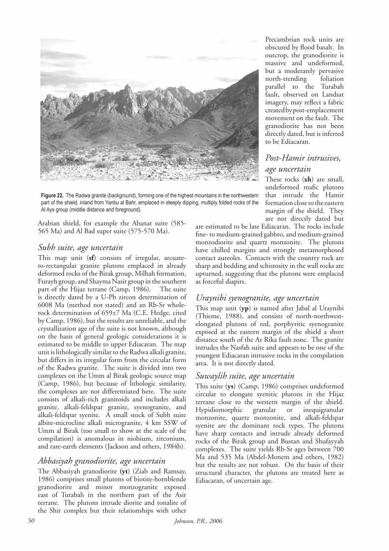
�0 Johnson, P.R., �006
Arabian shield, for example the Abanat suite (585-565 Ma) and Al Bad super suite (575-570 Ma).
Subh suite, age uncertain This map unit (sf) consists of irregular, arcuate-to-rectangular granite plutons emplaced in already deformed rocks of the Birak group, Milhah formation, Furayh group, and Shayma Nasir group in the southern part of the Hijaz terrane (Camp, 1986). The suite is directly dated by a U-Pb zircon determination of 6008 Ma (method not stated) and an Rb-Sr whole-rock determination of 659±7 Ma (C.E. Hedge, cited by Camp, 1986), but the results are unreliable, and the crystallization age of the suite is not known, although on the basis of general geologic considerations it is estimated to be middle to upper Ediacaran. The map unit is lithologically similar to the Radwa alkali granite, but differs in its irregular form from the circular form of the Radwa granite. The suite is divided into two complexes on the Umm al Birak geologic source map (Camp, 1986), but because of lithologic similarity, the complexes are not differentiated here. The suite consists of alkali-rich granitoids and includes alkali granite, alkali-feldspar granite, syenogranite, and alkali-feldspar syenite. A small stock of Subh suite albite-microcline alkali microgranite, 4 km SSW of Umm al Birak (too small to show at the scale of the compilation) is anomalous in niobium, zirconium, and rare-earth elements (Jackson and others, 1984b).
Abbasiyah granodiorite, age uncertainThe Abbasiyah granodiorite (yt) (Ziab and Ramsay, 1986) comprises small plutons of biotite-hornblende granodiorite and minor monzogranite exposed east of Turabah in the northern part of the Asir terrane. The plutons intrude diorite and tonalite of the Shir complex but their relationships with other
Precambrian rock units are obscured by flood basalt. In outcrop, the granodiorite is massive and undeformed, but a moderately pervasive north-trending foliation parallel to the Turabah fault, observed on Landsat imagery, may reflect a fabric created by post-emplacement movement on the fault. The granodiorite has not been directly dated, but is inferred to be Ediacaran.
Post-Hamir intrusives, age uncertainThese rocks (xh) are small, undeformed mafic plutons that intrude the Hamir formation close to the eastern margin of the shield. They are not directly dated but
are estimated to be late Ediacaran. The rocks include fine- to medium-grained gabbro, and medium-grained monzodiorite and quartz monzonite. The plutons have chilled margins and strongly metamorphosed contact aureoles. Contacts with the country rock are sharp and bedding and schistosity in the wall rocks are upturned, suggesting that the plutons were emplaced as forceful diapirs.
Uraynibi syenogranite, age uncertainThis map unit (yp) is named after Jabal al Uraynibi (Thieme, 1988), and consists of north-northwest-elongated plutons of red, porphyritic syenogranite exposed at the eastern margin of the shield a short distance south of the Ar Rika fault zone. The granite intrudes the Nasfah suite and appears to be one of the youngest Ediacaran intrusive rocks in the compilation area. It is not directly dated.
Suwaylih suite, age uncertainThis suite (ys) (Camp, 1986) comprises undeformed circular to elongate syenitic plutons in the Hijaz terrane close to the western margin of the shield. Hypidiomorphic granular or inequigranular monzonite, quartz monzonite, and alkali-feldspar syenite are the dominant rock types. The plutons have sharp contacts and intrude already deformed rocks of the Birak group and Bustan and Shufayyah complexes. The suite yields Rb-Sr ages between 700 Ma and 535 Ma (Abdel-Monem and others, 1982) but the results are not robust. On the basis of their structural character, the plutons are treated here as Ediacaran, of uncertain age.
Figure 22. The Radwa granite (background), forming one of the highest mountains in the northwestern part of the shield, inland from Yanbu al Bahr, emplaced in steeply dipping, multiply folded rocks of the Al Ays group (middle distance and foreground).

��Explanatory notes to the map of Proterozoic geology of western Saudi Arabia
UNASSIGNED NEOPROTEROZOIC ROCkS
These map units consist of intrusive rocks that, for various reasons, mainly their lack of direct dating and ambiguous information about their relative lithostratigraphic positions, are not assigned on any of the named lithostratigraphic units. The unassigned map units include serpentinite and gabbro that make up the ophiolites of the Arabian shield or are preserved as slivers of mafic-ultramafic rock along shear zones, and schist and gneiss developed from protoliths of various ages along shear zones in the shear.
Unassigned gabbro (ubu) comprises gabbro and metagabbro; unassigned dioritoid (udd) comprises diorite, quartz diorite and subordinate gabbro and tonalite; unassigned granite (ugg) comprises undivided monzogranite, syenogranite, and alkali-feldspar granite; unassigned schist and gneiss (ush) chiefly represents paraschist, paragneiss, orthoschist, and orthogniess located along northwest-trending shear zones of the Najd system; unassigned granodiorite and tonalite (utg) comprises plagioclase-rich granitoids; and serpentinite and gabbro (uum) consists of serpentinite, ultramafic rocks such as dunite, peridotite, and harzburgite, gabbro, and local diorite and trondhjemite, which as mentioned above, encompass the shield ophiolites (Pallister and others, 1988; Johnson and others, 2003; Stern and others, 2003) as well as serpentinite-gabbro lenses along shear zones.
ACkNOWLEDGMENTSThe work reported here was done under the terms of SGS Subproject 4.1.1.1.6 of the 2006 Technical Work Program of the Saudi Geological Survey, namely “Compilation and updating of the Arabian shield digital map”. The author acknowledges the support and encouragement of H.E. Dr. Zohair A. Nawab, President of the Saudi Geological Survey, M. Najeeb Rowaihy, Assistant President for Survey and Exploration, and Dr. Mohammed A. Tawfiq, former president of SGS. We thank colleagues in the SGS Geologic Mapping Unit, headed by Fayek H. Kattan for opportunities of joint fieldwork and discussion of problems. The work would not have been completed without the technical advice and input of Mansour Al-Otaibi and Maher R. Al-Subhi, SGS GIS Unit, and many thanks are given for their help. The report was peer-reviewed by Ian C.F. Stewart and Fayek Kattan, but conclusions and opinions expressed belong to the author alone.
DATABASE ARCHIvEFor archival purposes, a digital version of this map (Plate), and a copy of the report, is stored in the Saudi Geological Survey Geosciences Database. The digital
data are retrievable from the SGS intranet server. The report is retrievable by author, title, report number, and the following key words: Neoproterozoic, Arabian shield, lithostratigraphy.
REFERENCESAbdel-Monem, A.A., Al-Shanti, A.M., and Radain,
A.A., 1982, Rb-Sr dating and petrochemistry of some granite bodies, west-central Saudi Arabia: Precambrian Research, v. 16, p. A3.
Afifi, A.M., 1989, Geology of the Mahd adh Dhahab district, Kingdom of Saudi Arabia: Saudi Arabian Directorate General of Mineral Resources Open-File Report USGS-OF-09-2, 49 p.
Agar, R.A., 1985, Stratigraphy and paleogeography of the Siham group: direct evidence for a late Proterozoic continental microplate and active continental margin: Journal of the Geological Society, London, v. 142, p. 1205-1220.
Agar, R.A., 1986, The Bani Ghayy group: sedimentation and volcanism in pull-apart grabens of the Najd strike-slip orogen, Saudi Arabian shield: Precambrian Research, v. 31, p. 257-274.
Agar, R.A., 1988, Geologic map of the Zalm quadrangle, sheet 22F, Kingdom of Saudi Arabia: Saudi Arabian Deputy Ministry for Mineral Resources Geologic Map GM 89, scale 1:250,000, 41 p.
Agar, R.A., Stacey, J.S., and Whitehouse, M.J., 1992, Evolution of the southern Afif terrane−a geochronologic study: Saudi Arabian Directorate General of Mineral Resources Open-File Report DMMR-OF-10-15, 41 p.
Aldrich, L.T., 1978, Geochronologic data for the Arabian shield: Section 1, Radiometric age determinations of some rocks from the Arabian shield: U. S. Geological Survey Saudi Arabian Mission Project Report 240, p. 1-9.
Aleinikoff, J.N., and Stoeser, D.B., 1988, Zircon morphology and U-Pb geochronology of seven metaluminous and peralkaline post-orogenic granite complexes of the Arabian shield, Kingdom of Saudi Arabia: Saudi Arabian Directorate General of Mineral Resources Open-File Report USGS-OF-06-5, 32 p.
Al-Fotawi, B., 1982, Reconnaissance geology of the Al Muwayh quadrangle sheet 21/41D, Kingdom of Saudi Arabia: Saudi Arabian Deputy Ministry for Mineral Resources Open-File Report DGMR-OF-02-13, 1:100,000 scale, 26 p.
Al-Mishwt, A.T., 1977, Geology, mineralogy, and petrochemistry of Al-Halgah pluton, At Ta’if, Saudi
�� Johnson, P.R., �006
Arabia: Unpublished Ph.D. Thesis, University of Wisconsin (Madison), U.S.A., 296 p.
Al-Muallem, M.S., 1987, Reconnaissance geology of the Wadi Sarjuj quadrangle, sheet 21/42B, Kingdom of Saudi Arabia: Saudi Arabain Directorate General of Mineral Resources Open-File Report DGMR-OF-05-01, 24 p.
Al-Muallem, M.S., and Smith, J.W., 1988, Geologic map of the Ar Rawdah quadrangle, sheet 21F, Kingdom of Saudi Arabia: Saudi Arabian Deputy Ministry of Mineral Resources Geologic Map GM 85, scale 1:250,000, 25 p.
Al-Saleh, A.M., Boyle, A.P., and Mussett, A.E., 1998, Metamorphism and 40Ar/39Ar dating of the Halaban ophiolite and associated units: evidence for two-stage orogenesis in the eastern Arabian shield: Journal of the Geological Society, London, v. 155, p. 165-175.
Al-Shanti, A.M., and Abdel-Monem, A.A., 1982, Rb-Sr dating and petrochemistry of Umm Gerad granitic rocks, western Saudi Arabia (abstract): Precambrian Research , v. 16, p. A6.
Al-Shanti, A.M.S., Abdel-Monem, A.A., and Radain, A.A., 1983, Rb-Sr dating and petrochemistry of Umm Gerad granitic rocks (Rabigh area), western Saudi Arabia: Bulletin of the Faculty of Earth Sciences, King Abdulaziz University, v. 6, p. 221-232.
Al-Shanti, A.M.S., and Mitchell, A.H.G., 1976, Late Precambrian subduction and collision in the Al Amar-Idsas region, Arabian shield, Kingdom of Saudi Arabia: Tectonophysics, v. 30, p. T41-T47.
Andreassen, P.G., Bashawri, M., Al-Hijeri, F., Al-Jodaan, K., Al-Kolak, Z., Mawad, M., Al-Sagaby, I., Al-Sari, A., and Zuberi, M., 1977, Geology of the central Taif region, Kingdom of Saudi Arabia: King Abdulaziz University, Jiddah, Institute of Applied Geology Bulletin 2, 39 p.
Beyth, M., Stern, R.J., and Matthews, A., 1997, Significance of high-grade metasediments from the Neoproterozoic basement of Eritrea: Precambrian Research, v. 86, 45-58.
Béziat, P., and Donzeau, M., with the collaboration of Artignan, D., Bounny, I., Lemière, B., and Shanti, M., 1989, The Mamilah-Wadi Bidah mineral belt: Geology and mineral exploration: Saudi Arabian Directorate General of Mineral Resources Open-File Report BRGM-OF-09-5, scale 1:100,000, 34 p.
Blasband, B., 2006, Neoproterozoic tectonics of the Arabian-Nubian shield: Ph.D. Thesis, University of Utrecht, 213 p..
Bois, J., Leca, X., and Shanti, M., 1975, Geology and mineral exploration of the Al Khushaymiyah quadrangle, 22/44A: Bureau de Recherches Géologiques et Minières Technical Record 75 JED 14, scale 1:100,000, 57 p.
Bokhari, F.Y., and Kramers, J.D., 1981, Island-arc character and late Precambrian age of volcanics at Wadi Shwas, Hijaz, Saudi Arabia: geochemical and Sr and Nd isotopic evidence: Earth and Planetary Science Letters, v. 54, p. 409-422.
Bookstrom, A.A., Vennum, W.R., and Doebrich, J.L., 1989, Geology and mineral resources of the Farah Garan-Kutam mineral belt, southeast Asir, Kingdom of Saudi Arabia: Saudi Arabian Directorate General of Mineral Resources Technical Record USGS-TR-10-3, 57 p.
Bouge, R.G., 1953, Report on geologic reconnaissance in northwestern Saudi Arabia: Saudi Arabian Directorate General of Mineral Resources Open-File Report DGMR-27, 30 p.
BRGM, 1966, Annual Report February 1965-January 1966: Bureau de Recherches Géologiques et Minières JED 66 A.7, 37 p.
BRGM Geoscientists, 1995, Metallic mineral deposits map of the Arabian shield, Kingdom of Saudi Arabia: DMMR-BRGM Joint Special Publication, scale 1:1 million.
Brown, G.F., 1972, Tectonic map of the Arabian Peninsula: Saudi Arabian Directorate General of Mineral Resources, scale 1:4 million.
Brown, G.F., and Jackson, R.O., 1960, The Arabian shield: International Geological Congress, XXI Session, Norden, Part IX Precambrian stratigraphy and correlations, p.69-77.
Brown, G.F., Hedge, C., and Marvin, R., 1978, Geochronologic data for the Arabian shield, Section 2, Tabulation of Rb-Sr and K-Ar ages, given by rocks of the Arabian shield: U.S. Geological Survey Saudi Arabian Mission Project Report 240, p. 10-20.
Brown, G.F., Jackson, R.O., Bogue, R.G., and Elberg, E.L., Jr., 1963, Geologic map of the northwestern Hijaz quadrangle, Kingdom of Saudi Arabia: U.S. Geological Survey Miscellaneous Geologic Investigations Map I-204, scale 1:500,000.
Brown, G.F., Jackson, R.O., Bogue, R.G., and Maclean W.H., 1963, Geology of the Southern Hijaz quadrangle, Kingdom of Saudi Arabia: U.S. Geological Survey Miscellaneous Geologic Investigations Map I-210A, scale 1:500,000.
Brown, G.F., Schmidt, D.L., and Huffman, A.C., Jr., 1989, Geology of the Arabian Peninsula: Shield

��Explanatory notes to the map of Proterozoic geology of western Saudi Arabia
area of western Saudi Arabia: U.S. Geological Survey Professional Paper 560-A, scale 1:1 million, 188 p.
Calvez, J.-Y., and Kemp, J., 1982, Geochronological investigations in the Mahd adh Dhahab quadrangle, central Arabian Shield: Saudi Arabian Deputy Ministry for Mineral Resources Technical Report BRGM-TR-02-5, 41 p.
Calvez, J.-Y., Alsac, C., Delfour, J., Kemp, J., and Pellaton, C., 1983, Geologic evolution of western, central and eastern parts of the northern Precambrian shield: Saudi Arabian Deputy Ministry for Mineral Resources Open-file Report BRGM-OF-03-17, 57 p.
Calvez, J.-Y., and Delfour, J, 1986, Geochronology of the Ar Rayn structural province: Saudi Arabian Deputy Ministry for Mineral Resources Open-File Report BRGM-OF-06-14, 34 p.
Calvez, J.-Y., and Kemp, J., 1987, Rb-Sr geochronology of the Shammar group in the Hulayfah area, northern Arabian shield: Saudi Arabian Deputy Ministry for Mineral Resources Open-File Report BRGM-OF-07-11, 22 p.
Calvez, J.-Y., Pellaton, C., Alsac, A., and Tegyey, M., 1982, Geochronology and geochemistry of plutonic rocks in the Umm Lajj and Jabal al Buwanah areas: Saudi Arabian Deputy Ministry for Mineral Resources Open-File Report BRGM-OF-02-26, 39 p.
Camp, V.E., 1984, Island arcs and their role in the evolution of the western Arabian shield: Geological Society of America Bulletin, v. 95, p. 913-921.
Camp, V.E., 1986, Geologic map of the Umm al Birak quadrangle, sheet 23 D, Kingdom of Saudi Arabia: Saudi Arabian Deputy Ministry for Mineral Resources Geologic Map GM-87, 40 p.
Cater, F.W., and Johnson, P.R., 1986, Geologic map of the Jabal Ibrahim quadrangle, sheet 20E, Kingdom of Saudi Arabia: Saudi Arabian Deputy Ministry for Mineral Resources Geologic Map GM 96, scale 1:250,000, 32 p.
Carten, R.B., and Tayeb, J., 1989, Jabal Mardah: examples of low-temperature volcanogenic pyrite and millerite-polydymite-vaesite nickel deposits, Kingdom of Saudi Arabia: Directorate General of Mineral Resources Technical Record USGS-TR-09-3, 37 p.
Clark, M.D., 1981, Geologic map of the Al Hamra quadrangle, sheet 23 C, Kingdom of Saudi Arabia: Saudi Arabian Deputy Ministry for Mineral Resources Geologic Map GM-49, 28 p.
Clark, M.D., 1987, Geologic map of the Al Bad
quadrangle, sheet 28A, Kingdom of Saudi Arabia: Saudi Arabian Directorate General of Mineral Resources Geoscience Map GM-81, scale 1:250,000, 46 p.
Cole, J.C., 1988, Geologic map of the Aban al Ahmar quadrangle, sheet 25F, Kingdom of Saudi Arabia: Geologic Map GM-105, 45 p.
Cole, J.C., 1993, Proterozoic geology of western Saudi Arabia - northeastern sheet: Saudi Arabian Directorate General of Mineral Resources USGS-Open-File Report USGS-OF-93-2, p. 48.
Cole, J.C., and Hedge, C.E., 1986, Geochronologic investigations of late Proterozoic rocks in the northeastern shield of Saudi Arabia: Saudi Arabian Deputy Ministry of Mineral Resources Technical Record USGS-TR-05-5, 42 p.
Collenette, P., and Grainger, D.J., 1994, Mineral Resources of Saudi Arabia: Saudi Arabian Directorate General of Mineral Resources Special Publication SP-2, 322 p.
Collins, A.S., and Pisarevsky, S.A., 2005, Amalgamating eastern Godwana: The evolution of the circum-Indian orogens. Earth science Reviews, v. 71, p.229-270.
Cooper, J.A., Stacey, J.S., Stoeser, D.B., and Flack, R.J., 1979, An evaluation of the zircon method of isotopic dating in the southern Arabian craton: Contributions to Mineralogy and Petrology, v. 68, p. 429-439.
Darbyshire, D.P.F., Jackson, N.J., Ramsay, C.R., and Roobol, M.J., 1983, Rb-Sr isotope study of latest Proterozoic volcano-sedimentary belts in the Central Arabian shield: Journal of the Geological Society, London, v. 140, p. 203-213.
Davies, F.B., and McEwen, G., 1985, Geologic map of the Al Wajh quadrangle, sheet 26 B, Kingdom of Saudi Arabia: Saudi Arabian Deputy Ministry for Mineral Resources Geologic Map GM-83, 27 p.
Davies, F.B., and Grainger, D.J., 1985, Geologic map of the Al Muwaylih quadrangle, sheet 27A, Kingdom of Saudi Arabia: Saudi Arabian Deputy Ministry for Mineral Resources Geoscience Map GM-82, scale 1:250,000, 32 p.
Delfour, J. 1981, Geologic map of the Al Hissu quadrangle, sheet 24 E, Kingdom of Saudi Arabia: Saudi Arabian Deputy Ministry for Mineral Resources Geologic Map GM-58, 47 p.
Delfour, J., 1970, Le group de J’Balah, une nouvelle unité du Bouclier Arabie: Bureau de Recherches Géologique et Minières Bulletin, Ser 2. Sec. 4, no. 4, p. 19-32.
�� Johnson, P.R., �006
Delfour, J., 1977, Geologic map of the Nuqrah quadrangle, sheet 25 F, Kingdom of Saudi Arabia: Saudi Arabian Directorate General of Mineral Resources Geologic Map GM 28, scale 1:250,000, 32 p.
Delfour, J., 1979, Geologic map of the Halaban quadrangle, sheet 23 G, Kingdom of Saudi Arabia: Saudi Arabian Directorate General of Mineral Resources Geologic Map GM 46, scale 1:250,000, 32 p.
Delfour, J., 1980, Geologic map of the Wadi ar Rika quadrangle, sheet 22 G, Kingdom of Saudi Arabia: Saudi Arabian Directorate General of Mineral Resources Geologic Map GM-51, scale 1:250,000, 34 p.
Delfour, J., Dhellemes, R., Elsass, P., Vaslet, D., Brosse, J.-M., Le Nindre, Y.-M., and Dottin, O., 1982, Geological map of the Ad Dawadimi quadrangle, sheet 24 G, Kingdom of Saudi Arabia: Saudi Arabian Deputy Ministry for Mineral Resources Geoscience Map GM 60, scale 1:250,000, 36 p.
Doebrich, J.L., Al-Jehani, A.M., Siddiqui, A.A., Hayes, T.S., Saleh, Y., Wooden, J.L., Johnson, P.R., Kattan, F.H., Shaikan, B., Basahel, M., Zahran, H., and Al-Shammari, A., 2005, Geology and mineral resources of the Ar Rayn terrane, eastern Arabian shield, Kingdom of Saudi Arabia. Saudi Arabian Geological Survey Technical Reports SGS-TR-2005-2005-2, 54 p.
Doebrich, J.L., Zahony, S.G., Leavitt, J.D., Portacio, J.S., Siddiqui, A.M., Wooden, J.L., Fleck, R.J., and Stein, H.J., 2004, Ad Duwayhi, Saudi Arabia: Geology and geochronology of a Neoproterozoic intrusion-related gold system in the Arabian shield. Economic Geology, v. 99, p.713-741.
Donzeau, M., and Béziat, P., (with the collaboration of Artignan, D., Hottin, A.M., Khalil, I., Trinquard, R., and Vadala, P.), 1989, The Ablah-Wadi Shwas mineral belt: Geology and mineral exploration: Saudi Arabian Directorate General of Mineral Resources Open-File Report BRGM-OF-09-1, scale 1:100,000, 34 p.
Doughty, C.M., 1888, Arabia Deserta, first edition Cambridge University Press.
Drysdall, A.R., 1980, Geology and mineral potential of the granites of N.W. Hijaz: interim report no. 1: Saudi Arabian Directorate General of Mineral Resources Open-File Report DGMR-722, 83 p.
du Bray, E.A., 1983, Petrology of muscovite-bearing granitoid plutons in the eastern and southeastern Arabian shield, Kingdom of Saudi Arabia: Saudi Arabian Deputy Ministry for Mineral Resources Open-File Report USGS-OF-03-10, 36 p.
du Bray, E.A., Elliot, J.E., and Stoeser, D.B., 1982, Geochemical evaluation of felsic plutonic rocks in the eastern and southeastern Arabian shield, Kingdom of Saudi Arabia: Saudi Arabian Deputy Ministry for Mineral Resources Technical Record USGS-TR-02-2, 53 p.
Dunlop, H.M., Kemp, J., and Calvez, J.Y., 1986, Geochronology and isotope geochemistry of the Bi’r Umq mafic-ultramafic complex and Arj group volcanic rocks, Mahd adh Dhahab quadrangle, central Arabian shield: Saudi Arabian Deputy Ministry for Mineral Resources Open-File Report BRGM-OF-07-7, 38 p.
Duyverman, H.J., Harris, N.B.W., and Hawkesworth, C.J., 1982, Crustal accretion in the Pan African: Nd and Sr isotope evidence from the Arabian shield: Earth and Planetary Science Letters, v. 59, p. 315-326.
Ekren, E.B., Vaslet, D., Berthiaux, A., Le Strat, P., and Fourniguet, J., 1987, Geologic map of the Ha’il quadrangle, sheet 27 E, Kingdom of Saudi Arabia: Saudi Arabian Deputy Ministry for Mineral Resources Geologic Map GM-115, 46 p.
Fairer, G.M., 1985, Geologic map of the Wadi Baysh quadrangle, Sheet 17 F, Kingdom of Saudi Arabia: Saudi Arabian Deputy Ministry for Mineral Resources Geologic Map GM77, scale 1:250,000, 23 p.
Fairer, G.M., 1986, Geologic map of the Harrat Ithnayn quadrangle, sheet 26 D, Kingdom of Saudi Arabia: Saudi Arabian Deputy Ministry for Mineral Resources Geologic Map GM-106, 15 p.
Fleck, R.J., 1985, Age of diorite-granodiorite gneisses of the Jiddah-Makkah region, Kingdom of Saudi Arabia: Saudi Arabian Deputy Ministry for Mineral Resources Professional Paper PP2, p. 19-27.
Fleck, R.J., and Hadley, D.G., 1982, Ages and strontium initial ratios of plutonic rocks in a transect of the Arabian shield: Saudi Arabian Deputy Ministry for Mineral Resources Open-File Report USGS-OF-03-38, 43 p.
Fleck, R.J., Coleman, R.G., Cornwall, H.R., Greenwood, W.R., Hadley, D.G., Schmidt, D.L., Prinz, W.C., and Ratté, J.C., 1976, Geochronology of the Arabian shield, western Saudi Arabia: K-Ar results: Geological Society of America Bulletin, v. 87, p. 9-21.
Fleck, R.J., Greenwood, W.R., Hadley, D.G., Anderson, R.E., and Schmidt, D.L., 1980, Rubidium-strontium geochronology and plate-tectonic evolution of the southern part of the Arabian shield: U.S. Geological Survey Professional Paper 1131, 37 p.
��Explanatory notes to the map of Proterozoic geology of western Saudi Arabia
Flowerdew, M., Stoeser, D.B., and Whitehouse, M.J., 2004, The Nabitah fault zone: is it a suture between two ensimatic arcs? Abstracts; 32nd IGC – Florence
French, W.J., and Sindi, H.O., 1979, The petrology and geochemistry of the plutonic intrusives in the Al Jibub area, Kingdom of Saudi Arabia: King Abdulaziz University Institute of Applied Geology Bulletin 3, v., 2, p. 131-145.
Frets, D.C., Khallaf, H., Khokandi, M.E., Tayeb, G.M.S., and Davies, F.B., 1981, The reconnaissance geology of the Aba al Qazzaz quadrangle, Kingdom of Saudi Arabia: Saudi Arabian Directorate General of Mineral Resources Geologic Map GM-43, scale 1:100,000, 19 p.
Genna, A., Guerrot, C, Deschamps, Y., Nehlig, P., and Shanti, M., 1999, Les formations Ablah d’Arabie Saoudite (datation et implication géologique): Earth and Planetary Science Letters, 329, pp 661-67.
Genna, A., Nehlig, P., le Goff, E., Guerrot, C., and Shanti, M., 2002, Proterozoic tectonism of the Arabian shield: Precambrian Research, v. 117, p. 21-40.
Gettings, M.E., and Stoeser, D.B., 1981, A tabulation of radiometric age determinations for the Kingdom of Saudi Arabia: U.S. Geological Survey Saudi Arabian Mission Miscellaneous Document 20, 52 p.
Goddéris, Y., Donnadieu, Y., Nédélec, A., Dupré, B., Dessert, C., Grard, A., Ramstein, G., and François, L.M., 2003, The Sturtian ‘snowball’ glaciation: fire and ice: Earth and Planetary Science Letters, v. 211, p. 1-12.
Gradstein, F.M., Ogg, J.G., Smith, A.G., Bleeker, W., and Lourens, K.J., 2004, A new geologic time scale, with special reference to Precambrian and Neogene: Episodes, 27, p. 83-100.
Grainger, D.J., and Hanif, M.R., 1989, Geologic map of the Shaghab quadrangle, sheet 27B, Kingdom of Saudi Arabia: Saudi Arabian Directorate General of Mineral Resources Geoscience Map GM-109, scale 1:250,000, 31 p.
Greene, R.C., 1980, Reconnaissance geology of the Ar Rawdah quadrangle, sheet 21/42D, Kingdom of Saudi Arabia: U.S. Geological Survey Saudi Arabian Mission Technical Record 13, scale 1:100,000, 56 p.
Greene, R.C., 1993, Stratigraphy of the Late Proterozoic Murdama group, Saudi Arabia: U.S. Geological Survey Bulletin 1976, 59p.
Greene, R.C., and Gonzalez, L., 1980, Reconnaissance geology of the Wadi Shuqub quadrangle, sheet
20/41A, Kingdom of Saudi Arabia: Saudi Arabian Directorate General of Mineral Resources Geologic Map GM 54, scale 1:100,000, 15 p.
Greenwood, W.R., 1975a, Geology of Al ‘Aqiq quadrangle, sheet 20/41D, Kingdom of Saudi Arabia: Saudi Arabian Directorate General of Mineral Resources Geologic Map GM-23, scale 1:100,000, 15 p.
Greenwood, W.R., 1975b, Geology of the Jabal Ibrahim quadrangle, sheet 20/41C, Kingdom of Saudi Arabia: Saudi Arabian Directorate General of Mineral Resources Geologic Map GM 22, scale 1:100,000, 18 p.
Greenwood, W.R., 1985, Geologic map of the Abha quadrangle, sheet 18F, Kingdom of Saudi Arabia: Saudi Arabian Deputy Ministry for Mineral Resources Geoscience Map GM 75, scale 1:250,000, 27 p.
Greenwood, W.R., Anderson, R.E., Fleck, R.J., and Roberts, R.J., 1980, Precambrian geologic history and plate-tectonic evolution of the Arabian shield: Saudi Arabian Directorate General of Mineral Resources Bulletin 24, 35 p.
Greenwood, W.R., Jackson, R.O., and Johnson, P.R., 1986, Geologic map of the Jabal al Hasir quadrangle, Sheet 19F, Kingdom of Saudi Arabia: Saudi Arabian Deputy Ministry for Mineral Resources Geologic Map GM94, scale 1:250,000, 31 p.
Greenwood, W.R., Stoeser, D.B., Fleck, R.J., and Stacey, J.S., 1982, Late Proterozoic island-arc complexes and tectonic belts in the southern part of the Arabian shield, Kingdom of Saudi Arabia: Saudi Arabian Deputy Ministry for Mineral Resources Open-File Report USGS-OF-02-8, 46 p.
Hackett, D., 1986, Mineralized aplite-pegmatite at Jabal Sa’id, Hijaz region, Kingdom of Saudi Arabia, in, Drysdall, A.R., Ramsay, C.R., and Stoeser, D.B. (eds), Felsic plutonic rocks and associated mineralization of the Kingdom of Saudi Arabia, Saudi Arabian Deputy Ministry for Mineral Resources Bulletin 29, p. 257-267.
Hadley, D.G., 1974, Geologic map of the Wayban quadrangle, Kingdom of Saudi Arabia: Saudi Arabian Directorate General of Mineral Resources Geologic Map GM7, 10 p.
Hadley, D.G., 1976, Geology of the Bi’r Juqjuq quadrangle, sheet 21/43D, Kingdom of Saudi Arabia: Saudi Arabian Directorate General of Mineral Resources Geologic Map GM 26, scale 1:100,000, 30 p.
Hadley, D.G., 1987, Geologic map of the Sahl al

�6 Johnson, P.R., �006
Matran quadrangle, sheet 26 C, Kingdom of Saudi Arabia: Saudi Arabian Deputy Ministry for Mineral Resources Geologic Map GM-86, 24 p.
Hargrove, U.S., 2006, Crustal evolution of the Neoproterozoic Bi’r Umq suture zone, Kingdom of Saudi Arabia: Geochronological, isotopic, and geochemical constraints: Ph.D. Thesis, University of Texas at Dallas, 343 p.
Hedge, C.E., 1984, Precambrian geochronology of part of northwestern Saudi Arabia: Saudi Arabian Deputy Ministry for Mineral Resources Open-File Report USGS-OF-04-31, 12 p.
Hoffman, P.F., and Schrag, D.P., 2002, The snowball Earth hypothesis: testing the limits of global change: Terra Nova, v. 14, p. 129-155.
Hopwood, T., 1979, An exploration study of metal deposits in the Jabal Sayid region, Kingdom of Saudi Arabia: Riofinex Geologic Mission RFO-1979-9, 169 p.
Jackaman, B., 1971, Genetic and environmental factors controlling the formation of the massive sulphide deposits of Wadi Bidah and Wadi Wassat, Saudi Arabia: Unpublished Ph. D. Thesis, University of London, 359 p.
Jackson, N.J., and Al Yazidi, S., 1985, Reconnaissance prospecting of felsic plutons in the Demar area (21/44C): Saudi Arabian Deputy Ministry for Mineral Resources Open-File Report DGMR-OF-05-25, 35 p.
Jackson, N.J., Walsh, J.N., and Pegram, E., 1984a, Geology, geochemistry, and petrogenesis of late Precambrian granitoids in the central Hijaz region of the Arabian shield: Contributions to Mineralogy and Petrology, v., 87, p. 205-219.
Jackson, N.J., Douch, C.J., and Bedawi, H., 1984b, Geologic investigations of the Umm al Birak alkali microgranite (23/39C): Saudi Arabian Deputy Ministry for Mineral Resources Open-File Report DGMR-OF-04-6, 42 p.
Jarrar, G., Theye, T., and Khoury, H., 2004, Low pressure metamorphism of Neoproterozoic pelites in the central Wadi Araba, southwest Jordan: Abstracts: 32nd IGC – Florence.
Jarrar, G., Stern, R.J., Saffarini, G., and Al-Zubi, H., 2003, Late- and post-orogenic Neoproterozoic intrusions of Jordan: implications for crustal growth in the northernmost segment of the East African Orogen: Precambrian Research, v. 123, p. 295-319.
Johnson, P.R., 1983, A preliminary lithofacies map of the Saudi Arabian Shield : Deputy Ministry for Mineral Resources Technical Report RF-TR-03-2, scale 1:1 million, 72 p.
Johnson, P. R., Kattan, F.H., and Wooden, J.L., 2001, Implications of SHRIMP and microstructural data on the age and kinematics of shearing in the Asir terrane, southern Arabian shield, Saudi Arabia: Gondwana Research, v.4, p. 172-173.
Johnson, P.R. and Kattan, F., 1999, The timing and kinematics of a suturing event in the northeastern part of the Arabian shield, Kingdom of Saudi Arabia: Saudi Arabian Deputy Ministry for Mineral Resources Open-File Report USGS-OF-99-3, 29 p.
Johnson, P.R., 1993, Proterozoic geology of western Saudi Arabia – Northwestern sheet: Saudi Arabian Directorate General of Mineral Resources Open-File Report USGS-OF-93-3.
Johnson, P.R., 1995, Proterozoic geology of western Saudi Arabia – North-central sheet: Saudi Arabian Deputy Ministry for Mineral Resources Open-File Report USGS-OF-95-5.
Johnson, P.R., 1996, Proterozoic geology of western Saudi Arabia – East-central sheet: Saudi Arabian Deputy Ministry for Mineral Resources Open-File Report USGS-OF-96-4.
Johnson, P.R., 1998, The structural geology of the Samran-Shayban area, Kingdom of Saudi Arabia: Saudi Arabian Deputy Ministry for Mineral Resources Technical Report USGS-TR-98-02, 45 p.
Johnson, P.R., 1999, Proterozoic geology of western Saudi Arabia – Northwestern sheet: Saudi Arabian Deputy Ministry for Mineral Resources Open-File Report USGS-OF-99-2.
Johnson, P.R., 1999, Proterozoic geology of western Saudi Arabia – Southern sheet: Saudi Geological Survey Open-File Report USGS-OF-99-7.
Johnson, P.R., 2003, Post-amalgamation basins of the NE Arabian shield and implications for Ediacaran tectonism in the northern East African orogen: Precambrian Research, v. 123, p. 321-337.
Johnson, P.R., 2005a, Proterozoic geology of western Saudi Arabia, east-central sheet (revised, digital edition): Saudi Geological Survey Open-File Report SGS-OF-2004-9, 48 p.
Johnson, P.R., 2005b, Proterozoic geology of western Saudi Arabia, northeastern sheet (revised, digital edition): Saudi Geological Survey Open-File Report SGS-OF-2005-2, 39 p.
Johnson, P.R., 2005c, Proterozoic geology of western Saudi Arabia, southern sheet, Amended May 2005: Saudi Geological Survey Open-File Report SGS-OF-2005-4, 38 p
Johnson, P.R., 2005d, Proterozoic geology of western
��Explanatory notes to the map of Proterozoic geology of western Saudi Arabia
Saudi Arabia, north-central sheet: Amended May 2005: Saudi Geological Survey Open-File Report SGS-OF-2005-5, 34 p.
Johnson, P.R., 2005e, Proterozoic geology of western Saudi Arabia, west-central sheet: Amended May 2005: Saudi Geological Survey Open-File Report SGS-OF-2005-6, 59 p.
Johnson, P.R., 2005f, Proterozoic geology of western Saudi Arabia, northwestern sheet: Amended May 2005: Saudi Geological Survey Open-File Report SGS-OF-2005-7, 63 p.
Johnson, P.R., 2006, Digital map of Proterozoic rocks in western Saudi Arabia: Meta-data. Saudi Geological Survey Data-File Report SGS-DF-2005-7.
Johnson, P.R., Abdelsalam, M.G., and Stern, R.J., 2003, The Bi’r Umq-Nakasib suture zone in the Arabian-Nubian Shield: A key to understanding crustal growth in the East African Orogen: Gondwana Research, v. 6, p. 523-530.
Johnson, P.R., and Kattan, F., 2001, Oblique sinistral transpression in the Arabian shield: the timing and kinematics of a Neoproterozoic suture zone: Precambrian Research, v. 107, p. 117-138.
Johnson, P.R., and Kattan, F.H., 2005, Lithostratigraphy of the Arabian shield: An initial lithostratigraphic column: Saudi Geological Survey Open-File Report SGS-OF-2005-14, 6 p. in English and Arabic.
Johnson, P.R., Carten, R.B. & Jastaniah, A., 1997, Tabulation of previously published U-Pb, Rb-Sr, and Sm-Nd numerical age data for the Precambrian of Northeast Africa and Arabia: Saudi Arabian Deputy Ministry for Mineral Resources Open-file Report USGS-OF-97-1.
Johnson, P.R., Kattan, F.H., and Al-Saleh, A.M., 2004, Neoproterozoic ophiolites in the Arabian shield: field relationships and structures, in Kusky, T.M. (ed.) Precambrian Ophiolites and Related Rocks, Elsevier, Developments in Precambrian Geology vol. 13, p.129-162
Johnson, P.R., Kattan, F.H., and Wooden, J.L., 2001, Implications of SHRIMP and microstructural data on the age and kinematics of shearing in the Asir terrane, southern Arabian shield, Saudi Arabia: Gondwana Research, v. 4, p. 172-173.
Johnson. P.R., and Woldehaimanot, B., 2003, Development of the Arabian-Nubian Shield: perspectives on accretion and deformation in the northern East African Orogen and the assembly of Gondwana, in Yoshida, M., Windley, B.F., and Dasgupta, S., (eds) Proterozoic East Gondwana: Supercontinent Assembly and Breakup. Geological
Society of London Special Publications, 206, p. 289-325.
Johnson, P.R., Abdelsalam, M.G., and Stern, R.J., 2003, The Bi’r Umq suture zone in the Arabian-Nubian shield: a key to understanding crustal growth in the East African orogen: Gondwana Research, V. 6, p. 523-530.
Kattan, F.H., and Harire, A.R., 2000, Geology of the Ad Duwayah-Bi’r Warshah mineral belt: Saudi Geological Survey Open-File Report USGS-OF-99-6, 33 p.
Kattu, G.A., Al Harthi, H., Al Ghidany, Z.M., Khalil, I., Jannadi, E.Y., Johnson, P.R., and Siddiqui, A.A., 2006, Exploration results at the Wadi Yiba copper prospect: Saudi Geological Survey Technical Report SGS-TR-2005-1, 40 p.
Kellogg, K.S., Janjou, D., Minoux, L., and Fourniguet, J., 1986, Geologic map of the Wadi Tathlith quadrangle, sheet 20 G, Kingdom of Saudi Arabia: Saudi Arabian Deputy Ministry for Mineral Resources Geologic Map GM 103, scale 1:250,000, 27 p.
Kemp, J., 1996, The Kuara Formation (northern Arabian shield); definition and interpretation: a probable fault-trough sedimentary succession. Journal of African Earth Sciences, v. 22, p. 507-523.
Kemp, J., 1981, Geologic map of the Wadi al ‘Ays quadrangle, sheet 25 C, Kingdom of Saudi Arabia: Saudi Arabian Deputy Ministry for Mineral Resources Geologic Map GM-53, 39 p.
Kemp, J., Gros, Y., and Prian, J.-P., 1982, Geologic map of the Mahd adh Dhahab quadrangle sheet 23E, Kingdom of Saudi Arabia: Saudi Arabian Deputy Ministry for Mineral Resources Geologic Map GM-64, scale 1:250,000, 39 p.
Kemp, J., Pellaton, C., and Calvez, J.Y., 1980, Geochronological investigations and geological history in the Precambrian of northwestern Saudi Arabia: Saudi Arabian Directorate General of Mineral Resources Open-File Report BRGM-OF-01-1, 120 p.
Kennedy, A., Johnson, P.R., and Kattan, F.H., 2004, SHRIMP geochronology in the northern Arabian shield, Part I: Data acquisition: Saudi Geological Survey Open-file Report SGS-OF-2004-11, 28 p.
Kennedy, A., Johnson, P.R., and Kattan, F.H., 2005, SHRIMP geochronology in the northern Arabian shield, Part II: Data acquisition, 2004. Saudi Geological Survey Open-File Report SGS-OF-2005-10, 44 p..
Khogandi, M.E., 1983, Reconnaissance geology of the Jabal al Habid quadrangle, sheet 22/40B,

�� Johnson, P.R., �006
Kingdom of Saudi Arabia: Saudi Arabian Deputy Ministry for Mineral Resources Open-File Report DGMR-OF-03-1, 1:100,000 scale, 20 p.
Kröner, A. and Basahel, A., 1984, Stratigraphic position, correlationship and significance of metasediments in the eastern Al-Lith region, Southern Arabian shield: Bulletin of the Faculty of Earth Sciences, King Abdulaziz University, v. 6, p. 389-395.
Kröner, A., Halpern, M., and Basahel, A., 1984, Age and significance of metavolcanic sequences and granitoid gneisses from the Al-Lith area, Southwestern Arabian shield: Bulletin of the Faculty of Earth Sciences, King Abdulaziz University, v. 6, p. 380-388.
Kröner, A., Linnebacher, P., Stern, R.J., Reischmann, T., Manton, W., and Hussein, I.M., 1991, Evolution of Pan-African island-arc assemblages in the southern Red Sea Hills, Sudan and in southwestern Arabia as exemplified by geochemistry and geochronology: Precambrian Research, v. 53, p. 99-118.
Kröner, A., Pallister, J.S., and Fleck, R.J., 1992, Age of initial oceanic magmatism in the Late Proterozoic Arabian shield: Geology, v. 20, p. 803-806.
Ledru, P., and Augé, T., 1984, The Al ‘Ays ophiolitic complex petrology and structural evolution: Saudi Arabian Deputy Ministry for Mineral Resources Open-File Report BRGM-OF-04-15, 57 p.
Le Guerroné, E., Allen, P., and Cozzi, A., 2005, The largest ��13C excursion of Earth history: the late Neoproterozoic Khufai-Shuram boundary of Oman: Geophysical Research Abstracts, v. 7.
Leistel,. J.-M., and Eberlé, J.-M., 1999, The Zalm gold deposit, in Base and Precious Metal Deposits in the Arabian Shield, IUGS/UNESCO Deposit Modeling Workshop, November 12-19, 1999, Jiddah, Saudi Arabia.
Letalenet, J., 1979, Geological map of the Afif quadrangle, sheet 23 F, Kingdom of Saudi Arabia: Saudi Arabian Directorate General of Mineral Resources Geoscience Map GM 47, scale 1:250,000, 20 p.
Manivit, J., Pellaton, C., Vaslet, D., Le Nindre, Y.-M., Brosse, J.-M., and Fourniguet, J., 1985, Geologic map of the Wadi al Mulayh quadrangle, sheet 22H, Kingdom of Saudi Arabia: Saudi Arabian Deputy Ministry for Mineral Resources Geologic Map GM 92, scale 1:250,000, 32 p.
Mercolli, I., Brinner, A.P., Frei, R., Schönberg, R., Nagler, T.F., Kramers, J., and Pters, T., 2005, Lithostratigraphjy and geochronology of the
Neoproterozoic crystalline basement of Salalah, Dhofar, Sultanate of Oman: Precambrian Research, v. 154, p. 182-206.
Miller, N., Stern, R.J., and Johnson, P., 2005, Carbonate chemical and petrographic trends in an Ediacaran? post-amalgamation basin, NW Arabian shield: Geological Society of America Annual Meeting 2005, Abstracts with Programs, v. 37, no. 7, p. 219.
Moore, T.A., and Ar-Rehaili, H., 1989, Geologic map of the Makkah quadrangle, sheet 21D, Kingdom of Saudi Arabia: Saudi Arabian Deputy Ministry for Mineral Resources Geoscience Map GM 107, 62 p.
Nasseef, A.O., and Gass, I.G., 1977, Granitic and metamorphic rocks of the Taif area, western Saudi Arabia: Geological Society of America Bulletin, v. 88, p. 1721-1730.
Nawab, Z.A., 1979, Geology of the Al Amar-Idsas region of the Arabian shield, in, S.A. Tahoun, editor, Evolution and Mineralization of the Arabian-Nubian shield: King Abdulaziz University, Jiddah, Institute of Applied Geology Bulletin 3, v. 2, p. 29-39.
Nebert, K., 1969, Geology of the Jabal Samran and Jabal Farasan region, Kingdom of Saudi Arabia: Saudi Arabian Directorate General of Mineral Resources Bulletin 4, 32 p.
Nehlig, P., Genna, A., and Asfirane, F., 2002, A review of the Pan-African evolution of the Arabian Shield: GeoArabia, v. 7, p. 103-124.
Pallister, J.S., 1986, Geologic map of the Al Lith quadrangle, sheet 20D, Kingdom of Saudi Arabia: Saudi Arabian Deputy Ministry for Mineral Resources Geoscience Map GM 95, 41 p.
Pallister, J.S., Stacey, J.S., Fischer, L.B., and Premo, W.R., 1988, Precambrian ophiolites of Arabia: Geologic setting, U-Pb geochronology, Pb-isotope characteristics, and implications for continental accretion. Precambrian Research, v. 38, p. 1-54.
Parker, T.W.H., and Smith, G.H., 1979, An assessment of the stratifrom copper potential of the Ablah Synform. Saudi Arabian Deputy Ministry of Mineral Resources RF-TR-01-1.
Pellaton, C., 1979, Geologic map of the Yanbu’ al Bahr quadrangle, 24 C, Kingdom of Saudi Arabia: Saudi Arabian Directorate General of Mineral Resources Geologic Map GM-48, 16 p.
Pellaton, C., 1981, Geologic map of the Al Madinah quadrangle, sheet 24 D, Kingdom of Saudi Arabia: Saudi Arabian Deputy Ministry for Mineral Resources Geologic Map GM-52, 19 p.

��Explanatory notes to the map of Proterozoic geology of western Saudi Arabia
Pellaton, C., 1982a, Geologic map of the Umm Lajj quadrangle, sheet 25 B, Kingdom of Saudi Arabia: Saudi Arabian Deputy Ministry for Mineral Resources Geologic Map GM-61, 14 p.
Pellaton, C., 1982b, Geologic map of the Jabal al Buwanah quadrangle, sheet 24 B, Kingdom of Saudi Arabia: Saudi Arabian Deputy Ministry for Mineral Resources Geologic Map GM-62, 10 p.
Pellaton, C., 1985, Geological map of the Miskah quadrangle, sheet 24 F, Kingdom of Saudi Arabia: Saudi Arabian Deputy Ministry for Mineral Resources Geoscience Map GM 99, scale 1:250,000, 23 p.
Prinz, W.C., 1983, Geologic map of the Al Qunfudhah quadrangle, Sheet 19E, Kingdom of Saudi Arabia: Saudi Arabian Deputy Ministry for Mineral Resources Geologic Map GM 70, scale 1:250,000, 19 p.
Prinz, W.C., 1984, Geologic map of the Wadi Haliy quadrangle, Sheet 18E, Kingdom of Saudi Arabia: Saudi Arabian Deputy Ministry for Mineral Resources Geologic Map GM 74, scale 1:250,000, 13 p.
Quick, J.E., and Bosch, P.S., 1989, Tectonic history of the northern Nabitah fault zone, Arabian shield, Kingdom of Saudi Arabia: Saudi Arabian Directorate General of Mineral Resources Technical Record USGS-TR-08-2, 87 p.
Quick, J.E., and Doebrich, J.L., 1987, Geological map of the Wadi ash Shubah quadrangle, sheet 26 E, Kingdom of Saudi Arabia: Saudi Arabian Deputy Ministry for Mineral Resources Geoscience Map GM 108, scale 1:250,000, 23 p.
Radain, A.A., Ali, S., and Abdel-Monem, A.A., 1988, Geochronology and geochemical evolution of the Wadi Turabah felsic plutonic ring complex, central Arabian shield: Journal of King Abdulaziz University, Earth Sciences, v. 1, p. 1-25.
Radain, A.A., Ali, S., Nasseef, A.O., and Abdel-Monem, A.A., 1987, Rb-Sr geochronology and geochemistry of plutonic rocks from the Wadi Shuqub quadrangles, west-central Arabian shield: Journal of African Earth Sciences, v. 6, p. 553-568.
Radain, A.A., Al-Shanti, A.M.S., and Abdel-Monem, A.A., 1989, Age and petrochemistry of Bahrah granodiorite-granite complex, Jeddah-Makkah region, Saudi Arabia: Journal of King Abdulaziz University, Earth Sciences, v. 2, p. 147-167.
Ramsay, C.R., 1985, Specialized felsic plutonic rocks of the Arabian shield and their precursors: Journal of African Earth Sciences, v. 4, p. 153-168.
Ramsay, C.R., 1986, Geologic map of the Rabigh
quadrangle, sheet 22 D, Kingdom of Saudi Arabia: Saudi Arabian Deputy Ministry for Mineral Resources Geologic Map GM-84, 49 p.
Ramsay, C.R., Basahel, A.N., and Jackson, N.J., 1981, Petrography, geochemistry and origin of the volcano-sedimentary succession between Jabal Ibrahim and Al-Aqiq, Saudi Arabia: King Abdulaziz University Faculty of Earth Sciences Bulletin 4, p. 1-24.
Ramsay, C.R., Drysdall, A.R., and Clark, M.D., 1986, Felsic plutonic rocks of the Midyan region, Kingdom of Saudi Arabia—I, Distribution, classification, and resource potential, in, Drysdall, A.R., Ramsay, C.R., and Stoeser, D.B. (eds), Felsic plutonic rocks and associated mineralization of the Kingdom of Saudi Arabia, Saudi Arabian Deputy Ministry for Mineral Resources Bulletin 29, p. 63-77.
Reischmann, T., Bachtadse, V., Kröner, A., and Layer, P., 1992, Geochronology and paleomagnetism of a late Proterozoic island-arc terrane from the Red Sea Hills, northeast Sudan: Earth and Planetary Science Letters, v. 114, p. 1-15.
Reischmann, T., Kröner, A., and Basahel, A., 1984, Petrology, geochemistry, and tectonic setting of metavolcanic sequences from the Al Lith area, southwestern Arabian shield: Bulletin of the Faculty of Earth Sciences, King Abdulaziz University, v. 6, p. 366-378.
Rexworthy, S.R., 1972, Geology and mineralization of the Precambrian metavolcanics and intrusives of the Jabal Samran-Wadi Hawara region of the southern Hijaz: unpublished Ph. D. thesis, University of London, 239 p.
Roobol, M.J., 1989, Stratigraphic control of exhalative mineralization in the Shayban paleovolcanoes (22/39A): Saudi Arabian Directorate General of Mineral Resources Open-File Report DGMR-OF-10-7, 39 p.
Roobol, M.J., Ramsay, C.R., Jackson, N.J., and Darbyshire, D.P.F., 1983, Late Proterozoic lavas of the Central Arabian Shield – evolution of an ancient volcanic system: Journal of the Geological Society, London, v. 140, p. 185-202.
Rowaihy, N.M., 1985, Geologic map of the Haql quadrangle, sheet 29A, Kingdom of Saudi Arabia: Saudi Arabian Directorate General of Mineral Resources Geoscience Map GM-80, scale 1:250,000, 15 p.
Sable, E.G., 1985, Geologic map of the Najran quadrangle, Sheet 17G, Kingdom of Saudi Arabia: Saudi Arabian Deputy Ministry for Mineral Resources Geologic Map GM 78, scale 1:250,000,

60 Johnson, P.R., �006
17 p.
Sahl, M., 1981, Reconnaissance geology of the Tayyib al Ism quadrangle, sheet 28/34B, Kingdom of Saudi Arabia: Saudi Arabian Directorate General of Mineral Resources Open-File Report DGMR-OF-01-18, 24 p.
Sahl, M.S.A., 1993, Geochemistry and genesis of the gold deposits in Al Hajar and Sukhaybarat prospects: Unpublished Ph. D. thesis, King Abdulaziz University, Jiddah, Saudi Arabia, 295 p.
Sahl, M., and Smith, J.W., 1986, Geologic map of the Al Muwayh quadrangle, sheet 22 E, Kingdom of Saudi Arabia: Saudi Arabian Deputy Ministry for Mineral Resources Geoscience Map GM-88, scale 1:250,000, 29 p.
Salvador , A., 1994, International Stratigraphic Guide: International Union of Geological Sciences and Geological Society of America, 214 p.
Schmidt, D.L., 1981, Geology of the Jabal Yafikh quadrangle, sheet 20/43B, Kingdom of Saudi Arabia: U. S. Geological Survey Saudi Arabian Mission Miscellaneous Document 39, scale 1:100,000, 99 p.
Schmidt, D.L., Hadley, D.G., and Stoeser, D.B., 1979, Late Proterozoic crustal history of the Arabian Shield southern Najd province, Kingdom of Saudi Arabia: King Abdulaziz University Institute of Applied Geology Bulletin 3, v. 2, p. 41-58.
Schmidt, D.L., Hadley, D.G., Greenwood, W.R., Gonzalez, L., Coleman, R.G., and Brown, G.F., 1973, Stratigraphy and tectonism in the southern part of the Precambrian Shield of Saudi Arabia: Saudi Arabian Directorate General of Mineral Resources Bulletin 8, 13 p.
Simons, F., 1988, Geologic map of the Wadi Bishah quadrangle, sheet 20 F, Kingdom of Saudi Arabia: Saudi Arabian Deputy Ministry for Mineral Resources Geologic Map GM 97, scale 1:250,000, 34 p.
Sindi, H.O., 1976, The geology and geochemistry of the At Ta’if area, Saudi Arabia: Unpublished M.Sc. Thesis, University of Leeds, 304 p.
Skiba, W.J., and Gilboy, C.F., 1975, Geology of the Rabigh-Khulays quadrangle, 22/39, Kingdom of Saudi Arabia: unpublished manuscript SGS Central Library, 597 p.
Skiba, W.J., Tayeb, J., Al-Khatieb, S.O., and Khallaf, H.M., 1977, Geology of the Jiddah-Makkah area (21°/39°), Kingdom of Saudi Arabia (compiled by W.J. Skiba): Saudi Arabian Directorate General of Mineral Resources unpublished bulletin, 561 p.
Smith, J.W., 1980, Reconnaissance geology of the At Ta’if quadrangle, sheet 21/40C, Kingdom of Saudi Arabia: Saudi Arabian Directorate General of Mineral Resources Geologic Map GM-56, 1:100,000 scale, 33 p.
Smith, E.A., and Johnson, P.R., 1986, Selected Mineral Occurrences of the Arabian shield, showing their relationship to major Precambrian tectonostratigraphic entities: Saudi Arabian Deputy Ministry for Mineral Resource Technical Record RF-TR-06-1.
Stacey, J.S., and Agar, R.A., 1985, U-Pb isotopic evidence for the accretion of a continental microplate in the Zalm region of the Saudi Arabian shield: Journal of the Geological Society, London, v. 142, p. 1189-1203.
Stacey, J.S., and Stoeser, D.B., 1983, Distribution of oceanic and continental leads in the Arabian-Nubian shield: Contributions to Mineralogy and Petrology, v. 84, p. 91-105.
Stacey, J.S., Dow, B.R., Roberts, R.J., Delevaux, M.H., and Gramlich, J.W., 1980, A lead isotope study of mineralization in the Saudi Arabian shield: Contributions to Mineralogy and Petrology, v. 74, p. 175-188.
Stacey, J.S., Stoeser, D.B., Greenwood, W.R., and Fischer, L.B., 1984, U-Pb geochronology and geologic evolution of the Halaban-Al Amar region of the eastern Arabian shield, Kingdom of Saudi Arabia: Journal of the Geological Society, London, v. 141, p. 1043-1055.
Stern, R.J., 1994, Arc assembly and continental collision in the Neoproterozoic East African Orogen: Implications for the consolidation of Gondwanaland: Annual Review of Earth Sciences, v. 22, p. 319-351.
Stern, R.J., 2002, Crustal evolution in the East African Orogen: a neodymium isotopic perspective. Journal of African Earth Sciences, v. 34, p. 109-117.
Stern, R.J., Avigad, D., Miller, N.R., and Beyth, M., 2006, Evidence for the Snowball Earth hypothesis in the Arabian-Nubian shield and the East African Orogen: Journal of African Earth Sciences, v. 44, p. 1-20.
Stern, R.J., Johnson, P.R., Kröner, A., and Yibas, B., 2004, Neoproterozoic ophiolites of the Arabian-Nubin shield, in Kusky, T.M. (ed.) Precambrian Ophiolites and Related Rocks, Elsevier, Developments in Precambrian Geology vol. 13, p. 95-128.
Stoeser, D.B., and Camp, V.E., 1985, Pan-African
6�Explanatory notes to the map of Proterozoic geology of western Saudi Arabia
microplate accretion of the Arabian shield: Geological Society of America Bulletin, v. 96, p. 817-826.
Stoeser, D.B., and Frost, C.D., 2006, Nb, Pb, St, and O isotopic characterization of Saudi Arabian shield terranes: Chemical Geology, v. 226, p. 163-188.
Stoeser, D.B., and Stacey, J.S., 1988, Evolution, U-Pb geochronology, and isotope geology of the Pan-African Nabitah orogenic belt of the Saudi Arabian shield, in S. El-Gaby and R.O. Greiling, eds., The Pan-African Belt of Northeast Africa and Adjacent Areas: Braunschweig/ Wiesbaden, Vieweg and Sohn, p. 227-288.
Stoeser, D.B., Fleck, R.J., and Stacey, J.S., 1982, Geochronology and origin of an early tonalite gneiss of the Wadi Tarib batholith and the formation of syntectonic gneiss complexes in the southeastern Arabian shield, Kingdom of Saudi Arabia: Saudi Arabian Deputy Ministry for Mineral Resources Open-File Report USGS-OF-02-62, 27 p.
Stoeser, D.B., Jackson, N.J., Ramsay, C.R., Drysdall, A.R., du Bray, E.A., and Douch, C.J., 1985, Map of plutonic rocks in the Arabian shield, Kingdom of Saudi Arabia: Saudi Arabian Deputy Ministry for Mineral Resources, scale 1:1 million, 2 sheets.
Stoeser, D.B., Stacey, J.S., Greenwood, W.R., and Fischer, L.B., 1984, U/Pb zircon geochronology of the southern part of the Nabitah mobile belt and Pan-African continental collision in the Saudi Arabian shield: Saudi Arabian Deputy Ministry for Mineral Resources Technical Record USGS-TR-04-5, 88 p.
Stoeser, D.B., Whitehouse, M.J., and Stacey, J.S., 2001, The Khida subterrane – Geology of the Paleoproterozic rocks in the Muhayil area, eastern Arabian shield: Gondwana Research, v. 4, p. 192-194.
Stoeser, D.B., Whitehouse, M.J., and Stacey, J.S., 2004. Neoproterozoic evolution of the Khida terrane, Saudi Arabia: a detached microplate in the Arabian craton. Abstracts; 32nd IGC – Florence.
Stratigraphic Committee, 1984, Saudi Arabian code of lithostratigraphic classification and nomenclature: Second edition: Saudi Arabian Deputy Ministry for Mineral Resources Technical Manual DM-TM-04-1, 16 p.
Stuckless, J.S., Hedge, C.E., Wenner, D.B., and Nkomo, I.T., 1984, Isotopic studies of postorogenic granites from the northeastern Arabian shield, Kingdom of Saudi Arabia: Saudi Arabian Deputy Ministry for Mineral Resources Open-File Report USGS-OF-04-42, 40 p.
Tawfiq, M.A., and Al-Shanti, M, 1983, Geology and mineralization of the Bahrah area between Jiddah and Makkah, Saudi Arabia: Jiddah, King Abdulaziz University, Faculty of Earth Sciences Bulletin 6, p. 553-562.
Tayeb, J.M., 1982, Reconnaissance geology of the Al Birkah quadrangle, sheet 22/40D, Kingdom of Saudi Arabia: Saudi Arabian Deputy Ministry for Mineral Resources Open-file Report DGMR-OF-02-26, 1:100,000 scale, 25 p.
Theobald, P.K., and Allcott, G.H., 1973, Tungsten anomalies in the Uyaijah ring structure, Khushaymiyah igneous complex, Kingdom of Saudi Arabia: U.S. Geological Survey Saudi Arabian Project Report 160, 86 p.
Thieme, J., 1988, Geologic map of the Jabal Khida quadrangle, sheet 21 G, Kingdom of Saudi Arabia: Saudi Arabian Directorate General of Mineral Resources Geologic Map GM 90, scale 1:250,000, 35 p.
USGS-ARAMCO (U.S. Geological Survey and Arabian American Oil Company), 1963, Geologic map of the Arabian Peninsula: U.S. Geological Survey Miscellaneous Geologic Investigations Map I-270, scale 1:2 million.
Vaslet, D., Beurrier, M., Villey, M., Manivit, J., Le Strat, P., Le Nindre, Y.-M., Berthiaux, A., Brosse, J.-M., and Fourniguet, J., 1985, Geological map of the Al Faydah quadrangle, sheet 25 G, Kingdom of Saudi Arabia: Saudi Arabian Deputy Ministry for Mineral Resources Geoscience Map GM 102, scale 1:250,000, 28 p.
Vaslet, D., Delfour, J., Manivit, J., Le Nindre, Y.-M., Brosse, J.-M., and Fourniguet, J., 1983, Geologic map of the Wadi ar Rayn quadrangle, sheet 23 H, Kingdom of Saudi Arabia: Saudi Arabian Deputy Ministry for Mineral Resources Geoscience Map GM-63, scale 1:250,000, 46 p.
Vaslet, D., Kellogg, K.S., Berthiaux, A., Le Strat, P., and Vincent, P.-L., 1987, Geological map of the Baqa quadrangle, sheet 27 F, Kingdom of Saudi Arabia: Saudi Arabian Deputy Ministry for Mineral Resources Geoscience Map GM 116, scale 1:250,000, 45 p.
Warden, A.J., 1982, Reconnaissance geology of the Markas quadrangle, sheet 18/43B, Kingdom of Saudi Arabia: Saudi Arabian Deputy Ministry for Mineral Resources Open-File Report USGS-OF-02-41, 58 p.
Whitehouse, M.J., Stoeser, D.B., and Stacey, J.S., 2001, The Khida subterrane – Geochronological and isotopic evidence for Paleoproterozoic and

6�Explanatory notes to the map of Proterozoic geology of western Saudi Arabia
Archean crust in the eastern Arabian shield of Saudi Arabia: Gondwana Research, v. 4, p. 200-202.
Williams, P.L., Vaslet, D., Johnson, P.R., Berthiaux, A., Le Strat, P., and Fourniguet, J., 1986, Geological map of the Jabal Habashi quadrangle, sheet 26 F, Kingdom of Saudi Arabia: Saudi Arabian Deputy Ministry for Mineral Resources Geoscience Map GM 98, scale 1:250,000, 52 p.
Windley, B.F., Whitehouse, M.J., and Ba-Bttat, M.O., 1996, Early Precambrian gneiss terranes and Pan-African island arcs in Yemen: Crustal accretion of the eastern Arabian shield: Geology, v. 24, p. 131-134.
Ziab, A.M., and Ramsay, C.R., 1986, Geologic Map of the Turabah quadrangle, sheet 21E, Kingdom of Saudi Arabia: Saudi Arabian Deputy Ministry for Mineral Resources Geologic Map GM 93, scale 1:250,000, 35 p.