Experiments In the Use Of subtense Tachometry For Establishing Fourth Order Horizontal ... ·...
5
EXPERIMENTS IN THE USE OF SUBTENSE TACHOMETRY FOR ESTABLISHING FOURTH ORDER HORI- ZONTAL CONTROL C. D. Jackson and L. B. Lint, U. S. Forest Service Synopsis: This article presents a worthwhile and interesting method of locating fourth order horizontal control, by direct obser- vations into otherwise inaccessible places, with precise subtended angle measurements from points of known geographic position to a portable base of known length. By use of azimuth and computed dis- tances, these positions can be plotted, according to test results, on the manuscript base to the limit of plottable accuracy at 1: 24,000. The method will be of interest to those operating in rough country, and in any area where fourth order control is essential, but points cannot be located by conventional triangulation or traverse pro- cedures, without excessive costs.-Publication Committee. F IELD work for mapping in the Forest Service presents difficulties not gen- erally found elsewhere in the country. Transportation problems in the more remote areas increase costs, and visibility is frequently restricted by timber, particular in low lying areas where planimetric detail may be very important. Many canyons and other secluded formations cannot be controlled economically by ordinary triangulation. As a means of overcoming this situation, it was de- cided to experiment with a new method of locating fourth order photo control. No claims are made that the method is original, or that it will furnish all the answers to map control problems. It is merely a new application of an old idea. To date, results obtained with it are encouraging, and although the preference is for a longer period of use before making any statements as to its practical value, it is believed that others may also like to test the method. At any rate, they will no doubt be interested in what has been found out so far. For a long time, there has been dissatisfaction with the usual procedure of locating map control on high points only, when most of the map detail is in the bottoms: Yet to establish triangulation or traverse control down in the canyons and pockets, is either slow and costly, or even out of the question entirely. Frequently, however, a lookout or some other triangulation station overlooks a considerable area of lower country, in which many good photo control points along roads, railroads, etc., could be selected, and a single direction shot read to each from the one station. If the true distances to those points were known, they could be scaled along these direction lines and the points located. Several methods for measuring distances were considered and later discarded for one reason or another. The stadia principle was one of them, but it involves a slope correction for inclined sights and has other deficiencies. Likewise, the idea of a modified range-finder, with angles read at both ends of a known base, had some merit but also some serious weaknesses. Measurements of elapsed time of radio waves between points could not be financed. It finally boiled down to one method-a sort of reversal of the range-finder principle. Why not establish the base at the station to be located and simply read the angle which this base subtends, in order to compute the distance between the instrument on the es- tablished station and the base at the new station? This is the same method Zeiss and Wild use for distance measurements, in which an invar subtense bar of known length with targets at either end is used as a base. This and the angle subtended by the targets, make possible the computation of distance between instrument and targets. Unlike stadia, there is no slope correction involved, as 297
Transcript of Experiments In the Use Of subtense Tachometry For Establishing Fourth Order Horizontal ... ·...
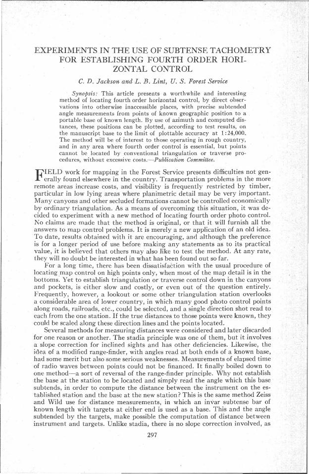
EXPERIMENTS IN THE USE OF SUBTENSE TACHOMETRYFOR ESTABLISHING FOURTH ORDER HORI
ZONTAL CONTROL
C. D. Jackson and L. B. Lint, U. S. Forest Service
Synopsis: This article presents a worthwhile and interestingmethod of locating fourth order horizontal control, by direct observations into otherwise inaccessible places, with precise subtendedangle measurements from points of known geographic position to aportable base of known length. By use of azimuth and computed distances, these positions can be plotted, according to test results, onthe manuscript base to the limit of plottable accuracy at 1: 24,000.The method will be of interest to those operating in rough country,and in any area where fourth order control is essential, but pointscannot be located by conventional triangulation or traverse procedures, without excessive costs.-Publication Committee.
FIELD work for mapping in the Forest Service presents difficulties not generally found elsewhere in the country. Transportation problems in the more
remote areas increase costs, and visibility is frequently restricted by timber,particular in low lying areas where planimetric detail may be very important.Many canyons and other secluded formations cannot be controlled economicallyby ordinary triangulation. As a means of overcoming this situation, it was decided to experiment with a new method of locating fourth order photo control.No claims are made that the method is original, or that it will furnish all theanswers to map control problems. It is merely a new application of an old idea.To date, results obtained with it are encouraging, and although the preferenceis for a longer period of use before making any statements as to its practicalvalue, it is believed that others may also like to test the method. At any rate,they will no doubt be interested in what has been found out so far.
For a long time, there has been dissatisfaction with the usual procedure oflocating map control on high points only, when most of the map detail is in thebottoms: Yet to establish triangulation or traverse control down in the canyonsand pockets, is either slow and costly, or even out of the question entirely.Frequently, however, a lookout or some other triangulation station overlooksa considerable area of lower country, in which many good photo control pointsalong roads, railroads, etc., could be selected, and a single direction shot read toeach from the one station. If the true distances to those points were known, theycould be scaled along these direction lines and the points located.
Several methods for measuring distances were considered and later discardedfor one reason or another. The stadia principle was one of them, but it involvesa slope correction for inclined sights and has other deficiencies. Likewise, theidea of a modified range-finder, with angles read at both ends of a known base,had some merit but also some serious weaknesses. Measurements of elapsed timeof radio waves between points could not be financed. It finally boiled down toone method-a sort of reversal of the range-finder principle. Why not establishthe base at the station to be located and simply read the angle which this basesubtends, in order to compute the distance between the instrument on the established station and the base at the new station? This is the same method Zeissand Wild use for distance measurements, in which an invar subtense bar ofknown length with targets at either end is used as a base. This and the anglesubtended by the targets, make possible the computation of distance betweeninstrument and targets. Unlike stadia, there is no slope correction involved, as
297

298 PHOTOGRAMMETRIC ENGINEERING
a simple geometric analysis will prove. With this method, then, the problemresolves itself into three parts-the length of base needed to provide the desiredaccuracy, the accuracy of measuring this base, and the accuracy of measuringthe subtended angle.
The first step is to state the maximum error in position that is permissible.A plotting accuracy of greater than 1/100 inch, seemed unnecessary for fourthorder points. At a manuscript scale of 1: 24,QOO, 1/100 inch equals 20 feet.T'herefore, the max,imum allowable error in the computed distance was set atplus or minus 20 feet. It appeared possible that with a precision instrument,such as the Wild or Zeiss Theodolite reading to one second, a base short enoughto be practical might be used.
Even with the finest instruments made, angular accuracy to single secondsis not easy to obtain. At ten miles, one second is only about 0.2S feet. However,to see what could be done, there was used a Wild Model T-2 Theodolite, readingto single seconds, with a micrometer which permitted estimating to tenths. Aset of 12"X12" and 24"X24" masonite targets were prepared, with white triangles painted on backgrounds of various colors. These were individually
. mounted on Johnson-head tripods provided with target carriers which werelaterally adjustable. A special SOO-ft. band-chain tape was rated against an invartape, and used under carefully controlled tension and temperature corrections toposition the targets exactly the desired distance apart. Special tape supportswere used where needed. /
To provide a known distance against which the computed distance couldbe compared, the targets were set up at a Coast and Geodetic Survey first orderstation, and the instrument at a similar station about four miles distant. Thetwo stations were "Richardson East" and "Ring"; see Coast and GeodetciSurvey Special Publication No. 202. Most of the instrumental work was done atthe north station "Ring" with shots directly into the sun, but this procedurewas reversed on occasion.
It was found that, with sun on the targets, excellent results could be obtained but that, with the same targets, shots into the sun were not practical. Abetter all around solution appeared to lie in the use of lights, and in subsequentwork in the field, the use of masonite targets was discontinued. Therefore twosealed-beam head-light lamps in special boxes equipped with two-vane shuttersto provide triangular apertures of variable width, were mounted on the targetcarriers in place of the targets. These made better signals but there was a flarewhich was difficult to control. Next a pair of Navy Aldis Multipurpose signallamps were used, with the directional honeycombs in the sleeves removed. Theselamps have a rheostat knob on the back. By radio (two SX sets were used) between the two stations, the observer was able to direct the men at the targetsso that the illumination was adjusted to exactly the right brilliance. When soadjusted, they no longer appeared as lights, but as fine pinpoints of white, whichmade excellent signals. Red and amber screens are also u!Oed under certain lightconditions and against certain backgrounds. These will take care of nearly allconditions under which the use of this method is practical.
It was found that, under average atmospheric conditions and with carefulwork, it was possible to obtain an angular measurement with an error of lessthan a second. By angular measurement, is not meant single angles but the meanof several angles. \iVith a Wild or Zeiss Theodolite, angles can be turned sorapidly that there is little point in reading fewer than six angles and twelvewould be better. A set of twelve can easily be read in from twenty to twenty-fiveminutes. Not over thirty to forty rriinutes should be required for the instrumental work required to locate a point, and the targets can be set up by two

EXPERIMENTS IN THE USE OF SUBTENSE TACHOMETRY 299
trained men in half an hour or less. Surely this represents a modest expenditurefor a weJllocated control point.
An example of the results obtained on one particular day may be of interest.The instrument was at Station Ring and the lights at Richardson East. Thebase was 100 feet. A gusty wind of up to 35 and 40 miles per hour was blowing.Humidity was rather high-a fruitful source of error due, it is believed, to a certain amount of lateral refraction. Pointing was difficult on account of the wind.No attempt would be made to do other than experimental work of this kindunder those field conditions. The true distance between Ring and RichardsonEast is 21,586.7 feet. The results were:
Angles in Set Computed Distance Errors
6 21,609.3 ft. +22.69 21,604.4 ft. +17.7
12 21,598.9 ft. +12.26 21,564.5 ft. -22.29 21 ,586 . 5 ft. - 0.2
12 21,595.0 ft. + 8.36 21,591.8 ft. + 5.19 21,586.9 ft. + 0.2
12 21,603.1 ft. +16.46 21,572.4 ft. -14.39 21 ,573.7 ft. -13.0
12 21,575.8ft. -10.9
The third series of twelve angles differ from most other series that wereread, in that the mean of twelve angles shows a greater error than the means ofsix and nine angles. Almost always, the error becomes less as the number ofangles increases. Probably, if enough angles are read with a one-second instrument, the desired accuracy can be obtained as long as the targets are visible,provided, of course, that the base is of such length that the subtended angle isnot less than sixteen minutes. In actual use, there would be required four readings from the initial station to the "point" light and either 12 or 18 repeats onthe subtended angle. The bases used were of from 100 to 150 feet at four miles;elf course better results were obtained with a longer base. It was possible toreach out eight miles with a 300 foot base. In actual practice, bases up to 900feet have been used. The greatest distance measured so far, was slightly over 9miles.
It is obvious that accuracies would be questioned, when operating undernormal field conditions. From the start, it was known that some method ofobtaining a reliable check on a significant percentage of the observations wasabsolutely necessary. It was decided that, tentatively at least, the following procedure would afford a fair and adequate check. In selecting the locations for thesubtense stations (this was done at the stations from which they were to belocated, and by inspection of the photos and the surrounding terrain), about 10%of these were to be purposely selected so that other triangulation stations wouldbe visible. Then these check stations could later be occupied, and their positionsdetermined along the with triangulation computation, as well as by the subtensemethod. To eliminate any chance that extra pains would be taken in setting upthe bases, etc., the base line crew was not told that these were check stations.In other words, in this as weJI as in all other phases of the work, there was soughtfacts for information and guidance, not pretty figures that would look well in areport. The adequacy of a 10% check may be open to question, but to date, no

300 PHOTOGRAMMETRIC ENGINEERING
one with whom this has been discussed, has seemed to feel that a larger percentage of check stations is necessary.
In all, eighty-eight subtense stations were established on one project, ofwhich nine stations were later occupied as check stations.
The results were: ..,.
Station Distance by Distance by DifferenceTriangulation Subtense
Weed #2 12,039.9 ft. 12,034.3 ft. - 5.6 ft.Weed #5 13,142.8 ft. 13,143.5 ft. + 0.7 ft.Beacon 26-3 16,182.7 ft. 16,187.0 ft. + 4.3 ft.Espee Tank 6,710.5 ft. 6,711.1 ft. + 0.6ft.P.B.M. K-118 (Horn Peak #2) 12,970.7 ft. 12,974.5 ft. + 3.8 ft.North Gazelle #2 10,997.0 ft. 10,991. 3 ft. - 5.7 ft.North Gazelle #3 16,382.2 ft. 16,387.9 ft. + 5.7 ft.Mt. Bradley #1 22,606.2 ft. 22,611.1 ft. + 4.9 ft.Mt. Bradley #2 23,627.7ft. 23,643.0 ft. +15.3 ft.
Since all of these differences fall within the a'llowable limits of plus or minus20 feet, it is believed that, unless unforeseen complications arise, subtense stations can be accepted wilh full confidence that they will meet all fourth-orderaccuracy requirements for any type of mapping, standard or substandard. Obviously, extra care will be required in plotting them on the laydown or manuscript sheets, but adequate checking should insure accuracy in this phase of thewmk .
The success of the method is quite dependent on adequate radio communication between the base crew and the observer on the station. Considerable' use ismade of signal mirrors. These, when flashed, are a signal to turn on the radioand much battery drain on standby is thus avoided.
The base crew's pickup is equipped to carry two six-volt storage batteriesfor the signal lights, in a rack on the running board. Leads to the car generatorpermit charging the batteries between setups. In additions there were threemidget gasoline-driven, portable generators weighing around 60 lbs. each. Notrouble was experienced in keeping batteries charged under almost any condition. Each light draws one ampere, and of course, is rheostat-controlled.
A brief description of the way in which these stations are plotted for templetlaydown use, may be advisable. There was used a very rigid laydown board withi" plywood top, 8 ft. by 12 ft., with one extra section, 4 ft. by 8 ft., that can bebutted up against either the side or end of the larger unit, to take care of oddshaped laydowns. These boards are so constructed that a special transit unit canbe used on them, without fear that the operator's weight will introduce errorsdue to movement of the base.
The transit is a i-minute instrument mounted on two lateral adjusters, 90°opposed, which in turn are threaded on a standard trivet which has been mountedon a heavy steel ring. The transit spindle has been drilled so that the telescopecan be directed' straight down at the plotted position of an existing controipoint. A supplementary lens is of course required so that the glass will focussharply in the plane of the surface on which the transit assembly rests, or inother words, the-laydown board. This assembly is similar in most respects to thePhoto Transit as described in PHOTOGRAMMETRIC ENGINEERING, Vol. XII,Number 1, pp. 106 by J. E. King. However, for this purpose, no need exists forthe photo holder as generally illustrated.
Fourth-order control, secured by ordinary intersections, is plotted as fol-

EXPERIMENTS IN THE USE OF SUBTENSE TACHOMETRY 301
lows: The transit is set up over a previously plotted third or higher order stations. Using the list of directions for that 'station, and with the plates at zero,the instrument is turned to the initial station. Then each successive direction islaid off on the laydown base, by sighting first on a needle and then on the needlehole, after the shot has been pricked. As successive stations are occupied, thepositions of the fourth order points are determined by actual intersections on thelaydown board. With careful work, excellent intersections are obtained.
I t will be seen that, with the subtense method described above and thissystem of plotting the photo control, the location of the new points becomes asimple matter. However, since there is no check on the plotting, great care mustbe taken both in turniJ;lg the angles and scaling the distance. An accuratelygraduated steel scale should of course be used.
Other mapping projects may present conditions in which this method wouldnot be as suitable as in California. For example, the target lamps and accessoryequipment cannot be taken too far from a road, because of the weight and bulk.Perhaps later on, refinements may result in increased portability.
It now appears that the cost of a subtense station will not ordinarily runover 25% of that for fourth-order triangulation stations which are flagged andoccupied. This should not be taken to mean that substitution of triangulation bysubtense is advocated. The two go hand in hand, with subtense the accessorymethod. But it is nice to know that it is now possible to reach down into holesthat heretofore would have been beyond reach except at prohibitive cost.
THE RADIAL PLANIMETRIC PLOTTER
• Easy and rapid to operate • Low costA plotter 01 many uses
• Grazing surveys• River and drainage studies• Geological studies• Teaching photogrammetry
• Accurate
• Planimetric maps• Oil surveys• Timber surveys• Tax assessment studies
1410 16th St. PHILIP B. KAIL ASSOCIATES Denver 2. Colo.Eastern Representative-Mr. Theodore W. Norcross-467 Raymond St., Chevy Chase 15, ;Md.


![IS 9892 (1981): Subtense Bar - Public.Resource.Org · IS 9892 (1981): Subtense Bar [PGD 22: Educational Instruments and Equipment] IS :9892 -1981 Indian Standard SPECIFICATION FOR](https://static.fdocuments.us/doc/165x107/5f7394b5454c884fb754b094/is-9892-1981-subtense-bar-is-9892-1981-subtense-bar-pgd-22-educational.jpg)