Existing Transport Conditions Summary · 2019-08-02 · Existing Transport Conditions Summary St...
68
Existing Transport Conditions Summary St Leonards and Crows Nest Station Precinct Transport Study 20 March 2017 Cardno i Existing Transport Conditions Summary St Leonards and Crows Nest Station Precinct Transport Study 80017028 Prepared for Department of Planning and Environment 20 March 2017
Transcript of Existing Transport Conditions Summary · 2019-08-02 · Existing Transport Conditions Summary St...

Existing Transport Conditions Summary St Leonards and Crows Nest Station Precinct Transport Study
20 March 2017 Cardno i
Existing Transport Conditions Summary
St Leonards and Crows Nest Station Precinct Transport Study 80017028
Prepared for Department of Planning and Environment 20 March 2017

Existing Transport Conditions Summary St Leonards and Crows Nest Station Precinct Transport Study
20 March 2017 Cardno ii
Contact Information
Cardno NSW/ACT
Trading as Cardno (NSW/ACT) Pty Ltd
ABN 95 001 145 035
Level 9, The Forum, 203 Pacific Highway, St Leonards, Sydney NSW 2065
Telephone: +61 2 9496 7700
Facsimile: +61 2 9439 5170
Document Information
Prepared for Department of Planning
and Environment
Project Name St Leonards and Crows
Nest Station Precinct
Transport Study
File Reference St Leonards and Crows
Nest Transport
Study_Draft
Job Reference 80017028
Date 20 March 2017
Document History
Version Effective Date
Description of Revision Prepared by: Reviewed by:
1 2 Dec 16 Draft – Existing Transport Conditions Summary
Larissa Miller
Chris Slenders
Bahman Mehrpour
Rachel Kohan
Larissa Miller
2 20 Mar 17 Draft – Strategic Transport Study Rachel Kohan
Elizabeth Muscat
Larissa Miller
© Cardno. Copyright in the whole and every part of this document belongs to Cardno and may not be used, sold, transferred, copied or reproduced in whole or in part in any manner or form or in or on any media to any person other than by agreement with Cardno.
This document is produced by Cardno solely for the benefit and use by the client in accordance with the terms of the engagement. Cardno does not and shall not assume any responsibility or liability whatsoever to any third party arising out of any use or reliance by any third party on the content of this document.

Existing Transport Conditions Summary St Leonards and Crows Nest Station Precinct Transport Study
20 March 2017 Cardno iii
Table of Contents
1 Introduction 1
1.1 Purpose 1
1.2 About this Transport Study 1
1.3 The precinct 1
2 Future precinct context 2
2.1 Strategic plans 2
2.1.1 A Plan for Growing Sydney 2
2.1.2 NSW Long Term Transport Master Plan 2
2.1.3 Draft North District Plan 2
2.1.4 Other relevant State plans and strategies 2
2.2 Council Strategic Plans 3
2.2.1 North Sydney Community Strategic Plan 3
2.2.2 Willoughby City Strategy 2013- 2029 3
2.2.3 Lane Cove Community Strategic Plan 2025 3
2.2.4 Additional documents considered 3
2.3 Planned transport initiatives 4
2.3.1 Sydney Metro 4
2.3.2 Road network changes 6
2.3.3 Cycling 6
3 Existing travel behaviour 8
3.1 Population and employment 8
3.1.1 Population 8
3.1.2 Employment 9
3.2 Dwelling types 9
3.3 Motor vehicle ownership 9
3.4 Transport mode share 10
3.4.1 Journey to work 10
3.4.2 Journey to Work 12
3.5 Crash analysis 15
3.5.1 Crash clusters 15
3.5.2 Crash types 18
4 Transport networks and performance 20
4.1 Major transport corridors 20
4.2 Road network 20
4.2.1 Pacific Highway 20
4.2.2 Warringah/Gore Hill Freeway access 20
4.2.3 Arterial and distributor roads 21
4.2.4 Local roads 21
4.2.5 Road network functions 23
4.3 Walking 26
4.3.1 The pedestrian experience 26
4.3.2 Network 26
4.3.3 Infrastructure 30
4.3.4 Demand 34
4.4 Cycling 36
4.4.1 Network 36

Existing Transport Conditions Summary St Leonards and Crows Nest Station Precinct Transport Study
20 March 2017 Cardno iv
4.4.2 Infrastructure 39
4.4.3 Demand 39
4.5 Train 42
4.5.1 Metro Network 42
4.5.2 Train Network 42
4.5.3 Infrastructure and services 44
4.5.4 Demand 44
4.6 Bus 44
4.6.1 Network 44
4.6.2 Infrastructure and services 47
4.7 Freight and servicing 50
4.7.1 Network 50
4.7.2 Infrastructure 50
4.8 Private vehicles 52
4.8.1 Demand and performance 52
4.9 Demand responsive public transport 54
4.9.1 Council Cabs 54
4.10 Parking 54
4.10.1 Infrastructure 54
4.10.2 Parking levels 58
4.10.3 Demand 58
4.11 Car share 58
4.12 Transport network summary 59
5 Opportunities and constraints 60
5.1 Opportunities 60
5.2 Constraints 62
Tables
Table 3-1 Population and employment .............................................................................................................. 9
Table 3-2 Dwelling types ................................................................................................................................... 9
Table 3-3 Motor vehicle ownership .................................................................................................................. 10
Table 4-1 Arterial and distributor roads ........................................................................................................... 21
Table 4-2 Summary of pedestrian volumes (2011) ......................................................................................... 34
Table 4-3 RMS average daily cycling volumes ............................................................................................... 40
Table 4-4 St Leonards Station train services .................................................................................................. 44
Table 4-5 In and Out volumes at St Leonards Station (2014) ......................................................................... 44
Table 4-6 Summary of bus service frequency and coverage .......................................................................... 48
Table 4-7 Pacific Highway inbound - Lane Cove to North Sydney ................................................................. 52
Table 4-8 Pacific Highway outbound – North Sydney to Lane Cove .............................................................. 52
Table 4-9 Off-street car parking in the precinct ............................................................................................... 54
Table 4-10 Council DCP parking rates ............................................................................................................ 57
Table 5-1 Precinct opportunities ...................................................................................................................... 60
Table 5-2 Precinct constraints ......................................................................................................................... 62

Existing Transport Conditions Summary St Leonards and Crows Nest Station Precinct Transport Study
20 March 2017 Cardno v
Figures
Figure 2-1 Sydney Metro Northwest TTP Route 3 ............................................................................................ 4
Figure 2-2 Sydney Metro - Proposed works at Crows Nest Station .................................................................. 5
Figure 3-1 Sub-precincts and travel zones within the St Leonards / Crows Nest Precinct ............................... 8
Figure 3-2 Mode split commuting from the precinct ........................................................................................ 11
Figure 3-3 Mode split commuting to the precinct ............................................................................................ 11
Figure 3-4 Commuting into the precinct .......................................................................................................... 13
Figure 3-5 Commuting from the precinct by travel zone ................................................................................. 14
Figure 3-6 Crash locations............................................................................................................................... 16
Figure 3-7 Crash cluster locations ................................................................................................................... 17
Figure 3-8 Pedestrian crash type .................................................................................................................... 18
Figure 3-9 Vehicle crash type .......................................................................................................................... 19
Figure 3-10 Crashes – time of day .................................................................................................................. 19
Figure 4-1 Road hierarchy ............................................................................................................................... 22
Figure 4-2 Draft NSW Road Planning Framework - movement and place functions and road categories ..... 23
Figure 4-3 Road Categories across the precinct ............................................................................................. 25
Figure 4-4 Primary and Secondary walking routes ......................................................................................... 28
Figure 4-5 Walking catchments ....................................................................................................................... 29
Figure 4-6 Existing pedestrian crossing facilities ............................................................................................ 32
Figure 4-7 Distances between crossings in the precinct - Pacific Highway and T1 rail corridor ..................... 33
Figure 4-8 Daily Pedestrian Volumes 2016 ..................................................................................................... 35
Figure 4-9 Existing and proposed cycling routes ............................................................................................ 37
Figure 4-10 2.5 kilometre cycling catchment ................................................................................................... 38
Figure 4-11 Daily Cyclist Volumes 2016 .......................................................................................................... 41
Figure 4-12 30 minute rail catchment .............................................................................................................. 43
Figure 4-13 Bus Network ................................................................................................................................. 46
Figure 4-14 Freight routes ............................................................................................................................... 51
Figure 4-15 Daily vehicle volumes 2016 .......................................................................................................... 53
Figure 4-16 Off-street parking locations .......................................................................................................... 56
Figure 4-17 GoGet car share parking locations .............................................................................................. 59

Existing Transport Conditions Summary St Leonards and Crows Nest Station Precinct Transport Study
20 March 2017 Cardno 1
1 Introduction
1.1 Purpose
The St Leonards and Crows Nest Station Precinct is a major employment centre in Sydney, with future plans
to grow residential and employment populations, and to enhance the health precinct around Royal North
Shore Hospital. The precinct is nominated as one of Sydney’s strategic centres and is located in the Global
Economic Corridor.
A number of recent planning proposals for the precinct advocate for increasing development densities,
particularly around the St Leonards Train Station and the future Crows Nest Metro Station. The Department
of Planning & Environment (DP&E) engaged Cardno to prepare a Strategic Transport Study. This study will
contribute to a Land Use and Infrastructure Strategy for the precinct and help to guide future development
and infrastructure investment.
1.2 About this Transport Study
This Strategic Transport Study:
> Sets the transport vision and objectives for the precinct;
> Aligns with strategic plans and policies and references planned projects;
> Identifies the increased demands on the public transport and road network associated with the proposed
uplift in residents and workers;
> Proposes improvements to the transport network to encourage a high public transport mode share and
enhance walking and cycling connectivity; and
> Presents a clear strategy for planning transport infrastructure to support the urban renewal and to take
advantage of existing and planned transport networks.
1.3 The precinct
The St Leonards and Crows Nest Precinct is located on the Lower North Shore, approximately 5km north of
the Sydney CBD and 3.5km south of Chatswood. The precinct includes the suburbs of St Leonards and
Crows Nest as well as parts of Naremburn, Wollstonecraft, Cammeray and Artarmon.
Within the precinct lies a wide range of land uses ranging from industrial and bulky goods in Artarmon, the
Royal North Shore Hospital on the eastern side of the railway line, mixed use land uses in close proximity to
St Leonards Station, and retail in Crow Nest and along the Pacific Highway. Low density housing is the
predominant land use in the suburbs of Naremburn, Cammeray and Crows Nest. Medium to high density
residential housing exists in Wollstonecraft and St Leonards and more high density residential uses is
developed for St Leonards and Crows Nest.
The area is supported by public transport services including the T1 North Shore and Northern Line and a
number of regional bus services providing connections to other regions of Sydney. The precinct is set to
change in the future with the development of the metro line providing a station in Crows Nest. Now is an
opportune time to plan for transport infrastructure to support the urban renewal and take advantage of the
existing and planned transport networks.
Existing Transport Conditions Summary St Leonards and Crows Nest Station Precinct Transport Study
20 March 2017 Cardno 2
2 Future precinct context
2.1 Strategic plans
2.1.1 A Plan for Growing Sydney
A Plan for Growing Sydney (2014) outlines the transport infrastructure actions required to support Sydney’s
growing population. St Leonards is identified as a strategic centre for health, education and office-based
employment markets, with many new jobs forecast for the precinct. The plan identifies the need to remove
pinch points in the transport network to increase accessibility and boost business activity. Further growth in
employment and housing opportunities are also considered in association with the plans for a Sydney Metro
train station at Crows Nest.
2.1.2 NSW Long Term Transport Master Plan
The NSW Long Term Transport Master Plan (TfNSW, 2012) identifies the need to improve the integration of
all transport modes to maintain Sydney’s role as a centre of economic and social activity. Seamlessly
connected infrastructure that provides a high level of service is important for all major employment centres,
such as St Leonards, to improve accessibility to local services and public transport. The plan notes the
importance of a new North West rail link in connecting North West residents to North Shore employment
centres like St Leonards. The residential and economic growth of St Leonards as a major employment hub is
supported by this plan which mandates customer-focused transport planning practices.
2.1.3 Draft North District Plan
The Greater Sydney Commission’s North District Plan (2016) provides a 20 year vision of northern Sydney’s
housing and employment growth opportunities and the supporting transport infrastructure plans. The
strategic centre of St Leonards forms part of the identified ‘Eastern City’ which stretches from Kogarah and
Port Botany through to Macquarie Park and the Northern Beaches Hospital. The plan notes the growing
demand for homes in St Leonards which could occur at the expense of additional commercial floor space.
Forecast jobs in St Leonards could grow from the 47,100 in 2016 to between 54,000 and 63,500 by 2036.
These changes in land use perpetuate the need for an improved transport system. The plan identifies St
Leonards as a health and education super precinct due to a number of hospitals, and health and education
related services. It is also named as a ‘Collaboration Area’ which would benefit from State and Local
government partnership. Transport planning for the area should specifically leverage off the new Sydney
Metro Station at Crows Nest and reduce the impact of vehicle movements on pedestrian and cyclist
accessibility. A principal bicycle route is proposed between Hornsby and North Sydney.
2.1.4 Other relevant State plans and strategies
Other state plans with relevant strategic transport directions for the precinct include the NSW State
Infrastructure Strategy and the future modal strategies: Sydney’s Rail Future, Sydney’s Bus Future, Sydney’s
Cycle Future and Sydney’s Walking Future.
The NSW State Infrastructure Strategy prepared by Infrastructure NSW presents a vision for NSW in 2031
and makes recommendations for infrastructure investment over the next 20 years, grouped by short, medium
and long-term priorities. The 2014 update to the Strategy provides detail of the proposed funding strategy for
infrastructure projects, the Restart NSW Fund. The 2014 update identifies additional priorities for transport
infrastructure including the need for the metro line and a second harbour crossing.
Sydney’s Rail Future notes the importance of enhancing the capacity of the rail network with the second
harbour crossing/ metro line which will deliver a 60% increase in rail services, and a time saving of up to 8
minutes for commutes from Chatswood to the CBD. Sydney’s Bus Future notes that direct links from the
Northern Beaches to St Leonards would be assessed to improve access to and from the Northern Beaches.
Sydney’s Walking Future demonstrates that the lower North Shore has one of the highest walking mode
share’s in Sydney at over 25%. St Leonards and Crows Nest also sit within a corridor of centres, from
Chatswood to the Sydney CBD. The strategy proposes that walking routes within two kilometres of centres
Existing Transport Conditions Summary St Leonards and Crows Nest Station Precinct Transport Study
20 March 2017 Cardno 3
should be prioritised. Sydney’s Cycling Future notes the investigation of a North Shore link which passes
close to the precinct. As with walking, cycling routes close to centres will be prioritised.
2.2 Council Strategic Plans
2.2.1 North Sydney Community Strategic Plan
The North Sydney Community Strategic Plan (2013) provides a set of directions aimed at addressing
prioritised transport issues identified by the community. These issues include the high level of vehicle
congestion, lack of on street parking, and reduced pedestrian accessibility and amenity. The directions
outlined by Council will promote the use of public and active transport by increasing the street space
dedicated to sustainable modes, and integrating them with the network of pedestrian and cycle paths. These
plans will also align with Council’s economic direction of supporting employment growth and increasing
social vitality by providing accessible transport options for the elderly and people with disability.
2.2.2 Willoughby City Strategy 2013- 2029
The Willoughby City Strategy 2013 – 2029 outlines key strategic directions for planning transport
infrastructure over the next 16 years. Council presents overarching principles that determine these strategic
directions. The principle of improving health and wellbeing, is to be achieved by providing connected walking
and cycle paths. The principle of increasing mobility involves improving the level of service of public and
active transport, improving integration between modes and managing traffic congestion. Sustainable
economic activity in the precinct is a principle to be achieved in part from a sustainable and efficient transport
network.
2.2.3 Lane Cove Community Strategic Plan 2025
The Lane Cove Community Strategic Plan 2025 is comprised of goals and strategies to achieve an
integrated transport system that will link various centres, facilities and suburbs. The goals are the result of
extensive community consultation, and resulting objectives are outlined. The goal of achieving an inclusive,
interconnected and active community should be achieved by promoting integrated public and active transport
options that link people to employment hubs, services and facilities. Incentives should be introduced that
reduce reliance on private vehicles for example for carpooling, and parking supply should respond to parking
demand. An improved transport network will also contribute to achieving the goal of creating a vibrant and
sustainable local economy by improving access to local business centres.
2.2.4 Additional documents considered
Additional documents considered in the preparation of this report to gather context and gain an
understanding of the issues and plans for the St Leonards and Crows Nest transport network include:
> St Leonards and Crows Nest Station Precinct Structure Plan, 2016 (SJB Architects)
> St Leonards Strategy, 2006 (David Lock Associates)
> St Leonards/Crows Nest Planning Study Precinct 1, 2011 (North Sydney Council)
> St Leonards South Strategy Precinct report, 2013 (David Lock Associates)
> St Leonards South Masterplan Draft, 2014 (Annand Associates Urban Design)
> St Leonards Development Capacity, 2015 (Architectus)
> St Leonards Crows Nest Planning Study, 2015 (North Sydney Council)
> St Leonards and Crows Nest Strategic Employment Review, 2016 (SGS Economics and Planning)
> Gore Hill Park Plan of Management, 2016
> Gore Hill Park redevelopment- FAQ, Willoughby City Council website
> Willoughby Street Parking Strategy, Willoughby City Council 2016

Existing Transport Conditions Summary St Leonards and Crows Nest Station Precinct Transport Study
20 March 2017 Cardno 4
2.3 Planned transport initiatives
2.3.1 Sydney Metro
Sydney Metro is Australia’s largest public transport project currently under planning and construction across
two stages. The project will deliver 31 stations across 65 kilometres of dedicated metro rail, connecting the
north-west and south-west suburbs of Sydney with the Sydney CBD. New fully automated single-deck metro
trains will operate along the new line every four minutes in the peak, with capacity to move up to 40,000
customers per hour.
2.3.1.1 Sydney Metro Northwest
Sydney Metro Northwest is Stage One of the Sydney Metro project, currently under construction and due for
completion in 2019. Once complete, the project will deliver metro services along eight new stations from
Cudgegong Road to Epping, before continuing along the existing Epping to Chatswood Railway and
terminating at Chatswood Station.
From late 2018, the Epping to Chatswood Railway (ECR) will require closure to allow for conversion works
including new platform screen doors and signalling systems. The closure will result in timetable changes on
the T1 Northern Line, and the loss of four train services through St Leonards Station. It is not known however
whether additional services will be provided along the T1 North Shore Line to compensate for this loss.
During the shutdown, replacement bus services will operate as part of the Temporary Transport Plan (TTP)
to continue the public transport connections between Epping and Chatswood. Additional services are also
proposed to connect non-ECR stations; Bus Route 3 of the TTP proposes a peak hour connection between
St Leonards, Macquarie Park, Macquarie University and Beecroft Stations. This temporary route will operate
18 buses per hour from the existing northbound Artarmon and Gore Hill Loop stop on Herbert Street.
Inbound services will arrive from the north via the Lane Cove Tunnel and Pacific Highway, and outbound
services will depart to the north via Herbert Street, Frederick Street and Reserve Road. Route 3 of the TTP is
shown in Figure 2-1 in green.
Figure 2-1 Sydney Metro Northwest TTP Route 3
Source: Epping to Chatswood Railway – Temporary Transport Plan (Parsons Brinckehoff, 2014)
Following the opening of Sydney Metro Northwest, capacity through St Leonards Station will increase to 20
trains per hour to facilitate interchange between Metro and Sydney Trains services at Chatswood Station.
Existing Transport Conditions Summary St Leonards and Crows Nest Station Precinct Transport Study
20 March 2017 Cardno 5
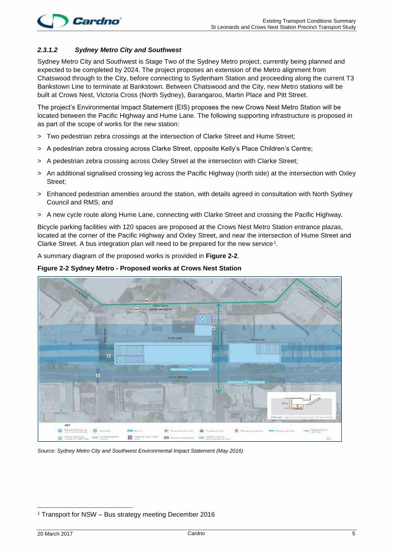
2.3.1.2 Sydney Metro City and Southwest
Sydney Metro City and Southwest is Stage Two of the Sydney Metro project, currently being planned and
expected to be completed by 2024. The project proposes an extension of the Metro alignment from
Chatswood through to the City, before connecting to Sydenham Station and proceeding along the current T3
Bankstown Line to terminate at Bankstown. Between Chatswood and the City, new Metro stations will be
built at Crows Nest, Victoria Cross (North Sydney), Barangaroo, Martin Place and Pitt Street.
The project’s Environmental Impact Statement (EIS) proposes the new Crows Nest Metro Station will be
located between the Pacific Highway and Hume Lane. The following supporting infrastructure is proposed in
as part of the scope of works for the new station:
> Two pedestrian zebra crossings at the intersection of Clarke Street and Hume Street;
> A pedestrian zebra crossing across Clarke Street, opposite Kelly’s Place Children’s Centre;
> A pedestrian zebra crossing across Oxley Street at the intersection with Clarke Street;
> An additional signalised crossing leg across the Pacific Highway (north side) at the intersection with Oxley
Street;
> Enhanced pedestrian amenities around the station, with details agreed in consultation with North Sydney
Council and RMS; and
> A new cycle route along Hume Lane, connecting with Clarke Street and crossing the Pacific Highway.
Bicycle parking facilities with 120 spaces are proposed at the Crows Nest Metro Station entrance plazas,
located at the corner of the Pacific Highway and Oxley Street, and near the intersection of Hume Street and
Clarke Street. A bus integration plan will need to be prepared for the new service 0F
1.
A summary diagram of the proposed works is provided in Figure 2-2.
Figure 2-2 Sydney Metro - Proposed works at Crows Nest Station
Source: Sydney Metro City and Southwest Environmental Impact Statement (May 2016)
1 Transport for NSW – Bus strategy meeting December 2016

Existing Transport Conditions Summary St Leonards and Crows Nest Station Precinct Transport Study
20 March 2017 Cardno 6
2.3.2 Road network changes
2.3.2.1 Lithgow Street
As part of the proposed over-railway plaza and the development on Lithgow Street, the intersection of
Lithgow Street and the Pacific Highway will be closed. This will direct traffic (heading outbound along the
Pacific Highway) from Lithgow Street to Oxley Street to join the Pacific Highway. A new laneway will be
created to the south of Christie Lane to provide vehicle access from Lithgow Street to Christie Street and
Nicholson Street.
2.3.2.2 Hume Street
As part of the redevelopment of the Hume Street Park (described in Section 1.1.1.1) North Sydney Council
proposed to close Hume Street adjacent to the park (between Pole Lane and Clarke Street) to traffic. Hume
Street currently operates as one lane and one direction to the to north.
A pedestrian link will also be created between the Hume Street Park and Willoughby Road for improved
permeability.
2.3.2.3 Chandos Street / Alexander Street intersection
North Sydney Council is planning to signalise the intersection of Chandos Street and Alexander Street in
Crows Nest. The T intersection currently operates with signed priority control.
2.3.2.4 Nicholson Street widening
Nicholson Street will be widened to support the new developments being built on the block between
Nicholson Street and the Pacific Highway.
2.3.3 Cycling
The 2013 Lane Cove Council Draft Bicycle Plan provides recommendations based on a review of the 2008
Plan, and the status of works proposed in 2008. In the precinct, three routes were proposed in the 2008
Plan, which remain incomplete.
> Regional Route B3: A shared path along the western side of the Pacific Highway, extending from the
intersection of Longueville Road to the intersection with Albany Street;
> Regional Route B4: A shared path along the northern side of River Road, extending from the intersection
of Longueville Road to the intersection with Shirley Road; and
> Local Route B18: A combination of shared paths, on-road shoulder lanes and mixed traffic facilities
connecting Greenwich Road with St Leonards Station.
An additional route (Route A9) was proposed in the 2013 Plan. This route extends from the intersection of
the Pacific Highway with Berry Street, and proceeds via Marshall Lane, Canberra Avenue, Lithgow Street,
Christie Lane, Christie Street and Nicholson Street to tie in with existing routes at the intersection of the
Pacific Highway with Christie Street, and Oxley Street with Nicholson Street. The primary aim of this route is
to complete a missing link in the network on the southern side of the Pacific Highway and facilitate travel
across Council LGA boundaries.
Lane Cove Council is also investigating a new east-west cycle link between Greenwich and Wollstonecraft.
The 2006 Willoughby City Council Bike Plan recommends 27 new routes or network links to be implemented
across the Willoughby LGA. The routes were classed as low, medium or high priority, and were designated
as either on or off-road facilities. Seven of the proposed routes proceed through the precinct; a 2012 review
of the Plan indicated that four of these remain incomplete.
> Route 22: A medium priority off-road route along the eastern side of the Pacific Highway between
Longueville Road to Herbert Street;
> Route 23: A high-priority on-road route through the TAFE and Gore Hill precinct (former ABC studio);
> Route 24: A medium priority on-road route through the Royal North Shore Hospital property, between St
Leonards Station and Westbourne Street; and

Existing Transport Conditions Summary St Leonards and Crows Nest Station Precinct Transport Study
20 March 2017 Cardno 7
> Route 25: A medium priority off-road route running parallel to the T1 North Shore and Northern Line on
the eastern side, between St Leonards Station and the Gore Hill Freeway.
The 2014 North Sydney Council Integrated Cycling Strategy outlines an infrastructure plan with five priority
routes for implementation. Two of these routes pass through the precinct:
> Route 1: Sydney Harbour Bridge to Cammeray via West Street (High priority); and
> Route 4: Cammeray to Crows Nest via Willoughby Road and Holtermann Street (Medium priority).
Route 1 is proposed along West Street, on the eastern boundary of the precinct. The street already supports
a large volume of cycling traffic. This route is a key north-south corridor, connecting the northern suburbs
with the Sydney Harbour Bridge. It will also have connections to St Leonards Station via an existing east-
west route along Atchinson Street. Concept plans have been developed for a separated bi-directional facility
on the eastern side of the road reserve, between the intersections with Church Street and Palmer Street.
The road reserve is flat and wide, making it ideal for accommodating a separated bi-directional facility.
Route 4 proposes to connect Chandos Street with the proposed cycleway along West Street via Willoughby
Road and Holtermann Street. This route is planned as an on-road mixed traffic facility, with alterations
planned for on-street parking and at key intersections.
The Greater Sydney Commission’s Draft North District Plan (2016) outlines an action to develop a Principal
Bicycle Network in the region. One of the proposed routes for this region will connect Hornsby to North
Sydney; via St Leonards and Chatswood.
A summary map of the existing and proposed bicycle routes is provided in Section 4.4.1.

Existing Transport Conditions Summary St Leonards and Crows Nest Station Precinct Transport Study
20 March 2017 Cardno 8
3 Existing travel behaviour
It is important to understand who is living in and accessing the precinct, and the existing travel behaviour
when planning for future movements in the precinct. This chapter provides a summary of the population and
employment, dwelling types and motor vehicle ownership, as well as how people are travelling and where
they are coming from. Crashes in the precinct are also analysed.
The precinct was divided into three sub-precincts; Artarmon, St Leonards and Crows Nest/Naremburn to
acknowledge different travel behaviours in each. Within each of the sub-precincts travel behaviour was
analysed by travel zones where possible; the travel zones which make up each of the sub-precincts are
shown in Figure 3-1.
Figure 3-1 Sub-precincts and travel zones within the St Leonards / Crows Nest Precinct
Base map source: BTS, 2016
3.1 Population and employment
This section provides a summary of the existing, population and jobs for the precinct as it has a direct
relationship with trip generation. The data is from TfNSW’s Transport and Performance Analytics website
and uses Journey to Work (JTW) data collected through the Census by the Australian Bureau of Statistics.
3.1.1 Population
3,324 residents lived in St Leonards, and 4,763 people lived in Crows Nest at the time of the 2011 Census
(JTW, 2011). There are no residents living in the Artarmon sub-precinct, as the land use is primarily retail.
Residential population for the precinct is summarised in Table 3-1.

Existing Transport Conditions Summary St Leonards and Crows Nest Station Precinct Transport Study
20 March 2017 Cardno 9
3.1.2 Employment
There were around 36,750 employees in the precinct at the time of the 2011 Census (JTW, 2011). Most
employees worked in St Leonards (56%) while Artarmon represented 21% of workers and Crows Nest 22%.
Table 3-1 summarises the number of residents and employees in the precinct.
Table 3-1 Population and employment
Residential Employment
Number % Number %
Artarmon 0 0 7,794 21%
Crows Nest 4,763 59% 8,233 22%
St Leonards 3,324 41% 20,718 56%
Total 8,087 100% 36,745 100%
Source: Bureau of Transport Statistics, Journey to Work, 2011
3.2 Dwelling types
All of the suburbs in the precinct have a low number of detached dwellings and a high number of Flats, Units
and Apartments (FUA). St Leonards has predominately FUA housing at 92% and less than 10% of housing
is detached dwellings or semi. Crows Nest is more diverse in dwelling types with 50% FUA, 22% detached
dwellings and 29% semi. The Sydney Metropolitan Area dwelling types are also listed for comparison. Table
3-2 summaries the dwelling types in the precinct.
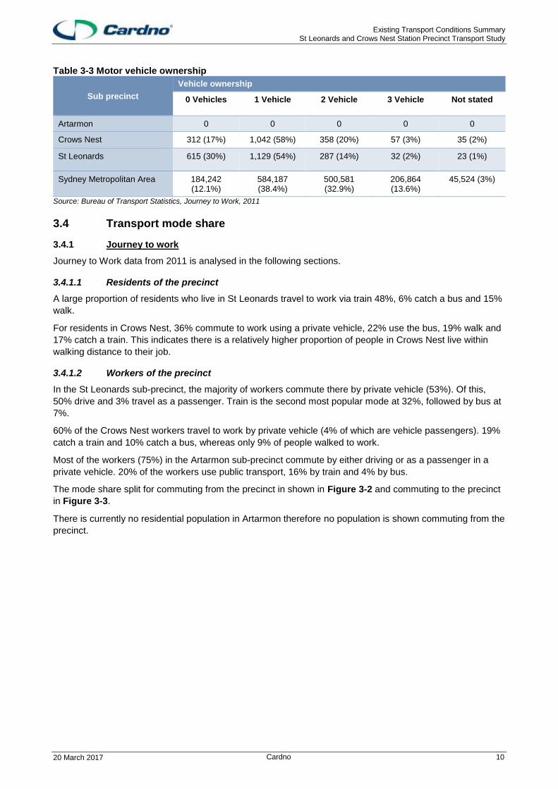
3.3 Motor vehicle ownership
Vehicle ownership is a key indicator of mode share. The portion of ownership indicates the need to rely on
other transport modes. Compared to the Sydney Metropolitan Area, the precinct has lower proportions of
private vehicle ownership. There is a significantly high proportion of households in the precinct that do not
own a private vehicle especially St Leonards at 30%, compared with the Greater Sydney Metropolitan Area
where the proportion of households without a car is only 12%. For the residents of the precinct that do own
private vehicles, the majority only own one vehicle. In Crows Nest this is 58% and St Leonards is 54%,
compared to the Greater Sydney Metropolitan Area which is 38%. Vehicle ownership in the precinct is
detailed in Table 3-3.
Table 3-2 Dwelling types
Sub precinct
Dwelling types
Separate Semi FUA Other
Artarmon 0 0 0 0
Crows Nest 394 (22%) 525 (29%) 884 (50%) 0 (0.2%)
St Leonards 110 (5%) 39 (2%) 1,927 (92%) 9 (0.4%)
Sydney Metropolitan Area 926,062 (70%) 194,171 (13%) 391,887 (26%) 7,004 (0.5%)
Source: Bureau of Transport Statistics, Journey to Work, 2011
Existing Transport Conditions Summary St Leonards and Crows Nest Station Precinct Transport Study
20 March 2017 Cardno 10
Table 3-3 Motor vehicle ownership
Sub precinct
Vehicle ownership
0 Vehicles 1 Vehicle 2 Vehicle 3 Vehicle Not stated
Artarmon 0 0 0 0 0
Crows Nest 312 (17%) 1,042 (58%) 358 (20%) 57 (3%) 35 (2%)
St Leonards 615 (30%) 1,129 (54%) 287 (14%) 32 (2%) 23 (1%)
Sydney Metropolitan Area 184,242 (12.1%)
584,187 (38.4%)
500,581 (32.9%)
206,864 (13.6%)
45,524 (3%)
Source: Bureau of Transport Statistics, Journey to Work, 2011
3.4 Transport mode share
3.4.1 Journey to work
Journey to Work data from 2011 is analysed in the following sections.
3.4.1.1 Residents of the precinct
A large proportion of residents who live in St Leonards travel to work via train 48%, 6% catch a bus and 15%
walk.
For residents in Crows Nest, 36% commute to work using a private vehicle, 22% use the bus, 19% walk and
17% catch a train. This indicates there is a relatively higher proportion of people in Crows Nest live within
walking distance to their job.
3.4.1.2 Workers of the precinct
In the St Leonards sub-precinct, the majority of workers commute there by private vehicle (53%). Of this,
50% drive and 3% travel as a passenger. Train is the second most popular mode at 32%, followed by bus at
7%.
60% of the Crows Nest workers travel to work by private vehicle (4% of which are vehicle passengers). 19%
catch a train and 10% catch a bus, whereas only 9% of people walked to work.
Most of the workers (75%) in the Artarmon sub-precinct commute by either driving or as a passenger in a
private vehicle. 20% of the workers use public transport, 16% by train and 4% by bus.
The mode share split for commuting from the precinct in shown in Figure 3-2 and commuting to the precinct
in Figure 3-3.
There is currently no residential population in Artarmon therefore no population is shown commuting from the
precinct.

Existing Transport Conditions Summary St Leonards and Crows Nest Station Precinct Transport Study
20 March 2017 Cardno 11
Figure 3-2 Mode split commuting from the precinct
Figure 3-3 Mode split commuting to the precinct
36%
17%19%
22%
3% 3%
26%
48%
15%
6%
3%2%
Vehicle Driver Train Walked Only Bus Vehicle passenger Other mode
Crows Nest
St Leonards
71%
16%
4% 3% 4%2%
56%
19%
10% 9%
4%2%
50%
32%
7%5%
3% 3%
Vehicle Driver Train Bus Walked only Vehicle Passenger Other
Artarmon
Crows Nest
St Leonards

Existing Transport Conditions Summary St Leonards and Crows Nest Station Precinct Transport Study
20 March 2017 Cardno 12
3.4.2 Journey to Work
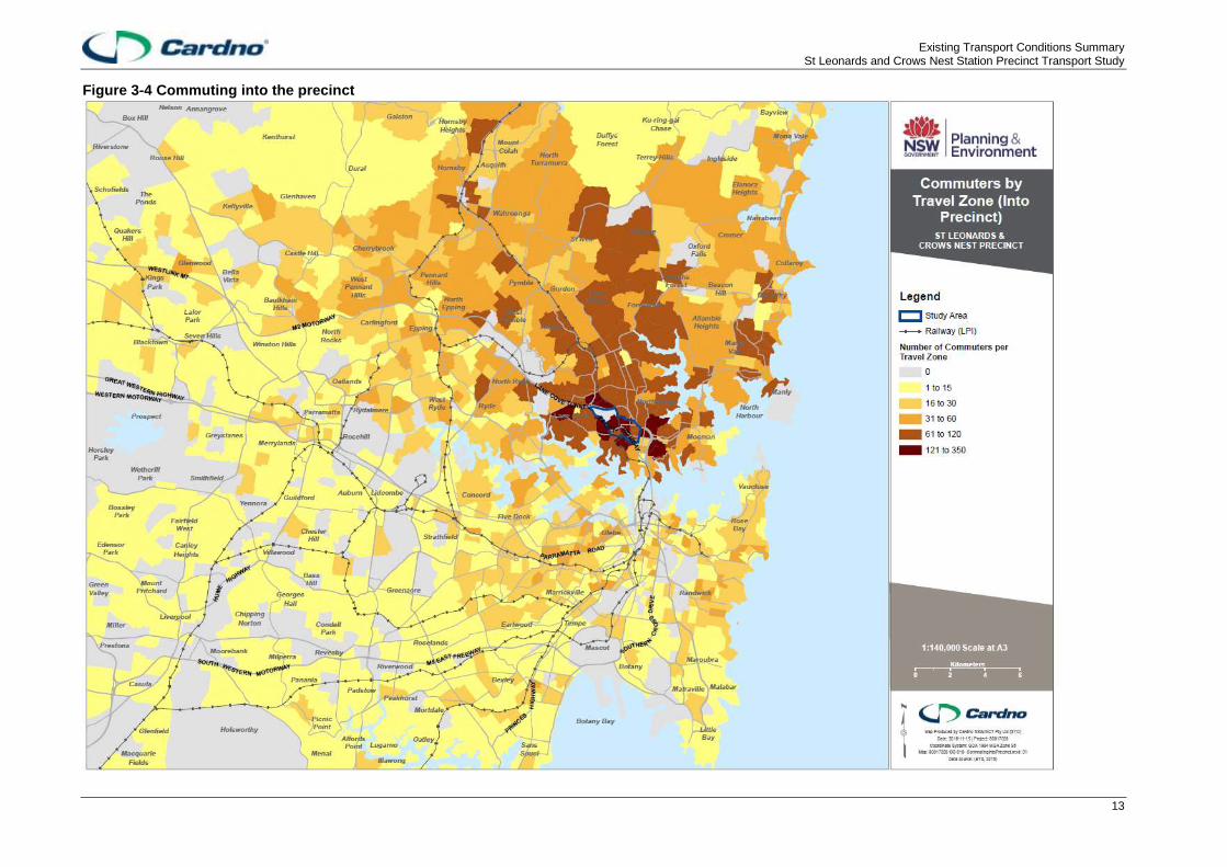
There are more people commuting from the north shore to the precinct than other areas across the Sydney
Metro Area. The areas with a higher number of people commuting to the precinct include the lower north
shore, areas in St Leonards, Greenwich, Lane Cove, Neutral Bay and Wollstonecraft. In general, there is a
low number of people commuting from the southwest of Sydney. A summary map showing where people are
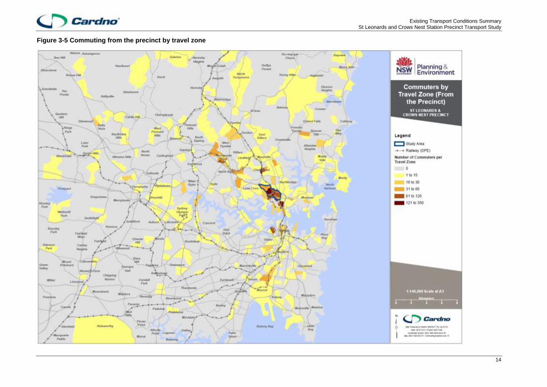
commuting from to get to the precinct by travel zone is provided in Figure 3-4.
The precinct has high commuter trip containment for residents, demonstrating a strong relationship between
housing and employment in the area. People commuting from the precinct mainly travel to jobs within the
precinct, or to Chatswood, North Sydney, Macquarie Park and Pyrmont.
A summary map showing where people are travelling from the precinct is provided in Figure 3-5.
Existing Transport Conditions Summary St Leonards and Crows Nest Station Precinct Transport Study
13
Figure 3-4 Commuting into the precinct
Existing Transport Conditions Summary St Leonards and Crows Nest Station Precinct Transport Study
14
Figure 3-5 Commuting from the precinct by travel zone

Existing Transport Conditions Summary St Leonards and Crows Nest Station Precinct Transport Study
15
3.5 Crash analysis
There was 543 crashes in the precinct between 2011 to 2015. This analysis excludes accidents in the Lane Cove Tunnel, Gore Hill Freeway and Warringah Freeway as this corridor by-passes the precinct. The crashes include: > Fifty-two (52) crashes involving pedestrians;
> One (1) fatal pedestrian crash; and
> Two (2) fatal vehicle crashes.
A summary map of the crash locations is provided in Figure 3-6.
3.5.1 Crash clusters
There are several crash clusters within the precinct which involve at least ten crashes. These clusters are
located along:
> Pacific Highway;
> Herbert Street;
> Falcon Street;
> Willoughby Road; and
> Miller Street.
The intersection between West Street and Falcon Street had the highest number of crashes (26 crashes in
the 5 year period). This is closely followed by the intersection of Falcon Street, Willoughby Road and Pacific
Highway with 25 crashes, followed by Herbert Street and Pacific Highway had 12 crashes. A density map
summarising crashes in the precinct is shown in Figure 3-7.
High density cluster represent up to 50 crashes per 100 square meters and low density represents 1 crash per square 100 square meters.

Existing Transport Conditions Summary St Leonards and Crows Nest Station Precinct Transport Study
16
Figure 3-6 Crash locations

Existing Transport Conditions Summary St Leonards and Crows Nest Station Precinct Transport Study
17
Figure 3-7 Crash cluster locations

Existing Transport Conditions Summary St Leonards and Crows Nest Station Precinct Transport Study
18
3.5.2 Crash types
One of the basic tools for understanding what happened in a crash is the road user movement (RUM) which
describes the first cause for the crash. The crash types which involve pedestrians are identified in the RMS
accident database under RUM codes 00 to 09.
There was a total of 52 pedestrian crashes within the precinct between 2011 - 2015. The most common
occurring crash types are RUM crash codes 00, where a pedestrian is hit in the near side lane and 02, where
a pedestrian is hit in the far side lane. These crashes occurred 24 and 16 times respectively over the five
year period. The number of pedestrian crashes by RUM code in shown in Figure 3-8.
Figure 3-8 Pedestrian crash type
In relation to vehicle crashes, rear ending was the most common crash type across the precinct with 93
occurrences in the past five year period. This was followed by vehicles from the opposing direction crossing
right through (RUM 21), and vehicles from the adjacent direction crossing traffic (RUM 10). A summary of the
number of vehicle crashes by RUM code is shown in Figure 3-9.
24
8
16
1 1 1 1
Pe
de
str
ian h
it in
ne
ar
sid
e la
ne
(0
0)
Pe
de
str
ian
hit e
merg
ing
fro
m b
eh
ind
(01)
Pe
de
str
ian
hit in
fa
r sid
e la
ne
(0
2)
Pe
de
str
ian
hit o
n t
he
ca
rria
ge
way (
03)
Pe
de
str
ian
hit o
n t
he
foo
twa
y (
06)
Pe
de
str
ian
hit in
dri
ve
wa
y (
07
)
Oth
er
(09
)
Num
ber
of
Cra
shes
RUM code description

Existing Transport Conditions Summary St Leonards and Crows Nest Station Precinct Transport Study
19
Figure 3-9 Vehicle crash type
The majority of vehicle and pedestrian crashes occurred in daylight hours (370) in the precinct. This was
followed by crashes occurring in hours of darkness (127). There were fewer crashes occurring during dawn
and dusk (33) periods. A summary of pedestrian and vehicle crashes, broken down by the occurrence time is
provided in Figure 3-10.
Figure 3-10 Crashes – time of day
67
32
78
93
10 12 12
41
1310
17
Ve
hic
les fro
m a
dja
ce
nt
dir
ection
cro
ssin
g t
raffic
(1
0)
Ve
hic
les fro
m a
dja
ce
nt
dir
ection
cro
ssin
g r
igh
t n
ea
r (1
3)
Ve
hic
les fro
m o
ppo
sin
g d
irectio
ncro
ssin
g r
igh
t th
rou
gh
(2
1)
Ve
hic
le h
as r
ea
r en
d a
ccid
ent
(30)
Ve
hic
les fro
m t
he s
am
e d
irectio
n le
fttu
rn s
ide
sw
ipe (
37)
U t
urn
colli
sio
n (
40
)
Ve
hic
le e
me
rgin
g f
rom
drive
wa
y (
47)
Left
turn
off t
he c
arr
iage
wa
y c
olli
sio
nin
to p
ark
ed
ve
hic
le (
71
)
Rig
ht
turn
off t
he c
arr
iage
wa
y c
olli
sio
nin
to a
pa
rke
d v
ehic
le (
73
)
Ve
hic
le is o
n r
oad
out
of co
ntr
ol (7
4)
Ve
hic
le o
ff t
he c
arr
iage
wa
y le
ft o
r rig
ht
han
d s
ide c
olli
sio
n in
to a
park
ed
veh
icle
(8
1)
Num
ber
of
cra
shes
RUM code description
127
10
33
370
Darkness Dawn Dusk Daylight
Num
ber
of
cra
shes
Time of day
Existing Transport Conditions Summary St Leonards and Crows Nest Station Precinct Transport Study
20
4 Transport networks and performance
The assessment of the precinct’s existing transport networks and performance relied on:
> Desktop and site investigations
> Intersection counts at signalised intersections along the Pacific Highway
> Review of passenger data and vehicle counts.
4.1 Major transport corridors
The precinct sits within a series of major transport corridors which provide connections to regional and
strategic centres throughout the Greater Metropolitan Area. These include:
> T1 North Shore and Northern Line: rail connection from St Leonards to either the Sydney CBD or
Berowra and beyond;
> Pacific Highway: A major arterial road corridor connecting the northern suburbs, and the Sydney Harbour
Bridge or Tunnel; and
> The Warringah / Gore Hill Freeway: a key state road corridor forming part of the Sydney Motorway
network, it connects to the Lane Cove Tunnel and M2 to the north-west, and the Sydney Harbour Bridge
and Tunnel, and Eastern Distributor to the south.
4.2 Road network
The road network can be an indication of the land uses it supports. The north-west side of the precinct
generally has large blocks supporting light industrial, bulk goods, retail, education and health related land
uses. Elsewhere, the road network is denser, supporting residential, retail and commercial office land uses.
The road network is the most dense in the Crows Nest sub-precinct, which contributes to a lower speed road
environment.
4.2.1 Pacific Highway
The Pacific Highway is a key route through the precinct with a high movement function. It is generally
configured with three through lanes in each direction, but occasionally with two lanes where turning lanes are
provided at some intersections.
Where there are three lanes, parking is generally allowed in the kerbside lane during off-peak periods.
Through the precinct there are 14 signalised intersections along the Pacific Highway. It is obvious from the
frequent change in the number of through lanes that the corridor is space constrained by surrounding
development.
4.2.2 Warringah/Gore Hill Freeway access
Access to the Warringah/ Gore Hill Freeway from the precinct is provided at:
> Pacific Highway at the intersection of Longueville Road;
> Reserve Road;
> Willoughby Road off-ramp from the Sydney CBD direction only;
> Brooke Street access to/ from Sydney CBD direction only; and
> Falcon Street.
Precinct links to the Warringah/ Gore Hill Freeway provide more opportunities for trips travelling towards the
Sydney CBD than for north-west bound trips. Access away from the CBD is only available at Pacific Highway
to the north east, Reserve Road and Falcon Street. The Falcon Street entry and exit points to the north are
tolled which may act as a deterrent for some motorists. This means than any vehicle in the southern part of
the precinct that needs to continue north or north-west may travel through the precinct along Pacific
Highway, rather than deviate to the Falcon Street entry to the freeway and pay a toll.

Existing Transport Conditions Summary St Leonards and Crows Nest Station Precinct Transport Study
21
4.2.3 Arterial and distributor roads
Other roads in the precinct are described in Table 4-1.
Table 4-1 Arterial and distributor roads
Road name and description
Falcon Street
Falcon Street forms the second major road access to the precinct. It links directly to Military Road, providing a key access point to the Northern Beaches region. It is generally configured with two lanes in each direction, with a combination of through and turning lanes. Kerbside parking is restricted during most of the day, but is available at some locations overnight.
Shirley Road/ River Road
Shirley Road/ River Road provides a key link to suburbs to the west of the precinct, including Greenwich, Longueville and Lane Cove. This corridor also connects across the Pacific Highway to Falcon Street.
Reserve Road
Reserve Road provides a key access point between the Artarmon sub-precinct and the Sydney motorway network. Frederick Street provides a direct link between Reserve Road and Herbert Street.
Herbert Street
Herbert Street provides a parallel route to the Pacific Highway, connecting Artarmon and St Leonards.
Willoughby Road
Willoughby Road provides a key north-south link which can be used as an alternative access point from the northern suburbs, including the Northern Beaches. Through Crows Nest it provides access to the activity centre along Willoughby Road and has Local Area Traffic Management measures to encourage lower vehicle speeds and enhance pedestrian amenity and safety.
Chandos Street
Chandos Street provides a key link between St Leonards and the Warringah Freeway. This provides an alternative access point to the freeway, avoiding the Pacific Highway.
4.2.4 Local roads
There is a lack of capacity on some side streets off the Pacific Highway1F
2. A number of local roads in the
precinct are cul-de-sacs which pushes general traffic onto the roads through the precinct that connect to the
wider network. Some of the roads closed to reduce vehicle permeability and improve pedestrian amenity
include Mitchell Street at Pacific Highway in St Leonards, and Ernest Street between Willoughby Road and
Willoughby Lane in Crows Nest. Lane Cove Council has tried to prevent ‘rat-running’ in the planning and
design of the street network in the area south-west of the Pacific Highway2F
3. The road widths and available
linkages or no-through roads were planned to discourage through traffic but still allow servicing such as
garbage trucks.
The lack of right-turn movements from the Pacific Highway into the surrounding street network increases
vehicle circulation around Albany Street and Oxley Street in the North Sydney LGA 3F
4. Traffic travelling
inbound and headed for destinations south of the Pacific Highway (e.g. to Nicholson Street), can not turn
right into the area and so must turn left into Albany Street and right into Hume Street or Oxley Street to cross
the Pacific Highway. This particularly occurs in the PM peak period.
Most local roads in the precinct have one lane in each direction.
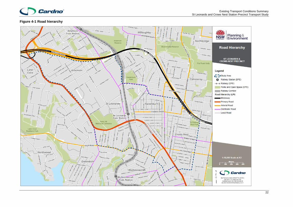
The general function of key roads in the precinct are shown in .
2 Transport for NSW – RMS and Freight Strategy meeting December 2016 3 Lane Cove Council meeting, November 2016 4 North Sydney Council meeting, November 2016
Existing Transport Conditions Summary St Leonards and Crows Nest Station Precinct Transport Study
22
Figure 4-1 Road hierarchy

Existing Transport Conditions Summary St Leonards and Crows Nest Station Precinct Transport Study
23
4.2.5 Road network functions
Roads support a wide range of functions. They are places for people and they also support movement,
access to buildings and spaces, parking and provide space for utilities, drainage, signage and street lighting.
Of these functions, ‘place’ and ‘movement’ are considered the most important for assessing a road’s
character and role within a network. Professor Peter Jones from the University College of London notes in
Link and Place: A New Approach to Street Planning and Design (2009) that the purpose of the movement
function is to save time while the purpose of the place function is to spend time. An ideal road supports both
to some degree.
A road’s movement function supports through movement as part of a trip. The road is part of a route
connecting someone or something from their origin to their destination in a seamless journey. A road’s place
function acknowledges that roads can be end destinations themselves. Activities such as shopping, sitting,
eating and meeting people can occur on or adjacent to the road. Movement and place are often looked at on
a two-dimension chart, with different types of streets sitting along the spectrums of each.
In busy centres with a range of land uses and travel demands, a single road can support both movement and
place functions. A road’s functions can change along its length, as the land uses and travel demands along it
change. It can also change across a day or week as people use the road for different purposes at different
times. Furthermore, and importantly as the precinct transforms, road functions can transition over time. As
sites are redeveloped, they can be designed to enhance the movement and place functions of their
surrounding road network.
The draft NSW Road Planning Framework defines the movement and place functions of the road network for
five categories of road: motorways, movement corridors, vibrant streets, places for people and local streets.
For each category, the typical characteristics and features are described including land uses, trip types,
speed limits, intersection treatments, parking, and pedestrian and bicycle facilities. The road categories are
shown visually and described in Figure 4-2.
Figure 4-2 Draft NSW Road Planning Framework - movement and place functions and road categories
Source: Parramatta Road Corridor: Planning and Design Guidelines
The roads in the heart of the Crows Nest precinct are places for people or vibrant streets. This is due to the
high pedestrian activity along a number of these streets, including active shop fronts, dining seats along the
verges and the slow speeds of traffic established by the pedestrian priority of the roads. Roads south of
Pacific Highway and west of the precinct are local streets as they provide access to residential areas. The
Pacific Highway, is a movement corridor as it provides reliable and efficient movement between regions and
strategic centres, however Brook Street and Chandos Street (west of Willoughby Road) are also movement
corridors as these roads are predominately utilised by vehicles entering and exiting the Warringah Freeway.
The roads in the St Leonards precinct vary based on their location in relation to the Pacific Highway. The
roads south of the Pacific Highway are local streets. In comparison, the roads north of the Pacific Highway

Existing Transport Conditions Summary St Leonards and Crows Nest Station Precinct Transport Study
24
serve a large number of commercial properties and support higher pedestrian volumes from the activity
centre and public transport interchange. These have been assigned as vibrant streets or local streets that
facilitate access to business premises.
The roads in the Artarmon precinct, which is comprised predominately of commercial property, are local
streets that facilitate access to business premises; however, Herbert Street (between Pacific Highway and
Cleg Street) is a vibrant street given the high vehicle movement demand and the pedestrian activity along
the road.
The current road categories for the precinct are shown on Figure 4-3.

Existing Transport Conditions Summary St Leonards and Crows Nest Station Precinct Transport Study
25
Figure 4-3 Road Categories across the precinct

Existing Transport Conditions Summary St Leonards and Crows Nest Station Precinct Transport Study
26
4.3 Walking
4.3.1 The pedestrian experience
The pedestrian experience in the precinct can vary dependent on the sub-precinct.
In Artarmon, pedestrians encounter large blocks without active street frontages, a lack of crossing facilities at
intersections, narrow footpaths, no weather protection and some steep hills, particularly north of the Royal
North Shore Hospital along Reserve Road. There is little pedestrian activity and traffic flows occur at
relatively high speeds, further emphasising the lack of pedestrian priority. Outside of business daytime hours
the sub-precinct could present personal security concerns from the lack of passive and active surveillance.
The St Leonards sub-precinct presents different pedestrian experiences, dependent on location. To the
south of the Pacific Highway steep grades affect all north-south routes. Currently a low-medium density
residential area, there is a lack of street lighting, active surveillance and pedestrian activity. Around the RNS
Hospital, pedestrians are affected by large block sizes, similar to those in the Artarmon sub-precinct. While
Herbert Street has several pedestrian crossings, vehicle speeds are high, blocks are large, buildings are
private with entrances set back from the street, and there is little weather protection. The road network
adjacent to the eastern side of St Leonards Station has better pedestrian amenity.
Pedestrians heading east from St Leonards Station have a range of direct routes to choose from. The
permeable grid network, awnings and active street frontages during the day encourage short walking trips
between diverse land uses but queued traffic, pedestrian refuges that are too narrow at the intersection of
Christie Street and Chandos Street, and the illegibility of the Christie Street Reserve, contribute to
constrained pedestrian movements to and from the station.
The Crows Nest Village centre around Willoughby Road, Alexander Street and Clarke Street provides a
pleasant pedestrian experience with priority road crossings, small block sizes and a network of laneways for
permeability, active street frontages at all times of the day and week, civic spaces, weather protection from
awnings and landscaping. Away from Willoughby Road there is less pedestrian amenity; Albany Street and
Oxley Street are unpleasant roads to cross; vehicles speed towards intersections which either have no
crossing facilities or small, non-compliant pedestrian refuges offer little protection for people attempting to
cross. In particular, roundabouts in the area have poor pedestrian amenity 4 F
5; including the ones at the
intersections Chandos Street/Christie Street, Oxley Street/Albany Street and Burlington Street/Alexander
Street.
The pedestrian experience along the Pacific Highway changes little between the sub-precincts. Throughout
the day, pedestrians suffer from a lack of priority at intersections, limited crossing opportunities, high traffic
volumes in the AM and PM peak and high traffic speeds at other times. This can give pedestrians the sense
that the Pacific Highway is a dangerous road 5 F
6 and could cause pedestrian frustration resulting in crossings
against the red light or away from signalised intersections 6F
7. While the section of the Pacific Highway through
Crows Nest has an active retail strip, west of Hume Street there are less engaging street frontages and west
of Reserve Road long blocks with building entrances set back from the road create an isolated walking
experience.
4.3.2 Network
The precinct has a well-established pedestrian network, with walking connections throughout.
Primary walking routes are defined as key corridors that generally support higher volumes of pedestrians
and provide the most direct and convenient connections between key trip-generating destinations. In the
precinct, the current primary walking routes converge on St Leonards Station at The Forum and connect key
commercial and mixed land uses in the neighbouring Artarmon and Crows Nest sub-precincts.
In St Leonards, a primary route runs along Christie Street, connecting to businesses and high-density
residential areas.
5 North Sydney Council meeting, November 2016 6 Transport for NSW – Centre for Road Safety meeting, December 2016 7 Willoughby City Council meeting, November 2016

Existing Transport Conditions Summary St Leonards and Crows Nest Station Precinct Transport Study
27
Towards Artarmon, the primary walking routes proceed along the Pacific Highway and Reserve Road,
connecting to the RNSH and businesses along the south side of Pacific Highway. Another route proceeds
north along Herbert Street and Frederick Street, connecting to the SBS studio and Home HQ Homemaker
Centre.
Towards Crows Nest, the primary walking routes along the Pacific Highway, Atchison Street and Willoughby
Road provide direct connections to local restaurants, cafes and retailers in the Crows Nest Village.
Secondary routes provide a support function to the primary routes. These generally connect to fewer trip-
generating land uses and facilitate lower volumes of pedestrian movement than primary routes.
In the St Leonards sub-precinct, two secondary routes proceed south along Canberra Avenue and Lithgow
Street, supporting trips between St Leonards Station and low-density residential areas in St Leonards and
Wollstonecraft.
In the Artarmon sub-precinct, secondary routes provide connections to local businesses along Reserve Road
and Herbert Street, and extend towards the Artarmon local centre and train station. Another secondary route
located further north-west along the Pacific Highway, connects to the Gore Hill technology park.
In the Crows Nest sub-precinct, secondary routes along Albany Street, Alexander Street, Oxley Street and
Chandos Street provide connections to local retailers surrounding the major activity areas along Willoughby
Road, and in the creative precinct between Willoughby Road and St Leonards Station. An additional route
connects the Pacific Highway and Falcon Street intersection with Wollstonecraft Station via Shirley Road.
The current primary and secondary walking routes in the precinct are shown on Figure 4-4.
4.3.2.1 Walking catchments
Once the Sydney Metro Crows Nest Station is operational in 2024, the majority of the precinct will be within a
10 minute walk of a train station. Figure 4-5 presents the combined 400 metre, 800 metre and 1,200 metre
walking catchment from St Leonards Station and the proposed Crows Nest Metro Station site.

Existing Transport Conditions Summary St Leonards and Crows Nest Station Precinct Transport Study
28
Figure 4-4 Primary and Secondary walking routes

Existing Transport Conditions Summary St Leonards and Crows Nest Station Precinct Transport Study
29
Figure 4-5 Walking catchments
Existing Transport Conditions Summary St Leonards and Crows Nest Station Precinct Transport Study
30
4.3.3 Infrastructure
4.3.3.1 Footpaths
Footpaths around the St Leonards sub-precinct are provided on both sides of roads and are generally wide,
extending from the property boundary to the kerb. On the southern side of the Pacific Highway, footpath
connections are limited along key north-south streets proceeding towards St Leonards Station including
Lithgow Street, Canberra Avenue and Christie Street. Footpaths along these streets are smaller in width and
are aligned directly adjacent to property boundaries.
In the Artarmon sub-precinct, footpath quality and width is dependent on the location. Along the Pacific
Highway footpaths are wide and in good condition. Herbert Street also has generally wide footpaths. On
minor roads such as Dickson Avenue, Campbell Street, Clarendon Street and Hotham Parade, footpath
widths are generally between 1 to 2 metres, with grassy nature strips separating them from the roadside.
Around the RNS Hospital the footpath network is too narrow for the volume of pedestrians and the
requirements of mobility impaired people. The footpath network in the more industrial parts of the sub-
precinct is missing in some sections and subject to interactions with driveway access for heavy vehicles.
Around the Crows Nest sub-precinct, footpath facilities are wide and in generally good condition. Links are
provided to the proposed Sydney Metro Station site and key bus stops along the Pacific Highway and
Willoughby Road. Where footpaths are provided, they are generally restricted in width, and intersect
frequently with driveways.
Recent improvements in the Crows Nest sub-precinct include a widening of the footpath on the southern side
of Albany Street, between Oxley Street and Hume Lane, and building frontage improvements, including new
footpaths associated with the redeveloped Woolworths supermarket at the corner of Falcon Street and
Alexander Street. To the south-west of the Pacific Highway, footpaths are provided on both sides of the local
roads in residential areas. Footpaths along streets south-west of the Pacific Highway including Oxley Street,
Hume Street, Nicholson Street and River Road are generally restricted in width (average width is 1.5
metres), but in serviceable condition and are well connected to the Pacific Highway corridor.
4.3.3.2 Crossings
In the St Leonards sub-precinct, signalised pedestrian crossings are provided at intersections of the Pacific
Highway and Christie Street, Herbert Street and Berry Road, however pedestrian crossings are not provided
across all legs at these locations which results in reduced pedestrian connectivity and informal crossings
made across the Pacific Highway. An underpass between The Forum and Lithgow Street provides an
alternative north-south crossing across the Pacific Highway however the amenity here is poor with potential
security concerns and it doesn’t provide a direct route between either side of the road. To the east,
signalised crossings and pedestrian refuges provide access to the Crows Nest sub-precinct, while a
pedestrian bridge over Herbert Street links the Gore Hill and Artarmon Loop bus stop to the St Leonards
Station’s western entrance.
Formal pedestrian crossings are very limited in the Artarmon sub-precinct. They are restricted to signalised
crossings at four intersections and two pedestrian refuges at the intersection of Carlotta Street and
Clarendon Street. Recent improvements include reconstruction of a zebra crossing on Herbert Street
opposite the RNSH Community Health Centre to a raised zebra crossing.
Crossing facilities are provided at most intersections in the Crows Nest sub-precinct including raised zebra
and signalised crossings. Pedestrian refuges are also provided along Chandos Street and Albany Street,
however these are non-standard in design and provide only small waiting spaces, introducing a potential
conflict risk with vehicles approaching the crossing at the posted 50km/h speed.
A summary of the existing pedestrian crossing facilities in the precinct is presented in Figure 4-6.
Both the rail corridor and the Pacific Highway act as major barriers for pedestrians, with limited places to
cross. The distance required for pedestrians to travel before approaching a crossing of the Pacific Highway
varies across the precinct; generally pedestrians are required to travel further to arrive at a formalised
crossing in the Artarmon sub-precinct compared to the St Leonards and Crows Nest sub-precinct.
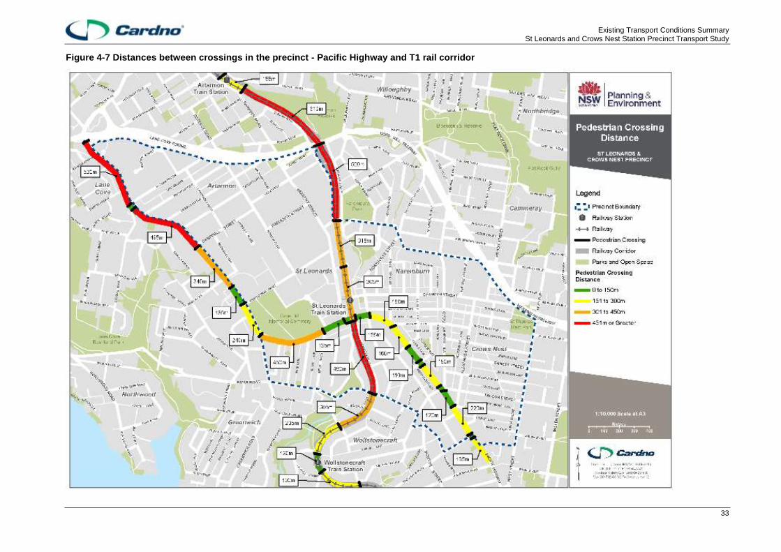
In the Artarmon sub-precinct, the longest distance between two crossings is located along the Pacific
Highway, between the intersection of Longueville Road and Hotham Parade at 530 metres. This is followed

Existing Transport Conditions Summary St Leonards and Crows Nest Station Precinct Transport Study
31
by the distance along the rail corridor between the Gore Hill Freeway and Ella Street at 520 metres, and
along the Pacific Highway between Hotham Parade and Campbell Street at 495 metres.
In the St Leonards sub-precinct, the longest distance between pedestrian crossings is located along the rail
corridor between the Pacific Highway and River Road at 480 metres. Along the Pacific Highway between
Greenwich Road and Reserve Road the distance is 450 metres, and north of St Leonards Station, the
distance between the station plaza and the Herbert Street bridge is 365 metres.
In the Crows Nest precinct, the distance required to travel between crossings is significantly shorter when
compared to the St Leonards and Artarmon sub-precincts, with crossing facilities provided more frequently
along the Pacific Highway. The longest distance between crossings in this area is located between the
intersections of Alexander Street and Rocklands Road at 220 metres.
A map summarising the distances between formal pedestrian crossing facilities along the T1 rail corridor and
the Pacific Highway is provided on Figure 4-7.

Existing Transport Conditions Summary St Leonards and Crows Nest Station Precinct Transport Study
32
Figure 4-6 Existing pedestrian crossing facilities
Existing Transport Conditions Summary St Leonards and Crows Nest Station Precinct Transport Study
33
Figure 4-7 Distances between crossings in the precinct - Pacific Highway and T1 rail corridor

Existing Transport Conditions Summary St Leonards and Crows Nest Station Precinct Transport Study
34
4.3.4 Demand
Pedestrians counts were completed on the 17th November 2016 at 18 locations throughout the precinct. The
highest pedestrian volumes were found to be along the Pacific Highway, in close proximity to the St
Leonards Station, and towards Crows Nest. Daily pedestrian volumes at count locations surrounding St
Leonards Station were a minimum of 2,800 pedestrians per day.
The pedestrian underpass at Pacific Highway adjacent to the east of the railway line at St Leonards has
pedestrian volumes of 4,700 pedestrians. This is well below that of the pedestrian crossings of Pacific
Highway at Herbert Street and Christie Street which cater for 13,000 and 8,000 pedestrians respectively.
2016 pedestrian intersection volumes are shown in .
Pedestrian counts were also completed at select locations in the Lane Cove LGA as part of the 2013 Lane
Cove Council Pedestrian Access and Mobility Plan, prepared by GTA Consultants. Surveys were completed
across three time periods at ten locations. Two of these locations are situated within the precinct, near St
Leonards Station. These included Location 6 (Intersection of Pacific Highway and Berry Road) and Location
7 (Intersection of Pacific Highway and Reserve Road).
A summary of the pedestrian volumes captured at these locations is provided in Figure 4-8.
Table 4-2 Summary of pedestrian volumes (2011)
Survey location 7am – 9am AM Peak 12pm – 2pm MID Peak 4pm - 6pm PM Peak Total
Pacific Highway / Berry Road 493
414 (8am – 9am)
805 515
(12:30pm – 1:30pm)
506 251 (5pm –
6pm) 1,804
Pacific Highway / Reserve Road 708
527 (8am – 9am)
1,131 713
(12:30pm – 1:30pm)
675 279 (5pm –
6pm) 2,514
Source: Lane Cove Council PAMP (GTA Consultants, 2013)

Existing Transport Conditions Summary St Leonards and Crows Nest Station Precinct Transport Study
35
Figure 4-8 Daily Pedestrian Volumes 2016

Existing Transport Conditions Summary St Leonards and Crows Nest Station Precinct Transport Study
36
4.4 Cycling
4.4.1 Network
The precinct’s cycling network varies from good to limited coverage depending on the sub-precinct. There is
a general lack of directness and continuity along the existing network routes, as many avoid arterial road
corridors such as the Pacific Highway and Falcon Street; they instead run along local and collector roads.
These roads are characterised by their low traffic volumes and speeds, making them more suitable for mixed
traffic cycling facilities.
North-south cycling routes in the existing network run predominately through the Crows Nest sub-precinct;
the most direct route runs along West Street, connecting to routes along the Warringah and Gore Hill
Freeways and proceeding towards Chatswood. The route along West Street also proceeds south to connect
to North Sydney. An alternative north-south route runs through the Crows Nest village centre along Hayberry
Street, Alexander Street, Clarke Street and Oxley Street, and proceeds through Naremburn before also
connecting to the regional routes to Chatswood. In the Artarmon sub-precinct, a north-south route proceeds
along Herbert Street and Hampden Road, connecting St Leonards Station and Artarmon Station.
Two key east-west routes are provided through the precinct. To the north of the precinct, a shared path
facility is provided along the southern perimeter of the Warringah and Gore Hill Freeways. This facility forms
part of a key regional route from Naremburn to Macquarie Park via Lane Cove and North Ryde. A second
route runs along River Road and through suburban streets in Greenwich, connecting Lane Cove with
Wollstonecraft and routes proceeding south towards North Sydney.
Cycling access to St Leonards Station is limited to two routes approaching from the north and east of the
precinct. The first of the key access routes approaches from Herbert Street, with the second arriving from the
east along Henry Lane and Christie Street. Access to St Leonards Station from the south is limited due to the
lack of routes connecting to and across the Pacific Highway. The two routes in this area closest to St
Leonards Station include a route along Greenwich Road (ending at the intersection with the Pacific Highway)
and Nicholson Street (ending at the intersection with Oxley Street). Both routes are incomplete, with no
additional facilities connecting to the St Leonards Station. Cycling access to the future Crows Nest Metro
Station is currently available via a route along Clarke Street. A summary map of the existing and proposed
cycling routes is provided in Figure 4-9. Proposed routes are described in Section 2.3.2.
The majority of the precinct is within a 15 minute cycle of the St Leonards and Crows Nest stations. Figure
4-10 presents the combined 2.5 kilometre cycling catchment from St Leonards Station and the proposed
Crows Nest Metro Station site.

Existing Transport Conditions Summary St Leonards and Crows Nest Station Precinct Transport Study
37
Figure 4-9 Existing and proposed cycling routes

Existing Transport Conditions Summary St Leonards and Crows Nest Station Precinct Transport Study
38
Figure 4-10 2.5 kilometre cycling catchment

Existing Transport Conditions Summary St Leonards and Crows Nest Station Precinct Transport Study
39
4.4.2 Infrastructure
Along existing routes there is limited dedicated cycling infrastructure, many are unmarked with no
accompanying signage and wayfinding. Off-road facilities are limited, however along some routes, facilities
such as shared paths provide links between disconnected or incomplete on-road routes.
To the north of the precinct, a shared path is provided along the southern perimeter of the Gore Hill Freeway.
In the St Leonards sub-precinct, an on-road separated lane is provided in both directions along most of
Herbert Street, reverting to mixed traffic on approach to the Pacific Highway. On the eastern side of the
railway line, a combination of mixed traffic and shared paths run parallel to the rail corridor. To the east, a
mixed traffic facility is provided on Henry Lane and Atchison Street (eastbound). For westbound movements
along Atchison Street, a 1.4 metre wide contraflow on-road lane was recently implemented. The only
facilities provided on the south side of the Pacific Highway include a combination of mixed traffic and
separated on-road lanes run along the precinct boundary on Greenwich Road and River Road.
In the Artarmon sub precinct, formal cycling facilities are provided along major routes. A mixed traffic route
with painted markings is provided running east-west on Carlotta Street, connecting a short section of shared
path on Pacific Highway to a separated on-road facility on Herbert Street leading to St Leonards Station.
This separated on-road facility on Herbert Street extends north to Artarmon Station via Hampden Road.
In the Crows Nest sub-precinct, most routes operate with mixed traffic arrangements. These include Atchison
Street east of Willoughby Road, and the route along Oxley Street (northbound), Clarke Street (northbound),
Alexander Street and Hayberry Street. Southbound along Oxley Street and Clarke Street, a separated on-
road lane is provided. Two segments of this route are also rated as high difficulty by the Roads and Maritime
Services Cycleway Finder; these include:
> The roundabout intersection of Chandos Street and Christie Street; and
> Oxley Street, between Chandos Street and Albany Street.
In the Crows Nest sub-precinct, no facilities are available to facilitate crossing of the Pacific Highway by bike.
Some cycling does occur in bus lanes, in particular on the Pacific Highway as it is the most direct through
route to traverse the precinct. This interaction between buses and bicycles in the same space may cause
conflict 7F
1.
4.4.3 Demand
Intersection counts were completed on 17th November 2016 at 18 locations throughout the precinct. These
counts showed the Pacific Highway being used by between 80 to 160 cyclists per day, with the higher end of
the range being recorded in Crows Nest.
The main ridership within the precinct was along Alexander Street with 288 cyclists northbound and Falcon
Street with 500 cyclists eastbound counted. 2016 daily cyclist volumes are shown in Figure 4-11.
In addition to the survey counts, RMS collects bicycle volume data using counters across Greater Sydney.
The counters provide daily counts of passing bicycles, with average daily counts reported by month and
year. There are currently no survey facilities installed in the precinct, however three counters are provided at
the following nearby locations which indicate volume:
> Merrenburn Avenue (ramp onto the Warringah Freeway), Naremburn;
> Falcon Street pedestrian bridge, Neutral Bay; and
> Ridge Street bridge, North Sydney.
Willoughby City Councils reports a lack of cycling in their part of the precinct, but notes that the Gore Hill
Freeway bike links are popular 8F
2
The most recent average daily counts by year are provided in Table 4-3.
1 Transport for NSW – RMS and Freight Strategy meeting, December 2016 2 Willoughby City Council meeting, November 2016

Existing Transport Conditions Summary St Leonards and Crows Nest Station Precinct Transport Study
40
Table 4-3 RMS average daily cycling volumes
Merrenburn Avenue Falcon Street pedestrian bridge
Ridge Street bridge
2016 342 16 90
2015 310 16 85
Source: RMS Cycling Statistics (Viewed November 2016)
.

Existing Transport Conditions Summary St Leonards and Crows Nest Station Precinct Transport Study
41
Figure 4-11 Daily Cyclist Volumes 2016
Existing Transport Conditions Summary St Leonards and Crows Nest Station Precinct Transport Study
42
4.5 Train
4.5.1 Metro Network
Sydney Metro Northwest includes eight new railway stations to accommodate the region’s population growth,
and commercial and mixed land uses. The metro, operational in 2024, will extend from the Northwest region
of Sydney to Chatswood, Crows Nest, North Sydney, Barangaroo, Martine Place, Central and ultimately will
continue further to the South West.
Crows Nest Metro Station will be located 25 metres underground with entrances at the intersection of Pacific
Highway and Oxley Street, and the intersection of Clarke Street and Hume Street. The proposed features of
the Crows Nest Metro Station that will enhance customer accessibility are:
> Pedestrian crossings on Clarke Street, Hume Street and Oxley Street, and a signalised pedestrian
crossing at the intersection of Pacific Highway and Oxley Street;
> Bike parking at the station entrances;
> On-road cycle facilities on Hume Street and Oxley Street;
> Kiss and ride and taxi bays on Clarke Street;
> Existing bus stops on Pacific Highway;
> Helpful wayfinding signage and Sydney Metro information.
The travel time from Crows Nest Metro Station to Martin Place is expected to be 7 minutes, and 11 minutes
to Central Station.
4.5.2 Train Network
St Leonards Station is located at the centre of the precinct, under The Forum, a commercial and residential
development. The station, served by Sydney Trains, operates services along the T1 North Shore and
Northern Lines. Customers can travel to Berowra via Gordon, Hornsby via Macquarie Park or Penrith,
Epping and Richmond via the City. Customers can also interchange at Hornsby Station for NSW TrainLink
intercity services to Hamilton, or at Town Hall for the T2, T3 and T4 lines on the Sydney Trains network.
With current timetable arrangements, from St Leonards Station, the 30 minute rail catchment extends to
stations on the following lines:
> T1 North Shore Line: Waitara Station (via Gordon);
> T1 Northern Line: Pennant Hills Station (via Macquarie Park);
> T1 Western Line: Redfern Station;
> T2 Inner West Line: Newtown Station;
> T3 Bankstown Line: Erskineville Station; and
> T4 Eastern Suburbs and Illawarra Line: Edgecliff and Sydenham Stations.
A map showing the extent of the 30 minute rail catchment is provided in Figure 4-12.
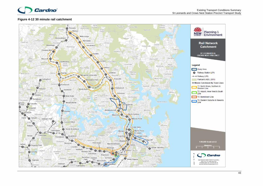
Existing Transport Conditions Summary St Leonards and Crows Nest Station Precinct Transport Study
43
Figure 4-12 30 minute rail catchment
Existing Transport Conditions Summary St Leonards and Crows Nest Station Precinct Transport Study
44
4.5.3 Infrastructure and services
St Leonards Station is configured as two island platforms, however space is available for an additional two
platforms on either side of the current Platforms 2 and 3.
The station is wheelchair accessible, with lifts connecting both platforms with the concourse and accessible
toilet facilities are provided. Access to the station is available from the Pacific Highway and Christie Street,
and an accessible path is available via Herbert Street. Interchange opportunities are available with bus
services departing from the Pacific Highway and Herbert Street. No dedicated taxi rank is provided at the
interchange. No commuter parking is available, however Council and privately operated parking facilities are
provided on the eastern side of the station. Bicycle parking is available, in addition to Kiss & Ride facilities on
Sergeants Lane.
Trains operate between 4:47am and 12:02am to the City and between 4:44am and 12:55am towards
Hornsby. During AM and PM peak hour, 15 trains serve St Leonards Station via the T1 North Shore Line in
both directions, and four services operate in both directions on the T1 Northern Line via Macquarie Park.
Outside of peak periods, eight trains per hour operate through the station in both directions, four each along
the T1 North Shore and Northern Lines respectively. During weekend and public holiday periods, four trains
per hour operate all day along the T1 North Shore Line via Gordon in both directions, and two trains per
hour, in both directions along the T1 Northern Line via Macquarie University.
A summary of the St Leonards Station services is provided in Table 4-4.
Table 4-4 St Leonards Station train services
Line Direction Daily services (Weekday)
AM Peak
06:00-09:30
Daytime
09:30-16:00
PM Peak
16:00-18:30
Daily services (Saturday)
T1 North Shore Line (via Gordon)
From City 122 33 32 26 73
To City 118 32 30 24 74
T1 Northern Line (via Macquarie Park)
From City 76 19 26 10 38
To City 80 14 26 18 39
Source: Sydney Trains (viewed November 2016)
4.5.4 Demand
An average of 35,180 customers used St Leonards Station over a 24 hour period in 2014. Station Out and In
volumes are particularly concentrated during the AM and PM peaks respectively, with commuters travelling
to the precinct to work making up the dominant movement. A summary of the peak and daily customer
volumes through the station is provided in Table 4-5.
Table 4-5 In and Out volumes at St Leonards Station (2014)
24 Hour AM Peak (6:00am–9:30am)
PM Peak (3:00pm–6:30pm)
Station Ins 17,590 3,420 8,780
Station Outs 17,590 8,900 3,230
Source: Bureau of Transport Statistics (BTS, viewed November 2016)
4.6 Bus
4.6.1 Network
Buses travelling through the precinct provide connections to key centres including Chatswood, North
Sydney, Manly, the Sydney CBD and Bondi. They also connect with northern residential areas such as Lane
Cove, Epping, the Hills District and Dural. The only direct connection to the Northern Beaches is from Manly.
Services are provided by four operators:
1. The State Transit Authority of NSW (STA);
Existing Transport Conditions Summary St Leonards and Crows Nest Station Precinct Transport Study
45
2. Hillsbus;
3. Lindsay Bennelong Developments (for the Gore Hill Loop); and
4. Willoughby Council (for the Artarmon Loop).
Buses operated by the STA and Hillsbus are generally confined to key arterial road corridors such as the
Pacific Highway; some STA services also operate along River Road and Willoughby Road. The Pacific
Highway is the most direct route to travel north-west to the CBD through the precinct.
Service coverage is limited in the Artarmon and St Leonards sub-precincts, customers generally need to
access major corridors to board services. An exception is the route between Manly and Chatswood, it
provides direct connection to the Royal North Shore Hospital entrance; saving visitors a 200 metre uphill
walk from the Pacific Highway. Service coverage is higher in the Crows Nest sub-precinct, with a
combination of local and suburban routes connecting to commercial and local land uses.
The Gore Hill Loop is a free shuttle bus service that connects St Leonards Station with the Gore Hill
business and technology precinct, providing a dedicated public transport connection for employees
transferring from train services. The service runs between a shared stop (with the Artarmon Loop) on the
western side of Herbert Street and two stops adjacent to the Fox Sports and Australian Stock Exchange
buildings at Gore Hill.
The Artarmon Loop is a free Council shuttle bus service that operates along three routes, connecting St
Leonards Station with the Artarmon sub-precinct, Artarmon train station, or Royal North Shore Hospital
depending on the time of day. During peak periods, the shuttle connects the shared bus stop (with the Gore
Hill Loop) on Herbert Street with 16 stops through the industrial area. Outside of peak periods, the shuttle
proceeds further north to service the Artarmon local centre and train station and diverts along Westbourne
Street to link to the Royal North Shore Hospital.
A map summarising the precinct bus routes is provided in Figure 4-13.

Existing Transport Conditions Summary St Leonards and Crows Nest Station Precinct Transport Study
46
Figure 4-13 Bus Network
Existing Transport Conditions Summary St Leonards and Crows Nest Station Precinct Transport Study
47
4.6.2 Infrastructure and services
4.6.2.1 Infrastructure
Bus stop infrastructure varies in the precinct by LGA. All bus stops are identifiable by J-Pole or newer TfNSW
“B” Mode ID signage at their respective boarding points, and most bus stops provide additional facilities
including shelters and seating. Where stops are located beneath building awnings, these are used as
shelters in favour over prefabricated shelter structures.
The majority of stops have not been designed to DDA compliant standards. Common deficiencies include
insufficient circulation space and lack of designated waiting areas for mobility impaired customers, non-
compliant seating and missing boarding point tactile ground surface indicators (TGSI). No weather protection
is provided at stops along River Road, and on the western side of Greenwich Road.
Willoughby City Council engaged JCDecaux in 2013 for the supply and maintenance contract for bus
shelters. As part of the engagement, new shelters with seating and boarding point TGSI were installed at
most stops within the LGA. Some stops were not included in the upgrade program; one of the key stops
where a shelter is not provided is the M20 Artarmon terminus stop on Campbell Street.
The Pacific Highway is considered very challenging for bus operations; with parking allowed along the
majority of it and no bus lanes 9F
1. The lack of priority affects bus travel times and reliability. The steep grades,
road widths and street parking constraints within the Artarmon Industrial Estate are not conducive to full-size
buses, the current mini-bus shuttle operations have better access1.
Bus layover in lower North Shore is currently at capacity, growth in service frequency would require
additional layover options1.
4.6.2.2 Services
During weekdays, eight out of the 21 routes operate until the early evening; seven operate during the peak
periods only, and four provide all day services until late in the evening. 11 out of the 21 routes operate on
weekends, with services on five routes each extending to the late afternoon and late night respectively, and
route 290 restricted to the early morning.
As part of Sydney’s Bus Future, the NSW Government’s strategy to deliver improved bus services for
customers in Sydney, a new network of three bus service tiers was developed: Rapid, Suburban and Local,
with each targeted to deliver a specific function within the wider bus network. A tier has been allocated to
each existing route based on their current stopping pattern and the destinations they connect to.
A summary of the bus services travelling through the precinct, their weekday and weekend frequencies and
precincts served is provided in Table 4-6.
4.6.2.3 Performance
Bus on the Pacific Highway, along with the North Sydney and Sydney CBD, experience congestion in peak
periods 10F
2. The majority of routes that use the Pacific Highway are affected by congestion which can impact
services from Chatswood. In the long term, bus capacity in the North Sydney and Sydney CBDs may need to
be addressed by reshaping the bus network to facilitate greater interchange from bus to railway from the
CBD.
Bus to rail interchange occurs at St Leonards Station. The Hills Bus routes that stop at St Leonards see
people transferring to the rail service1. The Artarmon Loop Shuttle Service is well-utilised and receives
positive feedback from customers.
1 Transport for NSW – Bus strategy meeting December 2016 2 Transport for NSW – Bus strategy meeting, December 2016

Existing Transport Conditions Summary St Leonards and Crows Nest Station Precinct Transport Study
48
Table 4-6 Summary of bus service frequency and coverage
Netw
ork
tier
Route Operator Route direction
General frequency
(services per hour)
First service Last service Sub-precinct coverage
Weekday Weekend Weekday Weekend Weekday Weekend Artarmon St Leonards
Crows Nest
Rap
id 602X Hillsbus Rouse Hill to North
Sydney 4 0 05:39 - 08:29 -
612X Hillsbus Kellyville to Milsons Point
4 0 05:30 - 09:06 -
Su
bu
rba
n
140 STA Epping to Manly 2 0 16:07 - 17:07 -
143 STA Chatswood to Manly
2 0 06:41 - 18:09 -
144 STA Chatswood to Manly (via RNSH)
2 4 05:04 07:10 23:55 23:55
200 STA Chatswood to Bondi
4 0 06:25 - 19:10 -
252 STA Lane Cove West to City
2 2 06:00 06:24 23:00 00:00
257 STA Chatswood to Balmoral
2 2 06:52 06:19 18:22 17:42 X X
261 STA Chatswood to City (via Longueville)
1 1 06:14 07:45 20:21 17:28 X
263 STA Crows Nest to City 2 2 06:04 07:06 18:56 19:05 X X
286 STA Denistone East to Milsons Point (via St Leonards)
4 0 06:24 - 07:52 -
287 STA Ryde to Milsons Point
4 0 06:27 - 07:51 -
290 STA Epping to City 2 2 04:05 04:35 05:251 05:152
291 STA Epping to McMahons Point
1 1 06:01 05:58 21:57 21:57
343 STA Chatswood to Kingsford
6 4 04:45 05:00 23:37 00:30 X X

Existing Transport Conditions Summary St Leonards and Crows Nest Station Precinct Transport Study
49
Netw
ork
tier
Route Operator Route direction
General frequency
(services per hour)
First service Last service Sub-precinct coverage
Weekday Weekend Weekday Weekend Weekday Weekend Artarmon St Leonards
Crows Nest
622 Hillsbus Dural to Milsons Point
3 0 06:10 - 07:50 -
653 Hillsbus West Pennant Hills to Milsons Point
3 0 06:25 - 08:05 -
M20 STA Metrobus Chatswood to Bondi
4 4 06:31 07:38 20:13 19:35
Lo
ca
l
254 STA Riverview to McMahons Point
1 1 06:33 06:49 22:45 22:45
265 STA Lane Cove to McMahons Point
1 1 05:53 08:50 17:37 17:58 X
267 STA Chatswood to Crows Nest
1 1 06:39 08:27 18:38 17:47 X X
Gore Hill Loop
Private operator
Loop service from St Leonards to Gore Hill
Unknown 0 Unknown - Unknown - X
Artarmon Loop
Willoughby Council
Loop Service from St Leonards to Artarmon Industrial and Station or RNS Hospital
5 0 06:00 - 18:00 - X
Total (routes per sub-precinct) 17 19 21
Source: State Transit Authority of NSW, Hillsbus, Gore Hill Business Precinct and Willoughby Council
1 One additional 290 service operates at 23:00
2 Four additional 290 services operate hourly from 23:00 to 01:53
Existing Transport Conditions Summary St Leonards and Crows Nest Station Precinct Transport Study
50
4.7 Freight and servicing
4.7.1 Network
Freight movements are essential to support the industrial land uses in Artarmon and general deliveries to
retail, business and residential land uses throughout the precinct. The precinct’s freight network comprises of
designated on-road routes, providing access to the wider NSW network and air, port, rail and intermodal
terminals.
Restrictions for freight vehicles relate to dimensional and/or vehicle mass. The precinct is generally
accessible to smaller freight vehicles including delivery vans and rigid trucks. While access is available along
the Pacific Highway, this is generally not used as a through route given the time advantage of the Warringah/
Gore Hill Freeway.
A summary map of the RMS designated freight routes is provided in Figure 4-14.
4.7.2 Infrastructure
All freight corridors in this precinct are road-based, there is no dedicated freight rail line. The Gore Hill
Freeway/ Lane Cove Tunnel provides a bypass route for general road traffic including freight vehicles past
the precinct.
To meet the needs of the Artarmon industrial area, designated freight routes are provided for access
between the Lane Cove Tunnel/ Gore Hill Freeway and Artarmon.
The precinct is generally restricted to short combination vehicles less than 19 metres in length. Combination
vehicles up to 19 metres in length are permitted on the Pacific Highway between the Lane Cove tunnel and
Campbell Street in the north-west corner of the precinct. They are also permitted along Hotham Parade,
McLanlan Avenue, Campbell Street and Lanceley Place..

Existing Transport Conditions Summary St Leonards and Crows Nest Station Precinct Transport Study
51
Figure 4-14 Freight routes

Existing Transport Conditions Summary St Leonards and Crows Nest Station Precinct Transport Study
52
4.8 Private vehicles
4.8.1 Demand and performance
The performance of Pacific Highway between Lane Cove and North Sydney helps to show the demand the
road network has in the precinct. The performance of the highway was measured by two variables, including:
> Average speed (km/h); and
> Percentage of Speed Limit (%) (The posted speed limit along the Pacific Highway is 60 km/h).
The average speed is a mean of all the vehicle speeds travelling along a road in a particular timeframe. The
percentage of speed limit is a measure of how many vehicles are travelling at the designated speed for the
road, the higher the percentage of speed limit the better flow along the road. The data used for this analysis
only considers weekdays during the time period from November 2015 to November 2016.
This analysis shows that this section of the Pacific Highway is not flowing at the designated speeds. The AM
peak inbound and PM peak outbound are the worst performing time periods with average vehicle speeds
below 40 km/h and percentage of speed limit below 70%. The performance data is summarised in Table 4-7
and Table 4-8.
Table 4-7 Pacific Highway inbound - Lane Cove to North Sydney
AM Peak (6am- 9am) PM Peak (3pm- 7pm)
Average speed (km/h) 37.0 41.1
Percentage of vehicles achieving 60 km/h speed limit (%)
69 76
Source: http://roadsreport.rms.nsw.gov.au/#/chart?location=71&dateStart=2016-06-01&dateEnd=2016-08-31&peak=AM&type=period-plot
Table 4-8 Pacific Highway outbound – North Sydney to Lane Cove
AM Peak (6am- 9am) PM Peak (3pm- 7pm)
Average speed (km/h) 43.4 35.7
Percentage of vehicles achieving 60 km/h speed Limit (%)
80 66
Source: http://roadsreport.rms.nsw.gov.au/#/chart?location=71&dateStart=2016-06-01&dateEnd=2016-08-31&peak=AM&type=period-plot
Daily vehicle volumes from the traffic surveys completed on 17th November 2016 at 18 intersections
throughout the precinct confirm that the Pacific Highway is the main thoroughfare for drivers with over 20,000
vehicles using certain stretches of this road in both directions. There is also a high level of vehicles on
Falcon Street, with approximately 10,000 vehicles in both directions. This is primarily due to Falcon Street
providing direct access to the Warringah Freeway in both directions.
The collector roads, providing access to the Pacific Highway currently have a demand of between 4000 –
8000 vehicles per day.
A summary of the daily vehicle volumes for 2016 is provided in Figure 4-15.
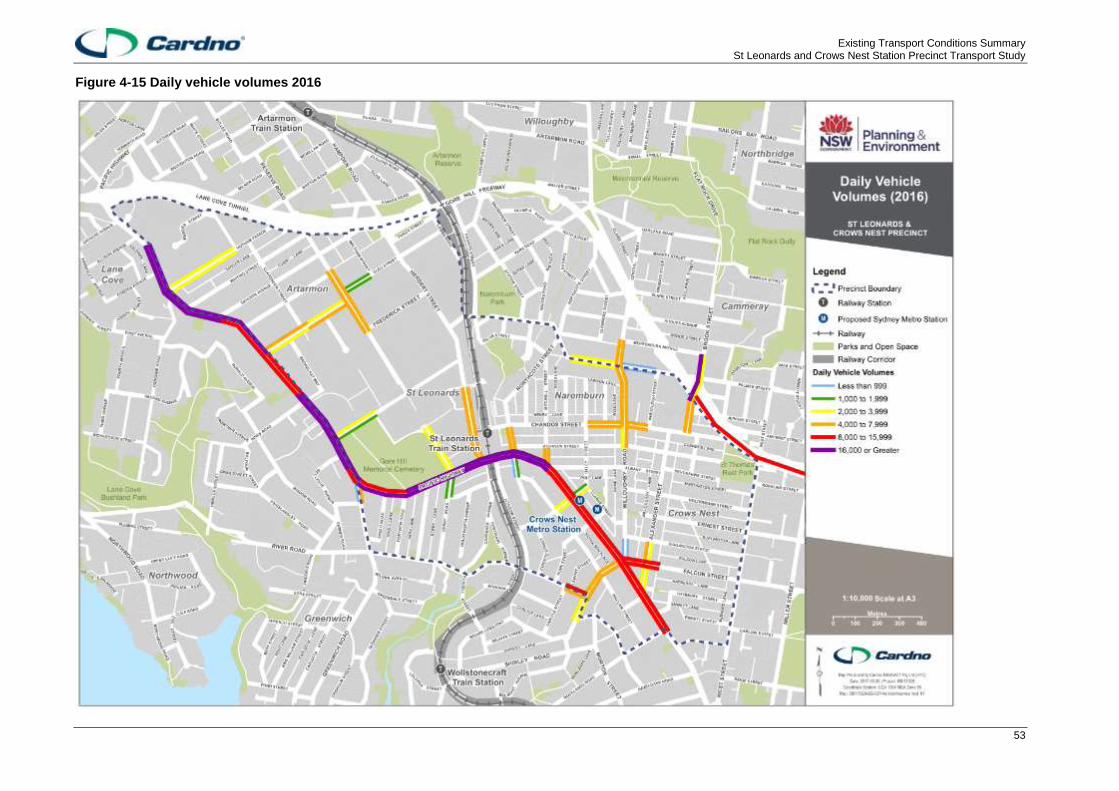
Existing Transport Conditions Summary St Leonards and Crows Nest Station Precinct Transport Study
53
Figure 4-15 Daily vehicle volumes 2016

Existing Transport Conditions Summary St Leonards and Crows Nest Station Precinct Transport Study
54
4.9 Demand responsive public transport
4.9.1 Council Cabs
Willoughby City Council runs a program called ‘Council Cabs’ which provides a door-to-door service for trips
in the LGA. The service must be booked a day in advance and it is typically used by senior citizens.
4.10 Parking
4.10.1 Infrastructure
A range of car parking options are available through the precinct. This includes private parking spaces, and
publicly accessible (paid and free) on and off-road facilities.
4.10.1.1 On street parking
Each Council has a different approach to on-street parking management in the St Leonards sub-precinct.
North Sydney Council and Lane Cove Council have paid parking on the streets that fall within their LGA but
Willoughby City Council does not, leading to higher parking demand in the Willoughby LGA 11F
1.
In some parts of the Artarmon sub-precinct, in particular on Dickson Street, on-street parking intended for
customers of surrounding businesses has been used by car smash repair companies 12F
2. Previous plans to
introduce paid parking to the Artarmon Industrial Estate to address this issue have not had business support.
It has only been implemented in Dickson Street but the meters there are subject to a lot of vandalism.
4.10.1.2 Off-street publically available car parking
Publicly accessible off-street car parking areas within the precinct generally have fees (that vary by location)
and are mainly managed by private operators including Wilson Parking and Secure Parking.
Off-street car parking locations are summarised in Table 4-9.
Table 4-9 Off-street car parking in the precinct
Car Park Location Fee
Home HQ multi-level parking Frederick Street, Artarmon 3 hours free parking on weekdays, free parking all weekend
Bunnings Reserve Road, Artarmon Free for customers, maximum stay is 3 hours
Two multi-story car parks at the Royal North Shore Hospital
Reserve Road, Artarmon All day - $33.60
Artarmon Reserve Artarmon Reserve off of Burra Road
Free
Alexander Street above Woolworths
Alexander Street, Crows Nest All day - $52.00
Clemenger Garage Pacific Highway All day - $50.00
Holtermann Street garage Holtermann Street All day - $52.00
486-494 Pacific Highway Pacific Highway All day - $42.00
Forum Parking, Willoughby City Council
Chandos Street, St Leonards All day - $34.00
Norths Rugby Club Wilson Parking
Christie Street All day - $35.00
Charter Grove garage Christie Street All day - $35.00
1 Willoughby City Council meeting, November 2016 2 Willoughby City Council meeting, November 2016

Existing Transport Conditions Summary St Leonards and Crows Nest Station Precinct Transport Study
55
Car Park Location Fee
2 Chandos Street Garage, Willoughby City Council
Chandos Street, St Leonards All day - $25.00
Hume Street car park, North Sydney Council
Hume Street, Crows Nest Daytime - $52.00
Nicholson Street car park, North Sydney Council
Nicholson Street, Crows Nest Monthly - $375.00
Gore Hill Oval, Willoughby City Council
St Leonards, Pacific Highway Free
Crows Nest Plaza, North Sydney Council
Holtermann Street, Crows Nest Maximum - $52.00
Monthly - $420.00
Many other publicly accessible car parks exist as part of developments. These vary between casual
availability and on a month by month basis.
A summary map of the locations of off-street parking in the precinct is provided in Figure 4-16.

Existing Transport Conditions Summary St Leonards and Crows Nest Station Precinct Transport Study
56
Figure 4-16 Off-street parking locations

Existing Transport Conditions Summary St Leonards and Crows Nest Station Precinct Transport Study
57
4.10.1.3 Parking rates for developments
Multiple Development Control Plans (DCP) apply to the precinct due to the convergence of three LGAs and
have area specific parking rates. Each Council has developed their parking rate provisions independently.
Lane Cove Council has minimum parking rates for new developments but it does allow developers to
nominate their own car parking provision for residential land uses within 400 metre radius of St Leonards
station. This is based on market demand, i.e. the willingness of people willing to purchase a dwelling with or
without a car parking space and allows developers to construct dwellings without dedicated car parking
provisions. The Lane Cove DCP also provides developers the flexibility to reduce car parking spaces by
allocated car share space(s) if site constraints do not allow adequate on-site parking.
The North Sydney DCP nominates maximum parking rates for developments as opposed to the more
common approach of applying minimum parking rates. Parking rates for some residential flat buildings and
shop top housing in St Leonards Precincts 2 & 3 and mixed use developments in St Leonards have lower
maximum parking rates than other areas of North Sydney Council LGA. The DCP also offers the flexibility to
provide car share spaces in developments as a portion of required spaces.
The Willoughby DCP states that the parking requirements are neither maximum nor minimum rates. They
are rates to be satisfied in any application and that applicants may nominate lower or higher rates, but this
must be justified to Council in a Statement of Environmental Effects or Traffic Study. The current approach to
parking provision is to ensure on-street parking in neighbourhoods is not impacted by demand from new
nearby developments.
A summary comparison of the required parking rates for each Council is provided in Table 4-10.
Table 4-10 Council DCP parking rates
Council
Car parking rates
Residential (multi-dwelling) Commercial (Office)
North
Sydney
Council
(maximum)
Studio & 1-2 bedroom: 1 space
3 or more bedroom: 1.5 spaces
Visitor: 0.25 spaces
1 space / 400 sqm GFA
Lane Cove
Council
(minimum)
Studio: 0.5 spaces
1 bedroom: 1 space
2 bedroom: 1.5 spaces
3 or more bedrooms: 2 spaces
1 disabled space per adaptable dwelling
Visitor: 1 space / 4 dwellings
Disabled visitor: 1 space / 50 visitor spaces
(minimum 1 space)
1 space / 60 sqm GFA
1 disabled space / 10 spaces (minimum 1
space)
Willoughby
City
Council
(set rates)
Studio: 0.5 spaces
1-2 bedroom: 1 space
3 or more bedrooms: 1.25 spaces
Visitor: 1 space / 4 dwellings
1 space / 110 sqm

Existing Transport Conditions Summary St Leonards and Crows Nest Station Precinct Transport Study
58
4.10.2 Parking levels
4.10.2.1 Bike parking
Each DCP nominates bicycle parking requirements for new developments, all documents referencing AS
2890.3 in terms of bicycle facilities to be provided.
The rates of bicycle parking required generally vary between each DCP, particularly with reference to
residential requirements and business premises. For these land uses, North Sydney requires a higher level
of parking provision followed by Lane Cove and Willoughby requires the least amount.
4.10.2.2 Motorcycle
The provision of motorcycle parking assists to reduce the spatial impacts of motorised vehicle parking. In the
context of parking provisions, motorcycles also include scooters and mopeds. Each DCP has requirements
for motorcycle parking based on the number of car parking spaces provided. Similar to bike parking
requirements, North Sydney require a greater number of spaces followed by Lane Cove and Willoughby with
the lowest requirement.
4.10.3 Demand
Parking demand within close proximity to high traffic-generating land uses are generally managed through
restrictions and fees.
Where no on-street restrictions exist, parking demands for spaces occurs a considerable distance from
activity centres on weekdays. This demand is most likely from employees of the St Leonards sub-precincts.
Residential streets in Naremburn (north of Chandos Street) close to St Leonards have high levels of
commuter parking associated with the employment centre.
Local businesses in Crows Nest are concerned about a lack of parking for customers 13F
14.
4.11 Car share
Car share decreases the need for some people to own a car and can therefore reduce parking demand and
traffic generation. Within the precinct, two car share companies operate:
> GoGet; and
> Hertz 24/7.
GoGet is an established car share company and provides the most comprehensive coverage of the precinct.
Hertz 24/7 have one vehicle which is located in The Forum basement car park adjacent to St Leonards
station. A map of the GoGet parking locations is shown in Figure 4-17.
GoGet car share parking locations are located in the central and south-east of the precinct, generally close
to higher density residential and business land uses. This maximises the potential for use throughout the
week.
Car share is becoming increasingly popular, some body corporates in the North Sydney LGA are purchasing
their own vehicles to house in the car share spaces provided on their properties.
14 North Sydney Council meeting, November 2016
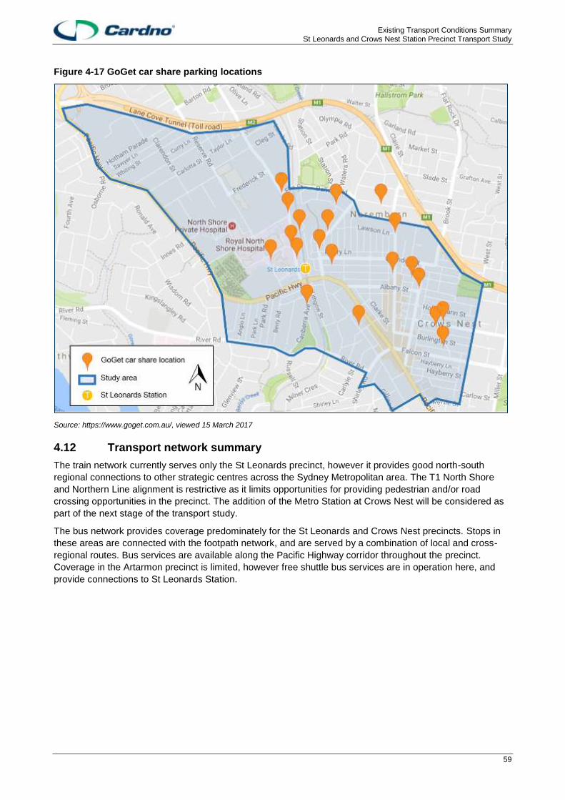
Existing Transport Conditions Summary St Leonards and Crows Nest Station Precinct Transport Study
59
Figure 4-17 GoGet car share parking locations
Source: https://www.goget.com.au/, viewed 15 March 2017
4.12 Transport network summary
The train network currently serves only the St Leonards precinct, however it provides good north-south
regional connections to other strategic centres across the Sydney Metropolitan area. The T1 North Shore
and Northern Line alignment is restrictive as it limits opportunities for providing pedestrian and/or road
crossing opportunities in the precinct. The addition of the Metro Station at Crows Nest will be considered as
part of the next stage of the transport study.
The bus network provides coverage predominately for the St Leonards and Crows Nest precincts. Stops in
these areas are connected with the footpath network, and are served by a combination of local and cross-
regional routes. Bus services are available along the Pacific Highway corridor throughout the precinct.
Coverage in the Artarmon precinct is limited, however free shuttle bus services are in operation here, and
provide connections to St Leonards Station.

Existing Transport Conditions Summary St Leonards and Crows Nest Station Precinct Transport Study
60
5 Opportunities and constraints
This section provides an overview of the opportunities and constraints applicable to the precinct, determined
through the background review and consultation with stakeholders including local councils.
5.1 Opportunities
A summary of the opportunities within the precinct is provided in Table 5-1.
Table 5-1 Precinct opportunities
Category Summary of opportunity Description
Travel demand High public transport commuting mode share from precinct
A high proportion of precinct residents commute by public transport - St Leonards and Crows Nest has one of the lowest peak hour traffic generation rates in Sydney.
Demonstrated cycling demand for direct routes
Cycling along the Pacific Highway is popular among Strava users; there is an opportunity to harness Council plans to provide dedicated facilities along this corridor for the demonstrated demand.
Popularity of, and support for, car share
More car share facilities will help to reduce private vehicle ownerships and is an initiative supported by the three Councils.
Reduced need for vehicle ownership and parking spaces due to proximity of proposed developments to major transport interchanges
The close proximity of most proposed development to the St Leonards Station and future Crows Nest Metro Station will reduce the need for private vehicle ownership. Innovative parking rates and charges can be considered for this well connected precinct.
Infrastructure and services
Comprehensive current and future public transport network
The existing public transport network provides good service coverage and frequency, with many major destinations within a 30-minute travel catchment. The proposed Sydney Metro will improve public transport access to destinations across Sydney even further.
The introduction of Sydney Metro will create more public transport capacity
The shift of many passengers from the T1 North Shore line to the Sydney Metro will increase public transport capacity to and from the precinct and could allow optimisation of train and bus services
Roll out of TfNSW Wayfinding Strategy will improve public transport legibility
Improved public awareness of public transport options and access in the precinct can be achieved with the rollout of Transport for NSW's Wayfinding Strategy.
The Herbert Street road bridge over the railway line could be extended to Chandos Street to improve permeability for vehicles, pedestrians and cyclists.
Connecting this road bridge over the railway line would reduce trip distance and travel time for vehicles, pedestrians and cyclists travelling between Herbert Street and Chandos Street. It would also remove these movements from the busy Pacific Highway intersections with Christie Street and Herbert Street.
Land use development / design / parking
Proximity to other strategic and district centres
The precinct is located close to the Sydney CBD and other strategic centres including North Sydney, Chatswood and Macquarie Park. It is also in Sydney’s Global Economic Corridor.
Freight accessibility to Artarmon from Gore Hill and Warringah Freeways
The Artarmon sub-precinct has good heavy vehicle access from nearby regional roads such as the Lane Cove Tunnel and Gore Hill Freeway. This limits the heavy vehicle movements on the Pacific Highway.
Urban renewal will allow for street reconfiguration to accommodate walking and cycling facilities, reduce vehicle space, provide new through
New developments in the precinct should be used as an opportunity to deliver improvements to the pedestrian and cycle network, new through site links and active laneways. The new Sydney Metro Crows Nest Station could be accompanied by closure of Oxley Street
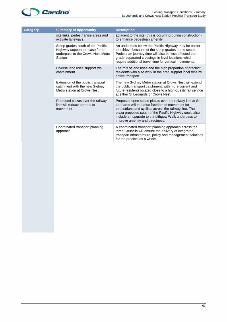
Existing Transport Conditions Summary St Leonards and Crows Nest Station Precinct Transport Study
61
Category Summary of opportunity Description
site links, pedestrianise areas and activate laneways.
adjacent to the site (this is occurring during construction) to enhance pedestrian amenity.
Steep grades south of the Pacific Highway support the case for an underpass to the Crows Nest Metro Station
An underpass below the Pacific Highway may be easier to achieve because of the steep grades to the south. Pedestrian journey time will also be less affected than grade-separated crossings in level locations which require additional travel time for vertical movements.
Diverse land uses support trip containment
The mix of land uses and the high proportion of precinct residents who also work in the area support local trips by active transport.
Extension of the public transport catchment with the new Sydney Metro station at Crows Nest
The new Sydney Metro station at Crows Nest will extend the public transport catchment, with more current and future residents located close to a high-quality rail service at either St Leonards or Crows Nest.
Proposed plazas over the railway line will reduce barriers to movement
Proposed open space plazas over the railway line at St Leonards will enhance freedom of movement for pedestrians and cyclists across the railway line. The plaza proposed south of the Pacific Highway could also include an upgrade to the Lithgow Walk underpass to improve amenity and directness.
Coordinated transport planning approach
A coordinated transport planning approach across the three Councils will ensure the delivery of integrated transport infrastructure, policy and management solutions for the precinct as a whole.

Existing Transport Conditions Summary St Leonards and Crows Nest Station Precinct Transport Study
62
5.2 Constraints
A summary of the constraints within the precinct is provided in Table 5-2.
Table 5-2 Precinct constraints
ID Summary of constraint Description
Travel demand
Railway network at capacity in peak periods
The existing T1 North Shore and Northern Line can only accommodate a maximum of 20 trains per hour in each direction. Some services are already at capacity in the AM and PM peaks and Sydney’s Rail Future notes that total capacity will be exceeded on large sections of the line between Chatswood and Wynyard by 2031.
Traffic congestion and queues on local and collector roads
There is significant congestion on local and collector roads in the St Leonards and Crows Nest precinct in peak periods. This can cause queues and risky vehicle behaviour like speeding which affects pedestrian amenity and safety.
Future traffic growth on the Pacific Highway
Future developments in the precinct are anticipated to result in additional vehicle trips along the Pacific Highway, which is already affected by congestion during peak periods.
High private vehicle mode share for St Leonards workers
The majority of precinct workers drive there. The continued car use for the majority of work trips contributes to traffic congestion and parking demand.
High demand for on-street parking There is high demand for on-street parking in the precinct by commuters who have driven to work in the area. Commuters driving to St Leonards are parking in nearby non-time restricted residential streets up to a kilometre away from their workplaces. Circulating occurs after 8am when spaces are largely filled up. In Artarmon, on-street parking is heavily utilised by local car smash repair companies.
Infrastructure and services
Lack of pedestrian priority and crossing opportunities
Both the Pacific Highway and the T1 rail corridor act as barriers to pedestrian movement. There are a lack of designated crossing points across both corridors. Warrants are needed for new pedestrian crossings but it could be hard to justify in some locations based on existing numbers of pedestrians. Pedestrians also suffer from long wait times at intersections and a lack of crossings at signalised intersections. The most common crash type involving pedestrians in the precinct were those where a pedestrian was hit by a vehicle in the near side lane.
Pedestrian security in some areas Pedestrian security concerns in some areas, particularly the Artarmon sub-precinct, due to a lack of land use activation, poor street lighting and passive surveillance could prevent some walking trips. At St Leonards the pedestrian underpass beneath the Pacific Highway could present personal security concerns late at night.
Lack of pedestrian connectivity between land uses in the west of the precinct
The west of the precinct including Gore Hill Oval, TAFE NSW, Royal North Shore Hospital and the Gore Hill Cemetery is poorly connected by walking routes between land uses.
Lack of pedestrian amenity and inconsistent facilities
Pedestrian amenity is lacking in some parts of the precinct, where facilities are not provided or are non-compliant, affecting pedestrian comfort and safety. Inconsistency in pedestrian facilities, including paving, lighting and street furniture across the three Council areas varies the pedestrian experience.
Steep grades on pedestrian routes south of the Pacific Highway
Pedestrian trips south of the Pacific Highway are affected by steep grades which can reduce the attractiveness of walking for some people include mobility impaired or those who are carrying shopping.
Poor amenity of grade-separated crossing
The grade-separated crossing linking Lithgow Street to St Leonards station has poor pedestrian amenity, and does not serve as a direct route across the Pacific Highway
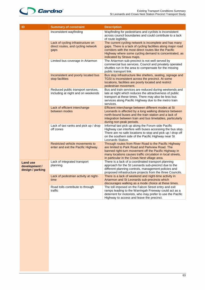
Existing Transport Conditions Summary St Leonards and Crows Nest Station Precinct Transport Study
63
ID Summary of constraint Description
Inconsistent wayfinding Wayfinding for pedestrians and cyclists is inconsistent across council boundaries and could contribute to a lack of route legibility.
Lack of cycling infrastructure on direct routes, and cycling network gaps
The current cycling network is incomplete and has many gaps. There is a lack of cycling facilities along major road corridors with the most direct routes like the Pacific Highway where some cycling demand is concentrated, as indicated by Strava maps.
Limited bus coverage in Artarmon The Artarmon sub-precinct is not well served by commercial bus services. Council and privately operated shuttles run in the area to compensate for the missing public transport link.
Inconsistent and poorly located bus stop facilities
Bus stop infrastructure like shelters, seating, signage and TGSI is inconsistent across the precinct. At some locations, facilities are poorly located and restrict pedestrian movement.
Reduced public transport services, including at night and on weekends
Bus and train services are reduced during weekends and late at night which reduces the attractiveness of public transport at these times. There may also be less bus services along Pacific Highway due to the metro train services.
Lack of efficient interchange between modes
Efficient interchange between different modes at St Leonards is affected by a long walking distance between north-bound buses and the train station and a lack of integration between train and bus timetables, particularly during non-peak periods.
Lack of taxi ranks and pick up / drop off zones
Informal taxi pick up along the Forum side Pacific Highway can interfere with buses accessing the bus stop. There are no safe locations to stop and pick up / drop off on the southern side of the Pacific Highway near St Leonards Station.
Restricted vehicle movements to enter and exit the Pacific Highway.
Through routes from River Road to the Pacific Highway are limited to Park Road and Parkview Road. The banned right-turn movement off the Pacific Highway in many locations causes traffic circulation in local streets, in particular in the Crows Nest village area.
Land use development / design / parking
Lack of integrated transport planning
There is a lack of a coordinated transport planning approach for the St Leonards sub-precinct due to the different planning controls, management policies and proposed infrastructure projects from the three Councils.
Lack of pedestrian activity at night-time
There is a lack of weekend and night-time activity in Artarmon and St Leonards sub-precincts which discourages walking as a mode choice at these times.
Road tolls contribute to through traffic
The toll imposed on the Falcon Street entry and exit ramps leading to the Warringah Freeway could act as a deterrent for motorists, who may prefer to use the Pacific Highway to access and leave the precinct.