Existing Conditions—Project Site and Primary Study Area · 8 VENUE 2.5.18 Figure 8-5 Existing...
71
ECF 80 FLATBUSH AVENUE 2.5.18 Figure 8-5 Existing Conditions—Project Site and Primary Study Area 6 The project site, including the triangular building on Lot 24, is seen on the left. The recently constructed building at 300 Ashland Place is seen on the right. View north along Flatbush Avenue from State Street. 5 Lot 18 contains a three-story building with frontages on Flatbush Avenue and State Street; Lot 23 contains a two-story building, and Lot 24 contains a five-story brick building with a triangular footprint. The primarily glass-clad building at 333 Schermerhorn Street and the building at 388 Bridge Street can be seen in the background. View from Flatbush Avenue near State Street facing northwest. Lot 24 333 Schermerhorn Street Lot 23 388 Bridge Street 300 Ashland Place Lot 18
Transcript of Existing Conditions—Project Site and Primary Study Area · 8 VENUE 2.5.18 Figure 8-5 Existing...

ECF 80 FLATBUSH AVENUE
2.5.18
Figure 8-5
Existing Conditions—Project Site and Primary Study Area
6The project site, including the triangular building on Lot 24, is seen on the left. The recently constructed building at 300 Ashland Place is seen on the right. View north along
Flatbush Avenue from State Street.
5Lot 18 contains a three-story building with frontages on Flatbush Avenue and State Street; Lot 23 contains a two-story building, and Lot 24 contains a five-story brick building with a triangular footprint. The primarily glass-clad building at 333 Schermerhorn Street and
the building at 388 Bridge Street can be seen in the background. View from Flatbush Avenue near State Street facing northwest.
Lot 24
333 Schermerhorn Street
Lot 23
388 Bridge Street
300 Ashland Place
Lot 18

ECF 80 Flatbush Avenue
8-6
Lot 24 contains a five-story (approximately 67-foot-tall) building with a triangular footprint with frontages on Flatbush Avenue and State Street (see Figure 8-5). The building is built out to the sidewalk along both streets and rises without setbacks. Along Flatbush Avenue, the ground floor contains a gym with large plate-glass windows and three recesses glass-door entries. Along State Street, the ground-floor entrances have been bricked in except for a raised entry at the west end of the façade, which is accessed by concrete stairs. This building formerly had a rounded bay front at that corner, as well as a cornice, both of which have been removed.
VIEW CORRIDORS AND VISUAL RESOURCES
The architecturally distinguished buildings at 362 Schermerhorn Street (School Building 2/Building D) and 475 State Street (School Building 1/Building E)—described above and in Chapter 7, “Historic and Cultural Resources”—are visual resources located on the project site (see Figure 8-3).
Views from the sidewalks adjacent to the project site include long views north on Flatbush Avenue that provide views of the tall buildings of Downtown Brooklyn, including the 19-story and 30-story towers of City Point, a mixed-use development; 388 Bridge Street, a 53-story (590-foot-tall) glass- and masonry-clad building; and the buildings at 333 Schermerhorn Street, 250 Ashland Place, and 300 Ashland Place described below. Views south along Flatbush Avenue adjacent to the project site include the tall buildings located in the Pacific Park development, described below; Barclays Center; One Plaza Street—a 15-story (approximately 195-foot-tall) older brick-clad building with an enclosed roof-top water tower—located at the corner of Flatbush Avenue and Plaza Street West, and 10 Plaza Street—a 15-story (approximately 175-foot-tall) brick building that rises without setbacks—located at the corner of Flatbush Avenue and Plaza Street East (see Figure 8-6, photo 8). Long north-south views on 3rd Avenue are also afforded from the sidewalks adjacent to the project site and include the Baptist Temple west of the project site, a church—the Temple of Restoration—on the corner of 3rd Avenue and Pacific Street, the trees and tall buildings of the New York City Housing Authority (NYCHA) Wyckoff Housing development on the west side of 3rd Avenue between Wyckoff and Baltic Streets, and the tall buildings at 250 Ashland Place, 66 Rockwell Place, and 230 Ashland Place (see Figure 8-7, photo 9). The Baptist Temple has square towers at the corners, with the tallest, the belfry, located at the northeast corner and rising approximately 62 feet. The other towers rise approximately 50 feet and have a hipped-roof clad in glazed barrel terra-cotta tile (see Figure 8-7, photo 9). The temple’s towers and belfry can be seen along 3rd Avenue adjacent to the project site and along Schermerhorn Street adjacent to the project site. The Temple of Restoration’s square belfry rises approximately 73 feet and is capped with a copper-clad hipped roof. The three buildings within the Wyckoff Housing development are 23 stories tall (approximately 220 feet) and have a roughly T-shaped plan. Views along State Street from the sidewalks adjacent to the project site are short and include the nearby mature street trees and close views of the former Williamsburgh Savings Bank, described below (see Figure 8-7, photo 10).
PRIMARY STUDY AREA
The 400-foot primary study area is generally bounded by Livingston Street and Flatbush Avenue to the north, Ashland Place and St. Felix Street to the east, Atlantic Avenue to the south, and the mid-block between Nevins Street and 3rd Avenue to the west (see Figures 8-1 and 8-2). The primary study area has an irregular street grid pattern, with Flatbush Avenue running at an angle through the study area and block orientation shifting east of Flatbush Avenue creating angular blocks and irregular intersections. The topography of the primary study area is relatively flat without any prominent natural features. Generally, there is not a cohesive urban design to the primary study area;

ECF 80 FLATBUSH AVENUE
2.5.18
Figure 8-6Existing Conditions—Primary Study Area
8
The view north along Flatbush Avenue is long and includes the tall buildings of Downtown Brooklyn and 333 Schermerhorn Street. The base of the recently
completed building at 300 Ashland Place, seen on the right, is built out to the sidewalk.
7The view east along Schermerhorn Street includes the tall building at 300 Ashland Place, the former Williamsburgh Savings Bank , and the mature trees in Sixteen Sycamores Playground.
300 Ashland Place former Williamsburgh Savings Bank
ECF 80 FLATBUSH AVENUE
2.5.18
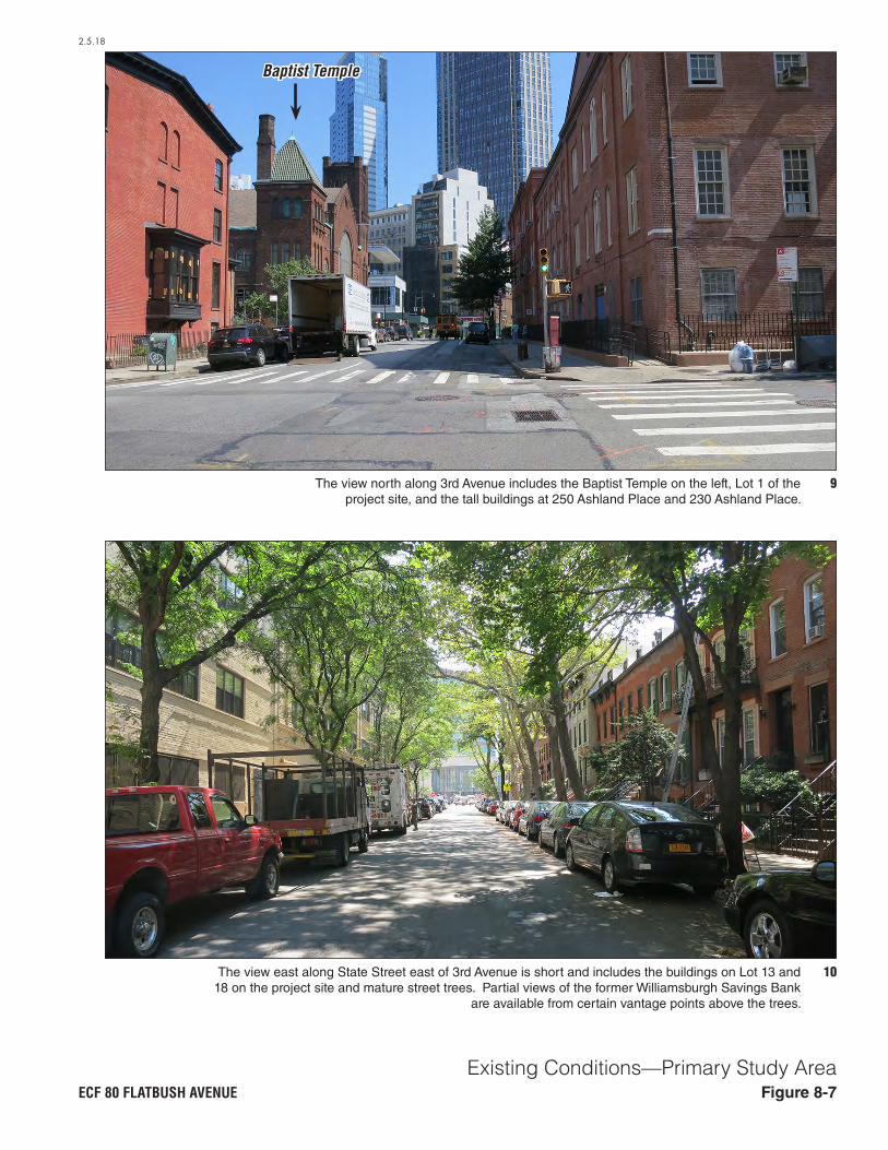
Figure 8-7Existing Conditions—Primary Study Area
10The view east along State Street east of 3rd Avenue is short and includes the buildings on Lot 13 and 18 on the project site and mature street trees. Partial views of the former Williamsburgh Savings Bank
are available from certain vantage points above the trees.
9The view north along 3rd Avenue includes the Baptist Temple on the left, Lot 1 of the project site, and the tall buildings at 250 Ashland Place and 230 Ashland Place.
Baptist Temple

Chapter 8: Urban Design and Visual Resources
8-7
the area west and south of Flatbush Avenue tends to be older, with smaller residential buildings while the area east and north is newer, with larger mixed-use and commercial buildings.
The discussion below focuses first on the area’s urban design—its basic layout and structures—and then describes its visual resources.
URBAN DESIGN
Streets As described above, the primary study area streets form an irregular street pattern. Flatbush Avenue runs at an angle and the street grid shifts east and west of Flatbush Avenue. Additionally, several streets dead-end within the primary study area. Flatbush and Atlantic Avenues are wider, primary thoroughfares and carry two-way traffic. The New York City Transit (NYCT) Atlantic Avenue–Barclays Center subway station for the B, Q, D, N, R 2, 3, 4, and 5 lines and the terminus for the Long Island Rail Road (LIRR) is located at the intersection of Flatbush Avenue and Hanson Place. There are several NYCT bus routes along Flatbush, Atlantic, and 3rd Avenues. Street furniture within the primary study area includes cobra-head street lamps, bishops crook street lamps, tear-drop street lamps, traffic lights, bus stop signs and shelters, fire hydrants, trash cans and recycling bins, mailboxes, newsstands, benches, concrete and steel protective bollards, concrete planters, CitiBike stations, bike racks, parking meter kiosks, and street-food carts.
As noted above, Flatbush Avenue is a 100-foot-wide thoroughfare with four lanes of two-way traffic separated by a painted median south of Schermerhorn Street and Lafayette Avenue (see Figure 8-5, photo 6). Atlantic Avenue is 100-foot-wide with four lanes of two-way east-west traffic and curbside parking (see Figure 8-8, photo 11). Schermerhorn Street is an 80-foot-wide street with two lanes of east-west traffic, bike lanes, and curbside parking (see Figure 8-6, photo 7). State Street is a 60-foot-wide eastbound street with curbside parking (see Figure 8-7, photo 10). East of Flatbush Avenue, Rockwell Place is a 50-foot-wide southbound street with curbside parking, and Ashland Place is 70-foot-wide with two-way traffic and curbside parking on the northbound side of the street. Lafayette Avenue is a 90-foot-wide eastbound street two lanes of traffic, a bike lane, and curbside parking. Hanson Place is an 80-foot-wide two-way street with curbside parking and a large CitiBike station at the western end of the street (see Figure 8-8, photo 12).
The streets in the primary study area generally have heavy pedestrian and vehicular activity, as there are public transportation hubs, a mix of commercial and residential buildings, and the intersection of two major thoroughfares (Flatbush and Atlantic Avenues) in the primary study area. Active ground-floor uses are located throughout the primary study area, but are more heavily concentrated along the avenues. Street trees tend to be recently planted and concentrated at the oddly shaped intersections where there are public pedestrian plazas. Within the primary study area, only State Street has mature street trees that form a canopy over the street.
Buildings The built environment within the primary study area is varied, with buildings ranging from tall towers to three-story row houses. Located approximately 90 feet east of the project site, the recently completed 300 Ashland development is a 32-story (approximately 364-foot-tall) mixed-use building with a triangular footprint (see Figure 8-5, photo 6 and Figure 8-6, photo 7). The building is constructed out to the sidewalk along Ashland Place and the south side of Flatbush Avenue, but is set back from Lafayette Avenue and the north end of Flatbush Avenue behind a public plaza (see Figure 8-9, photo 13). The building rises without setbacks. The development includes dwelling units (DUs) above retail and community facility space that is anticipated to

ECF 80 FLATBUSH AVENUE
2.5.18
Figure 8-8Existing Conditions—Primary Study Area
12Hanson Place east of Flatbush Avenue is developed with Atlantic Terminal on the right and mid-rise buildings are seen in the background.
11Atlantic Avenue within the primary study area is lined with buildings of a variety of heights and materials. The view from Atlantic Avenue near 3rd Avenue facing east includes views of the Barclays Center and the tall buildings of the
Pacific Park development beyond.
Pacific Park Development

ECF 80 FLATBUSH AVENUE
2.5.18
Figure 8-9Existing Conditions—Primary Study Area
14333 Schermerhorn Street is a 56-story mixed-use building that is clad in glass and brick with a three-story
base. View from Schermerhorn Street at 3rd Avenue facing west.
13The recently constructed building at 300 Ashland Place is seen in the foreground with its public plaza. The former
Williamsburgh Savings Bank is partially visible behind 300 Ashland Place and the tall buildings within the
Pacific Park development are seen in the background.View from Flatbush Avenue at Schermerhorn Street
facing southeast.

ECF 80 Flatbush Avenue
8-8
include a dance studio, cinema, and cultural library. The building is clad in glass and metal. Just east of 300 Ashland Place, the former Williamsburgh Savings Bank, now known as One Hanson Place, is a 42-story (approximately 512-foot-tall) historic commercial building, recently converted to residential, retail, and event space use (see Figure 8-6, photo 7 and Figure 8-9, photo 13). The stone-clad building is constructed out to the sidewalk on Hanson and Ashland Places and has symmetrical setbacks with a central domed tower with clock faces on four sides. Approximately 110 feet northwest of the project site, the recently completed 333 Schermerhorn Street is a 56-story (approximately 610-foot-tall) mixed-use building that rises from a one- to three-story base (see Figure 8-9, photo 14 and Figure 8-10, photo 15). The building is clad in glass and brick, with apartments over ground-floor retail spaces. The building occupies the most of the southern half of the block and is built out to the sidewalk along Schermerhorn Street and Flatbush Avenue. Just west of this building, 319 Schermerhorn Street is a recently completed 21-story (210-foot-tall) residential building clad in glass and cast stone with ground-floor retail.
Just south of the project site, State Street is developed with a mix of two- and three-story (approximately 40- to 42-foot-tall) brick row houses which are set back from the street by enclosed yards, four-story (approximately 50-foot-tall) older brick buildings with ground-floor retail, and a newer eight-story (approximately 80-foot-tall) brick-clad apartment building with below-ground parking (see Figure 8-7, photo 10 and Figure 8-10, photo 16). Just west of the project site, 3rd Avenue is developed with a mix of residential and institutional buildings. The Baptist Temple, a brownstone-clad church with a square belfry that rises approximately 62 feet, is located at the southwest corner of 3rd Avenue and Schermerhorn Street. The building is built out to the street along 3rd Avenue and Schermerhorn Street and occupies most of its lot. A group of five three-story (approximately 45-foot-tall) brick row houses is located on the northwest corner of 3rd Avenue and State Street. The houses are set back from the street by enclosed yards (see Figure 8-7, photo 9). An 11-story (approximately 160-foot-tall) YWCA brick and stone residential building occupies the east end of the block bounded by 3rd Avenue, State Street, and Atlantic Avenue. The building is constructed out to the sidewalk and rises without setback (see Figure 8-11, photo 17). Along Atlantic Avenue, there is a mix of two- to four-story (approximately 31- to 50-foot-tall) older mixed-use masonry buildings, six-story (approximately 75-foot-tall) older terra-cotta and brick-clad commercial buildings, and an eight-story (approximately 80-foot-tall) recently constructed residential building (see Figure 8-8, photo11).
Natural Features and Open Space As noted above, the topography of the study area is generally flat. The plaza at 300 Ashland Place, just east of the project site, and Sixteen Sycamores Playground on Schermerhorn Street at the western boundary of the primary study area are the principal open spaces. There are no natural features in the primary study area. The plaza at 300 Ashland Place is tiered, with planting beds, trees, decorative pavers, and lighting (see Figure 8-9, photo 13 and Figure 8-11, photo 18). Sixteen Sycamores Playground, located approximately 200 feet west of the project site, contains a handball court enclosed in a tall chain-link fence, playground equipment, benches, a comfort station, landscaping, and mature trees (see Figure 8-6, photo 7).
VIEW CORRIDORS AND VISUAL RESOURCES
Views within the primary study area are longest along Atlantic Avenue, Flatbush Avenue, and south along 3rd Avenue. Views east along Atlantic Avenue include close views of Barclays Center and Atlantic Terminal located just outside the primary study area, and more distant views of tall buildings located in the Pacific Park development, including 461 Dean Street, a 32-story modular tower, and 38 Sixth Avenue, a 23-story apartment building at Dean Street and Sixth Avenue (see

ECF 80 FLATBUSH AVENUE
2.5.18
Figure 8-10Existing Conditions—Primary Study Area
16View from State Street at Flatbush Avenue facing southwest.
15The one- to three-story base of 333 Schermerhorn Street. View from Schermerhorn Street west of 3rd Avenue facing northwest.

ECF 80 FLATBUSH AVENUE
2.5.18
Figure 8-11Existing Conditions—Primary Study Area
18The plaza at 300 Ashland Place is a tiered plaza with planting beds, trees, and lighting. View from Flatbush Avenue at Lafayette Avenue facing south.
17The view north along 3rd Avenue at Atlantic Avenue includes an 11-story brick and stone building and the belfry of the Baptist Temple, both seen on the left. Street trees partially obscure views of the project site. The tall buildings at
230 Ashland Place and 250 Ashland Place are seen in the background.

Chapter 8: Urban Design and Visual Resources
8-9
Figure 8-8, photo11). The domed tower of the former Williamsburgh Savings Bank can be seen over the top of the lower-scale buildings along Atlantic Avenue. Views west along Atlantic Avenue include mature street trees just outside of the study area, and older, shorter buildings.
Views along Flatbush Avenue are long in both directions. Views north include the tall buildings of Downtown Brooklyn, including the towers of City Point and 388 Bridge Street (see Figure 8-6, photo 8, Figure 8-5, photo 6, and Figure 8-4, photo 4). Closer views along Flatbush Avenue include tall buildings located at 250 Ashland Place (described below), 300 Ashland Place, and the former Williamsburgh Savings Bank. Views south along Flatbush Avenue extend toward taller buildings in the distance, including One Plaza Street—a 15-story (approximately 195-foot-tall) building—and 10 Plaza Street—15-story (approximately 175-foot-tall) (see Figure 8-12, photo 19). The trees located within Grand Army Plaza can also be seen in the distance. Closer views south along Flatbush Avenue include Barclays Center and the Pacific Park development.
Views south along 3rd Avenue include the Temple of Restoration Church on the corner of 3rd Avenue and Pacific Street, and the trees and tall buildings of the Wyckoff Housing development on the west side of 3rd Avenue between Wyckoff and Baltic Streets, both described above.
Visual resources in the primary study area include the former Williamsburgh Savings Bank, described above, and the Baptist Temple at 360 Schermerhorn Street (see Chapter 7, “Historic and Cultural Resources”) and the buildings at 362 Schermerhorn Street (School Building 2/Building D) and 475 State Street (School Building 1/Building E). The corbelled roofline, decorative cornice, and centered dormer window on the Schermerhorn façade of the building at 362 Schermerhorn Street can be seen from Lafayette Avenue east of the project site within the study area, but views of this building on Flatbush Avenue are limited to the area between Livingston Street and Schermerhorn Street. Views of the School Building 2/Building D on Schermerhorn Street are limited by nearby buildings and the mature trees in Sixteen Sycamores Playground (see Figure 8-6, photo 7). The triangular roof pediment of the building at 475 State Street (School Building 1/Building E) can be seen from 3rd Avenue within the primary study area, but views along State Street west of the site are limited by intervening buildings and mature street trees.
SECONDARY STUDY AREA
URBAN DESIGN
The streets within the secondary study area form an irregular grid, with Flatbush Avenue running at an angle through the study area and block orientation shifting east of Flatbush Avenue, creating angular blocks and irregular intersections. The topography of the secondary study area is generally flat, with a slight rise toward the northeast. Although located just outside of the secondary study area, Fort Greene Park can be seen from the study area and is a prominent natural feature.
The built environment within the study area is varied and includes tall towers, buildings that occupy a full or half block, and small, three- and four-story row houses. The eastern portion of the secondary study area contains the Fort Greene Historic District and the Brooklyn Academy of Music (BAM) Historic District (see Chapter 7, “Historic and Cultural Resources”). The north-south cross streets within the historic districts are primarily developed with three- to four-story masonry row houses with smaller footprints that are set back from the street behind enclosed yards (see Figure 8-12, photo 20). Mature trees line the streets within the historic districts. The Brooklyn Technical High School occupies the northern half of the block bounded by DeKalb Avenue, South Elliot Place, Lafayette Avenue, and Fort Greene Place (see Figure 8-13, photo 21). The building has a large (approximately 100,000 square foot [sf]) footprint and rises seven stories (approximately 120 feet) without setbacks. An 11-story tower (approximately 208-foot-tall) is

ECF 80 FLATBUSH AVENUE
2.5.18
Figure 8-12Existing Conditions—Secondary Study Area
20The Fort Greene Historic District and the Brooklyn Academy of Music Historic District are developed with three-to four-story masonry rowhouses. View from St. Felix Street near
Hanson Place facing northeast.
19The view south along Flatbush Avenue includes long views of the Pacific Park Development and 10 Plaza Street.

ECF 80 FLATBUSH AVENUE
2.5.18
Figure 8-13Existing Conditions—Secondary Study Area
22The view west on Lafayette Avenue near Fort Greene Place includes the BAM Peter Jay Sharp Building on the left and long views of the Baptist Temple.
21The Brooklyn Technical High School has a large footprint and rises seven stories without a setback. View from Fort Greene Place north of Fulton Street facing north.
BAM Peter Jay Sharp Building

ECF 80 Flatbush Avenue
8-10
centered on the Fort Greene Place façade and has a hipped roof clad in copper. The building is constructed out to the sidewalk along DeKalb Avenue, South Elliot Place, and Fort Greene Place. The historic Brooklyn Academy of Music (now known as the BAM Peter Jay Sharp Building) located at 30 Lafayette Avenue is a historic theater with frontages on Lafayette Avenue, St. Felix Street, and Ashland Place (see Figure 8-13, photo 22). The highly detailed brick and terra-cotta building has five raised double-door entries with stone steps, an undulating glass entry canopy that spans across all of the entrances, and five double-height arched windows on the Lafayette Avenue façade. The southwest end of the secondary study contains the Boerum Hill Historic District. Within the secondary study area, the historic district is developed with three-story brick-clad row houses with small footprints and raised-stoop entrances that are set back from the sidewalk behind small yards, many of which are enclosed by decorative fencing. Mature trees line the streets (see Figure 8-14, photo 23).
Within the secondary study area, taller buildings tend to be located to the north of the project site. A 44-story (approximately 484-foot-tall) glass-clad mixed-use building with a six-story base is located at 66 Rockwell Place, approximately 540 feet north of the project site. Approximately 430 feet north of the project site, the recently completed building at 250 Ashland Place rises 51 stories (approximately 568 feet) and is a glass- and masonry-clad residential building with a four-story base with ground-floor retail, including a food market (see Figure 8-14, photo 24 and Figure 8-15, photo 25). The mixed-use building at 230 Ashland Place rises 30 stories (approximately 310 feet) without setbacks. This glass and concrete-clad building has a triangular footprint with ground-floor BAM artist space and DUs above (see Figure 8-15, photo 26). A recently constructed 37-story (approximately 370-foot-tall) glass and metal-clad building at 80 DeKalb Avenue contains DUs over ground-floor retail and parking garage.
Several buildings within the secondary study area have large footprints and occupy full or partial blocks. At the northern boundary of the secondary study area, 395 Flatbush Avenue occupies the entire block bounded by Fulton Street, Hudson Avenue, DeKalb Avenue, and Flatbush Avenue. The building has a large footprint (approximately 50,600 sf) and rises nine stories (approximately 115 feet). The building is clad in glass and metal with the first two stories recessed (see Figure 8-16, photo 27). Occupying the entire irregularly shaped block bounded by Flatbush Avenue, Nevins Street, and Livingston Street, 38 Flatbush Avenue is a concrete and glass-clad building with ground-floor retail that rises seven stories (approximately 94 feet) and has a large footprint (approximately 33,000 sf) (see Figure 8-16, photo 28). The Atlantic Terminal Mall at 139 Flatbush Avenue, occupies most of the block bounded by Flatbush Avenue, Hanson Place, Fort Greene Place, and Atlantic Avenue. The brick-clad commercial building has a very large footprint (approximately 191,700 sf) with a two- to three-story base and a 14-story tower that rises on the eastern side along Fort Greene Place (see Figure 8-17, photo 29). Just east of this, the L-shaped building at 625 Atlantic Avenue occupies the entire block bounded by Fort Greene Place, Hanson Place, South Elliott Place, Academy Park Place, South Portland Avenue, and Atlantic Avenue. The commercial building has a large footprint (approximately 164, 500 sf) and rises three stories. The building is clad in stucco. At the southeast boundary of the secondary study area, the Barclays Center has an approximately 315,900 sf footprint, rises approximately 137 feet and is clad in glass and metal (see Figure 8-8, photo 11). A large public plaza is located in front of the building in the triangular space between Flatbush and Atlantic Avenues.
Additional open space within the secondary study area includes the Theatre for a New Audience plaza located on Ashland Place between Lafayette Avenue and Fulton Street, and the privately owned public space located on Ashland Place at Fulton Street. The Theatre for a New Audience plaza has decorative semi-circular benches, several trees planted in tree pits, and decorative

ECF 80 FLATBUSH AVENUE
2.5.18
Figure 8-14Existing Conditions—Secondary Study Area
24250 Ashland Place is a recently constructed 51-story mixed-use building with ground-floor retail, including a food market. View from Fulton Street at Ashland Place facing west.
23The Boerum Hill Historic District within the secondary study area is developed with three-story brick rowhouses. View from Pacific Street at Nevins Street facing west.

ECF 80 FLATBUSH AVENUE
2.5.18
Figure 8-15Existing Conditions—Secondary Study Area
26Views along Fulton Street include 250 Ashland Place and 66 Rockwell Place. View from Fulton Street at St. Felix Street facing west.
25The view from Hudson Avenue facing southeast includes a vacant lot, 66 Rockwell Place, 250 Ashland Place, and 230 Ashland Place.
230 Ashland Place 250AshlandPlace
66 RockwellPlace

ECF 80 FLATBUSH AVENUE
2.5.18
Figure 8-16Existing Conditions—Secondary Study Area
28The view from Livingston Street at Nevins Street facing east with 38 Flatbush Avenue on the left and the recently constructed 300 Ashland Place in the background on the right.
The domed tower of the former Williamsburgh Savings Bank can be seen behind 300 Ashland Place.
27Views north along Flatbush Avenue at Fulton Street include the tall buildings of City Point and Downtown Brooklyn. The under-construction One Manhattan Square building can be seen in the distance.

ECF 80 FLATBUSH AVENUE
2.5.18
Figure 8-17Existing Conditions—Secondary Study Area
30The plaza at Ashland Place and Fulton Street contains planting beds, benches, trees, lighting, and decorative pavers. View from Fulton Street facing northeast.
29The view north from 4th Avenue near Atlantic Avenue includes the Atlantic Terminal on the right and the base of the former Williamsburgh Savings Bank.

Chapter 8: Urban Design and Visual Resources
8-11
paving; the plaza at Ashland Place and Fulton Street contains raised stone planting beds, stone benches with planters, trees, and decorative lighting (see Figure 8-17, photo 30). The space is demarcated with decorative pavers.
VIEW CORRIDORS AND VISUAL RESOURCES
Within the secondary study area, views are longest along Flatbush Avenue, Atlantic Avenue, and 3rd Avenue—similar to the primary study area—and along Fulton Street and 4th Avenue. Views north along Flatbush Avenue include the tall buildings of Downtown Brooklyn, the towers of City Point, and closer tall buildings located at 250 Ashland Place, 300 Ashland Place, and the former Williamsburgh Savings Bank (see Figure 8-16, photo 27). Views south along Flatbush Avenue include Barclays Center, the Pacific Park development, and longer views toward tall buildings, including One Plaza Street and 10 Plaza Street, and the trees located within Grand Army Plaza (Figure 8-18, photo 31). Views east along Atlantic Avenue include views of Barclays Center, Atlantic Terminal, and the Pacific Park development; views west include mature street trees, and the belfry of the House of the Lord Pentecostal Church located at 415 Atlantic Avenue (see Figure 8-18, photo 32 and Figure 8-19, photo 33). Views south along 3rd Avenue include the Temple of Restoration Church at 490 Pacific Street and the trees and tall buildings of the Wyckoff Housing.
Views west along Fulton Street extend toward Borough Hall, and include 44 Court Street, a 14-story stone-, brick-, and terra-cotta-clad building with corner towers capped with copper-clad mansard roofs; 32 Court Street, a 23-story brick and stone-clad building with a hipped copper roof and brick dormer windows; 388 Bridge Street; 333 Schermerhorn Street; 250 Ashland Place; 230 Ashland Place; 66 Rockwell Place; and 80 DeKalb Avenue (each described above) (see Figure 8-19, photo 34). Views east along Fulton Street include mature street trees located outside of the study area, and older three- to four-story buildings (see Figure 8-15, photo 26). Views north along 4th Avenue are short and end at the former Williamsburgh Savings Bank (see Figure 8-17, photo 29). Views south include the brick- and stone-clad Brooklyn Public Library–Pacific Branch (described below), and distant mid-rise buildings including the 10-story (approximately 128-foot-tall) mixed-use building at 110 4th Avenue and the 11-story (approximately 119-foot-tall) residential building with ground-floor retail at 613 Baltic Street (see Figure 8-20, photo 35).
Visual resources in the secondary study area include architecturally distinguished buildings and natural resources. The Brooklyn Public Library–Pacific Branch located at 25 4th Avenue is an older, two-story brick- and stone-clad building with a D-shaped footprint (see Figure 8-20, photo 35). The building has a raised-stoop entrance centered on the 4th Avenue façade, and carved-stone details project from the 4th Avenue and Pacific Street façades. The building is visible along nearby portions of 4th Avenue. The BAM Peter Jay Sharp Building located at 30 Lafayette Avenue can be seen on Lafayette Avenue from Flatbush Avenue to just east of South Elliott Place (see Figure 8-13, photo 22). A portion of the building can be seen from Ashland Place just north of Fulton Street to Hanson Place to the south. Views of the building from St. Felix Street are limited due to mature street trees and nearby construction. Located just outside of the secondary study area, Fort Greene Park is visually prominent from within the secondary study area. The hilly park contains mature trees, open green space, and wide walking paths (see Figure 8-20, photo 36). The park is surrounded by a low stone wall. The park’s trees can be seen from Hudson Avenue, Rockwell Place, Ashland Place, and St. Felix Street near DeKalb Avenue and from farther south along Fort Greene Place and South Elliott Place. Views from near Fort Greene Park toward the study areas include views of the Fort Greene Historic District, Brooklyn Technical High School, and nearby tall buildings including 333 Schermerhorn Street; 250 Ashland Place; 230 Ashland Place; 66

ECF 80 FLATBUSH AVENUE
2.5.18
Figure 8-18Existing Conditions—Secondary Study Area
32The view east along Atlantic Avenue east of Flatbush Avenue includes close views of Barclays Center and longer views of the Pacific Park development, currently under construction.
31The view south along Flatbush Avenue near Atlantic Avenue includes close views of Atlantic Terminal and longer views of the Pacific Park Development and 10 Plaza Street.

ECF 80 FLATBUSH AVENUE
2.5.18
Figure 8-19Existing Conditions—Secondary Study Area
34The view west along Fulton Street at Flatbush Avenue extends toward Borough Hall plaza.
33Views east from Atlantic Avenue near Nevins Street include mature street trees and the tower of the former Williamsburgh Savings Bank.

ECF 80 FLATBUSH AVENUE
2.5.18
Figure 8-20Existing Conditions—Secondary Study Area
36Fort Greene Park contains mature trees open space, and wide walking paths surrounded by a low stone wall. View from Fort Greene Place at DeKalb Avenue facing northeast.
35 The view south along 4th Avenue at Atlantic Avenue includes the Brooklyn Public Library-Pacific Branch on the left and longer views of the mid-rise buildings located at 110 4th Avenue and 613 Baltic Street.
Brooklyn Public Library—Pacific Branch

ECF 80 Flatbush Avenue
8-12
Rockwell Place; and 300 Ashland Place, and the very top of the former Williamsburgh Savings Bank (see Figure 8-21).
D. FUTURE WITHOUT THE PROPOSED ACTIONS This section considers urban design and visual resource in the No Action condition in 2025. These conditions are projected by considering changes that are likely or expected to occur on the project site and within the primary and secondary study area.
PROJECT SITE
In the No Action condition, it is assumed that the public high school on Lot 1 would remain in its existing facility, and the remainder of the project site would be redeveloped with an as-of-right 31-story (approximately 400 feet in height, including bulkhead) mixed-use building that complies with the current zoning regulations. The new development under the No Action condition would contain residential, retail, and community facility uses as well as a parking facility (see Figure 8-22). Along Flatbush Avenue, the building would be built out to the sidewalk and have a three-story (approximately 60-foot-tall) base with the tower set back from the streetwall between approximately 14 to 36 feet. Along State Street, the building would be set back from the sidewalk 15 feet and would rise 10 stories (approximately 130 feet) before a setback. The tower would have additional setbacks at the 13th, 18th, 21st, 24th, and 27th floors. Along Schermerhorn Street, the building would be built out to the sidewalk and rise one story (approximately 20 feet tall). Open space would be located on Lot 24 and along the State Street façade. The building would have an approximately 13,330-sf footprint and would appear as one large building.
PRIMARY STUDY AREA
URBAN DESIGN
As discussed in Chapter 2, “Land Use, Zoning, and Public Policy,” there are several development projects located within the 400-foot primary study area anticipated to be complete by 2025. The closest, located approximately 270 feet northeast of the project site is a mixed-used building currently under construction at 15 Lafayette Avenue. The building will be 12 stories with residences above a cultural facility and retail clad in glass, brick, and pre-cast panels. As described above, several large residential developments have been recently completed, including 300 Ashland Place nearest the project site, and 333 Schermerhorn Street. These projects add new, tall buildings with large footprints clad in a variety of materials, including glass, metal, and pre-cast panels to the area. The No Build development and other recent projects will add more ground-floor retail and arts and cultural spaces to the primary study area and well as introduce new public plazas to the irregularly shaped blocks. These projects will enhance the pedestrian experience of the primary study area closest to these developments by adding active ground floor uses and improving the streetscape by replacing under-utilized sites with new active uses.
VIEW CORRIDORS AND VISUAL RESOURCES
In the future without the proposed actions, views in the primary study area will remain similar to existing conditions along most streets. The as-of-right building that will be constructed on the project site would not substantially alter views north-south along 3rd Avenue or east-west along State Street (Figure 8-23, view b, Figure 8-24, view b, Figure 8-25, view b, and Figure 8-26, view b). Along Schermerhorn Street, the view toward the former Williamsburgh Savings Bank, which is already partially obscured by the new building at 300 Ashland Place, will also include the upper portion of the as-of-right tower (see Figure 8-27, view b). Views north along Flatbush

ECF 80 FLATBUSH AVENUE
2.5.18
Figure 8-21Existing Conditions—Secondary Study Area
38Close views from Fort Greene Park facing south include views of the Fort Greene Historic District and the Brooklyn Technical High School.
37Long views from Fort Greene Park facing southwest include nearby tall buildings at 333 Schermerhorn Street; 250 Ashland Place; 230 Ashland Place; 66 Rockwell Place; and 300 Ashland Place,
and the former Williamsburgh Savings Bank.

2.5.18
ECF 80 FLATBUSH AVENUEAs-of-Right Ground Floor Plan
Figure 8-22

Figure 8-23
2.5.18
ECF 80 FLATBUSH AVENUE
Comparison Views—3rd Avenue at Schermerhorn Street: View Southeast
Proposed With Action
Current Condition
No Action Condition
maximum zoning envelope

Figure 8-24
2.5.18
ECF 80 FLATBUSH AVENUE
Comparison Views—State Street Near Nevins Street: View East
Proposed With Action
Current Condition
No Action Condition
maximum zoning envelope

Figure 8-25
2.5.18
ECF 80 FLATBUSH AVENUE
Comparison Views—3rd Avenue South of Dean Street Facing North
Proposed With Action
Current Condition
No Action Condition
maximum zoning envelope

Figure 8-26
2.5.18
ECF 80 FLATBUSH AVENUE
Comparison Views —State Street and 3rd Avenue, Looking North
Proposed With Action
Current Condition
No Action Condition
maximum zoning envelope

Figure 8-27
2.5.18
ECF 80 FLATBUSH AVENUE
Comparison Views—Schermerhorn Street At Nevins Street: View East
Proposed With Action
Current Condition
No Action Condition
maximum zoning envelope

Chapter 8: Urban Design and Visual Resources
8-13
Avenue will continue to include the tall buildings of Downtown Brooklyn, and the views south along Flatbush Avenue will continue to include the Pacific Park development, Barclays Center, and longer views of One Plaza Street and 10 Plaza Street. The as-of-right building will partially obscure views of the recently-completed 333 Schermerhorn Street in these northward views, but views of the former Williamsburgh Savings Bank will remain. Views south along Flatbush Avenue would continue to be long and include other tall buildings in the area, including 333 Schermerhorn Street (see Figure 8-28, view b). Views north along 4th Avenue will continue to include the full structure of the former Williamsburgh Savings Bank (see Figure 8-29, view b). The as-of-right building will not block any views of the Baptist Temple and the square towers at the corners, including the belfry, would continue to be visible along 3rd Avenue and partially visible from Schermerhorn Street.
SECONDARY STUDY AREA
URBAN DESIGN
Several development projects located within the ¼-mile study area are anticipated to be complete by 2025, including large mixed-use developments. At the western boundary of the secondary study area, the building at 300 Livingston Street (also known as 33 Bond Street) will be a 25-story (approximately 271-foot-tall) mixed-use building with a large footprint (approximately 51,000 sf) and will occupy the entire western half of the block bounded by Schermerhorn, Bond, Livingston, and Nevins Streets. The building, anticipated to be completed in 2017, will be clad primarily in glass and will be constructed out to the sidewalk with high lot coverage. The building will rise 14 stories before a setback. The building at 570 Fulton Street will be a 40-story (approximately 550-foot-tall including the bulkhead), mixed-use development containing residential, office, and retail space. The building will rise 10 stories along Fulton Street, then set back approximately 10 feet and rise to a total height of 40 stories. The new building at 8 Nevins Street will be a 28-story (approximately 345-foot-tall) development with frontages on Nevins and Livingston Streets. The building will rise seven stories before a setback.
Located just outside of the secondary study area, the building at 9 DeKalb Avenue will rise 73 stories (approximately 1,071 feet). The building will be clad in glass and metal with ground-floor retail with residential use above. The building will connect to the historic Dime Savings Bank Building located on the same block.
The No Build developments in the secondary study area and located just outside the study area will contribute to the already changing urban design character and visual context by adding new, tall towers to the area and developing previously underdeveloped lots. These No Build projects will also introduce more glass-clad façades to an area that is already varied, without any primary façade material. In addition, the No Build projects will continue the trend of higher lot coverage in the secondary study area by constructing buildings on multistory bases that will cover most of the lot before rising to the full building heights. The active ground floor uses being developed will enhance the pedestrian experience within the secondary study area.
VIEW CORRIDORS AND VISUAL RESOURCES
As described above, view corridors within the secondary study area are longest along Flatbush, Atlantic, 3rd, and 4th Avenues, and Fulton Street. The No Action developments will add new, taller buildings along these view corridors; however, they will not eliminate any view corridors, and long views will remain available along these streets. Views north toward the former Williamsburgh Savings Bank and the Brooklyn Public Library–Pacific Branch along 4th Avenue will remain unobstructed, as will views along Flatbush Avenue. The BAM Peter Jay Sharp

2.5.18
ECF 80 FLATBUSH AVENUE Figure 8-28
Comparison Views— Flatbush Avenue Near DeKalb Avenue Facing South
Proposed With ActionCurrent Condition No Action Condition
maximum zoning envelope

Figure 8-29
2.5.18
ECF 80 FLATBUSH AVENUE
Comparison Views — 4th Avenue, Looking North from near St. Mark’s Avenue
Proposed With Action
Current Condition
No Action Condition
maximum zoning envelope

ECF 80 Flatbush Avenue
8-14
Building will remain visible on Lafayette Avenue, Ashland Place, and partially visible from St. Felix Street. Views toward Fort Greene Park, including views of its mature trees, open green space, and wide walking paths, will remain along Hudson Avenue, Rockwell Place, Ashland Place, and St. Felix Street just south of DeKalb Avenue and from farther south along Fort Greene Place and South Elliott Place. The views from near Fort Greene Park toward the study areas will include the No Build developments described above; however, no development will obscure views to visual resources in the secondary study area, including the former Williamsburgh Savings Bank and the Brooklyn Technical High School.
E. FUTURE WITH THE PROPOSED ACTIONS PROJECT SITE
URBAN DESIGN
As discussed in Chapter 1, “Project Description,” the proposed project would be developed with five distinct buildings, including two towers (see Figures 8-30, 8-31, and 8-34). The construction sequencing incorporates the need to maintain the operations of the existing school at its current location until the replacement school is completed. Construction would include the development of an approximately 50-foot-tall to 120-foot-tall building at the center of the site for the replacement public high school and new lower school, and a wedge-shaped mixed-use tower that would rise approximately 560 feet on the eastern side of the project site. Based on the current design, along State Street the first floor of the new school building (Building A) would be clad in glass and brick and would be set back from the lot line. The second and third floors would be clad in brick and would project out over the first floor (see Figure 8-32). A glass portion would visually connect the new building to the existing brick building at 475 State Street (School Building 1/Building E) and would provide the entrance to the new lower school. An entrance to the high school would be set at an angle to Schermerhorn Street (see Figure 8-33). Overall, Building A would reach a total height of approximately 50 feet along State Street, a reduction of approximately 80 feet compared to the No Action condition, in which the building would rise approximately 10 stories (approximately 130 feet) before a setback along State Street. The wedge-shaped tower (Building B) would be built out to the sidewalk along Flatbush Avenue and State Street (see Figure 8-31). The mixed-use tower would be clad in glass with entrances to the ground-floor retail and office lobby on Flatbush Avenue and an entrance to the residential lobby on State Street.
Following completion of the central and eastern portions of the project site, construction would include a 986-foot tall mixed use tower (Building C) between two of the existing school buildings that would be modified and adaptively reused. Under the current design of the proposed project, the existing school building at the southwest corner of the project site (Building E) would be adaptively reused as retail space, and the existing school building at the northwest corner of the project site (Building D) would be adaptively reused as a cultural community space (see Figures 8-32 and 8-33). The new tower would be clad in glass and metal panels. The building be would set back from 3rd Avenue at an angle with an entrance to the residential lobby at the southern end; the entrance to the commercial space would be located on Schermerhorn Street and would be recessed from the adjacent school building. In total, the proposed project would include approximately 830,000 gsf of residential uses, approximately 245,000 gsf of office uses, approximately 120,000 gsf of public school use, approximately 50,000 gsf of retail use, and approximately 15,000 gsf of cultural community facility use. While the proposed project would have high lot coverage, it also would consist of five distinct buildings that would visually break up the site.

B
AC
D
E
2.5.18
ECF 80 FLATBUSH AVENUE Figure 8-30Proposed Project Site Plan and Phases

SHARED SCHOOL
RESIDENTIAL
HIGH SCHOOL
LOWER SCHOOL
RETAIL
CULTURAL
LOADING
OFFICE
RESIDENTIAL ENTRY
OFFICE LOBBY
LOBBY
LOADING
LOADINGENTRY
LOA
DIN
G Z
ON
ECU
RB C
UT
ZON
E
2.5.18
ECF 80 FLATBUSH AVENUE Figure 8-31Proposed Project Ground Floor Plan

2.5.18
ECF 80 FLATBUSH AVENUE Figure 8-32
Illustrative Renderings of Proposed Project State Street East of 3rd Avenue

2.5.18
ECF 80 FLATBUSH AVENUE Figure 8-33
Illustrative Renderings of Proposed ProjectLooking South from Flatbush and Lafayette Avenues

3.3.06
ECF 80 FLATBUSH AVENUE Figure 8-34
Illustrative Renderings of Proposed Project Flatbush Avenue Facing Southeast
FOR ILLUSTRATIVE PURPOSES ONLY
Sour
ce: A
lloy
Desi
gn, L
LC

Chapter 8: Urban Design and Visual Resources
8-15
Development of the proposed project would be governed by the use and density regulations of the Special Downtown Brooklyn District (SDBD) and the proposed C6-9 zoning district, and the applicable bulk modifications sought under the special permit. The bulk modifications to height and setback requested under the special permit define the building envelope or maximum zoning envelope within which the proposed structures can be built. The maximum zoning envelope for the proposed project is intended to provide design flexibility, and is somewhat larger than the space occupied by the proposed buildings. Therefore, the potential effects associated with the maximum zoning envelope are considered in this EIS. The maximum zoning envelope is shown in Figure 1-9.
Under the maximum zoning envelope, Building C could be built to the streetwalls of Schermerhorn Street and 3rd Avenue, with an envelope prescribed by the underlying zoning (see Figures 8-23 and 8-26). The maximum zoning envelope would encompass the site of historic School Building 2/Building D and allow for its demolition. The maximum zoning envelope also could partially extend into the existing footprint of historic School Building 1/Building E. and thus development allowed under the maximum zoning envelope could cantilever above or extend into the existing volume of this historic structure.
Compared to the No Action condition, the proposed actions would result in the development of two tall towers and the removal of historic building elements on the project site, altering its urban design character. The new development would visually break up the block into five buildings with smaller footprints. The five-building design would add visual interest to the site and would avoid large stretches of building without any breaks, improving the pedestrian experience, particularly on State Street. The new tower buildings would be much taller and have different forms and massings than the existing buildings on the project site that would remain, however, the wedge-shaped tower at the southeast portion of the project site (Building A) would be similar in height to the Williamsburgh Savings Bank building and to the building at that location on the project site that would be built under the No Action condition. As described above, Building A would reach a total height of approximately 50 feet along State Street, a reduction of approximately 80 feet compared to the No Action condition, in which the building would rise approximately 10 stories (approximately 130 feet) before a setback along State Street, and thus would be more similar in height to the rowhouses on the south side of State Street. The proposed project would allow for the expansion and enhancement of the current public high school on the project site and introduce a new lower school as compared to the No Action condition. The requested zoning map and text amendments would allow for office space within the towers, and would add greater density to the site. Compared to the No Action condition, the proposed project would include a cultural facility which would activate the 3rd Avenue portion of the project site and tie it to surrounding cultural uses. As compared to No Action condition, the proposed project would not create open space on the project site.
VIEW CORRIDORS AND VISUAL RESOURCES
In the future with the proposed actions, the views from the sidewalks adjacent to the project site would continue to include views of the tall buildings of Downtown Brooklyn, close views of the former Williamsburgh Savings Bank and the Baptist Temple, the buildings at 333 Schermerhorn Street, 230 Ashland Place, 250 Ashland Place, and 300 Ashland Place, the tall buildings located in the Pacific Park development, Barclays Center, the church at 490 Pacific Street, and distant views of the trees located within Grand Army Plaza.
The buildings of the current school at 362 Schermerhorn Street (School Building 2/Building D) and 475 State Street (School Building 1/Building E) would remain on the site and be reused under the current design of the proposed project. However, as discussed above, under the maximum zoning envelope, historic School Building 2/Building D may not be retained, and the development

ECF 80 Flatbush Avenue
8-16
allowed under the maximum zoning envelope could cantilever above or extend into the existing volume of historic School Building 1/Building E.
PRIMARY STUDY AREA
URBAN DESIGN
Under the current design of the proposed project, the proposed actions would result in the development of three new buildings on the project site and the reuse of two existing historic buildings. The 986-foot-tall tower would be the tallest building in the primary study area. However, the 560-foot-tall wedge-shaped tower (Building A) would be similar to other buildings in the primary study area including the approximately 364-foot-tall building at 300 Ashland Place, the approximately 512-foot-tall former Williamsburgh Savings Bank, and the approximately 610-foot-tall building at 333 Schermerhorn Street. See Figure 8-35 for a comparison of building heights in the surrounding area. The buildings would have smaller footprints than other buildings within the primary study area including 300 Ashland Place, 333 Schermerhorn Street, and the Williamsburgh Savings Bank. Additionally, the bulk of the new buildings would be oriented along Flatbush and 3rd Avenues, in keeping with other large developments in the primary area. With the bulk of the project’s massing would front onto Flatbush and 3rd Avenues, the project would not adversely affect the urban design of the narrower Schermerhorn and State Streets. The maximum zoning envelope also would result in the bulk of the proposed project’s massing fronting onto Flatbush and 3rd Avenues, with lower scale development in the middle of the project block and along Schermerhorn and State Streets.
The proposed project also would establish a more pedestrian-friendly streetwall along State Street, with a lower volume for the proposed school than the No Action condition, entrances, recessed and projecting façade elements, new landscaping breaking up the façade and adding visual interest, and no parking entrance/exit (see Figure 8-32). New street trees would be placed immediately adjacent to the proposed buildings, and the publicly accessible open spaces in the primary study area would not be altered in the future with the proposed actions.
The proposed project’s mix of educational, office, retail, residential, and cultural community facility uses would be in keeping with existing uses found throughout the primary study area. Compared with the No Action condition, the proposed project would include commercial office space, which would bring more people to the area and increase foot traffic within the area. Similar to the No Action condition, the proposed building would activate underutilized lots and provide visual interest to the pedestrian at street level. The new residential and ground floor retail and cultural community facility space would contribute to enlivened pedestrian activity along Schermerhorn Street, 3rd Avenue, and Flatbush Avenue. Therefore, the proposed actions would not be anticipated to adversely affect any urban design features of the primary study area or the pedestrian’s experience of those characteristics.
VIEW CORRIDORS AND VISUAL RESOURCES
In the future with the proposed actions, views in the primary study area would remain long along Atlantic Avenue, Flatbush Avenue, 4th Avenue, and south along 3rd Avenue (see Figures 8-23, 8-24, and 8-26). Under the current design, the corbelled roofline, decorative cornice, and centered dormer window on the Schermerhorn façade of School Building 2/Building D would continue to be visible from Lafayette Avenue east of the project site within the study area and on Flatbush Avenue between Livingston Street and Schermerhorn Street (see Figure 8-33). The triangular roof pediment of School Building 1/Building E would continue to be visible from 3rd Avenue and State Street (see Figure 8-26, view c).

73 STORY BUILDINGHEIGHT: 1071'
57 STORY BUILDINGHEIGHT: 692'
BUILDING CPROPOSED DEVELOPMENT
ENVELOPE HT: 986'
52 STORY BUILDINGHEIGHT:610'
BUILDING BPROPOSED DEVELOPMENTENVELOPE HEIGHT: 561'
53 STORY BUILDINGHEIGHT: 567'
42 STORY BUILDINGHEIGHT: 512'
32 STORY BUILDINGHEIGHT: 384'
DEAN ST65' WIDE
3RD AVENUE70' WIDE
ATLANTIC AVENUE120' WIDE
FLATBUSH AVE110' WIDE
ST FELIX ST40' WIDE
FORT GREENE PL70' WIDE
ZL ZL
FOR ILLUSTRATIVE PURPOSES ONLY
Sour
ce: A
lloy
Desi
gn, L
LC
2.5.18
ECF 80 FLATBUSH AVENUE Figure 8-35Neighborhood Building Heights

Chapter 8: Urban Design and Visual Resources
8-17
Development allowed under the maximum zoning envelope could result in the removal of School Building 2/Building D, and School Building 1/Building E could be cantilevered over or development could extend into the existing volume of this building. Such development would alter the view corridors along surrounding streets. However, as described above, while views of School Building 2/Building D are available from Lafayette Avenue east of the project on Flatbush Avenue, views of the building on Flatbush Avenue are limited to the area between Livingston Street and Schermerhorn Street, and views from Schermerhorn Street are limited by nearby buildings and the mature trees in Sixteen Sycamores Playground. Views of School Building 1/Building E would still be available from 3rd Avenue and State Street, though such views would be altered by the new development cantilevering over or extending into this structure (see Figure 8-26, view c). Such views are already limited by intervening buildings and mature street trees along State Street.
The proposed project would alter surrounding views by adding new towers to the study area, but would not result in any significant adverse impacts to these view corridors. Views north-south along 3rd Avenue within the primary study area would include close views of the new tower (Building C) and School Building 1/Building E on Lot 1, to the extent it is retained (see Figures 8-26 (view c)). Views east-west along State Street would not substantially alter due to the narrowness of the street and mature street trees, but would include views of the base of the proposed building (see Figures 8-24 and 8-32).
Under the current design of the proposed project, along Schermerhorn Street, upper portions of the former Williamsburgh Savings Bank, including its iconic clock and domed tower, will continue to be visible from eastward views. Views toward this visual resource would be available to pedestrians from other vantage points along Schermerhorn Street as well. Views east-west along Schermerhorn Street would continue to be long and include the former Williamsburgh Savings Bank and the new development at 333 Schermerhorn Street (see Figure 8-27). Under the maximum zoning envelope, views of the former Williamsburgh Savings Bank along Schermerhorn Street would be obstructed by the buildings on the project site; however, as discussed below, views of this building would remain available along other view corridors, including along Atlantic, Flatbush, and 4th Avenues.
Views north along Flatbush Avenue will continue to include the tall buildings of Downtown Brooklyn, including the 1,071-foot-tall building currently under development at 9 DeKalb Avenue. The proposed project would be visually prominent on Flatbush Avenue, and would obscure some northward views of the recently completed 333 Schermerhorn Street from some vantage points, but views north along the avenue of the former Williamsburgh Savings Bank would remain. The proposed project would not block any views of the Baptist Temple and the square towers at the corners, including the belfry, would continue to be visible along 3rd Avenue and Lafayette Avenue within the primary study area and partially visible from Schermerhorn Street. Therefore, while the proposed project would alter certain views within the primary study by adding two towers, potentially removing School Building 2/Building D and cantilevering over or extending into School Building 1/Building E, the proposed project would not eliminate any existing view corridors and would create an enhanced pedestrian experience on streets adjacent to the project site compared to the No Action condition.
SECONDARY STUDY AREA
URBAN DESIGN
The proposed project would add new buildings to the project site. While the proposed project’s 560-foot-tall tower would be in keeping with other existing or planned tall buildings in the

ECF 80 Flatbush Avenue
8-18
secondary study area such as the approximately 550-foot tall building proposed at 570 Fulton Street, the 484-foot-tall building at 66 Rockwell Place, the approximately 568-foot-tall building at 250 Ashland Place, and the approximately 370-foot-tall at 80 DeKalb Avenue, the 986-foot-tall tower would be the tallest buildings in the secondary study area; however, the planned development at 9 DeKalb Avenue, located just outside the secondary study area, would have a height of approximately 1,071 feet and would be taller than the proposed project (see Figure 8-35). In addition, it should be noted that the 9 DeKalb Avenue development, like the proposed project, would create a very tall tower directly adjacent to a low-scale historic building (the Dime Savings Bank), and that the other tower developments in the study area are in close proximity to lower-scale structures. The proposed project would have high lot coverage, similar to buildings within the secondary study area at 300 Livingston Street, 395 Flatbush Avenue, 38 Flatbush Avenue, and Atlantic Terminal Mall at 139 Flatbush Avenue; however, the design of the proposed buildings would visually break up the lot by expressing five distinct buildings and separating the two towers as far as possible. Additionally, the proposed educational, office, retail, residential, and cultural community facility uses would be in keeping with uses throughout the secondary study area.
VIEW CORRIDORS AND VISUAL RESOURCES
As described above, view corridors within the secondary study area are longest along Flatbush, Atlantic, 3rd, and 4th Avenues, and Fulton Street. The proposed project would add new buildings along these view corridors; however the towers would not eliminate any view corridors, and long views along these streets would remain available. Views north along 4th Avenue toward the former Williamsburgh Savings Bank, and views south on the avenue toward the Brooklyn Public Library–Pacific Branch would remain unchanged, as would views along Flatbush Avenue (see Figures 8-28 and 8-29). The BAM Peter Jay Sharp Building would remain visible on Lafayette Avenue, Ashland Place, and partially visible from St. Felix Street. Views toward Fort Greene Park, including views of the mature trees, open green space, and wide walking paths, would remain along Hudson Avenue, Rockwell Place, Ashland Place, and St. Felix Street just south of DeKalb Avenue and from farther south along Fort Greene Place and South Elliott Place. The views from near Fort Greene Park would include the two towers of the proposed project, but the proposed buildings would not obscure any existing views from this location to other visual resources including the very top of the former Williamsburgh Savings Bank, or the Brooklyn Technical High School.
In conclusion, the proposed actions would not result in the obstruction of views along any view corridors; result in any substantial changes to the built environment of a historic district or historic resource; or result in an area-wide rezoning. The new buildings on the project site would change the urban design context of the study areas by replacing underdeveloped sites with tall structures that are similar or taller than most buildings in the primary and secondary study areas; however, the proposed project would be consistent in height, material, and/or form with the buildings at 300 Ashland Place, 333 Schermerhorn Street, 15 Lafayette Avenue, 66 Rockwell Place, 250 Ashland Place, and 80 DeKalb Avenue, and the former Williamsburgh Savings Bank, and the buildings planned or under construction at 9 DeKalb Avenue, 300 Livingston Street, 1 Flatbush Avenue, and 8 Nevins Street. Under the current design of the proposed project, views of the former Williamsburgh Savings Bank, a visual resource within the study area, would be retained along existing view corridors. Under the maximum zoning envelope, views of the former Williamsburgh Savings Bank along Schermerhorn Street would be obstructed by the buildings on the project site; however, views of the building along other view corridors, including along Atlantic, Flatbush, and 4th Avenues, would remain available. Further, the proposed project would contribute to an active urban design character within the nearby primary study area. Therefore, the proposed actions would not result in any significant adverse impacts on urban design and visual resources.

9-1
Chapter 9: Hazardous Materials
A. INTRODUCTION This chapter addresses the potential for the presence of hazardous materials resulting from previous or existing uses at the project site and in the surrounding area, and identifies potential issues of concern that could pose a hazard to workers and residents of the new buildings, the community, and/or the environment during or after development of the proposed project.
The proposed actions would facilitate the development of the project site with three new buildings, including two mixed-use residential and office towers, and new public school facilities (Buildings A, B, and C), and as currently designed, the adaptive reuse of two existing school buildings (School Building 1/Building E and School Building 2/Building D). The remaining buildings on the project site would be demolished to allow for construction of three new buildings. The proposed project would require excavation for the proposed new buildings, foundations, and utilities, as well as some subsurface disturbance in certain areas around the existing buildings to remain.
Phase I Environmental Site Assessments (ESA) addressing the six lots that make up the project site have been prepared, between 2015 and 2017, by Langan Engineering, Environmental, Surveying and Landscape Architecture, D.P.C. (Langan) in accordance with ASTM E1527-13, Standard Practice for Environmental Site Assessments: Phase I Environmental Site Assessment Practice. The Phase I ESAs included a visual inspection and, for the project site lots and nearby, a review of historical land-use maps, aerial photographs, local records, and state and federal regulatory databases relating to use, generation, storage, treatment, and/or disposal of hazardous materials. In 2004, in connection with the Downtown Brooklyn Development Final Environmental Impact Statement, the project site lots (except Lot 1, which is occupied by the existing high school) were assigned an (E) Designation (E-124) for hazardous materials, indicating that their subsurface disturbance would be subject to pre- and post-construction requirements overseen by the New York City Office of Environmental Remediation (OER).
PRINCIPAL CONCLUSIONS
The proposed actions would not result in significant adverse impacts associated with hazardous materials. As currently designed, two existing buildings would be adaptively reused and three new buildings would be constructed on the project site. Given the age of the existing structures, it is possible that the existing buildings could contain (typical of older buildings) asbestos-containing materials (ACM), lead-based paint (LBP), and polychlorinated biphenyls (PCB). Construction activity, including demolition work, would be conducted in accordance with all federal, state, and local regulatory requirements addressing activities that would disturb or dispose of these materials.
Construction of new buildings would require extensive excavation. Although this could increase pathways for human exposure to contaminants, impacts would be avoided by constructing the proposed buildings in accordance with the provisions of the existing (E) Designation on Lots 9, 13, 18, 23, and 24, which imposes pre- and post-construction requirements overseen by the OER.

ECF 80 Flatbush Avenue
9-2
Although there is no (E) Designation mapped on Lot 1, any excavation would have a similar potential for encountering subsurface contamination. To ensure that there are no significant adverse impacts associated with hazardous materials on Lot 1, restrictions requiring compliance with testing and remedial measures would be included as part of the proposed project through the development agreement between the New York City Educational Construction Fund (ECF) and 80 Flatbush Avenue, LLC (the “co-applicants”), which would be comparable to the (E) Designation requirements.
B. EXISTING CONDITIONS
SUBSURFACE CONDITIONS
The project site area generally slopes down towards the East River. The project site likely includes fill material of an unknown origin.
Based upon previous subsurface investigations completed by Langan in the vicinity of the project site, the estimated depth to groundwater is about 38 feet below grade. However, a New York City Transit (NYCT) subway tunnel is located below Flatbush Avenue, the bottom of which ranges from about 20–25 feet below-grade. This and other factors may affect groundwater depth and flow direction. Groundwater is not a source of drinking water in New York City.
HAZARDOUS MATERIALS ASSESSMENT
The Phase I ESAs prepared for the project site identified various Recognized Environmental Conditions (REC), i.e., the presence or likely presence of hazardous substances or petroleum in the ground or groundwater, and other potential environmental concerns, relating to:
• Historical uses at the project site, including a marble works, a coal yard, an auto manufacturer, an iron railing factory, battery storage, a dental laboratory, and other manufacturing uses. The project site also includes an in-service 4,000-gallon No. 2 fuel oil aboveground storage tank (AST). An apparent additional former petroleum tank fill port and evidence of a former petroleum AST were also observed.
• Nearby historical uses, including a filling station, auto repair, an auto supply company, the Detroit Cadillac Motor Car Co., sign painting, laboratories, a carpentry shop, a printer, a drug manufacturer, a medical laboratory, a tin shop, an iron railing factory, the Plastic Slipcovers Co., and Allied Service Refrigeration.
• The potential presence of ACM, LBP, and PCBs within the existing buildings on the project site, which were constructed before 1980.
C. FUTURE WITHOUT THE PROPOSED ACTIONS In the future without the proposed actions, it is anticipated that the existing public high school on the project site would remain in its existing facility, but the remainder of the buildings would be demolished and new buildings constructed, requiring a comparable amount of subsurface disturbance to that associated with the proposed project. The area where the new buildings would be constructed (Lots 9, 13, 18, 23, and 24) would be governed by the existing (E) Designation for hazardous materials, and therefore would be subject to pre- and post-construction requirements (described in more detail in Section D, “Future with the Proposed Actions”), overseen by the OER.

Chapter 9: Hazardous Materials
9-3
D. FUTURE WITH THE PROPOSED ACTIONS As currently designed, two existing buildings would be adaptively reused and three new buildings would be constructed on the project site. Given the age of the existing structures, it is possible that the existing buildings could contain (typical of older buildings) ACM, LBP, and PCB. There are a variety of federal, state, and local regulatory requirements addressing activities that would disturb or dispose of these materials. Similarly, the existing buildings on the remainder of the project site, which would be demolished, would have to address similar requirements including:
• Prior to demolition or renovation, existing buildings (or portions planned for disturbance) would be surveyed for asbestos by a NYC-certified asbestos investigator and all ACM would be removed and disposed of prior to demolition (or renovation) in accordance with local, state and federal requirements.
• Demolition or renovation activities with the potential to disturb LBP would be performed in accordance with applicable requirements (including federal Occupational Safety and Health Administration regulation 29 CFR 1926.62–Lead Exposure in Construction).
• Unless there is labeling or test data indicating that any suspect PCB-containing electrical equipment and fluorescent lighting fixtures do not contain PCBs, and that any fluorescent lighting bulbs do not contain mercury, disposal would be conducted in accordance with applicable federal, state, and local requirements.
Construction of new buildings would require extensive excavation. Although this could increase pathways for human exposure, impacts would be avoided by performing the project in accordance with the following:
• The existing (E) Designation on Lots 9, 13, 18, 23, and 24 imposes pre- and post-construction requirements overseen by OER. Specifically, in addition to the Phase I ESAs, the applicant would be required to submit to OER for approval a Phase II (Subsurface) Investigation Work Plan, consisting of proposed soil, groundwater and soil vapor sampling locations, depths, analytical parameters, etc. Following implementation of this work plan, a report would be prepared for OER and, based on the Phase II Investigation, a Remedial Action Work Plan (RAWP) and associated Construction Health and Safety Plan (CHASP) would be prepared for implementation during the subsurface disturbance associated with the proposed project. The RAWP and CHASP would address requirements for items such as: soil management, dust control, and contingency measures should underground storage tanks (UST) or soil contamination be encountered. The RAWP also would include any necessary requirements for vapor controls to avoid the potential for soil vapor intrusion into the new structures. The RAWP and CHASP would be subject to OER approval and, following construction, occupancy permits could only be issued once OER received documentation that the RAWP and CHASP were properly implemented.
• Although there is no (E) Designation mapped on Lot 1, any excavation would have a similar potential for encountering subsurface contamination. To ensure that there are no significant adverse impacts associated with hazardous materials on Lot 1, certain restrictions would be required as part of the proposed project through the development agreement between ECF and 80 Flatbush Avenue, LLC, which would be comparable to the (E) Designation requirements.
• Therefore, similar procedures (for investigation and a RAWP/CHASP) to the other lots would be implemented at Lot 1.

ECF 80 Flatbush Avenue
9-4
• Removal of the known AST and any unforeseen petroleum tanks would be performed in accordance with applicable regulatory requirements including New York State Department of Environmental Conservation’s (NYSDEC) requirements relating to spill reporting and tank registration.
• Though not anticipated, if dewatering were to be necessary for the proposed construction, water would be discharged to sewers in accordance with New York City Department of Environmental Protection (DEP) requirements.
With the implementation of the regulatory requirements relating to the existing buildings to be adaptively reused and the remedial measures required by the (E) Designation and other applicable regulatory requirements, the potential for significant adverse hazardous materials impacts from construction at the project site would be avoided. Following construction, there would be no potential for significant adverse impacts relating to hazardous materials.

10-1
Chapter 10: Water and Sewer Infrastructure
A. INTRODUCTION This chapter evaluates the potential for the proposed project to result in significant adverse impacts on New York City’s (the “City”) water supply, as well as its wastewater and stormwater conveyance and treatment infrastructure. The project site comprises Block 174, Lots 1, 9, 13, 18, 23, and 24 in Brooklyn’s Community District (CD) 2. As described in Chapter 1, “Project Description,” the proposed actions would result in the redevelopment of the project site with up to 922 dwelling units (DUs) (approximately 830,000 gross square feet [gsf]), a 350-seat public lower school, a 350-seat replacement public high school, 245,000 gsf of office use, 50,000 gsf of retail, and 15,000 gsf of cultural community facility use. Based on the current design, two of the existing school buildings currently on the project site would be retained and adaptively reused in the proposed project.
According to the 2014 City Environmental Quality Review (CEQR) Technical Manual, projects that increase density or change drainage conditions on a large site require a water and sewer infrastructure analysis. Developments that would result in an exceptionally large demand for water (more than 1 million gallons per day [gpd]) or that are in an area that experiences low water pressure require an analysis of potential impacts on the water supply system. The project site is not located in an area that experiences low water pressure and the proposed actions would not result in water demand exceeding 1 million gpd. Therefore, further water analysis was not warranted; however, total water demands have been calculated for purposes of the preliminary sanitary analysis. A preliminary analysis of the potential impacts on the wastewater and stormwater conveyance and treatment system is warranted because the proposed project is located in a combined sewer area in Brooklyn and would result in the incremental development of 400 DUs or 150,000 sf of commercial, public facility, and institution and/or community facility space. Therefore, following the guidelines of the CEQR Technical Manual, an analysis of the proposed actions’ potential impacts on the water supply, wastewater and stormwater conveyance, and treatment system was performed.
PRINCIPAL CONCLUSIONS
This analysis finds that the proposed actions would not result in any significant adverse impacts on the City’s water supply or its wastewater and stormwater conveyance and treatment infrastructure.
The future with the proposed actions (the “With Action” condition) would generate a water demand of 444,500 gpd. As compared to the future without the proposed actions (the “No Action” condition), this would represent an incremental 312,696 gpd of water demand. Based on the projected incremental demand, it is expected that there would be adequate water service to meet the proposed actions’ incremental water demand, and there would be no significant adverse impacts on the City’s water supply.

ECF 80 Flatbush Avenue
10-2
The With Action condition would generate 230,300 gpd of sanitary sewage from the project site. Over the No Action condition, this would represent an incremental 157,916 gpd of flow. This incremental volume in flow to the combined sewer system would represent approximately 0.58 percent of the average daily flow to the Red Hook Wastewater Treatment Plant (WWTP), which is located adjacent to the Brooklyn Navy Yard. This incremental increase in volume would not result in a significant adverse impact on the City’s sanitary sewage treatment system, and would not exceed the capacity of the Red Hook WWTP.
The overall volume of stormwater runoff and the peak stormwater runoff rate from the project site is anticipated to remain approximately the same because in the With Action condition the project site would have similar surface coverage as both the existing and No Action conditions. With the incorporation of selected best management practices (BMP) that would be required as part of the site connection approval process, and subject to the review and approval by the New York City Department of Environmental Protection (DEP), the peak stormwater runoff rates would be reduced from the existing condition and would not have a significant impact on the downstream City combined sewer system or the City sewage treatment system. All sewer connections from the project site to the City sewer system would be made to sewers located either in Flatbush Avenue or Schermerhorn Street. The sewers in these streets flow north to Red Hook WWTP.
B. METHODOLOGY This analysis follows the methodologies set forth in the CEQR Technical Manual. Existing and future water demands and sanitary sewage generation are calculated based on use generation rates set by the CEQR Technical Manual.1 The DEP Flow Volume Calculation Matrix was then used to calculate the overall combined sanitary sewage and stormwater runoff volume discharged to the combined sewer system for four rainfall volume scenarios with varying durations. The ability of the City’s water and sewer infrastructure to handle the proposed actions’ anticipated demand is assessed by estimating existing water demand and sewage generation rates, and then comparing the future with and without the proposed actions. In addition, this chapter compares the incremental water demand and sewage generated from the proposed actions to the future without the proposed actions per CEQR Technical Manual methodology.
C. EXISTING CONDITIONS
WATER SUPPLY
The City’s water supply system is composed of three watersheds—Croton, Delaware, and Catskill—and extends as far north as the Catskill Mountains. From these watersheds, water is carried to the City via a conveyance system made up of reservoirs, aqueducts, and tunnels. Within the City, a network of underground water pipes distributes water to customers. On average, the New York City water system delivers approximately 1.1 billion gallons per day (bgd) to the five boroughs and Westchester County.
The Croton system supplies an average of 22 million gpd primarily to users in the lower-elevation portions of Manhattan and the Bronx. The Delaware and Catskill systems supply all five boroughs and deliver approximately 98 percent of the City’s drinking water. The Delaware and Catskill water systems collect water from watershed areas in the Catskill Mountains and deliver it to the
1 CEQR Technical Manual, January 2014, p.13-12.

Chapter 10: Water and Sewer Infrastructure
10-3
Kensico Reservoir in Westchester County. From the Kensico Reservoir, water is sent to the Hillview Reservoir in Yonkers, which balances the daily fluctuations in water demand and pressure to the system. From there, water is delivered to the City through three tunnels: Tunnel Nos. 1, 2, and 3. Tunnel No. 1 carries water through the Bronx and Manhattan to Brooklyn; Tunnel No. 2 travels through the Bronx, Queens, Brooklyn, and then through the Richmond Tunnel to Staten Island; and Tunnel No. 3 goes through the Bronx and Manhattan, terminating in Queens. City Tunnel No. 2 serves the area of Brooklyn where the project site is located.
WATER CONSUMPTION
City water mains are present in all the roadways adjacent to the project site. An 8-inch water main is located in 3rd Avenue, while 12-inch water mains are available for connection in Schermerhorn Street, State Street, and Flatbush Avenue. A distribution main, which is not available for connection, is located within 3rd Avenue and Schermerhorn Street. Table 10-1 summarizes the estimated water demand on the project site under existing conditions.
Table 10-1 Existing Water Consumption and Sewage Generation
Use Floor Area (gsf) Rate1 Consumption (gpd) Retail Stores Domestic 9,589 0.24 gpd/sf 2,301 Air Conditioning 9,589 0.17 gpd/sf 1,630 Commercial/Office Domestic 99,476 0.10 gpd/sf 9,948 Air Conditioning 99,476 0.17 gpd/sf 16,911 School
Domestic 261 students2 10 gpd/seat
(student) 2,610 Air Conditioning 43,750 0.17 gpd/sf 7,438
Total Water Supply Demand 40,838 Total Sewage Generation 14,859
Notes: 1 Rates are from the CEQR Technical Manual, Table 13-2. 2 Current utilization
SANITARY SEWAGE
Sanitary sewage from the project site is conveyed to 15-inch combined sewers in the abutting streets. For purposes of this analysis, the amount of sanitary sewage is conservatively estimated as all water demand except that used by air conditioning, which is typically not discharged to the sewer system. The estimated amount of daily sanitary sewage generated on the project site under existing conditions is 14,859 gpd.
In periods of dry weather, the combined sewer network in the streets and area surrounding the project site conveys both sanitary sewage and stormwater to the Red Hook WWTP, where combined sewage from the project site is treated. During and immediately after wet weather, the combined sewers can experience a much larger flow due to stormwater runoff collection. To control flooding at the Red Hook WWTP, regulators are built into the system to allow only approximately two times the amount of design dry weather flow into the interceptors. The

ECF 80 Flatbush Avenue
10-4
interceptor takes the flow to the Red Hook WWTP, while the excess flow to the regulators is discharged to the nearest waterbody as combined sewer overflow (CSO).
The project site is located within the subcatchment areas of two different CSO outfalls (although all flow during dry weather is ultimately conveyed to Red Hook WWTP). The northern portion of the project site (the portion fronting on Flatbush Avenue and Schermerhorn Street) is located in the subcatchment area of Regulator RH-R20. This area is approximately 0.63 acres in size, or approximately 45 percent of the overall project site. Flow from this area is conveyed to Regulator RH-R20, which is located in Plymouth Street and Gold Street and conveys CSO to outfall RH-005 located on the East River at Gold Street, south of the Navy Yard Basin.
The southern portion of the project site (the portion fronting on 3rd Avenue and State Street) is within the drainage area of Regulator RH-R34 and the Gowanus Pump Station. This area comprises approximately 0.78 acres, or approximately 55 percent of the overall project site. CSO discharge from the Gowanus Pump Station is conveyed to CSO outfall RH-034, which is located at the head of the Gowanus Canal. However, as discussed below, the location of sewer connections from the project site would be reviewed and approved by DEP during the site connection approval process. No sewer connections to the combined sewers in 3rd Avenue and State Street would be proposed as a part of this project.
Within the subcatchment area of Regulator RH-R20, flow is conveyed north along Flatbush Avenue in 15-inch combined sewer. On Schermerhorn Street, there is a 15-inch sewer that conveys sewage east to the sewer in Flatbush Avenue, where it continues to the Red Hook WWTP though Regulator RH-R20. A 15-inch combined sewer in State Street conveys flow west along State Street until it meets the 15-inch combined sewer in 3rd Avenue, where flow is conveyed south.
Once at the Red Hook WWTP, wastewater is fully treated by physical and biological processes before it is discharged into the East River. The quality of the treated wastewater (effluent) is regulated by a New York State Pollution Discharge Elimination System (SPDES) permit issued by the New York State Department of Environmental Conservation (NYSDEC). A maximum daily capacity for each treatment facility in the City is set to ensure that the quality of effluent is acceptable to discharge into surrounding waterbodies, and the maximum capacity for the Red Hook WWTP is 60 mgd. Table 10-2 lists the monthly flows to the Red Hook WWTP. The average monthly flow over the past 12 months is 27 mgd, well below the maximum permitted level of 60 mgd.
STORMWATER
As discussed above, the area surrounding the project site is served by a combined sewer system that conveys both sanitary and stormwater to the Red Hook WWTP. Stormwater runoff from the project site is collected and conveyed by the City’s combined sewers to the Red Hook WWTP.
Cumulatively, the project site is approximately 1.41 acres in size. As described above, combined sewer flow from the project site is conveyed to two regulator subcatchment areas. Approximately 45 percent of the project site (0.63 acres) conveys stormwater to the Regulator RH-R20 subcatchment area (CSO outfall RH-005), and approximately 55 percent (0.78 acres) conveys stormwater to the Regulator RH-R34 subcatchment area (CSO outfall RH-034). Table 10-3 describes the surfaces and surface areas of the project site. The weighted runoff coefficient calculated for each of the subcatchment areas; these numbers correspond to the percentage of precipitation that becomes surface runoff.

Chapter 10: Water and Sewer Infrastructure
10-5
Table 10-2 Monthly Flows at Red Hook WWTP
Month Flow (mgd) March 2016 25 April 2016 24 May 2017 26 June 2016 25 July 2016 29
August 2016 25 September 2016 26
October 2016 27 November 2016 26 December 2016 26 January 2017 30 February 2017 25
March 2017 29 12-Month Running Average (March 2017) 27 Note: Permitted limit: 60 mgd Source: DEP Monthly Reports: Operating Efficiency Citywide Bubble up
to March 2017
Table 10-3 Existing Conditions Surface Coverage
Affected CSO Outfall Site Roof2
Pavement and Walkways Other
Grass and Soft Scape Total
RH-005 Total Surface Area (acres) 0.58 0.05 0 0 0.63 Area (percent) 92 8 0 0 100 Runoff Coefficient1 1 0.85 N/A 0.20 0.99
RH-034 Total Surface Area (acres) 0.71 0.06 0 0 0.78 Area (percent) 92 8 0 0 100 Runoff Coefficient1 1 0.85 N/A 0.20 0.99
Notes: Totals may not sum due to rounding. 1 Weighted Runoff Coefficient calculations based on the DEP Flow Volume Calculation Matrix provided in
the CEQR Technical Manual. 2 Estimates based on New York City Department of Information Technology and Telecommunications
Building Footprints and project site from MapPluto data.
D. FUTURE WITHOUT THE PROPOSED ACTIONS As described in Chapter 1, “Project Description,” in the No Action condition, the project site is assumed to be redeveloped with an as-of-right project resulting in approximately 281 DUs, a 43,750 gsf high school, 53,185 gsf of retail space, and 130 parking spaces.
CONVEYANCE SYSTEM
It is expected that the sewers in State Street, Flatbush Avenue, Schermerhorn Street, and 3rd Avenue would be available for connection in the No Action condition, which would convey the sanitary and stormwater flow from the project site to the Red Hook WWTP. Additionally, a DEP capital plan currently in design proposes to install a high level storm sewer in State Street between 3rd and 4th Avenues. The anticipated construction completion date is 2020.

ECF 80 Flatbush Avenue
10-6
WATER SUPPLY
Table 10-4 summarizes the water and sewage generation under the No Action condition.
Table 10-4 No Action Water Consumption and Sewage Generation Use Floor Area (gsf) Rate1 Consumption (gpd)
Residential Domestic 565 (residents)2 100 gpd/person 56,500 Air Conditioning 252,590 0.17 gpd/sf 42,940 Retail Stores Domestic 53,185 0.24 gpd/sf 12,764 Air Conditioning 53,185 0.17 gpd/sf 9,041 School
Domestic 312 (students)3 10 gpd/seat
(student) 3,120 Air Conditioning 43,750 0.17 gpd/sf 7,438
Total Water Supply Demand 131,804 Total Sewage Generation 72,384
Notes: 1 Rates are from the CEQR Technical Manual, Table 13-2. 2 The number of residents was calculated by multiplying the number of DUs
(281DUs) by the average household size of 2.01 for Brooklyn CD 2 (Sources: U.S. Census Bureau, 2010 Census SF1, Population Division—DCP [December 2011]).
3 School capacity
The water demand from the project site in the No Action condition would be approximately 131,804 gpd.
SANITARY SEWAGE
Table 10-4 summarizes the sewage generation under the No Action condition. For purposes of this analysis, the amount of sanitary sewage is estimated to be equal to the entire water demand generated by the development except for water used by air conditioning, which is typically not discharged back into the sewer system. The No Action condition would be expected to generate an estimated 72,384 gpd of sanitary sewage. The New York City Plumbing Code (Local Law 33 of 2007) requires all projects to utilize low-flow plumbing fixtures; with the incorporation of low-flow fixtures, the No Action condition would result in less sanitary sewage generation than presented here.
STORMWATER FLOWS
The No Action condition would result in a minimal change in impervious surface on the project site compared to the existing conditions, which is currently developed with commercial buildings and the Khalil Gibran International Academy. The public high school portion of the project site will remain the same as in existing conditions. Although the DEP Flow Volume Calculation Matrix considers changes from the existing surface coverage and does not account for changes that may occur in the No Action condition, for informational purposes, the estimated surface area coverage and the resulting stormwater runoff coefficient in the No Action condition are presented in Table 10-5.

Chapter 10: Water and Sewer Infrastructure
10-7
Table 10-5 No Action Condition Surface Coverage
Affected CSO Outfall Site Roof2
Pavement and Walkways Other
Grass and Soft Scape Total
RH-005 Total Surface Area (acres) 0.59 0.04 0 0 0.63 Area (percent) 93 7 0 0 100 Runoff Coefficient1 1 0.85 N/A 0.20 0.99
RH-034 Total Surface Area (acres) 0.72 0.05 0 0 0.78 Area (percent) 93 7 0 0 100 Runoff Coefficient1 1 0.85 N/A 0.20 0.99
Notes: Totals may not sum due to rounding. 1 Weighted Runoff Coefficient calculations based on the DEP Flow Volume Calculation Matrix provided in the CEQR
Technical Manual. 2 Total roof areas on-site including open space roofs.
E. FUTURE WITH THE PROPOSED ACTIONS
WATER SUPPLY
By 2025, the existing buildings on the project site would be demolished and replaced by the proposed development. As currently designed, two of the existing buildings currently utilized by the Khalil Gibran International Academy would be renovated and adaptively reused as part of the proposed project. Table 10-6 summarizes the projected water consumption for the project site under the With Action condition.
Table 10-6 With Action Water Consumption and Sewage Generation
Use Floor Area (gsf) Rate1 Consumption (gpd) Residential Domestic 1,853 (residents)2 100 gpd/person 185,300 Air Conditioning 830,000 0.17 gpd/sf 141,100 Retail Stores Domestic 50,000 0.24 gpd/sf 12,000 Air Conditioning 50,000 0.17 gpd/sf 8,500 Commercial/Office3 Domestic 260,000 0.10 gpd/sf 26,000 Air Conditioning 260,000 0.17 gpd/sf 44,200 School
Domestic 700 (students) 10 gpd/seat
(student) 7,000 Air Conditioning 120,000 0.17 gpd/sf 20,400
Total Water Supply Demand 444,500 Total Sewage Generation 230,300
Notes: 1 Rates are from the CEQR Technical Manual, Table 13-2. 2 The number of residents was calculated by multiplying the number of DUs
(922 DUs) by the average household size of 2.01 for Brooklyn CD 2 (Sources: U.S. Census Bureau, 2010 Census SF1, Population Division—DCP [December 2011]).
3 Commercial/Office uses also include cultural community facilities.

ECF 80 Flatbush Avenue
10-8
The water demand from the project site in the With Action condition would be approximately 444,500 gpd, representing an incremental increase of approximately 312,696 gpd over the No Action condition. Additionally, in a letter dated December 15, 2017, DEP confirmed that the existing water mains serving the project site are expected to be sufficient to supply the increased water demand.
SANITARY SEWAGE
As shown in Table 10-6, the estimated amount of sanitary sewage generated at the project site under the With Action condition would be 230,300 gpd. The incremental sanitary sewage generated by the proposed project, over the No Action condition, would be 157,916 gpd. This amount would represent approximately 0.58 percent of the average daily flow of 27 mgd at the Red Hook WWTP, and would not result in an exceedance of the Red Hook WWTP’s capacity. Therefore, the proposed project would not create a significant adverse impact on the City’s sanitary sewage treatment system. In addition, per the New York City Plumbing Code (Local Law 33 of 2007) low-flow fixtures would be required to be implemented and would help to reduce sanitary flows from the proposed buildings.
STORMWATER
In the With Action condition, the weighted runoff coefficient of the CSO outfall subcatchment areas would all remain the same because the project site would have similar surface coverages in both the existing and No Action conditions. Table 10-7 describes the project site surfaces and surface areas and the weighted runoff coefficients in the With Action condition.
Table 10-7 With Action Condition Surface Coverage
Affected CSO Outfall Site Roof2
Pavement and Walkways Other
Grass and Soft Scape Total
RH-005 Total Surface Area (acres) 0.59 0.04 0 0 0.63 Area (percent) 93 7 0 0 100 Runoff Coefficient1 1.00 0.85 N/A 0.20 0.99
RH-034 Total Surface Area (acres) 0.72 0.05 0 0 0.78 Area (percent) 93 7 0 0 100 Runoff Coefficient1 1.00 0.85 N/A 0.20 0.99
Notes: Totals may not sum due to rounding. 1 Weighted Runoff Coefficient calculations based on the DEP Flow Volume Calculation Matrix provided in
the CEQR Technical Manual. 2 Total roof areas on-site include open space roof areas for conservative analysis purposes.
The DEP Flow Volume Calculation Matrix was completed for the existing conditions and With Action condition. The calculations from the Flow Volume Calculation Matrix help to determine the change in wastewater volumes to the combined sewer system from existing conditions to With Action conditions. Runoff volumes were calculated for four rainfall volume scenarios with varying durations. The summary tables, taken from the DEP Flow Volume Calculation Matrix, are included in Table 10-8. The summary tables discuss increments in storm and sanitary flow to both CSO outfalls RH-006 and RH-034; however, as discussed below, project site sewer connections are proposed to City sewers that are within the CSO outfall RH-005 drainage area only.

Chapter 10: Water and Sewer Infrastructure
10-9
Table 10-8 DEP Flow Volume Matrix: Existing and With Action Volume Comparison
Rainfall Volume
(in)
Rainfall Duration
(hr)
Runoff Volume to
Direct Drainage (MG)
Runoff Volume to CSS (MG)1
Sanitary Volume to CSS (MG)
Total Volume to CSS (MG)
Runoff Volume to River
(MG)
Runoff Volume to CSS (MG)1
Sanitary Volume to CSS (MG)2
Total Volume to CSS (MG)
Increased Total Volume to CSS
(MG)3 Regulator: RH-R20
CSO Outfall: RH-005 Existing With Action RH-R20 Increment Area =27,630 SF (0.63 acres) Area =27,630 SF (0.63 acres)
0 3.80 0 0 0 0 0 0 0.02 0.02 0.02 0.40 3.80 0 0.01 0 0.01 0 0.01 0.02 0.02 0.02 1.20 11.30 0 0.02 0 0.02 0 0.02 0.05 0.07 0.05 2.50 19.50 0 0.04 0.01 0.05 0 0.04 0.08 0.13 0.08
Regulator: RH-R34 CSO Outfall: RH-034 Existing With Action RH-R34
Increment Area =33,769 SF (0.78 acres) Area =33,769 SF (0.78 acres) 0 3.80 0 0.00 0 0 0 0 0.02 0.02 0.02
0.40 3.80 0 0.01 0 0.01 0 0.01 0.02 0.03 0.02 1.20 11.30 0 0.03 0 0.03 0 0.03 0.06 0.08 0.06 2.50 19.50 0 0.05 0.01 0.06 0 0.05 0.10 0.16 0.10
Notes: 1 Assumes no on-site detention or BMPs for purposes of calculations. 2 Daily sanitary sewage generation per CEQR Technical Manual in mgd calculated by 45 percent of flow being directed to RH-R20
and 55 percent of flow being directed to RH-R34 regulator subcatchment areas. 3 Totals may not sum due to rounding. CSS = Combined Sewer System; MG = Million Gallons
As shown in Table 10-8, in all rainfall volume scenarios flow to both CSO outfalls would increase. The increase in flow is attributable to the increase in sanitary flow resulting from the proposed project. However, the Flow Volume Matrix calculations do not reflect the use of any BMPs, which are required by DEP for all new sewer site connections and which substantially reduce sanitary and stormwater runoff volumes to the combined sewer system. Specific BMP methods would be determined with further refinement of the building design and in consultation with DEP as a part of the site connection approval process, but may include on-site stormwater detention systems such as blue roofs and/or detention tanks. These green technologies would release stormwater with slowed discharge rates to control peak runoff rates. The selected measure(s) will be designed to meet Chapter 31 of Title 15 of the Rules of the City of New York (RCNY), as amended in 2012, which stipulates for a new development the stormwater release rate is the greater of 0.25 cubic feet per second (cfs) or 10 percent of the allowable flow.
In accordance with DEP requirements, a hydraulic analysis of the existing sewer system may be required at the time of the site connection proposal application to determine whether the existing sewer system is capable of supporting higher density development and the related increase in wastewater flow. The proposed project would, however, incorporate low-flow plumbing fixtures to reduce sanitary flow in accordance with the New York City Plumbing Code; the Flow Volume Matrix does not incorporate this requirement.
As noted above, combined City sewers are located within all streets fronting the project site. All sewer connections from the project site to the City sewer system would be made to sewers located either in Flatbush Avenue or Schermerhorn Street. The sewers in these streets flow north to Red Hook WWTP, therefore no storm or sanitary flow from the project site would be discharged to the Regulator RH-R34 and Gowanus Pump Station drainage area.
The incorporation of the appropriate sanitary flow and stormwater source control BMPs that would be required as part of the DEP site connection approval process would substantially reduce the overall volume of sanitary sewer discharge as well as the peak stormwater runoff rate from the

ECF 80 Flatbush Avenue
10-10
project site. Sewer conveyance near the project site and the treatment capacity at the Red Hook WWTP is sufficient to handle wastewater flow resulting from the proposed project. Therefore, the proposed project would not have significant adverse impacts on the City’s wastewater and stormwater conveyance and treatment infrastructure.

11-1
Chapter 11: Transportation
A. INTRODUCTION This chapter examines the potential effects of the proposed actions on the study area’s transportation systems. Specifically, it compares conditions in the future with the proposed actions (the “With Action” condition) against conditions in the future without the proposed actions (the “No Action” condition) in order to determine the potential for significant adverse impacts to transportation systems. The analyses consider the 2025 analysis year to identify potential impacts, and if warranted, identify mitigation measures that would be appropriate to address those impacts. The travel demand projections, trip assignments, and capacity analysis presented in this chapter were conducted pursuant to the methodologies outlined in the 2014 City Environmental Quality Review (CEQR) Technical Manual.
BACKGROUND
As described in Chapter 1, “Project Description,” the New York City Educational Construction Fund (ECF) and 80 Flatbush Avenue, LLC (the “co-applicants”), are seeking a rezoning and other actions to allow the construction of a mixed-use development, which includes a replacement facility for an existing high school, a new lower school as well as residential, office, retail, and cultural community facility use (the “proposed project”). The project site is located in Downtown Brooklyn on the full block bounded by State Street to the south, Schermerhorn Street to the north, 3rd Avenue to the west, and Flatbush Avenue to the east.
The project site is currently under the control of the City of New York and 80 Flatbush Avenue, LLC. The western portion of the project site is currently occupied by the Khalil Gibran International Academy, which is operated by the New York City Department of Education (DOE). The remainder of the site is currently a mix of residential and commercial property. Absent the proposed project, in the No Action condition, the non-City-owned portion of the project site would be developed with an as-of-right mixed-use building that complies with the current zoning regulations, and the Khalil Gibran International Academy would remain in its existing facility. The development under the No Action condition would contain approximately 281 dwelling units (DUs), approximately 53,185 gsf of retail space, approximately 2,108 gsf of community facility space, and approximately 20,000 gsf of parking (approximately 130 accessory spaces), as well as the existing public school (approximately 43,750 gsf). The No Action condition would comprise a total of approximately 371,633 gsf of floor area.
In the With Action condition, the project site would be developed with a mixed-use building, including approximately 922 DUs, approximately 245,000 gsf of office space, approximately 145,000 gsf of public school use (350-seat high school and 350-seat lower school), approximately 50,000 gsf of retail space, and approximately 15,000 gsf for a cultural community facility. Table 11-1 provides a comparison of the development program between the No Action and With Action conditions.

ECF 80 Flatbush Avenue
11-2
Table 11-1 Comparison of No Action and With Action Conditions
Use No Action condition With Action condition Increment Residential 252,590 gsf 830,000 gsf +577,410 gsf DUs1 281 922 +641 Affordable DU count 0 225 +225 Office 0 245,000 gsf 245,000 gsf
Public school 43,750 gsf (1 public high school)
145,000 gsf (1 public lower school, 1 public high school)
+101,250 gsf (1 public lower school)
Lower School students 0 350 350 High school students 312 350 38 Staff 17 70 53 Retail 53,185 50,000 gsf -3,185 gsf Community facility 2,108 15,000 gsf +15,000 gsf
Accessory parking 0 surface 130 enclosed
0 surface 0 enclosed
0 surface -130 enclosed
Notes: 1 Assumes average DU size of 900 sf. 900 sf per DU was assumed as it is deemed a reasonable assumption
based on real estate trends for this location and is comparable with other environmental studies in Downtown Brooklyn.
Assumes 1 staff for every 10 students.
PRINCIPAL CONCLUSIONS
TRAFFIC
Based on a detailed assignment of project-generated vehicle trips, 16 intersections were identified as warranting further analysis for the weekday AM, midday, and PM peak hours. Based on that analysis, there would be the potential for significant adverse impacts at 9 intersections during the weekday AM peak hour, 9 intersections during the midday peak hour, and 12 intersections during the PM peak hour.
Table 11-2 provides a summary of the impacted locations by lane group and analysis time period. Potential measures to mitigate the projected traffic impacts are described in Chapter 19, “Mitigation.” As detailed in that chapter, most of the locations where significant adverse traffic impacts are predicted to occur could be fully mitigated with the implementation of standard traffic mitigation measures (e.g., signal timing changes, lane restriping, parking regulation changes), as described below. However, the significant adverse impacts at the intersections of Flatbush Avenue and Fulton Street during the AM, midday, and PM peak hours; Flatbush Avenue and Lafayette Avenue during the AM, midday, and PM peak hours; Flatbush Avenue and 4th Avenue during the AM and PM peak hours; and Fulton Street and Ashland Place during the AM and PM peak hours that would potentially occur could not be fully mitigated with standard traffic mitigation measures.

Chapter 11: Transportation
11-3
Table 11-2 Summary of Significant Adverse Traffic Impacts
Intersection Weekday AM Peak Hour
Weekday Midday Peak Hour
Weekday PM Peak Hour EB/WB Street NB/SB Street
DeKalb Avenue Flatbush Avenue SB-TR
Fulton Street Flatbush Avenue WB-LT SB-L
WB-LT SB-L
EB-LTR WB-LT SB-L
Schermerhorn Street Nevins Street EB-TR SB-LTR
EB-TR SB-LTR
EB-TR SB-LTR
State Street Nevins Street SB-LT
Lafayette Avenue Flatbush Avenue EB-L
EB-LT NB-TR
EB-L EB-L
EB-LT NB-TR
Schermerhorn Street 3rd Avenue EB-L NB-LT
EB-L NB-LT
EB-L NB-LT
State Street 3rd Avenue EB-LT EB-LT
Atlantic Avenue 3rd Avenue WB-T WB-R
4th Avenue Flatbush Avenue SB-R SB-R SB-R
Atlantic Avenue 4th Avenue SB-LT SB-R
Atlantic Avenue Flatbush Avenue WB-TR WB-TR
Fulton Street Ashland Place EB-LT SB-L EB-LT
EB-LT WB-LT NB-L SB-L
Lafayette Avenue Ashland Place SB-LT NB-TR SB-LT
Hanson Place Fort Greene Place NB-LR NB-LR Total Impacted Intersections/Lane Groups 9/17 9/12 12/22
Notes: L = Left Turn, T = Through, R = Right Turn, DefL = Defacto Left Turn, EB = Eastbound, WB = Westbound, NB = Northbound, SB = Southbound.
TRANSIT
As described below, as the projected peak-hour incremental subway trips would exceed 200 riders during the weekday AM and PM peak hours, the CEQR guidelines require a more detailed analysis. Based on subway pedestrian trip assignments described below, a detailed analysis of station circulation elements and control areas is warranted for the Atlantic Avenue–Barclays Center subway station (D, N, R, B, Q, and No. 2, 3, 4, 5 routes) for the weekday AM and PM peak hours. The subway station analysis concluded that the proposed project would not result in the potential for a significant adverse subway station impact.
PEDESTRIANS
Weekday peak hour pedestrian conditions were evaluated at key area sidewalk, corner reservoir, and crosswalk locations. Based on the assignment of pedestrian trips, 8 sidewalks, 9 corner reservoirs, and 10 crosswalks were selected for detailed analysis for the weekday peak hours. The pedestrian analysis concluded that the proposed project would result in the potential for significant adverse pedestrian impacts at one crosswalk during the weekday AM and midday peak hours, and two crosswalks during the weekday PM peak hour, as outlined in Table 11-3.

ECF 80 Flatbush Avenue
11-4
Table 11-3 Summary of Significant Adverse Pedestrian Impacts
Intersection Pedestrian Element
2025 With Action Condition Weekday AM
Peak Hour Weekday Midday
Peak Hour Weekday PM
Peak Hour 3rd Avenue and State Street North Crosswalk X X X Flatbush Avenue and Lafayette Avenue / Schermerhorn Street South Crosswalk X
Total Impacted Pedestrian Elements 1 1 2 Note: X = Impacted.
VEHICULAR AND PEDESTRIAN SAFETY
Crash data for the study area intersections were obtained from the New York State Department of Transportation (NYSDOT) for the time period between March 1, 2014, and February 28, 2017. During this period, a total of 416 reportable and non-reportable crashes, 1 fatality, 409 injuries, and 95 pedestrian/bicyclist-related accidents occurred at the study area intersections. A rolling total of accident data identifies three high-crash locations in the 2014 to 2017 period: Flatbush Avenue and Atlantic Avenue, Flatbush Avenue and Fulton Street, and Flatbush Avenue and Lafayette Avenue. A summary of the identified high crash locations, prevailing trends, project-specific effects, and recommended safety measures is provided in Table 11-4.
Table 11-4 Summary of High Crash Locations
High Crash Intersections Prevailing
Trends Peak Hour
Project-Specific Effects Recommended Safety Measures
Flatbush Avenue and Atlantic Avenue None Incremental trips: 49 vehicles and 45 peds High visibility crosswalks
Flatbush Avenue and Fulton Street None Incremental trips: 92 vehicles and 161 peds Countdown timer on west crosswalk
Flatbush Avenue and Lafayette Avenue None Incremental trips: 73 vehicles and 273 peds Countdown timer on west crosswalk
Source: NYSDOT crash data; March 1, 2014 to February 28, 2017
In addition to the recommended safety measures in Table 11-4, the safety benefits of a New York City Department of Transportation (DOT)-proposed pedestrian and vehicular safety improvements project are described in the Vehicular and Pedestrian Safety Evaluation section.
A school safety assessment was also conducted at the intersections included in the pedestrian and vehicular safety assessment. This assessment includes intersections with a high number of pedestrian crashes, uncontrolled pedestrian crossings, narrow sidewalks, and non-Americans with Disabilities Act (ADA)-compliant pedestrian ramps. There were three intersections with a high number of pedestrian crashes in the study area: Flatbush Avenue and Fulton Street, Flatbush Avenue and Lafayette Avenue, and Flatbush Avenue and Atlantic Avenue. Safety improvements at these locations have been recommended in the pedestrian and vehicular safety assessment of the Environmental Impact Statement (EIS). In addition to these recommendations, advanced school crosswalk warning signage should be placed on the blocks approaching the school on Flatbush Avenue, 3rd Avenue, Schermerhorn Street, and State Street, and either a reduced school speed zone or speed humps should be considered on State Street where the entrance to the proposed lower school would be located.
Under the With Action condition, it is not anticipated that there would be any uncontrolled crossings at the study area intersections. Narrow sidewalks were observed at six locations in the study area. Because the narrow sidewalk conditions are primarily on residential streets with low observed

Chapter 11: Transportation
11-5
pedestrian foot traffic and are not narrow for prolonged lengths, the narrow sidewalks do not represent a significant safety issue to the school-related pedestrian trips, and it is not recommended that they be mitigated. Non-ADA-compliant ramps were found at eight study area locations: it is recommended that DOT consider upgrading these pedestrian ramps to be ADA compliant to accommodate the school-related pedestrian trips and improve safety for users of all abilities.
PARKING
Accounting for the parking supply and demand generated by the proposed project, the With Action public parking utilization is expected to result in a parking shortfall in the ¼-mile study area during the weekday AM, midday, PM, and overnight time periods. In consideration of this potential parking shortfall, an additional inventory of off-street parking resources was conducted to determine if the overflow demand could be accommodated at a slightly longer walking distance from the project site. The assessment concluded that the additional parking resources available between ¼-mile and ½-mile of the project site would yield 939, 714, 681, 1,348 additional available parking spaces during the weekday AM, midday, PM, and overnight time periods respectively. While a ¼-mile parking shortfall would be expected with the proposed project, it would not result in a significant adverse parking impact since most of the excess parking demand can be adequately accommodated by a slightly longer walk beyond the ¼-mile radius and since there are adequate public transit options nearby.
B. PRELIMINARY ANALYSIS METHODOLOGY AND SCREENING ASSESSMENT
The CEQR Technical Manual recommends a two-tier screening procedure for the preparation of a “preliminary analysis” to determine if quantified analyses of transportation conditions are warranted. As discussed below, the preliminary analysis begins with a trip generation analysis (Level 1) to estimate the volume of person and vehicle trips attributable to the proposed project. If the proposed project is expected to result in fewer than 50 peak-hour vehicle trips and fewer than 200 peak-hour transit or pedestrian trips, further quantified analyses are not warranted. When these thresholds are exceeded, detailed trip assignments (Level 2) are performed to estimate the incremental trips at specific transportation elements and to identify potential locations for further analyses. If the trip assignments show that the proposed project would result in 50 or more peak-hour vehicle trips at an intersection, 200 or more peak-hour subway trips at a station, 50 or more peak-hour bus trips in one direction along a bus route, or 200 or more peak-hour pedestrian trips traversing a pedestrian element, then further quantified analyses may be warranted to assess the potential for significant adverse impacts on traffic, transit, pedestrians, parking, and vehicular and pedestrian safety.
LEVEL 1 SCREENING ASSESSMENT
A Level 1 trip generation screening assessment was conducted to estimate the number of person and vehicle trips by mode expected to be generated by the proposed project during the weekday AM, midday, and PM peak hours. These estimates were then compared to the CEQR Technical Manual thresholds to determine if a Level 2 screening and/or quantified operational analyses would be warranted.
TRANSPORTATION PLANNING ASSUMPTIONS
Trip generation factors for the proposed project were developed based on information from the CEQR Technical Manual, U.S. Census data, and other approved Environmental Assessment Statements (EAS) and EISs—as summarized in Table 11-5.

ECF 80 Flatbush Avenue
11-6
Table 11-5 Travel Demand Assumptions
Use Residential Community Facility Local Retail Office Lower School
Students High School Students Lower School/
High School Staff Lower School Parents Total (1) (4) (1) (1) (1) (1) (1) (1)
Daily Person Trip Weekday Weekday Weekday Weekday Weekday Weekday Weekday Weekday 8.075 44.70 205.00 18.00 2.00 2.00 2.00 4.00 Trips / DU Trips / KSF Trips / KSF Trips / KSF Trips / Student Trips / Student Trips / Staff Member Trips / Student
Trip Linkage 0% 0% 25% 0% 0% 0% 0% 0% Net Weekday Weekday Weekday Weekday Weekday Weekday Weekday Weekday
Daily Person trip 8.075 44.70 153.75 18.00 2.00 2.00 2.00 4.00 Trips / DU Trips / KSF Trips / KSF Trips / KSF Trips / Student Trips / Student Trips / Staff Member Trips / Student AM MD PM AM AM AM AM MD PM AM MD PM AM MD PM AM MD PM AM MD PM AM MD PM
Temporal (1) (4) (1) (1) (1) (1) (1) (1) 10.0% 5.0% 11.0% 4.0% 49.5% 49.5% 40.0% 40.0% 40.0% 20.0% 40.0% 30.0% 49.5% 0.0% 49.5% 49.5% 0.0% 49.5% 40.0% 0.0% 40.0% 49.5% 0.0% 49.5%
Direction (2) (4) (2) (2) (2) (2) (1) (2) In 20% 51% 65% 61% 100% 100% 100% 100% 100% 96% 39% 5% 100% 50% 0% 100% 50% 0% 100% 50% 0% 100% 50% 0%
Out 80% 49% 35% 39% 0% 0% 0% 0% 0% 4% 61% 95% 0% 50% 100% 0% 50% 100% 0% 50% 100% 0% 50% 100% Total 100% 100% 100% 100% 100% 100% 100% 100% 100% 100% 100% 100% 100% 100% 100% 100% 100% 100% 100% 100% 100% 100% 100% 100%
Modal Split (3) (5) (6) (2,10) (2) (7) AM MD PM AM AM AM AM MD PM AM MD PM AM MD PM AM MD PM AM MD PM AM MD PM
Auto 7.0% 7.0% 7.0% 23.0% 15.0% 15.0% 11.0% 11.0% 11.0% 8.0% 2.0% 8.0% 19.0% 19.0% 17.0% 15.0% 15.0% 15.0% 31.0% 31.0% 31.0% 0.0% 0.0% 0.0% Taxi 1.0% 1.0% 1.0% 1.0% 0% 0.0% 0.0% 0.0% 0.0% 2.0% 1.0% 2.0% 0.0% 0.0% 0.0% 0.0% 0.0% 0.0% 1.0% 1.0% 1.0% 0.0% 0.0% 0.0%
Subway 74.0% 74.0% 74.0% 30.0% 3.3% 40.0% 3.0% 3.0% 3.0% 64.0% 7.0% 64.0% 5.3% 5.3% 4.6% 40.0% 40.0% 40.0% 41.0% 41.0% 41.0% 7.0% 7.0% 7.0% Railroad 2.0% 2.0% 2.0% 0.0% 0.0% 0.0% 0.0% 0.0% 0.0% 0.0% 0.0% 0.0% 0.0% 0.0% 0.0% 0.0% 0.0% 0.0% 5.0% 5.0% 5.0% 0.0% 0.0% 0.0%
Bus 2.0% 2.0% 2.0% 24.0% 1.7% 20.0% 2.0% 2.0% 2.0% 5.0% 7.0% 5.0% 2.7% 2.7% 2.4% 20.0% 20.0% 20.0% 15.0% 15.0% 15.0% 3.0% 3.0% 3.0% School Bus 0.0% 0.0% 0.0% 0.0% 55.0% 0.0% 0.0% 0.0% 0.0% 0.0% 0.0% 0.0% 2.0% 2.0% 2.0% 0.0% 0.0% 0.0% 0.0% 0.0% 0.0% 0.0% 0.0% 0.0%
Walk 14.0% 14.0% 14.0% 22.0% 25.0% 25.0% 84.0% 84.0% 84.0% 21.0% 83.0% 21.0% 71.0% 71.0% 74.0% 25.0% 25.0% 25.0% 7.0% 7.0% 7.0% 90.0% 90.0% 90.0% Total 100% 100% 100% 100% 100% 100% 100% 100% 100% 100% 100% 100% 100% 100% 100% 100% 100% 100% 100% 100% 100% 100% 100% 100%
Vehicle Occupancy (2)(3) (4) (2) (2) (2) (2) (2)(8) Weekday Weekday Weekday Weekday Weekday Weekday Weekday
Auto 1.10 1.65 2.00 1.42 1.32 1.75 1.10 Taxi 1.40 1.30 2.00 1.42 1.75 1.75 1.10
School Bus 0.00 0.00 0.00 0.00 7.00 0.00 0.00 Daily Delivery Trip (1) (4) (1) (1) (2) (2) Generation Rate Weekday Weekday Weekday Weekday Weekday Weekday
0.06 0.29 0.35 0.32 0.03 0.03 Delivery Trips / DU Delivery Trips / KSF Delivery Trips / KSF Delivery Trips / KSF Delivery Trips / Student Delivery Trips / Student AM MD PM AM AM AM AM MD PM AM MD PM AM MD PM AM MD PM
Delivery Temporal (1) (4) (1) (1) (2) (2) 12.0% 9.0% 2.0% 9.6% 9.6% 9.6% 8.0% 11.0% 2.0% 9.6% 11.0% 1.0% 9.6% 11.0% 1.0% 9.6% 11.0% 1.0%
Delivery Direction (1) (4) (1) (1) (2) (2) In 50% 50% 50% 50% 50% 50% 50% 50% 50% 50% 50% 50% 50% 50% 50% 50% 50% 50%
Out 50% 50% 50% 50% 50% 50% 50% 50% 50% 50% 50% 50% 50% 50% 50% 50% 50% 50% Total 100% 100% 100% 100% 100% 100% 100% 100% 100% 100% 100% 100% 100% 100% 100% 100% 100% 100%
Sources: (1) CEQR Technical Manual (2) Atlantic Yards Arena and Redevelopment Project FSEIS (2014), with no high school student school bus trips (3) U.S. Census Bureau, American Community Survey (ACS) 2011–2015 Five-Year Estimates–Journey-to-Work (JTW) (4) East New York Rezoning FEIS (2016) (5) Caton Flats Development EAS (2016) (6) DOT Trip Generation and Mode Choice Study (7) Brownsville Ascend Charter School EAS (2012) (8) U.S. Census Bureau, ACS 2006-2010 Five-Year Estimates – Reverse Journey-to-Work (RJTW) (9) Assumes 1 parent for every 1.32 students taking subway, bus, or walking to school (10) DOT Office mode choice survey for Downtown Brooklyn
Residential The daily person trip rate and temporal distribution for the residential component are from the CEQR Technical Manual. The directional distribution is from the Atlantic Yards Arena and Redevelopment Project FSEIS. JTW data for the 2011–2015 U.S. Census Bureau ACS for Kings County Census Tracts 33, 35, 37, 39, 41, 71, 127, and 129.01 were used to estimate modal splits for the standard weekday AM (8 AM to 9 AM), midday (12 PM to 1 PM), and PM (5 PM to 6 PM) analysis peak hours. The vehicle occupancies are from the 2011–2015 U.S. Census ACS for autos and from the Atlantic Yards Arena and Redevelopment Project FSEIS for taxis. The daily delivery trip rate and temporal and directional distributions are from the CEQR Technical Manual.
Community Facility The daily person trip rate, the temporal and directional distributions for all three weekday analysis peak hours, the vehicle occupancies, and the daily delivery trip rate and temporal and directional distributions for the community facility component are all from the East New York Rezoning FEIS. The modal splits are from the Caton Flats Development EAS. It is not yet known what type of community facility will be housed at 80 Flatbush Avenue, so a generic community facility is assumed in the Transit Demand Factors (TDF) Memo.

Chapter 11: Transportation
11-7
Local Retail The daily trip generation and delivery vehicle trip generation rates for the local neighborhood retail component are from the CEQR Technical Manual. In line with accepted City practice, a 25-percent linked trip credit was applied to the local retail trip generation estimates. The temporal and directional distributions for all three weekday analysis peak hours are from the CEQR Technical Manual and the Atlantic Yards Arena and Redevelopment Project FSEIS, respectively. The modal splits are from the DOT Trip Generation and Mode Choice Study. The vehicle occupancies are from the Atlantic Yards Arena and Redevelopment Project FSEIS. The temporal distributions for the delivery trips are from the CEQR Technical Manual.
Office The daily person trip rate and temporal distribution for the office component are from the CEQR Technical Manual. The directional distribution for all three weekday analysis peak hours, and the vehicle occupancies are from the Atlantic Yards Arena and Redevelopment Project FSEIS. The modal splits are from the DOT office mode choice survey for Downtown Brooklyn. The daily delivery trip rate and temporal and directional distributions are from the CEQR Technical Manual.
Lower School/High School Travel demand assumptions for these two schools that would be located on the project site are from the CEQR Technical Manual and other previously approved EISs. In line with accepted CEQR guidance, the school peak hour trip-making were conservatively overlaid on top of the weekday AM and PM peak hours for the proposed project’s other typical uses, including residential, community facility, and retail uses. The lower school and high school trip generation factors are described below.
School Staff The daily person trip rate, temporal distribution, and directional distribution for school staff are from the CEQR Technical Manual. The modal splits and vehicle occupancies are from the 2006–2010 U.S. Census ACS for autos and from the Atlantic Yards Arena and Redevelopment Project FSEIS for taxis.
Lower School/High School Students The daily person trip rate for the lower school and high school students are from the CEQR Technical Manual. The temporal and directional distributions for all three weekday analysis peak hours are from the CEQR Technical Manual and the Atlantic Yards Arena and Redevelopment Project FSEIS, respectively. The modal splits are from the Atlantic Yards Arena and Redevelopment Project FSEIS. The vehicle occupancies and school delivery travel demand factors are also from the Atlantic Yards Arena and Redevelopment Project FSEIS. Auto trips are assumed to be pick-ups and drop-offs made by parents.
Lower School Parents The daily person trip rate and temporal distribution for the lower school parents are from the CEQR Technical Manual. The directional distributions, modal splits, and vehicle occupancies are from the Atlantic Yards Arena and Redevelopment Project FSEIS.
TRAVEL DEMAND PROJECTION SUMMARY
The net incremental trips associated with the proposed actions are shown in Table 11-6.

ECF 80 Flatbush Avenue
11-8
Table 11-6 Trip Generation Summary: Net Incremental Trips
Peak Hour In/Out Person Trip Vehicle Trip
Auto Taxi Subway Railroad Bus School Bus Walk Total Auto Taxi School Bus Delivery Total
Net Increments
AM In 122 12 492 8 57 7 747 1,445 98 10 1 8 117
Out 33 4 323 8 12 0 58 438 82 10 1 8 101 Total 155 16 815 16 69 7 805 1,883 180 20 2 16 218
Midday In 16 4 123 3 27 0 199 372 13 4 0 6 23
Out 17 5 128 3 36 0 318 507 14 4 0 6 24 Total 33 9 251 6 63 0 517 879 27 8 0 12 47
PM In 27 4 297 8 12 0 40 388 72 13 1 2 88
Out 126 15 610 10 64 7 790 1,622 103 13 1 2 119 Total 153 19 907 18 76 7 830 2,010 175 26 2 4 207
Traffic As shown in Table 11-6, the incremental trips generated by the proposed project would be 218, 47, and 207 vehicle trips during the weekday AM, midday, and PM peak hours, respectively. Since the incremental vehicle trips would be greater than 50 vehicles during the weekday AM and PM peak hours, a Level 2 screening assessment has been conducted to confirm at which intersections traffic analysis is warranted.
Transit The project site is located in the vicinity of multiple subway station options including the Hoyt–Schermerhorn Street station (A, C, and G trains), Atlantic Avenue–Barclays Center station (B, D, N, Q, R, and No. 2, 3, 4, 5 trains), Nevins Street station (No. 2, 3, 4, and 5 trains), Fulton Street station (G train), and the Lafayette Avenue station (C train), and the B41, B45, B63, and B67 bus routes. Although the subway trips would be dispersed among many subway and bus lines, the trips are expected to be heavily oriented toward the Atlantic Avenue–Barclays Center station. Since the incremental subway trips would be greater than 200 during all three peak hours, a Level 2 screening assessment has been conducted to confirm at which locations quantified subway analysis is warranted.
As shown in Table 11-6, the incremental railroad trips generated by the proposed project would be 16, 6, and 18 person trips by railroad during the weekday AM, midday, and PM peak hours, respectively. Since these increments do not exceed the CEQR Technical Manual analysis threshold of 200 peak-hour trips made by rail, a detailed analysis of rail facilities is not warranted and the proposed project is not expected to result in any significant adverse rail impacts.
As shown in the Table 11-6, the incremental bus trips generated by the proposed project would be 69, 63, and 76 person trips during the weekday AM, midday, and PM peak hours, respectively. Considering that these trips would be further dispersed among the multiple local bus routes serving the study area, no single bus route would exceed the CEQR Technical Manual analysis threshold of 50 or more peak-hour bus riders in a single direction. Therefore, a detailed bus line-haul analysis is also not warranted and the proposed project is not expected to result in any significant adverse bus line-haul impacts.
Pedestrians All incremental person trips generated by the proposed project would traverse the pedestrian elements (i.e., sidewalks, corners, and crosswalks) surrounding the project site. As shown in Table 11-6, the net incremental pedestrian trips would be greater than 200 during the weekday AM,

Chapter 11: Transportation
11-9
midday, and PM peak hours. A Level 2 screening assessment has been conducted to confirm at which elements pedestrian analysis is warranted.
LEVEL 2 SCREENING ASSESSMENT
As part of the Level 2 screening assessment, project-generated trips have been assigned to specific intersections and pedestrian elements near the project site. As previously stated, further quantified analyses to assess the potential impacts of the proposed project on the transportation system would be warranted if the trip assignments were to identify key intersections incurring 50 or more peak-hour vehicle-trips or pedestrian elements incurring 200 or more peak-hour pedestrian trips. Similarly, for transit elements, the projected trips will be considered in determining the likely transit facilities requiring a detailed analysis of potential impacts.
SITE ACCESS AND EGRESS
For the proposed building, the entrances to the components would be on the south sidewalk of Schermerhorn Street between 3rd Avenue and Flatbush Avenue, on the west sidewalk of Flatbush Avenue between State Street and Schermerhorn Street, on the east sidewalk of 3rd Avenue between State Street and Schermerhorn Street, and along the north sidewalk of State Street between 3rd Avenue and Flatbush Avenue. Entrances to the retail components would be along the south sidewalk of Schermerhorn Street between 3rd Avenue and Flatbush Avenue, and along the west sidewalk of Flatbush Avenue between State Street and Schermerhorn Street. The community facility entrances would be on the south sidewalk of Schermerhorn Street between 3rd Avenue and Flatbush Avenue, and along the east sidewalk of 3rd Avenue between State Street and Schermerhorn Street. The office and high school entrances would be along the west sidewalk of Flatbush Avenue between State Street and Schermerhorn Street. The primary school entrance would be along the north sidewalk of State Street between 3rd Avenue and Flatbush Avenue. One truck loading berth would be along State Street between 3rd Avenue and Flatbush Avenue and one truck loading berth would be located along 3rd Avenue between State Street and Schermerhorn Street.
TRAFFIC
As shown in Table 11-6, incremental vehicle trips resulting from the proposed project would exceed the CEQR Level-1 screening threshold during the weekday AM and PM peak hours. These vehicle trips have been assigned to area intersections based on the most likely travel routes to and from the project site, prevailing travel patterns, commuter origin-destination (O–D) summaries from the census data, configuration of the roadway network, anticipated locations of site access and egress, locations of parking facilities, and nearby land use and population characteristics. Table 11-7 shows the available study area off-street parking facilities and their utilization during the weekday AM, midday, PM, and overnight peak periods. Level 2 traffic trip assignments were individually developed for all the proposed uses, as shown in Figures 11-1 through 11-3 and discussed below. Taxi trips have been distributed to the various project site entrances. Delivery trips have been assigned to the project site loading docks and project site curbsides via the DOT designated truck routes.

0
14
24
0
0
25
24
2
0
1
30
3
3
0
0
3
0
3
0
0
1
10
0
25
0
15
0
0
45
26
0
0
016
7
11
21
0
3
0
3
1
21
021
34
4
7
0
21
0
19
0
12
0
0
6
43
25
30
0
0
11
0
0
0
0
30
11
0
11
0
0
10
0
11
0
1
5
3
18
19
18
0
11
0
0
49
10
0
45
0
0
1
11
16
0
27
0
25
30
0
0
25
27
52
-1
25
21 -1
0
25
0
32
30
0
27
2
10
0
21
21
26
24
48
1
0
11
8
0
0
18 0
16
30
1
FT GR
EENE P
L
FLEE
T PL
HANSON PL
WYCKOFF ST
PACIFIC ST
DEAN ST
DE KALB AVE
FLATBUSH
AVE EXTENSIO
N
BERGEN ST
WILLOUGHBY ST
FULTON ST
5 A
VE
FLATBUSH
AVE
4 AV
E
SCHERMERHORN ST
FLEE
T S
T
SO
UT
H EL
LIO
TT P
L
LAFAYETTE AVE
3 AV
E
AS
HLA
ND
PL
BO
ND
ST
ATLANTIC AVE
NEV
INS
ST
LIVINGSTON ST
HA
NO
VER
PL
RO
CK
WE
LL P
L
ST MARK'S PL
ST FE
LIX
ST
GROVE PL
HU
DS
ON
AV
E
STATE ST
SO
UT
H P
OR
TLA
ND
AV
E
Fort
GreenePark
University
Place
Greenstreet
North
PacificPlgd
Fowler
Square
Sixteen Sycamores
Playground
Albee
Square
230 Ashland
Place POPS
Rockwell Place
Bears CommunityGarden
Seating
Area 2
Atlantic
TerminalMall Plaza
Theatre for
a NewAudience
Wykoff
GardensOpen Space
Barclay's
CenterPlaza
300 Ashland
Place Plaza
2/5/
2018
0 400 FEET
2025 Proposed Project Incremental Vehicle TripsWeekday AM Peak Hour
Project Site
Figure 11-1ECF 80 FLATBUSH AVENUE

0
0
9
0
0
10
9
1
0
2
3
2
2
0
0
2
2
2
0
-1
0
1
0
10
0
4
0
0
7
4
0
0
03
2
10
6
0
1
0
1
2
3
03
6
1
2
0
3
0
5
1
3
0
0
1
6
1
6
0
0
3
0
0
0
0
6
0
0
4
0
0
3
0
5
0
0
1
3
4
3
4
0
3
0
0
6
3
0
5
1
0
2
4
3
0
4
0
1
5
0
0
1
8
7
0
10
7
0
0
1
0
6
10
0
8
1
1
0
3
3
4
6
6
0
0
4
3
0
0
3 0
4
6
1
FT GR
EENE P
L
FLEE
T PL
HANSON PL
WYCKOFF ST
PACIFIC ST
DEAN ST
DE KALB AVE
FLATBUSH
AVE EXTENSIO
N
BERGEN ST
WILLOUGHBY ST
FULTON ST
5 A
VE
FLATBUSH
AVE
4 AV
E
SCHERMERHORN ST
FLEE
T S
T
SO
UT
H EL
LIO
TT P
L
LAFAYETTE AVE
3 AV
E
AS
HLA
ND
PL
BO
ND
ST
ATLANTIC AVE
NEV
INS
ST
LIVINGSTON ST
HA
NO
VER
PL
RO
CK
WE
LL P
L
ST MARK'S PL
ST FE
LIX
ST
GROVE PL
HU
DS
ON
AV
E
STATE ST
SO
UT
H P
OR
TLA
ND
AV
E
Fort
GreenePark
University
Place
Greenstreet
North
PacificPlgd
Fowler
Square
Sixteen Sycamores
Playground
Albee
Square
230 Ashland
Place POPS
Rockwell Place
Bears CommunityGarden
Seating
Area 2
Atlantic
TerminalMall Plaza
Theatre for
a NewAudience
Wykoff
GardensOpen Space
Barclay's
CenterPlaza
300 Ashland
Place Plaza
2/5/
2018
0 400 FEET
2025 Proposed Project Incremental Vehicle TripsWeekday Midday Peak Hour
Project Site
Figure 11-2ECF 80 FLATBUSH AVENUE

0
12
49
0
0
58
49
1
0
5
23
0
4
0
0
3
5
0
0
-2
1
-1
0
58
0
19
0
0
31
30
0
0
023
19
46
38
0
14
0
14
5
14
014
30
0
19
0
20
0
14
1
14
0
0
3
39
14
8
0
0
7
0
0
0
0
8
11
0
9
0
0
3
0
22
0
1
6
11
20
1
20
0
7
0
0
40
3
0
35
2
0
8
9
14
0
28
0
14
31
0
0
14
25
47
0
58
46 0
0
14
0
32
20
0
25
-1
8
0
20
20
30
31
42
2
0
9
22
0
0
14 0
20
8
3
FT GR
EENE P
L
FLEE
T PL
HANSON PL
WYCKOFF ST
PACIFIC ST
DEAN ST
DE KALB AVE
FLATBUSH
AVE EXTENSIO
N
BERGEN ST
WILLOUGHBY ST
FULTON ST
5 A
VE
FLATBUSH
AVE
4 AV
E
SCHERMERHORN ST
FLEE
T S
T
SO
UT
H EL
LIO
TT P
L
LAFAYETTE AVE
3 AV
E
AS
HLA
ND
PL
BO
ND
ST
ATLANTIC AVE
NEV
INS
ST
LIVINGSTON ST
HA
NO
VER
PL
RO
CK
WE
LL P
L
ST MARK'S PL
ST FE
LIX
ST
GROVE PL
HU
DS
ON
AV
E
STATE ST
SO
UT
H P
OR
TLA
ND
AV
E
Fort
GreenePark
University
Place
Greenstreet
North
PacificPlgd
Fowler
Square
Sixteen Sycamores
Playground
Albee
Square
230 Ashland
Place POPS
Rockwell Place
Bears CommunityGarden
Seating
Area 2
Atlantic
TerminalMall Plaza
Theatre for
a NewAudience
Wykoff
GardensOpen Space
Barclay's
CenterPlaza
300 Ashland
Place Plaza
2/5/
2018
0 400 FEET
2025 Proposed Project Incremental Vehicle TripsWeekday PM Peak Hour
Project Site
Figure 11-3ECF 80 FLATBUSH AVENUE

ECF 80 Flatbush Avenue
11-10
Table 11-7 Existing Off-Street Parking—¼-Mile Weekday Utilization
Map # Name/Address
License Number
Licensed Capacity
Utilization Rate Utilized Spaces Available Spaces AM MD PM ON AM MD PM ON AM MD PM ON
1 Central Parking System of NY / 74 DeKalb Avenue 1346796 126 75% 90% 60% 50% 101 113 101 101 25 13 25 25
2 312 Bergen Street Parking / 312 Bergen Street 2036981 42 65% 95% 45% 20% 38 40 34 36 4 2 8 6
3 LAZ Parking of NY/NU Inc / 300 Schermerhorn Street 2035633 30 90% 90% 70% 30% 27 27 23 23 3 3 7 7
4 Ochre Car Park LLC / 625 Atlantic Avenue 1242325 650 50% 80% 70% 40% 455 553 553 429 195 97 97 221
5 Impark / 556 State Street 1328826 25 75% 85% 50% 25% 23 23 23 23 2 2 2 2
6 MPG 470 Flatbush Avenue / 395 Flatbush Avenue Extension 1187231 140 75% 85% 50% 25% 119 126 133 126 21 14 7 14
7 Discount Parking / 180 Ashland Place 1009614 316 90% 95% 60% 25% 253 284 284 253 63 32 32 63
8 LAZ Parking of NY Inc. / 97-103 DeKalb Avenue 1435944 155 60% 70% 50% 50% 124 140 140 124 31 15 15 31
9 Park Kwik LLC / 286 Ashland Place 2050330 175 80% 90% 90% 80% 140 158 158 140 35 17 17 35
10 Rockwell Car Park LLC / 66 Rockwell Place
2022970-DCA 92 40% 70% 75% 50% 37 64 69 46 55 28 23 46
1,751 75% 87% 87% 74% 1,317 1,528 1,518 1,301 434 223 233 450 Notes: MD = Midday; ON = Overnight Source: Survey conducted by AKRF Inc., September 2016, June 2017
As shown in Table 11-8 and Figure 11-4, based on the project-generated traffic assignments, 16 study area intersections are selected for analysis as part of the proposed project.
TRANSIT
As shown in Table 11-6, incremental subway trips resulting from the proposed project would exceed the CEQR Level-1 screening threshold during the weekday AM, midday, and PM peak hours. However, since only the AM and PM peak hours would have high enough background subway volumes to incur potential significant impacts, only the AM and PM peak hours are recommended for analysis. These subway trips have been assigned to subway stations based on the most likely travel routes to and from the project site, prevailing travel patterns, and commuter O–D summaries from the census data.
Based on the assignments, no subway station elements at any station except Atlantic Avenue–Barclays Center would need to be analyzed. At that station, based on project-generated trip assignments, 17 stairwells and 3 fare control arrays were identified to be analyzed. Based on the assignment of subway person trips line haul analyses are not warranted, since there would be sufficient dispersal of subway trips to multiple subway lines and directions upon entering the fare control area.


![JCAD3 GLB Ver.1.0.0 MANUAL2.5.17 [GLB(ガイドラインボックス)]コマンド N 2.5.18 [テンプレート表示]コマンド N 2.5.19 [テンプレート設定]コマンド](https://static.fdocuments.us/doc/165x107/5e4a4131f2335f0ebb430bf5/jcad3-glb-ver100-2517-glbffffoeffifff-n.jpg)


![Site Management Plan Template · Site Management Plan, Site # [XXXXXX] Site Management Plan Template Instructions to NYSDEC Project Manager The NYSDEC Project Manager may delete or](https://static.fdocuments.us/doc/165x107/5e76e4781841b76b3435bba4/site-management-plan-template-site-management-plan-site-xxxxxx-site-management.jpg)