Exhibit T Recreation Boardman to Hemingway Transmission...
60
Exhibit T Recreation Boardman to Hemingway Transmission Line Project 1221 West Idaho Street Boise, Idaho 83702 Todd Adams, Project Leader Zach Funkhouser, Permitting (208) 388-2740 (208) 388-5375 [email protected] [email protected] Preliminary Application for Site Certificate February 2013
-
Upload
nguyentuyen -
Category
Documents
-
view
215 -
download
1
Transcript of Exhibit T Recreation Boardman to Hemingway Transmission...

Exhibit T Recreation Boardman to Hemingway Transmission Line Project
1221 West Idaho Street Boise, Idaho 83702 Todd Adams, Project Leader Zach Funkhouser, Permitting (208) 388-2740 (208) 388-5375 [email protected] [email protected]
Preliminary Application for Site Certificate
February 2013
Boardman to Hemingway Transmission Line Project Exhibit T
PRELIMINARY APPLICATION FOR SITE CERTIFICATE Page T-i
TABLE OF CONTENTS 1.0 INTRODUCTION ........................................................................................................... T-1 2.0 APPLICABLE RULES AND STATUTES ..................................................................... T-1 3.0 ANALYSIS .................................................................................................................... T-2
3.1 Analysis Area ....................................................................................................... T-2 3.2 Methods ............................................................................................................... T-3
3.2.1 Inventory Methods .................................................................................... T-3 3.2.2 Impacts Analysis Methods ........................................................................ T-4
3.3 Information Required by OAR 345-021-0010(1)(t) ............................................... T-6 3.3.1 Recreational Opportunities in the Analysis Area ...................................... T-6 3.3.2 Impacts to Recreational Opportunities ................................................... T-12 3.3.3 Mitigation ................................................................................................ T-31 3.3.4 Maps ....................................................................................................... T-32 3.3.5 Monitoring ............................................................................................... T-32 3.3.6 Additional Project Order Requirements .................................................. T-32
4.0 CONCLUSIONS .......................................................................................................... T-33 5.0 SUBMITTAL AND APPROVAL COMPLIANCE MATRICES ..................................... T-33 6.0 RESPONSE TO COMMENTS FROM REVIEWING AGENCIES AND THE
PUBLIC ....................................................................................................................... T-34 7.0 REFERENCES ............................................................................................................ T-35
LIST OF TABLES Table T-1. Summary of Impacts to Important Recreational Opportunities .................... T-13 Table T-2. Submittal Requirements Matrix .................................................................... T-33 Table T-3. Approval Standard ....................................................................................... T-34 Table T-4. Reviewing Public and Reviewing Agency Comments .................................. T-35
LIST OF ATTACHMENTS Attachment T-1. Figures Attachment T-2. List of Recreational Opportunities in the Analysis Area Attachment T-3. Importance Assessment for Recreational Opportunities in the Analysis Area

Boardman to Hemingway Transmission Line Project Exhibit T
PRELIMINARY APPLICATION FOR SITE CERTIFICATE Page T-ii
This page intentionally left blank.
Boardman to Hemingway Transmission Line Project Exhibit T
PRELIMINARY APPLICATION FOR SITE CERTIFICATE Page T-iii
ACRONYMS AND ABBREVIATIONS Note: Not all acronyms and abbreviations listed will appear in this Exhibit.
°C degrees Celsius 4WD 4-wheel-drive A ampere A/ph amperes/phase AC alternating current ACDP Air Contaminant Discharge Permit ACEC Area of Critical Environmental Concern ACSR aluminum conductor steel reinforced AIMP Agricultural Impact Mitigation Plan AMS Analysis of the Management Situation aMW average megawatt ANSI American National Standards Institute APE Area of Potential Effect APLIC Avian Power Line Interaction Committee ARPA Archaeological Resource Protection Act ASC Application for Site Certificate ASCE American Society of Civil Engineers ASP Archaeological Survey Plan AST aboveground storage tank ASTM American Society of Testing and Materials ATC available transmission capacity ATV all-terrain vehicle AUM animal unit month B2H Boardman to Hemingway Transmission Line Project BCCP Baker County Comprehensive Plan BCZSO Baker County Zoning and Subdivision Ordinance BLM Bureau of Land Management BMP best management practice BPA Bonneville Power Administration BOR Bureau of Reclamation C and D construction and demolition CAA Clean Air Act CadnaA Computer-Aided Noise Abatement CAFE Corona and Field Effects CAP Community Advisory Process CBM capacity benefit margin CFR Code of Federal Regulations CH critical habitat CIP critical infrastructure protection CL centerline cm centimeter cmil circular mil COA Conservation Opportunity Area CO2e carbon dioxide equivalent COM Plan Construction, Operations, and Maintenance Plan

Boardman to Hemingway Transmission Line Project Exhibit T
PRELIMINARY APPLICATION FOR SITE CERTIFICATE Page T-iv
CPCN Certificate of Public Convenience and Necessity cps cycle per second CRP Conservation Reserve Program CRT cathode-ray tube CRUP Cultural Resource Use Permit CSZ Cascadia Subduction Zone CTUIR Confederated Tribes of the Umatilla Indian Reservation CWA Clean Water Act of 1972 CWR Critical Winter Range dB decibel dBA A-weighted decibel DC direct current DoD Department of Defense DOE U.S. Department of Energy DOGAMI Oregon Department of Geology and Mineral Industries DPS Distinct Population Segment DSL Oregon Department of State Lands EA environmental assessment EDRR Early Detection and Rapid Response EIS Environmental Impact Statement (DEIS for Draft and FEIS
for Final) EFSC or Council Energy Facility Siting Council EFU Exclusive Farm Use EHS extra high strength EMF electric and magnetic fields EPA Environmental Protection Agency EPC Engineer, Procure, Construct EPM environmental protection measure EPRI Electric Power Research Institute ERO Electric Reliability Organization ERU Exclusive Range Use ESA Endangered Species Act ESCP Erosion and Sediment Control Plan ESU Evolutionarily Significant Unit EU European Union FAA Federal Aviation Administration FCC Federal Communication Commission FEMA Federal Emergency Management Agency FERC Federal Energy Regulatory Commission FFT find, fix, track, and report FLPMA Federal Land Policy and Management Act Forest Plan Land and Resource Management Plan FPA Forest Practices Act FSA Farm Services Agency FWS U.S. Fish and Wildlife Service G gauss GeoBOB Geographic Biotic Observation GF Grazing Farm Zone
Boardman to Hemingway Transmission Line Project Exhibit T
PRELIMINARY APPLICATION FOR SITE CERTIFICATE Page T-v
GHG greenhouse gas GHz gigahertz GIL gas insulated transmission line GIS geographic information system GPS Global Positioning System GRMW Grande Ronde Model Watershed GRP Grassland Reserve Program HAC Historic Archaeological Cultural HCNRA Hells Canyon National Recreation Area HPFF high pressure fluid-filled HPMP Historic Properties Management Plan HUC Hydrologic Unit Code Hz hertz I-84 Interstate 84 ICC International Code Council ICES International Committee on Electromagnetic Safety ICNIRP International Commission on Non-Ionizing Radiation Protection IDAPA Idaho Administrative Procedures Act IDEQ Idaho Department of Environmental Quality IDFG Idaho Department of Fish and Game IDWR Idaho Department of Water Resources ILS intensive-level survey IM Instructional Memorandum INHP Idaho Natural Heritage Program INRMP Integrated Natural Resources Management Plan IPC Idaho Power Company IPUC Idaho Public Utilities Commission IRP integrated resource plan IRPAC IRP Advisory Council ISDA Idaho State Department of Agriculture JPA Joint Permit Application KCM thousand circular mils kHz kilohertz km kilometer KOP Key Observation Point kV kilovolt kV/m kilovolt per meter kWh kilowatt-hour Ldn day-night sound level Leq equivalent sound level lb pound LCDC Land Conservation and Development Commission LDMA Lost Dutchman’s Mining Association LiDAR light detection and ranging LIT Local Implementation Team LMP land management plan LOLE Loss of Load Expectation LRMP land and resource management plan

Boardman to Hemingway Transmission Line Project Exhibit T
PRELIMINARY APPLICATION FOR SITE CERTIFICATE Page T-vi
LUBA Land Use Board of Appeals LWD large woody debris m meter mA milliampere MA Management Area MAIFI Momentary Average Interruption Frequency Index MCC Malheur County Code MCCP Morrow County Comprehensive Plan MCE Maximum Credible Earthquake MCZO Morrow County Zoning Ordinance mG milligauss MHz megahertz mm millimeter MMI Modified Mercalli Intensity MP milepost MPE maximum probable earthquake MRI magnetic resonance imaging MVAR megavolt ampere reactive Mw mean magnitude MW megawatt µV/m microvolt per meter N2O nitrous oxide NAIP National Agriculture Imagery Program NED National Elevation Dataset NEMS National Energy Modeling System NEPA National Environmental Policy Act of 1969 NERC North American Electric Reliability Corporation NESC National Electrical Safety Code NF National Forest NFPA National Fire Protection Association NFS National Forest System NGDC National Geophysical Data Center NHD National Hydrography Dataset NHOTIC National Historic Oregon Trail Interpretive Center NHT National Historic Trail NIEHS National Institute of Environmental Health Sciences NIST National Institute of Standards and Technology NOAA National Oceanic and Atmospheric Administration NOAA Fisheries National Oceanic and Atmospheric Administration Fisheries
Division NOI Notice of Intent to File an Application for Site Certificate NOV Notice of Violation NPDES National Pollutant Discharge Elimination System NRCS Natural Resources Conservation Service NRHP National Register of Historic Places NSR noise sensitive receptor NTTG Northern Tier Transmission Group NWGAP Northwest Regional Gap Analysis Landcover Data
Boardman to Hemingway Transmission Line Project Exhibit T
PRELIMINARY APPLICATION FOR SITE CERTIFICATE Page T-vii
NWI National Wetlands Inventory NWPP Northwest Power Pool NWR National Wildlife Refuge NWSRS National Wild and Scenic Rivers System NWSTF Naval Weapons Systems Training Facility O3 ozone O&M operation and maintenance OAIN Oregon Agricultural Information Network OAR Oregon Administrative Rules OATT Open Access Transmission Tariff ODA Oregon Department of Agriculture ODEQ Oregon Department of Environmental Quality ODF Oregon Department of Forestry ODFW Oregon Department of Fish and Wildlife ODOE Oregon Department of Energy ODOT Oregon Department of Transportation OHGW overhead ground wire OHV off-highway vehicle OPGW optical ground wire OPRD Oregon Parks and Recreation Department OPS U.S. Department of Transportation, Office of Pipeline Safety OPUC Public Utility Commission of Oregon OR Oregon (State) Highway ORBIC Oregon Biodiversity Information Center ORS Oregon Revised Statutes ORWAP Oregon Rapid Wetland Assessment Protocol OS Open Space OSDAM Oregon Streamflow Duration Assessment Methodology OSHA Occupational Safety and Health Administration OSSC Oregon Structural Specialty Code OSWB Oregon State Weed Board OWC Oregon Wetland Cover P Preservation PA Programmatic Agreement pASC Preliminary Application for Site Certificate PAT Project Advisory Team PCE Primary Constituent Element PEM palustrine emergent PFO palustrine forested PGA peak ground acceleration PGE Portland General Electric PGH Preliminary General Habitats Pike Pike Energy Solutions PNSN Pacific Northwest Seismic Network POD Plan of Development POMU Permit to Operate, Maintain and Use a State Highway Approach PPH Preliminary Priority Habitats Project Boardman to Hemingway Transmission Line Project
Boardman to Hemingway Transmission Line Project Exhibit T
PRELIMINARY APPLICATION FOR SITE CERTIFICATE Page T-viii
PSD Prevention of Significant Deterioration PSS palustrine scrub-shrub R Retention R-F removal-fill RCM Reliability Centered Maintenance RCRA Resource Conservation and Recovery Act ReGAP Regional Gap Analysis Project RFP request for proposal RLS reconnaissance-level survey RMP resource management plan ROD Record of Decision ROE right of entry RNA research natural area ROW right-of-way SAIDI System Average Interruption Duration Index SAIFI System Average Interruption Frequency Index SC Sensitive Critical SEORMP Southeastern Oregon Resource Management Plan SF6 sulfur hexafluoride Shaw Shaw Environmental and Infrastructure, Inc. SHPO State Historic Preservation Office SLIDO Statewide Landslide Inventory Database for Oregon SMS Scenery Management System SMU Species Management Unit SPCC Spill Prevention, Containment, and Countermeasures SRMA Special Recreation Management Area SRSAM Salmon Resources and Sensitive Area Mapping SSURGO Soil Survey Geographic Database STATSGO State Soil Geographic Database SUP special-use permit SV Sensitive Vulnerable SWPPP Stormwater Pollution Prevention Plan T/A/Y tons/acre/year TDG Total Dissolved Gas TES threatened, endangered, and sensitive (species) TG Timber Grazing TMIP Transmission Maintenance and Inspection Plan TNC The Nature Conservancy tpy tons per year TSD treatment, storage, and disposal TV television TVES Terrestrial Visual Encounter Surveys TVMP Transmission Vegetation Management Program UBAR Umatilla Basin Aquifer Restoration UBWC Umatilla Basin Water Commission UCDC Umatilla County Development Code UCZPSO Union County Zoning, Partition and Subdivision Ordinance UDP Unanticipated Discovery Plan
Boardman to Hemingway Transmission Line Project Exhibit T
PRELIMINARY APPLICATION FOR SITE CERTIFICATE Page T-ix
U.S. United States USACE U.S. Army Corps of Engineers U.S.C. United States Code USDA U.S. Department of Agriculture USFS U.S. Department of Agriculture, Forest Service USGS U.S. Geological Survey UWIN Utah Wildlife in Need V/C volume to capacity V volt VAHP Visual Assessment of Historic Properties VMS Visual Management System VQO Visual Quality Objective VRM Visual Resource Management WAGS Washington ground squirrel WCU Wilderness Characteristic Unit WECC Western Electricity Coordinating Council WHO World Health Organization WMA Wildlife Management Area WOS waters of the state WOUS waters of the United States WPCF Water Pollution Control Facility WR winter range WRCC Western Regional Climate Center WRD (Oregon) Water Resources Division WRP Wetland Reserve Program WWE West-wide Energy XLPE cross-linked polyethylene

Boardman to Hemingway Transmission Line Project Exhibit T
PRELIMINARY APPLICATION FOR SITE CERTIFICATE Page T-1
Exhibit T 1 Recreation 2
1.0 INTRODUCTION 3
Exhibit T demonstrates that the Boardman to Hemingway Transmission Line Project (Project) 4 complies with the approval standard for protection of important recreational opportunities, in 5 accordance with Oregon Administrative Rule (OAR) 345-022-0100, based on information 6 provided pursuant to OAR 345-021-0010(1)(t), paragraphs (A) through (E). 7
Specifically, Exhibit T demonstrates that Idaho Power Company (IPC) has designed the Project, 8 including its construction and operation, to avoid significant adverse impact on important 9 recreation opportunities within the analysis area. Although construction of the Project will likely 10 result in some intermittent disruption of access to recreation sites, IPC does not expect that 11 construction and operations of the Project will result in permanent loss of opportunity for any 12 important recreation resources. 13
2.0 APPLICABLE RULES AND STATUTES 14
The Oregon Energy Facility Siting Council (EFSC or Council) recreation approval standard is 15 set forth in OAR 345-022-0100. Under OAR 345-022-0100, the Council must find through 16 appropriate study that: 17
(1) Except for facilities described in section (2), to issue a site certificate, the Council must 18 find that the design, construction and operation of a facility, taking into account 19 mitigation, are not likely to result in a significant adverse impact to important recreational 20 opportunities in the analysis area as described in the project order. The Council shall 21 consider the following factors in judging the importance of a recreational opportunity: 22
(a) Any special designation or management of the location; 23 (b) The degree of demand; 24 (c) Outstanding or unusual qualities; 25 (d) Availability or rareness; 26 (e) Irreplaceability or irretrievability of the opportunity. 27
(2) The Council may issue a site certificate for a special criteria facility under OAR 345-015-28 0310 without making the findings described in section (1). However, the Council may 29 apply the requirements of section (1) to impose conditions on a site certificate issued for 30 such a facility. 31
To demonstrate compliance with this standard, and in accordance with OAR 345-021-32 0010(1)(t), Exhibit T must include the following: 33
(A) A description of the recreational opportunities in the analysis area that includes 34 information on the factors listed in OAR 345-022-0100(1) as a basis for identifying 35 important recreational opportunities. 36
(B) A description of any significant potential adverse impacts to the important opportunities 37 identified in (A) including, but not limited to: 38 (i) Direct or indirect loss of a recreational opportunity as a result of facility 39
construction or operation. 40 (ii) Noise resulting from facility construction or operation. 41 (iii) Increased traffic resulting from facility construction or operation. 42 (iv) Visual impacts of facility structures or plumes. 43
Boardman to Hemingway Transmission Line Project Exhibit T
PRELIMINARY APPLICATION FOR SITE CERTIFICATE Page T-2
(C) A description of any measures the applicant proposes to avoid, reduce or otherwise 1 mitigate the significant adverse impacts identified in (B). 2
(D) A map of the analysis area showing the locations of important recreational 3 opportunities identified in (A). 4
(E) The applicant’s proposed monitoring program, if any, for impacts to important 5 recreational opportunities. 6
In addition, the Project Order requires Exhibit T to include the following specific information: 7
The application should analyze the importance of recreational opportunities using the 8 factors listed in OAR 345-022-0100(1), and describe any significant potential adverse 9 impacts to important recreational opportunities, and measures proposed to avoid, 10 minimize or mitigate those impacts. The application should include proposed efforts to 11 avoid such impacts by route adjustments or project design, or describe why alternate 12 alignments were not available. The application should address all recreational resources 13 cited in public comments (see Section VII of this order). 14
From Section VIII of Project Order: 15
Commenters expressed concern about the proposed facility’s impacts to recreation 16 areas along the entire route. Exhibit T should address potential impacts to recreational 17 opportunities in the analysis area, including, but not limited to, construction and 18 operation impacts from roads, increased traffic, new access routes (such as to all-terrain 19 vehicles), noise. Visual impacts should also be considered. 20
As documented in Table T-2 (Submittal Requirements Matrix), IPC has drafted Exhibit T to 21 respond to each paragraph of OAR 345-021-0010(1)(t) described above, as well as the 22 additional requirements set forth in the Project Order. 23
3.0 ANALYSIS 24
3.1 Analysis Area 25
Pursuant to the Project Order, the analysis area for Exhibit T is the area within the Site 26 Boundary and 2 miles from the Site Boundary. The Site Boundary is defined in OAR 345-001-27 0010(55) as “the perimeter of the site of a proposed energy facility, its related or supporting 28 facilities, all temporary laydown and staging areas, and all corridors and micrositing corridors 29 proposed by the applicant.” The Site Boundary for the Project includes the following related and 30 supporting facilities in Oregon: 31
Proposed Corridor: 277.2 miles of 500-kilovolt (kV) transmission line corridor, 5.0 miles 32 of double circuit 138/69-kV transmission line corridor, and 0.3 mile of 138-kV 33 transmission line corridor. 34
Alternate Corridor Segments: Seven alternate corridor segments consisting of 35 approximately 134.1 miles that could replace certain segments of the Proposed Corridor. 36 IPC has proposed these alternate corridor segments in order to allow flexibility for IPC 37 and EFSC, as well as federal agencies, to reconcile competing resource constraints in 38 several key locations. 39
One proposed substation expansion of 3 acres; two alternate substation sites (one 3-40 acre substation expansion and one new 20-acre substation). IPC ultimately needs to 41 construct and operate only one substation expansion or substation in the Boardman 42 area. 43

Boardman to Hemingway Transmission Line Project Exhibit T
PRELIMINARY APPLICATION FOR SITE CERTIFICATE Page T-3
• Eight communication station sites of less than one acre each in size; four alternate 1 communication station sites along alternate corridor segments. 2
• Temporary and permanent access roads. 3 • Temporary multi-use areas, pulling and tensioning sites, and fly yards. 4
The features of the Project are fully described in Exhibit B and the Site Boundary for each 5 Project feature is described in Exhibit C, Table C-21. The location of the Project (Site Boundary) 6 is outlined in Exhibit C. 7
3.2 Methods 8
3.2.1 Inventory Methods 9
The initial step in assessing the potential impact of the Project on important recreational 10 opportunities was to identify recreational opportunities occurring within the 2-mile analysis area 11 around the Site Boundary. Recreational opportunities areas were identified through a systematic 12 search process using existing Geographic Information System (GIS) data, maps, reports, guide 13 books, websites, and similar sources likely to provide site-specific information about recreational 14 opportunities in the analysis area. The search focused primarily on information sources 15 maintained by likely or potential recreation providers, including federal land management 16 agencies, state fish and wildlife and parks agencies, county and municipal governments, non-17 governmental organizations, and private-sector associations with a recreation focus. As 18 indicated by this list, the inventory included recreational opportunities provided by both public 19 and private-sector entities. Specific types of information sources reviewed during the inventory 20 included the following: 21
• GIS files documenting land areas and sites potentially associated with recreational 22 resources managed by key public agencies, including the Bureau of Land Management 23 (BLM), U.S. Department of Agriculture, Forest Service (USFS, including both the 24 Umatilla National Forest [Umatilla NF] and Wallowa-Whitman National Forest [Wallowa-25 Whitman NF]), U.S. Fish and Wildlife Service (USFWS), Oregon Department of Parks 26 and Recreation (OPRD), and Oregon Department of Fish and Wildlife (ODFW). 27
• Published maps with geographic coverage applicable to the analysis area, including U.S. 28 Geological Survey (USGS), BLM, and USFS maps and the Oregon Atlas and Gazetteer 29 (DeLorme 2004), which includes topographic maps and data on a wide variety of 30 recreational opportunities. 31
• Land management agency planning documents, including the Land and Resource 32 Management Plans for the two national forests in the analysis area, BLM Resource 33 Management Plans (RMPs) for lands in the analysis area, and USFWS planning 34 documents for the Umatilla National Wildlife Refuge (NWR). 35
• BLM and USFS lists of recreation sites, features, and activities. 36 • Comprehensive plans, park and recreation plans, and individual park master plans 37
prepared by OPRD and by counties and municipal governments within the analysis area. 38 • Internet sites maintained by recreation provider agencies, including the Umatilla NF, 39
Wallowa-Whitman NF, BLM Vale and Boise Districts, OPRD, ODFW, and county and 40 city park departments. 41
• Internet sites maintained by various other governmental and commercial entities, 42 including sites providing general recreation and tourism information (e.g., Travel Oregon 43 and regional-level visitor and tourism organizations) and sites applicable to specific 44
Boardman to Hemingway Transmission Line Project Exhibit T
PRELIMINARY APPLICATION FOR SITE CERTIFICATE Page T-4
private-sector recreation opportunities (e.g., the Oregon Golf Association, recreational 1 vehicle [RV] camping guides). 2
Attachment T-1 is a set of maps showing the locations of the recreational opportunities in the 3 analysis area that were identified through the search process described above. Table T-2-1 in 4 Attachment T-2 is a list of the recreational opportunities identified within the analysis area with 5 their distance and direction to the IPC Proposed Corridor or alternate corridor segments. 6
The identified recreational opportunities were then evaluated against the importance criteria 7 listed in OAR 345-022-0100(1)(a) – (e). Attachment T-3 lists the recreational opportunities within 8 the analysis area and provides qualitative ratings for the five importance criteria for each 9 opportunity, and the conclusion as to whether the opportunity was considered important based 10 on the evaluation. Figures T-1-1 through T-1-5 in Attachment T-1 show the locations of the 11 important recreational opportunities in the analysis area. 12
3.2.2 Impacts Analysis Methods 13
Once the important recreational opportunities were identified, the next step was to evaluate and 14 describe “any significant potential adverse impacts to the important opportunities identified in (A) 15 including, but not limited to the following, as set forth in Exhibit T requirements: 16
(i) Direct or indirect loss of a recreational opportunity as a result of facility construction or 17 operation. 18
(ii) Noise resulting from facility construction or operation. 19
(iii) Increased traffic resulting from facility construction or operation. 20
(iv) Visual impacts of facility structures or plumes.” 21
3.2.2.1 Direct and Indirect Loss 22
Impacts from the Project which may result in potential loss of important recreational opportunity 23 were evaluated based on review of Project engineering plans (indicating the preliminary 24 locations of specific Project facilities) relative to the locations of the important recreational 25 opportunities. A direct loss of opportunity could occur where the Project footprint overlapped the 26 location of a recreational opportunity, indicating that displacement of an existing recreational 27 use could be expected. An indirect loss of opportunity could occur where Project construction or 28 operation activity would occur sufficiently close to a recreational opportunity or where access to 29 an existing recreational use might be affected. An indirect loss of opportunity primarily applies to 30 cases where construction activity might require temporary closures or access restrictions for 31 recreational opportunities. 32
3.2.2.2 Noise Impacts 33
Project noise impacts are evaluated in Exhibit X. Section 3.2.1 of Exhibit X provides a review of 34 construction noise sources. Section 3.4.1.1 of Exhibit X discusses a screening-level evaluation 35 of predicted construction noise levels, and how those would relate to receptor locations. Table 36 X-3 in Exhibit X indicates that the noise from construction sources would attenuate (decrease) 37 rapidly with distance from the source. For example, the composite construction noise level 38 during erection of the support structures (the highest composite noise level among the four 39 phases of Project construction) will be 95 A-weighted decibels (dBA) at a location 50 feet from 40 the source and 60 dBA at a location 1,000 feet from the source. Table X-3 also shows that the 41 composite construction noise at 1,000 feet from the source will be 51 dBA during the site access 42 and preparation, 56 dBA during installation of structure foundations, and 52 dBA during the 43 stringing phase. The construction noise impact discussion notes that no single receptor will be 44 exposed to significant construction noise levels for an extended period, because work in the 45
Boardman to Hemingway Transmission Line Project Exhibit T
PRELIMINARY APPLICATION FOR SITE CERTIFICATE Page T-5
proximity of any single location will last no more than a few days to a week. The impact 1 assessment for Exhibit T followed a similar approach; it considered the proximity of construction 2 noise sources to the respective recreational areas and the timing aspects of the construction 3 noise to make conclusions regarding the significance of construction noise at each recreation 4 area. 5
Section 3.2.2 of Exhibit X provides a review of operational noise sources. Attachment X-2 to Exhibit 6 X documents calculation of audible noise levels associated with Project operation under various 7 conditions. The worst-case audible noise level, with the line operating at 550 kV (a 10 percent 8 overvoltage condition) at an altitude of 5,380 feet (the highest elevation along the Proposed 9 Corridor) under foul weather conditions, was calculated at 58 dBA under the line, 52 dBA at the 10 edges of the right-of-way (ROW; 125 feet from the centerline), and 48 dBA at 300 feet from the 11 edge of the ROW. Foul-weather sound levels will be less than these worst-case levels at lower 12 elevations; for example, edge-of-ROW sound levels will be approximately 47.5 dBA at an elevation 13 of 1,000 feet and 49 dBA at an elevation of 2,300 feet. Section 3.4.1.2 and Attachment X-5 of 14 Exhibit X discuss predicted operational noise levels at receptor locations with respect to the 15 maximum sound levels permitted by regulation and the maximum permissible increase above the 16 ambient sound level (the ambient anti-degradation standard). Exhibit X includes technical 17 information demonstrating that operational noise would be low-level at locations beyond 0.5 mile 18 from the Project. The impact assessment for Exhibit T applied modeled operational noise contours 19 for the Project and applicable information from Exhibit X to address the potential for operational 20 noise-based impacts on users of the important recreational opportunities. 21
3.2.2.3 Traffic Impacts 22
Traffic impacts during construction will be intermittent and temporary, and therefore will be 23 insignificant for all recreational opportunities evaluated. Traffic impacts resulting from long-term 24 operation of the proposed Project will be negligible, and therefore will likewise be insignificant 25 for all recreational opportunities. For more information on expected traffic demands associated 26 with the Project, refer to Exhibit U. 27
3.2.2.4 Visual Impacts 28
Exhibit T also applies results from Exhibit R and Attachment R-1 to address the potential for 29 visual effects on important recreational opportunities. The analysis documented in Exhibit R was 30 based on review of topographic maps, aerial and ground-level photography, viewshed maps, 31 available literature on the protected areas, field observations, and simulations of expected visual 32 conditions with the Project. Viewshed mapping for this analysis employed a bare-earth 33 approach, which identifies areas where the Project would potentially be visible based on 34 topography alone, without considering the possible screening effects of vegetation. While parts 35 of the analysis area have extensive tree cover that would limit views in specific locations, the 36 bare-earth viewshed analysis approach was used to represent the maximum potential for 37 Project visibility. The visual impact assessment documented in detail in Exhibit R and 38 Attachment R-1 included identification of a visual impact level for each Key Observation Point 39 (KOP) included in the analysis. The visual impact levels were determined through a systematic 40 rating process that accounted for two main components: the expected visual resource change 41 (the change in visual quality with the Project) and the expected viewer response to that change. 42 The visual resource change for each KOP was based on the existing scenic quality and the 43 degree of visual contrast created by the Project. The viewer response was based on the 44 sensitivity to visual change for the viewer group(s) likely to be present at a KOP, the duration of 45 the view, and the numbers of viewers. Visual impact levels were identified for the KOPs using a 46 scale ranging from Low (or none, if the Project would not be visible) to High, following an impact 47 rating matrix presented in Table R-1 in Exhibit R. Refer to Exhibit R, Section 3.3 for more 48 specific discussion of methods used in the analysis of scenic resources. 49

Boardman to Hemingway Transmission Line Project Exhibit T
PRELIMINARY APPLICATION FOR SITE CERTIFICATE Page T-6
3.3 Information Required by OAR 345-021-0010(1)(t) 1
3.3.1 Recreational Opportunities in the Analysis Area 2
OAR 345-021-0010(1)(t)(A) 3
A description of the recreational opportunities in the analysis area that includes information on the 4 factors listed in OAR 345-022-0100(1) as a basis for identifying important recreational opportunities. 5
The Site Boundary for the Project passes within 2 miles of 16 recreational opportunities. 6 Following the importance criteria outlined in OAR 345-022-0100(1), IPC concluded that 12 of 7 the 16 resources inventoried were important recreational opportunities. Three recreational 8 opportunities are within the Site Boundary and are crossed by the Proposed Corridor or an 9 alternate corridor segment; two of these were determined to be important recreational 10 opportunities. 11
The importance assessment for each opportunity reflected the joint consideration of 12 characteristics for all five importance factors, and no specific factor was given extra weight in 13 the determination. All of the opportunities determined to be important have clear indications of 14 importance for at least two of the five factors, such as special designation, rareness, and/or 15 irreplaceability. The four resources determined not to be important are all replaceable, provide 16 recreation opportunities that are relatively common within the surrounding area, and have 17 relatively limited use and/or capacity. 18
The following discussion includes a summary description of each recreational opportunity within 19 the analysis area. The assessment of importance for these opportunities is documented in 20 Attachment T-3, Table T-3-1. 21
3.3.1.1 Umatilla National Wildlife Refuge 22
The Umatilla NWR, which is part of the Mid-Columbia River NWRs, comprises six units; two are 23 located in Oregon, three are in Washington, and one is in the Columbia River. These six units 24 include a mix of open water, sloughs, shallow marsh, seasonal wetlands, cropland, islands, and 25 shrub steppe upland habitats. This NWR is vital to migratory waterfowl, bald eagles, colonial 26 nesting birds, and other migratory and resident wildlife. 27
The northern end of the Longhorn Alternate Corridor Segment is 1.2 to 12.0 miles from various 28 parts of this NWR. Recreational use areas within the McCormack Unit of the refuge, located 29 northeast of Boardman, are within approximately 1.5 miles of the Longhorn Alternate. Specific 30 resources include a boat ramp, trail, and auto tour route on McCormack Slough. Recreational 31 opportunities in this area include wildlife viewing, interpretation, hunting, fishing, and hiking 32 (USFWS 2008, 2012a). As explained in Attachment T-3, Table T-3-1, this is an important 33 resource because of its designation status, high level of use, rareness, and irreplaceable 34 character. 35
3.3.1.2 Coyote Springs Wildlife Area 36
The Coyote Springs Wildlife Area is a 160-acre parcel of federal land under the jurisdiction of 37 the Bureau of Reclamation (BOR). The property is surplus to agency needs and is managed as 38 wildlife habitat by the ODFW under lease from the BOR. Land cover within the area includes 39 grasslands, sagebrush-steppe, intermittently flooded wetlands, and irrigated cropland. The 40 wildlife area is crossed by Interstate 84 (I-84), a railroad line, and three existing transmission 41 lines, and is adjacent to industrial and agricultural land uses. Public access for wildlife-oriented 42 recreation (excluding big game hunting) is allowed; access is via a small parking area on the 43 west side of the unit (ODFW 2008). The northern terminus of the Longhorn Alternate is located 44
Boardman to Hemingway Transmission Line Project Exhibit T
PRELIMINARY APPLICATION FOR SITE CERTIFICATE Page T-7
approximately 0.5 mile to the east of the eastern boundary of the Coyote Springs Wildlife Area. 1 Given the fact that this resource provides a relatively common recreational opportunity, is not 2 irreplaceable, and experiences limited recreational use, this is not an “important” resource within 3 the meaning of OAR 345-021-0010(1)(t)(A). See Attachment T-3, Table T-3-1. 4
3.3.1.3 Blue Mountain Forest State Scenic Corridor 5
The Blue Mountain Forest State Scenic Corridor (Blue Mountain Corridor) is a designated unit of 6 the Oregon state park system and is administered by the OPRD. The Blue Mountain Corridor 7 lies along the former route of the Old Oregon Trail Highway (old U.S. Highway 30; I-84 is now 8 designated as the Old Oregon Trail Highway), and was established to protect one of the few 9 remaining examples of mature evergreen forest along the I-84 corridor between The Dalles, 10 Oregon, and Ogden, Utah (OPRD 2012a). The Blue Mountain Corridor boundary includes 11 approximately 990 acres within five separate parcels, two of which are entirely outside the 12 analysis area. In general, the parcels are relatively long, narrow, linear features. With the 13 exception of a designated viewpoint at one location, there are no developed facilities to support 14 recreational use. Visitors typically access the Blue Mountain Corridor via one or more of three I-15 84 interchanges that allow access. Viewing scenery, forest communities, and wildlife are the 16 primary activities for this resource. The Blue Mountain Corridor is typically experienced from 17 within a vehicle. 18
From northwest to southeast, the Blue Mountain Corridor begins in the vicinity of Deadman’s 19 Pass, as the route climbs Emigrant Hill into the Blue Mountains. The first corridor parcel spans a 20 stretch of Old Emigrant Hill Road for approximately 0.5 mile near the headwaters of Mission and 21 Cottonwood Creeks. Approximately 2 miles farther east, the second Blue Mountain Corridor 22 parcel follows I-84 and Old Emigrant Hill Road to the east and south for about 6.4 miles. This 23 parcel ends just southeast of Emigrant Springs State Heritage Area and about 2 miles north of 24 the small community of Meacham. These first two parcels of the Blue Mountain Corridor are 25 both located entirely outside the 2-mile analysis area and are not discussed further in Exhibit T. 26
The third Blue Mountain Corridor parcel begins just south of Meacham and follows I-84 for 1.4 27 miles. It then angles south for approximately 3.6 miles along Old Emigrant Hill Scenic Frontage 28 Road to Kamela, with approximately the last 0.5 mile in Union County. Virtually the entire parcel 29 is within the analysis area. The Proposed Corridor in this area is 1 to 2 miles to the west from 30 the Blue Mountain Corridor. The southern end of this Blue Mountain Corridor parcel at Kamela 31 is about 0.4 mile from the Proposed Corridor. 32
After a gap of less than 1 mile, the fourth Blue Mountain Corridor segment begins about 0.7 mile 33 southeast of Kamela, and follows Old Emigrant Hill Scenic Frontage Road and the Union Pacific 34 Railroad for approximately 2 miles. This Blue Mountain Corridor parcel is located from 1 to 1.5 35 mile west of I-84 in Railroad Canyon. Here the Blue Mountain Corridor runs generally parallel to 36 the Proposed Corridor, with a separation distance ranging from approximately 250 to 950 feet. 37
The fifth parcel of the Blue Mountain Corridor begins near Motanic and extends to the southeast 38 and east for nearly 3 miles. The eastern end of this parcel is just on the east side of I-84 near 39 Exit 248, about 11 miles northwest of La Grande. This parcel is also located within Railroad 40 Canyon and follows the course of Dry Creek, Old Emigrant Hill Scenic Frontage Road, and the 41 Union Pacific Railroad. Most of this Blue Mountain Corridor parcel is roughly parallel to I-84 and 42 is located about 0.5 mile to 1 mile southwest of the highway. The Proposed Corridor runs 43 parallel to the Blue Mountain Corridor for about 1.3 miles, at a distance of 0.3 mile or less, then 44 crosses the Blue Mountain Corridor near the point where the latter turns to the east. As 45 explained in Attachment T-3, Table T-3-1, this is an important resource because of its 46 designation status, rareness, and irreplaceable character. 47
Boardman to Hemingway Transmission Line Project Exhibit T
PRELIMINARY APPLICATION FOR SITE CERTIFICATE Page T-8
3.3.1.4 Oregon Trail Interpretive Park at Blue Mountain Crossing 1
The Wallowa-Whitman NF provides the Oregon Trail Interpretive Park at Blue Mountain 2 Crossing as a day-use recreation facility oriented to the historic Oregon Trail. The site is on a 3 forested ridge approximately 0.6 mile to the northeast of I-84 and 1.1 mile northeast of the 4 Proposed Corridor. Access is via Exit 248 on I-84 to the Old Emigrant Hill Scenic Frontage 5 Road and Forest Road 1843. Facilities include a picnic area and a trailhead serving interpretive 6 trails that access well-preserved evidence of Oregon Trail use, including wagon ruts and scars 7 on trees. As explained in Attachment T-3, Table T-3-1, this is an important resource because of 8 its designation status, rareness, and irreplaceable character. 9
3.3.1.5 Blue Mountain Crossing Day-Use Area/Sno-Park 10
The Blue Mountain Crossing Day-Use Area/Sno-Park is a small developed recreation facility 11 operated by the USFS (2012). The site is located just west of I-84 near Exit 248 in Union County 12 and is accessed via the Old Emigrant Hill Scenic Frontage Road. The site is used primarily for 13 cross-country skiing, snowshoeing and related winter recreation activities. Site facilities are 14 limited to a parking area and signage, and portable toilets that are present during the winter 15 season. The USFS categorizes the use level as light. The Proposed Corridor is located 16 approximately 0.3 mile southwest of the site. Given the fact that this resource provides a 17 relatively common recreational opportunity, is not irreplaceable, and possesses neither a special 18 designation nor unusual qualities, it is not an “important” resource within the meaning of OAR 19 345-021-0010(1)(t)(A). See Attachment T-3, Table T-3-1. 20
3.3.1.6 Spring Creek Campground 21
The Wallowa-Whitman NF operates the Spring Creek Campground as an overnight recreation 22 facility. The site is in a forested area approximately 1.5 mile to the southwest of I-84 near Exit 23 248. Access is via Exit 248 to the Spring Creek Road and Forest Road 21. Facilities include 24 vault toilets and four campsites with picnic tables and firepits. The USFS (2012) categorizes the 25 use level as light and does not charge fees for use of the campground. The Proposed Corridor 26 is located 0.8 mile northeast of the campground. Given the fact that this resource provides a 27 relatively common recreational opportunity, is not irreplaceable, possesses neither a special 28 designation nor unusual qualities, and is infrequently used, it is not an “important” resource 29 within the meaning of OAR 345-021-0010(1)(t)(A). See Attachment T-3, Table T-3-1. 30
3.3.1.7 Hilgard Junction State Park 31
Hilgard Junction State Park is a designated unit of the Oregon state park system and is 32 administered by the OPRD. The park property includes three parcels and a total of 1,084 acres. 33 The park extends along I-84 for more than 4 miles, with almost all of the acreage located on the 34 south side of the highway. The western end of the park is slightly to the west of the I-84 35 interchange with State Highway 244 (Exit 252, Hilgard Junction), which is 8 miles west of La 36 Grande. The eastern end of the park is at Wilson Canyon, about 2 miles from the western 37 outskirts of La Grande. 38
The developed facilities at the park are located south of the interchange and on the north bank 39 of the Grande Ronde River. The facilities include an Oregon Trail interpretive shelter and a 40 campground with 18 recreational vehicle (RV, with a 30-foot maximum length) and tent camping 41 sites, potable water, and restrooms with flush toilets along the river upstream of the State 42 Highway 244 bridge across the river (OPRD 2012a). A day-use area with picnic tables, water, 43 restrooms, and horseshoe pits is situated downstream of the bridge. In addition to camping and 44 picnicking, the park is popular for fishing, rafting trips, and other water-based activities. The 45 Proposed Corridor is located 1 mile southwest of the park campground. As explained in 46

Boardman to Hemingway Transmission Line Project Exhibit T
PRELIMINARY APPLICATION FOR SITE CERTIFICATE Page T-9
Attachment T-3, Table T-3-1, this is an important resource because of its designation status, 1 rareness, and special qualities. 2
3.3.1.8 Morgan Lake Park 3
Morgan Lake Park is one of 11 municipal parks provided by the City of La Grande, Parks and 4 Recreation Department. The park is unusual in that it is located outside the city limits, 5 approximately 3 miles southwest of La Grande, and accommodates overnight camping. The 6 park includes 204.5 acres and is considered a regional park (City of La Grande 2009). Park 7 facilities include 12 campsites, 5 barbeque pits, 4 fishing piers, and a restroom, boat launch, 8 and floating dock. There is no fee for camping and no motors are allowed on the lake (City of La 9 Grande 2012). The lake provides year round fishing opportunity. The Proposed Corridor is 10 located 0.8 mile southwest of the park. As explained in Attachment T-3, Table T-3-1, this is an 11 important resource primarily because of its unique designation status as a city park, rareness, 12 and special qualities. 13
3.3.1.9 Ladd Marsh Wildlife Area 14
The Ladd Marsh Wildlife Area is managed by the ODFW and located about 6 miles southeast of 15 La Grande in southern Union County. The southwestern corner of the wildlife area is 16 approximately 1.3 miles northeast of the Proposed Corridor. The wildlife area has 6,019 acres of 17 land comprising eight Habitat Management Units and is divided into three large parcels by I-84 18 and State Highway 203. It encompasses one of the largest wetlands in northeast Oregon which 19 provides habitat for breeding and nesting water fowl and other water birds. The management 20 plan for Ladd Marsh identifies goals to protect, enhance, and manage wetland and upland 21 habitats to benefit a variety of fish and wildlife species, and to provide the public with wildlife-22 oriented recreational and educational opportunities that are compatible with the habitat goals 23 (ODFW 2008). 24
Visitors to Ladd Marsh can enjoy hiking, wildlife viewing (primarily bird watching), fishing, and 25 hunting. Two small units within the wildlife area are open to the public use year-round, two other 26 units are closed to public entry at all times, and the remainder of the units have various types of 27 seasonal, day-of-week, and/or travel (e.g., foot traffic only) restrictions (ODFW 2012). The Tule 28 Lake Public Access Area at the eastern end of the wildlife area has the greatest level of 29 development for recreational use, with a parking area, restrooms, a viewing blind and viewing 30 platform, and a loop trail system. Small parking areas are provided at 17 other locations 31 distributed around the periphery of the wildlife area, and restrooms are provided at one other 32 location on Peach Road near the Tule Lake area. The western end of the wildlife area (roughly, 33 the part west of I-84) is within the analysis area; this area includes two parking areas located on 34 Foothill Road and a trail in the Glass Hill Unit, which is open from April 1 through January 31 for 35 foot and horse traffic only. As explained in Attachment T-3, Table T-3-1, this is an important 36 resource because of its designation status, high level of use, rareness, and irreplaceable 37 character. 38
3.3.1.10 Oregon Trail Area of Critical Environmental Concern (ACEC) – National 39 Historic Oregon Trail Interpretive Center (NHOTIC) Parcel 40
The BLM Vale District has designated seven parcels of public lands with remnants of the 41 Oregon National Historic Trail as the Oregon Trail Area of Critical Environmental Concern 42 (ACEC). The seven parcels are distributed over a wide area and include a total of 1,495 acres. 43 One of the parcels, the Echo Meadows site, is located southwest of Stanfield in Umatilla County 44 and is outside the analysis area. The remaining six parcels range from a northerly location in the 45 Blue Mountains near Meacham in Umatilla County to a southerly location near Weatherby in 46 Baker County. One of these parcels is located a short distance outside the analysis area, while 47

Boardman to Hemingway Transmission Line Project Exhibit T
PRELIMINARY APPLICATION FOR SITE CERTIFICATE Page T-10
the other five parcels are within 2 miles of the Proposed Corridor. The lands in this ACEC are 1 managed to preserve the historic resources and visual qualities of these areas. The current 2 Baker Resource Area RMP indicates that “New uses incompatible with maintaining visual 3 qualities or providing public interpretation will be excluded in a ½-mile corridor” (BLM 1989). 4
The parcel including the National Historic Oregon Trail Interpretive Center (NHOTIC) is the only 5 one of the six parcels that currently has a significant recreational use component. Consequently, 6 Exhibit T focuses on conditions applicable to the NHOTIC parcel. 7
The NHOTIC parcel is found along the north side of State Highway 86, 4 miles northeast of 8 Baker City. This is the largest of the ACEC parcels, at 507 acres (BLM 1989), and receives the 9 greatest level of recreational use. The Interpretive Center itself is located on the top of Flagstaff 10 Hill and has extensive views, including west across Baker Valley to the Blue Mountains and to 11 the southeast across Virtue Flat. The Proposed Corridor passes approximately 0.4 mile to the 12 southeast of the NHOTIC parcel, and 1.2 miles from the Interpretive Center building. 13
Facilities at the site include the main Interpretive Center building, with exhibit galleries; a theater 14 and a gift shop; outdoor exhibits, including a pioneer wagon encampment, a replica stamp mill, 15 and a historic gold mine; picnic facilities; and 4 miles of interpretive trails, including a trail to a 1-16 mile-long stretch of Oregon Trail ruts (BLM 2012). BLM (2011) reported over 66,000 visitors to 17 the Interpretive Center site in 2009. As explained in Attachment T-3, Table T-3-1, this is an 18 important resource because of its designation status, high level of use, outstanding quality, and 19 irreplaceable character. 20
3.3.1.11 Virtue Flat Special Recreation Management Area (SRMA)/Off-Highway 21 Vehicle (OHV) Park 22
The BLM manages an area in Baker County northeast of Baker City and I-84 as the Virtue Flat 23 Off-Highway Vehicle (OHV) Play Area. Existing OHV use on 4,260 acres in two parcels was 24 documented in the Baker RMP (BLM 1989) that is currently in effect. The Proposed Corridor 25 crosses the western end of the OHV area. The Baker Field Office Draft RMP (BLM 2011) 26 indicates the Virtue Flat OHV Area was established in 1980, and proposes to manage 4,918 27 acres with 61 miles of trails as a Special Recreation Management Area (SRMA). The OHV area 28 includes rolling sagebrush hills and rocky terrain that offers a variety of challenges and is 29 available year-round for all classes of OHVs, including motorcycles, four-wheel drive vehicles, 30 and quad all-terrain vehicles (BLM 2012). Facilities at the site include a staging area with a 31 seasonal restroom, a loading ramp, parking, bulletin boards, and maps. Virtue Flat accounts for 32 the 9,022 participants on OHV travel reported for the Baker Resource Area for 2009 (BLM 33 2011). As explained in Attachment T-3, Table T-3-1, this is an important resource because of 34 high local and regional demand, frequent use, and special designation as a SRMA. 35
3.3.1.12 Blue Bucket Lost Dutchman’s Mining Association (LDMA) Camp 36
The Lost Dutchman’s Mining Association (LDMA), a recreational gold prospecting club, owns a 37 property of approximately 118 acres near Weatherby in Baker County that it operates as a site 38 for recreational gold panning and camping by members. Known as the Blue Bucket Camp, the 39 property has flat areas that are used for camping and some availability of electricity and water, 40 with limited or no additional facilities developed to support recreational use (Gold Prospectors 41 Association of America 2013). The site is only open to LDMA members, who number 42 approximately 5,000 and have access to approximately 14 LDMA properties nationwide 43 (Funding Universe 2013). The 138/69-kV Rebuild crosses the LDMA parcel and the Proposed 44 Corridor is located approximately 0.2 mile to the east. Given the fact that this resource provides 45 a relatively common recreational opportunity, experiences only limited use, and does not offer 46
Boardman to Hemingway Transmission Line Project Exhibit T
PRELIMINARY APPLICATION FOR SITE CERTIFICATE Page T-11
many amenities, it is not an “important” resource within the meaning of OAR 345-021-1 0010(1)(t)(A). See Attachment T-3, Table T-3-1. 2
3.3.1.13 Farewell Bend State Recreation Area 3
Farewell Bend State Recreation Area is a designated unit of the Oregon state park system and 4 is administered by the OPRD. The park is located about 3 miles southeast of Huntington in 5 Baker County on the west shore of the Snake River’s Brownlee Reservoir. The Proposed 6 Corridor and the Willow Creek Alternate Corridor Segment are located 5 miles and 1.8 miles, 7 respectively, northwest of the park. The principal facilities at the park are a campground with 91 8 sites with electricity and water and 30 tent sites, and restrooms with flush toilets and showers; a 9 boat ramp and large parking area; a wastewater dump station; and a day-use area. The day-use 10 area includes picnic tables and fire rings, a fishing dock, a viewing deck, and basketball and 11 volleyball courts. Additional facilities at the site include a group tent camp, two cabins available 12 for rent, a hiker/biker camp, and a shelter with Oregon Trail interpretive displays (OPRD 2012a). 13 As explained in Attachment T-3, Table T-3-1, this is an important resource because of its 14 designation status, high level of use, and rareness. 15
3.3.1.14 Owyhee River Below Dam SRMA 16
The Owyhee River Below Dam SRMA/ACEC comprises 11,239 acres on both sides of the 17 Owyhee River north of Owyhee Dam in Malheur County, Oregon. This river corridor area was 18 designated as an ACEC for “high scenic values of diverse landscape elements in a substantially 19 natural setting, a special status plant species (Mulford’s milk-vetch), the rare presence of a 20 black cottonwood gallery in a riverine system, and the combined wildlife values of diverse 21 habitat types supporting a large number of wildlife species and an important migratory corridor 22 for neotropical birds” (BLM 2002). The area was also designated as an SRMA because it 23 includes two existing recreation sites, a 13-mile reach of the Owyhee River, and a paved, two-24 lane road that provides access to Owyhee Reservoir. One of the existing recreation sites is an 25 area of about 120 acres at Snively Hot Springs that has been partially developed for camping 26 and day use (BLM 2001). The other is the Lower Owyhee River Watchable Wildlife and 27 Gateway Interpretive Site, which has two picnic tables, a toilet, and interpretive displays. 28 Estimated use of these sites in 1997 was reported at 8,200 and 9,600 visitors, respectively. 29 Several other sites within the river canyon are used for various types of dispersed recreation, 30 including camping. The Proposed Corridor passes approximately 0.2 mile to the east of the 31 SRMA, while the Malheur S Alternate Corridor Segment crosses the middle portion of the 32 SRMA. 33
The BLM-administered lands within the SRMA adjoin an area managed by the BOR that 34 generally lies to the east of the SRMA lands. As explained in Attachment T-3, Table T-3-1, this 35 is an important resource because of its designation status, high level of use, high quality, and 36 irreplaceable character. 37
3.3.1.15 Owyhee River Complex SRMA 38
BLM (2002) designated 462,134 acres of public lands in Malheur County as the Owyhee River 39 Complex SRMA. The SRMA designation incorporates 18 specific areas, including 3 Wild and 40 Scenic River corridors, 3 ACECs, and 8 Wilderness Study Areas. The primary values 41 associated with the designation include outstanding river canyon scenery, unique cultural sites, 42 a high-value fishery, whitewater boating, hiking, camping, sightseeing, and outstanding 43 opportunities for solitude and primitive recreation. The management objectives for the area are 44 to preserve those opportunities and implement the existing area-specific management plans, 45 such as those for the respective Wild and Scenic Rivers and ACECs. 46
Boardman to Hemingway Transmission Line Project Exhibit T
PRELIMINARY APPLICATION FOR SITE CERTIFICATE Page T-12
The Owyhee River Complex SRMA extends along the Owyhee River canyon for more than 140 1 miles, from the Owyhee Dam area to the boundary with the Fort McDermitt Indian Reservation 2 near the Oregon/Nevada state line. The Proposed Corridor is more than 5 miles east of the 3 SRMA, and very little of the SRMA acreage is within 2 miles of the Malheur S Alternate. The 4 only SRMA lands within the analysis area are two small parts of the Owyhee Views ACEC; one 5 is located on the east side of Owyhee Reservoir, adjacent to Lake Owyhee State Park, and the 6 other is on the west side of the reservoir. 7
In total, the Owyhee Views ACEC includes 52,506 acres of public land adjacent to the BOR’s 8 53-mile-long Owyhee Reservoir and certain land adjacent to the lowermost portion of the 9 congressionally designated Owyhee National Wild River. The ACEC consists of the landscape 10 as observed from the reservoir and certain maintained roads in the area. Relevant and 11 important values for which the ACEC was designated include scenic values for outstanding 12 geologic features and vistas, special status bighorn sheep and habitat, and special status plant 13 species (BLM 2001). The visual sensitivity of the area is considered elevated because of current 14 and expected future recreation use levels on the reservoir and within the ACEC (BLM 2002). As 15 explained in Attachment T-3, Table T-3-1, this is an important resource because of its 16 designation status, high level of use, high quality, and irreplaceable character. 17
3.3.1.16 Lake Owyhee State Park 18
Lake Owyhee State Park is a designated unit of the Oregon state park system and is 19 administered by the OPRD. The park is located about 33 miles southwest of Nyssa in Malheur 20 County on the southeast shore of Lake Owyhee, a 53-mile-long water body. The principal 21 facilities at this park are Indian Creek and McCormack campgrounds and the Gordon Gulch 22 day-use area. The main campground (McCormack) has 31 electric and 8 tent sites, showers, a 23 boat ramp, tepees, a wastewater dump station, and more. The Indian Creek campground has 24 26 electric sites, 9 primitive tent sites and a boat ramp. The Gordon Gulch day-use area has a 25 boat ramp and a large, shaded picnic area (OPRD 2012a). The Malheur S Alternate is located 26 approximately 2 miles northeast of the park. As explained in Attachment T-3, Table T-3-1, this is 27 an important resource because of its designation status, high level of use, high quality, and 28 irreplaceable character. 29
3.3.2 Impacts to Recreational Opportunities 30
OAR 345-021-0010(1)(t)(B) 31
A description of any significant potential adverse impacts to the important opportunities identified in (A) 32 including, but not limited to: 33 (i) Direct or indirect loss of a recreational opportunity as a result of facility construction or 34 operation. 35 (i) Noise resulting from facility construction or operation. 36 (ii) Increased traffic resulting from facility construction or operation 37 (iii) Visual impacts of facility structures or plumes. 38
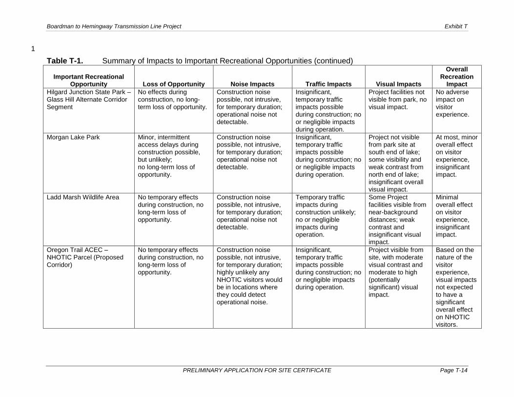
Table T-1 provides a summary of potential impacts to important recreational opportunities, 39 based on site-specific assessment for each opportunity. Expected impacts are discussed below 40 for important opportunities along the IPC Proposed Corridor and the alternate corridor 41 segments, as applicable. 42

Boardman to Hemingway Transmission Line Project Exhibit T
PRELIMINARY APPLICATION FOR SITE CERTIFICATE Page T-13
Table T-1. Summary of Impacts to Important Recreational Opportunities 1
Important Recreational Opportunity Loss of Opportunity Noise Impacts Traffic Impacts Visual Impacts
Overall Recreation
Impact Umatilla National Wildlife Refuge (Longhorn Alternate Corridor Segment only)
No effects during construction, no long-term loss of opportunity.
Construction noise possible, not intrusive, for temporary duration; operational noise not detectable.
No traffic impacts during construction or long-term impacts during operation.
Some Project facilities potentially visible at middleground distance; weak visual contrast and insignificant impact.
Minimal or no overall effect on visitor experience, insignificant impact.
Blue Mountain Forest State Scenic Corridor
Minor, intermittent access delays at three specific locations possible during construction; no long-term loss of opportunity.
Transitory construction noise exposure possible for some visitors, for temporary duration; few or no visitors likely to experience operational noise.
Insignificant, temporary traffic impacts possible during construction; no or negligible impacts during operation.
Visibility primarily limited to two locations where Proposed Corridor crosses scenic frontage road, with Project facilities not dominant in brief views; limited visibility along most of Scenic Corridor.
Minor or minimal overall effect on visitor experience, insignificant impact.
Oregon Trail Interpretive Park at Blue Mountain Crossing
Access delays during construction unlikely; no long-term loss of opportunity.
Construction noise possible, not intrusive, for temporary duration; operational noise not detectable.
Insignificant, temporary traffic impacts possible during construction; no or negligible impacts during operation.
Views to Project blocked by terrain and vegetation, no visual impacts.
Minor or minimal overall effect on visitor experience; insignificant impact
Hilgard Junction State Park – Proposed Corridor
Minor, intermittent access delays possible during construction for some visitors; no long-term loss of opportunity.
Construction noise possible, not intrusive, for temporary duration; operational noise not detectable.
Insignificant, temporary traffic impacts possible during construction; no or negligible impacts during operation.
Partially-screened Project facilities likely visible at middleground distance; weak visual contrast and moderate (insignificant) impact.
At most, minor overall effect on visitor experience, insignificant impact.
2
Boardman to Hemingway Transmission Line Project Exhibit T
PRELIMINARY APPLICATION FOR SITE CERTIFICATE Page T-14
1
Table T-1. Summary of Impacts to Important Recreational Opportunities (continued)
Important Recreational Opportunity Loss of Opportunity Noise Impacts Traffic Impacts Visual Impacts
Overall Recreation
Impact Hilgard Junction State Park – Glass Hill Alternate Corridor Segment
No effects during construction, no long-term loss of opportunity.
Construction noise possible, not intrusive, for temporary duration; operational noise not detectable.
Insignificant, temporary traffic impacts possible during construction; no or negligible impacts during operation.
Project facilities not visible from park, no visual impact.
No adverse impact on visitor experience.
Morgan Lake Park Minor, intermittent access delays during construction possible, but unlikely; no long-term loss of opportunity.
Construction noise possible, not intrusive, for temporary duration; operational noise not detectable.
Insignificant, temporary traffic impacts possible during construction; no or negligible impacts during operation.
Project not visible from park site at south end of lake; some visibility and weak contrast from north end of lake; insignificant overall visual impact.
At most, minor overall effect on visitor experience, insignificant impact.
Ladd Marsh Wildlife Area No temporary effects during construction, no long-term loss of opportunity.
Construction noise possible, not intrusive, for temporary duration; operational noise not detectable.
Temporary traffic impacts during construction unlikely; no or negligible impacts during operation.
Some Project facilities visible from near-background distances; weak contrast and insignificant visual impact.
Minimal overall effect on visitor experience, insignificant impact.
Oregon Trail ACEC – NHOTIC Parcel (Proposed Corridor)
No temporary effects during construction, no long-term loss of opportunity.
Construction noise possible, not intrusive, for temporary duration; highly unlikely any NHOTIC visitors would be in locations where they could detect operational noise.
Insignificant, temporary traffic impacts possible during construction; no or negligible impacts during operation.
Project visible from site, with moderate visual contrast and moderate to high (potentially significant) visual impact.
Based on the nature of the visitor experience, visual impacts not expected to have a significant overall effect on NHOTIC visitors.
Boardman to Hemingway Transmission Line Project Exhibit T
PRELIMINARY APPLICATION FOR SITE CERTIFICATE Page T-15
Table T-1. Summary of Impacts to Important Recreational Opportunities (continued)
Important Recreational Opportunity Loss of Opportunity Noise Impacts Traffic Impacts Visual Impacts
Overall Recreation
Impact Oregon Trail ACEC – NHOTIC Parcel (Flagstaff Alternate Corridor Segment)
Possible minor, intermittent access delays during construction; no long-term loss of opportunity.
Construction noise possible, not intrusive, for temporary duration; small segment of NHOTIC visitors could be in locations where operational noise at faint sound levels might be detectable.
Insignificant, temporary traffic impacts possible during construction; no or negligible impacts during operation.
Project visible from site, with moderate visual contrast and moderate to high (potentially significant) visual impact.
Based on the nature of the visitor experience, visual impact not expected to have a significant overall effect on NHOTIC visitors.
Virtue Flat SRMA/OHV Park – Proposed Corridor
Possible minor, intermittent access delays during construction; no meaningful long-term loss of opportunity.
Construction noise possible, not intrusive, for temporary duration; unlikely OHV users would encounter or notice operational noise.
Insignificant, temporary traffic impacts possible during construction; no or negligible impacts during operation.
Project visible from most of SRMA; contrast generally moderate or weak and visual impact moderate or less (not significant).
Limited overall effect on visitor experience, insignificant impact.
Virtue Flat SRMA/OHV Park - Flagstaff Alternate Corridor Segment
Minor, intermittent access delays possible during construction; no long-term loss of opportunity.
Construction noise possible, not intrusive, for temporary duration; operational noise not detectable.
Insignificant, temporary traffic impacts possible during construction; no or negligible impacts during operation.
Project facilities not visible from SRMA, no visual impact.
Minimal overall effect on visitor experience; insignificant impact.
Farewell Bend State Recreation Area – Proposed Corridor
Minor, intermittent access delays during construction possible, but unlikely; no long-term loss of opportunity.
Construction noise possible, not intrusive, for temporary duration; operational noise not detectable.
Insignificant, temporary traffic impacts possible during construction; no or negligible impacts during operation.
Some Project facilities possibly visible at background distances; weak contrast and insignificant visual impact.
No adverse impact on visitor experience.
Boardman to Hemingway Transmission Line Project Exhibit T
PRELIMINARY APPLICATION FOR SITE CERTIFICATE Page T-16
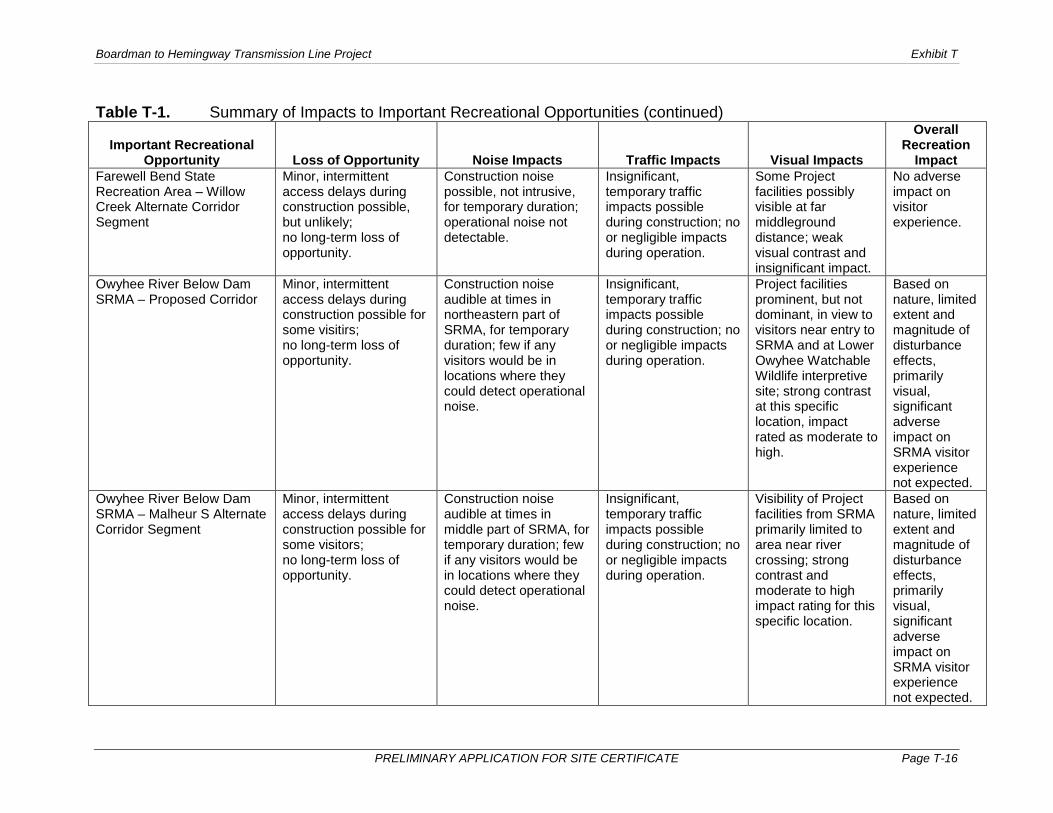
Table T-1. Summary of Impacts to Important Recreational Opportunities (continued)
Important Recreational Opportunity Loss of Opportunity Noise Impacts Traffic Impacts Visual Impacts
Overall Recreation
Impact Farewell Bend State Recreation Area – Willow Creek Alternate Corridor Segment
Minor, intermittent access delays during construction possible, but unlikely; no long-term loss of opportunity.
Construction noise possible, not intrusive, for temporary duration; operational noise not detectable.
Insignificant, temporary traffic impacts possible during construction; no or negligible impacts during operation.
Some Project facilities possibly visible at far middleground distance; weak visual contrast and insignificant impact.
No adverse impact on visitor experience.
Owyhee River Below Dam SRMA – Proposed Corridor
Minor, intermittent access delays during construction possible for some visitirs; no long-term loss of opportunity.
Construction noise audible at times in northeastern part of SRMA, for temporary duration; few if any visitors would be in locations where they could detect operational noise.
Insignificant, temporary traffic impacts possible during construction; no or negligible impacts during operation.
Project facilities prominent, but not dominant, in view to visitors near entry to SRMA and at Lower Owyhee Watchable Wildlife interpretive site; strong contrast at this specific location, impact rated as moderate to high.
Based on nature, limited extent and magnitude of disturbance effects, primarily visual, significant adverse impact on SRMA visitor experience not expected.
Owyhee River Below Dam SRMA – Malheur S Alternate Corridor Segment
Minor, intermittent access delays during construction possible for some visitors; no long-term loss of opportunity.
Construction noise audible at times in middle part of SRMA, for temporary duration; few if any visitors would be in locations where they could detect operational noise.
Insignificant, temporary traffic impacts possible during construction; no or negligible impacts during operation.
Visibility of Project facilities from SRMA primarily limited to area near river crossing; strong contrast and moderate to high impact rating for this specific location.
Based on nature, limited extent and magnitude of disturbance effects, primarily visual, significant adverse impact on SRMA visitor experience not expected.

Boardman to Hemingway Transmission Line Project Exhibit T
PRELIMINARY APPLICATION FOR SITE CERTIFICATE Page T-17
Table T-1. Summary of Impacts to Important Recreational Opportunities (continued)
Important Recreational Opportunity Loss of Opportunity Noise Impacts Traffic Impacts Visual Impacts
Overall Recreation
Impact Owyhee River Complex SRMA – Malheur S Alternate Corridor Segment
Minor, intermittent access delays during construction possible, but unlikely; no long-term loss of opportunity.
Construction noise possible, not intrusive, for temporary duration; operational noise not detectable.
Insignificant, temporary traffic impacts possible during construction; no or negligible impacts during operation.
Project facilities potentially visible from very limited locations in SRMA; weak contrast and low to moderate (insignificant) visual impacts in those locations, no impact elsewhere.
Limited overall effect on visitor experience, insignificant impact.
Owyhee Lake State Park - Malheur S Alternate Corridor Segment
Minor, intermittent access delays during construction possible for some visitors; no long-term loss of opportunity.
Construction noise possible, not intrusive, for temporary duration; operational noise not detectable.
Insignificant, temporary traffic impacts possible during construction; no or negligible impacts during operation.
No visibility of Project facilities from park; no contrast and no visual impact.
Limited, short-term overall effect on visitor experience, insignificant impact.
1
Boardman to Hemingway Transmission Line Project Exhibit T
PRELIMINARY APPLICATION FOR SITE CERTIFICATE Page T-18
The following sections discuss the nature and degree of expected impacts on each important 1 recreational opportunity within the analysis area for Exhibit T (the area within the Site Boundary 2 and 2 miles from the Site Boundary). As noted in Section 3.2.2.3 and in Table T-1, access road 3 and traffic impacts for the Project will be insignificant for all important recreational opportunities. 4 Therefore, the following impact discussion addresses each applicable factor (loss of a 5 recreational opportunity, noise impacts, or visual impacts) as it applies to each particular 6 important recreational opportunity, and their effect on the overall visitor experience. 7
3.3.2.1 Umatilla National Wildlife Refuge 8
The Longhorn Alternate is separated from the Umatilla NWR by a distance of approximately 1.5 9 miles from the McCormack Slough locations (see Figure T-1-1 in Attachment T-1), and the 10 Project will have no direct impact on use of the facilities. Project construction activity will be 11 occurring to the south and will not temporarily disrupt access to the refuge via local roads. 12 Similarly, the distance and nearby land use conditions indicate that recreational use at the 13 refuge will not be adversely affected by noise from Project. Construction noise might be audible 14 at times in the southern part of the area, but the sound levels will be attenuated considerably 15 and will not be intrusive. The peak construction noise will be approximately 60 dBA at a point 16 1,000 feet from the source, for example, and will be considerably less than 60 dBA 8,000 feet 17 away at the refuge boundary. The subjective impression of sound levels in the 60 to 70 dBA 18 range is characterized as “moderate,” while sound levels between 40 and 60 dBA are 19 characterized as “quiet” (Exhibit X, Table X-10). Given the distance from the Longhorn 20 Alternate, operational noise from the Project (a maximum of about 48 dBA at the source) will not 21 be audible at the refuge. 22
Bare-earth viewshed analysis indicates that Project transmission facilities near the Longhorn 23 Substation will potentially be visible from upland areas within the McCormack Unit of the refuge. 24 A multi-use area adjacent to the Alternate Longhorn Substation Expansion likely will not be 25 noticeable to viewers. Views to the south from the McCormack Slough area toward the 26 proposed 500-kV line will include three existing transmission lines that are located between the 27 viewing location and the proposed line. Other industrial facilities along the river and within 28 Boardman are also visible to viewers from the NWR. Due to the visual presence of the existing 29 utility and industrial facilities, the Project will create minimal visual contrast as seen from this 30 area and visual impacts will be low, at most. Overall, there will be minimal, if any, effect on the 31 recreational experience for visitors to the Umatilla NWR. 32
3.3.2.2 Blue Mountain Forest State Scenic Corridor 33
The Project will not result in any long-term loss of opportunity for users of the Blue Mountain 34 Corridor. The Project will cross the Blue Mountain Corridor in one location, approximately 1 mile 35 west of the southern end of the corridor (within the Motanic-Glover parcel of the Blue Mountain 36 Corridor; see Figure T-1-2 in Attachment T-1). The transmission line will span the Blue Mountain 37 Corridor and Old Emigrant Hill Scenic Frontage Road, and Project facilities will not be located 38 within the Blue Mountain Corridor. 39
Construction activity in the vicinity of the Blue Mountain Corridor could result in minor indirect 40 effects on users of this resource through possible intermittent delay of traffic along the frontage 41 road at the crossing location, or near either end of the Kamela-Bodie parcel of the Blue 42 Mountain Corridor. 43
The noise impacts of the Project are addressed in Exhibit X. Information about construction 44 noise sources and levels indicates that construction noise will likely be audible at times at 45 locations along the entire length of the Blue Mountain Corridor within the analysis area. It is 46 unlikely that many Blue Mountain Corridor users will actually be exposed to construction noise, 47 however. The predominant means for visitors to “use” the Blue Mountain Corridor is to travel 48

Boardman to Hemingway Transmission Line Project Exhibit T
PRELIMINARY APPLICATION FOR SITE CERTIFICATE Page T-19
through the corridor in a motor vehicle. Because the Blue Mountain Corridor parcels within the 1 analysis area do not include developed recreation facilities, it is possible or even likely that most 2 visitors do not leave their vehicles during their trip through the corridor, and therefore have 3 limited exposure to external noise sources. In addition, any Blue Mountain Corridor visitors who 4 might hear Project construction noise would experience it on a transitory basis. 5
The modeled sound contours for Project operational noise indicate that maximum sound levels 6 (i.e., under foul weather conditions) within the Blue Mountain Corridor will range from 16 dBA to 7 61 dBA. Sound levels in the lower part of that range represent locations where operational noise 8 from the Project will be below the ambient sound level and not detectable.1 Sound levels in the 9 higher part of that range represent locations quite close to the Project, such as in the immediate 10 vicinity of the location where the Project crosses the Blue Mountain Corridor at milepost 102.6. 11 Operational noise from the Project in the 60-dBA range will be detectable to a person in the 12 immediate vicinity and outside of a vehicle. While these results indicate that operational noise 13 will be audible at selected locations along the Blue Mountain Corridor, the specific nature of use 14 for this resource suggests that very few or no visitors will actually experience operational noise 15 and that any exposures will be brief. 16
Viewing conditions and visibility of the Project will vary by location within the Blue Mountain 17 Corridor. For much of the 5-mile length of the Meacham-Kamela parcel, the Blue Mountain 18 Corridor is screened from views toward the proposed line by vegetation and topography. 19 Potential fly yard locations 2 miles west and 1 mile southeast of Blue Mountain Corridor 20 segments will be blocked from view by terrain and vegetation and will not contribute temporarily 21 to Project visual impacts for this resource. For locations in this parcel where the Project 22 transmission facilities likely will be visible, the viewing distance will typically be 1 to 2 miles and 23 the Project will not be prominent in the view. 24
The transmission line will also be partially screened from view by topography and stands of 25 coniferous trees along the Kamela-Bodie and Motanic-Glover parcels of the Blue Mountain 26 Corridor, which are generally parallel to the Proposed Corridor. In these areas the Project will 27 typically be within about 0.5 mile and Project facilities that were in view will be more prominent. 28 In addition, there are two locations where Blue Mountain Corridor visitors will have views of the 29 Project crossing their route of travel. 30
The assessment of scenic resources documented in Exhibit R and Attachment R-1 includes one 31 viewpoint located along the Blue Mountain Corridor. At this location, visitors traveling 32 northbound through the Blue Mountain Corridor will have a view perpendicular to the Project at 33 a distance of 0.3 mile. The view toward the Project will be at least partially screened by the 34 dominant forest vegetation in this area. To the extent that Project facilities will be visible, they 35 will be evident within a scene that includes the frontage road, the roadway cut, and an adjacent 36 railroad line. Blue Mountain Corridor visitors will also have a similar view near the location 37 where the Project crosses the Motanic-Glover Blue Mountain Corridor parcel. The Project 38 facilities will not be dominant elements in these views. 39
Overall, considering the expected viewing conditions for all three parcels within the analysis 40 area, the Project will likely have at most a minor effect on the recreational experience of visitors 41 to the Blue Mountain Corridor. Visitors making a side trip along the Old Emigrant Hill Scenic 42 Frontage Road (approximately 15 miles for a trip including all three parcels, or about 10 miles 43 for a trip involving the two southerly parcels) will likely be exposed to brief, focused views of the 44 Project at two locations and intermittent, peripheral views in a few additional locations. Given 45
1 Ambient sound levels specific to the recreational opportunities included in the assessment have not been measured. As documented in Exhibit X, late-night baseline sound levels monitored for the Project ranged from 25 dBA to 63 dBA. ODOE has suggested that 20 dBA should be used as a conservative assumed ambient sound level.

Boardman to Hemingway Transmission Line Project Exhibit T
PRELIMINARY APPLICATION FOR SITE CERTIFICATE Page T-20
the presence of a parallel railroad line along most of this trip and freeway interchange scenes at 1 the two endpoints, it is unlikely that the visible presence of the 500-kV transmission line will be 2 sufficient to detract noticeably from the quality of the experience for most Blue Mountain 3 Corridor visitors. 4
3.3.2.3 Oregon Trail Interpretive Park at Blue Mountain Crossing 5
The Proposed Corridor is separated from the Oregon Trail Interpretive Park at Blue Mountain 6 Crossing by a distance of 1.1 miles (see Figure T-1-2 in Attachment T-1), and the Project will 7 have no direct impact on use of the facilities. Construction activity for the Project will occur on 8 the opposite side of I-84 from the Oregon Trail Interpretive Park and will have no effect on 9 access to the Interpretive Park. 10
Project construction noise might be audible at times, but the distance indicates the sound levels 11 will be attenuated considerably and will not be intrusive (see the previous discussion for the 12 Umatilla NWR). Given the separation distance and the presence of I-84 between the Oregon 13 Trail Interpretive Park and the Proposed Corridor, operational noise will not be audible. The 14 assessment of Project operational noise indicates that modeled sound contours at the 15 Interpretive Park ranged from 16 dBA to 21 dBA. A sound level of 35 dBA is characteristic of a 16 typical wilderness area, while 25 dBA is typical of wilderness with no wind or animal activity (see 17 Exhibit X, Table X-10); given that I-84 is located approximately 0.5 mile west of the Interpretive 18 Park, it is evident that the typical daytime sound level at the park will be substantially above 19 25 dBA, and that operational noise from the Project will not be detectable. 20
Bare-earth viewshed analysis indicates that Project facilities on the Proposed Corridor will 21 potentially be visible from the Oregon Trail Interpretive Park. The park is located in a dense 22 forest setting, however, and tree cover has a substantial effect on visibility. This recreation site 23 is the location for KOP 3-42 in the visual impact analysis. The results provided in Exhibit R, 24 Attachment R-1 indicate that the forest vegetation and an intervening ridge will block views 25 toward the Proposed Corridor from the day-use facilities, and there will be no visual impact from 26 the Project at KOP 3-42. 27
Considering all elements of the impact analysis, the Project will cause only minimal, short-term 28 impacts on the recreational experience for visitors to the Oregon Trail Interpretive Park. 29
3.3.2.4 Hilgard Junction State Park 30
Proposed Corridor 31
The Proposed Corridor is located between approximately 0.7 and 1.0 mile to the west of the 32 recreation facilities at Hilgard Junction State Park, and on the opposite (west) side of the 33 Grande Ronde River (see Figure T-1-2 in Attachment T-1). The Proposed Corridor is sufficiently 34 separated from the developed part of the park that the Project will have no direct impact on use 35 of the recreation facilities. Construction activity occurring in the vicinity could result in minor 36 indirect effects through intermittent delay of visitors traveling to and from the park. 37
Project construction noise might be audible at times; given the separation distance and the 38 sound-masking effects of I-84, Oregon Highway (OR) 244, and the Grande Ronde River, the 39 sound levels will be attenuated considerably and will not be intrusive. For similar reasons, 40 operational noise will not be audible. The assessment of Project operational noise indicates that 41 modeled sound contours at the park ranged from 16 dBA to 26 dBA. As discussed in Section 42 3.3.2.3, a sound level of 25 dBA is characteristic of wilderness with no wind or animal activity. 43 Given that the park is located between the river and OR 244 and is nearly adjacent to I-84, it is 44 evident that the typical sound level at the park will be substantially above 25 dBA, and that 45 operational noise from the Project will not be detectable to park visitors. 46
Boardman to Hemingway Transmission Line Project Exhibit T
PRELIMINARY APPLICATION FOR SITE CERTIFICATE Page T-21
The park property located east of the campground is undeveloped, extends away from the 1 direction of the Proposed Corridor, and is situated on the south side of a canyon with an 2 orientation toward I-84 and the north. Consequently, views of the Project are not expected in the 3 eastern part of the park property. 4
The western end of the park property is occupied by a correctional facility2 (the River Bend 5 Transitional Facility, operated by the Oregon Youth Authority), with buildings about 0.4 mile from 6 the Proposed Corridor (the property comes within 0.3 mile). This portion of the park property is 7 not expected to be used by public viewers, and visual conditions have not been specifically 8 assessed. 9
The assessment of scenic resources provided in Exhibit R and Attachment R-1 includes KOP 4-10 19, located in the portion of the park developed for recreational use. Bare-earth viewshed 11 analysis (based on terrain only) indicates that up to six transmission towers will potentially be 12 visible at a middleground distance to the west and southwest. Two other towers just east of the 13 Proposed Corridor crossing of the Grande Ronde River and OR 244 might be visible to the 14 south, although photographs of current conditions indicate trees will partially screen these 15 towers. Site-specific review indicates that elevated terrain to the west and vegetation will 16 partially block and screen views to the Project from the day-use area and campground. Based 17 on the viewing distance and partial screening, the visual contrast created by the Project at this 18 location will be weak. With a Class B scenic quality and weak contrast, the overall resource 19 change will be low to moderate. Viewer characteristics for this location include high sensitivity, 20 moderate view duration, and moderate viewer numbers, resulting in a moderate to high overall 21 viewer response. Therefore, the incremental visual impact of the Project at Hilgard Junction was 22 determined to be moderate, and not significant. 23
The Project will have no adverse effect on the opportunity for visitors to use Hilgard Junction 24 State Park. Indirect/disturbance impacts will be limited to visual effects that will create weak 25 contrast and will not be dominant visual elements. Considering the various components of the 26 visitor experience, the Project will have at most a minor overall effect on the experience of a 27 typical visitor to the state park. 28
Glass Hill Alternate Corridor Segment 29
The recreation facilities in Hilgard Junction State Park are located approximately 1.7 miles to the 30 north of the point from where the Glass Hill Alternate Corridor Segment leaves the Proposed 31 Corridor (see Figure T-1-2 in Attachment T-1). Development of this segment will have no direct 32 or indirect effect on the opportunity to use the recreation facilities at the Park. Construction 33 noise might be audible at times, but the sound levels will be attenuated considerably and will not 34 be intrusive. Given the distance from the Glass Hill Alternate, operational noise from the Project 35 will not be audible at Hilgard Junction. 36
Bare-earth viewshed analysis indicates that views to the Glass Hill Alternate from the recreation 37 facilities at Hilgard Junction will be screened by topography and vegetation. Based on the 38 viewing distance and the expected screening, there will not be visual impact from the Glass Hill 39 Alternate at the state park. Consequently, the Glass Hill Alternate will have no direct or indirect 40 impact on the recreation experience at Hilgard Junction. 41
3.3.2.5 Morgan Lake Park 42
The Proposed Corridor is separated from Morgan Lake Park by a distance of approximately 43 1 mile (see Figure T-1-2 in Attachment T-1), and the Project will have no direct impact on use of 44
2 This facility is addressed as a noise receptor location in Exhibit X.

Boardman to Hemingway Transmission Line Project Exhibit T
PRELIMINARY APPLICATION FOR SITE CERTIFICATE Page T-22
the facilities. Project construction activity will occur to the west of the park and it is unlikely that 1 access to the park from La Grande will be disrupted. 2
Distance and terrain conditions indicate that recreational use at Morgan Lake Park will not be 3 adversely affected by noise from the Project. Construction noise might be audible at times, but 4 the sound levels will be attenuated considerably and will not be intrusive. The assessment of 5 Project operational noise indicates that modeled sound contours at the park will be low level, 6 ranging from 16 dBA to 26 dBA, which is equivalent to or less than the sound level in wilderness 7 with no wind or animal activity (see Exhibit X, Table X-10). 8
The Proposed Corridor passes to the west of Morgan Lake Park and is situated on the opposite 9 (western) side of the ridge that separates Sheep Creek and Rock Creek; Morgan Lake is 10 located to the east of Sheep Creek. Based on the local terrain conditions, bare-earth viewshed 11 analysis indicates the Project will not be visible from Morgan Lake Park, which is located at the 12 south end of the lake and is identified as KOP 4-19 in Exhibit R, Attachment R-1. At the north 13 end of the lake, however, the upper portions of a number of transmission towers will be visible 14 at a middleground distance of 1 mile. A potential fly yard located approximately 1 mile 15 southwest of KOP 4-28 will be blocked from view by terrain and vegetation and will contribute to 16 visual contrast at this site. Based on the viewing distance and partial screening, the visual 17 contrast created by the Project from the northern part of Morgan Lake will be weak, and from 18 the park itself there will be no contrast (no view). Considering the Class C existing scenic quality 19 applicable to KOP 4-19 and moderate overall viewer response for this location, the incremental 20 visual impact of the Project at Morgan Lake was determined to be low to moderate, and 21 insignificant. 22
The Project will have no adverse effect on the opportunity for visitors to use Morgan Lake Park. 23 Indirect/disturbance impacts will be limited to visual resource effects that will be minor and 24 present only in a portion of the Morgan Lake area and not at the park itself. Considering the 25 various components of the visitor experience, the Project will have at most a minor overall effect 26 on the experience of a typical visitor to Morgan Lake. 27
3.3.2.6 Ladd Marsh Wildlife Area 28
The Proposed Corridor is separated from Ladd Marsh by a minimum distance of approximately 29 1.7 miles from the Foothill Road locations (see Figure T-1-2 in Attachment T-1), and the Project 30 will have no direct impact on use of the facilities. Project construction activity would occur to the 31 west of the wildlife area and will not temporarily disrupt access from Foothill Road. Similarly, 32 distance and terrain conditions indicate that recreational use at Ladd Marsh will not be 33 adversely affected by noise from the Project. Construction noise might be audible at times in the 34 western part of the wildlife area, but the sound levels will be attenuated considerably and will not 35 be intrusive. The assessment of Project operational noise indicates that modeled sound 36 contours at the wildlife area ranged from 16 dBA to 21 dBA, which is equivalent to or less than 37 the sound level in wilderness with no wind or animal activity. Given the extent of human 38 development activity in and near Ladd Marsh (the wildlife area is bisected by I-84, for example), 39 ambient sound levels in the wildlife area will be substantially higher than the Project operational 40 sound levels. 41
The potential for visual effects was evaluated from two viewpoints in and adjacent to the Wildlife 42 Area. KOP 4-27 is located along OR 203 and KOP 4-26 is on Foothill Road. These viewpoints 43 are located 4.9 and 2.4 miles, respectively, from the Proposed Corridor. From OR 203 there 44 may be distant views of the tops of some transmission structures. The transmission line will not 45 be visible from KOP 4-26 on Foothill Road. The scenic resource analysis documented in Exhibit 46 R and Attachment R-1 determined that the Project will create weak contrast as seen from the 47 State Highway 203 location and no contrast as seen from the Foothill Road location. The overall 48

Boardman to Hemingway Transmission Line Project Exhibit T
PRELIMINARY APPLICATION FOR SITE CERTIFICATE Page T-23
resource change for the former location will be low and the overall viewer response was rated 1 as low to moderate. Consequently, the visual impacts for this area will be nonexistent in some 2 areas and at most low to moderate where the Project might be visible; consequently, any visual 3 effects from the Project in the wildlife area will be insignificant. 4
The Project will have no adverse effect on the opportunity for visitors to use Ladd Marsh. 5 Indirect/disturbance impacts will be limited to visual resource effects; based on the apparent 6 distribution of public use at Ladd Marsh and the distant viewing conditions, the overall effect of 7 these changes on the visitor experience for users of the Ladd Marsh Wildlife Area will be 8 minimal. 9
3.3.2.7 Oregon Trail ACEC – NHOTIC Parcel 10
Proposed Corridor 11
At the closest point, the Proposed Corridor is located 0.4 mile to the southeast of the NHOTIC 12 Parcel boundary (see Figure T-1-3 in Attachment T-1) and 1.1 miles from the Interpretive Center 13 itself. The Project will have no direct or indirect impact on the ability of visitors to access or use 14 the site. Construction noise might be audible at times at the NHOTIC Parcel, but the sound 15 levels will be attenuated considerably and will not be intrusive. The modeled sound contours for 16 the NHOTIC Parcel ranged from 16 dBA to 31 dBA. Based on the size and configuration of the 17 NHOTIC Parcel, the 31 dBA maximum sound level will be applicable to the easternmost part of 18 the NHOTIC Parcel, while sound levels around the Interpretive Center building will be in the 19 middle of the range. Given the level of human activity present at and near the NHOTIC Parcel, 20 daytime ambient sound levels will exceed the 35 dBA level typically found in a wilderness (see 21 Exhibit X, Table X-10). The potential for operational noise from the Project to be audible will be 22 limited to the easternmost part of the NHOTIC Parcel, which does not include developed 23 facilities on the site or any portion of the interpretive trail system (BLM 2012). Consequently, it is 24 highly unlikely that visitors to the NHOTIC Parcel will be in a location where they were close 25 enough to detect operational noise from the Project. 26
The visual assessment documented in Exhibit R and Attachment R-1 (specifically, for KOP 5-27 25a) determined that the proposed transmission line structures and conductors will be highly 28 visible approximately 1.1 miles to the southeast of the Interpretive Center and about 1,900 feet 29 from the closest part of the NHOTIC Parcel property line. Because of the elevated viewing 30 position, the structures and conductors will mostly be backdropped and will create less contrast. 31 Nevertheless, the contrast level was rated as moderate. A multi-use area and potential fly yard 32 located 4 miles to the north will either not be visible from the NHOTIC Parcel or will not create 33 noticeable sources of additional contrast. With a Class B scenic quality, the overall resource 34 change will be moderate. Because viewer numbers and sensitivity are high, the overall viewer 35 response was rated as moderate to high. Consequently, the visual impacts at this location will 36 be moderate to high, and potentially significant. As necessary, IPC will develop mitigation to 37 reduce the visual impact of the Project on the NHOTIC Parcel to less than significant. 38
The Project will have no adverse impact on the opportunity for visitors to use NHOTIC Parcel or 39 the Interpretive Center. Long-term indirect/disturbance impacts will be limited to the visual 40 resource effects discussed above. While NHOTIC Parcel visitors will be exposed to visual 41 impacts rated as moderate to high, it should not be assumed that all visitors will notice the 42 Project facilities or perceive them as a substantial adverse impact on their visit. While the 43 NHOTIC Parcel provides both indoor and outdoor displays and many visitors to the site use one 44 or more of the trails, for most users the main Interpretive Center building is the primary focus 45 and the experience is primarily an indoor experience. In addition, views of the surrounding 46 landscape include a number of existing cultural modifications (e.g., development on the 47 NHOTIC Parcel site, OR 86, local roads, fencing and utility poles) to which the Project facilities 48
Boardman to Hemingway Transmission Line Project Exhibit T
PRELIMINARY APPLICATION FOR SITE CERTIFICATE Page T-24
will include an incremental addition. Therefore, based on the nature of the typical visitor 1 experience, the visual impact of the Project is not expected to result in significant impact on the 2 overall recreation experience for NHOTIC visitors. 3
Flagstaff Alternate Corridor Segment 4
The Flagstaff Alternate is within 1,200 feet of the western boundary of the NHOTIC Parcel, 5 which is described in Section 3.3.1, and is within a mile of the Interpretive Center building (see 6 Figure T-1-3 in Attachment T-1). 7
The Flagstaff Alternate is separated from the NHOTIC Parcel by approximately 0.2 mile and will 8 have no direct impact on use of the facilities. Project construction activity will occur to the west 9 and could cause intermittent delays for visitors traveling to the Interpretive Center via OR 86. 10
Construction noise will likely be audible at times in the western part of the parcel and may be 11 audible at the Interpretive Center, but the sound levels will be attenuated and will not be 12 intrusive. The modeled foul-weather sound contours for the NHOTIC Parcel with the Flagstaff 13 Alternate ranged from 16 dBA to 36 dBA. Based on the size and configuration of the NHOTIC 14 Parcel, the 36 dBA maximum sound level will be applicable to the westernmost part of the 15 NHOTIC Parcel, while sound levels around the Interpretive Center building will be in the middle 16 of the range. Given the level of human activity present at and near the NHOTIC Parcel (in 17 particular, OR 86 runs along the southern edge of the NHOTIC Parcel and the Baker Municipal 18 Airport is located approximately 3 miles to the northwest) daytime ambient sound levels will no 19 doubt exceed the 35-dBA level typically found in a wilderness. Overall, it is possible that 20 operational noise from the Project will be detectable within the extreme western part of the 21 NHOTIC parcel. The potential for audible operational noise from the Project will be limited to the 22 westernmost part of the interpretive trail system, and probably to just the western part of the 23 Eagle Valley Railroad Grade Loop Trail (BLM 2012). With-Project sound levels at the 24 Interpretive Center itself, the adjacent outdoor displays, Panorama Point, and the Oregon Trail 25 Ruts Loop Trail will be in the lower part of the modeled range. Consequently, it is likely that at 26 most a small segment of the visitors to the NHOTIC Parcel will be in a location close enough for 27 them to detect operational noise from the Project. If operational noise was audible to those 28 visitors, the sound levels will be in a range characterized as “faint” (Exhibit X, Table X-10). 29
The visual assessment documented in Exhibit R and Attachment R-1 determined that 30 approximately 1.6 miles (about seven or eight structures) of the Flagstaff Alternate will be visible 31 from various points on the NHOTIC Parcel, at a distance of 0.5 to 1 mile. Because this is an 32 elevated viewing point the landscape will provide a backdrop, reducing the degree of visual 33 contrast. In addition, the Project facilities on this segment will be seen in conjunction with an 34 existing 230-kV line. A potential fly yard location about 1 mile to the west of the NHOTIC will be 35 blocked from view by a ridge, and aerial activity associated with a fly yard will not represent a 36 meaningful increase to the contrast created by the Project in this area; moreover, aerial activity 37 will be temporary. The contrast level and overall resource change for this alternative both rate 38 as moderate for three specific NHOTIC viewpoints (KOPs 5-25c, 5-25d and 5-25e). Based on a 39 viewer response rated as moderate to high, the visual impact for this alternative will be 40 moderate to high and potentially significant. As necessary, IPC will develop mitigation to reduce 41 the visual impact of the Project on the NHOTIC Parcel to less than significant. 42
As noted above for the Proposed Corridor, the visual effects of the Flagstaff Alternate are not 43 expected to have a significant impact on the overall recreation experience for NHOTIC visitors. 44

Boardman to Hemingway Transmission Line Project Exhibit T
PRELIMINARY APPLICATION FOR SITE CERTIFICATE Page T-25
3.3.2.8 Virtue Flat SRMA/OHV Park 1
Proposed Corridor 2
The Proposed Corridor crosses the extreme western tip of the Virtue Flat SRMA, between 3 mileposts 156 and 157 (see Figure T-1-3 in Attachment T-1). At this location SRMA lands 4 occupy a narrow triangular area between State Highway 86 and Ruckles Creek Road, which is 5 the access route to the OHV area. The current indicative layout for the Project shows one tower 6 located in this part of the OHV area. While the tower will occupy a small area of land within the 7 OHV park (roughly 0.5 acre), the tower will have no meaningful, direct impact on the ability of 8 visitors to access or use the site. Construction activity in the vicinity could result in minor, 9 temporary indirect effects through intermittent delay of traffic heading to and from the staging 10 area on Ruckles Creek Road. 11
Construction noise may be audible at times at the OHV area, but the sound levels will be 12 attenuated considerably within most of the OHV area. Given the baseline noise level associated 13 with OHV activity and the common use of helmets by OHV riders, it is not likely that construction 14 noise will be intrusive or even noticeable. Similarly, operational noise likely will not be 15 noticeable, even to OHV users in the western part of the SRMA. The modeled sound contours 16 for the Project within the Virtue Flat SRMA ranged from 16 dBA to 61 dBA. Sound levels in the 17 lower part of that range represent locations where operational noise from the Project will be 18 below the reference ambient sound level for a very quiet area, such as a wilderness, and not 19 detectable. Sound levels in the higher part of that range represent locations under the Project, 20 such as the location where the Project crosses the SRMA at milepost 156. Even in areas where 21 operational noise from the Project will reach 61 dBA, it is highly unlikely that the Project noise 22 will be noticed by SRMA users, who will be wearing helmets and riding OHVs; the typical sound 23 level from a motorcycle at a distance of 25 feet is 90 dBA (Exhibit X, Table X-10). 24
The proposed transmission line structures and conductors will potentially be visible from most 25 locations within the OHV area. The Virtue Flat area is generally rolling, open terrain with 26 expansive views; view blockage will occur within draws and in some areas with steep slopes. 27 Foreground views of the Project would be limited to recreational users within the extreme 28 western end of the SRMA, an area accounting for approximately 200 acres. Most of the SRMA 29 acreage is within middleground viewing distance of the Proposed Corridor, while approximately 30 the eastern one-third of the SRMA is within background viewing distance. 31
Potential views from the OHV area include both inferior (lower) viewing positions, oriented 32 toward the proposed line crossing the southern slopes of Flagstaff Hill, and elevated positions 33 relative to Project facilities in the valley below. As a result, there may be some skylining of the 34 facilities in views to the northwest and west, while the structures and conductors would mostly 35 be backdropped in views to the southwest. Contrast levels would be variable within the area, but 36 would generally be moderate or weak; the contrast at KOP 5-84 within the OHV area was rated 37 as weak. With a Class B existing scenic quality, the overall resource change would be no more 38 than moderate. Viewer numbers at this location are moderate. Because Virtue Flat users would 39 be focused on their activity and typically moving, viewer sensitivity is considered moderate and 40 view duration is considered low. Therefore, the overall viewer response would be low to 41 moderate. With the resource change rated as moderate or less and viewer response as low to 42 moderate, visual impacts within the Virtue Flat OHV Area would be low to moderate, and not 43 significant. 44
The Project will have no adverse effect on the opportunity for visitors to use the Virtue Flat OHV 45 Area. Long-term indirect/disturbance impacts will be limited to the visual resource effects 46 discussed above. Therefore, the Proposed Corridor is not expected to have a significant impact 47 on the recreation experience for Virtue Flat users. 48
Boardman to Hemingway Transmission Line Project Exhibit T
PRELIMINARY APPLICATION FOR SITE CERTIFICATE Page T-26
Flagstaff Alternate Corridor Segment 1
The Flagstaff Alternate is approximately 1.5 miles to the west of the western boundary of the 2 Virtue Flat OHV Area (see Figure T-1-3 in Attachment T-1), and the Project on the Flagstaff 3 Alternate will have no direct impact on use of the OHV area. Project construction activity could 4 cause minor, intermittent delays for visitors traveling to Virtue Flat via OR 86. 5
Construction noise may be audible at times in the western part of the OHV area, but the sound 6 levels will be attenuated considerably and masked by OHV noise. Given the distance from the 7 Flagstaff Alternate, operational noise from the Project will not be audible at Virtue Flat. Flagstaff 8 Hill and adjacent terrain will block views to the Flagstaff alignment, and this alternate will have 9 no visual impact on the Virtue Flat OHV Area. Therefore, the Flagstaff Alternate will have a 10 minimal (and insignificant) impact on the recreation experience for Virtue Flat users. 11
3.3.2.9 Farewell Bend State Recreation Area 12
The Proposed Corridor is located about 5 miles northwest of the public use areas at Farewell 13 Bend State Recreation Area (see Figure T-1-4 in Attachment T-1), which extend to the east 14 from U.S. Highway 30 (also known as the Huntington Highway). GIS records indicate that a 15 separate parcel of the park property is located near the west edge of Huntington and 1.3 miles 16 from the Proposed Corridor. Field review indicated that the facilities on this parcel are used for 17 maintenance, rather than for public recreational use. Therefore, impact assessment for Exhibit T 18 addresses expected effects within the public use areas of the park. While the recreational 19 facilities within the park are more than 2 miles from the Proposed Corridor, they are within 20 2 miles of a potential fly yard and a multi-use area associated with the Willow Creek Alternate 21 and therefore are within the analysis area. 22
Proposed Corridor 23
Permanent and temporary Project facilities on the Proposed Corridor are all more than 4 miles 24 from the public recreation facilities in the Farewell Bend State Recreation Area and will have no 25 direct impact on use of the park. Project construction activity will cause minimal, if any, 26 intermittent delays for visitors traveling to Farewell Bend State Recreation Area. 27
Construction noise may be audible at times at the park. The sound levels will be attenuated 28 considerably, however, and will be masked to a degree by sound from traffic on I-84 and U.S. 29 30 and from motorized boating on the reservoir. Given the distance from the Proposed Corridor, 30 operational noise from the Project will not be audible in the park. 31
Bare-earth viewshed analysis indicates that facilities on the Proposed Corridor could potentially 32 be visible from the Farewell Bend State Recreation Area. Because the existing developed 33 recreation facilities are located at lower elevations along the western reservoir shoreline and 34 there are extensive plantings of shade trees around the park, it is possible that views toward the 35 Proposed Corridor will be screened by vegetation if not by intervening terrain. If any Project 36 facilities were visible, they will be seen at a background viewing distance and the degree of 37 contrast will be very weak (as determined for KOP 5-13 in the visual assessment). With a Class 38 C scenic quality, the overall resource change for this location will be low. The overall viewer 39 response for KOP 5-13 was rated as moderate to high. With a low resource change and 40 moderate to high viewer response, the visual impact at Farewell Bend State Recreation Area 41 will be low to moderate and not significant. 42
The Project will have no long-term adverse impact on the opportunity for visitors to use Farewell 43 Bend State Recreation Area. Indirect/disturbance impacts will be limited to visual resource 44 effects, which will be moderate at most. Therefore, the recreational experience for park users 45 will not be adversely affected by the Project. 46

Boardman to Hemingway Transmission Line Project Exhibit T
PRELIMINARY APPLICATION FOR SITE CERTIFICATE Page T-27
Willow Creek Alternate Corridor Segment 1
The Willow Creek Alternate passes about 3 miles west of the public use areas at Farewell Bend 2 State Recreation Area (see Figure T-1-4 in Attachment T-1), which extend to the east from U.S. 3 Highway 30 (also known as the Huntington Highway). A potential fly yard location south of 4 Durbin Creek Road is approximately 4 miles northwest of the park, and a multi-use area will be 5 located on the west side of U.S. Highway 30 just outside the park entrance. 6
Permanent Project facilities on the Willow Creek Alternate will have no direct impact on use of 7 Farewell Bend State Recreation Area. Project construction activity, primarily traffic associated 8 with the multi-use area, could cause brief, intermittent delays for visitors traveling to Farewell 9 Bend. 10
Construction noise may be audible at times at the park, especially during times of activity at the 11 fly yard and multi-use area. The sound levels will be attenuated considerably, however, and will 12 likely be masked to a degree by sound from traffic on I-84 and U.S. 30 and from motorized 13 boating on the reservoir. Noise levels from equipment will typically be in the 75 to 85 dBA range 14 within the multi-use area, and about 51 dBA or less 1,000 feet away within the use areas of the 15 park (Exhibit X, Table X-3); 50 dBA is the sound level of light auto traffic at 100 feet from the 16 source, and sound levels between 40 and 60 dBA are characterized as “quiet” (Exhibit X, Table 17 X-10). Based on the separation distance of 3 miles, operational noise from the Project will not 18 be audible in the public use areas of the park. 19
Visibility conditions and viewer characteristics at Farewell Bend State Recreation Area for the 20 Willow Creek Alternate will be somewhat similar to those described previously for the Proposed 21 Corridor, although the terrain will block some views and provide a backdrop in other locations. 22 Because any contrast will likely not be evident to the typical viewer, there will be no overall 23 resource change and no incremental visual impact. A construction multi-use area located to the 24 west of KOP 5-13 on the opposite side of U.S. 30 will be noticeable to visitors entering and 25 leaving the park. Because equipment and activity at this facility will be seen in the context of 26 substantial existing development and vehicle traffic, this short-term visual presence is not 27 considered sufficient to measurably change the contrast rating associated with the transmission 28 facilities. As a result, any visual impacts at this location will not be significant. 29
The Willow Creek Alternate will have no long-term adverse impact on the opportunity for visitors 30 to use Farewell Bend State Recreation Area. Indirect/disturbance impacts will be limited 31 intermittent, short-term noise and traffic associated with the multi-use area. Therefore, the 32 overall recreational experience for park users will not be adversely affected by development on 33 the Willow Creek Alternate. 34
3.3.2.10 Owyhee River Below Dam SRMA 35
Proposed Corridor 36
The Proposed Corridor passes along the northeast side of Deer Butte, at the mouth of the 37 canyon between SRMA boundary and irrigated agricultural land to the northeast (see Figure T-38 1-5 in Attachment T-1). The Proposed Corridor crosses the Owyhee River about 1,000 feet 39 downstream (east) from the Owyhee Siphon, a large, steel pipe that conveys irrigation water 40 from the Owyhee Irrigation District North Canal across the Lower Owyhee River canyon; the 41 siphon passes under the Lake Owyhee Road (BOR 1994). 42
The Project will cross the Lower Owyhee River canyon just east of the SRMA boundary on 43 federal lands administered by Reclamation, and will have no direct impact on the ability of 44 visitors to access or use the SRMA. Construction activity in the vicinity could result in minor 45 indirect effects through intermittent delay of traffic heading to and from Lake Owyhee. 46

Boardman to Hemingway Transmission Line Project Exhibit T
PRELIMINARY APPLICATION FOR SITE CERTIFICATE Page T-28
Construction noise will be audible at times within the eastern part of the SRMA, including at the 1 Lower Owyhee Canyon Watchable Wildlife Area interpretive site and the Snively Hot Springs 2 site. Undeveloped sites along the river that are used for dispersed recreation are far enough 3 upstream that construction noise will not likely be noticeable at these locations. The peak 4 construction noise will be approximately 60 dBA at a point 1,000 feet from the source, for 5 example, and will be less than 60 dBA more than 2,000 feet away at the interpretive site. A 60 6 dBA sound level is characteristic of the sound from a large store air conditioning unit at a 7 distance of 20 feet, and the subjective impression of sound levels between 40 and 60 dBA is 8 characterized as “quiet” (Exhibit X, Table X-10). 9
The modeled sound contours for the Project indicate that foul-weather sound levels within the 10 Lower Owyhee Below Dam SRMA will range from 16 dBA to 46 dBA. Sound levels in the higher 11 part of that range represent locations quite close to the Project, such as in the extreme 12 northeastern end of the SRMA, where the SRMA boundary is essentially adjacent to Proposed 13 Corridor near milepost 261. A 45 dBA sound level is characteristic of a quiet residential area 14 with no activity, and the subjective impression of sound levels between 40 and 60 dBA is 15 characterized as “quiet” (Exhibit X, Table X-10). Among the commonly used sites within the 16 SRMA, the Lower Owyhee Watchable Wildlife interpretive site is the closest to the Proposed 17 Corridor, at a distance of approximately 0.4 mile; at this distance, the with-Project sound level 18 will be attenuated to a level well below 46 dBA. As noted above, sound levels between 40 and 19 60 dBA are considered quiet (40 dBA, for example, is the typical sound level of a bedroom or 20 quiet living room or bird calls, and is considered “faint”), and are not likely to be a source of 21 annoyance to visitors present at the interpretive site during foul weather. Therefore, it is likely 22 that very few visitors will be exposed to operational noise from the Project. 23
Exhibit R addresses the expected visual impact of the Proposed Corridor crossing of the Lower 24 Owyhee River canyon. The transmission line crossing of Lake Owyhee Road will be visible for 25 about 1 mile on this road proceeding west to east at the eastern end of the SRMA. Proceeding 26 east to west on Lake Owyhee Road toward the reservoir, motorists will view the north crossing 27 structure skylined. The crossing structure on the south side of the road and the Owyhee River 28 and the line proceeding south will be mostly backdropped by existing topography. The crossing 29 will also be visible from the Owyhee Watchable Wildlife Area interpretive site (KOP 8-52), 30 located about 0.4 mile west of the crossing. The view looking east from the interpretive site will 31 include the crossing structure skylined on the north side of the river and road. Other structures 32 to the north and south will be blocked by the canyon walls. The existing view from this location 33 includes the Owyhee Siphon, which currently creates substantial contrast with the natural 34 landscape, and the visual contrast with the Project is rated as strong. A construction multi-use 35 area and an adjacent fly yard location are situated along the Lake Owyhee Road approximately 36 0.5 mile northeast of the Proposed Corridor as it passes near the eastern edge of the SRMA. 37 Features at these facilities will not be visible from KOP 8-52, and associated aerial activity will 38 not represent a meaningful addition to the visual contrast of the transmission facilities at this 39 location. The overall resource change and viewer response for KOP 8-52 are both rated as 40 moderate to high, resulting in a moderate to high (potentially significant) impact level for this 41 specific location. As necessary, IPC will develop mitigation to reduce the visual impact of the 42 Project on the Owyhee River Below the Dam SRMA to less than significant. 43
The Project will have no long-term adverse effect on the opportunity for visitors to use the 44 SRMA. Disturbance effects associated with Project noise will be limited, as construction noise 45 will be intermittent and of short duration and very few visitors will experience operational noise 46 from the Project. Disturbance effects associated with Project visual changes will vary, based on 47 the specific activities and locations of individual visitors. As seen from the Owyhee Watchable 48 Wildlife Area interpretive site, a skylined Project tower and the existing Owyhee Siphon will be 49 prominent elements in the view, although they will not dominate the natural landscape. SRMA 50

Boardman to Hemingway Transmission Line Project Exhibit T
PRELIMINARY APPLICATION FOR SITE CERTIFICATE Page T-29
visitors who stop at the interpretive site may feel that the value of the experience at that site was 1 diminished by the view of the Project. All visitors to the SRMA will briefly view a similar scene in 2 will the vicinity of the Proposed Corridor crossing location. Based on the transitory nature of that 3 view, it is unlikely that many visitors will perceive that visual change as having a noticeable 4 effect on their overall recreational experience in the SRMA. Based on the nature, limited extent, 5 and magnitude of the disturbance-related effects, the Project is not expected to have a 6 significant adverse impact on the overall experience of visitors to the SRMA. 7
Malheur S Alternate Corridor Segment 8
The Malheur S Alternate crosses approximately 1.4 miles of this SRMA and crosses the river 9 about 4.5 miles north of Owyhee Dam (see Figure T-1-5 in Attachment T-1). While this alternate 10 will be located on SRMA lands for a considerable distance, it will have no direct impact on the 11 ability of visitors to access or use the SRMA; recreational use is concentrated along the Owyhee 12 River, and the Project will span the canyon at the crossing location. Construction activity in the 13 vicinity could result in minor indirect effects through intermittent delay of traffic along the river 14 and heading to and from Lake Owyhee. 15
Construction noise will be audible within the SRMA in the vicinity of the river crossing at times 16 when construction activity is occurring nearby. Construction activity in any given location will 17 occur for up to about a week at a time during each phase of the construction process. The 18 Malheur S Alternate is more than 5 miles south of the existing developed recreation sites in the 19 SRMA (the Lower Owyhee Canyon Watchable Wildlife Area interpretive site and the Snively Hot 20 Springs site) and construction noise will not be noticeable at these sites. The river crossing 21 location is near one undeveloped site along the river where private land is used for dispersed 22 recreation (BOR 1994), and construction noise will likely be noticeable at this location. The 23 modeled sound contours for the Project indicate that foul-weather operational noise within the 24 Lower Owyhee Below Dam SRMA will range from 16 dBA to 61 dBA (as discussed previously 25 for the Proposed Corridor). Sound levels in the higher part of that range represent locations 26 quite close to the Project, such as in the immediate vicinity of the crossing location near 27 milepost 24. Based on observed use patterns for the SRMA, this will primarily apply to 28 dispersed recreational visitors near the river and the corridor crossing location. A 60 dBA sound 29 level is characteristic of the sound from a large store air conditioning unit at a distance of 20 30 feet, and the subjective impression of sound levels from 60 to 70 dBA is characterized as 31 “moderate,” while sound levels between 40 and 60 dBA (which will apply to areas beyond the 32 immediate crossing location) are characterized as “quiet” (Exhibit X, Table X-10). As noted 33 above, the two most commonly used sites within the SRMA are both approximately 5 miles 34 distant and will be beyond the range of Project operational noise. 35
Project facilities on the Malheur S Alternate will be visible from some locations in the SRMA up 36 to 6.2 miles to the northeast (downstream) and up to 2.2 miles to the southwest (upstream). The 37 majority of this SRMA occupies steep topography and is relatively inaccessible, and few viewers 38 are likely to be present in areas above the canyon where views are less restricted by the terrain. 39
Most potential viewers of the Project will be those individuals traveling on Owyhee Lake Road or 40 other roads in the narrow river valley. The crossing of the river will be viewed both from Owyhee 41 Lake Road and Haystack Rock Road in the SRMA. A fly yard location for the Malheur S 42 Alternate along Haystack Rock Road 1 mile northwest of the SRMA and a construction multi-43 use area 3 miles east of the SRMA will have little or no visibility to SRMA visitors and will not 44 make a meaningful contribution to the visual contrast created by the Project. Because potential 45 viewers are concentrated in a narrow river canyon that encloses more distant views, visibility of 46 the alternate corridor segment will be limited to the area on either side of the river crossing near 47 milepost 24. The visual assessment documented in Exhibit R and Attachment R-1 indicates 48 there will be strong contrast, a moderate to high resource change, and a moderate to high 49

Boardman to Hemingway Transmission Line Project Exhibit T
PRELIMINARY APPLICATION FOR SITE CERTIFICATE Page T-30
viewer response for KOP 8-96 near the crossing location, resulting in a moderate to high impact 1 rating for that specific location. Based on the viewing conditions and the short duration of the 2 view for the typical visitor, however, the visual effect of the Malheur S Alternate on most visitors 3 to this SRMA is likely to be moderate or less, and not significant. 4
Development of the Project on the Malheur S Alternate will have no long-term adverse effect on 5 the opportunity for visitors to use the SRMA. Disturbance effects associated with Project noise 6 will be limited, as construction noise will be intermittent and of short duration and very few 7 visitors will experience operational noise from the Project. Disturbance effects associated with 8 Project visual changes will similarly be limited. All SRMA visitors traveling as far as the canyon 9 crossing will have a brief view of the Project spanning the canyon at the crossing location. A 10 small number of dispersed recreation users along the river near the crossing location will 11 experience views of longer duration. Based on the transitory effect for most visitors, it is unlikely 12 that many visitors will perceive the visual change as having a noticeable effect on their overall 13 recreational experience in the SRMA. Based on the nature, limited extent, and magnitude of the 14 disturbance-related effects, the Project is not expected to have a significant adverse impact on 15 the overall experience of visitors to the SRMA. 16
3.3.2.11 Owyhee River Complex SRMA 17
The northern (downstream) edge of this SRMA/ACEC along the west side of Lake Owyhee is 18 located 1.8 mile southwest of the Malheur S Alternate, while the area on the east side of the 19 reservoir is approximately 1.5 miles distant (see Figure T-1-5 in Attachment T-1). Project 20 facilities on the Malheur S Alternate will have no direct impact on use of the SRMA. Project 21 construction activity could cause minor, intermittent delays for visitors traveling to Lake Owyhee 22 and the SRMA. 23
Construction noise may be audible at times in the parts of the SRMA that are closest to the 24 Malheur S Alternate, but the sound levels will be attenuated considerably and will likely be 25 masked to a degree by sound from motorized boating on the reservoir. Given the distance from 26 the Malheur S Alternate, operational noise from the Project will not be audible in the SRMA. 27
Much of the west side of this SRMA occupies very steep slopes and is inaccessible. The 28 northern end of the SRMA unit east of the reservoir is approximately 1.5 miles south of the 29 Malheur S Alternate. Views across the reservoir from this area will be oriented away from the 30 500-kV line; views to the north and east toward this alternate will be at least partially blocked by 31 intervening topography. Bare-earth viewshed analysis indicates potential visibility of the Malheur 32 S Alternate will be limited to the extreme northern end of the SRMA. Given the middleground 33 viewing distance and the existence of a parallel 500-kV line, contrast with the Project will be 34 weak in those limited locations and the resource change will be low. A fly yard and a 35 construction multi-use area located 3 miles east of the SRMA will have little or no visibility to 36 SRMA visitors and will not make a meaningful contribution to the visual contrast created by the 37 Project. While viewer sensitivity in this area will be high, the view duration will be moderate at 38 most and viewer numbers will be quite low, resulting in a moderate overall viewer response. 39 With a low resource change and moderate viewer response, the visual impact will be low to 40 moderate and not significant. 41
Development of the Project on the Malheur S Alternate will have no long-term adverse effect on 42 the opportunity for visitors to use the SRMA. Disturbance effects associated with Project noise 43 will be limited to a small portion of the SRMA and will only occur on an intermittent, short-term 44 basis. Disturbance effects associated with Project visual changes will similarly be limited to a 45 small portion of the SRMA and be seen by very few visitors. Based on the nature, limited extent, 46 and low magnitude of the disturbance-related effects, the Project is not expected to have a 47

Boardman to Hemingway Transmission Line Project Exhibit T
PRELIMINARY APPLICATION FOR SITE CERTIFICATE Page T-31
significant adverse impact on the overall experience of visitors to the Owyhee River Complex 1 SRMA. 2
3.3.2.12 Lake Owyhee State Park 3
The Malheur S Alternate passes about 2.2 miles northeast of the northernmost part of the park 4 (see Figure T-1-5 in Attachment T-1). Project facilities on the Malheur S Alternate will have no 5 direct impact on use of Lake Owyhee State Park. Project construction activity could cause 6 minor, intermittent delays for visitors traveling to Lake Owyhee. 7
Construction noise may be audible at times at the park, but the sound levels will be attenuated 8 considerably and will likely be masked to a degree by sound from motorized boating on the 9 reservoir. Given the distance from the Malheur S Alternate, operational noise from the Project 10 will not be audible in the park. 11
The existing developed recreation facilities at the park are located at lower elevations along the 12 eastern reservoir shoreline. Bare-earth viewshed analysis indicates that the Malheur S Alternate 13 will not be visible from the KOP 8-18 in the park, because the tall, steep canyon walls will block 14 views to the northeast. Visual contrast and impact from KOP 8-18 will be nonexistent. 15
Development of the Project on the Malheur S Alternate will have no long-term adverse effect on 16 the opportunity for visitors to use Lake Owyhee State Park. Disturbance effects associated with 17 Project noise will be limited in magnitude and will only occur during construction, and 18 disturbance effects associated with Project visual changes will not occur. Based on the nature, 19 limited duration, and magnitude of the disturbance-related effects, the Project is not expected to 20 have a significant adverse impact on the overall experience of visitors to Lake Owyhee State 21 Park. 22
3.3.3 Mitigation 23
OAR 345-021-0010(1)(t)(C) 24
A description of any measures the applicant proposes to avoid, reduce or otherwise mitigate the 25 significant adverse impacts identified in (b). 26
IPC has employed measures in the Project planning process to avoid or reduce potential 27 significant adverse impacts from the Project on recreation resources, and will continue to do so 28 during right-of-way negotiations and micrositing of the Project facilities. IPC conducted an 29 extensive Siting Study (Exhibit B, Attachment B-1) and a Supplemental Siting Study (Exhibit B, 30 Attachment B-2) to consider and evaluate the many resource constraints and opportunities in 31 determining the location of the Proposed Corridor and the alternate corridor segments. 32 Avoidance and minimization of potential recreation impacts were prominent objectives in the 33 siting process for the Project. A number of the land use constraints identified in the siting 34 process related to the existing or potential recreational attributes of specific locations (see 35 Exhibit B, Attachment B-1 [2010 Siting Study]). Features related to recreation addressed in the 36 Siting Study included intact segments of the Oregon National Historic Trail, ACECs (many of 37 which were designated, at least in part, to protect recreation values), SRMAs, Oregon state 38 parks (which were treated as exclusion areas), recreation sites and community parks, Wild and 39 Scenic Rivers and Oregon State Scenic Waterways, and lands designated as wilderness or 40 known to have wilderness characteristics. As shown in Appendix D of the Siting Study, these 41 factors were included in the analysis of alternate routes, the comparative analysis of the West, 42 Central, and Eastern Corridors, and the selection of a Preferred Corridor. 43
As a result of the extensive work done in the Siting Study, the recreation impact assessment 44 identified no long-term loss of recreational opportunity for the Proposed Corridor or any of the 45
Boardman to Hemingway Transmission Line Project Exhibit T
PRELIMINARY APPLICATION FOR SITE CERTIFICATE Page T-32
alternate corridor segments, and insignificant impacts from short-term interference with access 1 to certain recreational opportunities during the construction period. The recreation assessment 2 identified indirect, disturbance-related impacts to recreation as a result of expected visual and/or 3 noise effects in some locations. For all of the important recreation resources evaluated, 4 however, the assessment concluded that there will not be a significant adverse impact on the 5 overall visitor experience. 6
Because the analysis did not identify significant adverse impact on the overall visitor experience 7 for any important recreational opportunities, IPC has not proposed any mitigation measures that 8 are specifically based on the recreation analysis. The expected impacts for recreational visitors 9 primarily involve the visual effects of the Project in or near areas that provide recreational 10 opportunities; those visual impacts and consideration of corresponding mitigation are addressed 11 in Exhibit R and Attachment R-1. 12
3.3.4 Maps 13
OAR 345-021-0010(1)(t)(D) 14
A map of the analysis area showing the locations of important recreational opportunities identified in (A). 15
Attachment T-1 contains a set of five maps that show the recreational opportunities identified in 16 the analysis area. 17
3.3.5 Monitoring 18
OAR 345-021-0010(1)(t)(E) 19
The applicant’s proposed monitoring program, if any, for impacts to important recreational 20 opportunities. 21
The impact analysis has not identified any significant adverse impacts or mitigation needs 22 specific to important recreational opportunities that will require monitoring, and no monitoring is 23 proposed. 24
3.3.6 Additional Project Order Requirements 25
In addition to assessing impacts to important recreational opportunities, as required under the 26 applicable statutes and rules, the Project Order directs IPC to address scoping comments that 27 the Oregon Department of Energy (ODOE) received from the public and reviewing agencies. 28 Specifically, ODOE included the following text in the Project Order 29
Commenters expressed concern about the proposed facility’s impacts to recreation 30 areas along the entire route. Exhibit T should address potential impacts to recreational 31 opportunities in the analysis area, including, but not limited to, construction and 32 operation impacts from roads, increased traffic, new access routes (such as to all-terrain 33 vehicles), noise. Visual impacts should also be considered. 34
Consistent with the Project Order and the guidance provided in OAR 345-021-0010(1)(t)(B), the 35 impact analysis documented in Exhibit T considers impacts from both construction and 36 operations of the Project, and it considers the recreation-related aspects of Project noise, traffic, 37 and visual impacts. The potential for new or improved roads associated with the Project to 38 displace recreational use has been incorporated in the assessment of potential direct or indirect 39 loss of recreational opportunity associated with the Project. IPC has also evaluated the potential 40 for new or improved roads associated with the Project to affect recreational resources by 41 providing increased access for all-terrain vehicles and other means of travel. The results of this 42 evaluation are summarized below and apply Project-wide. 43

Boardman to Hemingway Transmission Line Project Exhibit T
PRELIMINARY APPLICATION FOR SITE CERTIFICATE Page T-33
IPC proposes to provide access to the Project for construction and operations through a 1 combination of improvements to existing roads and construction of new roads. While the 2 Proposed Corridor and the alternate corridor segments pass through areas that can be 3 characterized as either rural or remote, virtually the entire analysis area is served by existing 4 roads that provide a substantial degree of access for motorized travel. Much of the new road 5 mileage will be within or close to the Project ROW, although substantial mileage will also be 6 needed to obtain access from existing roads to the ROW. 7
As indicated by the Project maps provided in Exhibit C, Attachment C-2, there are very few 8 locations along the Project routes that are more than about a mile from an existing road of some 9 type. Because access to virtually all parts of the analysis area is physically possible now, the 10 incremental expansion of the road network to serve the Project will not result in a substantial 11 expansion of OHV use in areas where it is not physically possible under current access 12 conditions. IPC does not propose to allow public OHV use on Project access roads. IPC also 13 expects that the terms of ROW agreements with private landowners and public land-managing 14 agencies will include provisions requiring control and management of unauthorized uses, such 15 as posting of closure signs along the roads. Based on the limited degree of change in physical 16 access conditions and implementation of appropriate management provisions, IPC anticipates 17 that OHV use facilitated by Project access roads will not be a widespread occurrence and will 18 not be a source of significant impacts to recreation resources. 19
4.0 CONCLUSIONS 20
Exhibit T provides an analysis of potential significant adverse impacts of the Project to important 21 recreational opportunities. This Exhibit demonstrates that the Project will comply with the 22 approval standard in OAR 345-022-0100 and the submittal requirements in OAR 345-021-23 0010(1)(t). Based on the information in this Exhibit T and other related exhibits, there is 24 substantial evidence upon which EFSC can find that construction and operation of the Project 25 will not result in a significant adverse impact to any of the important recreational opportunities 26 within 2 miles of the Project. 27
5.0 SUBMITTAL AND APPROVAL COMPLIANCE MATRICES 28
Tables T-2 and T-3 provide cross-references between the submittal requirements of OAR 345-29 021-0010 and the Council’s Approval standards of OAR 345-022-0100 and where discussion 30 can be found in the Exhibit. 31
Table T-2. Submittal Requirements Matrix 32 Requirement Location
OAR 345-021-0010(1)(t) (t) Exhibit T. Information about the impacts the proposed facility would have on important recreational opportunities in the analysis area, providing evidence to support a finding by the Council as required by OAR 345-022-0100, including:
(A) A description of the recreational opportunities in the analysis area that includes information on the factors listed in OAR 345-022-0100(1) as a basis for identifying important recreational opportunities.
Section 3.3.1, Attachment T-3
33

Boardman to Hemingway Transmission Line Project Exhibit T
PRELIMINARY APPLICATION FOR SITE CERTIFICATE Page T-34
Table T-2. Submittal Requirements Matrix (continued) 1 Requirement Location
(B) A description of any significant potential adverse impacts to the important opportunities identified in (A) including, but not limited to:
(i) Direct or indirect loss of a recreational opportunity as a result of facility construction or operation; (ii) Noise resulting from facility construction or operation; (iii) Increased traffic resulting from facility construction or operation; (iv) Visual impacts of facility structures or plumes.
Section 3.3.2
(C) A description of any measures the applicant proposes to avoid, reduce or otherwise mitigate the significant adverse impacts identified in (B).
Section 3.3.3
(D) A map of the analysis area showing the locations of important recreational opportunities identified in (A).
Attachment T-1
(E) The applicant’s proposed monitoring program, if any, for impacts to important recreational opportunities.
Section 3.3.5
2
Table T-3. Approval Standard 3 Requirement Location
OAR 345-022-0100 Except for facilities described in section (2), to issue a site certificate, the Council must find that the design, construction and operation of a facility, taking into account mitigation, are not likely to result in a significant adverse impact to important recreational opportunities in the analysis area as described in the project order. The Council shall consider the following factors in judging the importance of a recreational opportunity:
(a) Any special designation or management of the location; (b) The degree of demand; (c) Outstanding or unusual qualities; (d) Availability or rareness; (e) Irreplaceability or irretrievability of the opportunity.
Section 3.3.2, Attachment T-3
The Council may issue a site certificate for a special criteria facility under OAR 345-015-0310 without making the findings described in section (1). However, the Council may apply the requirements of section (1) to impose conditions on a site certificate issued for such a facility.
Not Applicable
4
6.0 RESPONSE TO COMMENTS FROM REVIEWING AGENCIES AND 5 THE PUBLIC 6
Table T-4 cross references comments cited in the Project Order from reviewing agencies and 7 the public and where discussion can be found in the Exhibit. 8

Boardman to Hemingway Transmission Line Project Exhibit T
PRELIMINARY APPLICATION FOR SITE CERTIFICATE Page T-35
Table T-4. Reviewing Public and Reviewing Agency Comments 1 Public Comments Location
Commenters expressed concern about the proposed facility’s impacts to recreation areas along the entire route. Exhibit T should address potential impacts to recreational opportunities in the analysis area, including, but not limited to, construction and operation impacts from roads, increased traffic, new access routes (such as to all-terrain vehicles), noise. Visual impacts should also be considered.
Section 3.3.2
Reviewing Agency Comments None 2
7.0 REFERENCES 3
BLM (Bureau of Land Management). 1989. Baker Resource Management Plan and Record of 4 Decision. U.S. Department of the Interior, BLM, Baker Resource Area, Vale District. 5 Baker City, Oregon. 6
BLM. 1999. Owyhee Resource Management Plan (RMP). U.S. Department of the Interior, BLM, 7 Lower Snake River District, Boise Field Office. Boise, Idaho. 8
BLM. 2001. Proposed Southeastern Oregon Resource Management Plan and Final 9 Environmental Impact Statement. U.S. Department of the Interior, BLM, Vale Field 10 Office. Vale, Oregon. 11
BLM. 2002. Southeastern Oregon Resource Management Plan and Record of Decision. U.S. 12 Department of the Interior, BLM, Vale Field Office. Vale, Oregon. 13
BLM. 2011. Baker Field Office Draft Resource Management Plan and Environmental Impact 14 Statement. U.S. Department of the Interior, BLM, Baker Resource Area, Vale District. 15 Baker City, Oregon. 16
BLM. 2012. Vale District Recreation Sites. Accessed at: 17 http://www.blm.gov/or/districts/vale/recreation/activities. 18
BOR (Bureau of Reclamation). 1994. Owyhee Reservoir Resource Management Plan. U.S. 19 Department of the Interior, Bureau of Reclamation, Pacific Northwest Region, Central 20 Snake Projects Office. Boise, Idaho. 21
Carver, E., and J. Caudill. 2007. Banking on Nature 2006: The Economic Benefits to Local 22 Communities of National Wildlife Refuge Visitation. U.S. Department of the Interior, Fish 23 and Wildlife Service, Division of Economics. Accessed at: 24 http://www.fws.gov/refuges/about/bankingonnature.html 25
City of La Grande. 2012. Parks page on City website. Available online at 26 http://www.cityoflagrande.org/muraProjects/muraLAG/lagcity/index.cfm/city-27 facilities/parks. 28
City of La Grande. 2009. City Ordinance Number 3182, Comprehensive Plan. Adopted October 29 21, 2009. Available online at 30 http://www.cityoflagrande.org/muraProjects/muraLAG/lagcity/?LinkServID=97481322-31 C409-86DB-21D8C2DD524B14E7&showMeta=0 32
DeLorme. 2004. Oregon Atlas and Gazetteer. Yarmouth, Maine. 33
DeLorme. 2007. Idaho Atlas and Gazetteer. Yarmouth, Maine. 34

Boardman to Hemingway Transmission Line Project Exhibit T
PRELIMINARY APPLICATION FOR SITE CERTIFICATE Page T-36
Funding Universe. 2013. Global Outdoors, Inc. History. Available at: http://www.funding 1 universe.com/company-histories/global-outdoors-inc-history/ 2
Givens Hot Springs. 2012. Welcome, Swimming and camping website pages. Available online 3 at: http://www.givenshotsprings.com 4
Gold Prospectors Association of America. 2013. Blue Bucket. Available at: 5 http://www.goldprospectors.org/Membership/LDMA/BlueBucket/tabid/130/Default.aspx 6
ODFW (Oregon Department of Fish and Wildlife). 2008. Ladd Marsh Wildlife Area Management 7 Plan. Available online at: 8 http://www.dfw.state.or.us/agency/commission/minutes/08/01_January/Exhibit%20G_%29 04%20Ladd%20Marsh.pdf 10
ODFW. 2012. Visitors’ Guide, Northeast Region and High Desert Region. Available online at 11 http://www.dfw.state.or.us/resources 12
ODOT (Oregon Department of Transportation). 2010. 2010 Traffic Volumes on State Highways. 13 Available online at: http://www.oregon.gov/ODOT/TD/TDATA/tsm/docs/2010_TVT.pdf 14
ODOT. 2011. Oregon Official State Map. ODOT, Transportation Development Division. Salem, 15 Oregon. 16
ODOT. 2012. Trip Check website, Rest Areas and SnoParks pages. Available online at: 17 http://www.tripcheck.com 18
OPRD (Oregon Parks and Recreation Department). 2012a. Oregon State Parks: Lake Owyhee 19 State Park, Hilgard Junction State Park, Farewell Bend State Recreation Area and Blue 20 Mountain Forest State Scenic Corridor. Accessed at: 21 http://www.oregonstateparks.org/park 22
OPRD. 2012b. Eastern Oregon Ride Areas. Available online at: http://atv.prd.state.or.us/places. 23
USFS (U.S. Department of Agriculture, Forest Service). 2012. Wallowa-Whitman National 24 Forest Recreation. Available online at http://www.fs.usda.gov/recarea/wallowa-25 whitman/recreation 26
USFWS (U.S. Fish and Wildlife Service). 2008. Umatilla National Wildlife Refuge 27 Comprehensive Conservation Plan. U.S. Department of the Interior, Fish and Wildlife 28 Service, Mid-Columbia River National Wildlife Refuge Complex. Available online at: 29 http://www.fws.gov/umatilla/refuge-planning.html 30
USFWS. 2012a. Umatilla National Wildlife Refuge –Overview. Available online at: 31 http://www.fws.gov/refuges/profiles/index.cfm?id=13583 32
USFWS. 2012b. Deer Flat National Wildlife Refuge – Map and Directions and Refuge and 33 Policy History, Public Use Overview and Wildlife and Habitat Fact Sheets. Available 34 online at: http://www.fws.gov/deerflat 35
Boardman to Hemingway Transmission Line Project Exhibit T
PRELIMINARY APPLICATION FOR SITE CERTIFICATE
ATTACHMENT T-1 FIGURES

LONGHORNALTERNATE
HORN BUTTEALTERNATE
PROPOSEDCORRIDOR
#0
#0
#0
UmatillaNationalWildlife Refuge*
CoyoteSprings WA
UV221
UV207
UV74
UV320
UV37
UV207
UV74
UV14£¤395
£¤730
§̈¦82§̈¦84
§̈¦84
G IL L I A MCO U N T Y
M O R R O WCO U N T Y
UM AT IL LACO UN T Y
BE N TO NCO UN T YKLICKITAT
COUN TY
CECIL
STANFIELD
HERMISTONBOARDMAN
IRRIGON
UMATILLA
GRASSLANDSUBSTATION
LONGHORNSUBSTATION
HORNBUTTESUBSTATION
Boardman to HemingwayTransmission Line Project
Oregon-IdahoFebruary 2013
Inventoried RecreationOpportunities
°0 5 10
Miles
LegendBLM Recreation SiteUSFS Recreation SiteUSFWS Recreation SiteODFW Recreation SiteOPRD Recreation SiteCounty/City Recreation SitePrivate Recreation Site
#0 Proposed Substation#0 Alternative Substation
Proposed RebuildProposed CorridorAlternate CorridorSite BoundaryExhibit T Analysis Area(2 mi Radius from Site Boundary)
!( City/TownState BoundaryCounty BoundaryInterstateHighway Major RoadBureau of Land ManagementBureau of ReclamationDepartment of DefenseIndian ReservationPrivateStateU.S. Fish and Wildlife ServiceU.S. Forest Service
IDOR
WA
T-1-1T-1-2
T-1-3
T-1-4
T-1-5
\GIS_B2H\Spatial\MXD\2011_ResourceReports_Exhibits\ExhibitT_Recreation\ExhibitT_Recreation Mapbook pASC.mxd
Figure T-1-1
*Note: Important Recreation Sites are designated with a bolded label and an asterik (*) on the map.
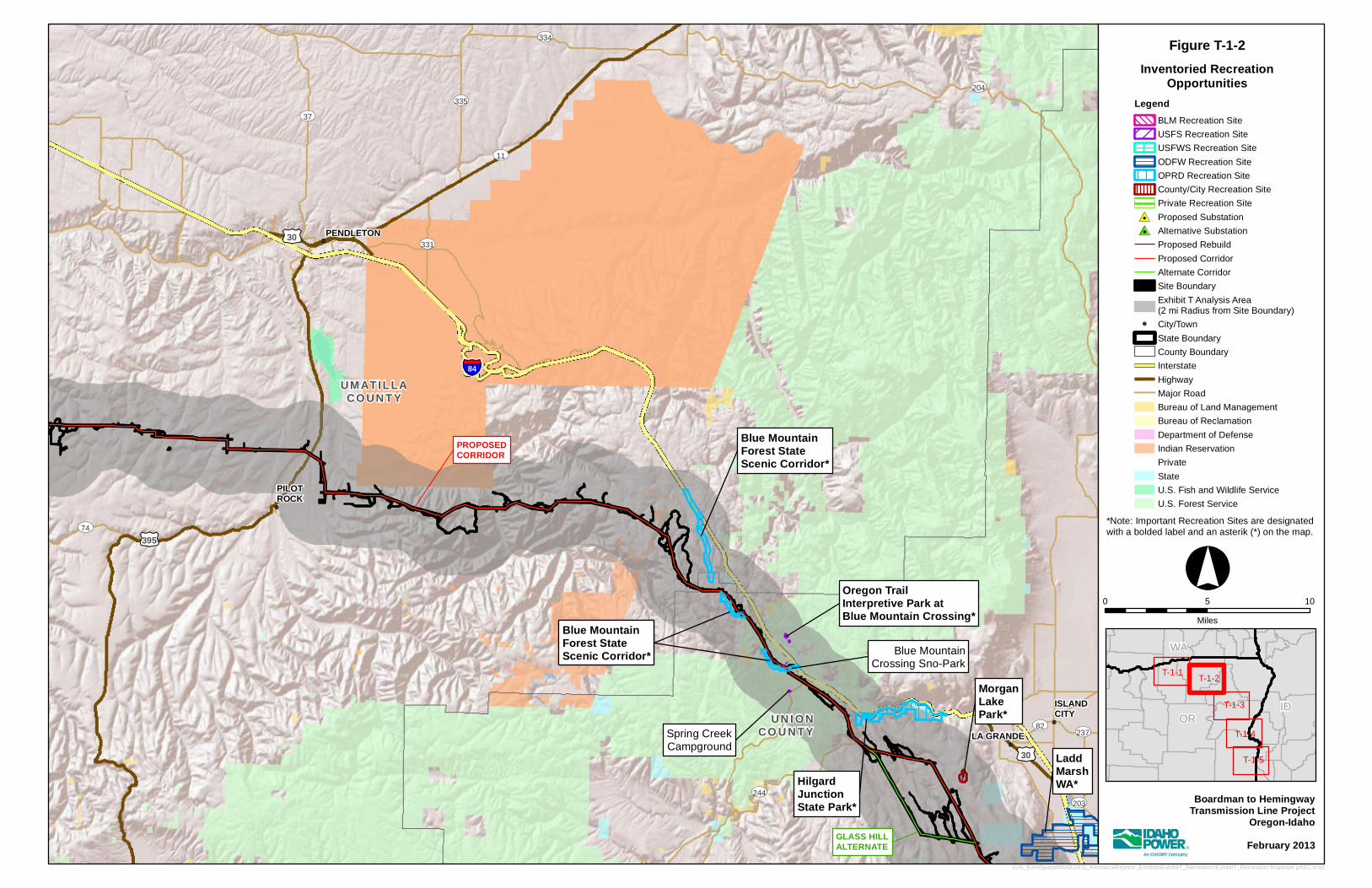
GLASS HILLALTERNATE
PROPOSEDCORRIDOR
Oregon TrailInterpretive Park atBlue Mountain Crossing*
Blue MountainForest StateScenic Corridor*
HilgardJunctionState Park*
LaddMarshWA*
MorganLakePark*
Spring CreekCampground
Blue MountainCrossing Sno-Park
Blue MountainForest StateScenic Corridor*Blue MountainForest StateScenic Corridor*
UV37
UV331
UV203
UV237
UV74
UV82
UV334
UV335
UV244
UV11
UV204
£¤30
£¤30
£¤395
§̈¦84UM AT IL LACO UN T Y
UN I O NCO U N T Y LA GRANDE
ISLANDCITY
PILOTROCK
PENDLETON
Boardman to HemingwayTransmission Line Project
Oregon-IdahoFebruary 2013
Inventoried RecreationOpportunities
°0 5 10
Miles
LegendBLM Recreation SiteUSFS Recreation SiteUSFWS Recreation SiteODFW Recreation SiteOPRD Recreation SiteCounty/City Recreation SitePrivate Recreation Site
#0 Proposed Substation#0 Alternative Substation
Proposed RebuildProposed CorridorAlternate CorridorSite BoundaryExhibit T Analysis Area(2 mi Radius from Site Boundary)
!( City/TownState BoundaryCounty BoundaryInterstateHighway Major RoadBureau of Land ManagementBureau of ReclamationDepartment of DefenseIndian ReservationPrivateStateU.S. Fish and Wildlife ServiceU.S. Forest Service
IDOR
WA
T-1-1T-1-2
T-1-3
T-1-4
T-1-5
\GIS_B2H\Spatial\MXD\2011_ResourceReports_Exhibits\ExhibitT_Recreation\ExhibitT_Recreation Mapbook pASC.mxd
Figure T-1-2
*Note: Important Recreation Sites are designated with a bolded label and an asterik (*) on the map.
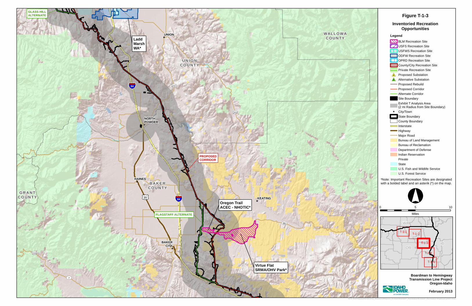
PROPOSEDCORRIDOR
GLASS HILLALTERNATE
FLAGSTAFF ALTERNATE
HilgardJunctionState Park*
Virtue FlatSRMA/OHV Park*
LaddMarshWA*
Oregon TrailACEC - NHOTIC*
LaddMarshWA*
UV220
UV237
UV7
UV86
UV203
£¤30 §̈¦84
§̈¦84
BA K E RCO U N T Y
G R A N TCO U N T Y
UN I O NCO U N T Y
WALL O WACOUN TY
BAKERCITY
KEATING
HAINES
NORTHPOWDER
UNION
Boardman to HemingwayTransmission Line Project
Oregon-IdahoFebruary 2013
Inventoried RecreationOpportunities
°0 5 10
Miles
LegendBLM Recreation SiteUSFS Recreation SiteUSFWS Recreation SiteODFW Recreation SiteOPRD Recreation SiteCounty/City Recreation SitePrivate Recreation Site
#0 Proposed Substation#0 Alternative Substation
Proposed RebuildProposed CorridorAlternate CorridorSite BoundaryExhibit T Analysis Area(2 mi Radius from Site Boundary)
!( City/TownState BoundaryCounty BoundaryInterstateHighway Major RoadBureau of Land ManagementBureau of ReclamationDepartment of DefenseIndian ReservationPrivateStateU.S. Fish and Wildlife ServiceU.S. Forest Service
IDOR
WA
T-1-1T-1-2
T-1-3
T-1-4
T-1-5
\GIS_B2H\Spatial\MXD\2011_ResourceReports_Exhibits\ExhibitT_Recreation\ExhibitT_Recreation Mapbook pASC.mxd
Figure T-1-3
*Note: Important Recreation Sites are designated with a bolded label and an asterik (*) on the map.
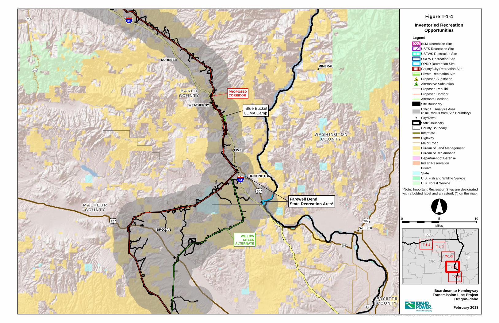
WILLOWCREEK
ALTERNATE
PROPOSEDCORRIDOR
Farewell BendState Recreation Area*Farewell BendState Recreation Area*
Blue BucketLDMA Camp
UV52
UV7
UV201
UV245
£¤30
£¤95£¤26
§̈¦84
§̈¦84
PAYETTECOUNTY
WA SH IN G TO NCO U NT Y
BA K E RCO U N T Y
M A L H E U RCO U N T Y
WEISER
MINERAL
BROGAN
HUNTINGTON
LIME
WEATHERBY
DURKEE
Boardman to HemingwayTransmission Line Project
Oregon-IdahoFebruary 2013
Inventoried RecreationOpportunities
°0 5 10
Miles
LegendBLM Recreation SiteUSFS Recreation SiteUSFWS Recreation SiteODFW Recreation SiteOPRD Recreation SiteCounty/City Recreation SitePrivate Recreation Site
#0 Proposed Substation#0 Alternative Substation
Proposed RebuildProposed CorridorAlternate CorridorSite BoundaryExhibit T Analysis Area(2 mi Radius from Site Boundary)
!( City/TownState BoundaryCounty BoundaryInterstateHighway Major RoadBureau of Land ManagementBureau of ReclamationDepartment of DefenseIndian ReservationPrivateStateU.S. Fish and Wildlife ServiceU.S. Forest Service
IDOR
WA
T-1-1T-1-2
T-1-3
T-1-4
T-1-5
\GIS_B2H\Spatial\MXD\2011_ResourceReports_Exhibits\ExhibitT_Recreation\ExhibitT_Recreation Mapbook pASC.mxd
Figure T-1-4
*Note: Important Recreation Sites are designated with a bolded label and an asterik (*) on the map.
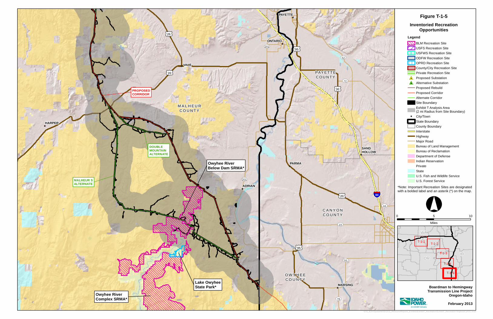
DOUBLEMOUNTAINALTERNATE
MALHEUR SALTERNATE
PROPOSEDCORRIDOR
Owyhee RiverComplex SRMA*
Owyhee RiverBelow Dam SRMA*
Lake OwyheeState Park*
UV72
UV44
UV78
UV19
UV55
UV201
UV52
UV201
£¤95
£¤26
£¤30
£¤20
£¤95
£¤20
§̈¦84
CA N Y O NCO U N T Y
O W Y H EECO U N T Y
PAYETTECOUNTY
M A L H E U RCO U N T Y
MARSING
PARMA
SANDHOLLOW
PAYETTE
ADRIAN
HARPER
VALE
ONTARIO
Boardman to HemingwayTransmission Line Project
Oregon-IdahoFebruary 2013
Inventoried RecreationOpportunities
°0 5 10
Miles
LegendBLM Recreation SiteUSFS Recreation SiteUSFWS Recreation SiteODFW Recreation SiteOPRD Recreation SiteCounty/City Recreation SitePrivate Recreation Site
#0 Proposed Substation#0 Alternative Substation
Proposed RebuildProposed CorridorAlternate CorridorSite BoundaryExhibit T Analysis Area(2 mi Radius from Site Boundary)
!( City/TownState BoundaryCounty BoundaryInterstateHighway Major RoadBureau of Land ManagementBureau of ReclamationDepartment of DefenseIndian ReservationPrivateStateU.S. Fish and Wildlife ServiceU.S. Forest Service
IDOR
WA
T-1-1T-1-2
T-1-3
T-1-4
T-1-5
\GIS_B2H\Spatial\MXD\2011_ResourceReports_Exhibits\ExhibitT_Recreation\ExhibitT_Recreation Mapbook pASC.mxd
Figure T-1-5
*Note: Important Recreation Sites are designated with a bolded label and an asterik (*) on the map.

Boardman to Hemingway Transmission Line Project Exhibit T
PRELIMINARY APPLICATION FOR SITE CERTIFICATE
ATTACHMENT T-2 LIST OF RECREATIONAL OPPORTUNITIES
IN THE ANALYSIS AREA

Boardman to Hemingway Transmission Line Project Exhibit T
PRELIMINARY APPLICATION FOR SITE CERTIFICATE Page T-1-1
Table T-2-1. Recreational Opportunities within the Analysis Area (within 2 Miles of the Site Boundary)
Recreational Opportunity Closest Milepost
Distance to Corridor from Property
Direction to
Corridor Visibility Within 0.5 Mile
Important Resource
Umatilla NWR - McCormack Unit 0.0 1.25 miles NW Unlikely No Yes Columbia Basin –Coyote Springs WA 1 0.0 mile Crossed Yes Yes No Blue Mountain Forest State Scenic Corridor 102.6 0.0 mile Crossed Yes Yes Yes Oregon Trail Interpretive Park at Blue Mountain Crossing
101 1.05 W No No Yes
Blue Mountain Crossing Day-Use Area/Sno-Park 102.8 0.25 SW Yes Yes No Spring Creek Campground 103.4 0.75 NE Yes No No Hilgard Junction State Park – Proposed Corridor 106.8 0.35 mile W Yes Yes Yes Hilgard Junction State Park – Glass Hill Alternate 0.0 1.27 miles NW No No Yes Morgan Lake Park 113 0.8 mile W No No Yes Ladd Marsh WA 117.6 1.3 miles S Yes No Yes Oregon Trail ACEC - NHOTIC Parcel (Proposed Corridor)
156.4 0.35 SE Yes Yes Yes
Oregon Trail ACEC - NHOTIC Parcel (Flagstaff Alternate Corridor Segment)
4.0 0.2 mile W Yes Yes Yes
Virtue Flat SRMA OHV Park – Proposed Corridor 156.2 0.0 mile Crossed Yes Yes Yes Virtue Flat SRMA OHV Park – Flagstaff Alternate 4.9 1.9 miles W No No Yes Blue Bucket LDMA Camp (Proposed Corridor and Rebuild)
190.8, 2.5
<0.1 mile 0.0 mile
W Crossed
Yes Yes No
Farewell Bend State Recreation Area – Proposed Corridor
198.4 5.0 miles NW Yes No Yes
Farewell Bend State Recreation Area – Willow Creek Alternate
0.4 1.8 miles W Yes No Yes
Owyhee River Below Dam SRMA – Proposed Corridor 260.8 0.2 mile NE Yes Yes Yes Owyhee River Below Dam SRMA – Malheur S Alternate
22.7 – 29.1
0.0 mile Crossed Yes Yes
Owyhee River Complex SRMA (Malheur S only) 25.9 1.5 mile S Yes No Yes Lake Owyhee State Park (Malheur S only) 25.9 2.2. mile S No No Yes ACEC – Area of Critical Environmental Concern NHOTIC – National Historic Oregon Trail Interpretive Center NWR – National Wildlife Refuge OHV – off-highway vehicle SRMA – Special Recreation Management Area WA – Wilderness Area

Boardman to Hemingway Transmission Line Project Exhibit T
PRELIMINARY APPLICATION FOR SITE CERTIFICATE
ATTACHMENT T-3 IMPORTANCE ASSESSMENT FOR RECREATIONAL
OPPORTUNITIES IN THE ANALYSIS AREA
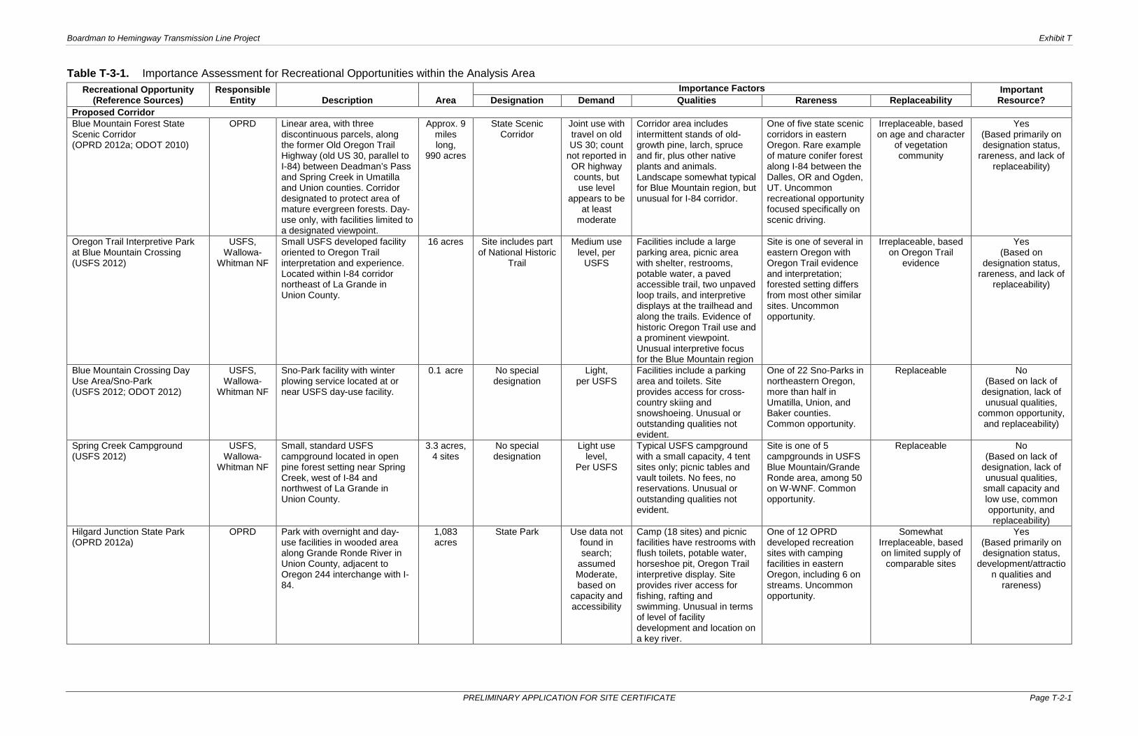
Boardman to Hemingway Transmission Line Project Exhibit T
PRELIMINARY APPLICATION FOR SITE CERTIFICATE Page T-2-1
Table T-3-1. Importance Assessment for Recreational Opportunities within the Analysis Area Recreational Opportunity
(Reference Sources) Responsible
Entity Description Area Importance Factors Important
Resource? Designation Demand Qualities Rareness Replaceability Proposed Corridor Blue Mountain Forest State Scenic Corridor (OPRD 2012a; ODOT 2010)
OPRD Linear area, with three discontinuous parcels, along the former Old Oregon Trail Highway (old US 30, parallel to I-84) between Deadman’s Pass and Spring Creek in Umatilla and Union counties. Corridor designated to protect area of mature evergreen forests. Day-use only, with facilities limited to a designated viewpoint.
Approx. 9 miles long,
990 acres
State Scenic Corridor
Joint use with travel on old US 30; count
not reported in OR highway counts, but use level
appears to be at least
moderate
Corridor area includes intermittent stands of old-growth pine, larch, spruce and fir, plus other native plants and animals. Landscape somewhat typical for Blue Mountain region, but unusual for I-84 corridor.
One of five state scenic corridors in eastern Oregon. Rare example of mature conifer forest along I-84 between the Dalles, OR and Ogden, UT. Uncommon recreational opportunity focused specifically on scenic driving.
Irreplaceable, based on age and character
of vegetation community
Yes (Based primarily on designation status,
rareness, and lack of replaceability)
Oregon Trail Interpretive Park at Blue Mountain Crossing (USFS 2012)
USFS, Wallowa-
Whitman NF
Small USFS developed facility oriented to Oregon Trail interpretation and experience. Located within I-84 corridor northeast of La Grande in Union County.
16 acres Site includes part of National Historic
Trail
Medium use level, per
USFS
Facilities include a large parking area, picnic area with shelter, restrooms, potable water, a paved accessible trail, two unpaved loop trails, and interpretive displays at the trailhead and along the trails. Evidence of historic Oregon Trail use and a prominent viewpoint. Unusual interpretive focus for the Blue Mountain region
Site is one of several in eastern Oregon with Oregon Trail evidence and interpretation; forested setting differs from most other similar sites. Uncommon opportunity.
Irreplaceable, based on Oregon Trail
evidence
Yes (Based on
designation status, rareness, and lack of
replaceability)
Blue Mountain Crossing Day Use Area/Sno-Park (USFS 2012; ODOT 2012)
USFS, Wallowa-
Whitman NF
Sno-Park facility with winter plowing service located at or near USFS day-use facility.
0.1 acre No special designation
Light, per USFS
Facilities include a parking area and toilets. Site provides access for cross-country skiing and snowshoeing. Unusual or outstanding qualities not evident.
One of 22 Sno-Parks in northeastern Oregon, more than half in Umatilla, Union, and Baker counties. Common opportunity.
Replaceable No (Based on lack of
designation, lack of unusual qualities,
common opportunity, and replaceability)
Spring Creek Campground (USFS 2012)
USFS, Wallowa-
Whitman NF
Small, standard USFS campground located in open pine forest setting near Spring Creek, west of I-84 and northwest of La Grande in Union County.
3.3 acres, 4 sites
No special designation
Light use level,
Per USFS
Typical USFS campground with a small capacity, 4 tent sites only; picnic tables and vault toilets. No fees, no reservations. Unusual or outstanding qualities not evident.
Site is one of 5 campgrounds in USFS Blue Mountain/Grande Ronde area, among 50 on W-WNF. Common opportunity.
Replaceable No (Based on lack of
designation, lack of unusual qualities, small capacity and low use, common opportunity, and replaceability)
Hilgard Junction State Park (OPRD 2012a)
OPRD Park with overnight and day-use facilities in wooded area along Grande Ronde River in Union County, adjacent to Oregon 244 interchange with I-84.
1,083 acres
State Park Use data not found in search;
assumed Moderate, based on
capacity and accessibility
Camp (18 sites) and picnic facilities have restrooms with flush toilets, potable water, horseshoe pit, Oregon Trail interpretive display. Site provides river access for fishing, rafting and swimming. Unusual in terms of level of facility development and location on a key river.
One of 12 OPRD developed recreation sites with camping facilities in eastern Oregon, including 6 on streams. Uncommon opportunity.
Somewhat Irreplaceable, based on limited supply of comparable sites
Yes (Based primarily on designation status,
development/attraction qualities and
rareness)

Boardman to Hemingway Transmission Line Project Exhibit T
PRELIMINARY APPLICATION FOR SITE CERTIFICATE Page T-2-3
Table T-3-1. Importance Assessment for Recreational Opportunities within the Analysis Area (continued)
Recreational Opportunity (Reference Sources)
Responsible Entity Description Area
Importance Factors Important Resource? Designation Demand Qualities Rareness Replaceability
Morgan Lake Park (City of La Grande 2009, 2012)
City of La Grande
City park with overnight and day-use facilities on a small reservoir 3 miles southwest of La Grande in Union County.
204.5 acres
City Park Assumed moderate, based on capacity
Site has 12 picnic tables and 5 barbecue pits, restroom, boat launch, floating dock, fishing piers. Opportunities for camping, picnicking, fishing, swimming and walking. Considered a regional park. Unusual setting and facilities for a municipal park resource.
One of 11 La Grande city park facilities; only one located outside of town and with camping. Uncommon opportunity close to a sizable community.
Somewhat Irreplaceable, based
on supply of comparable sites
Yes (Based primarily on unusual city park
qualities and rareness)
Ladd Marsh Wildlife Area (ODFW 2012)
ODFW Wildlife management area with three parcels and eight management units adjacent to I-84 and OR 203 southeast of La Grande in Union County. Open for wildlife-oriented recreation, with various seasonal and access restrictions.
6,019 acres
State Wildlife Area
Assumed moderate,
based on area size and use restrictions
Recreation access features include 18 small parking areas, a 1-mile nature trail and several foot trails. Restrooms, viewing blind and viewing platform at Tule Lake Access Area location. Unusual habitat within the region, widely known viewing opportunities.
Largest hardstem bulrush marsh in northeastern Oregon. Uncommon opportunity.
Essentially Irreplaceable, based
on key habitat
Yes (Based on
designation status, apparent use level,
rareness, and lack of replaceability)
Oregon Trail Area of Critical Environmental Concern (ACEC), National Historic Oregon Trail Interpretive Center (NHOTIC) Parcel (BLM 1989, 2011)
BLM, Vale District
Management designation applied to seven parcels of public lands (five in analysis area) with remnants of the Oregon National Historic Trail, managed to preserve the historic resources and visual qualities. Parcels are distributed along approximately 90 miles of the analysis area, within Union and Baker counties. Parcel including NHOTIC provides substantial recreation opportunities.
519 acres Area of Critical Environmental Concern and
National Historic Trail
High; 66,000 NHOTIC visits
in 2009
Largest ACEC parcel (500 acres) includes the National Historic Oregon Trail Interpretive Center (NHOTIC), which is a high-use visitor facility with major road access, trail system, outdoor interpretive displays and picnic areas. The other parcels have more limited access, minimal or no visitor facilities, and low use. Outstanding facility and opportunity for Oregon Trail interpretation.
NHOTIC is a unique facility and visitor attraction of national significance.
Irreplaceable, based on Oregon Trail
evidence
Yes (Based on
designation status, NHOTIC use level, outstanding quality,
rareness, and lack of replaceability)
Virtue Flat Special Recreation Management Area (SRMA) Off-Highway Vehicle (OHV) Park (BLM 2011, 2012a; OPRD 2012b)
BLM, Vale District
Area of public lands managed for OHV recreation, located east of Baker City in Baker County.
4,918 acres (3,560 acres for intensive
use), 61 miles of trails
Special Recreation
Management Area
9,000 visits in 2009
(Moderate)
Rolling sagebrush hills and rocky terrain provides variety of challenges for all types of OHVs, and excellent views of Elkhorn and Wallowa mountains. Site includes a staging area with seasonal restroom, loading ramp, information signs, and maps, and parking. Area reported to be considered a premier OHV destination.
Site is one of nine OHV areas in the Blue Mountain region. Common, based on number of similar opportunities.
Somewhat Irreplaceable, based on potential supply of sites suitable for OHV
use
Yes (Based on local and regional demand and
relative lack of replaceability)

Boardman to Hemingway Transmission Line Project Exhibit T
PRELIMINARY APPLICATION FOR SITE CERTIFICATE Page T-2-5
Table T-3-1. Importance Assessment for Recreational Opportunities within the Analysis Area (continued) Recreational Opportunity
(Reference Sources) Responsible
Entity Description Area Importance Factors Important
Resource? Designation Demand Qualities Rareness Replaceability Blue Bucket LDMA Camp (Gold Prospectors Association of America 2013)
LDMA-AU, Inc.
Privately-owned property used by members for recreational gold prospecting and associated camping. Access is via Valentine Lane from I-84, Exit 335.
140 acres None Assumed to be Low, based
on approximately
5,000 members and
14 similar properties
nationwide.
Camping use is secondary to recreational prospecting; some availability of electricity and water, with minimal other developed recreation facilities; property is crossed by Chimney Creek and 138, 69-kV lines, adjacent to I-84 and railroad. Substantially modified site with diminished attractiveness for recreation.
Apparently 1 of 14 similar properties available to LDMA members. Other properties operated for similar purposes not known in the analysis area, but prospecting opportunities on public and other private lands are widespread. Common.
Replaceable No (Based on low
demand, lack of outstanding qualities, common opportunity,
and replaceability)
Farewell Bend State Recreation Area (OPRD 2012a)
OPRD Moderate-sized state park system unit with overnight and day-use facilities on shoreline of Snake River/Brownlee Reservoir. Access is via U.S. Highway 30, near I-84 and Huntington.
86 acres State Recreation
Area
Use data not found in search;
assumed to be High, based
on large capacity and
mix of facilities
Main campground with capacity of 121 sites (91 utility sites with electricity and water and 30 tent sites); restrooms with flush toilets, hot showers, potable water. Separate hiker/biker camp area, group tent camp and two cabins. Day-use and support facilities include large picnic area, boat ramp, wastewater dump station, fishing dock, viewing deck, basketball and volleyball courts, and shelter with Oregon Trail interpretive displays. Outstanding opportunities for reservoir-oriented recreation.
One of 12 OPRD developed recreation sites with camping facilities in eastern Oregon, including 4 on lakes or reservoirs. Rare facility, based on size of reservoir, development level and setting.
Somewhat Irreplaceable, based
on supply of comparable sites
Yes (Based primarily on designation status, capacity/use level,
development/ attraction qualities
and rareness)
Owyhee River Below the Dam Special Recreation Management Area (SRMA) (BLM 2002)
BLM, Vale District
Area coincides with ACEC of the same name and incorporates Lower Owyhee River Watchable Wildlife Area, located southeast of Adrian and downstream from Owyhee Dam in Malheur County.
11,239 acres Special Recreation
Management Area (and
ACEC)
Low to Moderate,
depending on site; 8,200 visitors at
Snively Hot Springs and
9,600 at interpretive site in 1997
River corridor includes high-quality scenery and provides excellent opportunities for sightseeing/driving for pleasure, hiking/walking, viewing wildlife and historic resources, photography, hunting, fishing, camping, and water play. SRMA includes the existing Lower Owyhee Interpretive Site and the Snively Hot Springs partially developed recreation site. Unusual combination of desert canyon and river scenery, and accessibility.
Canyon scenery and variety of opportunities are uncommon.
Irreplaceable, based on river and canyon
Yes (Based on
designation status, unusual quality of
opportunities, rareness and lack of
replaceability)
Horn Butte Alternate Corridor Segment None

Boardman to Hemingway Transmission Line Project Exhibit T
PRELIMINARY APPLICATION FOR SITE CERTIFICATE Page T-2-7
Table T-3-1. Importance Assessment for Recreational Opportunities within the Analysis Area (continued) Recreational Opportunity
(Reference Sources) Responsible
Entity Description Area Importance Factors Important
Resource? Designation Demand Qualities Rareness Replaceability Longhorn Alternate Corridor Segment Umatilla National Wildlife Refuge (USFWS 2012b, 2008; Carver and Caudill 2007)
USFWS Relatively large area spanning the Columbia River in Oregon and Washington, with a mix of open water, wetland and upland habitats. Six total management units, with portion of McCormack Unit in the analysis area
25,000 total acres, 6,900
in McCormack
Unit
National Wildlife Refuge
75,700 total visits to all 6 units in 2006; Moderate for McCormack
McCormack Unit facilities include a boat ramp, trail and auto tour route; excellent opportunities for wildlife viewing and interpretation, hunting, fishing, and hiking. Unusual scale of water-oriented wildlife recreation opportunities.
Scope and variety of habitats is uncommon. Types of visitor opportunities are uncommon within the region.
Irreplaceable (based on effective ability to replace the habitats
that create the recreational
opportunities)
Yes (Based on
designation status, use level, rareness
and lack of replaceability)
Coyote Springs Wildlife Area (ODFW 2012)
ODFW Small wildlife management unit adjacent to I-84 east of Boardman in Morrow County. Open for wildlife-oriented recreation.
160 acres State Wildlife Area
Not reported; assumed to be Low, based on
site characteristics
Minimal facilities for recreation, primarily a small gravel parking lot for public access. Activities include bird watching and hunting, other than big game. Substantially modified site with adjacent transportation and utility facilities, resulting in reduced attractiveness as a recreation site.
Types of habitat and opportunities available at several other locations nearby. Common opportunity.
Replaceable (based on ability to replace the habitats and/or
acquire other property for on-site
recreational opportunities)
No (Based on limited use, quality of site
conditions, common opportunity, and replaceability)
Glass Hill Alternate Corridor Segment (No additional sites not listed above; Hilgard Junction State Park within analysis area) Flagstaff Alternate Corridor Segment (No additional sites not listed above; NHOTIC and Virtue Flat opportunities within analysis area) Double Mountain Alternate Corridor Segment None Malheur S Alternate Corridor Segment Owyhee River Complex Special Recreation Management Area (SRMA) (BLM 2002)
BLM, Vale District
Large area surrounding Owyhee Reservoir and the upper Owyhee River; contains more than 15 separate management units including wild and scenic river corridors, wilderness study areas, and ACECs, to be managed to protect resources and values associated with respective units.
462,134 acres
Special Recreation
Management Area
Use data not found in search;
assumed to be Low to High, depending on specific unit
SRMA includes outstanding river canyon scenery and whitewater boating, unique cultural sites, high-quality fishery, hiking, camping, sightseeing, and opportunities for solitude and primitive recreation.
Rare river canyon setting and variety of river-oriented recreation opportunities
Irreplaceable Yes (Based primarily on diversity and quality
of opportunities, rareness and lack of
replaceability)
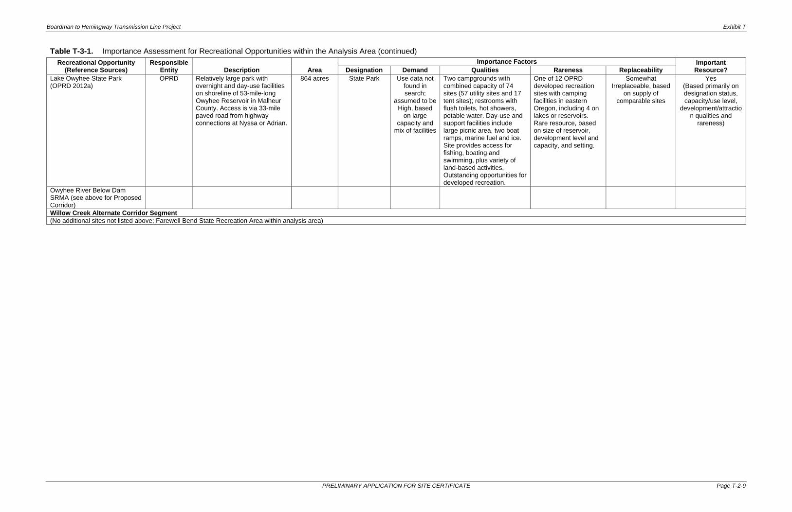
Boardman to Hemingway Transmission Line Project Exhibit T
PRELIMINARY APPLICATION FOR SITE CERTIFICATE Page T-2-9
Table T-3-1. Importance Assessment for Recreational Opportunities within the Analysis Area (continued) Recreational Opportunity
(Reference Sources) Responsible
Entity Description Area Importance Factors Important
Resource? Designation Demand Qualities Rareness Replaceability Lake Owyhee State Park (OPRD 2012a)
OPRD Relatively large park with overnight and day-use facilities on shoreline of 53-mile-long Owyhee Reservoir in Malheur County. Access is via 33-mile paved road from highway connections at Nyssa or Adrian.
864 acres
State Park Use data not found in search;
assumed to be High, based
on large capacity and
mix of facilities
Two campgrounds with combined capacity of 74 sites (57 utility sites and 17 tent sites); restrooms with flush toilets, hot showers, potable water. Day-use and support facilities include large picnic area, two boat ramps, marine fuel and ice. Site provides access for fishing, boating and swimming, plus variety of land-based activities. Outstanding opportunities for developed recreation.
One of 12 OPRD developed recreation sites with camping facilities in eastern Oregon, including 4 on lakes or reservoirs. Rare resource, based on size of reservoir, development level and capacity, and setting.
Somewhat Irreplaceable, based
on supply of comparable sites
Yes (Based primarily on designation status, capacity/use level,
development/attraction qualities and
rareness)
Owyhee River Below Dam SRMA (see above for Proposed Corridor)
Willow Creek Alternate Corridor Segment (No additional sites not listed above; Farewell Bend State Recreation Area within analysis area)