EXHIBIT 1 - Riverkeeper 1 . United States Fish ... FWS Final Comments on Draft Environmental Impact...
128
EXHIBIT 1 United States Fish and Wildlife Service, Letter to National Park Service Enclosing FWS Final Comments on Draft Environmental Impact Statement (DEIS) for the Tappan Zee Hudson River Crossing Project 87/287, Rockland and Westchester Counties, NY (March 1, 2012)
Transcript of EXHIBIT 1 - Riverkeeper 1 . United States Fish ... FWS Final Comments on Draft Environmental Impact...

EXHIBIT 1
United States Fish and Wildlife Service, Letter to National Park Service Enclosing FWS Final Comments on Draft Environmental Impact Statement (DEIS) for the Tappan Zee Hudson River Crossing Project 87/287, Rockland and Westchester
Counties, NY (March 1, 2012)


EXHIBIT 2
United States Fish and Wildlife Service Comments on draft DEIS Chapter 18- Construction Impacts (December 2011)

DRAFT for Cooperating Agency Review 18-1 December 5, 2011
Chapter 18: Construction Impacts
18-1 INTRODUCTION This chapter describes the construction means and methods of the Long Span and Short Span Options for the Replacement Bridge Alternative and assesses the potential environmental impacts associated with these activities. The two options would be constructed using the same general construction sequencing and methods over an approximately 4½ to 5½ year period. Provided in Section 18-2 of this chapter is a description of the overall construction sequencing and schedule for both the Long and Short Span Options. Section 18-3 includes a more detailed description of the construction methods and equipment that would be used to complete each of the key project elements. As discussed below, much of the work for the project would be performed from barges in the river as well as temporary platforms along both shorelines of the Hudson River. The potential adverse environmental effects as well as any proposed measures to avoid, minimize, or mitigate adverse effects are also discussed.
The construction means and method presented in this chapter are based on the current level of engineering design, discussions with contractors, and past experience on similar projects. While the techniques ultimately utilized for the project may vary to some degree, the process described below presents the most likely scenario for construction of the project. While some flexibility is available within the overall means and methods, the environmental impacts and types of mitigation measures would likely be the same.
With the above in mind, this chapter does not include an analysis of those elements of construction that would be at the contractor’s discretion and are unknown at this time. Those elements would include construction staging, in lieu of, or in addition to the two privately owned sites discussed below; disposal and borrow sites; sites used for the pre-fabrication of bridge components outside the immediate vicinity of the project and the production of concrete at existing permitted batch plants. In accordance with FHWA policy independent decisions by the contractor, unless effectively dictated by the project sponsor, are beyond the scope of the federal action. Furthermore, NYSDOT Standard Specifications for all construction contracts require the contractor to comply with all applicable environmental regulations and obtain all necessary approvals and permits for the course of construction.
In an effort to avoid and/or minimize potential adverse effects during construction of the project, a number of Environmental Performance Commitments (EPCs) have been identified which will be included as part of the project’s construction contracts. The EPCs are identified and discussed where applicable below.
Comment [TC1]: These are elements which we need to understand in order to adequately analyze potential impacts to trust resources.

Tappan Zee Hudson River Crossing Project Environmental Impact Statement
18-2
18-2 CONSTRUCTION SEQUENCE AND SCHEDULE As shown in Figure 18-1, construction of the Short Span Option would take approximately 5½ years. The schedule shows both preliminary activities used to support the construction of the project (i.e., dredging and temporary platforms) as well as individual elements of bridge construction (i.e., main span and approaches). Throughout the construction period roadway work would be required at various times. During that time, the approach roadways would be shifted and remain in the new location for an extended period before being shifted again. The dredging would occur in three 3-month phases over a 4-year period, and construction of the main span would consist of approximately 3½ years of construction. Completion of the short span approaches would involve approximately 3½ to 4 years of construction. Demolition of the existing Tappan Zee Bridge would be expected to span approximately 1 year.
Construction of the Long Span Option would last approximately 4½ years. The construction sequence and schedule would be similar to that of the Short-Span Option with the exception of the construction of the approaches, which would be expected to take approximately 2½ to 3 years.
18-2-1 LANDINGS
Landings would employ typical highway construction techniques and would be completed on both the Westchester and Rockland sides of the Hudson River upland from the bridge abutment to the tie in with the existing roadway. Construction of the landings would occur throughout the duration of the construction. The construction activity for the landings, however, would be gradual, as the roadways on both sides would be altered and then maintained for lengthy spans of time before being altered again. The alterations to the landings would consist of changes in roadway grade, elevation, direction, and general configuration.
18-2-2 APPROACHES
Beginning at the abutments, the approaches carry traffic from the land to the main span of the bridge. Construction of the approaches would last for approximately three and a half to four years for the short-span alternative, and two and a half to three years for the long-span alternative. The piles, pile caps, piers, and deck that compose this segment of the bridge would be built sequentially so that as a new pile is being constructed, a completed pile would be undergoing further transformation with, for example, the addition of a pile cap.
18-2-3 MAIN SPANS
The main span would stretch between the Westchester and Rockland approaches. It is the segment of the bridge that would be defined largely by its superstructure design as an arch or cable stayed bridge. Within its substructure, the piers would be more substantial than those of the approaches. All main span work would be done sequentially and in a similar manner as that of the approaches. The piles, pile caps, pylons, and deck construction would last approximately three and a half years.
Comment [TC2]: Where are these techniques described?

Chapter 18: Construction Impacts
18-3
18-3 CONSTRUCTION OF KEY ELEMENTS Construction of either option of the Replacement Bridge Alternative would require a wide range of activities on both sides of the river as well as from within the waterway itself. In addition, due to the lack of available land along the waterfront in the vicinity of the bridge, staging areas at some distance from the construction site would be required. Furthermore, it is likely that some bridge components would be pre-fabricated well outside the study area and transported to the site via barge.
To support construction of the main span and bridge approaches, materials, equipment, and crews would be transported from upland staging areas in Westchester and Rockland counties to temporary platforms that would be constructed on the shoreline of the river, as shown in Figure 18-2. Dredged channels would provide access to the two work areas in the shallow portion of the river crossing: the Rockland and Westchester approaches. Substructure construction would establish the foundation of the bridge through the processes of pile driving, construction of pile caps, and construction of columns. Superstructure construction would then take place either with a gantry that would move from pier to pier lifting segments from barges below (as in the case of the short-span design option) or a short pier-head truss segment would be lifted atop the next open pier column and secured (as in the case of the long-span option).
18-3-1 WATERFRONT CONSTRUCTION STAGING
The shoreline areas near the proposed bridge site are limited by adjacent development. In order to provide space for the docking of vessels, the transfer of materials and personnel, and the preparation of construction elements, temporary platforms would be extended out from the shoreline over the Hudson River (see Figures 18-3 and 18-4). The Rockland platforms would protect the shoreline and also enable the continued maintenance of the original Tappan Zee Bridge as well as providing continued support for the New York State Thruway Authority (NYSTA) Dockside Maintenance facility operation. The number of acres that the footprint of the platforms would occupy would depend upon the available upland area and the bridge option selected. Upon the delineation of the work area, steel piles would be driven to support the platforms. These platforms would provide access to the replacement bridge site via temporary trestles. Their main purposes would be to facilitate delivery of heavy duty bridge elements from an offsite fabrication facility, receive deliveries from the concrete batch plant, receive deliveries (i.e., construction equipment and light duty bridge elements) from the staging areas, and allow for barge-mounted cranes to erect heavy duty bridge elements. Upon completion of construction, the temporary platforms and the piles that support them would be removed.
As the construction of the temporary platforms and access trestles would begin at the shoreline, an access road and work area near the shore would also be constructed. A channel would be dredged specifically to provide barge access to the temporary platforms from in-river work sites.
18-3-2 IN-LAND CONSTRUCTION STAGING
For a project of this size, additional construction staging beyond the waterfront staging areas would be required to accommodate a number of functions. A contractor may utilize one large site or possibly use multiple sites to satisfy their specific construction

Tappan Zee Hudson River Crossing Project Environmental Impact Statement
18-4
needs. While the contractor may or may not choose to use the sites discussed below, based on their proximity to the project site, available size, surrounding land uses and access to the Thruway, these sites are likely candidates and provide a reasonable scenario to assess the potential impacts that may occur from the operation of a construction staging area in Westchester or Rockland Counties. While it is likely that the contractor may use a number of sites throughout the area to stage construction, the analysis in this document for the two in-land sites conservatively assumes that all activities would occur at one of the two sites. As noted above, at any staging areas ultimately utilized for construction of the project, the contractor would be required to obtain all of the necessary permits and approvals for each and any site.
18-3-2-1 FUNCTIONS
Concrete Batch Plant
One or more concrete batch plants could be utilized to provide the concrete needed to construct the bridge foundation, piers, and deck. Typically, a batch plant would occupy approximately 3 acres of land. The location for the plant would be strategically assigned such that the material will be deliverable to the construction site within 90 minutes of load-out at the plant in order to allow concrete to be poured before curing in the truck. For the purpose of this analysis, it was assumed that 40 percent of the concrete needed for construction would be supplied by a batch plant at one of the two sites discussed below. The remaining 60 percent would be supplied by existing concrete batching facilities in Rockland and/or Westchester Counties.
Laydown/Storage Area
The assembly sites would offer space to complete many tasks throughout the course of construction. Unassembled construction equipment would be delivered to and assembled within these sites. Light duty bridge components would also be delivered to and stored within the assembly sites until they are ready to be utilized at the construction site.
Office/Administrative and Support Space
Office space would be required for construction administration and engineering staff. Interconnected trailers adjacent to the assembly sites would be ideal structures to support this need. It would also be possible, however, for the contractor to rent office space in nearby communities if the trailers are unattainable for any reason. Designated parking for all employees would be a consideration. It will be preferable to have on site space allocated for this purpose but, if necessary, employees would be shuttled from remote parking areas to the construction sites.
18-3-2-2 POTENTIAL CONSTRUCTION STAGING AREAS
Four inland staging sites are discussed below—two privately-owned properties and two parcels within the NYSTA’s right-of-way. While the sites within the Thruway right-of-way would definitely be used for construction staging, additional sites would be required. The two privately-owned properties in Rockland County discussed below are likely candidate sites which could supply the needed area for construction staging outside the project’s right-of-way. As such, an analysis of these two sites is included in the construction impact assessment. However, as noted above, the contractor is not
Comment [TC3]: How might this affect timing of the project?
Comment [TC4]: Is there a likelihood that they will be located in different locations?

Chapter 18: Construction Impacts
18-5
obliged to use the privately owned sites and they are included in this document for a discussion of the possible environmental effects if they were used as part of the project’s construction. With this analyze, the impacts can be understood wherever the staging area may be.
West Nyack Staging Area (WNSA) Site
The potential West Nyack Staging Area Site occupies approximately 33 acres of land near Interchange 12 south of the Palisades Mall at the intersection of Routes 59 and 303. Only 3.7 miles from the Rockland Bridge Staging Area, WNSA has the additional benefit of currently operating its own concrete batch plant. In addition, the relatively large expanse allows for potential accommodation of office trailers and parking lots. Light duty items may be stored and assembled here. To access the construction site, vehicles would travel on Route 303, entering the Thruway at Interchange 12 before exiting onto a temporary ramp located west of the bridge. From the temporary ramp, vehicles would pass onto River Road and travel under the existing Tappan Zee Bridge onto the temporary platforms of the Rockland Landing Dock Facility, as shown in Figure 18-3. Concrete trucks would drive onto barges by way of the docks. All other vehicles would deliver their stock to waterborne vessels. Delivery of batched concrete to the Tarrytown abutment is expected to take about 90 minutes.
Tilcon Quarry Staging Area (TQSA) Site
The potential Tilcon Quarry Staging Area, which is directly north of the Thruway and opposite the Palisades Mall, is an exceptionally large quarry site operated by Tilcon. Measuring approximately 120 acres, this site would have the capacity to contain many of the facets required for construction operations. In addition, this site is adjacent to the CSX West Shore Line and could potentially provide materials to be used during construction. Although the site is currently in operation, it may be possible to lease a portion of the space. The site is accessible via Interchange 12 of the Thruway and access to the construction site would be similar to that described above for the WNSA.
Westchester Inland Staging Area (WISA) Site
Presently used by the NYSTA’s Tappan Zee Bridge Maintenance Facility, Bridge Patrol, Equipment Maintenance, and the local station of New York State Police (NYSP) Troop T, the triangle of land located north of I-87 and opposite the toll plaza is a possible location for staging on the Westchester side of the Hudson River, as shown in Figure 18-4. The Westchester Inland Staging Area currently contains a westbound on-ramp from southbound Route 9 which would be removed during construction staging. Highway access to WISA is available directly to the westbound I-287 shoulder, eastbound from I-287 by a short restricted-use ramp leading south of the Toll Plaza to the administrative area, and from South Broadway via Interchange 9. In order to access the Westchester Bridge Staging Area, vehicles would travel along the north-south access road under the Tappan Zee Bridge. From there, they would pass onto a temporary haul road that will be constructed in order to bring trucks over the Metro-North Railroad (MNR) Hudson Line to the Westchester Bridge Staging Area (WBSA).
Interchange 10
The vacant land included within the footprint of the existing interchange may be utilized for construction support for the RBSA. This site measures approximately 7.4 acres. This
Comment [TC5]: This is not necessarily true. There may be site-specific issues which cannot be analyzed without knowing where these sites are located.
Comment [TC6]: Is this a completely developed site or are there any natural resources on or near this site?
Comment [TC7]: See comment above.
Comment [TC8]: See comment above.
Comment [TC9]: See comment above.

Tappan Zee Hudson River Crossing Project Environmental Impact Statement
18-6
site would most likely be used as a laydown/storage area for unassembled construction equipment, light duty bridge elements such as sheet piles, reinforcing bars and cables and other material delivery and storage.
18-3-3 DREDGED ACCESS CHANNEL
Since the proposed bridge alignment spans extensive shallows, it would be necessary to dredge an access channel for tugboats and barges to utilize during construction of the approach spans. These vessels would be instrumental in the installation of cofferdams, pile driving, the construction of pile caps and bridge piers, and the erection of bridge decks and other superstructure components. As noted earlier, temporary, trestle-type access platforms would be constructed near the shoreline to provide access for construction vehicles that would operate on the trestles. This would avoid the need to dredge the near-shoreline area.
Two alternate construction methods were evaluated in an effort to avoid the need to dredge an access channel. One method involved the use of overhead gantries for the construction of foundations and the other consisted of the implementation of a full-length temporary trestle for access. Both of these alternatives were found to be impractical: the former because it is not practicable for the heavy-duty pile-driving requirements of the replacement bridge and the latter because the deep soft soils in the shallow waters of the construction zone would require foundations that would be expensive and time-consuming to construct.
As shown in Figure 18-5, dredging would be conducted in three stages over a 4-year period for a duration of 3 months each year. The purpose of the first two dredging stages (Years 1 and 2) would be to provide access for bridge construction, while the final dredging stage (Year 4) would provide access for demolition of portions of the existing bridge allowing completion of the remaining portions of the new structure. Each of these three-month spans would occur during the limited fall window when dredging is typically allowed in the New York Harbor/Hudson River Estuary area; this is the period when dredging activities would have the minimum effect on aquatic resources.
Based on an analysis of the types, number, size and operation of vessels that would operate in the access channel during construction, it was determined that a clear draft of 12 feet would be required within the access channel. To avoid the potential for grounding of vessels, an additional two feet would be added to provide a working channel depth of 14 feet at the lowest observed water level, which occurs during the Spring Neap Tide. The lowest observed water level is referred to as Mean Low Low Water (MLLW).
In addition, to minimize any adverse effects from the re-suspension of the fine sediment material due to movement of vessels, particularly tugboats, within the dredged channel, a layer of sand and gravel (referred to as “armor”) would be placed at the bottom of the channel following dredging. As discussed below in Section 18-4-12 (Water Resources) the sediments in the vicinity of the area to be dredged are highly susceptible to resuspension into the water column. Without “armoring,” prop scour from working tugboats in the channel would result in the generation of suspended sediment at rates several orders of magnitude greater than what would occur from the dredging operation itself. Therefore, it was concluded that this level of sediment resuspension and ultimate
Comment [TC10]: The substrate of the Hudson River contains a number of environmental contaminants and dredging activities would be likely to disturb these contaminants and place them into suspension within the water quality. You need to analyze (1) what contaminants are known to exist in these areas; (2) how much or to what degree these contaminants will be disturbed and to what degree water quality would be affected; and (3) what impacts will these affects have on natural resources and human health.
Comment [TC11]: The draft EIS should contain a complete analysis of all alternatives considered.
Comment [s12]: •The document should specify the three months when drEndangered Species Act (16 USC §§ 1531-1544; 50 CFR Part 402). Section 7 of this Act requires FHWA to consult with the U.S. Fish and Wildlife Service (USFWS) for any project activities that may jeopardize threatened or endangered species or destroy or adversely modify their critical habitats. Coordination with the National Marine Fisheries Service (NMFS) will also be required for this project due to its location in a marine environment.
edging would occur.
Comment [TC13]: Will the entire bridge be removed?
Comment [s14]: Location of armoring should be depicted on a figure and referenced here.

Chapter 18: Construction Impacts
18-7
transport into the river would pose an unnecessary and potentially substantive adverse effect to the environment.
The installation of the stone or gravel would take place as soon as the dredging for that section of the channel was successfully completed, forming a protective layer to keep sediment from further disturbance. Without this protective layer, additional dredging would be required to create a deeper work zone. The stone or gravel materials would be delivered by barges or scows, and would be placed within the channel by barge-mounted cranes. The materials would not be removed after the project completion, since they would become fully buried by the gradual deposition of river sediments over time. The dredging depth required assumes that two feet of stone or gravel armor is placed on the bottom. In total, the channel would be dredged to a depth corresponding to 16 feet below MLLW1.
Table 18-1 shows the amount of material to be dredged during each stage for the two bridge design options. For either design option, the channel width would measure approximately 475 to 530 feet, and it would extend approximately 7,000 feet from the Rockland County side into deeper waters and 2,000 feet from the Tarrytown access trestle into deeper waters. Because the long span alternative would occupy a wider footprint, a slightly larger area must be dredged for that alternative. It is estimated that approximately 1.68 and 1.74 million cubic yards of sediment would be dredged for the short and long span options, respectively.
Table 18-1 Dredging Quantities for the Replacement Bridge Alternatives
Construction Stage
Short Span Long Span Quantity
(million CY) Percent of Total Quantity
(million CY) Percent of Total Stage 1 1.08 64% 1.12 64% Stage 2 0.42 25% 0.43 25% Stage 3 0.18 11% 0.19 11%
Total 1.68 100% 1.74 100% Notes: CY = cubic yards Dredging for bridge demolition (Stage 3) includes that portion of the bridge which must be removed to
complete the Replacement Bridge Alternative tie-in.
Environmental Performance Commitments (EPCs) to be used during dredging operations include:
Adherence to a 3-month fall window when dredging would be allowed;
Use of an environmental bucket with no barge overflow; and
Armoring of the channel to prevent re-suspension of sediment during the movement of construction vessels, installation and removal of cofferdams, and pile driving.
1 Since the elevation of MLLW is -1.9 feet below datum in the project’s design drawings the actual elevation of the
dredging as referenced in the design and permit documents is -17.9 feet or approximately -18 feet.
Comment [TC15]: Is this intended as a temporary impact during construction? What remedial actions will be taken after construction is completed? What are the environmental impacts of the armoring? Where will it take place—what currently exists there (e.g., plant or animal resources)—chapter 16 references SAV, etc? What would be lost or degraded and what would that do to aquatic plants and animals?
Comment [TC16]: This still does not address what impact this armoring will have. Also, the deposition of river sediments on top of an unnatural substrate is unlikely to mimic a natural river bottom. The DEIS needs to clearly explain what the impacts of armoring will be and what loss of natural resources will result. Additionally, we generally recommend that the natural bottom be restored post-construction and any short term impacts to natural resources be mitigated. The appropriate measures would depend upon what the impacts are. Please clarify.
Comment [s17]: Again, the document should specify the months when dredging would occur.

Tappan Zee Hudson River Crossing Project Environmental Impact Statement
18-8
18-3-4 TRANSPORT AND DISPOSAL OF DREDGED MATERIAL
During each three-month period when dredging is occurring, dredged materials would be collected from the bottom of the river by barge-mounted cranes placed into hopper scows, which are boats with a capacity of approximately 2,500 cubic yards. To ensure that the scows do not exceed the maximum allowable draft of the river work zone, they would be limited to 80 percent of their maximum load, or 2,000 cubic yards per load.
Each dredging stage would occur during a 90-day period. During that period, it is estimated that dredging would occur up to 75 of the 90 days, with two dredge operations occurring at a time. During the busiest dredging stage, Stage 1, up to 15,000 cubic yards of materials would be dredged each day. Table 18-2 presents the estimated daily volumes of materials removed for each dredging stage for the two replacement bridge alternatives.
Table 18-2 Daily Materials Removal by Construction Stage
Construction Stage
Short Span Daily Volume (cubic yards)
Long Span Daily Volume (cubic yards)
Stage 1 14,600 15,000 Stage 2 5,700 5,800 Stage 3 2,400 2,600
After placement in the hopper scows, the next step in the dredge materials handling would depend on the dredge placement option selected.
As discussed above in the introduction of this chapter, certain activities related to project construction are left to the discretion of the contractor. One of these specific activities would be the ultimate transport and disposal of dredge spoils from construction of the access channel. Transport by ocean scow and placement in the Historic Area Remediation Site (HARS) in the New York Bight would offer a number of benefits to the project including cost, schedule, logistics and the avoidance of impacts to the surrounding residential communities on the Rockland and/or Westchester shorelines.
In this option, the dredged materials would be transported to HARS, 3.5 miles east of Sandy Hook, NJ. The HARS is overseen by the U.S. Army Corps of Engineers (USACE) and the U.S. Environmental Protection Agency (USEPA). This site was historically used for ocean disposal of dredged material and a variety of waste products, including some contaminated materials. Today, the site is being remediated through a program to cap those historic sediments with cleaner sediments dredged from New York Harbor that meet certain criteria established by the Ocean Dumping Act.
A permit is required for dredged material to be placed at the HARS from the USACE for that placement. To receive the permit, the materials must be suitable for remediation, in that they meet certain criteria related to contaminants based on sediment toxicity and bioaccumulation tests. In addition, in accordance with 40 CFR §227.16, the USEPA must evaluate alternative disposal options before permitting placement of dredged material at the HARS, and must find that there are no practicable alternative locations
Comment [TC18]: We note that sediment concentrations of copper, lead, mercury, PCBs and PAHs (in particular) were reported in excess of thresholds that categorize them as Class C sediments according to the 2004 “NYSDEC In-water and Riparian Management of Sediment and Dredged Materials” (Tables 15-3, 15-4, 15-5) . Class C sediments should be dredged using a closed bucket or other method that minimizes resuspension . There should be no barge overflow, which you state above. Most importantly, in-water disposal is generally not acceptable for Class C sediment, making the HARs site potentially unsuitable. FHWA should provide further support for use of this disposal site and consider upland contained options for disposal of these sediments.
Comment [TC19]: What about impacts to natural resources within the river and in the vicinity of the disposal site?
Comment [TC20]: Describe these criteria.
Chapter 18: Construction Impacts
18-9
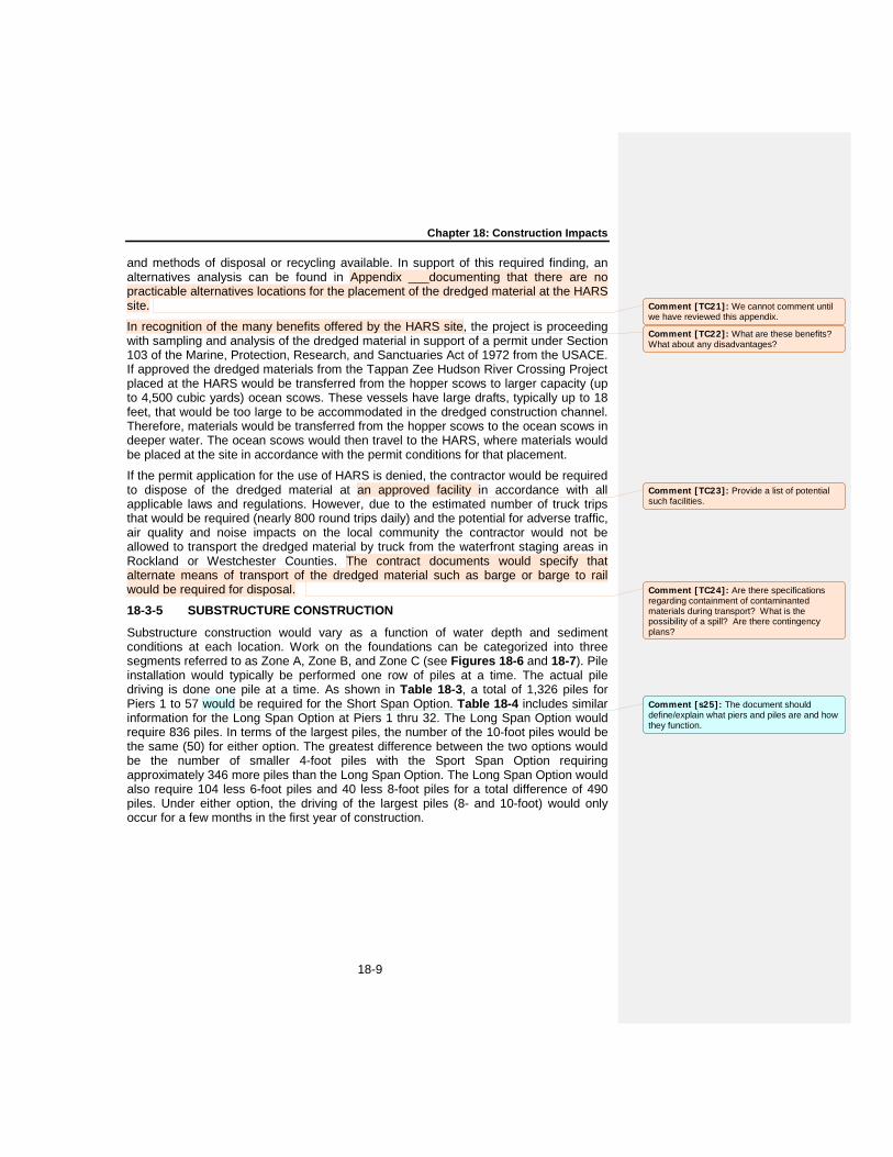
and methods of disposal or recycling available. In support of this required finding, an alternatives analysis can be found in Appendix ___documenting that there are no practicable alternatives locations for the placement of the dredged material at the HARS site.
In recognition of the many benefits offered by the HARS site, the project is proceeding with sampling and analysis of the dredged material in support of a permit under Section 103 of the Marine, Protection, Research, and Sanctuaries Act of 1972 from the USACE. If approved the dredged materials from the Tappan Zee Hudson River Crossing Project placed at the HARS would be transferred from the hopper scows to larger capacity (up to 4,500 cubic yards) ocean scows. These vessels have large drafts, typically up to 18 feet, that would be too large to be accommodated in the dredged construction channel. Therefore, materials would be transferred from the hopper scows to the ocean scows in deeper water. The ocean scows would then travel to the HARS, where materials would be placed at the site in accordance with the permit conditions for that placement.
If the permit application for the use of HARS is denied, the contractor would be required to dispose of the dredged material at an approved facility in accordance with all applicable laws and regulations. However, due to the estimated number of truck trips that would be required (nearly 800 round trips daily) and the potential for adverse traffic, air quality and noise impacts on the local community the contractor would not be allowed to transport the dredged material by truck from the waterfront staging areas in Rockland or Westchester Counties. The contract documents would specify that alternate means of transport of the dredged material such as barge or barge to rail would be required for disposal.
18-3-5 SUBSTRUCTURE CONSTRUCTION
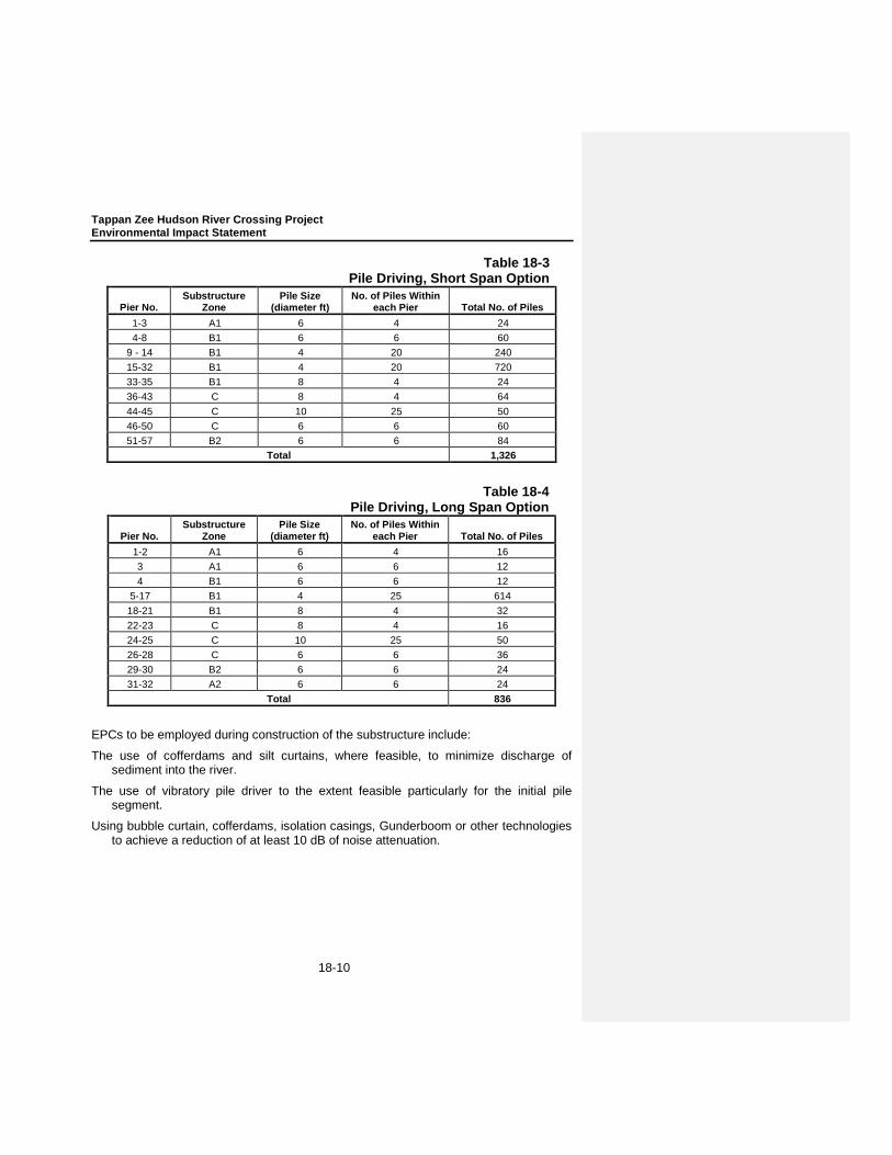
Substructure construction would vary as a function of water depth and sediment conditions at each location. Work on the foundations can be categorized into three segments referred to as Zone A, Zone B, and Zone C (see Figures 18-6 and 18-7). Pile installation would typically be performed one row of piles at a time. The actual pile driving is done one pile at a time. As shown in Table 18-3, a total of 1,326 piles for Piers 1 to 57 would be required for the Short Span Option. Table 18-4 includes similar information for the Long Span Option at Piers 1 thru 32. The Long Span Option would require 836 piles. In terms of the largest piles, the number of the 10-foot piles would be the same (50) for either option. The greatest difference between the two options would be the number of smaller 4-foot piles with the Sport Span Option requiring approximately 346 more piles than the Long Span Option. The Long Span Option would also require 104 less 6-foot piles and 40 less 8-foot piles for a total difference of 490 piles. Under either option, the driving of the largest piles (8- and 10-foot) would only occur for a few months in the first year of construction.
Comment [TC21]: We cannot comment until we have reviewed this appendix.
Comment [TC22]: What are these benefits? What about any disadvantages?
Comment [TC23]: Provide a list of potential such facilities.
Comment [TC24]: Are there specifications regarding containment of contaminanted materials during transport? What is the possibility of a spill? Are there contingency plans?
Comment [s25]: The document should define/explain what piers and piles are and how they function.
Tappan Zee Hudson River Crossing Project Environmental Impact Statement
18-10
Table 18-3 Pile Driving, Short Span Option
Pier No. Substructure
Zone Pile Size
(diameter ft) No. of Piles Within
each Pier Total No. of Piles 1-3 A1 6 4 24 4-8 B1 6 6 60
9 - 14 B1 4 20 240 15-32 B1 4 20 720 33-35 B1 8 4 24 36-43 C 8 4 64 44-45 C 10 25 50 46-50 C 6 6 60 51-57 B2 6 6 84
Total 1,326
Table 18-4 Pile Driving, Long Span Option
Pier No. Substructure
Zone Pile Size
(diameter ft) No. of Piles Within
each Pier Total No. of Piles 1-2 A1 6 4 16 3 A1 6 6 12 4 B1 6 6 12
5-17 B1 4 25 614 18-21 B1 8 4 32 22-23 C 8 4 16 24-25 C 10 25 50 26-28 C 6 6 36 29-30 B2 6 6 24 31-32 A2 6 6 24
Total 836
EPCs to be employed during construction of the substructure include:
The use of cofferdams and silt curtains, where feasible, to minimize discharge of sediment into the river.
The use of vibratory pile driver to the extent feasible particularly for the initial pile segment.
Using bubble curtain, cofferdams, isolation casings, Gunderboom or other technologies to achieve a reduction of at least 10 dB of noise attenuation.

Chapter 18: Construction Impacts
18-11
Using the results of the Hudson River site specific PIDP1 to inform the project on the effectiveness of BMP technologies for reducing sound levels, and implementing BMPs to achieve maximum sound reduction.
Limiting the periods of pile driving to no more than 8 to 12-hour day.
Pile tapping (i.e., a series of minimal energy strikes) for an initial period to frighten fish.
Development of a comprehensive monitoring plan. Elements would include:
- Monitoring locations to characterize the hydroacoustic field surrounding pile driving operations with locations and distances from pile driving established on the basis of sound levels established by NMFS as potential for impact;
- Monitoring of fish mortality and predation levels by gulls and other piscivorous birds; and
- Development of criteria for re-initiating consultation with NMFS should specific numbers of shortnose or Atlantic sturgeon come to the surface wounded or dead.
18-3-5-1 FOUNDATION ZONE A
The two areas of shallowest water depth extend from the shorelines on the Rockland and Westchester sides of the Hudson. These areas, where the water measures less than 7 feet in depth, are labeled as Zone A. The area adjacent to the Rockland shoreline is labeled Zone A1, while the area adjacent to the Westchester shoreline is Zone A2. Zone A substructure elements would be constructed within cofferdams from adjacent temporary trestle platforms. These cofferdams would be constructed prior to pile driving the bridge foundation piles. The cofferdam would remain flooded during pile installation.
Cofferdams
A cofferdam is a watertight chamber designed to facilitate construction in an area that would otherwise be underwater. In this case, the cofferdams would be composed of interlocking sheet piles extending into the riverbed a distance of up to 20 feet. Upon completion of the cofferdam, foundation piles would be driven into the riverbed prior to dewatering. The remaining work of pile cap and pier construction would follow the dewatering process.
Pile installation
Prior to pile driving, a template to guide piles would be placed within the cofferdam to ensure that they are in position and to hold them when pile driving is not taking place. Once all piles are driven, the template and its supports would be transitioned to the next cofferdam. A quick, low-noise, moderate-energy vibratory hammer would be used to install much of the length of the pile, after which a high efficiency hydraulic impact hammer suspended from cranes operating on the two temporary shoreline access 1 Hydroacoustic modeling performed for the Pile Demonstration Implementation Project (PIDP) (JASCO 2011b)
indicated that the distances to peak SPL thresholds at 206 dB for 10 ft diameter piles went from 573 ft without BMPs, to 166 ft with a 10 dB BMP, to 89 ft with a 20 dB BMP. The PIDP project which will be conducted in early 2012 will test various BMP practices and provide additional information on the level of sound reduction that may be achieved by their implementation for the Bridge Replacement Project.
Comment [TC26]: What are the likely impacts of noise and vibration to terrestrial and aquatic wildlife?
Comment [TC27]: For what purpose? What would this do to fish behavior and what would be the consequences?

Tappan Zee Hudson River Crossing Project Environmental Impact Statement
18-12
trestles would be used to apply force to the tops of the piles so as to deliver the piles more deeply into the riverbed. It should be noted that the use of vibratory hammer for the entire driving operation is not possible due to the excessive depths to solid founding layers. Feasibility of deep vibratory techniques will be tested in the PIDP. From these tests, it is anticipated that the initial set for these deep piles cannot be overcome after pile sections are spliced. The introduction of vibratory methods throughout would require the addition of substantially more pilings to achieve the desired capacity and settlement characteristics. The extent of vibratory piling will be reconsidered after the results from the PIDP are available.
A 300-ton crawler crane would suspend the 150-foot pile sections and support the pile driving hammer during operation. Upon completion of pile installation, the soil within each pile would be excavated and transported to an off-site disposal facility. Finally, a tremie concrete plug, which braces the bottom of the sheet pile cofferdam and provides a seal at the base of the cofferdam to allow for dewatering of the cofferdam, would be poured inside the pile and a steel reinforcing cage would be inserted into the pile. Since the water within the cofferdam would be of the same quality as the water outside the cofferdam, no treatment during the dewatering process is proposed.
Pile caps
As previously mentioned, a tremie concrete plug would be poured into the hollowed pile. The pile itself would be dewatered down to the plug. Prior to the installation of the pile cap, pier reinforcement, post tensioning ducts, and pile reinforcement would be secured. A pile cap, which is a reinforced concrete slab constructed atop a cluster of foundations piles, would then be constructed to form a single structural element that would allow for even distribution of the weight that the piles bear, avoiding over stressing any individual component. These slabs would also provide a larger area for the construction of the columns that they will support.
18-3-5-2 FOUNDATION ZONE B
The water depths in Zone B range from 5 to 18 feet, and the zone is characterized by a relatively deep soft-soil profile. Zones B1 (close to the Rockland shoreline) and B2 (close to the Westchester shoreline) are located adjacent to Zones A1 and A2 and are closer to the centerline of the river. The functions performed in Zone B substructure construction would take place in cofferdams, as in Zone A, but the tasks would be completed from barges and support vessels.
Pile installation
Piles, which would be transported in two pieces to Zone B by barge, would measure between 250 and 300 feet due to the relatively deep soft-soil profile within the zone. Pile driving would begin immediately upon completion of the cofferdam construction. As in Zone A, a 300 ton crawler crane would lift the pile sections. A pile-driving rig would supply a hammer suspended from the barge mounted crane. The template would be positioned to guide the lower pile section into proper position before the pile would be allowed to delve into the soft stratum under its own weight. The depth achieved in this manner would be considerable, and should the application of further pressure be called for, a vibratory hammer would be used to drive the remainder of the pile into place. Upon the placement of the lower segment of the pile, preparations to begin welding the
Chapter 18: Construction Impacts
18-13
two segments together will commence. In order for the two segments to be joined, the upper segment would be hovered over the lower until the automated welding process was complete. Upon the completion and inspection of the welding, the remaining length of the conjoined pile would be driven to required depth or specified penetration resistance with a hydraulic hammer. As in Zone A, the soil within the pile would be excavated and transported to an off-site disposal facility in order to create space for the tremie plug and steel reinforcing cage.
Pile caps
The construction process of pile caps in Zone B would be similar to that of Zone A. One difference would be that a granular fill material would be distributed inside of the cofferdam to enable the tremie seal to be poured to its planned elevation. This granular material would remain after the removal of the cofferdam.
18-3-5-3 FOUNDATION ZONE C
Foundation Zone C lies between Zones B1 and B2, connecting the two sides of the river. This zone is defined by the greatest water depths, which range from 18 to 45 feet. Construction in this zone would encompass the construction of the main span as well as that of both approaches.
The first substructure construction activity in Zone C would be the installation of the foundation piles. In this zone, due to the greater depths than Zones A or B, cofferdam construction would follow the pile installation, thus requiring that the cofferdam be constructed around the installed pile to create a dry environment in which to construct the tremie seal. The cofferdam in Zone C would be constructed using a different method than that utilized in Zones A and B. This alternative method, the “hanging cofferdam method”, would begin with the installation of a temporary support structure above the foundation piles on which the cofferdam would be assembled. The cofferdam components would then be pieced together from pulleys secured to the top beams of the support structure. After the placement of the cofferdam, the tremie slab would be poured onto a steel deck acting as the cofferdam floor. Divers would seal the gaps between the piles and the cofferdam deck before the dewatering process. The tremie slab would then be poured, and the unreinforced slab would bond the piles to the cofferdam pending the construction of the reinforced pile cap.
18-3-6 CONSTRUCTION OF BRIDGE SUPERSTRUCTURE
Completion of the bridge superstructure would include piers, columns, pylons (for a cable-stayed option), bridge deck, roadway finishes, lighting, and the shared use path. Much of the material would be pre-fabricated at various locations and delivered to the project site via barge. At the construction site, these elements would be lifted into place by gantries and cranes operating on barges, the temporary work platforms, or completed portions of the structure.
18-3-7 EXISTING BRIDGE DEMOLITION
The existing Tappan Zee Bridge contains five segments: causeway, east trestle, east deck truss, west deck truss, and main spans. The demolition of the existing bridge will be performed in two stages. The first stage will include partial demolition to allow for

Tappan Zee Hudson River Crossing Project Environmental Impact Statement
18-14
construction of the new bridge, and the second stage will occur after the completion of the new bridge. No blasting of the existing structure would occur.
18-3-7-1 CAUSEWAY AND EAST TRESTLE SPANS
The causeway is a simple span construction composed of 166 spans measuring 50 feet, with the exception of one 100-foot span. The east trestle is comprised of 6 spans. Within its simple span construction, the causeway contains a stringer and deck superstructure and a substructure of concrete columns and footings on timber piles. Initially, the deck and stringers would be lifted out and placed onto awaiting barges. Then, the protective dolphins would be cut so as to offer unrestricted access for pier removal. Columns and footings would either be cut with diamond wire or broken by pneumatic hammers. Finally, the timber piles forming the causeway foundation would be cut to just below the mud line. All materials would be transported to an appropriate permitted off-site disposal facility, and a turbidity curtain would be utilized to ensure that demolition debris would not be dispersed. Side-scan sonar surveys would be performed in order to verify that all generated debris would be removed from the river.
18-3-7-2 DECK TRUSS SPANS
The deck truss spans, including 13 east deck, 7 west deck, and all approach truss spans, each contain a deck slab, steel trusses, and concrete piers supported on buoyant foundations or caissons. The deck slabs would be removed and transported off-site by an awaiting barge. A channel would then be dredged in Stage 3 to provide access to the trusses near the Westchester shoreline, and steelwork would either be removed by barge-mounted crane or a crane mounted on an adjacent in-tact span. Caisson-supported piers would be demolished using the same process as in the causeway and east trestle spans, and would then be removed to the mud line using diamond cutting wire devices or pneumatic hammers. Steel H piles would remain below the mud line. Turbidity curtains and netting would also be used in this stage.
18-3-7-3 MAIN SPAN
The main span stretches 2,412 feet and is structurally formed by a through truss above a deck supported by four latticework piers on buoyant foundations, ice deflectors around the two central piers, and pre-stressed concrete beams on 30-inch diameter steel piles. Initially, the main span deck slab would be lifted and removed off-site by barge. Then, the entire suspended span would be lowered onto a barge via a strand jack or winch system. Conventional barge-mounted cranes would then deconstruct the anchor span steelwork piece by piece and the ice-breaker and fender structures protecting the main span piers would be demolished by divers and barge-mounted cranes. The pier steelwork would also be removed piece by piece, and the buoyant caissons would be cut and flooded. Following main span demolition, a barge-mounted crane operated clam shell bucket would clear the river bottom of debris. Side-scan sonar surveys would verify that all debris and concrete were removed from the river.
18-3-8 CONSTRUCTION ANALYSIS FRAMEWORK
For construction projects that extend over multiple years, a critical period is identified to isolate the greatest potential for adverse effects. The assessment of impacts in the critical or peak construction period results in and the determination of mitigation measures that would also alleviate adverse effects in other phases of the construction

Chapter 18: Construction Impacts
18-15
period, since activities would be less intense than in the critical period. For each stage of construction, a peak condition has been developed that replicates the daily activities that may be encountered for each stage. These activities include the type and location of construction activities, a roster of (onsite) construction equipment, the hours of operation for each equipment type, and the numbers of trucks providing material or demolition transport. It was also necessary to develop estimates of construction worker vehicle trips, even though these are not expected to occur in the peak analysis hours, because they may be substantial over a 24-hour period. Once these details were established for the individual construction stages, an analysis scenario was developed to assess the potential environmental impacts.
To develop the analysis framework, different critical analysis periods were selected for different resource impact assessment (i.e., Air Quality, Noise and Vibration, Ecology, etc.). For example, the peak period for the construction noise analysis would occur when both the landing and bridge construction equipment would be operating simultaneously in close proximity to sensitive receptors near the shoreline. However, for potential water quality impacts, the peak dredging period was analyzed, while the bioacoustics analysis focuses on the peak pile driving activities.
Table 18-5 includes a list of the major pieces of construction equipment that is anticipated to be used for construction of the bridge. Table 18-6 includes the equipment that would be used to support construction of the roadway segments on the upland portion of the project. This equipment roster was utilized in the air quality as well as the noise and vibration analyses discussed later in this chapter of the DEIS.
18-3-9 OTHER ENVIRONMENTAL PERFORMANCE COMMITMENTS
In addition to those EPCs already discussed above, there are a number of measures that the project would employ during construction to avoid or minimize adverse environmental impacts as follows:
18-3-9-1 TRANSPORTATION
Traffic and transportation issues as they relate to the construction effort would be managed by a comprehensive and detailed Work Zone Traffic Control (WZTC) management plan. The contract specifications would require road closures and detours to be strictly coordinated so that traffic can take safe, practical and short detour routes. This coordination would serve to avoid or minimize, to the extent feasible, traffic diversions through residential neighborhoods. Further, the construction would be staged to maintain through traffic, perhaps with only one direction being detoured at a time. Temporary closures and detours would be done in sequence as the project progresses geographically through a particular construction zone. During such closures and detours, the construction contractor would be required to post detours for traffic and implement other measures to ensure that traffic flow can be accommodated in an efficient manner as may be both practical and safe. Intelligent Transportation System (ITS) measures, such as variable message signs (VMS), would be deployed at strategic locations during construction to provide accurate, timely information to motorists to enable them to make rational decisions on routing choices.
While much of the material needed for construction of the project is anticipated to arrive by barge directly to the work platforms within the river, the project sponsors would also

Tappan Zee Hudson River Crossing Project Environmental Impact Statement
18-16
coordinate with local agencies regarding the hauling of any construction materials to identify acceptable routes and times of operation, and roadways to be used. The
Table 18-5 Major Construction Equipment Required for Bridge Construction
Equipment Short Span Option Long Span Option Required
Sheetpile Vibratory Hammer X X 2 Barge Mounted 500 Ton Crane X X 1 Barge Mounted 200 Ton Crane X X 2 Barge Mounted 100 ton Crane X X 4 Pile Vibratory Hammer X X 1 Pile Driving Hammer - 500 kJ X X 1 Pile Driving Hammer – 800 kJ X 1 Compressors X X 20 Generators X X 20 Water Pumps X X 20 Welding Huts X X 8 Rock Socket Drilling Rig X X 4 Tugboats X X 8-10 Dredgers X X 2 Hopper Scows X X 10 Dump Scows X X 3 Flat Deck Barges X X 20 Concrete Delivery Barges X X 20 Concrete Pumping Barges X X 6 Pile Delivery Barges X X 3-5* Segment Delivery Barges X 5-10* Truss Delivery Barges X 3-5* Deck Segment Erection Gantry X 2 Units Truss Lifting winches X 2 Sets Jacking T-cranes (pylons) X X 6-8 Temporary Cable Stayed Pylon X X 6 Note: * Supplier provided, depends upon travel distance, capacity and installation rates.
Table 18-6 Major Construction Equipment Required for Roadway

Chapter 18: Construction Impacts
18-17
Construction Equipment Rockland Westchester
Crew Buses 2 1 Trucks (tractor-trailer) 3 3 Cranes (50 to 100 tons) 3 1 Dump Trucks (9-12 yd) 10 10 Dump Trucks (articulated) 3 2 Pay-loaders 2 1 Bulldozers/graders 2 2 Backhoe 2 2 Excavator 3 1 Rock/Concrete Crusher 1 1 Screeder (vibratory) 1 0 Rolling compactor 1 0 Concrete Trucks 6 6 Truck Wash Station 1 1 Milling Machine 1 1 Saw Cutting Machine 2 1 Concrete Paving Screed 1 1 Asphalt Paver 1 1 Asphalt Roller 1 1 Jack Hammers 8 8 Compressors 3 3 Pavement Breakers 2 2 H-Pile Driver 1 1 Personnel Boom Lift 2 1 Highway Advisory Signs 4 4 Construction Lights 6 6 Construction Generators 3 3 MPT Trucks 4 4
contractor, in coordination with NYSDOT and NYSTA, would coordinate with potentially affected public services in planning traffic control measures. Construction activities that might substantially disrupt traffic would not be performed during peak travel periods to the maximum extent practicable. Access to all businesses and residences would be maintained.
Warning signs would be used as appropriate to provide notice of road hazards and other pertinent information to the traveling public. Signage and barricades would be used as part of the typical roadway construction traffic controls. Temporary traffic signal adjustments and/or temporary manual traffic control could be required when construction occurs at signalized intersections on adjacent arterials or roadways. The effectiveness of the traffic control measures would be monitored during construction and adjustments would be made, as necessary. The local news media would be notified in advance of road closures, detours, and other construction activities. Information would also be posted on the project website.
Tappan Zee Hudson River Crossing Project Environmental Impact Statement
18-18
The ability for boats to travel along the Hudson River would be maintained throughout the construction period. Signage and channel markers would be utilized to advise recreational boaters of preferred routes and potential dangers within the construction zone. While some boaters, due to water craft size or power source, may experience difficulty navigating through the construction zone during this time period, this temporary disruption is not considered an adverse impact.
18-3-9-2 AIR QUALITY
Construction activity in general, and large-scale construction in particular, has the potential to adversely affect air quality as a result of diesel emissions. The main component of diesel exhaust that has been identified as having an adverse effect on human health is fine PM. To ensure that the construction of the project results in the lowest practicable diesel particulate matter (DPM) emissions, the construction contracts will require several EPC, including the following components:
Clean Fuel
Best Available Tailpipe Reduction Technologies.
Utilization of Newer Equipment
Tug Boat Emissions Reduction
Concrete Batch Plant Controls
In addition, land-based non-road diesel-powered vehicles and construction equipment rated Tier 3, discussed further in “Air Quality” below, or higher would be used where conforming equipment is available, and the use of such equipment is practicable.
18-3-9-3 NOISE AND VIBRATION
Noise abatement measures would be utilized where practicable and feasible, including:
Electric powered equipment, rather than diesel powered mechanical equipment would be utilized;
Use of impact devices such as jackhammer, pavement breakers and pneumatic tools should be limited and shrouds would be utilized to limit noise exposure;
Construction staging areas would have appropriate noise attenuation installed around the areas and would be configured to minimize backup alarm and other noises; and
Contractors and subcontractors would be required to properly maintain and service their equipment and install quality mufflers so they meet noise specifications;
Sound attenuating curtains or shrouds would be used on the pile drivers to reduce noise when operating in close proximity to residential uses (i.e. for pile driving activities near the Westchester and Rockland shorelines); and
Movable noise attenuation measures would be erected around pumps, trucks, and other noisy equipment when operating in close proximity to residential areas.

Chapter 18: Construction Impacts
18-19
18-3-9-4 ENERGY AND CLIMATE CHANGE
Construction contracts will require the use of recycled materials, locally resourced materials, and renewable fuels, which would substantially reduce the potential greenhouse gas (GHG) emissions during construction.
18-3-9-5 ARCHAEOLOGICAL RESOURCES
Ongoing geo-archaeological survey work has been designed to collect sufficient data on potential prehistoric sites previously identified, in order to mitigate any adverse effects that may occur on these potential resources as a result of the replacement bridge alternative. If S/NR-eligible historic-period submerged resources such as shipwrecks are identified on the river bottom, an appropriate data recovery plan will be implemented in coordination with SHPO and consulting parties to mitigate unavoidable adverse effects of implementation of the project. These measures are set forth in the projects Section 106 MOA (see Appendix C).
18-4 SOCIAL, ECONOMIC, AND ENVIRONMENTAL IMPACTS This section addresses the potential adverse social, environmental and economic impacts due to construction of the Replacement Bridge Alternative. As discussed in Chapter 2, “Project Alternatives,” two feasible build options (Short Span and Long Span) have been identified. Generally, the short-term construction impacts of each build alternative are similar since the methods used to construct the river crossing would be the similar for both Short Span and Long Span Options. The difference in the bridge span options would not substantially alter any of the short-term effects. Much of the following discussion of potential construction impacts would apply to both the Short Span and Long Span Options being considered for the Replacement Bridge Alternative. The analysis below identifies impacts that would occur under both the Short Span and Long Span Options.
Since the No Build Alternative would involve the continued operation of the existing seven-lane bridge with ongoing maintenance to keep the bridge in a state of good repair, it is not analyzed further for construction-related impacts. The New York State Thruway Authority (NYSTA) would continue maintenance of the bridge and would invest capital funds to keep it in a state of good repair. NYSTA estimates that it would spend $1.3 billion to maintain and repair over the next decade. Major work activities would include seismic upgrades to portions of the bridge, navigational safety improvements, steel and concrete repairs, and other miscellaneous work to continue to keep the bridge safe for the traveling public. At times, these activities would be disruptive of traffic movement on the bridge.
Extraordinary maintenance efforts and capital projects would ensure that the bridge continues to be safe to the traveling public, but these projects would not correct all of the structural, operational, safety, security, or mobility needs of the bridge as described in Chapter 1, “Purpose and Need.” Therefore, given the age of the bridge and its vulnerabilities in extreme events, it is possible that under the No Build Alternative, the crossing could be closed altogether at some point in the future, resulting in the loss of a critical infrastructure element to an important transportation corridor.

Tappan Zee Hudson River Crossing Project Environmental Impact Statement
18-20
18-4-1 TRANSPORTATION
The potential transportation impacts due to the construction of the project may be summarized in three areas; (1) the potential impact on traffic operations due to construction activities on the bridge and along the highway approaches; (2) the potential impact due to the increase in traffic generated by construction worker trips and truck trips from the proposed staging areas; and, (3) the impact of bridge construction on marine traffic. These potential impact areas were studied and the findings of which determined the Replacement Bridge Alternative would not constitute an adverse impact provided the environmental performance commitments are implemented. These commitments include the preparation of a comprehensive and detailed Work Zone Traffic Control Plan,
18-4-1-1 CONSTRUCTION ACTIVITY ALONG THE HIGHWAY AND BRIDGE APPROACHES
Although the construction site and staging areas would benefit from direct access to the New York State Thruway and New York State highways, temporary closures are anticipated that would inconvenience local residents and create delays for users of the Tappan Zee Bridge.
For the Tappan Zee Bridge users, these delays would be comparable to conditions currently experienced on the existing Tappan Zee Bridge due to recurring maintenance projects. Construction activities along the bridge and highway approaches would involve traditional construction lane closures, lane narrowing and shifting of lanes requiring traffic to slow down at the construction areas. Four lanes of traffic would be maintained on the Tappan Zee Bridge in the peak direction during all peak hours during construction.
Construction-related vehicles would also create temporary traffic impacts at the approaches to the Tappan Zee Bridge and at construction staging areas. Slow-moving construction vehicles on the roadway near the construction exits or staging area would create delays. A qualitative review indicates that the magnitude of these impacts would vary depending on the final location of the construction staging areas relative to the construction sites, the concrete batch plant, laydown/storage areas, and administrative facilities. Other factors to be determined include the sources of fill material, disposal sites for surplus material, land uses along the haul roads, amount and duration of hauling operations, and construction phasing strategies.
In Rockland County, temporary closures are anticipated on River Road and South Broadway (Route 9W). Since River Road provides direct access to the waterfront staging area, temporary closures would occur on River Road throughout the construction period to support roadway improvements, movement of heavy machinery and delivery of construction materials. River Road is likely to be signalized to allow for improved construction access.
The construction effort would also require improvements to the existing service roads (on ramp and off ramp) providing access to and from River Road in South Nyack. These ramps would provide access for construction vehicles to the waterfront construction staging area. These highway elements would create a merge, diverge and weave conditions in both directions on I-287/I-87. To address the potential impact that

Chapter 18: Construction Impacts
18-21
the additional construction-related traffic would have on highway users, a weaving analysis was conducted utilizing Highway Capacity Manual methodologies. The weaving analysis focused on Level of Service (LOS) conditions in both directions on the highway between Interchange 10 and the construction access ramps, a length of approximately 1,500 feet. In the eastbound direction, the results of the analysis indicated an acceptable LOS D during the weekday AM peak hour and LOS B during the PM peak hour. In the westbound direction, the weaving analysis indicated a LOS B during the weekday AM peak hour and LOS D during the PM peak hour. The details supporting the technical analysis are presented in a technical memorandum provided in Appendix E.
Interchange 10 (Route 9W) would not be closed for any extended duration; however, the construction sequence may require closure for short durations to allow for the movement of heavy machinery. The closures would be limited to less than six hours and confined to off-peak commuter periods.
In Westchester County, the on-ramp from South Broadway (Route 9) to the Tappan Zee Bridge would be closed for approximately 24 months. The closure is anticipated to take effect approximately 12 months into the construction effort. Vehicles currently utilizing the on-ramp would be rerouted to the primary access ramp (Interchange 9) at White Plains Road (NY119) via the jug handle at the intersection of South Broadway (US 9) and White Plains Road (NY119). An LOS capacity analysis was conducted to analyze the impacts of this detour. The analysis focused on operations at the intersection of South Broadway (Route 9) at White Plains Road (NY119) and the intersection of White Plains Road (NY 119) at the westbound I-287/I-87 ramp (Interchange 9). The findings indicated that the existing LOSs would be maintained under the future detour condition with minor adjustments (a five second green time allocation) to the traffic signal at South Broadway (Route 9) and White Plains Road (NY119). Currently, both intersections operate at LOS A during the weekday AM peak hour and LOS E during the weekday PM peak hour. The details supporting the technical analysis are presented in a technical memorandum provided in the Appendix.
As previously stated, the actual construction means and methods would be determined by the contractor; the final details of the traffic management plan would be included in a Work Zone Traffic Control (WZTC) management plan to be prepared by the contractor in advance of any construction activity.
18-4-1-2 CONSTRUCTION TRAFFIC GENERATED FROM THE PROPOSED ROCKLAND INLAND STAGING AREA
As previously discussed, two sites near Interchange 12 in Rockland County could serve as potential inland staging areas for construction activities that would generate construction worker trips and truck trips. For purposes of evaluating potential impacts associated with construction activities and the delivery of material, the primary staging area was assumed to be located west of the Tappan Zee Bridge in the vicinity of Interchange 12 either at the West Nyack Staging Area (WNSA) or the Tilcon Quarry Staging Area (TQSA).
Tappan Zee Hudson River Crossing Project Environmental Impact Statement
18-22
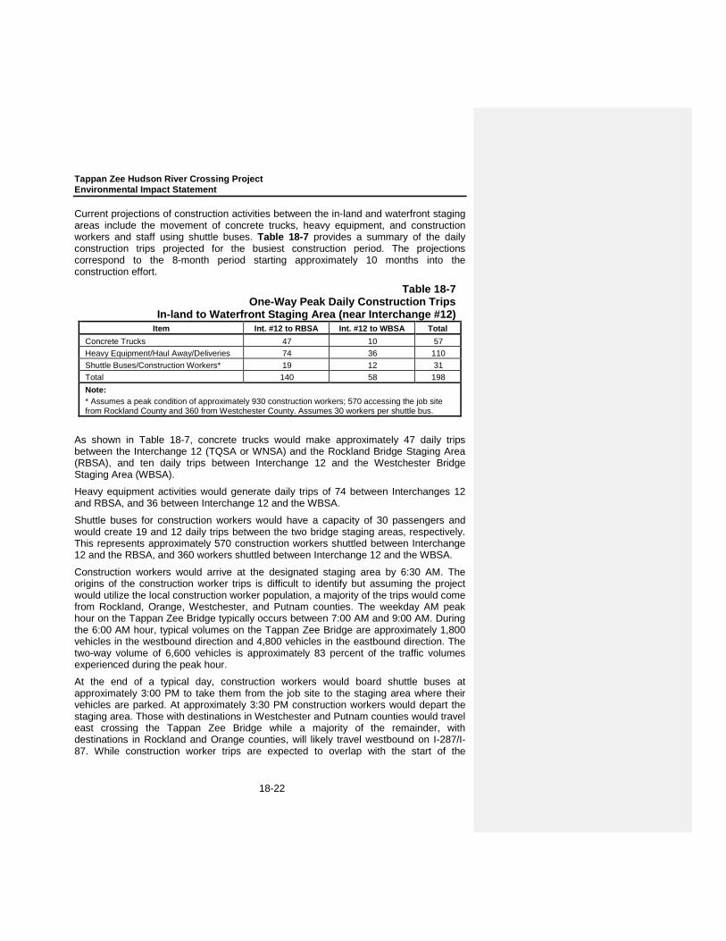
Current projections of construction activities between the in-land and waterfront staging areas include the movement of concrete trucks, heavy equipment, and construction workers and staff using shuttle buses. Table 18-7 provides a summary of the daily construction trips projected for the busiest construction period. The projections correspond to the 8-month period starting approximately 10 months into the construction effort.
Table 18-7 One-Way Peak Daily Construction Trips
In-land to Waterfront Staging Area (near Interchange #12) Item Int. #12 to RBSA Int. #12 to WBSA Total
Concrete Trucks 47 10 57 Heavy Equipment/Haul Away/Deliveries 74 36 110 Shuttle Buses/Construction Workers* 19 12 31 Total 140 58 198 Note: * Assumes a peak condition of approximately 930 construction workers; 570 accessing the job site from Rockland County and 360 from Westchester County. Assumes 30 workers per shuttle bus.
As shown in Table 18-7, concrete trucks would make approximately 47 daily trips between the Interchange 12 (TQSA or WNSA) and the Rockland Bridge Staging Area (RBSA), and ten daily trips between Interchange 12 and the Westchester Bridge Staging Area (WBSA).
Heavy equipment activities would generate daily trips of 74 between Interchanges 12 and RBSA, and 36 between Interchange 12 and the WBSA.
Shuttle buses for construction workers would have a capacity of 30 passengers and would create 19 and 12 daily trips between the two bridge staging areas, respectively. This represents approximately 570 construction workers shuttled between Interchange 12 and the RBSA, and 360 workers shuttled between Interchange 12 and the WBSA.
Construction workers would arrive at the designated staging area by 6:30 AM. The origins of the construction worker trips is difficult to identify but assuming the project would utilize the local construction worker population, a majority of the trips would come from Rockland, Orange, Westchester, and Putnam counties. The weekday AM peak hour on the Tappan Zee Bridge typically occurs between 7:00 AM and 9:00 AM. During the 6:00 AM hour, typical volumes on the Tappan Zee Bridge are approximately 1,800 vehicles in the westbound direction and 4,800 vehicles in the eastbound direction. The two-way volume of 6,600 vehicles is approximately 83 percent of the traffic volumes experienced during the peak hour.
At the end of a typical day, construction workers would board shuttle buses at approximately 3:00 PM to take them from the job site to the staging area where their vehicles are parked. At approximately 3:30 PM construction workers would depart the staging area. Those with destinations in Westchester and Putnam counties would travel east crossing the Tappan Zee Bridge while a majority of the remainder, with destinations in Rockland and Orange counties, will likely travel westbound on I-287/I-87. While construction worker trips are expected to overlap with the start of the
Chapter 18: Construction Impacts
18-23
weekday PM peak period (3:00PM to 6:00PM); those workers with destinations in Westchester and Putnam counties will be traveling in the off-peak direction (eastbound).
No adverse effect on traffic flow is anticipated due to the increase in construction worker trips for either the AM or PM peak conditions.
The construction schedule identifies single eight hour shifts for work crews without weekend work; however, on occasion shifts may extend past eight hours and up to 12 hours, depending on the crew type and detail of the work to be completed. It should be anticipated, that some activities may required the contractor to work late shifts or possibly weekends on critical activities. Some of these activities would include cable erection of the main spans, heavy lifts or potentially delivery of material by barge.
With new ramps to/from River Road proposed in the eastbound and westbound directions on I-287/I-87, weaving maneuvers involving heavy vehicles to/from Interchange 12 would occur, but operations would remain acceptable, as previously discussed.
18-4-1-3 MARINE TRAFFIC
In addition to roadway traffic, construction of the new bridge and demolition of the existing bridge could affect marine traffic in the Hudson River. Impacts to navigation could occur during construction of the project from the following activities:
Delivery of material by vessel would increase usage of the navigation channel;
Scow movements related to dredging would increase usage of the navigational channel;
Construction of the main spans’ substructure and superstructure would result in some restrictions to navigation; and
Demolition of the existing bridge’s main span substructure and superstructure would result in some restrictions to navigation.
The dredging required as part of the replacement bridge’s construction would occur outside of the navigational shipping channel, with no projected impacts on navigation.
Disruption to river shipping during overall construction would be minimized, but cannot be eliminated, as some of the main span construction activities would restrict the channel for a short period. For the Cable-stayed Option, it is anticipated that deck segments may be delivered via barge and hoisted up to the deck. Up to 40 segments may be delivered in the main channel with an additional 20 segments in each of the adjacent spans. Delivery and installation of the segments would be coordinated with the U.S. Coast Guard to minimize the effect on shipping. It is anticipated that two hours would be required for the delivery of each section, with time included for the segment to reach the required clearance and be stabilized. For the Arch Option, bridge segments may also be delivered by barge, with a similar number of segments required. However, instead of construction in segments, there is the potential that the contractor may construct the Arch in one large full span lift—a method that would require closing of the main shipping channel for one or two days.
.

Tappan Zee Hudson River Crossing Project Environmental Impact Statement
18-24
To minimize any adverse effects on marine navigation, the NYSDOT and NYSTA would coordinate with the U.S. Coast Guard in conjunction with the Bridge Permit process to develop acceptable navigation windows and limit any channel closures to the minimum time necessary to provide a safe construction process.
18-4-2 COMMUNITY CHARACTER
Major construction projects have the potential to inconvenience or disturb persons who reside in or use the areas adjacent to construction and staging areas. Temporary effects to adjacent neighborhoods could include:
Traffic congestion and detours;
Disrupted access to residences and businesses;
Loss of roadside parking;
Disruption of utility services;
Presence of construction workers, equipment, materials and staging areas including potential concrete batch;
Noise and vibrations from construction equipment and vehicles;
Airborne dust and possible mud on roadway surfaces; and
Removal of or damage to vegetation (e.g., trees, shrubs, grass, etc.).
Without proper planning and implementation of controls, these construction-related impacts could adversely affect the comfort and daily life of residents and inconvenience or disrupt the flow of customers, employees, and materials/supplies to and from businesses. For residents living along the roadway alignment, some materials stored for the project may be visually displeasing. This is a temporary condition and should pose no substantial problem in the long term. Nevertheless, the construction contract documents would stipulate that the contractor must maintain a clean and orderly worksite and would include metrics for determining compliance, provisions for enforcement, and penalties for non-compliance.
Provisions for construction phasing and traffic control plans, as mentioned under transportation would be used to avoid the potential for adverse effects of traffic on community character. In addition, an emergency access plan for the construction phase of the project will be developed as part of the project’s safety program. As described above under air quality and noise EPCs, other measures that would be incorporated into the contract documents which would avoid or minimize, in the case of noise, the adverse effects of construction on community character.
18-4-2-1 ROCKLAND BRIDGE STAGING AREA
The land use context near the proposed temporary platform on the Rockland County side is exclusively residential, with the seven-story Salisbury Point apartments and three-story Bradford Mews apartments immediately north of the bridge landing. Other areas to the north and south of the bridge landing are medium density single-family residences. The existing bridge would screen most of the temporary platform and its activity from residences to the south. However, the residents near the river to the north would have direct views of the platform. Visibility of the temporary construction platform

Chapter 18: Construction Impacts
18-25
would not constitute an adverse impact, and would not alter the existing community character.
18-4-2-2 WEST NYACK STAGING AREA (WNSA)
As discussed above, the WNSA site occupies approximately 33 acres of land near Interchange 12 south of the Palisades Mall at the intersection of Routes 59 and 303. With respect to land use compatibility, this potential staging area is currently an industrial site with an existing concrete batch plant. The potential staging area is zoned Manufacturing (M) and Regional Shopping (RS) by the Town of Clarkstown. Land uses surrounding the site include industrial, transportation and utilities, commercial, a closed sanitary landfill that is currently used as a waste transfer station, and vacant land. There are no residential uses adjacent to the site.
The proposed construction facilities would not be out of character with existing uses at and around the site. Operations at the site during the construction phase may be more intensive than those operating presently, but all truck traffic would be using the major arterials of Route 59 and Route 303 and would have immediate access to the Thruway at Interchange 12 on NYS Route 303. Consequently, there would be little spillover of operational effects to nearby residential neighborhoods on Greenbush Road, and none to the West Nyack neighborhood. Consequently, no adverse impacts to community character are anticipated.
18-4-2-3 TILCON QUARRY STAGING AREA (TQSA)
As discussed above, the TQSA is an approximately 120-acre site located directly north of the Thruway and opposite the Palisades Mall. This potential staging is currently an active industrial site. The potential staging area is zoned Manufacturing (M) by the Town of Clarkstown. Land uses surrounding the site include industrial, transportation and utilities, commercial, and vacant land. There are residential uses located to the northeast of the potential staging area, which are in the southern portion of the Valley Cottage neighborhood.
The proposed construction facilities would not be out of character with existing industrial uses and character at and around the site. Consequently, no adverse impacts to community character are anticipated.
18-4-2-4 WESTCHESTER BRIDGE STAGING AREA (WBSA)
On the Tarrytown waterfront, the temporary platform would be approximately 600 feet from the shore, opposite the Tarry Landing neighborhood and approximately 400 feet south of the entrance to the Tarrytown Boat Club Marina. While the existing bridge would screen most of the platform and its activity from residences to the south, the residents near the river to the north would have direct views of the platform. Visibility of the temporary platform would not alter the existing community character.
18-4-2-5 WESTCHESTER INLAND STAGING AREA (WISA)
Another staging area is the triangle of land located north of Interstate 87/287 and opposite the toll plaza. As discussed above, this staging area currently comprises NYSTA’s Tappan Zee Bridge Maintenance Facility, Bridge Patrol, Equipment Maintenance, and the local station of NYSP Troop T.

Tappan Zee Hudson River Crossing Project Environmental Impact Statement
18-26
Although this area is completely within the existing Interstate 87/287 right-of-way, it is currently zoned R-7.5 (One-Family Residence on 7,500 square foot lots) by the Village of Tarrytown. Existing land uses in close proximity to the potential staging area site include commercial and multi-family residential.
The proposed truck route from the WISA and the Westchester Bridge Staging Area would traverse in close proximity to the Van Wart and Paulding Avenue neighborhoods south of Interstate 87/287. Although there is an existing noise barrier screening much of the Van Wart and Paulding Avenues neighborhood from Interstate 87/287 and the toll plaza, the temporary access road would pass adjacent to the homes on Hudson Place (north of Van Wart Avenue) before crossing over the MNR tracks to the temporary river platform. The temporary access road would also connect with Green Street and the Tarrytown street network in the north, and would be within the viewshed of the Quays and Tarry Landing residential neighborhoods. The WISA or temporary access road would not change community character of the adjacent residential neighborhoods and business districts in the Village of Tarrytown.
18-4-3 LAND ACQUISITION, DISPLACEMENT, AND RELOCATION
The Replacement Bridge Alternative would result in several temporary easements on parcels in Rockland County during construction (permanent land acquisitions are discussed fully in Chapter 6, “Land Acquisition, Displacement, and Relocation”). In the Village of South Nyack, a 0.03-acre temporary easement on a portion of Elizabeth Place Park and a 0.04-acre temporary easement on a nearby un-named park would be required for the purposes of reconstructing and realigning the South Broadway bridge over Interstate 87/287. These temporary easements would be returned to the Village of South Nyack after construction for continued use. Access to and use of Elizabeth Place Park would remain unaffected during construction. The un-named park would be inaccessible during construction.
North of the existing highway, a temporary easement on a portion of a multi-family residential parcel in Rockland County would be required for purposes of realigning Interstate 87/287 with the replacement bridge. The temporary easement on this parcel would be substantially similar under both the Short and Long Span Options (slightly less than 0.05 acres for the Short Span Option and slightly greater than 0.05 acres for the Long Span Option). This temporary easement would displace existing parking spaces. In addition, a 0.01-acre temporary easement of an adjacent single-family residential property would be required during construction. This temporary easement would not be expected to affect the use of the parcel.
18-4-4 PARKLANDS AND RECREATIONAL RESOURCES
The construction of the Replacement Bridge Alternative would temporarily impact two parkland resources in Rockland County: Elizabeth Place Park and its ancillary un-named park. Both are located in the Village of South Nyack near the proposed bridge landing. In addition, potential impacts to Hudson River recreational uses are also discussed below.
18-4-4-1 ELIZABETH PLACE PARK AND ANCILLARY UN-NAMED PARK
As discussed in Chapter 7, “Parklands and Recreational Resources,” Elizabeth Place Park is a public park in the Village of South Nyack that is situated on an approximately

Chapter 18: Construction Impacts
18-27
0.81-acre triangular parcel on the southwest side of Interstate 87/287. Southeast of Elizabeth Place Park is an ancillary, un-named 0.05 acre triangular park.
Implementation of the Replacement Bridge Alternative would require a 0.03-acre temporary easement from Elizabeth Place Park, which represents 3.7 percent of the total park area. The temporary easement would occur only during the construction period of the project. This easement would not affect access to Elizabeth Place Park and all active features of the park would continue to be accessible during the construction period.
The construction of the Replacement Bridge Alternative would also require a temporary easement of 0.04 acres and acquisition of 0.01 acres of the 0.05 acre un-named ancillary park located southeast of Elizabeth Place Park. This park would be inaccessible during construction, but the 0.04-acre temporary easement would be returned to the Village of South Nyack after construction for continued parkland use. This temporary easement and partial acquisition would be required for purposes of reconstructing and realigning the South Broadway bridge over Interstate 87/287 and to avoid the closure of South Broadway during construction which would otherwise have potential adverse traffic and economic impacts in the area.
18-4-4-2 HUDSON RIVER GREENWAY WATER TRAIL
As further discussed in Chapter 7, “Parklands and Recreational Resources,” the Hudson River Greenway Water Trail, which accommodates canoeists and kayakers, traverses through the study area and beneath the existing Tappan Zee Bridge. Although the Replacement Bridge Alternative would not directly affect the existing Hudson River Greenway Water Trail landing sites, temporary disruptions to small water craft navigation beneath the bridge during the construction period can be expected. No long-term impacts to the Hudson River Greenway Water Trail are anticipated once the Replacement Bridge Alternative is operational.
18-4-4-3 HUDSON RIVER RECREATIONAL BOATING
The Hudson River is also used by sail boaters, power boaters, and other personal water craft users for recreational purposes. Temporary disruptions to recreational boating through the study area can be expected during the construction period for the Replacement Bridge Alternative, and sail boaters may be precluded from using sails while traversing through the construction zone. However, no long-term impacts to recreational boating on the Hudson River are anticipated once the Replacement Bridge Alternative is operational.
18-4-5 SOCIOECONOMIC CONDITIONS
The economic benefits associated with construction activities are directly related to the cost of constructing the Tappan Zee Hudson River Crossing. Those benefits were estimated using the IMPLAN (IMpact analysis for PLANning) input-output modeling system. IMPLAN was originally developed by the U.S. Department of Agriculture Forest Service in 1979 and was subsequently privatized by the Minnesota IMPLAN Group (MIG). This analysis is based on the 2009 models for Rockland and Westchester Counties, and uses economic data from sources such as the U.S. Bureau of Economic Analysis, the U.S. Bureau of Labor Statistics, and the U.S. Census Bureau to predict effects on the local economy from direct changes in spending. The model contains data

Tappan Zee Hudson River Crossing Project Environmental Impact Statement
18-28
for Rockland and Westchester Counties on 440 economic sectors, showing how each sector affects every other sector as a result of a change in the quantity of a product or service. A similar IMPLAN model for New York State was used to trace the effects on the state economy. Using these models and the specific characteristics of the projected development, the total effect has been projected for Rockland and Westchester Counties and New York State.
18-4-5-1 IMPLAN OVERVIEW
Using IMPLAN terminology, economic impacts are broken into three components: direct, indirect, and induced effects:
Direct effects represent the initial benefits to the economy of new investment (e.g., a construction project, changes in employment, or changes in employee compensation).
Indirect effects represent the benefits generated by industries purchasing from other industries as a result of the direct investment (e.g., indirect employment resulting from construction expenditures would include jobs in industries that provide goods and services to the contractors). A direct investment triggers changes in other industries as businesses alter their production to meet the needs of the industry in which the direct impact has occurred. These businesses in turn purchase goods and services from other businesses, causing a ripple effect through the economy. The ripple effect continues until leakages from the region (caused, for example, by imported goods) stop the cycle. The sum of these iterative inter-industry purchases is called the indirect effect.
Induced effects represent the impacts caused by increased income in a region. Direct and indirect effects generate more worker income by increasing employment and/or salaries in certain industries. Households spend some of this additional income on local goods and services, such as food and drink, recreation, and medical services. Benefits generated by these household expenditures are quantified as induced effects.
18-4-5-2 CONSTRUCTION PERIOD EFFECTS
Value of Construction
Based on preliminary estimates, the cost of constructing the Tappan Zee Hudson River Crossing (at the 90 percent confidence level) is estimated at $4.64 billion dollars in 2011 dollars. The construction cost includes sitework, hard costs (actual construction), and soft costs (such as engineering and permitting).
For purposes of the economic and fiscal benefits analysis, the $4.64 billion construction cost estimate was reduced by $1.285 billion (or 27.7 percent) to deduct escalation costs and equipment and steel that would be manufactured outside of New York State. These costs were deducted since the purchase of out-of-state equipment and material would not have a direct effect on the regional or statewide economy. Therefore, the construction cost assumed for this economic benefits analysis is $3.36 billion. The following analysis presents the economic and fiscal benefits that would result during the construction period.
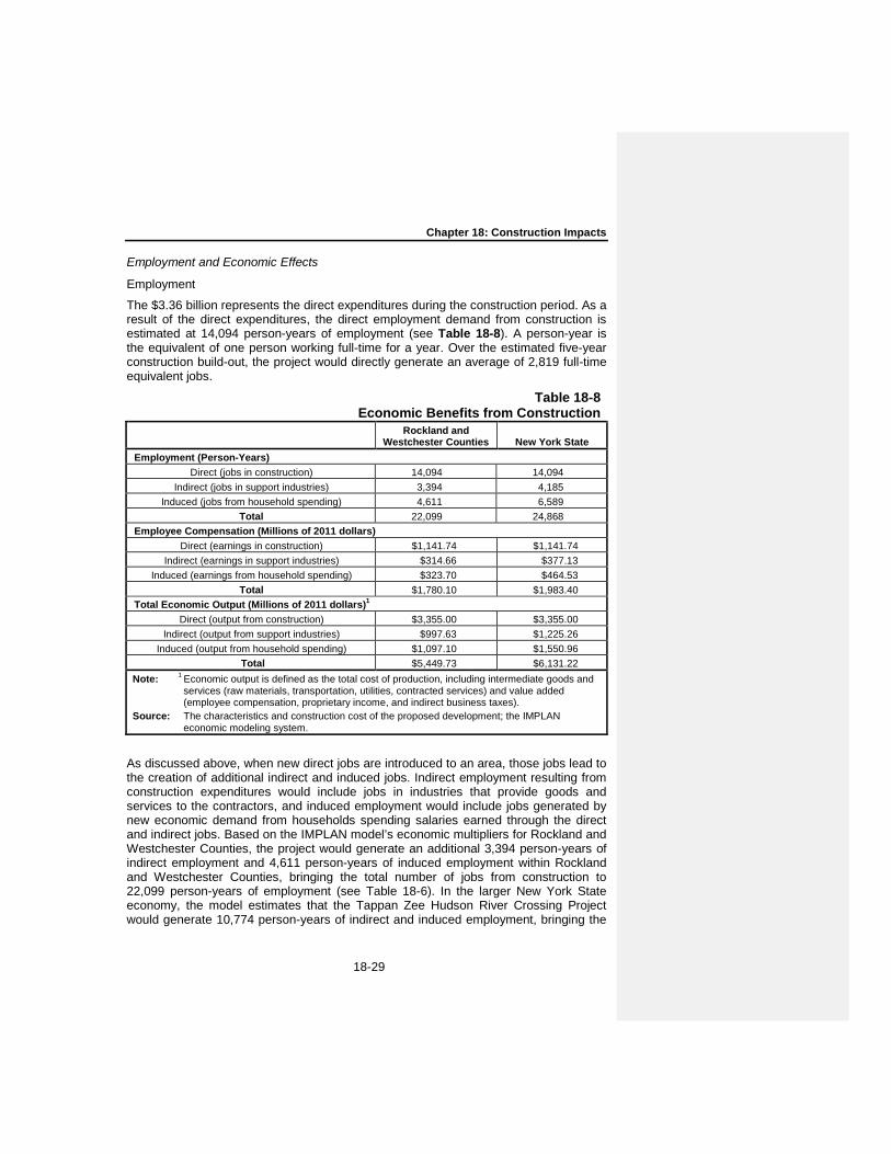
Chapter 18: Construction Impacts
18-29
Employment and Economic Effects
Employment
The $3.36 billion represents the direct expenditures during the construction period. As a result of the direct expenditures, the direct employment demand from construction is estimated at 14,094 person-years of employment (see Table 18-8). A person-year is the equivalent of one person working full-time for a year. Over the estimated five-year construction build-out, the project would directly generate an average of 2,819 full-time equivalent jobs.
Table 18-8 Economic Benefits from Construction
Rockland and
Westchester Counties New York State Employment (Person-Years)
Direct (jobs in construction) 14,094 14,094 Indirect (jobs in support industries) 3,394 4,185
Induced (jobs from household spending) 4,611 6,589 Total 22,099 24,868
Employee Compensation (Millions of 2011 dollars) Direct (earnings in construction) $1,141.74 $1,141.74
Indirect (earnings in support industries) $314.66 $377.13 Induced (earnings from household spending) $323.70 $464.53
Total $1,780.10 $1,983.40 Total Economic Output (Millions of 2011 dollars)1
Direct (output from construction) $3,355.00 $3,355.00 Indirect (output from support industries) $997.63 $1,225.26
Induced (output from household spending) $1,097.10 $1,550.96 Total $5,449.73 $6,131.22
Note: 1 Economic output is defined as the total cost of production, including intermediate goods and services (raw materials, transportation, utilities, contracted services) and value added (employee compensation, proprietary income, and indirect business taxes).
Source: The characteristics and construction cost of the proposed development; the IMPLAN economic modeling system.
As discussed above, when new direct jobs are introduced to an area, those jobs lead to the creation of additional indirect and induced jobs. Indirect employment resulting from construction expenditures would include jobs in industries that provide goods and services to the contractors, and induced employment would include jobs generated by new economic demand from households spending salaries earned through the direct and indirect jobs. Based on the IMPLAN model’s economic multipliers for Rockland and Westchester Counties, the project would generate an additional 3,394 person-years of indirect employment and 4,611 person-years of induced employment within Rockland and Westchester Counties, bringing the total number of jobs from construction to 22,099 person-years of employment (see Table 18-6). In the larger New York State economy, the model estimates that the Tappan Zee Hudson River Crossing Project would generate 10,774 person-years of indirect and induced employment, bringing the

Tappan Zee Hudson River Crossing Project Environmental Impact Statement
18-30
total direct and generated jobs from construction of the project to 24,868 person-years of employment over the estimated five-year construction period.
Employee Compensation
The direct employee compensation during the construction period is estimated at $1.14 billion (see Table 18-6). Total direct, indirect, and induced employee compensation resulting in Rockland and Westchester Counties from construction of the Tappan Zee Hudson River Crossing Project is estimated at $1.78 billion. In the broader state economy, total direct, indirect, and induced employee compensation from construction of the project is estimated at $1.98 billion.
Total Effect on the Local Community
As indicated above, the total construction cost for the project (excluding escalation costs and materials/specialized equipment from outside of New York State) is expected to be $3.36 billion. Based on the IMPLAN models for Rockland and Westchester Counties and New York State, the total economic activity that would result from construction of the project is estimated at $6.13 billion in New York State, of which $5.45 billion would occur in Rockland and Westchester Counties (see Table 18-8).
Taxes
Even though the project would be exempt from sales tax on construction materials, the construction activity would have associated with it tax revenues for New York State, the Metropolitan Transportation Authority (MTA), Rockland and Westchester Counties, and other local jurisdictions. Of these tax revenues, the largest portion would come from personal income tax, sales tax from workers’ expenditures, corporate and business taxes, and numerous other taxes on direct and secondary economic activity. These public sector revenues are estimated to have an order-of-magnitude value of approximately $166.95 million.
18-4-6 VISUAL AND AESTHETIC RESOURCES
During construction, there would be an increase in the level of activity within the study area, especially in the location of the Hudson River crossing for the bridge replacement. As the project proceeds, cranes, vessels, and other large pieces of equipment, as shown in Table 18-5, would be utilized and visible to a variety of viewer groups. As described previously in Chapter 9, “Visual and Aesthetic Resources,” Interstate 87/287 is screened from view from the majority of the surrounding neighborhoods in the study area by dense vegetation and sound walls along the rights-of-way on both sides of the river. However, in some locations, the vegetative screenings and sound walls would need to be removed for creation of the shared-use path and other project construction activities. In addition, those who have views of the Hudson River crossing would have views altered during construction. The Hudson River crossing would become a large construction site that would be visible to sensitive viewers such as residents, park users, and rail travelers along the river. Commercial and/or recreational boaters would also be sensitive to the possible effects upon the quality of the view within the study area during construction. Other groups, including local motorists and employees and visitors of commercial activity have been estimated to have lower sensitivity to the visual alterations arising during the construction phase. Because the largest group of viewers in the study area is motorists passing through the region on Interstate 87/287 at
Chapter 18: Construction Impacts
18-31
generally greater speeds than 55 mph, viewer sensitivity during construction would be considered low for these viewers.
The character and quality of views of the Hudson River during construction of the project would be impaired for sensitive viewers who have views of this visual resource. Therefore, the Replacement Bridge Alternative would result in temporary unavoidable adverse impacts to visual and aesthetic resources during construction.
18-4-7 HISTORIC AND CULTURAL RESOURCES
18-4-7-1 ARCHAEOLOGICAL RESOURCES
A Phase I Archaeological survey of the terrestrial portions of the Area of Potential Effect (APE) for potential direct effects concluded that no archaeological resources are present in that area. However, two classes of potential archaeological resources have been identified within the river portion of the APE that could potentially be affected by the proposed project: a submerged landform that may have been occupied during the Archaic Period or the Paleo-Indian Period; and possible submerged historic resources including potential shipwrecks lying on the river bottom. Further analysis will be undertaken to determine whether submerged S/NR eligible resources are present in the river portion of the APE for direct effects. If submerged resources are identified and determined to be S/NR eligible, the project would have an adverse effect on those resources as a result of dredging and construction of the replacement bridge. The FEIS will provide the results of this further analysis. Consultation with SHPO and any appropriate tribal nations and consulting parties would be undertaken to identify measures to avoid, minimize or mitigate any potential S/NR-eligible resources that may be adversely affected by the proposed project.
18-4-7-2 ARCHITECTURAL RESOURCES
Direct impacts upon a property could include demolition, alteration, or damage from construction. Indirect affects could include the isolation of a property from its surrounding environment, or the introduction of visual, audible, or atmospheric (e.g., pollutants) elements that are out of character with a property or that alter its historic setting and context (e.g., contextual effects).
As described in “Chapter 10, “Historic and Cultural Resources,” two resources that have been determined eligible for the State/National Register of Historic Places (S/NR) are located within the APE for potential direct effects. The Tappan Zee Bridge would be removed under the bridge replacement alternative. The South Nyack Historic District is also partially located within the APE for potential direct effects. Two properties that contribute to the Historic District, 21 Cornelison Avenue and 78 Smith Avenue, would be removed in order to construct the bridge replacement alternative. Therefore, the Tappan Zee Bridge and the South Nyack Historic District would be adversely affected by the construction for this project.
In order to mitigate the adverse effect on the Tappan Zee Bridge that would result under the bridge replacement alternatives, mitigation measures have been identified in a Memorandum of Agreement (MOA), included in Appendix C. These measures include Historic American Engineering Record (HAER) documentation of the existing Tappan

Tappan Zee Hudson River Crossing Project Environmental Impact Statement
18-32
Zee Bridge and the production of an educational brochure for use by local libraries, historical societies, and educational institutions.
A potential adverse effect has also been identified on the S/NR-eligible South Nyack Historic District in Rockland County. This effect would result from the removal of two contributing resources within that district, 21 Cornelison Avenue and 78 Smith Avenue. Measures to mitigate this direct adverse effect on the South Nyack Historic have been identified in the MOA included in Appendix C, and include planting vegetation along sound walls along the western edge of the district and preparing Historic American Building Survey (HABS) recordation to document the two contributing resources that would be removed. Furthermore, it is proposed that signage interpreting the history and architecture of the South Nyack Historic District be created for installation within the South Nyack Historic District or along the shared-use path that would be constructed along the western edge of the Historic District as part of the project.
18-4-8 AIR QUALITY
This section examines the potential air quality impacts from the construction of the project. Emissions from on-site construction equipment and on-road construction-related vehicles, and the effect of construction vehicles on background traffic congestion, have the potential to affect air quality. The analysis of potential impacts of the construction of the project on air quality includes a quantitative analysis of both on-site and on-road sources of air emissions, and the overall combined impact of both sources, where applicable. The analysis addresses both local (microscale) concentrations and regional (mesoscale) emissions.
In general, most construction engines are diesel-powered, and produce relatively high levels of nitrogen oxides (NOx) and particulate matter (PM). Some construction activities also emit fugitive dust. Although diesel engines emit much lower levels of carbon monoxide (CO) than gasoline engines, the stationary nature of construction emissions and the large quantity of engines could lead to elevated CO concentrations, and impacts on traffic could increase mobile source-related emissions of CO as well. Therefore, the pollutants analyzed for the construction period are nitrogen dioxide (NO2), particles with an aerodynamic diameter of less than or equal to 10 micrometers (PM10), particles with an aerodynamic diameter of less than or equal to 2.5 micrometers (PM2.5), and CO. For each pollutant, concentrations were modeled for each averaging period regulated in the National Ambient Air Quality Standards (NAAQS): short-term analyses address 24-hour averages for PM, and 8-hour and 1-hour concentration averages for CO, and long-term analyses address annual averages for PM2.5 and NO2. For more details on air pollutants and NAAQS see Chapter 11, “Air Quality.”
As defined in 40 Code of Federal Regulations (CFR) Part 80 Subpart I, diesel fuel supplied by large refiners and exporters must limited to a sulfur content of 15 parts per million (ppm) for nonroad engines beginning June 1, 2010, and for marine engines beginning June 1, 2012; purchase by wholesale purchaser consumers in the locomotive and marine sectors by October 1, 2012. Ultra-low-sulfur diesel (ULSD) would be used exclusively for all diesel engines throughout the construction sites, including marine engines; therefore, sulfur oxides emitted from construction activities would be negligible.
Chapter 18: Construction Impacts
18-33
Construction activity in general, and large-scale construction in particular, has the potential to adversely affect air quality as a result of diesel emissions. The main component of diesel exhaust that has been identified as having an adverse effect on human health is fine PM. To ensure that the construction of the project results in the lowest practicable diesel particulate matter (DPM) emissions, the construction contracts will require several EPCs, including the following components:
• Clean Fuel. All diesel fuel used for the project will contain 15 parts per million (ppm) or less sulfur by weight. This includes on-road, non-road, and tug boats operating on-site.
• Best Available Tailpipe Reduction Technologies. Nonroad diesel engines with a power rating of 50 horsepower (hp) or greater and controlled truck fleets (i.e., truck fleets under long-term contract) including but not limited to concrete mixing and pumping trucks, would utilize the best available tailpipe (BAT) technology for reducing DPM emissions. Diesel particulate filters (DPFs) have been identified as being the tailpipe technology currently proven to have the highest PM reduction capability. Construction contracts would specify that all diesel nonroad engines rated at 50 hp or greater would utilize DPFs, either installed on the engine by the original equipment manufacturer (OEM) or retrofit with a DPF verified by the United States Environmental Protection Agency (USEPA) or the California Air Resources Board, and may include active DPFs,1 if necessary; or other technology proven to reduce DPM by at least 90 percent.
• Utilization of Newer Equipment. EPA’s Tier 1 through 4 standards for nonroad engines regulate the emission of criteria pollutants from new engines, including PM, CO, oxides of nitrogen (NOx), and hydrocarbons (HC). All nonroad construction equipment in the project would meet at least the Tier 3 emissions standard.
• Tug Boat Emissions Reduction. The total combined PM emission rate from all tug boats used for the project will be limited to 3,700 grams per hour at peak power, including auxiliary engine emissions. This limit may be achieved by installing retrofits, using new engines, repowering or engine replacement, or various combinations of these measures, along with limitations on the engine size and number of tug boats on site.2
• Concrete Batch Plant Controls. The concrete batch plant would vent the cement weigh hopper, gathering hopper, and mixing loading operations to a baghouse or filter sock. Storage silo chutes would be vented to a baghouse. Baghouses should have a control efficiency of at least 99.9 percent. Roadways at the concrete batch plant, and all unloading and loading material handling operations would have a dust control plan providing at least a 50 percent reduction in PM10 and PM2.5 emissions from fugitive dust through wet suppression.
1 There are two types of DPFs currently in use: passive and active. Most DPFs currently in use are the “passive” type,
which means that the heat from the exhaust is used to regenerate (burn off) the PM to eliminate the buildup of PM in the filter. Some engines do not maintain temperatures high enough for passive regeneration. In such cases, “active” DPFs can be used (i.e., DPFs that are heated either by an electrical connection from the engine, by plugging in during periods of inactivity, or by removal of the filter for external regeneration).
2 For example, the analysis in this section assumed eight 1,500 hp tug boats with EPA Tier 2 rating each with an 80 kw auxiliary engine, with all engines retrofit with a diesel oxidation catalyst.

Tappan Zee Hudson River Crossing Project Environmental Impact Statement
18-34
18-4-8-1 METHODOLOGY
Chapter 11, “Air Quality,” contains a review of the pollutants for analysis; applicable regulations, standards, and benchmarks; and general methodology for mobile source air quality analyses. Additional details relevant only to the construction air quality analysis methodology are presented in the following section.
Local (Microscale) On-Site Construction Activity Assessment
As described in Section B above, there are two construction options: Short Span Option and Long Span Option. The Short Span Option would require approximately twenty-seven more spans than the Long Span Option and would have more construction equipment working simultaneously. In addition, the Short Span Option would take approximately one year longer to construct than the Long Span Option. The Short Span Option was selected for analysis because it would represent the worst-case scenario for air quality.
The construction periods with activities closest to sensitive receptors (i.e., residences, institutional buildings, and open spaces) and with the most intense activities and highest emissions were selected as the worst-case periods for analysis. Construction-related PM2.5 emissions were estimated for the different subtasks of construction, including the reconstruction of the approach roadway areas in Rockland and Westchester counties, dredging, trestle construction, abutment construction, cofferdam construction, pile installation, pile cap construction, column construction, deck installation, and demolition of the existing TZB.
Detailed analyses were performed for the following construction periods, as shown in Figures 18-8 through 18-11:
Rockland Landing—Reconstruction of the South Broadway Bridge: The Rockland landing is defined as the portion of the corridor that extends from the abutment of the bridge to just west of the South Broadway Bridge. During this period of construction, the South Broadway Bridge would be replaced and heavy diesel equipment such as cranes, excavators and loaders would be used. The peak construction activities during this period would occur near sensitive residential receptors and would last for several months.
Rockland Landing—Approach Roadway Construction: The side slopes south of existing Interstate 87/287 from South Broadway to the river would be removed, the retaining walls would be constructed and temporary pavement would be placed. Heavy diesel equipment such as cranes, excavators and loaders would be used. The peak construction activities during this period would occur near sensitive residential receptors and would last for several months.
Rockland Inland Staging Area: A staging area would be required for a concrete batch plant and miscellaneous construction vehicle storage. The precise location of this area is unknown at this time, and therefore this analysis was performed for a generic plant meeting the needs of the project. The concrete batch plant would be a source of particulate matter emissions. Fugitive sources associated with a concrete batch plant include the transfer of sand and aggregate, truck loading, mixer loading, vehicle traffic, and wind erosion from sand and aggregate storage piles. Estimates

Chapter 18: Construction Impacts
18-35
of air emissions from these activities were derived based on EPA procedures delineated in AP-42 Section 11.12.
Bridge Construction—Rockland Approach and Main Span: There would be 3 principal in-river work areas, including the main span, Rockland approach, and Westchester approach. Tug boats and barges would be used during in-river construction activities. The substructure construction at each area would include dredging, cofferdam construction, assembly work, pile driving, construction of the pile cap, construction of the columns and deck erection. Pile driving was identified as the substructure construction activity with the highest air quality emissions due to the high amount of heavy equipment employed during this task, including pile drivers and large generators. The period when pile driving would occur at spans that are closest to the Rockland shoreline and therefore closest to sensitive receptors was selected for analysis. Pile driving at spans near the shoreline would last for approximately two months for the north structures and another two months for the south structures at a later period. Similar pile driving work would occur at spans further away from the shoreline at an earlier time. Construction activities at the Main Span that would overlap with the Rockland Approach during this peak period were also included in the analysis, as well as roadway and earthworks at the Rockland Landing.
Westchester Landing: This period of construction would include the relocation of the NYSTA Tappan Zee Bridge Maintenance Facility and New York State Police (NYSP) facilities directly north of the Interstate 87/287 near the Toll Plaza. In addition, a temporary bridge would be constructed to connect the temporary access road west of the railroad tracks and the existing bridge area east of the railroad tracks. Heavy diesel equipment such as cranes, excavators and loaders would be used. The peak construction activities during this period would occur near sensitive residential receptors and would last for several months.
Bridge Construction—Westchester Approach and Main Span: Tug boats and barges would be used during in-river construction activities for the Westchester Approach. Pile driving was identified as the substructure construction activity with the highest air quality emissions due to the high amount of heavy equipment employed during this task, including pile drivers and large generators. The period when pile driving would occur at spans that are closest to the Westchester shoreline and therefore closest to sensitive receptors was selected for analysis. Pile driving at spans near the shoreline would last for approximately two months for the north structures and another two months for the south structures at a later period. Similar pile driving work would occur at spans further away from the shoreline at an earlier time. Construction activities at the main span that would overlap with the Westchester approach during this peak period were also included in the analysis, as well as roadway and earthworks at the Westchester landing.
Engine Exhaust Emissions
The projected usage factors, sizes, types, and number of construction equipment were estimated based on the construction activity schedule. Emission factors for NOx, CO, PM10, and PM2.5 from on-site construction engines were developed using the EPA’s NONROAD2008 Emission Model (NONROAD). Since emission factors for truck-
Tappan Zee Hudson River Crossing Project Environmental Impact Statement
18-36
mounted concrete pumps are not available from either the EPA MOBILE6.2 emission model (MOBILE6) or NONROAD, emission factors specifically developed for this type of application were used.1 With respect to trucks, emission rates for NOX, CO, PM10, and PM2.5 for truck engines were developed using MOBILE6. A maximum of 5-minute idle time was employed for the heavy trucks. For analysis purposes, it was assumed that each concrete truck would operate for 45 minutes per delivery. Tugboat emissions were estimated according to the latest emission factors and methodologies delineated by US. Environmental Protection Agency (EPA)2.
Fugitive Emission Sources
Particulate matter emissions would be generated by material handling activities (i.e., loading/drop operations for fill materials and excavate), truck transports, and concrete batching at the Inland Staging Area. Estimates of air emissions from these activities were developed based on EPA procedures delineated in AP-42 Table 13.2.3-1.
Dispersion Modeling
Projected NO2, CO, PM10 and PM2.5 concentration increments resulting from the construction of the project were predicted using the EPA/AMS AERMOD dispersion model.3 AERMOD is a state-of-the-art dispersion model, applicable to rural and urban areas, flat and complex terrain, surface and elevated releases, and multiple sources. AERMOD is a steady-state plume model that incorporates current concepts with respect to flow and dispersion in complex terrain.
For the short-term model scenarios, all stationary sources that idle in a single location while unloading, were simulated as point sources. Other engines, which would move around the site on any given day, were simulated as area sources. In the annual analyses, all sources would move around the site throughout the year and were therefore simulated as area sources.
Meteorological Data
The meteorological data set consisted of five consecutive years of meteorological data: surface data collected at LaGuardia Airport (2006–2010) and concurrent upper air data collected at Brookhaven, New York.
Receptor Locations
Thousands of receptors (locations in the model where concentrations are predicted) were placed along the sidewalks closest to the construction sites that would be publicly accessible, at residential and other sensitive uses at both ground-level and elevated locations (e.g., residential windows), and at open spaces. In addition, a ground-level
1 Concrete pumps are usually truck mounted and use the truck engine to power pumps at high load. This application of
truck engines is not addressed by the MOBILE6 model, and since it is not a non-road engine, it is not included in the NONROAD model. Emission factors were obtained from a study which developed factors specifically for this type of activity. FEIS for the Proposed Manhattanville in West Harlem Rezoning and Academic Mixed-Use Development, CPC–NYCDCP, November 16, 2007.
2 EPA, Current Methodologies in Preparing Mobile Source Port-Related Emission Inventories, April 2009. 3 EPA, AERMOD: Description Of Model Formulation, 454/R-03-004, September 2004; and EPA, User's Guide for the
AMS/EPA Regulatory Model AERMOD, 454/B-03-001, September 2004 and Addendum December 2006.

Chapter 18: Construction Impacts
18-37
receptor grid of approximately two thousand receptors was also included in the dispersion modeling to assist in the analysis of potential impacts.
Local (Microscale) Mobile Source Assessment
The general methodology for mobile source modeling presented in Chapter 11, “Air Quality” was followed.
Traffic flow on Interstate 87/287 would be maintained throughout the construction period while roadway work is performed. During those times, traffic would be diverted to temporary roadway segments and remain in the temporary location for an extended period before being shifted again. A shift in the roadway would reduce the distance between the heavily traveled Interstate 87/287 and residences located near the temporary segment, potentially increasing pollutant concentrations at those locations. Microscale analyses were performed for both the Rockland and the Westchester sides to assess the effect of these temporary roadway shifts on air quality.
Combined Impact
Since emissions from on-site construction equipment and mobile sources may contribute to concentration increments concurrently, the combined effect was assessed. Total concentrations were estimated by combining the results from the on-site construction analysis with the construction-related mobile source increments at the same location. The combined total is a conservatively high estimate of potential impacts, since it is likely that the highest results from different sources would occur under different meteorological conditions (e.g., different wind direction and speed), and would not necessarily occur when the highest background concentrations are present.
Region-Wide (Mesoscale) Effects of Construction Activity
The pollutants of concern on a regional basis are CO, PM10, PM2.5, NOx, and volatile organic compounds (VOC). (Although CO reacts rapidly in the atmosphere and is therefore not transported throughout the region, it is accounted for on a mesoscale in order to ensure that area-wide emissions do not exceed the emissions budgets in the applicable maintenance plan.) Construction activity related non-road equipment emissions and marine engine emissions were calculated on an annual basis based on the emissions modeling procedures described above for the microscale analysis.
18-4-8-2 ENVIRONMENTAL EFFECTS
Local (Microscale) On-Site Construction Activity Assessment
Rockland Landing—Reconstruction of the South Broadway Bridge
Maximum predicted concentration increments from construction activities associated with the South Broadway Bridge replacement and overall concentrations (including background) are presented in Table 18-9.
The maximum predicted total concentrations of PM2.5, PM10, CO, and annual-average NO2 would not exceed the NAAQS.

Tappan Zee Hudson River Crossing Project Environmental Impact Statement
18-38
Table 18-9 Maximum Predicted Pollutant Concentrations from Construction Site Sources—Rockland Landing, Reconstruction of the South Broadway
Bridge (μg/m3) Pollutant Averaging Period No Build Alternative Project Increment NAAQS
PM2.5 24-hour 28.0 28.4 0.4 35
Annual Local 9.6 9.7 0.1 15 PM10 24-hour 64 65 1 150 NO2 Annual 45 51 6 100
CO 1-hour 3.4 ppm 7.2 ppm 3.8 ppm 35 ppm 8-hour 2.5 ppm 2.8 ppm 0.3 ppm 9 ppm
Rockland Landing-Approach Roadway Construction
Maximum predicted concentration increments from construction activities associated with the Rockland landing approach roadway and overall concentrations (including background) are presented in Table 18-10. As shown, the maximum predicted total concentrations of PM2.5, PM10, CO, and annual-average NO2 would not exceed the NAAQS.
Table 18-10 Maximum Predicted Pollutant Concentrations from Construction Site
Sources—Rockland Landing, Approach Roadway Construction (μg/m3) Pollutant Averaging Period No Build Alternative Project Increment NAAQS
PM2.5 24-hour 28.0 29.2 1.2 35
Annual Local 9.6 9.7 0.1 15 PM10 24-hour 64 66 2 150 NO2 Annual 45 52 7 100
CO 1-hour 3.4 ppm 6.2 ppm 2.8 ppm 35 ppm 8-hour 2.5 ppm 2.8 ppm 0.3 ppm 9 ppm
Rockland Inland Staging Area
Maximum predicted concentration increments from construction activities associated with the construction staging activities including the concrete batch plant at the Rockland inland staging area and overall concentrations (including background) are presented in Table 18-11.
Since the location of the project concrete batch plant has not been determined, a grid receptor network was used for modeling to capture the potential area of effect from operations at the concrete batch plant.
The maximum total concentrations of PM2.5, PM10, CO, and annual-average NO2 were predicted at fenceline receptors adjacent to the project concrete batch plant, and would not exceed the NAAQS.
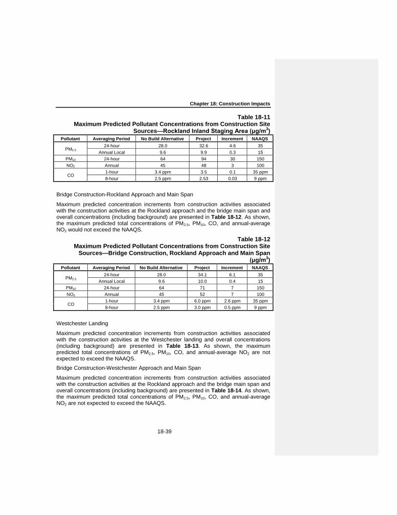
Chapter 18: Construction Impacts
18-39
Table 18-11 Maximum Predicted Pollutant Concentrations from Construction Site
Sources—Rockland Inland Staging Area (μg/m3) Pollutant Averaging Period No Build Alternative Project Increment NAAQS
PM2.5 24-hour 28.0 32.6 4.6 35
Annual Local 9.6 9.9 0.3 15 PM10 24-hour 64 94 30 150 NO2 Annual 45 48 3 100
CO 1-hour 3.4 ppm 3.5 0.1 35 ppm 8-hour 2.5 ppm 2.53 0.03 9 ppm
Bridge Construction-Rockland Approach and Main Span
Maximum predicted concentration increments from construction activities associated with the construction activities at the Rockland approach and the bridge main span and overall concentrations (including background) are presented in Table 18-12. As shown, the maximum predicted total concentrations of PM2.5, PM10, CO, and annual-average NO2 would not exceed the NAAQS.
Table 18-12 Maximum Predicted Pollutant Concentrations from Construction Site
Sources—Bridge Construction, Rockland Approach and Main Span (μg/m3)
Pollutant Averaging Period No Build Alternative Project Increment NAAQS
PM2.5 24-hour 28.0 34.1 6.1 35
Annual Local 9.6 10.0 0.4 15 PM10 24-hour 64 71 7 150 NO2 Annual 45 52 7 100
CO 1-hour 3.4 ppm 6.0 ppm 2.6 ppm 35 ppm 8-hour 2.5 ppm 3.0 ppm 0.5 ppm 9 ppm
Westchester Landing
Maximum predicted concentration increments from construction activities associated with the construction activities at the Westchester landing and overall concentrations (including background) are presented in Table 18-13. As shown, the maximum predicted total concentrations of PM2.5, PM10, CO, and annual-average NO2 are not expected to exceed the NAAQS.
Bridge Construction-Westchester Approach and Main Span
Maximum predicted concentration increments from construction activities associated with the construction activities at the Rockland approach and the bridge main span and overall concentrations (including background) are presented in Table 18-14. As shown, the maximum predicted total concentrations of PM2.5, PM10, CO, and annual-average NO2 are not expected to exceed the NAAQS.

Tappan Zee Hudson River Crossing Project Environmental Impact Statement
18-40
Table 18-13 Maximum Predicted Pollutant Concentrations from Construction Site
Sources—Westchester Landing (μg/m3) Pollutant Averaging Period No Build Alternative Project Increment NAAQS
PM2.5 24-hour 28.0 28.5 0.5 35
Annual Local 9.6 9.63 0.03 15 PM10 24-hour 64 65 1 150 NO2 Annual 45 48 3 100
CO 1-hour 3.4 ppm 4.0 ppm 0.6 ppm 35 ppm 8-hour 2.5 ppm 2.6 ppm 0.1 ppm 9 ppm
Table 18-14 Maximum Predicted Pollutant Concentrations from Construction Site Sources—Bridge Construction, Westcheter Approach and Main Span
(μg/m3) Pollutant Averaging Period No Build Alternative Project Increment NAAQS
PM2.5 24-hour 28.0 34.3 6.3 35
Annual Local 9.6 10.4 0.8 15 PM10 24-hour 64 73 9 150 NO2 Annual 45 63 18 100
CO 1-hour 3.4 ppm 13.5 ppm 10.1 ppm 35 ppm 8-hour 2.5 ppm 6.3 ppm 3.8 ppm 9 ppm
Other Periods of Construction
The modeled results are based on construction scenarios for specific worst-case periods. Lower concentration increments from construction would generally be expected during periods with lower construction emissions. Since worst-case short-term results may often be indicative of very local impacts, similar maximum local impacts may occur at any stage at various locations but would not persist in any single location, since emission sources would not be located continuously at any single location throughout construction, but would not exceed the concentrations projected for the worst-case scenarios.
Local (Microscale) Mobile Source Assessment
Maximum predicted concentration increments from mobile sources from roadway shifts at both the Rockland and Westchester sides, and overall concentrations (including background) are presented in Tables 18-15 and 18-16. The maximum predicted total concentrations of PM2.5, PM10, and CO are not expected to exceed the NAAQS.
Summary of Total Combined Concentrations
Total combined concentration increments were estimated by combining the results from the on-site construction analysis with the construction-related mobile source increments from the mobile source receptor closest to the location of the on-site increment. The overall combined concentrations of PM10, CO, and annual-average PM2.5, including background concentrations, are not expected to exceed the NAAQS.

Chapter 18: Construction Impacts
18-41
Table 18-15 Maximum Predicted Pollutant Concentrations from Mobile Sources—
Rockland County (μg/m3) Pollutant Averaging Period No Build Alternative Project Increment NAAQS
PM2.5 24-hour 28.0 31.2 3.2 35
Annual Local 9.6 10.2 0.6 15 PM10 24-hour 64 76 12 150
CO 1-hour 3.4 ppm 7.4 ppm 4.0 ppm 35 ppm 8-hour 2.5 ppm 5.3 ppm 2.8 ppm 9 ppm
Table 18-16 Maximum Predicted Pollutant Concentrations from Mobile Sources—
Westchester County (μg/m3) Pollutant Averaging Period No Build Alternative Project Increment NAAQS
PM2.5 24-hour 28.0 31.9 3.9 35
Annual Local 9.6 10.6 1.3 15 PM10 24-hour 64 72 8 150
CO 1-hour 3.4 ppm 12.0 ppm 8.6 ppm 35 ppm 8-hour 2.5 ppm 6.5 ppm 4.0 ppm 9 ppm
At the Rockland side, the maximum total combined PM2.5 24-hour concentration is estimated to be 34.9 µg/m3 which is less than the applicable air quality standard of 35 µg/m3. This maximum concentration includes a background value of 28.0 µg/m3, a stationary source contribution of 5.5 µg/m3, and a mobile source contribution of 1.2 µg/m3, and was predicted at a receptor location along the Rockland shoreline adjacent to Interstate 87/287.
At the Westchester side, the maximum total combined PM2.5 24-hour concentration is estimated to be 35.6 µg/m3. This maximum concentration includes a background value of 28.0 µg/m3, a stationary source contribution of 5.7 µg/m3, and a mobile source contribution of 1.9 µg/m3, and was predicted at several residential receptor locations along the Westchester shoreline north of the Interstate 87/287. The meteorological conditions required to produce predicted concentrations above 35 µg/m3 at each of these locations occurred only once in five years of meteorological data. These maximum increments are unlikely to occur because it is likely that the highest results from different sources would occur under different meteorological conditions (e.g., different wind direction and speed) and are unlikely to coincide with the highest background level. Therefore, 24-hour exceedances would be unlikely to occur, and if they do, would be limited to a single occurrence at any given location. Since the duration of intense construction activity near the shorelines is limited, this would not occur in successive years, and would therefore not result in an exceedance of the NAAQS for 24-hour average PM2.5 which is based on a 3-year average of peak concentrations. Based on the limited duration and extent of these peak concentrations, the low frequency of occurrence, and the limited potential for exposure, this would not be considered an adverse impact.

Tappan Zee Hudson River Crossing Project Environmental Impact Statement
18-42
Regionwide (Mesoscale) Effects of Construction Activity
Construction activity emissions on an annual basis and for the entire construction period are presented in Table 18-17. The estimated non-road emissions from the project correspond to 1.2 percent, 0.04 percent, and 0.01 percent of the total 2012 NOx, VOC, and CO metropolitan area-wide emissions from non-road sources presented in the New York ozone State Implementation Plant (SIP)1, respectively. The estimated total PM2.5 emissions correspond to 0.3 percent of the total 2012 metropolitan area-wide PM2.5 emissions from non-road sources presented in the PM2.5 SIP.2 At this time, no PM10 SIP is available and the project area is not classified as nonattainment for PM10. However, the PM10 emissions would represent a fraction of regional emissions similar to PM2.5.
Table 18-17 Total Regional Emissions from Construction Activities (ton/yr)
Pollutant PM2.5 PM10 NOx VOC CO Year 1* 4.6 5.0 179.9 8.1 47.1 Year 2 11.4 12.4 458.5 21.2 105.9 Year 3 11.2 12.2 435.3 19.1 78.9 Year 4 11.0 12.0 394.7 16.0 48.7 Year 5 10.9 11.9 385.6 15.2 42.0 Year 6 10.9 11.9 387.0 15.4 48.3 Year 7* 1.4 1.6 49.3 1.9 4.5
Max Year 11.4 12.4 458.5 21.2 105.9 Project Total (ton)
Project 61.4 66.9 2,290.2 96.9 375.4 Note: * The first and last years were assumed to include only a few months of the year.
The contribution from the project to regional non-road emissions of VOC and CO emissions is small. [ASSESSMENT OF PM AND NOX EMISSIONS AWAITS CONSULTATION WITH THE APPROPRIATE AGENCIES]. 18-4-8-3 1-HOUR NO2 NATIONAL AMBIENT AIR QUALITY STANDARD
EPA recently established a new 1-hour average NO2 standard of 100 parts per billion (ppb), effective April 12, 2010, in addition to the current annual standard. The statistical form is the 3-year average of the 98th percentile of daily maximum 1-hour average concentrations in a year. EPA is considering the need for changes to the secondary NO2 standard under a separate review.
By promulgating the 1-hour NO2 standard, EPA has initiated a process under the CAA that will ultimately result in the adoption of strategies designed to attain and maintain ambient NO2 concentrations at levels below the standard. This process will first involve
1 New York State Implementation Plan for Ozone 8-Hour NAAQS Attainment Demonstration for New York Area,
NYSDEC, February 2008. 2 New York State Implementation Plan for PM2.5 (Annual NAAQS) Attainment Demonstration for the New York
Metropolitan Area, NYSDEC, October 2009.

Chapter 18: Construction Impacts
18-43
installation of additional ambient NO2 monitoring stations near roadways. With respect to those areas that are identified as in non-attainment, states will be required to develop SIPs designed to meet the standard by specified time frames. EPA and the states also can be expected to issue new regulations and guidance that will address methodologies and criteria for performing assessments of 1-hour NO2 concentrations from project-level emission sources and for evaluating their impacts. This information is not currently available. Therefore, although EPA has promulgated the 1-hour standard, it has yet to be fully implemented.
Uncertainty exists as to 1-hour NO2 background concentrations at ground level, especially near roadways, since these concentrations have not been measured within the current monitoring network. In the New York downstate region and adjacent counties in New Jersey and Connecticut, background concentrations at existing rooftop monitors range from 41 ppb to 67 ppb (there are no stations in the immediate area of the project). In addition, there are no clear methods to predict the rate of transformation of NO to NO2 at ground-level given the level of existing data and models. EPA, in promulgating the standard, has expressed specific concern regarding mobile source impacts, and estimated that ambient concentrations of NO2 adjacent to roadways could be 30 to 100 percent higher than the concentrations measured at community scale (rooftop) monitoring stations.1 Similar concerns exist regarding areas adjacent to large construction sites.
Therefore, predicted construction impacts cannot be based on comparison with the new 1-hour NO2 NAAQS since total 98th percentile values, including local area roadway contributions, cannot be estimated. In addition, methods for accurately predicting 1-hour NO2 concentrations from construction activities have not been developed. However, given the magnitude of the NOx emissions associated with the project’s construction, exceedances of the 1-hour NO2 standard resulting from construction activities cannot be ruled out; however, as discussed above, land-based non-road diesel-powered vehicles and construction equipment rated Tier 3 or higher would be used where conforming equipment is available, and the use of such equipment is practicable.
18-4-9 NOISE AND VIBRATION
Although they are temporary, construction activities can create noise levels sufficient to cause community annoyance and interfere with daily activities. Similarly, construction activities can cause vibration levels that may result in structural or architectural damage, and/or community annoyance or interference with vibration-sensitive activities. This section assesses the potential noise and vibration effects resulting from construction of the Tappan Zee Bridge Hudson River Crossing Project.
Construction noise differs from traffic noise in a number of ways, including the following:
Construction noise only lasts for the duration for the duration of the construction contract(s);
Construction activities generally take place for a short or limited period of time at any specific location;
1 EPA, Final Regulatory Impact Analysi s (RIA) for the NO2 National Ambient Air Quality Standards (NAAQS), January
2010.

Tappan Zee Hudson River Crossing Project Environmental Impact Statement
18-44
Construction noise may be intermittent and variable depending upon the type of construction activities taking place at a specific location and time period; and
Construction noise is sporadic in nature, whereas traffic noise occurs continuously over the life of a facility.
Construction activities that may cause noise impacts include earthwork, land clearing, paving, and structure construction. Noise levels due to construction at specific locations are a function of the number and types of construction equipment that would be utilized for a specific project, and are highly variable throughout the various phases of construction. Although construction noise is unavoidable in its entirety, there are a number of noise abatement measures that can be implemented to minimize and reduce construction noise effects. NYSDOT and NYSTA are committed to requiring the use of a wide variety of noise abatement measures, which have been found to be effective, feasible and practicable to minimize noise with construction activities. These measures include the EPCs previously discussed in this chapter, as well as:
Source Control Measures:
1. Use of properly designed and well-maintained mufflers in all internal combustion engines, engine enclosures, and intake silencers;
2. Perform regular equipment maintenance; and 3. Use of new equipment subject to new product noise emission standards;
Site Control Measures:
1. Place stationary equipment as far away as feasible and practicable from sensitive receptor locations;
2. Strategically select waste disposal sites to minimize potential noise concerns;
3. Coordinate work operations to coincide with time periods when people would be least likely to be affected by construction-related noise;
4. Limit work hours (i.e., limited nighttime operations);
5. Eliminate “tail gate banging”;
6. Reduce backing-up procedures for equipment with backup alarms, and replace backup alarms with strobes where acceptable per OSHA and other regulations; and
7. Construct proposed noise barriers prior to other construction operations.
Community Awareness Measures:
1. Notify the public of construction activities that may be perceived of as noisy and intrusive prior to starting construction;
2. Establish means for the public to contact the engineer-in-charge (i.e., provide telephone number, email, etc.) and methods to handle complaints.
At locations where construction-related noise and/or vibration levels would have the potential for result in adverse impacts, the feasibility and practicability of implementing abatement measures to reduce or eliminate predicted adverse impacts has been examined.
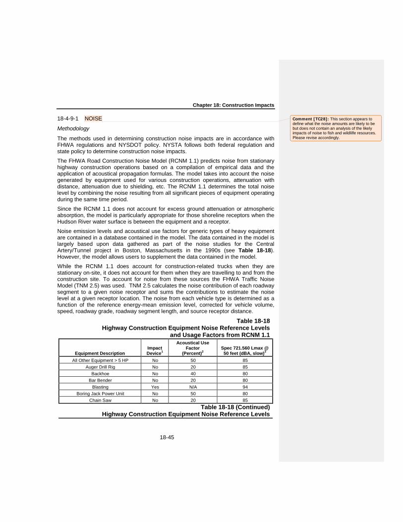
Chapter 18: Construction Impacts
18-45
18-4-9-1 NOISE
Methodology
The methods used in determining construction noise impacts are in accordance with FHWA regulations and NYSDOT policy. NYSTA follows both federal regulation and state policy to determine construction noise impacts.
The FHWA Road Construction Noise Model (RCNM 1.1) predicts noise from stationary highway construction operations based on a compilation of empirical data and the application of acoustical propagation formulas. The model takes into account the noise generated by equipment used for various construction operations, attenuation with distance, attenuation due to shielding, etc. The RCNM 1.1 determines the total noise level by combining the noise resulting from all significant pieces of equipment operating during the same time period.
Since the RCNM 1.1 does not account for excess ground attenuation or atmospheric absorption, the model is particularly appropriate for those shoreline receptors when the Hudson River water surface is between the equipment and a receptor.
Noise emission levels and acoustical use factors for generic types of heavy equipment are contained in a database contained in the model. The data contained in the model is largely based upon data gathered as part of the noise studies for the Central Artery/Tunnel project in Boston, Massachusetts in the 1990s (see Table 18-18). However, the model allows users to supplement the data contained in the model.
While the RCNM 1.1 does account for construction-related trucks when they are stationary on-site, it does not account for them when they are travelling to and from the construction site. To account for noise from these sources the FHWA Traffic Noise Model (TNM 2.5) was used. TNM 2.5 calculates the noise contribution of each roadway segment to a given noise receptor and sums the contributions to estimate the noise level at a given receptor location. The noise from each vehicle type is determined as a function of the reference energy-mean emission level, corrected for vehicle volume, speed, roadway grade, roadway segment length, and source receptor distance.
Table 18-18 Highway Construction Equipment Noise Reference Levels
and Usage Factors from RCNM 1.1
Equipment Description Impact Device1
Acoustical Use Factor
(Percent)2 Spec 721.560 Lmax @
50 feet (dBA, slow)3
All Other Equipment > 5 HP No 50 85 Auger Drill Rig No 20 85
Backhoe No 40 80 Bar Bender No 20 80
Blasting Yes N/A 94 Boring Jack Power Unit No 50 80
Chain Saw No 20 85 Table 18-18 (Continued)
Highway Construction Equipment Noise Reference Levels
Comment [TC28]: This section appears to define what the noise amounts are likely to be but does not contain an analysis of the likely impacts of noise to fish and wildlilfe resources. Please revise accordingly.

Tappan Zee Hudson River Crossing Project Environmental Impact Statement
18-46
and Usage Factors from RCNM 1.1
Equipment Description Impact Device1
Acoustical Use Factor
(Percent)2 Spec 721.560 Lmax @
50 feet (dBA, slow)3
Clam Shovel (dropping) Yes 20 93 Compactor (ground) No 20 80
Compressor (air) No 40 80 Concrete Batch Plant No 15 83 Concrete Mixer Truck No 40 85 Concrete Pump Truck No 20 82
Concrete Saw No 20 90 Crane No 16 85 Dozer No 40 85
Drill Rig Truck No 20 84 Drum Mixer No 50 80 Dump Truck No 40 84 Excavator No 40 85
Flat Bed Truck No 40 84 Front End Loader No 40 80
Generator No 50 82 Generator (<25KVA, VMS signs) No 50 70
Gradall No 40 85 Grader No 40 85
Grapple (on backhoe) No 40 85 Horizontal Boring Hydr. Jack No 25 80
Hydra Break Ram Yes 10 90 Impact Pile Driver Yes 20 95
Jackhammer Yes 20 85 Man Lift No 20 85
Mounted Impact Hammer (hoe ram) Yes 20 90 Pavement Scarafier No 20 85
Paver No 50 85 Pickup Truck No 40 55
Pneumatic Tools No 50 85 Pumps No 50 77
Refrigerator Unit No 100 82 Note: 1 Denotes percussive construction equipment that strikes another surface or material. 2 An estimation of the fraction of time each piece of construction equipment is operating at full
power (i.e., its loudest condition) during a construction operation. 3 A-Weighted Maximum sound level, measured at a distance of 50 feet from the construction
equipment.
Impact Criteria
There are no federal or state regulations which define what constitutes a noise impact. In general, three factors should be considered when determining whether a
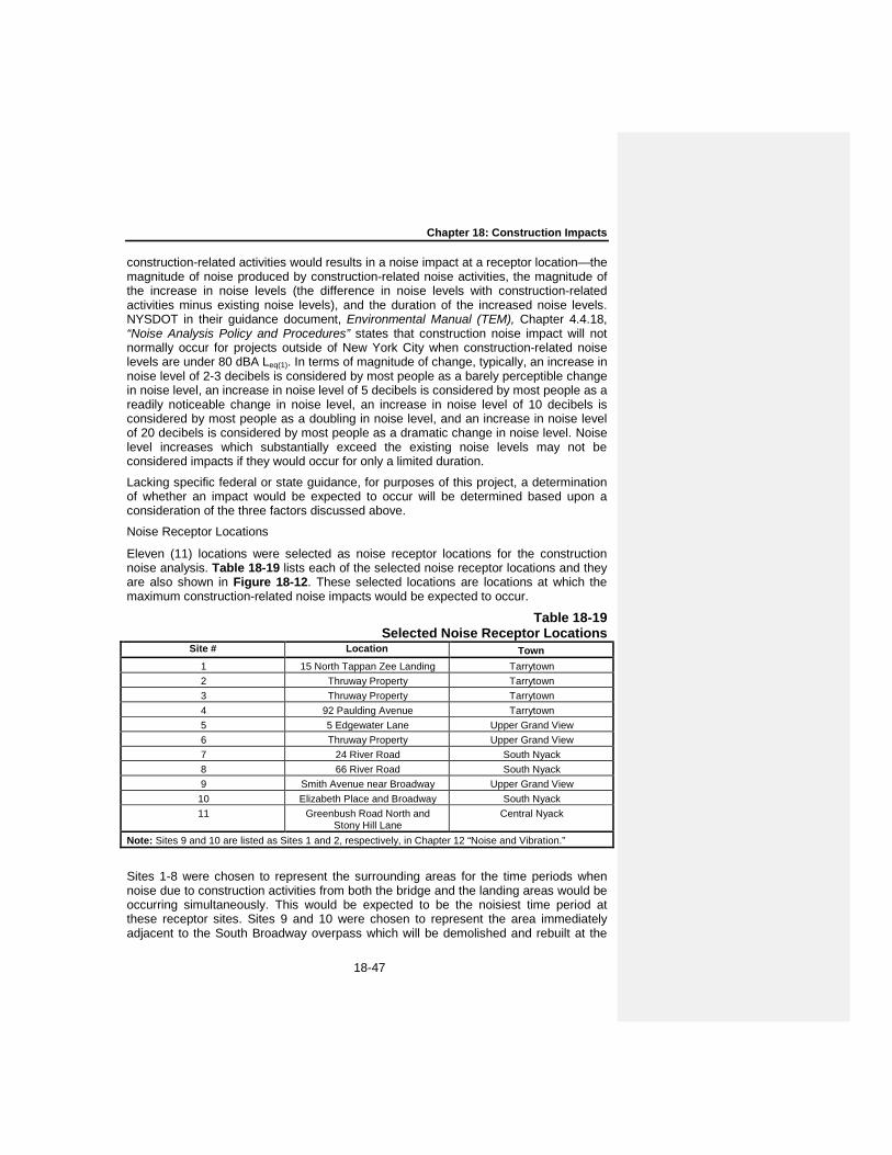
Chapter 18: Construction Impacts
18-47
construction-related activities would results in a noise impact at a receptor location—the magnitude of noise produced by construction-related noise activities, the magnitude of the increase in noise levels (the difference in noise levels with construction-related activities minus existing noise levels), and the duration of the increased noise levels. NYSDOT in their guidance document, Environmental Manual (TEM), Chapter 4.4.18, “Noise Analysis Policy and Procedures” states that construction noise impact will not normally occur for projects outside of New York City when construction-related noise levels are under 80 dBA Leq(1). In terms of magnitude of change, typically, an increase in noise level of 2-3 decibels is considered by most people as a barely perceptible change in noise level, an increase in noise level of 5 decibels is considered by most people as a readily noticeable change in noise level, an increase in noise level of 10 decibels is considered by most people as a doubling in noise level, and an increase in noise level of 20 decibels is considered by most people as a dramatic change in noise level. Noise level increases which substantially exceed the existing noise levels may not be considered impacts if they would occur for only a limited duration.
Lacking specific federal or state guidance, for purposes of this project, a determination of whether an impact would be expected to occur will be determined based upon a consideration of the three factors discussed above.
Noise Receptor Locations
Eleven (11) locations were selected as noise receptor locations for the construction noise analysis. Table 18-19 lists each of the selected noise receptor locations and they are also shown in Figure 18-12. These selected locations are locations at which the maximum construction-related noise impacts would be expected to occur.
Table 18-19 Selected Noise Receptor Locations
Site # Location Town
1 15 North Tappan Zee Landing Tarrytown 2 Thruway Property Tarrytown 3 Thruway Property Tarrytown 4 92 Paulding Avenue Tarrytown 5 5 Edgewater Lane Upper Grand View 6 Thruway Property Upper Grand View 7 24 River Road South Nyack 8 66 River Road South Nyack 9 Smith Avenue near Broadway Upper Grand View
10 Elizabeth Place and Broadway South Nyack 11 Greenbush Road North and
Stony Hill Lane Central Nyack
Note: Sites 9 and 10 are listed as Sites 1 and 2, respectively, in Chapter 12 “Noise and Vibration.”
Sites 1-8 were chosen to represent the surrounding areas for the time periods when noise due to construction activities from both the bridge and the landing areas would be occurring simultaneously. This would be expected to be the noisiest time period at these receptor sites. Sites 9 and 10 were chosen to represent the area immediately adjacent to the South Broadway overpass which will be demolished and rebuilt at the

Tappan Zee Hudson River Crossing Project Environmental Impact Statement
18-48
beginning of construction activities. Site 11 was chosen to represent the area adjacent to the potential concrete batching plant located south of the Palisades Center Mall. This location represents the location where maximum noise levels would be expected since it is the location that is closest to sensitive receptors.
Existing Noise Levels
Existing noise levels were determined by field measurements at each of the 11 construction noise receptor locations. Twenty-four hour measurements were made at Sites 1 through 8. Twenty minute short-term measurements were made at Sites 9, 10, and 11 during the AM peak hour only. These measurements are summarized below in Table 18-20. A range of the hourly Leq(1) was given for Sites 1 through 8 based on the measured values between 7:00AM and 4:00 PM (i.e., the typical hours of construction).
Analysis Results
Table 18-20 shows the construction noise analysis results. For each of the eleven receptor locations the following Leq(1) noise levels are shown: existing noise levels; noise level due to construction-related activities alone without noise abatement; noise levels with proposed noise abatement (EPCs); total ambient noise levels with construction-related activities with proposed noise abatement (i.e., the sum of existing noise levels and noise levels due to construction-related activities with proposed noise abatement); and the increase in noise levels due to construction-related activities.
Table 18-20 Existing Noise Levels at Construction Noise Receptors
Site # Measurement Leq(1) (in dBA) 1 24 hour 60-68 2 24 hour 67-70 3 24 hour 56-61 4 24 hour 63-71 5 24 hour 49-56 6 24 hour 64-68 7 24 hour 65-67 8 24 hour 56-63 9 20 minute AM peak period 69 10 20 minute AM peak period 61 11 20 minute AM peak period 58
Note: The Leq(1) noise levels shown for Sites 1-8 are values measured between 7:00AM and 4:00PM.
Noise abatement measures described in the EPCs include shrouds to reduce pile driver noise, quiet compressors and generators, and use of portable or other noise barriers and/or enclosures. Other noise abatement measures that would be utilized where practicable and feasible are as follows:
Electric power equipment, rather than diesel powered mechanical equipment would be utilized;
Use of impact devices such as jackhammer, pavement breakers and pneumatic tools should be limited and shrouds would be utilized to limit noise exposure;

Chapter 18: Construction Impacts
18-49
Construction staging areas should have appropriate noise attenuation installed around the areas and would be configured to minimize backup alarm and other noises; and
Contractors and subcontractors would be required to properly maintain and service their equipment and install quality mufflers so they meet noise specifications.
As shown in Table 18-21, the proposed noise abatement measures would be expected to reduce noise due to construction at receptor sites by up to approximately 6 dBA.
Table 18-21 Construction Noise Analysis Results
At Sites 1 through 8, even with the proposed noise abatement measures, construction-related activities alone from the bridge and landing areas would result in Leq(1) noise levels that would range from 63-81 dBA. In addition, these activities would increase Leq(1) noise levels by between 1 and 15 dBA, depending upon the site and hour. Therefore, at all but Site 3, construction-related activities would result at least a doubling of noise levels during one or more hours of the day. These large increases in
Site # Location
Existing Noise Levels Leq(1)
Construction Only Noise
Levels without
4Abatement Leq(1)
Construction Noise Levels
with Abatement
Leq(1)
Total Noise Levels
with Abatement
Leq(1)
Increases in Noise Levels
with Construction
and Noise Abatement
Leq(1)
1 15 North Tappan Zee
Landing
60-68 68 68 69-71 9-11
2 Thruway Property
67-70 87 81 81 11-14
3 Thruway Property
56-61 75 70 70-71 10-15
4 92 Paulding Avenue
63-71 66 66 68-72 1-9
5 5 Edgewater Lane
49-56 69 64 64-65 8-16
6 Thruway Property
64-68 81 75 75-76 7-12
7 24 River Road 65-67 81 75 75-76 8-11 8 66 River Road 56-63 67 63 64-66 3-10 9 Smith Avenue
near Broadway 69* 71 69 70-72 3-9
10 Elizabeth Place and Broadway
61* 80 76 76 15-21
11 Greenbush Road North and Stony Hill Lane
58* 60 60 61-62 3-5
Note: * This represents the peak measured value. Off-peak values are assumed to be approximately up to 6 dBA lower than the peak measured value.

Tappan Zee Hudson River Crossing Project Environmental Impact Statement
18-50
noise level would occur principally because of pile driving. While noise abatement measures are proposed for pile driving, even with the proposed measures pile driving would be expected to produce noisy and intrusive noise increases at Sites 1-8 and adjacent receptor locations. There are no additional noise more effective noise abatement measures that are feasible and practicable that could be utilized to eliminate and/or further reduce the noise levels due to pile driving. However, these pile driving is only expected to occur for a limited time period (i.e., less than 5 months) in this area and, the effects they cause are not considered to be noise impacts.
At Sites 9 and 10, even with the proposed noise abatement measures, construction-related activities alone from the South Broadway overpass would result in Leq(1) noise levels of 69 and 76 dBA, respectively. In addition, these activities would increase Leq(1) noise levels by 3 to 9 dBA at Site 9 and by 15 to 21 dBA at Site 10. (The higher increase in noise levels at Site 10 is due to the distance between the receptor and the construction activities and the lower existing noise levels at Site 10.) Therefore, construction-related activities would result almost a doubling of noise levels during some hours of the day at Site 9 and significantly more than a doubling of noise levels during all hours of the day at Site 10 when construction activities are underway. There are no additional noise more effective noise abatement measures that are feasible and practicable that could be utilized to eliminate and/or further reduce the noise levels at these locations. However, while construction-related activities would result in noisy and intrusive noise levels at these two receptor sites and locations adjacent to these sites, because construction activities are expected to occur for a limited time period (i.e., less than a two months) in this area, the effects they cause are not considered to be noise impacts.
At Site 11, construction-related activities alone from the concrete batching plant south of the Palisades Center Mall would result in Leq(1) noise levels of 60 dBA, respectively. In addition, construction-related activities would increase Leq(1) noise levels at Site 11 by 3 to 4 dBA, a perceptible increase. These modest increases in noise levels would not be considered to be noise impacts.
The cumulative noise results presented above were primarily a function of the construction equipment. Construction vehicles idling on the project site and traveling to and from the construction site made negligible additions to the noise levels. Tug boats in operation for staging and transporting equipment and crew are similarly expected to contribute negligible amounts due to their distance from any noise sensitive receptors.
18-4-9-2 VIBRATION
Construction activities have the potential to result in vibration levels that may in turn result in structural or architectural damage, and/or annoyance or interference with vibration-sensitive activities. In general, vibration levels at a location are a function of the source strength (which in turn is dependent upon the construction equipment and methods utilized), the distance between the equipment and the location, the characteristics of the transmitting medium, and the building construction type at the location. Construction equipment operation causes ground vibrations which spread through the ground and decrease in strength with distance. Vehicular traffic, even construction-related vehicular and equipment traffic, typically does not result in perceptible vibration levels unless there are discontinuities in the roadway surface. With
Comment [TC29]: Similar to noise—this document estimates the amount of vibration but fails to analyze the resulting impacts to fish and wildlife resources. Please revise accordingly.

Chapter 18: Construction Impacts
18-51
the exception of the case of fragile and possibly historically significant structures or buildings, construction activities typically do not reach vibration levels that can cause architectural or structural damage, but can achieve levels that may be perceptible and annoying in buildings very close to a construction site. An assessment has been prepared to quantitatively assess potential vibration impacts of construction activities on structures and residences near the project area.
Construction Vibration Criteria
For purposes of assessing potential structural or architectural damage, the determination of a significant impact was based on the vibration impact criterion of a peak particle velocity (PPV) of 0.50 inches per second. For non-fragile buildings, vibration levels below 0.50 inches per second would not be expected to result in any structural or architectural damage. For fragile buildings, vibration levels should be below 0.20 inches per second.
For purposes of evaluating potential annoyance or interference with vibration-sensitive activities, vibration levels greater than 65 vibration decibels (VdB) would have the potential to result in adverse impacts if they were to occur for a prolonged period of time.
Methodology
For purposes of assessing potential structural or architectural damage, Peak Particle Velocity (PPV) was used while the vibration level in VdB Lv(D) was used assess potential annoyance or interference with vibration sensitive activities.
Table 18-22 shows vibration source levels for typical construction equipment.
Table 18-22 Vibration Source Levels for Construction Equipment
Equipment PPVref (in/sec) Approximate Lv (ref) (VdB)
Pile Driver (sonic) upper range 0.734 105
Typical 0.170 93 Clam shovel drop (slurry wall) 0.202 94
Vibratory Roller 0.210 94 Ram Hoe 0.089 87
Large bulldozer 0.089 87 Caisson drilling 0.089 87 Loaded trucks 0.076 86 Jackhammer 0.035 79
Small bulldozer 0.003 58 Source: Transit Noise and Vibration Impact Assessment, FTA-VA-90-1003-06, May 2006.
Analysis Results
Generally, the types of construction equipment involved in construction activities that have the highest potential for resulting in architectural damage due to vibration are pile driving, ram hoes, truck loading/unloading, and jackhammers. In terms of potential vibration levels that would result in architectural damage, construction would have the

Tappan Zee Hudson River Crossing Project Environmental Impact Statement
18-52
most potential for producing levels which would exceed the 0.50 inches per second PPV limit at receptor locations within a distance of approximately 50 feet from the operation of the pile driving rig; approximately 8 feet from the operation of ram hoe or truck loading/unloading; and approximately 5 feet from the operation of jackhammer. Since all receptors are located substantially beyond these distances, there would not be the potential for architectural damage due to construction activities.
In terms of potential vibration levels that would be perceptible and annoying, pile driving, vibratory roller activities, and truck loading activities would have the most potential for producing levels which exceed the 65 VdB limit. It is likely that at receptor locations within a distance of approximately 900 feet pile driving would produce perceptible and annoying vibration levels, within a distance of 230 feet vibratory roller activities would produce perceptible and annoying vibration levels, and within a distance of 125 feet truck loading activities would produce perceptible and annoying vibration levels. However, these operations would only occur for limited periods of time at a particular location and therefore would not result in any significant adverse impacts. In no case are significant adverse impacts from vibrations expected to occur.
18-4-10 ENERGY AND CLIMATE CHANGE
The potential effect of project construction on energy consumption and greenhouse gas (GHG) emissions is assessed in this section.
While the contribution of any single project to climate change is infinitesimal, the combined GHG emissions from all human activity severely impact global climate—an impact that is expected to increase in the future. The nature of the impact dictates that all sectors address GHG emissions by identifying GHG sources and practicable means to reduce them. Therefore, this chapter does not identify specific contributions of the proposed project to climate impacts, but rather addresses the changes in GHG emission associated with the project construction.
18-4-10-1 POLICY, REGULATIONS, STANDARDS, AND BENCHMARKS
In a step toward the development of national climate change regulation, the U.S. has committed to reducing emissions to 17 percent lower than 2005 levels by 2020 and to 83 percent lower than 2005 levels by 2050 (pending legislation) via the Copenhagen Accord.1 Without legislation focused on this goal, the U.S. Environmental Protection Agency (USEPA) is required to regulate GHGs under the Clean Air Act, and has already begun preparing and implementing regulations. USEPA has established various voluntary programs to reduce emissions and increase energy efficiency and has recently embarked on regulatory initiatives related to GHG emissions.
There are also regional, state, and local efforts to reduce GHG emissions. In 2009, Governor Paterson issued Executive Order No. 24, establishing a goal of reducing GHG emissions in New York by 80 percent, compared to 1990 levels, by 2050, and creating a Climate Action Council tasked with preparing a climate action plan outlining
1 Todd Stern, U.S. Special Envoy for Climate Change, letter to Mr. Yvo de Boer, UNFCCC, January 28, 2010.

Chapter 18: Construction Impacts
18-53
the policies required to attain the GHG reduction goal—that effort is currently under way, and an interim draft plan has been published.1
The 2009 New York State Energy Plan2 outlines the state’s energy goals and provides strategies and recommendations for meeting those goals.
The 2009 New York State Smart Growth Public Infrastructure Policy Act requires that State infrastructure agencies (including NYSDOT, NYSTA, and others) ensure that, to the extent practicable, public infrastructure projects they approve, undertake, support, or finance be consistent with a series of smart-growth criteria.
A number of benchmarks for energy efficiency and green building design have also been developed. For example, NYSDOT’S Green Leadership in Transportation Environmental Sustainability (GreenLITES) Project Design Certification Program3 is a self-certification rating system for enhancing the environmental performance of transportation projects. The certification addresses issues such as recycled content of materials, local materials, reducing electricity and petroleum consumption, improving cycling and pedestrian facilities, and many other sustainability items.
Currently, there are no standards or regulations applicable to GHG emission levels or impacts from actions subject to environmental review under NEPA or SEQRA. Accordingly, the potential effects of the project have been evaluated in the context of their consistency with the objectives stated in federal and state policies. Potential GHG emissions from the project are assessed and disclosed, and the feasibility and practicability of various measures available for reducing GHG emissions are discussed. 18-4-10-2 METHODOLOGY FOR GREENHOUSE GAS EMISSIONS ANALYSIS
Approach and Scope
Since the impact of GHGs emitted in the troposphere is generally the same regardless of where they are emitted, the analysis of GHGs addresses emissions resulting from project construction regardless of their location and timing. However, since project operations are expected to affect only a small reduction in GHG emissions from vehicles, the construction emissions represent the net total GHG emissions associated with the project.
The analysis includes both direct emissions from sources such as construction equipment and vehicles, and indirect emissions associated with electricity consumption. In addition, there are emissions preceding and following the proposed project, referred to as upstream and downstream emissions, such as emissions associated with the transport and production of fuels and construction materials, and emissions associated with disposal of materials after their use. The GHG analysis addresses both direct and indirect emissions, and, where practicable and substantial, upstream and downstream emissions.
1 http://www.nyclimatechange.us/ 2 New York State, 2009 New York State Energy Plan, December 2009. 3 https://www.dot.ny.gov/programs/greenlites
Tappan Zee Hudson River Crossing Project Environmental Impact Statement
18-54
NYSDOT’s Draft Energy Analysis Guidelines for Project-Level Analysis, November 25, 2003 (NYSDOT guidance) and associated MOVES Roadway and Rail Energy and Greenhouse Gas Analysis Extension (MOVES-RREGGAE) enable analysis of transportation project, using EPA’s MOVES model for on-road emissions and other analysis procedures for construction emissions. The construction analysis procedures used in MOVES-RREGGAE rely on available information, mostly associated with standard roadway and rail projects, including in some cases estimates associated with the correlation between project costs and energy expenditure. Given the scale and complexity of the project, and the availability of more detailed construction information, a more detailed approach was applied here, relying on project data and existing information from USEPA, the US Department of Energy’s Energy Information Administration (EIA), and other sources when necessary, as detailed below.
Greenhouse Gases Analyzed
Six GHGs are included in the analysis where relevant: Carbon dioxide (CO2), nitrous oxide (N2O), methane, Hydrofluorocarbons, Perfluorocarbons, and Sulfur Hexafluoride. To present a complete inventory of all GHGs, component emissions are added together and presented as CO2 equivalent (CO2e)—a unit representing the quantity of each GHG weighted by its effectiveness using CO2 as a reference.
Non-Road Construction Engines
Fuel use for nonroad engines used on-site, including all construction engines, generators, and tug boats for all construction years and sites was estimated, similar to the detailed estimates of engine use described above for air quality and noise analyses. The total diesel fuel use was estimated to be 11.5 million gallons for the Short Span Option and 10.7 million gallons for the Long Span Option. This quantity of fuel was multiplied by an emission factor of 10.14 kg CO2e per gallon of diesel to calculate total GHG emissions from these sources.
On-Road Vehicles
The total number of construction worker trips was estimated using the detailed construction schedule. The total number of trips, 885,832 for the Short Span Option and 246,238 for the Long Span Option, was then divided by an average vehicle occupancy of 1.2 and multiplied by an average round-trip distance of 30.3 miles1 to obtain a total personal vehicle miles traveled of 11.17 million for the Short Span Option and 3.10 million miles for the Long Span Option. An average combined emission factor of 406 grams CO2e per mile was applied; this was derived from the EPA MOVES emission model, assuming a roadway classification mix of 23.0 percent, 27.6 percent, and 49.4 percent on local, arterial, and freeway/expressway, respectively.2
Concrete and general deliveries (fuel, potable water, and other miscellaneous materials) were assumed to travel 50 miles round-trip (ready-mix concrete needs to be
1 A one-way average commuting distance in the Poughkeepsie area of 15.13 miles was obtained from—Oak Ridge
National Laboratory, 2001 National Household Travel Survey, New York Add-On— Putnam, Rockland, Westchester, May 2004.
2 Average 2007 vehicle miles traveled mix by roadway classification for Rockland and Westchester counties. Data provided by NYSDOT.
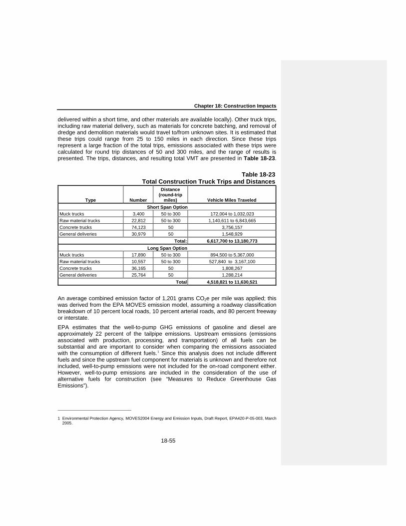
Chapter 18: Construction Impacts
18-55
delivered within a short time, and other materials are available locally). Other truck trips, including raw material delivery, such as materials for concrete batching, and removal of dredge and demolition materials would travel to/from unknown sites. It is estimated that these trips could range from 25 to 150 miles in each direction. Since these trips represent a large fraction of the total trips, emissions associated with these trips were calculated for round trip distances of 50 and 300 miles, and the range of results is presented. The trips, distances, and resulting total VMT are presented in Table 18-23.
Table 18-23 Total Construction Truck Trips and Distances
Type Number
Distance (round-trip
miles) Vehicle Miles Traveled Short Span Option
Muck trucks 3,400 50 to 300 172,004 to 1,032,023 Raw material trucks 22,812 50 to 300 1,140,611 to 6,843,665 Concrete trucks 74,123 50 3,756,157 General deliveries 30,979 50 1,548,929
Total: 6,617,700 to 13,180,773 Long Span Option
Muck trucks 17,890 50 to 300 894,500 to 5,367,000 Raw material trucks 10,557 50 to 300 527,840 to 3,167,100 Concrete trucks 36,165 50 1,808,267 General deliveries 25,764 50 1,288,214
Total 4,518,821 to 11,630,521
An average combined emission factor of 1,201 grams CO2e per mile was applied; this was derived from the EPA MOVES emission model, assuming a roadway classification breakdown of 10 percent local roads, 10 percent arterial roads, and 80 percent freeway or interstate.
EPA estimates that the well-to-pump GHG emissions of gasoline and diesel are approximately 22 percent of the tailpipe emissions. Upstream emissions (emissions associated with production, processing, and transportation) of all fuels can be substantial and are important to consider when comparing the emissions associated with the consumption of different fuels.1 Since this analysis does not include different fuels and since the upstream fuel component for materials is unknown and therefore not included, well-to-pump emissions were not included for the on-road component either. However, well-to-pump emissions are included in the consideration of the use of alternative fuels for construction (see “Measures to Reduce Greenhouse Gas Emissions”).
1 Environmental Protection Agency, MOVES2004 Energy and Emission Inputs, Draft Report, EPA420-P-05-003, March
2005.

Tappan Zee Hudson River Crossing Project Environmental Impact Statement
18-56
Electricity Use
Although some grid-supplied electric power would be used for the Project, this would be limited to office use and other uses in the various staging areas. These uses are unknown at this time, but are expected to be minor on the scale of the other emissions quantified here, and were therefore not included.
Construction Materials
Upstream emissions related to the production of construction materials were estimated based on the expected quantity of iron or steel and cement. Although other materials will be used, cement and metals have the largest embodied energy and direct GHG emissions associated with their production, and large quantities would be used for the project.
The construction is estimated to require 739 and 351 thousand cubic yards of cement for the Short and Long Span Options, respectively. Concrete is estimated to have a density of 1.8 metric tons per cubic yard, and 10 percent cement content by weight, resulting in approximately 134 and 64 thousand metric tons of cement used for the Short and Long Span Options, respectively. An emission factor of 0.928 metric tons of CO2e per metric ton of cement produced was applied to estimate emissions associated with energy consumption and process emissions for cement production.1
The construction is estimated to require approximately 295 and 301 thousand tons of steel for the Short and Long Span Options, respectively. An emission factor of 0.6 metric tons of CO2e per metric ton of steel product produced was applied to estimate emissions associated with production energy consumption,2 and a factor of 0.65 metric tons of CO2e per metric ton of steel product produced was applied for process emissions associated with iron and steel production.3
18-4-10-3 ANALYSIS RESULTS
Greenhouse Gas Emissions—Long Span Option
The projected maximum GHG emissions by component for the duration of construction of the Long Span Option, along with the quantities and emissions factors for each component, are presented in Table 18-24.
Table 18-24 Greenhouse Gas Emissions—Long Span Option
Component Quantity Units
Emission Factor (metric tons CO2e/unit)
Total Emissions (metric tons
CO2e)
1 The Portland Cement Association, Life Cycle Inventory of Portland Cement Manufacture, 2006 2 Arpad Horvath et al., Pavement Life-cycle Assessment Tool for Environmental and Economic Effects, Consortium on
Green Design and Manufacturing, UC Berkeley, 2007. 3 Based on 42.3 teragrams of CO2e emitted and 65,460 thousand tons produced; EPA, Inventory of U.S. Greenhouse
Gas Emissions and Sinks: 1990–2009, April 15, 2011.

Chapter 18: Construction Impacts
18-57
Materials Embedded* Cement 63,600 metric tons 0.928 59,100 Steel 272,700 metric tons 1.25 339,700
Non-road Engines** (diesel) 10,673,000 gallons 0.0101 108,300 On-Road Vehicles
Trucks*** 11,630,000 VMT 0.00120 14,000 Worker vehicles 3,100,000 VMT 0.00041 1,300
Total: 522,000 Notes: Numbers are presented at analysis precision level. Sums may not add up due to rounding. * Emissions do not include extensive additional shipping such as international shipping of steel, if
steel is imported. For example, shipping the steel from South America could add 250 thousand metric tons of CO2e, and from China could be double that amount.
** Non-road engines include on-site tug boat operations. Tug boat deliveries are listed separately. *** Truck emissions presented are based on the high-end assumption of 300-mile round trip distance.
The lower-end scenario of 50-mile round trip would result in 5,400 metric tons of CO2e from truck trips, reducing the total by 8,500 metric tons CO2e.
Greenhouse Gas Emissions—Short Span Option
The projected maximum GHG emissions by component for the duration of construction of the Short Span Option, along with the quantities and emissions factors for each component, are presented in Table 18-25.
Summary
Total GHG emissions associated with construction of the project are projected to be approximately 0.5 million metric tons, with emissions from the Short Span Option approximately 12 percent higher than the Long Span Option. It is unknown at this time if steel for the bridge will be produced in the US or imported; if the steel for the project needs to be shipped for long distances emissions could be considerably higher. For example, shipping all steel 12,500 miles (approximate distance from Shanghai to an east coast port) would result in an additional 850 thousand metric tons CO2e (both options require approximately 300 thousand tons of steel in total).
Table 18-25 Greenhouse Gas Emissions—Short Span Option
Component Quantity Units
Emission Factor (metric tons CO2e/unit)
Total Emissions (metric tons
CO2e) Materials Embedded*

Tappan Zee Hudson River Crossing Project Environmental Impact Statement
18-58
Cement 133,900 metric tons 0.928 124,300 Steel 267,400 metric tons 1.25 333,100
Non-road Engines** (diesel) 11,526,000 gallons 0.0101 116,900 On-Road Vehicles
Trucks*** 13,180,000 VMT 0.00120 15,800 Worker vehicles 11,170,000 VMT 0.00041 4,500
Total: 595,000 Notes: Numbers are presented at analysis precision level. Sums may not add up due to rounding. * Emissions do not include extensive additional shipping such as international shipping of steel, if
steel is imported. For example, shipping the steel from South America could add 66 thousand metric tons of CO2e, and from China could be double that amount.
** Non-road engines include on-site tug boat operations. Tug boat deliveries are listed separately. *** Truck emissions presented are based on the high-end assumption of 300-mile round trip
distance. The lower-end scenario of 50-mile round trip would result in 7,950 metric tons of CO2e from truck trips, reducing the total by 7,900 metric tons CO2e.
18-4-10-4 MEASURES TO REDUCE GREENHOUSE GAS EMISSIONS
Potential measures to reduce GHG emissions could address any of the GHG emission categories analyzed above for construction. In addition, there are some measures that could be incorporated in the project design and operations which could further reduce GHG emissions for years to come—see Chapter 13, “Energy and Climate Change for a discussion of project design and operational measures and features.
To address emissions associated with construction, several measures will be required via construction contracts to reduce direct emissions and upstream emissions associated with construction materials and their transportation:
Supplementary Cementitious Materials (SCM): Construction contracts would require the use of fly ash, slag, silica fume, calcined clay, and/or interground limestone to the extent practicable, contingent upon meeting the project’s concrete specifications. Depending on the practicable level of implementation, these measures may reduce emissions by as much as 15,000 or 30,000 metric tons CO2e for the Long Span Option and the Short Span Option, respectively.
Reducing Concrete Waste: Construction contracts would require contractors to make efforts to reduce concrete waste. Concrete is wasted when concrete cannot be poured on site for reasons such as timing, quality control, or quantity estimates (e.g., leftover concrete from the last pour of the day). In such cases, concrete can be poured as blocks or sidewalk slabs for later use.
Optimize Cement Content: Contractors will be required to optimize cement content according to project specifications.
In addition, the following measures will be implemented where practicable:
Biodiesel: Biodiesel could be used for non-road engines during construction. The feasibility of using biodiesel for some or all construction engines and/or tug boats will be investigated, and included in construction contracts if found to be practicable.

Chapter 18: Construction Impacts
18-59
This would reduce project emissions in the range of 12,000 to 117,000 metric tons CO2e depending on the biodiesel blend used.
Recycled Steel: Requiring the use of recycled steel in construction contracts where practicable could ensure lower GHG emissions from steel production. If all project steel is from recycled sources, emissions could be reduced by approximately 220,000 metric tons CO2e (40 to 45 percent of total emissions).
Local Materials Sourcing: The use of local materials can substantially reduce emissions from transportation. For example, the difference between the 50-mile round trip scenario and the 300-mile trip scenario for project truck trips is approximately 14,000 metric tons CO2e for the Long Span Option, and 10,000 for the Short Span Option. More importantly, as discussed above, if steel is shipped from distant international origins, additional emissions associated with the shipping could amount to 385,000 to 850,000 metric tons CO2e. In addition to the request for the use of local materials where practicable in the construction bid documents, the “buy American” provisions would require the use of American materials unless savings amounting to 25 percent of the entire cost of the project could be made by purchasing materials from other countries; therefore, it is unlikely that materials would be sourced from international origins.
18-4-11 TOPOGRAPHY, GEOLOGY, AND SOILS
As described in Chapter 14, “Topography, Geology, and Soils,” the limit of disturbance area for the replacement bridge is characterized by rolling and gently sloped topography, primarily comprising 0-15 percent slopes. The only area of steep slopes (25-35 percent) is along the Hudson River shoreline in Westchester County. The TQSA and WNSA are located in areas of primarily minimal slopes (0-15 percent).
The majority of ground disturbance related to construction of the Replacement Bridge Alternative would occur in areas of 0-15 percent slopes. The roadway would be elevated over the areas of 25-35 percent slopes in Westchester County; therefore, substantial regrading would not be required.
The primary concerns related to soils are erosion and suitability for construction. Ground disturbance can expose soils to wind, rain, and other erosive forces, thereby potentially creating dust or sedimentation of waterbodies. Erosion hazards for the soils in the limit of disturbance area range from moderate to very severe. To minimize potential impacts associated with soil erosion, all construction activities would be conducted in accordance with any applicable NYSDEC-approved SWPPP and ESC plan developed pursuant to NYSDEC’s SPDES General Permit for Stormwater Discharges from Construction Activity (GP-0-10-001). In the post-construction (i.e., operation) condition, any previously exposed areas during construction would either be developed with highway improvements or maintenance facilities or would be re-vegetated, thereby limiting long-term erosion concerns.
18-4-12 WATER RESOURCES
Construction of the Replacement Bridge Alternative has the potential to affect the water quality of the Hudson River within the study area due to in-water construction activities that include dredging of bottom sediments, installation of cofferdams, driving of piles, vessel movement, and demolition of the existing bridge. Additionally, upland
Tappan Zee Hudson River Crossing Project Environmental Impact Statement
18-60
construction activities within the upland staging areas, the bridge landings within Rockland and Westchester Counties, upland activities associated with establishing access to the waterfront staging areas have the potential to affect floodplains, and surface and groundwater resources within the vicinity of these sites. Activities within the floodplain, discharges to surface water and groundwater, and dredging and disposal of dredge material must comply with the federal and state legislation and regulatory programs described previously in Chapter 15, “Water Resources”.
Potential impacts on groundwater, floodplains, and water quality of the Hudson River were assessed by considering the following:
The existing groundwater and floodplain resources and Hudson River water quality within the study areas, as discussed in Chapter 15, “Water Resources;”
Results of modeling conducted to assess the potential for sediment disturbance resulting from in-water construction activities (i.e., dredging, cofferdam installation, pile driving, and vessel movement) to result in adverse environmental impacts to Hudson River water and sediment quality, as described in greater detail below;
The potential for cofferdam dewatering to affect water quality; and
The potential for demolition of the existing bridge to impact water quality.
The potential for land-based construction activities to result in soil erosion and the discharge of stormwater runoff.
18-4-12-1 SEDIMENT RESUSPENSION ANALYSIS METHODOLOGY
For the Hudson River, the principal water quality resources issues for the construction of the Replacement Bridge Alternative is the resuspension of river sediments during construction and removal of the existing bridge foundations, and the transport1 and eventual deposition2 of this resuspended sediment elsewhere in the Hudson River. While the sand fraction of river sediment settles out relatively quickly after being resuspended, the finer sediment fractions will remain suspended and will be transported away from the construction area and will be deposited elsewhere in the estuary or leave the estuary altogether. Hydrodynamic modeling was used to project the plume of resuspended sediment that would result from sediment disturbing construction activities and the fate and transport of this plume within the Hudson River estuary. As discussed in detail in Appendix E, two public domain models were employed in the modeling; the Environmental Fluid Dynamics Code (EFDC) model and Research Management Associates (RMA) model. The EFDC is a state-of-the-art hydrodynamic model that can be used to simulate aquatic systems in one, two, and three dimensions. It is one of the most widely used and technically defensible hydrodynamic models in the world (www. Epa.gov/Athens/wwqtsc/html/efdc.html). The EFDC model and technical support is available from the USEPA and is the most widely used hydrodynamic model. The RMA model is a dynamic two-dimensional depth-averaged finite element hydrodynamic 1 Resuspended sediment will be transported by river flow. During transport the sediment is subject to a variety of
processes, including dispersion, which tends to dilute concentrations over time. 2 At some point after being resuspended, sediment will settle in depositional areas within the estuary system. This
material will become part of the natural sediment transport cycle in the Hudson River estuary and will undergo additional cycles of resuspension and deposition.
Comment [TC30]: Yes. However, you still need to disclose to the public what impacts these activities will have.
Comment [TC31]: Existing contaminants in the river and the impacts from re-suspension?
Comment [TC32]: What impacts on aquatic species and their habitats would result from sediment resuspension? Include discussion of contaminants (e.g., bioaccumulation, etc )
Chapter 18: Construction Impacts
18-61
model that was developed for the USACE and is used extensively for bridge scour evaluations in estuaries. It is one component of the US Army Corps of Engineers TABS-MD System (US Geological Service (USGS) Surface Water and Water Quality Models Information Clearinghouse (http://smig.usgs.gov/cgi-bin/SMIC/model_home_pages /model_home?selection=rma2).
Inputs to the hydrodynamic models included the following:
Results of SedFlume1 analysis of sediments within the vicinity of the area to be dredged conducted by Dr. Donald Hayes, that indicated sediments within the study area are highly susceptible to resuspension. Dr. Hayes is the director of the Institute for Coastal Ecology and Engineering at the Universtiy of Louisiana at Lafayette Department of Civil Engineering and a recognized expert in the areas of dredging, sediment management, beneficial uses and contaminated sediment (Louisiana Sea Grant program http://www.laseagrant.org/comm/experts/hayes.htm).
Existing information to characterize the Hudson River Estuary within the study area, examples of which include bathymetry from the National Oceanic and Atmospheric Administration (NOAA) navigational charts, tidal data from US Geological Survey (USGS) and NOAA tide stations, USGS freshwater discharge, salinity and suspended sediment concentration data, and USGS suspended sediment concentration data.
Results of numeric models developed by Dr. Hayes to estimate suspended sediment loadings that would result from dredging; pile driving, coffer dam installation, dewatering, and removal; and vessel movement as described below. Inputs to these models are presented below.
- Suspended sediment generated by dredging—dredging area (up to approximately 173 acres (about 0.2 square miles) and volume (up to 1.8 million cubic yards), rate of dredging (about 7,500 cubic yards per dredge per 24 hour period with two dredges operating concurrently), use of environmental/closed bucket with no barge overflow and a conservative sediment loss rate of about 1 percent. This conservative loss rate, combined with the projected dredging rate and the sediment characteristics results in an average sediment resuspension rate for each dredge of 39 kilograms per minute (kg/min), and a maximum rate of 94 kg/min (see Appendix E, Attachment 4).
- Suspended sediment generated by cofferdam construction and dewatering—In the absence of existing information on sediment resuspension rates associated with cofferdam construction, resuspension of sediment during installation of sheet pile for cofferdams was developed on the basis of results of suspended sediment monitoring conducted for the San Francisco-Oakland Bay Bridge East Span Seismic Safety Project during dredging and in-water construction activities
1 High Shear Stress flume (SEDflume http://www.erdc.usace.army.mil) is designed for estimating gross erosion rates of
fine-grained and mixed fine/coarse-grained sediments and the variation of the erosion rate with depth below the sediment-water interface. The erosion data are used to predict stability for contaminated sediments, capping material, native sediment, or dredged material and are often incorporated into numerical sediment transport models. The flume is designed to erode sediment cores layer by layer. Each core layer is eroded by regulating flow over the core surface. The flume is operator-controlled, so the operator selects the range of shear stresses (starting at a low value and proceeding through higher values) for measuring erosion rate.

Tappan Zee Hudson River Crossing Project Environmental Impact Statement
18-62
(http://biomitigation.org/bio_overview/subjects_overview.asp#water). Results of monitoring for that project indicated that installation of sheet pile for cofferdam construction resulted in average resuspension of bottom material that was about 30 percent of the average resuspension during dredging (see Appendix E, Attachment 4).
- Suspended sediment generated by pile driving and dewatering—Existing information on sediment resuspension from pile driving and dewatering was similarly absent and was estimated to be approximately 40 percent of that observed during dredging on the basis of the suspended sediment monitoring for the San Francisco-Oakland Bay Bridge East Span Seismic Safety Project (see Appendix E, Attachment 4).
- Suspended sediment generated by vessel movement and prop scour—As discussed previously a layer of gravel and sand would be placed at the bottom of the dredged channel to minimize sediment re-suspension. However, this layer would not prevent the resuspension of sediment that would be naturally deposited each day. Using an estimated depositional rate of sediment within the dredged channel of 104 kilograms per meter per day developed on the basis of van Rijn (1986) and total suspended sediment concentrations measured during studies conducted for the Replacement Bridge Alternative, the hourly scour rate of sediment as the vessels move along the channel was estimated as 8.7 kg per meter per hour (kg/m/hr) (see Appendix E, Attachment 4).
As indicated in the construction timeline presented in Figure 18-1, there are periods when sediment disturbing activities evaluated in the hydrodynamic modeling would occur concurrently, with the majority of the potential for sediment resuspension occurring during the first two dredging periods. The hydrodynamic modeling results evaluated in this EIS comprise conservative scenarios that would be expected to result in the greatest sediment resuspension:
Stage 1 dredging with pile driving for the main span (Zone C) and trestles;
Pile driving and cofferdam installation and dewatering for Zones C and B, movement of construction vessels, and trestle construction after Stage 1 dredging is complete; and
Stage 2 dredging combined with pile driving and cofferdam installation and dewatering for Zones C and B, and movement of construction vessels.
Appendix E to this chapter presents the results of the hydrodynamic modeling for all of the scenarios evaluated for the project. The worst case scenarios evaluated in this EIS were developed on the basis of these analyses.
18-4-12-2 SEDIMENT RESUSPENSION AND TRANSPORT
The Long Span Option would have fewer total number of piers (35) than the Short Span Option (62) (see Figures 18-6 and 18-7), resulting in a shorter construction duration (4½ years) than the short span option (5½ years). While the number of main span piers is the same between the two options, the long span option has far fewer piers in the approaches.
Sediment disturbing construction activities include dredging, cofferdam construction, and pile driving within Substructure Zones A and B, pile driving within Substructure
Comment [TC33]: We need to see this document in order to provide comments.

Chapter 18: Construction Impacts
18-63
Zone C (see Figures 18-6 and 18-7 for the location of these zones) and the movement of construction vessels within the construction access channel for the Long and Short Span options. Within Construction Zones A and B (see Figures 18-6 and 18-7) pile driving would occur within the cofferdams and would not have the potential to re-suspend sediment within the river. Within Zone C, piles would be driven first and then the pile caps installed within hanging cofferdams. Therefore, only the Zone C piles would have the potential to result in additional sediment re-suspension. Hydrodynamic modeling was used to project the plume of resuspended sediment that would result from these concurrent sediment disturbing construction activities and the fate and transport of this plume within the river estuary.
The results of the modeling of the scenarios expected to result in the greatest resuspension of sediment indicated in Figures 18-13 through 18-16 are similar for the Long Span and Short Span Options and indicate that total suspended sediment concentrations in the range of 50 to 100 mg/L above ambient conditions would only occur in the immediate vicinity of the dredges. This level of increase would be expected to occur within the allowable mixing zone1 for dredging. Other sediment disturbing construction activities would result in a much smaller contribution of suspended sediment (i.e., driving of piles for the cofferdams, pile driving, vessel movement and cofferdam dewatering). On flood and ebb tides, concentrations of 10 mg/L above ambient conditions may extend in a relatively thin band approximately 1,000 to 2,000 feet from the dredges, while concentrations of 5 mg/L may extend a greater distance. Total suspended sediment concentrations recorded during sampling conducted for the project ranged from 13 to 111 mg/L. Additionally, the approximately 8-year record of suspended sediment concentration (SSC) recorded by the USGS at Poughkeepsie (see Chapter 15, “Water Resources,” Figure 15-8) indicates there is considerable variation in the suspended sediment concentration within the Hudson River, as would be expected with an estuarine environment. During periods of higher freshwater flow the differences between low and high SSCs range between approximately 20 to 40 mg/L, during periods of low freshwater inflow the differences between low and high SSCs range from about 5 to 20 mg/L. Therefore, the projected increases in suspended sediment due to dredging concurrent with other sediment-disturbing construction activities would be well within the natural variation in suspended sediment concentration and would not result in adverse impacts to water quality and would be expected to meet the turbidity standard2 for Class SB waters at the edge of the mixing zone. Concentrations of total suspended sediment from cofferdam construction (which include the discharge of river water recovered during dewatering) and pile driving would be approximately 5 to 10 mg/L in the immediate vicinity of the activity (within a few hundred feet) which would be much less than that projected to result from dredging and would not result in adverse water quality impacts. Concentrations of total suspended sediment resulting from construction vessel movement are projected to be less than 5 mg/L. Increases of total suspended
1 A mixing zone is an area in a water body within which the NYSDEC will accept temporary exceedances of water quality
standards resulting from short-term disruptions to the water body caused by dredging or the management of dredged material. A mixing zone can be assigned at the site of dredging (NYSDEC 2004).
2 The turbidity standard for Class SB waters is “No increase that will cause a substantial visible contrast to natural conditions.”
Comment [TC34]: Impacts to aquatic species and their habitats?

Tappan Zee Hudson River Crossing Project Environmental Impact Statement
18-64
sediment concentration above ambient would be greatest during slack tide, without tidal action to disperse it (see Figures 18-13 and 18-15).
Placement of the sand/gravel armoring material within the dredged area, similar to the placement of granular capping material over contaminated sediment, has the potential to result in sediment resuspension when the capping material is deposited upon the sediment, but would not be expected to affect the magnitude of sediment resuspension projected through the hydrodynamic modeling. Results of monitoring conducted during placement of granular capping material on soft sediment indicated that resuspended sediment plumes were due to fines washed of the sand cap material and not due to resuspension of bottom sediment as the capping material was put in place (USACE 2005). Measures would be implemented during placement of the sand layer of the armoring to minimize resuspension of the newly exposed sediment. These measures are the same type of measures that have been demonstrated to successfully cap contaminated sediment with minimal mixing of the cap with contaminated sediment (Palermo et al. 2011), and for the capping of subaqueous dredged material (Palermo et al. 1998). They include both mechanical (dry sand capping material with bottom-dump barge, side-casting, bucket/clamshell, tremie (gravity-fed downpipe)) and hydraulical (wet/slurry of sand placed from a pipe or tremie, or from a spreader barge) placement of the capping material (USACE 2005 and 2006a, USEPA 1995, Palermo et al. 2011). Mechanical methods rely on the gravity settling of the granular capping materials in the water column (Palermo et al. 2011) which can result in less water column dispersion than discharge of hydraulically-handled cap material because it settles faster in the water column (USACE 1991). Hydraulic methods can allow for a more precise placement of the material at the surface or depth but may require use of a dissipation devise to reduce sediment resuspension (Palermo et al. 2011, USACE 1991).
Placing sand capping material in layers has been found to allow gentle spreading, resulting in a more stable sand cap (Ling and Leshchinsky undated), and avoiding displacement of or mixing with the underlying sediment (USEPA 2005). This results in a decrease in the turbidity plume with each successive cap layer. The reduction in sediment resuspension observed by placing granular capping material in lifts or layers may afford the ability to place subsequent layers using an alternative methodology that may allow faster placement (USEPA 2008). Therefore, once the sand layer of the proposed armoring is in place, the placement of the gravel would have limited potential to result in sediment resuspension. With the implementation of these methods of placement of granular capping material that have been proven to reduce sediment resuspension during placement, additional sediment resuspension that would occur during the placement of the armoring material would be minimized and would not be expected to result in adverse water quality impacts.
In summary, the results of the hydrodynamic modeling of changes in suspended sediment resulting from construction activities—dredging, pile driving, cofferdam construction, and vessel movement—indicate that with the exception of the portion of the mixing zone within the immediate vicinity of the dredge, increases in suspended sediment would be minimal for the Long and Short Span Options and within the natural range of variation of suspended sediment concentration within this portion of the river. Sediment resuspension resulting from dredging and other sediment disturbing activities would be expected to meet the Class SB turbidity standard at the edge of the mixing
Chapter 18: Construction Impacts
18-65
zone. Resuspended sediment would dissipate shortly after the completion of the dredging activities, and would not result in adverse impacts to water quality. During the periods of in-water construction when no dredging is occurring, the limited sediment resuspension during pile driving, cofferdam installation and removal, and vessel movement would be localized, would be expected to dissipate shortly after the completion of in-water construction activity and would not result in adverse water quality impacts. Similarly, with the implementation of measures demonstrated to minimize sediment resuspension during placement of capping or armoring material, the placement of the armoring material within the dredged area would not result in adverse water quality impacts. For all of the reasons presented above the increase in suspended sediment projected to result from dredging and other in-water sediment-disturbing construction activities, even under the worst case scenarios, and the placement of armoring within the dredged channel, would not result in adverse impacts to water quality of the Hudson River.
18-4-12-3 SEDIMENT QUALITY
Chapter 15, “Water Resources,” presents a detailed discussion of sediment quality on the basis of results of laboratory analysis of sediment samples collected within the study area in 2006 and 2008 (see Figures 15-13 through 15-18). The results of these analyses are summarized in Table 15-3, and the samples classified as Class B (moderate contamination) or Class C (high contamination) in accordance with NYSDEC’s In-Water and Riparian Management of Sediment and Dredged Material (NYSDEC 2004). While there are some locations for which certain contaminants fall under the Class B or Class C category, these concentrations typically apply to only the upper few feet and the concentrations of these contaminants decline to those meeting Class A (no appreciable contamination) category within a few feet of the mudline. Resuspension of sediments during dredging can also affect water quality through the release of contaminants dissolved in the sediment pore water (i.e., the water occupying the spaces between sediment particles). Considering the limited plume of increased suspended sediment above ambient concentrations projected to occur during the three-month dredging periods, and the limited area of sediments with low to moderate levels of contamination within the area to be dredged, the release of any contaminants would not result in adverse impacts to water quality.
The other in-water construction activities with the potential to result in sediment resuspension (pile driving, installation of the cofferdam and vessel movement) for the Long and Short Span Options are projected to result in a minimal increase in SSC above ambient concentrations. These projected increases would actually be much lower, because within Zones A and B, the sand/gravel armoring layer installed throughout these two zones to minimize scouring would also minimize any resuspension of sediment resulting from the installation of the cofferdams. River water recovered during dewatering of the cofferdams would be treated (e.g., tanks to settle out any suspended sediments and water filtration system as necessary) and discharged back to the Hudson River in accordance with conditions issued by the NYSDEC under the Section 401 water quality certification for the project and would not result in adverse impacts to water quality of the Hudson River.
Comment [TC35]: Adverse impacts to aquatic species?
Comment [TC36]: This section needs to have a discussion of existing contaminants in the river.

Tappan Zee Hudson River Crossing Project Environmental Impact Statement
18-66
18-4-12-4 EXISTING BRIDGE DEMOLITION
Bridge demolition would occur in two stages. The first stage includes partial demolition to allow for construction of the replacement bridge in the vicinity of the Westchester shoreline. The second stage includes the remaining demolition after completion of the replacement bridge. Use of turbidity curtains during removal of the columns and footings and cutting of the timber piles would minimize the potential for sediment resuspended during the bridge removal activities to adversely affect water quality. Following removal of the existing bridge, sediment that has been deposited within mounds in the vicinity of the existing bridge piers may erode over time until reaching a new equilibrium elevation. Because the Tappan Zee portion of the Hudson River is considered to be neither a depositional or erosional environment (i.e., in equilibrium) (Nitsche et al. 2007) as indicated by the results of the 20th century sediment mapping presented in Chapter 15, “Water Resources” (see Appendix E), the erosion of these sediments in the vicinity of the existing bridge would be limited under normal river conditions and would most likely occur during high flow events. While some of these sediment deposits have elevated concentrations of certain contaminants (Class B or Class C categories), these elevated concentrations do not extend more than a few feet below the mudline. Therefore, the gradual erosion of some areas of contaminated sediment following the removal of the bridge would not be expected to result in adverse impacts to water quality or result in water quality conditions that fail to meet the Class SB standards.
18-4-12-5 INLAND STAGING AREAS
Groundwater Resources
West Nyack Staging Area
This approximately 33-acre site contains a concrete batch plant, and areas of paved and unpaved surfaces. The use of the WNSA for the construction staging activities described in Section 18-3-2, “Inland Construction Staging,” of this chapter would not be expected to adversely affect the designation of the aquifer at the site as a Principal Aquifer with maximum obtainable well yields of 10 to 100 gallons per minute (gpm)(see Figure 18-17). As described in Chapter 15, “Water Resources,” principal Aquifers are known to be highly productive, but are not used as a public water supply (NYSDEC 1990). Any storage and use of petroleum and other chemical products (e.g., diesel fuel, lubricating oil and miscellaneous cleaning and maintenance chemicals) would be in accordance with applicable regulatory requirements, including those relating to federal Spill Prevention, Control, and Countermeasures (SPCC) requirements and state petroleum bulk storage, chemical bulk storage (CBS), and spill requirements. With implementation of these measures, potential impacts to groundwater resources would be minimized. Furthermore, once specific locations of soil disturbance are identified, environmental site investigation(s) would be conducted to identify potential areas of subsurface contamination to minimize the potential for adversely affecting groundwater quality. Therefore, the project would not result in any adverse impacts to groundwater resources at the WNSA.

Chapter 18: Construction Impacts
18-67
Tilcon Quarry Staging Area
Use of the quarry site or adjacent commercial properties for construction staging activities described in Section 18-3-2, “Inland Construction Staging,” of this chapter would not result in significant adverse impacts to the Principal Aquifer near the site. Implementation of the SPCC requirements as necessary would minimize the potential for the storage of petroleum or chemical products on the site to adversely affect groundwater resources. With implementation of these measures, potential impacts to groundwater resources would be minimized. As discussed for the WNSA environmental site investigation(s) would be conducted to identify potential areas of subsurface contamination prior to any soil disturbing activities to minimize the potential for adversely affecting groundwater quality. Therefore, the project would not result in any adverse impacts to groundwater resources at the TQSA.
Westchester Staging Area
The WISA is currently used by the NYSTA’s TZB maintenance facility, Bridge patrol, Equipment Maintenance, and the NYSP Troop T unit. It contains impervious surfaces, such as buildings and paved road/parking areas, and landscaped areas. There are no Principal or Primary Aquifers designated by the NYSDEC or Sole Source Aquifers (SSAs) designated by the EPA within the vicinity of the WISA (see Figure 18-17). Implementation of the SPCC requirements as necessary would minimize the potential for the storage of petroleum or chemical products on the site to adversely affect groundwater resources. With implementation of these measures, potential impacts to groundwater resources would be minimized. Use of this site for construction staging activities described in Section 18-3-2, “Inland Construction Staging,” of this chapter would not result in adverse impacts to groundwater resources.
Watersheds and Waterbodies
Rockland Inland Staging Areas
On the Rockland Inland Staging Area sites, any soil disturbance that would occur as a result of use of the WNSA and TQSA in preparation for their use for construction staging would employ erosion and sediment control measures (e.g., silt fences and straw bale dikes) in accordance with the New York Standards and Specifications for Erosion and Sediment Controls (last revised August, 2005). Stormwater management measures would be implemented in accordance with the Stormwater Pollution Prevention Plan (SWPPP) developed for the site in accordance with the New York State Stormwater Management Design Manual (NYSSMDM) (last revised August, 2010). These measures would minimize potential impacts to water quality of the Hackensack Tributary 9AA and Hackensack River associated with stormwater runoff from the WNSA and TQSA, respectively. Therefore, the project would not result in adverse environmental impacts to the water quality of Hackensack Tributary 9AA or the Hackensack River.
Westchester Inland Staging Area
Use of the WISA for construction staging activities would not result in significant adverse environmental impacts to surface water resources. Any soil disturbance that would occur on this primarily paved site in preparation for its use for construction staging would employ erosion and sediment control measures (e.g., silt fences and

Tappan Zee Hudson River Crossing Project Environmental Impact Statement
18-68
straw bale dikes) in accordance with the New York Standards and Specifications for Erosion and Sediment Controls. Stormwater management measures would be implemented in accordance with the SWPPP developed for the site in accordance with the NYSSMDM. These measures would minimize potential impacts to surface waters associated with stormwater runoff from the WISA, and the use of this site as a staging area would not result in adverse impacts to surface waters.
Floodplains
West Nyack Staging Area
While a portion of the site is within the 100- and 500-year floodplain, no activities would be conducted in this portion of the site that would impede floodwaters or result in increased flooding of adjacent areas (see Figure 18-18).
Tilcon Quarry Staging Area
The TWSA is located outside the 100- and 500-year floodplain (see Figure 18-18) and would not result in adverse impacts to floodplain resources.
Westchester Inland Staging Area
The WISA is located outside the 100- and 500-year floodplain (see Figure 18-18) and would not result in adverse impacts to floodplain resources.
Bridge Staging Areas
The temporary platforms constructed for the Rockland and Westchester Bridge Staging areas would be within the 100-year flood plain. As discussed in Chapter 15, “Water Resources,” the Hudson River within the study area is tidally influenced and as such is affected by coastal flooding, which is influenced by astronomic tide and meteorological forces and would not be affected by the platforms proposed within the Bridge Staging Areas for the Replacement Bridge Alternative. Therefore, the platforms within the bridge staging areas would not result in adverse impacts to wetland resources and would be in compliance with Executive Order 11988.
18-4-12-6 STORMWATER MANAGEMENT
During upland construction activities such as those associated with the previously described upland staging areas, the bridge landings for the Replacement Bridge Alternative, and development of construction access to the waterfront staging areas, erosion and sediment control measures (e.g., silt fences and straw bale dikes) would be implemented in accordance with the New York Standards and Specifications for Erosion and Sediment Controls. Stormwater management measures would be implemented through development of a SWPPP, in accordance with the New York State Stormwater Management Design Manual (NYSSMDM) (last revised August, 2010) and the NYSDEC SPDES General Permit for Stormwater Discharges from Construction Activity (GP-0-10-001). Implementation of these measures would minimize the potential for stormwater runoff from upland construction areas to adversely affect water quality of the Hudson River, Sheldon Brook, or the freshwater wetland adjacent to the access road to the Westchester Bridge Staging Area. Therefore, upland soil disturbance and discharge of stormwater runoff from construction access and inland

Chapter 18: Construction Impacts
18-69
staging areas would not result in adverse impacts to water quality of the Hudson River or Sheldon Brook.
18-4-13 ECOLOGY
Construction of the Replacement Bridge Alternative has the potential to affect wetlands, terrestrial resources including vegetation, wildlife, and threatened or endangered terrestrial species, due to disturbance for construction of the new bridge landings, staging areas and development of construction access to the waterfront staging areas. In-water construction activities such as dredging, armoring of the dredged channel, installation of cofferdams and bulkhead, driving of piles, and demolition of the existing bridge have the potential to affect aquatic biota, including threatened or endangered species, and significant habitat areas of the Hudson River (e.g., Significant Coastal Fish and Wildlife Habitat, USFWS Significant Habitats, and Essential Fish Habitat (EFH)) within the study area. Activities within wetlands or special habitats, or those that have the potential to affect federal or state-listed threatened or endangered species, EFH, or affect the presence of invasive species must comply with the federal and state legislation and regulatory programs described previously in Chapter 16, “Ecology.”
Potential impacts to terrestrial biota, wetlands and aquatic biota within the study area were assessed by considering the following:
Temporary impacts to wetlands due to dredging and temporary structures;
Permanent impacts to NYSDEC littoral zone wetlands and a possible freshwater wetland due to placement of fill or structure;
Temporary and permanent loss of terrestrial vegetation and it use as wildlife habitat due to land clearing, grading and other construction activities;
Airborne noise disturbances to wildlife, including threatened and endangered species;
The potential for temporary increases in suspended sediment resulting from dredging, in-water construction activities, and demolition of the existing bridge, to affect benthic invertebrates, fish (including threatened and endangered species), and Submerged Aquatic Vegetation (SAV)
The loss or temporary modification of bottom habitat due to dredging, armoring of the dredged channel, and pile-driving;
Permanent loss of bottom habitat due to construction of in-water components of the project; and
Hydroacoustic effects to fish (including threatened or endangered species) and benthic invertebrates.
18-4-13-1 WETLANDS
Tidal Wetlands
Tidal wetlands would be affected within the Bridge Study Area by construction of the temporary access roadway to the temporary platform for the Westchester Bridge Staging Area, construction of the permanent work platform within the Rockland Bridge Staging Area; and dredging activities for the project as described below and summarized in Tables 18-26 and 18-27.

Tappan Zee Hudson River Crossing Project Environmental Impact Statement
18-70
Table 18-26 Overwater Coverage from Platforms
Habitat Acres Temporary Overwater Coverage West Platform-Storage Platform Area Open Water 2.30 West Platform-Docking Platform Area Open Water 1.84 East Platform-Storage Platform Area Open Water 2.30 East Platform-Docking Platform Area Open Water 1.84 East Platform-Access Road Littoral Zone 0.50 TOTAL 8.78 Permanent Overwater Coverage Permanent Platform Littoral Zone 0.09 Permanent Platform Open Water 1.89 TOTAL 1.98
Table 18-27
Potential Loss of River Bottom, Wetlands, and Adjacent Area Habitats due to Project Activities
Possible Freshwater Wetland Areas
NYSDEC Littoral Zone Tidal Wetlands
NYSDEC Tidal WetlandAdjacent Area
Open Water Benthic Habitat
Total
Temporary West Platform-Storage Platform Area - - - 0.12 0.12 West Platform-Docking Platform Area - - - 0.09 0.09 East Platform-Storage Platform Area - - - 0.12 0.12 East Platform-Docking Platform Area - - - 0.09 0.09 East Platform-Access Road - 0.03 0.4 - 0.43 Dredging - 5.3 - 160-170 165-175 West Nyack Staging Area 2.0 - - - 2.0 Tilcon Quarry Staging Area - - - - 0 TOTAL TEMPORARY 2.0 5.3 0.4 160.4-170.4 167.9-177.9 Permanent Permanent Work Platform-Pile-supported 0.11 0.005 - 0.09 0.21 Permanent Work Platform-Bulkheaded - - - 0.23 0.23 New Bridge - - - 6.5-8.0 6.5-8.0 Removal of Existing Structure - - - (7.1) (7.1) TOTAL PERMANENT 0.11 0.005 - (0.28)-1.22 (0.16)-1.34
Temporary Access Roadway
Two temporary work platforms would be constructed north of the existing bridge, one platform within each Bridge Staging Area, to provide space for the docking of vessels, the transfer of materials and personnel, and the preparation of construction elements for the Replacement Bridge Alternative. Neither temporary platform would be located within mapped NYSDEC littoral zone tidal wetlands. However the construction of the temporary access road leading to the Westchester Bridge Staging Area would result in temporary impacts to approximately 0.03 acres of mapped NYSDEC littoral zone tidal
Comment [s37]: Table should specify area of benthic habitat lost/impacted by armoring.
Comment [s38]: Acres?
Comment [s39]: The document should either state that the losses are the same for each alternative or specify the losses for each alternative.

Chapter 18: Construction Impacts
18-71
wetland within the footprint of the piles driven to support the pile-supported access roadway platform. Approximately 0.5 acres of mapped NYSDEC littoral zone tidal wetlands would be covered by the access roadway platform. In addition, approximately 0.4 acres within the associated tidal wetland adjacent area1 would be affected. After construction, the temporary roadway would be removed and the area would return to littoral zone habitat. The area disturbed within the adjacent area would be revegetated with species indigenous to this region of New York to the greatest extent practicable in accordance with a landscaping plan that would be in compliance with E.O. 13112, “Invasive Species.” Therefore, the construction of the temporary access roadway for the Westchester Bridge Staging Area would not result in adverse impacts to mapped NYSDEC tidal wetlands or adjacent area.
Rockland Bridge Staging Area
Approximately 0.09 acres of mapped NYSDEC littoral zone tidal wetlands would be covered by the approximately 2-acre permanent overwater platform within the Rockland Bridge Staging Area. Within this littoral zone tidal wetland area, only approximately 0.005 acres would be permanently lost within the footprint of the piles driven to support the platform. This area of NYSDEC littoral zone tidal wetland is flat, unvegetated, with a silty bottom. The covering of this small area of NYSDEC littoral zone tidal wetland and minimal loss within the pile footprints would not result in adverse impacts to NYSDEC littoral zone tidal wetlands within the Hudson River.
Dredging
As discussed above in Section 18-3-3, “Dredged Access Channel,” dredging of the Hudson River is required to allow access for construction barges. While the majority of dredging would occur in water depths of greater than 6 feet at mean lower low water (MLLW), approximately 5.3 acres of mapped NYSDEC littoral zone tidal wetland south of the existing bridge on the east bank of the River would be dredged to construct the eastern portion of the Replacement Bridge Alternative. The area that would be dredged is flat, unvegetated, with a silty bottom. Upon completion of construction activities, natural deposition of sediment within the dredged channel over time would be expected to restore some or all of this area to a depth that would be classified as NYSDEC littoral zone tidal wetland (i.e., no deeper than 6 feet at mean low water (MLW)). The temporary loss of this small area of mapped NYSDEC littoral zone tidal wetlands would not result in adverse impacts to NYSDEC littoral zone tidal wetland resources within the Lower Hudson River.
1 Adjacent area is the land immediately adjacent to a tidal wetland within whichever of the following limits is closest to
the most landward tidal wetland boundary, as such most landward tidal wetlands boundary is shown on an inventory map:
(i) 300 feet landward of said most landward boundary of a tidal wetland; or (ii) to the seaward edge of the closest lawfully and presently, functional and substantial fabricated structure; or (iii) to the elevation contour of 10 feet above mean sea level, except when such contour crosses the seaward face of a
bluff or cliff, or crosses a hill on which the slope equals or exceeds the natural angle of repose of the soil, then to the topographic crest of such bluff, cliff, or hill.
Comment [TC40]: Will the area be rehabbed or are you expecting to return naturally? What measures will be taken to reduce impacts such as invasive exotic species?
Comment [TC41]: What about temporary impacts or indirect effects? What time of year will these activities take place? What species of plants and animals will be affected and how? What wetland ecological functions will be impacted? Will the landscaping plan be reviewed by DEC or other agency?
Comment [TC42]: Still no discussion of contaminants.

Tappan Zee Hudson River Crossing Project Environmental Impact Statement
18-72
Freshwater Wetlands
Bridge Study Area
Upland construction of the access road to the temporary platform within the Westchester Bridge Staging Area adjacent to the small stream and forested wetland corridor (approximately 0.18 acres) on the east bank of the river would have the potential to affect this resource through the discharge of sediment in stormwater runoff. However, as discussed above in Section 18-4-12-5, “Stormwater Management,” implementation of erosion and sediment control measures (e.g., silt fences and straw bale dikes) and stormwater management measures implanted through the development of a SWPPP would minimize the potential for stormwater runoff from construction of the access road to affect this small wetland area. Therefore the project would not adversely affect this freshwater wetland.
The small (approximately 0.11 acres) depression exhibiting freshwater wetland characteristics within the Rockland Bridge Staging Area would be permanently lost due to the placement of fill for the construction of the permanent work platform. The loss of this potential freshwater wetland area would not adversely affect freshwater wetland resources within the region. Once engineering design has sufficiently progressed and the permitting phase of the project has begun, this possible freshwater wetland would be evaluated and the boundary delineated in accordance with the USACE Wetlands Delineation Manual.1
Westchester Inland Study Area
No mapped NYSDEC freshwater wetlands are present on the WISA. In addition, no National Wetland Inventory (NWI)-mapped wetlands are present on the WISA (see Figure 18-19).
West Nyack Inland Staging Area
No mapped NYSDEC freshwater wetlands are present on the WNSA. As shown in Figure 18-20, National Wetland Inventory (NWI)-mapped wetlands consist of a palustrine forested wetland with broad-leaved deciduous vegetation that is seasonally flooded or saturated (PFO1E). However, most of the PFO1E wetland appears as unvegetated land that is part of the current industrial activities and concrete batch plant operations. If the WNSA is selected and completely developed, about 2 acres of palustrine forest would be lost. As part of the design build contract, a wetland delineation would be performed to confirm the presence, area, and condition of potential wetlands on the WNSA per the USACE Wetlands Delineation Manual. The project would first seek to avoid and minimize impacts to wetlands on the WNSA. If there is no feasible or practical alternative to filling wetlands, a wetland mitigation plan will be developed in coordination with the USACE. Therefore, the use of the WNSA would not result in adverse impacts to freshwater wetlands.
1 USACE 1987 Wetland Delineation Manual and 2009 Interim Regional Supplement to the Corps of Engineers Wetland
Delineation Manual: Northcentral and Northeast Region.
Comment [TC43]: Minimize or eliminate?
Comment [TC44]: Why not?

Chapter 18: Construction Impacts
18-73
Tilcon Quarry Staging Area
As stated above, the majority of the TQSA is an active excavation site devoid of vegetation. No mapped NYSDEC freshwater wetlands are present on this site. As shown in Figure 18-21, NWI-mapped wetlands within the site comprise: excavated palustrine wetland with an unconsolidated bottom that is permanently flooded (PUBHx), excavated palustrine wetland with an unconsolidated bottom that is semi-permanently flooded (PUBFx), excavated palustrine wetland with an unconsolidated shore that is seasonally flooded (PUSCx), and palustrine forested wetland with broad-leaved deciduous vegetation that is saturated (PFO1B). The area in the vicinity of the PFO1B was observed to be cleared during the site visit. In addition, the mapped palustrine excavated areas are not visible on aerial mapping of the TQSA and have likely been altered quarry activities. Additionally, under guidance issued by the USACE1 surface waters created as a result of construction activity and pits excavated in dry land for the purpose of obtaining fill, sand, or gravel are not considered Waters of the United States until the construction or excavation operation is abandoned. Therefore, use of the TQSA would not result in adverse impacts to freshwater wetland resources.
Executive Order 11990, “Protection of Wetands”
As described in Chapter 16, “Ecology,” under E.O. 11990, federal agencies must avoid undertaking or providing assistance for new construction in wetlands unless there is no practical alternative to such construction and the proposed action includes all practicable measures to minimize harm to the wetland. NYSDEC-regulated littoral zone wetlands and open water benthic habitats are considered deepwater habitats and as such, are not included as E.O. 11990 wetland resources.
Wetland habitats with the potential to be affected per E.O. 11990 include the small (0.11-acre) possible freshwater wetland depression at the Rockland Bridge Staging Area, the 0.18-acre stream and forested wetland corridor at the Westchester landing, and approximately 2 acres of forested wetlands at the WNSA. As described above, all practicable measures (i.e., avoidance, minimizing intrusion, implementation of erosion and sediment control measures) will be taken to minimize harm to wetland areas.
As discussed above, implementation of erosion and sediment control measures (e.g., silt fences and straw bale dikes) and stormwater management measures implanted through the development of a SWPPP would minimize the potential for stormwater runoff from construction of the access road to affect the small wetland area at the Westchester landing. In addition, the project would first seek to avoid and minimize impacts to wetlands on the WNSA. If there is no feasible or practical alternative to filling wetlands, a wetland mitigation plan will be developed in coordination with the USACE.
The small (approximately 0.11 acres) depression exhibiting freshwater wetland characteristics within the Rockland Bridge Staging Area would be permanently lost due to the placement of fill for the construction of the permanent work platform. There is no feasible or practicable alternative to construction within this potential wetland area. In order to provide access to the Rockland Bridge Staging Area, the configuration of the 1 The U.S. Army Corps of Engineers issued guidance clarifying the definitions of waters of the United States under their
Section 404 regulatory program (33 CFR Parts 320 through 330) as a Final Rule published in the Federal Register (Vol 51, No 219) on November 13, 1986
Comment [TC45]: CWA section 404 permit needed?

Tappan Zee Hudson River Crossing Project Environmental Impact Statement
18-74
platform is sized to accommodate the width required for construction equipment and emergency vehicles. Once engineering design has sufficiently progressed and the permitting phase of the project has begun, this possible freshwater wetland would be evaluated and the boundary delineated in accordance with the USACE Wetlands Delineation Manual and mitigation measures developed, as necessary, in coordination with the USACE should this area be considered under USACE jurisdiction.
Therefore, the project is consistent with the intent of E.O. 11990.
18-4-13-2 TERRESTRIAL RESOURCES
Construction of the project would require the temporary loss of terrestrial vegetation in addition to permanent changes discussed in Chapter 16, “Ecology.” The temporary loss of vegetative communities (i.e., successional forest) would occur as a result of construction at the bridge landings, staging areas, and access roads would have the potential to affect wildlife using these areas. Noise and increased human activity associated with the in-water construction activities would have the potential to result in the loss of foraging habitat due to avoidance of the area in the vicinity of these activities, as described below.
Terrestrial Vegetation
Bridge Study Area
Less than 9 acres of habitat that would be characterized as disturbed roadside (mowed lawn, paved areas, etc.) and successional forest terrestrial habitats following Edinger et al. (2002) would be disturbed due to staging areas, access roads, etc. These ecological communities are common throughout the region and are of low ecological value due to low species diversity, high level of anthropogenic activities, and dominance of non native, invasive vegetation. Therefore, the loss of these habitats during construction of the project would not result in adverse impacts to these ecological communities throughout the region. Disturbed areas not occupied by permanent structures (about 7 acres) would be revegetated with native species indigenous to this region of New York to the greatest extent practicable in accordance with a landscape plan that would be in compliance with E.O.13112, “Invasive Species.”
Interchange 10 Staging Area
The ecological communities of the Interchange 10 Staging Area would be characterized as unpaved and paved areas and mowed lawn communities following Edinger et al. (2002). The site is an existing staging area for the NYSTA located north-adjacent of Interstate 87/287 and is nearly devoid of vegetation. The habitat value of this site is low due to limited vegetation and high levels of anthropogenic activities. During construction of the project, this facility would continue to operate as a staging area. Therefore, the project would not result in adverse impacts to terrestrial plant resources.
West Nyack Inland Staging Area
The disturbed/developed portions of this potential staging area contain industrial uses (e.g., an existing concrete batch plant). The ecological communities within these portions of the WNSA site would be characterized as unpaved and paved areas and urban vacant lot habitat following Edinger et al. (2002) and have limited vegetation coverage with invasive and pioneer species. Plants observed around buildings and at

Chapter 18: Construction Impacts
18-75
the edges of the site are common urban-adapted species. The habitat value of these communities is low due to low species diversity, high level of anthropogenic activities, and dominance of non native, invasive vegetation and the loss of these communities as a result of the construction of the project would not result in adverse impacts to terrestrial plant resources. The potential impacts to late flowering boneset (Eupatorium serotinum) individuals, a state-listed endangered species, observed on the WNSA is discussed below under Threatened, Endangered, and Special Concern Species.
As described above under Freshwater Wetlands, there is a potential for palustrine forested wetlands mapped by the NWI to be present on the WNSA (see Figure 18-20). For the reasons discussed under Freshwater Wetlands, the use of this site would not result in adverse impacts to this plant community within the region.
Tilcon Quarry Staging Area
The ecological community of this site would be characterized as a rock quarry terrestrial community following Edinger et al. (2002) and is an active excavation site. The site is nearly devoid of vegetation with limited vegetation coverage along the perimeters of the site. This site has low habitat value due to lack of vegetation, low species diversity, high level of anthropogenic activities, and dominance of non native, invasive vegetation. Therefore, the loss of the limited habitat within the TQSA would not result in adverse impacts to this habitat type within the region.
Westchester Inland Staging Area
The terrestrial communities present within the WISA would be characterized paved road/path, mowed lawn, and mowed lawn with and a successional southern hardwoods community following Edinger et al. (2002). The habitat value of these communities is low due to low species diversity, high level of anthropogenic activities, and dominance of non native, invasive vegetation and the loss of these communities as a result of the construction of the project would not result in adverse impacts to these habitat types within the region.
Terrestrial Wildlife
Bridge Study Area
As described in detail in Chapter 16, “Ecology,” the terrestrial wildlife communities in the bridge study area are largely composed of disturbance-tolerant, species that are associated with fragmented habitats and forest edges and can co-exist with anthropogenic activities in highly disturbed areas. The loss of the vegetation communities described above under Terrestrial Vegetation for construction of the project within the bridge landings and access roads to the Bridge Landing Areas, which comprise primarily poor quality wildlife habitat, would not result in adverse impacts to wildlife resources of the region.
Wildlife using habitats within the Bridge Study Area that would not be affected by construction of the project would have the potential to be affected by noise and increased human activity resulting from the construction of the project. Human activity levels influence wildlife community composition, as disturbance tolerance varies greatly among different species (Bowles 1995, Bayne et al. 2008, Francis et al. 2009). Because the study area around the bridge has been developed and under its present land use

Tappan Zee Hudson River Crossing Project Environmental Impact Statement
18-76
for many years, local wildlife communities have been shaped in part by its high existing levels of noise and other human disturbances. These communities are primarily composed of urban-adapted, disturbance-tolerant species. Highly sensitive species are unlikely to occur in the study area due to its high levels of human activity and lack of undisturbed habitat. However, construction of the project and demolition of the existing bridge would elevate noise and human activity levels above background levels in the area, and thus there is the potential to temporarily displace or otherwise adversely affect wildlife that is habituated to lower levels of disturbance.
The species most likely to be affected are those that would occur in closest proximity to the areas of construction, such as peregrine falcons that nest on the bridge, and waterbirds that forage in the Hudson River, primarily during winter. However, there has been significant maintenance work on the bridge on recent years and many of these species are habituated to elevated noise and anthropogenic activity. As discussed below, peregrine falcons have become increasingly common in urban areas and are tolerant of human disturbance (Cade et al. 1996, White et al. 2002).
Reactions of wildlife to loud, unfamiliar noises and other human disruptions usually include a rise in heart rate and acute stress level, and/or departure from the source of the disturbance (Bowles 1995). Waterbirds that forage in the Hudson River would in most cases be expected to temporarily avoid the areas of construction activity and instead utilize other sections of the river slightly up- or down-stream. The loss of this small section of the river to birds for habitat would not result in adverse impacts to regional bird populations. Additionally, nearby expanses of open river would remain accessible and free of disturbances throughout the project’s construction.
On land, the terrestrial species expected to occur within the vicinity of the bridge landings and WISA would take place are limited to urban-adapted birds and mammals, due to the high existing levels of noise and limited habitat availability in the area. Noise and human activity associated with construction in these areas would not adversely affect regional wildlife populations.
Rockland Inland Staging Areas
The WNSA and TQSA are within a heavily developed landscape with minimal undisturbed habitat available to wildlife. Similar to the bridge study area, the wildlife expected to occur around the Rockland potential staging areas is largely limited to urban-adapted, disturbance-tolerant species that inhabit degraded habitats. The pond and forested wetland areas to the east and west of the WNSA and forested wetland area within the central portion of the WNSA may support relatively diverse assemblages of wildlife species, particularly reptiles and amphibians. However, the WNSA site is located in a highly commercial area, along a busy road adjacent to a waste transfer station. In addition, the WNSA site already has a concrete batching plant and other industrial activities. Similarly, the TQSA is an active quarry. Birds and wildlife that use this site would be acclimated to the use of noisy heavy equipment. Overall, given the current commercial and industrial usages of the proposed staging areas and birds and wildlife using these sites are already adapted to high levels of anthropogenic activity, the use of the WNSA and TQSA for the construction staging activities described in Section 18-3-2, “Inland Construction Staging,” of this chapter would not result in adverse impacts to regional wildlife populations. During project construction, the
Comment [TC46]: This is a speculative statement. We recommend time of year restrictions to avoid disruption of breeding falcons, etc.
Chapter 18: Construction Impacts
18-77
habitats within and around the potential staging sites would continue to support urban-adapted wildlife.
18-4-13-3 AQUATIC RESOURCES
Construction of the project has the potential to affect benthic macroinvertebrates and fish due to loss of habitat from dredging, pier installation (e.g., pile driving, installation of cofferdams and fendering), the temporary change in bottom habitat resulting from dredging and subsequent placement of armoring, temporary increases in suspended sediment due to dredging and other sediment disturbing construction activities, and hydroacoustic effects on fish and benthic macroinvertebrates, as discussed in detail below.
Benthic Macroinvertebrates
Tables 18-26 and 18-27 indicate permanent and temporary impacts to benthic macroinvertebrates due to dredging and armoring. Temporary increases in suspended sediment and changes to the hydroacoustic environment have the potential to affect benthic macroinvertebrate resources.
Dredging
The primary impact to benthic macroinvertebrates from dredging is the loss of the habitat and animals associated with the dredged material (Hirsch et al. 1978). Dredging can also cause the conversion of shallow subtidal habitat to deeper subtidal habitat and can result in temporary increases of suspended sediment due to resuspension of bottom sediment. This section addresses the potential impacts to benthic macroinvertebrates from the loss of habitat and individuals. Potential impacts associated with increased suspended sediment are evaluated under In-water Construction Activities. The frequency of dredging or disturbance of an area affects the invertebrate community and its ability to recover following each dredging event. Benthic communities found in environments with a great deal of variability such as estuaries have higher rates of recovery from disturbance. Recovery rates of benthic macroinvertebrate communities following dredging range from only a few weeks or months to a few years, depending upon the type of project, the type of bottom material, the physical characteristics of the environment and the timing of disturbance (Hirsch et al. 1978, LaSalle et al. 1991). In a two year study in the lower Hudson River, Bain et al. (2006) reported that within a few months following dredging, the fish and benthic communities at a dredged location were no different from seven nearby sites that had not been dredged. The results of monitoring did not indicate a lasting effect at the dredged site.
Dredging activities for the project have the potential to remove benthic macroinvertebrates, including oyster beds, and the food resources they provide to other aquatic resources. Approximately 165 to 175 acres of bottom habitat—including about 5.3 acres of NYSDEC regulated littoral zone tidal wetland described above under Tidal Wetlands and 160-170 acres of open water benthic habitat—would be dredged during three 3-month phases over a four year period (see Figure 18-5). Dredging would be initiated in the late summer or fall to avoid periods of anadromous fish spawning migrations and peak biological activity. In addition, the trench would be armored following dredging and the benthic habitat within the dredge zone which was primarily Comment [TC47]: Why must the armoring be
left in place after construction?

Tappan Zee Hudson River Crossing Project Environmental Impact Statement
18-78
soft sediment would be changed to a substrate of sand and gravel. Since armoring would occur up to 20 feet of the side slope, total acreage of hard bottom would be approximately 155 to 165 acres.
While the dredging would result in the loss of individual macroinvertebrates, it is not expected to result in adverse impacts of these species at the population level within the Hudson River Estuary System. The majority of the bottom habitat and associated benthic macroinvertebrates within the area impacted is the soft sediment community which dominates the Upper New York Harbor and Hudson River. Calculations suggest that deposition within the dredged channel will occur at a rate of about one foot per year (see Appendix D). Recolonization by benthic organisms adapted to softer sediments could be expected to begin within a few months after completion of construction in any given area. Prior to the deposition of sufficient sediment to support a soft substrate benthic invertebrate community, some recolonization of the gravel armor material would be expected occur. Organisms within the nearby gravel substrate located within the main channel (NYSDEC benthic mapper http://www.dec.ny.gov/lands/33596.html, and Nitsche et al. 2007) would serve as a source of organisms to colonize the gravel capping material until the soft sediment is of a sufficient depth to be colonized by soft substrate organisms. Although the area affected by dredging is substantial, the effects to the soft sediment habitat, which is the dominant sediment type in the lower estuary, should be viewed as temporary and not indicative of a long-term adverse impact.
Oyster beds Oyster beds were mapped approximately two miles north and south of the existing bridge from depths of 8 to 30 feet. Seven potential oyster beds were identified south of the bridge and six potential beds to the north (see Appendix E-3 for a description of each of the beds). All identified oyster beds except one were confirmed to contain at least some live organisms with beds exhibiting differences in terms of oyster density, amount of shell hash, gravel, or sandstone fragments, etc. Dredging would remove about 13 acres of oyster beds, some or all of which may be permanently lost due to dredging and armoring of the bottom. A permanent loss of these oyster beds would result in an unavoidable adverse impact. Potential for implementation of oyster enhancement or restoration projects will be explored and other mitigation strategies will be developed through consultation with the NYSDEC.
In-Water Construction Activities
In-water construction activities have the potential to result in temporary and permanent habitat loss, habitat modification, and temporary increases in suspended sediment due to resuspension of bottom sediment as described below.
Pier Construction During construction, a total of approximately 8 acres and 7 acres of open water benthic habitat would be lost within the footprint pilecaps and fendering for the Short Span and Long Span Options, respectively.
Temporary Platforms within Bridge Staging Areas Impacts to benthic habitat would also occur due to the construction of two temporary work platforms north of the existing bridge. Temporary platforms would be constructed
Comment [TC48]: Cite data upon which this assertion is based.
Comment [s49]: The document should cite and discuss any previous studies on the impacts of armoring benthic habitats for other bridge construction projects.
Comment [TC50]: This is unclear—if oyster beds were mapped, does this mean that there are oysters here, or that there is unoccupied suitable habitat? Please clarify.
Comment [TC51]: NEPA requires that all impacts be identified and fully analyzed, including all responses to those impacts. You need to be specific in what you will do to offset the adverse impact.
Comment [s52]: Should include NMFS, USFWS, USACOE in this effort.
Comment [s53]: The document should specify is these losses are temporary or permanent. Also, the document states in Chapter 16 of this document (16-27) that “Under the Short Span Option there would be a net increase of approximately one acre of new benthic (bottom) habitat. With the Long Span Option, there would be a net loss of approximately 0.5 acre of bottom habitat”. This document also states the following in Chapter 16 (16-28): “Furthermore, the Short Span and Long Span Options would provide 7, and 8.7 acres of additional benthic habitat, respectively, above the current condition after demolition of the existing bridge is completed.” The document needs to clarify this apparent discrepancy.

Chapter 18: Construction Impacts
18-79
on the east and west sides of the river. Since the work platforms for the two bridge replacement options would be the same, approximately 8 acres of open water benthic habitat would be temporarily affected due to overwater coverage, and about 0.4 acres of open water benthic habitat would be temporarily lost within the footprint of the piles supporting the temporary platforms. After construction, these temporary platforms would be removed and the supporting piles cut at the mudline.
Permanent Platform Within the Rockland Bridge Staging Area As discussed above a permanent work platform would also be constructed within the Rockland Bridge Staging Area. In order to support the platform, the existing bulkhead would be extended waterward and about 0.2 acres of open water benthic habitat would be filled. An additional 0.09 acres of open water benthic habitat would be lost within the footprint of the piles supporting the overwater portion of the work platform. The permanent work platform would result in about 2 acres of overwater coverage. The permanent loss of about 0.3 acres of open water benthic habitat and permanent coverage of approximately 2 acres of open water benthic habitat would not result in adverse impacts to benthic macroinvertebrate resources.
Temporary Increases in Suspended Sediment from Construction Activities Construction activities that are expected to contribute to sediment resuspension include dredging, vessel movements, cofferdam construction, pile driving and demolition of the existing bridge. The principal Hudson River resources that can potentially be impacted by resuspended sediments are water quality (addressed in Section 18-4-12 Water Resources) and aquatic biota, including benthic macroinvertebrates.
A wide array of benthic macroinvertebrates occurs near the bridge; they vary from motile to sessile benthic organisms and include mollusks (e.g., oysters and clams), annelids (i.e., worms), and arthropod crustaceans such as mysid shrimp, amphipods, isopods, crabs, and other species. Although estuarine benthos have developed behavioral and physiological mechanisms for dealing with variable concentrations of suspended sediment and are well adapted to changes in sedimentation and resuspension processes, certain organisms could be impacted by high levels of water column TSS interfering with their methods of feeding (e.g., filter feeders) and/or causing possible habitat impairment. With respect to shellfish, negative impacts to oyster egg development have been observed at TSS concentrations of 188 mg/L and impacts to clam egg development at 1,000 mg/L (Clarke and Wilber 2000). NOAA, NMFS has identified 390 mg/L (Letter from Patricia Kurkul, NMFS Regional Administrator to Stacey Jensen, USACE dated March 16, 2011) as a concentration below which adverse impacts to benthos are not anticipated. In studies of the tolerance of crustaceans to suspended sediments that lasted up to two weeks, nearly all mortality was caused by extremely high suspended sediment concentrations (greater than 10,000 mg/L) (Clarke and Wilber 2000), levels which would not occur from the in-water work associated with the proposed project.
Background concentrations of TSS in the bridge vicinity generally vary between 15 mg/L and 50 mg/L throughout the year. The increase in TSS levels predicted to occur as a result sediment-disturbing activities would range from 50-100 mg/L in the immediate vicinity of the dredging to 5 mg/L to 10 mg/L over a relatively limited river
Comment [TC54]: What impact would this temporary loss have on benthic organisms?
Comment [TC55]: As determined how? A permanent loss of habitat would be expected to adversely impact the organisms/populations that live there. Please clarify.
Comment [TC56]: It is true that benthic organisms can generally cope with natural changes in sedimentation, etc. However, construction activities are likely to create an unnatural suspension load for an extended period of time, resulting in adverse impacts to all benthic organisms in the area and downstream.
Comment [TC57]: Sub-lethal effects?

Tappan Zee Hudson River Crossing Project Environmental Impact Statement
18-80
area near the replacement bridge construction site (Section 18-4-12-2). Such increases in water column solids loads would be within the normal variation occurring in the Hudson River and well below levels that would be expected to affect normal life functions of benthic invertebrates. Thus, impacts to benthic invertebrates due to increased water column suspended sediments from construction activities are expected to be minimal and would not result in adverse impacts to benthic communities.
Bridge Demolition As discussed above under Section 18-4-12, “Water Resources,” and in Temporary Increases in Suspended Sediment from Construction Activities, demolition of the bridge could cause turbidity and the potential resuspension of contaminated sediments. Turbidity curtains would be used during removal of the columns and footings and cutting of the timber piles would minimize the potential for sediment that may be resuspended during bridge removal activities to affect benthic macroinvertebrates and other aquatic biota. Since the benthic sampling program for the project indicated similar benthic community structure in bottom sediments at both existing and proposed bridge location, and because the demolition is not expected to substantially alter sediment characteristics, the benthic community recolonizing the restored bottom habitat following bridge demolition would be expected to be similar to that lost as a result of dredging. Demolition of the existing bridge would also remove the benthic invertebrates and algae that are attached to the bridge, which provide forage and structural habitat for fish. However, the new bridge would offset much of these losses by providing similar structural habitat for these species. Impacts to benthic invertebrates due to increased water column suspended sediments from bridge deomolition activities are expected to be minimal and would not result in adverse impacts to benthic communities.
Hydroacoustic Effects Limited information is available on how benthic invertebrates may use sound (e.g., Popper et al. 2003) and there is little information indicating whether sounds from construction would have any impact on invertebrate behavior. The one available study on effects of seismic exploration on shrimp suggests no behavioral effects at sound levels, with a source level of about 196 dB re 1 µPa rms at 1 meter (Andriguetto-Filho et al. 2005).
There is also no substantive evidence on whether the high sound levels from pile driving or any anthropogenic sound would have physiological effects on benthic invertebrates. The only potentially relevant data are from a study on the effects of seismic exploration on snow crabs on the east coast of Canada (Boudreau et al. 2009). The preponderance of evidence from this study showed no short- or long-term effects of seismic exposure in adult or juvenile animals, or on eggs.
The lack of any air bubbles (such as those of the fish swim bladder) that would be set in motion by high intensity sounds would suggest that there would be little impact on benthic invertebrates. However, like fish, if the benthic invertebrates are very close to the source, the shock wave from the source might have an impact on survival.
Impacts to benthic invertebrates due to increased water column suspended sediments from hydroacoustic effects associated with pile driving activities are expected to be minimal and would not result in adverse impacts to benthic communities.
Comment [TC58]: You seem to define adverse impacts as only consisting of mortality. However, you do not address sub-lethal effects such as loss of recruitment, impacts to feeding, breeding or sheltering, complete or partial loss of local communities, and the results of these and any other impacts to the benthic community. Please revise to include this analysis.
Comment [TC59]: Citation.
Comment [TC60]: See above comment re sub-lethal effects.
Comment [TC61]: What impact and what effect would that have on the benthic community?
Comment [TC62]: You do not define what these “minimal effects” are.

Chapter 18: Construction Impacts
18-81
Summary In summary, for the reasons presented above, the cumulative permanent loss of benthic habitat due to pier construction, and the construction of the permanent platform for the Rockland Bridge Staging Area of 7 and 8 acres for the Short Span and Long Span Options respectively, the temporary loss of approximately 0.4 acres of benthic habitat within the footprint of the piles for the temporary platforms within the Bridge Staging Areas, and dredging of between 165 and 175 acres of bottom habitat followed by placement of approximately 155 to 165 acres of armoring material would not result in adverse impacts to populations of benthic macroinvertebrates within the lower Hudson River estuary.
Submerged Aquatic Vegetation (SAV)
The nearest SAV beds to the replacement bridge construction site are small and located north of the project area (see Figure 16-3). Therefore, dredging and temporary platform construction for the project would not directly impact SAV, but would have the potential to result in indirect impacts due to potential temporary increases in suspended sediment levels and sedimentation rates within these beds. However, dredging operations would occur after the SAV growing season, minimizing potential adverse impacts to this resource. Additionally, as discussed above under “Water Resources,” cumulative increases in suspended sediment due to dredging and other in-water construction activities are projected to be within the range of normal variation in SSC within this portion of the Hudson River. Therefore, construction of the project would not result in adverse environmental impacts to SAV within the Hudson River.
Fish
Dredging
Where access channels are dredged, there would be a temporary loss of habitat that could impact fish that use the dredged area. These impacts would occur, in part, as a result of a localized reduction in benthic fauna. However, the dredging footprint represents a very small percentage of the Hudson River Estuary. Thus, the temporary reduction of benthic fauna within the dredged area would not substantially reduce foraging opportunities for the river’s fish populations. Once construction is completed, the dredged channels would be restored over time to their original elevations by action of natural sedimentation, and the river’s benthic community would recolonize those areas as well.
Temporary and Permanent Platforms Within the Bridge Staging Areas
Approximately 8 acres of temporary platforms would be erected within the Bridge Staging Areas in the Hudson River to facilitate bridge construction. These platforms would be supported by an array of small piles driven into the river substrate. The piles would occupy approximately 0.4 acres of benthic habitat representing a minor reduction of foraging opportunities for fish near the construction site. An approximately 2-acre permanent platform would result in the permanent loss of approximately 0.3 acres of benthic habitat due to bulkhead construction and pile driving. The supporting piles for the platforms would provide a substrate for encrusting organismswhich would provide some additional foraging opportunities for fish. Moreover, fish are widely known to seek structures for shelter and the temporary and permanent platforms could represent a
Comment [s63]: See comment No. 10 above about inconsistencies in the net gain/loss of benthic habitat.
Comment [s64]: The Service does not agree with this conclusion. The filling of 155 to 165 acres of bottom habitat is a significant action that will have adverse impacts to the benthic organisms present in these areas through burial of these species and alteration of the habitat.
Comment [TC65]: As mentioned above, you do not analyze sub-lethal effects, nor do you analyze the ecological community effects due to temporary impacts. Please revise to include this analysis.
Comment [TC66]: What species are dependent upon this SAV and what ecological impacts would result?
Comment [TC67]: Loss of species’ habitat “over time” may also have impacts—please revise to include this analysis.
Comment [TC68]: This is too general and vague. You need to discuss what “foraging opportunities” will be lost, what species will be affected and how, in order to substantiate your statement that there are no adverse effects.

Tappan Zee Hudson River Crossing Project Environmental Impact Statement
18-82
favorable diversity in habitat that currently is a large flat, silty bottom. Therefore, the minimal loss of foraging habitat, and the temporary and permanent coverage of aquatic habitat by overwater structures would not result in adverse impacts to fish within the Lower Hudson River estuary.
Temporary Increases in Suspended Sediment from Construction Activities
As described above under Benthic Macroinvertebrates, construction activities expected to contribute to sediment resupsension include dredging, vessel movements, cofferdam construction, pile driving and demolition of the existing bridge.
Resuspension of sediments can have a range of impacts to fish depending on the species and life stages being considered. Lethal levels of TSS vary widely among species; one study found that the tolerance of adult fish for suspended solids ranged from 580 mg/L to 24,500 mg/L (Shrek et al. 1975 as cited in NMFS 2003). Common impacts to fish are the abrasion of gill membranes resulting in an inability to collect oxygen, impairment of feeding, reduction in dissolved oxygen, and fatal impacts to early life stages. Increased TSS can inhibit migratory movements as well. A study conducted by NOAA concluded that TSS concentrations as low as 350 mg/L could block upstream migrations of various species (NOAA 2001). Fish, however, are mobile and generally avoid unsuitable conditions in the field, such as large increases in suspended sediment and noise (Clarke and Wilber 2000). Fish also have the ability to expel materials that may clog their gills when they return to cleaner, less sediment-laden waters.
Burton (1993) indicated that concentrations of suspended solids can reach thousands of milligrams per liter before an acute toxic reaction is reached. Lethal effects were demonstrated between concentrations of 580 to 700,000 mg/L depending on species, (580 mg/L for sensitive species and 1,000 as more typical). Striped bass did not avoid concentrations of 954 to 1,920 mg/L to reach spawning sites (Summerfelt and Mosier 1976; Burton 1993) which are well above the levels likely to be encountered during dredging operations.
Larval stage fish also have a wide suspended sediment tolerance range. Kiorboe et al. 1981 (as cited in Clarke and Wilber 2000), indicate that hatching of striped bass and white perch can be delayed if daily sediment concentrations reach 100 mg/L. Wilbur and Clarke 2001 (as cited in NMFS 2003), indicate that hatching is delayed for striped bass and white perch at concentrations of 800 mg/L and 100 mg/L, respectively. In a 2003 Biological Opinion, the NMFS indicated that TSS concentrations below 100 mg/L are not likely to affect eggs and larvae—at least over short durations (NMFS 2003).
The TSS projected to occur as a result of the project’s construction would be below the physiological impact thresholds of adult and larval fish and also below concentrations that would be expected to impact migration. Furthermore, anadromous fish such as striped bass, American shad, blueback herring, and alewife spawn well upriver and their most vulnerable early life stages such as eggs and yolk-sac larvae would not be expected to occur in the Tappan Zee vicinity. Impacts due to increased water column suspended sediments are expected to be minimal and would not result in adverse impacts to fish within the Lower Hudson River estuary.
Comment [TC69]: Which species? Which species are present in the proposed construction site? Explain how this study is relevant. What other studies have you included? Other life stages?
Comment [TC70]: Impairment of ability to locate predators, breeding activities, effects to growth rates, mortality to all life stages—not just early, other?
Comment [TC71]: This is also an effect and needs to be included in your analysis. What is the result of area avoidance to the local ecological community (e.g., changes in predator/prey ratios? Reduction in recruitment? Other?)
Comment [TC72]: This is not always the case. You need to substantiate these vague statements and analyze the impacts likely to arise from the actions.
Comment [TC73]: As above, you do not analyze sub-lethal effects and their results on the ecology of the area.
Comment [TC74]: Which species were included in this analysis? You state that larval fish have a wide tolerance but then extrapolate NMFS’s statement in an unnamed BO as applicable to all species. This needs to be clarified. Also, we do not know what papers you are citing so we cannot comment on the completeness of your lit search. See: THE INFLUENCES OF INORGANIC SEDIMENT ON THE AQUATIC LIFE OF STREAMS ALMO J. CORDONE and DON W. KELLEY Inland Fisheries Branch, California Department of Fish; Direct and indirect effects of sediment pulse duration on stream invertebrate assemblages and rainbow trout (Oncorhynchus mykiss) growth and survival E Al Shaw, John S Richardson; and others.
Comment [TC75]: All species?
Comment [TC76]: Citation?
Comment [TC77]: Are there other species present that would be affected?
Comment [TC78]: As above, you do not analyze sub-lethal impacts and their consequences.

Chapter 18: Construction Impacts
18-83
Hydroacoustic Effects
Effects on fish associated with noise from pile driving include damage to body tissue that can potentially result in death, sub-lethal effects that could result in temporary decreases in fitness, or to temporary or long-term changes in behavior. Alternatively, there is the likelihood of no effect of sound exposure on fish. The type of effects depends on many factors including sound intensity, sound duration, fish species, and numerous other variables, The type and intensity of pile driving sounds that may result in effects vary with factors such as the type and size of the pile, firmness of the substrate, depth of water, and the type and size of the pile driver. Larger piles and firmer substrate require greater energy to drive the pile resulting in higher sound pressure levels (SPL). Hollow steel piles appear to produce higher SPLs than similarly sized wood or concrete piles (Hanson et al. 2003). Some fish have been observed exhibiting an initial startle response to the first few strikes of an impact hammer, after which they may remain in an area with potentially harmful sound levels (Dolat 1997, NMFS 2001 in Hanson et al. 2003), or they may leave the area. Fish with swim bladders and smaller fish have been shown to be most vulnerable (Hanson et al. 2003). The degree of damage to fish and their hearing organs from pile driving is related to the received level and duration of the sound exposure.
Popper (2010) (Appendix E-5) indicated that the limited data from other projects suggests that immediate fish mortality may occur in limited circumstances during driving of very large piles (e.g., 8 ft diameter) and that generally only fish that are very close (up to 33 ft) to the pile driving would potentially be impacted. California Department of Transportation (Caltrans 2001) showed some mortality for several different species of wild fish exposed to driving of 8 ft diameter steel pipes, whereas Ruggerone et al. (2008) found no mortality to caged yearling coho salmon (Oncorhynchus kisutch) placed as close as 5.9 ft from a 1.7 ft diameter pile and exposed to over 1,600 strikes. During construction of the Woodrow Wilson Bridge, driving of piles larger than 66” in diameter near the navigation channel resulted in kills of certain species including catfish, gizzard shad, alewife, and white perch. Implementation of bubble curtain technology at the Woodrow Wilson Bridge attenuated pressure waves to below the threshold for fish mortality (FHWA 2003). The Woodrow Wilson report also indicated that “pile tapping” which involves a series of less intensive strikes at the beginning of pile driving to startle fish, was at times an effective method for reducing fish mortality.
Sound is measured in many ways with the most common approach being the “root mean square” (rms) which is the average sound signal over a specific time period (Popper 2010). “Peak” sound, which is the highest level of sound within a signal, may also be measured. Because neither peak nor rms measures provide a true characterization of the extent of energy that can potentially impact an organism, scientists developed the concept of Sound Exposure Level (SEL). SEL is the integration over time of the square of the acoustic pressure in the signal and is an indication of the total acoustic energy the organism is exposed to (see Popper and Hastings 2009). SEL is generally expressed as the total energy in a signal over one second. There are two ways of looking at SEL that are relevant to pile driving. The single strike SEL (SELss) is the amount of energy in one strike of the pile while the cumulative SEL (SELcum) represents the summed energy in all strikes received over a unit of time. SELcum is particularly useful since it indicates the full energy to which an organism is exposed to
Comment [TC79]: Unsubstantiated statement.

Tappan Zee Hudson River Crossing Project Environmental Impact Statement
18-84
during any kind of signal. Halvorsen et al. (2011), based on extensive experimental studies, concluded that at least three metrics should be considered when evaluating or predicting the onset of injury, namely, SELcum, SELss, and the total number of strikes. A more detailed discussion of the characteristics of sound, how it is measured and propagated in water, and the potential for noise from project activities to impact fish species is presented in the Popper 2010 (Appendix E-5) and the Biological Assessment (BA) Report (Appendix E-4).
Current Interim Physiological Criteria The current interim criteria for onset of physiological effects on fish were developed on the U.S. west coast. These interim criteria arose from discussions between the members of the Fisheries Hydroacoustic Working Group (FHWG), a group consisting of West Coast state agencies, NMFS, USFWS, and FHWA. In June 2008, these discussions resulted in the FHWG establishing interim injury onset criteria for projects in California, Oregon, and Washington (reviewed in Woodbury and Stadler, 2008; Stadler and Woodbury, 2009). These West Coast interim criteria (FHWG, 2008) are:
Peak SPL: 206 dB re 1 µPa
SELcum: 187 dB re 1µPa2-s for fishes above 2 grams (0.07 ounces)
SELcum: 183 dB re 1µPa2-s for fishes below 2 grams (0.07 ounces)
The 2008 agency agreement specifically designated the criteria as interim, and the agencies committed to “review the science periodically and revise the threshold and cumulative levels as needed to reflect current information” (FHWG, 2008).
Recent studies provide additional important data that indicate that the onset of physiological effects occur at levels considerably greater than 187 SELcum re 1µPa2-s (Popper et al. 2006; Carlson et al. 2007; Popper 2010).These views have been strongly supported in a recent peer-reviewed study from the Transportation Research Board (TRB) of the National Research Council of the National Academies of Science that describes the first carefully controlled experimental study of the effects of pile driving sounds on fish (Halvorsen et al. 2011). This investigation was funded by National Cooperative Highway Research Program (NCHRP) of the TRB, Caltrans, and the Bureau of Ocean Energy Management (BOEM), as well as by the Canadian Department of Fisheries and Oceans (DFO) and was developed and overseen by individuals from highway programs throughout the United States. The study was the first to document effects of pile driving sounds (recorded by actual pile driving operations) under simulated free-field acoustic conditions where fish could be exposed to signals that were precisely controlled in terms of number of strikes, strike intensity, and other parameters. The acoustic field simulated one that would take place beyond about 10 m from a source. Subsequent to treatment, animals were subjected to extensive necropsy (autopsy) to determine the types of physiological effects and the sound exposure levels at which these effects would show up.
The study was conducted on Chinook salmon (Oncorhynchus tshawytscha), an endangered species on the U.S. West Coast. The study considered the onset of a wide variety of potential physiological effects that ranged from small amounts of hemorrhage at the base of fins to severe hemorrhage or rupture of the swim bladder and surrounding body tissues (kidney, liver, spleen, etc.). It was determined that effects,

Chapter 18: Construction Impacts
18-85
such as small hemorrhages at the base of fins are not life threatening nor would they have any short or long-term effect on fish, while damage such as swim bladder rupture would result in mortality. Based on a statistical analysis of results, with extensive controls, it was determined that onset of physiological effects that have the potential of reduced fitness, and thus a potential impact on survival, started to appear when sounds were above 210 dB re 1 µPa2·s SELcum, a level that is about 23 dB above the current West Coast interim onset criteria. The peak level for effects is about the same as the current West Coast level.1
Subsequent work, using the identical methodology, has demonstrated that there is complete recovery from effects on Chinook salmon exposed to sounds as high as 216 dB 1 µPa2·s SELcum (higher levels could not be used), and similar results have been found for striped bass (Casper et al., in prep.). In addition, other studies have shown that similar results to those reported for Chinook salmon were also found in several other species, including lake sturgeon (Acipenser fulvescens). There was small variation in the onset SELcum level for physiological effects, but all were well above 200 dB 1 µPa2·s (Halvorsen et al., in prep; Casper et al., in prep), or levels well above the West Coast interim criteria.
Pile driving also has the potential to affect fish behavior. However, the generated sound must be behaviorally relevant to the fish, it must be detected, and be sufficiently above a threshold level so that the fish responds to it. While NMFS has considered 150 dB as a possible criterion, the scientific basis for a behavioral threshold has not been determined, and there is a substantial question as to even the origin of the 150 dB level (Hastings, 2008). Furthermore, fish would not be expected to remain in an area at which noise (from pile driving or any other source) would cause discomfort.
Hydroacoustic Modeling In order to analyze the potential impacts of the project’s pile driving on Hudson River aquatic resources, the likely hydroacoustic scale of pile driving was modeled (JASCO 2011a, Appendix E-6). The extent of the sound pattern generated by pile driving for the replacement bridge was determined by application of three different sound propagation modeling approaches (i.e., MONM, VSTACK, and FWRAM). The models account for the frequency composition of the source signal and the physics of acoustic propagation in the Hudson River and underlying geological substrates. This type of modeling differs from generalized and empirical acoustic models, such as “practical spreading loss” models (Caltrans, 2009), that do not take into full account the source characteristics or the many site-specific factors that could influence the rate of noise transmission such as water depth and substrate transmission characteristics.
Various pile driving scenarios were used to generate the cumulative sound exposure level (SELcum) for each day over the construction period. Maximum and typical pile driving scenarios were analyzed. In addition, the application of Best Management Practices (BMPs) that provided a 10 dB reduction in sound was incorporated into the
1 The authors also point out that there is a criterion single strike level that is determined by the number of strikes to
which fish will be exposed. Thus, a fish exposed to 960 strikes, could be exposed to SELssof about 181 dB 1 µPa2·s whereas if the fish will be exposed to 1920 strikes the maximum single strike level to which the fish should be exposed is about 177 dB 1 µPa2·s.
Comment [TC80]: Changes in behavior is a sub-lethal effect and should be included in your analysis.

Tappan Zee Hudson River Crossing Project Environmental Impact Statement
18-86
acoustic modeling effort. These practices represent various methods to reduce the extent to which a waterbody would be ensonified by pile driving operations. Various BMPs have been employed on pile driving operations around the country, including air bubble curtains of various forms, isolation casings, Gunderbooms, and dewatered cofferdams. The Tappan Zee Bridge Project is committed to the use of BMPs to attenuate the potential impacts of sound associated with pile driving.
Figure 18-22 presents the peak SPL, with BMPs, for 4-, 6-, 8-, and 10-ft piles being driven at representative locations along the alignment of the replacement bridge. The figure illustrates the transmission loss that would occur as distance from the pile driving site increases. Transmission loss is not uniform across the different size piles since the piles would be driven at locations where water depth and other environmental factors vary. For the 4-ft piles, sound above the interim 206 dB threshold encompasses a distance of about 30 ft; for the 10-ft piles the 206 dB peak SPL the distance increases to approximately 300 ft.
Figure 18-23 presents the SELcum metric for installing two 10-ft piles at the replacement bridge main span in one day, which is considered a representative worst case for driving of 10 ft piles, and would be the same for both the Short and Long Span Options. The concentric “circles” (or isopleths) of different colors represent distances from the pile driving activity at which various SELcum levels would be attained during that particular pile driving day. For example, the 187 dB isopleths extends over a mile in each direction north and south of the point of pile driving and 49% of the cross sectional width of the river. This can be contrasted with the 187 dB 1 µPa2·s isopleth profile for installing four 4-ft piles at the replacement bridge main span in one day, which does not extend substantial distances in any direction (see Figure 18-24).
Figure 18-25 indicates the cross sectional area of the river that would be ensonified by the 187 dB re 1µPa2-s isopleths over the duration of the construction period for the Short Span Option, and assumes a BMP reduction of 10 dB. During the period of driving the 10 foot piles, 49% of the river cross sectional width would be occupied within the 187dB re 1µPa2-s isopleth. This ensonified area would be between 43 and 61% during the four-month period when 4, 6, and 8 ft piles are all being driven, sometimes simultaneously. The figure indicates that driving of the 10 and 8 ft piles would take place in the first few months of the first year of construction, limiting the period of time of greatest potential impact, During the remaining years of the construction period, the affected cross section of the river is considerably less, on the order of 14 to 38%. Given that the river is approximately 3 miles wide, there would always be a considerable portion of the river that remains below the threshold noise criteria, thereby insuring adequate corridors for migration and movement of fish through the region. Figure 18-26 indicates the cross sectional area of the river that would be ensonified by the 187 dB re 1µPa2-s isopleths over the duration of the construction period for the Long Span Option,
Impacts to Fish As a means to quantitatively assess potential impacts of pile driving to Hudson River fish resources, the isopleths that were generated by the JASCO hydroacoustic model (JASCO 2011a; See Appendix E-6) were used to delineate the spatial extent of the SELcum of 187 dB re 1µPa2-s noise isopleths generated during pile driving. Noise isopleths were superimposed on bathymetric data of the project area to estimate water

Chapter 18: Construction Impacts
18-87
volumes contained by the 187 dB re 1µPa2-s isopleths during driving of 4, 6, 8 and 10-foot diameter piles. To account for depth-related differences in habitat use by various fish species, the three-dimensional volume was partitioned into habitats that corresponded to those recognized by the Hudson River Utilities Monitoring Program. These habitats included:
Shoal (0-20-ft depth),
Bottom (0-10-ft from the bottom where water is >20-ft deep), and
Channel (water column above the bottom where water is >20-ft deep).
Fish community data collected as part of the Hudson River Utilities Fall Shoals monitoring program over a recent 10-year period (1998-2007) were used to estimate the number of fish by habitat within the 187 dB re 1µPa2-s isopleths. To do this, mean fish densities in the Tappan Zee region (RM 24-33) were first calculated by habitat and sampling event for each of the sampling events that typically occurred every other week from July through November. Using the actual observed densities, interpolated densities for “off” weeks were calculated during the survey year (July through November) when samples were not collected, as well as for weeks between survey years (December through June). Details of the interpolation and the other analysis methods are presented in Appendix E-7. The resulting dataset included an estimate of the mean density of fishes by habitat in the Tappan Zee region for each of the 52 weeks during the calendar year.
Mean weekly fish abundances were calculated within the boundaries of the187 dB re 1µPa2-s noise isopleths during each week of the proposed construction schedule to estimate the total number of fish expected to be potentially impacted by pile-driving activities on a weekly basis over the course of bridge construction. Impacted volumes were determined following the preliminary proposed construction schedule, which outlines the month, week and year during which specific piles are to be driven and allows fish-density estimates to be linked to the habitat and volume impacted by pile driving over the course of construction. This approach accounted for the various combinations of pile sizes that will be driven simultaneously (which includes worst case modeled scenarios), and their location along the span and their depth within the River. Fish numbers were expressed in terms of the Hudson River standing crop. Upper and lower bounds were calculated by assuming that individual fish could either be affected only once (i.e., fish are highly mobile and all fish leave the ensonfied area after each week, and are replaced by new fish) or multiple times (i.e., fish are less mobile and limited in their range to habitats within the project area). The details of the methodology used for setting ranges for estimating fish encounters within the ensonified area are also presented in Appendix E-7.
For the Short Span Option, the number of fish that would be contained within the boundaries of a SELcum level of 187 dB re 1µPa2-s and be potentially affected would range from 0.4% (lower bound) to 2.0% (upper bound) of the estimated annual riverwide standing stock of approximately 346.3 million fish. (Appendix E-7, Table 1). For the Long Span Option the number of fish that would be potentially affected by 187 dB 1 µPa2·s ispoleth would range from approximately 0.4% to 2.3% of the riverwide standing stock. It is not considered likely, however, that the affected number of fish would approach either extreme of the range.

Tappan Zee Hudson River Crossing Project Environmental Impact Statement
18-88
Appendix E-7, Table 1 presents results for the seven most abundant species. Three of these species (bay anchovy, striped bass and weakfish) made up about 94% of the standing stock abundance. Species composition of the fish community is largely dominated by bay anchovy (Anchoa mitchilli), which represented 283.8 million, or 82% of the riverwide standing stock of 346.3 million fish. In the Tappan Zee region bay anchovy was the dominant fish in all habitats but particularly in the channel habitat where it made up 99% of all individuals collected. In the shoal habitat bay anchovy comprised over 85% of all individuals collected and comprised 48% of fish in the bottom habitat.. For the Short Span Option, the number of bay anchovy encounters within the boundaries of a SELcum level of 187 dB re 1µPa2-s and be potentially affected would range from 0.5% (lower bound) to 1.8% (upper bound) of their standing stock. For the Long Span Option the number of fish encounters within the 187 dB re 1µPa2-s ispoleth would range from approximately 0.5% to 2.1% of the bay anchovy standing stock. Potential bay anchovy losses that might occur due to pile driving are a very small portion of the large coastal population that is the source of the bay anchovy that enter the Hudson, and the potential losses of individuals of this forage species would not be expected to result in significant adverse impacts on the Hudson River or coastal population of this species.
Striped bass, the second most abundant species with 21.2 million fish, comprised about 6% of the riverwide standing stock of 346.3 million fish. For the Short Span Option, the number of striped bass encounters within the boundaries of a SELcum level of 187 dB re 1µPa2-s would range from 0.08% (lower bound) to 0.7% (upper bound) of their standing stock. For the Long Span Option the number of fish encounters within by 187 dB re 1µPa2-s ispoleth would range from approximately 0.06% to 0.7% of the striped bass standing stock.
Weakfish, the third most abundant species with 9.2 million fish, comprised just under 3% of the riverwide standing stock of 346.3 million fish. For the Short Span Option, the number of weakfish encounters within the boundaries of a SELcum level of 187 dB re 1µPa2-s would range from 0.07% (lower bound) to 0.7% (upper bound) of their standing stock. For the Long Span Option the number of weakfish encounters within the 187 dB re 1µPa2-s ispoleth would range from approximately 0.09% to 0.7% of the weakfish standing stock.
The number of fish at risk would be expected to be lower than the encounter estimates presented above and in Appendix 7, Table 1 for a number of reasons:
Since the calculations do not take into consideration the normal behaviors of the fish it is reasonable to assume that fish, on hearing the pile driving sound, would either not approach the source or move around it. Since the pile driving sounds are very loud, it is very likely that many of the fish will hear the sound, and respond behaviorally, well before they reached a point at which the sound levels exceeded even the interim SELcum criterion of 187 dB 1 µPa2·s.
The modeling assumes that during the construction schedule when multiple pile sizes are being driven, they are all being driven simultaneously, representing a worst case scenario with the largest isopleth footprint. In reality, the isopleths are likely to be considerably smaller given that during a large part of any day the piles may be each driven separately rather than simultaneously.

Chapter 18: Construction Impacts
18-89
Based on the recent scientific studies discussed above, the 187 dB re 1µPa2-s SELcum threshold may be overly conservative, and if the conclusions of these studies are relied upon, a higher threshold (e.g. SELcum of 203 dB or greater) would be used to evaluate injury to fish. Under this higher threshold value, the area of the isopleths would be considerably reduced, as would the number of potentially affected fish.
The analysis was conducted using a 10 dB decibel reduction associated with implementation of BMPs, which may underestimate the level of noise attenuation that can be achieved by bubble curtains or other technologies. The California Department of Transportation’s technical guidance document (CALTRANS 2009) indicates that bubble curtains will attenuate noise by about 20 dB for piles greater than 4 ft in diameter. With an attenuation system providing 20 dB of noise reduction the spatial extent of the isopleth could be expected to be substantially reduced. For example, hydroacoustic modeling performed for the Pile Demonstration Implementation Project (PIDP) (JASCO 2011b) indicated that the distances to peak SPL thresholds at 206 dB for 10 ft diameter piles went from 573 ft without BMPs, to 166 ft with a 10 dB BMP, to 89 ft with a 20 dB BMP. The PIDP project which will be conducted in early 2012 will test various BMP practices and provide additional information on the level of sound reduction that may be achieved by their implementation for the Bridge Replacement Project.
Summary
For all of the reasons stated above, construction of either the Short or Long Span Options would not be expected to result in adverse impacts to populations of fish species in the Hudson River.
18-4-13-4 THREATENED, ENDANGERED, AND SPECIAL CONCERN SPECIES
Terrestrial Species
Threatened or endangered terrestrial species were evaluated for a distance of ½ mile north and south of the Interstate 87/287 (New York State Thruway) right-of-way generally between Interchange 10 (Route 9W) in Rockland County and Interchange 9 (Route 9) in Westchester County, including the Hudson River, and within a ½ mile radius of the WNSA and TQSA sites.
Bridge Study Area
As discussed in Chapter 16, “Ecology,” due to lack of appropriate habitat in the study area, the project would have no effect on federally-listed threatened or endangered terrestrial wildlife species, including the bog turtle (Clemmys [Glyptemys] muhlenbergii), New England cottontail (Sylvilagus transitionalis), or Indiana bat (Myotis sodalis). All of the terrestrial threatened, endangered, and special concern wildlife species that are considered to occur within the study area are birds. State-listed species considered to have the potential to occur in the bridge study area include bald eagle (also protected under the federal Bald and Golden Eagle Protection Act), peregrine falcon (Falco peregrinus), sharp-shinned hawk (Accipiter striatus), Cooper’s hawk (A. cooperii), red-shouldered hawk (Buteo lineatus), osprey (Pandion haliaetus), common loon (Gavia immer), and pied-billed grebe (Podilymbus podiceps). These species are also protected under the federal Migratory Bird Treaty Act. Of these state-listed species, the occurrence of sharp-shinned hawk, Cooper’s hawk, red-shouldered hawk, and osprey
Comment [TC81]: As above, you have not fully analyzed the sub-lethal impacts.

Tappan Zee Hudson River Crossing Project Environmental Impact Statement
18-90
would likely be limited to passage overhead during migration and possibly brief stopovers. In these cases, project construction would not have any impact on individuals or populations of these species. Sharp-shinned hawk, Cooper’s hawk, and red-shouldered hawk have the potential to overwinter in the area, but suitable wintering habitat for these species is limited to the study area’s periphery, such as the forest fragment on the Lyndhurst Museum property, where they would not experience any disturbance as a result of project construction.
Bald eagles would have the potential to occur within the study area during the winter during which time individuals would usually be found sitting on ice flows within areas of open water. Because bald eagles are easily disturbed by human activities (Stalmaster and Newman 1978, Stalmaster and Kaiser 1997) bald eagles would be expected to avoid the portion of the river within the Bridge Study Area and instead forage elsewhere on the river where disturbance levels are lower. On the basis of the 0.5-mile maximum buffer for minimizing disturbances to bald eagles due to extremely loud noises recommended in the federal guidelines (USFWS 2007), approximately 1 mile of foraging habitat on the river would have the potential to be avoided during construction of the project. This minimal loss of foraging habitat within the lower Hudson River would not result in adverse impacts to bald eagles at either the individual or regional population levels.
Common loons and pied-billed grebe would have the potential to occur within the study area during the fall and winter and winter and spring, respectively (DeOrsey and Butler 2006). Individuals of both species would be expected to avoid the bridge study area during construction of the project and use other portions of the river with less human disturbance for foraging habitat. This minimal loss of foraging habitat for these two species would not result in adverse impacts to regional populations of these two species.
Peregrine falcons have consistently nested in artificial nest boxes on the Tappan Zee Bridge since the 1980’s (Mildner 1988, USFWS 1997) and they remain in the area year-round. Peregrine falcons have become increasingly common in urban areas, demonstrating a tolerance of human disturbance and an ability to exploit resources in human-modified environments (Cade et al. 1996, White et al. 2002). It has been suggested that peregrine falcons will tolerate almost any level of human activity taking place below their nest, provided that the nest is inaccessible (Ratcliffe 1972).
The pair of falcons currently occupying the Tappan Zee Bridge is expected to habituate (i.e., after a period of exposure or after repeated exposures to a stimulus an animal stops responding) to and tolerate the increased levels of noise and human activity that would occur during project construction, and continue to utilize the current nest site based on their past tolerance of maintenance work. The boxes were placed on the existing bridge over 20 years ago by NYSTA and have been adopted by the falcons. Nest site abandonment in urban peregrine falcons is extremely rare when successful nesting has occurred in prior years (Cade et al. 1996).
During project construction, efforts should be taken to distance activities as far from the peregrine falcon nest on the existing bridge as possible. During previous maintenance construction activities on the bridge, NYSTA developed contractor protocols, in conjunction with NYSDEC and NYCDEP, for avoiding disturbance to peregrine falcons
Comment [TC82]: Once again, this is also an impact. You need to include sub-lethal effects in your analysis.
Comment [TC83]: Unsubstantiated statement.
Comment [TC84]: Suggested or demonstrated? Please provide the context for this statement.
Comment [TC85]: Speculative statement. Examples of falcons habituating to unusual, extended disturbance?
Comment [TC86]: Provide a comparison of noise and other disturbances from routine maintenance and the proposed construction.
Comment [TC87]: The same pair or successive pairs?
Comment [TC88]: Under normal conditions—but what about the sudden, loud, unaccustomed disturbance. What about breeding season? It is unlikely that a single pair would be able to habituate (if indeed they would) quickly enough to successfully breed during construction disturbance.

Chapter 18: Construction Impacts
18-91
nesting on the Tappan Zee Bridge. Similar protocols would be developed for this project. They may include prohibiting construction activities, where practicable, at heights greater than 26 feet above the roadway or within 100 feet of the piers over which the nest boxes are located, and marking the tops of heavy equipment (e.g., cranes) and any tall exhaust pipes of such equipment with flagging to deter peregrine falcons from landing on them. It is possible, upon completion of the replacement bridge, and prior to demolition of the existing bridge, nest boxes would be moved to the replacement bridge to provide an alternative nest site for the resident pair of peregrine falcons to utilize in future breeding seasons. Depending on the timing of completion and demolition of the bridges, the pair may lose an opportunity to reproduce for one breeding season. The nesting season of peregrine falcons in New York City is generally from February through August. The timing of nest box relocation and the siting of the boxes on the replacement bridge would be performed in consultation with NYSDEC and NYCDEP wildlife biologists to help ensure a successful transition. As such, it is expected that the falcons would relocate to boxes on the new bridge. Therefore, there the project would not result in adverse impacts to peregrine falcons.
Inland Staging Areas
The limited habitat available within the Inland Staging Areas would not be expected to provide habitat for threatened or endangered wildlife. Therefore, use of these sites for construction staging activities would not have any adverse impact on threatened, endangered, or special concern wildlife species.
The state-listed endangered late flowering boneset was observed within portions of the successional southern hardwoods community within the WNSA. Currently, this species is on the New York Natural Heritage Program’s (NYNHP) “2010 Rare Plant Status List - Native Pioneer Plant Watch List.” This list contains species that are under review for potential delisting by the state because they are considered pioneer species, or weedy in nature, and predicted to increase in numbers over time. These species are usually recent additions to the state and are actively colonizing disturbed sites. With respect to late flowering boneset, there is a debate among botanists over the native versus non-native status of this species within New York State (Lamont and Young 2001). Despite this debate, it has been determined that late flowering boneset is considered to be a native weedy species in states south and west of New York State, and the species is expected to continue to spread northward (Lamont and Young 2001).
Should late flowering boneset be delisted by the state prior to project construction, then it would be assumed that populations of this plant are secure and that the construction of the project would not result in an adverse impact on populations of this species within the region. However, if late flowering boneset remains listed by the state when construction is scheduled to commence, then coordination with NYNHP to develop a conservation strategy (e.g., the implementation of protection measures during construction or relocation of plants) to protect individuals of this species would occur. With this conservation strategy in place, the construction of the project would not result in adverse impacts on late flowering boneset populations within the region.
Aquatic Species
Only one federally listed ESA species is located in this region of the Hudson River—the endangered shortnose sturgeon. The Atlantic sturgeon is proposed for listing as
Comment [TC89]: Describe these measures and document the falcons responses during breeding season.
Comment [TC90]: What if they don’t?
Comment [TC91]: This is a weak statement. You present no data that demonstrates that the falcons would accept a new nest box—you also assume that the falcons will immediately nest in a new box, but again, no data are presented to substantiate this claim. The loss of reproductive output for one (or more?) seasons is an adverse impact and needs to be fully analyzed in this document.

Tappan Zee Hudson River Crossing Project Environmental Impact Statement
18-92
endangered. Both species forage in this portion of the river as they migrate to and from their upriver spawning grounds far to the north of the Tappan Zee Bridge. This portion of the river is not used as spawning grounds or overwintering habitat for either species. There is no designated critical habitat for either shortnose or Atlantic sturgeon in the Hudson River.
As described in Chapter 16, “Ecology,” a Biological Assessment (BA) has been prepared as part of a formal consultation process under Section 7 of the Endangered Species Act (ESA) (see Biological Assessment, Appendix E-4). Under Section 7 of the Endangered Species Act (ESA), the FHWA is required to consult with the USFWS and National Oceanic and Atmospheric Administration (NOAA) Fisheries to determine whether any federally listed species or species proposed for listing as endangered or threatened species, or their designated critical habitats, occur in the vicinity of a proposed project that is subject to United States Environmental Protection Agency (USEPA) jurisdiction. In the event that a federally listed or proposed endangered or threatened species or its designated critical habitat occurs in the vicinity of a “major construction activity,” a Biological Assessment (BA) must be prepared to determine whether the proposed federal action would affect that species. The regulations promulgated pursuant to the ESA require every federal agency to “. . .[e]nsure that any action it authorizes, funds, or carries out, in the United States or upon the high seas, is not likely to jeopardize the continued existence of any listed species or result in the destruction or adverse modification of critical habitat” (50 CFR Section 402.01).
While the loss of habitat associated with construction of the project may impact individual shortnose and Atlantic sturgeon, it would not be expected to jeopardize either their populations or adversely modify their critical habitat. The project site is neither a shortnose nor Atlantic sturgeon spawning area, or designated as critical habitat. Both of these species spawn well north of the bridge, with the principal spawning area for the shortnose as far north as Albany. Early life stages such as eggs and larvae of either species would not occur in the vicinity of the project. The dredged access channels would represent an area of reduced foraging opportunities for both sturgeon species. As discussed above, over time deposition processes would allow benthic habitat to return to its pre-construction state. The temporary loss of the access channel area would represent a minor fraction of similar available habitat throughout and the Tappan Zee portion of river. The BA (Appendix E-4) concluded that while construction activities such as dredging and pile driving could affect individual fish, these activities would have minimal effects to shortnose and Atlantic sturgeon populations. Therefore, the construction of the project would not result in adverse impacts to populations of either species.
Analyses were conducted to estimate the number of shortnose sturgeon that may be affected by pile driving activities. These analyses are more fully described in the attached appendix document (Appendix E-7).
Using fish abundance estimates from a 1-year comprehensive gill-net sampling study (Appendix E-3), the encounter rate of shortnose sturgeon in the project area was estimated as the number of shortnose sturgeon collected per gill net per hour. From June 2007–May 2008, 476 gill nets were deployed just upstream of the existing Tappan Zee Bridge for a total sampling time of 679 hours. During this time, 12 shortnose sturgeon were collected: 7 in September and October, 4 in May and June, and 1 in
Comment [TC92]: This is not a determination that FWHA/DOT can make. You must make an effects determination (e.g., no effect; may affect but not likely to adversely affect (requires NMFS concurrence); or likely to adversely affect (requires formal section 7 consultation). The jeopardy analysis and determination lies with the regulatory agency with jurisdiction (in this case, NMFS) as a part of the section 7 consultation.

Chapter 18: Construction Impacts
18-93
August. Based on the observed number of sturgeon collected over 679 gill-net hours, the encounter rate for shortnose sturgeon in the project area was calculated as 0.02 sturgeon encountered per hour of sampling.
To estimate the potential number of shortnose sturgeon affected by pile driving activities, it was necessary to scale gill-net encounter rates from a single gill-net sample to the area encompassed by the isopleth bounding the SELcum of 187 dB re 1µPa2-s (JASCO 2011a, Appendix E-6). The SELcum of 187 dB re 1µPa2-s, which is a NMFS interim threshold measure for onset of physical injury to fish was used to determine the number of shortnose sturgeon that would have been collected if multiple gill nets were deployed side-by-side across the width of the 187 dB re 1µPa2-s isopleth. The length of the gill net is 125-ft. For the Short Span Option the width of the 187 dB isopleth for the pile sizes ranges from 1,020 ft to 9,324 ft, depending on the size of the pile, or combination of pile sizes being driven (Appendix E-7, Table 2) . However, for about 80% of the weeks that construction will be ongoing, the width of the isopleths will be 3,500 ft or less. For the Long Span Option the width of the 187 dB isopleth for the pile sizes ranges from 1,178 ft to 7,965 ft, depending on the size of the pile, or combination of pile sizes being driven (Appendix E-7, Table3). For 80% of the weeks that construction will be ongoing for the Long Span Option, the width of the isopleths will be 3,910 ft or less.
Movement by shortnose sturgeon has been shown to be strongly oriented into or with river currents. This is supported by data collected during the 2007-2008 gill net study, in which shortnose sturgeon were collected with greater frequency in gill nets deployed across the river current vs. with the current. Based on these results, it was assumed that sturgeon moved in an upstream or downstream direction through the project area and at a constant rate and would thus be intercepted by gill nets spanning the width of the noise isopleth. It was also assumed that catch rates are proportional to shortnose sturgeon abundance, which is a central assumption of most fish-sampling gears, and that sturgeon were uniformly distributed throughout the Tappan Zee region. Under these assumptions, each gill net would encounter shortnose sturgeon at the same rate allowing the estimates of sturgeon number to be scaled to the width of the isopleth.
Appendix E-7, Tables 2 and 3 provide a summary of the number of shortnose sturgeon potentially affected by the pile driving at various locations with 10 dB BMPs for each week of the construction period. Based on the analytical approach, the Short Span Option has the potential to impact 505 shortnose sturgeon and the Long Span Option has the potential to impact 407 fish, in total, for the project. Assuming 60,000 as a valid, current standing stock estimate for shortnose sturgeon in the Hudson River and assuming that this number remains static for the duration of the project, the Short Span Option has the potential to affect 0.84% of the population and the Long Span has the potential to affect 0.68% of the population. These estimates can be viewed as a conservative maximum because they represent the encounter rate within the isopleths over several years, and one should assume that some fraction of that total number would be encountered more than once. This approach also overestimates the numbers affected because is neglects any behavioral effects, such as moving away from the sounds at the onset of ensonification.
Because Atlantic sturgeon were not collected in the gill net sampling program no estimate of the number of fish within the ensonifed zone was calculated. However,

Tappan Zee Hudson River Crossing Project Environmental Impact Statement
18-94
because the Hudson River population size is considerably less than that for the shortnose, the number would be expected to be less than 505 and 407 fish for the Short Span and Long Span, respectively.
The attached BA (Appendix E-4) concluded that while pile driving can potentially injure sturgeon in the immediate vicinity of the activity, it will not jeopardize the continued existence of shortnose or Atlantic sturgeon in the Hudson River. Both shortnose and Atlantic sturgeon are subject to the same risks associated with pile driving as are other fish species inhabiting or migrating through the Tappan Zee region. However, their relatively small swim bladder would suggest that the physiological impacts of pile driving on sturgeon may not be as great as for other species with larger swim bladders. Furthermore, NMFS has commented (FHWA 2003) that fish like shad and alewife are more susceptible to pressure waves due to their laterally compressed body shape, in comparison to the shortnose sturgeon’s fusiform shape. There is no critical habitat for shortnose or Atlantic sturgeon in the Hudson River.
While pile driving impacts resulting from constructing either Short or Long Span options may impact some individuals of these two species either behaviorally or physiologically, the activity would not adversely impact their overall populations.
Impacts to Marine Mammals from Pile Driving
The impact of sound on marine mammals are addressed in the attached Biological Assessment (Appendix E-4). The BA concludes that given the scarcity of marine mammals in the project area, it is not possible to reliably estimate the number of animals that may be affected by pile driving sounds (or noises associated with other construction activities). Based on the few anecdotal observations cited in the BA, the presence these species in the vicinity of the project is rare and is likely attributable to either previously stressed/injured animals or healthy, but transient, individuals. In the case of the former, the pile driving sounds could exacerbate existing stressors and result in either sub-lethal or lethal effects, while in the case of the latter, healthy animals would be expected to retreat from the source of any sounds that produce discomfort. Nevertheless, because this portion of the Hudson River doesn’t provide areas for spawning, nursery, or overwintering, or migratory pathways for these species, any anthropogenic sound in the river is not expected to result in adverse effects to the movement, reproduction, feeding, or sustained population of these species.
18-4-13-5 SIGNIFICANT HABITATS
Significant Coastal Fish and Wildlife Habitats
Neither the area to be dredged for access channels nor the area over which temporary platforms would be constructed, would directly impact Significant Coastal Fish and Wildlife Habitat. The closest Significant Coastal Fish and Wildlife Habitat is the Piermont Marsh, which is located two miles south of the bridge, far outside the projected plumes of increased suspended sediment for the worst-case in-water construction scenarios discussed above. Therefore, construction of the project would not result in adverse impacts to the resources of Piermont Marsh.
Comment [TC93]: We do not have this document and therefore, cannot comment.
Comment [TC94]: Which mammal species? Estimated pop. density per mile, etc?
Comment [TC95]: And go where? From where? Where are they going to? As above, area avoidance is an effect and must be fully evaluated.
Comment [TC96]: But will it prevent them from coming/going to places that do have these characteristics?

Chapter 18: Construction Impacts
18-95
USFWS Significant Habitats
For reasons discussed above under “Fish,” and below in Sections 18-4-13-3, “Suspended Sediment,” and 18-4-13-4, “Hydroacoustic Effects,” construction of the project would not result in adverse impacts to aquatic habitat or biota and would not affect the inclusion of this portion of the Hudson River within the USFWS Lower Hudson River Estuary Significant Habitat of the New York Bight.
Essential Fish Habitat
An EFH evaluation has been prepared as part of a formal consultation process under the Magnuson-Stevens Fishery Conservation and Management Act (see Appendix E-2). As discussed in Chapter 16, “Ecology,” and summarized in the attached EFH evaluation, the vicinity of the Tappan Zee Bridge is not spawning habitat for most EFH species, and construction of a replacement structure is not expected to adversely affect EFH. Dredging for an access channel would result in an area of reduced foraging opportunities for some EFH species; however, the access channel represents a minor fraction of similar available habitat throughout the estuary. Temporary construction platforms, would be removed once the bridge becomes operational, but a portion of the platform constructed within the Rockland Bridge Landing would remain following completion of construction of the Replacement Bridge Alternative. Finally the in-river footprint of the construction platforms (i.e., approximately 8.78 acres for both options) would indicate that any loss of habitat from their temporary emplacement would not aversely effect EFH.
The effects of pile driving on EFH and EFH fish species are discussed in detail in Appendix E-2. Most of the EFH species do not utilize the Tappan Zee region as their spawning grounds and/or critical habitat. In the winter, few, if any, of the EFH species are likely to be in the project area due to low river salinities. However, in the warmer months of the year several EFH species do frequent the project area. While the proposed construction activities may affect individuals of the EFH species, and their prey, these species are common throughout the waters of the estuary, and it is anticipated that only a small percentage of the regional fish stock would be potentially exposed to high acoustic levels. Thus, pile driving impacts resulting from constructing either Short or Long Span options may impact individuals of the EFH species, but they would not adversely impact their overall populations. Therefore, the hydroacoustic effects resulting from pile driving would not result in adverse impacts to EFH.
18-4-13-6 PROJECT MEASURES TO MINIMIZE HYDROACOUSTIC EFFECTS
A number of measures are being implemented by the bridge replacement project to reduce the potential for pile driving associated injury to sturgeon and other aquatic species. These include:
Driving the largest (10 and 8 ft) diameter piles within the first few months of the project thereby limiting the period of greatest potential impact.
Using cofferdams and silt curtains, where feasible, to minimize discharge of sediment into the river.
Using a vibratory pile driver to the extent feasible particularly for the initial pile segment.
Comment [TC97]: See comments in these sections.

Tappan Zee Hudson River Crossing Project Environmental Impact Statement
18-96
Using bubble curtain, cofferdams, isolation casings, Gunderboom, or other technologies to achieve a reduction of at least 10 dB of noise attenuation.
Using the results of the Hudson River site specific PIDP to inform the project on the effectiveness of BMP technologies for reducing sound levels, and implementing BMPs to achieve maximum sound reduction.
Limiting the periods of pile driving to no more than 8 to 12-hours/day.
Pile tapping (i.e. a series of minimal energy strikes) for an initial period to frighten fish.
Development of a comprehensive monitoring plan. Elements would include:
- Monitoring at locations to characterize the hydroacoustic field surrounding pile driving operations, which also includes a nearfield component to evaluate the performance of underwater noise attenuation systems that are integral to the project.
- A water quality element that monitors water quality parameters such as temperature, salinity, and suspended sediment concentrations in the vicinity of the pile driving.
- Monitoring of fish mortality and inspection of fish for types of injury. - Monitoring of predation levels by gulls and other piscivorous birds. - Development of criteria for re-initiating consultation with NMFS should specific
numbers of shortnose or Atlantic sturgeon come to the surface wounded or dead.
- Preparation of a Standard Operating Procedures Manual outlining the monitoring and reporting methods to be implemented during the program.
18-4-14 HAZARDOUS AND CONTAMINATED MATERIALS
Construction of the Replacement Bridge Alternative would not result in any adverse impacts to workers or the surrounding communities because a variety of procedures would be implemented to manage hazardous materials1 (e.g., asbestos and lead-based paint) both in the existing bridge structure and in other structures that would be demolished/renovated as well as any potential hazardous materials in the subsurface, i.e., soil and groundwater, in the upland areas that would be disturbed.
To evaluate the potential presence of hazardous materials, a Phase I Environmental Site Assessment (ESA) was performed. This non-ground-intrusive study included site reconnaissance, research on current/historical use, and review of federal and state regulatory listings for both the project site itself and for its neighboring properties within certain specified distances. Where a Phase I ESA finds evidence of known or potential concerns, a subsurface (also known as a Phase II) investigation is generally recommended. Unlike a Phase I ESA, a Phase II investigation typically includes laboratory analysis of soil and groundwater samples in the areas of potential disturbance. Both Phase I and Phase II studies also frequently include evaluation of 1 For the purposes of this chapter the terms “hazardous material” and “contaminated material” are used interchangeably
and to mean any substance that poses a threat to human health or the environment. “Hazardous waste” is a specific regulatory term meaning a subset of solid wastes in the federal (40 CFR Part 261) or State (6 NYCRR Part 371) regulations that are either specifically listed or possess the characteristic of ignitability, reactivity, corrosivity or toxicity.

Chapter 18: Construction Impacts
18-97
non-subsurface issues typically associated with structures, e.g., asbestos-containing materials (ACM) or lead-based paint. Hazardous materials associated with existing structures must be addressed in accordance with established regulatory requirements, especially when being renovated or demolished.
Phase I ESAs found evidence of “recognized environmental conditions” (RECs) as well as non-REC issues, such as ACM and lead-based paint, and recommended that subsurface investigations be done to understand the nature of potential contaminants.
Phase II investigations would be used to refine the measures to be implemented during construction to properly manage hazardous materials in the existing bridge structure, in other structures that would be disturbed, and in the subsurface, i.e., soil and groundwater. In this way, adverse impacts to workers, the surrounding communities and the environment would be avoided. To avoid the potential for adverse impacts, the project would be conducted in accordance with the following:
Once the exact areas where soil disturbance are identified (and prior to the soil disturbance activities), subsurface (Phase II) investigations of the areas to be disturbed would be conducted. The investigations would involve the collection of subsurface soil and groundwater samples for laboratory analysis. Should additional project areas (e.g., construction staging) be identified that were not within the limits of the existing Phase I ESA, additional Phase I ESAs and, if warranted by Phase I ESA findings, subsurface investigations, would be conducted prior to soil disturbance in those areas.
Based on the findings of the subsurface investigations, site-specific Remedial Action Plans (RAPs) and Construction Health and Safety Plan (CHASP) would be prepared and implemented during construction. These plans would provide the appropriate clean fill importation criteria and criteria for allowable reuse of excavated site soils (whether in the uppermost layer of unpaved areas or elsewhere), handling, stockpiling, testing, transportation, and disposal of excavated materials, including any unexpectedly encountered contaminated soil and petroleum storage tanks, in accordance with applicable regulatory requirements. The RAP would include requirements that all excavated soil and/or fill be handled and disposed of in accordance with regulatory requirements and standard NYSDOT procedures. Where dewatering is required, it would be conducted under a NYSDEC State Pollutant Discharge Elimination System (SPDES) permit and in accordance with standard NYSDOT procedures. The CHASP would ensure that subsurface disturbance is performed in a manner protective of workers, the community, and the environment.
Any petroleum storage tanks within the project limits that would not be used following the proposed action would be properly closed and removed, along with any contaminated soil, prior to disturbance in accordance with NYSDEC requirements and NYSDOT procedures. Any remaining tanks, as well as any new tanks, would be maintained in accordance with regulatory requirements and standard NYSDOT procedures as discussed in Chapter 17, Hazardous and Contaminated Materials.
Any chemicals requiring disposal would be properly disposed of in accordance with regulatory requirements and standard NYSDOT procedures. Any chemicals used for maintenance following the proposed action, as well as any accident-related

Tappan Zee Hudson River Crossing Project Environmental Impact Statement
18-98
chemicals requiring clean-up, would be handled and disposed of in accordance with regulatory requirements and standard NYSDOT procedures as discussed in Chapter 17, Hazardous and Contaminated Materials.
18-5 MITIGATION 18-5-1 ECOLOGY
Potential measures to mitigate effects on ecological resources are identified below.
Oyster Reefs: Opportunities for oyster bed restoration would be evaluated under consideration with NYSDEC as possible mitigation for loss of oyster reefs.
Wetland Enhancement: Wetland enhancement and/or creation can be implemented to offset impacts to wetlands at the WNSA should this staging site be selected during the design build process and there are unavoidable impacts to the forested wetland habitat. Mitigation would be coordinated with USACE during the design build process for the loss of wetlands at this site.
Comment [TC98]: This is not an adequate analysis. Mitigation actions can also have effects and are a part of the Action. You need to provide a robust analysis of the anticipated impacts; the anticipated ecological consequences; and then the mitigation measures should be developed to offset those consequences.

EXHIBIT 3
Review of NMFS Biological Opinion and NYSDEC Draft Permit Tappan Zee
Bridge Replacement Project Carpenter Environmental Associates, Inc.
August 30, 2012

307 Museum Village Road Monroe, New York 10950
Phone: 845-781-4844 Fax: 845-782-5591
Sender’s Phone: 845-781-4844 EXT 307 Sender’s Email: [email protected]
August 30, 2012
Mr. Phillip Musegaas, Esq. Hudson River Program Director Riverkeeper, Inc. Ossining, NY 10562 Re: Review of NMFS Biological Opinion and NYSDEC Draft Permit Tappan Zee Bridge Replacement Project CEA No. 21233 Dear Mr. Musegaas: Carpenter Environmental Associates, Inc. (CEA) has reviewed the Biological Opinion (BO) for the Tappan Zee Bridge Replacement Project prepared by the NOAA’s National Marine Fisheries Service (NMFS) dated June 22, 2012 and the New York State Department of Environmental Conservations’ (NYSDEC) Draft Permit and associated documents. CEA offers the following comments with respect to project related impacts to Atlantic (Acipenser oxyrichus) and shortnose sturgeon (Acipenser brevirostrum) populations. Dredging 1.) The NMFS utilizes the Bath Iron Works’ (BIW) permit as a source of information to predict inaccurate conclusions, regarding the effects of dredging, for the TZB project. The BO issued for the BIW permit, for dredging the Kennebec River in Maine, details the BIW project. Dredging at the BIW facility would entail the removal of 303,500 CY of material over six years (50,583 CY, on average, per year).1 NMFS estimates that one shortnose sturgeon is likely to be captured during each year that dredging maintenance at the BIW facility will occur, or every 50,583 CY of material removed.2 Over the three year period that dredging will occur at the Tappan Zee Bridge (TZB) project site, a total
1 NOAA’s National Marine Fisheries Service – Northeast Region. Endangered Species Act Section 7
Consultation: Biological Opinion. Issuance of 10 Year Permit to Bath Iron Works for Maintenance Dredging at their facility along the Kennebec River at Bath, Maine. November 4, 2009. p 5.
2 NOAA’s National Marine Fisheries Service – Northeast Region. Endangered Species Act Section 7 Consultation: Biological Opinion. Issuance of 10 Year Permit to Bath Iron Works for Maintenance Dredging at their facility along the Kennebec River at Bath, Maine. November 4, 2009. p 56.

2
of 1.68 – 1.74 million CY of material is to be removed.3 By utilizing NMFS’ estimate developed for dredging at the BIW facility, of one mortally injured shortnose sturgeon per 50,583 CY of material removed, the TZB dredging can be expected to mortally injure 33 shortnose sturgeon. NMFS does not account for this major size difference within projects. Dredging is a principal threat to the shortnose sturgeon’s survival.4 Sturgeons are known to be sensitive to anthropogenic impacts.5 Habitat modification, such as that caused by dredging and other construction activities, is one of the main factors responsible for the decreasing abundance of most sturgeon species and populations.6 Any and all potential impacts from the TZB project must be fully assessed to ensure the safety of the Atlantic and shortnose sturgeon. 2.) During the one year gillnet survey, conducted by AECOM, a total of 12 shortnose sturgeon were captured; 7 of which were caught in the vicinity of the bridge during September and October.7 Dredging would occur between August 1st and November 1st, when more than 50% of the shortnose sturgeon were caught.8 The dredging window must be more closely examined for temporal impacts through additional gillnet surveys and utilization of historic U.S. Fish and Wildlife Service (USFWS) and NYSDEC tagging and tracking and sampling surveys. Pile Driving 3.) The BO readily acknowledges that there is no data for shortnose or Atlantic sturgeon regarding hearing sensitivity or the structure of their auditory systems.9 NMFS use data available for lake sturgeon. Lake sturgeon in New York average a length of 3-5 feet, while Atlantic sturgeon are typically much larger, 6-10 feet, and shortnose sturgeon are typically smaller, less than 3.5 feet.10 Generally, smaller fish are more vulnerable to
3 NOAA’s National Marine Fisheries Service – Northeast Regional Office. Endangered Species Act
Section 7 Consultation: Biological Opinion. Tappan Zee Bridge Replacement F/NER/2012/01780. June 22, 2012. p 12.
4 National Marine Fisheries Service. Final Recovery Plan for the Shortnose Sturgeon – Acipenser brevirostrum. December 1998. p 6.
5 Hatin, D. Effect of Dredged Sediment Deposition on Use by Atlantic Sturgeon and Lake Sturgeon at an Open-Water Disposal Site in the St. Lawrence Estuarine Transition Zone. American Fisheries Society Symposium 56:235-255. p 249.
6 Hatin, D. Effect of Dredged Sediment Deposition on Use by Atlantic Sturgeon and Lake Sturgeon at an Open-Water Disposal Site in the St. Lawrence Estuarine Transition Zone. American Fisheries Society Symposium 56:235-255. p 249.
7 NOAA’s National Marine Fisheries Service – Northeast Regional Office. Endangered Species Act Section 7 Consultation: Biological Opinion. Tappan Zee Bridge Replacement F/NER/2012/01780. June 22, 2012. p 98.
8 NOAA’s National Marine Fisheries Service – Northeast Regional Office. Endangered Species Act Section 7 Consultation: Biological Opinion. Tappan Zee Bridge Replacement F/NER/2012/01780. June 22, 2012. p 11.
9 NOAA’s National Marine Fisheries Service – Northeast Regional Office. Endangered Species Act Section 7 Consultation: Biological Opinion. Tappan Zee Bridge Replacement F/NER/2012/01780. June 22, 2012. p 84.
10 NYSDEC. Similarities and Differences Among New York’s Sturgeon. http://www.dec.ny.gov/animals/7265.html. 2012.

3
injuries endured from sound than larger fish.11 Furthermore, lake sturgeon are primarily found in freshwater habitats while the shortnose and Atlantic sturgeon within the project area will be in brackish waters.12,13 Because seawater has a higher density than freshwater, sound travels faster and with greater frequency in seawater than freshwater.14 For these reasons, NMFS needs to assess the Atlantic and shortnose sturgeon individually, since the noise from pile driving will affect each fish differently. 4.) The BO acknowledges the data used regarding lake sturgeon (the surrogate used for both the Atlantic and shortnose sturgeon) (Lovell et al. 2005; Meyer et al. 2010) examines the responses of the ear rather than whether or not the fish respond to the sounds detected by the ear. It is therefore hard to determine the lake sturgeon’s hearing threshold because of this lack of data. 15 The BO goes on to state that the lake sturgeon has a hearing range from below 100 Hz to 800 Hz.16 Initial studies (unpublished) by Meyer and Popper suggest that some species within the Acipenser genus of sturgeon may be able to detect sounds from below 100 Hz to over 1,000 Hz.17 Based on the Meyer and Popper data, impacts to Atlantic and shortnose sturgeon due to an increased hearing range need to be examined 5.) The NMFS states in the BO “there are no data that correlate effects of noise on fishes and swim bladder size.”18 Despite this, NMFS continues to draw conclusions from the size of the swim bladder such as “the physiological effects of pile driving on sturgeon may actually be less than on other species due to the small size of their swim bladder.”19 Without data that correlates the effect noise has on fish and swim bladder size, NMFS should not be drawing such conclusions.
11 California Department of Transportation (Caltrans). Technical Guidance for Assessment and Mitigation
of the Hydroacoustic Effects of Pile Driving on Fish. February 2009. 12 NYSDEC. Lake Sturgeon Fact Sheet. http://www.dec.ny.gov/animals/26035.html. 2012. 13 Haley, N. et al. Juvenile Sturgeon Habitat Use in The Hudson River. 1996. p VIII-14. 14 NOAA’s National Marine and Fisheries Service – Northeast Regional Office. Endangered Species Act
Section 7 Consultation: Biological Opinion. Tappan Zee Pile Installation Demonstration Project F/NER/2011/05769. March 7, 2012. p 50.
15 NOAA’s National Marine Fisheries Service – Northeast Regional Office. Endangered Species Act Section 7 Consultation: Biological Opinion. Tappan Zee Bridge Replacement F/NER/2012/01780. June 22, 2012. p 84.
16 NOAA’s National Marine Fisheries Service – Northeast Regional Office. Endangered Species Act Section 7 Consultation: Biological Opinion. Tappan Zee Bridge Replacement F/NER/2012/01780. June 22, 2012. p 84.
17 Popper, A. Environmental BioAcoustics, LLC. A Review of Hearing by Sturgeon and Lamprey. August 12, 2005. p 13.
18 NOAA’s National Marine Fisheries Service – Northeast Regional Office. Endangered Species Act Section 7 Consultation: Biological Opinion. Tappan Zee Bridge Replacement F/NER/2012/01780. June 22, 2012. p 84.
19 NOAA’s National Marine Fisheries Service – Northeast Regional Office. Endangered Species Act Section 7 Consultation: Biological Opinion. Tappan Zee Bridge Replacement F/NER/2012/01780. June 22, 2012. p 84.

4
6.) Fish with swim bladders, like Sturgeon, are suspected to be more likely to experience neurotrauma when exposed to high sound pressures. 20 “Acoustic stunning”, loss of consciousness, is expected to be a result of such neurotrauma.21 When a sturgeon experiences “acoustic stunning”, its ability to leave the ensonified area and protect itself from further harm will be greatly reduced, contrary to the BO’s assumption that the fish will immediately leave the area. The BO needs to account for possible deaths caused by acoustic stunning. 7.) The BO assumes that Atlantic and shortnose sturgeon will leave the ensonified area when pile driving begins and concludes that injury and mortality from pile driving will be rare.22,23 This assumption is partially based on the planned utilization of a “soft start”.24,25 However, either exposure to low levels of sound for a relatively long time, or exposure to higher levels of sound for shorter periods of time, may result in auditory tissue damage or temporary hearing loss.26 Temporary loss of hearing can prevent the sturgeon from sensing their physical environment (i.e. decreased success in locating prey).27 The 2009 Caltrans study states that “no studies have examined the long-term effect of exposure to pile driving sounds that may lead to delayed death or, perhaps, to other alteration in behavior that could affect the survival of individuals or of populations of fishes.”28 The study suggests that future research needs to address not only the immediate impacts of pile driving, but the long-term effects it has on fish physiology and behavior.29 The BO must discuss how hearing loss may inhibit the federally endangered Atlantic and shortnose sturgeon’s long term survival. 8.) The BO uses conclusions from a 2003 Plachta and Popper study on the American shad (20-24 inches long) to draw a generalized conclusion on fish’s behavioral response to
20 California Department of Transportation (Caltrans). Technical Guidance for Assessment and Mitigation
of the Hydroacoustic Effects of Pile Driving on Fish. February 2009. p 3-4. 21 California Department of Transportation (Caltrans). Technical Guidance for Assessment and Mitigation
of the Hydroacoustic Effects of Pile Driving on Fish. February 2009. p 3-4. 22 NOAA’s National Marine Fisheries Service – Northeast Regional Office. Endangered Species Act
Section 7 Consultation: Biological Opinion. Tappan Zee Bridge Replacement F/NER/2012/01780. June 22, 2012. p 114.
23 NOAA’s National Marine Fisheries Service – Northeast Regional Office. Endangered Species Act Section 7 Consultation: Biological Opinion. Tappan Zee Bridge Replacement F/NER/2012/01780. June 22, 2012. p 110.
24 NOAA’s National Marine Fisheries Service – Northeast Regional Office. Endangered Species Act Section 7 Consultation: Biological Opinion. Tappan Zee Bridge Replacement F/NER/2012/01780. June 22, 2012. p 114.
25 NOAA’s National Marine Fisheries Service – Northeast Regional Office. Endangered Species Act Section 7 Consultation: Biological Opinion. Tappan Zee Bridge Replacement F/NER/2012/01780. June 22, 2012. p 110.
26 California Department of Transportation (Caltrans). Technical Guidance for Assessment and Mitigation of the Hydroacoustic Effects of Pile Driving on Fish. February 2009. p 3-3.
27 California Department of Transportation (Caltrans). Technical Guidance for Assessment and Mitigation of the Hydroacoustic Effects of Pile Driving on Fish. February 2009. p 3-3.
28 California Department of Transportation (Caltrans). Technical Guidance for Assessment and Mitigation of the Hydroacoustic Effects of Pile Driving on Fish. February 2009. p 3-4.
29 California Department of Transportation (Caltrans). Technical Guidance for Assessment and Mitigation of the Hydroacoustic Effects of Pile Driving on Fish. February 2009. p 3-5.

5
different sound intensities. The American shad has a much larger hearing range than that of the Atlantic and shortnose sturgeon.30 Inferring the sturgeon’s behavioral responses to sound from that of the American shad is contradictory of the BO’s prior statement that “behavioral responses can vary substantially, even within a single species…Thus, it may be difficult to assign a single criterion above which behavioral responses to noise would occur.”31 The BO cannot use the behavioral responses observed by American shad to predict responses in the shortnose and Atlantic sturgeon. Vessel Strikes 9.) The BO claims that geographic features, such as narrow migration corridors and shallow/narrow river channels, are not present in the Hudson River.32 While that is normally true, during the installation of the piles the corridor available for fish to move through without being subject to behavioral or physiological effects will be limited.33 Locations that have relatively narrow waterways seem to be more prone to ship strikes.34 Although the increase in traffic associated with the bridge replacement project is small, any expected increase in boating traffic increases the potential for Atlantic sturgeon to be struck by boats.35 The BO must account for deaths to sturgeons due to vessel strikes during pile driving activities. NYSDEC Draft Permit 10.) Major inconsistencies exist between agency methodologies utilized to determine the number of sturgeon expected to be affected from the increased noise due to pile driving. Shortnose sturgeon The NYSDEC draft permit anticipates the number of shortnose sturgeon to be affected by the elevated noise levels to be 298, 89 of which may suffer mortality.36 These numbers are consistent with the Incidental Take Permit (ITP) report submitted to NYSDEC and
30 NOAA’s National Marine and Fisheries Service – Northeast Regional Office. Endangered Species Act
Section 7 Consultation: Biological Opinion. Tappan Zee Pile Installation Demonstration Project F/NER/2011/05769. March 7, 2012. p 51.
31 NOAA’s National Marine Fisheries Service – Northeast Regional Office. Endangered Species Act Section 7 Consultation: Biological Opinion. Tappan Zee Bridge Replacement F/NER/2012/01780. June 22, 2012. p 87.
32 NOAA’s National Marine Fisheries Service – Northeast Regional Office. Endangered Species Act Section 7 Consultation: Biological Opinion. Tappan Zee Bridge Replacement F/NER/2012/01780. June 22, 2012. p 119.
33 NOAA’s National Marine Fisheries Service – Northeast Regional Office. Endangered Species Act Section 7 Consultation: Biological Opinion. Tappan Zee Bridge Replacement F/NER/2012/01780. June 22, 2012. p 8.
34 Atlantic Sturgeon Status Review Team - NMFS. Status Review of Atlantic Sturgeon (Acipenser oxyrinchus). February 23, 2007. Updated July 27, 2007. p 91.
35 Atlantic Sturgeon Status Review Team - NMFS. Status Review of Atlantic Sturgeon (Acipenser oxyrinchus). February 23, 2007. Updated July 27, 2007. p 91.
36 NYSDEC Facility DEC ID 3-9903-00043/00012. Permit Under the Environmental Conservation Law (ECL). Part 182 Incidental Take. p 2.
6
the revised Biological Assessment (BA), both prepared by AKRF, Inc. in April 2012.37,38 AKRF’s methodology in calculating the affected number of shortnose sturgeon is based on the encounter rate of sturgeon within the project area, obtained from AECOM’s one year gillnet survey, and the SELcum noise levels at which injuries can occur.39,40 The gillnet survey provided a scaled encounter rate of .033 shortnose sturgeon per hour of sampling along with data showing that sturgeon typically move with or against the current.41,42 Since the sturgeon tend to move with or against the current, AKRF further scaled the gillnet encounter rate from one gillnet to the number of gillnets necessary to encompass the width of the isopleth of concern.43,44 The ITP and BA, prepared by AKRF, state that based on recent studies and discussions with the NMFS, the SELcum levels at which injuries can occur are 197 dB re 1μPa2·s for potential recoverable physical injury and 207 dB re 1μPa2·s for potential mortal injury.45,46 AKRF estimates the number of shortnose sturgeon affected as a result of pile driving by assessing the amount of fish each driven pile will affect.47,48 AKRF anticipates 298 shortnose sturgeon to be affected, 89 of which may suffer mortality, based on SELcum sound levels.49,50 The NMFS, in the June 22, 2012 BO, anticipates the number of shortnose sturgeon to be affected by the increased noise level to be 43-70 (depending on the Long Span or Short Span Options, respectively), one of which may suffer mortality.51 NMFS uses the same methodology as AKRF in the ITP with one major difference; the noise criteria for the onset of physiological effects.52 NMFS uses a peak sound level of 206 dB re 1μPa, rather than a SELcum sound level, as their criteria for potential physiological effects to occur
37 AKRF, Inc. Tappan Zee Hudson River Crossing Project – Incidental Take Permit. April 2012. p 37. 38 AKRF, Inc. Biological Assessment for the Tappan Zee Hudson River Crossing Project. Revised April
2012. p 56. 39 AKRF, Inc. Tappan Zee Hudson River Crossing Project – Incidental Take Permit. April 2012. p 35-37. 40 AKRF, Inc. Biological Assessment for the Tappan Zee Hudson River Crossing Project. Revised April
2012. p 54-55. 41 AKRF, Inc. Tappan Zee Hudson River Crossing Project – Incidental Take Permit. April 2012. p 35-36. 42 AKRF, Inc. Biological Assessment for the Tappan Zee Hudson River Crossing Project. Revised April
2012. p 54-55. 43 AKRF, Inc. Tappan Zee Hudson River Crossing Project – Incidental Take Permit. April 2012. p 36. 44 AKRF, Inc. Biological Assessment for the Tappan Zee Hudson River Crossing Project. Revised April
2012. p 54-55. 45 AKRF, Inc. Tappan Zee Hudson River Crossing Project – Incidental Take Permit. April 2012. p 36-37. 46 AKRF, Inc. Biological Assessment for the Tappan Zee Hudson River Crossing Project. Revised April
2012. p 55. 47 AKRF, Inc. Tappan Zee Hudson River Crossing Project – Incidental Take Permit. April 2012. p 45-48. 48 AKRF, Inc. Biological Assessment for the Tappan Zee Hudson River Crossing Project. Revised April
2012. p 64-67. 49 AKRF, Inc. Tappan Zee Hudson River Crossing Project – Incidental Take Permit. April 2012. p 48. 50 AKRF, Inc. Biological Assessment for the Tappan Zee Hudson River Crossing Project. Revised April
2012. p 56. 51 NOAA’s National Marine Fisheries Service – Northeast Regional Office. Endangered Species Act
Section 7 Consultation: Biological Opinion. Tappan Zee Bridge Replacement F/NER/2012/01780. June 22, 2012. p 104-110.
52 NOAA’s National Marine Fisheries Service – Northeast Regional Office. Endangered Species Act Section 7 Consultation: Biological Opinion. Tappan Zee Bridge Replacement F/NER/2012/01780. June 22, 2012. p 104.

7
within sturgeon.53 The difference in criteria is based on NMFS’ assumption that the shortnose sturgeon will not remain in the ensonified area for more than a few minutes.54 The different criteria results in a decreased number of sturgeon because the new isopleth (peak 206 dB re 1μPa) has a smaller width; thus, needing less gillnets to span it. NMFS also states that because they expect the shortnose sturgeon to leave the ensonified area during pile driving activities, they do not expect any deaths. However, NMFS stated they must account for the unexpected, resulting in their estimated death of one sturgeon.55 It is unclear as to why after discussions between NMFS and AKRF, the ITP and BO use radically different criteria in assessing the amount of affected shortnose sturgeon. The noise level at which physiological effects occur within shortnose sturgeon is obviously unknown and needs to be investigated further. Atlantic sturgeon The NYSDEC draft permit anticipates the number of Atlantic sturgeon to be affected by the elevated noise levels to be 125, 52 of which may suffer mortality. 56 These numbers do not directly correspond to those found within the AKRF produced ITP and revised BA reports; however, the Draft NYSDEC Permit uses Atlantic sturgeon numbers taken from the data found within AKRF’s April 2012 documents.57 The method employed by AKRF to determine the amount of Atlantic sturgeon affected consists of four steps: 1) Determine the efficiency of the gear used in the Fall Shoals Program (FSP) for catching juvenile Atlantic sturgeon 2) Develop a population estimate for juvenile Atlantic sturgeon 3) Estimate abundance of juvenile Atlantic sturgeon in the ensonified area 4) Estimate abundance of adult Atlantic sturgeon in the ensonified area.58,59 AKRF produced numbers for both the Short and Long Span bridge Options and for both juvenile and adult sturgeon.60,61 It is from these numbers that the NYSDEC obtained the amount of Atlantic sturgeon they expected to be affected by the pile driving operations.
53 NOAA’s National Marine Fisheries Service – Northeast Regional Office. Endangered Species Act
Section 7 Consultation: Biological Opinion. Tappan Zee Bridge Replacement F/NER/2012/01780. June 22, 2012. p 104.
54 NOAA’s National Marine Fisheries Service – Northeast Regional Office. Endangered Species Act Section 7 Consultation: Biological Opinion. Tappan Zee Bridge Replacement F/NER/2012/01780. June 22, 2012. p 104.
55 NOAA’s National Marine Fisheries Service – Northeast Regional Office. Endangered Species Act Section 7 Consultation: Biological Opinion. Tappan Zee Bridge Replacement F/NER/2012/01780. June 22, 2012. p 110.
56 NYSDEC Facility DEC ID 3-9903-00043/00012. Permit Under the Environmental Conservation Law (ECL). Part 182 Incidental Take. p 2.
57 Personal communication. Riverkeeper and the NYSDEC. 8/22/12. 58 AKRF, Inc. Tappan Zee Hudson River Crossing Project – Incidental Take Permit. April 2012. p 38. 59 AKRF, Inc. Biological Assessment for the Tappan Zee Hudson River Crossing Project. Revised April
2012. p 56. 60 AKRF, Inc. Tappan Zee Hudson River Crossing Project – Incidental Take Permit. April 2012. p 48. 61 AKRF, Inc. Biological Assessment for the Tappan Zee Hudson River Crossing Project. Revised April
2012. p 67.

8
There is a major issue with the NYSDEC obtaining the amount of Atlantic sturgeon they expect to be affected by the pile driving operations from AKRF’s analysis. In the BO, NMFS details the method that AKRF used, points out multiple errors and clearly states that the estimates provided in the BA (and thus the ITP) cannot be relied on.62 The BO acknowledges that the basis for the entire method, the assumption that gear selectivity for juvenile Atlantic sturgeon can be obtained from shortnose sturgeon data, cannot be validated.63 The BO further states that the numbers produced by AKRF for affected adult sturgeon are likely an underestimate.64 NYSDEC’s use of AKRF’s data for the draft Incidental Take statement is unjustified. The NYSDEC must reevaluate the number of Atlantic sturgeon expected to be affected with a methodology that relies not only on AKRF’s limited gillnet survey, but also on the extensive sampling and tracking studies the USFWS and NYSDEC has performed and gathered for federally endangered Atlantic sturgeon populations over the last 9 years.65,66 The NMFS, in the June 22, 2012 BO, anticipates the number of Atlantic sturgeon to be affected by the increased noise level to be 43-70 (depending on the Long or Short Span Options, respectively), one of which may suffer mortality.67 These numbers were obtained directly from the shortnose sturgeon calculations and are an estimate of the maximum amount of Atlantic sturgeon NMFS expects to be affected.68 This is based on the assumption that there are less Atlantic sturgeon within the project area than there are shortnose sturgeon.69 Furthermore, the NMFS assumes that the one possible death would be that of a juvenile Atlantic sturgeon rather that an adult because the potential for mortal injury from noise exposure decreases as fish size increases.70
62 NOAA’s National Marine Fisheries Service – Northeast Regional Office. Endangered Species Act
Section 7 Consultation: Biological Opinion. Tappan Zee Bridge Replacement F/NER/2012/01780. June 22, 2012. p 110-113.
63 NOAA’s National Marine Fisheries Service – Northeast Regional Office. Endangered Species Act Section 7 Consultation: Biological Opinion. Tappan Zee Bridge Replacement F/NER/2012/01780. June 22, 2012. p 113.
64 NOAA’s National Marine Fisheries Service – Northeast Regional Office. Endangered Species Act Section 7 Consultation: Biological Opinion. Tappan Zee Bridge Replacement F/NER/2012/01780. June 22, 2012. p 113.
65 NYSDEC. Adult Atlantic Sturgeon. http://www.dec.ny.gov/animals/37121.html. Accessed 8/24/12. 66 NYSDEC. Juvenile Atlantic Sturgeon Monitoring. http://www.dec.ny.gov/animals/9970.html. Accessed
8/24/12. 67 NOAA’s National Marine Fisheries Service – Northeast Regional Office. Endangered Species Act
Section 7 Consultation: Biological Opinion. Tappan Zee Bridge Replacement F/NER/2012/01780. June 22, 2012. p 113.
68 NOAA’s National Marine Fisheries Service – Northeast Regional Office. Endangered Species Act Section 7 Consultation: Biological Opinion. Tappan Zee Bridge Replacement F/NER/2012/01780. June 22, 2012. p 113.
69 NOAA’s National Marine Fisheries Service – Northeast Regional Office. Endangered Species Act Section 7 Consultation: Biological Opinion. Tappan Zee Bridge Replacement F/NER/2012/01780. June 22, 2012. p 113.
70 NOAA’s National Marine Fisheries Service – Northeast Regional Office. Endangered Species Act Section 7 Consultation: Biological Opinion. Tappan Zee Bridge Replacement F/NER/2012/01780. June 22, 2012. p 113.

9
The methods employed by both AKRF and NMFS and subsequently relied on by NYSDEC to estimate impacts to both Atlantic and shortnose sturgeon suffer from a lack of consensus regarding methodology and efficient use of available historical data. A reevaluation using methodologies bolstered by historical USFWS and NYSDEC sturgeon population data coupled with definitive, long-term research regarding localized acoustical impacts from pile driving must be completed to fully assess and understand the impacts that the project will have on the federally endangered Atlantic and shortnose sturgeon.
Sincerely, Carpenter Environmental Associates, Inc.
Ralph E. Huddleston, Jr Senior Vice President
RALPH E. HUDDLESTON, JR. – SENIOR VICE-PRESIDENT
Contact: [email protected]
EDUCATION • Eastern Kentucky University:
Master of Science, Fisheries Biology, 1982
• University of Louisville: Bachelor of Arts, Biology, 1976
CONTINUING PROFESSIONAL EDUCATION • Rutgers University: Coastal
Vegetation Identification • Methodology of Delineating
Wetlands • Advanced Wetland
Delineation • Wetland Systems of the
Northeast
AFFILIATIONS • American Fisheries Society • Society of Wetland Scientists
EXPERTISE • Wetlands and Ecological
Investigations • Delineation • Enhancement and creation
studies • Permitting, stream sampling
and analysis • Natural Resource Inventories • Litigation Support
SKILLS AND EXPERIENCE Ralph E. Huddleston, Jr., is a Senior Vice-President with over 30 years of experience in the wetlands and environmental permitting industry. His areas of expertise include environmental impact assessment; wetland delineation, enhancement and creation; flora and fauna studies; natural resource inventories; and environmental permitting. Mr. Huddleston is responsible for providing technical input and directing the firm’s environmental assessment efforts, ecological investigations, and wetland assessment activities. He regularly provides expert witness testimony in the environmental and biological sciences in local, state and federal courts.
REPRESENTATIVE PROJECTS COOLING WATER INTAKE STRUCTURES Proposed Athens Generating Project Evaluation, Riverkeeper Inc./Scenic Hudson, Athens, New York. A new electric generating station was proposed for construction along the Hudson River. CEA was retained to evaluate the siting application for the facility, as well as the draft State Pollutant Discharge Elimination System (SPDES) permit. Mr. Huddleston assessed the environmental impacts of the proposed facility on the Hudson River, particularly its fisheries. Mr. Huddleston also evaluated the proposed cooling water intake structures for the facility in relation to the Clean Water Act requirement that CWIS reflect the best technology available (BTA) for minimizing environmental impacts. Mr. Huddleston provided testimony at an administrative hearing on the expected adverse impacts of the facility on the Hudson River fisheries, as well as the proposed CWIS. Fish Entrainment Prevention Barrier Evaluation, Riverkeeper, Inc., Stony Point, New York. Riverkeeper, Inc. initiated litigation against Orange and Rockland Utilities (O&R) alleging that the cooling water intake structure (CWIS) at the Lovett Generating Station (Lovett) did not reflect best technology available for minimizing adverse environmental impacts as required by the Clean Water Act. A Federal court mandated that Lovett mitigate the CWIS to attain acceptable environmental impact levels. Mr. Huddleston served as a technical advisor to Riverkeeper, Inc. throughout the installation, removal, and performance of the mitigative measures at Lovett. Mr. Huddleston identified several issues of concern, including the high
Page 1 Telephone: (845) 781-4844 Ext. 307
RALPH E. HUDDLESTON, JR. – SENIOR VICE-PRESIDENT
Contact: [email protected]
potential for impingement and entrainment of fish larvae and eggs. The issues of concern must be addressed prior to support of the mitigative measures at the Lovett facility. In the Matter of Mirant Bowline, LLC for a State Pollutant Discharge Elimination System Permit pursuant to Environmental Conservation Law Article 17 and Title 6 of the Official Compilations of Codes, Rules & Regulations of the State of New York (6NTCRR) Parts 750 et seq., Riverkeeper, Inc. Haverstraw, New York. The Bowline Generating Station (Bowline 3) proposed the construction of a new unit along the Hudson River with a hybrid cooling and filter fabric Gunderboom around the water intake structure. The Clean Water Act CWA requires that cooling water intakes reflect the Best Available Technology (BAT) for minimizing adverse environmental impacts. Mr. Huddleston assisted in the evaluation of the proposed cooling technology and determined that the Gunderboom was an experimental technology and not a BAT. Mr. Huddleston also directed in-river experiments that were conducted to determine whether the Gunderboom would be subject to clogging by organisms. The Gunderboom was subject to extensive biofouling, which reduced its effectiveness. Mr. Huddleston provided testimony at an administrative hearing, and ultimately the Administrative Law Judge determined that the Gunderboom could not be considered a BAT. Salem Generating Station Cooling Water Intake Structure Evaluation, Delaware Riverkeeper Network, Salem, New Jersey. The Delaware Riverkeeper Network retained CEA to review the impact of the Salem Generating Station (Salem) on the biota of the Delaware Estuary. CEA reviewed Salem’s permit application, New Jersey Pollutant Discharge Elimination System (NJPDES) permit, and also conducted a Best Technology Available (BTA) analysis. CEA determined that each of the technologies designated as BTA by the NJDEP could only serve to reduce fish mortality associated with impingement, while over 99% of fish losses at Salem were associated with entrainment. CEA concluded that the intake flow of the facility must be reduced in order to minimize fish entrainment. As a result, CEA recommended a closed-cycle cooling system at the Salem facility. Mr. Huddleston prepared comments to the NJDEP detailing the deficiencies in the draft NJPDES permit and Salem’s BTA analysis. Mr. Huddleston also assisted in the preparation of a grant application to the United States Environmental Protection Agency (EPA) for continued
Page 2 Telephone: (845) 781-4844 Ext. 307
RALPH E. HUDDLESTON, JR. – SENIOR VICE-PRESIDENT
Contact: [email protected]
evaluation of the Salem facility. The grant was accepted and CEA continued to evaluate the effectiveness of the wetland mitigation programs instituted by Salem in the Delaware Estuary. Salem Generating Station Wetland Restoration Program Evaluation, Delaware Riverkeeper Network, Salem, New Jersey, Delaware Estuary. CEA prepared a grant application and received a grant from the United States Environmental Protection Agency (EPA) to evaluate the effectiveness of the wetland restoration and enhancement program in and around the Delaware Estuary. Mr. Huddleston evaluated data provided by PG&E regarding the response of vegetation to PG&E’s wetland restoration/enhancement efforts that included restoring the tidal influence to salt hay farms and treatment of Phragmites dominated wetlands to reduce Phragmites densities. Mr. Huddleston also evaluated the possible increase in fish migration and spawning as a result of the installation of fish ladders in tributaries to the Delaware Estuary. CEA determined that there was little benefit from Phragmites removal, but vegetation and fish responded positively to mitigation at the former salt hay farm sites. Additionally, some of the fish ladders installed met with success while others did not. There was no evidence in an Estuary-wide increase in fish populations as a result of the restoration and enhancement program. Mr. Huddleston assisted in the preparation of a report documenting CEA’s evaluation for distribution to the EPA and the public. Trout Unlimited Catskill Mountain Chapter and Theodore Gordon Flyfishers, et. al. v. The City of New York et. al., Trout Unlimited Catskill Mountain Chapter and Theodore Gordon Flyfishers, Catskill Region, New York. Trout Unlimited Catskill Mountain Chapter and Theodore Gordon Flyfishers brought a Clean Water Act (CWA) citizen suit against The City of New York for discharge without a permit into the Shandaken Tunnel. The Shandaken Tunnel discharges to Esopus Creek, a well known trout fishery in a separate watershed. The discharge from the City of New York resulted in highly turbid water being discharged into Esopus Creek resulting in a dimished trout fishery. Mr. Huddleston provided litigation support to Trout Unlimited during trial after initial negotiations with New York City were unsuccessful. He presented an opinion based upon historical documentation that flows from the Shandaken Tunnel were critical to the sport fishery of Esopus Creek as claimed by the City. The United States District Court ruled that the City was
Page 3 Telephone: (845) 781-4844 Ext. 307

RALPH E. HUDDLESTON, JR. – SENIOR VICE-PRESIDENT
Contact: [email protected]
liable for violations of the CWA for operating the Tunnel without a permit. The Court also assessed penalties and ordered the City to obtain a permit in a timely fashion. The New York State Department of Environmental Conservation (NYSDEC) was ordered to issue a NPDES permit within 18 months. The draft permit was issued and Mr. Huddleston assisted in the preparation of comments to the NYSDEC regarding the lack of enforceable permit conditions for turbidity. WETLANDS
Chester Industrial Park, Wetland Habitat Restoration. Chester, New York. As part of a negotiated settlement of a Notice of Violation (NOV) with the New York State Department of Environmental Conservation (NYSDEC), Mr. Huddleston investigated the historical delineation of the wetlands and designed a wetland restoration plan to address 10 acres of concern. After the NYSDEC approval of the plan, Mr. Huddleston oversaw the successful implementation of the restoration effort that included site grading, stormwater management, construction and planting of the wetlands, three years of status reporting, and maintenance recommendations. Our efforts resulted in a successful settlement of all outstanding issues and the creation of 10 acres of functional and mapped NYSDEC freshwater wetlands.
Wetlands Delineation/Mitigation, Richmond Valley Estates. Staten Island, New York. The NYSDEC issued a NOV for the non-permitted clearing of vegetation and earth within regulated freshwater wetland and wetland adjacent area. Mr. Huddleston delineated on-site wetland boundaries to determine the extent of clearing and excavation activities within regulated wetland and adjacent areas. Mr. Huddleston worked directly with the NYSDEC to develop a plan that would mitigate the impacts to the freshwater wetland and wetland adjacent area. Mr. Huddleston oversaw the implementation of the approved mitigation plan, and after approximately one year’s time, the plan was deemed successful, and the violation was closed. Toys “R” Us Distribution Center. Henry County, Georgia. Mr. Huddleston delineated on-site wetlands for a one-million-square-foot distribution center proposed in 157 acres in Henry County, GA. Mr. Huddleston oversaw the design of an 8.75-acre
Page 4 Telephone: (845) 781-4844 Ext. 307

RALPH E. HUDDLESTON, JR. – SENIOR VICE-PRESIDENT
Contact: [email protected]
mitigation area/stormwater detention basin for the establishment of new wetlands. The design minimized the disturbance to the on-site wetlands while assuring that usable site area was maximized. In addition to providing new wetlands to offset disturbed wetlands, the mitigation design also provided required stormwater control. CEA prepared and submitted applications for a Nationwide Permit #26 and a Georgia Stream Encroachment Permit for submittal to the Georgia Environmental Protection Division (GAEPD). GAEPD expedited the review and approval of the applications.
Waterfront Commons Mitigation Design. Staten Island, New York. Mr. Huddleston was responsible for overseeing the development of a 4.8-acre wetland mitigation design in conjunction with an Army Corps of Engineers (ACOE) Individual Permit and NYSDEC Tidal Wetlands Permit. The mitigation involved the creation and enhancement of tidal and freshwater wetlands within a 30-acre parcel containing coastal upland, historically disturbed, freshwater wetlands and tidal wetland communities along the Arthur Kill.
Wetland Permitting/Mitigation, C & S Grocers. Chester, New York. Mr. Huddleston directed efforts for obtaining an ACOE Nationwide Permit and NYSDEC Freshwater Wetlands Permit in conjunction with a warehouse expansion project. The permit application process included conducting wetland delineations and preparing a wetland mitigation plan. The mitigation plan was designed for the enhancement of adjacent freshwater wetlands associated with historically disturbed, fallow agricultural land. The mitigation plan and the permit application were approved, and the permits were issued for the expansion.
Wetland Permitting, The Shoppes at Union Square. Newburgh, New York. Mr. Huddleston supervised the preparation of NYSDEC Protection of Waters Permit and ACOE Nationwide Permit applications in conjunction with a stream crossing for a commercial development. The permit application process included conducting a freshwater wetland delineation, a Phase I Bog Turtle site assessment and agency negotiations. Mr. Huddleston worked with the project architects to minimize any potential impacts to the stream and associated wetlands. The project is currently under review.
Page 5 Telephone: (845) 781-4844 Ext. 307

RALPH E. HUDDLESTON, JR. – SENIOR VICE-PRESIDENT
Contact: [email protected]
Wetland Delineation/Mitigation, Proposed Motorsports Entertainment Facility and Retail Center. Staten Island, New York. Mr. Huddleston supervised coordination efforts with the multi-disciplinary project team to delineate tidal and freshwater wetlands, assess site flora and fauna, and design mitigation plans for a 675-acre parcel in Staten Island, New York. Mr. Huddleston contributed to the composition of environmental impact statements prepared for the proposed facility. He also provided project planning assistance to counsel and played an integral role in agency negotiations to obtain required NYSDEC and ACOE Permits.
Seton Hall Prep, Old Growth Forest Survey. Essex County, New Jersey. Mr. Huddleston oversaw the development and implementation of field protocols to conduct a survey to determine the presence of old growth forest within a 45-acre parcel. Survey methodologies included the use of grid sampling to assess vegetative strata and clinometer measurements to determine the presence/absence of specimen trees.
Moore Mining Stream and Wetland Impact Evaluation. Sparrowbush, New York. Mr. Huddleston coordinated a stream corridor and wetland assessment to determine the impact of sediment deposition which was a result of a failed detention basin. The assessment included the identification of impacted vegetation and aquatic wildlife and preparation of a cost estimate for re-establishment of native fish species. The project is currently pending.
ECOLOGICAL ASSESSMENTS
Scenic Development Natural Resource Inventory. Ramapo, New York. Mr. Huddleston oversaw the design and implementation of a natural resource inventory for the characterization of ecological communities within a 200-acre parcel. Site surveys were conducted over four seasons to assess the native flora and fauna, as well as the presence of threatened and endangered species. Mr. Huddleston directed the composition of the wetland and wildlife sections incorporated into a Draft Environmental Impact Statement (DEIS).
Page 6 Telephone: (845) 781-4844 Ext. 307

RALPH E. HUDDLESTON, JR. – SENIOR VICE-PRESIDENT
Contact: [email protected]
Natural Resource Inventory, Waterfront Commons. Staten Island, New York. Mr. Huddleston supervised the design and execution of a four-season natural resource inventory to document the ecological communities, associated flora and fauna, and threatened and endangered species within a 30-acre parcel containing coastal upland, historically disturbed, freshwater wetlands and tidal wetland communities along the Arthur Kill. The data from these surveys was used to develop the wetland and wildlife sections which will be incorporated into a DEIS. The project is currently pending.
Tetz Asphalt Plant Draft Environmental Impact Statement (DEIS) Review, International Union of Operation Engineers. Middletown, New York. The Tetz Concrete and Gravel facility proposed the expansion of the current operation to include an asphalt plant. Mr. Huddleston reviewed and evaluated the DEIS under the New York State Environmental Quality Review Act (SEQRA). CEA determined that the DEIS was incomplete and could not be used as a basis for decisions regarding the environmental impacts for the proposed asphalt plant. Mr. Huddleston prepared comments for submission to the Middletown Planning Board and the US Army Corps of Engineers ACOE, and he also provided oral and written testimony to the local planning board. The ACOE issued a wetlands violation notice to the applicant, and the planning board denied the expansion.
LITGATION SUPPORT
General Electric (GE) Westchester County Hanger Environmental Assessment Form (EAF) Review, Hudson Riverkeeper Inc. Westchester County, New York. GE proposed the construction of a 75,000-square foot airplane hanger at the Westchester County Airport. Riverkeeper raised concerns about the close proximity of the proposed construction to the Kensico Reservoir and associated wetlands. Mr. Huddleston reviewed GE’s EAF and supporting materials for completeness and adherence to applicable regulations and standards under the SEQRA. After review of the EAF, it was determined that the project could have the potential to significantly impact the Kensico Reservoir. The EAF also failed to provide mitigation for wetland disturbances and contained no Stormwater Pollution Prevention Plan (SWPPP). Mr. Huddleston provided litigation
Page 7 Telephone: (845) 781-4844 Ext. 307

RALPH E. HUDDLESTON, JR. – SENIOR VICE-PRESIDENT
Contact: [email protected]
support during the lawsuit brought against the Westchester County Legislature for inadequate environmental assessment. The State Supreme Court ruled that the Westchester County Legislature failed to conduct a complete environmental assessment of the effects of the proposed hanger, and they mandated that additional studies be conducted. GE ultimately abandoned the project. American Canoe Association; Professional Paddlesports Association; Conservation Council of North Carolina; United States of America v. Murphy Farms, Inc., d/b/a Murphy Family Farms and D.M. Farms of Rose Hill, L.L.C., US District Court for the Eastern District of North Carolina Southern Division, 7-98-CV-4-V(1); 7-98-CV-19-F(1); & 5-98-CV-209-F(1). Mr. Huddleston provided litigation support to the American Canoe Association and US Department of Justice (USDOJ) in a Clean Water Act (CWA) Citizen Suit against five related hog Confined Feeding Operations (CAFO’s) in Rose Hill, North Carolina, that allegedly discharged swine wastes to waters of the US without a National Pollutant Discharge Elimination System (NPDES) Permit. Mr. Huddleston assisted in the evaluation of Murphy’s waste management practices and demonstrated that Murphy failed to prevent or mitigate discharges of hog waste to waters of the US. The substance of the suit was settled after the 4th Circuit ruled that a NPDES Permit was required.
New York City Bluebelt Proceedings, The City of New York Law Department, Staten Island, New York. The city of NY initiated the acquisition of approximately 130 properties located on Staten Island to form a “Bluebelt” of protected wetlands. Mr. Huddleston supervised the analysis and preparation of reports detailing the development potential of each property in the City’s Bluebelt eminent domain proceedings based on the interpretation and application of wetland, wetland adjacent area, and zoning regulations. These reports were used by the city’s appraiser to determine a fair market value for each property. Mr. Huddleston also provided expert witness testimony during trials. The Bluebelt Proceedings are still underway.
Page 8 Telephone: (845) 781-4844 Ext. 307

RALPH E. HUDDLESTON, JR. – SENIOR VICE-PRESIDENT
Contact: [email protected]
PUBLICATIONS
1. Bell, B., R. Cardenas, R. Huddleston, and R. Martin, Procedure for Evaluation of the Impact of Intermittently Discharged Industrial Wastes on Municipal Treatment Facilities, In: Industrial Wastes, J. Alleman and J. Kavanaugh, Eds., Ann Arbor Science Publishers, Ann Arbor, MI, 1982.
2. Cardenas, R., and R. Huddleston, Toxicity of Heavy Metals in Anaerobic Digestors, Presented at the WPCF National Meeting, 1978, In: Proceedings.
Page 9 Telephone: (845) 781-4844 Ext. 307

EXHIBIT 4
Review of JASCO PIDP and NYSDEC FOIL GIS Data for Tappan Zee Bridge Replacement Project
Carpenter Environmental Associates, Inc. September 4, 2012
307 Museum Village Road Monroe, New York 10950
Phone: 845-781-4844 Fax: 845-782-5591
Sender’s Phone: 845-781-4844 EXT 307 Sender’s Email: [email protected]
September 4, 2012
Mr. Phillip Musegaas, Esq. Hudson River Program Director Riverkeeper, Inc. Ossining, NY 10562 Re: Review of JASCO PIDP and NYSDEC FOIL GIS data Tappan Zee Bridge Replacement Project CEA No. 21233 Dear Mr. Musegaas: Carpenter Environmental Associates, Inc. (CEA) has reviewed the New York State Department of Environmental Conservations’ (NYSDEC) FOIL Response and associated documents and the JASCO Applied Sciences Underwater Acoustic Monitoring of the Tappan Zee Bridge Pile Installation Demonstration Project (PIDP) Comprehensive Report. CEA offers the following comments with respect to project related impacts to Atlantic (Acipenser oxyrichus) and shortnose sturgeon (Acipenser brevirostrum) populations.
1.) The PIDP prepared by JASCO Applied Sciences documents the identification of 195 tagged fish within the immediate vicinity of the demonstration project.1 126 of the 195 identified tagged fish were confirmed sturgeon species (65%).2 JASCO fails to specifically identify whether they are Atlantic or shortnose sturgeon. Of the four hydroacoustic monitoring stations deployed, only three were recovered from the demonstration study. Of the three recovered stations, #6 and #7, located on either side of the deep navigation channel, had the highest number of tagged sturgeon present during the month long study (April 28 through May 18, 2012).3 The 185 tagged fish identified at Station #6 were detected 15,838 times over the course of the one month study period.4 The 187 tagged fish identified at station #7 were detected 20,418 times over the course of the one month study period.5
1 JASCO Applied Sciences. Underwater Acoustic Monitoring of the Tappan Zee Bridge Pile Installation Demonstration Project Comprehensive Report. July 7, 2012. 2 Ibid. 3 Ibid. 4 Ibid. 5 Ibid.
2
During the one year gillnet survey, conducted by AECOM, a total of only 12 shortnose sturgeon were captured in the vicinity of the bridge.6 The FEIS must account for the huge discrepancy between the JASCO PIDP report issued in July 2012 (126 sturgeon), based on one month of study, and the observed AECOM gillnet study results (12 shortnose sturgeon/no Atlantic sturgeon), based on one year of study. It must also be noted that none of the reports issued to date have been revised to reflect the JASCO sturgeon data including the Biological Assessment, the Incidental Take Permit, and the Biological Opinion all of which rely on AECOM’s gillnet data to determine the amount of sturgeon expected to be affected from the pile driving operations. 2.) Boththe JASCO PIDP report and the FEIS-Response to Comments (RTC) discuss the size reduction in isopleth intensity contours that were observed between modeled and actual PIDP results. The decrease in isopleth intensity was attributed to both noise attenuation systems (primarily bubble curtains) and the presence of barges almost completely surrounding the pile driving location.7 Both documents readily acknowledge that the presence of the barges with drafts ranging from 6-10 feet likely had a large impact on pile driving noise attenuation and subsequently isopleth intensity contour reduction as the depth of the water at the PIDP test sites ranged from 9 to 16 feet.8 However, the FEIS RTC does not elaborate on whether the actual pile driving for the bridge will utilize the same methodologies, so as to recreate the noise attenuation provided by the barges.9 The FEIS must verify that the same procedures that resulted in reduced isopleth intensities during the PIDP will be utilized during actual bridge construction (i.e. ringing the pile driving locations with barges) so as to limit the predicted impacts to sturgeon and other fish species from elevated noise levels.
Sincerely, Carpenter Environmental Associates, Inc.
Ralph E. Huddleston, Jr Senior Vice President
6 NOAA’s National Marine Fisheries Service – Northeast Regional Office. Endangered Species Act
Section 7 Consultation: Biological Opinion. Tappan Zee Bridge Replacement F/NER/2012/01780. June 22, 2012. p 98.
7 JASCO Applied Sciences. Underwater Acoustic Monitoring of the Tappan Zee Bridge Pile Installation Demonstration Project Comprehensive Report. July 7, 2012. 8 Ibid. 9 FHWA. Final Environmental Impact Statement and Section 4(f) Evaluation: Volume I. Chapter 24: Response to Comments on DEIS. July 2012.

3