Executive Summary - Woodside Energy Activities... · Executive Summary . ... The MODU shall drill a...
28
Executive Summary
Transcript of Executive Summary - Woodside Energy Activities... · Executive Summary . ... The MODU shall drill a...

Executive Summary

INITIAL ENVIRONMENTAL EXAMINATION (IEE)
OFFSHORE EXPLORATION DRILLING FOR A-6, RAKHINE BASIN, MYANMAR
Page | ES-1
INTRODUCTION
The Government of the Republic of the Union of Myanmar (hereinafter referred to as Myanmar) is
developing oil and gas opportunities in the Rakhine Basin portion of the Bay of Bengal. In 2013 Woodside
Energy (Myanmar) Pte Ltd entered into a farm-in agreement with MPRL E&P Pte Ltd with respect to
Block A-6 (A-6). A-6 is located in the Rakhine Basin in the western offshore area. Previous exploration
activities in A-6 include a marine seismic survey and an exploration well. Woodside, on behalf of the Joint
Venture Participants (JVP), intends to carry out exploratory drilling to meet the work commitments of the
Production Sharing Contract (PSC). The Joint Venture (JV) structure for A-6 is presented in Table 1
below.
Table 1: Joint Venture Participant Composition for A-6
Partners % Share Operator
Woodside Energy (Myanmar) Pte Ltd 40 Operator for all operations other
than government relations
Myanmar Petroleum Resources Limited (MPRL) 20 Government Relations Operator
Total E&P Myanmar 40 Non-Operator
Woodside prepared this Initial Environmental Examination (IEE) for the drilling of one exploration well
(Shwe-Yee-Htun-1) for submission to MOGE and Ministry of Environment, Conservation and Forestry
(MOECAF) in accordance with the draft Environment Impact Assessment procedure. Prior to this,
Woodside undertook a screening assessment documented in a Project Proposal which was submitted to
MOECAF in July 2015. The IEE process is described in Chapter 3 of this IEE. The proposed activities
are planned to be undertaken from November 2015 to April 2016.

INITIAL ENVIRONMENTAL EXAMINATION (IEE)
OFFSHORE EXPLORATION DRILLING FOR A-6, RAKHINE BASIN, MYANMAR
Page | ES-2
Figure 1: Location of A-6 in Relation to Woodside Exploration Acreage, Offshore Myanmar
*

INITIAL ENVIRONMENTAL EXAMINATION (IEE)
OFFSHORE EXPLORATION DRILLING FOR A-6, RAKHINE BASIN, MYANMAR
Page | ES-3
PROJECT DESCRIPTION
Woodside proposes to drill an exploration well (Shwe-Yee-Htun-1) in A-6, located in the Rakhine Basin
approximately 54km offshore from the western coast of Myanmar in the Bay of Bengal. A-6 covers an
area of approximately 10,250 square kilometres (km2) with depths ranging from 20 metres (m) to 2,000m.
The nearest townships are Pathein and Thabaung. The nearest marine park, Diamond Island, is
approximately 103km to the south-east. The exploration well is located 7 km from the edge of the
continental shelf in a water depth of approximately 2,000m. Drilling activities are estimated to last for
approximately 80 days, with operations running 24 hours a day.
Figure 2: The Project Exploration Lease Area A-6
Exploration Drilling
The Shwe Yee Htun-1 well is expected to be drilled to a planned Total Depth (TD) of 4,800 m. Typical
drilling and well construction activities are described in the following sections and are illustrated in Figure
3. A dynamically positioned (DP) mobile offshore drilling unit (MODU) will undertake the exploration
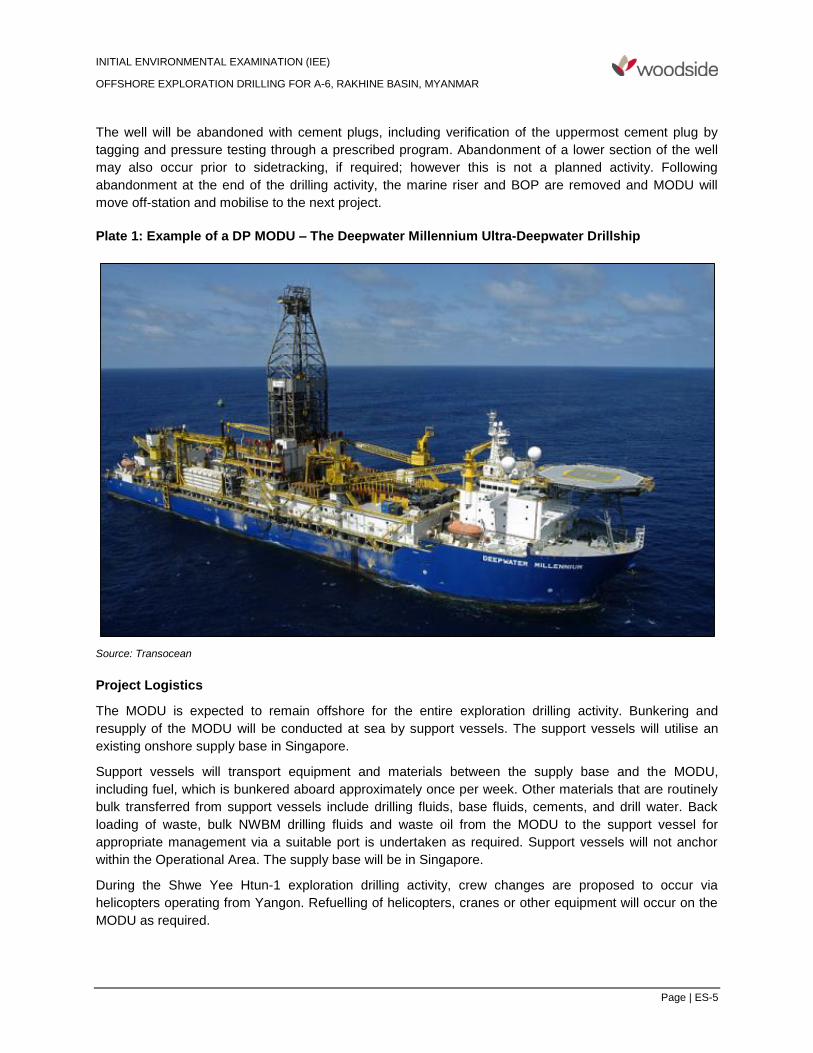
drilling rather than a MODU fixed to the seafloor. The Deepwater Millennium DP MODU will drill the
Shwe-Yee-Htun-1 well. The MODU shall drill a top hole riserless, install a blow-out preventer (BOP) and
marine riser and then drill the bottom-hole sections of the well.

INITIAL ENVIRONMENTAL EXAMINATION (IEE)
OFFSHORE EXPLORATION DRILLING FOR A-6, RAKHINE BASIN, MYANMAR
Page | ES-4
Figure 3: Exploratory Drilling Well Overview Diagram (JAMSTEC 2010)
Formation evaluation shall then be undertaken to determine the presence of hydrocarbons using methods
that may include cores, wireline logging and vertical seismic profiling (VSP). Should acquiring a VSP be
required, a small airgun array will be used to generate a pulse of underwater sound energy. The array will
typically comprise either two or three 250 cubic inch (cui) airguns, giving a total volume of either 500 or
750 cui of compressed nitrogen at a pressure of about 1800 psi. These volumes and the energy they
release into the marine environment are significantly smaller than those generated during normal
exploration marine seismic surveys (typically with an airgun array > 3,000 cui in total volume). During
VSP operations, around four or five receivers are positioned in a section of the well and the array is
discharged approximately five times at 20 second intervals. The generated sound pulses pass through
the shallow geological formations and are recorded by the downhole receivers to generate a profile along
a short (60 to 75m) section of the well. This process is repeated as required and may take up to 10 hours
to complete throughout a 24-hour period, depending on depth and number of profiles required. VSP
operations will be conducted in accordance with the contractor’s VSP procedure approved by Woodside.
INITIAL ENVIRONMENTAL EXAMINATION (IEE)
OFFSHORE EXPLORATION DRILLING FOR A-6, RAKHINE BASIN, MYANMAR
Page | ES-5
The well will be abandoned with cement plugs, including verification of the uppermost cement plug by
tagging and pressure testing through a prescribed program. Abandonment of a lower section of the well
may also occur prior to sidetracking, if required; however this is not a planned activity. Following
abandonment at the end of the drilling activity, the marine riser and BOP are removed and MODU will
move off-station and mobilise to the next project.
Plate 1: Example of a DP MODU – The Deepwater Millennium Ultra-Deepwater Drillship
Source: Transocean
Project Logistics
The MODU is expected to remain offshore for the entire exploration drilling activity. Bunkering and
resupply of the MODU will be conducted at sea by support vessels. The support vessels will utilise an
existing onshore supply base in Singapore.
Support vessels will transport equipment and materials between the supply base and the MODU,
including fuel, which is bunkered aboard approximately once per week. Other materials that are routinely
bulk transferred from support vessels include drilling fluids, base fluids, cements, and drill water. Back
loading of waste, bulk NWBM drilling fluids and waste oil from the MODU to the support vessel for
appropriate management via a suitable port is undertaken as required. Support vessels will not anchor
within the Operational Area. The supply base will be in Singapore.
During the Shwe Yee Htun-1 exploration drilling activity, crew changes are proposed to occur via
helicopters operating from Yangon. Refuelling of helicopters, cranes or other equipment will occur on the
MODU as required.

INITIAL ENVIRONMENTAL EXAMINATION (IEE)
OFFSHORE EXPLORATION DRILLING FOR A-6, RAKHINE BASIN, MYANMAR
Page | ES-6
Vessel Discharges and Waste Management
Wastewater generated by the MODU includes domestic and sanitary wastewater, and deck and bilge
water, all of which will be treated and monitored aboard before discharge into the surrounding marine
environment. These wastewater releases will strictly comply with MARPOL Convention regulations and
international best practice standards.
A variety of non-hazardous solid wastes, such as glass, paper, plastic and wood will be generated during
the offshore exploration activities. No solid wastes will be disposed of intentionally into the marine
environment, and all solid wastes will be collected and shipped to shore for appropriate treatment,
recycling or disposal. Vessels will be operated in compliance with MARPOL regulations whereby the
discharge of comminuted and disinfected sewage and food waste ground to particle size less than 25
millimetres is permitted at distances of greater than three (3) nautical miles from the nearest land.
Hazardous wastes such as lubricants, filters, chemical containers and used equipment, will be stored and
transferred onshore for appropriate treatment and disposal.
Treatment and Discharge of Drilling Fluids and Cuttings
All chemicals that may be operationally released or discharged to the marine environment during the
drilling activity are required to be selected and approved as per the Woodside Chemical Assessment and
Selection Process. Chemicals are assessed, considering the application, discharge and identification of
potential risk to the marine environment, to demonstrate acceptability for use.
The drilling of wells associated with exploring for oil and gas reserves is complex, as the strata of
geological formations below the earth’s surface present a complex mix of materials with a wide range of
properties that influence the drilling. Drilling fluids (muds) are recirculated to the well from the MODU to
serve two primary purposes – lubrication of the drilling process to reduce friction and displacement of the
cuttings from the hole and return them to the surface. On return to the surface the muds are treated by
physical separation techniques such as shakers and centrifuges to recover and recycle as much of the
mud as possible and separate the cuttings for disposal. There are two broad categories of mud systems
– water based (WBM) and non-water based (NWBM).
WBM shall be used as first preference in all cases. The decision to use NWBM for a particular well, or a
section of a particular well, is based on a variety of factors relevant to well bore conditions such as well
temperature, well profile (depth, inclination, and azimuth) well bore instability and well bore friction.
NWBM may only be used following a commercial and/or technical justification including environmental,
technical, health and waste management considerations.
NWBM will be required for drilling of the bottom-hole section. Approximately 238m3 of NWBM cuttings
discharged at the surface with less than 10% oil on cuttings. NWBM drilling fluid is only operationally
discharged as oil on cuttings associated with drill cuttings from sections of the well where a NWBM drilling
fluid system has been used, at the sea surface. When drilling fluid and cuttings are returned via the riser
to the MODU, they are separated using the solids control equipment (SCE). Any NWBM drilling fluids that
cannot be re-used due to not meeting required drilling fluid properties or are mixed in excess of required
volumes are recovered from the storage pits and returned for onshore processing, recycling and/or
disposal.
Drill cuttings (WBM) are discharged at the seabed when the top hole section is being drilled in the
absence of a marine riser. Drill cuttings accumulate around the wellhead. When a marine riser is in place
for intermediate and bottom hole sections of a well, cuttings will be circulated back to the MODU via the
marine riser and passed through the solids control equipment (SCE) prior to overboard discharge.

INITIAL ENVIRONMENTAL EXAMINATION (IEE)
OFFSHORE EXPLORATION DRILLING FOR A-6, RAKHINE BASIN, MYANMAR
Page | ES-7
BASELINE ENVIRONMENTAL CONDITIONS
Physical Environment
Weather and oceanographic conditions in the Bay of Bengal are dominated by the North-east Monsoon in
the months from November through to April, and the South-west Monsoon from April through to
September, the former being the period of calmest seas. A-6 is located within the Rakhine Basin, on the
eastern fringe of the Bay of Bengal and offshore from the western coast of Ayeyarwady Province,
Myanmar. Adjacent offshore features to the basin include the Bay of Bengal and the associated Bengal
Fan deposits to the west, the Ayeyarwady Delta and associated Moattama Offshore Basin to the south
and the Andaman-Nicobar Trench and associated island arc also to the south. The Rakhine Basin is
approximately 850 kilometres (km) in length and 200km in width. Water depths range from approximately
200m to 2,450m.
The ecology of the north-eastern Bay of Bengal, within which A-6 is located, is dominated by the outflow
of the three major rivers: the Ayeyarwady, Sittaung and Thanlwin. Through the rainy season of the South-
west Monsoon these rivers release fresh water into the coastal region surrounding their extensive river
delta systems. With the onset of the drier months from September through to November, the salinity of
the oceanic waters rises, which combined with an upwelling event off the coastal shelf, attracts an
abundance of fish species to the coastal areas. Accordingly, it is the months of the North-east Monsoon,
primarily from November through to March that tend to be the most productive for local fishermen.
Biological Environment
The nearshore areas of the Ayeyarwady coastline show significant biodiversity with mangrove, seagrass
and coral reef ecosystems distributed throughout the region. The mangrove communities are located
along the coastline, outside of A-6. Seagrass meadows are generally located in water depths up to 15
metres and will therefore not be overlapped by the exploration drilling well in A-6, which will be restricted
to deeper waters. Coral reefs are dependent on light penetration and are generally limited to shallow
water—there are no shoals inside the operational area that are likely to support coral communities.
There are known turtle rookeries on the beaches in the southern part of A-6, although little is known of the
migration routes and distribution of turtles in offshore waters. Of the seven (7) species of marine turtles
known internationally, five (5) species are recorded as regularly breeding on Myanmar’s beaches.
Diamond Island, a marine reserve located approximately 103km to the south-east of the south-eastern
corner of A-6, is a major nesting site of green turtles in Myanmar and is protected as a year-round nesting
location for this species.
A total of 104 inshore fish species probably occur in the operational area. These include reef fishes,
commercially important fishes and pelagic species that will also use deeper waters of the Bay of Bengal.
There are two fish species that are listed as Critically Endangered under on the World Conservation
Union (IUCN) Red List of Threatened Species that may occur in the operational area and surrounding
waters. The proposed exploration drilling is not expected to have any impact on the presence or
abundance of these species.
There are 20 species of ocean seabirds currently identified as occurring in Myanmar waters. An additional
61 species of birds live in the coastal zone, although there is limited data on their use of the marine
environment. The exploration drilling is not expected to have any impact on marine or coastal birdlife.
There are two broad groups of marine mammals present in Myanmar waters—cetaceans (whales and
dolphins) and sirenians (dugongs and manatees). It is highly unlikely that any dugongs will be present in

INITIAL ENVIRONMENTAL EXAMINATION (IEE)
OFFSHORE EXPLORATION DRILLING FOR A-6, RAKHINE BASIN, MYANMAR
Page | ES-8
the operational area, given that their preferred habitat is seagrass meadows in shallow waters and the
exploration drilling will take place in 2000 m water depth. There is limited detailed research into the
presence and activities of cetaceans in the eastern Bay of Bengal, and data has been compiled based on
information that is available from primary literature and historical records. There is evidence of the
possible presence of approximately 32 species of cetaceans in Myanmar waters. These species are
comprised of seven (7) baleen whales, five (5) beaked whales, three (3) large delphinids, 14 smaller
delphinids and three (3) species of sperm whale. Cetacean range data is considered to be approximate
due to limited information sources.
Socio-economic Environment
Fisheries
Myanmar's marine fishing industry consists of three distinct fishing zones namely, onshore, inshore and
offshore. The inshore area starts from the Low Water Mark to 10 nautical miles from shore in the
Ayeyarwady Region. For offshore fisheries management, the Department of Fisheries has divided the
Myanmar coastline into 140 fishing grounds of 30 by 30 nautical mile blocks by using latitude and
longitude lines and has designated four fishing areas—Rakhine, Ayeyarwady, Mon and Tanintharyi. The
offshore zone is the area from the 15 metre isobath out to the limit of Myanmar’s Economic Exclusion
Zone (EEZ).
The inshore fishing zone is located close to the coast, in waters less than 40m deep. The inshore fishery
is small scale and mostly artisanal in nature, with limited technology and equipment to process fisheries
resources information. In 2011-2012, there were approximately 2,050 offshore vessels and 27,751
inshore vessels registered with the Department of Fisheries across Myanmar, half of which were non-
motorised boats, and 1,600 were trawlers. In the Ayeyarwady Region, there were 456 offshore vessels
and 1,107 inshore vessels registered with the Department of Fisheries. Approximately 70% of those may
be expected to operate in the operational area in and around A-6.
The project area is located in the offshore fishery zone and coincides with fishing block B9 established by
the Department of Fisheries. Parts of fishery blocks B8, B14, B13, B10 and B15 also overlap with A-6.
Artisanal fishermen use active fishing techniques during the dry season. When weather conditions are
good enough to allow fishing far away from the coast, they can venture out to the offshore area, targeting
grouper, sea bass and mackerel, and their fishing trips can last more than one week. During the rainy
season, the offshore area is less accessible because it is more dangerous, limiting the fishing grounds to
the inshore fishery zone. Fishermen tend to use more passive fishing gear during the rainy season, such
as stow nets, drift nets and gill nets, targeting shrimps, mud crabs or fishes such as mullet or giant sea
bass.
The most important and intensive fishing activity in the Ayeyarwady Region is from October through to
early April each year. During the South-west monsoon season of June through to August the region has
almost no fishing activity. All community fishing grounds are located within 20km of land, although the
majority tend to be located within 1 – 5km from the shoreline. Therefore the majority of fishery activities
are considered to be nearshore, rather than offshore. In most cases, the fishing grounds claimed by each
Village-tract are located within 5 – 20km of their main coastal villages (Figure 3). Thus distance travelled
has a significant influence on local fishing practices.
Given that the offshore exploration vessels will operate in water depths of approximately 2000 metres, it
is possible that fishing vessels targeting large pelagic fish species such as tuna and swordfish may be

INITIAL ENVIRONMENTAL EXAMINATION (IEE)
OFFSHORE EXPLORATION DRILLING FOR A-6, RAKHINE BASIN, MYANMAR
Page | ES-9
encountered. The Woodside survey of Village-tracts identified a number of fishing grounds along the
coastline within A-6 (Figure 4). Of the fishing grounds that have been identified only one (1) is located
partially within A-6. However, this is approximately 50km and 90km from the Shwe Yee Htun-1 well.
Consequently, the offshore exploration vessels will not be operating in inshore waters where significantly
higher numbers of artisanal fishermen operate.
Figure 4: Proximity of Local Inshore Fishing Grounds to A-6
Marine Traffic
Marine traffic off the coast of Ayeyarwady State is limited to regional traffic. A moderately busy shipping
lane, shown by the red lane on the map, connects Chittagong port in Bangladesh to the Malacca Straits in
Malaysia. A-6 is located just to the east of this shipping lane, and encounters with vessels in this lane
during operations may happen, however the rate is likely to be low by viewing the potential cross-over.
The block is also utilised by coastal trading vessels from Yangon and Kyaukpyu. Illegal boat movement
down the coastline of the Rakhine Basin is known to occur.

INITIAL ENVIRONMENTAL EXAMINATION (IEE)
OFFSHORE EXPLORATION DRILLING FOR A-6, RAKHINE BASIN, MYANMAR
Page | ES-10
POTENTIAL IMPACTS AND MITIGATION
Risk Assessment Methodology
The objective of a risk assessment is to identify risks and associated impacts of an activity, so that they
can be assessed and appropriate control measures applied to eliminate, control or mitigate the risk to as
low s reasonably practicable (ALARP) and to determine if the risk level is acceptable.
An environmental risk assessment (Environmental Hazard Identification [ENVID] workshop) for the
activity, based on the project description provided in Chapter 4 of this IEE, was undertaken in
accordance with Woodside’s Hazard Identification Procedure.
The ENVID was undertaken by multidisciplinary teams consisting of relevant operational and
environmental personnel with sufficient breadth of knowledge, training and experience to reasonably
assure that risks were identified and their potential environmental impacts assessed. During this process,
risks that are identified as Not Applicable (not credible) are ‘scoped out’ of the assessment. This is
undertaken through defining of the activity and the identification that an aspect is not applicable, e.g.
impacts to benthic habitat from the physical presence of a moored vessel is not applicable if anchoring
the vessel is not required. The purpose of an ENVID is to understand the level of risk exposure a given
activity presents to the environment. The ENVID is used to identify risk events with the potential to harm
the environment. Risks were identified during the ENVID for both planned (routine and non-routine) and
unplanned (accidents/incidents/emergency conditions) activities. The output of the ENVID is summarised
in Table 6-3.
Identification of Impacts
The ENVID is used to identify risk events with the potential to harm the environment. Risks were identified
during the ENVID for both planned (routine and non-routine) and unplanned
(accidents/incidents/emergency conditions) activities. Based on the exploration drilling activities, the
following aspects were identified and further assessed:
Planned
Physical presence of the MODU
Routine emissions (noise, atmospheric, light)
Routine discharges to the marine environment.
Unplanned
Introduction of invasive marine species
Accidental collision between support vessels and migratory marine fauna
Accidental discharges to the marine environment (NWBM, hydrocarbons, chemicals, solid or liquid waste
Dropped Objects from MODU
Loss of well integrity resulting in liquid hydrocarbon spill

INITIAL ENVIRONMENTAL EXAMINATION (IEE)
OFFSHORE EXPLORATION DRILLING FOR A-6, RAKHINE BASIN, MYANMAR
Page | ES-11
Summary of Environmental/Social Risk Assessment
The ENVID indicates that the potential impacts arising from A-6 can be categorised as having Low
residual risk levels. No residual risks were assessed as Medium, High or Severe. Table 2 presents a
summary of the assessed level of residual (post-mitigation) environmental and social risk associated with
the exploration drilling. Table 2 also summarises the key mitigation strategies and measures that
Woodside and the drilling contractor(s) will implement during the exploration drilling activity to ensure that
impacts are either eliminated or reduced to levels that are ALARP and environmentally and socially
acceptable.

INITIAL ENVIRONMENTAL EXAMINATION (IEE)
OFFSHORE EXPLORATION DRILLING FOR A-6, RAKHINE BASIN, MYANMAR
Page | ES-12
Table 2: Summary of Environmental/Social Risk Assessment for Exploration Drilling in A-6
Aspect Source of Risk Key Potential Environmental
and Social Impacts Key Mitigation Measures
Residual Risk
Planned (Routing) Activities
Physical presence of MODU and support vessels
Proximity of MODU and support vessels causing interference with or displacement of other vessels (commercial fishing, commercial shipping.).
Short-term, isolated interference with/exclusion of commercial fishing, commercial shipping.
Issuance of Notice to Mariners.
Standard maritime safety procedures will be followed including the appropriate navigational lighting and maintenance of radio contact with nearby vessels.
Support vessel on standby to respond to implementation of safety zone if required.
Community grievance mechanism in place.
Low
Routine noise emissions
Routine noise from drilling operations
Temporary and minor behavioural and physiological disturbance to marine fauna (e.g. avoidance or attraction)
Support vessels will not travel greater than 6 knots within 300m of a whale and approach closer than 100m from a whale.
A vessel will not approach closer than 50m for a dolphin and/or 100m for a whale (with the exception of animals bow riding).
Low
Routine noise from vertical seismic profiling for drilling operations
Temporary and minor behavioural and physiological disturbance to marine fauna (e.g. avoidance or attraction).
Approximately 10 hours of source release, within a 24 hour period.
The guidelines that will be adopted for VSP are:
Visual check for whales within 3km (observation zone) of the rig or
vessel for 20 minutes prior to commencing VSP operations.
Delay VSP if whales sighted within 1km (low power zone).
Soft start - build up power for VSP slowly to give adequate time
for whales to leave the area (20 minutes at minimum). If a whale
is sighted within or is about to enter the low power zone (1km), the
acoustic source should be powered down to the lowest possible
setting. If a whale is sighted within, or enters the shut-down zone
(500m), the acoustic source should be shut down completely.
Low

INITIAL ENVIRONMENTAL EXAMINATION (IEE)
OFFSHORE EXPLORATION DRILLING FOR A-6, RAKHINE BASIN, MYANMAR
Page | ES-13
Aspect Source of Risk Key Potential Environmental
and Social Impacts Key Mitigation Measures
Residual Risk
Soft start procedures should only resume after the whale has
been observed to move outside the low power zone (1km) or
when 30 minutes have lapsed since the last whale sighting.
Visual observations of the observation zone (3km) must be
maintained continuously to identify if there are any whales
present.
If a whale is sighted within or is about to enter the low power zone
(1km), the acoustic source should be powered down to the lowest
possible setting. If a whale is sighted within, or enters the shut-
down zone (500m) the acoustic source should be shut down
completely.
Power-up of the acoustic source with soft-start procedures should
only occur after the whale has been observed to move outside the
low power zone, or when 30 minutes have lapsed since the last
whale sighting.
During periods of low visibility (where the observation zone cannot
be clearly viewed out to 3km), including night-time, the VSP
source may be used as described in soft start procedures and
operating procedures, provided that:
o there have not been three or more whale-instigated shut down
situations during the preceding 24 hour period; or
o if operations were not previously underway during the
preceding 24 hours, a period of continual observation was
undertaken in good visibility for at least two hours (to the
extent of the observation zone) within the preceding 24 hour
period and no whales were sighted.

INITIAL ENVIRONMENTAL EXAMINATION (IEE)
OFFSHORE EXPLORATION DRILLING FOR A-6, RAKHINE BASIN, MYANMAR
Page | ES-14
Aspect Source of Risk Key Potential Environmental
and Social Impacts Key Mitigation Measures
Residual Risk
During the pre-start meeting, alert all crews to immediately report
to the trained observer when they sight any mammals during and
prior to the activity. The pre-start meeting will cover the likelihood
of whale observations and required actions if they are sighted.
Routine atmospheric emissions
Internal combustion engines on project vessel(s) and machinery engines all activities
Reduced local air quality from atmospheric emissions.
Minor contribution to greenhouse gas emissions.
MODU and support vessels comply with MARPOL73/78 Annex VI requirements such as International Air Pollution Prevention (IAPP) Certificate as appropriate to class.
Use of low sulphur fuel (sulphur content not to exceed 3.5% m/m) when it is available.
Low
Routine discharges to the marine environment
Discharge of bilge water, grey water, sewage and putrescible wastes from the project vessel(s) to the marine environment.
Localised and temporary reduction in water quality due to nutrient enrichment.
Localised and temporary adverse effect to marine biota in offshore waters.
MODU and support vessels comply with MARPOL requirements for waste management, e.g. sewage treatment unit, oil/water separator, macerator for biodegradable waste. Including:
o International Sewage Pollution Prevention (ISPP) certificate and International Oil Pollution Prevention (IOPP) certificate, as appropriate to vessel class.
o Waste management plan providing procedure for minimizing,
collecting, storing, processing and disposing of garbage
waste.
Maintain a waste log including waste type, quantity and disposal method.
Low
Drill Fluid, water based (WBM)
Localised short-term decrease in water quality and toxic effects to marine biota.
All chemicals that may be operationally released or discharged to the marine environment are required to be selected and approved as per Woodside Chemical assessment and approval process.
To demonstrate that the potential impacts of the chemicals selected are acceptable and as low as reasonably practicable (ALARP).
Low

INITIAL ENVIRONMENTAL EXAMINATION (IEE)
OFFSHORE EXPLORATION DRILLING FOR A-6, RAKHINE BASIN, MYANMAR
Page | ES-15
Aspect Source of Risk Key Potential Environmental
and Social Impacts Key Mitigation Measures
Residual Risk
Drill Fluid, non- water based (NWBM)
Water quality (turbidity) effects on marine fauna
Toxic effects to marine biota (NWBM)
NWBM use is to comply with Woodside Drilling and Completions Operations Manual - Drilling and Completions Fluids Procedure
NWBM shall only be used where WBM cannot provide the required technical specifications.
All residual NWBM must be returned to a shore for reconditioning, re-use or disposal.
The average oil content allowable for discharge of NWBM pit cleaning slops is 1% by volume.
No bulk discharge of NWBM drilling fluids is permitted.
All chemicals that may be operationally released or discharged to the marine environment are required to be selected and approved as per the Woodside Chemical assessment and approval process to demonstrate that the potential impacts of the chemicals selected are acceptable and as low as reasonably practicable (ALARP).
See Drill cuttings (NWBM).
Low
Drilling Fluids - Cementing, Subsea fluids
Localised short-term decrease in water quality and toxic effects to marine biota
All chemicals that may be operationally released or discharged to the marine environment are required to be selected and approved as per Woodside Chemical assessment and approval process to demonstrate that the potential impacts of the chemicals selected are acceptable and ALARP.
Subsea ROV inspection during the cementing of the conductor will ensure that excess cement returns to the seabed are minimised.
Low
Drill Cuttings (WBM & NWBM)
Localised burial or smothering of seabed habitats from seabed discharge of cuttings and also as a result of deposition from sea surface discharge.
NWBM use is to comply with Woodside Drilling and Completions Operations Manual - Drilling and Completions Fluids Procedure
NWBM shall only be used where WBM cannot provide the required technical specifications.
Low

INITIAL ENVIRONMENTAL EXAMINATION (IEE)
OFFSHORE EXPLORATION DRILLING FOR A-6, RAKHINE BASIN, MYANMAR
Page | ES-16
Aspect Source of Risk Key Potential Environmental
and Social Impacts Key Mitigation Measures
Residual Risk
Water quality (turbidity) effects on marine fauna.
Toxic effects to marine biota (NWBM).
All residual NWBM must be returned to a shore for reconditioning, re-use or disposal.
The average oil content allowable for discharge of NWBM pit cleaning slops is 1% by volume.
No bulk discharge of NWBM drilling fluids is permitted.
All chemicals that may be operationally released or discharged to the marine environment are required to be selected and approved as per the Woodside Chemical assessment and approval process to demonstrate that the potential impacts of the chemicals selected are acceptable and as low as reasonably practicable (ALARP).
Bulk operational discharges conducted under the MODU’s permit to work (PTW) system (to operate discharge valves/pumps) or risk assessed using the MODU contractors risk assessment prompt cards, to prevent accidental discharge.
Woodside NWBM Start-up Checklist Part 1 – Rig (focus areas include mud tanks, mud tank room, transfer hoses, NWBM base fluid transfer lines, NWBM base fluid transfer station, base fluid storage, pit cleaning on completion of use of NWBM and health and safety).
Woodside NWBM Start-up Checklist Part 2 – Rig (focus areas include ancillary equipment, rig floor preparation, drains, mud bucket, bunding, sackroom/mixing area, cementing area, moonpool and BOP, mud laboratory, pump room, shakers, centrifuge area, trip tank, elastomers, water/fuel supply lines, and rig laundry).

INITIAL ENVIRONMENTAL EXAMINATION (IEE)
OFFSHORE EXPLORATION DRILLING FOR A-6, RAKHINE BASIN, MYANMAR
Page | ES-17
Aspect Source of Risk Key Potential Environmental
and Social Impacts Key Mitigation Measures
Residual Risk
Unplanned (Non Routine) Activities
Unplanned discharges to the marine environment
Accidental discharge of other hydrocarbons/ chemicals from MODU or support vessel deck activities and equipment (e.g. cranes and winches).
Localised and minor temporary disruption to fauna such as oiling of marine mammals, and seabirds.
Localised and temporary contamination of water which may lead to toxic effects on marine biota in offshore waters.
MODU and support vessels comply with MARPOL73/78 Annex VI requirements such as valid International Oil Pollution Prevention (IOPP) Certificate and Shipboard Oil Pollution Emergency Plan (SOPEP) as appropriate to class.
Handling, storage and packaging of hazardous substances in accordance with MARPOL (Annex III).
Chemicals will be stored safely and handled to prevent the release to the marine environment
Spill response kits located in proximity to hydrocarbon storage/bunkering areas and appropriately stocked/replenished as required
Crew induction to include spill prevention, reporting and use of spill response equipment.
All chemicals that may be operationally released or discharged to the marine environment are required to be selected and approved as per Woodside Chemical Assessment and Approval Process to demonstrate that the potential impacts of the chemicals selected are acceptable and ALARP.
In the event of any incidents which resulted in the release of hydrocarbon fuels to the marine environment,
The survey contractor will implement the project-specific ERP.
Any significant fuel losses to the marine environment will be reported to the relevant government agencies.
Low

INITIAL ENVIRONMENTAL EXAMINATION (IEE)
OFFSHORE EXPLORATION DRILLING FOR A-6, RAKHINE BASIN, MYANMAR
Page | ES-18
Aspect Source of Risk Key Potential Environmental
and Social Impacts Key Mitigation Measures
Residual Risk
Unplanned release of NWBM and Base Oil
Localised and minor temporary disruption to fauna such as oiling of marine mammals, and seabirds.
Localised and temporary contamination of water which may lead to toxic effects on marine biota in offshore waters.
NWBM system set up as per the following checklists and third-party audited:
Woodside NWBM Start-up Checklist Part 1 – Rig (focus areas include mud tanks, mud tank room, transfer hoses, NWBM base fluid transfer lines, NWBM base fluid transfer station, base fluid storage, pit cleaning on completion of use of NWBM and health and safety).
Woodside NWBM Start-up Checklist Part 2 – Rig (focus areas include ancillary equipment, rig floor preparation, drains, mud bucket, bunding, sackroom/mixing area, cementing area, moonpool and BOP, mud laboratory, pump room, shakers, centrifuge area, trip tank, elastomers, water/fuel supply lines, and rig laundry).
Standard offshore industry vessel operations applied in Myanmar, including:
o Emergency shutdown systems for stopping losses of
containment (e.g. burst hoses).
o Break-away dry-break couplings for oil based mud hoses.
o Constant monitoring of the offloading process.
o Direct radio communications.
o Additional operator will be used to monitor and manage
NWBM operations and volumes (with suitable communication
equipment).
Notification of significant spills to the marine environment to
relevant government agencies
Deck areas are bunded and bunged to reduce the likelihood of
deck leaks into the marine environment
Mud pits dump valve will be locked closed and operated through
the MODU’s Permit to Work (PTW) system
Low

INITIAL ENVIRONMENTAL EXAMINATION (IEE)
OFFSHORE EXPLORATION DRILLING FOR A-6, RAKHINE BASIN, MYANMAR
Page | ES-19
Aspect Source of Risk Key Potential Environmental
and Social Impacts Key Mitigation Measures
Residual Risk
Release of hydrocarbons during bunkering or vessel collision
MODU and support vessels comply with MARPOL73/78 Annex VI
requirements such as valid International Oil Pollution Prevention
(IOPP) Certificate and Shipboard Oil Pollution Emergency Plan
(SOPEP) as appropriate to class
Bunkering will be undertaken in accordance with operational
bunkering procedure
Dry break couplings (or similar) in place for all flexible hydrocarbon
transfer hoses.
Pre-bunkering checklist developed and implemented
Bunkering to commence during daylight hours and during
appropriate sea conditions, as determined by the Vessel Master.
Spill response kits located in proximity to hydrocarbon
storage/bunkering areas and appropriately stocked/replenished as
required.
Crew induction to include spill prevention and use of spill response
equipment
Notification of significant spills to the marine environment to
relevant government agencies.
Low
Accidental loss of solid hazardous or non-hazardous wastes to the marine environment.
Pollution and contamination of the environment and secondary impacts on marine fauna (e.g. ingestion or entanglement).
MODU and support vessels comply with MARPOL73/78 Annex V requirements including:
Vessel Waste Management Plan (or equivalent) must contain as a
minimum:
o Waste handling equipment, waste storage containers, and
spill response equipment appropriate to the type and volume
of waste will be provided at waste storage areas.
Low

INITIAL ENVIRONMENTAL EXAMINATION (IEE)
OFFSHORE EXPLORATION DRILLING FOR A-6, RAKHINE BASIN, MYANMAR
Page | ES-20
Aspect Source of Risk Key Potential Environmental
and Social Impacts Key Mitigation Measures
Residual Risk
o All hazardous wastes will be segregated prior to a shore
disposal.
o Vessels >400 tonnes (or certified for >15 persons onboard)
will have a Garbage Record Book.
Any accidental release of foreign material to the marine
environment that does not meet MARPOL discharge standards
will be reported if required to relevant government agencies.
These substances include; oil, chemicals, harmful packaged
substances, sewage and garbage.
All non-hazardous and hazardous solid wastes generated offshore
are to be returned to a shore for disposal.
Where safe and practicable to do so, lost objects will be
recovered.
Unplanned events associated with physical presence of MODU and support vessels
Accidental collision between support vessels and migratory marine fauna.
Potential injury or fatality of an individual or a number of marine fauna with no threat to overall population viability.
Where possible support vessels will reduce vessel speed if mammals sighted within 500m
Where possible, support vessels will not approach closer than 100m for a cetacean (unless animals bow riding)
Low
Dropped Objects from MODU
There is the potential for objects to be dropped from the MODU and/or supply vessels overboard into the marine environment, potentially disturbing benthic habitats.
MODU Safe Work Procedures developed and followed for bulk transfer to prevent objects being dropped
Personnel will be trained with regard to the prevention of dropped objects during relevant meetings and the appropriate inductions
Recover if possible and safe to do so
Low

INITIAL ENVIRONMENTAL EXAMINATION (IEE)
OFFSHORE EXPLORATION DRILLING FOR A-6, RAKHINE BASIN, MYANMAR
Page | ES-21
Aspect Source of Risk Key Potential Environmental
and Social Impacts Key Mitigation Measures
Residual Risk
Introduction of invasive marine species MODU and support vessels from other locations
Introduction of Invasive species to the marine or terrestrial environments
MODU and support vessels that have mobilised from international waters risk the introduction or establishment of Invasive Marine Species (IMS) to the Operational Area
Assess and manage IMS risk for the MODU and support vessels through the Woodside Invasive Marine Species Management Plan.
Support vessels to have valid Fouling Coating Certificates.
Ballast Water Exchange will occur prior to arrival in Myanmar at an appropriate location (50nmi from the nearest land and in water at least 200m in depth).
Low
Unplanned hydrocarbon release – Loss of well integrity resulting in liquid hydrocarbon spill
Loss of well integrity resulting in liquid hydrocarbon spill
Petroleum systems analysis of A-6 deep water prospects indicates a base-case fluid consisting of very dry biogenic gas with > 99% methane and negligible associated liquids. The alternative possibility of wet gas or liquids has been considered and is judged highly unlikely given (a) the results of offset wells (b) no oil prone source rock is proven present and (c) the most likely source bearing interval (the Eocene) is extremely deeply buried.
Woodside’s Well Barriers Engineering Standard will be applied which includes the following requirements:
o all permeable zones penetrated by the well bore, containing hydrocarbons or over-pressured water, shall be isolated from the surface environment by a minimum of two barriers (a single fluid barrier may be implemented during the initial stages of well construction if appropriateness is confirmed by a shallow hazard study)
o discrete hydrocarbon zones shall be isolated from each other (to prevent cross flow) by a minimum of one barrier
o all normally pressured permeable water-bearing formations shall be isolated from the surface by a minimum of one barrier
o barriers shall be effective over the lifetime of well construction or production
o effectiveness of primary and secondary barriers shall be verified (physical evidence of the correct placement and performance)
Woodside’s Well Control Engineering requirements for a fluid barrier comprising drilling fluid of a suitable weight, composition and volume to counter pore pressure and over pressure zones when drilling.
Low

INITIAL ENVIRONMENTAL EXAMINATION (IEE)
OFFSHORE EXPLORATION DRILLING FOR A-6, RAKHINE BASIN, MYANMAR
Page | ES-22
Aspect Source of Risk Key Potential Environmental
and Social Impacts Key Mitigation Measures
Residual Risk
Subsea BOP specification and function/pressure testing will be undertaken in accordance with API Standard 53 4th Edition (API 53), requiring the following:
o one annular preventer.
o two pipe rams (excluding the test rams).
o a MODU is required to have a minimum of two sets of shear rams, one of which must be capable of sealing.
o on activation of the shear ram the drill string can be sheared and after the sealing blind shear rams are closed a seal is provided which creates a barrier to the reservoir to reduce/prevent further hydrocarbon discharges.
o if the BOP’s operation cannot be achieved from the MODU, the rams within the BOP can be operated by ROV.
Prepare OPEP in line with requirements of the International Convention on Oil Pollution Preparedness, Response and Cooperation 1992 (OPRC) which provides a framework for international co-operation for combating major oil pollution incidents.

INITIAL ENVIRONMENTAL EXAMINATION (IEE)
OFFSHORE EXPLORATION DRILLING FOR A-6, RAKHINE BASIN, MYANMAR
Page | ES-23
PUBLIC CONSULTATION AND INFORMATION DISCLOSURE
Approach
The consultation effort for the exploration activities in A-6 aimed to achieve a consistent, comprehensive, coordinated and culturally appropriate approach. Principles employed for consultation included:
Stakeholder identification, analysis and mapping.
Information disclosure.
Consultation and participation.
Feedback system.
Stakeholders were identified at three levels – Union (Country/National level), Regional (Ayeyarwady Region) and ‘Local’ (Township). Stakeholder groups included Government, civil society and institutions as well as potentially affected people in local communities. These groups are depicted in Figure 7-1.
The consultation process was designed to align to the stages of an IEE, and involved three key phases:
Consultation for the IEE (Table 7-1).
Baseline Data Gathering: conducted from 18th March 2015 to 24th June 2015.
Disclosure of the IEE (to be completed within ten days after submission of the report to
MOECAF).
Outcomes of Consultation
Stakeholders from the Ayeyarwady Regional Government encouraged Woodside to continue to engage with the Regional Government and requested more details on project activities (e.g. vessel specifications). ‘Environmental Conservation’ was highlighted as an important issue, and specifically water and air pollution issues were raised. It was also emphasised that Woodside should engage transparently and sensitively with local communities, particularly as there were existing sensitivities in local communities about previous development projects, resulting in local controversy due to non-transparent engagement.
Representatives from Thabaung Township stated that the project is far from their fishing activities, which are predominantly carried out in fresh water. They stated that the project will not directly or significantly affect the local area or society.
Some civil society groups highlighted the importance of marine species conservation.
As per Myanmar regulations, this draft IEE will be made available. The full report will be made
available to the public in English and a non-technical summary will be made available in Burmese.
The report will be disclosed to stakeholders by means of local media, at public meeting places and at
Woodside’s office in Yangon.

INITIAL ENVIRONMENTAL EXAMINATION (IEE)
OFFSHORE EXPLORATION DRILLING FOR A-6, RAKHINE BASIN, MYANMAR
Page | ES-24
Plate 2: Disclosure of Project Activities, Thabaung Township Meeting, General Administrative Department Office (28/03/2015)

INITIAL ENVIRONMENTAL EXAMINATION (IEE)
OFFSHORE EXPLORATION DRILLING FOR A-6, RAKHINE BASIN, MYANMAR
Page | ES-25
Plate 3: Meeting with Ayeyarwady Regional Government (18/03/2015)
Plate 4: Meeting with Myanmar Fishing Federation (30/04/2015)

INITIAL ENVIRONMENTAL EXAMINATION (IEE)
OFFSHORE EXPLORATION DRILLING FOR A-6, RAKHINE BASIN, MYANMAR
Page | ES-26
ENVIRONMENTAL AND SOCIAL MANAGEMENT PLAN
Overview
An Environmental and Social Management Plan (ESMP) has been prepared for the exploration drilling
in A-6. The ESMP aims to provide an environmental and social management framework by outlining
the compliance requirements, mitigation measures and monitoring programmes to be undertaken
throughout the execution of the offshore exploration activities.
The ESMP has been prepared based on the findings of this IEE and describes management
measures designed to mitigate potential environmental and social impacts of the proposed exploration
drilling to levels that are considered to be ALARP and acceptable. The overarching purpose of the
ESMP is to:
Integrate management and mitigation measures into the Project activities in order to reduce or
mitigate any potential adverse impacts on natural and socio-economic environments.
Consider and address the concerns and interests of stakeholders who will potentially be engaged
or impacted during execution of the marine seismic surveys.
Establish systems and processes for delivery and implementation of the Project environmental
and social requirements in order to meet statutory and compliance standards.
Stakeholder Engagement and Communications Plan
The Stakeholder Engagement and Communications Plan details plans for the continued engagement
and notification of the proposed activities with fishers and key stakeholders prior to, during and after
the surveys are completed. The Plan contains actions and protocols that satisfy management
requirements of both the Social Management Plan and ongoing stakeholder engagement
requirements. As part of this Plan, a Community Grievance Mechanism will be established and
communicated.
Roles and Responsibilities
The ESMP describes the key roles and responsibilities for key Woodside personnel who will be
involved in the exploration drilling. Contractor personnel shall be assigned responsibilities under the
ESMP commensurate with their roles.
Monitoring, Record Keeping and Reporting
The ESMP details key monitoring, record keeping and reporting requirements for proposed
exploration drilling in the A-6 operational area.
Auditing and Review
Environmental performance auditing will be undertaken to confirm that all significant environmental
and social aspects of the exploration drilling are covered by the ESMP. It will also verify whether the
standards to achieve environmental and social performance are being implemented and identify non-
conformances and opportunities for continuous improvement.
Emergency Response
Woodside has a number of Emergency Response Plans (ERP) in place, which detail the actions and
resources available in the event of various emergency scenarios. A MODU ERP will be drafted for the
exploration drilling in Myanmar. The ERPs will contain instructions for support vessel emergency,
medical emergency, search and rescue, reportable incidents, incident notification, contact information
and activation of the Contractor’s emergency centre and Woodside Communication Centre (WCC).

INITIAL ENVIRONMENTAL EXAMINATION (IEE)
OFFSHORE EXPLORATION DRILLING FOR A-6, RAKHINE BASIN, MYANMAR
Page | ES-27
Woodside has a well developed oil spill response management framework which includes a range of
response strategies based on credible spill scenario modelling. Woodside is a member of Oil Spill
Response Limited (OSRL) who will supplement Woodside capability with the provision of specialist
personnel and equipment.
CONCLUSIONS
With the control and mitigation measures that will be employed, the environmental and social impacts
of the proposed Shwe-Yee-Htun-1 exploration drilling well in A-6, offshore Myanmar, are expected to
be localised and temporary.
Overall, the proposed exploration drilling is not expected to have any long-term effects on local or
regional biodiversity. The exploration drilling will not adversely impact ecosystem structure and
function, for any of the key environmental and social sensitivities and values identified for the marine
environment of the operational area. The characteristics of the activities, particularly their relatively
short duration and separation (temporal and/or spatial) from sensitive environmental and social
resources, mitigate many of the potential environmental and social effects of the exploration drilling.
The risk assessment indicates that, with effective implementation of mitigation measures, the residual
environmental and social impacts associated with the proposed exploration drilling are ranked Low,
are ALARP and acceptable. There are no High, Medium or Severe rated environmental and social
impacts associated with the Project. The environmental and social impacts arising from the
exploration drilling will not have any significant negative effects on the environment during and after
the proposed activities.