
“Evidence Based Policy Making” Paris, 2-3 December 2010 Sustainability assessment and public...
29
“Evidence Based Policy Making” Paris, 2-3 December 2010 Sustainability assessment and public participation in territorial planning Marta Bottero Politecnico di Torino
-
Upload
tyler-walsh -
Category
Documents
-
view
212 -
download
0
Transcript of “Evidence Based Policy Making” Paris, 2-3 December 2010 Sustainability assessment and public...
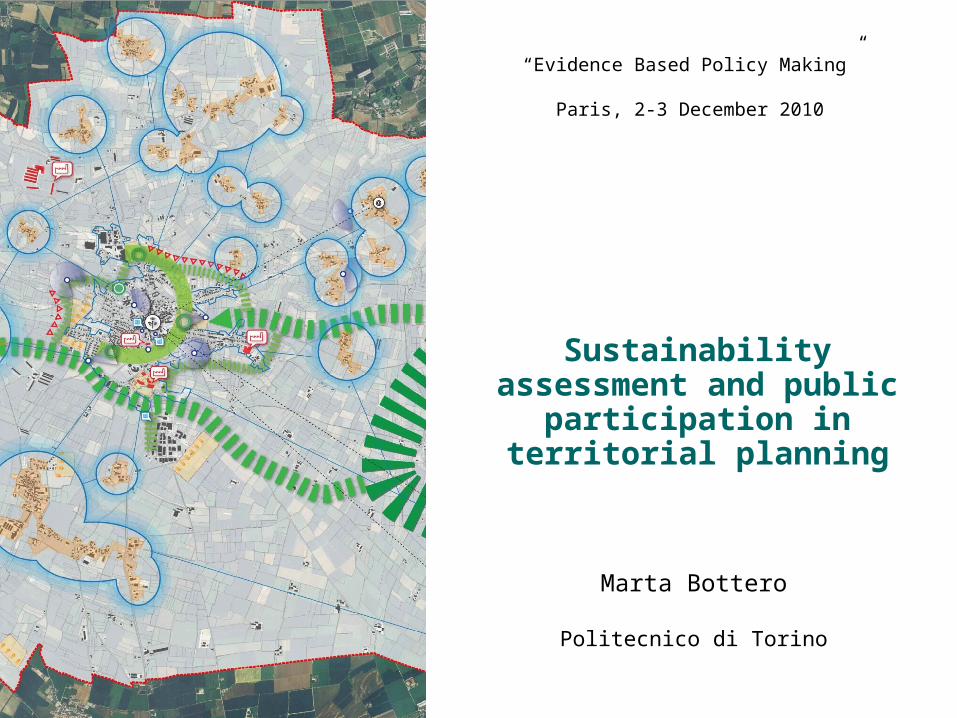
“Evidence Based Policy Making”
Paris, 2-3 December 2010
Sustainability assessment and public
participation in territorial planning
Marta Bottero
Politecnico di Torino
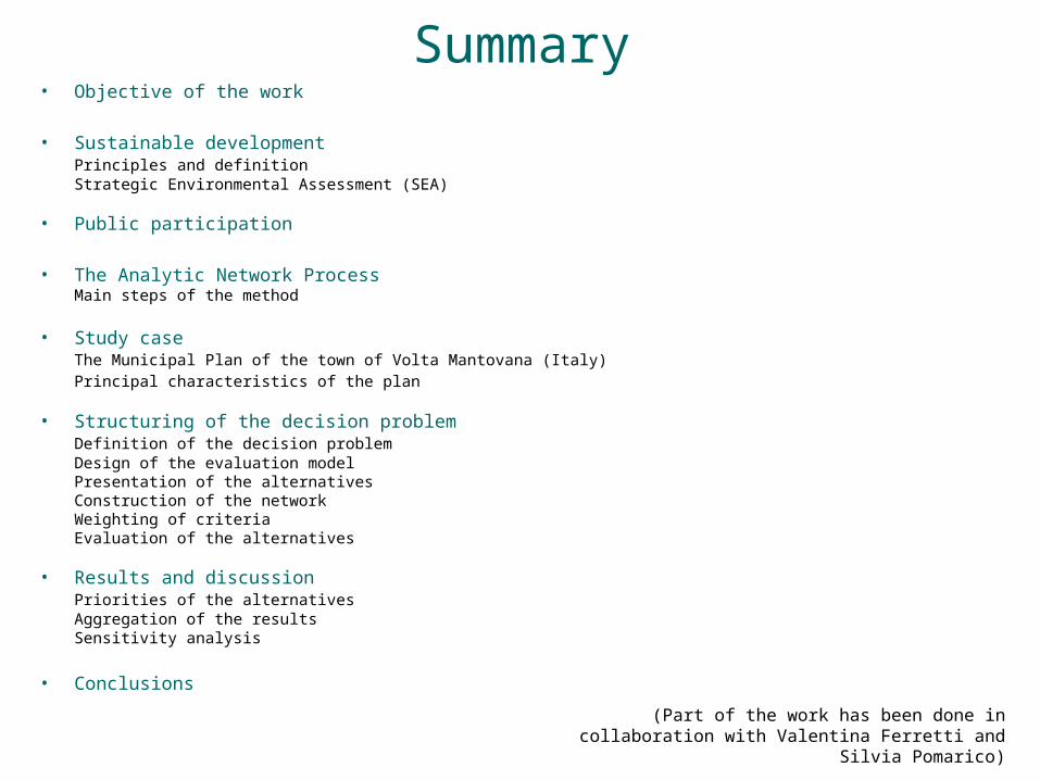
Summary• Objective of the work
• Sustainable developmentPrinciples and definitionStrategic Environmental Assessment (SEA)
• Public participation
• The Analytic Network ProcessMain steps of the method
• Study caseThe Municipal Plan of the town of Volta Mantovana (Italy)Principal characteristics of the plan
• Structuring of the decision problemDefinition of the decision problemDesign of the evaluation modelPresentation of the alternativesConstruction of the networkWeighting of criteriaEvaluation of the alternatives
• Results and discussionPriorities of the alternativesAggregation of the resultsSensitivity analysis
• Conclusions(Part of the work has been done in collaboration with
Valentina Ferretti and Silvia Pomarico)

Evidence Based Policy Making Evidence Based Policy Making (EBPM) has been defined as an approach that “helps people make well informed decisions about policies, programmes and projects by putting the best available evidence from research at the heart of policy development and implementation” (Davies, 1999).
Tools for policy assessment
- checklists;- questionnaires;- decision trees;- Cost Benefit Analysis;- risk analysis;- computer-based models;- …
Opinion Based Policy Making
Evidence Based Policy Making
Increasing pressures (Time)
(source: adapted from Gray, 1997)
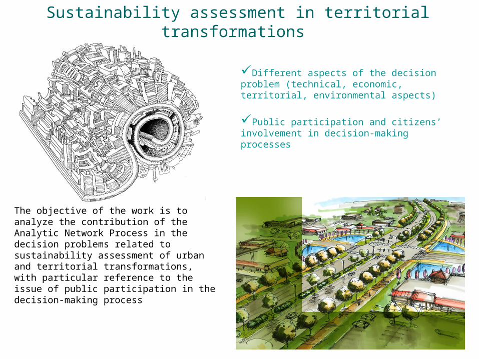
Sustainability assessment in territorial transformations
Different aspects of the decision problem (technical, economic, territorial, environmental aspects)
Public participation and citizens’ involvement in decision-making processes
The objective of the work is to analyze the contribution of the Analytic Network Process in the decision problems related to sustainability assessment of urban and territorial transformations, with particular reference to the issue of public participation in the decision-making process
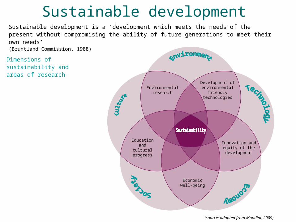
Sustainable development
Dimensions of sustainability and areas of research
Development of environmental
friendly technologies
Innovation and equity of the development
Economic well-being
Education and cultural
progress
Environmental research
Sustainable development is a 'development which meets the needs of the present without compromising the ability of future generations to meet their own needs’(Bruntland Commission, 1988)
(source: adapted from Mondini, 2009)

1 Minimise use of non-renewable resources
2 Use renewable resources within limits of capacity for regeneration
3Environmentally sound use and management of hazardous/polluting substances and wastes
4 Conserve and enhance the status of wildlife, habitats and landscapes
5 Maintain and improve the quality of soils and water resources
6 Maintain and improve the quality of historic and cultural resources
7 Maintain and improve local environmental quality
8 Protection of the atmosphere
9 Develop environmental awareness, education and training
10 Promote public participation in decisions involving sustainable development
10 criteria for sustainable development
(source: European Commission, 1998)

Strategic Environmental Assessment SEA is a process to ensure that significant environmental effects arising from policies, plans and programmes are identified, assessed, mitigated, communicated to decision-makers, monitored and that opportunities for public involvement are provided.
Particular benefits of SEA include: To support sustainable developmentTo improve the evidence base for strategic decisionsTo facilitate and respond to consultation with stakeholders
(source: European Commission, 2001)
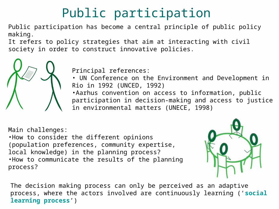
Public participation Public participation has become a central principle of public policy making.It refers to policy strategies that aim at interacting with civil society in order to construct innovative policies.
Main challenges:•How to consider the different opinions (population preferences, community expertise, local knowledge) in the planning process?•How to communicate the results of the planning process?
The decision making process can only be perceived as an adaptive process, where the actors involved are continuously learning (‘social learning process’)
Principal references:• UN Conference on the Environment and Development in Rio in 1992 (UNCED, 1992)•Aarhus convention on access to information, public participation in decision-making and access to justice in environmental matters (UNECE, 1998)

The Analytic Network Process The ANP is a multiple criteria decision making method that has recently been developed by Thomas Saaty (2005) as the generalization of the more well known Analytic Hierarchy Process – AHP (Saaty, 1980) to dependences and feedbacks.
AHP and ANP represent a theory of relative measurement on absolute scales of tangible and intangible criteria based on both the judgments of experts and on existing measurements and statistics needed to make a decision. By means of pairwise comparisons, it is possible to establish the relative importance of the different elements, with respect to a certain component of the network.
A very large and consolidated amount of ANP literature exists in which it is possible to find a wide range of applications in the different fields (economy and finance, transport and logistic, environmental impact assessment, urban and territorial planning).
Network strucuture (ANP)
Goal
Criteria
Sub-criteria
Alternatives
Hierarchical strucutre (AHP)
Alternatives
Cluster Elements
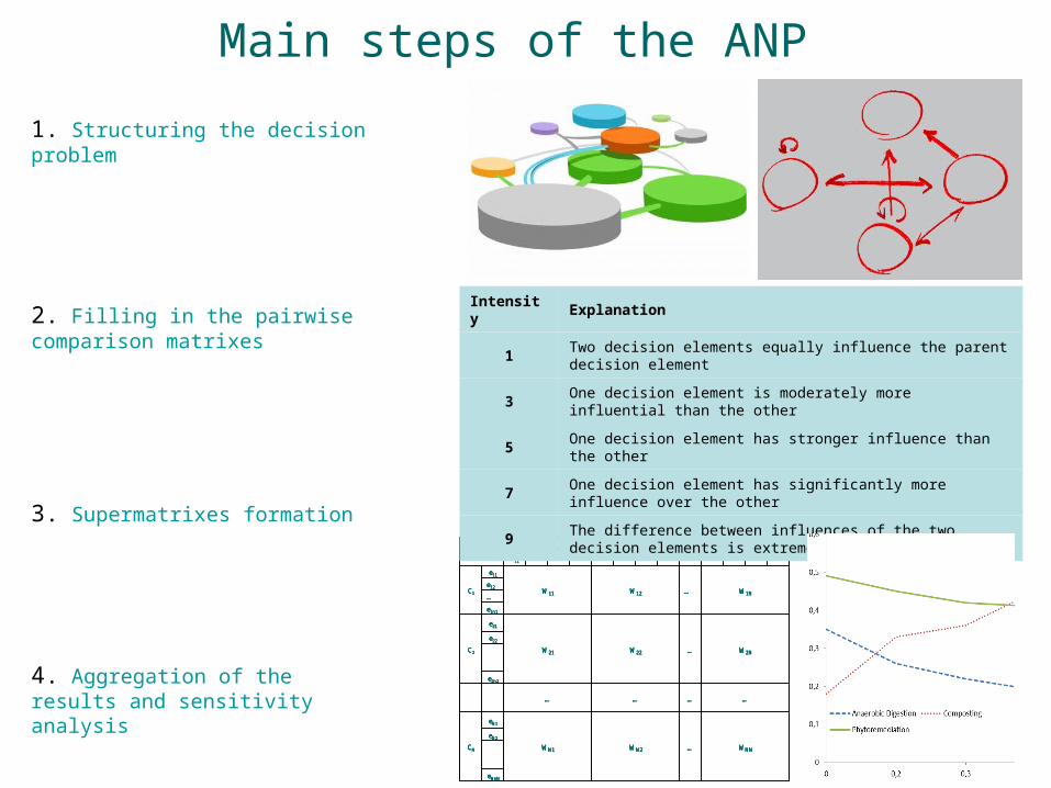
Main steps of the ANP
1. Structuring the decision problem
3. Supermatrixes formation
4. Aggregation of the results and sensitivity analysis
eNnN
eN2
WNN…WN2WN1
eN1
CN
…………
e2n2
e22
W2N…W22W21
e21
C2
e1n1
…
e12W1N…W12W11
e11
C1
ENnN…eN2eN1e2n2…e22e21e1n1…e12e11
CN….
C2C1
eNnN
eN2
WNN…WN2WN1
eN1
CN
…………
e2n2
e22
W2N…W22W21
e21
C2
e1n1
…
e12W1N…W12W11
e11
C1
ENnN…eN2eN1e2n2…e22e21e1n1…e12e11
CN….
C2C1
eNnN
eN2
WNN…WN2WN1
eN1
CN
…………
e2n2
e22
W2N…W22W21
e21
C2
e1n1
…
e12W1N…W12W11
e11
C1
ENnN…eN2eN1e2n2…e22e21e1n1…e12e11
CN….
C2C1
eNnN
eN2
WNN…WN2WN1
eN1
CN
…………
e2n2
e22
W2N…W22W21
e21
C2
e1n1
…
e12W1N…W12W11
e11
C1
ENnN…eN2eN1e2n2…e22e21e1n1…e12e11
CN….
C2C1
2. Filling in the pairwise comparison matrixes
Intensity Explanation
1Two decision elements equally influence the parent decision element
3One decision element is moderately more influential than the other
5 One decision element has stronger influence than the other
7One decision element has significantly more influence over the other
9The difference between influences of the two decision elements is extremely significant
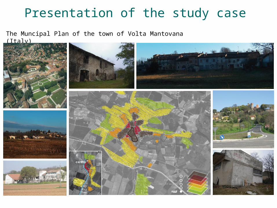
Presentation of the study case
The Muncipal Plan of the town of Volta Mantovana (Italy)
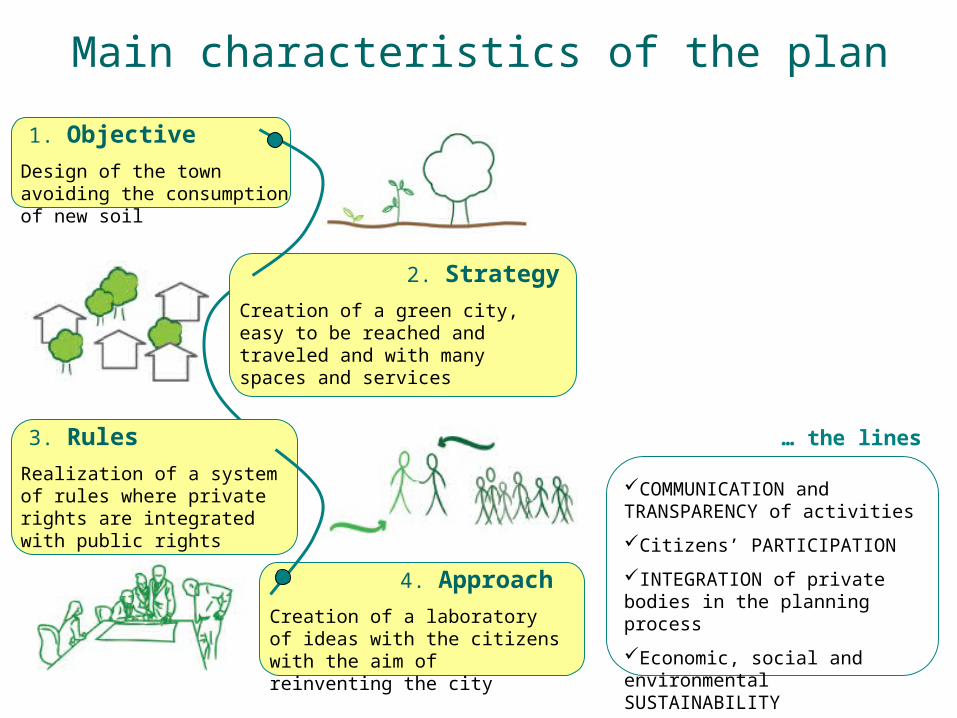
Main characteristics of the plan
1. Objective
Design of the town avoiding the consumption of new soil
2. Strategy
Creation of a green city, easy to be reached and traveled and with many spaces and services
3. Rules
Realization of a system of rules where private rights are integrated with public rights
4. Approach
Creation of a laboratory of ideas with the citizens with the aim of reinventing the city
COMMUNICATION and TRANSPARENCY of activities
Citizens’ PARTICIPATION
INTEGRATION of private bodies in the planning process
Economic, social and environmental SUSTAINABILITY
… the lines
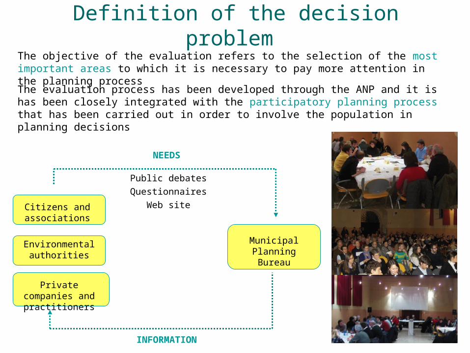
Definition of the decision problem The objective of the evaluation refers to the selection of the most important areas to which it is necessary to pay more attention in the planning process
The evaluation process has been developed through the ANP and it is has been closely integrated with the participatory planning process that has been carried out in order to involve the population in planning decisions
Citizens and associations
Environmental authorities
Private companies and
practitioners
Public debates
Questionnaires
Web site
Municipal Planning Bureau
NEEDS
INFORMATION
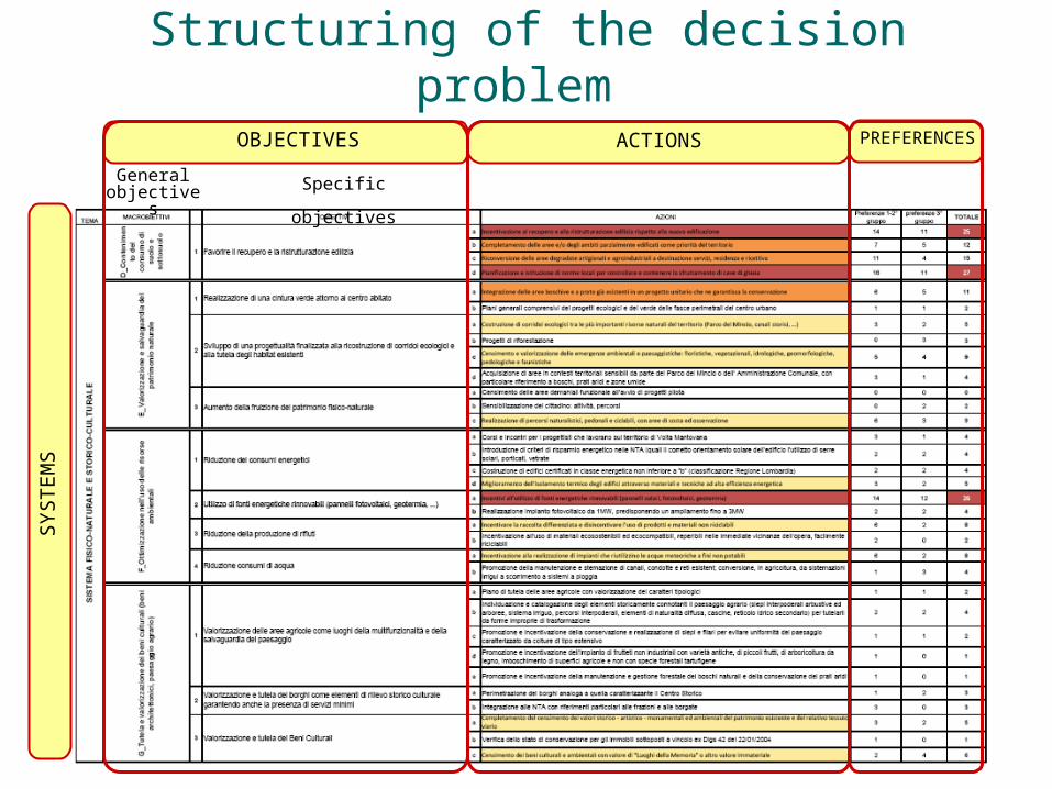
Structuring of the decision problem
OBJECTIVES ACTIONS PREFERENCES
General objectives Specific objectives
SYSTEM
S
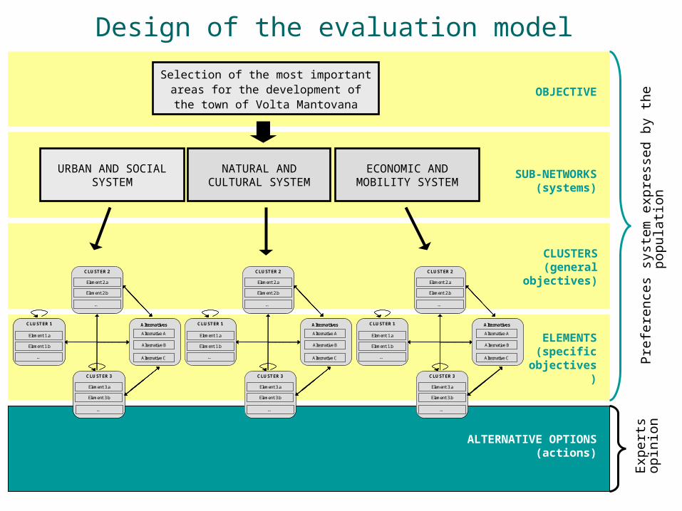
Design of the evaluation model
Selection of the most important areas for the development of the
town of Volta MantovanaOBJECTIVE
SUB-NETWORKS(systems)
NATURAL AND CULTURAL SYSTEM
URBAN AND SOCIAL SYSTEM
ECONOMIC AND MOBILITY SYSTEM
CLUSTERS(general objectives)
ELEMENTS(specific
objectives)
ALTERNATIVE OPTIONS(actions)
Pre
fere
nce
s sy
stem
expre
ssed b
y t
he p
opu
lati
on
Exp
ert
s opin
ion
Element 1.b
…
Element 1.a
CLUSTER 1
Alternative B
Alternative A
Alternatives
Alternative C
Element 2.b
…
Element 2.a
CLUSTER 2
Element 3.b
…
Element 3.a
CLUSTER 3
Element 1.b
…
Element 1.a
CLUSTER 1
Alternative B
Alternative A
Alternatives
Alternative C
Element 2.b
…
Element 2.a
CLUSTER 2
Element 3.b
…
Element 3.a
CLUSTER 3
Element 1.b
…
Element 1.a
CLUSTER 1
Alternative B
Alternative A
Alternatives
Alternative C
Element 2.b
…
Element 2.a
CLUSTER 2
Element 3.b
…
Element 3.a
CLUSTER 3
Element 1.b
…
Element 1.a
CLUSTER 1
Alternative B
Alternative A
Alternatives
Alternative C
Element 2.b
…
Element 2.a
CLUSTER 2
Element 3.b
…
Element 3.a
CLUSTER 3
Element 1.b
…
Element 1.a
CLUSTER 1
Alternative B
Alternative A
Alternatives
Alternative C
Element 2.b
…
Element 2.a
CLUSTER 2
Element 3.b
…
Element 3.a
CLUSTER 3
Element 1.b
…
Element 1.a
CLUSTER 1
Alternative B
Alternative A
Alternatives
Alternative C
Element 2.b
…
Element 2.a
CLUSTER 2
Element 3.b
…
Element 3.a
CLUSTER 3
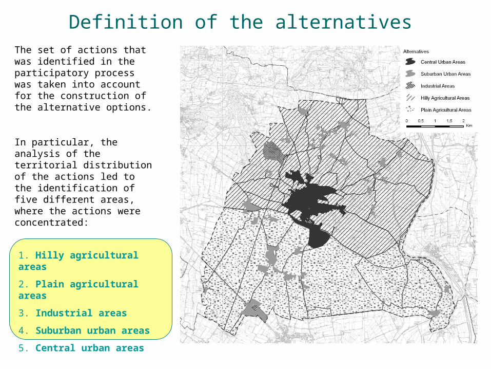
Definition of the alternatives The set of actions that was identified in the participatory process was taken into account for the construction of the alternative options.
In particular, the analysis of the territorial distribution of the actions led to the identification of five different areas, where the actions were concentrated:
1. Hilly agricultural areas
2. Plain agricultural areas
3. Industrial areas
4. Suburban urban areas
5. Central urban areas
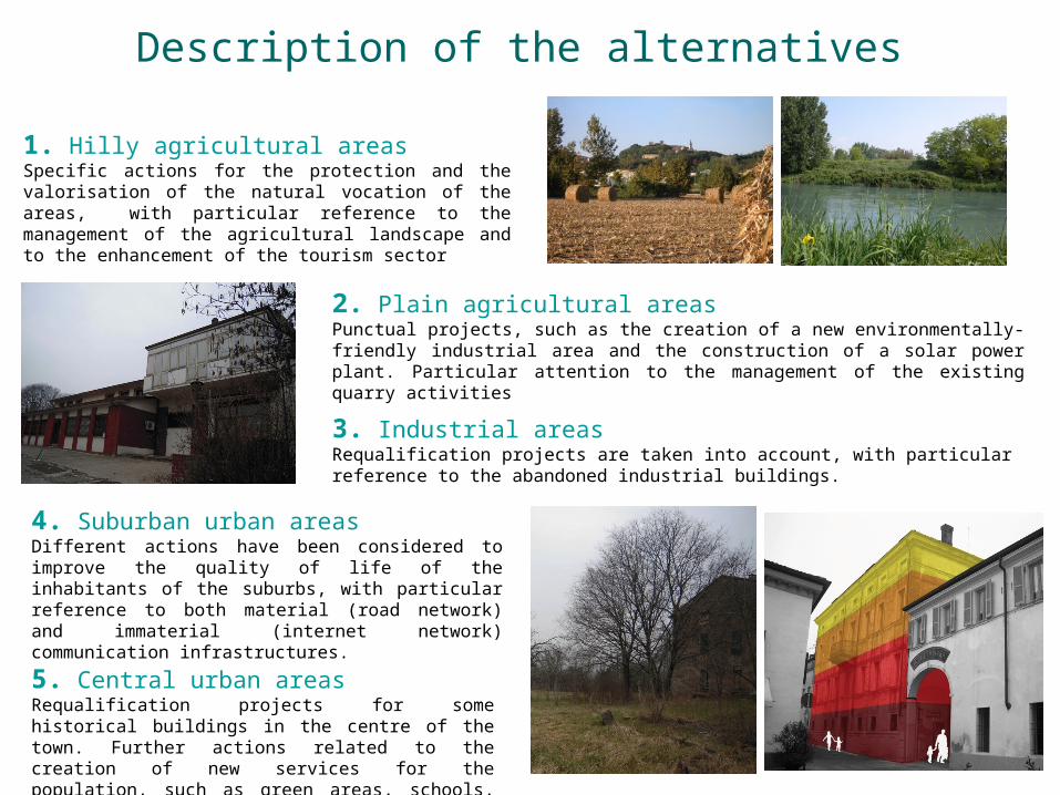
Description of the alternatives
1. Hilly agricultural areasSpecific actions for the protection and the valorisation of the natural vocation of the areas, with particular reference to the management of the agricultural landscape and to the enhancement of the tourism sector
2. Plain agricultural areasPunctual projects, such as the creation of a new environmentally-friendly industrial area and the construction of a solar power plant. Particular attention to the management of the existing quarry activities
3. Industrial areasRequalification projects are taken into account, with particular reference to the abandoned industrial buildings.
4. Suburban urban areas Different actions have been considered to improve the quality of life of the inhabitants of the suburbs, with particular reference to both material (road network) and immaterial (internet network) communication infrastructures.
5. Central urban areasRequalification projects for some historical buildings in the centre of the town. Further actions related to the creation of new services for the population, such as green areas, schools, etc.
Construction of the network
Control criteria Clusters
Creation of new centralities in the suburban urban areas
Recovery and reuse of buildings and abandoned areas
Promotion of architectural and urban projects in terms of quality Implementation of services such as areas dedicated to sports, culture and meeting places
Preservation of the original destination of the areas
Improvement of the quality of life of the poor people and young couples Good quality city life for children
City valorization and requalification
Creation of an urban green areas system Environmental and functional requalification of downgraded urban areas, with particular reference to the abandoned industrial areas
Requalification of downgraded urban
areas Landscape improvement and amelioration of external areas and of the main gates of the town Promotion of the community tradition of Volta Mantovana through the existing festivals and events in an integrated way
URBA
N A
ND
SO
CIA
L SY
STEM
Promotion and valorization of cultural
events Pursuit of greater social involvement of the c itizens Reduction in energy consumption Use of renewable energy sources Reduction in waste Reduction in water consumption Efficiency in consumption of resources Exploitation of daylight
Promotion of bio architectural projects
Optimization of the use of environmental
resources
Optimization of the healthiness of the settlement areas Enhancement of agricultural areas as places of multifunctionality and landscape conservation Valorization and protection of suburban urban areas as part of historical and cultural importance ensuring the presence of minimum services
Protection and valorization of the cultural heritage
Valorization and protection of Cultural Heritage Creation of a green belt around the town Development of a project aimed at the reconstruction of ecological corridors and at the protection of existing habitats
Conservation and valorization of the natural heritage
Increase in the use of natural-physical heritage NA
TURA
L A
ND
CULT
URA
L SY
STEM
Soil consumption reduction
Encouragement of building recovery and renovation
Rationalization of the transport system within the municipality Enlargement of the links outside the munic ipal area Containment of urban traffic by promoting alternative modes to private cars
Rationalization of the transport system inside
the town territory Creation of a mobility system taking into account citizens with mobility difficulties
Promotion of economic activities connected to
the tourist sector Enhancement of tourist sector
Diffusion of sustainable agricultural activities
ECO
NO
MIC
AN
D
MO
BIL
ITY S
YST
EM
Enhancement of agricultural areas as
sustainable productive areas
Production of a short chain with a direct relationship between the producer and the citizen
Elements
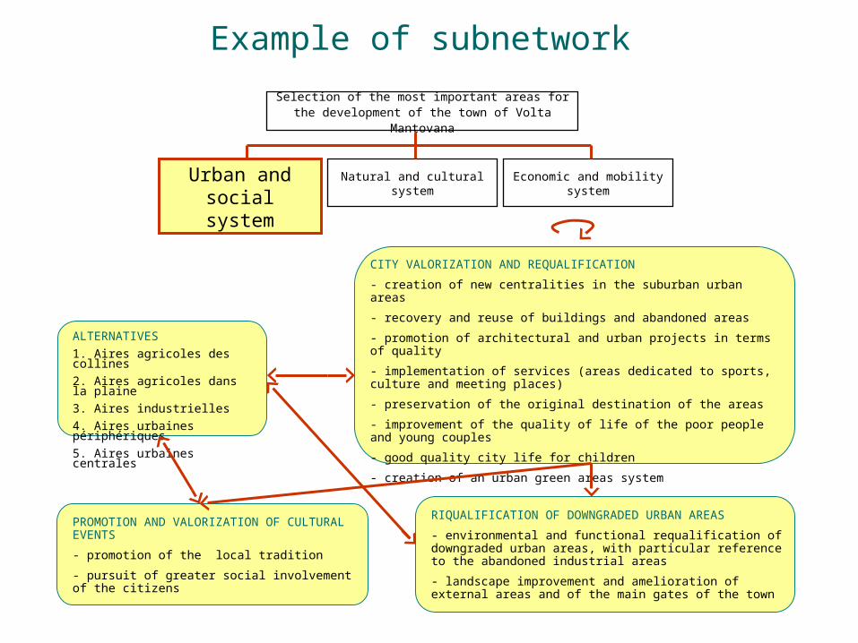
Example of subnetwork
ALTERNATIVES
1. Aires agricoles des collines
2. Aires agricoles dans la plaine
3. Aires industrielles
4. Aires urbaines périphériques
5. Aires urbaines centrales
CITY VALORIZATION AND REQUALIFICATION
- creation of new centralities in the suburban urban areas
- recovery and reuse of buildings and abandoned areas
- promotion of architectural and urban projects in terms of quality
- implementation of services (areas dedicated to sports, culture and meeting places)
- preservation of the original destination of the areas
- improvement of the quality of life of the poor people and young couples
- good quality city life for children
- creation of an urban green areas system
PROMOTION AND VALORIZATION OF CULTURAL EVENTS
- promotion of the local tradition
- pursuit of greater social involvement of the citizens
RIQUALIFICATION OF DOWNGRADED URBAN AREAS
- environmental and functional requalification of downgraded urban areas, with particular reference to the abandoned industrial areas
- landscape improvement and amelioration of external areas and of the main gates of the town
Selection of the most important areas for the development of the town of Volta Mantovana
Natural and cultural systemUrban and
social system
Economic and mobility system

Weighting of criteria With reference to the weighting of control criteria and clusters, the judgments are directly derived from the preferences expressed by citizens for the actions during the participatory planning process.
It was decided to proceed according to the following procedure:
1. The sum of all preferences expressed for the actions was calculated and divided by ten;
2. The figures thus obtained were normalized using each of the three systems and expressed in percentage terms;
3. The values of the actions related to the same specific objective were summed;
4. The figures related to each specific objective were further summed with respect to the related general objective;
5. The sum of the weights of the general objectives in each system gives the weights of the three control criteria.
CONTROL CRITERIA
CLUSTERSWEIGH
TS
URBAN AND SOCIAL SYSTEM
(49,86)
City valorization and requalification 37,92
Requalification of downgraded urban areas 5,83
Promotion and valorization of cultural events 6,11
NATURAL AND CULTURAL
SYSTEM(30,69)
Optimization of the use of environmental resources 9,85
Protection and valorization of the cultural heritage 3,89
Conservation and valorization of the natural heritage
6,25
Soil consumption reduction 10,97
ECONOMIC AND MOBILITY SYSTEM(19,72)
Rationalization of the transport system inside the town territory
13,47
Promotion of economic activities connected to the tourism sector
2,50
Enhancement of agricultural areas as sustainable productive areas
3,75
The weights thus obtained have been then used for filling in the cluster matrix in each subnetwork
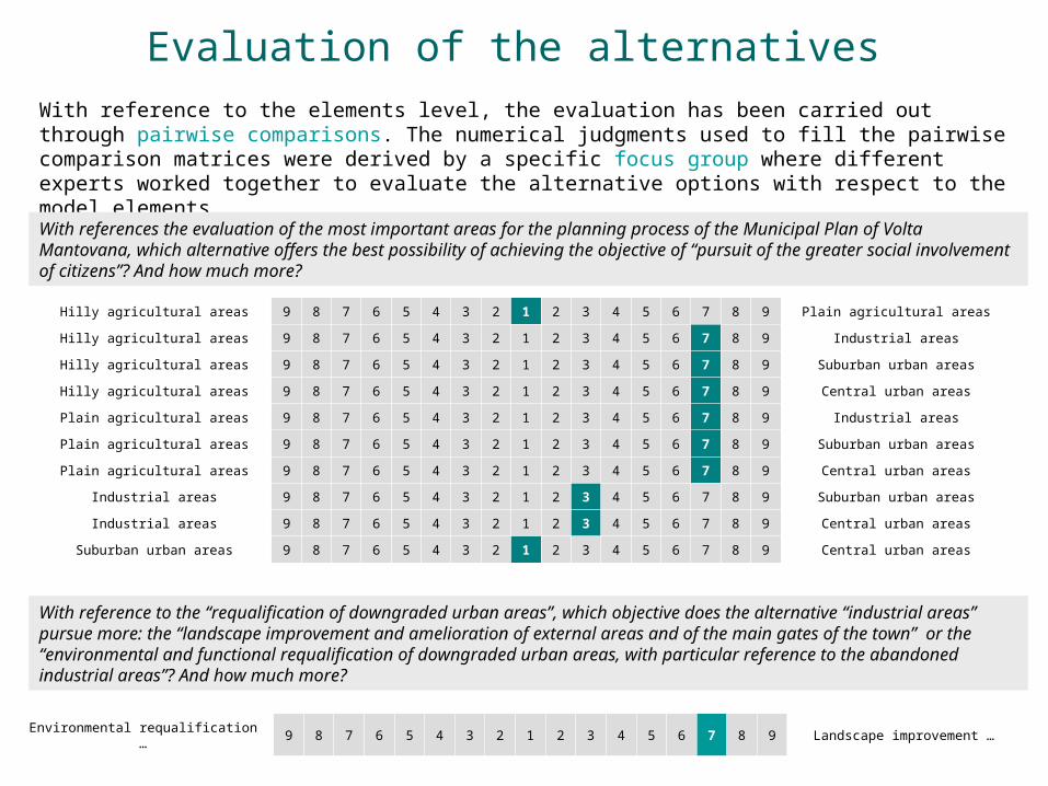
Evaluation of the alternatives With reference to the elements level, the evaluation has been carried out through pairwise comparisons. The numerical judgments used to fill the pairwise comparison matrices were derived by a specific focus group where different experts worked together to evaluate the alternative options with respect to the model elements.
Hilly agricultural areas 9 8 7 6 5 4 3 2 1 2 3 4 5 6 7 8 9 Plain agricultural areas
Hilly agricultural areas 9 8 7 6 5 4 3 2 1 2 3 4 5 6 7 8 9 Industrial areas
Hilly agricultural areas 9 8 7 6 5 4 3 2 1 2 3 4 5 6 7 8 9 Suburban urban areas
Hilly agricultural areas 9 8 7 6 5 4 3 2 1 2 3 4 5 6 7 8 9 Central urban areas
Plain agricultural areas 9 8 7 6 5 4 3 2 1 2 3 4 5 6 7 8 9 Industrial areas
Plain agricultural areas 9 8 7 6 5 4 3 2 1 2 3 4 5 6 7 8 9 Suburban urban areas
Plain agricultural areas 9 8 7 6 5 4 3 2 1 2 3 4 5 6 7 8 9 Central urban areas
Industrial areas 9 8 7 6 5 4 3 2 1 2 3 4 5 6 7 8 9 Suburban urban areas
Industrial areas 9 8 7 6 5 4 3 2 1 2 3 4 5 6 7 8 9 Central urban areas
Suburban urban areas 9 8 7 6 5 4 3 2 1 2 3 4 5 6 7 8 9 Central urban areas
With references the evaluation of the most important areas for the planning process of the Municipal Plan of Volta Mantovana, which alternative offers the best possibility of achieving the objective of “pursuit of the greater social involvement of citizens”? And how much more?
With reference to the “requalification of downgraded urban areas”, which objective does the alternative “industrial areas” pursue more: the “landscape improvement and amelioration of external areas and of the main gates of the town” or the “environmental and functional requalification of downgraded urban areas, with particular reference to the abandoned industrial areas”? And how much more?
Environmental requalification … 9 8 7 6 5 4 3 2 1 2 3 4 5 6 7 8 9 Landscape improvement …
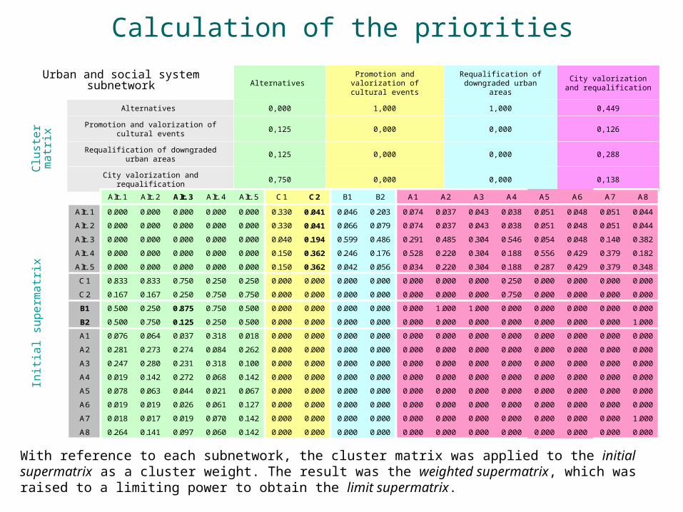
Calculation of the priorities
Alternatives Promotion and valorization
of cultural eventsRequalification of
downgraded urban areasCity valorization and
requalification
Alternatives 0,000 1,000 1,000 0,449
Promotion and valorization of cultural events
0,125 0,000 0,000 0,126
Requalification of downgraded urban areas
0,125 0,000 0,000 0,288
City valorization and requalification 0,750 0,000 0,000 0,138
Init
ial su
perm
atr
ixC
lust
er
matr
ix
With reference to each subnetwork, the cluster matrix was applied to the initial supermatrix as a cluster weight. The result was the weighted supermatrix, which was raised to a limiting power to obtain the limit supermatrix.
Urban and social system subnetwork
Alt. 1 Alt. 2 Alt. 3 Alt. 4 Alt. 5 C1 C2 B1 B2 A1 A2 A3 A4 A5 A6 A7 A8
Alt. 1 0.000 0.000 0.000 0.000 0.000 0.330 0.041 0.046 0.203 0.074 0.037 0.043 0.038 0.051 0.048 0.051 0.044
Alt. 2 0.000 0.000 0.000 0.000 0.000 0.330 0.041 0.066 0.079 0.074 0.037 0.043 0.038 0.051 0.048 0.051 0.044
Alt. 3 0.000 0.000 0.000 0.000 0.000 0.040 0.194 0.599 0.486 0.291 0.485 0.304 0.546 0.054 0.048 0.140 0.382
Alt. 4 0.000 0.000 0.000 0.000 0.000 0.150 0.362 0.246 0.176 0.528 0.220 0.304 0.188 0.556 0.429 0.379 0.182
Alt. 5 0.000 0.000 0.000 0.000 0.000 0.150 0.362 0.042 0.056 0.034 0.220 0.304 0.188 0.287 0.429 0.379 0.348
C1 0.833 0.833 0.750 0.250 0.250 0.000 0.000 0.000 0.000 0.000 0.000 0.000 0.250 0.000 0.000 0.000 0.000
C2 0.167 0.167 0.250 0.750 0.750 0.000 0.000 0.000 0.000 0.000 0.000 0.000 0.750 0.000 0.000 0.000 0.000
B1 0.500 0.250 0.875 0.750 0.500 0.000 0.000 0.000 0.000 0.000 1.000 1.000 0.000 0.000 0.000 0.000 0.000
B2 0.500 0.750 0.125 0.250 0.500 0.000 0.000 0.000 0.000 0.000 0.000 0.000 0.000 0.000 0.000 0.000 1.000
A1 0.076 0.064 0.037 0.318 0.018 0.000 0.000 0.000 0.000 0.000 0.000 0.000 0.000 0.000 0.000 0.000 0.000
A2 0.281 0.273 0.274 0.084 0.262 0.000 0.000 0.000 0.000 0.000 0.000 0.000 0.000 0.000 0.000 0.000 0.000
A3 0.247 0.280 0.231 0.318 0.100 0.000 0.000 0.000 0.000 0.000 0.000 0.000 0.000 0.000 0.000 0.000 0.000
A4 0.019 0.142 0.272 0.068 0.142 0.000 0.000 0.000 0.000 0.000 0.000 0.000 0.000 0.000 0.000 0.000 0.000
A5 0.078 0.063 0.044 0.021 0.067 0.000 0.000 0.000 0.000 0.000 0.000 0.000 0.000 0.000 0.000 0.000 0.000
A6 0.019 0.019 0.026 0.061 0.127 0.000 0.000 0.000 0.000 0.000 0.000 0.000 0.000 0.000 0.000 0.000 0.000
A7 0.018 0.017 0.019 0.070 0.142 0.000 0.000 0.000 0.000 0.000 0.000 0.000 0.000 0.000 0.000 0.000 1.000
A8 0.264 0.141 0.097 0.060 0.142 0.000 0.000 0.000 0.000 0.000 0.000 0.000 0.000 0.000 0.000 0.000 0.000
Discussion of the results
Control criteria
Clusters Nodes Priorities
Alt 1 0,035
Alt 2 0,033
Alt 3 0,167
Alt 4 0,132
Alt 5 0,087
A1 0,041
A2 0,074
A3 0,080
A4 0,054
A5 0,016
A6 0,019
A7 0,025
A8 0,038
B1 0,100
B2 0,030
C1 0,033
C2 0,036
Alt 1 0,107
Alt 2 0,083
Alt 3 0,136
Alt 4 0,082
Alt 5 0,082
D1 0,015
D2 0,013
D3 0,008
D4 0,012
D5 0,036
D6 0,016
D7 0,019
D8 0,062
E1 0,025
E2 0,028
E3 0,012
F1 0,024
F2 0,035
F3 0,034
Soil consumption reduction G1 0,173
Alt 1 0,077
Alt 2 0,059
Alt 3 0,016
Alt 4 0,139
Alt 5 0,196
H1 0,112
H2 0,071
H3 0,089
H4 0,085
Promotion of economic activities connected to the turist sector
I1 0,087
L1 0,030
L2 0,037
NA
TU
RA
L A
ND
CU
LT
UR
AL
SY
STE
M
Alternatives
Optimization of the use of environmental resources
Protection and valorization of the cultural heritage
Conservation and valorization of the natural heritage
EC
ON
OM
IC A
ND
MO
BIL
ITY
SY
STE
M
Alternatives
Rationalization of the transport system inside the town territory
Enhancement of agricultural areas as sustainable productive areas
Alternatives
City valorization and requalification
Requalification of downgraded urban areas
Promotion and valorization of cultural events
UR
BA
N A
ND
SO
CIA
L S
YST
EM The calculation of the limit supermatrix in the
three subnetworks provides the final priority vector of all the elements being considered.
Leaving aside the priorities of the alternatives (in white in the graph), the results of the ANP model highlight that the most important elements in the identification of the strategic areas for the development of Volta Mantovana are:
Environmental and functional requalification of downgraded urban
areas
(urban and social system)
Encouragement of building recovery and renovation
(natural and cultural system)
Rationalization of the transport system within the municipality
(economic and mobility system)

Priorities of the alternatives
The normalization of the raw priorities of the alternatives obtained by the limit supermatrix provides the priorities of the alternatives for each subnetwork
AlternativesUrban and
social systemNatural and
cultural systemEconomic and
mobility system
1. Hilly agricultural areas 0,077 0,218 0,159
2. Plain agricultural areas 0,074 0,170 0,121
3. Industrial areas 0,368 0,277 0,034
4. Suburban urban areas 0,290 0,168 0,284
5. Central urban areas 0,191 0,167 0,402
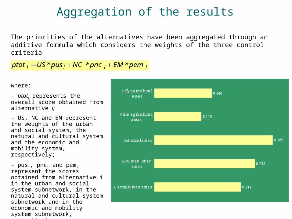
Aggregation of the results
The priorities of the alternatives have been aggregated through an additive formula which considers the weights of the three control criteria
iiii pem*EMpnc*NCpus*USptot
where:
- ptoti represents the overall score obtained from alternative i;
- US, NC and EM represent the weights of the urban and social system, the natural and cultural system and the economic and mobility system, respectively;
- pusi, pnci and pemi represent the scores obtained from alternative i in the urban and social system subnetwork, in the natural and cultural system subnetwork and in the economic and mobility system subnetwork, respectively.
0.140
0.115
0.289
0.245
0.211
Hilly agriculturalareas
Plain agriculturalareas
Industrial areas
Suburban urbanareas
Central urban areas

Sensitivity analysis
Urban and social system
0.0
0.2
0.4
0.6
0.8
1.0
0.0 0.2 0.4 0.6 0.8 1.0
Alt 1
Alt 2
Alt 3
Alt 4
Alt 5
Natural and cultural system
0.0
0.2
0.4
0.6
0.8
1.0
0.0 0.2 0.4 0.6 0.8 1.0
Alt 1
Alt 2
Alt 3
Alt 4
Alt 5
Economic and mobilty systemThe sensitivity analysis allows the robustness of the model to be tested by verifying the changes in the alternatives priorities (y axis) with reference to the changes in the weights of the control criteria (x axis).
The analysis puts in evidence that the alternative related to the industrial areas (alternative 3) is not sensitive to the changes in the weights of the control criteria, with an exception for the economic and mobility system.
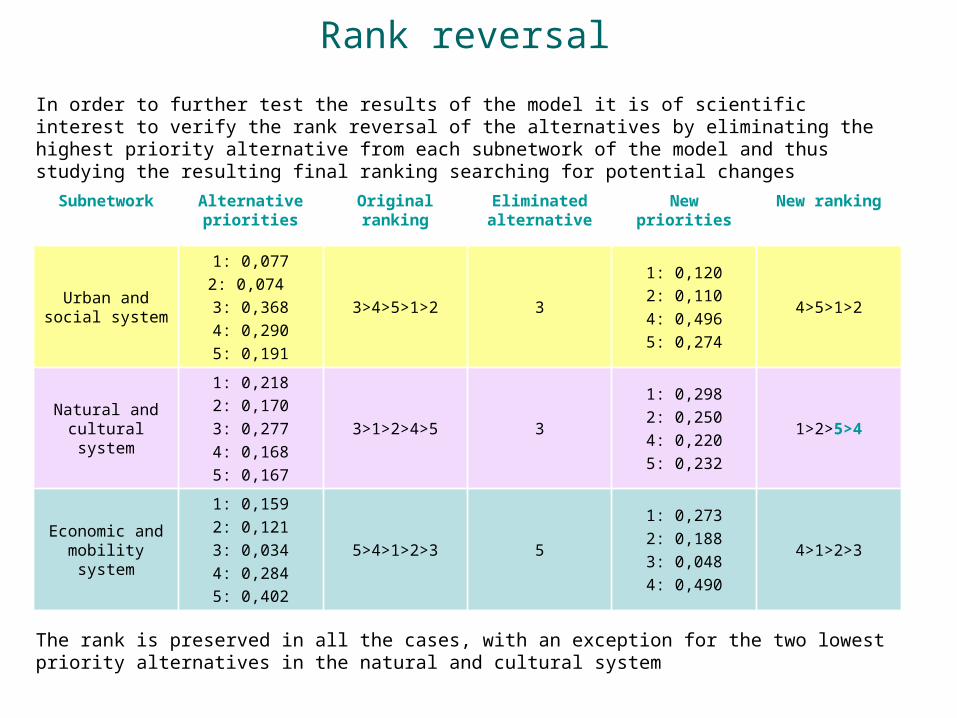
Rank reversal
In order to further test the results of the model it is of scientific interest to verify the rank reversal of the alternatives by eliminating the highest priority alternative from each subnetwork of the model and thus studying the resulting final ranking searching for potential changes
Subnetwork Alternative priorities
Original ranking
Eliminated alternative
New priorities
New ranking
Urban and social system
1: 0,0772: 0,074 3: 0,3684: 0,2905: 0,191
3>4>5>1>2 3
1: 0,1202: 0,1104: 0,4965: 0,274
4>5>1>2
Natural and cultural system
1: 0,2182: 0,1703: 0,2774: 0,1685: 0,167
3>1>2>4>5 3
1: 0,2982: 0,2504: 0,2205: 0,232
1>2>5>4
Economic and mobility system
1: 0,1592: 0,1213: 0,0344: 0,2845: 0,402
5>4>1>2>3 5
1: 0,2732: 0,1883: 0,0484: 0,490
4>1>2>3
The rank is preserved in all the cases, with an exception for the two lowest priority alternatives in the natural and cultural system
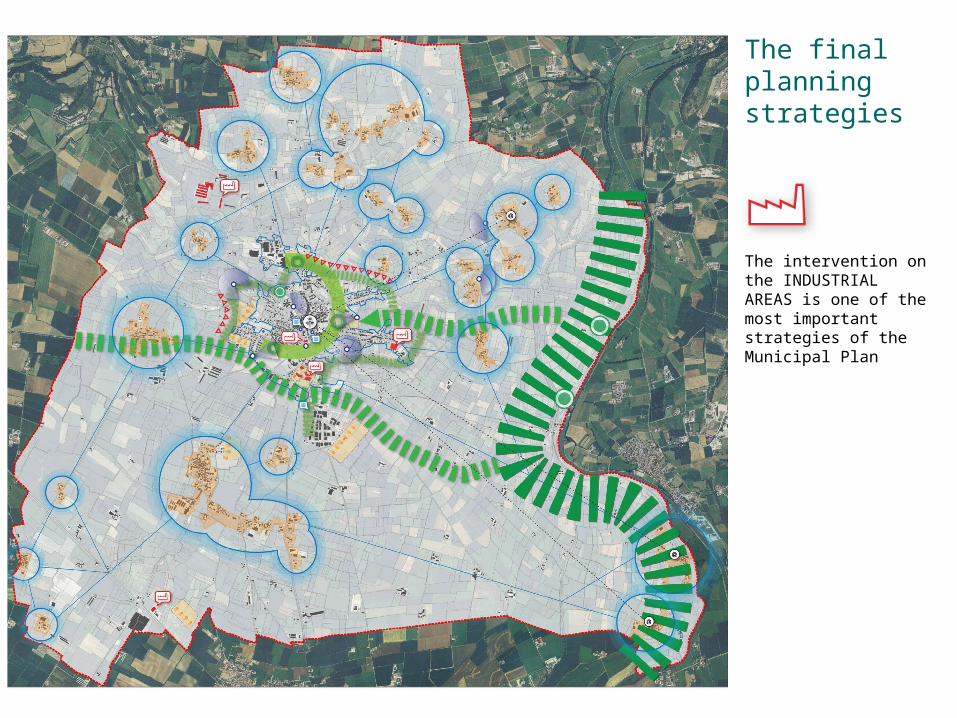
The final planning strategies
The intervention on the INDUSTRIAL AREAS is one of the most important strategies of the Municipal Plan
Conclusions
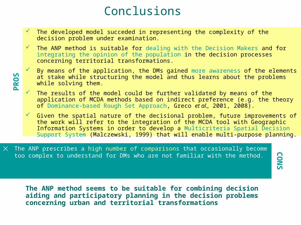
✕ The ANP prescribes a high number of comparisons that occasionally become too complex to understand for DMs who are not familiar with the method.
The developed model succeded in representing the complexity of the decision problem under examination.
The ANP method is suitable for dealing with the Decision Makers and for integrating the opinion of the population in the decision processes concerning territorial transformations.
By means of the application, the DMs gained more awareness of the elements at stake while structuring the model and thus learns about the problems while solving them.
The results of the model could be further validated by means of the application of MCDA methods based on indirect preference (e.g. the theory of Dominance-based Rough Set Approach, Greco et al., 2001, 2008).
Given the spatial nature of the decisional problem, future improvements of the work will refer to the integration of the MCDA tool with Geographic Information Systems in order to develop a Multicriteria Spatial Decision Support System (Malczewski, 1999) that will enable multi-purpose planning.
The ANP method seems to be suitable for combining decision aiding and participatory planning in the decision problems concerning urban and territorial transformations
PR
OSC
ON
S