EVALUATION - Globalwaters.org Evaluation of... · Tom Ryan (International Expert) Dr. Salahuddin...
91
EVALUATION MID-TERM EVALUATION OF USAID’S MIDDLE EAST BUREAU/TECHNICAL SERVICES MONITORING AGRICULTURE AND WATER RESOURCES DEVELOPMENT (MAWRED) PROJECT AND WATER INFORMATION SYSTEM PLATFORMS (WISPS) PROJECT [February 2015] This publication was produced at the request of the United States Agency for International Development. It was prepared independently by Mendez England & Associates.
Transcript of EVALUATION - Globalwaters.org Evaluation of... · Tom Ryan (International Expert) Dr. Salahuddin...
EVALUATION MID-TERM EVALUATION OF USAID’S MIDDLE EAST BUREAU/TECHNICAL SERVICES MONITORING AGRICULTURE AND WATER RESOURCES DEVELOPMENT (MAWRED) PROJECT AND WATER INFORMATION SYSTEM PLATFORMS (WISPS) PROJECT
[February 2015]
This publication was produced at the request of the United States Agency for International Development. It wasprepared independently by Mendez England & Associates.
MID-TERM EVALUATION OF USAID’S MIDDLE EAST BUREAU/TECHNICAL SERVICES MONITORING
AGRICULTURE AND WATER RESOURCES DEVELOPMENT (MAWRED) PROJECT AND WATER
INFORMATION SYSTEM PLATFORMS (WISP) PROJECT
Final Report
12 February 2015
Prepared under RFTOP No. SOL-OAA-14-000157 Submitted to: USAID Submitted by: Jim Franckiewicz (Team Leader) Tom Ryan (International Expert) Dr. Salahuddin Jaber (Local Remote Sensing Specialist) Contractor: Mendez England & Associates 4300 Montgomery Avenue, Suite 103 Bethesda, MD 20814 Tel: 301-652-4334 www.mendezengland.com
DISCLAIMER The authors’ views expressed in this publication do not necessarily reflect the views of the United States Agency for International Development or the United States Government
ACRONYMS ACSAD Arab Center for Studies of Arid Zones and Dry Lands AFRICOVER Database on Land Cover Network for Africa ALEXI Atmosphere-Land Exchange Inverse ASTER Advance Spaceborne Thermal Emission and Reflection Radiometer AWC Arab Water Council CHIRPS Climate Hazard Group Infrared Precipitation with Station CNCT National Mapping and Remote Sensing Center CNRS National Council for Scientific Research CREST Coupled Routing and Excess Storage CRTEAN Regional Center for Remote Sensing of North Africa States CRTS Royal Centre for Remote Sensing DEM Digital Elevation Model DGGREE General Directorate of Rural Engineering and Water Exploitation DGRE General Directorate of Water Resources DISALEXI Disaggregate ALEXI DMU Drought Monitoring Unit EC European Commission ESA European Space Agency ET Evaluation Team EURISY International Astronautical Federation FAO Food and Agriculture Organization FEWSNET Famine Early Warning System Network GDP Gross Domestic Product GEF Global Environment Facility GIS Geographic Information System GoE Government of Egypt GoI Government of Iraq GoL Government of Lebanon GoM Government of Morocco GoUAE Government of United Arab Emirates GoY Government of Yemen GSFC Goddard Space Flight Center IAF International Astronautical Federation ICBA International Center for Biosaline Agriculture INAT National Agronomic Institute of Tunis INM National Institute of Meteorology IOC Intergovernmental Oceanographic Commission IRA Arid Region Institute IT Information Technology JVA Jordan Valley Authority KELD Multi Model Photogrammetry KII Key Informant Interview KRG Kurdistan Regional Government LDAS Land Data Assimilation System LIS Land Information System LORDI Lebanese Observatory for Research, Development and Innovation MAWRED Monitoring Agriculture and Water Resources Development MCM Million Cubic Meters MDG Millennium Development Goal ME&A Mendez England & Associates ME/TS Middle East Bureau/Technical Services
MEMWE Ministry of Energy, Mines, Water and Environment MENA Middle East and North Africa METRIC Mapping ET at High Resolution MODIS Moderate Resolution Imaging Spectroradiometer MoF Ministry of Finance MOU Memorandum of Understanding MWI Ministry of Water and Irrigation MWR Ministry of Water Resources MWRI Ministry of Water Resources and Irrigation NARSS National Authority for Remote Sensing and Space Sciences NASA National Aeronautics and Space Administration NCARE National Centre for Agricultural Research and Extension NDVI Normalized Difference Vegetation Index OMEP Office of Middle East Programs OPEC Organization of Petroleum Exporting Countries OWL Other Wooded Land PAPA Participating Agency Program Agreement PIO Private International Organization PIP Project Implementation Plan R&D Research and Development RCIWRM Regional Coordination on Improved Water Resource Management Project RJGC Royal Jordanian Geographic Center RS Remote Sensing SEBAL Energy Balance Evapotranspiration Model SOW Statement of Work STIP Science and Technology Innovation Policy TDY Temporary Duty UAE United Arab Emirates UN United Nations UNDP United Nations Development Programme UNEP United Nations Environment Programme UNESCO United Nations Educational, Scientific and Cultural Organization UNICEF United Nations Children’s Fund UNOOSA United Nations Office for Outer Space Affairs US United States USAID United States Agency for International Development USG United States Government USGS United States Geological Survey WAJ Water Authority of Jordan WB World Bank WISPS Water Information System Platforms
i
CONTENTS
EXECUTIVE SUMMARY ........................................................................................................................................... ii
Evaluation Purpose ........................................................................................................................................... i
Background ........................................................................................................................................................ i
Evaluation Methodology ................................................................................................................................ iii
Findings, Conclusions & Recommendations ............................................................................................. iii
1.0 INTRODUCTION .......................................................................................................................................... 1
1.1 Evaluation Purpose ............................................................................................................................... 1
1.2 Evaluation Questions ........................................................................................................................... 1
2.0 BACKGROUND ............................................................................................................................................. 2
2.1 Development Context ........................................................................................................................ 2
2.2 Overview ................................................................................................................................................ 3
2.2.1 ICBA/MAWRED Program ................................................................................................... 5
2.2.2 NASA/WISP Program .......................................................................................................... 6
3.0 EVALUATION METHODS & LIMITATIONS .......................................................................................... 8
3.1 Evaluation Methodology ..................................................................................................................... 8
3.2 Evaluation Limitations.......................................................................................................................... 8
4.0 FINDINGS, CONCLUSIONS & RECOMMENDATIONS ................................................................... 9
4.1 Lebanon .................................................................................................................................................. 9
4.1.1 Background ............................................................................................................................. 9
4.1.2 Findings .................................................................................................................................. 10
4.1.3 Conclusions .......................................................................................................................... 12
4.1.4 Recommendations ............................................................................................................... 12
4.2 Jordan .................................................................................................................................................... 13
4.2.1 Background ........................................................................................................................... 13
4.2.2 Findings .................................................................................................................................. 13
4.2.3 Conclusions .......................................................................................................................... 17
4.2.4 Recommendations ............................................................................................................... 18
4.3 Tunisia ................................................................................................................................................... 18
4.3.1 Background ........................................................................................................................... 18
4.3.2 Findings .................................................................................................................................. 19
4.3.3 Conclusions .......................................................................................................................... 21
4.3.4 Recommendations ............................................................................................................... 21
4.4 Morocco ............................................................................................................................................... 23
4.4.1 Background ........................................................................................................................... 23

ii
4.4.2 Findings .................................................................................................................................. 23
4.4.3 Conclusions .......................................................................................................................... 27
4.4.4 Recommendations ............................................................................................................... 26
4.5 Egypt ...................................................................................................................................................... 28
4.5.1 Background ........................................................................................................................... 28
4.5.2 Findings .................................................................................................................................. 28
4.5.3 Conclusions .......................................................................................................................... 30
4.5.4 Recommendations ............................................................................................................... 30
4.6 Iraq ......................................................................................................................................................... 30
4.6.1 Background ........................................................................................................................... 30
4.6.2 Findings .................................................................................................................................. 31
4.6.3 Conclusions .......................................................................................................................... 32
4.6.4 Recommendations ............................................................................................................... 32
4.7 Yemen ................................................................................................................................................... 32
4.7.1 Background ........................................................................................................................... 32
4.7.2 Findings .................................................................................................................................. 33
4.7.3 Conclusions .......................................................................................................................... 34
4.7.4 Recommendations ............................................................................................................... 34
5.0 OVERALL RECOMMENDATIONS ......................................................................................................... 34
6.0 LESSONS LEARNED ................................................................................................................................... 36
ANNEXES ANNEX 1: Evaluation Statement of Work ANNEX 2: List of Documents Reviewed ANNEX 3: List of Interviewees ANNEX 4: Evaluation Design Matrix ANNEX 5: Data Collection Instruments ANNEX 6: MAWRED/WISP Training 2009-2014 ANNEX 7: Matrices for Country Accomplishments ANNEX 8: Background and Assessment for the Tools and Technology Provided by NASA/ICBA
Projects
FIGURES FIGURE 1: Donors and Countries that Participate in the Program FIGURE 2: NASA/ICBA/RCIWRM Program Organizational Structure FIGURE 3: Management Complexities FIGURE 4: ICBA/MAWRED Activity Summary FIGURE 5: NASA/WISPS Activity Summary

i
EXECUTIVE SUMMARY EVALUATION PURPOSE This is a report on the mid-term evaluation of two inter-related water activities funded by the United States Agency for International Development (USAID) and managed by USAID’s Middle East Bureau/Technical Services (ME/TS) out of Washington, DC. These activities are:
1. Monitoring Agriculture and Water Resources Development (MAWRED), implemented by the International Center for Biosaline Agriculture (ICBA) in Morocco, Egypt, Jordan, Lebanon, Yemen, Iraq and Tunisia over the period March 2009 to December 2016, for a total cost of approximately $3.0 million. This activity will be referred to hereafter as the ICBA/MAWRED activity.
2. Water Information System Platforms (WISP) for Use in the Middle East and North Africa (MENA) Region, implemented by the National Aeronautics and Space Administration’s (NASA) Goddard Space Flight Center (GSFC) in Lebanon, Jordan, Egypt, Morocco and Tunisia over the period April 2011 to September 2017, for a total cost of $2.8 million. This activity will be referred to hereafter as the NASA/WISP activity.
The evaluation of the above activities was conducted during the period October – December 2014, by a team assembled by Mendez England & Associates (ME&A) with headquarters in Bethesda, Maryland. A USAID ME/TS monitoring and evaluation officer accompanied the team in Jordan and for a few days in Morocco. The purpose of the evaluation was to provide USAID with an external mid-term assessment of the performance of the two activities to-date, as well as with actionable recommendations that can be adopted by USAID ME/TS to improve their implementation for the remaining years.
The evaluation covered the periods of (i) March 2009 - December 2014 for the ICBA/MAWRED activity, and (ii) April 2011 - December 2014 for the NASA/WISP activity.
BACKGROUND The ICBA/MAWRED and NASA/WISP are separate but closely linked activities that aim to support and reinforce USAID’s Development Objectives for the MENA region in the areas of water resource management and climate change.
The specific roles of the lead institutions under each activity are summarized below:
NASA provides technical expertise and NASA-developed tools and technologies to participating country institutions in the area of remote sensing (RS) and modeling [e.g. related to surface and groundwater resources (floods, drought, groundwater extraction, evapotranspiration, etc.) and climate change impacts] even though its tools and data are generally designed for global/regional applications. NASA works closely with ICBA as a regional institution, providing tools and training to ICBA staff on the use of NASA technologies.
With support from NASA, ICBA will become a knowledge hub and RS/modeling ‘center of excellence’ for the MENA region, able to provide training and hands-on capacity building on the NASA tools and technologies to the activity-specific partner organizations and institutions within the participating countries. ICBA also assists the participating countries to customize NASA models and tools for national applications. The NASA models will make use of earth science satellite observations, in conjunction with ground measurements, in order to address the region’s agriculture/water resources priorities, provide information on climate change, and improve decision making for societal benefits. Contractually, the ICBA/MAWRED activity is required to be implemented in seven countries (Morocco, Egypt, Jordan, Lebanon, Yemen, Iraq and Tunisia);

ii
however, to date, the primary focus of ICBA has been in Iraq, Yemen and Lebanon, with some limited interest in Tunisia and Jordan1.
The World Bank provides funding for country-level activities in support of the NASA/WISP activity, through its Regional Coordination on Improved Water Resources Management and Capacity Building (RCIWRM) project. The World Bank funds are available only to participating NASA/WISP countries for the purchase of equipment, contracting of technical expertise, and travel and training expenses. The USAID-NASA-World Bank partnership provides technical expertise to participating country institutions in the area of RS and modeling.
The Arab Water Council (AWC) supports the World Bank’s aims and objectives, primarily through assisting in conducting biannual project reviews, progress reporting, and regional coordination.
USAID ME/TS provides financial support to NASA and ICBA in support of their partnership to develop a RS/modeling and knowledge hub for the MENA region to be based at ICBA.
The NASA/WISP activity, the ICBA/MAWRED activity, and the World Bank RCIWRM project, will be collectively referred to hereafter as the Program. Figure 1, below, indicates the donors that are supporting the Program, the specific activities they are funding under this Program, and the countries they support under each activity.
1 Evaluation Team briefing by NASA (Ref NASA Activity Overview Power Point Presentation for USAID Evaluation Team, October 22, 2014).
iii
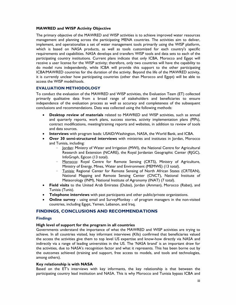
MAWRED and WISP Activity Objective
The primary objective of the MAWRED and WISP activities is to achieve improved water resources management and planning across the participating MENA countries. The activities aim to deliver, implement, and operationalize a set of water management tools primarily using the WISP platform, which is based on NASA products, as well as tools customized for each country's specific requirements and capabilities. NASA develops and transfers WISP tools and data sets to each of the participating country institutions. Current plans indicate that only ICBA, Morocco and Egypt will receive a user license for the WISP activity; therefore, only two countries will have the capability to do model runs independently, while ICBA will provide this support to the other participating ICBA/MAWRED countries for the duration of the activity. Beyond the life of the MAWRED activity, it is currently unclear how participating countries (other than Morocco and Egypt) will be able to access the WISP model/tools.
EVALUATION METHODOLOGY To conduct the evaluation of the MAWRED and WISP activities, the Evaluation Team (ET) collected primarily qualitative data from a broad range of stakeholders and beneficiaries to ensure independence of the evaluation process as well as accuracy and completeness of the subsequent conclusions and recommendations. Data was collected using the following methods:
Desktop review of materials related to MAWRED and WISP activities, such as annual and quarterly reports, work plans, success stories, activity implementation plans (PIPs), contract modifications, meeting/training reports and websites, in addition to review of tools and data sources.
Interviews with program leads: USAID/Washington, NASA, the World Bank, and ICBA. Over 30 semi-structured interviews with ministries and institutes in Jordan, Morocco
and Tunisia, including: - Jordan: Ministry of Water and Irrigation (MWI), the National Centre for Agricultural
Research and Extension (NCARE), the Royal Jordanian Geographic Center (RJGC), InfoGraph, Egicon (13 total).
- Morocco: Royal Centre for Remote Sensing (CRTS), Ministry of Agriculture, Ministry of Energy, Mines, Water and Environment (MEMWE) (13 total).
- Tunisia: Regional Center for Remote Sensing of North African States (CRTEAN), National Mapping and Remote Sensing Center (CNCT), National Institute of Meteorology (INM), National Institute of Agronomy (INAT) (7 total).
Field visits to the United Arab Emirates (Dubai), Jordan (Amman), Morocco (Rabat), and Tunisia (Tunis).
Telephone interviews with past participants and other public/private organizations. Online survey - using email and SurveyMonkey - of program managers in the non-visited
countries, including Egypt, Yemen, Lebanon, and Iraq.
FINDINGS, CONCLUSIONS AND RECOMMENDATIONS
Findings
High level of support for the program in all countries Governments understand the importance of what the MAWRED and WISP activities are trying to achieve. In all countries visited, key informant interviews (KIIs) confirmed that beneficiaries valued the access the activities give them to top level US expertise and know-how directly via NASA and indirectly via a range of leading universities in the US. The ‘NASA brand’ is an important draw for the activities, due to NASA’s recognition factor and what it represents. This has been borne out by the outcomes achieved (training and support, free access to models, and tools and technologies, among others).
Key relationship is with NASA Based on the ET’s interviews with key informants, the key relationship is that between the participating country lead institution and NASA. This is why Morocco and Tunisia bypass ICBA and

iv
choose to access capacity support and training directly from NASA. ICBA has provided some useful technical support to participating country institutions, but its projected role as a regional ‘knowledge and modeling hub’ is unlikely to be sustainable without ongoing NASA’s support and USAID funding. This poses the question about an exit strategy after the activities’ completion. Many of the participating institutions will hope to maintain their established links with NASA and US universities after the activities end; however, there is uncertainty whether these academic partnerships will be maintained. NASA is the brand that holds the activities together and underscores the level of excellence that they strive to achieve.
Program structure and implementation arrangements The overall Program (i.e. the ICBA/MAWRED and NASA/WISP activities, together with the World Bank RCIWRM project) has been loosely structured primarily due to the United States Government (USG) contracting mechanisms – NASA’s interagency contract and ICBA’s Public International Organization Grant – in addition to the World Bank’s RCIWRM funding mechanism program. Advantages and disadvantages of this structure include:
Advantages: Lebanon, Tunisia, and Morocco, with good existing capacity and skills in RS and a strong champion institution, have been able to achieve good outcomes due to the flexibility of the contracts. The Program is fairly open-ended, not overly-constrained by outputs, deliverables, and targets. Arguably this is the kind of environment best suited to cutting-edge research like climate change. The Program has provided:
Access to knowledge and latest concepts Technical support and training Networking opportunities (regionally, and with US institutions) Funding support (for essential equipment and hire of consultants, etc.)
The Program’s model allows experts, champions, and enthusiasts to excel; however, it is not a model for beginners facing a steep learning curve. The Program demands high level of expertise and motivation if beneficiary countries are to maximize the benefits from high level technical interactions with NASA and ICBA. Thus, those countries with good existing capacity and skills in RS and a strong champion institution have been able to take advantage of the Program.
Disadvantages: The Program has a rather complex management and implementation structure. NASA and ICBA have strong technical capacity but limited backstopping staff. Participating country institutions have different priorities and capacity levels, and different training needs according to the stage of their research. Therefore, beyond the initial training and orientation, accommodating the training and support needs of all the stakeholder institutions has been challenging. Not all participating countries are included in the ICBA/MAWRED activity and so do not have access to ICBA’s support. Under the NASA/WISP activity, accessing World Bank funds (and navigating the World Bank’s procurement procedures) has been challenging for Morocco, Jordan and Tunisia.
The AWC provides an administrative support role, as coordinator and facilitator, to the World Bank under their RCIWRM project. The AWC has no formal relationship with either NASA or ICBA and, therefore, has no direct involvement in either the MAWRED or WISP activities. However, under the World Bank’s RCIWRM project, the AWC interfaces with all the relevant stakeholder organizations in the participating countries of Jordan, Morocco, Tunisia, Lebanon and Egypt. AWC’s role and responsibilities were not clear to participating countries and, although originally envisioned to be responsible for overall coordination, it appears to have adopted a low key role without either implementation or technical guidance aspects. AWC lacks expertise in RS, has not interfaced well with country institutions, and has not coordinated implementation of regional applications of WISP tools.
Coordination The overall Program has lacked coordination and an effective communication stream. The AWC role has lacked clarity and connectivity with the Program and its key institutions. ICBA, the other
v
institution that could potentially play a regional coordination role, is itself only involved in one of the activities (namely the MAWRED activity). The current Program organizational structure, with its inherent complexity, poses a real challenge in terms of overall coordination. Country-Level Progress Jordan has had a slower start than other countries; the lead institution, the MWI, lacks expertise in RS, leading to a rather tentative start and a lack of confidence in coordinating with other institutions with RS capacity. So far, MWI has been able to only minimally engage and exploit the available talent pool that exists within Jordan. Its lack of leadership has caused the existing partner institutions2 (NCARE and RJGC) to disengage from the activity. In the last six months, MWI has engaged short term consultants from academia to work on crop mapping, irrigation, evapotransipration, and climate change. There has been no substantial progress made in the other component areas and this is of concern for the future of the overall Program in Jordan. Jordanian academic institutions are consequently playing a significant role and are responsible for most of the recent achievements in the implementation of the Program. In general:
The cooperation between MWI and the University of Jordan to accomplish the crop mapping and evapotransipration component has had some promising results to date.
Drought monitoring (by NASA, MWI, and NCARE) has suffered from the lack of cooperation between the MWI and NCARE to achieve the goals of this component.
No progress has been achieved on the climate change component; however, MWI recently hired consultants from academia to carry out the requirements of this component.
Morocco has a strong lead institution, CRTS, good project management, and coordination within the diverse components, all of which are housed within the one institution. As a result, it has been able to achieve good outcomes in all of its component areas. Notable progress has been achieved in locust invasion risk, which used RS data, supported by field ground-truthing to produce locust risk maps and early warning maps. The Land Information System (LIS) platform was successfully installed for CRTS. In general, the people in charge of all components have the technical competency and knowledge necessary to achieving their goals.
Tunisia’s lead institution, CRTEAN, already served as regional coordinator and, as such, has been highly collaborative and engaging with all stakeholders. Although this has been challenging and time consuming, it has resulted in a more inclusive coordination and management approach (compared to Morocco and Jordan), involving multiple stakeholders such as university research institutes. This is evident in the climate change component, which involved the INM, whose results are exceeding those in the other countries. Tunisia is seeing good progress in all component areas, with the exception of groundwater storage where the groundwater specialist has only recently been engaged to achieve the component goals.
Lebanon managed to make progress despite receiving limited training opportunities. Its lead institution, the National Council for Scientific Research (CNRS), has been effective at using the limited assistance it received in training and capacity building to make progress in the primary areas of floods, droughts, evapotranspiration, and crop mapping. Sustainable management of natural resources and real time assessments of droughts, floods and fires were the driving force for its efforts. Links have been established with stakeholders and end users such as the Ministries of Water Resources, Forestry and Agriculture, farmers associations, and civil aviation.
Egypt, to date, has received only limited support; it is not a beneficiary country for the ICBA/ MAWRED activity, but is included in the WISP/NASA activity. Furthermore, Egypt was not included in Phase 1 of the World Bank’s grant funding3 but is scheduled to be included in Phase 2. Therefore,
2 RJGC – Joint implementing partner, and the National Centre for Agricultural Research (NCARE), Agriculture and Drought Division. 3 under the RCIWRM Program

vi
Egypt has not yet received direct grant funding to undertake activities, and has only limited access to NASA (as part of the USAID funding) and no access to ICBA. Additionally, Egypt is subject to a temporary work stoppage due to the USG policy restrictions on dealing with Egypt, which has blocked program implementation. Its future in the overall Program is therefore uncertain. However, at the time of this report, USAID has indicated that a waiver is approved for Egypt’s participation in this Program to begin in 2015.
Iraq, to date, has not been able to fully participate in the MAWRED activity because it was not a beneficiary country for either WISP or Phase 1 of the World Bank grant funding. Iraq has received some data and modeling information from ICBA. Further, Iraq’s security situation has severely limited foreign assistance interventions.
Yemen, to date, has been unable to fully participate in the MAWRED activity. Yemen was not a beneficiary country for either WISP or Phase 1 of the World Bank grant funding. The country has received some data and modeling information from ICBA. USAID/Yemen paid for some Famine Early Warning System Network (FEWSNET) and ICBA collaboration regarding modeling information for early warning systems. Further, Yemen’s security situation has severely limited foreign assistance interventions.
Role of ICBA
ICBA is a key implementing partner, but also significant (albeit indirect or unintended) activity beneficiary as a result of its association with NASA and the training and capacity building its scientists have received. However, this arrangement has presented some issues, which include:
ICBA has been less effective at transferring its knowledge to other countries: 1) Jordan has had little meaningful contact with ICBA; 2) Morocco was not intended to have direct contact with ICBA under the activity structures and communication arrangements, but has unofficially made some useful contacts with ICBA that have resulted in training and capacity building; and 3) Tunisia has benefitted from its links with ICBA. However, ICBA is regarded as having a limited potential to assist individual countries. At a more advanced level, country specialists need a higher level of expertise that they believe is only available from NASA, US universities, or other institutions.
ICBA expertise lies with the LIS model; it does not have expertise in the other models and tools being used in the MENA countries.
ICBA has been less effective at coordination and is more interested in its role in research and development (R&D) of models. ICBA’s scientists have gone off-track on occasions, for example, in their development work on Land Data Assimilation System (LDAS), which persisted for one year with no meaningful output while the MENA countries had already found that LDAS did not suit to their needs.
ICBA has not yet determined its exit strategy – how the capacity developed by ICBA will be available to the MENA countries at the end of the overall Program. ICBA will need ongoing funding if it is to continue to play a support role. There is a risk that the capacity developed within ICBA could be lost or unavailable to the MENA countries, or only available on payment of fees.
Conclusions
As a well-known global institution with a high recognition factor and associated with scientific and engineering excellence, NASA’s participation in the Program has proved to be a strong draw for the participating countries and institutions. As a result, the participating countries’ priority relationship is with NASA, meaning that they prefer to deal directly with it. ICBA’s role remains unclear to many of the participating institutions.
The interagency agreement and Public International Organization (PIO) grant mechanisms provided flexibility to both the contractors (NASA and ICBA) and the host country implementing agencies. The $1.0 million per country World Bank grant funds called for procurement plan concurrence from NASA and the World Bank.

vii
Program coordination could be greatly improved with clear delineation of roles and responsibilities for NASA/ICBA/AWC along with annual work plans and reporting of annual results.
Morocco and Tunisia, and to some extent Lebanon, show that good progress is possible under the existing program structure. The formula for success includes:
RS organizations with experience and expertise. Thematic area leads with good background and enthusiasm. Overall Program management is assigned to and located in the right organization. Basic meteorologic, climate and hydrologic staff skills exist in-country.
The overall Program comprised three activities – WISP, ICBA and RCIWRM – which lacked good coordination and communication. Overall implementation coordination responsibility was envisioned but not performed. Online Program portal and annual regional reports were not in evidence for the document review.
Technical staff from NASA, universities, and ICBA had top notch skills and worked effectively with local partners.
The LIS platform contains all the models required to implement a successful water resource management and planning program across the MENA region. However, necessary customization, downscaling, and ground-truthing due to the use of global and regional models and low resolution data will be the responsibility of the individual countries.
Post-Program sustainability of modeling support and data acquisition has not been addressed.
Political issues in Egypt and security issues in Iraq and Yemen effectively blocked Program implementation in these countries during this time period.
Demand for RS information will depend upon adequate outreach efforts to stakeholders and end users.
Recommendations
Review AWC’s role. Coordination and reporting could be expanded to serve the needs of the Program as a whole, rather than only the World Bank’s program and components. Currently, progress reports are not widely disseminated, there is no mention of the Program in the AWC’s website, and AWC has not been involved in implementation coordination.
Clarify ICBA’s role related to the longer-term Program objectives. ICBA needs to strengthen its outreach capability and tailor its research to technologies that are being used by the participating countries. The longer-term role (and sustainability) of the Program team needs to be clarified. The team’s composition - in terms of their research, outreach, and coordination roles - should be reviewed.
Reporting. Annual work plans should be prepared for each participating country and progress monitored against the set targets. Country-level biannual progress reports should be prepared and circulated to the World Bank, USAID, NASA, ICBA, and AWC. These reports should be consolidated with updated reports from NASA and ICBA. A standard reporting format should be developed, and the reports should meet the World Bank and USAID needs as well as allow for ease of monitoring and evaluation.
Sustainability of modeling support and data acquisition in the MENA region should be resolved in the early stages of Phase II.

1
1.0 INTRODUCTION
1.1 EVALUATION PURPOSE This is a report on the mid-term evaluation of two inter-related water activities funded by the United States Agency for International Development (USAID) and managed by the USAID’s Middle East Bureau/Technical Services (ME/TS) out of Washington, DC. These activities are:
1. Monitoring Agriculture and Water Resources Development (MAWRED), implemented by the International Center for Biosaline Agriculture (ICBA) in Morocco, Egypt, Jordan, Lebanon, Tunisia, Yemen, Iraq over the period March 2009 to December 2016, for a total cost of approximately $3.0 million. ICBA’s assistance in Yemen and Iraq is limited.
2. Water Information System Platforms (WISP) for Use in the Middle East and North Africa (MENA) Region, implemented by the National Aeronautics and Space Administration’s (NASA) Goddard Space Flight Center (GSFC) in Lebanon, Jordan, Egypt, Morocco and Tunisia over the period April 2011 to September 2017, for a total cost of $2.8 million.
Throughout this report, the above activities are referred to as the NASA/WISP activity and the ICBA/MAWRED activity. Collectively, and hereafter, they will be referred to as the NASA/ICBA Activities.
The evaluation of the NASA/ICBA Activities was conducted during the period October – December 2014, by a team assembled by Mendez England & Associates (ME&A) located in Bethesda, Maryland. The team included: Mr. Jim Franckiewicz (Team Leader), Mr. Tom Ryan (International Expert), and Dr. Salahuddin Jaber (Local Remote Sensing Specialist). Ms. Amena Chenzaie, USAID ME/TS monitoring and evaluation officer accompanied the team in Jordan and for a few days in Morocco. The evaluation covered the activities’ implementation period of 2009-2014.
The purpose of the evaluation was to provide USAID with: 1) an external mid-term assessment of the performance of the NASA/ICBA Activities to-date; and 2) actionable recommendations that can be adopted by USAID ME/TS to improve program implementation for the remaining years. The findings and recommendations of the evaluation will be shared with USAID Missions in the countries where the awards are implemented, with the ICBA and NASA teams, and with other relevant stakeholders as needed. The evaluation was structured to respond to the key evaluation questions, which are identified in the Statement of Work (SOW) for this assignment (see Annex 1) and detailed in the following section of this report.
1.2 EVALUATION QUESTIONS As detailed in the SOW, the Evaluation Team (ET) was asked to answer a number of specific questions, outlined below:
1. How are the relevant organizations involved in adopting the tools and technology provided by NASA/ICBA to conduct their work?
a. Which tools and technologies4 do these organizations perceive to be of value for their own purposes?
b. To what extent are appropriate staff of the organizations familiar with and proficient with the tools and technologies?
c. To what extent have the tools and technologies been integrated into the work processes of the organizations?
2. What are the factors that lead to the adoption or non-adoption of NASA tools and resources?
4 “Tools and technologies” includes software, information system tools and models, data sets, and analysis that
have been provided to the relevant organizations and which the relevant organizations have been trained to use by the ICBA/NASA water activities.

2
a. What are the characteristics of the organizations that contribute to the adoption or prevent the adoption of these tools and technologies?
b. What are the internal factors that empower staff of the organizations to explore, adopt, and utilize NASA tools and models?
c. What are the external factors that lead to the integration of NASA tools and technologies into work processes for improved water resource management?
3. How are the tools and technologies being used to contribute to the planning and decision making of the management of water resources?
a. What decision making processes have been revised incorporating NASA tools and technologies?
b. What are the factors contributing to or preventing the use of the tools and technologies for water resource management, planning, and decision making of the ministries involved?
Based on the above core questions from the SOW, the ET derived sub-questions in order to further elaborate the information needs. The complete list of evaluation questions and sub-questions can be found in the Evaluation Design Matrix (Annex 4), which was used as a tool5 by the ET to conduct the evaluation.
2.0 BACKGROUND 2.1 DEVELOPMENT CONTEXT The purpose of the NASA/ICBA Activity is to address water resources issues and climate change impacts in the MENA region, through the use of integrated NASA developed capabilities based on satellite data and remote sensing (RS) modeling-based tools. Such tools and technologies are a significant advance over traditional manual/field-based data collection techniques being used and will allow real time data collection, which will improve forecasting and, therefore, planning and decision-making. The NASA/ICBA Activity will also foster links and partnerships between like-minded research and science based institutions within the MENA region, while at the same time providing access to cutting-edge US technologies from leading research institutions in the US in the specific fields of earth based sciences.
The need for the NASA/ICBA Activity is driven by the critical need to better manage the limited available water resources of the region, so as to better meet the competing demands of an ever expanding population and the increased need for water for irrigation and industry. The specific context, and hence challenges, for each of the participating countries are outlined in Section 46. This clearly establishes the justification for the activity intervention, and the application priorities.
The origins of the Activities can be traced back to an Arab Water Council (AWC) and World Bank sponsored workshop in Porto Marina, Egypt, in June 2008, which was convened to discuss and address ‘water resources issues in the Arab Region and the impact of impending climate change’. Representatives from most of the Arab League countries, USAID, NASA, and representatives from donor groups and academia participated in the workshop. Following the discussions in Porto Marina, USAID supported ICBA’s efforts to utilize data sets and modeling tools to enable MENA regional planning and water resource management. Two years later, USAID funded NASA/WISP activity and the World Bank funded the multi-country, Regional Coordination on Improved Water Resource Management (RCIWRM) country grants project.
5 The Evaluation Design Matrix was used as a guide and prompt for interview purposes. Interviews were semi-
structured and did not follow a rigid format. This allowed the ET to respond to, and follow up on priority issues identified by the respondents.
6 Under sub section titled “Background” for each country.
3
The NASA/ICBA Activities are separate but closely linked activities that support and reinforce USAID’s Development Objectives (DO) for the Middle East in the area of water resource management and climate change. The Activities fall under DO3, Increased Capacity of All Stakeholders to Manage Water Resources More Effectively and Efficiently.
2.2 OVERVIEW NASA/WISP activity’s objective is to improve water resources and agricultural management and planning within and across beneficiary countries based on quantitative and spatial-based decision making tools. ICBA/MAWRED’s activity objective is to support regional policy makers in current and future water and agriculture resource planning.
NASA/WISP activity was developed out of a partnership with the World Bank, in which the World Bank provides funding for purchasing equipment, contracting technical expertise, travel, and training through its Regional Coordination on Improved Water Resources Management and Capacity Building (RCIWRM) project. The USAID-NASA partnership provides technical expertise to participating country institutions in the area of RS and modeling.
NASA works closely with ICBA as a regional institution, providing tools and training to ICBA’s staff on the use of NASA’s technologies. In return, ICBA provides similar trainings and hands-on capacity building to a range of regional organizations within the participating countries and institutions, building on the working partnership between USAID, NASA and the World Bank, which was established in 2008.
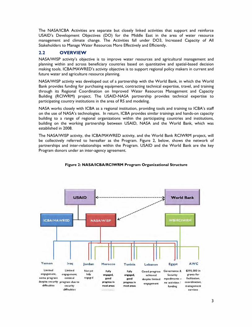
The NASA/WISP activity, the ICBA/MAWRED activity, and the World Bank RCIWRM project, will be collectively referred to hereafter as the Program. Figure 2, below, shows the network of partnerships and inter-relationships within the Program. USAID and the World Bank are the key Program donors under an inter-agency agreement.
Figure 2: NASA/ICBA/RCIWRM Program Organizational Structure
4
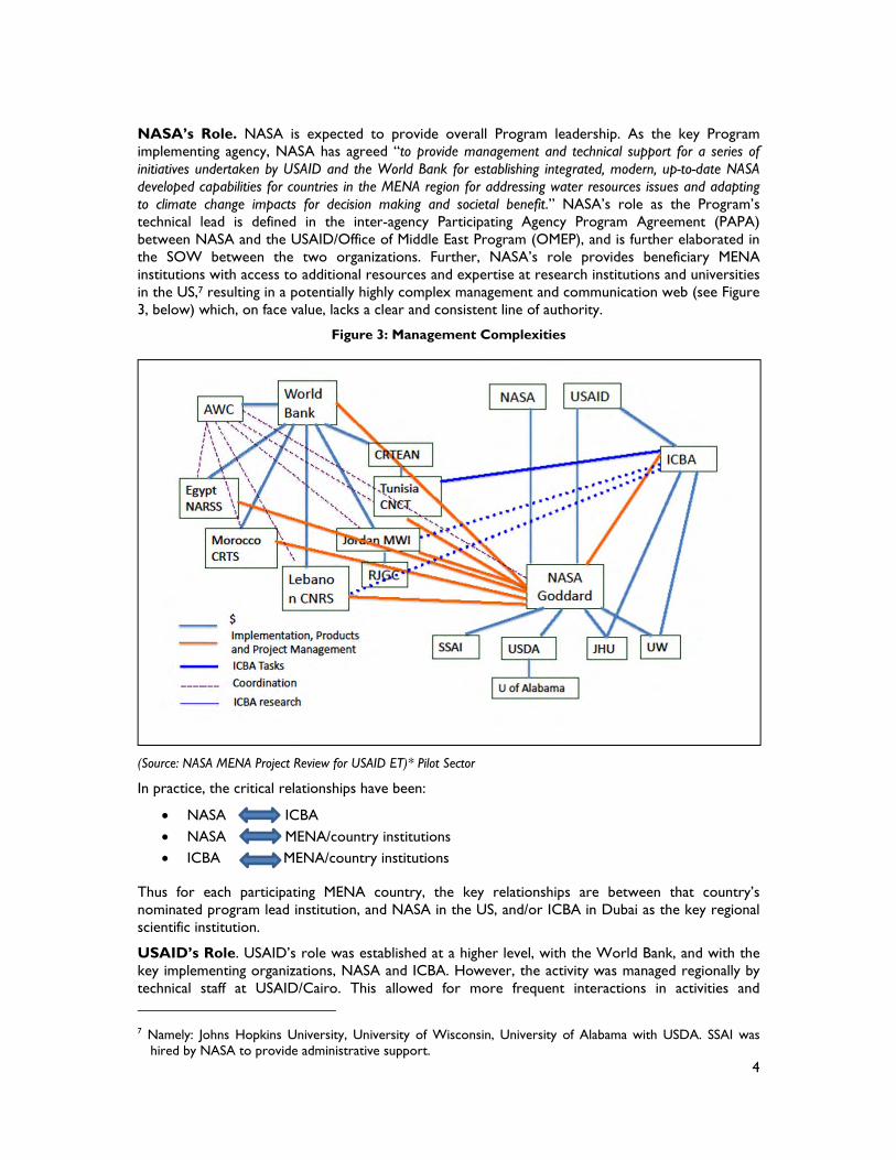
NASA’s Role. NASA is expected to provide overall Program leadership. As the key Program implementing agency, NASA has agreed “to provide management and technical support for a series of initiatives undertaken by USAID and the World Bank for establishing integrated, modern, up-to-date NASA developed capabilities for countries in the MENA region for addressing water resources issues and adapting to climate change impacts for decision making and societal benefit.” NASA’s role as the Program’s technical lead is defined in the inter-agency Participating Agency Program Agreement (PAPA) between NASA and the USAID/Office of Middle East Program (OMEP), and is further elaborated in the SOW between the two organizations. Further, NASA’s role provides beneficiary MENA institutions with access to additional resources and expertise at research institutions and universities in the US,7 resulting in a potentially highly complex management and communication web (see Figure 3, below) which, on face value, lacks a clear and consistent line of authority.
Figure 3: Management Complexities
(Source: NASA MENA Project Review for USAID ET)* Pilot Sector
In practice, the critical relationships have been:
NASA ICBA NASA MENA/country institutions ICBA MENA/country institutions
Thus for each participating MENA country, the key relationships are between that country’s nominated program lead institution, and NASA in the US, and/or ICBA in Dubai as the key regional scientific institution.
USAID’s Role. USAID’s role was established at a higher level, with the World Bank, and with the key implementing organizations, NASA and ICBA. However, the activity was managed regionally by technical staff at USAID/Cairo. This allowed for more frequent interactions in activities and 7 Namely: Johns Hopkins University, University of Wisconsin, University of Alabama with USDA. SSAI was
hired by NASA to provide administrative support.
5
meetings, and facilitated travel to participating countries. USAID/OMEP was, until 2011, based in Cairo, Egypt, but will be relocated to Germany in 2015. The Activities are currently overseen from staff at USAID ME/TS in Washington, DC.
WORLD BANK’s Role. Under the World Bank’s RCIWRM project, four participating countries – Jordan, Lebanon, Morocco, and Tunisia – received grants of approximately $1.0 million each from the World Bank’s Global Environment Facility (GEF) Trust Fund, the terms of which are under project implementation plans (PIPs) between the World Bank and each individual country. As such, each country maintains reporting and accountability obligations to the World Bank. The World Bank also paid approximately $395,000 to the AWC for overall coordination, which included facilitation, coordination and management.
ICBA’s Role. ICBA is a research organization founded by the Islamic Development Bank, the Organization of Petroleum Exporting Countries (OPEC) Fund, the Arab Fund for Economic and Social Development, and the Government of the United Arab Emirates (GoUAE). Although its initial focus was on bio-saline agriculture, it has diversified into other related research areas on water scarcity and agriculture in arid climates. One of NASA’s main objectives was to establish ICBA as a regional node with a comprehensive capacity to operate and support the Land Data Assimilation System (LDAS) water platform, considered to be the flagship NASA toolset for achieving the intended water resources and climate change outcomes. Building the capacity of ICBA to support the wider MENA region in advanced water resources and climate modeling, with NASA as a nurturing partner, was a key objective of the NASA/ICBA Activities.
ICBA’s role includes:
Working with regional RS centers to develop their expertise in water and climate change modeling and analysis.
Building its capacity as a regional node with a comprehensive, functional LDAS water platform able to support modeling across the region by working with NASA.
Collecting field data from the participating MENA countries to help verify and calibrate the models and tools.
AWC’s Role. AWC has a vision of promoting integrated water resources management in the Arab Region to maximize the economic, social, and environmental benefits from water use in Arab countries. AWC’s role in the overall Program originated from its joint sponsorship with the World Bank of a 2008 workshop in Porto Marina, Egypt, to address water resources issues in the Arab Region and the impact of impending climate change. The workshop, attended by USAID and NASA, identified the need for the current program to be rolled out across the MENA region. AWC’s existing regional mandate made it suited to the role of regional integration and coordination. As such, AWC supports the World Bank’s component aims and objectives, primarily by:
Assisting in conducting the biannual project reviews and progress reporting on behalf of the World Bank.
Coordinating and integrating the user communities across the MENA region.
2.2.1 ICBA/MAWRED Activity USAID/OMEP funded a regional effort to develop a RS modelling node for the MENA LDAS system to be based at ICBA in order to further develop the work started under a partnership between USAID, NASA, and the World Bank in 2008. The ICBA/MAWRED activity makes use of satellite observations, in situ data, and integrated hydrologic models to generate water data sets to support MENA decision makers in their deliberations. The activity’s components and activities are summarized in Figure 4.
Figure 4: ICBA/MAWRED Activity Summary
Title ICBA/MAWRED Activity
Location/Countries Morocco, Egypt, Jordan, Lebanon, Yemen, Iraq, and Tunisia. Implementing Partner International Center for Biosaline Agriculture (ICBA)

6
Title ICBA/MAWRED Activity
Activity effective start & scheduled end date 3/15/2009 & 12/31/2016
Award Budget (Initial) >$3 million ($424,309) Activity Development Objective
Supporting regional policy makers in current and future water and agriculture resource planning; developing the MAWRED activity to further meet information needs.
Specific objectives and outputs Under the original grant: a. Host one of the nodes of the MENA-LDAS Model
b. Develop and strengthen the network of RS entities and experts to exchange experiences and lessons learnt
c. Design and deliver an extended residential course for mid-level water specialists on the use of RS and the MENA-LDAS Model for water management.
d. Design and deliver a high level conference for key water decision-makers
Key outputs under the extension (Modification No. 3):
1. The provision of high quality hydrological and climatic data products which are developed in response to the needs of planners and decision makers and downloadable through a web portal
2. A refined and operating MENA-LDAS model capable of producing data at a useful resolution and accuracy for supporting decision making within a country
3. Two high quality workshops/training events on a) MENA-LDAS modelling and b) use of its data in water and land policy development and management;
4. Increased network development and knowledge exchange among regional RS/modeling specialists and water data users.
5. Written articles and other web based communications will be used to explain the findings of the work to a wide number of different audiences;
6. The provision of research facilities which will continue to be open to researchers and interns from the region to use
After 18 months of trials, which included attempts by NASA and LDAS model experts, ICBA was unable to install and implement LDAS and shifted its efforts to an alternative platform, the Land Information Systems (LIS). The LIS platform has higher resolution (1km) compared to LDAS (25km), making it more suitable even though it requires significant down-scaling to be appropriate for the MENA application.
2.2.2 NASA/WISPS Activity The primary objective of the NASA/WISP activity is to achieve improved water resources management and planning across Egypt, Jordan, Lebanon, Morocco and Tunisia. The activity aims to deliver, implement, and operationalize a set of water management tools, WISP, which are based on NASA products and tools customized for each country's specific requirements and capabilities. NASA will develop and transfer WISP tools and data sets to each implementing agency in the participating MENA countries. Activity components and activities are summarized in Figure 5, below.
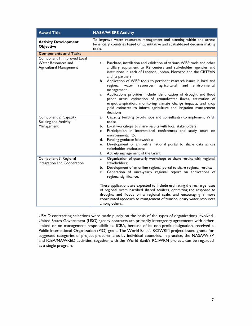
Figure 5: NASA/WISPS Activity Summary
Award Title NASA/WISPS Activity
Location/Countries Lebanon, Jordan, Egypt, Morocco and Tunisia. Implementing Partner NASA Goddard Space Flight Center Activity effective start & scheduled end date
04/14/2011 & 9/30/2017
Award Budget (Initial) $2.8million ($988,152)
7
Award Title NASA/WISPS Activity
Activity Development Objective
To improve water resources management and planning within and across beneficiary countries based on quantitative and spatial-based decision making tools.
Components and Tasks Component 1: Improved Local Water Resources and Agricultural Management
a. Purchase, installation and validation of various WISP tools and other
ancillary equipment to RS centers and stakeholder agencies and institutions in each of Lebanon, Jordan, Morocco and the CRTEAN and its partners;
b. Application of WISP tools to pertinent research issues in local and regional water resources, agricultural, and environmental management.
c. Applications priorities include identification of drought and flood prone areas, estimation of groundwater fluxes, estimation of evapotranspiration, monitoring climate change impacts, and crop yield estimates to inform agriculture and irrigation management decisions
Component 2: Capacity Building and Activity Management
a. Capacity building (workshops and consultants) to implement WISP tools;
b. Local workshops to share results with local stakeholders; c. Participation in international conferences and study tours on
environmental RS; d. Funding graduate fellowships; e. Development of an online national portal to share data across
stakeholder institutions; f. Activity management of the Grant
Component 3: Regional Integration and Cooperation
a. Organization of quarterly workshops to share results with regional stakeholders;
b. Development of an online regional portal to share regional results; c. Generation of once-yearly regional report on applications of
regional significance.
These applications are expected to include estimating the recharge rates of regional oversubscribed shared aquifers, optimizing the response to droughts and floods on a regional scale, and encouraging a more coordinated approach to management of transboundary water resources among others.
USAID contracting selections were made purely on the basis of the types of organizations involved. United States Government (USG) agency contracts are primarily interagency agreements with either limited or no management responsibilities. ICBA, because of its non-profit designation, received a Public International Organization (PIO) grant. The World Bank’s RCIWRM project issued grants for suggested categories of project procurements by individual countries. In practice, the NASA/WISP and ICBA/MAWRED activities, together with the World Bank’s RCIWRM project, can be regarded as a single program.

8
3.0 EVALUATION METHODS AND LIMITATIONS 3.1 EVALUATION METHODOLOGY The methodology for this evaluation was carefully designed to respond to the evaluation questions outlined in the SOW, as well as to assess the NASA/ICBA Activities’ performance and achievements. Per the evaluation SOW (Annex 1), the ET utilized a mixed-method approach including a variety of mainly qualitative, but also quantitative, techniques. Data was collected from a broad range of stakeholders to ensure independence of the evaluation process as well as accuracy and completeness of the subsequent conclusions and recommendations. The ET collected data from the following sources:
Review of documents and materials related to NASA/ICBA, such as annual and quarterly reports, work plans, success stories, activity implementation plans (PIPs), contract modifications, meeting/training reports and websites, in addition to review of tools and data sources.
Interviews with USAID/Washington, the World Bank, NASA, and ICBA staff. Field visits to United Arab Emirates (UAE), Jordan, Morocco, and Tunisia. Over 30 semi-structured interviews with ministries and institutes, including:
- Jordan: MWI, National Centre for Agricultural Research and Extension (NCARE), RJGS, InfoGraph (13 total).
- Morocco: Royal Centre for Remote Sensing (CRTS), Ministry of Agriculture, Ministry of Energy, Mines, Water and Environment (MEMWE) (13 total).
- Tunisia: Regional Center for Remote Sensing of North African States (CRTEAN), National Mapping and Remote Sensing Center (CNCT), National Institute of Meteorology (INM), National Institute of Agronomy (7 total).
Telephone interviews with past participants and other public/private organizations. Online survey of program managers in the non-visited countries of Lebanon, Egypt, Iraq,
and Yemen. Since the ET was unable to travel to all participating countries, they determined that an online survey, using SurveyMonkey, would be the most suitable approach to collect feedback from stakeholders in the other participating countries.
To the extent possible, the evaluation was conducted in an independent manner. In their introductions and discussions with stakeholders, the ET members at all times made it clear that the purpose of the evaluation was to provide an independent perspective on the NASA/ICBA Activities, in particular, and the overall Program, in general, so that lessons can be learned, and recommendation made for the next phase of the Program.
3.2 EVALUATION LIMITATIONS The ET encountered some limitations inherent to the design of this evaluation. The most important limitation was the difficulty in obtaining progress reports that clearly documented progress achieved against agreed targets (e.g., there are no annual workplans for each country). There were many gaps during the desktop review of materials for both the visited and non-visited countries. Reports from the bi-annual progress reviews coordinated by the AWC have been difficult to obtain. This is perhaps one of the consequences or challenges of the fundamentally diverse and complex organizational and communication structure established for the Program.
Nonetheless, the ET had adequate access to all stakeholders who willingly cooperated and freely expressed their opinions. Throughout the field phase, the ET had no restrictions placed on planning or scheduling meetings and visits.

9
4.0 FINDINGS, CONCLUSIONS AND RECOMMENDATIONS After familiarizing itself with the activities and conducting a thorough desk review of materials, the ET determined that to best evaluate the factors that have led (or not) to the adoption or non-adoption of NASA tools and resources (Evaluation Question 2), five characteristics needed to be assessed: 1) Level of RS and GIS expertise in the implementing organization; 2) Level of seniority and expertise of the Program Manager; 3) Type of implementation organization (e.g. research organization) and its links with other relevant institutions and organizations; 4) Level of political support; and 5) Level of enthusiasm of technical staff regarding the promise of RS activities and act as champions to promote program activities.
Below, we present the findings, conclusions and recommendations for each participating MENA country, structured around the key evaluation questions listed in the SOW.
4.1 LEBANON
4.1.1 Background Lebanon faces numerous major water-related problems, including fresh water loss to the sea and low sanitation standards whereby water quality is degraded from untreated waste water being returned to the rivers and the sea. In March 2012, “Water in Lebanon – Strategic Management” was presented at the United Nations (UN), documenting Lebanon’s goals of 80% waste water collection and treatment by 2015 and 95% waste water collection and treatment by 2020. Within this context, it is imperative for Lebanon to properly manage water resources to ensure sustainability and limit negative impacts on economic development.
Satellites are currently providing the necessary observations for enhanced monitoring of the water cycle, which helps manage water resources more effectively. In addition, recent advances in scientific computing and hydrologic modeling enable more efficient application of these observations, improving estimation of the hydrological physical processes. A summary of the application priorities for Lebanon include: 1) country-wide water balance; 2) climate impact analysis of water resources; and 3) real-time access to satellite RS data.
Agricultural land use in Lebanon can be represented by three main cropping patterns: vegetable monoculture, wheat-potato rotation, and land under permanent fruit tree or grape crops. In 2007, Lebanon’s total cultivated land area was 277,000 ha (27% of total land area), of which only about 50% was irrigated. The country’s irrigation water remains primitively managed and, according to national experts, the majority of watered lands (67%) are irrigated by inefficient gravity fed furrows.
Population growth, as well as the spread of human consumption patterns, has exacerbated desertification, degradation of forest cover, and climate change. In several areas, soil and land degradation threatens the sustainability of natural and human systems and negatively effects soil productivity. In 2002, forests covered 139,376 ha and other wooded lands (OWLs) covered 108,378 ha, 13.3% and 10.37% of Lebanon’s surface area, respectively. However, as a result of unsustainable forest practices, neglect of forested lands, and the decline in controlled grazing in forest understory, oak and pine forests have become highly susceptible to fires. Forest fires are considered the most influential factor in the decline of Lebanese forests. Lack of forest and OWL management, mainly in the regions susceptible to fire, increases the risk and spreading of forest fires. The frequency and intensity of these fires pose a real threat to the sustainability of the forest ecosystems. The consequences of forest degradation in Lebanon will be disastrous on the natural environment and ecological systems, not to mention on communities, by increasing poverty and lowering the quality of life.
Lebanon is a drought-prone country and recent droughts underscore current and projected increases in societal vulnerability. Societal changes, such as the rapidly expanding population, are

10
anticipated to amplify the risks associated with droughts in Lebanon due to the added pressures on already scarce water and other natural resources. The recent droughts in Lebanon were the worst recorded in decades and negatively impacted agriculture production, natural vegetation growth, and water shortages. Therefore, an operational drought monitoring system would secure sustainable development for agriculture and water resources. The recent availability of free, near real time satellite images has boosted drought monitoring applications.
4.1.2 Findings Under the NASA/WISP activity, the following application priorities were identified for Lebanon:
1. Drought monitoring and forecasting 2. Flood detection and modeling 3. Evapotranspiration 4. Irrigation and crop mapping 5. Climate change impact 6. Fires – detection and risk
Note: Lebanon’s PIP shows two implementation phases (Phase I: components 1-4, approximately 18 months; and Phase II: components 5-6, greater than 36 months) with the program manager and central technical control under the National Center for Remote Sensing.
The National Council for Scientific Research (CNRS) of Lebanon, the lead institution for the Program implementation, is a national public institution which, since its establishment by law on 14 September 1962, has been entrusted with a double mission: advisory and executive. Reporting to the Prime Minister, CNRS is an autonomous public office administered by a Board of Administration and directed by a Secretary General. CNRS’s advisory mission involves formulating guidelines for national scientific policies aimed at enhancing Lebanon’s development.
As part of its executive mission, CNRS secures the promotion, organization, and realization of policies in programs of action, implemented in its own four affiliated research centers: 1) the National Centre for Geophysics; 2) the National Centre for Marine Sciences; 3) the Lebanese Atomic Energy Commission; and 4) the National Centre for Remote Sensing. CNRS may also work in collaboration with other academic, research, and development institutions in Lebanon.
The programs representing the nucleus of CNRS activities, and which are executed regularly, comprise: the Scholarship Grant Program for Advance Studies and Research; Grant Research Program for Research Support; and CNRS Associated Research Units Program that cooperates with top ranking laboratories in the country. In addition, in 2006, CNRS developed a new Science and Technology Innovation Policy (STIP) based on cooperation between relevant government institutions, the scientific community and the private sector, including the establishment of the Lebanese Observatory for Research, Development and Innovation (LORDI), which aims to collect and publicize information on research activities in Lebanon.
4.1.2.1 Evaluation Question 1 How are the relevant organizations involved in adopting the tools and technology provided by NASA/ICBA to conduct their work?
Based on the document review and the Team Leader’s interviews with the Program Manager and ICBA/NASA staff, for the thematic areas selected, Lebanon’s progress is assessed as follows:
a) Flood Detection and Modelling - There was good cooperation between NASA/ICBA and CNRS on model and data
selection and customization from the options available under LIS (refer also to Section 4.1.2.2).
- Training by ICBA in use of LDAS model on October 25 – 27, 2009, October, 2011, and May, 2013.
- Coupled Routing and Excess Storage (CREST) distributed hydrologic model and Moderate Resolution Imaging Spectroradiometer (MODIS) satellite data was selected by ICBA and CNRS.

11
b) Irrigation and Crop Mapping - Training by ICBA on October 21 – 29, 2013. - Model algorithm multi-model photogrammetry (KELD) selected and installed by
ICBA and CNRS for improved crop mapping.
c) Evapotranspiration - Staff training by ICBA on March 3 – April 2, 2014, and Oct 21 – 29, 2013. - MODIS data and Model algorithm installed instead of using ALEXI/DISALEXI.
d) Drought Monitoring and Forecasting - Images acquired for mapping of crops and crop stress indicators. - Prototype from the Arab Center for Studies of Arid Zones and Dry Lands (ACSAD)
used by ICBA and CNRS in place of LIS models.
Adoption of tools and technologies. Lebanon has made progress on the four components selected under Phase 1 even though there has been only minimal training to date and no USG employees, from either NASA or its subcontractors, are allowed to travel to Lebanon. Sustainable management of natural resources and real time assessments of droughts, floods, and fires have been the driving impetus of CNRS’ efforts. CNRS is using all available training and capacity building assistance received to set up an early warning platform and has established links with various stakeholders and end-users such as the Ministries of Water Resources, Forestry and Agriculture; farmers associations; and civil aviation specialists. Models are customized for forest cover and national crop mapping.
Primary areas of progress include flood and drought management, as well as crop mapping. Preliminary work on forest fire spotting and reporting that occurred under an Italian project is to be incorporated into the proposed early warning platform. The WISP activity is providing new information on water contained in the snow pack, which is being used for both flood forecasting and yearly water supply calculations. The work of CNRS staff to correlate the model findings to local snow pack measurements (ground trothing) has proved critical.
Using CNRS as the WISP activity implementer in Lebanon was sensible as the Council’s staff has education, training, and experience using RS and geographic information system (GIS) tools. Further, the staff has impressed NASA with their knowledge of the physics of RS and satellite data acquisition, and their skill sets in using GIS tools and working with the associated models. CNRS also appears to have made good effort to engage user communities and achieve their buy-in.
4.1.2.2 Evaluation Question 2 What are the factors that lead to the adoption or non-adoption of NASA tools and resources?
Lebanon was not visited by the ET. However, the ET had discussions with various NASA and ICBA staff regarding CNRS’s performance and capabilities. In addition, the Team Leader interviewed the Lebanon Activity Team Leader in Dubai. Based on the above discussions and interviews, NASA’s assessment, ICBA’s assessment, and the ET’s verification of staff education and their work experience as well as the results achieved under each thematic area to date, the ET found:
Relatively high level of RS and GIS expertise of the host organization, CNRS. The program lead/coordinator of CNRS is a senior expert in RS and has management
experience with a research organization. CNRS is a research based organization with established professional links to the other key
relevant national institutions and organizations. CNRS works independently and has high-level political support. The lead and partner institutions contain enthusiastic devotees of RS and the underlying
sciences, and are able to act as champions for the Program.
In addition, NASA has assessed the ‘RS capability’ and ‘satellite production acquisition’ capacity of the CNRS as high and Lebanon is the only participating country to be given a high rating by NASA. The high level of expertise of the lead organization (CNRS) has undoubtedly been a factor in the successful adoption of NASA tools.
12
The World Bank Mid Term Review Mission8 findings support NASA’s assessment: “Lebanon is at a very advanced stage and had proposed a new data dissemination (at Mid Term Review stage). CNRS also signed MOUs with the civil aviation to provide climatic data. The (World Bank) mission congratulates Lebanon PMU for their way of involving end users in each component.”
CNRS’ responses to an online survey questionnaire9 rated the activity tools and training as satisfactory, however it noted more training time was needed for some topics. In terms of achievements, CNRS valued the ‘ability to create crop maps, evapotranspiration maps, estimating crop yields’. However, CNRS staff also felt there was a “need (for) more cooperation with NASA regarding data and tools” and exchange/training visits to NASA and/or US universities.
4.1.2.3 Evaluation Question 3 How are the tools and technologies being used to contribute to the planning and decision making of the management of water resources?
Based on KIIs, online survey responses, and desk review of materials, developing tools and technologies for improved water resources planning, management, and decision making, remains in a preliminary stage. The Prime Minister is said to be supportive of the Program and a proposed climate change plan. The Ministry of Energy and Water is disseminating climate change information to other public sector agencies and standardizing data to enhance transferability. The Government of Lebanon (GoL) is planning to launch a platform for new disaster risk reduction information that will be generated in real time to improve end user accessibility, and has reached out to stakeholders and end users such as the Association of Farmers, other ministries, and the Litani River Authority. Launching such a platform is also a good indication that GoL’s leadership intends to quickly and efficiently disseminate critical RS data to end users. All signs are positive that as RS tools and technology are acquired, GoL will expand the user groups so that more can benefit from the information.
4.1.3 Conclusions Despite security difficulties and restrictions on USG employee travel to Lebanon, the country has managed to make progress on the four components under Phase 1.
Focusing the Program on disaster risk reduction and pushing to make information available to end users through a website was Lebanon’s priority. Lebanon is planning to use the climate change information under Phase 2 to start a National Adaptation Plan for Climate Change.
It appears that having political support and a competent organization to host and manage WISP activities have made all the difference in working effectively with NASA and making good progress on disaster risk reduction components.
4.1.4 Recommendations The training program for Lebanon should be located in a convenient, accessible location as the travel restrictions on USG employees are unlikely to change. Egypt, which will be starting training, Tunisia, and Morocco would be acceptable locations.
Since Lebanon has improved at disaster risk reduction, it should now shift focus to each thematic area with an application by application progression. Phase 2, longer-term applications, should begin early during the new program extension.
Outreach efforts, including organizing and scheduling end user and stakeholder capacity building and trainings, need to be completed in the next three years. Training should be progressive with overview, data uses and professional/student tracks. Farmer user groups, for example, will require specially designed short courses for their specific topics of interest.
8 Regional Coordination on Improved Water Resources Management & Capacity Building Program, Mid Term Review Mission (April 5 – 14, 2014), Aide Memoire, August 17, 2014. 9 Using Survey Monkey. Response received from an Associate Scientific Researcher at CNRS.

13
By program design, most models are either global or regional. Therefore, individual countries will customize outputs to national scale. Downscaling and ground truthing are GoL responsibilities but assistance with initial efforts can be supported by ICBA staff and verified by NASA/ICBA.
4.2 JORDAN
4.2.1 Background Jordan’s water sector faces a critical supply-demand imbalance from the unsustainable abstraction of groundwater (from both legal and illegal wells) and the depletion of groundwater aquifers.10 This will result in water scarcity becoming an even greater problem over the next two decades as the population doubles and climate change potentially leads to more uncertain and variable precipitation. Managing water resources is, therefore, a key issue facing national government authorities. Jordan’s current water supply status comprises:11
Jordan is the fourth driest country in the world. Demand for water exceeds the country's available water resources.
Groundwater is being exploited at about twice its recharge rate. Currently, there are hundreds of illegal wells.
Annual per capita water availability has declined from 3,600 m3/year in 1946 to 145 m3/year in 2007.
It is projected that the population will continue to grow from about 5.87 million in 2008 to over 7.80 million by 2022.
In 2007, water for irrigation accounted for 71% of water demand and 64% of water supply. Groundwater extraction for agriculture is beyond acceptable limits, resulting in a
groundwater deficit of 151 million cubic meters (MCM) in 2007.
A key objective of the NASA/ICBA Activities is to improve water resources management and planning in the MENA region, through providing access to and support for the use of advanced RS technologies, satellite data, and other tools. The NASA/ICBA Activities, therefore, have enormous potential for helping Jordan address its critical water resources challenges and improve its water resources management and decision making.
4.2.2 Findings Under the NASA/ICBA Activities, the following application priorities were identified for Jordan:
Evapotranspiration Crop irrigation and mapping Drought early warning Climate change impact
The ET was surprised to discover that flood and groundwater mapping and modeling were not considered priority thematic areas even though groundwater overdrafting is one of Jordan’s most critical water sector issues and flooding causes damage even during normal wet season’s runoff.
Jordan’s participating organizations include:
Ministry of Water and Irrigation (MWI) – lead implementing and program host organization. Royal Jordanian Geographic Center (RJGC) – Joint implementing organization. National Centre for Agricultural Research (NCARE) Drought Monitoring Unit (DMU) –
participating user organization.
MWI was created in 1988 as an umbrella organization following the merger of the Jordan Valley Authority (JVA) and the Water Authority of Jordan (WAJ) in 1983. The purpose of the merger was to streamline the administrative structure and improve coordination among the authorities which were established as financially and administratively independent organizations. However, MWI still
10 Water for Life - Jordan's Water Strategy, 2008-2022. 11 ibid

14
exhibits remnants of its previous separate structures and struggles to operate as a united organization with a consistent strategy. Additionally, MWI suffers from political instability as evidenced by the ‘revolving door’ of appointments at the highest level (five Minsters and two Secretary Generals in the last four years). During this same period, the Secretary General of WAJ changed four times and the Secretary General of JVA changed three times. Changes in hierarchy have been a hallmark of Jordanian governance for many decades.12 Such institutional instability has led to reluctance to make decisions; it is common for even routine decisions to be referred to Secretary General level. This has consequences for projects and programs, and for the organization as a whole.
USAID’s long-term association with Jordan’s water sector has resulted in a good working relationship with the MWI (and its current Minister) – the lead sector organization. Although the decision to base the NASA/ICBA Activities in the MWI was expedient, since the Ministry has a good track record of implementing USAID projects, it has also been divisive since the other NASA/ICBA Activities country host institutions have had extensive previous experience in RS. Jordan’s MWI has no previous experience in RS and lacked the essential high level skills required to understand the overall Program’s technical nuances and effectively coordinate and manage it.
RJGC was established in 1975 as the national agency responsible for aerial, spatial, and land surveying, and for producing maps to meet the needs of Jordan and other Arab countries. RJGC, under the Ministry of Defense, has a military heritage and intelligence focus. Its RS and GIS capabilities are under the remit of the Advanced Applications Department. RJGC considers itself the lead RS organization in Jordan and, therefore, the logical host institution for the NASA/ICBA Activities. However, as RJGC falls under military jurisdiction, some stakeholders have expressed the opinion that its heritage, culture, and priorities may not align well with the Activities’ aims.
RJGC hosts the Regional Centre for Space Sciences and Education for Western Asia affiliated to the UN in cooperation with Jordan Meteorological Department, Al al-Bayt University, and Jordan University of Science and Technology.
NCARE is a semi–autonomous institution and a leading center for agricultural research and extension in Jordan. NCARE aims to be “the supportive pillar for agricultural sector to achieve sustainability, protect the environment, and achieve food security.” NCARE’s DMU is a key partner for the drought modeling component of the overall Program. The DMU is the only specialized scientific center on drought prediction and monitoring in Jordan.
4.2.2.1 Evaluation Question 1 How are the relevant organizations involved in adopting the tools and technology provided by NASA/ICBA to conduct their work?
Based on the Team Leader’s discussions about Jordan’s performance with both NASA and ICBA staff, the ET’s interviews with managers and employees at both NCARE and RJGC, as well as with the MWI Secretary General, two activity managers and two thematic area managers (short term consultants), Jordan’s progress for the thematic areas selected is assessed as follows:
a. Crop Type and Irrigation Status Mapping (by NASA and MWI) - There was cooperation between the MWI and the University of Jordan to
accomplish these goals. - Landsat-8, Advance Spaceborne Thermal Emission and Reflection Radiometer
(ASTER) Digital Elevation Model (DEM), and knowledge-based classification are being used by MWI recruited consultants to produce maps showing major crop types and irrigation patterns in two selected areas.
b. Evapotranspiration Monitoring (by NASA and MWI)
12 Findings of the ‘End-of-Project Evaluation of the Institutional Support and Strengthening Program (ISSP)’
USAID, December 2013. The ISSP evaluation assessed the capacity of the MWI, the JVA and the WAJ.

15
- MWI argues13 that the atmosphere-Land Exchange inverse (ALEXI) and Disaggregate ALEXI (DisALEXI) models are not suitable models for Jordan use.
- ALEXI produces results with 3-km pixel size (or resolution), while the preferred pixel size is 0.25 km or less.14
- MWI’s Activity Manager is exploring the use of alternative models, Energy Balance and Evapotranspiration Model (SEBAL) and Mapping ET at High Resolution (METRIC), instead of ALEXI and DisALEXI.
c. Drought Monitoring (by NASA and MWI and NCARE) - An interview with the MWI Project Coordinator and Dr. Jawad, the MWI
consultant, as well as a key liaison person for NASA/ICBA Activities at NCARE, showed that there has been very little cooperation between MWI and NCARE to achieve the goals of this component.
- NCARE has ongoing research in drought monitoring using MODIS data, specifically Normalized Difference Vegetation Index (NDVI).
- NCARE’s Technical Manager agrees with the same ALEXI and DisALEXI arguments as above.
d. Climate Change Assessment (NASA and MWI) - So far, there are no achievements for this component. MWI recently hired a
university professor15 to assist in achieving the goals of this component.
Jordan’s Program, beset by the competing interests and ambitions of the two lead organizations, MWI and RJGC (discussed further in the following Section 4.1.2.2), has impacted progress in adopting the tools and technology provided by NASA/ICBA Activities.
Training received. One person each from MWI and RJGC received training in the US in RS. Thereafter, a professor from the University of Wisconsin delivered a training in Jordan, which was attended by 15 people from MWI, RJGC and NCARE.
Adoption of tools and technologies. Since RS is a relatively new discipline for MWI, it has taken time for the Ministry staff to gain an understanding of the Program’s aims, and to fully appreciate the Ministry’s role as the lead organization. The Program in Jordan has lacked a unity of approach among the key organizations involved. There is a sense that MWI has been feeling its way rather slowly, as it comes to terms with a whole new area of technical expertise. Little tangible progress was achieved until about six months ago, when MWI hired external consultants from academia to undertake key tasks in crop mapping, evapotranspiration, and climate change assessment.
MWI’s contact with ICBA has been limited since MWI is aware that it would have to pay (out of its World Bank project funds) for ICBA onsite services, such as training or guidance in using tools. Therefore, MWI prefers to hire local consultants to undertake essential tasks and studies (model calibration, field validation, etc.). The MWI-recruited consultants are, in fact, unaware of ICBA’s role and largely go their own way. The MWI consultants have good capability in RS and, in the case of crop mapping/evapotranspiration, some promising results have been achieved in the pilot areas, which will be scaled-up to cover the entire country. Climate change work has only recently started and the consultants hired were unaware of the NASA LIS model. So far, MWI has not shared this information with the other partner organizations.
It was apparent in interviews with RJGC staff that RJGC is aggrieved of its minor role in the Program and remains relatively disconnected from the other stakeholders. It claims a lack of communication and coordination by MWI, as well as confusion about its role in the Program. As an equal partner to
13 Opinions expressed by MWI project coordinator and Dr Jawad, the MWI consultant. 14 To suit typical farm/plot sizes found in Jordan (according to RS specialists interviewed). 15 Professor Fayez Abdulla (Ph.D), Water Resources/Climate Change Expert, Jordan University of Science & Technology.
16
MWI, RJGC feels it has been sidelined and that it should, at a minimum, be the host organization for the crop mapping/evapotranspiration component since it has the resources, laboratories, and technicians to support such activities. RJGC has had no contact with ICBA, and only very limited contact with NASA.
RJGC’s main focus is to purchase, using the World Bank grant funds, a hyperspectral spectroradiometer.16 However, both ICBA and NASA doubt that this purchase represents good use of Program funds, and do not consider it to be a priority for the Program. RJGC’s decision to prioritize purchasing expensive equipment ahead of building capacity has, to an extent, undermined its claim to be the natural lead and host organization for the Program.
The NCARE DMU has good expertise in drought monitoring and is potentially an enthusiastic partner for the Jordan Program. However, the NCARE DMU, like RJGC, is frustrated at the lack of communication and coordination by MWI and the seeming lack of a clear Program strategy. As a result, the DMU has relatively disengaged from the Program and is pursuing its own research agenda. The head of the DMU did, however, highly rated a training she attended in Jordan (conducted by the University of Wisconsin) and has since been able to use information from it in her research. However, the relationship between MWI and NCARE DMU needs to be repaired and improved so that NCARE’s potential contribution can be maximized for the benefit of the Program.
From discussions with MWI and other stakeholders in the water sector, flood and groundwater mapping/modeling are important priorities for Jordan but have not been included in the Program application priorities for the current phase.
4.2.2.2 Evaluation Question 2 What are the factors that lead to the adoption or non-adoption of NASA tools and resources?
Jordan has had a slower start than other countries because MWI, the lead institution, lacks expertise in RS and thus the confidence to coordinate with other institutions with such expertise. Based on interviews and discussions with relevant stakeholders, as well as other informed Jordanian RS experts, the ET found that MWI has so far been unable to maximize the available talent pool that exists in Jordan, in turn causing the partner institutions (NCARE and RJGC) to disengage from the activity.
The World Bank Mid-Term Review Mission17 similarly noted:
“Jordan has faced several administrative issues, including (1) delays in cash transfers, procurement and disbursement to the activity’s designated account; (2) delays in preparing and implementing training programs, which are due to the lengthy and complicated bureaucratic procedures for approvals for funds disbursements. This process is further complicated by restrictions resulting from government financial regulations imposed on the activity spending; (3) delays in the delivery of models to MWI and RJGC; (4) difficulties in participating in regional and international training because of lengthy bureaucratic paper work and difficulties of disbursing per diems for participants in such events; and (5) most critically, lack of expertise with remote sensing at MWI and other stakeholders staff.”
In the last six months, progress has improved with the MWI’s engagement of short-term consultants from academia to work on crop mapping/irrigation/evapotranspiration and climate change. However, there has been no significant or comparable progress achieved by either RJGC or NCARE.
16 Hyperspectral sensors are very useful for producing land use land cover maps and identifying features on the
surface of the earth (including crop types and irrigated areas). However, they are relatively expensive, the data generated are complex, and they need special training and special tools for analysis. Hence, in order to maximize the benefits obtained from the data, the major requirement is to build capacity – specifically well trained personnel.
17 Regional Coordination on Improved Water Resources Management &Capacity Building Program, Mid Term Review Mission (April 5 – 14, 2014), Aide Memoire, August 17, 2014.

17
The characteristics of the Jordan Program that have contributed to its relative lack of progress include:
Lack of high-level RS expertise in the lead organization (MWI). Over-bureaucratic administration and decision-making processes in MWI. Lack of a clear strategy and Action Plan for the Program, with responsibilities apportioned to
managers with delegation authority. Poor coordination and communication by MWI. Rivalry (between MWI, NCARE and RJGC) rather than teamwork has undermined Program
implementation.
4.2.2.3 Evaluation Question 3 How are the tools and technologies being used to contribute to the planning and decision making of the management of water resources?
To date, some useful results have been obtained in terms of mapping irrigated areas and quantifying irrigation water use. The work carried out on quantifying irrigation water use is showing interesting results that differ significantly from previous estimates (based on observations and traditional records), indicating that irrigation water use has been grossly underestimated in the past. The results of the investigations and modeling carried out under the NASA/ICBA Activities have great significance for water resources planning and decision-making in Jordan, and have been publicized in the local press (see textbox below). The potential value of this work appears to be well understood at the senior government level. As the progress being achieved is not widely shared among the partner organizations, the progress is disjointed rather than consistent across all Activities components and partner organizations. However, the serious work of developing the tools and technologies for improved water resources planning, management, and decision-making is still at a relatively early stage.
4.2.3 Conclusions Progress in Jordan has been slow (the slowest of the countries visited) and the country has not been able to maximize its full potential from the Program due to lack of effective coordination and leadership, especially in the early start-up phase. This is linked to the lack of appropriate technical (i.e. RS) capacity of MWI.
The location of the Program within the MWI, which had no expertise in RS, has factored into its slow progress because:
1. The Program has been a steep learning curve for the MWI. 2. MWI lacks necessary high-level competencies in RS and modeling. 3. The overly bureaucratic nature of MWI and its centralized decision-making (emails from
ICBA are forwarded up to the Director General level for response, resulting in long delays) have been a contributing factor.
Ministry seeks NASA Help to reveal major water theft, The Jordan Times December 11, 2014.
“Through using satellite remote sensing techniques in collaboration with the US National Aeronautics and Space Administration (NASA), authorities have uncovered a major case of water theft, Ministry of Water and Irrigation announced Monday”.
Satellite remote sensing uncovers violations in underground water resources, The Jordan Times November 16, 2014.
“Lands planted with irrigated crops in Ramtha District, 80km northeast of Amman, are more than double the estimated area, while the water pumped from wells is more than triple the allowed amounts, according to the results of the project, which was supported by the World Bank and implemented by the Water Ministry in cooperation with the US National Aeronautics and Space Administration between December 2013 and August 2014.”
Extracts from full-page feature articles in the Jordan Times, highlighting some of the findings of the Program.

18
However, the alternative location for the Program within the RJGC is also not ideal, as it falls under military jurisdiction and has priorities that may not align well with the Program’s aims.
The Program has good support at high levels within the government (Minister of MWI) where there is an appreciation of its national importance and of its potential to resolve problems and contribute solutions regarding water scarcity problems.
High-level RS capacity exists within Jordan but is dispersed across various ministries, departments, public and private sector organizations, and academia.
The Program has suffered from a lack of clear scope and consistency in coordination and implementation. Many stakeholders report being unaware of what is happening and what are their roles. Equally, the roles of ICBA and AWC are not well understood by the Jordanian organizations involved.
The lack of flood and groundwater mapping and modeling is puzzling. However, better appreciation of the Program means that there is now a demand to include these important components in the next phase.
4.2.4 Recommendations Improve coordination by hiring a part-time RS expert (preferably from academia or a private sector organization) to act as a neutral program coordinator and lead agent to drive the Program agenda and communicate effectively with all stakeholders on a regular basis.
RJGC needs to be given a meaningful role in the Program, such as responsibility for hosting the crop mapping/evapotranspiration component, while MWI retains the climate change component, and NCARE, drought monitoring.
The Program should be re-launched in Jordan, with a workshop to determine the coming year’s work plan. New organizations with proper expertise, available staff, and adequate funding should be considered for inclusion. The Program needs to be able to draw on this available talent pool in a much more effective way.
Consideration should be given to including flood and groundwater mapping and modeling in future Program phases. Agreement must be reached as to which organization shall be responsible.
4.3 TUNISIA
4.3.1 Background Tunisia extends over 164,000 km² with a climate characterized by the Mediterranean Sea. It is sub-humid in the north, semi-arid in the center, and arid in the south. The population of 10 million is growing at about 1.2% annually, and so is expected to reach 13 million by 2030. 64% of the population lives in towns and cities, with 36% in the countryside.
The country is endowed with diverse ecosystems – coastal plains, Sahel, valleys, plateaus, steppes, and oases produce – each with its own specific water management problems. However, aridity dominates and leads to uncertainties in agricultural production. Rainfall in Tunisia is generally insufficient and unreliable, with the northern coast receiving about 500 mm/year, and other regions negligible amounts.
About 57% of the annual total volume of exploitable water in Tunisia is surface water and the remaining 43% is groundwater. Northern, central, and southern aquifers comprise the three main aquifer zones. In the north, where rainfall is abundant (500-1,500 mm/year) and recharge from rainfall and river flooding is adequate, there are several important shallow and rechargeable aquifers. In the east, near the coast, water quality is poor due to saline intrusion as a result of excessive groundwater extraction. Several multi-layer aquifer systems, some up to 600m thick, exist in the center of the country. The south contains two of the largest aquifers in the world – the Terminal Complex aquifer and the Continental Interlayer. These aquifers are deep, extensive, contain fossil water, and also lie under much of Libya and Algeria. All three countries exploit these aquifers.

19
Although Tunisia has a long tradition of carefully managing its water resources, it is regarded as a water stressed country. The per capita renewable water availability in the country is about 486 m3, which is well below the water poverty threshold of 1,000 m3/capita/year. The situation is expected to worsen to 315 m3/capita/year by 2030 as a result of increasing demand for water due to an increased population, improved socio-economic conditions, and further industrialization and tourism development. Ultimately, this will further cause a corresponding competition for water use between agriculture, fisheries, municipal, and tourism sectors.
The NASA/ICBA Activities have enormous potential for helping Tunisia address its critical water resources challenges and improve its water resources management and decision making. Specifically, the Activities’ main goals are to monitor the availability of water resources, agricultural activities, and drought; map, forecast and monitor floods; and establish a mechanism for data assimilation.
4.3.2 Findings Under the NASA/ICBA Activities, application priorities for Tunisia include:
Floods mapping and modeling Crop and irrigation mapping Drought and evapotranspiration Climate impact analysis Groundwater storage
The major participating organizations in Tunisia’s NASA/ICBA Activities and the overall Program are CRTEAN and CNCT.
CRTEAN is an international sub-regional organization headquartered in Tunis. It was established on October 6, 1990, after the Consecutive Act was signed by the six party members from North Africa (Algeria, Egypt, Libya, Mauratania, Morocco, and Tunisia). CRTEAN’s mission is to: 1) ensure complementarity and exploitation of human and material potential between the region and national institutions specialized in RS, GIS and mapping; and 2) promote, encourage, coordinate, harmonize, and ensure the policies of Member States in RS and GIS. Under the NASA/ICBA Activities, CRTEAN’s role is to provide oversight and guidance to CNCT to ensure the baseline water issues are addressed.
CNCT is a Tunisian public agency founded on July 11, 1988, under the supervision of the Tunisian Ministry of National Defense in Tunis. The agency provides services in the fields of geodesy, surveying, mapping, GIS, and RS. It also conducts research in several areas including desertification, management of natural resources, management of scarce resources in coastal areas, and agriculture. CNCT’s role in the overall Program is to provide adequate technical staffing, and engage the user community and work to achieve their buy-in. This includes optimizing funding allocations to ensure availability of technical experts and consultants, providing in situ data and measurements for model calibration and validation, sharing technical data for accurate modeling, providing workaround plans, and working with AWC to arrange workshops and other regional-level coordination. CNCT was expected to work closely with the NASA team to ensure that the requirements development, model customization, and integration processes proceed as planned. In addition to CRTEAN and CNCT, other participating organizations in Tunisia include:
Ministry of Agriculture - General Directorate of Water Resources (DGRE) - General Directorate of Rural Engineering and Water Exploitation (DGGREE) - Arid Region Institute (IRA)
Ministry of Transportation - INM
Universities and Research Labs
20
4.3.2.1 Evaluation Question 1 How are the relevant organizations involved in adopting the tools and technology provided by NASA/ICBA to conduct their work?
Based on the ET’s interviews with key informants, presentations of research results, desk review of materials, and direct observations, for the thematic areas selected, progress in Tunisia is assessed below. Further technical explanations of models and their capabilities are found in Annex 8.
a. Floods Mapping and Modeling - CREST model18 is used by CNCT in this component.
b. Crop and Irrigation Mapping - Using conventional RS techniques and Landsat-8 satellite data
c. Drought and Evapotranspiration - In the interviews with the ET, and presentations made by the CNCT experts,
CNCT argued that ALEXI19 is not suitable for the activity. - According to NASA, ALEXI, and even DisALEXI, are still under construction. - There is no CNCT staff experience with either ALEXI or DisALEXI. - CNCT staff is exploring the use of SEBAL/METRIC instead of ALEXI and DisALEXI.
d. Climate Impact Analysis - Statistical downscaling using the R open-source modeling software20 for Tunisia
produced some results and is in the final stages. - Dynamic downscaling using the Weather Research and Forecasting (WRF) model for
Tunisia is still in the early stages. - According to CNCT managers, advanced training courses in the field of downscaling,
specifically dynamic downscaling, and how to assess the impacts of climate change in Tunisia are still needed.
e. Groundwater Storage - No progress yet achieved with this component. Groundwater expertise is in short
supply in Tunisia. However CNCT recently hired a groundwater specialist and this will result in progress in the near future.
In general, the persons in charge of these components have the basic technical competency and knowledge necessary to achieving their goals.
4.3.2.2 Evaluation Question 2 What are the factors that lead to the adoption or non-adoption of NASA tools and resources?
Tunisia’s lead institution, CRTEAN, as the existing regional coordinator, has been highly collaborative and engaged with all Program stakeholders. Although this dual role has been challenging and time consuming, it has resulted in a more inclusive approach to coordination and management (compared to Morocco and Jordan), involving multiple stakeholders including university research institutes. This is evidenced with the involvement of INM in the climate change component. Additionally, the lead and partner institutions contain enthusiastic devotees of RS and the underlying sciences who act as champions for the Program. The ET had several interviews with NASA and ICBA staff. All were impressed by the performance and professionalism of Tunisia’s team. The ET also interviewed all thematic area managers. Based on these interviews, the site visits, and desk
18 See Annex 8 for detail 19 See Annex 8 for explanation of models 20 See Annex 8 for details

21
review of materials, the ET found that the factors that lead to the successful utilization of NASA tools and resources in Tunisia include:
Relatively high level of RS and GIS expertise of the host organization. Program lead/coordinator of the lead institution is a senior expert in RS and has
management experience with a research organization. Lead/host institution is a research based organization with established professional links to
the other key relevant national institutions and organizations. Lead/host institution works independently and has high level political support. The lead and partner institutions contain enthusiastic devotees of RS and the underlying
sciences who act as Program champions.
4.3.2.3 Evaluation Question 3 How are the tools and technologies being used to contribute to the planning and decision making of the management of water resources?
Tunisia has made good progress in the use of the NASA tools and technologies, and in the different thematic areas selected with the exception of the groundwater storage component. Assessing the impacts of the NASA/ICBA Activities on Tunisia’s planning and decision-making with regard to water resources management is still rather premature. Tunisia has a clear vision and implementation plan in place to achieve its intended outcomes (see text box next page21) and is now well poised to achieve good results going forward. In addition, the highly collaborative approach adopted by CRTEAN promises a high level of buy-in by the partner organizations (confirmed by interviews) which augers well for the future of the activity in Tunisia.
4.3.3 Conclusions Tunisia’s management approach, led by CRTEAN, a regional institution, is somewhat different and more inclusive from those in Morocco and Jordan. CRTEAN supervises Program activities, and other partner institutions- specifically CNCT and INM- physically implement the Program.
Major leading and implementing institutions – CRTEAN, CNCT, and INM – possess the basic knowledge and technical competency to achieve Program goals.
There has been good collaboration between the implementing agencies and other stakeholders.
There has been good progress in all thematic areas that were selected except the groundwater storage component. This could be related to the fact that Tunisia was the only country that chose to engage in groundwater storage analysis activities, resulting in seemingly minimal support from NASA and ICBA, and delaying implementation. Also significant was the fact that the managers had no expertise or technical experience in groundwater.
Not all models suggested by NASA were deemed suitable. For example, ALEXI and DisALEXI were seen as merely under construction.
Holding a National Agronomic Institute of Tunis (INAT) three day workshop (evapotransipration, water, and climate factors) with decision makers, students, and other organizations is an excellent outreach model to follow in other countries.
Tunisia is a fairly successful example of transferring and passing along complex and state of the art RS tools and technologies with minimal problems.
4.3.4 Recommendations More capacity building, specifically advanced training, should be provided in the following fields:
21 Taken from: Improvement of Water Resources Management and Adaptation to Climate Change, LDAS – Tunisia, Regional Centre for Remote Sensing of North African States (CRTEAN). Brochure produced by CRTEAN for the NASA Activity.

22
Tunisia NASA/WISPS Project - Priority Needs and Outcomes
CRTEAN has clearly articulated Tunisia’s priority needs and outcomes for the NASA/WISPS Project. It has identified, for each critical application area, the problems and objectives for improving water resources management and adaptation to climate change:
1. Flood Mapping and Modelling Problem Tunisia has a dense hydrographic network in the north, where the river basins account for 81% of the nation’s surface water. The Oued Medjerda River is the largest in the country, and is prone to flooding. Since this also an area of high socio-economic interest for the country, flood mitigation efforts are important to minimize loss of human lives and property. Objectives To develop flood inundation and forecast maps: the ultimate purpose of this is to make these available in a timely manner to the Tunisian organizations involved in the field of emergency management and disaster response. Inundation maps will be generated in near real time and provide the information on which geographic areas are impacted due to flooding. Forecast maps will also provide early warning indication about areas which are a flood risk.
2. Irrigation and Crop Mapping Problem Many environmental and natural resource management issues identified in the agricultural sector in Tunisia need accurate and timely information on land cover and land use (including cultivated areas). However detailed and accurate and timely information on land use and its attributes throughout the cropping season are not available. The ability to extract this information from satellite data continuously and with precision, and the operation of biophysical models is also lacking. Objectives Establish a methodology based on remote sensing for irrigated crop mapping and water status. Validation of provided models for estimating evapotranspiration and soil moisture data using satellite
images for defining water needs of crops. Implementation of WISP platform as a monitoring tool for optimizing the use of water resources.
3. Groundwater Storage Problem Groundwater over-exploitation and the difficulty to evaluate correctly withdrawals related to private and public irrigation perimeters continue to be serious concerns for Tunisia. The delineation of aquifer systems, the identification of recharge areas and drainage of the over-exploited areas, identification of salt water intrusion, delineation of brackish groundwater, location of operating water points, inventory of surface wells and artificial sites etc. need to be better detailed and understood. Objectives Develop water balance of the hydro geologic basin by the evaluation of reserves and withdrawals of groundwater and to provide managers and planners with updated and accurate information on the status of groundwater resources in the intensively exploited areas. This information will help to make more accurate projections for more efficient water resources management.
4. Climate Change Problem For many parts of the MENA Region there is an expected precipitation decrease over the next century of over 20%, and warmer temperatures are simultaneously expected to increase the extreme events of droughts and floods. At the same time climate change projections are limited by coarse spatial resolution and uncertainty the rate and severity of predicted change. Objectives Projections of climate change at high resolution. Analyze results to develop future scenarios or impact on rainfall, agriculture and natural disasters. This will help to provide uncertainty estimates and understanding of projected impacts.
23
1. Climate change mapping and forecasting, especially dynamic downscaling using different methodologies such as the WRF model.
2. Assessing the impacts of climate change on different sectors in Tunisia (i.e., social, economic, and environmental).
3. The real benefits of ALEXI and DisALEXI and how to use them.
There should be more inclusion of stakeholders, such as professors and students from research and teaching institutes and organizations.
Advanced support in the area of groundwater storage should be provided in order to accelerate its progress. The US Geologic Survey (USGS) has already scheduled a temporary duty (TDY) to support development of a SOW for the groundwater sector as part of a new approach.
4.4 MOROCCO
4.4.1 Background Moroccan water resources are some of the most threatened in the world because of the fact that it is a country with large swaths of arid and semi-arid lands with spatially-temporally irregular precipitation. More than half of the available 22 billion m3 per year (730m3/inhabitant/yr) natural water resources are concentrated in the north of the country, which comprises only 7% of the national territory. During the last few decades, climate variability has impacted water resources: droughts are longer and more frequent, and flash flooding is more frequent, causing extreme devastating damages. Within this context, it becomes imperative for water resources to be managed to ensure sustainability and limit negative impacts on economic development.
Founded in 1992, CRTS is the national institution responsible for the promotion, use, and development of RS applications in Morocco. With an experienced and dynamic team and high-performance equipment, CRTS offers services in: 1) project realization and methodology definition; 2) satellite data acquisition and distribution; 3) consultancy and technical assistance; and 4) information system conception and realization. CRTS uses operational systems to collect, produce, and analyze data from Earth observation satellites and other sources. It also runs the national archiving facilities. CRTS provides its expertise in RS to national and regional organizations, ranging from private sector companies to government and non-government institutions, involved in resource management and environmental assessment projects.
4.4.2 Findings CRTS is the implementing partner for WISP. CRTS coordinates and carries out the national program of RS in collaboration with ministerial departments, private operators, and universities. Under the NASA/WISP Activity, the following application priorities were identified for Morocco:
1. Water sector modeling 2. Drought early warning 3. Flood detection and modeling 4. Locust monitoring 5. Crop mapping and irrigation
Action to Promote International Cooperation. CRTS promotes technology transfer and develops cooperation at the international level. These actions include:
Memoranda of understanding between CRTS and its international counterparts. Participation in a wide range of regional and international programs (e.g. AFRICOVER, etc.). Membership in international associations and committees (e.g. International Astronautical
Federation (IAF), International Astronautical Federation (EURISY)). Participation of CRTS staff in the activities of international agencies and organizations, as
members of advisory committees, consultants, etc. Organization of international conferences dedicated to regional problems – work with
United-Nations (UN) organizations such as: United Nations Development Programme

24
(UNDP), Food and Agriculture Organization (FAO), UN Environment Programme (UNEP), Intergovernmental Oceanographic Commission (IOC) of UN Educational, Scientific and Cultural Organization (UNESCO), UN Office for Outer Space Affairs (UNOOSA), etc.
Training to Contribute to Sustainable Development. One mission of CRTS is to encourage the use of satellite RS by training professionals and decision makers from different disciplines and at various levels. To fulfil these objectives, CRTS undertakes the following actions:
Setting-up infrastructures dedicated to training in high technology and adapted to regional needs.
Developing technical solutions through training sessions either for initiation or performance enhancement.
Developing specific training modules in cooperation with regional and international organizations including European Space Agency (ESA), FAO, European Commission (EC), UNDP.
Developing actions and programs of research and development (R&D) in collaboration with national and international universities and regional centers. These actions concern topics such as land cover, land use changes, climate change, desertification, and oceanography.
Information to Increase Awareness. CRTS has conducted a selection of workshops and trainings designed for a variety of levels to sensitize scientists, decision makers, administrators and youth to the social and economic benefits of space science and technology. Such programs consist of:
Organization of seminars, exhibitions, round tables, and conferences. Creation of a National Committee on RS to inform users and define needs. Publication of a newsletter on space activities. Publication of a multidisciplinary, technical and scientific journal, “GEOOBDERVATEUR,”
focused on themes concerning developing countries.
4.4.2.1 Evaluation Question 1 How are the relevant organizations involved in adopting the tools and technology provided by NASA/ICBA to conduct their work?
Based on interviews with key informants and presentations of preliminary results of research undertaken, and focus groups that the ET conducted with Ministries of Water and Agriculture, for the thematic areas selected, Morocco’s progress is assessed as follows:
a) Water Sector - There is good cooperation between NASA/ICBA and CRTS on model and data
source selection from the LIS platform. - CRTS received the LIS model and one week of training from ICBA. - 12 LIS water models selected for implementation by the Activity Manager to
determine floods and quantify water resources. b) Drought Early Warning
- Four staff trained at University of Nebraska.22 - CHIRPS precipitation model selected for use by the activity managers. - Ongoing precipitation model outputs validation using local weather data.
c) Flood Detection and Modelling - CREST, the water flow model, was transferred to CRTS in December 2013. - Staff training December 2013 and August 2014 on global model.
d) Locust Monitoring - Comprises four activities (see Case Study on page 26) for locust mapping: (i)
establish monitoring system; (ii) measure environmental parameters (e.g.
22 Two from CRTS, two from Ministry of Agriculture.

25
meteorological plus soil moisture, etc.); (iii) production of locust risk maps; and (iv) disseminate information to users.
- Since locust movement and monitoring cuts across the region, international and regional coordination is necessary. The activity has demonstrated that it liaises effectively with the FAO, the regional coordinator and lead.
e) Crop Mapping and Irrigation - National mapping of irrigated areas using MODIS model to quantify acreage. - CRTS and Ministry of Agriculture employees have been working with MODIS. - CRTS is using SEBS evapotranspiration model instead of LIS model. - Pilot zone studies are conducted to compare crop water consumption vs. crop
requirements.
Training received. Training classes included: flood modeling (2); flood detection (1); crop mapping (1); climate downscaling (1); evapotranspiration (2); LIS model overview (1 week); and a consultation on locust monitoring.
Adoption of tools and technologies. CRTS has been able to implement the Program very efficiently due to the fact that overall control and management of the WISP activity is handled in house; despite the complexity of having multiple funding streams and technical assistance sources, the interfaces established are relatively flexible and user friendly, allowing for formal and informal communication streams much as one finds in highly creative research environments. The Director General is the Program Manager and all component managers are employees at the CRTS office, which allows for weekly progress meetings to be held with all managers. A Steering Committee comprised of CRTS, Ministry of Finance (MoF), and Ministry of Water (MoW) has been instituted, and four Memorandums of Understanding (MoUs) were signed with participating agencies: MoW, Ministry of Agriculture, National Center for Locusts, and Hydraulic Institute. In addition to the close collaboration with the four MoU partners, CRTS has established connections with other participating partners: FAO, Ministry of Forest and Desert, local universities, laboratories, and public/private research organizations.
Institutional Capacity. For over twenty years CRTS has been the lead organization in Morocco engaged with RS and GIS. CRTS has provided technical services and products to both public and private entities within Morocco throughout this period and its employees have taught RS and GIS classes at local universities. Therefore, the assigned component managers had the education, experience, and technical backgrounds that allowed them to interface with top technical managers from NASA/ICBA, partner organizations, and end users. Capacity building and training were built upon existing skills and knowledge. Obvious delegation of authority and good morale among all staff involved with the Program indicate that implementation up to this point has been a team effort.
Funding. Procurement rules and regulations under the multi-country RCIWRM project funded by the World Bank were addressed up front in discussion with the Government of Morocco (GoM) and MoF. Cash advances from MoF and use of CRTS agency funds to start activities avoided possible delays from a procurement planning process involving various agencies in different countries. A convoluted approval process that, in the beginning, took 2-3 months but, was eventually streamlined down to several days. Distribution of the World Bank funds to the five components went smoothly: half of the $1,050,000 was spent on consultants and the other half disbursed equally between capacity building and information technology (IT) equipment along with data acquisition. It appears from the procurement history that funding allocation was equitable among the components and minimal contracting delays occurred during the two year implementation period.
4.4.2.2 Evaluation Question 2 What are the factors that lead to the adoption or non-adoption of NASA tools and resources?
Based on interviews that the ET conducted with NASA and ICBA staff; both were impressed by the CRTS professional staff and their performance to date. The ET spent three days at CRTS’ headquarters interviewing all managers and gained in-depth understanding of their progress under
26
each component. Several focus group discussions were held with managers and technical staff at the Ministries of Water and Agriculture. Based on data and information collected from the above sources as well as desk review of materials, the ET found:
Relatively high level of RS and GIS expertise of CRTS. Note: NASA has assessed the ‘RS capability’ and ‘satellite production acquisition’ capacity of the CRTS as medium to high. This is the second highest rating given by NASA, and indicates the relatively high level of expertise of the lead organization, which has contributed to the successful adoption of NASA tools.
CRTS contains in – house the majority of the expertise required for activity implementation. This has advantages in terms of coordination and overall activity management.
The program coordinator of CRTS is a senior expert in RS and has management experience with a research organization.
CRTS is a research based organization with established professional links to the other key relevant national institutions and organizations.
CRTS is relatively free of political interference and has high level political support. CRTS is an enthusiastic advocate for the use of RS and the underlying earth sciences.
4.4.2.3 Evaluation Question 3 How are the tools and technologies being used to contribute to the planning and decision making of the management of water resources?
Although it is too soon to answer this question for a Program that has only recently produced tangible results, it is safe to assume that RS and model information will be disseminated across a wide variety of organizations and individuals within Morocco. Probably the best indicator of future usage is the wide variety of public/private organizations, national and international data exposure, and academic/research units that have partaken in the existing efforts. The locust program is a good example and probably the furthest along to completion (see Case Study next page). Program information has been sent to FAO, surrounding countries, and national organizations. Students are refining the modules and inputting data. Information has also gone out to field users. It seems likely that future locust monitoring and risk assessments will be greatly enhanced.
CRTS is in the beginning phase of setting up a dissemination platform for end users. As far as disaster risk assessments and alerts to Moroccan users are concerned, floods and droughts should follow a similar development pattern as the models produce usable information in real time. Until now, the Program has focused on irrigated areas only, which will provide the MoW valuable information on water demand/withdrawals from surface and groundwater. Information on irrigation requirements, crop production, and agricultural water usage will be available to the Ministry of Agriculture for the first time. Developing tools and technologies for improved water resources planning, management, and decision making is still at preliminary stages.
4.4.3 Conclusions Program progress in Morocco has been impressive over the past two years. The fact that CRTS started the Program with the basic framework of administration, management, technical expertise, external connections, budget support, and high level political support has enabled it to make rapid progress. Communication and coordination with the World Bank, NASA, and ICBA appear to be working well. Out of all the countries participating in the three activities, it may be said that this organization’s unique circumstances allowed targets of opportunity (components) and champions (technical managers) to receive support on the tools and technology that NASA offered. Further, it is a fairly successful example of passing along complex and state of the art RS tools and technologies with minimal delays and implementation problems.
4.4.4 Recommendations Moroccan organizations should develop proposals for Phase 2 and begin negotiating with USAID and the World Bank, then continue longer term efforts regarding sustainability of all thematic areas.

27
Case Study: LDAS Sub Project - Locust Invasion Risk Analysis
The area prone to locust invasion during normal (calm) period is indicated in the above map. During locust infestation events the infected area is significantly increased. The socio economic impact of locust plagues can be enormous for the impacted country. The period 2003 – 2005 saw the worst locust plague in 15 years in the North Africa region. It required $400 million to combat the plague. (By way of example a 1km2 locust swarm will consume/destroy the same amount of food as required by 35,000 people).
LDAS Project - Locust Module Main Goal: This module aims to improve the process of prevention, monitoring and risk control of the locust invasion in Morocco by using environmental data provided by LDAS platform.
Specific goals: Use LDAS platform to generate environmental products involved in the development and
migration of the desert locust. Establish methodology for developing locust invasion risk maps to help the exploration operations
at the local and regional levels, in order to reduce its cost and enhance its efficiency.
Module activities Activity 1: Desert locust monitoring system (establish parameters etc.).
Activity 2: Setting up and implementation of system of environmental parameters related to the locust risk (Soil moisture data from RS; Use of LIS outputs: vegetation parameters & indices, land surface temperature, meteorological data etc.).
Activity 3: Production of locust risk maps (definition of locust risk, defined environmental parameters, collect data, develop and validate model, model runs). Output: Locust “composite” variables to predict for +40 days and for 25x25 km grid.
Activity 4: use of LDAS infrastructure for products dissemination to users.
Improve accuracy of model outputs with customization and downscaling for the following thematic areas: hydrologic, drought, locust, evapotranspiration, and crop mapping. Prioritize efforts over the next three years to use LIS for climate change. It will also be important to ground truth all model outputs in critical regions.
Start efforts to train and ramp-up capacity building with all relevant end users. It will be essential to ensure that all stakeholders understand and appreciate the seriousness of climate change impacts and necessary mitigation measures.
CRTS should expand current efforts on outreach and training events and MOU’s with partners and academic classes.

28
4.5 EGYPT
4.5.1 Background Egypt is predominantly deserted, with only 3.5% of its total land area cultivated and permanently settled. The country’s four major physical regions are the Nile Valley and Delta, the Western Desert (also known as the Libyan Desert), the Eastern Desert (also known as the Arabian Desert), and the Sinai Peninsula. The Nile Valley and Delta is the most important region because it supports 99% of the country’s population and its only cultivable land.
Only 55.5 billion m3 per year of natural water resources are currently available for use in Egypt compared to the total water requirement of 75 billion m3 per year. This roughly 20 billion m3 per year water deficit is overcome by recycling. The Nile system’s current overall efficiency is assessed at 75%23. Egypt has reached a point where the quantity of water available is imposing limits on national economic development. Egypt has passed the threshold value of 1,000 m3/capita/year in the 1990s and will reach the threshold value of absolute scarcity of 500 m3/capita/year in 2025 if the population continues to increase as expected. Egypt’s total population increased from 22 million in 1950 to around 83 million in 2009. This rapid increase in population growth is expected to continue and to reach 120-150 million by 2050, exacerbating the problems associated with water sector allocation. Further, the data available indicate that a rapid deterioration is occurring in surface and groundwater quality.
At almost 80% of total water demand, agriculture consumes the largest amount of available water in Egypt even though the sector only contributes about 20% to overall gross domestic product (GDP) and provides about 40% of total employment. In view of the expected increase in demand from other sectors, such as municipal and industrial water supply, the development of Egypt’s economy strongly depends on its ability to conserve and manage its water resources.
A climate change prediction model identified water resources as one of the three most vulnerable sectors to climate change in Egypt; the others being coastal zones and agricultural resources. Egypt is affected by climate change impacts, not only within its borders, but also within the whole basin, which it shares with nine other countries. Economic developments in upstream countries and measures they might take to adapt to climate change are likely to put more pressure on water resources in Egypt. Therefore, it is of paramount importance for Egypt, along with other Nile countries, to assess the hydrological impacts of climate change on the river.24
Within this context, it becomes imperative for water resources to be managed to ensure sustainability and limit negative impacts on economic development in Egypt. Satellites are now providing the necessary observations for enhanced monitoring of the water cycle to help manage water resources more effectively. In addition, recent advances in scientific computing and hydrologic modelling enable more efficient application of these observations, providing improved estimation of the hydrological physical processes. The NASA/ICBA Activities, therefore, have enormous potential to help Egypt address its critical water resources challenges and improve its water resources management and decision making.
4.5.2 Findings The NASA/WISP activity identified the following application priorities for Egypt:
1. Evapotranspiration 2. Flood detection and modeling 3. Drought monitoring 4. Climate change 5. Irrigation and crop mapping 6. Hydrological modelling
23 Project Implementation Plan – Egypt, Middle East North Africa Water Information System Platform,
November 27, 2012. USAID, NASA World Bank. 24 Ministry of Water Resources and Irrigation. “Water Challenges in Egypt”. 2010

29
The main institutional partners in Egypt for the overall Program are the National Authority for Remote Sensing and Space Sciences (NARSS) and the Ministry of Water Resources and Irrigation (MWRI).
NARSS, as the lead institution in Egypt for the WISP activity, provides technical staff support and resources, and engages with the end user groups and community members to ensure dissemination of the outputs. It is expected that some technical support will be provided by other Egyptian experts, such as those from academia. NARSS is considered the pioneering Egyptian institution in the field of satellite RS.
MWRI is the primary government agency charged with the management of Egyptian water resources, mainly of the Nile River, and major irrigation projects, such as the Aswan Dam and Al-Salam Canal. MWRI is charged with formulating policies based on scientific principles to meet the increasing demand in water for the country. In this regard, MWRI aims to benefit from the NASA-created and provided tools and products to support improved water resource management and decision-making.
4.5.2.1 Evaluation Question 1 How are the relevant organizations involved in adopting the tools and technology provided by NASA/ICBA to conduct their work?
Included in the NASA/WISPS activity but not a beneficiary country for the ICBA/MAWRED activity, Egypt has, to date, had only a limited role in the overall Program. In this respect, it has benefitted from initial training and Program orientation.25 Egypt was not included in the first phase of the World Bank grant funding26 (but is scheduled for inclusion in the second phase) and, as such, has had no direct grant funding to undertake activities. Further, Egypt has had no access to ICBA, only limited access to NASA (as part of the USAID funding), and is subject to a temporary work stoppage due to a USG moratorium on dealing with Egypt. Although USAID indicated that a waiver was approved for Egypt to participate in the Program beginning in 2015, the country’s future in the Program is uncertain.
The key activities prioritized under the proposed Egypt program27 are consistent with the national priorities and include:
Assess the impacts of climatic change on water resources. Monitor the spatial and the temporal characteristics of drought events. Assess the evaporation rates of Lake Nasser. Propose water management strategies for supporting the agricultural activities in the
Egyptian landscapes.
As a late starter to the Program, Egypt will benefit from the early model development work undertaken and the experience gained by the other participating countries. The Program lead institution, NARSS, has good expertise in RS and space sciences, and a technical staff of 50 scientists. With Egypt expected to avoid some of the teething problems associated with the Program start-up, and with the lifting of the USG moratorium, the country should benefit significantly from the proven tools and technologies available to it.
4.5.2.2 Evaluation Question 2 What are the factors that lead to the adoption or non-adoption of NASA tools and resources?
25 A representative from the Ministry of Water Egypt attended the ‘Regional Coordination on Improved Water
Resources Management & Capacity Building, Technical Stakeholder Meeting’, October 19 - 21,2011, Dubai, UAE.
26 A Grant Agreement between the World Bank and Egypt was signed on August 14, 2012 but the Agreement was not made effective, hence the funds could not be accessed.
27 World Bank Project Appraisal Document, Multicountry Regional Coordination on Improved Water Resources Management and Capacity Building Program, March 29, 2011

30
Lack of access to World Bank funding and the USG moratorium have significantly restricted Egypt’s full participation in the Program to date. Although Egypt has made progress to date, as documented under Program reporting, the ET has been unable to establish direct communication with the NARSS team to solicit direct feedback. Further, Egyptian partner institutions have had limited contact with NASA but no access to NASA tools and technologies.
4.5.2.3 Evaluation Question 3 How are the tools and technologies being used to contribute to the planning and decision making of the management of water resources?
The USG policy restrictions on dealing with Egypt have effectively prevented it from being able to have full access to the NASA tools and technologies. Therefore, as a result, there has been little meaningful impact on water resources planning and decision making. The approved waiver of USG’s policy restrictions on Egypt allows participation in the next phase of the Program. NARSS is eager to renew their commitment and buy-in to the Program after a period of relative isolation.
4.5.3 Conclusions Egypt’s participation in the Program to date has been effectively restricted by the USG moratorium on dealing with Egypt. As a result, no program targets have been achieved. Egypt is, however, expected to fully participate in the Program starting in 2015. The lead partner institution, NARSS, is well experienced and resourced, with the potential to be an active participant and beneficiary of the Program. Government of Egypt’s (GoE) commitment will need to be re-established to ensure buy-in to the Program. Egypt stands to benefit from the early model development work undertaken and the experience gained by the other participating countries. Internal political factors and the resulting climate of instability in the country are expected to continue to place the Egypt Program at risk.
4.5.4 Recommendations Confirm GoE’s commitment to the Program and willingness to agree on Program conditions. Following their period of exclusion from the Program, communication will need to be re-established with NARSS to ensure their commitment and buy-in to the Program. Facilitate NARSS (and partners) full integration into the Program.
Future training courses (by ICBA or NASA) should be planned for regional participation by Egypt, Lebanon, Yemen and Iraq to maximize efficiencies of scale
4.6 IRAQ
4.6.1 Background The combination of climate change, population growth, and limited environmental awareness effectively limits water resource management in Iraq. In addition, the destruction of vital infrastructure, as a consequence of recent conflicts, and a lack of capital investments have resulted in the deprivation of many Iraqis from access to potable water and basic sanitation facilities.
According to 2012 UN Children’s Fund (UNICEF) Report, 91% of the population has access to potable water with significant differences among governorates and between urban and rural areas. For example, in rural areas, only 77% of the population has access to improved drinking water sources compared to 98% in urban areas. Furthermore, 6.2% of the population does not use an improved sanitation facility. Poor drinking water and sanitation has increased the risk of waterborne diseases, especially among vulnerable groups such as children and women.
Covering an area of 126,900 km2 and 177,600 km2 respectively, the Tigris and the Euphrates Rivers are the primary sources of surface water in Iraq. Historically, the rivers played a central role in sustaining Iraq and contributed to the birth and development of flourishing civilizations in the Fertile Crescent. In the last few years, however, water levels in Iraq’s rivers have rapidly decreased to less than a third of their normal capacity. The flow of the Tigris and Euphrates rivers are expected to decrease further by 2025, with the Euphrates declining by more than 50% and the Tigris by more than 25%.

31
Lakes, reservoirs, and minor rivers are also experiencing diminished levels of water. Water levels may fall further in the coming years due to declining precipitation, gradual desertification, upstream water use, and damming. The long-term average annual precipitation in Iraq is equal to 216 mm per year, with high variability across time and governorate. In 2011, 507 mm of water fell in Suleimaniyah while only 65 mm fell in Basrah. If present conditions remain unchanged, Iraq will experience a water shortage of over 33 MCM a year by 2015. Climate change will significantly affect rainfall patterns and temperatures in Iraq, increasing the country’s vulnerability to drought and environmental challenges.
Water scarcity has the potential to increase levels of tribal and ethnic tensions within Iraq. Thirty-eight locations in Baghdad reported almost daily incidents of tension or verbal arguments related to water access. Other water related conflicts occurred in Kirkuk among Arabs, Turkmen, and Kurds. Moreover, water availability in Iraq is affected by the water projects of Turkey, Iran, and Syria. Therefore, ensuring that Iraq has adequate water supplies requires that all countries in the region adopt a diplomatic approach based upon mutual interests to reach a fair division of shared resources through agreements and strategic treaties.
The effects of water scarcity will vary by region, with some suffering more from recurrent droughts and water shortages. The trends of population growth and increasing urbanization will lead to a rise in water consumption and increased pressure on urban water systems. Moreover, oil production in Iraq is expected to grow in the next few years resulting in higher water requirements. Increased competition for water use is expected in various industries including agriculture, petroleum, sanitation, and hydro-electric production. If left unaddressed, the constant decline of and rising pressure on the water supply will lead to increased vulnerability and insecurity. Such a scenario requires more sustainable management of water resources, more effective irrigation, as well as a polluter pays principle which entails improved water pricing policies and new regulatory measures.
The Government of Iraq (GoI) and the Kurdistan Regional Government (KRG) are aware of the degradation of Iraq’s natural resources and ecosystems; however, concrete actions to address the issue remain uncoordinated and limited at the local and national levels mainly due to divergent ministerial interests in water resources. The Ministry of Water Resources (MWR) is struggling to balance the competing needs of water for irrigation, drinking, industry, and hydropower production, while meeting environmental requirements, including the restoration of marshlands. Programs to improve water resources include the maintenance and optimization of water facilities and pumping stations, effective water management, and comprehensive research projects that consider the environmental impacts and the needs of the population. Water and its management needs to be prioritized by GoI since it plays a key role in the sustainable development of the country and is fundamental to eradicating poverty and hunger, reducing child mortality, ensuring environmental sustainability, and contributing to the achievement of all the Millennium Development Goals (MDGs).
4.6.2 Findings
4.6.2.1 Evaluation Question 1 How are the relevant organizations involved in adopting the tools and technology provided by NASA/ICBA to conduct their work?
Training received. Several staff from the Ministries of Water and Agriculture received training in project initiation (May 29 – June 1, 2013) and crop mapping and modeling (May 4-6, 2014).
Adoption of tools and technology. MAWRED model runs generated data for Iraq that includes evapotranspiration and soil moisture, irrigation maps, changes in key water fluxes, crop type groups, and crop calendars.
Minimal progress in creating a RS program solely under the MAWRED Activity is not unexpected considering Iraq’s security situation, national budget restrictions, and political upheavals during this time period.
4.6.2.2 Evaluation Question 2 What are the factors that lead to the adoption or non-adoption of NASA tools and resources?

32
GoI budget support, security in country, and political will were lacking since the MAWRED grant agreement was signed. The Ministries of Water Resources and Agriculture and Agrarian Reform were selected to participate in the MAWRED activity (WISP was unavailable). Iraq paid $300,000 to ICBA for training and services. There is no further progress to report aside from training and data generation.
4.6.2.3 Evaluation Question 3 How are the tools and technologies being used to contribute to the planning and decision making of the management of water resources?
Iraq’s technical leads that participated in two training sessions and received MAWRED modeling information are now aware of the possibilities for improving water resource management in the country with RS models and data acquisition.
4.6.3 Conclusions Iraq was not included in either the WISP Program with NASA or the World Bank’s RCIWRM procurement grant. The $1.0 million dollar grant from World Bank was put to good use in the successful programs, mainly for key inputs such as technical services, capacity building, IT hardware/ software, and RS data acquisition. Therefore, as Iraq’s program was left to ICBA to provide training staff and engage in capacity building, with only three technical staff backstopping seven countries in addition to providing generic RS support for modeling and data acquisition, it is no surprise that little progress was made under the Iraq segment of the MAWRED program.
4.6.4 Recommendations The Iraq program should be assumed to be on hold until the country’s security situation improves or until suitable arrangements can be made to implement Program components from outside of the country (i.e. by having Iraqis travel outside of the country to secure locations for training and capacity building). When conditions allow for a normal program to resume, all implementers and stakeholders should campaign for local political support and national funding.
All future training courses should be held regionally in a third country either by ICBA or NASA. Second phase training should strive, if possible, for greater efficiencies of scale. A comprehensive training calendar should be developed for the three year period. Further, these courses should maximize participation by combining Lebanon, Egypt and Yemen along with Iraq.
4.7 YEMEN
4.7.1 Background Yemen is among the most water stressed countries in the world. With no permanent rivers, Yemenis rely completely on ground water supplies and available rainwater. Water scarcity is due to the arid conditions of the region, the increased urban demand for water from a growing population, exploitation of ground water resources by the agriculture sector, lack of enforcement of government regulations on well drilling and water wasting, current government policies promoting expansion of water use at great cost to sustainable development, and the hydrologic effects of climate change. Agriculture comprises 90% of Yemen’s water use, much of which is for irrigating water intensive crops like qat (a mild narcotic).
The exploitation of groundwater resources has resulted in over extraction and shrinking water levels in some parts of the country by up to 2 meters per year. In some areas, some wells are now over 1,000 meters deep, increasing the energy required to pump groundwater. Nationally, access to safe drinking water is extremely low, estimated at only 31%, with access to sanitation at only 21%.
The capital city of Sana’a is particularly vulnerable to future water shortages and, according to some experts; its population of 2 million will almost certainly be without a groundwater supply by 2015. World Bank experts believe that if the country’s agriculture policy and the reduction of qat use were illuminated around Sana’a, the city’s water picture would improve significantly. In Ta’izz, inhabitants have access to public water tanks just once every 45 days. Within a decade, water shortages will likely impair the agriculture sector, eliminating 750,000 jobs and cutting incomes by 25%.

33
Compounding the scarcity of water in cities, increasing amounts of urban wastewater have begun to pollute aquifers in the peri-urban zones, posing a direct health hazard to urban and rural populations. Yemen already faces a burden of supporting displaced persons from other areas in the region facing drought and famine. For example, an estimated 200,000 Somalis have migrated to Yemen. Government instability, corruption, and safety concerns render Yemen one of the most difficult countries in which to provide development assistance, making it difficult to achieve sustainable progress and causing donors to turn away. Therefore, it is possible that the water crisis could cause Yemenis to migrate to other countries.
Water is a perceived public good, the scarcity of which represents the weakening of a fundamental part of the social contract. The illegal proliferation of private wells is widespread in Yemen. Politically powerful tribal leaders and wealthy farmers constitute a “shadow state” effectively overruling regulations from the central government. Ownership of a water source is correlated with higher income, and the poor typically either share an agricultural water source, buy water, or have no access to water other than capturing rain. Impoverished segments of the population are forced to look to influential local leaders for the money necessary to purchase water supplies. Social violence over land and water inhibits social and economic development and is so pervasive and self-perpetuating that it claims approximately 4,000 lives per year. The Minister of Water and Environment has stated that fighting over water because of scarcity has increased. The current political situation has led to the April 2011 resignation of the Minister, and the closing, occupation, and ransacking of Ministerial buildings, and employees not reporting for work because of their inability to drive anymore. The Ministry of Water has, therefore, been dysfunctional since April 2011. Regions to the north and south of Sana’a have become lawless with tribal groups and terrorist organizations, like Al Qaeda, present. Al Qaeda in the Arabian Peninsula understands the vulnerabilities of the tribes from lack of water, fuel, and food, and uses these to help achieve their objectives. Due to internal conflict, approximately 450,000 people have been displaced, which exacerbates lawlessness and vulnerability to terrorist organizations.
4.7.2 Findings
4.7.2.1 Evaluation Question 1 How are the relevant organizations involved in adopting the tools and technology provided by NASA/ICBA to conduct their work?
Training Received. Yemen has received training in three areas: LDAS workshop (October 25-27, 2009), Project Initiation (December 3-6, 2013), and Crop Mapping and Modeling (March 24-26, 2014).
Adoption of tools and technology. MAWRED model runs generated data for Yemen that included: evapotransipration and soil moisture, irrigation maps, changes in key water fluxes, downscaling climate change key indices, crop type groups, crop calendars, predicted key crops changes in yield, and standard precipitation variations on averages.
Yemen was not included in either the WISP activity with NASA or the World Bank’s RCIWRM procurement grant. Therefore, it was left to ICBA to either train staff or engage in capacity building. Fortunately, USAID/Yemen paid for a joint ICBA/FEWSNET effort to assemble modeling information for early warning systems. The global FEWSNET platform is able to provide RS information to Yemen on precipitation, drought, climate change, surface water, soil moisture, and crop production.
4.7.2.2 Evaluation Question 2 What are the factors that lead to the adoption or non-adoption of NASA tools and resources?
Government of Yemen (GoY) budget support, political will, and a secure environment have been lacking in Yemen since the MAWRED grant agreement was signed. Four organizations were selected to participate in the MAWRED activity (WISP was unavailable): 1) Ministry of Water and Environment; 2) National Water Resources Authority; 3) Water and Environment Center (University of Sana’a); and 4) Agriculture Research and Extension Authority. All progress reported

34
in Yemen has come from FEWSNET’s assistance. Some climate change data (meteorologic and hydrometeorologic) was forwarded to ICBA for LIS model runs that cover Yemen.
4.7.2.3 Evaluation Question 3 How are the tools and technologies being used to contribute to the planning and decision making of the management of water resources?
Yemen’s technical leads who participated in three training sessions and received MAWRED modeling information are now aware of the possibilities for improving water resource management in Yemen with RS models and data acquisition.
Yemen responses28 to an online survey questionnaire rated the overall level of satisfaction with the training and capacity development provided under the activity as ‘less than satisfactory’. It rated the support provided by ICBA as satisfactory, with ‘good follow-up, quick procedures, and cooperative, and flexible’. In terms of achievements, Yemen valued the ‘access to GIS maps of climate change impacts with good resolution’.
4.7.3 Conclusions Yemen was not included in either the WISP activity with NASA or the World Bank’s RCIWRM procurement grant. The $1.0 million dollar grant from the World Bank was put to good use in the successful programs, mainly for key inputs including technical services, capacity building, IT hardware/software, and RS data acquisition. Therefore, Yemen’s program was left to ICBA for training and engaging in capacity building. With only three technical staff backstopping seven countries, in addition to providing generic RS support for modeling and data acquisition, it is no surprise that little progress was made under the Yemen segment of the MAWRED program.
4.7.4 Recommendations The Yemen program should be assumed to be on hold until the country’s security improves or until suitable arrangements can be made to implement Program components from outside the country (i.e Yemeni’s travel to secure locations for training and capacity building). When conditions allow for a normal program to resume, all implementers and stakeholders should campaign for local political support and national funding.
Maintain whatever FEWSNET modeling information support that can be continued with USAID/ Yemen funding support. Strengthen, if possible, any early warning systems in Yemen that can deal with the available FEWSNET global parameters: precipitation, drought, climate change, surface water, soil moisture and crop production.
All future training courses should be held regionally in a third country either by ICBA or NASA. Second phase training should strive, if possible, for greater efficiencies of scale. A comprehensive training calendar should be developed for the three year period. Further, these courses should maximize participation by combining Lebanon, Egypt and Yemen along with Iraq.
5.0 OVERALL RECOMMENDATIONS Review the role of AWC. Coordination and reporting should be expanded to serve the needs of the Program as a whole rather than AWC’s focus solely on the World Bank project and its components. Currently, progress reports are not widely disseminated, there is no mention of the Program on the AWC website, and AWC has not been involved in coordination of implementation.
28 Director General of Projects Department - National Water Supply and Sanitation Authority

35
Clarify ICBA’s role in terms of the longer-term Program objectives. ICBA needs to strengthen its outreach capability and tailor its research to technologies that are being used by the participating countries. The longer-term role (and sustainability) of the ICBA Program team needs to be clarified. The composition of the ICBA team in terms of its research, outreach, and potentially coordination, roles should be reviewed.
Reporting. Annual Work Plans should be prepared for each participating country and progress monitored against the targets set. Country-level Biannual Progress Reports should be prepared and circulated to the World Bank, USAID, NASA, ICBA, and AWC. These reports should be consolidated with update reports from NASA and ICBA. A standard reporting format should be developed. The reports should meet the needs of the World Bank and USAID, and allow for ease of monitoring and evaluation.
Interest in climate change impacts and mitigation is widespread among the public and private sectors in Tunisia. Therefore, stakeholder participation should be ramped up over the next three years of the Program to ensure adequate training and capacity building. This experience should be utilized to model programs elsewhere in the MENA region.
INAT end user workshops in Tunisia were very successful. This model should be replicated in other countries.
Begin discussions with the World Bank regarding Phase 2 of RCIWRM. The grant program has been a success in Phase 1, and it is a necessary component for Phase 2. Countries participating in WISP/ MAWRED without the GEF grant will need to set aside funds to support their activity.
Training classes for Phase 2 should be well organized from the start. NASA, ICBA, other USG agencies and academic partners should prepare comprehensive training plans. It would be efficient to look at regional training centers, particularly in view of countries like Iraq and Yemen that have difficulty with all aspects of their participation. Distance learning from the universities may be an option instead of travel to the US, to avoid visa approval concerns and delays.
Special projects supported by regional centers could be useful in making progress with complex topics like climate change.
Follow-up to ensure that the downscaling and ground truthing is successfully completed. If the next phase for the thematic area is expansion from the pilot areas into a national map, then have monitoring and progress reporting for those efforts.
The annual work plans, with milestones established for each thematic area, will be critical for monitoring progress especially if Phase 2 is intended to be the end of the NASA/ICBA Program.
Jordan’s program is suffering from poor management and lack of cooperation between the three organizations (MWI, NCARE, and RJGC). This program should have included flood/hydrologic modelling and disaster risk reduction. Leadership by local champions with education, experience, and enthusiasm will be required to start and sustain all these thematic areas.
High technology models like ALEXI and DISALEXI are not appropriate or sustainable for the WISP countries. Sometimes state-of-the-art is not the best option, depending on local circumstances.
All staff participating in senior project positions should have appropriate scientific backgrounds. Lack of staff in the public sector with prior expertise in meteorologic, hydrologic, and climate is a problem in the MENA region.
The selection of at least one regional center for post program modelling support and data acquisition will be critical if these countries are expected to add to and continue to improve upon their program accomplishments. Sustainability of the RS support center will depend upon both the demand for services and the willingness to pay for the services.

36
6.0 LESSONS LEARNED Political and security issues blocked implementation in three countries: Egypt, Iraq, and Yemen. Lebanon was able to make progress in disaster risk assessment despite restrictions on USG employee travel to Lebanon.
As long as implementing partners are trusted and competent, contracting mechanisms such as interagency agreements and PIO grants offer flexibility and convenience. Note that under these contract mechanisms the deliverables and oversight/management are either limited or not applicable.
Several activities, including the LDAS model setup in MENA, the subsequent switch to LIS, and the matrix development (thematic area selections for each country) had 18 month lead times prior to training and modeling activities between NASA, ICBA, and partner countries. The decision to start a new organization under the auspices of AWC, AWA, as the main implementation organization led to delays, frustration and eventually termination of AWA’s role in the program.
Technical capability and capacity in each country varied significantly. Countries without RS expertise and dedicated RS organizations were unable to work efficiently with NASA and ICBA technical experts.
The technology and tools offered under the program to improve water resource management and planning are state of the art, and require high technology knowledge. Staff participating in the program needed education and experience in hydrologic, meteorologic, and climate fields to take advantage of the opportunity to work side-by-side with experts in these fields.
Use of RS data and models holds great promise for the MENA regions management of water resources, agriculture and disaster risk reduction. However, RS models and data acquisition should have selection criteria to ensure appropriateness and sustainability for each country.
Regional programs will require extra effort to maintain good communication and coordination.
Too many changes in managers leads to implementation difficulties and confusion – five managers at both USAID (along with OMEP moving from Cairo to Washington) and MWI in Jordan. There were also multiple World Bank managers during this period.
Selection of organizations in country that participate in a complex, high-technology program like WISP/MAWRED is critical and, in all likelihood, determines the success or failure of thematic areas or the overall program.
If long-term sustainability of an organization is not assured by donors, then the means of support should be identified early in the program to verify its applicability.

ANNEXES

38
ANNEX 1: EVALUATION STATEMENT OF WORK
39
SECTION C – DESCRIPTION / SPECIFICATIONS/STATEMENT OF WORK C.1 TITLE
Mid-Term Evaluation of USAID ME/TS ICBA/NASA Water Activities
C.2 IDENTIFICATION OF AWARDS Award Title: NASA Water Information System Platforms (WISPs) for Use in the
MENA Region Implementing Partner: NASA Goddard Space Flight Center Mechanism: Participating Agency Program Agreement (PAPA);
Award No. 263-T-11-00001 Award Duration: Started on 04/14/2011 and is scheduled to end on 9/30/2017. Award Budget: $988,152, with a current modification being processed that will allow
the total estimated amount to be increased to $2.8 million. Countries of implementation:
Lebanon, Jordan, Egypt , Morocco and Tunisia.
Award Title: Monitoring Agriculture and Water Resources Development (MAWRED)
Implementing Partner: International Center for Biosaline Agriculture (ICBA) Mechanism: Public International Organization (PIO) Grant;
Award No. 263-G-00-09-0014-00 Award Duration: Started on 3/15/2009 and is planned to end on 12/31/2016. Initially,
the award started in March 2009 and was scheduled to end in March 2010 however, subsequent modifications extended the end date through 2014, and a current modification under discussion will extend the activity further. Similarly, the activity budget has been increased multiple times, increasing from the original award of $424,309 to over $3 million. The current modification under discussion may increase the award ceiling further.
Countries of implementation:
Morocco, Egypt , Jordan, Lebanon , Yemen, Iraq and Tunisia.
C.3 DESCRIPTION OF AWARDS The NASA and ICBA programs are separate but closely linked programs that support and reinforce USAID’s development objectives for the Middle East in the area of water resource management and climate change. The NASA program was developed out of a partnership with the World Bank, in which the World Bank provides funding to select country ministries for the purchase of equipment, contracting of technical expertise and travel and training expenses. The USAID-NASA partnership provides technical expertise to participating ministries in the area of remote sensing and modeling; leveraging billions of dollars in NASA investments in remote sensing technology. NASA works closely with ICBA as a regional institution, providing tools and training to ICBA staff on the use of NASA technologies. In return, ICBA is able to provide similar training and hands on capacity building to a wide range of regional organizations both within the NASA-World Bank network of participating ministries and beyond, including organizations in Yemen, and Iraq.

40
For contextual purposes, refer to the Results Framework (Attachment A) to better understand the Development Objective which the activities fall under. NASA - WISPs Water management starts with availability of data. In order to develop sound water resource policies and effectively manage limited resources, relevant data is required. The first step for sound water decision making and management is a comprehensive real time understanding of resource availability. Based on a partnership of USAID, NASA and the World Bank (WB), the Water Information System Platform (WISP) activity’s three main foci has been to provide management and technical support for:
i. establishing integrated, modern, up to date NASA developed capabilities for implementing countries in the MENA region for addressing water resources issues;
ii. providing information relevant to adapting to climate change impacts for societal benefit; iii. building capacity in the implementation countries so they can be self- sufficient in utilizing
NASA provided state of the art tools, models and satellite data sets to address such issues. WB partners with NASA to deliver, implement, and operationalize the WISP tools across each of the implementing agencies in Lebanon, Jordan, Morocco, Tunisia and Egypt. The WISP tools are customized for each country’s specific needs in addressing high priority water resource needs. The following WISP tools include a variety of approaches in solving water resource problems:
Evapotranspiration measurement Flood detection and modeling Drought index Climate data down scaling and climate impact Ground water variability (using GRACE satellite observations) Crop and irrigation mapping Hydrological modeling Locust monitoring Fire early warning MODIS Direct Broadcast ground station
Significant progress has been made toward implementing the NASA activity to date. Face-to-face meetings have been held with each member nation, and Project Implementation Plans have been developed for the implementing countries to help address specific demands and needs. Additionally, relevant products have been provided to the countries such as crop, evapotranspiration, and flood maps. However NASA has cited a number of challenges in implementation such as overestimating the skills and level of collaboration of each country in terms of their knowledge of remote sensing, hydrology, modeling, satellite data utilization and their ability to engage the user community who will be the eventual benefactors. The technical capability and capacity in each country varies significantly. NASA is planning for significant additional training in fundamentals of how to use the models given that the majority of the technical staff do not have the necessary remote sensing and water resource management experience. The next phase of the program will also include a focus on
41
the development of tools tailored to the specific priorities and needs of each country, requiring greater collaboration and hands on applications. A second implementation concern cited by NASA at this stage has been the proper involvement of end users who are from the agriculture, hydrology, academia, and meteorology communities who are to be the eventual benefactors. Although some effort has been made, it is not clear how these end users will utilize the information or tools and for what purposes. Additionally, it is not clear whether these end users will engage other relevant stakeholders and if this will lead to addressing societal benefit issues relating to water. On another level, we don’t know if cross-sharing amongst these end users/stake holders is happening at the country level and if there are plans for further cross-sharing/learning amongst the implementing countries. ICBA / MAWRED Sound water management begins with good data provision: water resources are under increasing pressure in the MENA region and declining water availability highlight the need for careful future management. Given the growing need for water in many economic sectors, decision-makers need to understand current resource limits and the impacts of future conditions, as they develop policies balancing demands. The provision of timely data is an important input into this process, yet in many MENA countries such information is limited. Therefore, the MAWRED program helps develop regional and country-scale analysis of climate impacts, water availability and demand. The program harnesses cutting edge space-based earth observations and hydrological modeling and represents a new era in water resources assessment in the region. Initially, the MAWRED program focused on support of the Arab Water Academy (AWA) and its efforts to facilitate individuals and groups to become ‘change agents’ – encouraging change to happen within organizations through executive leadership education, and where demanded, through coaching/mentoring of these change agents to enhance vitality of their organizations. The AWA was established in July 2008 in Abu Dhabi, receives administrative support from ICBA, and has received substantial financial support from the Environment Agency-Abu Dhabi (EAD). The Academy is closely associated with the Cairo-based Arab Water Council and is supported by EAD, and the World Bank. Through the assistance of NASA, ICBA uses the Land Information System (LIS) model to produce, not only current observations of water availability, but also expected future values under the latest climate change projections and scenarios. The LIS is a limited distribution computer model, developed by NASA, which uses mathematical equations to represent natural processes. Predictions are constrained using observed data, from field measurements or satellite sensors, increasing accuracy. Data generated with LIS help support regional policy making and contribute to sound water management. The LIS remains a sophisticated research tool that requires signification development, validation and calibration. ICBA has become a regional expert on the use of the LIS and has assisted Morocco in developing their own LIS model for land management and water balance analysis. With agriculture continuing to use the lion’s-share of water in most countries, an important component of this program is the linked development of land-use/crop maps that are coupled with water in an irrigation model. This supports an assessment of the impact of existing and future water use in irrigation, thereby facilitating collaborative initiatives in both water and agriculture policy.

42
Outputs from the modeling include regional water balances, groundwater variation and surface water levels, climate change predictions of water availability, and drought monitoring. At the national scale, data outputs include surface-water resources, land-use and crop-type information as well as irrigation estimates. To date, ICBA has worked closely with regional research organizations and public institutions to develop remote sensing products and databases, including crop and irrigation maps, water balance estimates of evapotranspiration, precipitation and groundwater fluxes. ICBA is working closely with USAID’s Famine Early Warning Systems Network (FEWSNET) and NASA to develop a drought monitoring system that will contribute to the FEWSNET warning and monitoring system and provide valuable analysis to regional partners. FEWSNET is an information system designed to identify problems in the food supply system that potentially lead to famine or other food-insecure conditions. In the Middle East FEWSNET only operates in Yemen, but has extensive programs in Africa and Asia. Through the MAWRED program, ICBA will serve as a regional knowledge hub for water, agriculture and climate change modeling; and has plans to develop a web portal, whereby governmental, research and civil society institutes can access and share regional data, and obtain model data and analysis on climate change, hydrology, and water availability. As well as developing new knowledge, the program focuses on developing communities of practice in this area. The team is working closely with ministries responsible for water and for agriculture as well as with remote sensing centers to bring both new data and modeling knowledge to the specific problems of individual countries. Researchers and policy developers are able to spend time at the ICBA modeling center to develop their capacity and to focus on modeling particular areas of relevance. C.4 Evaluation Design and Methodology
1. Overall Evaluation Design
Evaluators will use a mix of quantitative and qualitative data collection and analysis methods to generate answers to the evaluation questions listed in C.6. The overall design of the evaluation should consider answering the evaluation questions on two levels. First, the design should seek to answer the evaluation questions one, and three at a macro-level for the project as a whole, drawing from documentary evidence, in-person interviews, and on-line surveys and phone interviews with project beneficiaries and stakeholders in both those countries that will be visited in person and those countries that will not be visited in person by the evaluation team. Second, the evaluation should seek to answer the evaluation questions one, two, and three from individual country/ministry case studies (in Jordan, Tunisia, and Morocco) for a more in depth examination in these particular cases. Such case studies could be useful for describing what the implementation of the intervention looked like on the ground and why things happened the way they did. The Kirkpatrick model for evaluating training programs may serve as a useful framework for designing this evaluation. According to this model, four levels are to be evaluated: reactions, learning, behavior, and results.

43
Additionally, an Illustrative and Abbreviated Design Matrix (Attachment B) has been developed to help guide the evaluation. Evaluation teams are encouraged to come up with their own design to better suit their vision.
2. Data collection methods and sources Suggested data collection methods include:
1. Review/analysis of project reports for USAID 2. Review of project documents prepared for government agencies and other stakeholders 3. Review of documentary evidence from key ministries and other stakeholder groups 4. In-depth and open-ended interviews with key informants 5. Focus groups or group interviews with key informant groups 6. On-line surveys of key informants and training participants 7. Direct observations in the relevant organizations. 8. Process-tracing, contribution analysis, or other “case” based causal analysis
Suggested sources to include:
1. Top and mid-level managers engaged in shaping regional water management strategies, and young professionals active in generating data and analysis.
2. Training and workshop participants (to be chosen from different countries); 3. NASA/ICBA staff and training instructors. 4. NASA scientists involved in the MENA-WISP program and the development of the Land
Information Systems (LIS) and other tools and technologies used by country participants; 5. The Arab Water Council in Egypt;
The list below includes contacts from participating agencies from each of the case studies included in this evaluation. USAID will provide contacts at each of the following organizations. Evaluation teams are encouraged to identify additional contacts to answer the evaluation questions
Participating Organization/Country Ministry of Water and Irrigation (MWI) / Jordan Royal Center for Remote Sensing (CRTS) / Morocco Regional Centre for Remote Sensing of the States of North Africa (CRTEAN) / Tunisia International Center for Biosaline Agriculture (ICBA) / United Arab Emirates National Aeronautics and Space Administration (NASA), Goddard Space Flight Center (GSFC) / United States of America World Bank (WB) / United States of America
See the illustrative design matrix for suggestions for linking the data collection methods and sources to evaluation questions Fieldwork is expected to take place in Jordan, Tunisia and Morocco as case study sites. Meetings with ICBA will take place in UAE. The evaluation team will be accompanied by a staff member from ME/TS to observe interviews and fieldwork. USAID supports mixed evaluation teams, i.e. teams consisting of both USAID and contractor staff, as a means to build the Agency’s evaluation capacity.
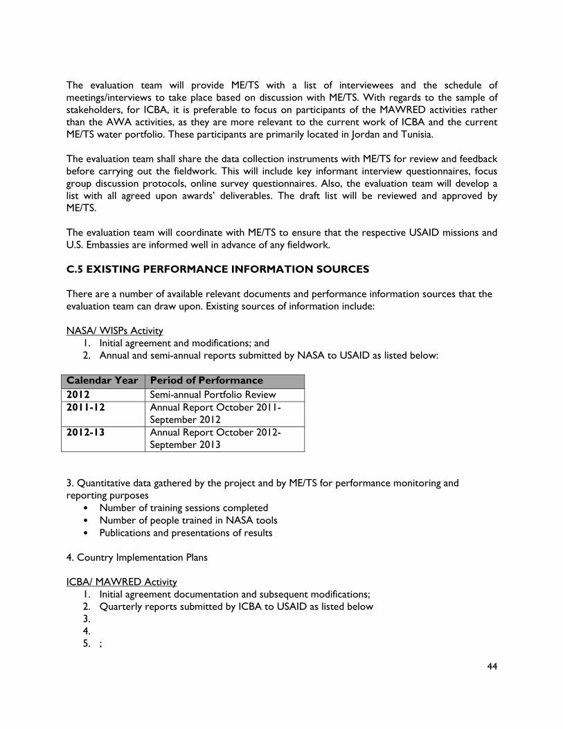
44
The evaluation team will provide ME/TS with a list of interviewees and the schedule of meetings/interviews to take place based on discussion with ME/TS. With regards to the sample of stakeholders, for ICBA, it is preferable to focus on participants of the MAWRED activities rather than the AWA activities, as they are more relevant to the current work of ICBA and the current ME/TS water portfolio. These participants are primarily located in Jordan and Tunisia. The evaluation team shall share the data collection instruments with ME/TS for review and feedback before carrying out the fieldwork. This will include key informant interview questionnaires, focus group discussion protocols, online survey questionnaires. Also, the evaluation team will develop a list with all agreed upon awards’ deliverables. The draft list will be reviewed and approved by ME/TS. The evaluation team will coordinate with ME/TS to ensure that the respective USAID missions and U.S. Embassies are informed well in advance of any fieldwork. C.5 EXISTING PERFORMANCE INFORMATION SOURCES There are a number of available relevant documents and performance information sources that the evaluation team can draw upon. Existing sources of information include: NASA/ WISPs Activity
1. Initial agreement and modifications; and 2. Annual and semi-annual reports submitted by NASA to USAID as listed below:
Calendar Year Period of Performance 2012 Semi-annual Portfolio Review 2011-12 Annual Report October 2011-
September 2012 2012-13 Annual Report October 2012-
September 2013 3. Quantitative data gathered by the project and by ME/TS for performance monitoring and reporting purposes
• Number of training sessions completed • Number of people trained in NASA tools • Publications and presentations of results
4. Country Implementation Plans ICBA/ MAWRED Activity
1. Initial agreement documentation and subsequent modifications; 2. Quarterly reports submitted by ICBA to USAID as listed below 3. 4. 5. ;

45
Calendar Year
Period of Performance
2009 April – July 2009 Aug – October 2009 October – December 2009
2010 January – March 2010 April- June 2010 July – September 2010 October – December 2010
2011 January – March 2011 April – June 2011 July – September 2011 October – December 2011
2012 January – March 2012 April – June 2012 July – September 2012 October – December 2012
2013 January – March 2013 April – June 2013 July – September 2013 October – December 2013
2014 January – March 2014 Course materials, attendee lists and write ups, to the extent available C.6 EVALUATION QUESTIONS The Evaluation Questions are, in priority order: 1. How are the relevant organizations involved in adopting the tools and technology provided by
NASA/ICBA to conduct their work?29
a) Which tools and technologies do these organizations perceive to be of value for their own purposes?
b) To what extent are the appropriate staff of the organizations familiar with and proficient with the tools and technologies?
c) To what extent have the tools and technologies been integrated into the work processes of the organizations?
2. What are the factors that lead to the adoption or non-adoption of NASA tools and resources?
a) What are the characteristics of the organizations that contribute to the adoption or prevent the adoption of these tools and technologies?
29 “Organizations” are being defined to include the public sector (Ministries, Government Agencies). “Tools and technologies” includes software, information system tools and models, data sets, and analysis that have been provided to the relevant organizations and which the relevant organizations have been trained to use by the ICBA/NASA water activities. “Adopting” is being referred to here as perception, proficiency, and integration.

46
b) What are the internal factors that empower staff of the organizations to explore, adopt, and utilize and NASA tools and models?
c) What are the external factors that lead to the integration of NASA tools and technologies into work processes for improved water resource management?
3. How are the tools and technologies being used to contribute to the planning and decision
making of the management of water resources? a) What decision making processes have been revised incorporating NASA tools and
technologies? b) What are the factors contributing to or preventing the use of the tools and technologies for
water resource management, planning, and decision making of the ministries involved? Based on the answers to the above evaluation questions, the evaluation team should also address: 4. Lessons Learned: What are lessons learned, if any from implementation to date that ME/TS
should take into consideration for design of future activities in this area? 5. Recommendations:
a) What adjustments, if any, should be made to increase the activities’ ability to help improve management of water resources in the implementing countries?
b) What additional resources, if any, are needed to address critical gaps and facilitate the adoption and use of ICBA/NASA water activity tools and technologies for improved water resource management?
C.7 PERSONNEL The key personnel identified below are considered to be essential to the work being performed. Unless otherwise agreed to in writing by the Contracting Officer, the contractor shall be responsible for providing such personnel as specified in the Task Order. Failure to provide key personnel designated below may be considered nonperformance by the contractor unless such failure is beyond the control, and through no fault or negligence of the contractor. The contractor must immediately notify the Contracting Officer of any key personnel’s departure and the reasons therefore. The contractor must take the necessary steps to immediately rectify this situation and must propose a substitute candidate for each vacated position along with a budget impact statement, if requested, in sufficient detail to permit evaluation of the impact on the program. The contractor without the written approval of the Contracting Officer shall make no replacement of key personnel. The contractor shall provide the following key personnel for the performance of this task order: Team Leader
The Team Leader will be a senior or mid-level international expert, with 5 years of experience in leading and conducting evaluations of development activities, preferably with experience in social science evaluation methods, especially program performance evaluations, rapid appraisal techniques, case studies and other relevant data collection/analysis techniques. The team leader should also have superior management, interpersonal relations and writing skills, and a solid technical understanding of issues related to water resources management, preferably in MENA region. A minimum of a graduate degree is required.
Two team members
47
The Contractor will propose two team members (an international and local expert) who are required to complete the task. The Contractor’s proposal will include each team member’s name and key skills relevant to this evaluation, with a current Curriculum Vitae included as an annex to the Technical Proposal. Team members must include: One scientist or engineer with technical expertise (minimum 10 years of experience) in the application of remote sensing data and water resources models; and at least one team member must be proficient in Arabic. A minimum of a graduate degree is required.

48
ANNEX 2: LIST OF DOCUMENTS REVIEWED

49
DOCUMENTS REVIEWED
NASA Nasa/USAID Contract – POPA Project Implementation Plan: Egypt, Jordan, Lebanon, Morocco, Tunisia Annual Project Report: 2012 & 2013 Action Item List Training Schedule Accomplishments & Future Plans Power Point Presentation 10/22/2014 WISP Project Annual Report from October 11 – September 2012
WORLD BANK P117170 Project Appraisal Document, Five Grants from GEF Trust Fund Restructuring Paper June 9, 2014 Aide Memoire August 17, 2014 P130802 Project Appraisal Document Implementation Status and Results August 4, 2014
ICBA MAWRED Training and Workshop Events Data Generation under MAWRED Quarterly Report, July-September 2014 Original Grant 263-6-00-09-000ICI-00 Modifications 1,3,4,5,6 & Application for Modification
AWC Technical Stakeholders Meeting Oct 19-21, 2011 MAWRED Work Plan 2014
USAID Shared Folder Documents: MAWRED Quarterly Reports: Q3 2009 – Q4 2012, Q1-Q3 2014 ICBA PIO Grant NASA POPA AID – OAA-TO-14-00043 Evaluation Documents
WEBSITES oas.gsfc.nasa.gov MAWREDh2o.org REIWRM.awc.org

50
ANNEX 3: LIST OF INTERVIEWEES

51
Name Position Institution Contact Email Date
Jordan
Rania Abdul Khaleq
Project Manager for NASA Project Ministry of Water and Irrigation (MWI) ----- 11/4/2014
Dr. Jawad El Bakri
Remote Sensing (Crop Mapping) Specialist
Department of Agriculture, University of Jordan, Consultant to MWI for NASA Project
----- 11/4/2014
Mohammed El Atrash
Former Project Manager for NASA Project MWI ----- 11/5/2014
Mona Saba Evapotranspiration & Drought -Liaison person for NASA Project at NCARE.
Supervisor of Drought Monitoring Unit, National Center for Agricultural Research and Extension (NCARE)
----- 11/5/2014
Mazen Jouaneh Managing Director InfoGraph LLC [email protected] 11/5/2014
Nisreen Al Ghorani Data Services & Training Manager InfoGraph LLC [email protected] 11/5/2014
Mutasem Jokhdar
Senior Account Manager InfoGraph LLC [email protected] 11/5/2014
Prof. Fayez Abdulla
Water Resources, Climate Change Expert
Consultant to MWI for NASA Project ----- 11/6/2014
Kotaiba Abugazleh
Research Assistant on Climate Change
Consultant to MWI for NASA Project ----- 11/6/2014
Eng. Nivin Hasan
Liaison person for NASA Project Royal Jordanian Geographic Center (RJGS) ----- 11/6/2014
Ibrahim Albaddawi
Deputy Director General Regional Centre for Space Science & Technology for Western Asia/UN. RJGS
----- 11/6/2014
Ali Olimat Remote Sensing Specialist RJGS ----- 11/6/2014
Samer Qarmout Head of GIS Section Engicon [email protected] 11/6/2014

52
Name Position Institution Contact Email Date
Morocco
Driss El Hadani Director Royal Centre for Remote Sensing (CRTS)
[email protected] 11/10/2014
Ahmed Er Raji NASA/LDAS Project, responsible for Water Resources/Flood component
Dept. of Environment & Natural Resources, CRTS [email protected] 11/10/2014
Mohammed Merdas NASA/LDAS Project, responsible for Irrigation/crop mapping
Head of Studies & Projects Division, CRTS
[email protected] 11/11/2014
Noureddine Bijaber NASA/LDAS Project, responsible for Drought Monitoring
Head of Environment & Natural Resources, CRTS
[email protected] 11/11/2014
Mohammed Faouzi Smiej
NASA/LDAS Project, responsible for Locusts Monitoring
Head of Acquisitions & Production Dept., CRTS
[email protected] 11/12/2014
Abderrahman Atillah NASA/LDAS Project, responsible for Locusts Monitoring
Head of Oceanography, Climate & Fisheries, CRTS
[email protected] 11/12/2014
Aziz El Omari NASA/LDAS Project, responsible for project finances& procurement
Head of Finance and Accounting Dept., CRTS ----- 11/12/2014
Bashir Ablat NASA Project, partner to CRTS
Irrigation Database, Ministry of Agriculture and Fisheries
----- 11/13/2014
Ehssan El Meknassi Youssoufi
NASA Project liaison person, partner to CRTS
Ministry of Agriculture and Fisheries
Head of Water Resources Planning
[email protected] 11/13/2014
Hassan Brighet NASA Project support
Meteorologist, Head of Surface Water Resources Dept., Water Resources Dept., Ministry of Energy, Minerals, Water and Environment (MEMWE)
----- 11/13/2014
Soundouce NASA Project support Meteorologist, Surface Water Resources Dept., Water Resources
[email protected] 11/13/2014

53
Name Position Institution Contact Email Date
Moutaouakkil Dept., MEMWE
Mariam El Meshtali NASA Project support Statistician, Surface Water Resources Dept., Water Resources Dept., MEMWE
----- 11/13/2014
Fatimah El Zahra’a Ben Farji
NASA Project support Hydrologist, Surface Water Resources Dept., Water Resources Dept., MEMWE
----- 11/13/2014
Tunisia
Thouraya Sahli Chahed LDAS Project, responsible for crop mapping, irrigation & ET.
National Mapping and Remote Sensing Center (CNCT)
[email protected] 11/17/2014
Sinan Bacha Manager of Flood Component (NASA/LDAS Project)
New Technologies Applications, Deputy Director, CNCT
[email protected] 11/18/2014
Abd El Bachar Ben Gsim
Manager of Groundwater Component (LDAS Project) since October 2014.
General Engineer Specialized in Water Resources, Head of Groundwater, General Directory of Water Resources, CNCT
[email protected] 11/18/2014
Ahmed Ezzine Flood Mapping Component, LDAS Project support.
CNCT [email protected] 11/18/2014
Haythem Belghrissi
Engineer in Hydrometeorology,
Climate Change Component,
support/modelling
National Institute of Meteorology [email protected] 11/19/2014
Dr. Youssef Trifa Associate Professor National Institute of Agriculture [email protected] 11/19/2014
Dr. Mahmoud Elies Hamza
Professor and Director General
National Institute of Agriculture ----- 11/19/2014
UAE
Rachael McDonnell Project Manager International Center Biosaline [email protected] 11/1/2014

54
Name Position Institution Contact Email Date
Agriculture
Adla Khalaf Remote sensing scientist ICBA [email protected] 11/2/2014
Karim Bergaoui Climate and water modeling ICBA [email protected] 11/2/2014
Rashyd Zaaboul Climate modelling scientist ICBA [email protected] 11/2/2014
Ismahane Elouafi Director General ICBA [email protected] 11/2/2014
Shoaib Ismail A/Dir Research & Innovation ICBA [email protected] 11/2/2014
Dr. Talat Darwish Project Manager Remote Sensing Center - CNRS [email protected] 11/2/2014
USA
Dr. Shahid Habib Project Manager NASA/GSFC [email protected] 10/22-23/14
Fritz Policelli Scientist NASA/GSFC [email protected] 10/22-23/14
Ms. Qun Li Project Manager World Bank [email protected] 10/28/2014
Ms. Sally Zgheib Water Specialist World Bank [email protected] 10/28/2014
Dr. Shawki Barghouti Consultant [email protected] 10/29/2014
Mark Peters Foreign Service Officer USAID [email protected] 11/5/2014
Kalim Hanna Foreign Service Officer USAID [email protected] 12/1/2014
Eric Viala Engineer AECOM [email protected] 12/8/2014
Gary Eilerts Remote Sensing Officer FEWSNET [email protected] 12/15/2014
Kamal Ouda A/project manager USAID [email protected] Numerous
Amena Chenzaie M&E Officer USAID [email protected] Numerous
John Wilson ME/TS USAID [email protected] ? 12/19/2014

55
ANNEX 4: EVALUATION DESIGN MATRIX
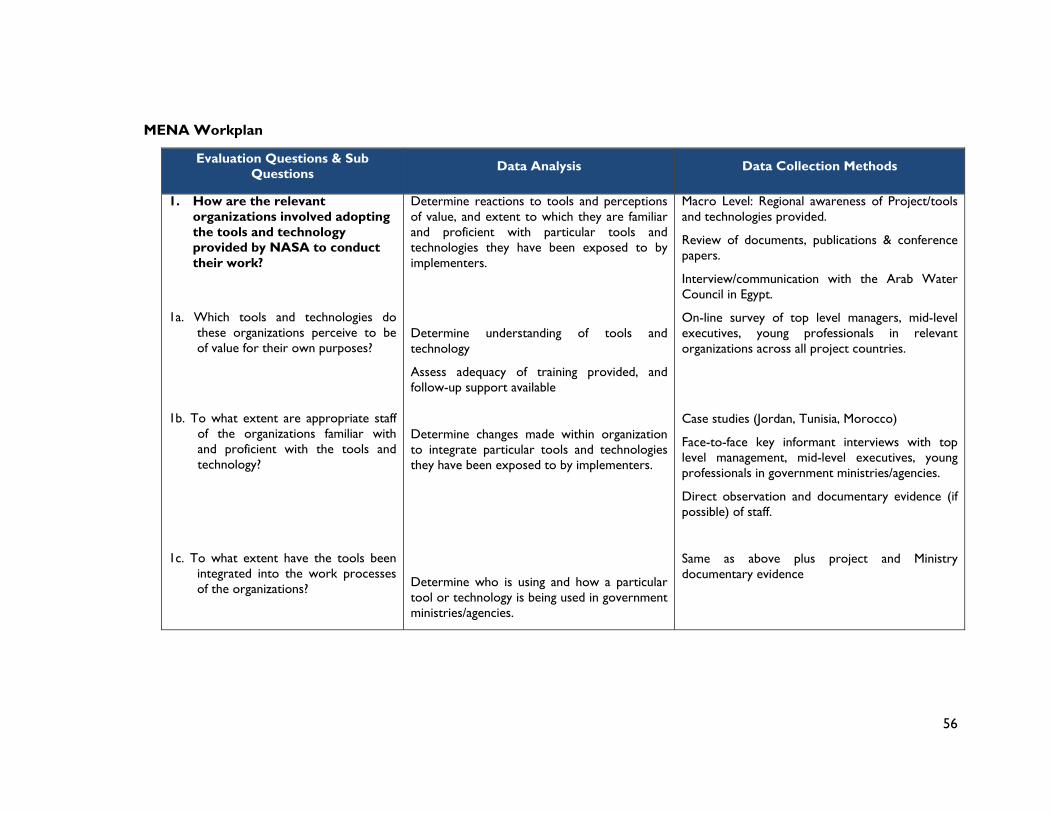
56
MENA Workplan
Evaluation Questions & Sub Questions
Data Analysis Data Collection Methods
1. How are the relevant organizations involved adopting the tools and technology provided by NASA to conduct their work?
1a. Which tools and technologies do these organizations perceive to be of value for their own purposes?
1b. To what extent are appropriate staff of the organizations familiar with and proficient with the tools and technology?
1c. To what extent have the tools been integrated into the work processes of the organizations?
Determine reactions to tools and perceptions of value, and extent to which they are familiar and proficient with particular tools and technologies they have been exposed to by implementers.
Determine understanding of tools and technology
Assess adequacy of training provided, and follow-up support available
Determine changes made within organization to integrate particular tools and technologies they have been exposed to by implementers.
Determine who is using and how a particular tool or technology is being used in government ministries/agencies.
Macro Level: Regional awareness of Project/tools and technologies provided.
Review of documents, publications & conference papers.
Interview/communication with the Arab Water Council in Egypt.
On-line survey of top level managers, mid-level executives, young professionals in relevant organizations across all project countries.
Case studies (Jordan, Tunisia, Morocco)
Face-to-face key informant interviews with top level management, mid-level executives, young professionals in government ministries/agencies.
Direct observation and documentary evidence (if possible) of staff.
Same as above plus project and Ministry documentary evidence

57
Evaluation Questions & Sub Questions
Data Analysis Data Collection Methods
2. What are the factors that lead to the adoption or non-adoption of NASA tools and resource?
2a. What are the characteristics of the organizations that contribute to the adoption or prevention of these tools and technologies?
Determine relevant organizational, bureaucratic, environmental, social, political factors that lead to adoption or non-adoption of tools and technologies.
Determine characteristics leading to or preventing adoption of technology, May address organizational characteristics, staff capacity, leadership structure, etc.
Case studies (Jordan, Tunisia, Morocco)
Face-to face interviews with Ministry/agency (top level management, mid-level executives, young professionals) and project implementers in relevant organizations.
Skype/phone interviews with key informants in other countries
Online survey
Case studies (Jordan, Tunisia, Morocco)
Key informant interviews with project partners and ministry/agency (top level, mid-level, young professionals).
Document review to support project and ministry staff assertions.
2b. What are the internal factors that empower ministry staff to explore, adopt, and utilize NASA tools and technologies?
2c. What are the external factors that lead to the integration of NASA tools and technologies into work processes for improved water resource management?
Determine internal enabling factor such as motivation or buy-in of leadership, staff motivation, and buy-in.
Determine external demands for revision of current procedures or practices. Role (or influence) of USAID?
Case studies (Jordan, Tunisia, Morocco):
Face-to-face interviews with ministry/agency (top level, mid-level, young professionals).
Phone/Skype interviews with professionals in other countries
Documentary review to support ministry staff assertions.
Case studies (Jordan, Tunisia, Morocco)
Key informant interviews with ministry staff, project staff, stakeholders, beneficiaries.
Interviews with USAID country staff.
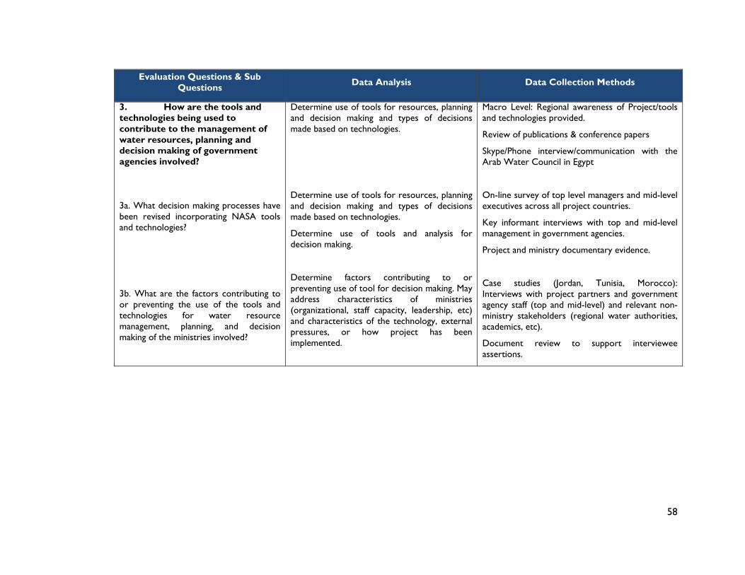
58
Evaluation Questions & Sub Questions
Data Analysis Data Collection Methods
3. How are the tools and technologies being used to contribute to the management of water resources, planning and decision making of government agencies involved?
3a. What decision making processes have been revised incorporating NASA tools and technologies?
3b. What are the factors contributing to or preventing the use of the tools and technologies for water resource management, planning, and decision making of the ministries involved?
Determine use of tools for resources, planning and decision making and types of decisions made based on technologies.
Determine use of tools for resources, planning and decision making and types of decisions made based on technologies.
Determine use of tools and analysis for decision making.
Determine factors contributing to or preventing use of tool for decision making. May address characteristics of ministries (organizational, staff capacity, leadership, etc) and characteristics of the technology, external pressures, or how project has been implemented.
Macro Level: Regional awareness of Project/tools and technologies provided.
Review of publications & conference papers
Skype/Phone interview/communication with the Arab Water Council in Egypt
On-line survey of top level managers and mid-level executives across all project countries.
Key informant interviews with top and mid-level management in government agencies.
Project and ministry documentary evidence.
Case studies (Jordan, Tunisia, Morocco): Interviews with project partners and government agency staff (top and mid-level) and relevant non-ministry stakeholders (regional water authorities, academics, etc).
Document review to support interviewee assertions.

59
Supplementary Questions Data Analysis Data Collection Methods
4. Contribution to Body of Knowledge
4a. To what extent will (has) the program add(ed) to the body of sector knowledge?
4b. How has this experience and knowledge been disseminated?
4c. How effective has the dissemination of products been (knowledge of products, application of knowledge?
In what way is the program new or innovative?
What are the principle methods for disseminating this knowledge (country level, regionally and internationally?)
Determine if the knowledge acquired has led to improved water and agriculture resource planning outcomes for the MENA Region.
On-line survey of appropriate staff in partner/implementing agencies in USA, and across all project countries.
Key informant interviews with relevant government agencies.
Document Review (scientific papers published, conferences attended, articles etc)
5. Development Impact and Aid Effectiveness
5a What is the level of Government support for the program?
5b What is the level of coordination and synergy with other similar programs, to maximize outcomes?
5c Is there evidence that program tools and outputs have supported other development projects (either by Government of donors)?
Has additional funding been provided by governments, other donors, other sources?
Has the program actively sought to develop linkages with government agencies, research bodies, NGOs ? What has been the facilitating factors and constraining factors?
Examples of synergy with other programs? EG Are the tools that have been developed being used on other programs (now or likely to in
Interviews with relevant government agencies in the countries visited.
Interviews with program implementation and partner staff in countries visited.
Interviews with USAID country staff.
Document Reporting

60
Supplementary Questions Data Analysis Data Collection Methods
future)?
6. Program Design and Implementation
6a. Was the overall program design realistic (design logic, timeline, funds, human resources, targets) to achieve the expected outcomes and impact?
6b. Have Program risks and assumptions been taken into account in the Program design and at implementation?
6c. Has the program demonstrated sufficient flexibility to adjust to changing circumstances and conditions?
6d. Is the Program monitoring and reporting effective in recording progress and achievements?
6e. Was the country context sufficiently taken into account?
Assess quality of design logic and framework, project resourcing, training methods used, and project effectiveness.
Is the progress reporting effective in identifying if program is on track? Does it clearly state targets to be achieved? Does it identify successes and challenges, and reasons for these?
What have been the main reasons for the program extensions, and budget revisions, and could these have been foreseen?
What has been the USAID support role (country level/DC level) during implementation? Has USAID decision-making been timely?
Are the program risks and assumptions realistic? Does the program risk matrix identify strategies to mitigate risks?
Are the project indicators SMART?
Review of Program Reports (eg Annual Reports, Quarterly Reports, PMPs, Annual Work Plans etc),
Interviews with program implementation and partner staff in all countries, including USAID country staff.
7. Training Impact and Effectiveness
7a. Was training received (under this program)
Was training tailored to the needs and context of the trainees? Was it sufficient (duration,

61
Supplementary Questions Data Analysis Data Collection Methods
relevant to your needs?
7b How effective/useful was the training received? Score on scale 1 – 4. Reasons for rating given?
7c. Have you been able to put into practice some aspects of the training received?
7d. How could training be improved?
resources etc) for your needs?
Effectiveness Rating:
1. Highly Satisfactory
2. Satisfactory
3. Less Than Satisfactory
4. Highly unsatisfactory
Why did you give this score (reasons)?
Examples of how trainee has been able to use the new learning?
In what ways could the training be improved in future?
Focus Group Discussions (where there are 4 or more beneficiaries, receiving similar training)
Interviews with trainees or online survey
8. How can the project be improved – to achieve better outcomes?
8a. What were/are the main reasons for program success (if any) and can they be replicated?
8b. What were/are the main challenges or obstacles in terms of achieving program outcomes, and how have they been addressed?
8c. How will you know when the program has achieved its outcomes? What next?
Lessons Learned Assessment
What will a successful program outcome look like? What will be the impact of a successful program? What needs to happen next (why, by whom)?
Structured interviews with implementers and beneficiaries.

62
ANNEX 5: DATA COLLECTION INSTRUMENTS

63
1) Stakeholder Assessment Form Name: Position: Country: Email Address:
2) Tools and technologies and their adaption for local country application: Unable to
rate/not relevant
Highly unsatisfactory
Less than satisfactory
Satisfactory Highly Satisfactory
Selection of tools and technologies appropriate and relevant?
0 0 0 0 0
Have the tools and technologies been integrated into your organization’s work practices?
0 0 0 0 0
Comment or justification:
3) Training and Capacity Development Provided? Unable to
rate/not relevant
Highly unsatisfactory
Less than satisfactory
Satisfactory Highly Satisfactory
Rate the training in terms of relevance to your needs? Was it sufficient in terms of needs? What is the result of the training (have you been able to put into practice lessons learned?)
0 0 0 0 0
Rate your overall level of satisfaction with the Training and Capacity Development provided under the Project? (and
explain why you have given this score)
0 0 0 0 0
4) How would you rate the effectiveness of the roles played by NASA, ICBA and the Arab Water Council (AWC) in terms of project coordination and support?

64
Unable to rate/not relevant
Highly unsatisfactory
Less than satisfactory
Satisfactory Highly Satisfactory
NASA 0 0 0 0 0
ICBA 0 0 0 0 0
AWC 0 0 0 0 0
5) From previous question please provide details NASA: ICBA: AWC:
6) Any other feedback?
7) What are/have been the main achievements of the project to date?
8) Has the project met your expectations (Yes/No)? If not, why not?
9) How could the project be improved to achieve better outcomes?

65
Mid–Term Evaluation of ICBA/NASA Water Activities
FOCUS GROUP DISCUSSIONS
Stakeholder Group: Recipients of Training under MENA
General
The FGDs should be carried out with representatives of the key sector stakeholders (working in small sub groups). Each stakeholder sub group will complete the questions and present the findings for discussion and consensus.
Q1. WHAT TRAINING HAVE YOU RECEIVED SPECIFIC TO YOUR TASK(S) ON THIS PROGRAM? Maybe homogenous group (identical training) or mixed group. Who provided training? Duration of training?
Q2. (SITUATION BEFORE) DID YOU HAVE OPPORTUNITIES FOR TRAINING BEFORE? Who provided/funded this? Duration?
Q3. WAS TRAINING RECEIVED (UNDER THIS PROGRAM) RELEVANT TO YOUR NEEDS? This may be obvious so may leave out
Q4. RATE HOW EFFECTIVE/USEFUL WAS THE TRAINING RECEIVED?:
1. Highly Satisfactory 2. Satisfactory 3. Less Than Satisfactory 4. Highly unsatisfactory
Q5. WHAT WAS GOOD/DISAPPOINTING ABOUT THE TRAINING?? Based on the rating given, get details
Q6. HAVE YOU BEEN ABLE TO PUT INTO PRACTICE SOME ASPECTS OF THE TRAINING RECEIVED? Tangible evidence of improved performance due to training?
Q7. HOW COULD TRAINING BE IMPROVED NEXT TIME?
Q8. ANY OTHER FEEDBACK? Explore maybe there are other issues (not training) where their needs are not being met eg lack equipment, transport/funding etc

66
ANNEX 6: MAWRED/WISP TRAINING 2009-2014

67
Mawred Training Schedule
Date Event Location Training course subject area Particpant countries# of
participantsDays
2009 25‐27th October
MENA LDAS WORKSHOP/TRAINING
PROGRAM; APPLICATIONS OF REMOTE
SENSING FOR WATER MANAGEMENT
Abu Dhabiremote sensing, modeling, land data
assimilation
Morocco, Syria, Egypt,
Yemen, Lebanon, Jordan,
Tunisia, Bahrain, UAE, Qatar,
Libya, Kuwait
27 3
2011 19‐21th October
Regional Coordination for Improved
Water Resources Management Project ‐
Technical WorkshopDubai
remote sensing, modeling, land data
assimilationMorocco, Jordan, Lebanon, 36 3
12‐15th December Eye on Earth, side event Abu Dhabi water modeling, climate change modeling MENA regional experts 30 1
201218‐19th November
National workshop on water and
climate modellingTunis climate change and water modeling
Tunisia 373
2013 20th January ACWUA annual event Amman water and climate change modeling Across the MENA region 25 0.5
25th February Workshop on Climate Change in MENA
event at AWC General ForumCairo climate change modeling Across the MENA region 105 1
15th AprilWorkshop on water, climate and crop
modelling ‐ needs assessmentTunis climate change, water and crop modeling Tunisia 15 1
8‐9th May
Technical support for Regional
Coordination for Improved Water
Resources Management ProjectDubai climate change and water modeling
Egypt, Tunisia, Jordan,
Lebanon and Morocco35 0.5
9‐12th June Technical support and training for LIS Rabat LIS modeling for water managemetn Morocco 4 5
29th June‐1st July
MAWRED Project Initiation and
training Dubai
climate change, water modeling,
irrigation mapping Iraq 3 3
3‐6th December
MAWRED Project Initiation and
training Dubai
climate change, water modeling,
irrigation mapping Yemen 3 3
2014 Climate change dWater days
23rd‐28th FebruaryTechnical training and project
initiationDubai
climate change, water modeling, crop
and irrigation mappingWest Bank/Gaza
4 5 20 20
9‐10th March Workshop on climate change, water
and crop modelingAmman
climate change, water,
evapotranspiration and irrigation
modeling
Jordanians3 2 6 20
24‐26th March
Training Program on Crop Mapping and
Modeling of climate change impactsDubai
crop mapping and modeling of climate
changePalestine, Yemen, Tunisia 6 3 18
31st March ‐ 2nd April
Training Program on Statistical
Downscaling of Climate Change
ScenariosDubai
statistical and dynamical climate change
downscalingTunisia, Jordan and Lebanon 8 5
40
4‐6th May
Training Program on Crop Mapping and
Modeling of climate change impactsDubai
crop mapping and modeling of climate
changeIraq 2 3 6
15th September Models, data and products for Tunisia
Tunisclimate change, water and crop modeling Tunisia
102 1 102 102
16‐17th September
Workshop on irrigation and crop
mapping and modellingTunis
irrigation and crop mapping and
modelling; cl imate change impact
modeling
Tunisia36 2 72 72
18th September
Workshop on irrigation and crop
mapping and modellingBouselm
irrigation and crop mapping and
modelling; cl imate change impact
modeling
Tunisia18 1 18
22nd SeptemberModels, data and products for Tunisia Tunis climate change, water and crop modeling Tunisia
32 0.5 16 16
22‐23rd September
Workshop on crop and
evapotranspiration mapping and
modelling
Tunis
irrigation and crop mapping and
modelling; cl imate change impact
modeling
Tunisia26 2 52
350 230
18th OctoberDrought monitoring and early warning
systems side event at Water For FoodSeattle
drought monitoring, climate and crop
modelling, irrigation modelingGlobal
56 0.5
11th December Climate change and crop modeling Cairo climate change modeling, crop mapping MENA region 20 0.5
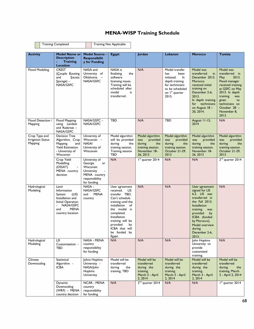
68
MENA-WISP Training Schedule
Training Completed Training Not Applicable
Activity Model Name or Description - Training Location
Model Source - Responsibility for Funding
Egypt Jordan Lebanon Morocco Tunisia
Flood Modeling CREST (Couple Routing and Excess Storage) – NASA/GSFC
NASA and University of Oklahoma – NASA/GSFC
NASA is finalizing the software licensing issues. Training will be scheduled after model is transferred.
N/A Model transfer has been initiated. In depth training for technicians to be scheduled on 1st quarter 2015.
Model was transferred in December 2013. Morocco received initial training on December 2-6, 2013. In depth training for technicians on August 18 – 20, 2014.
Model was transferred in May 2013. Flood manager received training at GSFC on May 2013. In depth training was given to technicians on October 28 – November 8, 2013.
Flood Detection / Mapping
Flood Mapping using Landsat and Radarsat – NASA/GSFC
NASA/GSFC – NASA/GSFC
TBD N/A TBD August 11-15, 2014
N/A
Crop Type and Irrigation Status Mapping
Decision Tree Algorithm, Crop Mapping and Yield Estimation - University of Wisconsin
University of Wisconsin – NASA/ University of Wisconsin
Model algorithm will be provided during the training session. Training session TBD
Model algorithm was provided during the training session. November 18- 26, 2013
Model algorithm was provided during the training session. October 21-29, 2013
Model algorithm was provided during the training session. November 18- 26, 2013
Model algorithm was provided during the training session. October 21-29, 2013
Crop Yield Modelling (DSSAT) - MENA country decision
University of Georgia or Wisconsin University - MENA country responsibility for funding
N/A 1st quarter 2014 N/A N/A 2nd quarter 2014
Hydrological Modeling
Land Information System (LIS) Installation and Initial Operation - NASA/GSFC and MENA country location
NASA - NASA/GSFC and MENA country
User agreement received. LIS transfer TBD. Can’t schedule training until the installation of the model is completed. Installation training will be provided by ICBA that will be funded by Egypt.
N/A N/A User agreement signed for LIS 6.2. LIS was transferred in the Fall 2013. Installation training was provided by ICBA (funded by Morocco). Model overview during December 2-6, 2013.
N/A
Hydrological Modeling
LIS Customization - TBD
NASA - MENA country responsibility for funding
N/A N/A N/A John Hopkins University to provide customized training.
N/A
Climate Downscaling
Statistical Algorithm - ICBA
Johns Hopkins University - NASA/John Hopkins University
Model will be transferred during the training. TBD
Model will be transferred during the training. March 3 - April 2, 2014
Model will be transferred during the training. March 3 - April 2, 2014
Model will be transferred during the training. March 3 - April 2, 2014
Model will be transferred during the training. March 3 - April 2, 2014
Dynamic Downscaling (WRF) - MENA country decision
NCAR - MENA country responsibility for funding
N/A 2nd quarter 2014 N/A N/A 1st quarter 2014

69
Activity Model Name or
Description - Training Location
Model Source - Responsibility for Funding
Egypt Jordan Lebanon Morocco Tunisia
Evapotranspirati on and Drought
ALEXI and DisALEXI Overview - ICBA
USDA - NASA/John Hopkins University
TBD March 3 - April 2, 2014
March 3 - April 2, 2014
March 3 - April 2, 2014
March 3 - April 2, 2014
ALEXI and DisALEXI (Atmosphere Land Exchange Inverse and Disaggregated ALEXI) - USDA
US Department of Agriculture (USDA) and NASA - NASA/USDA and ICBA
2007-2012 ET maps delivered for country’s evaluation. An ICBA fellow will participate in a short-term fellowships provided at USDA. Fellow will be funded by ICBA. NASA/USDA will provide collaborative research with fellow to understand ALEXI, DisALEXI and drought indices developed based on ET anomalies. He/she will also learn to adapt DisALEXI model. Candidate should hold a PhD degree. After training is completed countries will coordinate with ICBA how the knowledge will be transferred. The knowledge transferred from ICBA to countries will be funded by each country.
Calculation of Combined Drought Indicator (CDI) using SPI, soil moisture and fAPAR. Drought early warning system, MENA country decision
Consultant of Choice - MENA country responsibility for funding
N/A 3rd quarter 2014 N/A N/A 3rd quarter 2014
Remote Sensing use to generate Evapotranspirati on maps (theory and different models used in practice) - University of Wisconsin
NASA / University of Wisconsin - NASA/ University of Wisconsin
TBD November 18- 26, 2013
October 21-29, 2013
November 18- 26, 2013
October 21-29, 2013
Locust Monitoring
NASA Data Sets – NASA/GSFC
NASA – NASA/GSFC
N/A N/A N/A Moroccan expert consulted with NASA expert during the December 2-6, 2013 visit to exchange ideas. No further action was identified.
N/A
Fire Early Warning Indicators
NASA Satellite Observations - TBD
NASA and US Forest Service (USFS) - TBD
N/A N/A NASA fire products are openly available via the Web. NASA to provide an USFS expert contact information by 1st quarter 2014. Training need is TBD
N/A N/A
Ground Water Training on how to use GRACE data to detect water availability/ variability - ICBA
NASA/ICBA - MENA country responsibility for funding
1st quarter 2014 N/A N/A N/A N/A
Modeling with Modflow - MENA country decision
USGS or University of Missouri - MENA country responsibility for funding
N/A N/A N/A N/A 1st quarter 2014

70
ANNEX 7: MATRICES FOR COUNTRY ACCOMPLISHMENTS

71
MATRIX FOR COUNTRIES ACCOMPLISHMENTS
ACCORDING TO QUESTION # 1 (Part a)
Below is an assessment matrix for the accomplishments made by the different countries with regard to their position (i.e., stage) in implementing the NASA/ICBA Program. The matrix answers the first question (part a).
Question # 1: How are the relevant organizations involved in adopting the tools and technology provided by NASA/ICBA to conduct their work?
1a. Which tools and technologies do these organizations perceive to be of value for their own purposes?
Country Valuable Datasets, Models, and Systems Valueless Datasets, Models, and Systems
Jordan
Landsat-8, MODIS, ASTER GDEM Conventional classification techniques Unconventional classification techniques
(knowledge-based)
LDAS ALEXI
Morocco
Landsat-8, MODIS, TRMM, GPM, ASTER GDEM
Conventional classification techniques Unconventional classification techniques
(random forest) LIS CREST
LDAS ALEXI
Tunisia
Landsat-8, MODIS, TRMM, GPM, GRACE, ASTER, GDEM
Conventional classification techniques LIS CREST Statistical downscaling for climate change
analysis using R Dynamical downscaling for climate change
analysis using WRF
LDAS ALEXI
Lebanon
Egypt
Iraq
Yemen

72
ACCORDING TO QUESTION # 1 (Parts b and c)
Below is an assessment matrix for the accomplishments made by the different countries with regard to their position (i.e., stage) in implementing the NASA/ICBA Program. The matrix answers the first question (parts b and c).
Question # 1: How are the relevant organizations involved adopting the tools and technology provided by NASA to conduct their work?
1b. To what extent are appropriate staff of the organizations familiar with and proficient with the tools and technology?
1c. To what extent have the tools been integrated into the work processes of the organizations?
Key:
Stage:
- Not Applicable
0 Do Not Have Enough Information
1 Early Stage
2 Middle Stage
3 Advanced Stage
Familiarity and Proficiency of the Datasets
Familiarity and Proficiency of the Models and/or Systems
Integration of the Datasets Integration of the Models and/or Systems
Country Jordan Morocco Tunisia Lebanon Egypt Iraq Yemen
The
mat
ic A
rea
Evapotranspiration 2 1 2 2 2 2
1 1 2 2 2 2
Drought 2 1 2 2 2 2
1 1 2 2 2 2
Floods Detection and Modeling
- - 2 2 2 2 - -
- - 2 2 2 2 - -
Climate Change Impact 2 1 2 2 2 2
1 1 1 1 2 2
Crop Mapping and Irrigation
2 1 2 2 2 2
1 1 2 2 2 2
Hydrological Modeling and Analysis
- - 2 2 - - - -
- - 2 2 - - - -
Locust Monitoring - - 2 2 - - - - - -
- - 2 2 - - - - - -
Fires (Detection and Risk)
- - - - - - - -
- - - - - - - -
Crop Yield - - - - - - - -
- - - - - - - -
Groundwater - - - - 1 1 - - - -
- - - - 1 1 - - - -

73
ANNEX 8: BACKGROUND ASSESSMENT FOR THE TOOLS AND TECHNOLOGY PROVIDED
BY NASA/ICBA PROJECTS

74
BACKGROUND AND ASSESSMENT FOR THE TOOLS AND TECHNOLOGY PROVIDED BY NASA/ICBA PROJECTS
The basic philosophy behind NASA/ICBA Projects is to use different datasets that can be extracted from sensors installed on satellites in addition to other sources (e.g., ground-based) and incorporate these datasets into models of environmental systems for the purpose of managing water resources in the Middle East and North Africa (MENA) countries.
The sensors, satellites, and models of environmental systems are those that were developed by NASA in cooperation with other US and international agencies and available for the public (internationally) at no monetary cost, which is very critical for the sustainability of the Projects in the MENA countries, especially after their completion.
Sensors installed on satellites have the advantage of providing spatially continuous information at different scales of resolution (i.e., local such as at farm level, regional such as at watershed level, or global such as at terrestrial level) on a repetitive basis, which is suitable for implementing the Projects. Hence, a number of passive and active satellite-based multispectral sensors as suggested by NASA were explored and/or used by the implementing agencies in the implementing countries for accomplishing the goals of the Projects. They include Operational Land Imager (OLI) and Thermal Infrared Sensor (TIRS) onboard Landsat-8 satellite; Moderate Resolution Imaging Spectroradiometer (MODIS) instruments onboard Terra and Aqua satellites; Precipitation Radar (PR), TRMM Microwave Imager (TMI), and Visible and Infrared Scanner (VIRS), onboard Tropical Rainfall Measuring Mission (TRMM) satellite; GPM Microwave Imager (GMI) and Dual-frequency Precipitation Radar (DPR) onboard Global Precipitation Measurement (GPM) Core Observatory satellite; and Advanced Spaceborne Thermal Emission and Reflection Radiometer (ASTER) onboard Terra satellite; in addition to Gravity Recovery and Climate Experiment (GRACE) satellites, Geostationary Operational Environmental Satellites (GOES) system, Meteosat, and RADARSAT. These sensors have different radiometric, spectral, spatial, and temporal resolutions.
Environmental systems consist of a number of separable biological, physical, social and economic components that interact with each other as parts of the Earth’s environment. However, in order to better understand these complex systems, models are used. These models are human constructs that abstract reality. They can come in many shapes, sizes, and styles. Hence, a multitude of different types of models as suggested by NASA that vary in complexity were explored and/or used by the implementing agencies in the implementing countries for achieving the goals of the Projects. They include the Land Data Assimilation System for the MENA region (MENA-LDAS) and Land Information System (LIS).
The MENA-LDAS is an extension of the Global Land Data Assimilation System (GLDAS). It has been developed to provide regional, gridded fields at 0.25˚ resolution of land surface states (e.g., soil moisture and land surface temperature) and fluxes (e.g., evapotranspiration and runoff) relevant for weather and climate forecast model initialization, water resources assessment and monitoring, and other applications in order to aid in the identification and evaluation of regional hydrological anomalies. The
75
system works by synergistically combining the physically-based Catchment Land Surface Model (CLSM) with assimilated satellite observations. It is designed to estimate the mean and seasonal cycle of the water budget components across the MENA region. However, after installation and approximately 18 months of customization and implementation with the LDAS system, efforts and experience gained were transferred to utilizing NASA GSFC LIS system. LIS is a controlled software package and is a extremely complex system requiring highly qualified users to interact with. NASA had to get special legal clearances and export control clearances to release to ICBA, Morocco and Egypt (soon). NASA provided extensive training to ICBA staff to come up to speed in using this model. This model has additional features that include irrigation and GRACE satellite assimilation.
The LIS is a flexible Land Surface Model (LSM) and Data Assimilation (DA) framework. It was developed with the goal of integrating satellite- and ground-based observational data products and advanced land surface modeling techniques to produce optimal fields of land surface states and fluxes (such as soil moisture, evaporation, snow pack, and runoff). The latest version of the system (version 7) was released recently in July 2014.
Another type of models based on the inversion method were explored such as the Atmosphere-Land Exchange Inverse (ALEXI) and Disaggregated ALEXI (DisALEXI). The ALEXI model is a multi-sensor Thermal Infrared (TIR) approach to evapotranspiration mapping, coupling a two-source (soil and canopy) LSM with an atmospheric boundary layer model in time differencing mode to routinely and robustly map daily fluxes at continental scales and 3-10 km resolution using thermal band imagery and insolation estimates from geostationary satellites such as GOES and Meteosat. A related algorithm (DisALEXI), spatially disaggregates ALEXI fluxes down to finer spatial scales (30-1000 m) using moderate resolution TIR imagery from polar orbiting satellites such as Landsat, ASTER, or MODIS. Hence, it is clear that ALEXI produces evapotranspiration maps with relatively coarse spatial resolution, which is not suitable for local-scale applications. In addition, although DisALEXI is capable of producing evapotranspiration maps with relatively fine spatial resolution, which is suitable for local and country-level applications, it is still under development and therefore has been transferred to ICBA, but not yet to the implementing agencies in the implementing countries. In the long run, USDA and NOAA plan to provide ALEXI ET products via the Internet to the users. ALEXI requires many additional support models and observations to produce ET fields. It is pushing the state of the art in the US. Therefore, it is not possible to transfer such complex systems to other countries because of export control and other complexities. DisALEXI requires ALEXI boundary conditions to execute. That is why DisALEXI is transferred to ICBA and eventually to other countries as well. ICBA was asked by NASA to develop the DisALEXI code as portable code so it can be given to other countries. In the meantime, NASA has recommended other ET computing sources/models to ICBA and member countries. NASA has produced and provided daily ALEXI ET 3KM results from 2008-2013 to every member country for their use and evaluation.
Other models for producing evapotranspiration maps and still under exploration by the implementing agencies in the implementing countries include the Surface Energy Balance

76
Algorithm for Land (SEBAL) and the Mapping Evapotranspiration at High Resolution with Internalized Calibration (METRIC).
The Coupled Routing and Excess Storage (CREST) is a distributed hydrological model developed to simulate the spatial and temporal variation of land surface and subsurface water fluxes and storage on a regular grid with the grid cell resolution being user-defined, thereby enabling global- and regional-scale applications. The model was initially developed to provide online global flood predictions with relatively coarse resolution, but it is also applicable at small scales, such as single basins. CREST was successfully transferred to Morocco, Tunisia, and Lebanon. In addition to CREST, flood maps developed by the Near Real-Time (NRT) Global Flood Mapping program are provided to Morocco, Tunisia, and Lebanon online. The NRT Global Flood Mapping is a NASA program, which publishes global flood maps using MODIS. These maps are produced daily at approximately 250 m spatial resolution. However, in some circumstances, there are errors of omission associated with cloud cover (obscuring spectral response of flood water) and inundated vegetation (obscures surface water) and errors of commission associated with areas of extreme terrain (terrain shadow leading to false flood water positives), volcanic material (spectral characteristics of volcanic materials leading to false flood positives), and cloud shadows (shadow leading to false flood positives). Other factors that may lead to errors of omission include: (1) if the flood is too short-lived to be seen given that MODIS sensors image the Earth only (approximately) twice per day., (2) the clouds shadow masking algorithm, which requires multiple identifications of water for a given pixel during a variable compositing period, (3) floods too small to be detected by the 250m MODIS pixels used by the system, and (4) sediment-rich areas of water that camouflage the flood event as land. Higher spatial resolution flood maps based on Landsat and RADARSAT are still under development.
The “General Circulation Models” or “Global Climate Models” (GCMs) used for climate studies and climate projections have coarse spatial resolution. As a result GCM output cannot be used for local impact studies. To overcome this problem downscaling methods are developed to obtain local-scale weather and climate from regional-scale atmospheric variables that are provided by GCMs. Two main forms of downscaling technique exist. The first form is statistical downscaling, where a statistical relationship is established from observations between large scale variables, like atmospheric surface pressure, and a local variable, like the wind speed at a particular site. The relationship is then subsequently used on the GCM data to obtain the local variables from the GCM output. The second form is dynamical downscaling, where output from the GCM is used to drive a regional, numerical model in higher spatial resolution, which therefore is able to simulate local conditions in greater detail. Statistical downscaling is easier to use and readily transferred and does not require high performance computers. Dynamic downscaling requires investments in high performance computers and highly trained personnel. Also, there is no clear justification for dynamic versus statistical downscaling for regional climate studies. However, ICBA has been developing their internal capability to conduct dynamic downscaling.
Mapping crop types and their irrigation status using time-series of MODIS and/or Landsat-8 using techniques such as a decision tree supervised classification tool and a
77
tree-based regression algorithm was implemented successfully in Jordan, Morocco, and Tunisia in pilot areas. There are plans to expand the application of these tools and technology in other areas of these countries. All of the member countries and ICBA were provided training funded by NASA, USAID and the World Bank funding to further expand the crop and irrigation mapping within their respective countries.
Additionally, in the case of Jordan, to further pursue crop location and condition mapping, the Royal Jordanian Geographic Center (RJGC) is in the final stages of purchasing a hyperspectral spectroradiometer, which could be mounted on airplanes, and the Ministry of Water and Irrigation (MWI) recently purchased high spatial resolution QuickBird imagery. Remote sensing could be defined as the science and art of obtaining information about the surface of the earth without being in direct contact with this surface. This information could be obtained using sensors that are handheld or mounted on airplanes, space shuttles, or satellites. Also it can be obtained using sensors that are multispectral or hyperspectral with different radiometric, spatial, and temporal resolutions. Hyperspectral sensors and QuickBird imagery are very useful (among many more applications) for producing land use land cover maps and identifying features on the surface of the earth (including crop types and their irrigation status). However, their monetary cost (if compared to moderate resolution multispectral sensors) might be an obstacle and might hinder the sustainability of the Projects. As mentioned above, one major issue is to use tools and technology that are available at no monetary cost. After an extensive analysis involving many NASA experts, NASA did not recommend to Jordan to invest their funds in the hyperspectral instrument. It is extremely advance science and technology which requires a large investment in resident science community and labs to utilize this technique. Furthermore, there is no clear evidence that this technology will help the basic crop mapping and irrigation requirements.
The GRACE twin satellites observe time variations in Earth’s gravity field which yield valuable information about changes in terrestrial water storage (TWS). Although GRACE is characterized by relatively low spatial (> 150,000 km2) and temporal (> 10 day) resolution, it has the unique ability to sense changes in water stored at all levels (including groundwater) systematically and continuously. The GRACE Data Assimilation System (GRACE-DAS), based on the CLSM enhances the value of the GRACE water storage data by enabling spatial and temporal downscaling and vertical decomposition into moisture components (i.e., groundwater, soil moisture, snow), which individually are more useful for the NASA/ICBA Projects. However, the use of GRACE for TWS (specifically groundwater) was selected as a thematic area only in Tunisia, which might be seen as being awkward because of the importance of this component in all MENA countries. Therefore, there is a need for the implementing countries to re-consider including groundwater as one thematic area into their priorities.
In general, the information extracted from the NASA/ICBA Projects needs validation in order to assess accuracies. In this regard, it is critically important for the implementing counties to be more forthcoming in providing the relevant in-situ data, and to become more proactive in using such data in validation studies. Without such a validation effort, there is a risk that misrepresenting the accuracies of the information obtained will have several outcomes. One immediate outcome would be that the decision makers of the implementing agencies will be impressed by the capabilities of the program and decide

78
to adopt it as a major tool for making their decisions. Another outcome is that the long-term sustainability of the program might be affected if results can’t be defended and don’t meet the expectations of either the decision makers or the beneficiaries. There are uncertainties involved in the science, especially dealing with environmental science aspects. Actually, validating and assessing the accuracies of the information obtained needs confirmation during the program and prior to dissemination of the results to stakeholders and end users in the implementing countries.