EU-SOPAC (EDF9) Project Report 91 Reducing Vulnerability ...
23
EU-SOPAC (EDF9) Project Report 91 Reducing Vulnerability of Pacific ACP States FIJI TECHNICAL NOTE – RAPID ASSESSMENT OF EROSION AND FLOODING AT KOROTASERE VILLAGE, VANUA LEVU AND DELAIVADRA AND SALEVUKOSO VILLAGES, DRUADRUA ISLAND 30 May – 1 June 2007 Korotasere Village, Vanua Levu, Fiji
Transcript of EU-SOPAC (EDF9) Project Report 91 Reducing Vulnerability ...

EU EDF-SOPAC Reducing Vulnerability of Pacific ACP States Fiji Rapid Assessment of Erosion and Flooding in Vanua Levu, Fiji – 1
[EU-SOPAC Project Report 91 – Webb]
EU-SOPAC (EDF9) Project Report 91 Reducing Vulnerability of Pacific ACP States
FIJI TECHNICAL NOTE – RAPID ASSESSMENT OF EROSION AND FLOODING AT KOROTASERE VILLAGE,
VANUA LEVU AND DELAIVADRA AND SALEVUKOSO VILLAGES, DRUADRUA ISLAND
30 May – 1 June 2007
Korotasere Village, Vanua Levu, Fiji

EU EDF-SOPAC Reducing Vulnerability of Pacific ACP States Fiji Rapid Assessment of Erosion and Flooding in Vanua Levu, Fiji – 2
[EU-SOPAC Project Report 91 – Webb]
Compiled by:
Arthur Webb SOPAC Secretariat
August 2007
For more copies of this report, apply to the SOPAC Secretariat at the address below:
PACIFIC ISLANDS APPLIED GEOSCIENCE COMMISSION
c/o SOPAC Secretariat Private Mail Bag
GPO, Suva FIJI ISLANDS
http://www.sopac.org Phone: +679 338 1377
Fax: +679 337 0040 [email protected]
IMPORTANT NOTICE This document has been produced with the financial assistance of the European Community; however, the
views expressed herein must never be taken to reflect the official opinion of the European Community.

EU EDF-SOPAC Reducing Vulnerability of Pacific ACP States Fiji Rapid Assessment of Erosion and Flooding in Vanua Levu, Fiji – 3
[EU-SOPAC Project Report 91 – Webb]
CONTENTS INTRODUCTION...........................................................................................................................5 KOROTASERE VILLAGE .............................................................................................................6 Introduction/Background ........................................................................................................6 Physical Setting......................................................................................................................6 Discussion..............................................................................................................................8 Flooding ..........................................................................................................................8 Recommendations ...................................................................................................9 River Bank Erosion .......................................................................................................10 Recommendations .................................................................................................12 DRUADRUA ISLAND..................................................................................................................14 Introduction/Background ......................................................................................................14 Salevukoso Village...............................................................................................................14 Delaivadra Village ................................................................................................................16 Discussion/Recommendations.............................................................................................19 Salevukoso Village........................................................................................................19 Options...................................................................................................................20 Delaivadra Village .........................................................................................................21 Options...................................................................................................................21 REFERENCE..............................................................................................................................23

EU EDF-SOPAC Reducing Vulnerability of Pacific ACP States Fiji Rapid Assessment of Erosion and Flooding in Vanua Levu, Fiji – 4
[EU-SOPAC Project Report 91 – Webb]
ACRONYMS CC – Climate Change PACE-SD – Pacific Centre for Environment and Sustainable Development SOPAC – Secretariat for Pacific Islands Applied Geoscience Commission

EU EDF-SOPAC Reducing Vulnerability of Pacific ACP States Fiji Rapid Assessment of Erosion and Flooding in Vanua Levu, Fiji – 5
[EU-SOPAC Project Report 91 – Webb]
INTRODUCTION
The AusAID-funded Climate Change Adaptation (CCA) Project implemented by the Pacific Centre for Environment and Sustainable Development (PACE-SD) of the University of the South Pacific (USP) approached SOPAC for assistance to assess flooding and river bank erosion in Korotasere Village, Vanu Levu and shoreline erosion and water supply on the two villages (Delaivadra & Salevukoso) of Druadrua Island, situated off the north coast of Vanua Levu, Fiji.
Location map showing Korotasere Village and Druadrua Island.
A visit was made to Korotasere village by Arthur Webb (SOPAC Coastal Processes Adviser) and Leone Limalevu (PACE-SD) on the 30th and 31st of May, 2007. Marc Overmars (SOPAC Water Adviser) joined the team on the 31st May – 1st June 2007 for site visits to Delaivadra and Salevukoso villages, Druadrua Island.
It was only possible to spend 1 day in each location and as such this assessment could not undertake detailed study in either location. Additionally, at the time of study no high resolution satellite imagery was available for either area and the only available aerial photography (1994 and 1954) was high altitude (small scale) and not useful for detailed image rectification or analysis purposes.

EU EDF-SOPAC Reducing Vulnerability of Pacific ACP States Fiji Rapid Assessment of Erosion and Flooding in Vanua Levu, Fiji – 6
[EU-SOPAC Project Report 91 – Webb]
KOROTASERE VILLAGE
INTRODUCTION / BACKGROUND
Korotasere Village experienced severe flooding (the deepest in living memory) on the afternoon of the 4th of March 2007 and many homes in the village were inundated for a period of several hours. The village is bordered to the south by a tidal river (estuary) where bank erosion has been ongoing for a number of years and was greatly accelerated during the same flood event. At the time of the visit the rear wash room of one home had collapsed into the river due to bank migration and erosion and the remaining foundation of the same house is now within 1m of the erosion scarp of the river. Several other buildings including the community meeting hall are also threatened, laying within 10m of the river bank erosion scarp.
Local home owners indicated that they had considered armouring the river bank to prevent erosion and had also cleared mangroves on the opposite bank in the belief that the mangroves were encroaching on the river channel and “forcing” the track of the river to move towards the village. Additionally, consideration of relocating vulnerable homes has also been discussed, however the Community hall has a concrete floor and footing, meaning much of the structure can not be moved.
PACE-SD requested SOPAC to consider options to mitigate the impacts of erosion and flooding and consider these issues in the broader light of overall vulnerability to CC stress (namely possibly changes in rainfall patterns and increased sealevels).
PHYSICAL SETTING
The village of Korotasere lays on a narrow low-lying coastal flat between the present road and the shoreline, with its seaward (eastern boundary) transitioning into a swampy salt marsh area (presumably too wet for development as no homes have been built here) which is in turn bordered by a small erosive beach. Dense mangrove stands lay immediately north and south of this beach and it seems very likely that mangroves once grew across this cleared coastal area fronting the village. There was evidence of shrubs and other emergent vegetation in the cleared swamp area having been recently cut and cleared (however there was no evidence or living memory of mangroves having been cleared).
Immediately north of the village the land dips and gives way to low swampy forest with taro patches at its western extreme (nearer the road) and to the south lays the estuary bordered by mangrove which transition to fresh water species just upstream of the village. South beyond the river is similar dense marsh land with low forest. The main east west road marks the boundary between former low wet forest / marshland and the foot of the hills which rise to the west. In more recent times new facilities like the village clinic have been built on this slope (well away from flood waters). A single, isolated steep sided knoll rises in the centre of the village however, trespass or use of this high ground is forbidden due to cultural reasons. This leaves the vast majority of the village homes in an innately vulnerable position with much of the ground being estimated at less than 2m above the average high tide mark with a significant proportion being less than 1m above average high water. Indeed it’s surprising that similar extensive flooding has not occurred before.
Individuals in the community indicated that the March flooding followed persistent rainfall which was not locally perceived as particularly unusual, there is no information, anecdotal or otherwise, concerning rainfall in the upper catchment and it is likely that heavier falls occurred here. Local’s indicated that the flood peaked in the late afternoon (around 5pm) on Sunday the 4th May but started to abate within 1 hour of peaking. Only those homes which were sufficiently elevated (either high stilts or located on higher ground) escaped flooding. Erosion of the river bank has been an ongoing process but was greatly accelerated during the March flood and villagers are eager to address both issues to avoid future property loss or damage.

EU EDF-SOPAC Reducing Vulnerability of Pacific ACP States Fiji Rapid Assessment of Erosion and Flooding in Vanua Levu, Fiji – 7
[EU-SOPAC Project Report 91 – Webb]
Aerial photograph (1994) showing Korotasere village, the estuary and surrounds. This high altitude aerial photograph could not be magnified any further without distortion and houses and other village details are not clear. However, general features are identified and the village dwellings mostly lay within the yellow zone. Most of the buildings laying east of the road (right) are flood prone and waters entered all but a few well elevated homes during the March flood. Villagers indicated that water was approximately chest deep about (1.5m) in the centre of the playing field during the peak of the flood. (Note that orientation and scale are approximate only).
Low-lying swamp / forest
Mangrove
Recently cleared mangrove
Zone of problem river bank erosion
Village
Raised knoll
Slopes / hills rise to the north west
from the main road
Low-lying swamp / forest
Cleared swampy
grassland
Low-lying swamp / forest
N
100m
Mangrove (this marks the approximate
upper reach of mangrove)
Bank erosion
Playing field

EU EDF-SOPAC Reducing Vulnerability of Pacific ACP States Fiji Rapid Assessment of Erosion and Flooding in Vanua Levu, Fiji – 8
[EU-SOPAC Project Report 91 – Webb]
DISCUSSION
Flooding
Several issues need to be considered with regards to flooding at Korotasere Village.
1. This village is located in a naturally low-lying swampy area and as such has been, is and will remain flood prone irrespective of CC.
2. A better understanding of rainfall, river flow, stage heights and tidal conditions would allow the development of a simple early warning / evacuation system.
3. The village is vulnerable to flooding from both marine (mostly due to high water events as the coast is a relatively protected from oceanic waves) and freshwater sources and in light of climate change related sealevel rise and the possibility of changing rainfall patterns flooding may become more frequent.
4. The March ‘07 flood peak coincided with a new moon, spring tide. Lautoka tide predictions show the peak of 2.01m at 6.41pm on Sunday 04/03/07 (BoM, 2007). Tides at this location are unlikely to exactly match Lautoka however, it is very likely that the coincidence of high river flow rates (due to prolonged and heavy rainfall) and the peak spring tide combined to cause the March flood event.
The playing field in the centre of Korotasere village. During the March 2007 flood locals indicated that the water reached chest height (around 1.5m) in the centre of this playing field peaking in the later afternoon (around 5pm) which coincided with high spring tide (which also peaked around this time). The waters only remained at this level for approximately 1 hour and started to subside, presumably as the tide began to ebb.

EU EDF-SOPAC Reducing Vulnerability of Pacific ACP States Fiji Rapid Assessment of Erosion and Flooding in Vanua Levu, Fiji – 9
[EU-SOPAC Project Report 91 – Webb]
Recommendations
At present little is known regarding rainfall, corresponding river stage height or the elevation of homes and the general village environs and in the short term, a better understanding of these factors will allow the community to be better prepared for future events.
1. Survey of relative dwelling floor heights and village land marks and roadways should be undertaken to determine relative vulnerability and escape routes.
2. A simple flood gauge (graduated painted pole) could be erected at the bridge and the Police post to allow accurate monitoring of flood levels.
3. A simple rain gauge could also be installed to allow accurate monitoring of local rainfall (however, upper catchment rainfall may be a more important factor).
4. Make tide prediction charts available (however once again these are limited due to the variation at different locations).
5. Work with the village authorities to interpret and use this information (elevation, tide, rainfall, change in river height) to make better predictions regarding future flood events.
6. Defining the elevation of those homes which did not flood will better allow future homes, renovated or relocated houses to be built to safer elevation standards (either on stilts or higher ground). However, it must be cautioned that little is know regarding the potential to exceed the March flood.
In the long term, it must be accepted that the village of Korotasere is in an innately low-lying, flood prone location and climate change may result in the village becoming more flood prone. Furthermore, little is known regarding the frequency of flood events or indeed how much worse they could potentially become.
1. Comprehensive hydrological study could assist to determine the potential of this catchment to generate additional floods however due to the limitations of local, upper catchment and long term weather data such studies may be of limited value.
2. Large engineering approaches such as levy building (not recommended).
• These are too expensive for the village to either build or maintain.
• Little data is available to allow the systematic determination of design specifications and therefore it may be vulnerable to failure.
• Drainage behind any levy structure may be problematic and require pumps to prevent ponding of runoff behind the levy. This may not be feasible in this rural village setting.
• Levy construction would require the relocation of several vulnerable structures anyway and if relocation is to be undertaken it is strongly recommended that higher ground is selected for rebuilding (Relocation in turn avoids the need for levy protection).
3. Timber homes could be raised on higher stilts but again this will have significant costs and will not mitigate the nuisance of flooding in the village grounds and gardens etc.

EU EDF-SOPAC Reducing Vulnerability of Pacific ACP States Fiji Rapid Assessment of Erosion and Flooding in Vanua Levu, Fiji – 10
[EU-SOPAC Project Report 91 – Webb]
4. Korotasere has large undeveloped slopes beyond the Police Station to the west and ultimately the gradual relocation of homes to these slopes would permanently mitigate against any ongoing and/or CC related flood threat. This appears the most sustainable and feasible long term approach.
• It is recommended that the village community considers this option seriously as ultimately it provides long term security to ongoing and climate related threats.
• It is likely to be very cost effective in comparison to other mitigation options.
• If found acceptable, community negotiations for home sites, access and amenities need to be considered as soon as possible.
• It may even be possible to draw long term plans, negotiating the future location of all vulnerable homes and develop and prioritise a relocation strategy.
• Any additional new buildings should be discouraged in the low-lying areas and rather, individuals could be encouraged to locate new homes out of the known flood zone.
River Bank Erosion
River bank erosion at the southern boarder of the village is encroaching on several structures and was locally observed to have accelerated greatly during the March flood. Otherwise, erosion is seen as an ongoing process but is generally thought to be much slower in the absence of flood events. Erosion and river bank instability has likely been aggravated by clearing of riparian (riverside) vegetation (in this case most likely mangrove). The lower reaches of such rivers may naturally migrate and shift unless stabilised by hard substrate (rock) or as is often seen in Fiji by mangrove growth. As evidence of this, the lower forested reaches of the river (downstream from the village) are stabilised on both banks by dense mangrove and erosion was not evident. However, on the northern bank, up stream of the village (between the bridge and the village) the land has been cleared and again a deep erosion scarp (2 – 3m at low tide) is evident in this area.

EU EDF-SOPAC Reducing Vulnerability of Pacific ACP States Fiji Rapid Assessment of Erosion and Flooding in Vanua Levu, Fiji – 11
[EU-SOPAC Project Report 91 – Webb]
This photo shows the proximity of one Korotasere home to the erosive river bank (looking downstream). Obviously, it is a matter of some urgency to relocate this home before another flood event progresses bank erosion and causes further structural damage or complete collapse. Note in the foreground a rock outcrop (associated with the raised knoll) such a structure is likely to stabilise the river bank at this location however downstream of the outcrop the bank is composed of soil and clay and is susceptible to continued erosion.
The advanced nature of the erosion scarp through the village make reforestation and stabilisation of the river difficult as any young plants which are established are likely to be quickly undercut during a flood/erosion event. If mangroves could be re-established on the bank it is possible that a stable condition may be reached and erosion controlled however, it would be a matter of considerable luck if there was no flood during the interim years whilst mangroves became adequately established. At the time of the visit, surface (seaward) flow in the river was estimated at approximately 0.15m / sec and such low velocity was not seen to even increase turbidity let alone cause erosion. However, May is a dryer period of the year and flows may regularly be greater during wet periods of the year (local observations).
The villagers are indeed aware of the ability of mangrove to stabilise the river bank, however they have seen this in a negative light, since clearing of mangroves has occurred on the far bank (inside bend) opposite the erosive bank (outside bend). This has been undertaken in the belief that the encroaching mangroves are forcing the river to change its path (northwards) towards the village. Whilst mangrove may enhance accretion it is in fact unlikely that their removal at this location will have the desired effect of stopping erosion on the northern bank.
In a more general sense, erosion and meandering of tropical river channels through coastal lowlands can result in the main channel of rivers migrating many hundreds of metres over a few 10’s of years. Put simply, erosion on the outside bank of a river bend (and accretion on the inside bank) is a natural process. Now that this process is in motion at the Korotasere site, it is most likely to continue and the river channel will gradually migrate northwards. Additionally, large “pulse” events like the March ‘07 flood will continue to produce quick and dramatic change (see below).

EU EDF-SOPAC Reducing Vulnerability of Pacific ACP States Fiji Rapid Assessment of Erosion and Flooding in Vanua Levu, Fiji – 12
[EU-SOPAC Project Report 91 – Webb]
Work undertaken by SOPAC in the Solomon Islands (Lungga River Delta) shows graphically how rivers “naturally” meander over short periods of time (blue line 1949; yellow line 1968; red line 1986 and pink line 2005). In this example the river channel has shifted over 300m between ’49 and ’86 alone, whilst this is a larger and more dynamic system than Korotasere the processes are similar and the greatest changes occur rapidly during high flow events. Similarly, a typical erosion and accretion process can be seen in this river which mirrors the situation at Korotasere (red circle). The outside bend (right hand bank) is sharp with a steep erosion scarp, alternatively the left hand bank shows a large gravel deposit (white area) and this side of the river is gradually accreting. Therefore at this point in time net movement of the river channel will continue towards the north east and it would be foolhardy indeed to build any type of dwelling near such a channel.
Recommendations
Several mitigating options exist with regards to the river bank erosion issue.
1. Do nothing and simply replace the houses which fall in the river.
2. Attempt stabilising the bank with mangrove.
3. Prevent the continuing erosion of the river bank through hard engineering.
4. Redirect the river channel by dredging.
5. Relocate those structures which are threatened by erosion.
Doing nothing is not recommended as there is presently one home which is in imminent danger of collapse into the river. If this occurs rapidly certainly their will be damage and loss of property but there could also be loss of life if people are trapped in the house and / or waters are moving fast (flood conditions).
As discussed, it may be possible for the bank to be stabilised using mangrove. Since this is a simple and inexpensive method it is worth trying however, it is recognised that another flood event will likely remove any young mangroves and erosion would continue. This should not be relied on as a definitive mitigation measure but undertaken in combination with other measures

EU EDF-SOPAC Reducing Vulnerability of Pacific ACP States Fiji Rapid Assessment of Erosion and Flooding in Vanua Levu, Fiji – 13
[EU-SOPAC Project Report 91 – Webb]
(such as No. 5) and such an effort should be viewed from the perspective of “little is lost by trying” (and much to be gained if it happened to work).
The western side of the main road, Korotasere village (looking north) – note the reasonably gentle, undeveloped slopes. Assuming land negotiations could secure such a site for future relocation the gradual removal of homes and other buildings to these slopes presents the best long term technical solution to flooding, erosion and the potential for both issues to be accelerated by CC stress.
Hard engineering options, i.e. armour the river bank with suitable riprap type material to prevent erosion, would involve significant costs, quarrying of suitable material and the use of heavy machinery and is obviously beyond the capacity of the village. Such work also needs to be designed and overseen by a qualified engineer to reduce the possibility of failure. Again, existing dwellings and structures near the bank would probably have to be moved anyway to allow access, this in turn would negate the immediate need to protect the bank. Further, the feasibility of moving heavy machinery, laden with rock within the village area is also in question due to the inherently swampy nature of the location.
Re-aligning the river via dredging would also be a major undertaking and likely cause significant environmental disturbance, it would also likely require ongoing maintenance until the northern bank could be stabilised (e.g. mangroves). In light of the costs, methods and possible environmental damage involved such engineering approaches are considered inappropriate particularly since the cost of relocating threatened structures would likely be far lower than such work.
Relocation of the threatened structures appears by far the most appropriate approach. Relocation to higher ground also corresponds to the earlier recommendation to remove homes from flood risk areas. Ultimately, it will be far more efficient use of time effort and money to permanently remove homes from dangerous situations than to continue spending money trying to prevent or recover from ongoing erosion / flooding events. Furthermore, in light of the uncertainty that CC brings and the possibility of changing weather patterns and higher sealevels, the long term advantages of gradual relocation of the village community to higher ground are obvious.

EU EDF-SOPAC Reducing Vulnerability of Pacific ACP States Fiji Rapid Assessment of Erosion and Flooding in Vanua Levu, Fiji – 14
[EU-SOPAC Project Report 91 – Webb]
DRUADRUA ISLAND
INTRODUCTION/BACKGROUND
Aerial photograph (1994) showing Druadrau Is. and the relative position of Salevukoso and Delaivadra villages with estimated populations of 80 and 50 inhabitants, respectively.(Orientation and scale is approximate only)
There are two villages (Salevukoso and Delaivadra) on Druadrua Island which lays several kilometres off the north coast of Vanua Levu, both were visited and rapid appraisals undertaken on the 31st of May and the 1st of June 2007. Much of Druadrua’s coastline is either exposed erosive rock faces or mangrove fringed depositional environments. Several small sandy beaches persist around the island and both villages are situated on open sandy coastlines. In both cases the village communities indicate that shoreline erosion has been ongoing for some years and especially in the case of Delaivadra erosion is threatening many dwellings. It is was also explained that cyclones represent particularly destructive forces which accelerate erosion greatly, in both locations recovery from cyclone damage has been slow and shorelines have not reformed to their former positions.
Salevukoso Village
In the case of Salevukoso Village there are only a few structures which may eventually be threatened by the retreating coastline and the majority of homes are well above sealevel and built sufficiently back from the beach on a higher rocky slope which rises westward. Exposed rock forms a low cliff and hard reef flat platform at the northern end of the village beach and this transitions into a dense mangrove pocket which boarders the north. Dense mangrove stands also fringe the foreshore south of the village beach and these extensive stands reach up to 200m wide.
Salevukoso Village
Delaivadra Village
N
1km
Druadrua Is.

EU EDF-SOPAC Reducing Vulnerability of Pacific ACP States Fiji Rapid Assessment of Erosion and Flooding in Vanua Levu, Fiji – 15
[EU-SOPAC Project Report 91 – Webb]
Salevukoso Village and surrounds, again this low resolution aerial photo (1994) does not allow detailed analysis of the foreshore features but a general feel for the village surrounds can be gained. It is important to note the seeming discontinuity between the pocket of mangroves north of the village beach and the extensive stand to the south. This beach has the appearance of having been cleared of mangrove at some stage in it’s past however, there in no conclusive evidence of this and several other uninhabited mangrove free sandy beaches do occur on the island. Some of these on the eastern side of the island were also quickly inspected but did not show apparent signs of erosion. Note also the relative position of the shoreline behind the large southern mangrove stand and the village. (Orientation and scale is approximate only).
Salevukoso Village sandy foreshore is said to have retreated some 20 to 25 metres over it’s entire 200m length, during the last 40 years. At the time of our visit the Salevukoso community had undertaken significant work to protect their foreshore from further retreat by building a riprap rock wall in the central portion of the beach and backfilling behind the wall with soil from the inland slopes. Two perpendicular rock groynes had also been built (approximately 0.5m high x 15m long extending from the active beach across the flats) at each mouth of two small freshwater streams which enter the bay to the north and southern ends of the beach. The beach was composed of a mixture of biogenic carbonate (marine) and terrigenous material and it is possible the present groynes may actually act to divert stream born material away from the central beach area preventing incorporation of material onto the beach (i.e. exacerbates erosion). Otherwise, clear patterns of predominant long short movement on Salevukoso’s beach could not be conclusively detected however, large volumes of clean white sand were present in the root zone of the mangroves south of the beach and the substratum was significantly higher within these mangroves than on the tidal flat immediately in front of the village. Otherwise, clear evidence of ongoing erosion was seen in the form of root balls of mature coconut palms (some 5m seaward of Salevukoso’s present beach) and similarly the remains of mature mangrove root systems were also visible on the surface of the reef flat (within 10m of the present active beach). The Salevukoso Turaga in Koro indicated that he remembered mangroves used to extend further south across the village foreshore (in front of the present rocky area at the north end) but they have receded over time.
N
200m
Rocky coast
Small streams
Remnant mangrove
Village
Soft erosive shoreline
Shoreline position
EU EDF-SOPAC Reducing Vulnerability of Pacific ACP States Fiji Rapid Assessment of Erosion and Flooding in Vanua Levu, Fiji – 16
[EU-SOPAC Project Report 91 – Webb]
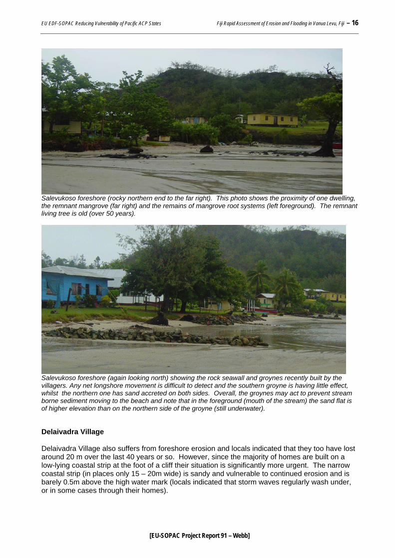
Salevukoso foreshore (rocky northern end to the far right). This photo shows the proximity of one dwelling, the remnant mangrove (far right) and the remains of mangrove root systems (left foreground). The remnant living tree is old (over 50 years).
Salevukoso foreshore (again looking north) showing the rock seawall and groynes recently built by the villagers. Any net longshore movement is difficult to detect and the southern groyne is having little effect, whilst the northern one has sand accreted on both sides. Overall, the groynes may act to prevent stream borne sediment moving to the beach and note that in the foreground (mouth of the stream) the sand flat is of higher elevation than on the northern side of the groyne (still underwater). Delaivadra Village Delaivadra Village also suffers from foreshore erosion and locals indicated that they too have lost around 20 m over the last 40 years or so. However, since the majority of homes are built on a low-lying coastal strip at the foot of a cliff their situation is significantly more urgent. The narrow coastal strip (in places only 15 – 20m wide) is sandy and vulnerable to continued erosion and is barely 0.5m above the high water mark (locals indicated that storm waves regularly wash under, or in some cases through their homes).

EU EDF-SOPAC Reducing Vulnerability of Pacific ACP States Fiji Rapid Assessment of Erosion and Flooding in Vanua Levu, Fiji – 17
[EU-SOPAC Project Report 91 – Webb]
Aerial photo (1994) showing Delaivadra Village – most dwellings are situated on a thin low-lying sandy strip between the reef flats and steep cliffs. A few buildings are located to the west (left) on a fairly steep hill side slope well above sealevel. Those on the coastal strip indicate that it is not unusual for waves to wash below there houses during storms and high water events.
Recently the villagers have made efforts to protect their shoreline by first building a riprap wall along the length of the soft foreshore (approximately 150m). This apparently failed to stop wave wash-over and subsequent erosion and the villagers removed the seawall and reassembled the rocks into several perpendicular groynes at 15 – 20m spacing’s (about 10m long x 0.5m high and stretching from the top of the active beach to the reef flat). At the time of our visit the villagers indicated that they felt the groynes were more successful in slowing erosion and had actually assisted to trap sand and rebuild the beach. It was not possible to conclusively confirm the success of the groynes or judge their long term potential to protect and rebuild the foreshore but at the time of this visit there was evidence of associated accretion (a pattern of net northward longshore transport was noted with greater accretion on the southern side of the groynes).
However, an important additional function of these structures has been to allow mangrove seedlings to become established within their protective rock matrix. Villagers were not aware of the potential benefits of establishing mangroves on this foreshore (or even over the groynes as they will eventually tie the rocks together preventing loss during storms). And they indicated that the mangrove seedlings (Rhizophora sp.) had simply washed into place and taken root within the rock groynes. There were also a large number of mangrove seedlings on the reef flats but these were either in very poor health or dead and it seems likely that the elevation of the reef flat is too low for successful mangrove seedling establishment. Alternatively, the increased elevation and physical protection of the rock groynes appears to provide and ideal environment for mangrove establishment.
N
200m
Erosive foreshore
Delaivadra Village
Low cliffs rocks
Low cliffs rocks
Small stream

EU EDF-SOPAC Reducing Vulnerability of Pacific ACP States Fiji Rapid Assessment of Erosion and Flooding in Vanua Levu, Fiji – 18
[EU-SOPAC Project Report 91 – Webb]
Delaivadra Village foreshore (looking south) showing the proximity of dwellings to the shoreline and the elevation of the sandy strip where the houses are built (around 0.5m above high water). The recently built (last 18 months) groynes can be seen crossing the active beach (at the time of study long shore transport was towards the camera [northwards]).
Typical groyne showing mangrove seedlings. Note that in the foreground the seedlings do not have leaves and neither do those further back – this graphically shows the importance of planting at the correct height and explains why seedlings on the reef flats fail. The groynes provide a gradient from high to low and the seedlings have naturally found their ideal height for establishment and growth. Some of the groynes further north do not have mangroves either because they are newer and missed out on the last wave of seedlings to move to this coast (presumably from the south) and it is highly recommended that seedlings be planted when they become available. Similarly, the importance of protecting and encouraging these mangroves should be carefully explained to the Delaivadra villagers.

EU EDF-SOPAC Reducing Vulnerability of Pacific ACP States Fiji Rapid Assessment of Erosion and Flooding in Vanua Levu, Fiji – 19
[EU-SOPAC Project Report 91 – Webb]
It seems the villagers have ingeniously (even if inadvertently) hit on an excellent strategy to assist in protecting their otherwise vulnerable and erosive soft foreshore (building the groynes and allowing the establishment of the mangrove). It would be worthwhile to encourage this strategy and ensure that the villagers understand the importance of not disturbing the mangroves and indeed planting and encouraging their growth. The long term benefits of establishing a mangrove fringe on this coast with a few narrow passes between the shore and reef flats (for boat access) are obvious and highly recommended.
Despite cautious optimism with regards to the actions of the Delaivadra Community to protect their foreshore, it must be remembered that all of the dwellings situated on the narrow coastal strip are in an innately vulnerable location since it is very low-lying and open to storms, wave surge, etc. Even if the community is successful in preventing (possibly even reversing) erosion their longer term vulnerability to sea level rise and the on going threat of large storms, will likely continue to cause flooding and hardship.
DISCUSSION/RECOMMENDATIONS Salevukoso Village
Salevukoso foreshore has without doubt eroded significantly and several structures may be at risk especially if the recently built seawall fails. Ultimately in order to develop the best erosion mitigation strategy the reason behind the erosion should be understood. Unfortunately, the rapid nature of this analysis can not conclusively identify why this coast is eroding. Climate change associated sealevel rise (and/or possible shift in weather patterns) may well play their part however, several other uninhabited beaches viewed during this trip did not appear to be eroding.
The presence of relict mangrove root systems and local knowledge confirming the gradual retreat of mangrove (at least in the northern part of Salevukoso foreshore) suggest that mangroves have been slowly cleared from this coast. Additionally, it is difficult to understand why mangrove should not form a continuous fringe in front of the village since dense healthy stands occur north and especially south of the village beach. It seems likely that human disturbance of the mangrove fringe started many years ago and once removed it was then difficult for mangrove to re-establish on this intensively trafficked beach. It should also be remembered that mangrove were once viewed in a negative light (especially by colonial authorities) and that the understanding of their importance in coastal protection may still not be fully appreciated in a village setting.
If we assume that mangrove has been progressively cleared from the village foreshore the scenario of ongoing erosion is easily explained, i.e. the soft foreshore has lost it’s protection. It is also instructive to note that a similar low-lying sandy foreshore extends in the south beyond the village and behind the mangroves. In this location the land obviously juts seaward by many meters indicating that the sandy foreshore in this location has not eroded because it remains protected by mangrove (see next photograph).
At the time of the visit the weather was calm and the seawall constructed by the Salevukoso Community adequately protected the foreshore from average spring tide conditions. It is not known how well the wall would stand up to cyclonic conditions but it is doubtful it would survive unscathed.

EU EDF-SOPAC Reducing Vulnerability of Pacific ACP States Fiji Rapid Assessment of Erosion and Flooding in Vanua Levu, Fiji – 20
[EU-SOPAC Project Report 91 – Webb]
This photo is taken south of the village (looking north) standing on the path between the extensive southern mangrove stand (to the right) and slope vegetation (to the left). Note this flat sandy area is analogous to what locals said once existed in front of their current foreshore (kids used to play football on the previous flat grassy area). It seems highly likely that ongoing erosion of the village shoreline is the result of having cleared that former protective mangrove fringe (and coastal vegetation) and the flat area in the foreground is a remnant which survives because it remains protected from wave impacts and erosion.
Options
1. Seawall – a seawall may be successful in halting shoreline erosion however, if a seawall approach is preferred by the community it’s design and height should the result of consideration by a qualified coastal engineer, taking into account CC projections.
• It is also possible that a correctly designed seawall will require the use of larger rock which would render the undertaking beyond the capacity of the village who have built the current structure by hand.
• A well designed seawall and it’s continued maintenance is likely to be prohibitively expensive and beyond the means of this small subsistence community.
2. Groyne building – the present groynes appear to produce mixed results and may even have a negative effect of directing sediment from the streams away from the central beach area.
3. Mangrove Planting – this is the preferred approach and once established they would restore the original protective barrier to this coast and prevent erosion.
• Mangrove would also provide better protection from storm waves.
• There are low establishment costs and they are self-sustaining once established.
• This work could be easily undertaken by the village community.
• The Delaivadra work provides an excellent example of how mangroves may be established on the beach.

EU EDF-SOPAC Reducing Vulnerability of Pacific ACP States Fiji Rapid Assessment of Erosion and Flooding in Vanua Levu, Fiji – 21
[EU-SOPAC Project Report 91 – Webb]
• Plant and protect shoreline vegetation (e.g. coconut, pandanua and other local appropriate species).
Delaivadra Village
Delaivadra Village presents a more urgent erosion issue since many houses are within a few metres of the shoreline. The reason for such chronic erosion at this site is difficult to determine as there is less evidence here of mangrove removal and no local memory of mangrove having fringed this beach. The southern reaches of the same beach (south of the stream) are uninhabited and it has dense shoreline vegetation (also mangrove free). This shore also had a small erosion scarp but appeared to align reasonably with the village foreshore. Unfortunately, people did not have a clear idea about how much erosion may have occurred in this southern undisturbed beach area and no indicators such as fallen trees, remnant root zones, etc, were seen at the time of the visit (possibly suggesting less erosion than at the village).
Again, CC related stresses especially increased sealevels may aggravate this erosion issue further and may already be playing a part. It is also likely that a combination of simple factors such as, clearance of shoreline vegetation and constant foot traffic and use of the village foreshore in combination with events like storms will combine to stress this environment. Additionally, there can be little doubt this is an innately fragile beach environment being low-lying and sandy and it must be recognised that such features can be both sensitive to disturbance and naturally dynamic, that is eroding and accreting with seasonal fluctuations.
Options
1. Seawall.
• Whilst the village experience with a seawall was not successful, it is probably the only option which could provide reliable protection both from erosion and flooding. However, only if the seawall was designed by a coastal engineer and built according to specification – in turn the cost would be way beyond the capacity of this village (as discussed earlier maintenance costs, etc. would also exist).
• A seawall would also need to be impervious (i.e. not allow seawater to seep through) since much of the village is extremely low-lying and would essentially sit bordered by a cliff and a seawall it would readily flood during cyclonic conditions (and in the longer term due to sealevel change). As such, even an adequately engineered seawall simply does not seem practical in this setting.
2. Continue with Groynes / Mangrove planting.
• Since there is little to be lost by continuing with the approach already started by the community it seems sensible to encourage this work, as if a mangrove fringe could be established along this coast it would have great benefits.
• Additional, rock “islands” could be constructed to further facilitate the establishment of mangroves and ultimately all of the these physical structures should assist to reduce wave energy and slow erosion.
• Once established mangrove could also assist in reducing the impact of storm waves through the village.
• Planting of shoreline vegetation should also be continued (e.g. coconut, pandanus and other appropriate local species).

EU EDF-SOPAC Reducing Vulnerability of Pacific ACP States Fiji Rapid Assessment of Erosion and Flooding in Vanua Levu, Fiji – 22
[EU-SOPAC Project Report 91 – Webb]
3. Relocation of vulnerable homes.
• The coastal defence measures discussed do not address the issue of flooding on this extremely low-lying area. Flooding will presumably become more frequent and ultimately relocation of homes to the western village slopes presents the most cost effective, safe and sustainable answer to the issue of coastal vulnerability in Delaivadra Village.
• This may be a gradual and planned process, moving those homes in the most threatened locations (proximity to the shoreline / low elevation) – prioritise locations.
• Like the Korotasere example, such a response will only work if appropriate home sites can be negotiated effectively within the community and a community approach to gradual relocation of homes would ease the individual burden of such an undertaking.
This photograph of a home in Delaivadra Village emphasises the low-lying nature of the land, the limited extent of this coastal strip (note cliffs immediately behind the house) and the proximity of the foreshore to this dwelling. Land rises less steeply to the north (right) of this location and there are large undeveloped areas which may have potential for home relocation.
As a final note, relocation may appear (to the outsider) an obvious choice and certainly in all of the locations visited, these Community’s appear to be extremely fortunate in that they have relocation options (i.e. higher undeveloped land suitable for settlement). However, this more technical, pragmatic view of these problems does not consider the less tangible issues of individual and community sense of place, home and belonging. When I asked people in Delaivadra and Korotasere Village why they hadn’t already moved their homes to more protected high sites (as experience would suggest these are innately vulnerable locations) they indicated that the main problem was not the lack of appropriate land (or even possibly the lack of labour – since the community could generally be relied on to “pull together” and assist). They simply

EU EDF-SOPAC Reducing Vulnerability of Pacific ACP States Fiji Rapid Assessment of Erosion and Flooding in Vanua Levu, Fiji – 23
[EU-SOPAC Project Report 91 – Webb]
indicated they had no desire to move and liked their home sites, irrespective of their vulnerability to flooding, erosion, etc.
This point deserves very careful consideration during PACE-SD’s planned community discussions and the reasons for suggesting relocation need to be sensitively and comprehensively explained.
REFERENCE
[Australia] Bureau of Meteorology, 2007: Tidal predictions for Fiji – Lautoka, March 2007. <www.bom.gov.au>
________________________________________