Estonian e-Cadastre, cadastral workbench overview for electronic proceedings Priit Kuus Estonian...
22
Estonian e- Cadastre, cadastral workbench overview for electronic proceedings Priit Kuus Estonian Land Board / Department of Land Cadastre May 13, 2015
-
Upload
mavis-owens -
Category
Documents
-
view
230 -
download
0
Transcript of Estonian e-Cadastre, cadastral workbench overview for electronic proceedings Priit Kuus Estonian...

Estonian e-Cadastre, cadastral workbench overview for electronic proceedingsPriit KuusEstonian Land Board / Department of Land Cadastre
May 13, 2015
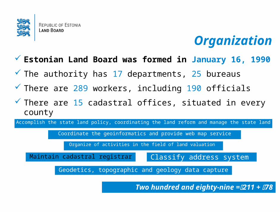
Organization Estonian Land Board was formed in January 16, 1990
The authority has 17 departments, 25 bureaus
There are 289 workers, including 190 officials
There are 15 cadastral offices, situated in every county
Two hundred and eighty-nine =211 + 78
Accomplish the state land policy, coordinating the land reform and manage the state land
Coordinate the geoinformatics and provide web map service
Geodetics, topographic and geology data capture
Organize of activities in the field of land valuation
Classify address system Maintain cadastral registrar
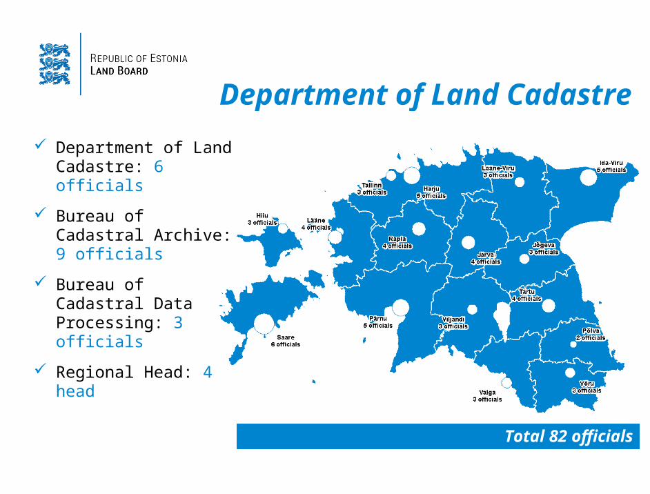
Department of Land Cadastre
Total 82 officials
Department of Land Cadastre: 6 officials
Bureau of Cadastral Archive: 9 officials
Bureau of Cadastral Data Processing: 3 officials
Regional Head: 4 head

Scope of data
Cadastral parcels (as of April 2015)
653 696 cadastral parcels, i.e. 96,8 % of Estonian land is registered in the cadastre
Over 697 000 items in the cadastral archive – of them about 2/3 are partially scanned
Objects causing restrictions and zones of restrictions
Over 59 000 km² of area objects (e.g. protected area, mineral deposit, etc)
Over 142 000 km of line objects (e.g. lines, roads, etc)
Over 123 000 of point objects (e.g. single objects of nature or heritage conservation)
Administrative boundaries
15 County; 213 Municipality; 4671 Settlement area
Estonian Republic
Area: 45 227 km²
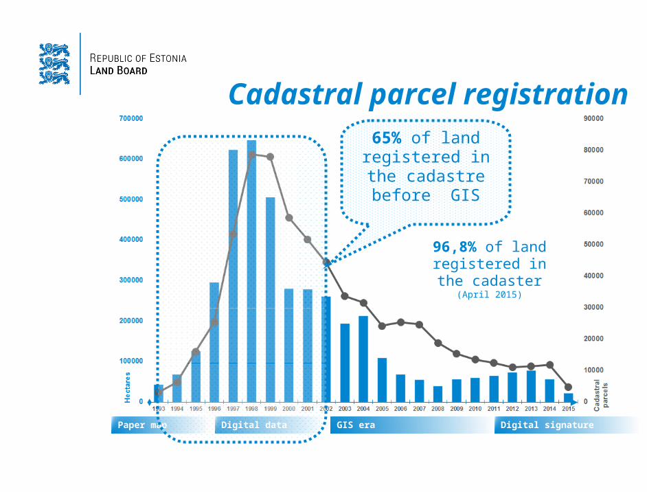
Cadastral parcel registration
Paper map Digital data GIS era Digital signature
96,8% of land registered in the cadaster (April 2015)
65% of land registered in the cadastre before
GIS

e-Cadastre software development
In October 2012 public procurement was declared to buy software development for electronic land cadaster and digital cadaster archive
The public procurement won by Estonian IT company Datel www.datel.ee
At the beginning of 2013 the development process started
Objective: paper-free proceedings and
cadastral data integration to other state GIS

e-Cadastre functional specifications
Managing cadastral data must be used open-sourced expandable software based on baseline security system (Estonian ISKE standard)
Identifying clients based on ID-card or Mobile-ID and able to store digital signatures
All cadastral procedures are paper-free and based on digital files
Ready for 3D spatial data storing and representation
Digital archive are able to store full cycles digital life of electronic documentsUser friendly and customizable settings

e-Cadastre workbench
Virtual office, created for surveyors to manage their surveying files and submit a data to the cadaster
Procedure module, created for cadastral registrar to controlling received data and register cadastral proceedings
Map, created for surveyors and cadastral registrar map proceedings
Digital archive, created for managing all cadastral digital files
Statistical module, created for managing cadastral data statistics and observing proceedings
Administration module, created for managing user rights and software settings All in one interface solution
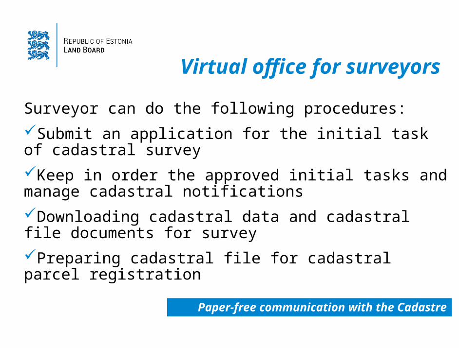
Virtual office for surveyors
Surveyor can do the following procedures:
Submit an application for the initial task of cadastral survey
Keep in order the approved initial tasks and manage cadastral notifications
Downloading cadastral data and cadastral file documents for survey
Preparing cadastral file for cadastral parcel registration
Paper-free communication with the Cadastre

Virtual office for surveyors
Notification and communication panel
Notification and communication panel
Rejected initial tasksRejected initial tasks
Approved initial tasks
Approved initial tasks
Drawing the initial task area
Drawing the initial task area
Managing spatial data
Managing spatial data
Sending digitale file to registration
Sending digitale file to registration

Cadastral procedure module
Cadastral registrant official can do the following procedures:
Manage and approve submitted initial tasks for cadastral survey
Examine cadastral file documents and data for cadastral parcel registration
Reject documents and data for registration and issue an order for corrections
Arrange cadastral data full inspection and prepare inspection report
Pre prepared inspection tools

Cadastral procedure module
Starting registration procedure
Starting registration procedure
Step by step all activities
Step by step all activities
Verify spatial data on map
Verify spatial data on map
Inspecting survey data
Inspecting survey data
All procedure activities are logged
All procedure activities are logged
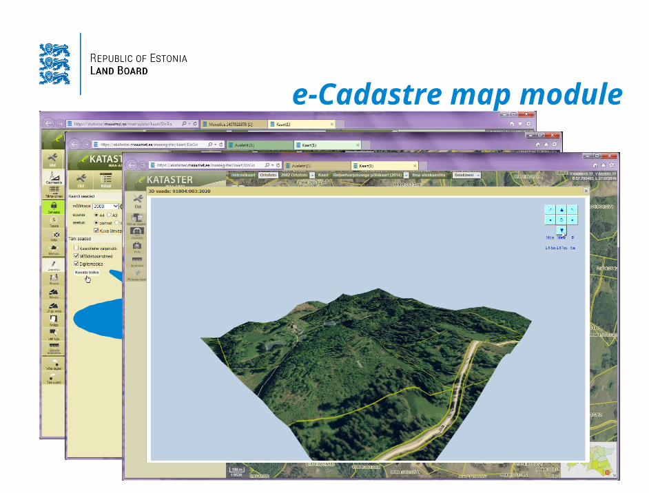
e-Cadastre map module
Map view Includes all web map services developed in Land Board
Have common task spatial redactor for manipulating cadastral spatial data (for surveyors and cadastral officials)
Have main topologic rules for spatial inspection
Displays cadastral data timeline based on registration versions
Have able to explore cadastral view in 3D visualization
Allow preparing all kind of scaled print outs and attach them with digital stamp
Map module uses HTML5 core technology
e-Cadastre map module
Main spatial data editing functionsMain spatial data editing functions
Adding digital stamp to scaled layout
Adding digital stamp to scaled layout

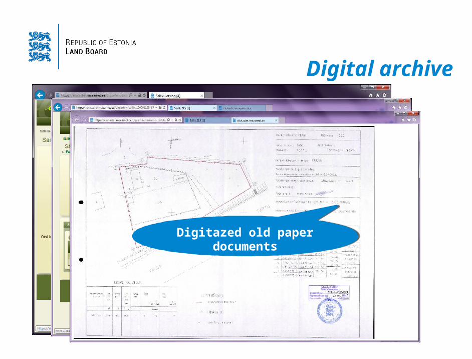
Digital archive
Main tool for digitizing old cadastral files and manage descriptions for accessible information
Able to store electronic documents during proceedings and creating linkages between cadastral unit data automatically
Have tool for managing lending’s for paper original documents
Includes sophisticated search engine for all kind of archive documents
All files can attached with digital stamp
Digital archive
Clever search engine for archive files
Clever search engine for archive files
Classified archive files
Classified archive files
Digitazed old paper documents
Digitazed old paper documents
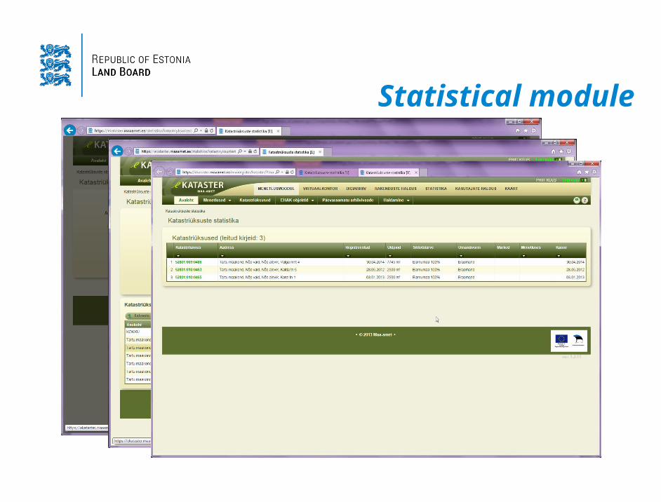
Statistical module
There are five main statistics functions:
Cadastral parcel statistics; Archival document statistics; Proceedings statistics; Survey file statistics; Initial task statistics
The user can store, publish inquiries and export data in csv
All statistical results have linkage to main data what were in the query
Arrange your own „group by“
Statistical module
Customizable inquiry conditions
Customizable inquiry conditions
Linkable result to source data
Linkable result to source data

Administration module
e-Cadastre administrator can manage:
Software options like data classifications and auto-text for documents
Adding and designing Web Map services and Web Feature services for map
Create user profiles for different proceedings and manage user rights
Manage surveyor certificates
Monitor e-Catastre usage and software notificationsAll changes are logged

Administration module
Map layers management (WMS
WFS)
Map layers management (WMS
WFS)
Auto-text rules for documents
Auto-text rules for documents Manage
transformation parameters
Manage transformation
parameters

Thank you!Priit [email protected]