Estimating Oil Reserves: History and Methods -...
25
7 Estimating Oil Reserves: History and Methods Nuno Luis Madureira ISCTE-IUL, CEHC Portugal 1. Introduction When human societies became aware that an increasing proportion of their power, heat and light were produced from fossil fuels and that fossil fuels were an exhaustible resource, there was no way back to the pre-industrial world. Drawing on the history and methodologies of estimating petroleum reserves this chapter explains how geologists, politicians, engineers, managers and the public at large have come to perceive the finite nature of energy sources. On the technical side, the need to assess petroleum reserves fostered scientific advances in the domain of the stratigraphic study of rock reservoirs, in terms of the geological understanding of petroleum origins and formation, in the domain of statistical forecasting based on data from producing wells as well as in geophysical measurements. However, the path from measurement technique capacities towards a set of final aggregate figures proved anything but linear. From the outset, the estimation of reserves took place within the framework of a web of political stances, business and social interests and economic organizational realities. What sway did these forces hold over the course of events? What came to determine the core choices about the classification of reserves and the assessments of undiscovered petroleum? Furthermore, how relevant did the contribution of science and technology prove? To answer these questions the ensuing pages sketch the state of the art in geological surveying at the dawn of the twentieth century before examining the technology available for oil discovery and closing with a comparative view of the institutional scenario prevailing over the classification of oil reserves. 2. Volumetric methods and statistical methods: The first oil survey The completion of the first oil survey unleashed generalized fears of imminent depletion in the United States (U.S.). Much in line with what had previously happened with coal surveys in Britain, key advances in the knowledge on fossil fuel stocks spread alarm about the finiteness of non-renewable resources. As early as 1909, Americans realized that oil wells might rapidly dry up and all the more so when the boom in automobiles could only worsen the situation. 2.1.1 Volumetric methods and statistical methods The first national estimate of oil resources was commissioned from the U.S. Geological survey and integrated into the national inventory of mineral wealth conducted under the www.intechopen.com
Transcript of Estimating Oil Reserves: History and Methods -...
7
Estimating Oil Reserves: History and Methods
Nuno Luis Madureira ISCTE-IUL, CEHC
Portugal
1. Introduction
When human societies became aware that an increasing proportion of their power, heat and light were produced from fossil fuels and that fossil fuels were an exhaustible resource, there was no way back to the pre-industrial world. Drawing on the history and methodologies of estimating petroleum reserves this chapter explains how geologists, politicians, engineers, managers and the public at large have come to perceive the finite nature of energy sources.
On the technical side, the need to assess petroleum reserves fostered scientific advances in the domain of the stratigraphic study of rock reservoirs, in terms of the geological understanding of petroleum origins and formation, in the domain of statistical forecasting based on data from producing wells as well as in geophysical measurements. However, the path from measurement technique capacities towards a set of final aggregate figures proved anything but linear. From the outset, the estimation of reserves took place within the framework of a web of political stances, business and social interests and economic organizational realities. What sway did these forces hold over the course of events? What came to determine the core choices about the classification of reserves and the assessments of undiscovered petroleum? Furthermore, how relevant did the contribution of science and technology prove? To answer these questions the ensuing pages sketch the state of the art in geological surveying at the dawn of the twentieth century before examining the technology available for oil discovery and closing with a comparative view of the institutional scenario prevailing over the classification of oil reserves.
2. Volumetric methods and statistical methods: The first oil survey
The completion of the first oil survey unleashed generalized fears of imminent depletion in the United States (U.S.). Much in line with what had previously happened with coal surveys in Britain, key advances in the knowledge on fossil fuel stocks spread alarm about the finiteness of non-renewable resources. As early as 1909, Americans realized that oil wells might rapidly dry up and all the more so when the boom in automobiles could only worsen the situation.
2.1.1 Volumetric methods and statistical methods
The first national estimate of oil resources was commissioned from the U.S. Geological survey and integrated into the national inventory of mineral wealth conducted under the
www.intechopen.com
Fossil Fuel and the Environment
144
supervision of a new National Conservation Commission, chaired by the head of forestry Gifford Pinchot. The call for a systematic inventory of America’s mineral wealth bore President Theodore Roosevelt’s personal stamp and thus proved both a scientific project and a political venture. For the U.S. Geological Survey, as an institution, this represented an enormous challenge as oil expertise was concentrated in regional field-surveys and there were no means available to undertake extensive and accurate estimations on a national scale. To overcome tight deadlines and surmount the practical difficulties, the geologist in charge, David T. Day was compelled to resort to indirect forecasting methods that took advantage of the undisputed achievements of geological knowledge. One such undisputed area was the study of oil reservoirs as traps. By the time of this national survey, it had effectively become clear that petroleum needed a particular “trap configuration” to exist. This trap was made up of:
1. a source rock of shale or limestone where a type of organic matter that gives rise to petroleum could once have been deposited;
2. a layer or formation of rock, generally a sandstone or a limestone, both porous and permeable to allow for the formation of a reservoir in the pore spaces, cavities or fissures;
3. a cap rock or “cover”, commonly a strata of shales, clays or marls, located above the reservoir to retain the petroleum and block any possible surface outflow;
4. a structural fault in the strata or a geological “unconformity” through which the reservoir was sealed while in this fold trap “gravitational factors” would impel oil to rise above water and gas to rise above oil.
In spite of this common ground, experts did not completely agree on issues including the origin of petroleum (point 1) or the theory of oil accumulation (point 2). Whilst some geologists, for instance, maintained that the oil and gas found in a porous reservoir originated somewhere in that reservoir, others claimed that most oil found its way there from beyond the reservoir’s own extent (Johnson & Huntley, 1916). Nevertheless, irrespective of these differences, the trap-configuration approach was solid enough to ensure the understanding that each reservoir enclosed a measurable space from which a commercially relevant amount of oil could be drawn. This enabled the oil reserves in place to be statistically inferred from the analysis of volumetric parameters.
David T. Day resorted to the volumetric method in regions where no other accurate information was available. In order to complete the survey’s blanks, he made a simplified calculation based on the average porosity of oil-bearing sands and the amount of crude oil obtained per cubic foot of pay sands. He then extrapolated this cubic foot gauge into a rough forecast of entire oil-pools and applied a value for the recovery factor, setting a ratio between the total oil found underground and the oil that could actually be raised to the surface under the technical conditions prevailing. Curiously, the volumetric method came to be tested on the regions David Day knew best from previous geological field work: Pennsylvania, New York, West Virginia, Kentucky, Tennessee, Ohio, and Indiana (Day, 1909).
The process turned out rather differently when the geologist gained access to primary sources containing oil-well production statistics. In this case, the future recovery could be estimated from the past yield, since the record of the actual output of a well was interpreted as an index to the quantity of recoverable oil. Texas, Louisiana, Oklahoma and California were the regions selected to apply this method of statistical forecasting. Actually, the
www.intechopen.com

Estimating Oil Reserves: History and Methods
145
method was very simple and dubbed the “per cent decline curve”. As its very name indicates, the per cent graph depicted the decline in the production of a well, of a property, or an oil-field by expressing each year’s production as a percentage of the first year of output. Under the assumption that nearby wells will return similar “curves”, the amount of ultimately recovered oil could be estimated for entire oil-pools.
Barely on the radar before the assessment undertaken by the U.S. Geological Survey, the “per cent decline curve” subsequently rose to prominence largely on account of its simplicity and utility, particularly for commercial and financial transactions. In one fell swoop, something that was designed with a view to guiding public policy became a decentralized instrument for private calculus applied to such diverse facets as assessing the rate of return on capital; evaluating the amount a company might afford to pay for the rights to a certain oil-land; future property values; and the distribution of quotas or taxes among producers (Requa, 1918; Beal, 1919: 80-89).
Pressed by the political agenda and the deadlines set by the Conservation Commission, the U.S. Geological Survey had to come up with a solution able to transpose the expertise held by regional oil-pool surveys into a national forecast. The mixed bag strategy of resorting in some circumstances to the volumetric approach and in others to the cutting-edge approach of production history statistics became the means of circumventing the practical difficulties.
The final figures portrayed bleak prospects for the future. David Day’s assessment pointed to 10 to 24 billion barrels of oil left underground, with a general estimation of 15 billion recoverable barrels of oil (15 X 109). This would last for a minimum of 80 years should the 1909 consumption level be somehow stabilized or less than 25 years should the recent upward trend continue (Day, 1909). In short, oil might be about to end quite suddenly.
Although the author recognized the conjectural and indirect nature of the assessment, this did not prevent him from proposing clear-cut policies. For David Day, it was the federal government’s responsibility to divert oil from power stations, railways, automobile drivers and exports and channel its usage to vital needs like lubrication and the military for which there were no substitutes. “Waste” was the produce of erroneous choices stirred by market prices, abundant resources and unsuitable lifestyles (Day, 1909). In this vein, depletion ceased to be a demand-side problem like that of uncontrolled wood-cutting in forests and became a moral and social question, a true challenge to citizenship impacting on the everyday life of Americans living off perceivably unsustainable resources. With depletion looming in the next quarter century, mechanisms other than price and individual choice in the allocation of resources seemed all the more justified. Moreover, the case of oil provided the ultimate confirmation of conservationist warnings as it demonstrated that those who had buttressed the moral, patriotic, democratic and ecological character of natural resources had been right all along.
2.1.2 Forest conservation and oil conservation
Much like a cause that becomes part of its effects, the conservationist administration of Theodore Roosevelt campaigned for an inventory of American mineral wealth, whose conclusions only underscored the need for conservation. Not only did the conclusions agree with the premises but the conclusions were, to a certain extent, also part of the premises. Identified by the catch-phrase “progressivism”, Roosevelt’s presidency (1901-1909)
www.intechopen.com
Fossil Fuel and the Environment
146
prompted a period of soul searching for an American identity deeply rooted in the President’s personal fondness for the “true” American values and way of life such as the open country, breathtaking scenery, the wild and everything associated with the outdoor life: hunting, fishing, horse riding and wood-chopping. The great and fair America envisioned by progressivism required an active stance at the federal level on environmental issues, sometimes stretching presidential powers well beyond the limits set by the constitution (Cooper, 1990). Roosevelt’s personal inclinations were further reshaped by increasingly closer contact with the Forest Bureau Director, Gifford Pinchot, appointed to advise Roosevelt on forestry matters. However, the mutual friendship and admiration that ensued brought Pinchot into the inner circle of the White House, making him into one of the most influential advisers on political questions with a say over all the critical points on the presidential agenda (Steen, 2001: 133-141). Pinchot’s political weight meant the conservation policy became attuned to a commercially oriented perspective based on competitive bidding, the regulation of big business and a call for citizenship. The very language of foresters, with their emphasis on “repairing” forests destroyed by settlers or “restoring” virgin lands, had clear affinities with Roosevelt’s message of “regeneration”. Culturally, both stressed a return to America’s roots. In accordance with key principles such as generational responsibility, social justice and industrial liberty, the government claimed natural resources should be handed back to the average citizen. In Roosevelt’s words, the function of “Government is to ensure to all its citizens, now and hereafter, their rights to life, liberty, and the pursuit of happiness. If we of this generation destroy the resources from which our children would otherwise derive their livelihood, we reduce the capacity of our land to support a population and degrade the standard of living“(Roosevelt, 1909: 3). Emboldened by the idea of change and reform, the Federal state pushed the institutions designed for the conservation of natural resources to the forefront of national policy and into the headlines of the press.
With the President’s second term drawing to an end and the survey’s discovery that oil would run out in 25 years, the eyes of the administration fastened on petroleum with enhanced drama and urgency. Whereas forest conservation had been the hallmark of Theodore Roosevelt’s time in office, oil conservation would prove its legacy. Continuity meant that much of the oil related public policy was outlined by the agenda, the knowledge and the legal instruments previously applied to forestry. Furthermore, this also meant that oil geologists, after the foresters, joined the rank and file in the protection of national resources in siding with the Federal State. It is important to note that progressivism consolidated a group of highly trained and qualified civil servants imbued with a sense of mission and whose careers depended on the ability to wield preservation as a key political issue for public opinion. The very program of American regeneration was anchored on a powerful social network of university friendships and further cemented through highly personalized and faithful administrative bureaucracies (Schulman, 2005). Because corporate actions were sometimes “illegitimate”, “under cover” and lacking in “industrial democracy”, they ought to be counteracted by equidistant public powers exercised by leading experts in transportation, agriculture, geology, utilities and public health (Miller, 2009). The best antidote to “the relentless exercise of unregulated control of the means of production” was joint action by government, scientific expertise and citizenship. This triple alliance formed the core message of progressivism. Indeed, the Director of the U.S. Geological Service had no
www.intechopen.com
Estimating Oil Reserves: History and Methods
147
problems in putting this down in black and white: “I have come to think of geology more as a phase of citizenship than as merely a branch of science” (Smith, 1920).
Once the case of impending depletion spilled over into public opinion and the “oil fraternity” at large, two areas of federal and state intervention surfaced with paramount urgency: one was precautionary action so as to guarantee the fundamentals of national security; the other involved rationalizing measures to tackle all sources of waste and find means to economize on oil consumption. On both fronts, petroleum geologists filled an important role by placing themselves as interpreters of the national interest. Unsurprisingly, the very first measures devised to face possible exhaustion mirrored the very same that had been applied in forest conservation. Security concerns prompted a strong position over oil-land ownership with rationalization efforts triggering a debate over tighter regulation. Globally, the 1909 oil survey proved instrumental in tilting the balance of power towards the “permanent public good” and against the “merely temporary private gain” (Roosevelt, 1909:4).
2.1.3 Shortage fears, precautionary action and regulation
The idea of ring-fencing strategic natural resources away from commercial usage by placing them under the management of the federal state had been enacted by the Amendment to the Land Revision Act of 1891. Though this, the U.S. Senate recognized the President’s authority to establish forest reserves by proclamation, leading to the constitution of a non-market sector removed from lands that would otherwise be available. However, it was only during Theodore Roosevelt’s presidency that the purchase of Western and even Eastern lands shot up and leading to the founding of a Federal reserve of 150.8 million acres embracing 159 forests and extending over 27% of the U.S. forested extent (Hays, 1959; Brown, 1919:3-7). Nevertheless, the more Roosevelt’s policy moved towards public ownership, the more Congress responded with hostility towards conservation and bowed to local commercial pressures for quicker private sector exploitation. The clash came to a head in 1907 when Congress forbade the creation of more forest reserves in Western states in arguing that the creation of public property and environmental concerns were just a means to expand presidential authority (Penick, 1968).
Under these circumstances, it would be mightily hard to transpose the recipe for public forest ownership onto the oil realm. All the more so when the geological warning about forthcoming depletion was clearly offset by the intuitive evidence of prices, driven down to an average of $70 cents for the 42-gallon barrel (Williamson, 1968:38-39). Inasmuch as the current evidence ran counter to the geological forecast, there was a kind of pathological split in public opinion. However, against all odds, a small but influential group of oil geologists backed by the director of the U.S. Geological Service, George Otis Smith, was able to circumvent opposition and carve a federal oil reserve through the withdrawal of Californian public lands, and their subsequent conversion to supply the navy. Working behind the scenes and taking advantage of consolidated intra-governmental networks, geologists were able to seize the opportunity that came about in California, firstly by withdrawing prime oil land from the agricultural register, and then by switching its usage to public property. As a result, in September 1909, roughly three million acres of oil-rich lands became the future Naval Petroleum Reserves (Shulman, 2003). This pro-active course of events was particularly significant because when the breakthrough decision was made, the Navy
www.intechopen.com
Fossil Fuel and the Environment
148
remained undecided over which battle ship types should be fully converted to fuel oil. Equally, the usurpation of private ownership arrayed the opposition of the most significant sectors of the petroleum industry (Olien & Olien, 1993:49-50).
Aside from the shift in natural resource property rights, the first oil survey also set in motion unprecedented appeals for regulation, on behalf of saving the threatened liquid fossil fuel reserves. Geologists and public authorities repeatedly asserted that consumption should be constrained. This was particularly true in the righteous domain of automobile driving, which should be restricted to unavoidable work-related activities such as making deliveries, transporting doctors, transporting children, guaranteeing public order and easing the life of isolated farmers. Beyond this array of utilitarian functions stood nothing less than the hedonistic usage of cars “for pleasure”, a social behavior increasingly targeted not only by conservationist writings but also by articles published in specialist magazines like “Motor”, “The Motor Age” or the “Oil & Gas Journal”. As the chief geologist of the U.S. Geological Service put it in an interview that addressed the danger of exhaustion: “the use of pleasure cars is growing beyond comprehension” (White, 1919; see also McCarthy, 2001).
More telling was the attempt to regulate the industry from the supply side, where sizable wastes were deemed to occur. Scarcity implied the rationalization of exploration. By the close of the nineteenth century, experts in scientific forestry had discovered the potential clash between the needs of common management of natural resources and the economic system of separate ownership and private appropriation. The discovery of the problem of ecological commonalities (indivisibility, interdependency, sustainability) had the effect of pushing the state into previously excluded areas asserting the importance of expert knowledge, norms and regulations. In fact, it might be said that the ascension of professional scientific groups came with the territory.
Although the oil industry long knew about the tremendous waste involved in legendary oil rushes and town-lot developments like the Sindletop oil-field of Texas or the Breman oil-field of Ohio, the explanation for the harmful outcome boiled down to the reckless behavior of adventurers, real-estate speculators and wildcatters. It was only by the close of the First World War that the issue of waste came to be perceived less in terms of economic greed and more in terms of the geologic preservation of reservoir indivisibility, interdependency and sustainability. What transformed the reservoir into an ecological commonality was the understanding of the bond between gas pressure and oil recovery: since the pressure of gas forced oil out of the rocks into the wells, pressure turns into a matter of great economic interest. One of the most influential manuals on oil geology summed up petroleum extraction as a two-step process in which the bore becomes gradually filled with oil, accumulating gas below, until the pressure is sufficient to cause the oil to overflow. Then, as the oil flows to the casing head, pressure is relieved allowing the gas to expand suddenly and to rise up the column with force (Emmons, 1921:184). Doubts still remained as to whether any increase in temperature, in accordance with the deeper burial of organic sediments, would linearly accelerate the process of gas formation leading to an overall increase in pressure. As a general principle, it was accepted that deeper reservoirs would return higher pressures; but geologists also pointed out, cautiously, that "rock pressure" was driven by an array of factors that acted over time: hydrostatic pressure; weight of superincumbent strata; rock movements; deep-seated thermal conditions; long-continued formation of natural gases; and the resistance to fluid
www.intechopen.com
Estimating Oil Reserves: History and Methods
149
movements through the strata. (Mills & Wells, 1919: 30). This would later be summed up in the principle that the level of maturation of the organic matter, through which lighter gas hydrocarbons are generated (methane, ethane, propane, butanes), increases exponentially with temperature and linearly over time.
In addition to natural conditions, human-made intervention plays no less a role in the reservoir pressure level. It was particularly the spacing of wells and the pace of oil extraction that captured the attention of geologists and public authorities. Industrial practices once tolerated henceforth came under close scrutiny (Requa, 1918). The threat of depletion and the harbingered scarcity brought into the spotlight practices like allowing gas to issue freely from open wells or gas flaring, which both contributed to abnormal decreases in reservoir pressure, and subsequently forbidden in several states. The legal framework for property rights known as the “rule of capture” was also criticized as a source of waste. Applied to oil fields, the rule of capture meant the owners of land atop a common pool could take as much oil as they wanted even when unduly draining the pool and reducing the output of nearby wells. This process meant everyone was in harsh competition to extract as much and as swiftly as they could. The ensuing haste and dense well spacing led to a steady drop in reservoir pressure with an inherent reduction in the volume of oil able to be brought to the surface during the exploration life-cycle. Contemporaries estimated that as much as half of the petroleum in U.S. reservoirs remained underground after the fields ceased to yield. This value was later corrected to between 75% and 65% and finally settling on 60%, and interpreted as a regrettable dissipation of national resources. (Emmons, 1921:184; McLaughin,1939:127; Schurr & Netschert, 1977:357-358). Ultimately, the amount of oil reserves could grow simply by improving the oil-recovery factor. However, to achieve this goal, production had to be more efficient, more science based and more regulated.
Stirred by eager conservationist exposés, petroleum shortage forecasts made good copy in popular periodicals and provided appealing headlines. Soon, the basic principles of conservation made their way into Oklahoma state through the institution of pro-rationing among the wells, control over storage and transportation facilities and restrictions over the subsurface waste that caused pressure depletion (1913 and 1915, albeit with few practical consequences). Later on, Texas and Kansas followed in the footsteps of the Oklahoma regulations. With American participation in World War I, conservationism was temporarily diverted from its inward regulatory drive and oriented towards government-business cooperation. The rapprochement stems from the idea that U.S. shortages would have to be met by acquiring foreign oil lands and by taking a more aggressive stance in support of corporate interests abroad (Nordhauser, 1979; Clark, 1987).
To conclude this section, the first oil survey was framed by the necessity to present data on the conservation of natural resources so that the final figures released matched the pattern of a readily quantifiable total. Owing to the usage of expedient methodologies, tested in scattered oil-pools, inferences from volumetric parameters and inferences from historical record of production were aggregated into national forecasts. In this manner, the amount determined, 15 billion oil barrels left in “reserve” represented a menace to the future. Geologists looked at the glass as if half empty rather than half full. It suffices to point out that if the amount accrued by new discoveries (plus revision of the previously found and now recoverable petroleum), exceeded the amount of oil extracted from
www.intechopen.com
Fossil Fuel and the Environment
150
existing fields, the results would have shown a net increase in the volume of reserves. Indeed, as long as this situation lasted, the deadline for depletion would be extended rather than shortened. It was precisely this type of knowledge deriving from the business dynamic of discovery-exhaustion-new discovery that the 1909 geological survey failed to take into account (Olien & Olien, 1993).
Important as this logical viewpoint may be, the fact is the rate of discovery did slow considerably just after the survey’s publication. The 1910s was a decade of “dry” wells, rising prices and new discoveries falling short of replacement needs. National Petroleum News, the journal of the independent oilmen, reported in 1913 that “during the past years the prospector has gone over the country with the drill, selecting the most favorable locations, and has not in a single instance been rewarded with a barrel of commercial oil, outside of what is generally accepted as the proven area” (Dunham,1913). Because compensation for growing demand barely occurred, the balance between withdrawals and additions to petroleum reserves moved the countdown of the time elapsing until exhaustion from 17 years (1918-1919 surveys), 13-15 years (1921-1922 surveys) and 6-10 years (1923-1925 surveys) (McLaughin,1939: 128-129; Clark, 1987:148).
This course of events definitely leaned towards the interests and the views of conservationists and geologists.
2.2 Oil discovery: Surface indicators and geophysical surveys
The first concept of oil reserves closely embraced the amounts of oil available in tapped reservoirs. Forecasting techniques like the volumetric and historical-statistical methods required that some successful drilling had already been carried out. In this sense, reserves resulted in ex-post measurements, with geologists tracking a path previously opened by wildcatters and oil-companies. Considering the epochal criteria, two omissions stand out as particularly relevant:
- The first is the failure to account for enhanced recovery practices implemented in pools that had long since passed their maturity, such as New York and Pennsylvania. In these regions, continued production was maintained chiefly by cleaning and deepening old wells or by obtaining oil from shallow sands which had been were thought too insignificant when the wells were first drilled (Bacon & Hamor, 1916:69). Thanks to these recovery methods, new oil from exhausted fields could be added to the reserves. While only small amounts were at stake in 1910s, the importance of enhanced recovery methods (ERH) would attain new heights in the 1920s with the injection of gas, the injection of compressed air and flooding water flooding into reservoirs on the verge of exhaustion (Miller & Lindsly, 1934). Fostered by a string of technological improvements, recovery techniques rebounded again in the 1950s and 1960s with steam injection, the injection of water-solutions with polymers, surfactants or caustic chemicals, in situ combustion and electric hydraulic shocks.
- The second was the omission of prospective and untapped reserves. To put the 1909 oil-survey into perspective, it is worth recalling that for nearly 50 years geological coal surveys had followed the practice of ascertaining the recoverable coal left behind in pits plus assessment of seams with “hidden coal”. Referred to as existent, probable and possible reserves, this assessment was quantitative in nature (Madureira, 2012).
www.intechopen.com
Estimating Oil Reserves: History and Methods
151
Insofar as oil reserves were equated as fixed assets, the depletion of reservoirs could somehow be thought of as the depletion of a non-renewable forest. The geological survey thus became a contentious issue that carved a trench between the business view of a drifting amount determined by new discoveries and the official view of a fixed amount determined by the already confirmed oil reservoirs. Hence, the stage was set for a public confrontation between those who claimed “a petroleum famine is imminent” and those who countervailed with “there will always be enough petroleum to meet demand” (Garfias & Whetsel, 1936:213).
Henceforth, the surveys were clouded by the suspicion that the conservative nature of the forecasts set the tone for those who argued in favor of government interference through regulation, pro-rationing, production controls, waste-disposal or even – the rumors persisted - partial nationalization. In an attempt to calm these troubled waters, in 1922 the U.S. Geological Survey (USGS) mobilized ten geologists representing the American Association of Petroleum Geologists and six from the USGS for a comprehensive and accurate study aimed at once and for all stemming the controversies and bringing the debate back to indisputably geological grounds. For the first time, the distinction between known fields and undiscovered reservoirs was acknowledged. The oilman’s view of exhaustion-discovery cycles was translated into probabilistic categorizations that accounted for “prospective” and “possible” oil. The concluding estimate identified 5 billion (5 x10⁹) barrels of crude “in sight” and an additional 4 billion barrels as “prospective” and “possible”. The former was judged “reasonably reliable” with the latter deemed absolutely “speculative and hazardous”. In the end, neither the enhanced accuracy of petroleum in sight nor the acknowledgment of “speculative” discoveries reassured the industry. On the contrary, the enduring politicization of the geological survey opened the door to the institutionalization of competing reports on petroleum reserves sponsored by the government, by specialized reviews (Oil & Gas Journal, Oil Weekly), and by the American Petroleum Institute business association. From 1922 onwards, this pluralism of estimates became the rule: each vested interest, each major institution produced its own forecasts. Maybe the surprising issue in this evolution towards customized surveys is that there were hardly any discrepancies in the final figures of proven reserves, although that did not halt public and private bickering between institutions (Dennis, 1985).
The crux of the matter was naturally the amount of oil still undiscovered. In this regard, the uncertainty could hardly be solved. There were bold stands on the subject but little means to figure out a reasonable and acceptable forecast. As regards finding oil, geological knowledge had limited utility: it could forecast where oil was not supposed to be found (for instance in rocks dating from the Jurassic, Permian and Silurian Eras) and it could provide some advice on defining areas worth exploring (areas of extensive limestone dolomization, salt domes or beds of porous sandstone lying within shales) (Johnson & Huntley, 1916; Bacon & Hamor, 1916). Nevertheless, the only way to be certain about oil reserves was to drill; as an experienced field-worker reported: “geologists have gone deeply into the matter and in a way seem to be able to select oil producing territory. But they are not infallible. A hole in the ground seems to be the only sure test” (Horlacher, 1929:24).
Up to the First World War, all geological knowledge was in fact exclusively based on surface indicators providing a vague clue as to the location of underground reservoirs. Throughout the U.S., the most reliable signal for the oil prospector was the localization of natural eruptions
www.intechopen.com
Fossil Fuel and the Environment
152
like oil seepages or springs, natural gas springs, outcrops of sands impregnated with petroleum or bitumen, bituminous dikes and bituminous lakes. These “eruptions” were the first feature to look for as they demonstrated that at least some oil existed in the vicinity and was able to migrate to the surface. Other sedimentary formations such as sands, sandstones, shales and limestones were also potential, though less certain, clues. For field-working American geologists, this hint was nonetheless of limited relevance since the few unveiled seepages were quickly drilled by wildcatters. On the contrary, seepage search did prove very productive in countries like Mexico and Azerbaijan- Russia where oil and gas leaked copiously from source rocks. So abundant was this type of primary surface indicators that the methodology for the second comprehensive Mexican oil survey relied chiefly on inventorying “chapopoteras” (seepages) scattered all over the country, and complemented by a geological description of the underlying sedimentary rock structure (Villarello, 1908). Before the 1910 revolution, the country had consolidated a hub of national oil geology expertise centered in the “small but highly respected organization” of the Instituto Geológico de Mexico, which kept in close contact with their North American colleagues (Owen, 1975: 246-256). In Azerbaijan, on the other hand, far-reaching seepages made the tapping of oil from surface wells a remunerative business for local tribes and an ecological nightmare once every amateur, adventurer and speculator began drilling at random during the oil rush of the 1880s. In truth, drilling appeared to be the single talent required to find oil (Leeuw, 2000).
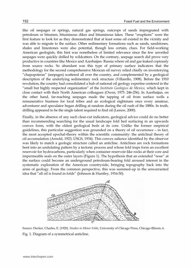
Finally, in the absence of any such clear-cut indicators, geological advice could do no better than recommending searching for the usual landscape fold bed surfacing in an upwards convex form, with the oldest geological beds at its core. Unlike the former empirical guidelines, this particular suggestion was grounded on a theory of oil occurrence – in fact, the most accepted epochal-theory within the scientific community: the anticlinal theory of oil accumulation (Arnold, 1923; USGS, 1934). This convex salience identified by the observer was likely to match a geologic structure called an anticline. Anticlines are rock formations bent into an undulating pattern by a tectonic process and whose fold traps form an excellent reservoir for hydrocarbons, particularly when container reservoir-like rocks at their core and impermeable seals on the outer layers (Figure 1). The hypothesis that an extended “nose” at the surface could become an underground petroleum-bearing fold aroused interest in the systematic exploration of the American countryside, bringing topography back into the arms of geology. From the common perspective, this was summed-up in the unwarranted idea that “all oil is found in folds” (Johnson & Huntley, 1916:50).
Source: Decker, Charles, E. (1920). Studies in Minor Folds, University of Chicago Press, Chicago-Illinois, 6.
Fig. 1. Diagram of a symmetrical anticline.
www.intechopen.com
Estimating Oil Reserves: History and Methods
153
However, perhaps the most important contribution of the anticline theory to petroleum discovery lay in the technical innovations that accompanied it, especially the systematic observation of rocks altitudes and the representation of anticlines by contour-line subsurface maps. Invented for a geological survey undertaken in Trenton, Ohio (1889), topographic contour lines represented lines in depth below sea-level so that the highest points on the map were labeled with the lowest values. By disclosing the topographical relationship between the observable landscape and concealed petroleum reservoirs, the maps triggered debate about the whereabouts of gas and oil deposits. Above all, this new scientific “gadget” proved extremely useful to impress the value of geological prospecting on both the public and on companies. As expected, geologists endeavored to play their trump card by every feasible means.
The anticline theory gained momentum as more oil was found in anticlines with oil traps as theoretically predicted. West Virginia and South-western Pennsylvania in this respect offered the best supportive evidence; conversely Ohio, Indiana and Illinois cast serious reservations on the global validity of the theory. We know today that most of the world’s oil was in effect discovered in anticline structures (Downey, 2009:98). However, this fact, per se, did not significantly raise the earlier probability of actually finding oil. Even when selecting anticlines as their main target, geologists of the 1920s could not single out precise location criteria. Surface indicators said little about whether or not anticlines might contain oil and gas, the amount of hydrocarbons in place, where the accumulation occurred, or the configuration of structural and stratigraphic traps. Ultimately, they could miss the spot simply because the oil was not at the top of a pronounced anticline or because the trap had an unexpected stratigraphic configuration. Furthermore, since oil was found in a great variety of structural positions, the basic anticline hypothesis underwent many vicissitudes (Hager, 1923; Hubbert, 1966).
The work with surface indicators required a sizable and labor-intensive organization. Nowhere as in the prospecting of foreign lands was this feature so remarkable. One may even say that an era of geologically-inspired “invasions” began with the dawn of the twentieth century sometimes involving the overseas relocation of battalions of forty to two hundred men. This stream was fostered by planned investments made by the largest oil companies and reflected the pressure to find untapped sources of supply in the face of increasingly global competition. Mesopotamia (1904 and 1908) Trinidad and the British West Indies (1908), Argentina (1908), Ecuador (1909) Egypt (1911), Algeria (1914) Venezuela (1917) were the most eminent cases of success in finding oil abroad. A geological expedition to China and Formosa (1914-1916) commissioned by the Standard Oil Company of New York also suggested there was a likelihood of discovering good reservoirs but the advance towards the production phase stalled for political reasons. In addition to the new production regions, multinational oil companies further reinforced their presence in Canada and in Peru, leading to a new cycle of discoveries, notably in Peru. So overwhelming was this trend that even firms long skeptical about geological endeavors ended up recruiting 10, 18, 26 geologists (Persia, Anglo-Persian, 1919-1924). Given the higher costs of oil prospecting in the international arena, the massification of discovery had to be spearheaded by some new institutional form of doing business: the multinational holding company was precisely the organizational structure able to finance a multiform presence in oil fields around the world.
www.intechopen.com
Fossil Fuel and the Environment
154
After the First World War, the strategic commitment of these large corporations to get hold of secure supplies by constituting buffers of private reserves intensified the scrambling for oil and for leases. Soaring prices further increased the pay-offs for each dollar invested in prospection. The more active stand in geological affairs prompted a phase of swift technological innovation with a bet on every technique that might disclose the sedimentary structures lying beyond anticline’s surfaces. Between 1919 and 1929 the core of geophysical technologies, as we currently know them, were experimented for the first time, improved and put to good usage.
Gravity surveys, magnetic surveys and seismic surveys derived from the idea that variations in rock density could be mapped by measuring the way they conveyed some signal. Hence, experiments with the torsion balance, a scientific instrument devised by the Hungarian Baron von Eoetvoes, relied on the assumption that the gravitational force exerted by very light rocks found close to the surface is less than those of very heavy rocks. By the same token, the electrical current sent by a magnetometer depicted a different magnetic “anomaly” when encountering minor magnetic sedimentary rocks and when coming across highly magnetic igneous rocks, thus enabling the identification of the former where oil was more likely to be found. Last of all, a concussive sound produced at the surface, in such a way that as much of its energy as possible was directed downwards, was then partially refracted backwards with greater or lesser velocity depending on the density or compactness of the geological formations encountered. In this echo-sounding technology, a picture could be formed by registering the way in which the velocity of vibrations changed with depth. The time taken for the sound wave to reach a seismic detector located on the surface was recorded on a strip of photographic paper. Owing to the fact that the speed of transmission was proportional to the density or compactness of the geological formation, the technique was firstly used to detect salt domes, which returned a high velocity of propagation. Later on, seismic refraction methods were improved and applied for the mapping of other rock strata (Forbes & O'Beirne, 1957:120-122).
Conceived for general scientific research in geodesy and geophysics (the gravitational method), for iron ore prospecting (the magnetic method) and for the location of enemy artillery firing positions (the seismic method), these technologies had to be further adapted to the particularities of oil surveying. As Bowker (1994:22) pointed out, during the first phase of learning and adjustment, the data produced by prospecting instruments could be correlated with underground structures and those structures could sometimes be correlated with the presence oil. Nevertheless, as of the 1920s, no link in this chain had been firmly established. It was only through further research and practical tests, financed by oil companies like Amerada Petroleum Company, Royal Dutch Shell and Shell’s affiliate Roxana, Gulf Oil and its subsidiaries, Louisiana Land & Exploration, Calcasieu Oil, Standard Oil of New York, Humble, Pure and Louisiana, Aguila and Burmah Oil, that fundamental improvements were brought about. Within a short period of time, these investments paid off and paid off handsomely. Successful discoveries of new reservoirs in southern Texas, U.S., Mexico and Hungary with the use of gravitational methods; discoveries in the nearby counties of Texas, in Louisiana, U.S. and Mexico by means of seismic refraction methods; and new finds in Texas, Venezuela and Rumania by means of magnetic surveys and electric logs imparted an aura of buoyancy to geophysical techniques (Williams, 1928; USGS 1934; Forbes & O'Beirne, 1957; Owen, 1975; Bowker, 1994; Robertson, 2000, Petty, n.d.).
www.intechopen.com
Estimating Oil Reserves: History and Methods
155
Afterwards, the effectiveness of these gravitational and magnetic methods became increasingly associated with reconnaissance surveys and efforts to measure sediment thickness. The seismic method additionally broadened its scope and seized the general purpose geophysical exploration market outside Texas, largely on account of its reliability, cost-benefit advantages and enhanced opportunity “for securing preferred acreage over mapped structures” (Bignell, 1934). The trend that turned seismic methods into the bedrock of core oil prospection activities was further reinforced by two international developments: first, the boom in offshore exploration that began in the late 1950s and was chiefly based on marine seismic surveys; in this respect the production of waterproof microphones (hydrophones) deployed along a cable or a steamer proved to be, far and away, the cheapest and most efficient technology; second, the interface with computing power which led to 3-D seismic surveys and the revolution in “the process of exploration and production, since the early 1990s” Among other aspects, 3-D surveys had the advantage of easing the identification of the optimal drilling point (Downey, 2009: 100-101).
A final piece in this puzzle may be called luck, coincidence or the unexpected coincidence of different series of events: in 1926 and 1927, a series of discoveries in Oklahoma, Texas and New Mexico hit some of the largest oil concentrations in the world, adding almost overnight 5 billion barrels (5 x10⁹) to the proven reserves of the United States. The frenzied oil boom that ensued flooded the markets and drove prices down, silencing the “famine”, “shortage” and “exhaustion” thesis for fifty years (i.e. up to the Club of Rome warnings). Institutions that had been founded to deal with scarcity and to fight “waste” were subsequently reshuffled to enforce conservation through the self-regulation of the industry. Overall, the rise of geophysical exploration played a minor role in this spurt (circumscribed to part of East Texas) as most of the discoveries resulted from wildcat drilling practices and surface indicator insights. Hence, the urgency that turned geophysical exploration into a key science for the future of humanity became less momentous. Conservationist ideas were also hit. The oil being endlessly pumped out of the earth washed away the bleak predictions of the early 1910s.
2.3 Classifying oil reserves: The U.S. and the Soviet Union
Geophysical surveys and particularly the promising branch of seismic refraction and reflection surveys changed the meaning of geological observations and mapping technologies. As aforementioned, the surface topography could henceforth be related with underground strata and, sometimes, with oil accumulations. For all these reasons, the stage seemed set for qualified assessments of prospective resources, at least of (untested) probable resources identified by geological or geophysical means. However, surprising as it may seem, the United States institutional evolution headed off in the opposite direction.
After 1925, geological uncertainty was removed from the very activity of measurement and substituted by the narrowest gauge of assessing “only the amount of crude oil which may be extracted by present known methods from fields completed developed or drilled or sufficiently drilled and explored to permit of reasonably accurate calculations” (API, 1938, as cited in Miser, Richardson & Dane, 1939: 289). This criterion pervaded the surveys of the American Petroleum Institute (API), the oil industry's trade association founded after the war by several oil companies. Over and over again, a special API committee called the Committee of Eleven, followed by the Committee on Petroleum Reserves, reasserted its
www.intechopen.com
Fossil Fuel and the Environment
156
pledge not to evaluate unproven reserves, for such estimates would only be “guess-work” and the “the committee refuses to indulge in speculation”. Even when criticism mounted, the API stuck to its predefined policy guidelines (Pew, 1944).
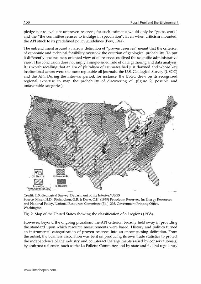
The entrenchment around a narrow definition of “proven reserves” meant that the criterion of economic and technical feasibility overtook the criterion of geological probability. To put it differently, the business-oriented view of oil reserves outlived the scientific-administrative view. This conclusion does not imply a single-sided rule of data gathering and data analysis. It is worth recalling that an era of pluralism of estimates had just dawned and whose key institutional actors were the most reputable oil journals, the U.S. Geological Survey (USGC) and the API. During the interwar period, for instance, the USGC drew on its recognized regional expertise to map the probability of discovering oil (figure 2, possible and unfavorable categories).
Credit: U.S. Geological Survey; Department of the Interior/USGS Source: Miser, H.D., Richardson, G.B. & Dane, C.H. (1939) Petroleum Reserves, In: Energy Resources and National Policy, National Resources Committee (Ed.), 293, Government Printing Office, Washington.
Fig. 2. Map of the United States showing the classification of oil regions (1938).
However, beyond the ongoing pluralism, the API criterion broadly held sway in providing the standard upon which resource measurements were based. History and politics turned an instrumental categorization of proven reserves into an encompassing definition. From the outset, the business association was bent on producing its own trade statistics to protect the independence of the industry and counteract the arguments raised by conservationists, by antitrust reformers such as the La Follette Committee and by state and federal regulatory
www.intechopen.com
Estimating Oil Reserves: History and Methods
157
institutions. Drawing on the long-standing informal network of "scouts", traditionally employed by producers to collect confidential information on the activities of rivals, the first API secretary-general, Robert Welch, set up an overarching system of data-field collection, based on weekly reports telegraphed to the headquarters. However, this move was anything but pacific. Suspicions loomed across the affiliates that the information thereby provided might end up in the wrong hands, paving the way for antitrust prosecutions or, even worse, to harmful competition by direct business rivals. According to Joseph Pratt, the dispute over the API's proper role in the area of statistics climaxed in a public confrontation between Robert Welch and Robert Stewart, the President of Standard Oil of Indiana, with the two men almost coming to blows during an API board meeting (Pratt, 1980:78). To ease the concerns of members, Welch reassured that all information submitted would be treated as strictly confidential; that no information on prices would ever be subject to enquiry; and that no strategic information concerning future oil-exploration plans would be collected. Hence, the narrow definition of “proven reserves” was a natural consequence of institutional arrangements inside the API. The assembled information left aside data on private development strategies for as long as the reservoirs remained unexplored (falling into the category of insufficiently drilled fields) they were beyond the survey’s scope. This meant that proven reserves was a narrower concept than the vaguer “oil in sight” measurement and also narrower than the standard settled for proven coal reserves (see McInnes, Dowling & Leach, 1913).
Soon API’s simplicity and pointedness paid off. The deployment of operational economic criteria enhanced the accuracy, reliability and comparability of statistics. It was this grounding of surveys on proprietary operational information, furthered by Robert Welch’s keen leadership and expertise, which established a first order reputation for the API’s publications. Henceforth, they became the most current and the most accurate estimates of U.S. oil reserves. On the flip side, such a reality pushed the main government agencies - the U.S. Geological Survey, the Bureau of Mines, and the Bureau of Foreign and Domestic Commerce – into a secondary and complementary role in data collection (Pratt, 1980). The federal state acknowledged that government institutions could not compete with API’s resourceful inroads into the industrial milieu. Accordingly, the oil-business association continued to issue reports until 1979, when the oil reserve estimation function was officially taken over by the U.S. Department of Energy. Along with that, the State department further embraced the in-built corporate concept of proven reserves. Finally, in 1983, the World Petroleum Congresses issued expanded definitions for categories ranging from “proven” to “speculative” reserves thereby reopening the door to probabilistic accounts of oil resources (Porter, 1995).
Due to its very history, the North American system of classifications bears the marks of private property, of individual rights and collective corporate action. To get a broader outlook of the ways in which social and economic systems imbue technical classifications, it is worth concisely considering the economic organization that took shape in the Soviet Union. The fact Russia only completed its systematic oil-surveys in the 1930s, when a central command economy was already well underway, eased the creation of a brand new system of oil-reserve classification.
Changes were nonetheless slow. The Bolshevik revolution and the Soviet nationalization of the oil industry did not alter the imperial tradition of oil-geology centered on Moscow with scarce field work outside the Caspian. Lenin’s objective of boosting oil production to obtain
www.intechopen.com
Fossil Fuel and the Environment
158
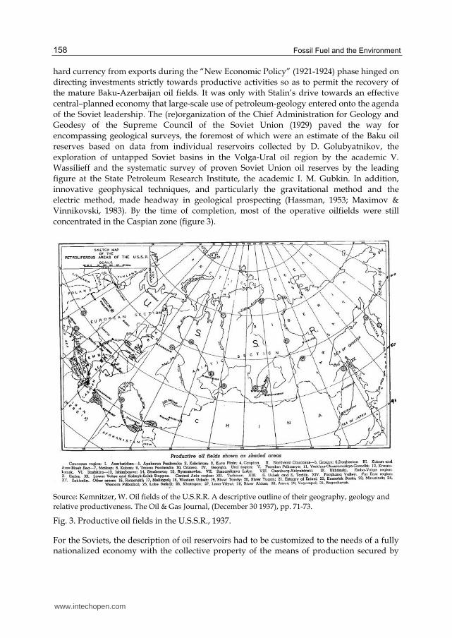
hard currency from exports during the “New Economic Policy” (1921-1924) phase hinged on directing investments strictly towards productive activities so as to permit the recovery of the mature Baku-Azerbaijan oil fields. It was only with Stalin’s drive towards an effective central–planned economy that large-scale use of petroleum-geology entered onto the agenda of the Soviet leadership. The (re)organization of the Chief Administration for Geology and Geodesy of the Supreme Council of the Soviet Union (1929) paved the way for encompassing geological surveys, the foremost of which were an estimate of the Baku oil reserves based on data from individual reservoirs collected by D. Golubyatnikov, the exploration of untapped Soviet basins in the Volga-Ural oil region by the academic V. Wassilieff and the systematic survey of proven Soviet Union oil reserves by the leading figure at the State Petroleum Research Institute, the academic I. M. Gubkin. In addition, innovative geophysical techniques, and particularly the gravitational method and the electric method, made headway in geological prospecting (Hassman, 1953; Maximov & Vinnikovski, 1983). By the time of completion, most of the operative oilfields were still concentrated in the Caspian zone (figure 3).
Source: Kemnitzer, W. Oil fields of the U.S.R.R. A descriptive outline of their geography, geology and
relative productiveness. The Oil & Gas Journal, (December 30 1937), pp. 71-73.
Fig. 3. Productive oil fields in the U.S.S.R., 1937.
For the Soviets, the description of oil reservoirs had to be customized to the needs of a fully nationalized economy with the collective property of the means of production secured by
www.intechopen.com
Estimating Oil Reserves: History and Methods
159
the state. Categories thus had to convey good information to “distant” decision-makers enabling these central planners not only to allocate investments and resources but also to anticipate the conduct of operations with minimal margins of error. In practice, coordination proved far more difficult than expected.
Furubotn and Pejovich (1972) and Furubotn and Richter (1997:148-156) reveal how in a socialist economy the interests of decentralized managers seldom match the interests of central managers and politicians. In the case of oil discoveries, the interests of regional institutions, encharged with exploratory operations such as the Soviet industrial trusts and the geological services from the various republics, was to secure future investments and shelter their own organization by listing the maximum of reserves that could satisfy the industrial standards and technological requirements for production. On the contrary, the interest of central managers consisted of ascribing investments only to the most remunerative projects whose feasibility was fully established. Thus, the situation could be equated in terms of a principal-agent relationship in which the information is asymmetric and the agent’s action on information cannot be observed directly by the principal. Under the conditions of the Soviet Union in the 1930s, the decentralized institutions (agents) had incentives and the means to overestimate the deposit sizes. This was particularly the case when the justifications for arriving at likely figures for untapped petroleum were based on volumetric method assessments resorting to a string of variables – volume of reservoir rock, porosity, oil saturation, recovery coefficient – that could be quietly manipulated (Campbell,1968:62-63). Central planners learned the lesson the hard way on disclosing the premature and wasteful nature of many investments, which after all proved to be over dimensioned given the reality of the petroleum reserves effectively obtainable. In an attempt to overcome this asymmetry of information, the political powers stipulated an intermediate level of certification and supervision, positioned between the central command level of the ministries and the decentralized level of oil exploration. Recognized by the acronym GKZ (Gosudarstvennaia Komissiia po Zapasam poleznykh iskopaemykh), this state commission tightened its grip on local organizations and imposed a system of oil-reserve certification with higher standards of geological evidence (1940). But despite all these endeavors, the principal-agent imbalance continued and attritions rumbled on down the years (Campbell, 1968: 62-68).
Just as the institutional configuration sought to enforce rules for efficient information control by distant decision-makers, so the design of categories sought the same purpose. The goal of monitoring was achieved by breaking up established international categories into minor markers in order to single out, in each marker, data on oil reservoirs and additional meta-data on how the reservoirs were estimated. The emphasis on meta-data loomed therefore as the distinctive feature of the Soviet central command economy.
Reserves were classified by six different tags, labeled A, B, C1, C2, D1, D2, so that central planners could confidently calculate the total quantity of oil extractable over the next five years, controlling for the reliability of the geological forecast. No equivalence whatsoever existed between these six category-tags and the American classification system. The API concept of proven reserves, for instance, was “lost in translation”. According to Krylov (Krylov et. al. 1998; see also Poroskun et. al., 2004), American proven reserves seem to correspond to three splits in the Soviet taxonomy:
- The A Category: reserves of a pool, or part of a pool outlined by wells with proven production. Meta-data requirements involve matters such as the lithological
www.intechopen.com

Fossil Fuel and the Environment
160
characteristics of the reservoir, quality of oil, well-logging indications, type of drive, pressure, permeability, position of the oil-gas contact and others.
- The B Category: reserves of a pool, or part of a pool outlined by at least two wells with proven production of commercial flows of oil or gas. Meta-data requirements: equal to category A, though some features may have been less fully studied.
- 15% to 20% of the C1 Category: deposits for which favorable conditions were revealed by geological or geophysical data and a commercial flow of oil or gas has been obtained from at least one well. Meta-data requirements: permeability and porosity (based on 1960 descriptions as cited in Campbell, 1968:60-61).
One may conclude that “proven”, in the Russian vocabulary, entails three levels of certification. In fact, the system of classification appears to have somehow been transformed into a system of certification.
From the perspective of “distant” decision-makers facing an asymmetry of information vis-à-vis the people in the field, more refined classifications could only mean enhanced control and lesser flaws. Ideally, there could be a quasi-perfect match between reserve categories and the successive stages of exploration. One may imagine the whole upstream sector of the nationalized oil industry functioning like an assembly line: each upgrade of petroleum reserves pushed oil reserves upwards in such a manner that the removal of pools from a lower category becomes the input for the next category (geological studies of category C2 let to them passing onto category C1; if confirmed, exploration and production of pools in category C1 made them pass to B, and so on). Because the whole process is supposed to be driven by adjustments in quantities, the sequence may theoretically be thought of as a linear enchainment (in normal circumstances no C1 pool is allowed to jump directly to A). The reader may remark, instead, how the current American tripartite classification of proved, probable and possible reserves supposes price-quantity adjustments and constitutes the basis of risk assessment and risk management by private investment companies (Poroskun et. al., 2004). Naturally, prices phase out the linearity of classificatory schemes.
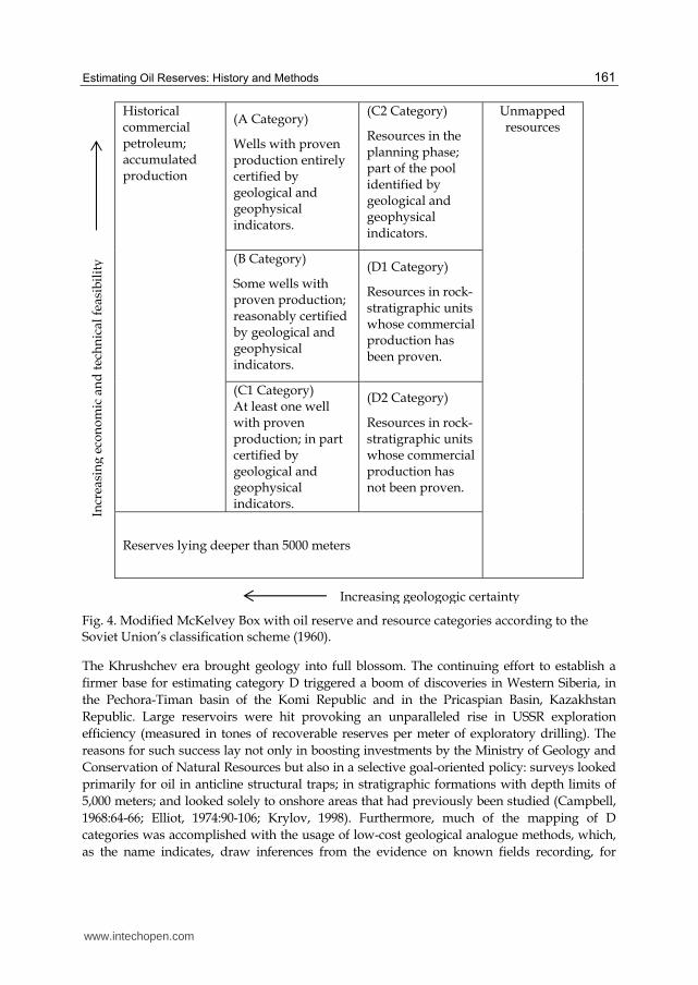
For a better understanding of the entire framework, Figure 4 depicts Soviet classifications within the space of a rectangle named the McKelvey box. The McKelvey box (McKelvey,1973) generates an insight into the relative position of each classification according to its location along the horizontal axis (geological certainty increasing from right to left) and according to its location along the vertical axis (technical end economic feasibility increasing from bottom to top). Hence, while the more feasible and more economic oil stands in the northwest corner of the box - in this case the petroleum that has been produced over the years -, the less feasible and undiscovered petroleum lies in the southeast corner. The Soviet categories come somewhere in between these two extremes (figure 4).
The fundamental division in the Soviet scheme is between reserves and resources. The identification of reserves of commercial interest, through the discovery of a field, draws a boundary between categories A+B+C1 and the prospective resources of C2+D1+D2. In fact, the communist leadership only began paying serious attention to the latter group of prospective resources at the end of the 1950s. This means that for a long time category C2 was not tied in very precisely with the planning and conduct of explorations. Moreover, D categories only received closer consideration in the 1960s (Campbell, 1968:64-65).
www.intechopen.com
Estimating Oil Reserves: History and Methods
161
Historical commercial petroleum; accumulated production
(A Category)
Wells with proven production entirely certified by geological and geophysical indicators.
(C2 Category)
Resources in the planning phase; part of the pool identified by geological and geophysical indicators.
Unmapped resources
(B Category)
Some wells with proven production; reasonably certified by geological and geophysical indicators.
(D1 Category)
Resources in rock-stratigraphic units whose commercial production has been proven.
(C1 Category) At least one well with proven production; in part certified by geological and geophysical indicators.
(D2 Category)
Resources in rock-stratigraphic units whose commercial production has not been proven.
Reserves lying deeper than 5000 meters
Fig. 4. Modified McKelvey Box with oil reserve and resource categories according to the Soviet Union’s classification scheme (1960).
The Khrushchev era brought geology into full blossom. The continuing effort to establish a
firmer base for estimating category D triggered a boom of discoveries in Western Siberia, in
the Pechora-Timan basin of the Komi Republic and in the Pricaspian Basin, Kazakhstan
Republic. Large reservoirs were hit provoking an unparalleled rise in USSR exploration
efficiency (measured in tones of recoverable reserves per meter of exploratory drilling). The
reasons for such success lay not only in boosting investments by the Ministry of Geology and
Conservation of Natural Resources but also in a selective goal-oriented policy: surveys looked
primarily for oil in anticline structural traps; in stratigraphic formations with depth limits of
5,000 meters; and looked solely to onshore areas that had previously been studied (Campbell,
1968:64-66; Elliot, 1974:90-106; Krylov, 1998). Furthermore, much of the mapping of D
categories was accomplished with the usage of low-cost geological analogue methods, which,
as the name indicates, draw inferences from the evidence on known fields recording, for
Increasing geologogic certainty
Incr
easi
ng
eco
no
mic
an
d t
ech
nic
al f
easi
bil
ity
www.intechopen.com
Fossil Fuel and the Environment
162
example, its real extent, thickness and porosity, to extrapolate them to similar stratigraphic
areas where oil and gas accumulation is expected to be found (Maximov & Vinnikovski, 1983).
To sum up, this chapter highlighted how the core concept of proven reserves has grown out of the willingness to strengthen the role of the business association, the American Petroleum Industry- API, in the turbulent waters of the 1920s. Just when the development of geophysical methods opened up the way for more accurate probabilistic assessments of oil reserves, North American institutions refrained from this path, preferring instead to draw their estimates from business-reports and surveys, therefore anchoring the concept on the solid ground of observable actions undertaken by corporations. In quite the opposite camp, the Soviet regime used oil reserve categories as instruments of control and certification thereby shortening the distance between decentralized operative exploration and central management. Although with less success, the regime also tried to use classifications to ease economic transactions by fitting the categories into the bureaucratic sequence of exploration, certification and production.
3. Conclusion
The history of estimating oil reserves is a history of long lasting misunderstandings. Although American geologists combined volumetric and statistical methods specifically tailored to the realities of the petroleum industry, the final figures from the first oil survey, released in 1909, came to be interpreted by analogy with the forest conservation practices and policies. The discovery of 15 billion barrels of oil left in reservoirs was regarded as a sort of opening shot in a race against the clock of depletion. “Reserves” were understood as a stock; a finite stock that had to be economized, held back and set aside for future uses or contingencies. By adopting terminologies with familiar nontechnical meanings furthermore colored by the moving debate on presidential powers and federal forest “reserves”, geologists ascribed the meaning of the concept to an observable fixed asset. Furthermore, given there was, after all, not so much of it left underground, they conveyed the idea that America was approaching its resource supply potential. What ensued was a sort of pathological split between the “scarcity” and the “overflowing” stances, a split sturdily entrenched in discourses, social networks, newspapers, journals and institutions.
To counteract looming claims over the need for regulation, the American Petroleum Association set up its own survey, based on preferential access to oilfields and business records, thereby building a spotless reputation for data gathering. Its aim was to replace geological uncertainties by a narrow but accurate appraisal of oil reserves. Between 1925 and 1935, all open possibilities were locked-into the concept of “proven reserves”, grounded on technical and economic feasibility. Such closure ran against the grain of current technological improvements as it excluded probabilistic methods of oil finding by the geophysical sciences and neglected the novel enhanced oil-recovery practices. This means that, in the end, economic-political factors superseded the technical and scientific factors. Comparatively, the Soviet system of oil reserve classification attempted to encapsulate technical feasibility and geological certainty in each category. Indeed, its major originality lay in carving up very analytical classifications with data imbued in meta-data. The fundamental asymmetry between decentralized exploration and central allocation of resources was expected to be overcome by this means.
www.intechopen.com
Estimating Oil Reserves: History and Methods
163
Overall, the conservation debate continues today with the dispute over whether or not oil production is approaching its maximum level and going to enter into decline soon afterwards, following the downward slope of a logistics curve. Dubbed the “peak oil problem” or “Hubbert’s peak” (for an overview see Deffeyes, 2006), its basic assumptions reverse the terms of the debate: whilst in the 1920s it was thought that the oil already found set a ceiling on the likelihood of any new discoveries, the peak oil theory argues the ability to find oil is dominated by the fraction of oil that remains undiscovered.
4. Acknowledgment
The author wishes to thank The Oil & Gas Journal for allowing the reproduction of copyrighted figures inserted in this chapter. Our appreciation is extensive to the University of Chicago Press and the United States Geologic Survey for their reply acknowledging that the figures inserted in this chapter are currently in the public domain.
5. References
Arnold, R. (1923). Two decades of petroleum geology 1903-1922. Bulletin of the American Association of Petroleum Geologists, Vol. 7, No. 6 (Nov-December 1923), pp.603-624, ISSN: 0883-9247.
Bacon, W.F. & Hamor, W.A. (1916). The American Petroleum Industry. McGraw-Hill, ISBN 9781144838599, New York, Vol.1.
Beal, C. H. (1919). The Decline and Ultimate Production of Oil Wells, with Notes on the Valuation of Oil Properties, U. S. Bureau Mines- Government Printing office, ISBN 9781146574471, Washington.
Bignell, L.G.(1934). Geophysical prospecting activity in all areas indicates need for additional oil reserves. The Oil & Gas Journal, (February 15 1934), pp. 16, 52, ISSN 0030-1388.
Bowker G. C. (1994). Science on the Run Information Management and Industrial Geophysics at Schlumberger, 1920-1940. The MIT Press, ISBN 0262023679, Cambridge-Massachusetts.
Brown, N.C. (1919). Forest products and Their Manufacture and Use, John Wiley & Sons, ISBN, 9781177904148, New York.
Campbell , R. W. (1968). The Economics of Soviet oil and gas. Johns Hopkins University Press, ISBN 9780801801051, Baltimore.
Clark, J.G. (1987). Energy and the Federal Government. Fossil fuel policies 1900-1946. University of Illinois Press, ISBN 9780252012952, Urbana and Chicago, USA.
Cooper, J.M. (1990). Pivotal decades: The United States 1900-1920, W.W. Norton, ISBN: 9780393956559, New York.
Day, D. T. (1909). The Petroleum Resources of the United States, In: United States Geological Survey Bulletin 394, USGS, pp.30-50, Government Printing office, ISBN 9780217915557, Washington.
Decker, C. E. (1920). Studies in Minor Folds, University of Chicago Press, Chicago-Illinois, ISBN 9781141569311.
Deffeyes, K. S. (2006). Beyond Oil. The view from Hubbert’s peak. Hill and Wang, ISBN 9780374707026, New York.
www.intechopen.com
Fossil Fuel and the Environment
164
Dennis, M.A.(1985). Drilling for Dollars: The Making of US Petroleum Reserve Estimates, 1921-25. Social Studies of Science, Vol. 15, No. 2 (May, 1985), pp. 241-265, ISSN:0306-3127.
Downey, M. (2009). Oil 101. Wooden Table Press, ISBN 9780982039205, New York. Dunham, W.M. (1913). Foresees Famine in Light crude oil. The National Petroleum News, No.3
(May 1913), pp. 1-2, ISSN 0149-5267. Elliot, I. F. (1974). The Soviet energy balance. Natural gas, other fossil fuels and alternative power
sources. Praeger Publishers, ISBN 9780275089306, New York- London. Emmons, H.E. (1921). Geology of petroleum. McGraw-Hill, ISBN 9781406707960 New-
York/London. Forbes, R. J. & O'Beirne, D. R. (1957). The technical development of the Royal Dutch/ Shell 1890-
1940. E.J. Brill, ISBN 9781157320234, Leiden. Netherlands. Furubotn E. G. & Pejovich, S. (1972). Property Rights and Economic Theory: A Survey of
Recent Literature. Journal of Economic Literature, Vol. 10, No. 4 (December 1972,) pp. 1137-1162, ISSN 0022-0515.
Furubotn E. G. & Richter, R. (1997). Institutions and economic theory. The contribution of the new institutional economics. University of Michigan Press, ISBN 9780472108176, Ann Arbor, USA.
Garfias V.R. & Whetsel, R.V. (1936). Proven oil reserves. Transactions of the American Institute of Mining and Metallurgical Engineers, Vol. 118, AIMME, ISBN 9781150194221, New York, pp.211-214.
Hager, D. (1923). Hager on Geology and the geologists. The Oil & Gas Journal, (January 18 1923), pp. 91-93, , ISSN 0030-1388.
Hassman, H. (1953). Oil in the Soviet Union: history, geography, problems. Princeton University Press , Princeton.
Hays, S. P. (1959). Conservation and the Gospel of Efficiency: The Progressive Conservation Movement, 1890-1920. Harvard University Press, Cambridge–Massachusetts.
Horlacher, J.L. (1929). A Year in the Oil Fields. The Kentucky Kernel Press, ISBN 0714843229, Lexington, USA.
Hubbert, M.K. (1966). History of petroleum geology and its bearing upon present and future exploration. American Association of Petroleum Geologists Bulletin (December 1966) Vol. 50, No. 12, pp. 2504-2518, ISSN 0883-9247.
Johnson, R.H. & Huntley, L.G. (1916). Principles of Oil and Gas Production, John Wiley and Sons, ISBN: 1148318283, New York.
Kemnitzer, W. (1937). Oil fields of the U.S.R.R. A descriptive outline of their geography, geology and relative productiveness. The Oil & Gas Journal, (December 30 1937), pp. 71-73.
Krylov, N.A.. et.al, (1998). The oil reserves and resource base of Russia, , In: The oil industry of the former Soviet Union, N.A. Krylov, A.A. Bokserman & E.R. Stavrovsky (Ed.), 1-68, Gordon and Breach Science Publishers, ISBN 9789056990626, Amsterdam, Netherlands.
Leeuw, C. (2000). Oil and gas in the Caucasus & Caspian. St. Martin Press, ISBN 9780312232542, New York.
Madureira, N.L. (2012).The anxiety of abundance: Stanley Jevons and coal scarcity in the nineteenth century. Environment and History, Vol. 18, (forthcoming), ISSN 0967-3407.
www.intechopen.com
Estimating Oil Reserves: History and Methods
165
Maximov, S.P. & Vinnikovski, S.A. (1983). Development of methods for the quantitative evaluation of Petroleum potential in the USSR. Journal of Petroleum Geology, Vol.5 No.3 (January 1983), pp. 309-314, ISSN 0141-6421.
McCarthy, T. (2001). The Coming Wonder? Foresight and Early Concerns about the Automobile. Environmental History, Vol. 6 (January 2001), pp. 46–74, ISSN: 1084-5453.
McInnes, W.,Dowling D.B. & Leach W.W. (1913). The Coal Resources of the World: an enquiry made upon the initiative of the Executive Committee of the Twelfth International Geological Congress. Morang & Co. and Dulau & Co, ISBN 9781149318232, Toronto-London, Canada-UK.
McKelvey, V. (1973). Mineral Estimates and Public Policy, In: United States Mineral Resources, D. Brobst & W. Pratt (Eds.), 9-19, U.S. Geological Survey Professional Paper 820, United States Printing Office, Washington.
McLaughin, G.L. (1939) The economic significance of oil and gas, In: Energy Resources and National Policy, National Resources Committee (Ed.), 123-236, Government Printing Office, ISBN 9781153473552, Washington.
Miller, C. (2009). The Once and Future Forest Service: Land-Management Policies and Politics in Contemporary America. · Journal of Policy History, Vol. 21, No. 1, (Winter 2009), pp. 89-104, ISSN: 1528-4190.
Miller, H.C.& Lindsly,B.E. (1934). Report on petroleum production and development, In: Hearings before a Subcommittee of the Committee on Interstate and Foreign Commerce, USGS (Ed.), 1087-1222, Government Printing Office, ISBN: 1153526220, Washington, USA, Part 2.
Mills, R. & Wells, R.C. (1919). The evaporation and concentration of waters associated with petroleum and natural gas. In: United States Geological Survey Bulletin 693, USGS, pp.1-31, Government Printing Office, Washington.
Miser, H.D., Richardson, G.B. & Dane, C.H. (1939) Petroleum Reserves, In: Energy Resources and National Policy, National Resources Committee (Ed.), 286-297, Government Printing Office, ISBN 9781153473552, Washington.
Nordhauser, N. (1979). The Quest for Stability: Domestic Oil Regulation 1917-1935. Garland Publishing Co., ISBN 9780824036386, New York.
Olien, D.D. & Olien, R.M. (1993). Running Out of Oil: Discourse and Public Policy, 1909-1929. Business and Economic History, Vol. 22, No. 2, (Winter 1993), pp. 36-66, ISSN: 0358-5522.
Owen, E.W. (1975). Trek of the Oil finders: A history of Exploration for Petroleum. American Association of Petroleum Geologists, Tulsa-Oklahoma.
Penick, J.L. (1968). Progressive politics and conservation: the Ballinger-Pinchot affair, University of Chicago Press, ISBN 9780226654713, Chicago.
Pew. J.E. (1944). Statement of J. Edgar Pew on A.P.I. Reserves Committee Report on Crude Oil Reserves in the United States as of December 31, 1943. Chemical & Engineering News, Vol. 22, No. 8 (April 1944), pp.642, ISSN 0009- 2347.
Poroskun, V.I. et.al. (2004). Reserves/ Resource classification schemes used in Russia and Western countries: a review and comparison. Journal of Petroleum Geology, Vol. 27, No.1 (January 2004), pp. 85-94, ISSN 0141-6421.
Porter, E.D. (1995). Are We Running Out of Oil? In: American Petroleum Institute-Policy Analysis And Strategic Planning Department, Discussion Paper #081. 02.09.2011 Available from http://gisceu.net/PDF/U30.pdf.
www.intechopen.com
Fossil Fuel and the Environment
166
Pratt, J.A. (1980). Organizing Information about the Modern Oil Industry in the Formative Years of the American Petroleum Institute, In: Business and Economic History On-Line, Vol.9, 26.09.2011. Available from http://h-net.org/~business/bhcweb/publications/BEHprint/toc91980.html.
Requa, M..L. (1918). Methods of Valuing Oil Lands. Bulletin of the American Institute of Mining Engineers, Vol. 134 (February 1918), pp. 409-428, ISSN 0096-7289.
Petty, O. S. (n.d.). Oil exploration, In: Handbook of Texas Online published by the Texas State Historical Association, 12.09.2011, Available from
http://www.tshaonline.org/handbook/online/articles/doo15. Robertson. H. (2000). A historic correspondence regarding the introduction of the torsion
balance to the United States, The Leading Edge, Vol. 19, No. 6 (June 2000), pp. 652-654, ISSN 1938-3789.
Roosevelt, T. (1909). Special message from the President of the United States transmitting a report of the National Conservation commission, In: Report of the National Conservation Commission, H. Gannett (Ed.),1-9, Government Printing Office, ISBN 1150477636, Washington, USA.
Schulman, B.J. (2005). Governing Nature, Nurturing Government: Resource Management and the Development of the American State: 1900-1912. Journal of Policy History, Vol. 17, No 4, (Fall 2005), pp. 375-403, ISSN 1528-4190.
Schurr, S. H. & Netschert, B. C. (1977). Energy in the American Economy 1850-1975: an economic study of its history and prospects, Greenwood Press, ISBN 9780837194714, Westport Connecticut, 2nd edition.
Shulman, P.A. (2003). Science can never demobilize: the United States Navy and the Petroleum Geology. History and Technology, Vol. 19, No. 4, (Summer 2003), pp. 365–385. ISSN 1477-2620.
Smith, G.O. (1920). Opportunity for the oil geologists. The Oil & Gas Journal, (March 26 1920), pp. 36, 74, , ISSN 0030-1388.
Steen, H. K. (2001). The Conservation Diaries of Gifford Pinchot, Forest History Society, ISBN 9780890300596 Durham, USA.
USGS (1934). Résumé of geology and occurrence of petroleum in the United States, In: Hearings before a Subcommittee of the Committee on Interstate and Foreign Commerce, USGS (Ed.), 884-907, Government Printing Office, ISBN: 1153526220, Washington, USA, Part 1.
Villarello, J.D. (1908). Algunas regiones petroliferas de Mexico. Imprenta y Fototipia de la Secretaria de Fomento. Ciudad de Mexico, ISSN: 0188-316X.
White, D. (1919). Mr White sees danger of exhaustion. The Oil & Gas Journal, (May 2 1919), pp. 8-9, ISSN 0030-1388.
Williams, N. (1928). Geophysics big factor on Gulf Coast. The Oil & Gas Journal, (November 8 1928), pp. 35, 88, ISSN 0030-1388.
Williamson H. F. et al. (1968). The American Petroleum Industry. The age of energy 1899-1959, Northwestern University Press, SBN-13: 978-0313227899 , Evanston, USA.
www.intechopen.com
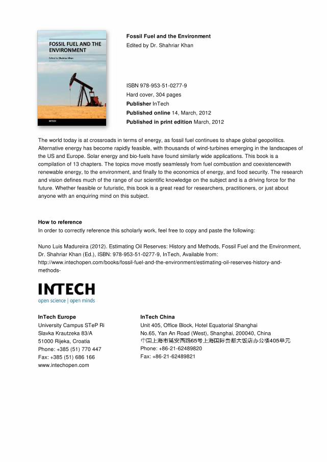
Fossil Fuel and the EnvironmentEdited by Dr. Shahriar Khan
ISBN 978-953-51-0277-9Hard cover, 304 pagesPublisher InTechPublished online 14, March, 2012Published in print edition March, 2012
InTech EuropeUniversity Campus STeP Ri Slavka Krautzeka 83/A 51000 Rijeka, Croatia Phone: +385 (51) 770 447 Fax: +385 (51) 686 166www.intechopen.com
InTech ChinaUnit 405, Office Block, Hotel Equatorial Shanghai No.65, Yan An Road (West), Shanghai, 200040, China
Phone: +86-21-62489820 Fax: +86-21-62489821
The world today is at crossroads in terms of energy, as fossil fuel continues to shape global geopolitics.Alternative energy has become rapidly feasible, with thousands of wind-turbines emerging in the landscapes ofthe US and Europe. Solar energy and bio-fuels have found similarly wide applications. This book is acompilation of 13 chapters. The topics move mostly seamlessly from fuel combustion and coexistencewithrenewable energy, to the environment, and finally to the economics of energy, and food security. The researchand vision defines much of the range of our scientific knowledge on the subject and is a driving force for thefuture. Whether feasible or futuristic, this book is a great read for researchers, practitioners, or just aboutanyone with an enquiring mind on this subject.
How to referenceIn order to correctly reference this scholarly work, feel free to copy and paste the following:
Nuno Luis Madureira (2012). Estimating Oil Reserves: History and Methods, Fossil Fuel and the Environment,Dr. Shahriar Khan (Ed.), ISBN: 978-953-51-0277-9, InTech, Available from:http://www.intechopen.com/books/fossil-fuel-and-the-environment/estimating-oil-reserves-history-and-methods-