ESTATE AND TRUST NOTICES Houseknecht, Leon E. … · ESTATE AND TRUST NOTICES Notice is hereby...
18
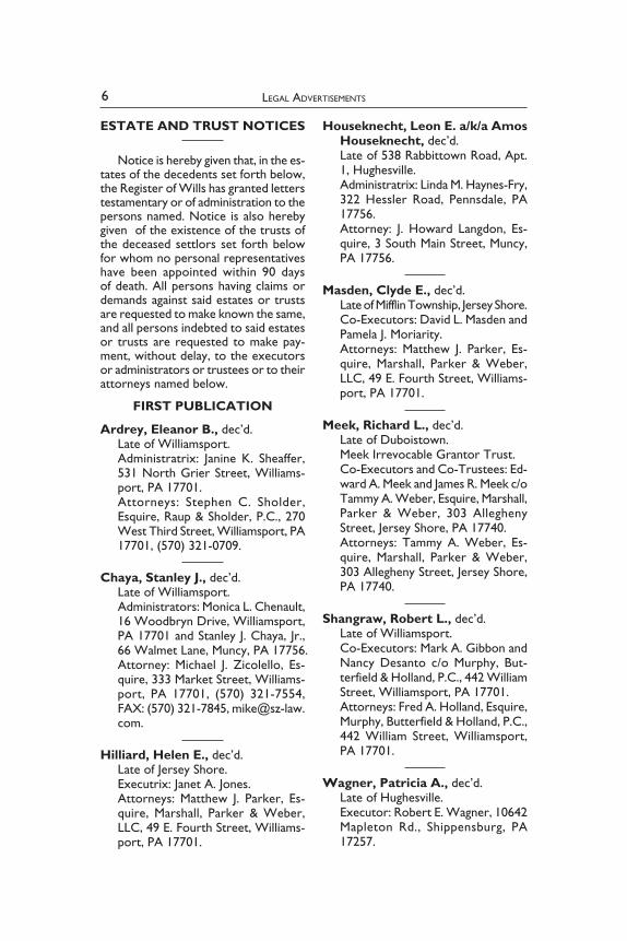
6 LEGAL ADVERTISEMENTS ESTATE AND TRUST NOTICES Notice is hereby given that, in the es- tates of the decedents set forth below, the Register of Wills has granted letters testamentary or of administration to the persons named. Notice is also hereby given of the existence of the trusts of the deceased settlors set forth below for whom no personal representatives have been appointed within 90 days of death. All persons having claims or demands against said estates or trusts are requested to make known the same, and all persons indebted to said estates or trusts are requested to make pay- ment, without delay, to the executors or administrators or trustees or to their attorneys named below. FIRST PUBLICATION Ardrey, Eleanor B., dec’d. Late of Williamsport. Administratrix: Janine K. Sheaffer, 531 North Grier Street, Williams- port, PA 17701. Attorneys: Stephen C. Sholder, Esquire, Raup & Sholder, P.C., 270 West Third Street, Williamsport, PA 17701, (570) 321-0709. Chaya, Stanley J., dec’d. Late of Williamsport. Administrators: Monica L. Chenault, 16 Woodbryn Drive, Williamsport, PA 17701 and Stanley J. Chaya, Jr., 66 Walmet Lane, Muncy, PA 17756. Attorney: Michael J. Zicolello, Es- quire, 333 Market Street, Williams- port, PA 17701, (570) 321-7554, FAX: (570) 321-7845, mike@sz-law. com. Hilliard, Helen E., dec’d. Late of Jersey Shore. Executrix: Janet A. Jones. Attorneys: Matthew J. Parker, Es- quire, Marshall, Parker & Weber, LLC, 49 E. Fourth Street, Williams- port, PA 17701. Houseknecht, Leon E. a/k/a Amos Houseknecht, dec’d. Late of 538 Rabbittown Road, Apt. 1, Hughesville. Administratrix: Linda M. Haynes-Fry, 322 Hessler Road, Pennsdale, PA 17756. Attorney: J. Howard Langdon, Es- quire, 3 South Main Street, Muncy, PA 17756. Masden, Clyde E., dec’d. Late of Mifflin Township, Jersey Shore. Co-Executors: David L. Masden and Pamela J. Moriarity. Attorneys: Matthew J. Parker, Es- quire, Marshall, Parker & Weber, LLC, 49 E. Fourth Street, Williams- port, PA 17701. Meek, Richard L., dec’d. Late of Duboistown. Meek Irrevocable Grantor Trust. Co-Executors and Co-Trustees: Ed- ward A. Meek and James R. Meek c/o Tammy A. Weber, Esquire, Marshall, Parker & Weber, 303 Allegheny Street, Jersey Shore, PA 17740. Attorneys: Tammy A. Weber, Es- quire, Marshall, Parker & Weber, 303 Allegheny Street, Jersey Shore, PA 17740. Shangraw, Robert L., dec’d. Late of Williamsport. Co-Executors: Mark A. Gibbon and Nancy Desanto c/o Murphy, But- terfield & Holland, P.C., 442 William Street, Williamsport, PA 17701. Attorneys: Fred A. Holland, Esquire, Murphy, Butterfield & Holland, P.C., 442 William Street, Williamsport, PA 17701. Wagner, Patricia A., dec’d. Late of Hughesville. Executor: Robert E. Wagner, 10642 Mapleton Rd., Shippensburg, PA 17257.
Transcript of ESTATE AND TRUST NOTICES Houseknecht, Leon E. … · ESTATE AND TRUST NOTICES Notice is hereby...
6 LegaL advertisements
ESTATE AND TRUST NOTICES
Notice is hereby given that, in the es-tates of the decedents set forth below, the Register of Wills has granted letters testamentary or of administration to the persons named. Notice is also hereby given of the existence of the trusts of the deceased settlors set forth below for whom no personal representatives have been appointed within 90 days of death. All persons having claims or demands against said estates or trusts are requested to make known the same, and all persons indebted to said estates or trusts are requested to make pay-ment, without delay, to the executors or administrators or trustees or to their attorneys named below.
FIRST PUBLICATION
Ardrey, Eleanor B., dec’d. Late of Williamsport. Administratrix: Janine K. Sheaffer, 531 North Grier Street, Williams-port, PA 17701. Attorneys: Stephen C. Sholder, Esquire, Raup & Sholder, P.C., 270 West Third Street, Williamsport, PA 17701, (570) 321-0709.
Chaya, Stanley J., dec’d. Late of Williamsport. Administrators: Monica L. Chenault, 16 Woodbryn Drive, Williamsport, PA 17701 and Stanley J. Chaya, Jr., 66 Walmet Lane, Muncy, PA 17756. Attorney: Michael J. Zicolello, Es-quire, 333 Market Street, Williams-port, PA 17701, (570) 321-7554, FAX: (570) 321-7845, [email protected].
Hilliard, Helen E., dec’d. Late of Jersey Shore. Executrix: Janet A. Jones. Attorneys: Matthew J. Parker, Es-quire, Marshall, Parker & Weber, LLC, 49 E. Fourth Street, Williams-port, PA 17701.
Houseknecht, Leon E. a/k/a Amos Houseknecht, dec’d. Late of 538 Rabbittown Road, Apt. 1, Hughesville. Administratrix: Linda M. Haynes-Fry, 322 Hessler Road, Pennsdale, PA 17756. Attorney: J. Howard Langdon, Es-quire, 3 South Main Street, Muncy, PA 17756.
Masden, Clyde E., dec’d. Late of Mifflin Township, Jersey Shore. Co-Executors: David L. Masden and Pamela J. Moriarity. Attorneys: Matthew J. Parker, Es-quire, Marshall, Parker & Weber, LLC, 49 E. Fourth Street, Williams-port, PA 17701.
Meek, Richard L., dec’d. Late of Duboistown. Meek Irrevocable Grantor Trust. Co-Executors and Co-Trustees: Ed-ward A. Meek and James R. Meek c/o Tammy A. Weber, Esquire, Marshall, Parker & Weber, 303 Allegheny Street, Jersey Shore, PA 17740. Attorneys: Tammy A. Weber, Es-quire, Marshall, Parker & Weber, 303 Allegheny Street, Jersey Shore, PA 17740.
Shangraw, Robert L., dec’d. Late of Williamsport. Co-Executors: Mark A. Gibbon and Nancy Desanto c/o Murphy, But-terfield & Holland, P.C., 442 William Street, Williamsport, PA 17701. Attorneys: Fred A. Holland, Esquire, Murphy, Butterfield & Holland, P.C., 442 William Street, Williamsport, PA 17701.
Wagner, Patricia A., dec’d. Late of Hughesville. Executor: Robert E. Wagner, 10642 Mapleton Rd., Shippensburg, PA 17257.

7LEgAL AdvErtisEmEnts
Attorneys: John A. Smay, Esquire, Williams and Smay, 39 S. Main St., P.O. Box 35, Muncy, PA 17756.
Zulker, Marguerite C., dec’d. Late of Loyalsock Township. Administrator: Woodlands Bank, 2450 E. Third Street, Williamsport, PA 17701. Attorney: Andrea B. Bower, Esquire, 426 Broad Street, Montoursville, PA 17754.
SECOND PUBLICATION
Ault, Gerald Keith a/k/a Gerald K. Ault a/k/a G. Keith Ault, dec’d. Late of the Township of Fairfield. Executrix: Jill L. Kaplan, 2171 Quak-er State Road, Montoursville, PA 17754. Attorney: Joseph L. Rider, Esquire, 143 West Fourth Street, Williams-port, PA 17701.
Hollingsworth, Mary J., dec’d. Late of Loyalsock Township. Executor: Leonard W. Hiltz, 316 Sterling Drive, Muncy, PA 17756. Attorneys: James G. Malee, Esquire, Malee Law Firm, P.C., 310 East Third Street, Williamsport, PA 17701, (570) 321-6112.
Lynch, Robert, Jr., dec’d. Late of Washington Township. Executors: Rodney Lynch, Sr., 1624 Alvira Road, Allenwood, PA 17810 and Jeffrey Lynch, 1446 Pikes Peak Road, Allenwood, PA 17810. Attorneys: James G. Malee, Esquire, Malee Law Firm, P.C., 310 East Third Street, Williamsport, PA 17701, (570) 321-6112.
Picard, Helen B. a/k/a Helen Binder Picard a/k/a Helen Picard, dec’d. Late of the Township of Brady. Executrix: Nancy Picard, 300 Look-out Avenue, Unit B5, Hackensack, NJ 07601.
Attorneys: Eric Ladley, Esquire, Steinbacher, Stahl, Goodall & Yur-chak, 413 Washington Boulevard, Williamsport, PA 17701.
Weaver, Jack A., Sr., dec’d. Late of Williamsport. Executrix: Virginia S. Garison c/o Gary L. Weber, Esquire, Mitchell Gallagher, P.C., 10 West Third Street, Williamsport, PA 17701. Attorneys: Gary L. Weber, Esquire, Mitchell Gallagher, P.C., 10 West Third Street, Williamsport, PA 17701.
THIRD PUBLICATION
Emel, Phyllis A., dec’d. Late of the Township of Loyalsock. Administratrix: Terri A. Shick, 2445 Lincoln Drive, Williamsport, PA 17701. Attorneys: Kristine L. Waltz, Es-quire, Dinges, Dinges & Waltz, LLC, 1307 Sheridan Street, Williamsport, PA 17701.
Farmer, Jerome W., dec’d. Late of Loyalsock Township. Administratrix: Laura A. Keppel, 1335 Sycamore Road, Montoursville, PA 17754. Attorneys: L. Craig Harris, Esquire, Carpenter, Harris & Flayhart, 128 S. Main St., P.O. Box 505, Jersey Shore, PA 17740.
Gebhart, Mary Edna a/k/a Mary E. Gebhart, dec’d. Late of 18 Heatherbrooke Estates, Muncy. Executor: David Gebhart, 18 Heath-erbrooke Estates, Muncy, PA 17756. Attorney: G. Scott Gardner, Esquire, 2117 West Fourth Street, William-sport, PA 17701, (570) 322-7653.
Goodspeed, Walter E., dec’d. Late of Williamsport (Loyalsock Township).

8 LEgAL AdvErtisEmEnts
Executor: Ronald J. Goodspeed, 514 Spruce Street, Montoursville, PA 17754. Attorneys: Ann S. Pepperman, Es-quire, McCormick Law Firm, 835 West Fourth Street, Williamsport, PA 17701.
Hine, Shirley M. a/k/a Shirley Mae Hine, dec’d. Late of the Township of Loyalsock. Executor: Ronald E. Hine. Attorneys: Elizabeth A. White, Esquire, Marshall, Parker & Weber, LLC, 49 E. Fourth Street, Williams-port, PA 17701.
McClintock, Max G., dec’d. Late of 310 Edkin Hill Road, Muncy Valley. Co-Executors: Jack L. McClintock, 124 Montague Hill Road, Muncy Valley, PA 17758 and Jean M. Wal-dron, 26 Crestview Drive, Milton, PA 17847. Attorney: J. Howard Langdon, Es-quire, 3 South Main Street, Muncy, PA 17756.
Smith, Jeffrey B., dec’d. Late of 525 Harding Avenue, Wil-liamsport. Administrator: Muncy Bank and Trust Company, 2 North Main Street, Muncy, PA 17756. Attorney: J. Howard Langdon, Es-quire, 3 South Main Street, Muncy, PA 17756.
Souter, Robin A., dec’d. Late of Upper Fairfield Township. Executor: Clair C. Souter, 2203 Rt. 87 Hwy., Montoursville, PA 17754. Attorney: Joseph L. Rider, Esquire, 143 West Fourth Street, Williams-port, PA 17701.
Young, Richard R., dec’d. Late of Montgomery.
Executrix: Connie M. Charles, 4983 Rt. 220 Hwy., Hughesville, PA 17737. Attorneys: John A. Smay, Esquire, Williams and Smay, 39 S. Main St., P.O. Box 35, Muncy, PA 17756.
REGISTER OF WILLS CONFIRMATION OF
ACCOUNTS
NOTICE IS HEREBY GIVEN to all parties interested that the following Accounts together with all Statement of Proposed Distribution accompanying the same have been filed in the Office of the Register of Wills and Clerk of Orphans’ Court are presented to the Orphans’ Court of Lycoming County for Confirmation Absolute August 4, 2015 unless exceptions are filed before 5:00 P.M. on that date.
1. Bronson, Mary H.—Peter G. Facey, Administrator C.T.A.Annabel Miller Register of Wills
Ju-24, 31
REGISTRATION OF FICTITIOUS NAME
CORRECTED NOTICE
NOTICE IS HEREBY GIVEN, pur-suant to the provisions of the Act of Assembly of December 16, 1982, P.L. 1309 No. 295 [54 Pa. C.S. Section 311(g)], as amended, of the filing in the Office of the Secretary of the Common-wealth of Pennsylvania, at Harrisburg, Pennsylvania, on May 18, 2015, of an Application for Registration of Fictitious Name for the conduct of a business in Lycoming County, Pennsylvania, under the assumed or fictitious name, style or designation of:
SERVPRO OF LEWISBURG/SELINSGROVE
with its principal place of business at: 2890 Lycoming Mall Drive, Muncy,

9LEgAL AdvErtisEmEnts
Pennsylvania 17756. The name and address of the entity owning and inter-ested in said business are: Kimble and Sons Restoration and Cleaning, LLC, 2890 Lycoming Mall Drive, Muncy, PA 17756.JAMES D. CASALE, ESQUIRECASALE & BONNER, P.C.33 West Third StreetSuite 202Williamsport, PA 17701
Ju-31
FOR SALE
PENNSYLVANIA LIQUOR LICENSE FOR SALE
———A Lycoming County, Pennsylvania
Restaurant Liquor License is currently for sale. Interested parties may contact the undersigned for further information.JAMES D. CASALE, ESQUIREJody L. Bottorf, ParalegalCASALE & BONNER, P.C.33 West Third StreetSuite 202Williamsport, PA 17701(570) 326-7044
Ju-31
SERVICE BY PUBLICATION
In the Court of Common Pleas of Lycoming County, Pennsylvania
Civil Action—Quiet Title———
NO. 15-00721———
KEITH R. WHITMOYER and IRYNA WHITMOYER,
Plaintiffsvs.
ELIZABETH BITLER, SADIE WHITMOYER a/k/a SARAH
ELIZABETH HILL a/k/a SARAH E. WHITMOYER, SARAH M. NOLAN,
CARL A. NOLAN, MABEL E. WHITMOYER MUNN, ROBERT MUNN, EARL MUNN, WILLIAM
MUNN, PATRICIA KEISER SHINKER, KAYE KEYSER HYDE, BETTE JANE KEISER, DENNIS W. KEISER, W.J. BITLER, BELLA KISNER, DAVID
KISNER, JOHN H. BITLER, PHILIP E. HILL, CORA HILL ACOR, ANNABELL HILL BRIGGS,
ADDA F. HILL MANLEY, MARY E. HILL, ANNA HILL VANHORN and
LIZZIE HILL HURST, their heirs, successors, assigns and unknown persons claiming any right, title or interest by through or under them;
Defendants———
NOTICE OF ENTRY OF JUDGMENT———
TO: ABOVE NAMED DEFENDANTSOn July 15, 2015, the Court of
Common Pleas of Lycoming County, Pennsylvania, entered a judgment in which it gave you and each of you, with the exception of Carl A. Nolan, thirty (30) days from the date this notice is published in which to bring an action of ejectment, against the Plaintiffs for the recovery of land described in Plaintiffs’ Complaint and failing that, you are for-ever barred from asserting any right, lien, title or interest in Plaintiffs’ real property inconsistent with the owner-ship of Plaintiffs.J. HOWARD LANGDON, ESQUIREI.D. #21096Attorney for Plaintiffs3 South Main StreetMuncy, PA 17756(570) 546-3104FAX (570) 546-9300
Ju-31

10 LegaL advertisements
SHERIFF’S SALE
By Virtue of Writs of Execution issued out of the Court of Common Pleas of Lycoming County, and directed to me, there will be exposed to public sale at the Executive Plaza, 1st Floor, Commissioners Board Room, 330 Pine Street, Wil liamsport, PA 17701 on Friday, AUGUST 7, 2015, at 10:30 A.M., the following described real estate to wit:
NO. 8-1ALL that certain Lot, tract or parcel of
land, with the buildings and improvements thereon erected, situate, lying and being in the Township of Cogan House, County of Lycoming, State of Pennsylvania, and being more particularly described as follows:
PARCEL No. 1All that certain Lot of land situate in
the Township of Lycoming, County of Lycoming, Pennsylvania and being Lot No. 10, of McKee’s Acres, as recorded in Lycoming County Deed Book 433 at Page 240, and being more particularly described, to wit:
Having a width on First Street of 75 feet and a depth of 125 feet.
Bounded on West by Lot No. 12.Bounded on the North by Lot No. 31.Bounded on the East by Lot No. 8.Bounded on the South by First Street.BEING the same premises granted
and conveyed unto Russell Witt and Judy F. Witt, Husband and Wife, by deed of Mary McKee, dated June 14, 1972, and recorded August 31, 1972, in Lycoming County Deed Book 621, Page 281.
PARCEL No. 2All that certain lot of land situate in the
Township of Lycoming, County of Lycoming, Pennsylvania and being Lot. No. 12 of McKee’s Acres, as recorded in Lycoming County Deed Book 433 at Page 240 and more particularly described, to wit:
Having a width on First Street (as shown on Plan of McKee’s Acres noted above) of 75 feet and a depth of 125 feet.
Bounded on West by Lot No. 14.
Bounded on North by Lot No. 35.Bounded on East by Lot No. 12.Bounded on South by First Street as
shown on Plan of McKee’s Acres.Parcel No. 27308100.K.BEING THE SAME PREMISES which
Russell Witt aka Russell L. Witt, Jr. and Judy F. Witt, husband and wife, by Deed dated February 12, 2007 and recorded in the Lycoming County Recorder of Deeds Office on February 20, 2007 in Deed Book 5930, Page 182, granted and conveyed unto Russell L. Witt, Jr. and Judy F. Witt, husband and wife.
NO. 8-2
SHORT DESCRIPTIONDOCKET NO: 1401391.ALL THAT CERTAIN lot or piece
of ground situate in Clinton Township, County of Lycoming and Commonwealth of Pennsylvania.
TAX PARCEL NO: 0705102.PROPERTY ADDRESS 7166 State
Route 405, Montgomery, PA 17752.IMPROVEMENTS: a Residential
Dwelling.SOLD AS THE PROPERTY OF:
Charles M. Hallock, Jr.ATTORNEY’S NAME: Robert W.
Williams, Esquire.SHERIFF’S NAME: R. MARK LUSK.
NO. 8-3
EXHIBIT “A”
LEGAL DESCRIPTIONALL that certain piece, parcel and lot
of land situate in Old Lycoming Township, Lycoming County, Pennsylvania, bounded an described as follows, towit:
BEGINNING at an iron pin in the southern line of Princeton Avenue (formerly Grimesville Road), said iron pin being thre hundred (300) feet north fortynine (49) degrees zero (00) minutes west of the intersection of the southern line of the said Princeton Avenue with the
11LegaL advertisements
eastern line of the section of Princeton Avenue which runs in an approximate northsouth direction; thence south fortyone (41) degrees zero (00) minutes west one hundred sixtynine (169) feet to an iron pin at the northern line of Wheatland Avenue north thirtyfive (35) degrees twentysix (26) minutes west one hundred fortyone (141) feet to an iron pin; thenc along the same north four (04) degrees seventeen (17) minutes east one hundred nine. en and fifty hundredths (119.50) feet to an iron pin; thence along an arc to the right with a radius of twenty (20) feet fortyfour and twenty hundredths (44.20) feet to an iron pin in the northern line of Princeton Avenue; thence south fortynine (49) degrees zero (0) minutes east one hundred ninetythree (193) feet to an iron pin, the point and place of beginning.
FOR IDENTIFICATION PURPOSES ONLY, being known as Tax Parcel #4304214B, on the maps in the office of the Lycoming County Tax Assessor.
ALSO being known as 1611 Princeton Avenue, Williamsport, PA 17701.
BEING the same premises which Ernest J. Ginoble and Lisa K. Ginoble, husband and wife, by Deed dated July 28, 2006 and recorded July 28, 2006 in and for Lycoming County, Pennsylvania, in Deed Book Volume 5740, Page 239, granted and conveyed unto Emmanuel A. Balaguer.
NO. 8-4
SHORT DESCRIPTIONBy virtue of a Writ of Execution No.
1301947.Green Tree Servicing LLC. v. Mary E.
Sheleman, Theresa B. Esposit a/k/a Teresa Esposit owner(s) of property situate in WILLIAMSPORT CITY, LYCOMING County, Pennsylvania being 2351 Dove Street, Williamsport, PA 177014253.
Parcel No. 67+,012.00320.00000+.
Improvements thereon: RESIDENTIAL DWELLING.
Judgment Amount: $57,368.46.PHELAN HALLINAN DIAMOND & JONES, LLPAttorneys for Plaintiff
NO. 8-5By virtue of a Writ of Execution No.
1102290.U.S. Bank National Association as
Trustee for Rasc 2007KS3 v. Cathy L. Wright owner(s) of property situate in MUNCY CREEK TOWNSHIP, LYCOMING County, Pennsylvania, being 2424 Lime Bluff Road, Muncy, PA 177567805.
Parcel No. 40+,373.00105.04000+. Improvements thereon: RESIDEN
TIAL DWELLING.Judgment Amount: $191,681.63.
PHELAN HALLINAN DIAMOND & JONES, LLPAttorneys for Plaintiff
NO. 8-6Court of Common Pleas
Civil Division Lycoming County
MORTGAGE FORECLOSURENO. 14 01991
WELLS FARGO BANK, N.A., as Trustee for the POOLING AND
SERVICING AGREEMENT Dated as of September 1, 2004 Park Place Securities,
Inc. AssetBacked PassThrough Certificates Series 2004WHQ1
Plaintiffv.
ESTATE OF DAVID M. HORNBERGER c/o SUSAN A. GROFF, PERSONAL
REPRESENTATIVE, SUSAN A. GROFF, PERSONAL REPRESENTATIVE OF THE ESTATE OF DAVID M.
HORNBERGER, UNKNOWN HEIRS, SUCCESSORS, ASSIGNS AND ALL
PERSONS, FIRMS OR ASSOCIATIONS CLAIMING RIGHT, TITLE OR
INTEREST FROM OR UNDER DAVID M. HORNBERGER, DECEASED,
Defendant(s)
12 LegaL advertisements
SHORT DESCRIPTION FOR ADVERTISING
ALL THAT CERTAIN LOT OF LAND SITUATE IN WILLIAMSPORT, LYCOMING COUNTY, PENNSYLVANIA:
BEING KNOWN AS 457 Wilson Street & 913 Ward Street, Williamsport, PA 177013520.
PARCEL NUMBER: 692501 / 692502.
IMPROVEMENTS: Residential Property.DAVID NEEREN, ESQUIREPA ID 204242UDREN LAW OFFICES, P.C.Attorneys for Plaintiff
NO. 8-7SHORT DESCRIPTION
All that certain piece or parcel or Tract of land situate City of Williamsport, Lycoming County, Pennsylvania and being known as 2114 Lincoln Street, Williamsport, Pennsylvania 17701.
TAX MAP AND PARCEL NUMBER: 7102716.
THE IMPROVEMENTS THEREON ARE: Residential Dwelling.
REAL DEBT: $124,069.54.SEIZED AND TAKEN IN EXECU
TION AS THE PROPERTY OF: Cathy Ann Clark and Troy Anthony Clark.McCABE, WEISBERG AND CONWAY, P.C.123 South Broad StreetSuite 1400Philadelphia, PA 19109
NO. 8-9EXHIBIT “A”
LEGAL DESCRIPTIONTax ID Number(s): 152891S3,A.Land situated in the Township of
Hepburn in the County of Lycoming in the State of PA.
ALL those two certain pieces, parcels and lots of land siluate In the Township of Hepburn, County of Lycoming and Com
monwealth of Pennsylvania, per survey of Daniel F. Vassallo, Reglslered Surveyor, daled November 15, 1982 and per survey of Maneval Engineering and surveying, dated November 3,1984, respectively, as follows, towit:
PARCEL NO. 1: BEGINNING atan iron pin, on the Southern line of land now or formerly of Daniel Taddeo, said beginning point being referenced from the intersection of tho cenler of Township Road No. 450, and the center of PA State Highway, L.R. 41044, by three (3) following courses and distances: First: In a Southeasterly direction along lhe center of said Township Road NO. 450, two thousand six hundred fifty five (2655) feel to a point; Second: Soulh elghtythree (83) degrees thlrteen (13) minutes East, along the Southern line of land now or formerly of Delos and Ruth E. Beach, sixty two and sixly hundredths (62.60) feet to an lron pin; Third: along the Southern line of land now or formerly of Daniel Taddeo, North seventythree (73) degrees thirtyfour (34) mlnutes West one hundred twenty and twentyfive hundredths (120.25) feet to the place of beginning; lhence from the said place of beginning along the Western line of Rlght.ofWay (owned by Delos and Ruth E. Beach), South six (6) degrees four (4) minutes East, one hundred and no hundredths (100.00) feet to an iron pin; thence along the line of land of said Beach, by the two (2) following courses and distances: First: South eighty six (86) degrees twenty four (24) minutes West, two hundred slxtyelght and sixty hundredths (268.60) feet to an iron pin; Second: North one (1) degree forty•lhree (43) minutes West, one hundred ninetyfour and no hundredths (194.00) feet to an iron pin, on the Southern line of land now or formerly of lhe aforesaid Daniel Taddeo; thence along the Southern line of land now or formerly of said Taddeo, South seventythree (73) degrees thirtyfour (34) minutes East, two hundred seventyfour and fifty hundredths (274.50)
13LegaL advertisements
feet to the place of beginning. Containing 0.89 Acre.
PARCEL NO.2: BEGINNING at a spike In the center ofT450 which leads from L.R. 41044 to L.R. 41128, said spike being In a Southeasterly direction along the center of T450 a distance of two thousand seven hundred frftyseven and no tenths (2757.0) feet from the center of L.R. 41044 which leads from Cogan Station to Warrensville; thence along the land now or formerly of Delos and Ruth E. Beach South eightyone (81) degrees ten (10) minutes thirty (30) second West, three hundred ninetynine and twentytwo hundredths (399.22) feet to an Iron stake, thence along same North eightynine (89) degrees nine (09) minutes thirty (30) second West four hundred flfty•flve and fifteen hundredths (455.15) feet to an Iron stake; thence along same North zero (00) degree fifty (50) minutes thirty (30) seconds West, three hundred fortyeight and two tenths (348.2) feet to an Iron stake; thence along the land now or formerly of Willard Moore and along an old fence line South seventyfive (75) degrees fortytwo (42) minutes nine (09) seconds East, three hundred seventynine and seventyfour hundredths (379.74) feet to an original Iron pin; thence along the land now or formerly of Michael Mareusky South one (01) degree fortythree (43) minutes East, one hundred ninetyfour and no tenths (194.0) feet to an original iron pin; thence along same North elghtysix (86) degrees twentyfour (24) mlnutes East, four hundred fiftyelght and six tenths (458.6) feet through an original iron pin set thirty (30) feet from tho center ofT450 to a point In the center ofT450; thence along the center of same South twenty (20) degrees thirty (30) minutes East, thlrtyseven and no tenths (37.0) feet to a splke in the center of same or the place of beglnnlng. Contalnlng 3.21 acres.
ALSO a rightofway adjacent to the above mentioned property, bounded and described as follows, towit:
BEGINNING at a point in lhe center ofTownship Road No. 450, said beginning point being two thousand six hundred flfly five and no hundredths (2655.0) feet southerly from the intersection of the center of sald Township Road 450 and the center of PA State Highway LR 41044; thence from the said place of beglnnlng and along the center of said Township Road No. 450 South twenty (20) degrees thlrty (30) mlnutes East, sixty five and no hundredths (65.00) feet to a polnt; thence along the northern line of land now or formerly of Delos and Ruth E. Beach South eightysix (86) degrees twentyfour (24) minutes West one hundred ninety and no hundredths (190.00) feet to an lron pin; thence along the eastern line of Parcel of ground containing 0.89 acres North six (06) degrees four (04) minutes West, one hundred and no hundredths (100.00) feet to an Iron pln; on the southern line ofland now or formerly of Danlel Taddeo; thence along the southern llne ofland now or formerly of Taddeo South seventy•three (73) degrees thlrtyfour (34) minutes East, one hundred twenty and twenty five hundredths (120.25) feet to an Iron pln; thence along the Southern llne of land now or formerly of sald Beach North elghtythree (83) degrees thirteen (13) mlnutes East, slxty two and sixty hundredths (62.60) foet to the place of beginning. Contalnlng 0.30 acres.
BEING the same premises which Michael W. Marcusky and Dora A. Marcusky, husband and wife, by Deed dated January 29, 1999 and recorded February 1, 1999 in and for Lycoming County, Pennsylvania, in Deed Book Volume 3218, Page 304, granted and conveyed unto Jeffrey L. Hughes and Cynthia I. Hughes, husband and wife.
BEING known as 536 Beach Drive, Cogan Station, PA 17728.
PARCEL No. 15289.00153.A000.

14 LegaL advertisements
NO. 8-10
EXHIBIT “A”
LEGAL DESCRIPTIONALL that certain piece, parcel and lot
of land situate in the Township of Penn, County of Lycoming and Commonwealth of Pennsylvania, bounded and described as follows:
BEGINNING at a point in the center line of Route 220 at the division line of lands now or formerly of Harriman Estate (formerly Charles Fiester) and land now or formerly of the prior Grantor; thence from the said place of beginning and along land now or formerly of the Harriman Estate (formerly Charles Fiester) north forty (40) degrees zero (00) minutes east, one hundred fifteen (115.00) feet to an angle iron in the center line ofthe old road leading up Muncy Valley; thence continuing along lands now or formerly of the Harriman Estate and along the center line of the old road leading up Muncy Valley and land now or formerly of Sidney Boyer north forty (40) degrees zero (00) minntes east, three hundred six and ninety hundredths (306.90) feet to an angle iron corner; thence along land now or formerly of Sidney Boyer south seveutyseven (77) degrees fifteen (15) minutes east, fifty (50.00) feet to a point at low water mark of Muncy Creek; thence upstream along low water mark of Muncy Creek the two (2) following courses and distances: 1) south nineteen (19) degrees fortyfive (45) minutes west, one hundred twenty (120.00) feet to a point; 2) south ten (10) degrees fortyfive (45) minutes west, four hundred eighty (480.00) feet to a point in line of land now or formerly of Laura Harding; thence along land now or formerly of Laura Harding south eightyfour (84) degrees twentyseven (27) minutes forty (40) seconds west, ninetysix and sixtytwo hundredths (96.62) feet to a point in the center line of Route 220; thence by short cords ofthe center line of Route 220 the following two (2)
courses and distances: 1) north thirteen (13) degrees fortysix (46) minutes twenty (20) seconds west, one hundred seventyseven and thirtyone hundredths (177.31) feet to a point; 2) north twentY’five (25) degrees eleven (11) minutes thirty (30) seconds west, one hundred twentyone (121.00) feet to a point, the place of beginning. Containing two and four hundredths acres (2.04) acreS.
EXCEPTING AND RESERVING out of and from the abovedescribed tract of land to Laura Harding, her heirs and assigns, a rightofway ten (10.00) feet in width, with the free, uninterrupted right to use the same at such time or times as may be convenient to Laura Harding, her heirs and assigns. The ten (10) foot rightofway above excepted and reserved is to be used by Laura Harding, her heirs and assigns, for the purpose of access to lands lying on the opposite side of Muncy Creek from the tract of land herein described.
This conveyance is also made under and subject to any rights in the Williamsport and North Branch Railway Company, its successors or assigns, in, over or across the abovedescribed tract of land.
IT IS ALSO EXCEPTED AND RESERVED out of the above described tract of land all gas, oil, uranium, and other minerals of every kind and nature whatsoever underlying the same as set forth in deed from Laura Harding to Cyril L. Moser and Anna B. Moser, Is wife, dated March 6, 1957 and recorded in Lycoming County Deed Book 427, page 116.
THE PREMISES HEREBY CONVEYED are shown upon a plan by the Larson Design Group, Inc., Project No. 2003067, dated September 17, 2003, a copy of which survey is attached hereto and being more particularly bounded and described as follows:
ALL that certain piece, parcel and lot of land situate in the Township of Penn, County of Lycoming and
Commonwealth ofPenusylvanla, bounded and described as follows:
15LegaL advertisements
BEGINNING at a point in the centerline of State Route 220 at the southwestern corner of the within described parcel; thence from said point and place of beginning and partly along lands now or formerly of Kenneth M. Stackhouse and Helen M. Stackhouse, north fortythree (43) degrees two (02) minutes fiftynine (59) seconds east, four hundred fortyone and sixtyfour hundredths (441.64) feet to an existing steel pin in concrete and lands now or formerly of .John E. Brobst and Hazel A. Brobst; thence along lands now or formerly of John E. Brobst and Hazel A. Brobst, south eightyfive (85) degrees fortyone (41) minutes sixteen (16) seconds east, thirtythree and ninetyfour hundredths (33.94) feet to a point on the western low water line of Muney Creek; thence upstream along the western low water line of Muncy Creek by the three (3) following courses and distances: 1) south thirteen (13) degrees thirty (30) minutes fortytwo (42) seconds west, fortyfour and eightyseven hundredths (44.87) feet; 2) south twenty (20) degrees fiftytwo (52) minutes twenty (20) seconds west, two hundred seventy and ninetytwo hundredths (270.92) feet; 3) south ten (10) degrees fortysix (46) minutes fiftysix (56) seconds west, two hundred thirtyfour and ninetyfour hundredths (234.94) feet to lands now or formerly of Donald H. Koch and Marguerite L. Koch; thence along lands now or formerly of Donald H. Koch and Marguerite L. Koch, south fortyeight (48) degrees fortyseven (47) minutes fiftythree (53) seconds west, one hundred fiftyfive and fortynine hundredths (155.49) feet to a point in the centerline of State Route 220; thence along the centerline of State Route 220 by a curve to the left with a radius of seven hundred sixteen and seventyeight hundredths (716.78) feet, an arc length of three hundred nineteen and sixty hundredths (319.60) feet, a central angle of twentyfive (25) degrees thirtytwo (32) minutes fortynine (49)
seconds and a chord of north twelve (12) degrees fifteen (15) minutes nineteen (19) seconds west, three hundred sixteen and ninetysix hundredths (316.96) feet to the point and place of beginning. CONTAINING 82,832 square feet or 1.9016 acres.
RESERVING THEREFROM the right of way of State Route 220.
ALSO RESERVING THEREFROM a ten (10) foot wide right of way in favor of Robert A. Shelinski and Mary E. Shelinski (now or formerly owners of lands east of Muncy Creek) as referenced in the deed of record.
ALSO RESERVING THEREFROM any rights which may exist in the former Williamsport and North Branch Railroad which crossed the above described parcel.
TOGETHER WITH all rights of ingress, egress and regress over all portions of the existing access driveways whether such are fee rights or rights by adverse possession.
BEING known as 12681 Route 220 Highway, Hughesville, PA 17737.
PARCEL NUMBER 44315.00152.00000.
BEING the same premises which Gerald E. Harris and Ednabelle A. Harris, husband and wife, by Deed dated September 26, 2003 and recorded May 28, 2004 in and for Lycoming County, Pennsylvania, in Deed Book Volume 4976, Page 153, granted and conveyed unto James L. Shuta, Jr. and Deborah R. Shuta, husband and wife.
NO. 8-12SHORT DESCRIPTION
All that certain piece or parcel or Tract of land situate Williamsport, Lycoming County, Pennsylvania and being known as 954 Henrietta Street, Williamsport, Pennsylvania 17701.
TAX MAP AND PARCEL NUMBER: 68007501.
THE IMPROVEMENTS THEREON ARE: Residential Dwelling.
REAL DEBT: $44,751.54.

16 LegaL advertisements
SEIZED AND TAKEN IN EXECUTION AS THE PROPERTY OF: Catherine O’Connor.McCABE, WEISBERG AND CONWAY, P.C.123 South Broad StreetSuite 1400Philadelphia, PA 19109
NO. 8-13SHORT DESCRIPTION
All that certain piece or parcel or Tract of land situate City of Williamsport, Lycoming County, Pennsylvania and being known as 1325 Scott Street, Williamsport, Pennsylvania 17701.
TAX MAP AND PARCEL NUMBER:70+,010.00411.00000+.
THE IMPROVEMENTS ARE: Residential Dwelling.
REAL DEBT: $36,050.13.SEIZED AND TAKEN IN EXECU
TION AS THE PROPERTY OF: Mary Conroy a/k/a Mary L. Conroy, Mortgagor and Real Owner and Administratrix of the Estate of Delores Conroy, Deceased Mortgagor and Real Owner.McCABE, WEISBERG AND CONWAY, P.C.123 South Broad StreetSuite 1400Philadelphia, PA 19109
NO. 8-14SHORT DESCRIPTION
By virtue of a Writ of Execution No. 1500101.
Wells Fargo Bank, NA v. Mary B. Stamm a/k/a Mary B. Mann owner(s) of property situate in the JERSEY SHORE BOROUGH, 4TH, LYCOMING County, Pennsylvania, being 110 Nichols Alley, Jersey Shore, PA 177401154.
Parcel No. 22001709. Improvements thereon: RESIDEN
TIAL DWELLING.Judgment Amount: $98,548.45.
PHELAN HALLINAN DIAMOND & JONES, LLPAttorneys for Plaintiff
NO. 8-15LEGAL DESCRIPTION
ALL THAT CERTAIN LOT OF LAND SITUATE IN THE SEVENTH WARD PF THE CITY OF WILLIAMSPORT, COUNTY OF LYCOMING AND COMMONWEALTH OF PENNSYLVANIA, BOUNDED AND DESCRIBED, TO WIT:
BEGINNING AT A DRILL HOLE ON THE NORTHERN LINE OF WEST FOURTH STREET, SAID DRILL HOLE BEING ON THE DIVISION LINE OF THE EASTERN LINE OF THE JAMES REIGHARD ADDITON AND THE WESTERN LINE OF THE OLIVER ADDITION, BOTH ADDITIONS BEING TO THE CITY OF WILLIAMSPORT; THENCE ALONG THE LINE BETWEEN THE TWO (2) AFOREMENTIONED ADDITIONS TO THE CITY OF WILLIAMSPORT, NORTH (16) DEGREES, TWENTY (20) MINUTES WETS, ONE HUNDRED FIFTYTHREE AND THIRTYTHREE HUNDREDS(153.33) FEET TO AN IRON PIN ON THE SOUTHERN LINE OF A FIFTEEN (15) FOOT ALLEY; THENCE ALONG THE SOUTHERN LINE OF AFOREMENTIONED FIFTEEN (15) FOOT ALLEY, NORTH EIGHTYFIVE (85) DEGREES, THIRTYEIGHT (38) MINUTES EAST, NINETYTWO AND TWENTYSEVEN HUNDREDTHS (92.27) FEET TO AN IRON PIN; THENCE ALONG THE WESTERN LINE OF LAND NOW OR FORMERLY OF F.E. VAUGHN, SOUTH FOUR (4) DEGREES, TWENTYTWO (22) MINUTES EAST, SIXTY AND FIFTY HUNDREDTHS (60.50) FEET TO A DRILL HOLE, THE PLACE OF BEGINNING.
2720 West 4th Street, Williamsport, Pennsylvania 17701.
Title to said premises is vested in Amanda M. Eichenlaub, Married by deed from Shirley M. Thomas, Widow dated September 26, 2003 and recorded September 29, 2003 in Deed Book 4745, Page 21.
Tax parcel #: 6714315.Improvements:Residential Dwelling.

17LegaL advertisements
NO. 8-16ALL that certain piece, parcel and lot
of land situate in the Borough of South Williamsport, County of Lycoming and Commonwealth of Pennsylvania, bounded and described in accordance with a survey by Daniel P, Vassallo, Registered Surveyor, on June 22, 1987, as follows, to wit:
BEGINNING at an iron pin on the western line of Market Street, said beginning point being north twentysix (26) degrees fortyfive (45) minutes west two hundred twentythree and forty hundredths (223.40) feet from the intersection of the western line of Market Street and the northern line of West Central Avenue; thence from said place of beginning and along the northern line of land now or formerly of Ida Farley, south sixtythree (63) degrees fifteen (15) minutes west one hundred twentyfive and no hundredths (125.00) feet to an iron pin on the eastern line of a twenty (20) foot alley; thence along the eastern line of said alley, north twentysix (26) degrees fortyfive (45) minutes west twentytwo and eightyfour hundredths (22.84) feet to an iron pin; thence along the southern line of land now or formerly of Clyde W. Diehl, north sixtythree (63) degrees fifteen (15) minutes east one hundred twentyfive and no hundredths (125.00) feet to an iron pin on the western line of the aforesaid Market Street; thence along the western line of said Market Street, south twentysix (26) degrees fortyfive (45) minutes east twentytwo and eightyfour hundredths (22.84) feet to the place of beginning.
RESIDENTIAL units within the Borough of South Williamsport which are occupied other than by the owner thereof are subject to the inspection requirements of the South Williamsport Borough Code.
FOR IDENTIFICATION PURPOSES ONLY, being known as Tax Parcel #521660, on the maps in the office of the Lycoming County Tax Assessor.
BEING the same premises which Andrea C. Weinhoffer and Kevin Weinhoffer, her husband and Tricia M. Corbin and Marshall R. Corbin, her husband, by Deed dated 9/29/2008 and recorded 9/30/2008 in the Office of the Recorder of Deeds in and for the County of Lycoming, in Deed Book 6471, Page 4, granted and conveyed unto John J. Frankevich, single.
NO. 8-18
SHORT LEGAL TO ADVERTISEALL THOSE TWO CERTAIN parcels
of land situate in the Township of Nippenose, Lycoming County, Pennsylvania, containing 1.003 acres, including 0.218 acres within Township Road 347 right of way, and having thereon erected a dwelling house known as: 69 ANTES FORT FRONT STREET, JERSEY SHORE, PA 17740.
TAX PARCEL: 42386124.S.Reference Lycoming County Record
Book 7213, Page 72, with restrictions contained therein.
TO BE SOLD AS THE PROPERTY OF ANNETTE D. HORN AND JEFFREY T. HORN ON JUDGMENT NO. 1402767.
NO. 8-19
SHORT LEGAL TO ADVERTISEALL THAT CERTAIN piece, parcel
and lot of land situate in the 14th Ward (formerly Loyalsock Township) in the City of Williamsport, County of Lycoming and Commonwealth of Pennsylvania, known on the Plan of Vallamont as part of Lot No. 13, Block 1 AND HAVING THEREON ERECTED A DWELLING KNOWN AS: 330 RURAL AVENUE WILLIAMSPORT, PA 17701.
TAX PARCEL: 7401403.Reference Lycoming County Record
Book 6580 Page 125.TO BE SOLD AS THE PROPERTY OF
LACEY M. GRIFFITH ON JUDGMENT NO. CV2014000344MF.
18 LegaL advertisements
NO. 8-20
SHORT DESCRIPTIONBy virtue of a Writ of Execution No.
201303253.CitiMortgage, Inc. s/b/m to Abn
Amro Mortgage Group, Inc. v. Deborah A. Showers a/k/a Debra A. Showers owner(s) of property situate in OLD LYCOMING TOWNSHIP, LYCOMING County, Pennsylvania being 1850 Fry Avenue, Williamsport, PA 17701.
Parcel No. 43009404.Improvements thereon: RESIDEN
TIAL DWELLING.Judgment Amount: $29,311.21.
PHELAN HALLINAN DIAMOND & JONES, LLPAttorneys for Plaintiff
NO. 8-21
SHORT DESCRIPTIONAll that certain piece or parcel or
Tract of land situate Borough of Jersey Shore, Lycoming County, Pennsylvania, and being known as 124 Locust Street, Jersey Shore, Pennsylvania 17740.
TAX MAP AND PARCEL NUMBER: 19001.00127.00000.
THE IMPROVEMENTS THEREON ARE: Residential Dwelling.
REAL DEBT: $82,030.37.SEIZED AND TAKEN IN EXECU
TION AS THE PROPERTY OF: Thomas L. Burkholder, Jr. and Gayle L. Burkholder.McCABE, WEISBERG AND CONWAY, P.C.123 South Broad StreetSuite 1400Philadelphia, PA 19109
NO. 8-22
SHORT LEGAL FOR ADVERTISINGALL THOSE TWO (2) CERTAIN
pieces, parcels and lots of land situate in the Second Ward of the Borough of Jersey Shore, Lycoming County, Pennsylvania, being Lot No. 22 and one half of
Lot No. 23, on plan of Bickell’s Addition to said Borough and HAVING THEREON ERECTED A DWELLING KNOWN AS 415 WASHINGTON AVENUE JERSEY SHORE, PA 17740.
PARCEL: 2002433.See Lycoming County Record Book
6987 Page 36.TO BE SOLD AS THE PROPERTY
OF JAMES A. MIELE, II ON JUDGMENT NO. 1303165.
NO. 8-23ALL the right, title, interest and claim
of Walter L. Hauck of in, and to the following described property:
ALL the following described real estate situate in the Borough of Montgomery, Commonwealth of Pennsylvania, County of Lycoming.
HAVING erected thereon a dwelling being known and numbered as 101 Broad Street, Montgomery, PA 17752. Deed Book Volume 3043, Page 194, Parcel Number 35005414.
NO. 8-24ALL the right, title, interest and claim
of Stephen W. Greene of in, and to the following described property:
ALL the following described real estate situate in the 2nd Ward of the Borough of Jersey Shore, Commonwealth of Pennsylvania, County of Lycoming.
HAVING erected thereon a dwelling being known and numbered as 218 N. Broad Street, Jersey Shore, PA 17740. Deed Book Volume 3133, Page 88, Parcel Number 20001320.
NO. 8-25SHORT DESCRIPTION
All that certain piece or parcel or Tract of land situate Borough of Montoursville, Lycoming County, Pennsylvania, and being known as 226 Church Alley, Montoursville, Pennsylvania 17754.
TAX MAP AND PARCEL NUMBER: 33001.00428.

19LegaL advertisements
THE IMPROVEMENTS THEREON ARE: Residential Dwelling.
REAL DEBT: $112,113.09.SEIZED AND TAKEN IN EXECU
TION AS THE PROPERTY OF: Graham Laughner.McCABE, WEISBERG AND CONWAY, P.C.123 South Broad StreetSuite 1400Philadelphia, PA 19109
NO. 8-26
SHORT DESCRIPTIONBy virtue of a Writ of Execution No.
1402840.Santander Bank, N.A. v. Regina C.
Derrick owner(s) of property situate in JERSEY SHORE BOROUGH, LYCOMING County, Pennsylvania being 208 North Broad Street, Jersey Shore, PA 177401443.
Parcel No. 20+,001.00324.00000+. UPI: 20001324.
Improvements thereon: RESIDENTIAL DWELLING.
Judgment Amount: $67,320.94.PHELAN HALLINAN DIAMOND & JONES, LLPAttorneys for Plaintiff
NO. 8-27
SHORT DESCRIPTIONBy virtue of a Writ of Execution No.
1500386.U.S. Bank National Association, as
Trustee, SuccessorinInterest to Wachovia Bank, N.A. as Trustee for Park Place Securities, Inc. AssetBacked PassThrough Certificates, Series 2004Wwf1 v. Elizabeth A. Butler, Richard M. Butler owner(s) of property situate in the ARMSTRONG TOWNSHIP, LYCOMING County, Pennsylvania, being 323 Sylvan Dell Park Road a/k/a, 323 Sylvan Dell Park, South Williamsport, PA 177028524.
Parcel No. 02+,003.00186.0000+.
Improvements thereon: RESIDENTIAL DWELLING.
Judgment Amount: $61,938.47.PHELAN HALLINAN DIAMOND & JONES, LLPAttorneys for Plaintiff
NO. 8-28All that certain messuage or tenement
and lot of land situate in the Fourth Ward of the Borough of Jersey Shore, County of Lycoming and Commonwealth of Pennsylvania, bounded and described as follows to wit:
Beginning at a found iron pipe in the northern edge of a concrete sidewalk on the northern line of High Street, and being at the southeastern corner of land now or formerly of Chester U. Gaines and Kim L. Chung, and also being the southwestern corner of the premises herein described; thence along the eastern line of said Gaines and Chung land, North eleven (II) degrees West, one hundred four (104) feet to a set iron pin and cap; thence North seventyseven (77) degrees fiftyeight (58) minutes East, one hundred four (104) feet to a set iron pin and cap in the western line of land now or formerly of Todd R. Moore and Shelley L. Moore, his wife; thence along the western line of said Moore land, South eleven (11) degrees East one hundred four (104) feet to a set iron pin and cap in the northern edge of a concrete sidewalk on the northern line of High Street, being the southwestern corner of said Moore land and the southeastern corner of the premises herein described; thence along the northern edge of said sidewalk, South seventyseven (77) degrees fiftyeight (58) minutes West, one hundred four (104) feet to the point and place of beginning; containing twentyfive onehundredths (.25) of an acre, and having erected thereon a two story frame dwelling house and a frame garage.
The above description was taken from the subdivision survey made by William C. Hilling, PLS, dated November 23, 1998,
20 LegaL advertisements
and reviewed by the Lycoming County Planning Commission on December 17, 1998, and approved by the Jersey Shore Borough Council on March 17, 1999, and the Jersey Shore Borough Planning Commission on February 24, 1999; said subdivision having been recorded in the Office for the Recording of Deeds in and for Lycoming County on May 24, 1999, in Map Book 55, Page 382.
For identification purposes only, being known and designated as Tax Parcel No. 22001902A on the maps of the Lycoming County Tax Assessor.
Under and subject, nevertheless, to a ten (10) foot utility easement along the westernmost boundary line of the premises hereinabove described, for the purpose of ingress, egress and regress to the parcel of land lying immediately North of the premises hereinabove described, for installation, repairing, replacing and renewing the same, with the land to be returned to the present condition after completing of any such work.
BEING the same premises which James C. Tanner and Nicole J. Tanner, his wife, by Deed dated April 30, 2008, and recorded May 6, 2008, in the Lycoming County Recorder of Deeds in Book 6328, Page 192, as Instrument No. 200800006688, granted and conveyed unto Terry W. Harrow, Jr. and Kirstin L. Harrow, his wife, in fee.
420 High Street, Jersey Shore, PA.Parcel: 221902A.
NO. 8-29
SHORT DESCRIPTIONALL THAT CERTAIN lot of land situ
ated in Penn Township, Lycoming County, Pennsylvania, bounded and described as follows:
BEING KNOWN AS 4653 Beaver Lake Road, Hughesville, Pennsylvania 17737.
BEING TAX PARCEL ID NO.: 44335.00119.A.
CONTAINING 1.0 ACRE.BEING THE SAME PREMISES WHICH
ROGER D. WALBURN BY DEED DATED OCTOBER 21, 2003 AND RECORDED DECEMBER 2, 2003 IN THE RECORDER OF DEEDS OFFICE IN AND FOR LYCOMING COUNTY, PENNSYLVANIA IN DEED BOOK 4816, PAGE 152, GRANTED AND CONVEYED UNTO ROGER D. WALBURN AND TERESA WALBURN, HUSBAND AND WIFE, IN FEE.
NO. 8-30
SHORT DESCRIPTIONBy virtue of a Writ of Execution no.
142533.Wells Fargo Bank, N.A. v. Kristy Lee
Potter owner(s) of property situate in the WILLIAMSPORT CITY, 10TH, LYCOMING County, Pennsylvania, being 648 Cemetery Street, Williamsport, PA 177014547.
Parcel No. 70+.002.0.0714.00000+. Improvements thereon: RESIDEN
TIAL DWELLING.Judgment Amount: $72,395.09.
PHELAN HALLINAN DIAMOND & JONES, LLPAttorneys for Plaintiff
NO. 8-31
SHORT DESCRIPTIONBy virtue of a Writ of Execution no.
201500545.Wells Fargo Bank, NA v. Susan L.
Murphy owner(s) of property situate in the WILLIAMSPORT CITY, 10TH, LYCOMING County, Pennsylvania being 1630 West 4th Street, Williamsport, PA 177015653.
Parcel No. 7012217. Judgment Amount: $85,398.28.
PHELAN HALLINAN DIAMOND & JONES, LLPAttorneys for Plaintiff

21LegaL advertisements
NO. 8-32SHORT LEGAL TO ADVERTISEALL THAT CERTAIN messuage or
tenement and lot of land situate in the First Ward of the Borough of Jersey Shore, County of Lycoming and Commonwealth of Pennsylvania, together with the dwelling house erected thereon and known as: 409 SOUTH BROAD STREET, JERSEY SHORE, PA 17740.
TAX PARCEL: 19001501.Reference Lycoming County Record
Book 6201, Page 42.TO BE SOLD AS THE PROPERTY
OF STUART A. HAIGHT AND KELLY J. HAIGHT ON JUDGMENT NO. 201403355.
NO. 8-33SHORT LEGAL TO ADVERTISEALL THAT CERTAIN piece, parcel or
lot of land situate in the Seventh Ward of the City of Williamsport, Lycoming County, Pennsylvania, being Lot No. 61 on the Plan for West End Terraces Phase 4, prepared by MidPenn Engineering, dated October 1995, approved August 13, 1998 and recorded October 1, 1998 in Lycoming County Record Book 3120, Page 220 and Map Book 55, Page 211, CONTAINING 6,250 square feet or 0.143 acre and HAVING THEREON ERECTED A DWELLING KNOWN AS 117 LAUREL RUN CIRCLE, WILLIAMSPORT, PA 17701.
PARCEL: 6726701.61.Reference Lycoming County Deed
Book 3907, Page 216.
NO. 8-34SHORT LEGAL TO ADVERTISEALL THAT CERTAIN piece, parcel or
lot of land situate in the Third Ward of the Borough of Jersey Shore, County of Lycoming and Commonwealth of Pennsylvania, being designated as Lot No. 10 on the plot or plan of Ramsdell’s Addition to the Borough of Jersey Shore, and HAV
ING THEREON ERECTED A DWELLING KNOWN AS 1221 ALLEGHENY STREET, JERSEY SHORE, PA 17740.
TAX PARCEL: TP2104520.Reference Lycoming County Record
Book 6263, Page 277.TO BE SOLD AS THE PROPERTY OF
WILLIAM D. GREENE AND HEATHER L. GREENE ON JUDGMENT NO. 1403228.
NO. 8-35SHORT LEGAL TO ADVERTISEALL THAT CERTAIN piece, parcel or
lot of land situate in the City of Williamsport (formerly Township of Loyalsock), County of Lycoming and Commonwealth of Pennsylvania, being 60 x 180, more or less, and having thereon erected a dwelling known as: 1409 BLOOMINGROVE ROAD, WILLIAMSPORT, PA 17701.
TAX PARCEL: 7413302.Reference Lycoming County Record
Book 7120, Page 318.TO BE SOLD AS THE PROPERTY
OF TREVOR J. BOWES ON JUDGMENT NO. 1401398.
NO. 8-36LONG LEGAL DESCRIPTION
ALL THAT CERTAIN piece, parcel and lot of land situate in the Eleventh (11th) Ward of the City of Williamsport, County of Lycoming and Commonwealth of Pennsylvania, bounded and described as follows:
BEGINNING at a point in the East line of an alley eightyfive (85) feet South of the Southeast corner of said alley and Lincoln Street; THENCE Easterly along land now or formerly of George W. Braunbeck in a line parallel with the South line of Lincoln Street aforesaid fifty (50) feet to a point in the West line of Lot No. 14 of Updegraff ’s Addition to the City of Williamsport; THENCE Southerly along said West line of Lot No. 14, sixtyfive (65) feet to an alley; THENCE Westerly

22 LegaL advertisements
along the North line of said alley fifty (50) feet to the East line of the alley first above mentioned; THENCE Northerly along the East line of said first mentioned alley sixtyfive (65) feet to the point and place of beginning.
BEING the same premises which Robert J. Losieniecki, Jr. and Angela D. Losieniecki, his wife, by Indenture dated 042699 and recorded 042899 in the Office of the Recorder of Deeds in and for the County of Lycoming in Deed Book 3284 Page 38, granted and conveyed unto Jason A. Dawes, Single and Karin Petrella, Single, as joint tenants with the right of survivorship.
2129 Lincoln Street, Williamsport, Pennsylvania 17701.
Title to said premises is vested in Suzanne Kent by Deed from Jason A. Dawes and Karin Petrella dated June 1, 2007 and recorded June 5, 2007 in Deed Book 6031, Page 304.
Tax parcel #: 71002.00741.00000.Improvements: Residential Dwelling.
NO. 8-37
PROPERTY DESCRIPTIONALL that certain piece, parcel and
lot of land situate in the Township of Woodward, County of Lycoming and Commonwealth of Pennsylvania, bounded and described as follows, towit:
BEGINNING at a point in the center of Township Road No. 398, leading from Pennsylvania state Highway L.R. 41016 to Daugherty’s Run, said beginning point being referenced from the division line between land now or formerly of Edward F. Westphal and Harry J. Miller, Sr., where said division line intersects the center of said Township Road, by the two (2) following courses and distances: First: North 24 degrees 40 minutes East, 146.40 feet to a point. Second: North 12 degrees 40 minutes East, 205.00 feet to the place of beginning. Thence from the said place of
beginning and along the Northern line of land now or formerly of Clyde A. and Mary E. Norton, North 70 degrees 29 minutes West, 192.00 feet to a 24’ Apple tree. Thence along the lines of land now or formerly of Harry J. Miller, Sr., by the two (2) following courses and distances: First: North 2 degrees 55 minutes East, 351.00 feet to an iron pin. Second: South 74 degrees 46 minutes East, 261.00 feet to a point in the center of the aforesaid Township Road, No. 298. Thence along the center of the aforesaid Township Road, by the two (2) following courses and distances: First: South 15 degrees 14 minutes West, 279.25 feet to a point. Second: South 12 degrees 40 minutes West, 78.20 feet to the place of beginning. Containing 1.80 acres.
FOR IDENTIFICATION PURPOSES ONLY, being known as Tax Parcel No. 60348193F in the Office of the Lycoming County Tax Assessor.
NO. 8-38Property DescriptionALL those certain pieces, parcels and
lots of land situate in the Second Ward of the Borough of South Williamsport, County of Lycoming and Commonwealth of Pennsylvania and being more particularly bounded and described as follows, towit:
PARCEL NO.1: BEGINNING at the southeast comer of land now or formerly of Mrs. W. Koch, eighty (80) feet south of Reading Street, now Second Avenue; thence along the west side of South Market Street, eightynine and onehalf (89 1/2) feet, more or less, to the Williamsport and Linden Branch of the Philadelphia and Erie Railroad rightofway; thence westerly along said rightofway, one hundred and fifty (150) feet to an alley; thence northerly along said alley, seventyeight (78) feet, more or less, to and formerly of Koch, now or formerly

23LegaL advertisements
of Kuntz, and thence easterly along said Kuntz lot, one hundred and fifty (150) feet to the place of beginning.
PARCEL NO.2: BEGINNING at a point on the west side of South Market Street, forty (40) feet south of the southwest comer of South Market Street and Second Avenue (formerly Reading Street), being the southeast comer of lot now or formerly of Minnie Koch; thence southerly along Market Street, forty (40) feet; thence westerly on a line parallel with West Second Avenue (formerly Reading Street), one hundred fifty (150) feet to an alley; thence northerly along said Alley, forty (40) feet to lot now or formerly of Minnie Koch; thence easterly along said lot, one hundred fifty (150) feet to South Market Street, the place of beginning.
The above two parcels of land are more particularly bounded and described as one parcel of land in accordance with a survey by Daniel F. Vassillo, R.S., dated 1 September 1987, which survey is recorded in Lycoming County Deed Book 1230, Page 142 (see Lycoming County Map Book 45 Page 424) and the description herein below was contained in deed dated and recorded June 13, 1988, in Lycoming County Record Book 1280 Page 91 as follows:
BEGINNING at an iron pin at the western line of Market Street and the northern line of Matthew Boulevard; thence from the said place of beginning and along the northern line of said Matthew Boulevard, south sixtyone (61) degrees fiftyfour (54) minutes west, one hundred sixtynine and twenty hundredths (169.20) feet to an iron pin; thence along the center of a twenty (20) foot alley (now vacated), north thirtyone (31) degrees twentyfour (24) minutes west one hundred fifteen and eighteen
hundredths (115.18) feet to an iron pin; thence along the southern line of land now or formerly of Gregory Cristini, Jr., and Shirley M. Cristini, his wife, and Carl A. Nolan and Mary G. Nolan, his wife, north fiftysix (56) degrees fiftynone (59) minutes east, one hundred sixtysix and seven hundredths (166.07) feet to an iron pin on the western line of the aforesaid Market Street; thence along the western line of said Market Street, south thirtytwo (32) degrees eleven (11) minutes east, one hundred twentynine and sixty hundredths (129.60) feet to the place of beginning.
WHEREON IS ERECTED a twostory brick building with retail shops, commercial property and warehousing, known as 216 South Market Street, Borough of South Williamsport, Lycoming County, Pennsylvania.
BEING the same premises conveyed unto Kathryn M. Marcello by Deed dated November 23, 2013 by LaRae K. Allen, Executrix of the Estate of William C. Allen, deceased, formerly a Partner of Bright Banners, a Pennsylvania Partnership, recorded on December 26, 2013 in the Recorder of Deed’s Office of Lycoming County and Record Book 8216, Page 168.
———Take notice that a schedule of pro
posed distribution of the proceeds of the above sale will be on file by the Sheriff of Lycoming County, Pennsylvania, in his office on MAY 11, 2015 and that distribution will be made in accordance with said schedule unless exceptions are filed thereto within ten days thereafter.R. MARK LUSK, Sheriff Lycoming County, PA
Ju17, 24, 31