Essential Information Solutions - Geospatial World Forum Hornsby.pdf · MDA Corporation Earth...
14
1 FOR DECISION MAKING Essential Information Solutions
Transcript of Essential Information Solutions - Geospatial World Forum Hornsby.pdf · MDA Corporation Earth...

1
FOR DECISION MAKING
Essential Information Solutions

2 Use, duplication or disclosure of this document or any of the information contained herein is subject to the restrictions on the title page of this document.
GEOSPATIAL WORLD FORUM
EARTH OBSERVATION
FOR NATION
BUILDING
Commercial Earth
Observation, bringing
capability, innovation and
solutions to meet global
operational needs
Dr. J. Hornsby
MDA Corporation
Earth Imaging Journal, 2012

3 Version 0
April 21, 2010
© 2008 Euroconsult
Established
Government (53)Emergent
Government (52)
Commercial (29)
Dual Use (16)
Total Satellites: 69* Total Satellites: 151
Note: China institutional programs might include military missions
1997-2006 2007-2016
Total Earth Observation Satellites to be Launched by Operator Typology
1997-2006, planned/forecast to 2016
Total Country/Agency Participation: 21
(17 as Operator) Total Country/Agency Participation: 29
Established
Government (54)
Emergent
Government (10)
Dual Use (1)Commercial (5)
*6 launch failures in this period are not taken into account. Not including Meteorology specific satellites
Expanding EO capacity and capability
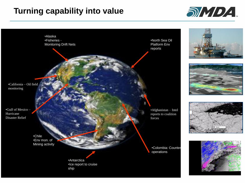
•4
•Alaska
•Fisheries -
Monitoring Drift Nets
•North Sea Oil
Platform Env
reports
•Antarctica
•Ice report to cruise
ship
•Colombia: Counter-narcotic
operations
•Chile
•Env mon. of
Mining activity
•Gulf of Mexico –
Hurricane
Disaster Relief
•Afghanistan – Intel
reports to coalition
forces
•California – Oil field
monitoring
Turning capability into value

5
Customer & Market Evolution
Large Single
Sensor National
Systems
Large Multi-
Sensor National
Systems
Single Sensor Single
User Systems
High Performance
Multi-Sensor
Systems
•1970 1980 1990 2000 2010
Civil (Gov’t &
Industry) and
Defence
Operational
Customers
Civilian
Government
Researchers
Civilian Government
Natural Resource
and Environmental
Agencies
Civil, Defence &
Security
Customers
•RESEARCH OPERATIONAL TIME CRITICAL •H
– V
AL
UE
OF
DA
TA
& S
YS
TE
M - L
REQUIREMENT
High operational
performance
High reliability
Best sensors suite

•West Freugh
•(1996) •Korea
•(1998)
•Gatineau
•(1995) •Prince Albert
•(1995)
•McMurd
o
•(1995)
•Alice's Spring
•(1998)
•Japan
•(1998)
•Saudi Arabia
•(1998) •Thailand
•(2000)
•Turkey
•(2002)
•Malaysia
•(2003)
•Singapore
•(1997)
•China
•(1998)
•Puerto Rico
•(2000)
•Brazil
•(2001)
•Argentin
a
•(2002)
•Miami
•(2004)
•Mosco
w
(2004)
•Kazakhstan
(2005)
•Fairbanks
•(1995) •Grimstad
•(2007)
•Italy
(2006)
•Magadan
(2007)
•Portug
al
•(2009)
•Tromsoe
•(1996)
•Samara
(2007) •Nizhini
(2007)
•Novosibirs
k (2007)
•Krasnoyarsk
(2007)
•Khaborovs
k (2007)
•Matera
(2010)
Global Demand for Public and Private Good RADARSAT Reception Coverage
•Arkhangelsk
(2011)
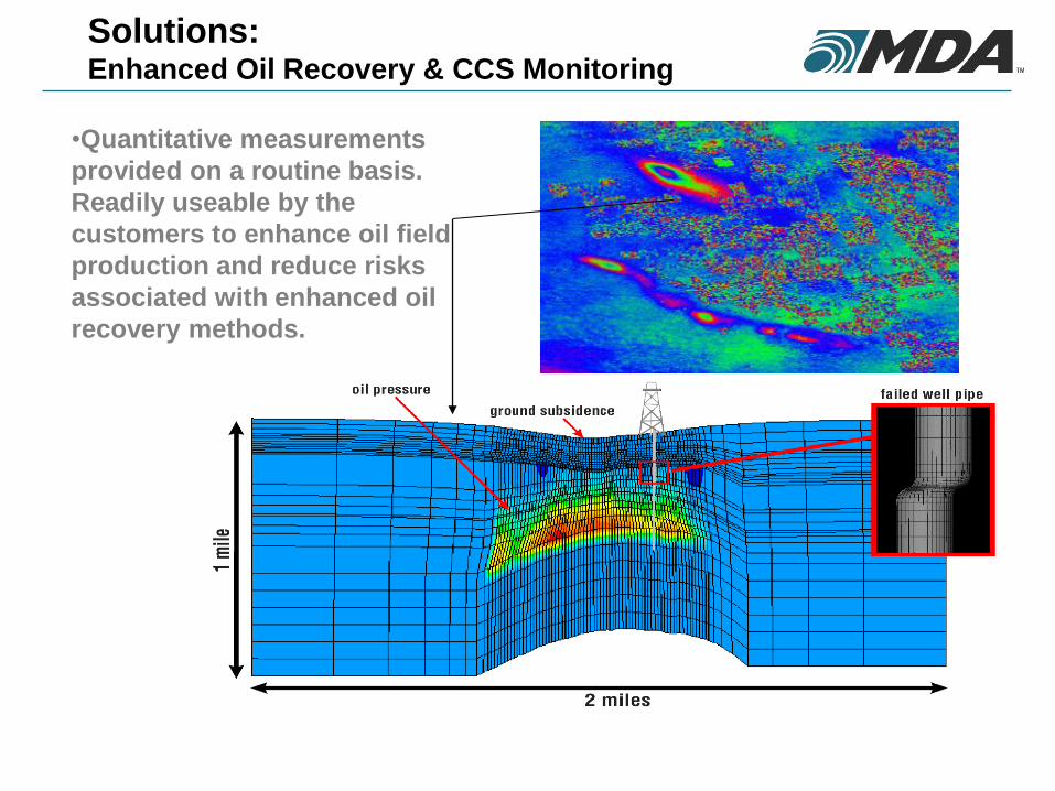
Solutions: Enhanced Oil Recovery & CCS Monitoring
•Quantitative measurements
provided on a routine basis.
Readily useable by the
customers to enhance oil field
production and reduce risks
associated with enhanced oil
recovery methods.

Solutions: Security and Defense – Maritime Surveillance
• Fuses the power of cooperative reporting (e.g. AIS) with the non-cooperative ship detection capabilities of Synthetic Aperture Radar (SAR)
• ADVANTAGE: ISOLATION OF NON-COOPERATIVE VESSELS
• All weather, wide area surveillance, for efficient cueing of resources
• Unclassified data allows wider distribution and coalition sharing
• Remote area (anywhere in world) maritime situational awareness
• Intuitive user interface, accessible from any physical location with internet access
• M2M interface available for integration into current systems

Solutions: Regulatory Enforcement – Illegal Fishing
• SAR satellite ship detection correlated with VMS used to
detect vessels in restricted fishing areas
• Kerguelen Islands, Crozet Island, Amsterdam Island
& Saint-Paul Island
• Valuable fishery – Patagonian Toothfish
(Chilean Sea Bass)
• Illegal fishing industry “stealing” the fish and
threatening stocks
• Continuous monitoring of the region using synthetic
aperture radar (SAR) satellites and VMS
• Illegal fishing vessels are intercepted and prosecutes.
•Net result: 90% reduction in illegal fishing activities

Solutions: Defense - Detection of movement and activity
•Iraq/Syria
•Border
•CCD from
RADARSAT-1
Mar. 19 to Apr. 12

Solutions: Offshore Production Monitoring & Exploration
• MDA GSI can deliver routine oil detection monitoring results via the SeaView intuitive web interface, correlated with wind speed estimates and ship locations.
• Underwater pipeline monitoring – detection of leaks so they can be fixed early with minimum down time means maximizing revenues
• Environmental monitoring – find problems when they are small and manageable. Determine responsibility, avoid bad publicity and/or regulatory action.
• Oil seep detection – find new areas of exploration. Long term monitoring allows triangulation of ocean floor sources.
•Leaking
Platform

12
Growth and Value Drivers driving Innovation
Imaging Performance
Requirement: Resolution, re-visit,
capacity, flexibility
Solution: Multi-source
Operational Performance
Requirement: On-line, on-demand, real
time,
globally accessible,
customer friendly
Solution: Utilization of global
infrastructure
New Offerings to Customers
Requirement: Offering addresses customers
critical information need.
Solution: Strategic partnerships, New
business models, non-’data
centric’ approach
Market Acceptance
Requirement: Critical information that
supports a customers decision
making.
Solution: Industry specific products and
services
Greater domain knowledge
Increased vertical integration
13
Challenges and Opportunities
Mission
• Differing data policies for individual missions (Government, PPP, Commercial) result in different mission priorities and focus.
• Long-term continuity of missions is key in supporting and developing on-going operational use.
• Differences in regulatory regimes impacts competitiveness and utilization in the world market.
Operations
• Integrating multiple missions into a single operational solution
• Re-visit and timeliness are key requirements for many users
Business
• Sufficient domain knowledge in order to develop and market services
• Bringing together complimentary capabilities through partnerships
• Defining clear value propositions for customers
14
Concluding Comments
• Space-Based EO is transitioning into a mainstream information source in major
industries and also providing essential information to government operating
agencies as a result of proven value to those users.
• This is a result of greater EO systems capability and capacity creating innovative
solutions often utilizing multiple sources of data and the systems that make this
possible.
• This business opportunity is driven by a number of technical factors such as
imaging performance, number of operational missions, high bandwidth
communications; ‘on-line’ user interfaces; global infrastructure.
• There is a need to evolve traditional business models and the way EO based
business is carried out. For example, such concepts as satellite-based streaming
video through social media.
• Governing policies must meet the needs of both government and commercial
business in order to realize the greatest benefit to nations.