esri thDelaware User Group Meeting, August 15 , 2012 - DTI GIS
26
esri Delaware User Group Meeting, August 15 th , 2012 Presented by: Kim Cloud, GISP Department of Technology & Information
Transcript of esri thDelaware User Group Meeting, August 15 , 2012 - DTI GIS

esri Delaware User Group Meeting, August 15th, 2012
Presented by: Kim Cloud, GISP
Department of Technology & Information

Delaware Geospatial Metadata Standard
Delaware Geospatial Data Exchange
Challenges
Preparing FGDC format metadata for upload
Option 1: ArcGIS 10 FGDC Add-In
Option 2: ArcGIS 10 Metadata fields
Option 3: Custom Metadata template
Q & A

Metadata is required by state code for geospatial data published by public agencies in Delaware. (See 91 Delaware Code, § 9144)
The existing standard was developed using the FGDC metadata standard as a guideline.
Consists of the minimum required FGDC attributes.
Was geared towards industry standard at the time, and in line with the input forms in ArcGIS.
The standard is available online: http://stateplanning.delaware.gov/dgdc/delaware_geospatial
_metadata_standard.pdf

Built to meet requirements defined by the DGDC Technical Infrastructure Sub-Committee.
Facilitates the publication of geospatial data across the State of Delaware.
End users include state organizations, local and county governments, private parties doing business with the state, and members of the general public.
Anyone can browse the list of public datasets anonymously.
Per state code, metadata is required.
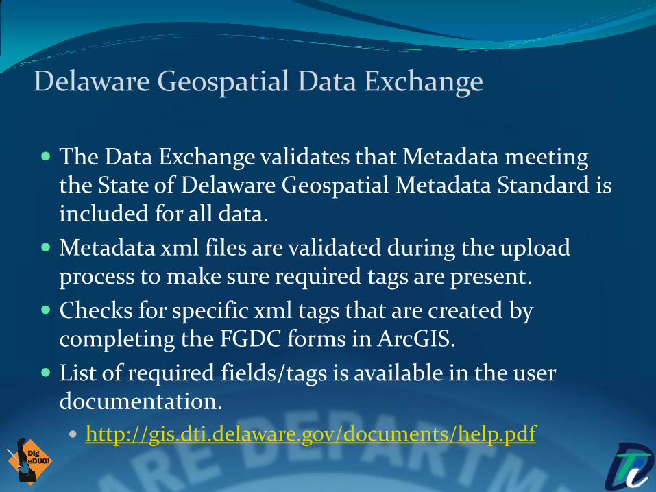
The Data Exchange validates that Metadata meeting the State of Delaware Geospatial Metadata Standard is included for all data.
Metadata xml files are validated during the upload process to make sure required tags are present.
Checks for specific xml tags that are created by completing the FGDC forms in ArcGIS.
List of required fields/tags is available in the user documentation.
http://gis.dti.delaware.gov/documents/help.pdf

Sample error message showing which metadata fields are missing.

ArcGIS 10+ does not include the FGDC forms by default.
The ArcGIS Metadata fields create different xml tags.
Industry standard has changed since the Data Exchange was built.
The new xml tags are not included in the validation checks in the Data Exchange.

FGDC tag example: /metadata/idinfo/descript/purpose
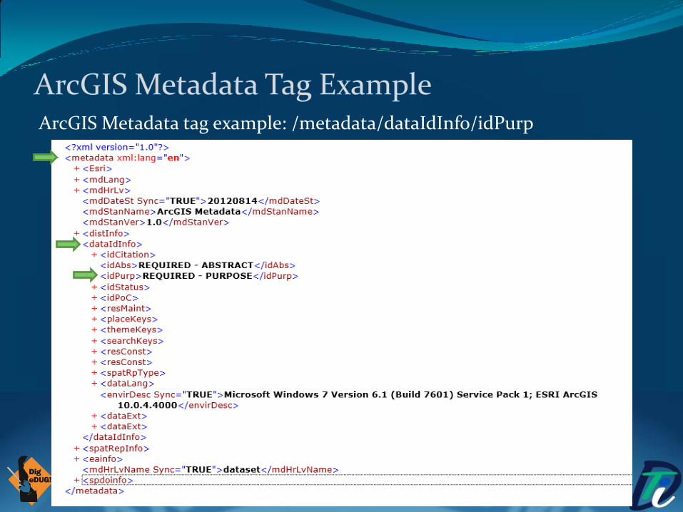
ArcGIS Metadata tag example: /metadata/dataIdInfo/idPurp

Configure ArcCatalog to use FGDC style metadata
Select Customize-ArcCatalog Options from within ArcCatalog
Set default Metadata Style to FGDC CSDGM Metadata

Create a shapefile or personal geodatabase.
View the description through ArcCatalog.
Edit the metadata and save, and ArcCatalog automatically creates the metadata xml file.
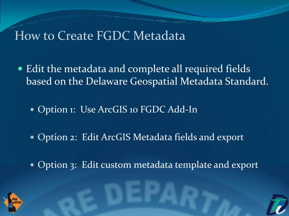
Edit the metadata and complete all required fields based on the Delaware Geospatial Metadata Standard.
Option 1: Use ArcGIS 10 FGDC Add-In
Option 2: Edit ArcGIS Metadata fields and export
Option 3: Edit custom metadata template and export

Option 1: Use the FGDC add-in for ArcGIS Desktop 10 & above in order to complete the metadata.
Creates the xml tags in FGDC format, so no exporting is required.
Download the add-in from esri’s web site:
http://blogs.esri.com/esri/arcgis/2010/06/25/fgdc-metadata-editor-for-arcgis-10/
Add the FGDC tool to the Metadata toolbar:

The Add-in provides the original input screens for FGDC format metadata.
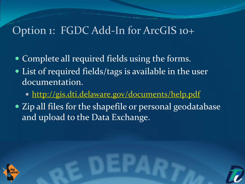
Complete all required fields using the forms.
List of required fields/tags is available in the user documentation.
http://gis.dti.delaware.gov/documents/help.pdf
Zip all files for the shapefile or personal geodatabase and upload to the Data Exchange.

Edit the ArcGIS Metadata and complete the required fields through the ArcGIS forms.
List of required Delaware Geospatial Metadata Standard values mapped to ArcGIS fields is available.
Detailed metadata instructions on esri’s web site:
http://help.arcgis.com/en/arcgisdesktop/10.0/help/index.html#/Illustrated_guide_to_complete_FGDC_metadata/003t00000037000000/
DE Standard Attribute FGDC Tag Corresponding ArcGIS Metadata Field
Purpose /metadata/idinfo/descript/purpose 1.2.2 Overview -> Item Description -> Summary (Purpose)
Abstract /metadata/idinfo/descript/abstract 1.2.1 Overview -> Item Description -> Description (Abstract)

Edit the metadata, using the map to locate all of the required fields.
Example from esri instructions:
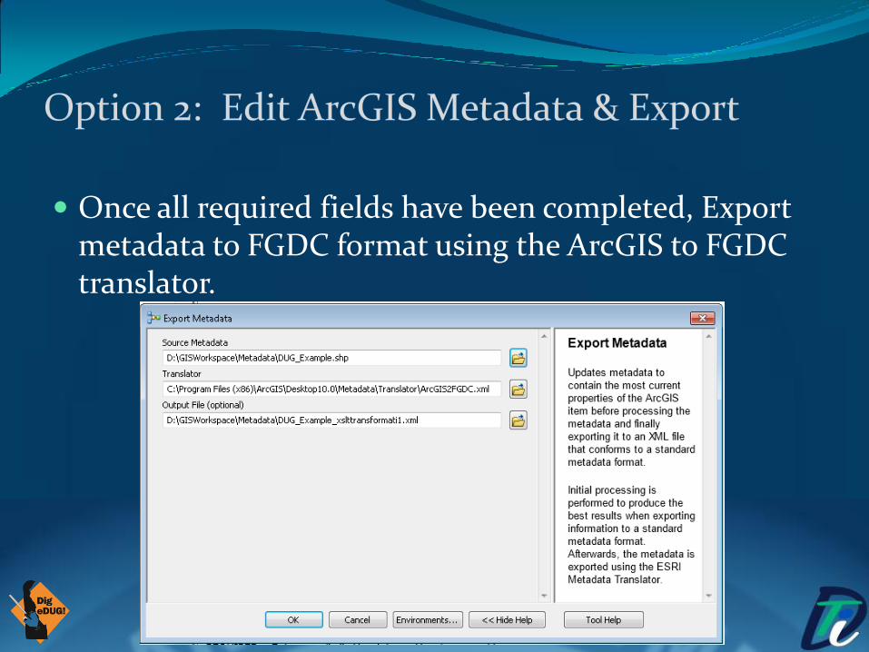
Once all required fields have been completed, Export metadata to FGDC format using the ArcGIS to FGDC translator.
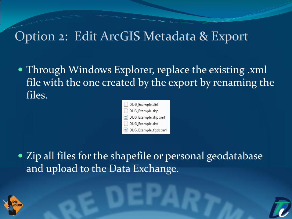
Through Windows Explorer, replace the existing .xml file with the one created by the export by renaming the files.
Zip all files for the shapefile or personal geodatabase and upload to the Data Exchange.

A custom template with all required Delaware Geospatial Metadata Standard fields completed is available.
Import the metadata template into an existing shapefile or personal geodatabase.
Synchronize the metadata.
Edit the required fields.
Export to FGDC format.

Import the metadata template into existing file.

Synchronize the metadata to update the spatial and attribute information.
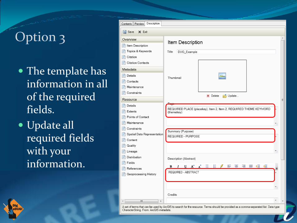
The template has information in all of the required fields.
Update all required fields with your information.

Once all required fields have been completed, Export metadata to FGDC format using the ArcGIS to FGDC translator.
Through Windows Explorer, replace the existing .xml file with the one created by the export by renaming the files.
Zip all files for the shapefile or personal geodatabase and upload to the Data Exchange.


For questions or feedback, please contact
Kim Cloud (302)739-9611,
Additional information is available online:
https://dataexchange.gis.delaware.gov/