ESCI 545 GIS Workshop - wiki.rice.edu
25
GIS/Data Center | Email [email protected] | Lab (713) 348-2599 | library.rice.edu/gdc ESCI 545 GIS Workshop
Transcript of ESCI 545 GIS Workshop - wiki.rice.edu

GIS/Data Center | Email [email protected] | Lab (713) 348-2599 | library.rice.edu/gdc
ESCI 545 GIS Workshop

GIS/Data Center | Email [email protected] | Lab (713) 348-2599 | library.rice.edu/gdc
Remote course logistics
1. Software should already be downloaded
2. Slides, wiki, recording available
3. Unmute yourself to ask a question
4. Type questions into chat

GIS/Data Center | Email [email protected] | Lab (713) 348-2599 | library.rice.edu/gdc
Objectives
1. Know where to go for further assistance
2. Refresh on GIS terms and concepts
3. Familiar with ArcGIS Pro interface
4. Employ GIS tools for geoscience objectives

GIS/Data Center | Email [email protected] | Lab (713) 348-2599 | library.rice.edu/gdc
Road mapGDC GIS overview Examples of GIS Hands-on workshop

GIS/Data Center | Email [email protected] | Lab (713) 348-2599 | library.rice.edu/gdc
GIS/Data Center

GIS/Data Center | Email [email protected] | Lab (713) 348-2599 | library.rice.edu/gdc
What is GIS?
A geographic information system (GIS) is a system designed to create, store, manipulate, analyze, manage, and visualize spatial data.
Photo source:
https://mangomap.com/what-is-gis

GIS/Data Center | Email [email protected] | Lab (713) 348-2599 | library.rice.edu/gdc
What is GIS?
Photo source:
https://geoawesomeness.com/gis-underwater/

GIS/Data Center | Email [email protected] | Lab (713) 348-2599 | library.rice.edu/gdc
GIS dataComponents Types Formats

GIS/Data Center | Email [email protected] | Lab (713) 348-2599 | library.rice.edu/gdc
GIS data components
Features• Graphic spatial representation
of real-world physical features
Attributes• Non-spatial data describing
the features
Photo source:
https://mangomap.com/what-is-gis

GIS/Data Center | Email [email protected] | Lab (713) 348-2599 | library.rice.edu/gdc
GIS data components
Features• Graphic spatial representation
of real-world physical features
Attributes• Non-spatial data describing
the features

GIS/Data Center | Email [email protected] | Lab (713) 348-2599 | library.rice.edu/gdc
Symbolize data by attributes
GIS/Data Center | Email [email protected] | Lab (713) 348-2599 | library.rice.edu/gdc
Select data by attributes

GIS/Data Center | Email [email protected] | Lab (713) 348-2599 | library.rice.edu/gdc
Data types
Vector• Uses points, lines, and polygons
to represent real features on the earth’s surface. Ideal for discrete themes with definite boundaries.
• Examples: light poles, roads, buildings
Raster• Composed of a continuous
grid of cells that represent a value for a portion of the earth’s surface. Ideal for continuous themes of change
• Examples: elevation, rainfall

GIS/Data Center | Email [email protected] | Lab (713) 348-2599 | library.rice.edu/gdc
Shapefile feature class• Open source
Geodatabase feature class• Esri, proprietary
Data formats
Feature class
• Vector storage data format; points, lines, polygons
• Homogenous collection of common features

GIS/Data Center | Email [email protected] | Lab (713) 348-2599 | library.rice.edu/gdc
• MrSID
• Esri GRID
• JPEG
• TIFF
• GeoTIFF
• PNG
Data formats
Raster
• Matrix of cells organized into rows and columns where each cell contains a value representing information.

GIS/Data Center | Email [email protected] | Lab (713) 348-2599 | library.rice.edu/gdc
Esri ArcGIS software

GIS/Data Center | Email [email protected] | Lab (713) 348-2599 | library.rice.edu/gdc
ArcGIS products
Desktop GIS• ArcGIS Pro, ArcMap, ArcCatalog
Web-based GIS• ArcGIS Online (AGOL): web maps, web apps
Mobile GIS• Collector for ArcGIS
• Survey123 for ArcGIS

GIS/Data Center | Email [email protected] | Lab (713) 348-2599 | library.rice.edu/gdc
GIS in practice
GIS/Data Center | Email [email protected] | Lab (713) 348-2599 | library.rice.edu/gdc
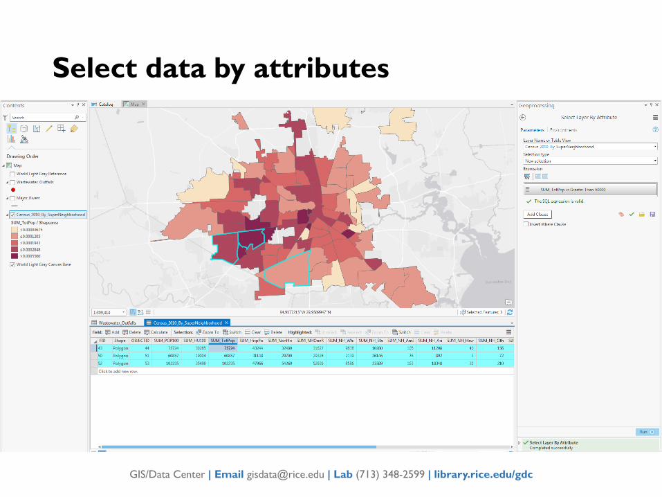
Environmental Impacts
https://icfgeospatial.maps.arcgis.com/apps/MapSeries/index.html?appid=58f90c5a5b5f4f94aaff93211c45e4ec

GIS/Data Center | Email [email protected] | Lab (713) 348-2599 | library.rice.edu/gdc
Environmental Impacts
https://harcresearch.maps.arcgis.com/apps/MapSeries/index.html?appid=d6b0a3d762ec46ef8ea676f1008f7028/
GIS/Data Center | Email [email protected] | Lab (713) 348-2599 | library.rice.edu/gdc
Hands-on workshop
Recording available.
Slides available.
Wiki tutorial available online.

GIS/Data Center | Email [email protected] | Lab (713) 348-2599 | library.rice.edu/gdc
1. Know where to go for further assistance
2. Refresh on GIS terms and concepts
3. Familiar with ArcGIS Pro interface
4. Employ GIS tools for geoscience objectives
Summary