ESA Standard Document - ESA Conference...
26
International Forum on Satellite Earth Observation for Geohazard Risk Management. Perspectives concerning Satellite EO and Geohazard risk management: the way forward Community paper concerning inactive mines hazards Date of Issue 18/04/2012 Status Draft 1.0
Transcript of ESA Standard Document - ESA Conference...

International Forum on Satellite Earth Observation for Geohazard Risk Management.
Perspectives concerning Satellite EO and Geohazard risk management: the way forward
Community paper concerning inactive mines hazards
Date of Issue 18/04/2012Status Draft 1.0

Coordinators of the International Forum:
Philippe Bally (ESA).
Francesco Gaetani (GEO Secretariat).
Lead Authors:
Norbert Benecke & Karsten Zimmermann (DMT GmbH & Co. KG),
Stuart Marsh (BGS – British Geological Survey)
Contributing Authors:
Luke Bateson (BGS – British Geological Survey), Chris Browitt (EFG - European Federation of
Geologists), Pierre-Yves Declercq (Royal Belgian Institute of Natural Sciences), Luca Demicheli
(EuroGeoSurveys), Marek Granicny (PGI – Polish Geological Survey), David Norbury (EFG).
Acknowledgements:
This paper received editing input from Philippe Bally (ESA), Francesco Gaetani (GEO Secretariat),
Geraint Cooksley (Altamira Information) and Andrew Eddy (Athena Global).
Page 2/26Date 18/04/2012

CONTENTSPE SPEC ES CO CE G S E E EO GEO S M GEME : E R TIV N RNIN AT LLIT AND HAZARD RI K ANA NT TH WAY
OF RWARD.....................................................................................................................1COMM P PE CO CE G C E M ES SUNITY A R N RNIN INA TIV IN HAZARD ..............................................11 SCOPE OF THIS COMMUNITY PAPER..................................................................42 ABANDONED MINING HAZARD AND EXPOSURE...............................................53 USERS AND THEIR INFORMATION NEEDS WITH REGARDS TO GEOHAZARD RISKS FROM ABANDONED MINES...........................................................................84 THE EUROPEAN CASE........................................................................................105 THE GLOBAL PERSPECTIVE...............................................................................126 CURRENT STATE OF APPLICATIONS & SERVICES.............................................15
Case Study Northumberland and Durham (UK).............................................................................16Case Study Bedzin and Sosnowiec (PL)...........................................................................................17Case Study Liège (B)....................................................................................................................... 19
7 THE WAY FORWARD..........................................................................................218 REFERENCES.....................................................................................................23
ANNEX 1......................................................................................................................................... 25APPENDIX 1....................................................................................................................................26
Page 3/26Date 18/04/2012

This document is a draft of a series of papers with the scope of reflecting the community
perspective on geohazards. It forms the basis for discussion to be held at the International Forum
on Satellite Earth Observation for Geohazard Risk Management organised by the European
Space Agency on May 21-23, 2012 (www.int-eo-geo-hazard-forum-esa.org). The authors invite
comments and further contributions from the community on this paper so they can be collated
and discussed at the conference. The document will be updated on the basis of this discussion.
Comments should be addressed to [email protected] with the title of the draft paper.
1 Scope of this community paper
This paper highlights the European perspectives concerning how satellite EO can contribute to
geohazard & disaster risk reduction in former mining areas. The aim is to consider the state of the
applications and services starting from the situation in Europe and expanding to provide a global
perspective. This paper presents the outcome of analysis on how to further consolidate applications
and services to achieve their expected benefits. A way forward is proposed considering activities
and plans of this community for the next 5 to 10 years. This document builds on the 3rd
International Geohazards workshop of the Group of Earth Observation (GEO), held in November
2007 in Frascati, Italy, which recommended “to stimulate an international effort to monitor and
study selected reference sites by establishing open access to relevant datasets according to GEO
principles to foster the collaboration between all various partners and end-users”.
Community papers are being elaborated for other types of geohazards for discussion at the
International Forum on Satellite Earth Observation for Geohazard Risk Management that
European Space Agency is organising in May 2012 at the Santorini Convention Centre in Greece.
These other hazards include volcanoes, seismic hazards, coastal lowland subsidence and flood
defence and landslides.
The scope and theme of these community papers are described in Appendix 1.
Page 4/26Date 18/04/2012

2 Abandoned Mining hazard and exposure
Mining is the extraction of valuable minerals or other geological materials from the earth, from an
ore body, vein or seam. The term also includes the removal of soil. Materials recovered by mining
include base metals, precious metals, iron, uranium, coal, diamonds, limestone, oil shale, rock salt
and potash [1]. Since the beginning of civilization, people have used stone, ceramics and, later,
metals found on or close to the Earth's surface. Therefore today active and abandoned mining areas
are widely spread all over the world (Figure 1); therefore hazards caused by mining can happen
anywhere in the world.
Fig. 1: Inactive Mines of the world (Source: Mineral Resource Database U.S. Geological Survey 2011, http://tin.er.usgs.gov/mrds/)
Every mining activity impacts the nearby environment, whether open pit mining or underground
mining, small scale mining or large operations. Active mining operations are mostly well monitored
by Mining Authorities; however, to different standards of quality and quantity depending on the
legal regulations within the certain country. Therefore, hazards caused by active mining are
Page 5/26Date 18/04/2012
reported frequently all over the world, e.g. the 2010 mine disaster in Chile’s San Jose mine is well
remembered.
When a mine site is abandoned, the awareness of previous mining activities decreases quickly.
Former mine shafts and underground cavities, re-filled open pits, tailings and dumping sites exist.
Even when the former mine sites have been secured, depending on the knowledge and standards at
the time of abandoning in the different countries, hidden legacies can cause geohazards at any time.
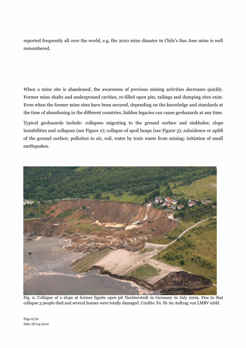
Typical geohazards include: collapses migrating to the ground surface and sinkholes; slope
instabilities and collapses (see Figure 2); collapse of spoil heaps (see Figure 3); subsidence or uplift
of the ground surface; pollution to air, soil, water by toxic waste from mining; initiation of small
earthquakes.
Fig. 2: Collapse of a slope at former lignite open pit Nachterstedt in Germany in July 2009. Due to that collapse 3 people died and several houses were totally damaged. Credits: Fa. Ilv im Auftrag von LMBV mbH.
Page 6/26Date 18/04/2012
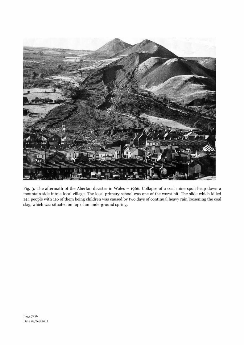
Fig. 3: The aftermath of the Aberfan disaster in Wales – 1966. Collapse of a coal mine spoil heap down a mountain side into a local village. The local primary school was one of the worst hit. The slide which killed 144 people with 116 of them being children was caused by two days of continual heavy rain loosening the coal slag, which was situated on top of an underground spring.
Page 7/26Date 18/04/2012

3 Users and their information needs with regards to geohazard risks from abandoned mines
As geohazards caused by abandoned mining are man-made geohazards, in general an originator
can be mentioned, namely the mining company who operated the particular mine. However, in
most cases this originator no longer exists or cannot be identified quickly after a hazardous event.
Therefore, the responsibility for all abandoned mining in a country is, firstly, a governmental task,
which is typically allocated to a governmental Mining Authority. The detailed regulations and
responsibilities differ from country to country; in some federal countries with different regulations
for different states or regions.
However, in all cases the responsible organizations have similar information needs. The common
steps are to:
identify the sites posing a risk;
map and assess the hazard;
identify the exposure of people and infrastructure;
monitor the hazard with a frequency dependent on the magnitude of the hazard and the
risk posed.
These information needs will be illustrated by the German example. As hazards from abandoned
mining are a serious problem all over Germany, an interdisciplinary expert working group under
the leadership of the German Geotechnical Society (Deutsche Gesellschaft für Geotechnik DGGT)
and the German Mine Surveyors Association (Deutscher Markscheider-Verein, DMV) has been
working on the theme of abandoned mining for more than 10 years. In particular this working
group has developed technical guidelines for the following sub-themes:
Geotechnical and mine surveying methods for investigation and evaluation of abandoned
(underground) mines (published 2004 [2])
Geotechnical and mine surveying methods for investigation and evaluation of abandoned
open pits, dumping and landfill sites (published 2009 [3])
Protection, ground support and permanent safekeeping of abandoned mines (published
2010 [4])
Geotechnical and mine surveying methods for evaluation and reclamation of abandoned
(underground) mines in urban areas (publication planned for 2012)
Page 8/26Date 18/04/2012

These guidelines represent the state-of-the art in dealing with abandoned mines in Germany and
will be accepted by all involved organisations, in particular Mining Authorities and mining
companies, as well as consulting and service companies or expert bodies. Also these guidelines are
being considered in Austria and Poland.
These guidelines contain detailed listings of relevant information and possible sources for this
information. One of the most important needs is any information about former and current surface
movement. This information allows those responsible for territorial management to identify
potential hazards through cross-referencing with known records or in situ investigation. In many
cases where records have been lost, the satellite EO measurement of ground subsidence may be the
only warning that catastrophic collapse is imminent. In essence, satellite EO can be the fabled
canary in the coal mine. Satellite EO also offers a means to constantly monitor safeguarded areas to
track the evolution of surface movement.
Page 9/26Date 18/04/2012

4 The European case
Mining of different raw materials in Europe took place for millennia and became one of the most
important industries in the 18th century. Today some European mining activities are still active but
several areas, widely spread all over Europe, are abandoned and therefore potentially risk areas for
hazards. Unfortunately no reliable numbers of the affected areas are available. In general it is safe
to say that a vast majority of deposits have been undermined at some time in the past. Therefore a
geological map showing the deposits can be used as a rough proxy for areas at risk from inactive
mining. The following European map with coal extraction areas (Figure 4) can be used as an
example.
Fig. 4: Areas of mine deposit (Source: http://ptrarc.gtk.fi/ProMine/default.aspx)
Page 10/26Date 18/04/2012

On a regional level more detailed information can be available. The following map from the State
Mining Authority of Northrhine-Westphalia (Germany) represents all communities which are
affected by abandoned mines (Figure 5). Within these areas more than 20,000 former mine shafts
are registered.
Fig. 4: Map of German federal state North Rhine-Westphalia. All communities with affected by abandoned mines are highlighted in green or yellow (Source: http://www.bezreg-arnsberg.nrw.de/themen/a/altbergbau_bergschaeden)
Page 11/26Date 18/04/2012

5 The global perspective
Initially, little effort was put into the global aspects of mining hazards in comparison to other
Geohazards. They were considered a local issue and were not really part of the International
Strategy and then Decade for Disaster Reduction in the 1990s and early 2000s. This changed when
CEOS joined with the UN agencies and the science programmes under the International Council for
Science to form the IGOS Partnership. This was dedicated to the setting of International Global
Observing Strategies, including one for geohazards that covered subsidence, including that related
to mining and resource extraction, as one of its four main themes. The IGOS Theme Report,
published by ESA in 2004, set out a long-term (10-years plus) strategy for the better observation
and monitoring of subsidence. One of the main strands was to build a stronger global geohazards
communities, which has seen these more applied hazards become part of the wider geohazard scene
alongside landslides.
The IGOS Partnership was an excellent forum for designing strategy but it lacked political
stakeholders and so implementation was on a best-endeavours basis amongst the partners. This is
one of the main reasons for the formal establishment in 2005 of the Group on Earth Observations
(GEO), an intergovernmental organisation with the sole objective of building the Global Observing
System of Systems (GEOSS). Once GEO was established, with almost 100 Member States, and the
IGOS Partners had joined it as Participating Organisations, the IGOS Themes were then integrated
into its 10 year Work Plan during 2009. Thus GEO has been responsible for implementing the
geohazard strategy through its Disasters Societal Benefit Areas (SBA). However, initial focus on
mining hazards was again somewhat weak in the face of the recognised geohazards such as
earthquakes and volcanoes. So, the IGOS Geohazards community that had developed the
subsidence theme set about changing this again in this new, GEO community. As a result, in its VIII
Plenary, in November 2011 the Group on Earth Observations (GEO) adopted a new Work Plan for
2012-15 which included minerals as specific theme for the first time under a new Energy and Geo-
resources Management Task, EN-01. This Task aims to develop tools and information for the
resource assessment, monitoring and forecasting of geological resources (including mineral and
fossil resources, raw material and groundwater). In addition, the GEO 2012-2015 Work Plan
includes a Task on Impact Assessment of Human Activities, SB-05, which aims to develop an
impact monitoring system for geo-resource exploration and exploitation.
Page 12/26Date 18/04/2012

An InSAR-based mapping and monitoring service could be offered into this GEO activity as a
significant new contribution and the techniques developed in a European context thereby extended
to global application. An initial approach could be made by contributing data to the GEOSS, the
Global Earth Observations System of Systems being developed through GEO. The European Project
EO-MINERS, which has been funded under FP7 to implement these GEO Tasks, involves several
Terrafirma Partners (BGS, BRGM and DLR) so this should be a smooth collaboration. Terrafirma
could offer to complement the work done on mine waste, pollution and other impacts by EO-
MINERS with InSAR-based analysis of ground deformation associated with the three mine sites
under study (Sokolov in the Czech Republic, Witbank in South Africa and Makmal in Kyrgyzstan).
A limited amount of such work is contemplated, but a Terrafirma contribution could greatly expand
on this.
In the context of the Global Monitoring for Environment and Security initiative, similar links could
be exploited with the PanGeo FP7 GMES Downstream project, which is using a combination of
Terrafirma results and new processing to provide geohazard information for 52 cities across
Europe, some of which are affected by mining. The plan for sustainability within PanGeo relies on
other cities requiring the same service. Based on the relationship already established, with 27
Terrafirma results being used in PanGeo, Terrafirma could work with PanGeo on marketing to
create this user demand and share the InSAR processing and geological interpretation work
required to create PanGeo products for the new cities.
Within GEO, the community building process has continued through the establishment of a
Community of Practice for Geohazards (GHCP). This has set out a Roadmap for the Disasters SBA
based on the four recognised stages of the disaster response cycle; preparedness, early warning,
response and recovery. This helped to shape the new GEO Work Plan for 2012-15 and Tasks in that
plan are now taking forward the implementation of the Roadmap. This Roadmap and the Work
Plan, which now has specific SBA Tasks related to mining, provide a potential framework for
defining new activities on mining hazards that could be supported and delivered by Terrafirma
partners and ESA. Minerals are rising up the EC agenda, too, and their Raw Materials Initiative
(RMI) is starting to explore ways in which GMES could provide the observations necessary for the
minerals-related issues.
Page 13/26Date 18/04/2012

The Community was recently brought together again by the GHCP with assistance from the
European Science Foundation and the COST Office for a High-Level Conference on Extreme
Geohazards and there will be follow-up meetings during the EGU in April 2012. The scientific focus
of these events will then be complemented by the more applied focus of the International Forum on
Satellite Earth Observation for Geohazard Risk Management in May 2012 at the Santorini
Convention Centre in Greece. This will bring together many of these international players with staff
from some of the key, relevant European, GMES and RMI projects. The combination of excellent
science, a strong observing system, applied projects approaching their sustainable, operational
phase and major industrial players will be critical to plan a more consolidated approach to dealing
with mining hazards globally.
Page 14/26Date 18/04/2012

6 Current state of applications & services
As the knowledge about surface movements is one of the most important information needs in
monitoring abandoned mining areas, the following examples from European practice will illustrate
how the EO technique “radar interferometry” is able to deliver the required information about
surface movements in abandoned mining areas. All three presented case studies have been
executed within the ESA GMES project Terrafirma. Knowledge about the area affected by surface
movements, the magnitude (from millimetres to meters per year) and the direction (subsidence or
uplift) of the movements, as well as the velocity and possible velocity changes, permits appropriate,
timely measures to be taken to avoid hazards or to minimize the impact of hazards.
In March 2011 a european workshop focusing on the area of post-mining was organized by the
organisation DMT to bring together the EO community and the mining community. The meeting
was successful in stimulating discussion and presenting to the post mining community the service
possible using InSAR. The workshop was open to all those interested in ground movement
monitoring, in particular in relation to mining. There were 36 participants, mainly from the
German and European mining industry, mining authorities and other governmental organizations
(e.g. state ministries and geological surveys) as well as a few service providers and universities.
Overall the observational requirements for Satellite EO concerning inactive mines are as follows:
(A) SAR data:
High Resolution SAR: (i) for hazard inventory purposes (e.g. historical hazard mapping):
continuous observations descending and ascending repeat coverage (maximum images per
year, C and L-band in stripmap mode), the focus is to extend and guarantee observations
over the of the priority areas defined in section 2; (ii) for hazard monitoring purposes:
descending and ascending repeat coverage of hotspots (e.g. most critical mines) with more
than 3 images per month C or L-band (e.g. Sentinel-1 at least all cycles in descending mode
and at least 50% cycles in ascending mode)
Very High Resolution SAR: (i) for hazard inventory purposes: specifically to survey small
spatial extent abandoned mine shaft motions for any ongoing motions continuous
Page 15/26Date 18/04/2012

observations descending and ascending repeat coverage with minimum 20 images per year.
(ii) for hazard monitoring purposes on hotspots (e.g. most critical mineshafts): descending
and ascending repeat coverage (e.g. TerraSAR-X every 11 days, COSMO-SkyMed every 8
days).
(B) HR Optical/VHR Optical: (i) to provide background reference imagery: archive image (no
more than 1-year old), panchromatic or true colour composite.
The use of Satellite EO is illustrated with the following case studies:
Case Study Northumberland and Durham (UK)
The Terrafirma Abandoned Mines service for Northumberland and Durham has shown PSI to be a
useful tool for the monitoring of minewater levels and their recovery. Northumberland and
Durham, in the northeast of the UK, has a history of coal extraction extending over hundreds of
years. The working of deeper and deeper coal seams, including those beneath the Permian bedrock
cover, led to the need to pump mine water. Systematic pumping of mine water ended with the
abandonment of underground mining. However, as part of a strategy to control and monitor mine
water within the now abandoned coalfield, the UK Coal Authority continued to pump minewater
from a number of sites. Recent years have seen a progressive reduction in the number of pumping
sites and groundwater levels within some parts of the coalfield have recovered.
Two PSI results, ERS 1995 to 2000 and Envisat 2002 to 2008, were produced for the area (Figure
6). In the earlier time period a complex pattern of ground motion is evident. There appears to be a
complex relationship between areas of subsidence, undermining, changes in groundwater/
minewater level and the pattern of faulting. In the more recent time period there is a change to a
regional pattern of uplift. The pattern of uplift follows the timing of recovery of minewater levels
within the minewater recovery blocks (structurally defined areas within which the Coal Authority
consider minewater levels to act in the same way); the greatest rates of uplift occur over blocks for
which the minewater level has recovered most recently. Water level changes measured within
monitoring boreholes show the same upward trend as the PSI ground motion histories (Figure 6).
This ability to identify areas of minewater level change offers potential savings to the Coal Authority
by reducing the need for unnecessary monitoring boreholes, with boreholes being sited in areas
where PSI data has shown that minewater levels are rising via its ground motion signature, rather
than employing an expensive ad hoc monitoring network of boreholes.
Page 16/26Date 18/04/2012

Fig. 5: ESR and Envisat PSI for Northumberland and Durham. Inset graph shows the minewater recovery (thick red line) and PSI time series (thinner coloured lines) for the Boldon Mine water monitoring borehole.
Case Study Bedzin and Sosnowiec (PL)
The project areas of Bedzin and Sosnowiec are located in the Upper Silesian Coal Basin, one of the
major coal production regions in Europe. Ground movement hazards and related risks within this
region are usually related to active and abandoned deep coal mining and causing severe damage to
gas and water pipelines, electric cables, traffic infrastructure and buildings.
Especially for land use planning purposes, the collection of systematic information on the ground
instabilities is very important and a main evaluation factor for responsible authorities. In the Upper
Silesian Coal Basin ground motion monitoring is one of main tasks of the Polish Geological
Institute (PGI) which is responsible for Poland’s security in supply of mineral resources,
groundwater management, monitoring of the geological environment and warning against natural
hazards and risk.
To support PGI in its tasks, Terrafirma specialists conducted a PSI analysis for selected areas to
provide large area, small scale movement information with high accuracy. Several stacks of ERS
and ENVISAT satellite data from 1992 to 2010 were therefore analysed in several processing
campaigns and projects. In addition and importantly, the PSI results were further analyzed and
Page 17/26Date 18/04/2012
enhanced with data related to mining, such as geological maps and mining maps. Through this
integration the evolution and cause of the mining induced movements was identified and this
enabled the assessment of surface movements in response to abandoned mining works including
ground subsidence, collapse or heaving due to mine water rise.
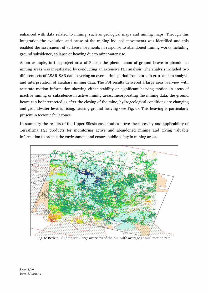
As an example, in the project area of Bedzin the phenomenon of ground heave in abandoned
mining areas was investigated by conducting an extensive PSI analysis. The analysis included two
different sets of ASAR-SAR data covering an overall time period from 2002 to 2010 and an analysis
and interpretation of auxiliary mining data. The PSI results delivered a large area overview with
accurate motion information showing either stability or significant heaving motion in areas of
inactive mining or subsidence in active mining areas. Incorporating the mining data, the ground
heave can be interpreted as after the closing of the mine, hydrogeological conditions are changing
and groundwater level is rising, causing ground heaving (see Fig. 7). This heaving is particularly
present in tectonic fault zones.
In summary the results of the Upper Silesia case studies prove the necessity and applicability of
Terrafirma PSI products for monitoring active and abandoned mining and giving valuable
information to protect the environment and ensure public safety in mining areas.
Fig. 6: Bedzin PSI data set - large overview of the AOI with average annual motion rate.
Page 18/26Date 18/04/2012

Case Study Liège (B)
A strong mining subsidence of several meters was observed during the coal exploitation in the Liege
basin associated with intensive groundwater pumping. After two centuries, the industrial coal
extraction has ceased, resulting in the abandonment of the dewatering. Since 1970, the recharge of
the aquifers has led to several surface phenomena. In 2005, the Geological Survey of Belgium
participated in the Terrafirma program. Using 102 SAR scenes, 28,000 PSI were identified in the
region of interest with a density ranging from 100 to 480 PS/km². Analysis of the annual average
velocity of the PSI highlighted different ground movements occurring in and around the city of
Liege. A subsidence along the river Meuse is recorded by the data with the interpretation of the
movement relating this to building loads on the soft alluvial plain deposits of the river Meuse. On
the other hand, strong positive annual average velocity values are observed in the Saint-Nicolas and
Seraing districts. The rise of groundwater mining after several years of aquifer recharge leads to
hydrostatic overpressure. This process resulted in several centimeters of elastic rebound (uplift) in
these previously subsiding mining areas (see figure 8).
Page 19/26Date 18/04/2012

Fig. 7: Kriging interpolation based on the annual average velocity and mine influence areas correlated with the uplifting (blue colours) regions.
Page 20/26Date 18/04/2012
7 The way forward
In 2011 the German organisation DMT organized an ad hoc working group under the patronage of
the German Mine Surveyors Association (DMV) to work towards the acceptance of PSI-based
movement monitoring by the Mining Authority in Germany. The first meeting took place directly
after the mentioned post-mining workshop and eleven participants from the German mining
industry, mining authority and mining service industry agreed upon a work plan for the
development of “Technical Guidelines for mining applications of radar interferometry”. Follow-up
meetings have resulted in an agreement about the general structure of the guidelines. Now the
creation of a first draft is under progress. According to current progress it is planned to release the
final version of these guidelines in mid-2012. They will define the technical state-of-the-art for
mining applications of radar interferometry. Although they will not become legal regulations, the
German mining authorities will be able to accept monitoring concepts presented by mining
companies on basis of these guidelines, as they already do with similar guidelines on GNSS and
laser scanning. The German example is a prototype as to how European countries could go forward
to implement EO technologies as an important part of a monitoring concept for post-mining areas.
Further work is required to develop standard procedures to systematically map former mining
areas at risk and compare them with actual population densities and critical infrastructure.
In Europe, over the course of the last decades, many mines have been abandoned. However, there
are indications that renewed interest in mining may lead to new ventures. Mining is an essential
part of the heavy industry. The demand for raw materials was, and still is, the basis for a continuous
production circle of developing deposits, building, operating and closing of mines. Despite of the
abandonment of many mining sectors in the last decades, due to high mining and production costs
in Europe, a renaissance can be observed lately and can be also predicted for the future. Looking at
the example of Germany, the German GMES user forum, as required by the European Regulation
No 911/2010 of the European Parliament and the Council [14] on the European Earth monitoring
programme (GMES) and its initial operations, has been established under the leadership of
German Federal Government. In November 2011 a German National Actions Program [15] has
been published, which proposes several particular actions for the next four to five years. One of
these actions is the development of a pilot service for monitoring abandoned mining areas by using
GMES data. This development is allocated to the German Geological Survey BGR and the Mining
Authorities of the Federal States, but it can be expected that also the German mining industry will
be involved in this development. Beside this the State Government of North Rhine-Westphalia, the
Page 21/26Date 18/04/2012

German Federal State with the highest amount of mining activities has funded a new R&D project
called GMES4Mining in which service providing companies and Universities will investigate new
developments in remote sensing technologies for mining purposes, in particular new hyper spectral
sensors as well as high resolution radar data. The integration of remote sensing data with ground
truth data is a key target of this project. As far as the European perspective is concerned, it is
understood that to meet the needs of risk management users concerned with the monitoring of
abandoned mining areas, within the next five years a regular service capability will be available in
the frame work of GMES data (primarily using Sentinel 1 data). In Germany it is expected that this
capability will be exploited as an operational service. The German approach is intended to form a
useful example as best practice for other European and worldwide countries.
Looking at the global issue, the demand for several raw materials, in particular rare earths and
graphite, is increasing, causing price increases. New technological evolution is further pushing
demand for some of these critical raw materials, so that prices may rise to levels far above those
before the economic downturn. Mining projects are (re)starting production and new mining
opportunities are being explored worldwide (magnesium, fluorspar, cobalt, antimony). This brings
a new focus on formerly abandoned mining areas and will make it more important and obvious that
knowledge and information about these areas and their changes with time will become a crucial
factor [16].
There are four fundamental questions that concern the use of Satellite EO to support the inactive
mines sector:
what needs to be delivered over the next 5 to 10 years?
what factors can accelerate the realization of these objectives? (looking at technology &
services and looking at science)
what organisations are involved? (role of mandated organisations, role of international
organisations, role of industry? are new partnerships needed?).
what about other users not using Satellite EO? (globally, many users are not aware or
able or cannot afford space technologies)
Page 22/26Date 18/04/2012

8 References
[1] http://en.wikipedia.org/wiki/Mining
[2] Geotechnical and mine surveying methods for investigation and evaluation of abandoned
(underground) mines; published in proceedings of 4th Altbergbaukolloquium, Leoben 2004
[3] Geotechnical and mine surveying methods for investigation and evaluation of abandoned
open pits, dumping and landfill sites; published in proceedings of 9th
Altbergbaukolloquium, Leoben 2009
[4] Protection, ground support and permanent safekeeping of abandoned mines; published in
proceedings of 10th Altbergbaukolloquium, Freiberg 2010
[5] CUSS, R.J. and BEAMISH, D. 2002. Ground penetrating radar and ground conductivity of
the fissuring of the A690 road in Houghton-le-Spring. British Geological Survey Internal
Report, IR/02/142. 36pp.
[6] GOULTY, N.R. and KRAGH, J.E. 1989. Seismic delineation of fissures associated with
mining subsidence at Houghton-le-Spring, Co. Durham. Quarterly Journal of Engineering
Geology, Vol. 22, 185-193.
[7] WIGHAM, D. 2000. The occurrence of mining induced open fissures and shear walls in the
Permian Limestones of County Durham. The Legacy of Mineral extraction, 18th-19th May
2000. (Newcastle upon Tyne: Institution of Mining and Metallurgy and North of England
Institute of Mining and Mechanical Engineers.).
[8] YOUNG, B. and CULSHAW, M.G. 2001. Fissuring and related ground movementsin the
Magnesian Limestone and Coal Measures of the Houghton-le-Spring area, City of
Sunderland. British Geological Survey Technical Report, WA/01/04. 33pp.
[9] YOUNG, B and LAWRENCE, D.J.D. 2002. Recent fissuring in the MagnesianLimestone at
Houghton-le-Spring, City of Sunderland. British Geological Survey Research Report,
RR/02/03. 22pp.
[10] YOUNG, B. 2003. Renewed fissuring in the Magnesian Limestone beneath the A690 road at
Houghton-le-Spring, City of Sunderland. British Geological Survey Internal Report,
IR/03/11. 8pp
[11] Delmer A., Dusar M. & Delcambre B., 2011, Upper carboniferous lithostratigraphic units
(Belgium). Geologica Belgica, 4/1-2: 95-103.
Page 23/26Date 18/04/2012

[12] Calembert L., 1955, Géologie, Mines et Aménagement régional du Bassin industriel liégeois.
Revue universelle des mines. 9è série, t.XI, n°12, Liège, pp. 645-669 (in French).
[13] Devleeschouwer X., Declercq P-Y., Flamion B., Brixko J., Timmermans A. & Vanneste J.;
2008, Uplift revealed by radar interferometry around Liège (Belgium): a relation with rising
mining groundwater. Proceedings of the Post-Mining Symposium 2008, 6-8 february 2008,
Nancy, France, 13 pages.
[14] REGULATION (EU) No 911/2010 OF THE EUROPEAN PARLIAMENT AND OF THE
COUNCIL of 22 September 2010 on the European Earth monitoring programme (GMES)
and its initial operations (2011 to 2013); Official Journal of the European Union 20.10.2010
[15] Nationales GMES Massnahmenprogramm (Deutschland), 24./25.11.2011; Download from:
http:// www.d-gmes.de/sites/default/files/dokumente/GMES_Ma%C3%9
Fnahmenprogramm _dtp.pdf
[16] European Competitiveness Report 2011; Directorate-General for Enterprise and Industry,
Unit B4 - Economic Analysis and Impact Assessment, European Commission
Page 24/26Date 18/04/2012
ANNEX 1.
Summary of user organisations – users & practitioners engaged in activities using Satellite EO.
This Theme draws on expertise from within the minerals, mining, groundwater, urban geohazards
and InSAR communities. This means that it cuts across data providers, value adders, mining
technology companies and a selection of geological surveys and experts, representing the
commercial, consultancy and research sectors. A cross section of activities undertaken
include application of InSAR and other Earth Observation technologies for mapping, measuring
and monitoring affected sites across Europe, as well as some modelling activities that help establish
the expected behaviour of abandoned mine lands. Other EO techniques that are important can
include high resolution optical imagery, for mapping sites, and airborne hyperspectral data, to
characterise the materials exposed at such sites. Lidar and digital photogrammetry are used to
measure detailed terrain models for the affected areas. In addition to EO, geological and mining
knowledge and experience are critical to better understand the behaviour of these hazards and their
manifestation in EO data.
At the present time, projects that are addressing this Theme include an EC FP7-funded GEO-
related project, EO-MINERS, coordinated by the French Geological Survey BRGM, and its sister
project FP7 IMPACTMIN, coordinated by an environmental technologies firm based in Hungary.
Beside this the German initiatives have been described within the community paper.
The TF InSAR providers have projects dealing with ….
DMT is service provider to the mining industry with a wide range of different services, one is
monitoring of abandoned mining areas. In particular, DMT is member of Terrafirma group, is
involved in the European project IMPACTMIN and also DMT is main partner in a Germany funded
(funds from Federal State of Northrhine Westphalia) project GMES4Mining, which is focussed on
integration of satellite- and ground-based methods for monitoring of active and abandoned mine
sites. Additionally DMT is heading the working group on radarinterferometry for mining purposes
in Germany (q.v. The way forward) and is also engaged in the German GMES user forum. On other
hand side, DMT is representing within the abandoned mining community the interests of its
customers from German and international mining companies.
Page 25/26Date 18/04/2012

APPENDIX 1.
Scope of the community papers prepared for the May 2012 International Forum on Satellite Earth Observation for Geohazard Risk Management
Different geohazard risk communities represented at the Forum are working on community papers
with the scope to describe the state-of-the-art concerning research & applications and define a 5 to
10 year vision on the use of data from new and planned Satellite EO missions. The types of
geohazard addressed cover primarily Solid Earth & natural geohazards and the following themes
are identified:
I) Seismic hazards
II) Coastal lowland subsidence & flood defence
III) Landslides
IV) Volcanoes
V) Other hydro-geological risks (such as groundwater management & inactive mines)
Focus is on the different phases of risk management, in particular hazard identification,
quantification and monitoring for prevention and preparedness. The contribution of Satellite EO is
considered primarily concerning hazard mapping and risk assessment. Other publications
concerning Satellite EO for exposure or asset mapping are available such as for instance the report
‘Using high resolution satellite data for the identification of urban natural disaster risk’ (Uwe
Deichmann, Daniele Ehrlich & al.) prepared in assoiciation with EC/JRC and published by the
Global Facility for Disaster Reduction and Recovery (GFDRR).
Draft community papers will be distributed before the event, will be discussed at the Forum and
will be available for on line for download and open review after the event (www.int-eo-geo-hazard-
forum-esa.org) with the aim of publishing final papers to be released by the conference co-
organizers. This will be used to produce a scientific and technical publication.
Following the International Forum on Satellite Earth Observation for Geohazard Risk
Management, a scientific and technical report will be released as a joint ESA-GEO publication.
Page 26/26Date 18/04/2012