ERDAS APOLLO 2018 - Datum Ingeniería
30
PRODUCT DESCRIPTION ERDAS APOLLO 2018 PRODUCT FEATURES AND COMPARISONS
Transcript of ERDAS APOLLO 2018 - Datum Ingeniería
PRODUCT DESCRIPTION
ERDAS APOLLO 2018 PRODUCT FEATURES AND COMPARISONS
ERDAS APOLLO 2018
October 05, 2018 2
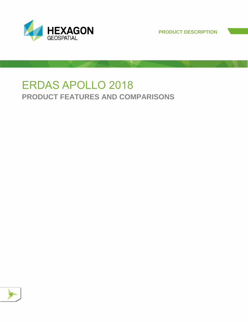
ERDAS® APOLLO is an enterprise-class, comprehensive data management, analysis, and delivery system enabling an organization to catalog, search, discover, process, and securely disseminate massive volumes of both file-based and web-enabled data. This solution consistently delivers virtually any digital object faster and with less hardware than competing server-based products. An interoperable OGC/ISO-based application that implements an out-of-the-box service-oriented architecture (SOA), ERDAS APOLLO is the solution for data management in the overall Hexagon Geospatial server story.
Available in three product tiers, ERDAS APOLLO suits a spectrum of organizations – integrating easily with other geospatial software and offering unparalleled performance even when handling massive data archives and many users.
ERDAS APOLLO Professional
Dynamic Online Geoprocessing
Perform online spatial analysis Dynamically create information products
WPS & Synchronous Geoprocessing
Large Volume Data Management
Catalog geospatial and non-geospatial data Hierarchical data model
Automated metadata harvesting Clip-Zip-Ship
Data download WMS, WCS, WFS(-T), CS-W,
ISO 19115/19139 Advanced Image Chain display properties
ERDAS APOLLO Essentials
ERDAS APOLLO 2018
October 05, 2018 3
Click on a link below for quick navigation:
FEATURES COMPARISON CHART
ERDAS APOLLO ESSENTIALS
ERDAS APOLLO ADVANTAGE
ERDAS APOLLO PROFESSIONAL
GEOSPATIAL PORTAL – INTEGRATED WEB CLIENT

ERDAS APOLLO 2018
October 05, 2018 4
FEATURES COMPARISON CHART
FUNCTIONALITY ERDAS
APOLLO ESSENTIALS
ERDAS APOLLO
ADVANTAGE
ERDAS APOLLO PROFESSIONAL
FAST IMAGE WEB DELIVERY AND GIS INTEGRATION
Distribute large volumes of geospatial imagery and LIDAR to thousands of users from a single standard server • • •
Deliver imagery and LIDAR to thousands of users via high performance ECWP (streaming protocol) or OGC WMTS tiled delivery
• • •
Deliver to various GIS, CAD, mobile, web applications and geospatial workstations such as ArcGIS, MapInfo, and AutoCAD • • •
Easily integrate with third-party GIS software
Desktop geospatial applications such as ERDAS IMAGINE®, GeoMedia®, Esri ArcGIS® for Desktop, Pitney Bowes MapInfo®, Autodesk AutoCAD®, PCITM, ERDAS ER Mapper, Microsoft® Office, GE SmallworldTM, Bentley® MicroStation, and more
Web client software simultaneously integrates data from GIS servers like MapXtreme®, ArcIMS®, ArcGIS® Server, and Autodesk MapGuide®
• • •
Leverage common industry standards for deployment including OGC WMS, OGC WMTS, Esri Geoservices, KML, and JPIP • • •
Utilize ER Mapper algorithms for on-the-fly geoprocessing • • •
Aggregate and connect thousands of datasets together as a single seamless layer using Virtual mosaic and Aggregate concepts • • •
Cloud compatible. All geospatial server products can be deployed in the cloud (via Amazon EC2) • • •
LARGE-VOLUME DISTRIBUTED DATA MANAGEMENT
Catalog, manage, and deliver large volumes of distributed spatial and non-spatial data; including raster, vector, point cloud, terrain, and digital object or business data (pdf, mov, doc, jpeg, and so forth)
• •
Schedule automatic data crawlers and metadata harvesters for continuous spatial and non-spatial data discovery at distributed file data stores
• •
Automatically provide data for optimized end-user consumption, including pyramid and thumbnail generation, and metadata translation to ISO 19115
• •
ERDAS APOLLO 2018
October 05, 2018 5
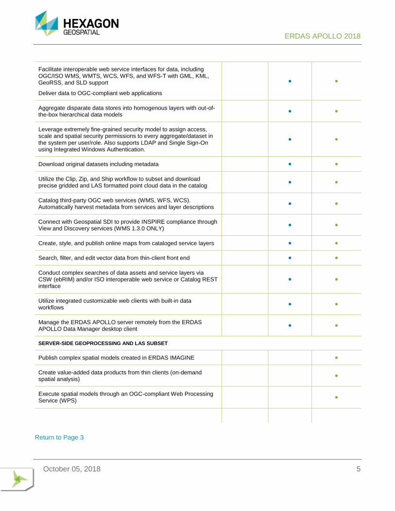
Facilitate interoperable web service interfaces for data, including OGC/ISO WMS, WMTS, WCS, WFS, and WFS-T with GML, KML, GeoRSS, and SLD support
Deliver data to OGC-compliant web applications
• •
Aggregate disparate data stores into homogenous layers with out-of-the-box hierarchical data models
• •
Leverage extremely fine-grained security model to assign access, scale and spatial security permissions to every aggregate/dataset in the system per user/role. Also supports LDAP and Single Sign-On using Integrated Windows Authentication.
• •
Download original datasets including metadata • •
Utilize the Clip, Zip, and Ship workflow to subset and download precise gridded and LAS formatted point cloud data in the catalog
• •
Catalog third-party OGC web services (WMS, WFS, WCS). Automatically harvest metadata from services and layer descriptions
• •
Connect with Geospatial SDI to provide INSPIRE compliance through View and Discovery services (WMS 1.3.0 ONLY)
• •
Create, style, and publish online maps from cataloged service layers • •
Search, filter, and edit vector data from thin-client front end • •
Conduct complex searches of data assets and service layers via CSW (ebRIM) and/or ISO interoperable web service or Catalog REST interface
• •
Utilize integrated customizable web clients with built-in data workflows
• •
Manage the ERDAS APOLLO server remotely from the ERDAS APOLLO Data Manager desktop client
• •
SERVER-SIDE GEOPROCESSING AND LAS SUBSET
Publish complex spatial models created in ERDAS IMAGINE •
Create value-added data products from thin clients (on-demand spatial analysis)
•
Execute spatial models through an OGC-compliant Web Processing Service (WPS)
•
Return to Page 3
ERDAS APOLLO 2018
October 05, 2018 6
ERDAS APOLLO ESSENTIALS ERDAS APOLLO Essentials is the fastest geospatial image and LIDAR server in the world. A single server with standard hardware can serve terabytes of data to thousands of concurrent users. Save days, or even weeks, delivering your data to the field by compressing it 5x faster to ECW or JPEG 2000 format. ERDAS APOLLO Essentials expedites your GIS to provide geospatial data as quickly as possible. Examples of ERDAS APOLLO Essentials in action can be seen at http://demo-apollo.hexagongeospatial.com/EA-Essentials/.
KEY FEATURES
PERFORMANCE
⚫ Supports massive imagery and LIDAR data – Deliver terabytes of data using a single server
⚫ Native 64-bit architecture – True 64-bit support enables large memory caches and faster overall performance due to 64-bit registers
⚫ Hardware accelerated to optimize CPU intrinsics to support more users, with less hardware load than any other software
⚫ Windows and Linux platform compatibility
⚫ Scales efficiently to support thousands of concurrent users by implementing ECWP patented delivery protocol to stream compressed data to clients to create a distributed decompression environment.
⚫ Supports ECW streaming protocol, JPEG 2000, and NITF files (JPEG 2000 codestreams only)
⚫ Web Map Service (WMS) and Web Map Tiling Service (WMTS) protocols
⚫ High-performance, standards-compliant interfaces
⚫ Allow OGC-compliant third-party applications to consume many image formats
⚫ Narrow to broadband scalability
⚫ Capable of serving images faster regardless of the bandwidth or network latency to users. ERDAS APOLLO Essentials will serve image data faster than any other solution.
MULTIPLE IMAGE SERVING PROTOCOLS
⚫ Multi-protocol support
⚫ Expose images via different protocols without duplicating any data
ENHANCED COMPRESSION WAVELET PROTOCOL (ECWP) IMAGE STREAMING PROTOCOL
Client-side decompression of image data and for LIDAR, providing:
⚫ Asynchronous panning and zooming
⚫ Intelligent client-side caching and image decompression
ERDAS APOLLO 2018
October 05, 2018 7
⚫ Reduced bandwidth requirements
⚫ Optimum user experience
⚫ Serve ECW, JPEG 2000, and Hexagon Point Cloud (HPC) format files via this protocol
OPTIMIZED TILE DELIVERY
⚫ Rapid delivery of pre-cached image tiles to browser-based applications
⚫ Servers can be configured to deliver 4,000+ image tiles per second
⚫ Deliver rasterized vector / feature data together in a single OTDF file
⚫ Serve your feature data with ERDAS APOLLO Essentials
OGC WMS 1.1.1 & 1.3.0 / WMC
⚫ On-the-fly image reprojection
⚫ Configure multiple WMS services on the same ERDAS APOLLO Essentials server
⚫ Fully compliant with OGC WMS v1.1.1 and v1.3.0
⚫ Scale dependent images from WMS services
⚫ Fastest and most efficient OGC WMS for imagery data in terms of data storage requirements, hardware requirements, and delivery speed
OGC WMTS V1.0.0
⚫ High-performance tile delivery through the Web Map Tiling Service interface
⚫ Deliver tiles as fast as tile caching solutions, without the tile cache headaches
⚫ Allow third-party applications to consume OTDF, ECW, and many other formats through WMTS
⚫ Enable only selected images through the WMTS service interface
⚫ Select from default OGC Well Known Tiles Matrix Sets per layer or configure custom ones, all without data duplication
⚫ Fully compliant with the OGC WMTS v1.0 TEAM Engine
⚫ No client-side plug-in required
⚫ Easily create mashups with consumer base maps including OpenStreetMap and Google Maps™
OTHER PROTOCOLS
⚫ JPEG 2000 Interactive Protocol (JPIP)
ERDAS APOLLO 2018
October 05, 2018 8
FILE FORMAT SUPPORT
Premium file formats: Read and serve ECW and JPEG 2000 wavelet-based compressed data formats.
⚫ These highly efficient file formats are read directly from disk. No complex publishing workflow, cache generation, or database wrapping.
OTDF (Optimized Tile Delivery Format): File format for delivering “tiled” views of image data to a web browser.
Standard file formats: GeoTIFF, IMG, and MrSID
⚫ For optimal performance, conversion to ECW of JPEG 2000 is recommended.
UDS – Hexagon Point Cloud (HPC) format for streaming point clouds
SECURITY
⚫ SSL communication
⚫ Data is encrypted for protocols (ECWPS/HTTPS). Encryption strength based on browser capabilities
⚫ Basic file system security
⚫ Data is secured on the server and user/group access is controlled by username/password (built on operating system security)
⚫ Advanced security
⚫ Users and their permissions can be stored in a third-party credential management system that the server can access and use for authentication
⚫ Security based on IP address – Filter user permissions based on originating IP address
⚫ Image resolution/region security – Limit the resolution an image can be viewed at (ground scale) and deny access to particular regions of an image (for example, security zone).
GIS INTEGRATION DESKTOP APPLICATIONS
⚫ High degree of compatibility with geospatial workstations such as ArcGIS, MapInfo, AutoCAD, PCI, ERDAS ER Mapper, Microsoft Office, Smallworld, Bentley MicroStation, and so forth
⚫ High-performance streaming for major GIS workstations
⚫ Plug-ins for native support is available for the following industry workstations to enable efficient streaming access with client-side caching:
⚫ Esri – ArcGIS for Desktop v8 to v10.x
⚫ MapInfo Professional
⚫ AutoCAD

ERDAS APOLLO 2018
October 05, 2018 9
⚫ Bentley MicroStation
VIEWING
⚫ Dynamic roam and zoom – Fast, interactive user experience
⚫ Native streaming support in many applications
⚫ Free application plug-ins – Plug-ins for common applications so that users can take advantage of ECWP streaming
Client component (ActiveX/Java) supports a layered view display with an asynchronous independent update of each image layer. The viewing control is fully scriptable from JavaScript providing functions to:
⚫ Use a transparency slider to set transparency on any image layer
⚫ Set visibility on any layer
⚫ Set clipping on image layers to restrict an image view to a defined area
⚫ Promote/demote the image order in the viewing “stack”
⚫ Select bands from multi-band imagery
⚫ Provide a means of measuring progressive image loading progress
⚫ Display imagery from industry-standard projections with ability to derive geodetic coordinates from a point
⚫ Overlay the raster images with maps from GIS servers in a separate image plane
⚫ Set transparency on any color in an image plane
⚫ Support standard image pan, zoom, and zoombox tools
⚫ Support basic red-lining capabilities for circle, rectangle, and irregular polygons
⚫ Support printing of a blended view from the viewing component
⚫ Support viewing of images side by side (that is,e geolinked) with automatic extents tracking between each view. Web 2.0 control requires the use of the server-side component to make GIS requests/knock-out colors on returned image for transparency.
⚫ NULL cell handling for JPEG 2000 images in all protocols
⚫ NULL cell handling for ECW for WMS, ImageX, and ArcXML. Exact delineation between null areas and images (no artifacts on the edges).
ADMINISTRATION
⚫ Powerful, flexible, and straightforward administration console
⚫ Add datasets, define protocols/access levels, and so forth
⚫ Remote administration
ERDAS APOLLO 2018
October 05, 2018 10
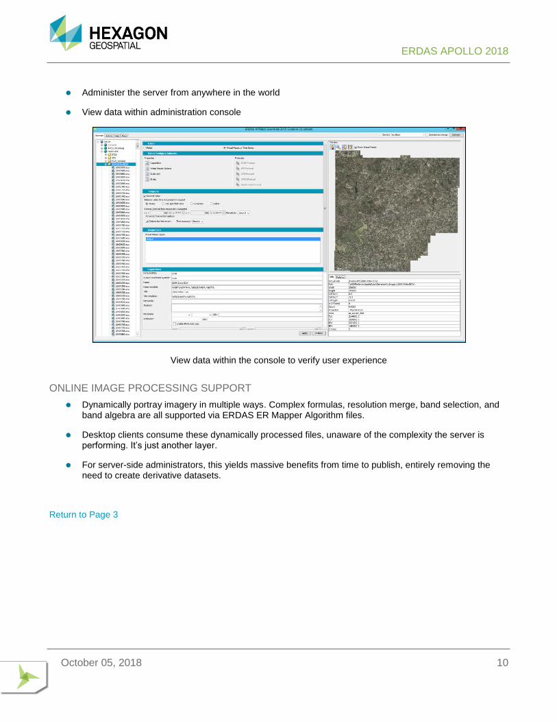
⚫ Administer the server from anywhere in the world
⚫ View data within administration console
View data within the console to verify user experience
ONLINE IMAGE PROCESSING SUPPORT
⚫ Dynamically portray imagery in multiple ways. Complex formulas, resolution merge, band selection, and band algebra are all supported via ERDAS ER Mapper Algorithm files.
⚫ Desktop clients consume these dynamically processed files, unaware of the complexity the server is performing. It’s just another layer.
⚫ For server-side administrators, this yields massive benefits from time to publish, entirely removing the need to create derivative datasets.
Return to Page 3

ERDAS APOLLO 2018
October 05, 2018 11
ERDAS APOLLO ADVANTAGE ERDAS APOLLO Advantage is a comprehensive data management and delivery solution providing remarkable business value. This OGC/ISO standards-based solution can organize, securely manage, and disseminate data within databases as well as massive volumes of dynamic and static images, point cloud data, terrain, vector data, third party web services, and any digital resource in the enterprise. ERDAS APOLLO Advantage is scalable through clustering to meet an organization’s specific needs, ensuring unprecedented performance even when handling the largest data archives.
ERDAS APOLLO Advantage integrates the feature set of ERDAS APOLLO Essentials, so please read the ERDAS APOLLO Essentials Product Description for more information about imagery data protocols.
Enterprise Application Integration – ERDAS APOLLO Advantage is designed to fulfill the requirements of the most demanding enterprises. Fully scalable through clustering, ERDAS APOLLO smoothly supports the extension of your geospatial business system with improved performance. Proven technological standards such as Java EE also ease the integration of ERDAS APOLLO into secure IT environments.
KEY FEATURES
ADVANCED DATA MANAGEMENT
Using ERDAS APOLLO, you can easily catalog databases, geospatial imagery, vector, terrain, LAS, any OGC-compliant third-party web service, CAD data, full motion video, and business data such as documents, movies, pictures, URLs, any electronic content. ERDAS APOLLO catalog automatically harvests web services and retrieves their metadata, including spatial extent, keywords, title, ISO and thumbnails. Web services metadata are automatically exposed through an OGC-compliant CSW (ebRIM) web interface, as well as through RESTful endpoints.
ERDAS APOLLO Data Manager – ERDAS APOLLO Advantage provides a desktop application to remotely and securely crawl, manage, and deliver geospatial imagery, terrain, vector, point cloud, database information and any digital data across the enterprise. OpenStreetMap is provided for global base map context. ERDAS APOLLO Data Manager can be fully internationalized.
Input Geospatial Data Formats – One of the main problems that GIS professionals face is the heterogeneity of data formats. Legacy and third-party data can be used together in ERDAS APOLLO in a common environment.
ERDAS APOLLO 2018
October 05, 2018 12
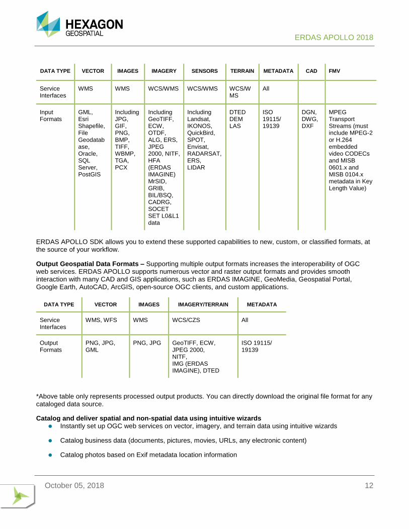
DATA TYPE VECTOR IMAGES IMAGERY SENSORS TERRAIN METADATA CAD FMV
Service Interfaces
WMS WMS WCS/WMS WCS/WMS WCS/WMS
All
Input Formats
GML, Esri Shapefile, File Geodatabase, Oracle, SQL Server, PostGIS
Including JPG, GIF, PNG, BMP, TIFF, WBMP, TGA, PCX
Including GeoTIFF, ECW, OTDF, ALG, ERS, JPEG 2000, NITF, HFA (ERDAS IMAGINE) MrSID, GRIB, BIL/BSQ, CADRG, SOCET SET L0&L1 data
Including Landsat, IKONOS, QuickBird, SPOT, Envisat, RADARSAT, ERS, LIDAR
DTED DEM LAS
ISO 19115/ 19139
DGN, DWG, DXF
MPEG Transport Streams (must include MPEG-2 or H.264 embedded video CODECs and MISB 0601.x and MISB 0104.x metadata in Key Length Value)
ERDAS APOLLO SDK allows you to extend these supported capabilities to new, custom, or classified formats, at the source of your workflow.
Output Geospatial Data Formats – Supporting multiple output formats increases the interoperability of OGC web services. ERDAS APOLLO supports numerous vector and raster output formats and provides smooth interaction with many CAD and GIS applications, such as ERDAS IMAGINE, GeoMedia, Geospatial Portal, Google Earth, AutoCAD, ArcGIS, open-source OGC clients, and custom applications.
DATA TYPE VECTOR IMAGES IMAGERY/TERRAIN METADATA
Service Interfaces
WMS, WFS WMS WCS/CZS All
Output Formats
PNG, JPG, GML
PNG, JPG GeoTIFF, ECW, JPEG 2000, NITF, IMG (ERDAS IMAGINE), DTED
ISO 19115/ 19139
*Above table only represents processed output products. You can directly download the original file format for any cataloged data source.
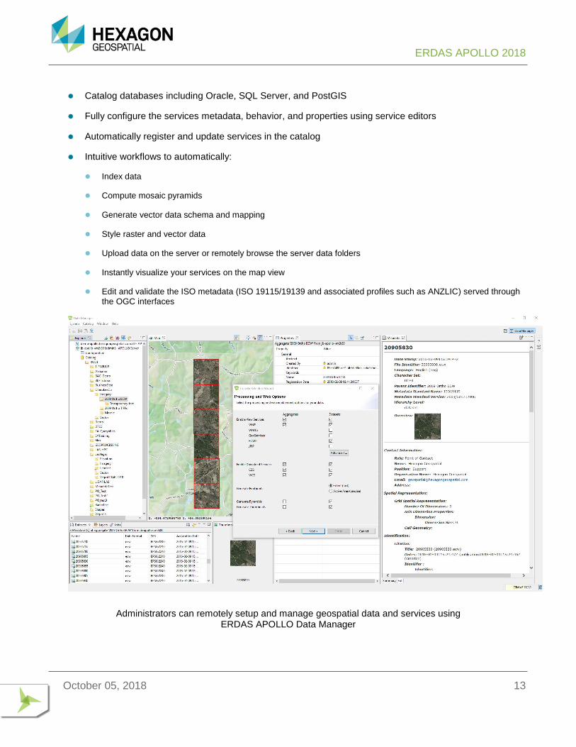
Catalog and deliver spatial and non-spatial data using intuitive wizards ⚫ Instantly set up OGC web services on vector, imagery, and terrain data using intuitive wizards
⚫ Catalog business data (documents, pictures, movies, URLs, any electronic content)
⚫ Catalog photos based on Exif metadata location information
ERDAS APOLLO 2018
October 05, 2018 13
⚫ Catalog databases including Oracle, SQL Server, and PostGIS
⚫ Fully configure the services metadata, behavior, and properties using service editors
⚫ Automatically register and update services in the catalog
⚫ Intuitive workflows to automatically:
⚫ Index data
⚫ Compute mosaic pyramids
⚫ Generate vector data schema and mapping
⚫ Style raster and vector data
⚫ Upload data on the server or remotely browse the server data folders
⚫ Instantly visualize your services on the map view
⚫ Edit and validate the ISO metadata (ISO 19115/19139 and associated profiles such as ANZLIC) served through
the OGC interfaces
Administrators can remotely setup and manage geospatial data and services using ERDAS APOLLO Data Manager
ERDAS APOLLO 2018
October 05, 2018 14
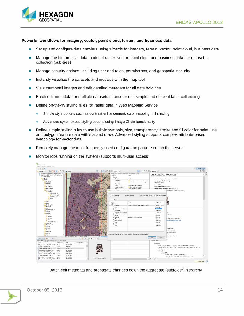
Powerful workflows for imagery, vector, point cloud, terrain, and business data
⚫ Set up and configure data crawlers using wizards for imagery, terrain, vector, point cloud, business data
⚫ Manage the hierarchical data model of raster, vector, point cloud and business data per dataset or collection (sub-tree)
⚫ Manage security options, including user and roles, permissions, and geospatial security
⚫ Instantly visualize the datasets and mosaics with the map tool
⚫ View thumbnail images and edit detailed metadata for all data holdings
⚫ Batch edit metadata for multiple datasets at once or use simple and efficient table cell editing
⚫ Define on-the-fly styling rules for raster data in Web Mapping Service.
⚫ Simple style options such as contrast enhancement, color mapping, hill shading
⚫ Advanced synchronous styling options using Image Chain functionality
⚫ Define simple styling rules to use built-in symbols, size, transparency, stroke and fill color for point, line and polygon feature data with stacked draw. Advanced styling supports complex attribute-based symbology for vector data
⚫ Remotely manage the most frequently used configuration parameters on the server
⚫ Monitor jobs running on the system (supports multi-user access)
Batch edit metadata and propagate changes down the aggregate (subfolder) hierarchy
ERDAS APOLLO 2018
October 05, 2018 15
Catalog Data Model – ERDAS APOLLO Advantage catalog enables data managers to develop complex hierarchical data models of heterogeneous gridded data to securely expose well-defined web service layers to end users.
⚫ Hierarchically aggregate disparate data sources into homogenous layers
⚫ Assign access and spatial security permissions to each user/role for every aggregate/dataset in the system
⚫ Web services (WMS and WCS) will automatically mosaic all raster data referenced in an aggregate sub-tree, with pyramid provisioning.
⚫ Web service (WMS) will automatically mashup raster and vector datasets referenced in an aggregate sub-tree as a seamless map using the defined styles in the system.
⚫ Drag and drop to reorganize the catalog hierarchy
Crawlers – Geospatial information crawlers are scheduled server jobs for continuous discovery of geospatial data at user-specified dataset store locations.
⚫ Run asynchronously on the server – set it and forget it
⚫ Run on a regularly scheduled basis to enable automatic catalog updates
⚫ Automatically discover imagery, terrain, vector, point cloud, and business data
⚫ Automatically harvest imagery/sensor metadata and translate into ISO 19115/19139 (support for Landsat 5, Landsat 7, IKONOS, QuickBird, SPOT, CEOS, RADARSAT, ERS, IRS, EROS, ODL, and Russian satellites metadata)
⚫ Automatically provide data for optimized end-user consumption (pyramids, thumbnails, and metadata generation, footprint computation, and security configuration)
⚫ Fine grained configuration of the web delivery services per dataset/aggregate (WMS, WMTS, ECWP, JPIP, ImageX, Geoservices, WCS, and CZS)
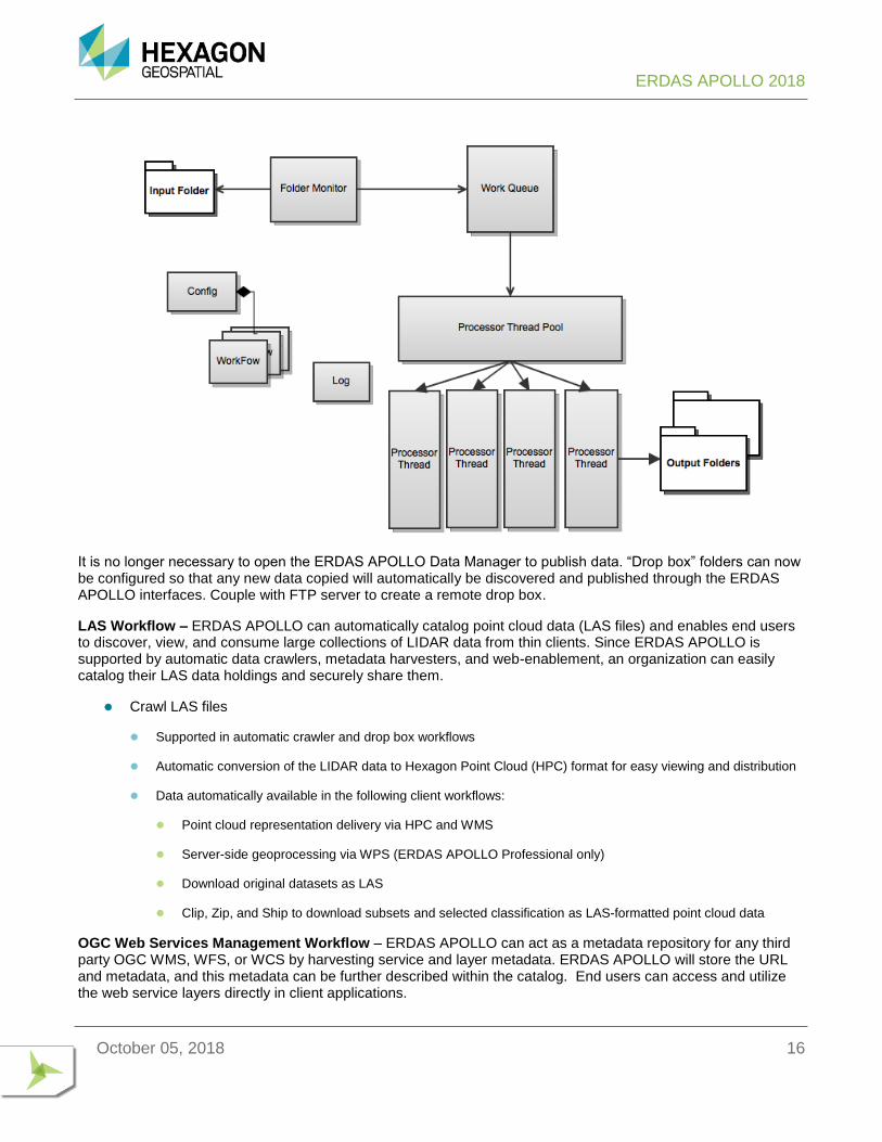
Drop Box – Automatically Catalog Incoming Data – This feature sets up listeners on directories to automatically crawl incoming raster, vector and multimedia files. A dedicated application runs on its own server and monitors the input folders (the drop box). When a file is added to an input folder, the drop box determines if it is a file of interest. If it is, it then places that file in the queue, from which it is retrieved when it is ready to ingest.
⚫ Configure multiple drop box directories, destination aggregates, and filters for specific data formats
⚫ Configure publishing, provisioning, security, and metadata options (same as for the crawlers)
⚫ Drag and drop data in the drop box directories using the Windows Explorer – no need to start the Data Manager application to publish new data
⚫ Setup ftp on drop box directories to remotely upload and publish data
⚫ Manage multi-files datasets, and file copy completion and handle broken files
ERDAS APOLLO 2018
October 05, 2018 16
It is no longer necessary to open the ERDAS APOLLO Data Manager to publish data. “Drop box” folders can now be configured so that any new data copied will automatically be discovered and published through the ERDAS APOLLO interfaces. Couple with FTP server to create a remote drop box.
LAS Workflow – ERDAS APOLLO can automatically catalog point cloud data (LAS files) and enables end users to discover, view, and consume large collections of LIDAR data from thin clients. Since ERDAS APOLLO is supported by automatic data crawlers, metadata harvesters, and web-enablement, an organization can easily catalog their LAS data holdings and securely share them.
⚫ Crawl LAS files
⚫ Supported in automatic crawler and drop box workflows
⚫ Automatic conversion of the LIDAR data to Hexagon Point Cloud (HPC) format for easy viewing and distribution
⚫ Data automatically available in the following client workflows:
⚫ Point cloud representation delivery via HPC and WMS
⚫ Server-side geoprocessing via WPS (ERDAS APOLLO Professional only)
⚫ Download original datasets as LAS
⚫ Clip, Zip, and Ship to download subsets and selected classification as LAS-formatted point cloud data
OGC Web Services Management Workflow – ERDAS APOLLO can act as a metadata repository for any third party OGC WMS, WFS, or WCS by harvesting service and layer metadata. ERDAS APOLLO will store the URL and metadata, and this metadata can be further described within the catalog. End users can access and utilize the web service layers directly in client applications.
ERDAS APOLLO 2018
October 05, 2018 17
ADVANCED SECURITY
Secure Geospatial Information Centrally — ERDAS APOLLO Advantage features a user/role-based, integrated security system, to define fine-grained and geospatial credentials at the service and layer levels.
⚫ User and role management to create as many users and roles as required
⚫ Supports LDAP/Active Directory, Database, XML, and all other Java EE compliant realms for security
⚫ Support for single Sign-On using Integrated Windows Authentication
⚫ Full SSL support
⚫ Global and homogenous security across all components – credentials are applied at the dataset level and will homogeneously impact the catalog searches and imagery data visualization and download
⚫ Centralized and smart security configuration. Using ERDAS APOLLO Data Manager, administrators can grant rights to read, write, update, and manage imagery data collections and individual datasets, as well as secure the data spatially with inclusion and exclusion areas and valid visible scale ranges. This configuration can be applied to crawler jobs so that fine-grained and geospatial credentials can be configured automatically during dataset indexing.
⚫ Realm login into the web client. Once logged in, the user gets access to all functionalities without additional prompts when it accesses different ERDAS APOLLO web services.
For each layer of the service, ERDAS APOLLO Data Manager can configure three types of security settings:
⚫ Coarse-grained security – to authorize/deny service access per user role
⚫ Fine-grained security – to authorize/deny layer access per user role
⚫ Geospatial security:
⚫ Area credentials – to authorize/deny access to an area defined by a bounding box or polygon. A specific GUI is provided within the security feature to select authorized and unauthorized bounding box using a map, within the
Data Manager.
⚫ Scale-range credentials – to deny access below a minimum and above a maximum scale per user role.
⚫ Masking – to prevent any or precise visualization of an area defined by a bounding box or polygon. The polygon can be blurred, transparent, or hidden by a color filling.
ERDAS APOLLO Advantage secures:
⚫ All catalog searches and filters search results are based on the user/role permissions
⚫ All data accessed for portrayed maps and data downloads are based on the user/role permissions
⚫ Scale range visibility for portrayed maps
⚫ Create inclusion and exclusion areas for aggregates and datasets per user/role
⚫ Global resolution masking of sensitive geographic areas. The polygon can be blurred, transparent, or hidden by a solid color fill for portrayed maps.
ERDAS APOLLO 2018
October 05, 2018 18
Enhanced Logging / Auditing – Additional logging information can be recorded for security or auditing purposes. The following activities can be logged when clients attempt to access services.
⚫ Login
⚫ Queries of Catalog
⚫ Browsing of Data Holdings
⚫ Access to files
⚫ Access to attachments
⚫ Access to metadata
⚫ Access to services
⚫ Modification of metadata
DATA AND METADATA DELIVERY
Imagery Delivery – ERDAS APOLLO Advantage provides the most comprehensive gridded-data-delivery protocols available on the market in a single server:
⚫ Web Mapping Service (WMS) – Deliver portrayed GIS-ready and web-client-consumable ‘styled’ map data to any OGC WMS client application (ERDAS IMAGINE, GeoMedia, Geospatial Portal AutoCAD, ArcGIS, Google Earth, Open Source, ArcGIS, custom applications)
⚫ Web Map Tiling Service (WMTS) – Deliver portrayed GIS-ready and web-client-consumable tiles to any OGC WMTS client application; easily create mashups with OpenLayers and Google Maps
⚫ Web Coverage Service (WCS) – Deliver raw pixel data of any supported imagery format and type to OGC imagery exploitation clients as interoperable coverage (ERDAS IMAGINE).
⚫ ECWP – Very fast and efficient delivery of ECW and JP2 wavelet-compressed imagery through ECWP protocol (ecwp://) to ECWP clients (ERDAS IMAGINE, AutoCAD, ArcGIS, ERDAS APOLLO Web Client)
⚫ JPIP – Fast and efficient delivery of JP2 wavelet-compressed imagery through the JPIP protocol (jpip://) to JPIP-compliant clients (web applications and IAS 3.1.x)
On-the-Fly Data Processing – ERDAS APOLLO Advantage Web Map Service (WMS) and Web Coverage Service (WCS) support on-the-fly:
⚫ Reprojection
⚫ Mosaicking
⚫ Band selection and ordering
⚫ Creation of imagery pyramids
⚫ Contextual rendering and styling
ERDAS APOLLO 2018
October 05, 2018 19
⚫ Format conversion
⚫ Temporal or attribute-based selection
⚫ Spatial subset creation
⚫ Data export
ISO 19115/19139 Metadata – ERDAS APOLLO Advantage contains a detailed ISO 19115 profile for describing aggregates and datasets, stylized viewer for ISO 19115 metadata, detailed editing interface, and validation tool, ensuring required fields are populated and contain correct values. Persist and disseminate your metadata interoperably.
OGC-Compliant Catalog Service – ERDAS APOLLO Advantage catalog exposes an internationally accepted, interoperable web service for searching the catalog – Catalog Service Web - CSW (ebRIM) and ISO profile
⚫ Enables complex searches of any catalog attribute(s) with standard search operators (>, <, =, NOT, LIKE, and so forth)
⚫ Provides a standardized search response result set
⚫ Independent of any persistence model
⚫ Allows third-party integration with your spatial data infrastructure data holdings in an interoperable service (OGC standard)
INTEROPERABILITY BASED ON OPEN STANDARDS
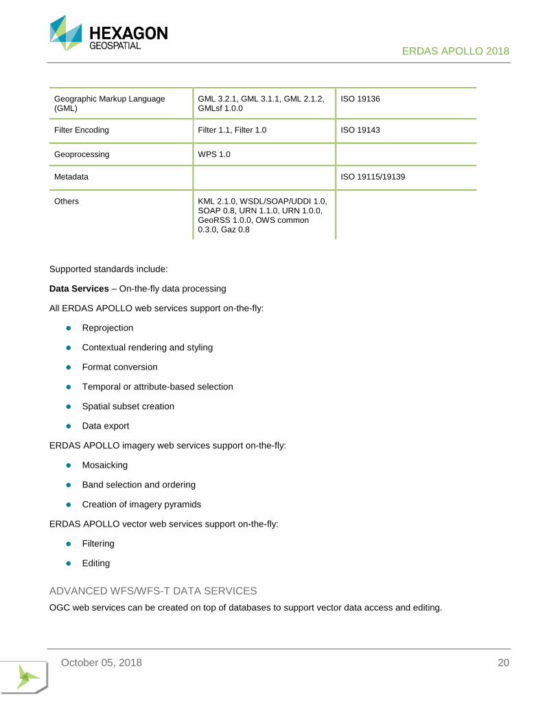
Based on the open standards of International Standardization Organization (ISO), ERDAS APOLLO provides an interoperable platform for enterprises to share their data internally and with a third party. Web Map Service (WMS), Web Feature Service (WFS and WFS-T), and Web Coverage Service (WCS), coupled with mature support for GML 3 and ISO 19115/19139 metadata, give ERDAS APOLLO the ability to communicate with any GIS or CAD application supporting those standards.
OGC SPECIFICATION SUPPORTED OGC SPECIFICATION VERSIONS
ISO SPECIFICATION
OGC Web Map Service (WMS) WMS 1.3.0, WMS 1.1.1, WMS 1.1 ISO 19128
OGC Web Feature Service (WFS-T) WFS 1.1, WFS(T) 1.1, WFS 1.0 ISO 19142
OGC Web Coverage Service (WCS) WCS 1.0.0
OGC Catalog Service Web (CS-W) CS-W 2.0.2, CAT2 AP ebRIM 1.0.0
OGC Web Map Context (WMC) WMC 1.1, WMC 1.0
Styled Layer Descriptor (SLD) SLD 1.1, SLD 1.0
ERDAS APOLLO 2018
October 05, 2018 20
Supported standards include:
Data Services – On-the-fly data processing
All ERDAS APOLLO web services support on-the-fly:
⚫ Reprojection
⚫ Contextual rendering and styling
⚫ Format conversion
⚫ Temporal or attribute-based selection
⚫ Spatial subset creation
⚫ Data export
ERDAS APOLLO imagery web services support on-the-fly:
⚫ Mosaicking
⚫ Band selection and ordering
⚫ Creation of imagery pyramids
ERDAS APOLLO vector web services support on-the-fly:
⚫ Filtering
⚫ Editing
ADVANCED WFS/WFS-T DATA SERVICES
OGC web services can be created on top of databases to support vector data access and editing.
Geographic Markup Language (GML)
GML 3.2.1, GML 3.1.1, GML 2.1.2, GMLsf 1.0.0
ISO 19136
Filter Encoding Filter 1.1, Filter 1.0 ISO 19143
Geoprocessing WPS 1.0
Metadata ISO 19115/19139
Others KML 2.1.0, WSDL/SOAP/UDDI 1.0, SOAP 0.8, URN 1.1.0, URN 1.0.0, GeoRSS 1.0.0, OWS common 0.3.0, Gaz 0.8
ERDAS APOLLO 2018
October 05, 2018 21
Advanced WFS/WFS-T Workflows – ERDAS APOLLO offers a workflow for vector data, including the ability to publish, edit, and update vector data geometry and attributes, using a Transactional Web Feature Service (WFS-T). Whatever the feature data model, ERDAS APOLLO Data Manager can automatically generate and customize the mapping between the data properties and attributes and the feature model exposed by ERDAS APOLLO WFS. ERDAS APOLLO WFS supports advanced searching, filtering, and editing functionality that is offered to the end user through Geospatial Portal. This functionality is also usable by any external client application that is compliant with WFS-(T). WFS service capabilities include the ability to expose vector data using different version of WFS and GML.
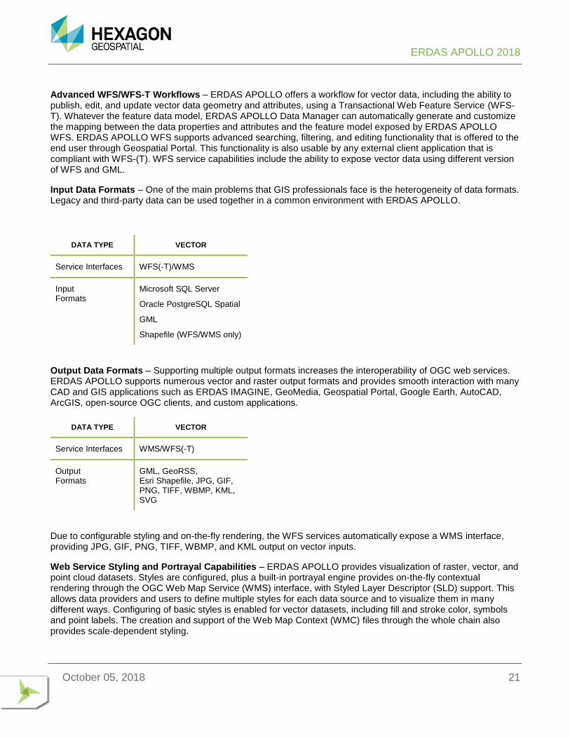
Input Data Formats – One of the main problems that GIS professionals face is the heterogeneity of data formats. Legacy and third-party data can be used together in a common environment with ERDAS APOLLO.
DATA TYPE VECTOR
Service Interfaces WFS(-T)/WMS
Input Formats
Microsoft SQL Server
Oracle PostgreSQL Spatial
GML
Shapefile (WFS/WMS only)
Output Data Formats – Supporting multiple output formats increases the interoperability of OGC web services. ERDAS APOLLO supports numerous vector and raster output formats and provides smooth interaction with many CAD and GIS applications such as ERDAS IMAGINE, GeoMedia, Geospatial Portal, Google Earth, AutoCAD, ArcGIS, open-source OGC clients, and custom applications.
DATA TYPE VECTOR
Service Interfaces WMS/WFS(-T)
Output Formats
GML, GeoRSS, Esri Shapefile, JPG, GIF, PNG, TIFF, WBMP, KML, SVG
Due to configurable styling and on-the-fly rendering, the WFS services automatically expose a WMS interface, providing JPG, GIF, PNG, TIFF, WBMP, and KML output on vector inputs.
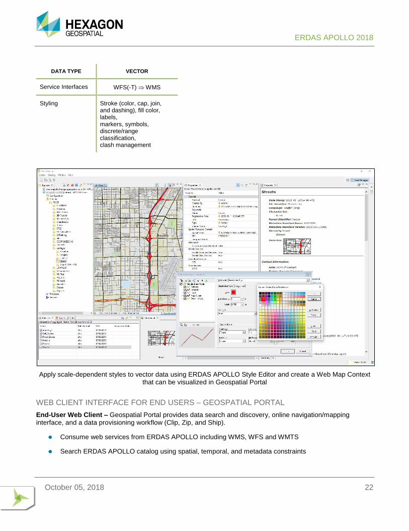
Web Service Styling and Portrayal Capabilities – ERDAS APOLLO provides visualization of raster, vector, and point cloud datasets. Styles are configured, plus a built-in portrayal engine provides on-the-fly contextual rendering through the OGC Web Map Service (WMS) interface, with Styled Layer Descriptor (SLD) support. This allows data providers and users to define multiple styles for each data source and to visualize them in many different ways. Configuring of basic styles is enabled for vector datasets, including fill and stroke color, symbols and point labels. The creation and support of the Web Map Context (WMC) files through the whole chain also provides scale-dependent styling.
ERDAS APOLLO 2018
October 05, 2018 22
DATA TYPE VECTOR
Service Interfaces WFS(-T) WMS
Styling Stroke (color, cap, join, and dashing), fill color, labels, markers, symbols, discrete/range classification, clash management
Apply scale-dependent styles to vector data using ERDAS APOLLO Style Editor and create a Web Map Context
that can be visualized in Geospatial Portal
WEB CLIENT INTERFACE FOR END USERS – GEOSPATIAL PORTAL
End-User Web Client – Geospatial Portal provides data search and discovery, online navigation/mapping interface, and a data provisioning workflow (Clip, Zip, and Ship).
⚫ Consume web services from ERDAS APOLLO including WMS, WFS and WMTS
⚫ Search ERDAS APOLLO catalog using spatial, temporal, and metadata constraints
ERDAS APOLLO 2018
October 05, 2018 23
⚫ Browse ERDAS APOLLO catalog hierarchy and third-party services repository
⚫ View data in the map
⚫ Download data
⚫ Original files, ERDAS IMAGINE formats, and Google formats
⚫ Clip, Zip, and Ship
⚫ Clip, Zip and Ship imagery or LAS-formatted point cloud data (in whole or just a subset) using the out-of-the-box
web client, Geospatial Portal:
⚫ Select polygonal clip areas, search the catalog, and download multiple aggregates or individual datasets of
gridded data
⚫ ERDAS APOLLO Advantage maintains a large download job query, executes jobs asynchronously, and provides e-mail notification when the download jobs begin and complete
⚫ In the job completion e-mail, the user is given a hyperlink to the download location
⚫ Automatic mosaic of results when clipping across multiple datasets in a given aggregate to return one single file
⚫ LAS-formatted point cloud data
⚫ Output options include output format, resolution, SRS, classification, and more
⚫ Imagery (raster)
⚫ Select classifications
⚫ Filter by return value
Return to Page 3
ERDAS APOLLO 2018
October 05, 2018 24
ERDAS APOLLO PROFESSIONAL ERDAS APOLLO Professional is the most advanced product tier of ERDAS APOLLO. Building on the Advantage level, Professional adds on-the-fly geoprocessing through a powerful geoprocessing option as well as an implementation of the OGC Web Processing Service (WPS) specification. Users can run an entire model, such as change detection, site analysis, or elevation change, completely contained within a single web processing service (WPS) or geoprocessing model. ERDAS APOLLO Professional is unrivalled in the complexity of algorithms stored under the hood.
ERDAS APOLLO Professional fully integrates ERDAS APOLLO Advantage. Please read the ERDAS APOLLO Advantage product description for imagery, vector data, and business data workflows.
KEY FEATURES
GEOPROCESSING SERVICE
ERDAS APOLLO Professional provides an OGC Web Processing Service (WPS) as well as more enhanced geoprocessing capabilities outside the WPS standard with enhanced performance, enabling users to run a variety of spatial models published from ERDAS IMAGINE.
Remotely Control the Geoprocessing – ERDAS APOLLO Professional provides asynchronous server-side processing through a web service, distributing the computational power of the server everywhere, inside and outside the enterprise.
⚫ Remotely select, configure, and execute the spatial models using Geospatial Portal
⚫ Connect and login anytime, from any computer, to monitor the progress
⚫ Visualize and/or download the processing results
Server-Side Technology – ERDAS APOLLO WPS and Geoprocessing REST services work together closely with ERDAS APOLLO catalog in the optimized server environment.
⚫ Any imagery dataset or collection registered in ERDAS APOLLO catalog can be used as input data for geoprocessing
⚫ Data stays on the server, no need to download onto the local system
⚫ Saves bandwidth, time, and disk space
⚫ Reduces data duplication
⚫ End users work with data from the collective data pool
⚫ Geoprocessing services run on the server, benefitting from optimized data access and optimized hardware environment
⚫ Geoprocessing results are added back into ERDAS APOLLO catalog
⚫ Others can visualize and download the results
⚫ Results can be used as inputs for additional geoprocessing
ERDAS APOLLO 2018
October 05, 2018 25
Reduced Need for Domain Knowledge – The workflow has been designed so that end users can execute the spatial models with very little domain knowledge. When publishing a new spatial model, the image analyst can:
⚫ Define the spatial model description
⚫ Define human-readable titles for each spatial model input parameter
⚫ Define default values for each input parameter
⚫ Predefine the catalog query that will automatically propose valid imagery data inputs to the end users
OGC Web Service – ERDAS APOLLO WPS service implements the OGC Web Processing Service (WPS) 1.0 specification
⚫ List published spatial models through the WPS GetCapabilities response
⚫ Provide full spatial model description through the WPS DescribeProcess response
⚫ Remotely execute spatial models through the WPS Execute request
MANAGE PROCESSES
Use ERDAS APOLLO Data Manager to manage the published spatial models and configure the level of access for each role.
Manage WPS Processes and Jobs – Use ERDAS APOLLO Data Manager to manage the WPS processes and jobs.
⚫ Browse and view the WPS process tree
⚫ Delete processes from the tree
⚫ Create customized users, roles
⚫ Manage, read, and execute rights to each process
⚫ View and manage the WPS “jobs” running on the server
EXECUTE PROCESSES OVER THE WEB
End users are able to select, configure, and execute the processes remotely in Geospatial Portal.
Fully Described Processes –Geospatial Portal provides multiple panels that fully describe the processes.
⚫ Process view
⚫ Displays all processes that the user can read and execute
⚫ Process Description panel
ERDAS APOLLO 2018
October 05, 2018 26
⚫ Provides a detailed description of the model that the user selected to execute
⚫ Process Input panel
⚫ Displays all process arguments and provides ability to configure them
⚫ Provides support for multiple data inputs
⚫ Provides configurable alpha-numeric and color input fields
⚫ Provides default values for arguments
⚫ Highlights required arguments
⚫ Input Data Search Results
⚫ Provides separate panels to display each imagery data input required to execute a process
⚫ Display imagery search results for the area the user is looking at in the map
⚫ Prompts the user to select the valid input data to “load” as the process input
Process Monitoring – Geospatial Portal provides panels to monitor the process execution and access the processing results.
⚫ My Process view
⚫ Lists all processes that the user has run
⚫ Displays job metadata: when the process was run, which process was run, and its progress
⚫ Process Arguments view
⚫ Displays all arguments used in the process run
⚫ Process Output view
⚫ Lists each process output with metadata, thumbnail, extent, and the tools to visualize and download the processing results
Visualize and Download Process Outputs – Geospatial Portal provides for visualization and downloading of the processing results.
⚫ Add process outputs to the map as map layers
⚫ Use any map and layer tools to manipulate the outputs
⚫ Configure layer opacity, visibility, and styling
⚫ Zoom in, zoom out, and pan
⚫ Measure distances and identify pixel values
⚫ Generate a Web Map Context (WMC) for distribution of a user-created map
⚫ Use the Clip, Zip, and Ship feature of Geospatial Portal to download the process results
ERDAS APOLLO 2018
October 05, 2018 27
ERDAS GEOPROCESSING WORKFLOW
⚫ Using ERDAS IMAGINE, the remote sensing data analyst can:
⚫ Author spatial models
⚫ Publish spatial models to the ERDAS APOLLO WPS
⚫ Save models for import into ERDAS APOLLO Advanced Geoprocessing
⚫ Using ERDAS APOLLO Data Manager, the ERDAS APOLLO administrator can:
⚫ Browse processes, which can be easily organized by category
⚫ Manage access to the processes
⚫ Delete processes
⚫ Using Geospatial Portal, the end user can:
⚫ Execute complex spatial models in a map area of interest, with detailed knowledge of the process
or data
⚫ Immediately visualize the WPS process outputs on the map and download them
Return to Page 3
ERDAS APOLLO 2018
October 05, 2018 28
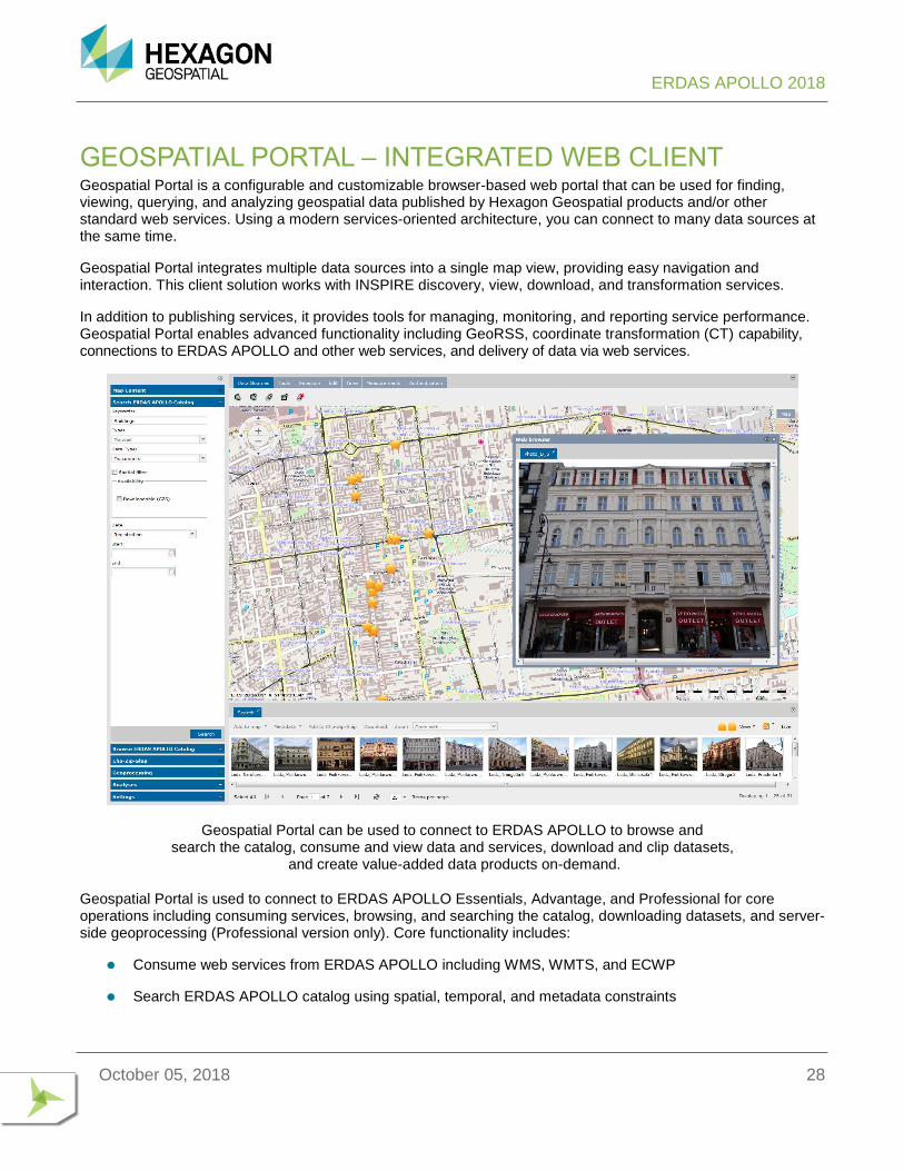
GEOSPATIAL PORTAL – INTEGRATED WEB CLIENT Geospatial Portal is a configurable and customizable browser-based web portal that can be used for finding, viewing, querying, and analyzing geospatial data published by Hexagon Geospatial products and/or other standard web services. Using a modern services-oriented architecture, you can connect to many data sources at the same time.
Geospatial Portal integrates multiple data sources into a single map view, providing easy navigation and interaction. This client solution works with INSPIRE discovery, view, download, and transformation services.
In addition to publishing services, it provides tools for managing, monitoring, and reporting service performance. Geospatial Portal enables advanced functionality including GeoRSS, coordinate transformation (CT) capability, connections to ERDAS APOLLO and other web services, and delivery of data via web services.
Geospatial Portal can be used to connect to ERDAS APOLLO to browse and search the catalog, consume and view data and services, download and clip datasets,
and create value-added data products on-demand.
Geospatial Portal is used to connect to ERDAS APOLLO Essentials, Advantage, and Professional for core operations including consuming services, browsing, and searching the catalog, downloading datasets, and server-side geoprocessing (Professional version only). Core functionality includes:
⚫ Consume web services from ERDAS APOLLO including WMS, WMTS, and ECWP
⚫ Search ERDAS APOLLO catalog using spatial, temporal, and metadata constraints
ERDAS APOLLO 2018
October 05, 2018 29
⚫ Browse ERDAS APOLLO catalog hierarchy and third-party services repository
⚫ View data in the map
⚫ Download data
⚫ Original files, ERDAS IMAGINE, and Google formats
⚫ Clip, Zip, and Ship data
⚫ Output options include output format, resolution, SRS, bands, and more
⚫ Create value-added data products (server-side geoprocessing)
⚫ Data styling for raster data
⚫ Create user-defined styles for data
⚫ Utilize pre-defined styles provided by the server
⚫ Monitor incoming data via GeoRSS
⚫ Monitor specific points or areas of interest
⚫ Use keywords and/or geometry
⚫ Full SSL support
For more information, please review Geospatial Portal product page and product description.
Return to Page 3
ERDAS APOLLO 2018
October 05, 2018 30
ABOUT HEXAGON GEOSPATIAL Hexagon Geospatial helps you make sense of the dynamically changing world. Known globally as a maker of leading-edge technology, we enable our customers to easily transform their data into actionable information, shortening the lifecycle from the moment of change to action. Hexagon Geospatial provides the software products and platforms to a large variety of customers through direct sales, channel partners, and Hexagon businesses. For more information, visit hexagongeospatial.com or contact us at [email protected]. Geospatial is part of Hexagon, a leading global provider of information technologies that drive productivity and quality across geospatial and industrial enterprise applications. Hexagon’s solutions integrate sensors, software, domain knowledge and customer workflows into intelligent information ecosystems that deliver actionable information. They are used in a broad range of vital industries. Hexagon (Nasdaq Stockholm: HEXA B) has more than 18,000 employees in 50 countries and net sales of approximately 4.2bn USD. Learn more at hexagon.com and follow us @HexagonAB. © 2018 Hexagon AB and/or its subsidiaries and affiliates. All rights reserved. Hexagon and the Hexagon logo are registered trademarks of Hexagon AB or its subsidiaries. All other trademarks or service marks used herein are property of their respective owners. Hexagon Geospatial believes the information in this publication is accurate as of its publication date. Such information is subject to change without notice.