Episodic burial and exhumation in NE Brazil after opening of the … · 2019-04-10 · Episodic...
17
ABSTRACT It is a common assumption that elevated passive continental margins have remained high since rifting and breakup. Here, we show that the Atlantic margin of NE Brazil has undergone a more complex history. Our synthesis of geological data, landscape analy- sis, and paleothermal and paleoburial data reveals a four-stage history: (1) After Early Cretaceous breakup, the margin underwent burial beneath a thick sedimentary cover; (2) uplift episodes in the Campanian and Eocene led to almost complete removal of these deposits; (3) the resulting large-scale, low-relief erosion surface (peneplain) was deeply weathered and finally reburied at the Oligocene-Miocene transition; and (4) Mio- cene uplift and erosion produced a new, lower- level peneplain by incision of the uplifted and re-exposed Paleogene peneplain. Previous studies have identified aspects of this inter- pretation, but we have defined the absolute timing and magnitude of discrete events of burial and exhumation that followed Early Cretaceous rifting and Eocene–Oligocene peneplanation. We suggest that a late sedi- mentary cover protected Paleogene weather- ing profiles until the present day. The uplift phases in Brazil are synchronous with uplift phases in Africa and the Andes. The Andean phases coincided with rapid convergence on the western margin of South America, and the Campanian uplift coincided with a decline in spreading rate at the Mid-Atlantic Ridge. Consequently, we suggest that both vertical movements and lateral changes in the motion of the plates have a common cause, which is lateral resistance to plate motion. “Throughout the coast of Brazil, and certainly for a considerable space inland, from the Rio Plata to Cape St. Roque, lat. 5°S, a distance of more than 2,000 geographical miles, wher- ever solid rocks occurs, it belongs to a granitic formation. The circumstance of this enormous area being thus constituted of materials, which almost every geologist believes to have been crystallized by the action of heat under pressure, gives rise to many curious reflections. Was this effect produced beneath the depth of a profound ocean? Or did a covering of strata formerly extend over it, which has since been removed? Can we believe that any power, acting for a time short of infinity, could have denuded the granite over so many thousand square leagues?” —Charles Darwin, Bahia or San Salvador, Brazil, 29 February 1832 (Darwin, 1839, p. 12) INTRODUCTION Landscapes along the Atlantic margin of NE Brazil are in many respects similar to those along other elevated passive continental mar- gins (cf. Ollier and Pain, 1997; Japsen et al., 2009a, 2012) around the world, including West Greenland, Scandinavia, and SE Australia (Lidmar-Bergström et al., 2000; Bonow et al., 2006a, 2006b). Common characteristics are high-level, low-relief plateaus cut by deeply incised valleys, Mesozoic-Cenozoic rift sys- tems along the coast, where erosional uncon- formities commonly truncate a tilted, postrift sequence, and a transition from continental to oceanic crust offshore. In NE Brazil, the pla- teaus reach more than 1 km above sea level (asl), and they are in many places separated by escarpments from low-level, low-relief surfaces below 500 m asl (Figs. 1A, 1B, 2, and 3). It is a common assumption that elevated passive continental margins have remained high since the time of rifting and breakup, and the absence of postrift sediment on many elevated passive continental margins is taken as evidence for nondeposition (e.g., Ussami et al., 1986; Ollier and Pain, 1997; Karner and Driscoll, 1999; Watts, 2001). Such assumptions have far- reaching implications for understanding land- scape development, hydrocarbon systems, and the properties of the lithosphere itself. However, studies of several elevated passive continental margins have challenged the assumption of permanent uplift, instead revealing histories of multiple episodes of postrift burial and subse- quent uplift and erosion (e.g., Cobbold et al., 2001; Japsen et al., 2006, 2012; Burke and Gunnell, 2008; Turner et al., 2008). Rifting of the Brazilian margin started in the Early Cretaceous and led to the formation of the Recôncavo-Tucano-Jatobá Rift, which reaches far into the continent (Figs. 1B and 2A) (Magnavita et al., 1994; Davison, 1999; Blaich et al., 2008). Continental breakup took place at the Albian-Aptian transition (Torsvik et al., 2009). Although there is evidence that the NE Brazilian margin underwent postrift thermal sub- sidence (McKenzie, 1978; White and McKenzie, 1988), there is also evidence for other events: (1) On the basis of vitrinite reflectance data, Magnavita et al. (1994) inferred that up to 2 km of postrift section have been removed from the Recôncavo-Tucano-Jatobá Rift as a result of erosion. Consequently, the postrift section within the rift is thin (<400 m). (2) Marine, postrift sediment of Albian age crops out at 800 m asl on the Planalto (pla- teau) do Araripe (Arai, 2000), and correlative deposits are at 600 m asl in the Recôncavo- Tucano-Jatobá Rift (Magnavita et al., 1994). The present elevation of these marine, postrift For permission to copy, contact [email protected] © 2012 Geological Society of America 1 GSA Bulletin; Month/Month 2012; v. 1xx; no. X/X; p. 1–17; doi: 10.1130/B30515.1; 9 figures; 1 table; Data Repository item 2012051. † E-mail: [email protected] Episodic burial and exhumation in NE Brazil after opening of the South Atlantic Peter Japsen 1,† , Johan M. Bonow 1 , Paul F. Green 2 , Peter R. Cobbold 3 , Dario Chiossi 4 , Ragnhild Lilletveit 5 , Luciano P. Magnavita 6 , and Augusto Pedreira 7 1 Geological Survey of Denmark and Greenland (GEUS), Øster Voldgade 10, 1350 Copenhagen, Denmark 2 Geotrack International, 37 Melville Road, Brunswick West, Victoria 3055, Australia 3 Géosciences (UMR6118), Centre National de la Recherche Scientifique (CNRS) et Université de Rennes1, 35042 Rennes, France 4 Statoil do Brasil, Praia de Botafoga 300, 22250-040 Rio de Janeiro, Brazil 5 Statoil Angola Team, Grenseveien 21, 4035 Stavanger, Norway 6 Petrobras, Avenida República do Chile 330, Rio de Janeiro, 20031-170, Brazil 7 Geological Survey of Brazil (CPRM), Avenida Ulysses Guimaraes 2862, Salvador, 41213-000, Brazil as doi:10.1130/B30515.1 Geological Society of America Bulletin, published online on 13 January 2012
Transcript of Episodic burial and exhumation in NE Brazil after opening of the … · 2019-04-10 · Episodic...
ABSTRACT
It is a common assumption that elevated passive continental margins have remained high since rifting and breakup. Here, we show that the Atlantic margin of NE Brazil has under gone a more complex history. Our synthesis of geological data, landscape analy-sis, and paleothermal and paleoburial data reveals a four-stage history: (1) After Early Cretaceous breakup, the margin under went burial beneath a thick sedimentary cover; (2) uplift episodes in the Campanian and Eocene led to almost complete removal of these deposits; (3) the resulting large-scale, low-relief erosion surface (peneplain) was deeply weathered and fi nally reburied at the Oligocene-Miocene transition; and (4) Mio-cene uplift and erosion produced a new, lower-level peneplain by incision of the uplifted and re-exposed Paleogene peneplain. Previous studies have identifi ed aspects of this inter-pretation, but we have defi ned the absolute timing and magnitude of discrete events of burial and exhumation that followed Early Cretaceous rifting and Eocene–Oligocene peneplanation. We suggest that a late sedi-mentary cover protected Paleogene weather-ing profi les until the present day. The uplift phases in Brazil are synchronous with uplift phases in Africa and the Andes. The Andean phases coincided with rapid convergence on the western margin of South America, and the Campanian uplift coincided with a decline in spreading rate at the Mid-Atlantic Ridge. Consequently, we suggest that both vertical movements and lateral changes in the motion of the plates have a common cause, which is lateral resistance to plate motion.
“Throughout the coast of Brazil, and certainly for a considerable space inland, from the Rio Plata to Cape St. Roque, lat. 5°S, a distance of more than 2,000 geographical miles, wher-ever solid rocks occurs, it belongs to a granitic formation. The circumstance of this enormous area being thus constituted of materials, which almost every geologist believes to have been crystallized by the action of heat under pressure, gives rise to many curious refl ections. Was this effect produced beneath the depth of a profound ocean? Or did a covering of strata formerly extend over it, which has since been removed? Can we believe that any power, acting for a time short of infi nity, could have denuded the granite over so many thousand square leagues?”
—Charles Darwin, Bahia or San Salvador, Brazil, 29 February 1832 (Darwin, 1839, p. 12)
INTRODUCTION
Landscapes along the Atlantic margin of NE Brazil are in many respects similar to those along other elevated passive continental mar-gins (cf. Ollier and Pain, 1997; Japsen et al., 2009a, 2012) around the world, including West Greenland, Scandinavia, and SE Australia (Lidmar-Bergström et al., 2000; Bonow et al., 2006a, 2006b). Common characteristics are high-level, low-relief plateaus cut by deeply incised valleys, Mesozoic-Cenozoic rift sys-tems along the coast, where erosional uncon-formities commonly truncate a tilted, postrift sequence, and a transition from continental to oceanic crust offshore. In NE Brazil, the pla-teaus reach more than 1 km above sea level (asl), and they are in many places separated by escarpments from low-level, low-relief surfaces below 500 m asl (Figs. 1A, 1B, 2, and 3).
It is a common assumption that elevated passive continental margins have remained high since the time of rifting and breakup, and the absence of postrift sediment on many elevated passive continental margins is taken as evidence for nondeposition (e.g., Ussami et al., 1986; Ollier and Pain, 1997; Karner and Driscoll, 1999; Watts, 2001). Such assumptions have far-reaching implications for understanding land-scape development, hydrocarbon systems, and the properties of the lithosphere itself. However, studies of several elevated passive continental margins have challenged the assumption of permanent uplift, instead revealing histories of multi ple episodes of postrift burial and subse-quent uplift and erosion (e.g., Cobbold et al., 2001; Japsen et al., 2006, 2012; Burke and Gunnell , 2008; Turner et al., 2008).
Rifting of the Brazilian margin started in the Early Cretaceous and led to the formation of the Recôncavo-Tucano-Jatobá Rift, which reaches far into the continent (Figs. 1B and 2A) (Magnavita et al., 1994; Davison, 1999; Blaich et al., 2008). Continental breakup took place at the Albian-Aptian transition (Torsvik et al., 2009). Although there is evidence that the NE Brazilian margin underwent postrift thermal sub-sidence (McKenzie, 1978; White and McKenzie , 1988), there is also evidence for other events:
(1) On the basis of vitrinite refl ectance data, Magnavita et al. (1994) inferred that up to 2 km of postrift section have been removed from the Recôncavo-Tucano-Jatobá Rift as a result of erosion. Consequently, the postrift section within the rift is thin (<400 m).
(2) Marine, postrift sediment of Albian age crops out at 800 m asl on the Planalto (pla-teau) do Araripe (Arai, 2000), and correlative deposits are at 600 m asl in the Recôncavo-Tucano -Jatobá Rift (Magnavita et al., 1994). The present elevation of these marine , postrift
For permission to copy, contact [email protected]© 2012 Geological Society of America
1
GSA Bulletin; Month/Month 2012; v. 1xx; no. X/X; p. 1–17; doi: 10.1130/B30515.1; 9 fi gures; 1 table; Data Repository item 2012051.
†E-mail: [email protected]
Episodic burial and exhumation in NE Brazil after opening of the South Atlantic
Peter Japsen1,†, Johan M. Bonow1, Paul F. Green2, Peter R. Cobbold3, Dario Chiossi4, Ragnhild Lilletveit5, Luciano P. Magnavita6, and Augusto Pedreira7
1Geological Survey of Denmark and Greenland (GEUS), Øster Voldgade 10, 1350 Copenhagen, Denmark2Geotrack International, 37 Melville Road, Brunswick West, Victoria 3055, Australia3Géosciences (UMR6118), Centre National de la Recherche Scientifi que (CNRS) et Université de Rennes1, 35042 Rennes, France4Statoil do Brasil, Praia de Botafoga 300, 22250-040 Rio de Janeiro, Brazil5Statoil Angola Team, Grenseveien 21, 4035 Stavanger, Norway6Petrobras, Avenida República do Chile 330, Rio de Janeiro, 20031-170, Brazil7Geological Survey of Brazil (CPRM), Avenida Ulysses Guimaraes 2862, Salvador, 41213-000, Brazil
as doi:10.1130/B30515.1Geological Society of America Bulletin, published online on 13 January 2012

Japsen et al.
2 Geological Society of America Bulletin, Month/Month 2012
strata in the interior of Brazil thus testifi es to postrift subsidence followed by significant uplift.
(3) The outlying Lower Miocene, marine Sabiá Formation rests on Early Cretaceous rift
deposits within the Recôncavo Basin (Viana et al., 1971; Petri, 1972) (Fig. 2A). This obser-vation indicates that the removal of the postrift section was completed prior to Miocene trans-gression and reburial of the margin.
(4) The plateau remnants are not easy to ex-plain in the context of a rifted margin. Peulvast et al. (2008) suggested that the plateaus of Araripe and Borborema at 750–1100 m asl are remnants of a continuous and low-lying, Late Cretaceous
B
CD
PM
PC
2km a. s. l.
1
50 km
AL
Ca
RWWell Bell BWell B
WWellell AAWell A
Well D
T
2.01.5
1.00.5
0.0
km a.s.l.
Elevation
Well C
Cenozoic laterite
AFTA sampleWell with AFTA and sonic data
Mesozoic rocks
Max. / min. topographyHigher / lower surfaceTrace of profile
City
Barreiras Fm (Neogene)
Neogene sediment
Lower Miocene sediment
Mesozoic sediment
Paleozoic sediment
Precambrian rock
>110°100-11090-10080-90
Paleotemperature(°C)
<60
70-8060-70
3 wells with AFTA dataWell with sonic data
>300Fission-track age (Ma)
See also legendto Fig. D
250-300
75-130
180-250130-180
A Legend Figs A, B
Legend Figs C–ELegend Figs D, E
Legend Fig C C
E Miocene 20–15 MaD Campanian 80–75 Ma
41°W 39°W
12°S
12°S
39°W
41°W
14°S41°W 39°W
12°S
41°W 39°W
12°S
Sabiá Fm Sabiá Fm
Belo HorizonteBelo HorizonteBelo Horizonte
Rio de JaneiroRio de Janeiro
Planalto doPlanalto doBorboremaBorboremaPlanalto doBorborema
Planalto doPlanalto doAraripeAraripe
RTJ RiftRTJ RiftRTJ Rift
Figs B–E
Rio de Janeiro
SalvadorSalvador
SF BasinSF BasinSF Basin
Brazil
10°S
20°S
40°W45°W
Planalto doAraripe
Salvador
14°S
14°S14°S
75 km
75 km75 km
Figure 1. Maps of NE Brazil and of the main study area in eastern part of Bahia State. (A) Overview map (high grounds in yellow) (Amante and Eakins, 2008). RTJ—Recôncavo-Tucano-Jatobá Rift, SF—São Francisco. (B) Three-dimensional (3-D) map of altitude showing plateaus at ~1000 m above sea level (asl). CD—Chapada Diamantina, PM—Planalto de Maracás, PC—Planalto da Conquista. Early Cretaceous rift basins: Al—Almada, Ca—Camamu, R—Recôncavo, T—Tucano. (C) Map of fi ssion-track ages in outcrop samples from this and previously published studies (Fig. 4). Young ages, postdating rifting, are not only in the coastal strip (as in conventional models of elevated passive continental margin development), but also occur hundreds of kilometers inland, suggesting profound denu-dation there. (D–E) Geological maps (CPRM, 2003) and paleotemperatures for Campanian and Miocene paleothermal episodes accord-ing to apatite fi ssion-track analysis (AFTA) data from outcrop samples.
as doi:10.1130/B30515.1Geological Society of America Bulletin, published online on 13 January 2012
Episodic burial and exhumation in NE Brazil
Geological Society of America Bulletin, Month/Month 2012 3
rift fl ank that was uplifted in post-Cenomanian time, following deposition of the youngest rocks now on the plateau. However, apa tite fi ssion-track data from the region indicate that rocks now at the surface have cooled by at least 50 °C
since the Campanian (Harman et al., 1998; Morais Neto et al., 2006, 2008, 2009), imply-ing that kilometer-thick deposits once covered the present-day plateau surface but have been removed since the Late Cretaceous.
(5) Offshore, in the Camamu Basin (Fig. 1B), Late Cretaceous strata are thin or absent, and the Cenozoic succession is ~1 km thick, above a prominent Eocene unconformity (Cobbold et al., 2010). On the basis of vitrinite refl ectance
W E
?
?
0
1
2
0
1
2
Precambrian basement
Jurassic–Cretaceoussediment
Maximum altitude in corridor
Minimum altitude in corridor
Higher surface
Lower surface
1C
2
38°W39°W40°W
39°W40°W41°W42°W
Ele
vatio
n(k
m a
sl)
Ele
vatio
n(k
m a
sl)
Higher surfaceWell locationLegend in Fig. 1D Lower surface
Water divideN
ot m
appe
d
Limit between well-developedcoastal plain and areas with highlydissected Lower surfaceLimit of rift basin
1
2
Chapada DiamantinaPlanalto do Maracás
Recôncavo Basin
Sabiá Fm(projected)
B
Fig. 3 75 km
38°W39°W40°W41°W42°W11°S
12°S
13°S
14°S
15°S
38°W39°W40°W41°W42°W
11°S
12°S
13°S
14°S
15°S
A
SabiáFm
SabiáFm
Well A
Well B
Well D
Well C
75 km
PM
CD
PC
PM
CD
PC
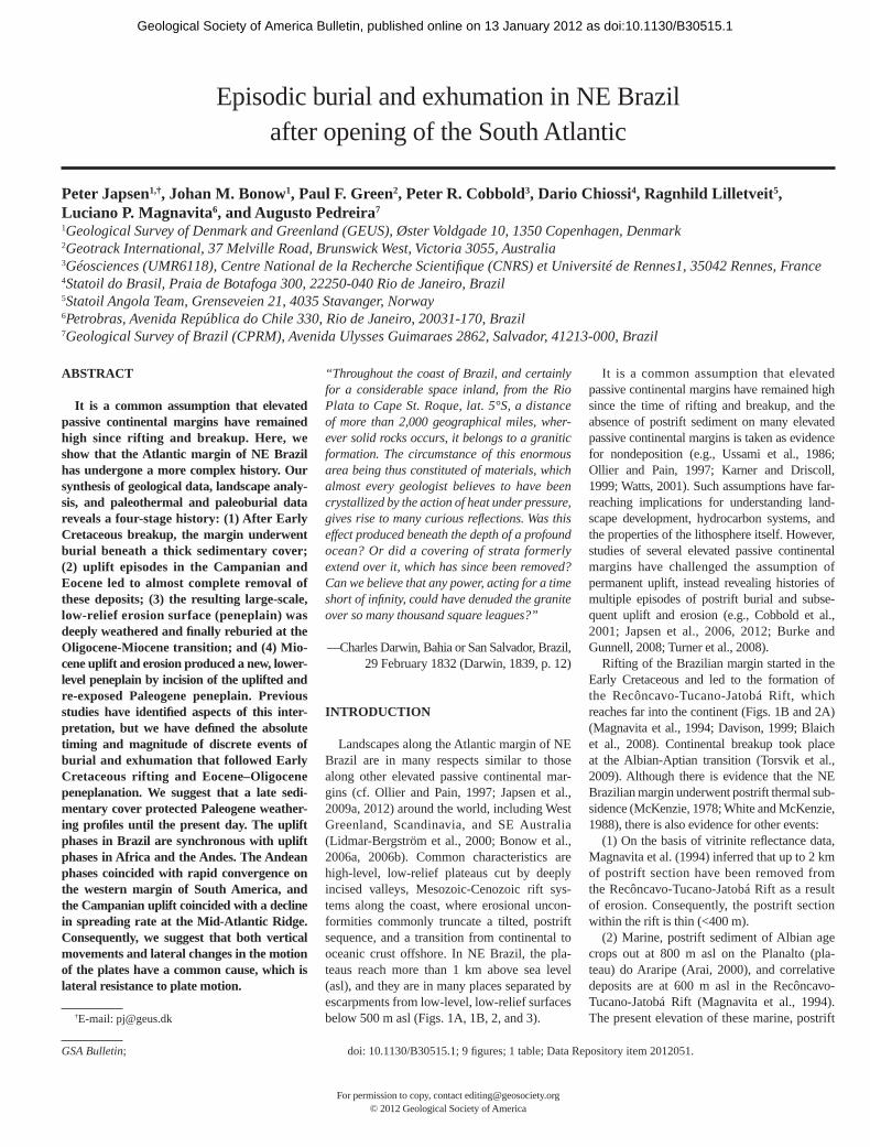
Figure 2. Geological map and interpretation of peneplains in the study area. (A) Geological map (CPRM, 2003) draped over a topo-graphic model with limits of the Early Cretaceous rift basin (see Fig. 1B) after Magnavita et al. (1994) and Scotchman and Chiossi (2008). (B) Map of the higher surface and the lower surface in areas where they are well preserved. Edges of map coincide with black frame in Figure 1A; profi le 1 continues 30 km east of this frame. Higher surface often coincides with presence of Cenozoic laterite. Lower surface extends across basement, rift sediment, and the Lower Miocene Sabiá Formation. (C) Two profi les to illustrate mapping of low-relief surfaces and interpreted peneplains, i.e., higher surface and lower surface (Bonow et al., 2009). Plateaus are part of one, seaward-dipping surface (profi le 2). Locations of profi les are in Figure 2B. CD—Chapada Diamantina, PM—Planalto de Maracás, PC—Planalto da Conquista. Mapped, low-relief surfaces cut across basement (consisting of rocks that have different resistance to ero-sion) as well as the sedimentary sequence of the Recôncavo-Tucano-Jatobá Rift. Hence, surfaces are erosional features. According to our interpretation, the higher surface formed as a peneplain by fl uvial erosion to near sea level during the Eocene–Oligocene. The higher surface was subsequently buried at the Oligocene-Miocene transition and then uplifted and re-exposed in the Miocene. Uplift caused rivers to incise, after which the lower surface formed below the higher surface.
as doi:10.1130/B30515.1Geological Society of America Bulletin, published online on 13 January 2012
Japsen et al.
4 Geological Society of America Bulletin, Month/Month 2012
data, Scotchman and Chiossi (2008) estimated that uplift and subsequent erosion have removed a kilometer-thick Cretaceous postrift section from the nearshore parts of this basin.
With this in mind, we report the outcome of an integrated study of landscape develop-
ment and thermo-tectonic evolution of the elevated passive continental margin in NE Brazil, focusing on the Recôncavo-Tucano-Jatobá Rift and the extensive plateaus in the eastern part of the State of Bahia (Fig. 1A) (see also Bonow et al., 2009; Japsen et al.,
2008a, 2008b, 2009b). We compare our re-sults with those of similar studies on both sides of the South Atlantic and also with those in the North Atlantic domain, where breakup happened ~50 m.y. later than along the Brazilian margin.
41°W 40°W42°W
16°S
15°S
14°S
13°S
Salvador
Elevation(m asl)
Salvador
Belo Horizonte
Rio de Janeiro
Salvador
Belo Horizonte
Rio de Janeiro
HS
HS55 km
HS
HSHS
LS
LS
LS
2000
1800
1600
1400
1200
1000
800
600
400
200
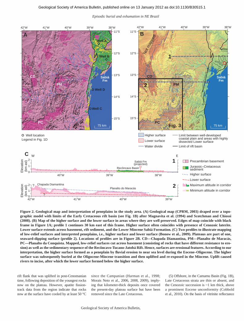
Figure 3. Altitude between Chapada Diamantina in the north and Planalto da Conquista in the south with interpretation of two pene-plains, the higher surface (HS) and the lower surface (LS). The lower surface is between 300 and 400 m above sea level (asl) and dips slightly eastward. Sharp, erosional, winding escarpment separates the lower surface from higher surface. The higher surface is particu-larly well preserved on Planalto da Conquista (~900 m asl) where the surface covers an area of ~18,000 km2 within the frame of Fig. 3; note the wide and shallow valley that trends toward east. The higher surface is also clearly defi ned on Chapada Diamantina (~1200 m asl).
as doi:10.1130/B30515.1Geological Society of America Bulletin, published online on 13 January 2012

Episodic burial and exhumation in NE Brazil
Geological Society of America Bulletin, Month/Month 2012 5
METHODS
We did fi eld work in the main study area in 2007 and in the State of Minas Gerais in 2009 (near Belo Horizonte; Fig. 1A). The details of all analyses are available as supplementary in-formation online.1
TECHNIQUE FOR MAPPING OF MAJOR LANDFORMS
We used a digital elevation model with 90 m grid (Jarvis et al., 2008) as input data for our landform analysis (Figs. 2 and 3). From the elevation data, we constructed a contour map, which is the primary input for the surface map-ping. In the study area, we found that a 100 m contour gives a reasonable picture of the general landscape (cf. Bonow et al., 2006b). Further-more, a contour map depicts the fully three-dimensional picture of the landscape, whereas the relief along a topographical profi le depends on the location and azimuth of the transect (Figs. 2B and 2C). To support the mapping, we used profi les along a square grid with a spac-ing of 0.1°. Topographical profi les were plotted along the grid lines together with maximum and minimum heights, which we extracted every 100 m along the grid within a swath, 0.2° wide, centered along the topographical profi le (Fig. 2C). The contour map and profi les were plotted on paper at a scale of 1:250,000. We analyzed 70 profi les with lengths of up to ~110 km.
We began the mapping of the surfaces in core areas that we defi ned from the contour map as areas of low relative relief and only minor fl u-vial valleys. In such areas, the maximum height along each swath coincides with the topographi-cal profi le. In this way (due to support from the profi les), we could map the same surface also in areas that are much more affected by fl uvial erosion and thus more dissected. We determined the edge of a surface where there was a rapid change of inclination on the contour map. This method is also useful for identifying offsets within a surface, e.g., by faults (cf. Bonow et al., 2006b). We also identifi ed surfaces incised be-low a higher plateau by aid of the minimum height along the profi les because such surfaces are guided by fl uvial erosion to a base level. In summary, we identifi ed the levels of the low-relief surfaces on the map and on the profi les. To ascertain that the interpretation was consistent, we checked that we could follow the surfaces from profi le to profi le. To distinguish erosion
surfaces from structural surfaces, we compared our mapped surfaces with geological maps of the area (CPRM, 2003) and were thus able to identify lithological control on the mapped surfaces (cf. Fjellanger and Etzelmuller, 2003; Japsen et al., 2009a). We fi nd that fl uvial ero-sion down to the base level is the key to under-standing the formation of extensive, low-relief surfaces such as those mapped here. Base level controls the fl uvial erosion, and unless a local base level is present, represented, for example, by a resistant rock surface or an internal drain-age basin, the ultimate base level is sea level, particularly for locations along continental margins after rifting and breakup. The process of valley widening by river erosion eventually results in a large-scale, low-relief erosion sur-face—a peneplain. Valley incision below such a surface is evidence for a lowering of base level (uplift of the landmass or drop in sea level), with subsequent formation of new valley fl oors grad-ing to sea level and thus possibly resulting in the formation of a new peneplain. The height differ-ence between the valley fl oor and the overlying surface therefore indicates the amount of uplift or fall in base level.
THERMOCHRONOLOGICAL ANALYSIS
We obtained apatite fi ssion-track analysis (AFTA®) data from 83 outcrop samples from NE Brazil at elevations up to 1.6 km asl (loca-tions shown in Fig. 1). Of these outcrop sam-ples, 43 are of Precambrian basement, 13 are of Proterozoic sediment, and 27 are of Phanerozoic sediment. We also obtained AFTA data from 47 samples of Upper Jurassic–Lower Cretaceous sediment from seven boreholes down to 5.3 km below ground level in the Tucano and Recôn-cavo Basins and one sample of Proterozoic sedi-ment from a well in the Sanfranciscana Basin (Fig. 1A). We also incorporated previously published AFTA data from 10 outcrop samples from Turner et al. (2008). Vitrinite refl ectance data came from 144 samples of primarily Lower Cretaceous sediment, mainly from wells in the Tucano and Recôncavo Basins. Full details of all AFTA and vitrinite refl ectance data, together with analytical details and technical back-ground, are provided in the online data supple-ment (see footnote 1).
AFTA data in outcrop samples that have ex-perienced different maximum paleotempera-tures (e.g., refl ecting different burial depths) prior to cooling in a single dominant episode show a well-defi ned relationship between mean track length and fi ssion-track age (Green, 1986). Samples that have undergone only minor heat-ing (say <60 °C) have old ages with relatively
long mean track lengths (>13 µm), whereas sam-ples heated above ~110 °C, in which all fi ssion tracks were totally annealed prior to the onset of cooling, give much younger fi ssion-track ages (“reset ages”) and long mean lengths around ~14 µm or more. Between these two extremes, a decrease in fi ssion-track age (representing in-creasing maximum paleotemperatures prior to the onset of cooling) is accompanied by a re-duction in mean track length as tracks formed prior to the onset of cooling are progressively shortened. In the fi nal stages of annealing, in samples heated to around 100 °C, the partially annealed tracks become so short that their con-tribution to the mean length is diminished. The mean length therefore increases with further reduction in fi ssion-track age, trending upward toward the long mean length characterizing the reset ages and resulting in the characteristic “boomerang” trend. For further explanation, see Green (1986).
However, data from NE Brazil show a much more complex pattern of variation (Fig. 4), sug-gesting a more complex thermal-history frame-work involving a number of cooling episodes, and detailed assessment of data in individual samples is required before any rigorous conclu-sions can be reached. Nevertheless, the consis-tent trend shown by the data in Figure 4 suggests that a common style of thermal history affected the entire region, with different samples reach-ing differing paleotemperatures in the dominant regional cooling episodes. Since samples of sedi-mentary rock and basement plot together and defi ne a common trend in Figure 4, the domi-nant, paleothermal events affected both basins and basement regions alike.
To investigate the details of the thermal his-tory, we extracted thermal-history constraints from the AFTA and vitrinite refl ectance data in each sample following the principles outlined by, e.g., Green et al. (2002, 2004) and Green and Duddy (2010). The process begins with construction of a default thermal history, assum-ing that the sample has never been any hotter than the present-day temperature. The default thermal history for an outcrop sample of sedi-mentary rock represents residence since deposi-tion at the prevailing mean surface temperature, while for basement outcrop samples, a similar approach can be adopted using the age of the oldest overlying sedimentary unit. For down-hole samples, the default thermal history is con-structed from the burial history defi ned from the sedimentary section preserved in the well, com-bined with the present-day thermal gradient.
Note that this approach does not imply that the default thermal history is a realistic sce-nario; it simply allows an initial assessment of the data. If the default thermal history can
1GSA Data Repository item 2012051, full details of thermochronological analyses, landscape analy-sis, and analysis of sonic data, is available at http://www.geosociety.org/pubs/ft2012.htm or by request to [email protected].
as doi:10.1130/B30515.1Geological Society of America Bulletin, published online on 13 January 2012

Japsen et al.
6 Geological Society of America Bulletin, Month/Month 2012
explain the AFTA data, possibly combined with the presence of shorter tracks inherited from sediment provenance regions, then it is not possible to extract further thermal-history information. Alternatively, if the AFTA data show a greater degree of postdepositional an-nealing (i.e., fi ssion-track age and/or track-length reduction) than expected from the default thermal history, then the sample must have been hotter in the past, and informa-tion on the magnitude and timing of heating and cooling events can be extracted from the data. In this case, modeling AFTA parameters through likely thermal-history scenarios within a framework constrained as far as possible by geological data (through the default thermal history) allows defi nition of the range of condi-tions giving predictions that match the observed data within 95% confi dence limits (i.e., ±2!). In samples of sedimentary rock in which the AFTA data are dominated by tracks formed prior to deposition, it is often not possible to separate postdepositional effects from the infl u-ence of tracks formed prior to deposition, and only a limit to the magnitude of the maximum postdepositional temperature can be obtained.
We did not attempt to constrain the entire ther-mal history of each sample using AFTA, because the data are dominated by the effects of the maxi-mum paleotemperature, which overprints the previous history. Instead, we focused on deter-mining the key aspects of the thermal history that control the fi ssion-track age and length distribu-
tion, i.e., maximum paleotempera ture, and the time at which cooling began. Estimates of these parameters were extracted from the AFTA data using a kinetic model of fi ssion-track anneal ing that takes full quantitative allowance of the in-fl uence of wt% Cl on annealing rates (Carlson et al., 1999; Barbarand et al., 2003). The process was explained by Green et al. (2002) and illus-trated further by Green and Duddy (2010). Independent estimates of maximum paleo-tempera ture were derived from vitrinite refl ec-tance data using the kinetic model of Burnham and Sweeney (1989). We routinely found con-sistent interpretations from the two techniques using this approach (e.g., Japsen et al., 2007b; Green and Duddy, 2010).
AFTA data contain a high degree of redun-dancy, in the sense that many different histories can produce similar data that cannot be resolved (cf. Chalmers et al., 2010), and for this reason, integration of geological constraints is vital to extracting accurate thermal-history information. Thermochronology studies conventionally as-sume monotonic cooling histories, but preserva-tion of even a thin veneer of sedimentary cover shows that underlying basement was at the sur-face when the sediment was deposited. Failure to take such constraints into account can result in misleading interpretations (cf. Persano et al., 2006, 2007; Brown, 2007; Gibson, 2007; Green and Duddy, 2007), since AFTA data can only defi ne progressive cooling events and will not independently identify reheating.
Even where no sedimentary outliers are pre-served, we favor an interpretation scenario in-volving a series of heating and cooling episodes. Such histories appear reasonable in NE Brazil, where outliers of Cretaceous sediment are wide-spread. AFTA data in individual samples allow resolution of multiple episodes through the distribution of track lengths, together with the fi ssion-track age reduction. In favorable cases, three discrete episodes can be resolved from data in a single sample. Typically, the earli-est event will reset the fi ssion-track age. If the sample then cools and is reheated to 90 °C or 100 °C, tracks formed after the earlier cooling will be shortened to around 10 µm; renewed cooling followed by reheating to a lower peak paleotemperature, say 70 °C, will shorten those tracks formed after the second cooling event to around 13 µm. Quantitative modeling of the fi ssion-track age and track-length data will show that all aspects of the data can only be explained by a scenario involving three discrete episodes of heating and cooling.
In regions that have undergone a number of cooling episodes, AFTA data will reveal only those events that dominate the data in indi-vidual samples. Synthesis of data from a large number of samples across a wide region then al-lows identifi cation of the main, regional cooling episodes.
Where AFTA and/or vitrinite refl ectance data are available through a vertical rock section, ei-ther from boreholes or from vertical transects
0 100 200 300 400
10
11
12
13
14
Fission-track age (Ma)
Mea
n tra
ck le
ngth
(mic
rons
)
Turner et al. (2008) basementTurner et al. (2008) Cretaceous sedimentHarman et al. (1998)
This studyMorais Neto et al. (2008)
Figure 4. Mean track length ver-sus fi ssion-track age for outcrop samples from NE Brazil ; data are from this study together with data from previously pub-lished studies (Harman et al., 1998; Morais Neto et al., 2008; Turner et al., 2008). The complex pattern revealed by the plot in-dicates that the thermal history involved more than just a single cooling episode. The differ-ent data sets defi ne a consistent trend, although note that the Borborema data from Morais Neto et al. (2008) plot at the limit of the trend, suggesting a dif-ferent history specifi c to those samples.
as doi:10.1130/B30515.1Geological Society of America Bulletin, published online on 13 January 2012

Episodic burial and exhumation in NE Brazil
Geological Society of America Bulletin, Month/Month 2012 7
in outcrop, the variation of paleotemperatures in key paleothermal episodes with depth/elevation allows the paleogeothermal gradient in each episode to be determined (Bray et al., 1992). Extrapolation of fi tted paleogradients to an as-sumed paleosurface temperature then allows determination of the amount of section that has been removed since the onset of cooling in each episode. Paleotemperature profi les also allow identifi cation of situations where heating is due to non-burial-related phenomena such as hot fl uids (Duddy et al., 1994, 1998).
MAGNITUDE OF EXHUMATION FROM PALEOBURIAL (SONIC) DATA
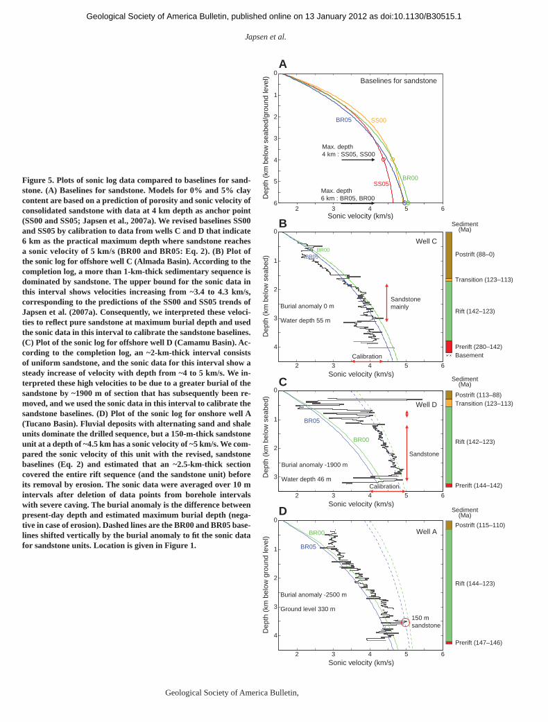
We estimated the magnitude of exhumation for fi ve well locations (four in the Recôncavo-Tucano-Jatobá Rift and one in the Camamu Ba-sin; Figs. 1 and 5) by comparing sonic-log data for sandstone with normal velocity-depth trends (baselines). Japsen et al. (2007a) constructed baselines for sandstone based on the properties of sandstone with varying clay content, but they considered 4 km to be the maximum depth for practical purposes and thus chose anchor points at that depth to constrain the baselines in the form of modifi ed, velocity-average equations:
V(z) = Vm – (Vm – Vc)e–z/b, (1)
where Vm is the matrix velocity of the sediment, Vc is the sonic velocity of the sediment at critical porosity (~1600 m/s for sand), z is depth below the surface of the sedimentary succession, and b is a decay parameter. These baselines predict velocities of around 4.5 km/s for pure sandstone (0%–5% clay) at a depth of 4 km and only a minor increase of velocity at greater depth. However, the sonic data for well D (Fig. 5C), for example, show a gradual increase of velocity from 4 to 5 km/s over a 2-km-thick sandstone interval. Consequently, we calibrated the base-lines for pure sandstone to match the data from the study area (Figs. 5B and 5C) with the fol-lowing parameters for the modifi ed, velocity-average equation (Eq. 1):
BR00, 0% clay: Vm = 5400 m/s, b = 2500 m,BR00, 5% clay: Vm = 5400 m/s, b = 2800 m.
(2)
For velocities higher than ~4.5 km/s, the re-vised baselines plot at shallower depths than those of Japsen et al. (2007a), and thus result in smaller estimated amounts of exhumation (Fig. 5A). Figure 6C shows a comparison be-tween the magnitude of exhumation (with esti-mated uncertainty) for wells A and B based on sonic data and the results based on paleother-
mal data. These fi gures show that the estimated amounts of removed section based on sonic data are 2–3 km for both wells, that the uncertainty is bigger for well A than for well B, and that the higher values of these estimates are in best agreement with the results based on the paleo-thermal data. The fl uvial deposits with alternat-ing sand and shale units penetrated by wells A and B only contain a few thick sand units with a uniform sonic-log pattern, and comparison with baselines is thus not straightforward.
DENUDATION CHRONOLOGY FROM LANDSCAPE ANALYSIS
Within the study area, we identifi ed two sur-faces of low relative relief and of regional ex-tent, the higher surface and the lower surface (Figs. 1B, 2, and 3). There is also a coastal plain of limited extent, and above the level of the higher surface, there are distinct hills along ridges of particularly resistant rock (e.g., along the eastern escarpment along Chapada Diamantina; Fig. 2C). These ridges may or may not be rem-nants of a surface above the higher surface, but we do not address this issue in the present study. The topographic model in Figure 3 depicts the relation between the higher surface and lower surface in the central part of the study area, where a sharp, erosional, winding escarpment separates the two surfaces.
The higher surface is preserved on high ground and includes the plateaus of Chapada Diamantina (~1200 m asl) and Planalto da Con-quista (~900 m asl). These plateaus defi ne a coherent surface, dipping slightly seaward. The higher surface cuts across Proterozoic sediment and Precambrian basement that frequently is deeply weathered into a soft and disintegrated rock many tens of meters below the surface; these weathering profi les have been mapped as Cenozoic laterites by the Geological Survey of Brazil (CPRM, 2003) (e.g., Fig. 2). The higher surface and the laterites are preserved where the drainage system is unaffected by the fl uvial system related to the younger, lower surface. The lower surface is well defi ned across wide areas in the interior (up to 500 m asl), but it can also be traced as a summit level across an intermediate zone along the coast, where it is highly dissected by the rivers that defi ne the coastal plain. The lower surface cuts across Precambrian basement outside the rift and the postrift sediment of the Aptian Marizal Forma-tion within the rift (Silva et al., 2007), but it also truncates the Lower Miocene, marine Sabiá Formation within the Recôncavo Basin (Viana et al., 1971; Petri, 1972).
Both the higher surface and the lower sur-face cut across rocks of different ages and re-
sistances and are therefore erosional features (peneplains). They presumably formed by de-nudation to a nearly horizontal plain, because even slightly dipping surfaces would be incised by fl uvial valleys and the relief would be rejuve-nated (Rudberg, 1970) until a new and younger peneplain formed.
The higher surface must originally have ex-tended across a larger area than that of the pla-teau remnants as the lower surface has developed at its expense. The higher surface is characterized by Cenozoic laterites over large areas, and both the higher surface and the laterites are currently subject to erosion along the escarpments that out-line the plateaus. We consequently fi nd that the laterites formed after fl uvial erosion had graded the higher surface to base level during the Ceno-zoic, but prior to the uplift of the higher surface to its present elevation. The age of the lower sur-face is Neogene because it postdates the Lower Miocene Sabiá Formation. The older, higher sur-face must consequently have developed during the Paleogene prior to the early Miocene trans-gression. This implies that the Sabiá Formation accumulated on the higher surface (when it was near sea level), but the sediment has been found in meter-deep trenches (Petri , 1972) below the lower surface, presumably because it was thus preserved by some degree of down-faulting. The lower surface is rapidly being dissected by river incision into the soft sediment of the Recôncavo- Tucano-Jatobá Rift. We infer a change in base level that occurred recently, and this fi ts well with the estimate of Bigarella (1975), who suggested that this change took place since ca. 2 Ma. Both of these regional erosion surfaces developed dur-ing the Cenozoic and thus are post-breakup phe-nomena that formed along the Atlantic margin. Consequently, we fi nd that sea level is the most likely base level to which the surfaces graded.
Similar plateaus outside the study area are also of Paleogene age (Fig. 1A). For example, in the Sanfranciscana Basin, a regional ero-sion surface truncates Maastrichtian sediment (Campos and Dardenne, 1997), and this sur-face correlates with the higher surface within the study area (Valadão, 1998). On the Planalto da Borborema, Paleogene sandstones and con-glomerates of the continental Serra do Martins Formation cover the plateau surface (Morais Neto et al., 2008). This demonstrates that the surface was exposed in Paleogene times until the Serra do Martins Formation accumulated over it and preserved the surface to the present day. A Paleogene age for the higher surface across the highlands of Chapada Diamantina and Planalto da Conquista is also in agreement with the in-terpretation of King (1967), who mapped these plateaus as part of the Paleogene Sul-Americana surface. The highly dissected higher surface of
as doi:10.1130/B30515.1Geological Society of America Bulletin, published online on 13 January 2012
Japsen et al.
8 Geological Society of America Bulletin, Month/Month 2012
2 3 4 5 6
4
3
2
1
0
Burial anomaly -2500 m
Ground level 330 m150 msandstone
Postrift (115–110)
Rift (144–123)
Prerift (147–146)
BR05
Dep
th (
km b
elow
gro
und
leve
l)
Sonic velocity (km/s)
BR00
Sediment(Ma)
Sediment(Ma)
Sediment(Ma)
2 3 4 5 6
3
2
1
0
Burial anomaly -1900 m
Water depth 46 m
Postrift (113–88)Transition (123–113)
Rift (142–123)
Prerift (144–142)
BR05
Dep
th (
km b
elow
sea
bed)
Sonic velocity (km/s)
BR00
2 3 4 5 6
4
3
2
1
0
Burial anomaly 0 m
Water depth 55 m
Sandstonemainly
Calibration
Postrift (88–0)
Transition (123–113)
Rift (142–123)
Prerift (280–142)Basement
BR05
Dep
th (
km b
elow
sea
bed)
Sonic velocity (km/s)
BR00
2 3 4 5 6
4
3
6
5
2
1
0
Sonic velocity (km/s)
Dep
th (
km b
elow
sea
bed/
grou
nd le
vel)
A
Well C
Baselines for sandstone
B
Well D
C
Well A
D
BR05
Max. depth4 km : SS05, SS00
Max. depth6 km : BR05, BR00
SS05
SS00
BR00
Sandstone
Calibration
Figure 5. Plots of sonic log data compared to baselines for sand-stone. (A) Baselines for sandstone. Models for 0% and 5% clay content are based on a prediction of porosity and sonic velocity of consolidated sandstone with data at 4 km depth as anchor point (SS00 and SS05; Japsen et al., 2007a). We revised baselines SS00 and SS05 by calibration to data from wells C and D that indicate 6 km as the practical maximum depth where sandstone reaches a sonic velocity of 5 km/s (BR00 and BR05: Eq. 2). (B) Plot of the sonic log for offshore well C (Almada Basin). According to the completion log, a more than 1-km-thick sedimentary sequence is dominated by sandstone. The upper bound for the sonic data in this interval shows velocities increasing from ~3.4 to 4.3 km/s, corresponding to the predictions of the SS00 and SS05 trends of Japsen et al. (2007a). Consequently, we interpreted these veloci-ties to refl ect pure sandstone at maximum burial depth and used the sonic data in this interval to calibrate the sandstone baselines. (C) Plot of the sonic log for offshore well D (Camamu Basin). Ac-cording to the completion log, an ~2-km-thick interval consists of uniform sandstone, and the sonic data for this interval show a steady increase of velocity with depth from ~4 to 5 km/s. We in-terpreted these high velocities to be due to a greater burial of the sandstone by ~1900 m of section that has subsequently been re-moved, and we used the sonic data in this interval to calibrate the sandstone baselines. (D) Plot of the sonic log for onshore well A (Tucano Basin ). Fluvial deposits with alternating sand and shale units dominate the drilled sequence, but a 150-m-thick sandstone unit at a depth of ~4.5 km has a sonic velocity of ~5 km/s. We com-pared the sonic velocity of this unit with the revised, sandstone baselines (Eq. 2) and estimated that an ~2.5-km-thick section covered the entire rift sequence (and the sandstone unit) before its removal by erosion. The sonic data were averaged over 10 m intervals after deletion of data points from borehole intervals with severe caving. The burial anomaly is the difference between present-day depth and estimated maximum burial depth (nega-tive in case of erosion). Dashed lines are the BR00 and BR05 base-lines shifted vertically by the burial anomaly to fi t the sonic data for sandstone units. Location is given in Figure 1.
as doi:10.1130/B30515.1Geological Society of America Bulletin, published online on 13 January 2012

Episodic burial and exhumation in NE Brazil
Geological Society of America Bulletin, Month/Month 2012 9
Mean length (µm)
Dep
th (
km)
Fission-track age (Ma)
0
1
2
3
4
50 100 200 300 400
30
40
50
60
70
80
90
30
40
50
60
70
80
90stratigraphic age
4 8 12 16
Chl Chl
Chl
Fission-track agewith error bar
Unconformity
Well AWell B
Prediction fromDTH
Increasingchlorine content
Well A
169 232
237239
242
245
248
251
254
171
174
177
180
183
186
190
193
194
Eocene profile
Eoceneprofile
Campanianprofile
Campanianprofile
Mioceneprofile
Mioceneprofile4
1
2
0
3
Dep
th (
km b
elow
gro
und
leve
l)
0 40 80 120 160 200Temperature (°C)
Well B0 40 80 120 160 200
Temperature (°C)
Corrected BHTAFTA sample horizonMaximum paleotemperature from VRCore measurement
OutlierRange of paleotemperaturesfrom AFTA
Present-daythermal gradient
of 15 °C/km
Postrift (115–110)
Rift(144–123)
Prerift(147–146)
Sediment(Ma)
Geothermal gradient (°C/km)
Maximum likelihood solution Parameter ranges from AFTA.95% confidence limits
Sandstonesonic data
Sandstonesonic data
Rem
oved
sec
tion
(km
)
Well A Well B
CampanianCampanian
Eocene Eocene
MioceneMiocene
Constant heat flow:15 °C/km
5
5
4
3
2
1
0
10 15 20 25
~3.0 km~2.5 km~2.0 km
A
B
C5
4
3
2
1
0
Temp. (°C)
Present-daythermal gradient
of 20 °C/km
~3.5 km
~2.5 km
~1.5 km
Geothermal gradient (°C/km)10 15 20 25 30
Constant heat flow:20 °C/km
Figure 6. Paleothermal data from two wells defi ning burial and exhumation histories in the Recôncavo-Tucano -Jatobá Rift. (A) Apatite fi ssion-track parame-ters for samples from wells A and B (drilled in the Tucano and Recôncavo Basins, respectively) plotted against depth and present-day temperature. The black line in the left panel shows the increasing stratigraphic age with depth, and the colored lines show the predicted patterns of fi ssion-track age and mean track length for apatites containing <0.1, 0.5, 1.0, and 1.5 wt% Cl from the default thermal history (DTH). The default thermal history was derived from the preserved sedi-mentary section and the present-day thermal gradi-ent calculated from corrected borehole temperatures (BHT) in each well. The fi ssion-track ages decrease systematically with depth, and at depths greater than 2 km, they are much less than the values predicted from the default thermal history. This shows that the sampled units have been hotter in the past (Green et al., 2002). The pattern of decrease in fi ssion-track age with depth is characteristic of a section that has undergone major cooling, with the “break in slope” at a depth of ~2.5 km representing the transition between partial and total annealing of fi ssion tracks formed prior to the onset of cooling (cf. Green et al., 2002). The corresponding fi ssion-track age of ca. 75 Ma rep-resents the onset of exhumation. (B) Paleotemperature constraints versus depth in wells A and B for the Cam-panian, Eocene, and Miocene paleothermal episodes. Drilled stratigraphy for each well is shown to the right. Constraints for each episode in both wells defi ne linear profi les, subparallel to the present-day temperature profi le, characteristic of heating due predominantly to deeper burial. VR—vitrinite refl ectance. (C) Ranges of amount of removed section and paleogeothermal gradients (banana-shaped areas) required to explain paleothermal profi les in wells A and B within 95% con-fi dence limits. Limits on the amount of removed section were estimated from sonic data from sandstone units (rectangular areas). Interpretations based on constant geothermal gradients corresponding to present-day conditions are also indicated, with paleothermal and paleoburial (based on sonic data; Fig. 5) approaches giving highly consistent results in both wells. The present-day temperature profi le for well B is based on corrected BHT data and temperatures revised on the basis of the apatite fi ssion-track analysis (AFTA) data (see supplementary data online [see text footnote 1]).
as doi:10.1130/B30515.1Geological Society of America Bulletin, published online on 13 January 2012

Japsen et al.
10 Geological Society of America Bulletin, Month/Month 2012
Planalto de Maracás corresponds to the Velhas surface of King, whereas the lower surface and the coastal plain are equivalent to his Paraguaçu surface within our study area.
North of our study area (north of 8°S, east of 41°W), Peulvast et al. (2008) also identifi ed two erosional levels of regional extent: a low plain between 0 and 300 m asl (the Sertaneja surface or Sertão), and the discontinuous remains of a high plain between 750 and 1100 m asl (includ-ing the Araripe and Borborema Plateaus). These two erosion surfaces are thus equivalent to the lower surface and higher surface, respectively, in this study. We conclude that there are two re-gional peneplains in NE Brazil, a lower surface (Paraguaçu/Sertaneja), and remnants of a higher surface (Sul-Americana), which were formed by erosion during Neogene and Paleogene time, respectively.
PALEOTHERMAL EVENTS DUE TO BURIAL AND EXHUMATION
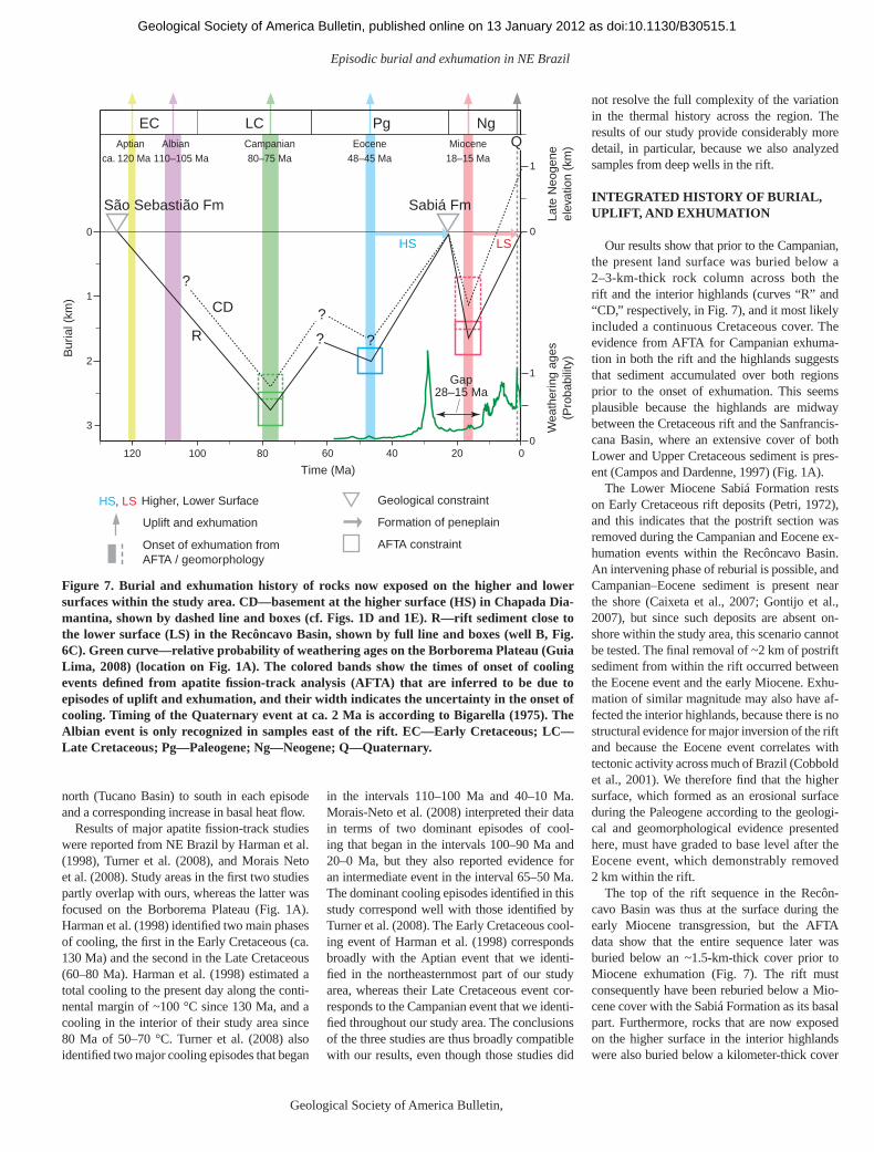
We have defi ned nine regional cooling epi-sodes from a synthesis of thermal history so-lutions derived from AFTA data in all samples (Table 1). The events date back to the Paleozoic, but here we focus on the (postrift) Cretaceous and Cenozoic development. The AFTA data de-fi ne cooling episodes that began ca. 120 Ma and in the intervals 80–75, 48–45, and 18–15 Ma (Aptian, Campanian, Eocene, and Miocene cooling episodes; see Fig. 7). Note that these time intervals represent the ranges of 95% un-certainty for the onset of cooling in each epi-sode. An Albian event that began between 110 and 105 Ma is only recognized outside the main study area (northeasternmost samples in Fig. 1A). This event correlates closely with the timing of breakup (Torsvik et al., 2009) as also recognized by Harman et al. (1998) and by Turner et al. (2008).
The Aptian cooling episode is dominant in AFTA data from most basement samples, and we interpret this event as refl ecting exhuma-tion, not only of the rift margins, but also of the
hinterland (e.g., ~200 km west of the rift). Even though we did not detect it in samples from the basin fi ll, a major correlative unconformity is present between the synrift section and the postrift Marizal Formation of Aptian age (Silva et al., 2007), suggesting some degree of exhu-mation at this time.
AFTA and vitrinite refl ectance data from wells in the Recôncavo-Tucano-Jatobá Rift show that the synrift sequences began to cool from their maximum, postdepositional paleo-temperatures in the Campanian (Fig. 6). Varia-tion of the Campanian paleotemperatures with depth suggests that heating was due to addi-tional burial by 2–3 km of postrift section if the paleogeothermal gradient was similar to the present-day value, but slightly higher gradients (corresponding to lower amounts of additional burial) are also possible. Our analysis of paleo-burial (sonic) data from deep wells also indi-cates that a 2–3-km-thick cover buried the rift sequence prior to uplift and erosion (Fig. 6C). This confi rms that the geothermal gradient had remained fairly low since maximum burial and that the subsequent cooling was due primarily to exhumation. Campanian cooling dominates all AFTA data from the Recôncavo-Tucano-Jatobá Rift and the exposed parts of the Almada and Camamu Basins, and it is also important in the data from the surrounding basement re-gions (Fig. 1D). Heating to Campanian paleo-temperatures must thus have been primarily due to deeper burial, with subsequent cooling due to exhumation. Paleotemperatures defi ned for out-crop samples in the interior highlands corre-spond to burial below a rock column of ~2 km. We consequently interpret the Campanian as a time of profound uplift and erosion across the entire area, following postrift subsidence and burial (Fig. 7).
AFTA data from some deep well samples also provide evidence for Eocene cooling. Eo-cene paleotemperatures were probably not of suffi cient magnitude in shallower samples to be resolved from those of the Campanian and Mio-cene episodes, but it seems likely that Eocene
cooling also affected much of the study area. Analysis of paleotemperature profi les in the wells suggests that Eocene paleotemperatures were due to additional burial by 2–2.5 km of postrift section under heat-fl ow conditions very close to those of the present day, and that cool-ing was due to renewed exhumation.
AFTA data from outcrop samples of both rift sediment and basement also consistently show Miocene cooling (Fig. 1E). Analysis of paleo-temperature profi les in the wells again suggests that paleogeothermal gradients were close to present-day values, and that Miocene paleotem-peratures refl ect additional burial by ~1.5 km of section. Miocene paleotemperatures for samples from the highlands correspond to burial below a rock column of ~1 km. We interpret the Mio-cene cooling as representing regional uplift and erosion during the fi nal phase of the exhumation history that began in the Campanian.
The postrift exhumation episodes that we have established from AFTA data correlate closely with major unconformities in the off-shore Camamu and Almada Basins in the mid-Campanian, mid-Eocene, and mid-Miocene (see Table 1; Caixeta et al., 2007; Gontijo et al., 2007). The correlation is better for the Almada Basin, probably because the Camamu Basin was affected by a major, submarine slide (Cob-bold et al., 2010), which has to some extent ob-scured the stratigraphic evidence.
The allowed range of paleogeothermal gradi-ents for the Campanian episode in well A (Tucano Basin) is close to the present-day gradient of 15 °C/km that we derived from the AFTA data and published temperature data (Meister, 1973) (Fig. 6C), as are results for the later episodes. The range of allowed paleogradients for well B (Recôncavo Basin) is broader than that for well A, but the paleotemperatures in the three key epi-sodes are consistent with paleogeothermal gra-dients in the range of 20–25 °C/km. This range overlaps with the present-day gradient in this well of ~20 °C/km that we estimated from the AFTA data. The results therefore suggest a pat-tern of decreasing amounts of paleoburial from
TABLE 1. INTERVALS DEFINING THE BEGINNING OF EPISODES OF REGIONAL COOLING BASED ON APATITE FISSION-TRACK ANALYSIS (AFTA) DATA IN 131 SAMPLES FROM OUTCROPS AND BOREHOLES IN NE BRAZIL
Onset of cooling(Ma)
Onset of cooling(chronostratigraphy)
sutaihtnelaviuqEtnevegniloocybdetceffaskcordnasaerA(Ma)
fltseWnainoveD–naicivodrO014–054 )T(044–035*dnalretnihWS,umamaCfoknafltseWsuorefinobraC003–023 )T(003.aC*umamaCdnaovacnôceRfoskna
)T,R(051–052*dnalretnihWScissairTetaL022–032flhtoBcissaruJelddiM071–081 anks of Recôncavo, west fl ank of Almada, SW hinterland* 250–150 (R,T)
)T,R(611–421selpmastnemesabtsoMnaitpA021.aC–)A1.giF(selpmasENylnOnaiblA501–011
)A(57–08selpmastnemesabdnatnemideSnainapmaC57–08)A(54–74selpmasllewpeeDenecoE54–84)A(21–61selpmastnemesabdnatnemideSenecoiM51–81
Note: A—Almada Basin (Gontijo et al., 2007); R—Recôncavo Basin (Silva et al., 2007); T—North Tucano–Jatobá Basins (Costa et al., 2007).*The earlier (pre-Cretaceous) episodes are recognized only in restricted areas where the effects of more recent events (particularly the Aptian episode) are low enough to
preserve evidence of the earlier history. It seems likely that the early episodes affected a wider part of the region.
as doi:10.1130/B30515.1Geological Society of America Bulletin, published online on 13 January 2012
Episodic burial and exhumation in NE Brazil
Geological Society of America Bulletin, Month/Month 2012 11
north (Tucano Basin) to south in each episode and a corresponding increase in basal heat fl ow.
Results of major apatite fi ssion-track studies were reported from NE Brazil by Harman et al. (1998), Turner et al. (2008), and Morais Neto et al. (2008). Study areas in the fi rst two studies partly overlap with ours, whereas the latter was focused on the Borborema Plateau (Fig. 1A). Harman et al. (1998) identifi ed two main phases of cooling, the fi rst in the Early Cretaceous (ca. 130 Ma) and the second in the Late Cretaceous (60–80 Ma). Harman et al. (1998) estimated a total cooling to the present day along the conti-nental margin of ~100 °C since 130 Ma, and a cooling in the interior of their study area since 80 Ma of 50–70 °C. Turner et al. (2008) also identifi ed two major cooling episodes that began
in the intervals 110–100 Ma and 40–10 Ma. Morais-Neto et al. (2008) interpreted their data in terms of two dominant episodes of cool-ing that began in the intervals 100–90 Ma and 20–0 Ma, but they also reported evidence for an intermediate event in the interval 65–50 Ma. The dominant cooling episodes identifi ed in this study correspond well with those identifi ed by Turner et al. (2008). The Early Cretaceous cool-ing event of Harman et al. (1998) corresponds broadly with the Aptian event that we identi-fi ed in the northeasternmost part of our study area, whereas their Late Cretaceous event cor-responds to the Campanian event that we identi-fi ed throughout our study area. The conclusions of the three studies are thus broadly compatible with our results, even though those studies did
not resolve the full complexity of the variation in the thermal history across the region. The results of our study provide considerably more detail, in particular, because we also analyzed samples from deep wells in the rift.
INTEGRATED HISTORY OF BURIAL, UPLIFT, AND EXHUMATION
Our results show that prior to the Campanian, the present land surface was buried below a 2–3-km-thick rock column across both the rift and the interior highlands (curves “R” and “CD,” respectively, in Fig. 7), and it most likely included a continuous Cretaceous cover. The evi dence from AFTA for Campanian exhuma-tion in both the rift and the highlands suggests that sediment accumulated over both regions prior to the onset of exhumation. This seems plausible because the highlands are midway between the Cretaceous rift and the Sanfrancis-cana Basin, where an extensive cover of both Lower and Upper Cretaceous sediment is pres-ent (Campos and Dardenne, 1997) (Fig. 1A).
The Lower Miocene Sabiá Formation rests on Early Cretaceous rift deposits (Petri, 1972), and this indicates that the postrift section was removed during the Campanian and Eocene ex-humation events within the Recôncavo Basin. An intervening phase of reburial is possible, and Campanian–Eocene sediment is present near the shore (Caixeta et al., 2007; Gontijo et al., 2007), but since such deposits are absent on-shore within the study area, this scenario cannot be tested. The fi nal removal of ~2 km of postrift sediment from within the rift occurred between the Eocene event and the early Miocene. Exhu-mation of similar magnitude may also have af-fected the interior highlands, because there is no structural evidence for major inversion of the rift and because the Eocene event correlates with tectonic activity across much of Brazil (Cobbold et al., 2001). We therefore fi nd that the higher surface, which formed as an erosional surface during the Paleogene according to the geologi-cal and geomorphological evidence presented here, must have graded to base level after the Eocene event, which demonstrably removed 2 km within the rift.
The top of the rift sequence in the Recôn-cavo Basin was thus at the surface during the early Miocene transgression, but the AFTA data show that the entire sequence later was buried below an ~1.5-km-thick cover prior to Miocene exhumation (Fig. 7). The rift must consequently have been reburied below a Mio-cene cover with the Sabiá Formation as its basal part. Furthermore, rocks that are now exposed on the higher surface in the interior highlands were also buried below a kilometer-thick cover
HS LS
60 40 20 0120 100 80
Time (Ma)
Geological constraint
Uplift and exhumation
Higher, Lower Surface
Onset of exhumation fromAFTA / geomorphology
AFTA constraint
Formation of peneplain
HS, LS
Late
Neo
gene
elev
atio
n (k
m)
1
3
0
1
0
Bur
ial (
km)
2
LC
?
EC Pg NgCampanian80–75 Ma
Aptianca. 120 Ma
Albian 110–105 Ma
Eocene48–45 Ma
Miocene18–15 Ma
Q
Wea
ther
ing
ages
(Pro
babi
lity)
1
0
Gap28–15 Ma
São Sebastião Fm Sabiá Fm
CD
R?
? ?
Figure 7. Burial and exhumation history of rocks now exposed on the higher and lower surfaces within the study area. CD—basement at the higher surface (HS) in Chapada Dia-mantina, shown by dashed line and boxes (cf. Figs. 1D and 1E). R—rift sediment close to the lower surface (LS) in the Recôncavo Basin, shown by full line and boxes (well B, Fig. 6C). Green curve—relative probability of weathering ages on the Borborema Plateau (Guia Lima, 2008) (location on Fig. 1A). The colored bands show the times of onset of cooling events defi ned from apatite fi ssion-track analysis (AFTA) that are inferred to be due to episodes of uplift and exhumation, and their width indicates the uncertainty in the onset of cooling. Timing of the Quaternary event at ca. 2 Ma is according to Bigarella (1975). The Albian event is only recognized in samples east of the rift. EC—Early Cretaceous; LC—Late Cretaceous; Pg—Paleogene; Ng—Neogene; Q—Quaternary.
as doi:10.1130/B30515.1Geological Society of America Bulletin, published online on 13 January 2012
Japsen et al.
12 Geological Society of America Bulletin, Month/Month 2012
prior to the Miocene event. However, since the higher surface was formed by erosion to base level during the Paleo gene, those rocks that are now on the higher surface were also near the surface prior to the Miocene. The higher surface was consequently reburied by sediment at the Oligocene-Miocene transition, also in the inte-rior highlands. The younger lower surface thus formed after the Miocene event and after almost complete removal of the Miocene cover.
In summary, we conclude that the present landscape is due to multiple postrift episodes of burial, uplift, and exhumation:
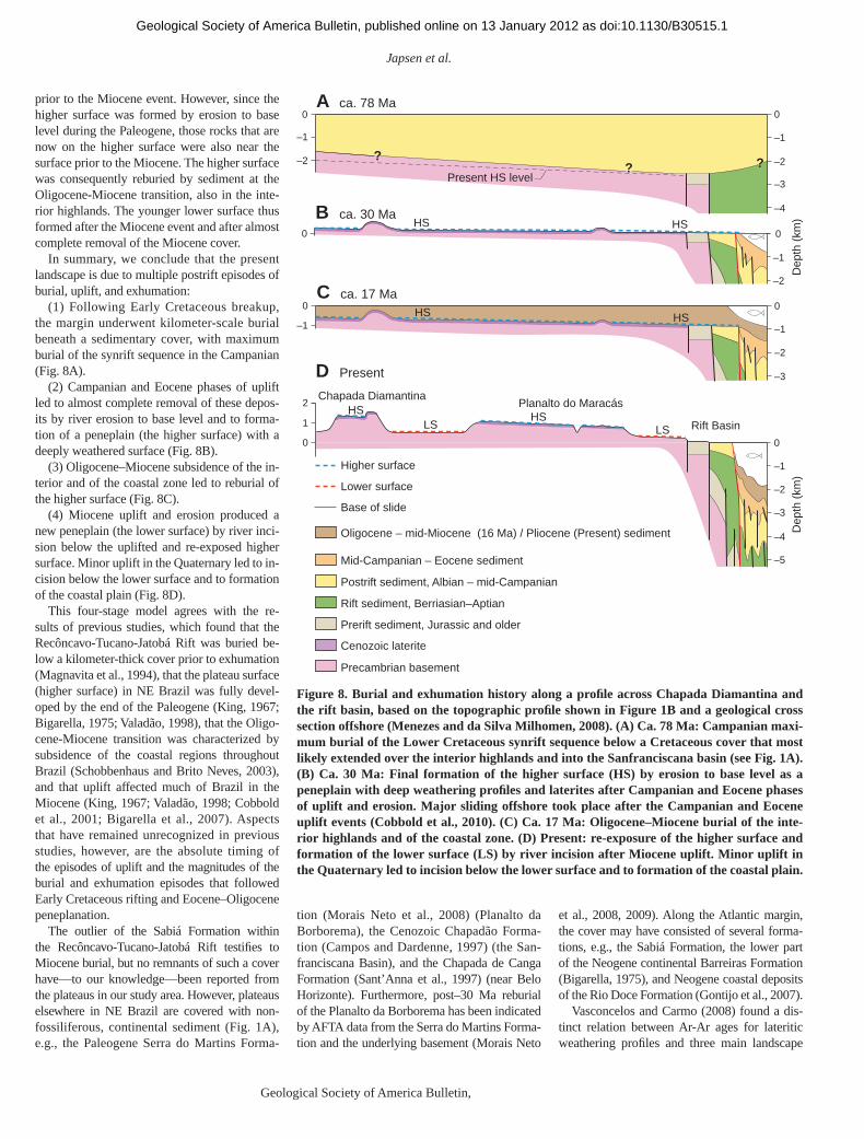
(1) Following Early Cretaceous breakup, the margin underwent kilometer-scale burial beneath a sedimentary cover, with maximum burial of the synrift sequence in the Campanian (Fig. 8A).
(2) Campanian and Eocene phases of uplift led to almost complete removal of these depos-its by river erosion to base level and to forma-tion of a peneplain (the higher surface) with a deeply weathered surface (Fig. 8B).
(3) Oligocene–Miocene subsidence of the in-terior and of the coastal zone led to reburial of the higher surface (Fig. 8C).
(4) Miocene uplift and erosion produced a new peneplain (the lower surface) by river inci-sion below the uplifted and re-exposed higher surface. Minor uplift in the Quaternary led to in-cision below the lower surface and to formation of the coastal plain (Fig. 8D).
This four-stage model agrees with the re-sults of previous studies, which found that the Recôncavo-Tucano-Jatobá Rift was buried be-low a kilometer-thick cover prior to exhumation (Magnavita et al., 1994), that the plateau surface (higher surface) in NE Brazil was fully devel-oped by the end of the Paleogene (King, 1967; Bigarella, 1975; Valadão, 1998), that the Oligo-cene-Miocene transition was characterized by subsidence of the coastal regions throughout Brazil (Schobbenhaus and Brito Neves, 2003), and that uplift affected much of Brazil in the Miocene (King, 1967; Valadão, 1998; Cobbold et al., 2001; Bigarella et al., 2007). Aspects that have remained unrecognized in previous studies , however, are the absolute timing of the epi sodes of uplift and the magnitudes of the burial and exhumation episodes that followed Early Cretaceous rifting and Eocene–Oligocene peneplanation.
The outlier of the Sabiá Formation within the Recôncavo-Tucano-Jatobá Rift testifi es to Miocene burial, but no remnants of such a cover have—to our knowledge—been reported from the plateaus in our study area. However, plateaus elsewhere in NE Brazil are covered with non-fossiliferous, continental sediment (Fig. 1A), e.g., the Paleogene Serra do Martins Forma-
tion (Morais Neto et al., 2008) (Planalto da Borborema), the Cenozoic Chapadão Forma-tion (Campos and Dardenne, 1997) (the San-franciscana Basin), and the Chapada de Canga Formation (Sant’Anna et al., 1997) (near Belo Horizonte). Furthermore, post–30 Ma reburial of the Planalto da Borborema has been indicated by AFTA data from the Serra do Martins Forma-tion and the underlying basement (Morais Neto
et al., 2008, 2009). Along the Atlantic margin, the cover may have consisted of several forma-tions, e.g., the Sabiá Formation, the lower part of the Neogene continental Barreiras Formation (Bigarella, 1975), and Neogene coastal deposits of the Rio Doce Formation (Gontijo et al., 2007).
Vasconcelos and Carmo (2008) found a dis-tinct relation between Ar-Ar ages for lateritic weathering profi les and three main landscape
2
1
0 0
HSHSLS LS
–1
–2
–3
Dep
th (
km)
Dep
th (
km)
–4
–5
D Present
Planalto do MaracásChapada Diamantina
Rift Basin
HS HS0
–1
0
–1
–2
–3
C ca. 17 Ma
HS HS0 0
–2
–1
B ca. 30 Ma
?? ?
–1
–2
0 0
–1
–2
–3
–4
Present HS level
A ca. 78 Ma
Oligocene – mid-Miocene (16 Ma) / Pliocene (Present) sediment
Mid-Campanian – Eocene sediment
Cenozoic laterite
Postrift sediment, Albian – mid-Campanian
Rift sediment, Berriasian–Aptian
Prerift sediment, Jurassic and older
Precambrian basement
Higher surface
Lower surface
Base of slide
Figure 8. Burial and exhumation history along a profi le across Chapada Diamantina and the rift basin, based on the topographic profi le shown in Figure 1B and a geological cross section offshore (Menezes and da Silva Milhomen, 2008). (A) Ca. 78 Ma: Campanian maxi-mum burial of the Lower Cretaceous synrift sequence below a Cretaceous cover that most likely extended over the interior highlands and into the Sanfranciscana basin (see Fig. 1A). (B) Ca. 30 Ma: Final formation of the higher surface (HS) by erosion to base level as a pene plain with deep weathering profi les and laterites after Campanian and Eocene phases of uplift and erosion. Major sliding offshore took place after the Campanian and Eocene uplift events (Cobbold et al., 2010). (C) Ca. 17 Ma: Oligocene–Miocene burial of the inte-rior highlands and of the coastal zone. (D) Present: re-exposure of the higher surface and formation of the lower surface (LS) by river incision after Miocene uplift. Minor uplift in the Quaternary led to incision below the lower surface and to formation of the coastal plain.
as doi:10.1130/B30515.1Geological Society of America Bulletin, published online on 13 January 2012
Episodic burial and exhumation in NE Brazil
Geological Society of America Bulletin, Month/Month 2012 13
types in Brazil. Weathering ages are 70–30 Ma for the main plateau surfaces (Sul-Americana), 15–6 Ma for intermediate surfaces (Velhas), and less than 4 Ma for lower surfaces (Paraguaçu). Notably, the authors highlighted the major gaps in the record, pre–70 Ma and 30–15 Ma. Reburial of the higher surface by an Oligo-cene–Miocene cover provides a straightforward explanation for the gap in the weathering record between 30 and 15 Ma (see Fig. 7; Guia Lima, 2008), prior to the removal of this cover during the Miocene uplift event. The presence of an extensive Cretaceous cover prior to Campanian uplift and exhumation may similarly explain the lack of pre–70 Ma weathering ages.
BURIAL AND EXHUMATION OF THE EOCENE FONSECA FORMATION IN THE HIGHLANDS OF MINAS GERAIS
A rare insight into the Cenozoic development of the highlands in the interior of Brazil is pos-sible due to an outlier of the Eocene Fonseca Formation near Belo Horizonte in the State of Minas Gerais, ~500 km southwest of the study area (Fig. 1A). This sediment is preserved in a small, graben-like basement structure ~800 m asl, and it is unconformably overlain by the un-dated, ironstone conglomerate of the Chapada de Canga Formation (Sant’Anna et al., 1997).
Abundant organic material from a sample of the Fonseca Formation was analyzed in the source-rock laboratory at the Geological Sur-vey of Denmark and Greenland (GEUS) and yielded a reliable Tmax value of 427 °C, which is equivalent to a vitrinite refl ectance of 0.4%–0.5% (Tissot and Welte, 1984), corresponding to a paleotemperature between 66 and 83 °C (cf. Green et al., 2002). This result is highly consis-tent with AFTA data from a basement sample collected near the Fonseca outcrop (fi ssion-track age 126.9 ± 14.5 Ma; mean track length 12.1 ± 0.2 µm). The thermal history extracted from these data involves cooling from >110 °C around 150 Ma, followed by subsequent cool-ing from 100 °C to 85 °C, which began in the interval 145–70 Ma, and fi nally between 80 °C and 60 °C in the interval 50–10 Ma. The two earlier cooling events correlate with the Juras-sic and Campanian events identifi ed in the main study area (Table 1). The similarity between the paleotemperatures in the most recent event defi ned from AFTA and those indicated by the Tmax value confi rms that this event postdates depo sition of the Fonseca Formation. The tim-ing defi ned by AFTA spans both the Eocene and Miocene events identifi ed from regional data, and it remains uncertain whether maximum burial of the Fonseca Formation occurred in late Paleogene or Neogene times.
Whatever the timing, these post-Fonseca paleo temperatures are equivalent to burial under 1.5–2.0 km of cover for a paleogeothermal gradient of 25 °C/km or a cover of 0.7–1.0 km for a gradient of 60 °C/km. Because the Fon-seca Formation was deposited by a meander-ing river system (Sant’Anna et al., 1997), more extensive areas must have been covered by these kilometer-thick deposits of Eocene and younger sediment. A likely scenario is thus that even the highest summit in the area, Pico do Sol (2.1 km asl), was buried under this cover. Furthermore, the predominantly early Eocene ages (Spier et al., 2006) for the formation of deep weathering profi les, less than 100 km from the outcrop of the Fonseca Formation, most likely refl ect exposure prior to the deposi-tion of (and burial by) the Fonseca Formation. The weathering profi les thus remained immune to erosion for tens of millions of years because they were protected by a sedimentary cover, not because of low erosion rates since Eocene time (e.g., Spier et al., 2006).
In summary, these observations lead us to suggest that the area was low-lying during the deposition of the Fonseca Formation, and that it subsided until the rocks now exposed at present-day surface were buried under fl uvial deposits in post-Fonseca times. The present landscape thus formed much later, i.e., after kilometer-scale up-lift and removal of the now-lost overburden to the Fonseca Formation.
POSTRIFT UPLIFT IN THE ATLANTIC DOMAIN
West Greenland provides another example from the Atlantic domain of an elevated pas-sive continental margin with high-level plateaus (Bonow et al., 2006a, 2006b). Major differences relative to the evolution of the Brazilian margin (apart from the present climate) are that breakup happened much later west of Greenland (mid-Paleocene; Chalmers and Pulvertaft, 2001) and that seafl oor spreading there has ceased (end-Eocene; Chalmers and Pulvertaft, 2001). In both West Greenland (Japsen et al., 2006) and NE Brazil, maximum burial of the rift took place tens of millions of years after breakup and was followed by several phases of uplift and exhu-mation, eventually leading to formation of the present-day landscape, which is characterized by elevated plateaus in various stages of dissec-tion (Figs. 9A and 9B). The regional peneplains were formed by erosion after uplift that started between 48 and 45 Ma in NE Brazil and be-tween 36 and 30 Ma in West Greenland; the sub-sequent uplift of the peneplains started between 18 and 15 Ma and between 11 and 10 Ma in the two areas, respectively. The plateau surfaces in
NE Brazil were thus graded to base level dur-ing Eocene–Oligocene times, whereas those in West Greenland formed during Oligocene–Miocene times. The uplift of the peneplains and the formation of the present-day landscape by destruction of the peneplains began in the mid-Miocene in NE Brazil, but in the late Miocene in West Greenland. The dominant uplift events in Greenland thus happened ~10 m.y. later than in Brazil.
Japsen et al. (2012) suggested that landscapes typical of elevated passive continental margins around the world, characterized by elevated plateaus and coastal plains (cf. Ollier and Pain, 1997; Lidmar-Bergström et al., 2000), are gen-erally independent of the processes of rifting and continental breakup. In addition to West Green-land (Japsen et al., 2006, 2009a) and NE Brazil (this study), this hypothesis also appears to ap-ply to other margins, e.g., South Africa (King, 1967; Burke and Gunnell, 2008), SE Australia (Holdgate et al., 2008), and West Africa (Turner et al., 2008). We consequently suggest that the assumption, common to many previous studies, that rift margins remain permanently elevated after breakup is not reasonable. Japsen et al. (2012) thus argued that the present elevation of passive continental margins is due, not to the formation of the margin, but rather to its presence. Elevated passive continental mar-gins occur close to abrupt boundaries between stretched and nonstretched lithosphere along the margin, and this is also the case in NE Brazil (Blaich et al., 2008).
Our results show that an interval of 20 m.y. is suffi cient to form a regional peneplain by ero-sion to base level, after rejuvenation of relief during an initial uplift event (Figs. 9A and 9B). In NE Brazil, the plateau surfaces are defi ned by the higher surface, whereas they are defi ned by the upper planation surface in West Green-land. The time available for the formation of these regional peneplains was around 20 m.y. (~15–18 and 19–26 m.y., respectively). The lower surface forms an extensive surface be-low the plateaus in Brazil, whereas the lower plana tion surface in Greenland is a generation of paleovalleys incised below the upper plana-tion surface. There was more time available for the formation of the lower surface in Brazil than for the lower planation surface in Greenland (~16–13 and 7–3 m.y., respectively), which seems reasonable given that the lower sur-face (Brazil) is more extensive than the lower plana tion surface (Greenland). On a geological time scale, there is evidence that relief disap-pears relatively quickly (e.g., Casas-Sainz and Cortes-Gracia, 2002; Japsen et al., 2009a).
Pronounced events of uplift and erosion in the Campanian (e.g., Walford et al., 2005; Turner
as doi:10.1130/B30515.1Geological Society of America Bulletin, published online on 13 January 2012
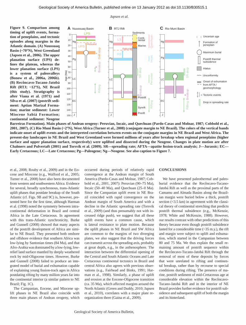
Japsen et al.
14 Geological Society of America Bulletin, Month/Month 2012
et al., 2008; Rouby et al., 2009) and in the Eo-cene and Miocene (e.g., Walford et al., 2005; Turner et al., 2008) have also been documented from western and southwestern Africa. Evidence for several, broadly synchronous, trans-Atlantic uplift phases that postdate breakup of the South Atlantic (cf. Figs. 9B and 9C) is, however, pre-sented here for the fi rst time, although Harman et al. (1998) noted the symmetry between intra-conti nental deformation in Brazil and central Africa in the Late Cretaceous. In agreement with this trans-Atlantic synchronic ity, Burke and Gunnell (2008) showed that many aspects of the postrift development of Africa are simi-lar to NE Brazil. They presented both onshore and offshore evidence that southern Africa was low-lying by Santonian times (84 Ma), and that Afro-Arabia was dominated by a low-lying, low-relief land surface mantled by deeply weathered rock by mid-Oligocene times. However, Burke and Gunnell (2008) failed to produce an inte-grated model of burial and exhumation capable of explaining young fi ssion-track ages in Africa postdating rifting by many million years far into the continental interior (a similar pattern to NE Brazil; Fig. 1C).
The Campanian, Eocene, and Miocene up-lift phases in NE Brazil also coincide with three main phases of Andean orogeny, which
occurred during periods of relatively rapid convergence at the Andean margin of South America (Pardo-Casas and Molnar, 1987; Cob-bold et al., 2001, 2007): Peruvian (90–75 Ma), Incaic (50–40 Ma), and Quechuan (25–0 Ma). Since the Campanian uplift event in NE Bra-zil coincided with rapid convergence on the Andean margin of South America and with a decline in the Atlantic spreading rate (Torsvik et al., 2009) (and thus presumably not with in-creased ridge push), we suggest that all these uplift events have a common cause, which is lateral resistance to plate motion. Because the uplift phases in NE Brazil and SW Africa are common to the margins of two diverging plates, we also suggest that the driving forces can transmit across the spreading axis, probably at great depth, e.g., in the asthenosphere. The interaction between the differential opening of the Central and South Atlantic Oceans and Late Cretaceous continental tectonics in Brazil and central Africa also agrees with previous obser-vations (e.g., Fairhead and Binks, 1991; Har-man et al., 1998). Similarly, a phase of uplift and erosion at the Eocene-Oligocene transition (ca. 35 Ma), which affected margins around the North Atlantic (Green and Duddy, 2010; Japsen et al., 2010), correlates with a major plate re-organization there (Gaina et al., 2009).
CONCLUSIONS
We have presented paleothermal and paleo-burial evidence that the Recôncavo-Tucano-Jatobá Rift as well as the proximal parts of the Camamu and Almada Basins along the Brazil-ian margin were buried below a thick, postrift section (<3.5 km) in agreement with the classi-cal theory of continental stretching that predicts postrift thermal subsidence (e.g., McKenzie, 1978; White and McKenzie, 1988). However, our results contrast with other predictions of this theory because even though postrift subsidence lasted for a considerable time (~35 m.y.), the rift and margin were subject to uplift and exhuma-tion, which started in the Campanian between 80 and 75 Ma. We thus explain the small re-maining amount of postrift sequence within the Recôncavo-Tucano-Jatobá Rift through the removal of most of these deposits by forces that were unrelated to rifting and continen-tal breakup, rather than by recourse to special conditions during rifting. The presence of ma-rine, postrift sediment of mid-Cretaceous age at considerable elevation within the Recôncavo-Tucano -Jatobá Rift and in the interior of NE Brazil provides further evidence for postrift sub-sidence and subsequent uplift of both the margin and its hinterland.
Figure 9. Comparison among timing of uplift events, forma-tion of peneplains, and tectonic episodes along margins in the Atlantic domain. (A) Nuussuaq Basin (~70°N), West Greenland (Japsen et al., 2006). The upper planation surface (UPS) de-fi nes the plateau, whereas the lower planation surface (LPS) is a system of paleovalleys (Bonow et al., 2006a, 2006b). (B) Recôncavo-Tucano-Jatobá Rift (RTJ; ~12°S), NE Brazil (this study). Stratigraphy is after Viana et al. (1971) and Silva et al. (2007) (postrift sedi-ment: Aptian Marizal Forma-tion; marine sediment: Lower Miocene Sabiá Formation; conti nental sediment: Neogene Barreiras Formation). Main phases of Andean orogeny: Peruvian, Incaic, and Quechuan (Pardo-Casas and Molnar, 1987; Cobbold et al., 2001, 2007). (C) Rio Muni Basin (~2°N), West Africa (Turner et al., 2008) (conjugate margin to NE Brazil). The colors of the vertical bands indicate onset of uplift events and the interpreted correlation between events on the conjugate margins in NE Brazil and West Africa. The present-day landscapes in NE Brazil and West Greenland were formed millions of years after breakup when regional peneplains (higher surface and upper planation surface, respectively) were uplifted and dissected during the Neogene. Changes in plate motion are after Chalmers and Pulvertaft (2001) and Torsvik et al. (2009). SR—spreading rate; AFTA—apatite fi ssion-track analysis; J—Jurassic; EC—Early Cretaceous; LC—Late Cretaceous; Pg—Paleogene; Ng—Neogene. See also caption to Figure 7.
Sediments
Ng
Pg
LC
EC
J
Ng
Pg
LC
EC
J
LS
HS
LPS
UPS
Uncertain age
Hiatus
Conti-nental
Reburial
Reburial Marine
Postrift
Bre
akup
Synrift
Prerift
Unconformity
Bre
akup
Bre
akupRift
ing
Rift
ing
Rift
ing
Per
uvia
nIn
caic
Que
chua
n
Drif
t sto
p
A Nuussuaq Basin B RTJ Rift C Rio Muni Basin
Maximum burial
Postrift thermalsubsidence
Formation ofpeneplain
Ng
Pg
LC
EC
J
0
10
20
30
40
50
60
70
80
90
100
110
120
130
140
150
SR
dro
p
SR
dro
p
Age
(M
a)
Onset of exhumationfrom AFTA /geomorphology
Tectonic events
Drop in spreading rate
as doi:10.1130/B30515.1Geological Society of America Bulletin, published online on 13 January 2012
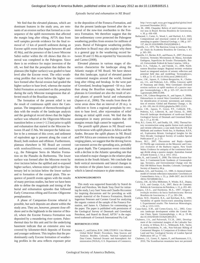
Episodic burial and exhumation in NE Brazil
Geological Society of America Bulletin, Month/Month 2012 15
We fi nd that the elevated plateaus, which are dominant features in the study area, are rem-nants of an erosion surface that formed as a con-sequence of the uplift movements that affected the margin long after rifting. AFTA data from well samples provide evidence for the fi nal re-moval of ~2 km of postrift sediment during an Eocene uplift event (that began between 48 and 45 Ma), and the presence of the Lower Miocene Sabiá outlier within the rift shows that this re-moval was completed in the Paleogene. Since there is no evidence for major inversion of the rift, we fi nd that the peneplain that defi nes the plateaus (the higher surface) was graded to base level after the Eocene event. The relict weath-ering profi les that occur below the higher sur-face formed after fl uvial erosion had graded the higher surface to base level, whereas the marine Sabiá Formation accumulated on this peneplain during the early Miocene transgression that af-fected much of the Brazilian margin.
The formation of the present relief is not the result of continuous uplift since the Cam-panian. The integration of thermochronological data with the results of the landscape analysis and the geological record shows that the higher surface was reburied at the Oligocene-Miocene transition below a cover (<1.5 km) prior to uplift and exhumation that started in the Miocene be-tween 18 and 15 Ma. We interpret the Sabiá out-lier to be a remnant of this cover, and sediment of equivalent age is present along the coast of Brazil, both onshore and offshore. Furthermore, plateaus elsewhere in NE Brazil are covered with nonfossiliferous, continental sediment, e.g., the Paleogene Serra do Martins Forma-tion on the Planalto da Borborema. The lower surface was formed after the Miocene event by river incision below the uplifted and re-exposed higher surface, whereas minor uplift in the Qua-ternary led to incision below the lower surface and to formation of the coastal plain. This se-quence of postrift events agrees with the results of many previous studies, but here we have been able to defi ne the magnitude and timing of the burial and exhumation episodes that followed Early Cretaceous rifting and Eocene–Oligocene peneplanation.
A phase of Campanian–Eocene reburial is possible, but such deposits are absent within the study area. They are, however, present close off-shore and in the highlands in the interior of Bra-zil, where the Eocene Fonseca Formation was deposited by a meandering river system. Paleo-thermal data for this unit and for the underlying basement indicate that an extensive area was covered by kilometer-thick deposits of Eocene and younger sediment. This implies that the pre-dominantly early Eocene formation of weather-ing profi les in the area refl ects exposure prior
to the deposition of the Fonseca Formation, and that the present landscape formed after the re-moval of the now-lost overburden to the Fon-seca Formation. We therefore suggest that the late sedimentary cover protected the Paleogene weathering profi les from erosion for millions of years. Burial of Paleogene weathering profi les elsewhere in Brazil may also explain why there is a general gap in the weathering record be-tween 30 and 15 Ma as reported by Vasconcelos and Carmo (2008).
Elevated plateaus in various stages of dis-section characterize the landscape along the Atlantic margin of NE Brazil. We have shown that this landscape, typical of elevated passive continental margins around the world, formed long after rifting and breakup. In the west part of Greenland, breakup happened ~50 m.y. later than along the Brazilian margin, but elevated plateaus in Greenland are also the result of sev-eral phases of postrift burial and exhumation (Japsen et al., 2006). The results from these di-verse areas show that an interval of 20 m.y. is suffi cient to form a regional peneplain by ero-sion to base level, after rejuvenation of relief during an initial uplift event. We fi nd that the assumption in many previous studies that rift margins remain high cannot be supported.
The postrift uplift phases in NE Brazil were synchronous with uplift phases in Africa and the Andes. Because the uplift phases in NE Brazil and SW Africa are common to the margins of di-verging plates, we suggest that the driving forces can transmit across the spreading axis, probably at great depth. The Campanian event coincided with a decline in the Atlantic spreading rate that was related to major changes in the relative plate motions in the South Atlantic. We conclude that both vertical movements and lateral changes in the motion of the plates have a common cause, which is lateral resistance to plate motion.
ACKNOWLEDGMENTS
This study was supported fi nancially by Statoil do Brasil and Petrobras. We thank Tony Doré for initiat-ing the study, Lucy Sant’Anna and Claudio Riccomini for inspiring discussions and for providing us with sample material of the Fonseca Formation, Henrik Ingerman Petersen and Carsten Guvad for analyzing the organic content of the sample of the Fonseca For-mation, and James A. Chalmers for commenting on the paper. The paper is published with permission of the Geological Survey of Denmark and Greenland, Petrobras, and Statoil do Brasil. AFTA® is the regis-tered trademark of Geotrack International Pty Ltd.
REFERENCES CITED
Amante, C., and Eakins, B.W., 2008, ETOPO1 1 Arc-Minute Global Relief Model: Procedures, Data Sources and Analysis: Boulder, Colorado, National Geophysical Data Center, National Oceanic and Atmospheric Ad-ministration (NOAA), U.S. Department of Commerce,
http://www.ngdc.noaa.gov/mgg/global/global.html (accessed November 2011).
Arai, M., 2000, Chapadas: Relicts of mid-Cretaceous inte-rior seas in Brazil: Revista Brasileira de Geociencias, v. 30, p. 436–438.
Barbarand, J., Carter, A., Wood, I., and Hurford, A.J., 2003, Compositional and structural control of fi ssion track annealing in apatite: Chemical Geology, v. 198, p. 107–137, doi:10.1016/S0009-2541(02)00424-2.
Bigarella, J.J., 1975, The Barreiras Group in northeast Bra-zil: Anais da Academia Brasileira de Ciencias, v. 47, p. 365–393.
Bigarella, J.J., Becker, R.D., and Passos, E., 2007, Processos Erosivos, Vertentes Movimentos de Massa, Atividade Endógena, Superfícies de Erosão: Florianópolis, Bra-zil, Universidade Federal de Santa Catarina, 1436 p.
Blaich, O.A., Tsikalas, F., and Faleide, J.I., 2008, North-eastern Brazilian margin: Regional tectonic evolution based on integrated analysis of seismic refl ection and potential fi eld data and modelling: Tectonophysics, v. 458, p. 51–67, doi:10.1016/j.tecto.2008.02.011.
Bonow, J.M., Japsen, P., Lidmar-Bergström, K., Chalm-ers, J.A., and Pedersen, A.K., 2006a, Cenozoic uplift of Nuussuaq and Disko, West Greenland—Elevated erosion surfaces as uplift markers of a passive mar-gin: Geomorphology, v. 80, p. 325–337, doi:10.1016/j.geomorph.2006.03.006.
Bonow, J.M., Lidmar-Bergström, K., and Japsen, P., 2006b, Paleosurfaces in central West Greenland as reference for identifi cation of tectonic movements and estima-tion of erosion: Global and Planetary Change, v. 50, p. 161–183, doi:10.1016/j.gloplacha.2005.12.011.
Bonow, J.M., Japsen, P., Green, P.F., Cobbold, P.R., Pedreira , A.J., Lilletveit, R., and Chiossi, D., 2009, Post-rift landscape development of north-east Brazil: Geological Survey of Denmark and Greenland Bulle-tin, v. 17, p. 81–84.
Bray, R.J., Green, P.F., and Duddy, I.R., 1992, Thermal his-tory reconstruction using apatite fi ssion track analysis and vitrinite refl ectance; a case study from the UK East Midlands and southern North Sea, in Hardman, R.F.P., ed., Exploration Britain: Geological Insights for the Next Decade: Geological Society of London Special Publication 67, p. 2–25.
Brown, M.C., 2007, Discussions and Reply—Apatite (U-Th)/He age constraints on the Mesozoic and Ceno-zoic evolution of the Bathurst region, New South Wales: Evidence for antiquity of the continental drain-age divide along a passive margin: Australian Journal of Earth Sciences, v. 54, p. 1011–1012.
Burke, K., and Gunnell, Y., 2008, The African Erosion Sur-face: A Continental-Scale Synthesis of Geomorphol-ogy, Tectonics, and Environmental Change over the Past 180 Million Years: Boulder, Colorado, Geological Society of America, 66 p.
Burnham, A.K., and Sweeney, J.J., 1989, A chemical kinetic model of vitrinite refl ectance maturation: Geochimica et Cosmochimica Acta, v. 53, p. 2649–2657, doi:10.1016/0016-7037(89)90136-1.
Caixeta, J.M., da Silva Milhomen, P., Witzke, R.E., Dupuy, I.S.S., and Gontijo, G.A., 2007, Bacia de Camamu: Bole tim de Geociencias da Petrobras, v. 15, p. 455–461.
Campos, J.E.G., and Dardenne, M.A., 1997, Origem e evolução tectônica da bacia Sanfranciscana: Revista Brasileira de Geociencias, v. 27, p. 283–294.
Carlson, W.D., Donelick, R.A., and Ketcham, R.A., 1999, Variability of apatite fi ssion-track annealing kinetics: I. Experimental results: The American Mineralogist, v. 84, p. 1213–1223.
Casas-Sainz, A.M., and Cortes-Gracia, A.L., 2002, Ceno-zoic landscape development within the Central Ibe-rian Chain, Spain: Geomorphology, v. 44, p. 19–46, doi:10.1016/S0169-555X(01)00129-5.
Chalmers, J.A., and Pulvertaft, T.C.R., 2001, Develop-ment of the continental margins of the Labrador Sea: A review, in Wilson, R.C.L., Withmarsh, R.B., Taylor, B., and Froitzheim, N., eds., Non-Volcanic Rifting of Continental Margins: A Comparison of Evidence from Land and Sea: Geological Society of London Special Publication 187, p. 77–105.
Chalmers, J.A., Green, P., Japsen, P., and Rasmussen, E.S., 2010, The Scandinavian mountains have not persisted
as doi:10.1130/B30515.1Geological Society of America Bulletin, published online on 13 January 2012
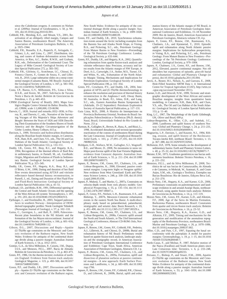
Japsen et al.
16 Geological Society of America Bulletin, Month/Month 2012
since the Caledonian orogeny. A comment on Nielsen et al. (2009a): Journal of Geodynamics, v. 50, p. 94–101, doi:10.1016/j.jog.2010.02.001.
Cobbold, P.R., Meisling, K.E., and Mount, V.S., 2001, Re-activation of an obliquely rifted margin, Campos and Santos Basins, southeastern Brazil: The American Asso ciation of Petroleum Geologists Bulletin, v. 85, p. 1925–1944.
Cobbold, P.R., Rossello, E.A., Roperch, P., Arriagada, C., Gómez, L.A., and Lima, C., 2007, Distribution, tim-ing, and causes of Andean deformation across South America, in Ries, A.C., Butler, R.W.H., and Graham, R.H., eds., Deformation of the Continental Crust: The Legacy of Mike Coward: Geological Society of Lon-don Special Publication 272, p. 583–592.
Cobbold, P.R., Gilchrist, G., Scotchman, I.C., Chiossi, D., Fonseca Chaves, F., Gomes de Souza, F., and Lillet-veit, R., 2010, Large submarine slides on a steep conti-nental margin (Camamu Basin, NE Brazil): Journal of the Geological Society of London, v. 167, p. 583–592, doi:10.1144/0016-76492009-033.
Costa, I.P., Bueno, G.V., Milhomem, P.S., Lima e Silva, H.S.R., and Kosin, M., 2007, Sub-bacia de Tucano Norte e Bacia de Jatobá: Boletim de Geociencias da Petrobras, v. 15, p. 445–453.
CPRM (Geological Survey of Brazil), 2003, Mapa Geo-lógico Região Centro Oriental da Bahia: Brasilia, Bra-zil, CPRM, scale 1:1,000,000, CD-ROM.
Darwin, C., 1839, Journal and remarks.1832–1836, in Fitz-roy, R., and Darwin, C., eds., Narrative of the Survey-ing Voyages of His Majestie’s Ships Adventure and Beagle: Between the Years of 1826 and 1836 Describ-ing Their Examination of the Southern Shores of South America and the Beagles Circumnavigation of the Globe: London, Henry Colburn, 615 p.
Davison, I., 1999, Tectonics and hydrocarbon distribution along the Brazilian South Atlantic margin, in Cameron, N.R., Bate, R.H., and Clure, V.S., eds., The Oil and Gas Habitats of the South Atlantic: Geological Society of London Special Publication 153, p. 133–151.
Duddy, I.R., Green, P.F., Bray, R.J., and Hegarty, K.A., 1994, Recognition of the thermal effects of fl uid fl ow in sedimentary basins, in Parnell, M., ed., Geofl uids: Origin, Migration and Evolution of Fluids in Sedimen-tary Basins: Geological Society of London Special Publication 78, p. 325–345.
Duddy, I.R., Green, P.F., Hegarty, K.A., Bray, R.J., and O’Brien, G.W., 1998, Dating and duration of hot fl uid flow events determined using AFTA® and vitrinite refl ectance–based thermal history reconstruction, in Parnell, J., ed., Dating and Duration of Hot Fluid Flow and Fluid-Rock Interaction: Geological Society of London Special Publication 144, p. 41–51.
Fairhead, J.D., and Binks, R.M., 1991, Differential opening of the Central and South Atlantic Oceans and the opening of the West African rift system: Tectonophysics, v. 187, p. 191–203, doi:10.1016/0040-1951(91)90419-S.
Fjellanger, J., and Etzelmuller, B., 2003, Stepped paleosur-faces in southern Norway—Interpretation of DEM-derived topographic profi les: Norsk Geologisk Tidsskrift (Norwegian Journal of Geology), v. 57, p. 102–110.
Gaina, C., Gernigon, L., and Ball, P., 2009, Paleocene–Recent plate boundaries in the NE Atlantic and the formation of the Jan Mayen microcontinent: Journal of the Geological Society of London, v. 166, p. 601–616, doi:10.1144/0016-76492008-112.
Gibson, D.L., 2007, Discussions and Reply—Apatite (U-Th)/He age constraints on the Mesozoic and Ceno-zoic evolution of the Bathurst region, New South Wales: Evidence for antiquity of the continental drain-age divide along a passive margin: Australian Journal of Earth Sciences, v. 54, p. 1012–1015.
Gontijo, G.A., da Silva Milhomen, P., Caixeta, J.M., Dupuy, I.S.S., and Menezes, P.E.L., 2007, Bacia de Almada: Boletim de Geociencias da Petrobras, v. 15, p. 463–473.
Green, P.F., 1986, On the thermo-tectonic evolution of north-ern England: Evidence from fission track analysis: Geological Magazine, v. 123, p. 493–506, doi:10.1017/S0016756800035081.
Green, P.F., and Duddy, I.R., 2007, Discussions and Re-ply—Apatite (U-Th)/He age constraints on the Meso-zoic and Cenozoic evolution of the Bathurst region,
New South Wales: Evidence for antiquity of the con-tinental drainage divide along a passive margin: Aus-tralian Journal of Earth Sciences, v. 54, p. 1009–1020, doi:10.1080/08120090701488339.
Green, P.F., and Duddy, I.R., 2010, Synchronous exhuma-tion events around the Arctic including examples from the Barents Sea and Alaska North Slope, in Vining, B.A., and Pickering, S.C., eds., Petroleum Geology: From Mature Basins to New Frontiers—Proceedings of the 7th Petroleum Geology Conference: London, Geological Society, p. 633–644.
Green, P.F., Duddy, I.R., and Hegarty, K.A., 2002, Quantify-ing exhumation from apatite fi ssion-track analysis and vitrinite refl ectance data: Precision, accuracy and lat-est results from the Atlantic margin of NW Europe, in Doré, A.G., Cartwright, J.A., Stoker, M.S., Turner, J.P., and White, N., eds., Exhumation of the North Atlan-tic Margin: Timing, Mechanisms and Implications for Petroleum Exploration: Geological Society of London Special Publication 196, p. 331–354.
Green, P.F., Crowhurst, P.V., and Duddy, I.R., 2004, Inte-gration of AFTA and (U-Th)/He thermochronology to enhance the resolution and precision of thermal history reconstruction in the Anglesea-1 well, Otway Basin, SE Australia, in Boult, P.J., Johns, D.R., and Lang, S.C., eds., Eastern Australian Basins Symposium II (Adelaide, 19–22 September): Petroleum Exploration Society of Australia Special Publication, p. 117–131.
Guia Lima, M.D., 2008, A História do Intemperismo na Província Borborema Oriental, Nordeste do Brasil: Im-plicações Paleoclimáticas e Tectônicas [Ph.D. thesis]: Natal, Brazil, Universidade Federal do Rio Grande do Norte, 251 p.
Harman, R., Gallagher, K., Brown, R., Raza, A., and Bizzi , L., 1998, Accelerated denudation and tectonic/geomorphic reactivation of the cratons of northeastern Brazil during the Late Cretaceous: Journal of Geophysical Research–Solid Earth, v. 103, p. 27,091–27,105, doi:10.1029/98JB02524.
Holdgate, G.R., Wallace, M.W., Gallagher, S.J., Wagstaff, B.E., and Moore, D., 2008, No mountains to snow on: Major post-Eocene uplift of the East Victoria Highlands; evidence from Cenozoic deposits: Australian Jour-nal of Earth Sciences, v. 55, p. 211–234, doi:10.1080/08120090701689373.
Japsen, P., Bonow, J.M., Green, P.F., Chalmers, J.A., and Lidmar-Bergström, K., 2006, Elevated, passive conti-nental margins: Long-term highs or Neogene uplifts? New evidence from West Greenland: Earth and Plan-etary Science Letters, v. 248, p. 330–339, doi:10.1016/j.epsl.2006.05.036.
Japsen, P., Mukerji, T., and Mavko, G., 2007a, Constraints on velocity-depth trends from rock physics models: Geo-physical Prospecting, v. 55, p. 135–154, doi:10.1111/j.1365-2478.2007.00607.x.
Japsen, P., Green, P.F., Nielsen, L.H., Rasmussen, E.S., and Bidstrup, T., 2007b, Mesozoic-Cenozoic exhumation events in the eastern North Sea Basin: A multi-disci-plinary study based on palaeothermal, palaeoburial, stratigraphic and seismic data: Basin Research, v. 19, p. 451–490, doi:10.1111/j.1365-2117.2007.00329.x.
Japsen, P., Bonow, J.M., Green, P.F., Chalmers, J.A., and Lidmar-Bergström, K., 2008a, Cenozoic uplift around the North and South Atlantic, in The 33rd International Geological Conference, Abstract CD-ROM: Oslo, Nor-way, 1 p.
Japsen, P., Bonow, J.M., Green, P.F., Cobbold, P.R., Pedreira, A.J., Lilletveit, R., and Chiossi, D., 2008b, Burial and exhumation history of NE Brazil: Preliminary results based on apatite fi ssion-track analysis, landscape analy-sis and the stratigraphic record, in American Associa-tion of Petroleum Geologists International Conference and Exhibition: Cape Town, South Africa, American Association of Petroleum Geologists, Abstracts CD, 1 p.
Japsen, P., Bonow, J.M., Green, P.F., Chalmers, J.A., and Lidmar-Bergström, K., 2009a, Formation, uplift and dissection of planation surfaces at passive continen-tal margins—A new approach: Earth Surface Proc-esses and Landforms, v. 34, p. 683–699, doi:10.1002/esp.1766.
Japsen, P., Bonow, J.M., Green, P.F., Cobbold, P.R., Chiossi, D., and Lilletveit, R., 2009b, Burial, uplift and exhu-
mation history of the Atlantic margin of NE Brazil, in American Association of Petroleum Geologists Inter-national Conference and Exhibition, 15–18 November 2009: Rio de Janeiro, Brazil, American Association of Petroleum Geologists, Abstracts volume CD, 4 p.
Japsen, P., Green, P.F., Bonow, J.M., Rasmussen, E.S., Chalmers, J.A., and Kjennerud, T., 2010, Episodic uplift and exhumation along North Atlantic passive margins: Implications for hydrocarbon prospectivity, in Vining, B.A., and Pickering, S.C., eds., Petroleum Geology: From Mature Basins to New Frontiers—Pro-ceedings of the 7th Petroleum Geology Conference: London, Geological Society, p. 979–1004.
Japsen, P., Chalmers, J.A., Green, P.F., and Bonow, J.M., 2012, Elevated, passive continental margins: Not rift shoulders but expressions of episodic, post-rift burial and exhumation: Global and Planetary Change (in press), doi:10.1016/j.gloplacha.2011.05.004.
Jarvis, A., Reuter, H.I., Nelson, A., and Guevara, E., 2008, Hole-Filled Seamless SRTM Data v. 4: International Centre for Tropical Agriculture (CIAT), http://srtm.csi.cgiar.org (accessed November 2011).
Karner, G.D., and Driscoll, N.W., 1999, Tectonic and strati-graphic development of the West African and eastern Brazilian margins; insights from quantitative basin modelling, in Cameron, N.R., Bate, R.H., and Clure, V.S., eds., The Oil and Gas Habitat of the South Atlan-tic: Geological Society of London Special Publication 153, p. 11–40.
King, L.C., 1967, The Morphology of the Earth: Edinburgh, UK, Oliver and Boyd, 699 p.
Lidmar-Bergström, K., Ollier, C.D., and Sulebak, J.C., 2000, Landforms and uplift history of southern Nor-way: Global and Planetary Change, v. 24, p. 211–231, doi:10.1016/S0921-8181(00)00009-6.
Magnavita, L.P., Davison, I., and Kusznir, N.J., 1994, Rift-ing, erosion, and uplift history of the Recôncavo-Tucano -Jatobá Rift, northeast Brazil: Tectonics, v. 13, p. 367–388, doi:10.1029/93TC02941.
McKenzie, D.P., 1978, Some remarks on the development of sedimentary basins: Earth and Planetary Science Letters, v. 40, p. 25–32, doi:10.1016/0012-821X(78)90071-7.
Meister, E.M., 1973, Gradientes geotérmicos nas bacias sedi-mentares brasileiras: Boletim Técnico Petrobras, v. 16, p. 221–232.
Menezes, P.E.L., and da Silva Milhomen, P., 2008, Tec-tônica de sal nas bacias de Cumuruxatiba, do Almada e de Camamu, in Mohriak, W., Szatmari, P., and Couto Anjos, S.M., eds., Geologia e Tectônica. Exemplos nas Bacias Brasileiras: Rio de Janeiro, Ediçoes Beca Ltd., p. 251–270.
Morais Neto, J.M., Hegarty, K.A., and Karner, G.D., 2006, Preliminary constraints on paleotemperature and land-scape evolution in and around Araripe Basin, northeast-ern Brazil, using apatite fi ssion track analysis: Boletim de Geociencias da Petrobras, v. 14, p. 113–119.
Morais Neto, J.M., Green, P.F., Karner, G.D., and Alkmim, F.F., 2008, Age of the Serra do Martins Formation, Borborema Plateau, northeastern Brazil: Constraints from apatite and zircon fi ssion track analysis: Boletim de Geociencias da Petrobras, v. 16, p. 23–52.
Morais Neto, J.M., Hegarty, K.A., Karner, G.D., and Alkmim , F.F., 2009, Timing and mechanisms for the generation and modifi cation of the anomalous topog-raphy of the Borborema Province, northeastern Brazil: Marine and Petroleum Geology, v. 26, p. 1070–1086, doi:10.1016/j.marpetgeo.2008.07.002.
Ollier, C.D., and Pain, C.F., 1997, Equating the basal un-conformity with the paleoplain: A model for passive margins: Geomorphology, v. 19, p. 1–15, doi:10.1016/S0169-555X(96)00048-7.
Pardo-Casas, F., and Molnar, P., 1987, Relative motion of the Nazca (Farallon) and South American plates since Late Cretaceous time: Tectonics, v. 6, p. 233–248, doi:10.1029/TC006i003p00233.
Persano, C., Bishop, P., and Stuart, F.M., 2006, Apatite (U-Th)/He age constraints on the Mesozoic and Ceno-zoic evolution of the Bathurst region, New South Wales: Evidence for antiquity of the continental drain-age divide along a passive margin: Australian Journal of Earth Sciences, v. 53, p. 1041–1050, doi:10.1080/08120090600923303.
as doi:10.1130/B30515.1Geological Society of America Bulletin, published online on 13 January 2012
Episodic burial and exhumation in NE Brazil
Geological Society of America Bulletin, Month/Month 2012 17
Persano, C., Bishop, P., and Stuart, F.M., 2007, Discussions and Reply—Apatite (U-Th)/He age constraints on the Mesozoic and Cenozoic evolution of the Bathurst re-gion, New South Wales: Evidence for antiquity of the continental drainage divide along a passive margin: Aus-tralian Journal of Earth Sciences, v. 54, p. 1005–1020.
Petri, S., 1972, Foraminíferos e o ambiente de deposição dos sedimentos do Mioceno do Recôncavo Baiano: Revista Brasileira de Geociencias, v. 2, p. 51–67.
Peulvast, J.P., Sales, V.C., Bétard, F., and Gunnell, Y., 2008, Low post-Cenomanian denudation depths across the Brazilian northeast: Implications for long-term land-scape evolution at a transform continental margin: Global and Planetary Change, v. 62, p. 39–60, doi:10.1016/j.gloplacha.2007.11.005.
Rouby, D., Bonnet, S., Guillocheau, F., Gallagher, K., Robin, C., Biancotto, F., Dauteuil, O., and Braun, J., 2009, Sediment supply to the Orange sedimentary system over the last 150 My: An evaluation from sedi-mentation/denudation balance: Marine and Petro leum Geology, v. 26, p. 782–794, doi:10.1016/j.marpetgeo.2008.08.004.
Rudberg, S., 1970, The sub-Cambrian peneplain in Sweden and its slope gradient: Zeitschrift für Geomorphologie, Supplementband, v. 9, p. 157–167.
Sant’Anna, L.G., Schorscher, H.D., and Riccomini, C., 1997, Cenozoic tectonics of the Fonseca Basin region, eastern Quadrilatero Ferrifero, MG, Brazil: Journal of South American Earth Sciences, v. 10, p. 275–284, doi:10.1016/S0895-9811(97)00016-3.
Schobbenhaus, C., and Brito Neves, B.B., 2003, A geologia do Brasil no contexto da plataforma Sul-Americana, in Bizzi, L., Schobbenhaus, C., Vidotti, R.M., and
Goncalves, J.H., eds., Geologia, Tectônica e Recursos Minerais do Brasil: Brasília, Brazil, CPRM (Geologi-cal Survey of Brazil), p. 1–54.
Scotchman, I.C., and Chiossi, D., 2008, Kilometre-scale up-lift of the Early Cretaceous rift section, Camamu Basin, offshore north-east Brazil, in American Association of Petroleum Geologists International Conference and Exhibition: Cape Town, South Africa, American Associ-ation of Petroleum Geologists, 26 p (American Asso-ciation of Petroleum Geologists Search and Discovery article 50183, http://www.searchanddiscovery.com).
Silva, O.B., Caixeta, J.M., da Silva Milhomen, P., and Kosin, M., 2007, Bacia de Recôncavo: Boletim de Geocien-cias da Petrobras, v. 15, p. 423–431.
Spier, C.A., Vasconcelos, P.M., and Oliveira, S.M.B., 2006, Ar-40/Ar-39 geochronological constraints on the evo-lution of lateritic iron deposits in the Quadrilatero Fer-rifero, Minas Gerais, Brazil: Chemical Geology, v. 234, p. 79–104, doi:10.1016/j.chemgeo.2006.04.006.
Tissot, B.P., and Welte, D.H., 1984, Petroleum Formation and Occurrence: Berlin, Springer Verlag, 699 p.
Torsvik, T.H., Rousse, S., Labails, C., and Smethurst, M.A., 2009, A new scheme for the opening of the South At-lantic Ocean and the dissection of an Aptian salt basin: Geophysical Journal International, v. 177, p. 1315–1333, doi:10.1111/j.1365-246X.2009.04137.x.
Turner, J.P., Green, P.F., Holford, S.P., and Lawrence, S.R., 2008, Thermal history of the Rio Muni (West Africa)–NE Brazil margins during continental breakup: Earth and Planetary Science Letters, v. 270, p. 354–367, doi:10.1016/j.epsl.2008.04.002.
Ussami, N., Karner, G.D., and Bott, M.H.P., 1986, Crustal detachment during South Atlantic rifting and deforma-
tion of Tucano-Gabon basin system: Nature, v. 322, p. 629–632, doi:10.1038/322629a0.
Valadão, R.C., 1998, Evolução de Longo-termo do Relevo do Brasil Oriental [Ph.D. thesis]: Salvador, Brazil, Uni-versidade Federal da Bahia, 243 p.
Vasconcelos, P., and Carmo, I.D., 2008, Calibrating denudation chronology through 40Ar/39Ar weathering geo chronol-ogy, in 33rd International Geological Conference, Ab-stract CD-ROM: Oslo, 1 p.
Viana, C.F., da Gama Junior, E., da Araújo Simöes, I., Moura, J.A., dos Reis Fonseca, J., and Alves, R.J., 1971, Revisão estratigráfica da bacia Recôncavo/Tucano : Boletim Técnico Petrobras, v. 14, p. 157–192.
Walford, H.L., White, N.J., and Sydow, J.C., 2005, Solid sediment load history of the Zambezi Delta: Earth and Planetary Science Letters, v. 238, p. 49–63, doi:10.1016/j.epsl.2005.07.014.
Watts, A.B., 2001, Isostasy and Flexure of the Lithosphere: Cambridge, UK, Cambridge University Press, 458 p.
White, N., and McKenzie, D., 1988, Formation of the steers head geometry of sedimentary basins by differential stretching of the crust and mantle: Geology, v. 16, p. 250–253, doi:10.1130/0091-7613(1988)016<0250:FOTSSH>2.3.CO;2.
SCIENCE EDITOR: CHRISTIAN KOEBERL
ASSOCIATE EDITOR: STEFANO MAZZOLI
MANUSCRIPT RECEIVED 25 MARCH 2011REVISED MANUSCRIPT RECEIVED 29 JUNE 2011MANUSCRIPT ACCEPTED 13 JULY 2011
Printed in the USA
as doi:10.1130/B30515.1Geological Society of America Bulletin, published online on 13 January 2012