Epipaleolithic/early Neolithic settlements at Qinghai Lake...
13
Epipaleolithic/early Neolithic settlements at Qinghai Lake, western China David Rhode a, * , Zhang Haiying b , David B. Madsen c , Gao Xing d , P. Jeffrey Brantingham e , Ma Haizhou f , John W. Olsen g a Division of Earth and Ecosystem Sciences, Desert Research Institute, 2215 Raggio Parkway, Reno, NV 89512, USA b Department of Anthropology, University of Washington, Seattle, WA 98195, USA c Texas Archeological Research Laboratory, University of Texas, 1 University Station R7500, Austin, TX 78712, USA d Institute of Vertebrate Paleontology and Paleoanthropology, Chinese Academy of Sciences, Beijing 100044, PR China e Department of Anthropology, University of California Los Angeles, Los Angeles, CA 90095, USA f Qinghai Institute of Salt Lakes, Chinese Academy of Sciences, Xining, Qinghai 810008, PR China g Department of Anthropology, University of Arizona, Tucson, AZ 85721, USA Received 21 May 2006; received in revised form 25 June 2006; accepted 27 June 2006 Abstract Transitions from terminal Pleistocene Upper Paleolithic foraging to Holocene Neolithic farming and pastoralist economic orientations in the northern Tibetan Plateau are examined from the perspective of Epipaleolithic sites located near Qinghai Lake, Qinghai Province, western China. Jiangxigou 2 is an artifact-rich, multicomponent midden site with the main period of occupation dating ca. 9000e5000 cal yr BP, containing abundant flaked stone artifacts including a substantial proportion of microlithic tools, abundant faunal remains including gazelle, deer, and sheep, and a small number of ceramics, including the oldest known on the Tibetan Plateau. Heimahe 3, on the other hand, is a brief hunter’s camp dating ca. 8450 cal yr BP, with evident affinities to late Upper Paleolithic camps in the same region that date several thousand years older. The two distinctively different sites are probably nodes within a single Epipaleolithic foraging system that developed on the margins of the high Tibetan Plateau during the early Holocene, and that served as a basis for colonization of the high-altitude Plateau at that time. Jiangxigou 2 appears to be connected to early Neolithic agricultural settlements along the upper Yellow River (Huang He) drainage during the middle Holocene, and may provide insights into foragereagriculturalist interactions that lead to the development of pastoralist systems in the region. Ó 2006 Elsevier Ltd. All rights reserved. Keywords: Tibetan Plateau; Epipaleolithic; Neolithic; Western China; Foragerefarmer interactions 1. Introduction The TibetaneQinghai Plateau, the vast high-altitude core of central Asia, ranks among the most extreme environments on earth inhabited by early modern humans. By 15,000 years ago, Upper Paleolithic foragers had moved into the northeastern fringes of the Plateau in the Qinghai Lake and Qaidam basins (Fig. 1), surviving at altitudes of 3000e4000 m [47]. People may have begun to occupy the high interior Plateau (at alti- tudes greater than 4000 m) by this time [1,2,14], but such an early date is unsubstantiated and it is likely that sustained oc- cupation of the central Plateau probably occurred during the early Holocene by human populations with Epipaleolithic or Neolithic economic and social adaptations [15]. Whether the Upper Paleolithic behavior pattern represented by the small short-duration camps in the marginal Qinghai Lake and Qai- dam Basins served as the basis for subsequent settlement of the high Plateau, and how such a behavior pattern may have evolved to enable more sustained occupation of high altitudes during the early Holocene, are still open questions. * Corresponding author. Tel.: þ1 775 673 7310; fax: þ1 775 673 7397. E-mail address: [email protected] (D. Rhode). 0305-4403/$ - see front matter Ó 2006 Elsevier Ltd. All rights reserved. doi:10.1016/j.jas.2006.06.016 Journal of Archaeological Science 34 (2007) 600e612 http://www.elsevier.com/locate/jas
Transcript of Epipaleolithic/early Neolithic settlements at Qinghai Lake...

Journal of Archaeological Science 34 (2007) 600e612http://www.elsevier.com/locate/jas
Epipaleolithic/early Neolithic settlements atQinghai Lake, western China
David Rhode a,*, Zhang Haiying b, David B. Madsen c,Gao Xing d, P. Jeffrey Brantingham e, Ma Haizhou f, John W. Olsen g
a Division of Earth and Ecosystem Sciences, Desert Research Institute, 2215 Raggio Parkway, Reno, NV 89512, USAb Department of Anthropology, University of Washington, Seattle, WA 98195, USA
c Texas Archeological Research Laboratory, University of Texas, 1 University Station R7500, Austin, TX 78712, USAd Institute of Vertebrate Paleontology and Paleoanthropology, Chinese Academy of Sciences, Beijing 100044, PR China
e Department of Anthropology, University of California Los Angeles, Los Angeles, CA 90095, USAf Qinghai Institute of Salt Lakes, Chinese Academy of Sciences, Xining, Qinghai 810008, PR China
g Department of Anthropology, University of Arizona, Tucson, AZ 85721, USA
Received 21 May 2006; received in revised form 25 June 2006; accepted 27 June 2006
Abstract
Transitions from terminal Pleistocene Upper Paleolithic foraging to Holocene Neolithic farming and pastoralist economic orientations in thenorthern Tibetan Plateau are examined from the perspective of Epipaleolithic sites located near Qinghai Lake, Qinghai Province, western China.Jiangxigou 2 is an artifact-rich, multicomponent midden site with the main period of occupation dating ca. 9000e5000 cal yr BP, containingabundant flaked stone artifacts including a substantial proportion of microlithic tools, abundant faunal remains including gazelle, deer, andsheep, and a small number of ceramics, including the oldest known on the Tibetan Plateau. Heimahe 3, on the other hand, is a brief hunter’scamp dating ca. 8450 cal yr BP, with evident affinities to late Upper Paleolithic camps in the same region that date several thousand years older.The two distinctively different sites are probably nodes within a single Epipaleolithic foraging system that developed on the margins of the highTibetan Plateau during the early Holocene, and that served as a basis for colonization of the high-altitude Plateau at that time. Jiangxigou 2appears to be connected to early Neolithic agricultural settlements along the upper Yellow River (Huang He) drainage during the middleHolocene, and may provide insights into foragereagriculturalist interactions that lead to the development of pastoralist systems in the region.� 2006 Elsevier Ltd. All rights reserved.
Keywords: Tibetan Plateau; Epipaleolithic; Neolithic; Western China; Foragerefarmer interactions
1. Introduction
The TibetaneQinghai Plateau, the vast high-altitude core ofcentral Asia, ranks among the most extreme environments onearth inhabited by early modern humans. By 15,000 years ago,Upper Paleolithic foragers had moved into the northeasternfringes of the Plateau in the Qinghai Lake and Qaidam basins(Fig. 1), surviving at altitudes of 3000e4000 m [47]. People
* Corresponding author. Tel.: þ1 775 673 7310; fax: þ1 775 673 7397.
E-mail address: [email protected] (D. Rhode).
0305-4403/$ - see front matter � 2006 Elsevier Ltd. All rights reserved.
doi:10.1016/j.jas.2006.06.016
may have begun to occupy the high interior Plateau (at alti-tudes greater than 4000 m) by this time [1,2,14], but such anearly date is unsubstantiated and it is likely that sustained oc-cupation of the central Plateau probably occurred during theearly Holocene by human populations with Epipaleolithic orNeolithic economic and social adaptations [15]. Whether theUpper Paleolithic behavior pattern represented by the smallshort-duration camps in the marginal Qinghai Lake and Qai-dam Basins served as the basis for subsequent settlement ofthe high Plateau, and how such a behavior pattern may haveevolved to enable more sustained occupation of high altitudesduring the early Holocene, are still open questions.

601D. Rhode et al. / Journal of Archaeological Science 34 (2007) 600e612
Fig. 1. The Tibetan Plateau in central Asia, showing locations of Qinghai Lake basin on the northeastern margin. Numbers refer to sites discussed in text: (1)
Jiangxigou 2 and Heimahe 3, (2) Yellow River Sites (Layihai and Zongri complex in Gonghe Basin), (3) Xidatan, (4) Mirikgyadram Tso, (5) Karuo. Map source:
Cornell University Digital Earth Geoscience Database.
Part of the answer to such questions must lie with the natureof Epipaleolithic and Neolithic populations in the QinghaiLake region, the likely colonizers of the northern and centralTibetan Plateau [1,14,15]. Late Neolithic occupation of theQinghai Lake region and northeastern margin of the TibetanPlateau has long been known [1,2,8,17,20,22,37], but the ear-lier Epipaleolithic and Neolithic antecedents in this region etheir age, economic orientation, and origins e are much lesswell understood.
In this paper, we present preliminary results from archaeo-logical sites in the Qinghai Lake area that shed light on Epipa-leolithic and early Neolithic occupation of the northeastern
Tibetan Plateau region (Fig. 2). One of these sites, Jiangxigou2, is a stratified cultural midden containing abundant lithic im-plements, mammal remains, and some ceramics, with the mainperiod of occupation dating possibly as early as 9300 cal yr BPand extending until sometime after ca. 5000 cal yr BP, withlimited occupation thereafter until at least 2000 cal yr BP.The other site, Heimahe 3, is a small hunter’s camp datingto ca. 8500 cal yr BP that is similar in many respects to UpperPaleolithic sites from the same region dating several thousandyears older. (Calendar estimates of radiocarbon dates presentedin this paper are based on the CALIB radiocarbon calibrationprogram [60].)
Fig. 2. Qinghai Lake, showing locations of Jiangxigou 2 (JXG2) and Heimahe 3 (HMH3).
602 D. Rhode et al. / Journal of Archaeological Science 34 (2007) 600e612
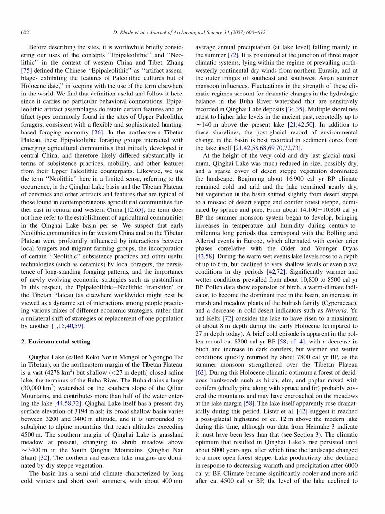
Before describing the sites, it is worthwhile briefly consid-ering our uses of the concepts ‘‘Epipaleolithic’’ and ‘‘Neo-lithic’’ in the context of western China and Tibet. Zhang[75] defined the Chinese ‘‘Epipaleolithic’’ as ‘‘artifact assem-blages exhibiting the features of Paleolithic cultures but ofHolocene date,’’ in keeping with the use of the term elsewherein the world. We find that definition useful and follow it here,since it carries no particular behavioral connotations. Epipa-leolithic artifact assemblages do retain certain features and ar-tifact types commonly found in the sites of Upper Paleolithicforagers, consistent with a flexible and sophisticated hunting-based foraging economy [26]. In the northeastern TibetanPlateau, these Epipaleolithic foraging groups interacted withemerging agricultural communities that initially developed incentral China, and therefore likely differed substantially interms of subsistence practices, mobility, and other featuresfrom their Upper Paleolithic counterparts. Likewise, we usethe term ‘‘Neolithic’’ here in a limited sense, referring to theoccurrence, in the Qinghai Lake basin and the Tibetan Plateau,of ceramics and other artifacts and features that are typical ofthose found in contemporaneous agricultural communities fur-ther east in central and western China [12,65]; the term doesnot here refer to the establishment of agricultural communitiesin the Qinghai Lake basin per se. We suspect that earlyNeolithic communities in far western China and on the TibetanPlateau were profoundly influenced by interactions betweenlocal foragers and migrant farming groups, the incorporationof certain ‘‘Neolithic’’ subsistence practices and other usefultechnologies (such as ceramics) by local foragers, the persis-tence of long-standing foraging patterns, and the importanceof newly evolving economic strategies such as pastoralism.In this respect, the EpipaleolithiceNeolithic ‘transition’ onthe Tibetan Plateau (as elsewhere worldwide) might best beviewed as a dynamic set of interactions among people practic-ing various mixes of different economic strategies, rather thana unilateral shift of strategies or replacement of one populationby another [1,15,40,59].
2. Environmental setting
Qinghai Lake (called Koko Nor in Mongol or Ngongpo Tsoin Tibetan), on the northeastern margin of the Tibetan Plateau,is a vast (4278 km2) but shallow (<27 m depth) closed salinelake, the terminus of the Buha River. The Buha drains a large(30,000 km2) watershed on the southern slope of the QilianMountains, and contributes more than half of the water enter-ing the lake [44,58,72]. Qinghai Lake itself has a present-daysurface elevation of 3194 m asl; its broad shallow basin variesbetween 3200 and 3400 m altitude, and it is surrounded bysubalpine to alpine mountains that reach altitudes exceeding4500 m. The southern margin of Qinghai Lake is grasslandmeadow at present, changing to shrub meadow abovew3400 m in the South Qinghai Mountains (Qinghai NanShan) [32]. The northern and eastern lake margins are domi-nated by dry steppe vegetation.
The basin has a semi-arid climate characterized by longcold winters and short cool summers, with about 400 mm
average annual precipitation (at lake level) falling mainly inthe summer [72]. It is positioned at the junction of three majorclimatic systems, lying within the regime of prevailing north-westerly continental dry winds from northern Eurasia, and atthe outer fringes of southeast and southwest Asian summermonsoon influences. Fluctuations in the strength of these cli-matic regimes account for dramatic changes in the hydrologicbalance in the Buha River watershed that are sensitivelyrecorded in Qinghai Lake deposits [34,35]. Multiple shorelinesattest to higher lake levels in the ancient past, reportedly up tow140 m above the present lake [21,42,50]. In addition tothese shorelines, the post-glacial record of environmentalchange in the basin is best recorded in sediment cores fromthe lake itself [21,42,58,68,69,70,72,73].
At the height of the very cold and dry last glacial maxi-mum, Qinghai Lake was much reduced in size, possibly dry,and a sparse cover of desert steppe vegetation dominatedthe landscape. Beginning about 16,900 cal yr BP climateremained cold and arid and the lake remained nearly dry,but vegetation in the basin shifted slightly from desert steppeto a mosaic of desert steppe and conifer forest steppe, domi-nated by spruce and pine. From about 14,100e10,800 cal yrBP the summer monsoon system began to develop, bringingincreases in temperature and humidity during century-to-millennia long periods that correspond with the Bølling andAllerod events in Europe, which alternated with cooler drierphases correlative with the Older and Younger Dryas[42,58]. During the warm wet events lake levels rose to a depthof up to 6 m, but declined to very shallow levels or even playaconditions in dry periods [42,72]. Significantly warmer andwetter conditions prevailed from about 10,800 to 8500 cal yrBP. Pollen data show expansion of birch, a warm-climate indi-cator, to become the dominant tree in the basin, an increase inmarsh and meadow plants of the bulrush family (Cyperaceae),and a decrease in cold-desert indicators such as Nitraria. Yuand Kelts [72] consider the lake to have risen to a maximumof about 8 m depth during the early Holocene (compared to27 m depth today). A brief cold episode is apparent in the pol-len record ca. 8200 cal yr BP [58; cf. 4], with a decrease inbirch and increase in dark conifers; but warmer and wetterconditions quickly returned by about 7800 cal yr BP, as thesummer monsoon strengthened over the Tibetan Plateau[62]. During this Holocene climatic optimum a forest of decid-uous hardwoods such as birch, elm, and poplar mixed withconifers (chiefly pine along with spruce and fir) probably cov-ered the mountains and may have encroached on the meadowsat the lake margin [58]. The lake itself apparently rose dramat-ically during this period. Lister et al. [42] suggest it reacheda post-glacial highstand of ca. 12 m above the modern lakeduring this time, although our data from Heimahe 3 indicateit must have been less than that (see Section 3). The climaticoptimum that resulted in Qinghai Lake’s rise persisted untilabout 6000 years ago, after which time the landscape changedto a more open forest steppe. Lake productivity also declinedin response to decreasing warmth and precipitation after 6000cal yr BP. Climate became significantly cooler and more aridafter ca. 4500 cal yr BP, the level of the lake declined to

603D. Rhode et al. / Journal of Archaeological Science 34 (2007) 600e612
approximately modern levels, trees decreased in abundanceand steppe vegetation came to dominate the landscape.Changes in the nature and distribution of mid-to-late Neolithiccultures in the Qinghai Lake region may be related to theselater Holocene oscillations [5,6,43,46]. Climatic conditionshave been fairly stable since about 3500 cal BP, with vegeta-tion increasingly dominated by grassy meadow and steppevegetation and diminishing woodland and shrublands. Dimin-ishment of woody taxa over the last 2500 years may have re-sulted in large part from increased human activities in thevicinity [58], similar to the deforestation that apparently oc-curred as a result of human settlement in the southeasternTibetan Plateau [38,53,54].
2.1. Jiangxigou 2
This multicomponent midden site is located at approxi-mately 3312 m elevation in the mouth of a canyon on the northside of the South Qinghai Mountains, approximately 4.5 kmsouth of Qinghai Lake (Fig. 2). The site occupies a fairly levelopen fluvial terrace on the east side of a small stream, within100 m of an active spring (Fig. 3), and is protected east and
Fig. 3. Setting of Jiangxigou 2, looking north toward Qinghai Lake. (A) General
overview of the Jiangxigou 2 site in the foothills of the South Qinghai Mountains.
(B) The exposed cutbank and pipeline trench are visible in center of photo.
west by low flanking ridges of alluvial, eolian, and possiblyancient deltaic sediments from the uppermost highstand ofQinghai Lake [69,74; but see 51]. The stream terrace is ap-proximately 2e3 m higher than the present depth of thestream. The buried cultural deposit at Jiangxigou 2 is exposedin several small cutbanks on the margin of the terrace, as wellas a pipeline trench from the spring.
Our investigations at this site have been limited to cleaningthe face of one exposed cutbank (Fig. 4), mapping the profileof that face, collecting controlled samples of artifacts and dat-able materials that were removed in the process of cleaning thecutbank, and mapping the exposed pipeline trench profile.Sediments removed from the cutbank were screened through3.2 mm hardware cloth to retrieve smaller-sized items.Although the amount of excavation and exposure at the siteis extremely limited to this point, the results are potentiallysignificant enough to warrant a preliminary report.
Fig. 4 depicts the stratigraphy revealed in the exposed cut-bank. Five main stratigraphic units are identified from the site.The basal unit (Stratum 5) consists of fluvial cobbles andsands that form the core of the stream terrace; this unit is bur-ied approximately 50 cm below the base of the profile shownin Fig. 4, but it was exposed in the pipeline trench and formsthe level of a slightly lower terrace between the cutbank andstream. These stream deposits are capped by a layer of fineyellow brown carbonaceous loess dominated by silt with smallfractions of sand and clay, very hard in structure but disturbedin places by mammal burrows, and containing scant artifacts(Table 1). It is shown as Stratum 4 in Fig. 4.
Above this lower, largely culturally sterile loess is a com-pact, light to medium gray-brown somewhat carbonaceoussilty loam (Stratum 3, 80e110 cm depth in the profile inFig. 4); it is the lowest stratum in the profile that contains sig-nificant quantities of artifacts (Table 1). The top of Stratum 3(81 cm depth) is radiocarbon dated to 7330� 50 14C yr BP(Beta-208336), or approximately 8170 cal yr BP (modal ageestimate). The age of the base of this stratum is obtained
Fig. 4. Stratigraphic profile at Jiangxigou 2. Numbers refer to stratigraphic
designations; see text for description.

604 D. Rhode et al. / Journal of Archaeological Science 34 (2007) 600e612
Table 1
Jiangxigou 2 Strata, dates, and artifact counts
Depth
(cm)
Stratum Dates Lithics Bone Ceramics Fire-Broken
Rock
0e10 1 4 9
10e20 1 6 4
20e30 1 1970� 90 cal yr BP; OSL, IRSL, TL weighted average; UW-1358 1 0 1 5
30e40 1 100� 40 14C yr BP¼w50, 120, or 230 cal yr BP multi-modal
values (270 cal yr BP to present, 2s); Beta-208335
13 1 4
40e50 2a 50 37 1 11
50e60 2a 4973� 254 cal yr BP; OSL, FS05-95, UW-1360; 54 cm depth 58 47 2 12
60e70 2a 4850� 40 14C yr BP¼w5950 cal yr BP modal value
(5657e5476 cal yr BP, 2s); Beta-209350
79 167 1 12
6542� 472 cal yr BP; FS05-74, UW-1359
70e80 2b 90 217 25
80e90 3 7330� 50 14C yr BP¼w8170 cal yr BP modal
value (8303e8014 cal yr BP, 2s); Beta-208336; 81 cm depth
51 121 14
90e100 3 8170� 50 14C yr BP¼w9100 cal yr BP modal value
(9268e9010 cal yr BP, 2s); Beta-194541;
sample taken 60 cm east of profile, depth approximate
48 124 4
100e110 3 5 24 2
110e120 4 5 6
120e130 4 2
Total 412 757 5 89
from charcoal in an ash lens traced to the bottom half of thissame stratum approximately 60 cm east of the profile, thatgives a radiocarbon date of 8170� 50 14C yr BP (Beta-194541), or about 9100 cal yr BP modal value. The datedcharcoal is tentatively identified as willow or poplar.
Stratum 2, at a depth of 42e80 cm below surface, is a thicklayer of dark gray-brown silty loam. This stratum may repre-sent a buried middle Holocene paleosol, but it also containsthe bulk of the artifacts at the site as well as charcoal flecks,ash, and scattered fire altered cobbles that probably representcooking stones, so whether it is in fact a buried soil is not cer-tain. Stratum 2 can be subdivided into upper and lower units,separable at an indistinct line of fire-affected cobbles at about70 cm depth. The lower unit (2b) contains the greatest artifactdensity in the profile, including abundant lithics, highly frag-mented faunal remains, and fire-affected rock fragments(Table 1). The lower unit 2b is not well dated, but based onthe ages of bracketing strata it probably dates between 8000and 6000 cal yr BP. The upper unit (2a) is slightly less denselyladen but still contains abundant artifacts with a high propor-tion of microliths, faunal remains, and fire-affected rock, anda small number of ceramics (Table 1). The upper unit 2a isdated by radiocarbon to 4850� 40 14C yr BP (60e70 cmdepth, Beta-209350), or approximately 5950 cal yr BP. Twoceramic sherds also provide estimates of the age of this de-posit. One sherd near the base of unit 2a (FS05-74; Fig. 5)yielded an optically stimulated luminescence (OSL) age esti-mate of 6542� 472 cal yr BP (UW-1359). A second sherdfrom higher up in Stratum 2a (FS05-95) yielded an OSL ageof 4973� 254 cal yr BP (UW-1360).
Finally, at the top of the profile Stratum 1 consists of themodern soil developed into surficial silts and sands, extendingto a depth of approximately 40 cm. Artifact density is muchless than in Stratum 2 below, and may represent materials
displaced upward by rodent burrowing in the sediments(Table 1). A ceramic sherd from the 20e30 cm depth yieldeda luminescence age of 1970� 90 cal yr BP (UW-1358). (Thisage estimate is a weighted average of thermoluminescence, OSL,and infrared stimulated luminescence methods; J. Feathers,personal communication.) A radiocarbon date of charcoal from30 to 40 cm depth yielded an age of 100� 40 14C yr BP, indicat-ing the extent of mixture in the upper 40 cm of sediments.
The main period of occupation at Jiangxigou 2 thus appearsto date as early as 9300 cal yr BP, and extends until sometimeafter ca. 5000 cal yr BP. Sporadic occupation after 5000 cal yr
Fig. 5. Cord-marked potsherd (FS05-74) from base of Stratum 2a, Jiangxigou 2.
This sherd returned an OSL date of 6542� 472 cal yr BP (UW-1359).

605D. Rhode et al. / Journal of Archaeological Science 34 (2007) 600e612
BP is indicated by the single luminescence date on the sherd inStratum 1, but the depleted number of artifacts in this stratumsuggests that post-5000 cal yr BP occupation was very limitedin intensity compared to the earlier habitation.
Lithic artifacts at the site are derived from microlithic,bladeebladelet, and flake-based industries (Fig. 6). Lithicraw materials include a wide variety of cherts, several visuallydifferentiable types of quartz, quartz crystal, a few largerflakes formed from granite, and two flakes of obsidian (seeSection 3). Microlithic industries are represented by abundantmicroblades and blade fragments, 10 microblade cores andcore fragments, and four crested bladelets (lame a crete).Microlithic industries have their greatest representation inStratum 2a, amounting to more than 40% of all lithic artifactsin this level, but they are nearly as frequent in lower strata aswell. Within Stratum 3 and the base of Stratum 2a are a fewlarger specialized blade forms, flat and straight-sided withpunctiform platforms, that appear to be end-hafted bladepoints that are very similar to those found at sites in the ChangTang on the high central Tibetan Plateau [13,14]. Debitagefrom flake-based lithic industries are dominant throughout,though no flake cores have yet been found. Formal stone toolsare rare in the cutbank profile, consisting of a single smallthumbnail scraper (from Stratum 2b) and a few retouchedmicroliths. Also noted at the site were a well-formed andwell-used two-sided handstone presumably used for milling,a large bifacially retouched green chert knife or sickle, andmicroblades. These finds were not encountered in buriedcontext, however, so their age is undetermined.
Several small ceramic sherds were located in the upperstrata, including relatively thin (<7 mm) cord-marked (Fig. 5)and thicker (>7 mm) undecorated varieties. The sherds arelight yellowish-brown to reddish-brown in color, often grading
to medium gray-brown on exterior surfaces. Inclusionstypically include crushed angular quartz and other mineralfragments 0.5e1.5 mm in diameter; two of four sherds exam-ined contain crushed pottery inclusions as well. Cracks andsmall vugs are frequent in most of the sherds; one sherd(FS05-61), the youngest, contains no cracks and only smallwell-distributed air pockets along with angular dark mineraltemper. The sherds are all so small that little can be said aboutvessel shape or size. The cord-marked sherds (Fig. 5) resemblebody sherds from painted ‘‘Zongri Culture’’ jars dating tow5600e4000 cal yr BP found in a number of sites alongupper Yellow River drainages in the Gonghe basin south ofJiangxigou 2 [20,55], although no painted sherds were recov-ered from the limited exposure. Luminescence ages of theceramics at Jiangxigou 2 suggest they date as early as 6500 calyr BP, the oldest known on the Tibetan Plateau (see Section 3).
Faunal remains are abundant at Jiangxigou 2, with morethan 750 bone and teeth fragments recovered in the smallarea excavated. The remains are highly fragmented, suggest-ing that they may have been processed for grease or marrowextraction. A small proportion (<5%) are burned or calcined,suggesting that the bones themselves were not heavily utilizedfor fuel [63]. Based on size, the remains appear to representprimarily medium-sized mammals, though small mammal re-mains are present as well. The high degree of fragmentationmakes taxonomic identification difficult. Skeletal parts repre-sented include primarily limb (long bone) fragments, as wellas ribs, vertebrae, scapula and pelvic fragments, and a fewskull fragments including teeth. Several teeth and teeth frag-ments can be tentatively identified to sheep (most likely thebharal or Himalayan blue sheep, Pseudois nayaur, but possiblydomestic sheep, Ovis aries), Tibetan gazelle (Procapra picti-caudata), and a small deer. The teeth fragments tend to be
0
20
40
60
80
100
120
Dep
th (c
m)
Stratum 1
Stratum 2a
Stratum 2b
Stratum 3
Stratum 4
0 5 0 5
Microb
lade C
ore
Microb
lade C
ore Frag
ment
0 10 20 30
Microb
lade P
roxim
al
0 5 10 15 20
Microb
lade F
ragmen
t
0 5
Flake C
ore Frag
ment
0 10 20 30
Flake P
roxim
al
0 10 20 30 40
Flake F
ragmen
t
0 5
Other
0 24 48 72 96
TOTAL
0 10 20 30 40 50
% Micr
oblad
e
Fig. 6. Distribution of lithic artifacts across strata in exposed cutbank, Jiangxigou 2.

606 D. Rhode et al. / Journal of Archaeological Science 34 (2007) 600e612
very well worn or small and deciduous, suggesting they camefrom either young or quite aged animals. These teeth are foundin Stratum 2b and 3, the earlier component at the site. Addi-tional identification and taphonomic study of larger faunalsamples is clearly necessary before definitive answers can begiven to the nature of the assemblage and changes in faunalrepresentation through time, including the important questionof whether the sheep remains represent wild hunted game ordomestic herds (see Section 3).
2.2. Heimahe 3
This small site consists of the remnant of an isolated hearthexposed in the profile of an old meander scar of the BlackHorse River (Heimahe) southwest of Qinghai Lake, at analtitude of w3202 m about 6 m above the present level ofthe lake and 2 km southwest of its present shoreline (Fig. 2).The site rests within a 3.5 m exposure of stream channelalluvium, shoreline sands and gravels, and eolian silts andsands (Fig. 7). Charcoal from the hearth is concentrated in
Fig. 7. Heimahe 3. (A) Location of the cutbank in which Heimahe 3 is located
(arrow) in relation to Black Horse River. Looking east toward town of Hei-
mahe. (B) Position of Heimahe 3 in cutbank.
a 1e2 cm thick lens above an oxidized zone resulting fromthe heat of the central fire. This intermittent charcoal stainingcan be traced 2 m to the west and 1 m to the east of the hearthcenter and appears to mark the limits of the surrounding usesurface. The meander extends in an L-shaped fashion aroundthis use surface and no charcoal or other cultural material isevident elsewhere on the face of this meander scar.
The hearth remnant and associated use surface occurs1.95 m below the modern surface and rests on the interface be-tween an underlying set of fluvial sands and overlying loess-like depositions (Fig. 8). A mid-Holocene soil occurs 75 cmabove the hearth surface. The underlying fluvial deposits con-sist of well-sorted gravel at the base, fining upwards to ripple-laminated sand and thin, flat-bedded silty sand. These fluvialdeposits may represent the shoreline interface of the BlackHorse River and Qinghai Lake. Charcoal from the hearth(identified as poplar) gives a radiocarbon date of ca. 8370e8540 cal yr BP (7630� 50 14C yr BP; Beta-208334), orapproximately 8410 cal yr BP (modal value; 8540e8369 calyr BP, 2s). This age estimate suggests that the hearth is coevalwith Stratum 3 of Jiangxigou 2.
The age estimate and the elevation of the site immediatelyabove ripple-laminated sediments does not support the hypoth-esis [42] that a middle Holocene highstand of Qinghai Lakereached ca. 12 m above the modern lake level (ca. 4 m abovethe present elevation of the site), since such an event wouldhave left a distinctive sedimentological signature at this siteand also would have destroyed the hearth.
We exposed, mapped, and sampled a 2 m long by 50 cmwide semi-circular area of the remnant hearth and associateduse surface (Fig. 9). This exposure revealed the remaining por-tion of a 50e60 cm diameter unprepared hearth laid directlyon the underlying surface. Sixteen fire-cracked coarse- tofine-grained granite stream cobbles or cobble fragments tow10 cm diameter occur in and around the hearth. The hearthcontains both poplar wood charcoal and small, carbonizedlumps of composite organic material tentatively identified as
Fig. 8. Stratigraphic section of Heimahe 3 site. Note scatter of stones and red-
dened silt beneath hearth.

607D. Rhode et al. / Journal of Archaeological Science 34 (2007) 600e612
Fig. 9. Plan map of Heimahe 3 occupation surface showing hearth feature and artifact scatter around it. Trowel points north.
herbivore dung. Bone fragments from a medium-sized mam-mal, possibly a gazelle, also occur across this surface, withthe density thinning away from the central hearth. Lithic de-bris associated with limited tool production and rejuvenationis similarly distributed. Much of this material appears tohave been raked from the hearth and sits on its unoxidizedmargins. The faunal remains consist of 22 highly fracturedbone fragments possibly broken for marrow extraction. Theseare primarily long-bone splinters, but some possible skull orscapular fragments are also present. Five of the bone frag-ments are charred or calcined.
Lithic materials at Heimahe 3 consist of approximately 80recovered items, mostly flaking debris from tool productionand rejuvenation of black metamorphosed mudstone, fine-grained sandstone, and a small number of retouch flakesfrom chert tools. The limited tool inventory includes proximaland distal ends of a single green chert microblade and tworetouched sandstone knives formed on cortical ‘salami slice’flakes. Though most of the lithic debitage are black mudstone,no tools of this material were found. The overall impression isof limited expedient and informal tool production, with a sig-nificant proportion of flakes derived from rejuvenation of cu-rated tools that were not recovered as part of this assemblage.
While only about half of Heimahe 3 remained intact at thetime of excavation, it appears to represent a short-term, possi-bly overnight, camp occupied by a small foraging party. Thesingle unprepared hearth is centered within a small, 3 m diam-eter use area. Charcoal, fire-cracked rock, bone fragments,microdebitage are scattered across this surface, thinningaway from the central fire. There was no evidence of evena temporary structure within this use area. The artifact materialis characterized by a limited diversity of tools and toolstoneassociated with core-reduction and microblade production.Bone scrap suggests preparation/consumption of a singlegazelle-sized mammal. Extensive bone fragmentation andfire-cracked rock suggest marrow extraction and, possibly,
degreasing was part of this process. Charcoal from the hearthconsists of a mixture of wood (branches of poplar trees, prob-ably) and probable herbivore dung. Herbivore dung is com-monly used for fuel in many places worldwide where woodor other fuels are rare or unavailable, and is known fromarchaeological contexts in the Near East, India, and elsewhere[49,52,64,71]. Yak dung in particular is a crucial fuel in thelargely treeless Tibetan Plateau today [31,56,57]. The evi-dence from Heimahe 3 suggests that people used dried dungas fuel during much of the period of occupation of the Plateauand its margins, even during periods when woody fuel wasmore plentiful in the landscape.
3. Discussion
Although our investigations at Jiangxigou 2 and Heimahe 3were limited in scope, several findings are broadly significantfor our understanding of prehistoric occupation patterns on thenorthern and central Tibetan Plateau. As noted above, lateUpper Paleolithic sites nearly identical to Heimahe 3 areknown from both the Heimahe and Jiangxigou localities,dating roughly 15,000e10,000 cal yr BP [47]. Epipaleolithicsites are probably fairly common in the region but have notbeen well documented [2]: apart from the sites discussedhere, the only dated Epipaleolithic site near the QinghaiLake basin is Layihai [29,30], located approximately 80 kmsoutheast of Jiangxigou 2 in the upper Yellow River (HuangHe) valley, at an elevation of 2580 m (Fig. 10). Layihai isradiocarbon dated to approximately 7500e6500 cal yr BP[30,45], equivalent to Stratum 2b at Jiangxigou 2. Excavationsyielded abundant cores, flakes, microblades and microbladecores, a variety of choppers, scrapers and burins, grindingtools, bone needles and awls, and a stone bead, but no potteryor polished stone tools. The broad tool assemblage at Layihai,compared with Jiangxigou 2, might reflect a broader range ofactivities at the lower-elevation site; but given the very limited
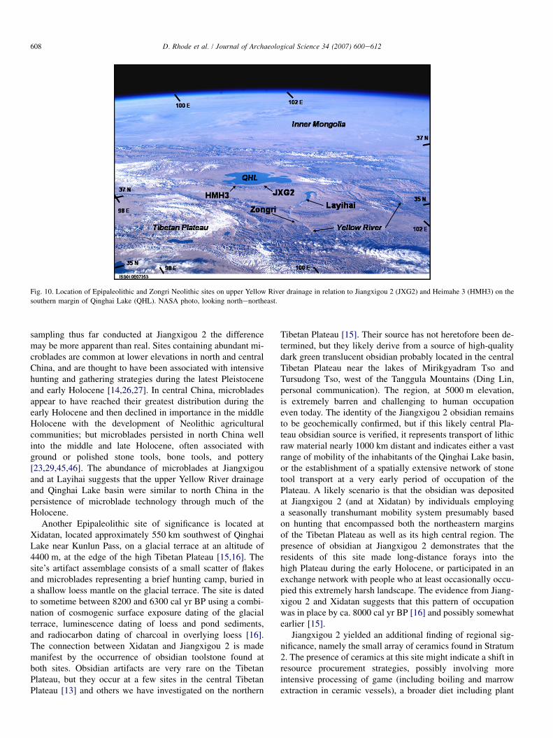
608 D. Rhode et al. / Journal of Archaeological Science 34 (2007) 600e612
Fig. 10. Location of Epipaleolithic and Zongri Neolithic sites on upper Yellow River drainage in relation to Jiangxigou 2 (JXG2) and Heimahe 3 (HMH3) on the
southern margin of Qinghai Lake (QHL). NASA photo, looking northenortheast.
sampling thus far conducted at Jiangxigou 2 the differencemay be more apparent than real. Sites containing abundant mi-croblades are common at lower elevations in north and centralChina, and are thought to have been associated with intensivehunting and gathering strategies during the latest Pleistoceneand early Holocene [14,26,27]. In central China, microbladesappear to have reached their greatest distribution during theearly Holocene and then declined in importance in the middleHolocene with the development of Neolithic agriculturalcommunities; but microblades persisted in north China wellinto the middle and late Holocene, often associated withground or polished stone tools, bone tools, and pottery[23,29,45,46]. The abundance of microblades at Jiangxigouand at Layihai suggests that the upper Yellow River drainageand Qinghai Lake basin were similar to north China in thepersistence of microblade technology through much of theHolocene.
Another Epipaleolithic site of significance is located atXidatan, located approximately 550 km southwest of QinghaiLake near Kunlun Pass, on a glacial terrace at an altitude of4400 m, at the edge of the high Tibetan Plateau [15,16]. Thesite’s artifact assemblage consists of a small scatter of flakesand microblades representing a brief hunting camp, buried ina shallow loess mantle on the glacial terrace. The site is datedto sometime between 8200 and 6300 cal yr BP using a combi-nation of cosmogenic surface exposure dating of the glacialterrace, luminescence dating of loess and pond sediments,and radiocarbon dating of charcoal in overlying loess [16].The connection between Xidatan and Jiangxigou 2 is mademanifest by the occurrence of obsidian toolstone found atboth sites. Obsidian artifacts are very rare on the TibetanPlateau, but they occur at a few sites in the central TibetanPlateau [13] and others we have investigated on the northern
Tibetan Plateau [15]. Their source has not heretofore been de-termined, but they likely derive from a source of high-qualitydark green translucent obsidian probably located in the centralTibetan Plateau near the lakes of Mirikgyadram Tso andTursudong Tso, west of the Tanggula Mountains (Ding Lin,personal communication). The region, at 5000 m elevation,is extremely barren and challenging to human occupationeven today. The identity of the Jiangxigou 2 obsidian remainsto be geochemically confirmed, but if this likely central Pla-teau obsidian source is verified, it represents transport of lithicraw material nearly 1000 km distant and indicates either a vastrange of mobility of the inhabitants of the Qinghai Lake basin,or the establishment of a spatially extensive network of stonetool transport at a very early period of occupation of thePlateau. A likely scenario is that the obsidian was depositedat Jiangxigou 2 (and at Xidatan) by individuals employinga seasonally transhumant mobility system presumably basedon hunting that encompassed both the northeastern marginsof the Tibetan Plateau as well as its high central region. Thepresence of obsidian at Jiangxigou 2 demonstrates that theresidents of this site made long-distance forays into thehigh Plateau during the early Holocene, or participated in anexchange network with people who at least occasionally occu-pied this extremely harsh landscape. The evidence from Jiang-xigou 2 and Xidatan suggests that this pattern of occupationwas in place by ca. 8000 cal yr BP [16] and possibly somewhatearlier [15].
Jiangxigou 2 yielded an additional finding of regional sig-nificance, namely the small array of ceramics found in Stratum2. The presence of ceramics at this site might indicate a shift inresource procurement strategies, possibly involving moreintensive processing of game (including boiling and marrowextraction in ceramic vessels), a broader diet including plant
609D. Rhode et al. / Journal of Archaeological Science 34 (2007) 600e612
foods, or more efficient use of fuels [11]. Apart from thesespeculations, and despite their small numbers, the ceramicsat Jiangxigou 2 clearly indicate a connection with Neolithicdevelopments in the upper Yellow River valley and elsewherein the Tibetan Plateau. Those developments began ca. 8500e7000 cal yr BP with the Laoguantai (Dadiwan) Culture, a mil-let-based agricultural society along the middle Yellow Riverand its tributaries [12,28], and the subsequent Yangshao Cul-ture in the same area and westward [65]. By 5400 cal yr BPthe Majiayao, a well-developed, socially stratified societyalso based on millet agriculture, had become established onthe Yellow River drainages of far eastern Qinghai and westernGansu [3,41,65]. The Zongri Culture (5600e4000 cal yr BP)probably represents the westernmost manifestation of theseearly Neolithic settlements found in the upper Yellow Riverdrainage, at elevations as high as 3200 m [20,55]. With a directOSL age of ca. 6500 cal yr BP, the oldest ceramics at Jiangxi-gou 2 are equivalent in age to the Yangshao Culture, are nearly1000 years older than the Zongri Culture sites on the upperYellow River, and are more than 500 years older than the Neo-lithic village site of Karuo, located on the southeastern TibetanPlateau near Chamdo, which dates ca. 5900e4100 cal yr BP[2,23].
The Zongri sites so far examined appear to be small vil-lages populated by ‘‘sedentists conducting agriculture withfishing and gathering’’ [20, p. 22]. These sites contain distinc-tive pottery in various vessel forms with complex painted, in-cised, and cord-marked designs [55]; a variety of worked bonetools, polished stone celts, axes, knives and possibly hoes,turquoise beads and other ornaments, and flaked stone tools in-cluding microblades and microcores (about 25% of the flakedstone assemblage [55]; numerous primary extended and dis-turbed secondary burials with grave goods suggesting somesocial stratification [19]; and faunal remains dominated bywild game including red deer, roe deer, musk deer, marmot,wild pig, Mongolian gazelle, and bharal. A small number ofbones of domesticated dog and cattle were also identifiedfrom some of these sites [7; cited in 28], although the presenceof domesticated cattle has been questioned [28]. The faunalevidence indicates that diet was heavily supplemented byhunting. The agricultural basis of these sites is not describedin the literature available to us [20,55]. Chen [18] suggeststhat the Zongri Culture represents an initial migration ofMajiayao agricultural communities into the upper YellowRiver basin, the assimilation of agricultural and ceramic tradi-tions by local Tibetan groups, followed by settled agriculturalcommunities peopled by these local groups. It seems plausiblethat these villages represent settled foragers who practicedsome horticulture, such as appeared in the Near East [10],the American Southwest [9,25,48,66], and elsewhere. Whetheror not the Zongri represent fully settled farmers, farmerson foraging expeditions, settled foragers practicing low-investment horticulture, or full-time foragers interacting withMajiayao farmers may yet be an open question.
The Neolithic site at Karuo contains a full ‘‘Neolithic pack-age’’ [1] of substantial residential architecture, domesticatedmillet, pigs, and cattle, a wide range of ground and polished
stone and bone tools, a few microliths, spindle whorls for tex-tile production, and numerous ornaments, as well as abundantceramics [2]. Ceramics at Karuo consist of incompletely firedbasins, bowls, and jars with incised or graved geometricdecoration, as well as applique, cord-marking, basketry im-pressions, and rare instances of black and red painting.Aldenderfer [1] suggests that Karuo is distinctive enoughfrom other known Neolithic complexes in north and centralChina to be considered an indigenous Tibetan archaeologicalculture, though with evident ties to Neolithic complexes innorthwestern Sichuan Province [2,23], and presumably tocomplexes such as Zongri as well. As this fully developedNeolithic site likely had a less well-developed progenitor, itseems reasonable to assume that earlier pottery-bearing sitesmay exist on the Tibetan Plateau margins. Whether or notJiangxigou 2 is such a site, remains to be confirmed.
The expansion of sedentary pottery-using communitieswestward into Tibet appears to have followed the naturalroute of travel up the Yellow River Valley. Such a route isconsistent with models of occupation of the Tibetan Plateau[47,53,61,67], though there were almost certainly several av-enues of expansion into the high Plateau from different low-land source areas such as Sichuan and Yunnan Provinces inChina, the Sikkim, and the western Himalayas [1]. If ChineseNeolithic communities expanded up the Yellow River Valley,then geography of the region very likely guided such an ex-pansion directly into the vicinity of Jiangxigou 2. The streamthat gives the locality its name runs through a major canyonon the north side of the South Qinghai Mountains, providingready access to the Yellow River immediately south (Fig. 10).
In any case, the presence of farming communities in thebroader region would likely have substantially altered boththe social and physical environments within which Epipaleo-lithic foragers on the mid-elevation step of the Tibetan Plateaumargin operated. As a result of territorial restriction andresource depression around settled villages, foragers, whetheroperating independently or interacting with farming communi-ties, might have been forced into more marginal environmentsor adopt more marginal resources. At the same time, farmingcommunities would have brought additional resources into theforagers’ economic opportunity set, promoting a range ofinteractions ranging from economic symbiosis to raiding tofostering the development of new economic strategies suchas pastoralism [24,33,40,48,59,76]. These interactions arelikely to have shifted in time as resource availability changedand procurement/production strategies evolved.
The processes by which Neolithic societies developedalong the Upper Yellow River, at relatively high altitudes of2800e3200 m, are only now beginning to be clarified. Thesites of Heimahe 3 and Jiangxigou 2 on the southern marginof Qinghai Lake, together with a small number of similar sitesin the Gonghe basin on the upper Yellow River drainage, pro-vide the beginnings of a possible reconstruction. They suggestthat the transition from highly mobile Epipaleolithic foragersoperating from the margins to the interior of the TibetanPlateau to the farmer/foragers and pastoralists of the earlyNeolithic began between about 7500 and 6500 cal yr BP.

610 D. Rhode et al. / Journal of Archaeological Science 34 (2007) 600e612
This is not substantially different from chronologies foundelsewhere in central and western China, suggesting the rapidspread of millet agriculture [12] substantially altered thesocio-economic conditions found in many disparate environ-mental settings. In the higher elevations of the Tibetan Plateau,however, the effects of these changes apparently differedbecause of the difficulty in producing domestic crops directly.This altitude is marginal for millet farming today, thoughperhaps not in the warmer wetter middle Holocene. On theother hand, it does provide good pasturage for wild gameand for domestic animals such as sheep and goats (thoughthese latter have not yet been reported at the Zongri sites).The presence of domestic cattle at the relatively high elevationZongri sites, if confirmed, may be important in the domestica-tion of the indigenous wild yak [28,57].
We have previously suggested that sustained occupation ofthe high Tibetan Plateau during the early and middle Holocenesubstantially increased with the development of sheep herd-ing associated with a Neolithic agro-pastoral complex[15,36,47,57]. Sheep pastoralism in the high Plateau wouldhave necessitated a transhumant pattern with summer campsin the high country and winter settlements at elevations belowca. 3500 m [31]. The Qinghai Lake region and Yellow RiverValley nearby may have provided ideal locations for winterpastoralist settlements. Evidence from Jiangxigou 2 (obsidianand specialized blade forms) as well as sites on the highPlateau at Xidatan and Chang Tang [13,16] strongly suggeststhat a transhumant settlement pattern, based presumably onhunting, was in place by at least 8000 cal yr BP. The originof sheep-based pastoralism in the region is not yet known,nor whether the development of such a system was relatedto earlier transhumant hunting systems. Further work at sitessuch as Jiangxigou 2 and Heimahe 3 will be useful to addresshow this transhumant pattern developed under Epipaleolithichunting and was modified with the inception of pastoralism.
4. Summary
Jiangxigou 2 and Heimahe 3 reflect substantially differentsettlement types in a large regional settlement organization.The small but rich artifact assemblage obtained at Jiangxigou2 suggests that the site was a long-term base camp for Epipa-leolithic and possibly Neolithic parties occupying the QinghaiLake basin, with the majority of occupation dating betweenabout 9000 and 5000 cal yr BP, essentially during the earlyand middle Holocene climatic optimum. Whether the occu-pants were principally hunters with a focus on wild sheepand other game, or alternatively were pastoralist sheepherders,is not yet known (though domestic sheep have not been iden-tified in this or other sites dating to this time period in theregion [28]). It is possible that the record at Jiangxigou 2contains both economic orientations and the transition fromEpipaleolithic hunting to Neolithic pastoralism.
Heimahe 3, on the other hand, is a small hunter’s camp thatmay reflect a single night’s stay by no more than a few indi-viduals, dating approximately 8400 cal yr BP. Coeval withthe early occupation at Jiangxigou 2, it is nearly identical to
small Late Upper Paleolithic hunters’ camps we have previ-ously described in the Qinghai Lake area that date severalthousand years older [47]. Despite obvious differences inoccupational duration and artifact abundance, the early com-ponent at Jiangxigou 2 and Heimahe 3 share similar artifactcontent, including microlithic tools, a lithic tool productiontechnology resulting in a preponderance of generalized flakes,and procurement and processing of medium-sized ungulatesinvolving heavy fragmentation of all skeletal parts suggestingintensive use of the carcass including marrow extraction andpossibly degreasing. Together, these sites appear to representa base camp e field camp dyad, a settlement system thatmay have developed during the early Holocene in the QinghaiLake basin, and that served as a basis for more sustainedoccupation of the high Tibetan Plateau during this sameperiod [15].
Both occupations date to a period when temperatures havebeen inferred to be higher and summer monsoons possiblystronger than today. Evidence from wood charcoal at the sitessupports paleoenvironmental reconstructions [39,58] that theQinghai Lake region supported woodlands, at least of water-loving trees along permanent streams. The sediment sequenceand dating of the occupation at Heimahe 3 contradicts hypoth-eses of a supposed rise in the level of Qinghai Lake to levelsabove w3202 m during the Middle Holocene climatic opti-mum [42]. Nevertheless, establishment of consistently occu-pied base camps such as Jiangxigou 2 appears to coincidewith development of warmer wetter conditions in the QinghaiLake Basin, and may represent an expansion of Epipaleolithicpopulations in the region as a result of improved environmen-tal circumstances. Alternatively, it is during this period thatNeolithic farming communities began to be established atlower elevations to the east of Qinghai and in the upper YellowRiver drainage southeast of Qinghai Lake, and the establish-ment of these farming communities may have pushed foraginggroups to higher elevations, more marginal environments, andpossibly toward alternative adaptive strategies such aspastoralism [15].
The later component of Jiangxigou 2 was undoubtedly con-nected to early Neolithic occupations in the upper YellowRiver watershed, but the nature of that connection is not yetclear. The most likely connection is with the Zongri Cultureof the upper Yellow River drainage, but ceramics at Jiangxigou2 predate Zongri and, indeed, are the oldest known in Tibet.The later component at Jiangxigou 2 continues the earlierlithic technology at the site but with a substantially greateremphasis on microlithic industries. In this respect it is moretypical of Epipaleolithic forager sites, with a dominance ofmicroblade tools, than of subsequent Neolithic sites [45,46],and may reflect the continued importance of Epipaleolithic-style hunting at higher elevations during the middle Holocenein this region. The later component also appears to representa continuation of faunal processing strategies, although morework is needed to identify the taxa at this site, to determinewhether procurement involved wild ungulates or domesticones (sheep and goats). If domestic animals were not involved,then Jiangxigou 2 may represent a base camp of an essentially
611D. Rhode et al. / Journal of Archaeological Science 34 (2007) 600e612
late Upper Paleolithic subsistence organization that began inthe Qinghai Lake basin ca. 15,000 cal yr BP [47]. If, on theother hand, domestic animals were present at Jiangxigou 2,the site may represent one of the earliest pastoralist occupa-tions known on the TibetaneQinghai Plateau.
Acknowledgments
This research was supported by the US National ScienceFoundation (INT-0214870), the Wenner-Gren Foundation,Sante Fe Institute, University of California Los Angeles, Des-ert Research Institute, University of Arizona, MerchyhurstArchaeological Institute, and A. Richard Diebold, Jr. USA,and by the Qinghai Institute of Salt Lakes and the Instituteof Vertebrate Paleontology and Paleoanthropology, ChineseAcademy of Sciences, PR China. We thank Jim Feathers(University of Washington) for assistance with luminescencedating; Melinda Zeder (Smithsonian Institution) and DonaldGrayson (University of Washington) for help with faunal iden-tifications; Ding Lin (Institute for Tibetan Plateau Research,Chinese Acadamy of Sciences) and Richard Hughes for infor-mation about obsidian sourcing; and Chen Gongbi, LeisaMeitl, Evelyn Seelinger, and Zhang Xiaoling for assistancein the field.
References
[1] M. Aldenderfer, Modeling the Neolithic on the Tibetan Plateau, in: D.B.
Madsen, F.-H. Chen, X. Gao (Eds.), Late Quaternary Climate Change
and Human Adaptation in Arid China, Developments in Quaternary
Science, Elsevier, Amsterdam.
[2] M. Aldenderfer, Y. Zhang, The prehistory of the Tibetan Plateau to the
seventh century A.D.: perspectives and research from China and the
west since 1950, Journal of World Prehistory 18 (2004) 1e55.
[3] F. Allard, Mortuary ceramics and social organization in the Dawenkou
and Majiayao cultures, Journal of East Asian Archaeology 3 (2001)
1e22.
[4] R.B. Alley, P.A. Mayewski, T. Sowers, M. Stuiver, K.C. Taylor,
P.U. Clark, Holocene climatic instability: a prominent, widespread event
8200 years ago, Geology 25 (1997) 483e486.
[5] C.-B. An, Z.D. Feng, L.Y. Tang, Environmental change and cultural re-
sponse between 8000 and 4000 cal. yr BP in the western Loess Plateau,
northwest China, Journal of Quaternary Science 19 (2004) 529e535.
[6] C.-B. An, L. Tang, L. Barton, F.-H. Chen, Climate change and cultural
response around 4000 cal yr B.P. in the western part of Chinese Loess
Plateau, Quaternary Research 63 (2005) 347e352.
[7] J. An, Report of the faunal remains from Zongri culture sites, Unpub-
lished manuscript in Chinese (cited in Flad et al.).
[8] J.G. Andersson, Children of the Yellow Earth: Studies in Prehistoric
China, Kegan Paul, Trench, Trubner & Co., London, 1934.
[9] K.R. Barlow, A formal model for predicting agriculture among the
Fremont, in: D.J. Kennett, B. Winterhalder (Eds.), Behavioral Ecology
and the Transition to Agriculture, University of California Press,
Berkeley, 2006, pp. 87e102.
[10] O. Bar-Yosef, R.H. Meadow, The origins of agriculture in the Near East,
in: T.D. Price, A.B. Gebauer (Eds.), Last Hunters First Farmers: New
Perspectives on the Prehistoric Transition to Agriculture, School of
American Research Press, Santa Fe, NM, 1995, pp. 39e94.
[11] R.L. Bettinger, D.B. Madsen, R.G. Elston, Prehistoric settlement cate-
gories and settlement systems in the Alashan Desert of Inner Mongolia,
PRC, Journal of Anthropological Archaeology 13 (1994) 74e101.
[12] R.L. Bettinger, L. Barton, P.J. Richerson, R. Boyd, H. Wang, W. Choi,
The transition to agriculture in northwestern China, in: D.B. Madsen,
F.-H. Chen, X. Gao (Eds.), Late Quaternary Climate Change and Human
Adaptation in Arid China, Developments in Quaternary Science,
Elsevier, Amsterdam.
[13] P.J. Brantingham, J.W. Olsen, G. Schaller, Lithic assemblages from the
Chang Tang region, northern Tibet, Antiquity 75 (2001) 319e327.
[14] P.J. Brantingham, H. Ma, J.W. Olsen, X. Gao, D.B. Madsen, D. Rhode,
Speculation on the timing and nature of Late Pleistocene hunter-gatherer
colonization of the Tibetan Plateau, Chinese Science Bulletin 48 (2003)
1510e1516.
[15] P.J. Brantingham, X. Gao, J.W. Olsen, H. Ma, D. Rhode, H. Zhang, D.B.
Madsen, A short chronology for the peopling of the Tibetan Plateau, in:
D.B. Madsen, F.-H. Chen, X. Gao (Eds.), Late Quaternary Climate
Change and Human Adaptation in Arid China, Developments in Quater-
nary Science, Elsevier, Amsterdam.
[16] P.J. Brantingham, X. Gao, R. Finkel, H. Ma, D.B. Madsen, X. Zhang,
J.W. Olsen, D. Rhode, Epi-Paleolithic occupation of the Northern Tibetan
Plateau dated by cosmogenic surface exposure, in press.
[17] K.C. Chang, The Archaeology of Ancient China, fourth ed. Yale Univer-
sity Press, New Haven, CT, 1986.
[18] H. Chen, A study of the Zongri remains, PhD dissertation, Peking
University, School of Archaeology and Museology, Beijing, 2002.
[19] H. Chen, A study of disturbed secondary burials in the prehistoric culture
of the GansueQinghai region, Kaogu, in press.
[20] H. Chen, S. Ge, G. Li, Preliminary discussion of the cultural character of
the Zongri site, Kaogu 5 (1998) 15e26 (in Chinese).
[21] K.Z. Chen, J.M. Bowler, K. Kelts, Paleoclimatic evolution within the
QinghaieXizang (Tibet) Plateau in the last 40,000 years, Quaternary
Science 1 (1990) 21e31 (in Chinese).
[22] T.-K. Cheng, Archaeology in China, Volume I: Prehistoric China,
W. Heffer and Sons Ltd., Cambridge, 1959.
[23] CPAM, Karuo: A Neolithic Site in Tibet, Cultural Relics Publishing
House, Beijing, 1985.
[24] R. Dennell, The hunter-gatherer/agricultural frontier in prehistoric
temperate Europe, in: S. Green, S.M. Perlman (Eds.), The Archaeology
of Frontiers and Boundaries, Academic Press, New York, 1985, pp.
113e140.
[25] M.W. Diehl, J.A. Waters, Aspects of optimization and risk during the
early agricultural period in southeastern Arizona, in: D.J. Kennett,
B. Winterhalder (Eds.), Behavioral Ecology and the Transition to
Agriculture, University of California Press, Berkeley, 2006, pp. 63e86.
[26] R.G. Elston, P.J. Brantingham, Microlithic technology in northeast Asia:
a risk minimizing strategy of the late Paleolithic and early Holocene, in:
R.G. Elston, S.L. Kuhn (Eds.), Thinking Small: Global Perspectives on
Microlithization, Archaeological Papers of the American Anthropologi-
cal Association, vol. 12, 2003, pp. 103e116.
[27] R.G. Elston, C. Xu, D.B. Madsen, K. Zhong, R.L. Bettinger, J. Li,
J. Brantingham, H. Wang, J. Yu, New dates for the Chinese Mesolithic,
Antiquity 71 (1997) 985e993.
[28] R.K. Flad, J. Yuan, S. Li, Zooarchaeological evidence for animal domes-
tication in northwest China, in: D.B. Madsen, F.-H. Chen, X. Gao (Eds.),
Late Quaternary Climate Change and Human Adaptation in Arid China,
Developments in Quaternary Science, Elsevier, Amsterdam.
[29] P. Gai, Microlithic industries in China, in: R. Wu, J.W. Olsen (Eds.),
Paleaeoanthropology and Paleolithic Archaeology in the People’s
Republic of China, Academic Press, Orlando, 1985, pp. 225e242.
[30] P. Gai, G. Wang, Excavation report on a mesolithic site at Layihai on the
upper Yellow River, Acta Anthropologica Sinica 2 (1983) 49e59 (in
Chinese).
[31] M. Goldstein, C. Beall, Nomads of Western Tibet: The Survival of a Way
of Life, University of California Press, Berkeley, 1990.
[32] A. Gong, J. Jiang, Landscape ecology of the region around Qinghai Lake,
Qinghai Province of China based on remote sensing, Journal of Environ-
mental Sciences 11 (1999) 211e215.
[33] T.N. Headland, L.A. Read, Hunter-gatherers and their neighbors from
prehistory to the present, Current Anthropology 30 (1989) 43e66.
612 D. Rhode et al. / Journal of Archaeological Science 34 (2007) 600e612
[34] U. Herzschuh, C. Zhang, S. Mischke, R. Herzschuh, F. Mohammadi,
B. Mingram, H. Kurschner, F. Riedel, A late Quaternary lake record
from the Qilian Mountains (NW China), evolution of the primary produc-
tion and the water depth reconstructed from macrofossil, pollen, biomarker
and isotope data, Global and Planetary Change 46 (2005) 361e379.
[35] U. Herzschuh, Palaeo-moisture evolution at the margins of the Asian
monsoon during the last 50 ka, Quaternary Science Reviews 25 (2006)
163e178.
[36] W. Huang, The prehistoric human occupation of the QinghaieXizang
plateau, Gotinger Geographische Abhandlungen 95 (1994) 201e219.
[37] W. Huang, Y. Hou, A perspective on the archaeology of the Pleistocenee
Holocene transition in north China and the QinghaieTibetan Plateau,
Quaternary International 49/50 (1998) 117e127.
[38] K. Kaiser, G. Miehe, W.H. Schoch, A. Zander, F. Schlutz, Relief, soil and
lost forests: late Holocene environmental changes in southern Tibet under
human impact, Zeitschrift fur Geomorphologie (Suppl. 142) (2006)
149e173.
[39] K. Kaiser, W.H. Schoch, G. Miehe, Holocene Paleosols and Colluvial
Sediments in Northeast Tibet (Qinghai Province, China): Properties, Dat-
ing and Paleoenvironmental Implications, Catena, Amsterdam.
[40] R. Layton, R. Foley, E. Williams, The transition between hunting and
gathering and the specialized husbandry of resources: a socio-ecological
approach, Current Anthropology 32 (1991) 255e274.
[41] S. Li, The newly discovered Majiayao culture in the Hexi Corridor and
related remains, Su Bingqi and Modern Chinese Archaeology (2001)
121e135 (in Chinese).
[42] G.S. Lister, K. Kelts, K.Z. Chen, J.-Q. Yu, F. Neissen, Lake Qinghai,
China: closed-basin lake levels and the oxygen isotope record for ostra-
coda since the latest Pleistocene, Palaeogeography, Palaeoclimatology,
Palaeoecology 84 (1991) 141e162.
[43] F. Liu, The impacts of climate jump during middle Holocene on pre-his-
tory culture in eastern Qinghai Province, China, in: Sixth Open Meeting
of the Human Dimensions of Global Environmental Change Research
Community, University of Bonn, 2005, http://openmeeting.homelinux.
org/admin/posters_view_details.asp?ID ¼ 255.
[44] X. Liu, J. Shen, S. Wang, X. Yang, G. Tong, E. Zhang, A 16,000-year
pollen record of Qinghai Lake and its paleoclimate and palaeoenviron-
ment, Chinese Science Bulletin 47 (2002) 1931e1936.
[45] L.D. Lu, The microblade tradition in China: regional chronologies and
significance in the transition to Neolithic, Asian Perspectives 37 (1998)
84e112.
[46] L.D. Lu, The transition from foraging to farming and the origin of agri-
culture in China, in: British Archaeological Reports International Series
774, Oxford, UK, 1999.
[47] D.B. Madsen, H. Ma, P.J. Brantingham, X. Gao, D. Rhode, H. Zhang,
J.W. Olsen, The late Upper Paleolithic occupation of the northern
Tibetan Plateau margin, Journal of Archaeological Science 33 (2006)
1433e1444.
[48] D.B. Madsen, S.R. Simms, The Fremont complex: a behavioral perspec-
tive, Journal of World Prehistory 12 (1998) 255e336.
[49] N.F. Miller, The use of dung as fuel: an ethnographic example and an
archaeological application, Paleorient 10 (1984) 71e79.
[50] B. Pan, Research upon the geomorphologic evolution of the Guide Basin
and the development of the Yellow River, Arid Land Geography 7 (1994)
43e50 (in Chinese).
[51] S.C. Porter, A. Singhvi, Z. An, Z. Lai, Luminescence age and palaeoen-
vironmental implications of a late Pleistocene ground wedge on the
northeastern Tibetan Plateau, Permafrost and Periglacial Processes 12
(2001) 203e210.
[52] S.N. Reddy, Fueling the hearths in India: the role of dung in paleoethno-
botanical interpretation, Paleorient 24 (1998) 61e70.
[53] G. Ren, Decline of the mid-to-late Holocene forests in China: climate
change or human impact? Journal of Quaternary Science 15 (2000)
273e281.
[54] G. Ren, H.J. Beug, Mapping Holocene pollen data and vegetation in
China, Quaternary Science Reviews 21 (2002) 1395e1422 (1428).
[55] Qinghai Sheng Wenwu Guanlichu and Hainan Zhou Minzu Bowuguan,
Preliminary report on the excavations at the site of Zongri in Tongde
County, Qinghai, Kaogu 5 (1998) 1e14 (in Chinese).
[56] D. Rhode, D.B. Madsen, P.J. Brantingham, T. Goebel, Human occupation
in the Beringian ‘‘mammoth-steppe:’’ starved for fuel, or dung-burner’s
paradise? Current Research in the Pleistocene 20 (2003) 68e70.
[57] D. Rhode, D.B. Madsen, P.J. Brantingham, T. Dargye, Yaks, yak dung,
and prehistoric human habitation of the Tibetan Plateau, in: D.B. Mad-
sen, F.-H. Chen, X. Gao (Eds.), Late Quaternary Climate Change and
Human Adaptation in Arid China, Developments in Quaternary Science,
Elsevier, Amsterdam.
[58] J. Shen, X. Liu, S. Wang, R. Matsumoto, Palaeoclimatic changes in the
Qinghai Lake area during the last 18,000 years, Quaternary International
136 (2005) 131e140.
[59] B.D. Smith, Low-level food production, Journal of Archaeological
Research 9 (2001) 1e43.
[60] M. Stuiver, P. Reimer, R. Reimer, CALIB Radiocarbon Calibration
version 5.02, <http://calib.qub.ac.uk/calib>, 2005.
[61] B. Su, C. Xiao, R. Deka, M. Seielstad, D. Kangwanpong, J. Xiao, D. Lu,
P. Underhill, L. Cavalli-Sforza, R. Chakraborty, J. Li, Y chromosome
haplotypes reveal prehistorical migrations to the Himalayas, Human
Genetics 107 (2000) 582e590.
[62] L. Tang, C. Shen, K. Liu, J.T. Overpeck, Changes in south Asian
monsoon: new high-resolution paleoclimatic records from Tibet, China,
Chinese Science Bulletin 45 (2000) 87e90.
[63] I. Thery-Parisot, Fuel management (bone and wood) during the Lower
Aurignacian in the Pataud rock shelter (Lower Paleolithic, Lez Eyzies
de Tayac, Dordogne, France). Contribution of experimentation, Journal
of Archaeological Science 29 (2002) 1403e1414.
[64] P.K. Thomas, Utilization of domestic animals in pre- and protohistoric
India, in: J. Clutton-Brock (Ed.), The Walking Larder: Patterns of
Domestication, Pastoralism, and Predation, Unwin Hyman, London,
1989, pp. 108e112.
[65] A.P. Underhill, Current issues in Chinese Neolithic archaeology, Journal
of World Prehistory 11 (1997) 103e160.
[66] S. Upham, Nomads of the desert west: a shifting continuum in prehistory,
Journal of World Prehistory 8 (1994) 113e167.
[67] G. Van Driem, TibetoeBurman phylogeny and prehistory: languages,
material culture, and genes, in: P. Bellwood, C. Renfrew (Eds.), Examin-
ing the Farming/Language Dispersal Hypothesis, McDonald Institute for
Archaeological Research, Cambridge University, Cambridge, 2002, pp.
239e249.
[68] S.M. Wang, J.R. Li, Lacustrine sediments e an indicator of historical cli-
matic variation, the case of Lakes Qinghai and Daihai, Chinese Science
Bulletin 36 (1991) 1364e1368 (in Chinese).
[69] S.M. Wang, Y.F. Shi, Review and discussion on the late Quaternary evolu-
tion of Qinghai Lake, Journal of Lake Sciences 4 (1992) 1e10 (in Chinese).
[70] S.M. Wang, Y.F. Wang, R.J. Wu, J.R. Li, Qinghai Lake level fluctuation
and climatic change since the last glaciation, Chinese Journal of Ocean-
ology and Limnology 9 (1991) 179e183 (in Chinese).
[71] B. Winterhalder, R. Larsen, R.B. Thomas, Dung as an essential resource
in a highland Peruvian community, Human Ecology 2 (1974) 89e104.
[72] J.Q. Yu, K.R. Kelts, Abrupt changes in climate conditions across the
late-glacial/Holocene transition on the N.E. TibeteQinghai Plateau: evi-
dence from Lake Qinghai, China, Journal of Paleolimnology 28 (2002)
195e206.
[73] B.Y. Yuan, K. Chen, S.J. Ye, Origin and evolution of Lake Qinghai,
Quaternary Sciences 3 (1990) 233e243 (in Chinese).
[74] H.C. Zhang, J.L. Peng, Y.Z. Ma, G.J. Chen, Z.D. Feng, B. Li, H.F. Fan,
F.Q. Chang, G.L. Lei, B. Wunnemann, Late Quaternary palaeolake levels
in Tengger Desert, NW China, Palaeogeography, Palaeoclimatology,
Palaeoecology 211 (2004) 45e58.
[75] S. Zhang, The Epipaleolithic in China, Journal of East Asian Archaeol-
ogy 2 (2000) 51e66.
[76] M. Zvelebil, P.M. Dolukhanov, The transition to farming in eastern and
northern Europe, Journal of World Prehistory 5 (1991) 233e278.