Environmentally Sustainable Traditional Natural Resource ... · PDF fileMihin Dollo 1, *,...
12
Marsland Press Journal of American Science 2009;5(5):41-52 http://www.americanscience.org [email protected] 41 Environmentally Sustainable Traditional Natural Resource Management and Conservation in Ziro Valley, Arunachal Himalaya, India Mihin Dollo 1, *, Prasanna K. Samal 1 , R.C. Sundriyal 2 and Kireet Kumar 3 1. G. B. Pant Institute of Himalayan Environment and Development, North East Unit, Vivek Vihar, Itanagar- 791 113, Arunachal Pradesh, India. 2. Herbal Research and Development Institute, Gopeshwar- 246401, Uttrakhand, India 3. G. B. Pant Institute of Himalayan Environment and Development, Kosi-Katarmal, Almora 263 643, India. [email protected] ; telefax: +91 360 2211773. Abstract: Arunachal Himalaya is the part of Eastern Himalaya with high ethnic and cultural diversity. It shares 2.5% of the total geographical area of the country, 15.76% of Indian Himalayan region and 43.62% of the Biological Hotspot, Eastern Himalaya. Apatani is one of the major ethnic tribal groups of Arunachal Himalaya inhabiting eco-culturally valued zone in Ziro valley, sharing 2.26% population of the Arunachal Pradesh. The community has distinct traditional land use practices and rich traditional ecological knowledge of natural resources management and conservation, acquired over the centuries through informal experimentation. Forest based land use has been classified into 8 sub-types having a plot size of 0.096±0.006 to 8.602±0.385 ha and agriculture with 6 sub-types of a plot size between 0.015±0.001 to 0.098±0.007 ha. Richness of forest is maintained through traditional ecological knowledge by means of selective harvesting, as well as by conserving the potential, ritualistic and socio-culturally valued species. Ziro Valley, a fascinating piece of land comprises of about 33 km 2 of cultivable areas out of 1058 km 2 of plateau, undulated by small hillocks at an elevation of 1525 m msl to a mountains tract ranging from 1830 to 2900 m in altitude. Only a limited area has been brought under cultivation, whereby the rest is under settlement and forest cover, which signifies the ecologically equilibrium management practices. Resource conservation is not only confined to forestry but also to agriculture with high agro-biodiversity (16 and 4 landraces of rice and millet respectively), and strong sense of soil and water conservation practices through indigenous technologies. Agronomic yield is five times as high as state average with maximum of 55 qha -1 , and is further strengthened by integration of fish culture. By appreciating the potential role of biodiversity in rural economy of Apatani and its socio-cultural values, conservation of flora and fauna is in their social norm over centuries. This paper explores the ecological management of natural and human modified ecosystems in Apatani plateau of Arunachal Himalaya in North East India. [Journal of American Science 2009;5(5):41-52]. (ISSN: 1545-1003). Key words: Eastern Himalaya, Apatani, traditional land use, socio-cultural, agro-biodiversity, fish culture. 1. Introduction The majority of the mountainous population of the Himalaya depends upon agricultural and forest based natural resources for their livelihood (Ramakrishnan, 1997) while the resources are sustainably maintained with traditional ecological knowledge (Dollo et al., 2005; Dollo, 2007; Farooquee et al., 2007). The traditional farming system in the Himalaya is a mixture of crop, forestry and animal husbandry (Gangwar and Ramakrishnan, 1987; Maikhuri and Ramakrishnan, 1990; Ramakrishnan, 1993; Dollo et al., 2006), and more recently horticulture (Dollo and Sundriyal, 2003). The forest is intricately linked with crop farming and livestock domestication, which provides fodder for livestock while firewood, food and medicine for humans and timber for house construction (Maikhuri, 1996; Upreti and Sundriyal, 2001), and nutrient rich runoff from forest floor to valley rich cultivation (Kumar and Ramakrishnan, 1990). Though the forest is the prime land use, agriculture is the mainstay of upland community (Ramakrishnan, 1997), where more than 85% of the total population of Arunachal Himalayan largely depends on it (Dollo and Sundriyal, 2003). Agricultural practices in upland regions are diverse, ranging from a variety of shifting cultivation systems (Ramakrishnan, 1983), fallow systems (Gangwar and Ramakrishnan, 1987), home gardens (Maikhuri and Ramakrishnan, 1990) to sedentary systems such as valley rice cultivation (Ramakrishnan, 1993; Kumar and Ramakrishnan, 1990). Each type of land use has distinct nature of management and is still sustainable where resources are managed through traditional knowledge, which has evolved through informal experimentations over centuries (Ramakrishnan et al., 1994). Increased population pressure with consequential demand for food and cash has led the farmers to change
Transcript of Environmentally Sustainable Traditional Natural Resource ... · PDF fileMihin Dollo 1, *,...
Marsland Press Journal of American Science 2009;5(5):41-52
http://www.americanscience.org [email protected] 41
Environmentally Sustainable Traditional Natural Resource Management
and Conservation in Ziro Valley, Arunachal Himalaya, India
Mihin Dollo1,
*, Prasanna K. Samal1, R.C. Sundriyal
2 and Kireet Kumar
3
1. G. B. Pant Institute of Himalayan Environment and Development, North East Unit, Vivek Vihar, Itanagar-
791 113, Arunachal Pradesh, India.
2. Herbal Research and Development Institute, Gopeshwar- 246401, Uttrakhand, India
3. G. B. Pant Institute of Himalayan Environment and Development, Kosi-Katarmal, Almora 263 643, India.
[email protected]; telefax: +91 360 2211773.
Abstract: Arunachal Himalaya is the part of Eastern Himalaya with high ethnic and cultural diversity. It shares
2.5% of the total geographical area of the country, 15.76% of Indian Himalayan region and 43.62% of the Biological
Hotspot, Eastern Himalaya. Apatani is one of the major ethnic tribal groups of Arunachal Himalaya inhabiting
eco-culturally valued zone in Ziro valley, sharing 2.26% population of the Arunachal Pradesh. The community has
distinct traditional land use practices and rich traditional ecological knowledge of natural resources management and
conservation, acquired over the centuries through informal experimentation. Forest based land use has been
classified into 8 sub-types having a plot size of 0.096±0.006 to 8.602±0.385 ha and agriculture with 6 sub-types of a
plot size between 0.015±0.001 to 0.098±0.007 ha. Richness of forest is maintained through traditional ecological
knowledge by means of selective harvesting, as well as by conserving the potential, ritualistic and socio-culturally
valued species. Ziro Valley, a fascinating piece of land comprises of about 33 km2 of cultivable areas out of 1058
km2 of plateau, undulated by small hillocks at an elevation of 1525 m msl to a mountains tract ranging from 1830 to
2900 m in altitude. Only a limited area has been brought under cultivation, whereby the rest is under settlement and
forest cover, which signifies the ecologically equilibrium management practices. Resource conservation is not only
confined to forestry but also to agriculture with high agro-biodiversity (16 and 4 landraces of rice and millet
respectively), and strong sense of soil and water conservation practices through indigenous technologies. Agronomic
yield is five times as high as state average with maximum of 55 qha-1
, and is further strengthened by integration of
fish culture. By appreciating the potential role of biodiversity in rural economy of Apatani and its socio-cultural
values, conservation of flora and fauna is in their social norm over centuries. This paper explores the ecological
management of natural and human modified ecosystems in Apatani plateau of Arunachal Himalaya in North East
India. [Journal of American Science 2009;5(5):41-52]. (ISSN: 1545-1003).
Key words: Eastern Himalaya, Apatani, traditional land use, socio-cultural, agro-biodiversity, fish culture.
1. Introduction
The majority of the mountainous population of the
Himalaya depends upon agricultural and forest based
natural resources for their livelihood (Ramakrishnan,
1997) while the resources are sustainably maintained
with traditional ecological knowledge (Dollo et al.,
2005; Dollo, 2007; Farooquee et al., 2007). The
traditional farming system in the Himalaya is a mixture
of crop, forestry and animal husbandry (Gangwar and
Ramakrishnan, 1987; Maikhuri and Ramakrishnan,
1990; Ramakrishnan, 1993; Dollo et al., 2006), and
more recently horticulture (Dollo and Sundriyal, 2003).
The forest is intricately linked with crop farming and
livestock domestication, which provides fodder for
livestock while firewood, food and medicine for
humans and timber for house construction (Maikhuri,
1996; Upreti and Sundriyal, 2001), and nutrient rich
runoff from forest floor to valley rich cultivation
(Kumar and Ramakrishnan, 1990). Though the forest is
the prime land use, agriculture is the mainstay of upland
community (Ramakrishnan, 1997), where more than
85% of the total population of Arunachal Himalayan
largely depends on it (Dollo and Sundriyal, 2003).
Agricultural practices in upland regions are diverse,
ranging from a variety of shifting cultivation systems
(Ramakrishnan, 1983), fallow systems (Gangwar and
Ramakrishnan, 1987), home gardens (Maikhuri and
Ramakrishnan, 1990) to sedentary systems such as
valley rice cultivation (Ramakrishnan, 1993; Kumar and
Ramakrishnan, 1990). Each type of land use has distinct
nature of management and is still sustainable where
resources are managed through traditional knowledge,
which has evolved through informal experimentations
over centuries (Ramakrishnan et al., 1994).
Increased population pressure with consequential
demand for food and cash has led the farmers to change
Environmentally Sustainable Traditional Natural Resource Dollo, et al
http://www.americanscience.org [email protected]
42
in the land uses as well as agro-ecosystems of the region
along with rapid depletion of natural resources
(Maikhuri et al., 2001). During recent past as a result,
there has been a shift from more extensive to intensive
systems of land use and the longer jhum fallow cycle
has been replaced by shorter fallow cycle and ultimately
to sedentary agriculture (Gangwar and Ramakrishnan,
1987). Animal husbandry integrated with agro-
ecosystem is an important component of the tribal
economic and the prosperity of a tribal family is
assessed on the basis of the number of animals it owns
(Gangwar and Ramakrishnan, 1987). However
potentiality of livestock management has declined over
the year and land degradation has taken place due to
dilemma of farmers either to adopt modern or maintain
traditional systems. Traditional practices in resources
management are basically people’s innovations to
environmental stress and transformation developed and
refined through trial and error (Palni and Choudhury,
2000). Of late, there has been a gradual shift the way
science perceives such knowledge, which need further
strengthening.
Ziro valley is categorized under sub-tropical and
temperate forest with huge diversity of potential flora
and fauna. The region is also well known for providing
diverse NTFPs and having many places of tourist
attraction, and has been considered as a centre of
developmental activities during recent years. The
Apatani with highly developed age-old valley rice
cultivation has often been counted to be one of the
advanced tribal communities in the northeastern region
of India (Haimendorf, 1962). It has been known for its
rich economy for decades, and has good knowledge of
land, forest and water management (Chaudhary et al.,
1993). The high-energy efficiency of Apatani agro-
ecosystems is in contrast with that recorded from jhum
in northeast India (Kumar and Ramakrishnan, 1990),
and highly evolved traditional forest based natural
resources management and conservation is unique in
upland India (Sundriyal and Dollo, 2004). They have
considerable expertise in land and water resources
management. Indigenous integration of pisciculture in
valley rice cultivation is distinct characteristic of
Apatani agro-ecosystem, which has further boosted up
the local economy. A number of studies have been
carried out on agriculture system, particularly jhum
system, natural resource utilization and livestock
managements but there is hardly any data available on
traditional natural resources management and
conservation in Apatani valley with few exceptions of
socio-anthropological investigations. The present paper
evaluates the value of traditional natural resources
management and conservation practices done by
Apatani community in Ziro valley, Arunachal Himalaya
of Northeastern India. This study will provide a clear
understanding on environmentally sustainable
indigenous resources management, availability and its
future potential, which will help the policy planners and
resource managers for efficient management of limited
resources in fragile Himalaya in particular and other
mountain regions in general.
2. Materials and Methods
2.1. Study Area
North-East India comprises of seven states, namely,
Arunachal Pradesh, Assam, Maghalaya, Manipur,
Mizoram, Nagaland and Tripura, which is known for
high ethnic and biological diversity, and is often
referred to as “Biological Hotspot” (Myers et al., 2000).
Recently Sikkim is included in this conglomeration.
Arunachal Pradesh has an area of 83,743 km2 with an
elevation ranging between 100-7090 m msl. The state is
having a total population of 10,91,117, which comprises
of 26 major and over 110 sub-tribes. It shares major
geographical land area of the Northeast region, and is
geo-politically importance as whole of the northern side
is bounded by China, the northeastern side by Myanmar,
the western by Bhutan, south-western by the state of
Assam and on the southern by Nagaland. The Lower
Subansiri district is located in the central western part of
Arunachal Pradesh and lies between 26° 55' to 28°21' N
and 92° 40' to 94° 21' E. Table 1. Temporal change in demographic of Apatani Tribe
and Arunachal Pradesh (Census of India 1961 to 2001)
Year Population % to
state Apatani Arunachal Pradesh
1961 10,793 3,36,588 3.21
1971 12,888 4,68,511 2.75
1981 16,580 6,31,839 2.62
1991 22,526 8,64,558 2.61
2001 24,650 10,91,117 2.26
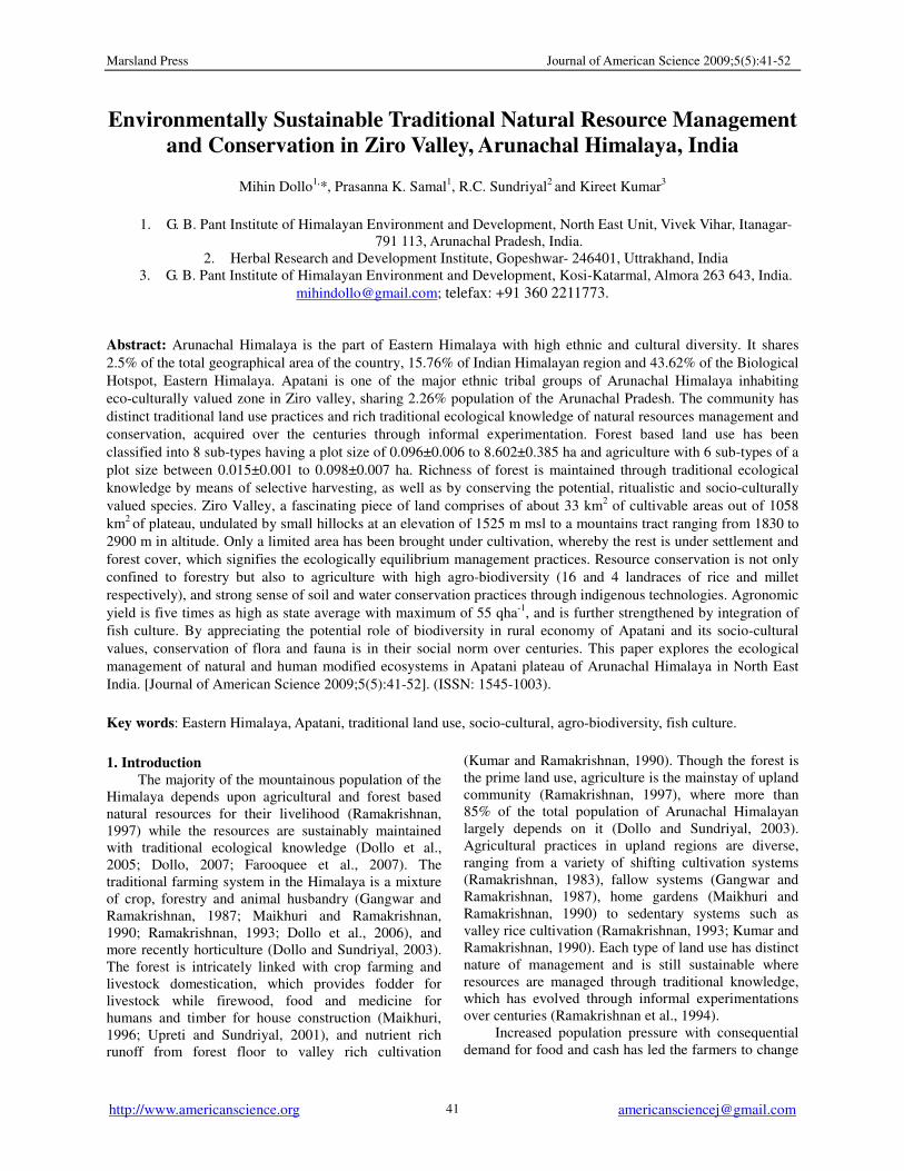
Ziro, a scenic valley, is the home of the Apatani
tribe whose unique land use pattern, resource
management and culture of conservation have made
them a focal point of attraction (Haimendrof, 1962;
Kumar and Ramakrishnan, 1990). It is the district
headquarters of the Lower Subansiri, and is popularly
called as “Rice Bowl of Arunachal Pradesh”. It has 35
villages, with a population of 24,650 and a density of 23
people per km2 (Table 1). The decadal (1991-2001)
growth rate of 8.62 is much lower than the state
(26.21%). The Valley has an area of more than 1058
km², of which 33 km² is cultivated land while the rest is
under forest, plantations and settlement (http://
lowersubansiri. nic.in /html /forestpractice.htm). The
valley lies between Panior and Kamla (Kuru) river at an
altitude that ranges from 1525 m msl in valley to 2900
m msl in hilltops (Fig 1). The region is bounded with
the areas traditionally belonging to the neighbouring
Nishi and Hill-Miri tribes except south-eastern region
Marsland Press Journal of American Science 2009;5(5):41-52
http://www.americanscience.org [email protected] 43
0
5
10
15
20
25
30
35
40
Januar
y
Febru
ary
Mar
chApril
May
June
July
Aug
ust
Septe
mber
Oct
ober
Nove
mber
Dec
ember
Months
Ma
xim
um
an
d m
inim
um
te
mp
era
ture
0
50
100
150
200
250
300
350
Hu
mid
ity
an
d r
ain
fall
Max. Temp.(˚C)
Min. Temp.(˚C)
Humidity (%)
Rainfall (mm)
by Assam.
Figure 1. Location map of Ziro Valley (agriculture and
settlement land only).
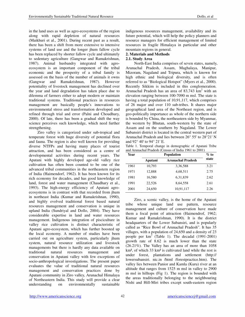
It has a humid subtropical to temperate types of
climate with 235 cm of annual rainfall and a
temperature ranging from 6.3 to 28.1°C and 1.9 to
18.4°C during summer and winter, respectively (Fig 2).
The soils of the valley are humid black and reddish in
colour, developed from genesis and schist overlaid on a
wide area with older alluvial deposits. The top soils are
sandy loam to clay loam in texture, soil pH ranges from
5.10 to 5.64, organic carbon from 1.25-2.87%, available
phosphorus from 19 to 32 kgha-1
and exchangeable
potassium from 300 to 365 gha-1
.
Figure 2. Climatic status of Apatani
plateau
2.2. Data collection and analysis
This study is mainly based on field surveys
through pre-tested questionnaire, formal and informal
interviews with villagers and farmers of 5 randomly
selected villages, and quadrate method for yield
estimations. Field survey was made during the year
2005-2007, at least by selecting 1/4 households in each
village, and the farmers were interviewed by
considering all economic and social backgrounds
(stratified method). The data were gathered on
indigenous land use, natural resources and its
sustainable management, economic yield of
agro-ecosystem as well as their historical and cultural
backgrounds. All the activities in the villages were
closely monitored and quantified over the years for
resources management. Economic yield were analysed
by using thirty 1m2 quadrates lying randomly. Economic
yield per hectare was calculated on the basis of the yield
from entire plot (Mishra, 1968). Fish production was
measured on the basis on total fish output by 15 farmers
in each village, which was further calculated into one
hectare basis. Soil analyses were done by TSBF
methods of Anderson and Ingram, 1993. Data collected
were systematically assessed and analysed, and
numerical value was treated statistically to assess the
standard error, which was interpreted further for
drawing conclusions.
3. Result and Discussion
Apatani tribe has been known as an efficient
resources manager with rich traditional ecological
knowledge, and conservative in nature, which has been
attracting the UNESCO to proposed Apatani or Ziro
valley as World Heritage Site. They follow a settled
pattern of life and are basically agrarian. The
community has evolved with unique skill of rice-fish
cultivation, and unlike to most other tribal communities
they do not practice shifting cultivation (Jhum).
Apatanis are efficient managers of land and depend
mostly on their plantations rather than on the forest for
their basic needs. Such practice distinguishes them from
most of the other tribes of the state and defines their
distinctive lifestyle and social system. The community
still maintains the age-old tradition for resources
management and the modern scientific technology has
little influence in this context. They have rather
strengthened the traditional systems of forest
management, bamboo plantation and land and water
resource utilization as compared to other northeast tribal
communities who have been impacted by the wind of
modernization to a large extent.
3.1. Historical and cultural Background
The people of Apatani were originally belonging to
Environmentally Sustainable Traditional Natural Resource Dollo, et al
http://www.americanscience.org [email protected]
44
the Tibeto-Mongoloid stock (Haimendorf, 1962). They
trace their descent from one legendary ancestor, Abotani.
Apatanis have migrated to this magnificent Valley from
northern areas beyond Kuru and Kime rivers. This is
revealed from finding of three neolithic celts at
Parsiparlo and Raga circle, and historical remains at
Talle Valley by Archaeological Survey of India (1992).
It is, therefore, apparent that they followed the path of
Kuru (Kamala), Kime and Tsangpo rivers. They settled
at Talle Valley for few decades and ultimately migrated
to Ziro valley. Apatanis live in fairly large villages,
which are compact and permanent, although during
recent years they are dispersed to avoid damage by fire
accidents. Housing patterns are long and made of
bamboo and timber.
They believe in indigenous religion ‘Donyi-
poloism’, and are patriarchal in social system. Earlier,
they have prominent tattoo marks on the face, which,
however, has been discouraged in recent past, and
almost abolished now. The community is sub-divided
into numerous clans but all the clans are believed to
have evolved from same ancestor. The clan is the main
social unit, which acts in solidarity. Like many other
tribes of Arunachal Pradesh, they are highly
co-operative and mutually linked up by kinship,
ritualistic and friendship ties through Binee Aajing. The
tribe practices clan exogamy and community endogamy,
and believes in monogamy. Community has diverse
types of ritual ceremonies and dances. Among that
Daminda and Pakhu-Ittu are popular dances while Dree,
Yapung, Myoko and Murung are major ritual ceremonies.
Myoko, the most important festival is celebrated each
year in the month of March in cycle manner by forming
three groups, each comprised of one or numerous
villages. The festivals are celebrated mainly to ensure
better crop harvest, protect grain from hailstone, insect,
pest, disease and wild animals, and also for the well
being of individuals or community as a whole. There is
Traditional Village Council to regulate the
administration, which is of three tiers, namely Akha
Buliyang, Yapha Buliyang and Ajang Buliyang. In each
tier of council, one or two person should represent from
each clan. Akha Buliyang hold the highest authority on
any decision making body while the role of Yapha
Buliyang is mediator and interpreter in nature and Ajang
Buliyang acts as messenger. The position of Buliyang
is hereditary or selected through democratic means.
They are arbiters of tribal law and upholders of tribal
justice, however, the individual Buliyang are primarily
the spokesman of their own clan or village.
Apatanis are agriculturists in nature and have good
numbers of traditional ecological knowledge on
sustainable management of their limited resources. The
exact date and time of initiation of wet rice cultivation
is still untraceable but through mythology, it is believed
that it might have been started at Pega-Sarang (name of
place). Apatani oral literature suggests that Hinkun Yari
carrying rice crops from mythological place called
Hinkun Lembyan met Ato Pussan and Ayo Tane at Miido
Pyagan. There, she offered varieties of rice seeds to Ato
Pussan and Ayo Tane for cultivation and till now,
through several generations the crops are successfully
cultivated. Once upon a time, Apatani Valley was
believed to be having sporadic mountains, hills and
marshy land. It was the sincere and hard working effort
of their ancestors to make it suitable for wet rice
cultivation.
Ever since most of the Apatani farmers practice
rice-cum-fish cultivation with finger millet on the bund
(risers) over an area of 3297 ha, while 1003 ha is under
rain-fed farming. The wet rice fields are irrigated
through well-managed canal systems. It is managed by
diverting numerous streams originated in the forest into
single canal and through canal each agriculture field is
connected with bamboo or pinewood pipe.
Socio-economy of the community is mainly based upon
agriculture, fishery and bamboo resources, though
majority of its land area is under primary and well
managed secondary forests more appropriately can be
termed as sacred groves. The blue pine and bamboo
plantations on the fringes of a wide mosaic of wet rice
fields surrounded by thickly forested mountains on all
sides, forms a picturesque landscape. Apatanis, though
famed for their agricultural practices, high rice yields
and forest and bamboo plantations, quantification of this
land and plantation based economy has received little
attention. Besides agriculture, they rear Mithun (Bos
forntalis), cattle, pig and poultry.
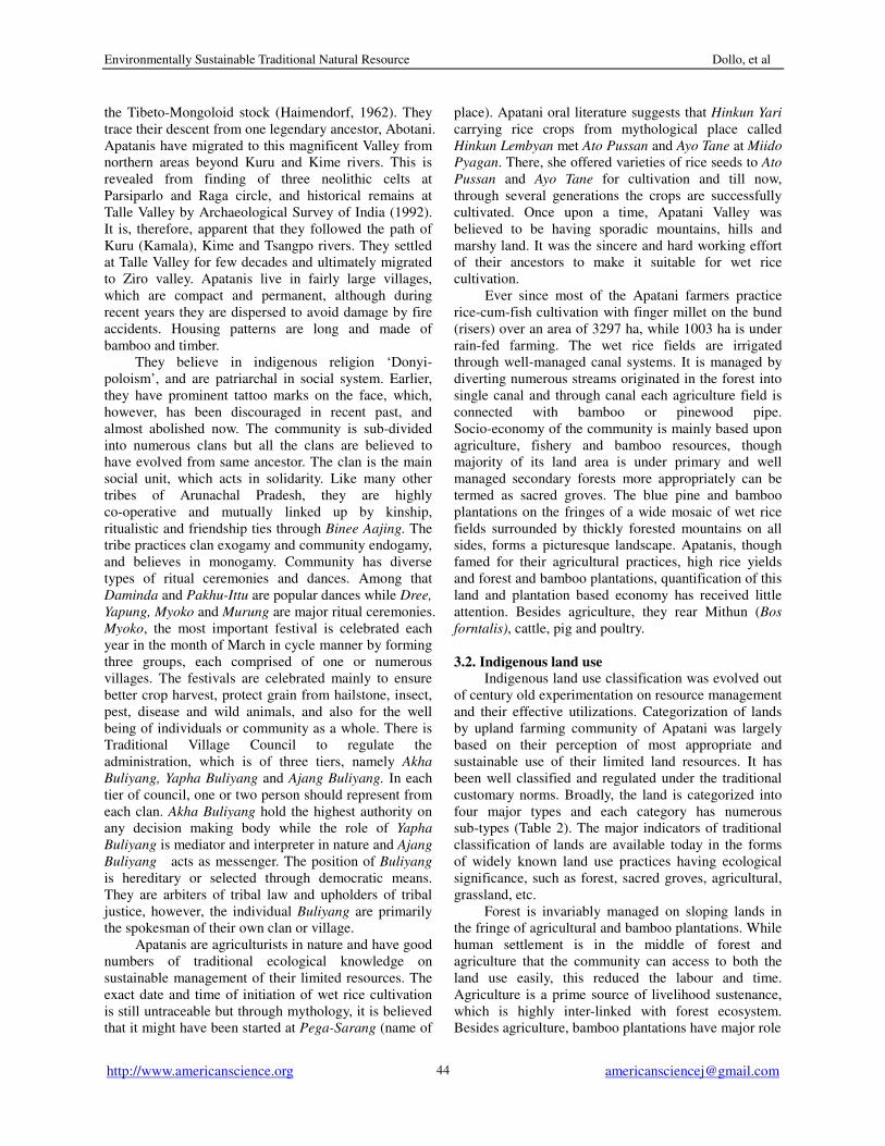
3.2. Indigenous land use
Indigenous land use classification was evolved out
of century old experimentation on resource management
and their effective utilizations. Categorization of lands
by upland farming community of Apatani was largely
based on their perception of most appropriate and
sustainable use of their limited land resources. It has
been well classified and regulated under the traditional
customary norms. Broadly, the land is categorized into
four major types and each category has numerous
sub-types (Table 2). The major indicators of traditional
classification of lands are available today in the forms
of widely known land use practices having ecological
significance, such as forest, sacred groves, agricultural,
grassland, etc. Forest is invariably managed on sloping lands in
the fringe of agricultural and bamboo plantations. While
human settlement is in the middle of forest and
agriculture that the community can access to both the
land use easily, this reduced the labour and time.
Agriculture is a prime source of livelihood sustenance,
which is highly inter-linked with forest ecosystem.
Besides agriculture, bamboo plantations have major role
Marsland Press Journal of American Science 2009;5(5):41-52
http://www.americanscience.org [email protected] 45
in the tribal economic and socio-cultural practices.
Diversification of land uses is an example of highly
successful human adaptation mechanism to the rigor
and constraints of upland regions. Among all the land
uses, clan forest and village forest have the largest mean
plot size with 8.60 ha while granary with lowest of
0.011ha. Meanwhile the most important land use,
agriculture varies from 0.098 to 0.015 ha and bamboo
plantation with 0.62 ha. Sacred groves, an important
land use for conservation purpose has only an average
plot size of just 0.096 ha (Table 2). However, it has an
important role in in-situ (germplasm) conservation of
socio-culturally valuable, economically potential and
ecologically significance species.
Table 2. Indigenous land use classification of Apatani community (*value in mean ±SE.).
Land use Type
(Local name)
Plot size
(ha)*
Description Importance
1. Forest
i) Bije 0.620±0.013 Individual bamboo forest,
mixed with pine &
Castanopsis spp.
Bamboo, timber and fuelwood extraction for
construction & household requirement.
ii) Sansung 0.871±0.017 Individual forest
(Castanopsis/ pine dominant
forest, mostly monoculture)
Extraction of timber, fuelwood and materials for
ritual ceremony.
iii) Uru Moreh 2.660±0.181 Sub-clan forest (mostly
mixed forest)
Extraction of timber, bamboo, cane, fuelwood &
other NTFPs for household requirement.
Collection of materials for ritual ceremony,
hunting & rearing of mithun.
iv)Hallu morey 8.602±0.385 Clan forest (monoculture of
pine, castanopsis dominant
& mixed forest)
-do-
v)Lemba Booth
Morey
8.601±0.367 Village forest (mixed
vegetation forest)
-do-
vi)Supung Booth
Morey
- Community forest -do-
vii) Polung 0.106±0.009 Community/village grazing
land
Grazing land for cattle
viii) Rantee 0.096±0.006 Sacred groves (Village land) Restriction of extraction except for ritual
purpose. Good seed bank for varieties of spp.
2. Agriculture
i) Ballu 0.053±0.006 Home garden Varieties of vegetables, pulses, chillies etc., &
millet nursery for garden & bund.
ii) Yollu 0.058±0.005 Vegetable garden -do-
iii) Lyapyo 0.031±0.002 Millet field Millet cultivation
iv) Jaebe-Aji 0.098±0.007 Wet rice field Rice-cum-fish culture
v) Ahi-Amii farang 0.054±0.006 Fruit garden Apple, pears, plum, peach etc.
vi) Ngyi su-per 0.015±0.001 Fish pond Particularly for raising fingerling for rice field.
3. Settlement
i) Neshu Nechang 0.011±0.001 Granary For storing rice, millet and other crops.
ii)Ude Nechang 0.048±0.002 House Household settlement
iii) Pede Pilley - Farm house Particularly for agricultural purpose
iv) Alyi giiri - Pig pane Rearing pig
4. Miscellaneous
i) Sukung - Well For drinking water.
ii) Sugang - Canal/streams Irrigation purpose
iii) Lenti lenda - Road Communication
iv) Killey - River Natural gift of water for Apatani valley
Environmentally Sustainable Traditional Natural Resource Dollo, et al
http://www.americanscience.org [email protected]
46
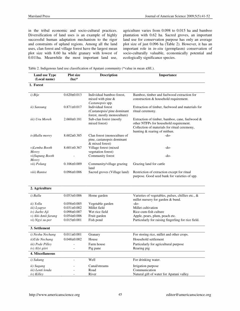
3.3. Traditional forestry
Apatanis are managing the forest and its resources
through traditional customary norms under above
classification. Each of the forest is sustainably managed
and the resources are tapped judiciously as well. The
forests of Apatani Valley comprised of four well-defined
zones (Table 3). In recent time this zonation is lightly
disturbed because less effort is being given on
management and successional takeover of Pinus
wallichina (Pessa) forest. However, it is still maintained
well, which is one of the sustainable systems of forest
management and is better than government regulated
protected forest. The first zone is just above the rain-fed
or wet rice cultivation, which is monoculture of bamboo
or mixed vegetation with bamboo, pine and Castanopsis
spp. The second zone consists of P. wallichina forest
followed by third zone, which is a monoculture of
Castanopsis spp., and or mixed vegetation of
Castanopsis spp. with Quercus spp. etc. The fourth zone
is the subtropical broad leave mixed vegetation that
consists of Quercus lanata, Castanopsis spp. etc., and
temperate vegetation such as Taxus wallichiana,
Cephalotaxus sp. etc. (Table 3). Though all forest types
are important for the community, there is a high
dependency on bamboo and Castanopsis spp. forests.
Table 3. Forest zonations and important plant species in Apatani plateau
Forest Species Major role
1. Bamboo plantation
a. Monoculture Phyllostachys bambusoides Fuel wood, food, handicraft,
housing and ritualistic materials.
b. Bamboo + pine P. bambusoides, Pinus wallichina, Alnus nepalensis,
etc.
Timber, fuel wood, food,
handicraft, housing and ritualistic
materials.
c. Bamboo+
castanopsis
P. bambusoides, Castanopsis indica,, C. hystrix, C.
tribuoides, A. nepalensis, Dendrocalamus hamiltoni,
etc.
Timber, fuel wood, food,
handicraft, housing and ritualistic
materials.
2. Pine P. wallichina, Pyrus pashia,, Prunus nepalensis, etc. Timber, fuel wood and wild
edible fruits.
3. Castanopsis C. indica,, C. hystrix, C. tribuoides, A. nepalensis,
Myrica esculenta,
Timber, fuel wood, ritualistic
materials and wild edible fruits.
4. Mixed forest
a. Sub-tropical Quercus lanata, C. tribuloides, C. indica, C. hystrix,
Michelia champaca, Terminalia chebula, Exbucklandia
populnea, Helicia robusta, Spondias axillaris, Illicium
griffithii, Actinidia callosa (wild kiwi), Dendrocalamus
hamiltonii, Chimonobambusa spp. etc.,
Timber, fuel wood, ritualistic
materials, handicraft, wild edible
fruits and herbal medicine.
b. Temperate Taxus baccata, Pinus wallichina, Cephalotaxus sp.
Cedrus deodra, Tsuga dumosa, Rhododedndron
arboreum, Pleioblastus simoni, Arundinaria sp. etc.
Timber, fuel wood, ritualistic
materials, wild edible fruits and
herbal medicine.
All the forests are maintained through century old
traditional ecological knowledge of resource
management practices, which is sustainable. These
forests are maintained not only to meet the fuelwood,
fodder, food, and timber need of the community but also
for socio-cultural and ritualistic purpose. Bamboo and
pine groves meet the requirement of timber for house
construction, edible bamboo shoots, fencing, erosion
control, fuelwood, handicrafts and materials for ritual
ceremonies. The Sansung (individual forest) are
managed for fuelwood and material source for ritual
ceremonies such as Myoko, Murung, Subu, etc. In
addition, it has an ethno-medico-botanical resource
centre for the community. The bamboo plantations are
dominated with a single species Phyllostachys
bambusoides, though the community uses other bamboo
species mainly collected from primary forest.
Maintenance and plantation of bamboo is done with
utmost care. The rhizomes are planted during the month
of February or early March, and proper weeding and
selective harvesting of young bamboo shoots are done
to increase the yield. It is normally carried out just a
month before the emergence of young shoots, and the
young shoots pruning is done by observing the nature
and size of shoots. Maturation of bamboo is recognized
through the development of a fungus on the surface of
main stem. Normally, it is harvested after every third
year.
Pine seedlings are planted during February and
looping of branch is done after third year of plantation.
It is believed that proper looping enhances growth and
straightness of plants, beside it supplies fuelwood
Marsland Press Journal of American Science 2009;5(5):41-52
http://www.americanscience.org [email protected] 47
requirement. Castanopsis spp., Alnus nepalensis,
Prunus sp., Prunus nepalensis, Pyrus sp. Quercus spp.
etc. are managed through cutting at the height of 3-8 m.
This helps to promote large scale emergence of
branches (coppices) and is believed that such type of
management gives faster growth of plant in comparison
to seedling plantation.
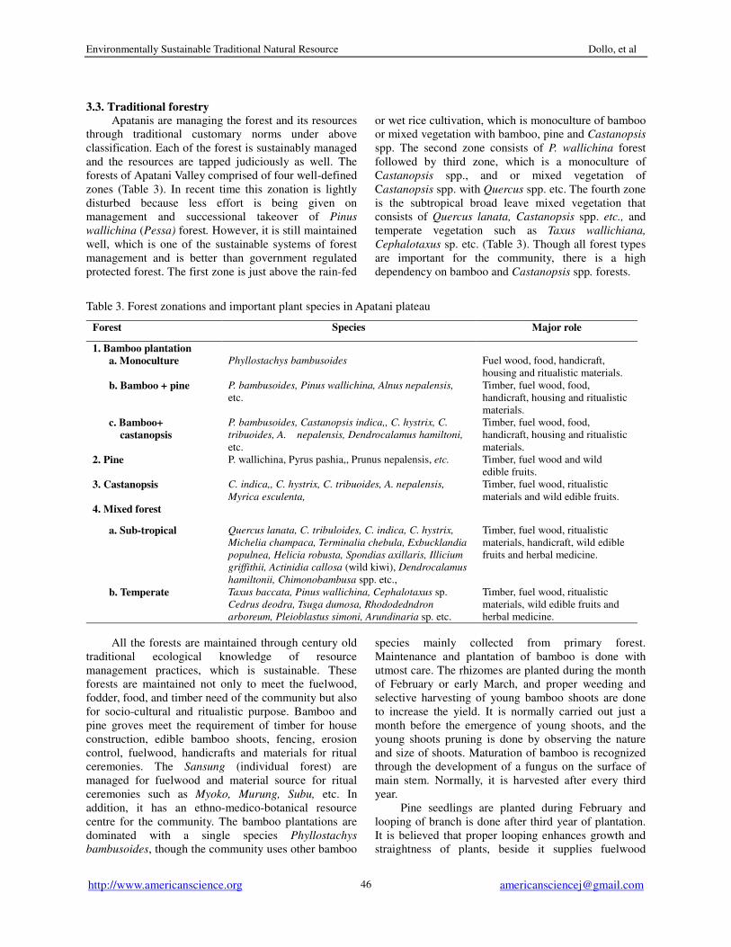
3.4. Farmer groups for sustainable management
It is often thought that underdeveloped or remote
regions are inhabited by unorganized farmers but a
closer look reveals that these farmers are often knitted
together in some way. Traditional farmers groups can
play a pivotal role in achieving and maintaining
sustainable production in a specific agro-ecosystem. For
example, Arunachal Himalaya is globally
acknowledged for its rich eco-cultural heritage, and the
wealth of traditional ecological knowledge amongst
farmers. Shared in farmers groups who form to work on
the land together, this knowledge clearly supports
sustainable agro-ecosystem management in the region.
The traditional farmers groups of the Apatani
people, in the Apatani Valley in the central western part
of Arunachal Himalaya, have been successfully
managing their natural resources for centuries. The
Apatani have different types of traditional farmer
groups, which have evolved over the years. There are no
written records so it is impossible to trace the exact
history and development of the groups. The traditional
agro-ecosystems are intricately linked with nature, and
are well-fitted to local environmental conditions and
cultural needs. These agro-ecosystems are sustainable,
self-sufficient and efficient due to strong organisations
and sharing of such ecological knowledge among
farmers, which has always been transmitted orally from
generation to generation. Indigenous classification of
agricultural land use into 7 categories for efficient land
management, and to produce enough to sustain the
population is an example of innovative ecological
design by the farmer groups. Traditional wisdom on
crop-soil interaction, ethno-pedology, nutrient
management, and soil and water conservation are some
examples of ecological knowledge which supports the
sustainable production system as it has evolved over the
decades, and which cannot be managed by individuals.
The Apatani have eight different types of informal
farmer organisations (Table 4) and each group has their
own task and workload. The groups are valued
differently by the community, for example, the Bogo
(that looks after construction and maintenance of water
sources) is seen as the most important group as there are
limited water sources for irrigation in the Apatani valley,
and good water management is essential for efficient
production in the paddy-cum-fish system.
Table 4. Types and working nature of traditional farmer groups of the Apatani tribe (texts in italic are in the local dialect)
Local name Description Group
Manager
Task
1. Bogo A farmer group sharing the common water sources.
The group manager leads all the activities. Posts can
be held for 1-3 year(s) and are selected/ elected from
within the group. Group size is between 3-600
households depending on village size.
Bogo Ahtoh
(male)
Construction and maintenance of
water supply system and
regulation of the efficient sharing
of water among the group
2. Aji Lenda A group which has their fields in the same area. The
group manager leads all the activities. Tenure is
normally for one year only. Group size is 50-350
households.
Lenda
Kagenee
(male/ female)
Construction and maintenance of
foot-paths to allow access to and
from fields.
3. Sulu- sikhii A group, which has their fields in the same area. The
group manager leads all the activities. Tenure is
normally for one year only. Group size is 50-350
households.
Sulu Kagenee
(male)
Construction and maintenance of
fencing to protect the agricultural
fields from domestic and wild
animals.
4. Tanser
Patang
Groups organised during field preparation and
weeding. Group size is 5-15 households.
Patang Ahtoh
(female)
Field and nursery preparation,
seed sowing, and weeding.
5. Konchi
Patang
This group works in the morning between 5 am to 8
am. Group size is 5-10 households.
Patang Ahtoh
(female)
Field preparation, transplantation
and weeding.
6. Halying
Patang
This group shares labour during seedling
transplantation. Group size is 5-15 households.
Patang Ahtoh
(female)
Transplantation of seedlings,
particularly paddy and millet.
7. Enthee
Patang
This group forms to share labour during crop
harvesting. Group size is 8-12 households
Patang Ahtoh
(male/ female)
Harvesting and carrying of
harvests.
8. Bijee Lenda A group having bamboo garden at same locality. Here
also group manager leads all the activities. Tenure is
normally for one year only. Group size is 70-300
households.
Lenda
Kagenee
(male)
Construction and maintenance of
foot-path, a way for carrying
bamboo, timber and fuelwood.
(source: Dollo, 2007)
Environmentally Sustainable Traditional Natural Resource Dollo, et al
http://www.americanscience.org [email protected]
48
The farmers know that traditional practices are
very important for maintaining sustainable production
systems, and also that the farmer groups are the
foundation of these practices. Most farmers recognise
that without farmer groups, agro-ecosystem
management will easily weaken, and the technical
ecological knowledge which supports it will erode fast.
In this sense, most farmers think that the groups are
effective in managing the agro-ecosystems. Except for
financial support, particularly for erosion control,
fencing and drainage maintenance, the farmers do not
receive or seek any technological interventions or other
help from any outside agencies. Outside experts
highlighted the Apatani paddy-cum-fish culture system
as one of the most efficient crop production systems,
which has further encouraged the Apatani farmers to
continue their traditional practices.
3.5. Traditional agro-ecosystem
The valley rice cultivation has undergone a steady
evolution and modification through the concise
management of land that led to well-drained terraces
with perfect bunds (Agher). Generally the bunds are
made up of soil, and supported by splitted bamboo and
wooden pieces at base if there is chance of erosion due
to splashing of water. The size of riser may vary from
0.5 to 2 m in breadth and 0.2 to 3 m in height depending
on the gradient of land and the size and shape of the
terraces. Perfect levelling of plots, well-managed
irrigation and drainage reduce the soil erosion to a
negligible level. Besides, varieties of soil and water
conservation are practised by using locally available
materials of bamboo, wood and cane. Average plot size
is 0.098 ±0.007 ha, however, the size of plot gradually
decreases towards the hills and small valleys. The
average area for rice field was recorded as 0.36 ha per
family in selected study villages of Apatani Valley.
The valley rice cultivation field can be categorised
into three types based on practices, viz. Jaibee-aji,
Pitang-aji and Miding. Jaibee-aji is the marshy
agricultural field, which is normally kept without
watering during the fallow period, while Pitang-aji is an
agricultural land that requires water supply during
fallow period, which is essentially required at least for
two months otherwise the productivity of the land is
considerably low with high weed infestation. Miding is
a small size (48 m2) agriculture land maintained for
rising rice nursery. In such plots water is maintained
round the year though needs to drain out just before the
preparation and sowing of seed but always kept with
light water supply.
The valley used for cultivation of rice is efficiently
irrigated through well-managed water supply canal
systems. Since time immemorial, the Apatanis have
practiced a scientific system of irrigation through
indigenous technique with local materials available in
the region. All the diversions are made with wooden
piece, bamboo and cane locally called Bogo (small
dam/barrier). The maintenance of barrier and irrigation
canal systems is managed through cooperative efforts
among all the beneficiaries under the supervision of
selected person(s) (Bogo-Ahtoh). Every stream from the
surrounding hills is tapped soon after it emerges from
the forest, channelized at the rim of the valley and
diverted by a network of primary, secondary and tertiary
channels. The discharge of the river during monsoon
varies from 4.8, 13.9 and 32.2 cubic meter per second at
the entrance, middle and end of the plateau, respectively.
In absence of large river, the water from minor river or
streams is used in such a way that all the fields get equal
benefit of irrigation. To maintain this, a volume of water
is diverted in feeder canal (Segang) and then to pipe
(Huburs/Siichoo). The feeder canals or pipes are
branched to feed many terraces by blocking or opening
the connecting pipes.
Table 5. Classification of indigenous rice (Oryzae sativa)
landraces
Land races Duration & cultivation
1. Eamo
i) Ampu Ahare Early variety, most commonly cultivated,
duration 195-210 days.
ii) Ampu Hatte Late variety, commonly cultivated, duration
245-256 days.
iii) Radhe Eamo Late variety, rarely cultivated, duration
235-245 days.
iv) Eylang Eamo Late variety, most commonly cultivated,
duration-230-240 days.
v) Ampu Puloo
Hatte
Late variety, extinct, duration-260-270 days.
2. Mipye
a) Pyate Mipye
i) Kogii Pyate Early variety, commonly cultivated,
duration-205-215 days
ii) Zeehe Pyate Early variety, rarely cultivated,
duration-205-215 days
iii) Pyate Pyapu Early variety, rarely cultivated, duration
195-208 days
b) Pyaping Mipye
i) Tepe Pyaping Early variety, most common cultivated,
duration-205-215 days
ii) Pyapu Pyaping Early variety, rarely cultivated, duration
195-208 days
iii) Kogii Pyaping Early variety, rarely cultivated, duration
205-215 days
iv) Zeehe Pyaping Early variety, rarely cultivated, duration
205-215 days
v) Pyare Mipye Early variety, cultivated nearby settlement,
duration 172-180 days
vi) Mishang
Mipye
Early variety, rarely cultivated, duration
205-215 days
vii) Mithu Mipye Early variety, commonly cultivated, duration
195-208 days
viii) Eylang Mipye Early variety, rarely cultivated, duration
205-215 days
Marsland Press Journal of American Science 2009;5(5):41-52
http://www.americanscience.org [email protected] 49
The cross section of main canal ranges between
0.8 to 1.5 m in width and 0.60 to 1.2 m in depth, while
that of feeder canal ranges between 0.48 to 0.85 m in
width and 0.45 to 0.75 m in depth. To check the erosion,
flow of water in each feeder canal or pipe is regulated
by wooden planks or stone. The most important aspect
of traditional water management by Apatanis, which
appears to be scientific, is to keep water layer on the
soil surface at the permissible depth. For that, flow of
water from one field to another is maintained through a
ditch (Muhgo) on bund and two outlet pipes. The ditch
is especially for outflow of excess water as well as
maintaining the desire depth. The desire level of water
is maintained by putting straws/weeds in ditches, where
the height of straws/weeds is maintained accordingly.
Two outlet pipes is placed in such a way that the upper
one is for over flow and lower one is for draining the
water completely. Normally, 1-2 cm water is maintained
just after plantation, which is increased gradually with
respect to rice plant growth and size of fish but is not
kept more than 15 cm. In the middle of rice field a small
depression or canal (Siikho/Parkho/Hehte) is made for
water and soil management in olden time but is best
suited for fish culture in present day. This canal is
constructed in perpendicular as well horizontal to the
bund with the help of traditional agriculture implement
(Hiita). During agro-piscicultural activities water is
drained out time to time. For weeding, water is drained
twice/thrice, which coincides with harvesting of fish. In
later stage, water is totally drained from field for early
ripening and increase the yield as well as to make it dry
during harvesting. The water from the terraces is finally
drained into the Kale river, which flows through the
middle of the valley.
Table 6. Indigenous millet (Eleusine coracana) landraces Landrace Duration & cultivation
Sarse
Surpu Ahare Early variety, duration 162-176 days, commonly
cultivated, average productivity.
Surpu Latha Late variety, duration 183-195 days, most
commonly cultivated, high productivity.
Sartii Late variety, duration 195-210 days, rarely
cultivated, low productivity.
Ahki sarse Late variety, duration 180-190 days, rarely
cultivated, low productivity.
Apatani is having high rice diversity with 16
indigenous landraces (Table 5), which differ in height,
grain characteristic, nutrition requirement, duration,
productivity and resistance to disease and insect pests.
All the indigenous rice landraces except Ampu Puloo
Hatte are grown. The rice crop duration varies from 172
to 270 days with an average of 221 days (Table 5).
Since 1992 high yielding rice varieties such as IR-36,
Mashuri and IET6666 are introduced but with little
success. The bunds of the rice fields are cultivated with
millet thus leaving no portion of land unutilized. Only
the indigenous millet (Eleusine coracana) landraces-
Surpu Latha, Surpu Ahare, Ahki Sarse and Sartii are
grown in the valley (Table 6). Ampu Ahare, Eylang
Eamo and Ampu Hatte are commonly cultivated in the
region, which together cover more than 67.02% of total
wet rice fields. These three varieties have high
productivity besides socio-religious importance. Among
Eamo varieties of rice, cultivation of Ampu Puloo Hatte
is not in practice probably due to its long maturation
phase. While Mipye has 11 landraces, of this Tepe
Pyaping is preferred the most by the farmers because of
its high yield and that can sustain the marshy land. The
Pyate Mipye and Pyare Mipye varieties are losing
importance in recent times due to immature grain falling,
which leads to low yield. Normally, the Eamo landraces
are cultivated in medium fertile soil while Mipye
varieties are preferred in high as well as very low fertile
land. It is believed that the grains of Eamo landraces are
abortive in highly fertile soils, and at the same time they
cannot be sustained in less fertile lands as well. The
yield is largely dependent on nutrient flow from villages
and recycling of crop residues. Wet rice agro-
ecosystems of Apatani largely depend on wash-out from
the hill slopes. To sustain the productivity of rice field
there is a need to maintain forest cover at high reaches.
The rice is first raised in the nursery (Miding) of
nearly 48 m2, which is further divided into 3-4 nursery
beds (Hohe) of 4x3 m size. The field for nursery is
normally selected in narrow valley or just near to the
settlement. This is done because nursery requires more
nutrients and high speed flow of wind delay the
germination. If the settlement is nearby, the nurseries
are fed with small canals carrying human wastes and
animal excreta. Each landrace is maintained separately
in nursery bed to avoid the possible mixed up of
seedlings. The beds are prepared just after the
completion of Murung festival in the month of February
with the help of traditional implement (Hiita). The seeds
are sown at the rate of 75-80 kgha-1
that were collected
through a selective procedure with high care. The
seedlings (Andee) are maintained for 55-80 days until
they attain height of 12-15 cm and 15-18 cm for lightly
wet (Pitang-aji) and marshy (Jaibee-aji) fields,
respectively. The finger millet nursery for bunds and
rain-fed millet field is raised at home garden. The sizes,
time and preparation technique of nursery beds are
almost same as that of rice. After attaining of 12-16 cm
height, the transplantation is done with the help of
traditional implements (Dum). Before transplanting of
rice, 5-10 cm apical portion of seedlings are removed to
avoid seedling mortality. The Dum is used for making
hole on bunds for seedlings to be transplanted.
Environmentally Sustainable Traditional Natural Resource Dollo, et al
http://www.americanscience.org [email protected]
50
0
50
100
150
200
250
300
350
400
450
500
550
600
650
700
750
1997-98 1998-99 1999-00 2000-01 2001-02 2002-03 2003-04
Year
Nu
meri
ca
l va
lue
in
each
ca
teg
ary
Beneficiary (no.) Area (ha) Fish seed ('0000) Production (kg/ha)
Preparation of agricultural land begins just after
the completion of Myoko festival in the later part of
March. All the land preparations are completed by the
end of April. These land operations are done manually
by indigenous wooden tools (Sampeyee, Hiita, etc) and
spade. Transplantation of seedlings begins with in the
month of April and is completed by the end of May. In
hard soil seedlings transplantation is done by traditional
implement (K-du), which is mainly used for making
hole. Single rice seedling is transplanted at a spacing of
12-18 cm. Terrace bunds are used for finger millet
cultivation through transplanted seedlings by
maintaining a spacing of 9-12 cm.
Weeds (Ahru-tamii) are the major problems for
farmers. Weeding (Ahru-hodo) is done 3-4 times in a
year. First weeding is done before soil preparation for
transplantation in the month of February followed by
second weeding in the month of July or early August,
which is coincided with first fish harvesting. Third is in
the late August while fourth is in September that also
coincides with final harvesting of fish. Weeds are
converted into compost through traditional systems by
gathering all the weeds in one place, which is then
covered with a thin layer of soil for quick
decomposition. The weeds collected in February from
bunds are used as compost for rain-fed garden, mainly
for cultivation of chilies.
Table 7. Area and yield of rice and millet (*value are mean
±SE)
Crop (% cover) Total Area in
ha (%)
Yield (qha-1)*
Rice (97.03%)
1. Eamo 2144 (67.02) 54.89±3.12
2.Pyaping 725 (22.66) 49.65±4.86
3. Pyat 330 (10.32) 42.93±3.01
Millet (2.97%)
1. Surpu Latha 58(59.18) 21.01±1.03
2. Surpu Ahare 28(28.57) 17.23±1.14
3. Sartii 7(7.14) 14.35±0.98
4. Ahki sarse 5(5.10) 12.98±1.26
The different landraces of rice and millet differ in
their yields. Productivity of rice varieties is high due to
best management practices. An agronomic yield of rice
varies from 43-55 qha-1
while that of millet is of 13-21
qha-1
(Table 7). Thus valley rice agro-ecosystem in
Apatani Valley is highly productive being about four
times higher than the average yield of the rice in the
state (11 qha-1
) while production of millet is double than
that of the state average (9 qha-1
). The system is
economically viable and environmentally sustainable,
cost of cultivation being low with minimal external
inputs. For all agricultural activities 298-328 mandays
are required in one hectare of land.
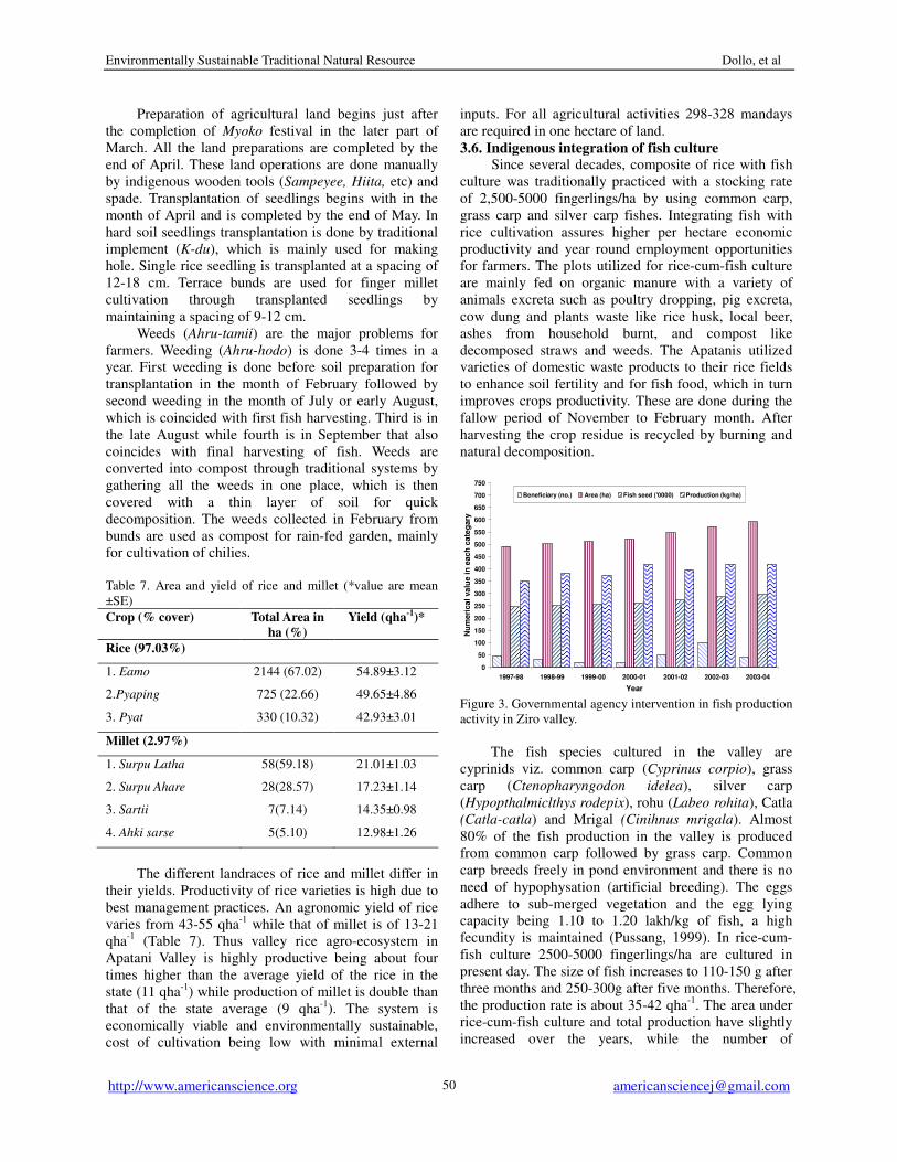
3.6. Indigenous integration of fish culture Since several decades, composite of rice with fish
culture was traditionally practiced with a stocking rate
of 2,500-5000 fingerlings/ha by using common carp,
grass carp and silver carp fishes. Integrating fish with
rice cultivation assures higher per hectare economic
productivity and year round employment opportunities
for farmers. The plots utilized for rice-cum-fish culture
are mainly fed on organic manure with a variety of
animals excreta such as poultry dropping, pig excreta,
cow dung and plants waste like rice husk, local beer,
ashes from household burnt, and compost like
decomposed straws and weeds. The Apatanis utilized
varieties of domestic waste products to their rice fields
to enhance soil fertility and for fish food, which in turn
improves crops productivity. These are done during the
fallow period of November to February month. After
harvesting the crop residue is recycled by burning and
natural decomposition.
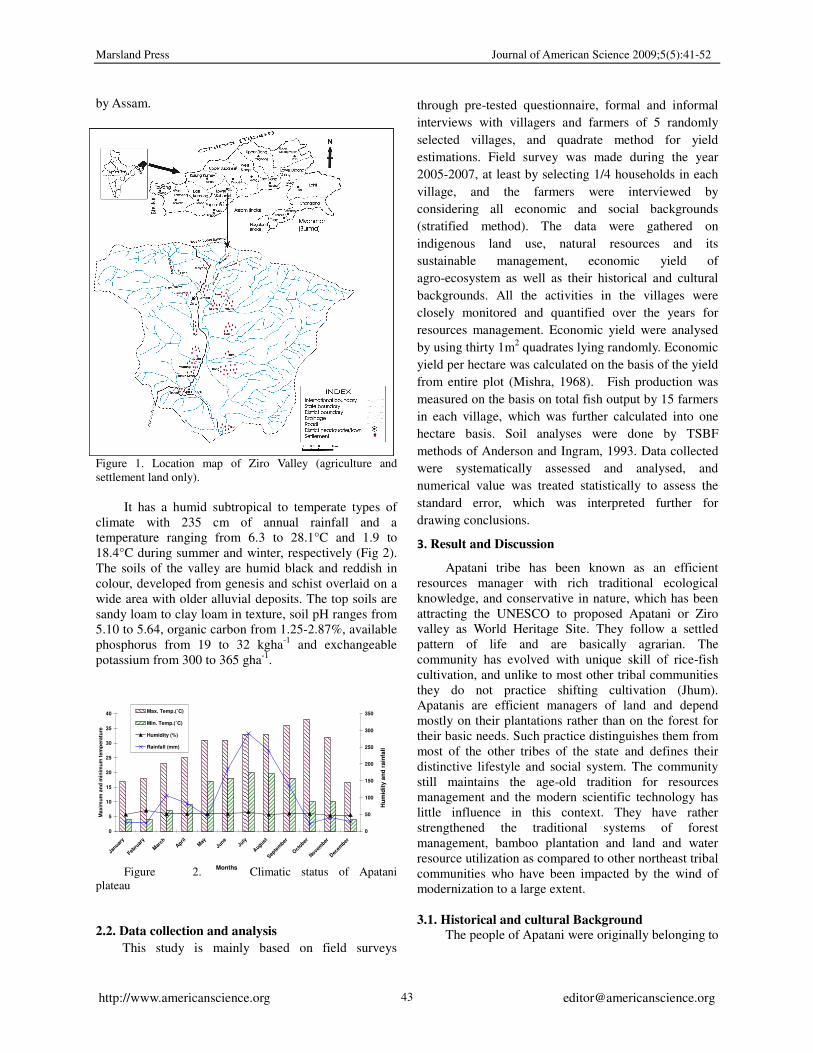
Figure 3. Governmental agency intervention in fish production
activity in Ziro valley.
The fish species cultured in the valley are
cyprinids viz. common carp (Cyprinus corpio), grass
carp (Ctenopharyngodon idelea), silver carp
(Hypopthalmiclthys rodepix), rohu (Labeo rohita), Catla
(Catla-catla) and Mrigal (Cinihnus mrigala). Almost
80% of the fish production in the valley is produced
from common carp followed by grass carp. Common
carp breeds freely in pond environment and there is no
need of hypophysation (artificial breeding). The eggs
adhere to sub-merged vegetation and the egg lying
capacity being 1.10 to 1.20 lakh/kg of fish, a high
fecundity is maintained (Pussang, 1999). In rice-cum-
fish culture 2500-5000 fingerlings/ha are cultured in
present day. The size of fish increases to 110-150 g after
three months and 250-300g after five months. Therefore,
the production rate is about 35-42 qha-1
. The area under
rice-cum-fish culture and total production have slightly
increased over the years, while the number of
Marsland Press Journal of American Science 2009;5(5):41-52
http://www.americanscience.org [email protected] 51
beneficiaries have slightly decreased from 47 to 40
numbers during 1997-2004 (Fig 3). The growth rate of
fishes is generally higher in the first year where they
attain 40-50 cm in length and 1.0-1.2 kg in weight, if
proper feeding is given. Moreover, these fish species
can be handled very easily without much care or
expertise. It is possible to generate additional sources
of income and employment generation by bringing more
and more water resources of the valley under scientific
exploitation with external inputs. It would be an
alternative venture to obtain protein rich food for
fighting against malnutrition and side-by-side generate
employment opportunities for many unemployed youths
among the rural population of the valley.
4. Conclusion There is enormous traditional ecological
knowledge embedded in the hilly communities of
Arunachal Himalaya, particularly in Apatani community.
These knowledge is based upon the centuries of
informal experimentations with local environment,
being adapted to local ecosystem and are effectively
functioning in sustainable resources tapping and
conservation. The indigenous knowledge of Apatani
tribe is unique in nature and effective in functioning.
However, if onslaught of modernisation and cultural
infestation continue, this will lead to loss of
environmentally sustainable traditional ecological
knowledge forever. Traditional practices not only
promote the integration and maintenance of diverse land
use types, but also ensure the continuity of diverse
species and varieties within each component, which are
observed in traditional agro-ecosystem with diverse
varieties of crop species. The local ecological setting
and the high degree of dependence on natural resources
make such practices exceptionally valuable. All the
management practices are highly self reliant with little
external input or technologies and low dependency from
external resources make it extremely endogenous and
sustainable.
Traditional forestry in Apatani valley has been
integral part of the local system, which is judiciously
guarded and meticulously tended by all community
members as it fulfils various basic needs. The rich
natural resources combined with traditionally
conservationist attitude of the Apatani can provide
solution to many economic needs of the people. The
Apatanis have a natural inclination towards plantation
and ecological conservation, which if properly utilized
can have tremendous impact on the development of the
area. The traditional knowledge and skill related to
management of natural resources by the Apatani is
immense and that can be replicated elsewhere.
In the era of globalisation, traditional ecological
knowledge of resources management provides a useful
rationale for designing new technologies for sustainable
management of valuable natural resources and efficient
ways of resource conservation. The ecological
traditional technologies of Apatani community, such as
fish-cum-paddy cultivation, bamboo and forest
resources management are found to be highly effective
in resource conservation and management, which are
unique in nature, and economically and environmentally
sustainable as well. A prerequisite, however, is proper
documentation, appreciation and understanding of these
ecological practices, which will help to harness the
traditional knowledge to develop strategy for
sustainable development of the fragile Himalayas.
Although few of indigenous knowledge practices of
Apatani community have been assessed by scientific
world, nevertheless the need of the hour is proper
documentation, analysis and in-depth understanding.
Besides, sufficient credits need to be given to traditional
ecological technologies and the practitionsers. The
integration of fish-cum-rice culture is unique in nature,
and economically and environmentally sustainable. The
choice of blending such knowledge with modern
scientific technologies for the well being of the local
people in particular and north eastern region in general,
lies with the scientific communities, policy planners and
administrators. However, undermining of the efficient
traditional ecological knowledge of resources
management and conservation will create disturbance in
social as well as ecological setting.
Acknowledgement
Authors are thankful to Director, G.B. Pant
Institute of Himalayan Environment and Development,
Almora for providing facilities, and the Apatani
community for sharing information. Thanks are also due
to Chairman and members of Nature Care and Disaster
Management Society, Ziro for their helps during data
collection.
Correspondence to:
Mihin Dollo, Programme Manager
G. B. Pant Institute of Himalayan Environment and
Development, North East Unit, Vivek Vihar,
Itanagar-791 113, Arunachal Pradesh, India.
(*e.mail:[email protected]; telefax: +91 360
2211773- office; +919436223597-mobile)
References
[1] Ramakrishnan PS. Scientific basis of traditional
wet rice cultivation by North-East India hills tribes.
In Behera MC and Roy NC (eds.), Trends in
Agrarian Structure in the Hills of North_East India,
Commonwealth Pulblishers, New Delhi,
1997;233-247.
[2] Dollo M, Singh KI, Saha D, Chaudhury S,
Environmentally Sustainable Traditional Natural Resource Dollo, et al
http://www.americanscience.org [email protected]
52
Sundriyal RC. Livelihood and natural resources
utilization pattern in an ethinically diverse area in
Arunachal Pradesh. In Bhatt BP and Bujarbaruah
KM (eds.), Agroforestry in north east India:
opportunities and challenges. ICAR Research
Complex for NEH Region, Meghalaya, India, 2005;
55-70.
[3] Dollo M. Traditional farmers groups supporting
sustainable farming. LEISA. 2007; 23(1): 22-24.
[4] Farooquee NA, Dollo M, Kala CP. Traditional
Wisdom of Apatani Community in the
management and sharing of natural resources in
North Eastern India. In Misra Kamal K (ed.),
Traditional Knowledge in Contemporary Societies:
Challenges and Opportunities Pratibha Prakashan,
Shakti Nagar, Delhi, India, 2007; 110-126.
[5] Gangwar AK, Ramakrishnan PS. Cropping and
yield patterns under different landuse systems of
the Khasis at higher elevations of Meghalaya in
North-Eastern India. International Journal of
Ecological and Environmental Science, 1987;
13:73-86.
[6] Maikhuri RK, Ramakrishnan PS. Ecological
analysis of cluster villages emphasizing land use of
different tribes of Meghalaya in north-east India.
Agriculture, Ecosystems and Environment, 1990;
31: 17-37.
[7] Ramakrishnan PS. Shifting agriculture and
sustainable development: An interdisciplinary
study from North-Eastern India. Oxford
University Press, Delhi, 1993; 424 pp.
[8] Dollo M, Chaudhury S, Sundriyal RC. Traditional
farming and land tenure systems in West Kameng
district, Arunachal Pradesh. In Ramakrishnan PS,
Sexena KG and Rao KS (eds.), Shifting agriculture
and sustainable development of North-Eastern
India, UNESCO-MAB series, Oxford & IBH, New
Delhi, India, 2006; 293-315.
[9] Dollo M, Sundriyal RC. Agricultural status and
future potential in the State of Arunachal Pradesh,
India. Arunachal University Research Journal,
2003;6(2):21-33.
[10] Maikhuri RK. Eco-Energetic analysis of village
ecosystem of different traditional societies of
Northeast India. Energy, 1996; 21(12):1287-1297.
[11] Upreti TC, Sundriyal RC. Indigenous resources
and community dependence: A case study from
Arunachal Pradesh, India. Grassroots Voices: A
Journal of Resources and Development,
2001;6(1-2): 28-39.
[12] Kumar A, Ramakrishnan PS. Energy flow through
an Apatani village ecosystem of Aranuchal
Pradesh in north-east India. Human Ecology,
1990;18(3):315-336.
[13] Ramakrishnan PS. Socio-economic and cultural
aspects of jhum in the north east and options for
eco-development of tribal areas. In N.P. Chaubey
(ed.), Tribal techniques, social organization and
development: Disruption and alternates, Indian
Academy of Social Sciences, India, 1983;12-30.
[14] Ramakrishnan PS, Purohit AN, Saxena KG, Rao KS.
Himalayan Environment and Sustainable
Development. Indian National Science Academy,
New Delhi, 1994;84.
[15] Maikhuri RK, Rao KS, Semwal RL. Changing
scenario of Himalayan agro ecosystems: Loss of
agro biodiversity, an indicator of environmental
change in central Himalaya, India. The
Environmentalist, 2001;21: 23-39.
[16] Palni LMS, Choudhury D. Agricultural
self-reliance in northeast India: The potential of
indigenous technical knowledge and traditional
practices. In National level seminar on resources
management for self reliant agricultural economy
of NE region, 2000; 9-10.
[17] Haimendorf CVF. The Apatanis and their
neighbours, Oxford University Press, London.
1962.
[18] Chaudhary RG, Dwivedi RN, Dutta KK, Sarma BK,
Patel CS, Prasad RN. Rice based farming of
Apatani- an efficient indigenous system of hill
farming. Indian Journal of Hill Farming. 1993;6(1):
93-102.
[19] Sundriyal RC, Dollo M. Apatani cultural landscape:
Integrated natural resource management and
community development- towards local assets
building and transformations. In Ninth
International Congress on “Ethnobiology, Social
Change and Displacement”, 13-17th June,
University of Kent, Canterbury, UK. 2004.
[20] Myers N, Mittermeier RA, Mittermeier CG, da
Fronseca GAB, Kent J. Biodiversity hotspots for
conservation priorities. Nature, 2000; 403:
853-858.
[21] Mishra R. Ecology Work Book. Oxford and IBH
Publishing Co., New Delhi. 1968.
[22] Anderson JM, Ingram JSI. Tropical Soil Biology
and Fertility: A Handbook Methods. C.A.B.
International, U.K, 1993; 218 pp.
[23] Pussang N. Paddy-cum-fish culture at Ziro.
Popiriscope, 1999; I(1):12-13.