ENVIRONMENTALASSESSMENT U.S.BORDERPATROL ...€¦ · FINAL ENVIRONMENTAL ASSESSMENT For Temporary...
112
ENVIRONMENTAL ASSESSMENT U.S. BORDER PATROL TEMPORARY VEHICLE BARRIERS NACO AND DOUGLAS, ARIZONA FINAL U.S. Department of Justice Immigration and Naturalization Service Washington, D.C. NOVEMBER 2002
Transcript of ENVIRONMENTALASSESSMENT U.S.BORDERPATROL ...€¦ · FINAL ENVIRONMENTAL ASSESSMENT For Temporary...

ENVIRONMENTAL ASSESSMENT
U.S. BORDER PATROLTEMPORARY VEHICLE BARRIERSNACO AND DOUGLAS, ARIZONA
FINAL
U.S. Department of JusticeImmigration and Naturalization Service
Washington, D.C.
NOVEMBER 2002


FINAL
ENVIRONMENTAL ASSESSMENT For
Temporary Vehicle Barriers Naco and Douglas, Cochise County, Arizona
November 2002
Responsible Agency: U.S. Immigration and Naturalization Service Headquarters, Facilities and Engineering Division 425 I Street NW Room 2030 Washington, DC 20536 Agency Point of Contact: Charles Parsons
INS Regional Environmental Officer 24000 Avila Road P.O. Box 30080 Laguna Niguel, California 92608-0080
Preparing Organization: Gulf South Research Corporation 7602 GSRI Avenue Baton Rouge, LA 70820

EXECUTIVE SUMMARY
PROPOSED ACTION: Infrastructure improvements that will be addressed include the placement of temporary vehicle barriers along 25 miles of the international border within the U.S. Border Patrol’s (USBP), Douglas and Naco Stations Areas of Operation. The acquisition, installation, and maintenance of temporary vehicle barriers are the primary focus of this Environmental Assessment (EA).
PURPOSE AND NEED: In the proposed project area the lack of physical barriers has allowed illegal vehicle entry into the U.S. to continue unimpeded. Because of the nearby road network, undocumented aliens, drug smugglers, and potential terrorists can easily escape into the U.S. once they have successfully breached the border. The purpose of this project is to provide an effective deterrence measure against illegal vehicle entry into the U.S. Temporary vehicle barriers have proven to be an effective method of stopping illegal entry into the United States. Thus, the need of this action is to place additional vehicle barriers at locations along the international border within the Naco and Douglas stations’ Area of Operations to enhance the USBP’s deterrence capability for illegal vehicle entry. This EA addresses the potential for adverse or beneficial environmental impacts of the proposed temporary vehicle barriers.
ALTERNATIVES ADDRESSED:
The No Action Alternative would not allow installation of the of the temporary vehicle barriers. The Preferred Alternative would allow the installation of temporary vehicle barriers at various locations along a 25-mile corridor, on an as-needed basis. No additional ground disturbance would be required for the installation of the barriers.
ENVIRONMENTAL IMPACTS OF THE PROPOSED ACTION:
The Preferred Alternative would involve minimal ground disturbance during the placement of the temporary vehicle barriers in an area that is disturbed. No significant adverse effects to air quality, water quality, cultural resources, unique areas, soils, threatened or endangered species, protected species, wetlands or land use are expected. Site-specific surveys for sensitive resources and coordination with the appropriate Federal and state agencies by INS and USBP have provided insurances that the proposed action would not have a significant adverse impact on the human or natural environment.

CONCLUSION: Based on the findings of this analysis and assuming that all mitigation measures recommended herein are implemented, no significant adverse impacts would occur from the Preferred Alternative.

TABLE OF CONTENTS
1.0 INTRODUCTION AND PURPOSE AND NEED.................................................1-1 1.1 Background and History .....................................................................................1-1
1.1.1 INS Organization ....................................................................................1-1 1.1.2 Area of Operation ...................................................................................1-3
1.1.3 Regulatory Authority ...............................................................................1-4 1.2 Purpose and Need............................................................................................. 1-5 1.3 Location of the Proposed Action ........................................................................1-6 1.4 Applicable Environmental Statues and Regulations ..........................................1-8 1.5 Report Organization ...........................................................................................1-9 2.0 ALTERNATIVES................................................................................................2-1 2.1 No Action Alternative..........................................................................................2-1 2.2 The Preferred Alternative – Temporary Vehicle Barriers ...................................2-1 2.2.1 Alternative Designs.................................................................................2-2 2.2.2 Construction Personnel and Equipment .................................................2-2 2.3 Alternatives Considered but Eliminated from Further Analysis ..........................2-3 2.4 Summary .......................................................................................................2-3 3.0 AFFECTED ENVIRONMENT.............................................................................3-1 3.1 Land Use .......................................................................................................3-1 3.2 Soils and Prime Farmland ..................................................................................3-1
3.2.1 Soil Associations ....................................................................................3-1 3.2.2 Hydric Soils.............................................................................................3-2
3.2.3 Prime and Unique Farmlands.................................................................3-2 3.3 Vegetation .......................................................................................................3-2 3.4 Wildlife Communities..........................................................................................3-3 3.5 Unique or Sensitive Areas..................................................................................3-3 3.5.1 Coronado National Forest ......................................................................3-4 3.5.2 Coronado National Memorial..................................................................3-4 3.5.3 San Pedro Riparian National Conservation Area ...................................3-4 3.5.4 San Bernardino National Wildlife Refuge ...............................................3-5 3.6 Protected Species and Critical Habitat...............................................................3-5 3.6.1 Federal ...................................................................................................3-6 3.6.2 Critical Habitat ......................................................................................3-10 3.6.3 State .....................................................................................................3-11 3.7 Cultural Resources...........................................................................................3-11 3.8 Air Quality .....................................................................................................3-12 3.9 Water Resources..............................................................................................3-12 3.9.1 Waters of the U.S. and Wetlands .........................................................3-14 3.10 Socioeconomics ...............................................................................................3-16 3.11 Noise ..............................................................................................................3-16 4.0 ENVIRONMENTAL CONSEQUENCES ............................................................4-1 4.1 Land Use............................................................................................................4-1 4.1.1 No Action Alternative ..............................................................................4-1 4.1.2 Preferred Alternative...............................................................................4-1 4.2 Soils and Prime Farmland ..................................................................................4-1 4.2.1 No Action Alternative ..............................................................................4-1 4.2.2 Preferred Alternative...............................................................................4-1
Temporary Vehicle Barriers EA iv Final

4.3 Vegetation .......................................................................................................4-2 4.3.1 No Action Alternative ..............................................................................4-2
4.3.2 Preferred Alternative...............................................................................4-2 4.4 Wildlife .......................................................................................................4-3 4.4.1 No Action Alternative ..............................................................................4-3 4.4.2 Preferred Alternative...............................................................................4-3 4.5 Unique or Sensitive Areas..................................................................................4-3
4.5.1 No Action Alternative ..............................................................................4-3 4.5.2 Preferred Alternative............ .................................................................. 4-3
4.6 Protected Species and Critical Habitats .............................................................4-4 4.6.1 No Action Alternative .............................................................................4-4 4.6.2 Preferred Alternative...............................................................................4-4 4.7 Cultural Resources.............................................................................................4-4 4.7.1 No Action Alternative ..............................................................................4-4 4.7.2 Preferred Alternative...............................................................................4-5 4.8 Air Quality .......................................................................................................4-5 4.8.1 No Action Alternative ..............................................................................4-5
4.8.2 Preferred Alternative...............................................................................4-5 4.9 Water Resources................................................................................................4-5 4.9.1 No Action Alternative ..............................................................................4-5 4.9.2 Preferred Alternative...............................................................................4-6 4.10 Socioeconomics .................................................................................................4-6 4.10.1 No Action Alternative ..............................................................................4-6 4.10.2 Preferred Alternative...............................................................................4-6 4.10.3 Environmental Justice ............................................................................4-7 4.11 Noise Effects ......................................................................................................4-8 4.11.1 No Action Alternative ..............................................................................4-8 4.11.2 Preferred Alternative...............................................................................4-8 4.12 Cumulative Impacts............................................................................................4-8 4.12.1 No Action Alternative ...........................................................................4-11 4.12.2 Preferred Alternative.............................................................................4-11 5.0 ENVIRONMENTAL DESIGN MEASURES ........................................................5-1 5.1 Air Quality .......................................................................................................5-1 5.4 Biological ............................................................................................................5-1 6.0 PUBLIC INVOLVEMENT ...................................................................................6-1 6.1 Agency Coordination ..........................................................................................6-1 6.2 Public Review.....................................................................................................6-1 6.3 Comments and Responses ................................................................................6-3 7.0 REFERENCES...................................................................................................7-1 8.0 ACRONYMS ......................................................................................................8-1 9.0 LIST OF PREPARERS ......................................................................................9-1
Temporary Vehicle Barriers EA v Final

LIST OF FIGURES Figure 1-1 Location map of Project Area ................................................................ 1-7
EXIHIBITS
Exhibit 6-1 Notice of Availability ...............................................................................6-2
LIST OF TABLES Table 1-1 Applicable Environmental Statutes and Regulations..............................1-9 Table 2-1 Alternative Matrix....................................................................................2-3 Table 2-2 Summary Matrix of Potential Impacts.....................................................2-4 Table 3-1 Federally Listed, Proposed, and Candidate Species Potentially Occurring within Cochise County, Arizona .............................................3-7 Table 3-2 National Ambient Air Quality Standards ...............................................3-13
APPENDICES APPENDIX A State Protected Species APPENDIX B Correspondence
Temporary Vehicle Barriers EA vi Final

SECTION 1.0INTRODUCTION AND PURPOSE AND NEED

1.0 INTRODUCTION AND PURPOSE AND NEED This Environmental Assessment (EA) addresses the potential effects, beneficial and
adverse, of the Immigration and Naturalization Service (INS) and U.S. Border Patrol
(USBP) proposal to install temporary vehicle barriers at various locations along a 25-mile
corridor within the USBP Douglas and Naco Stations’ Areas of Operation (AO).
Temporary vehicle barriers would be installed in areas that receive high illegal vehicular
entry on an as-needed basis, in order to aid USBP agents in defending the United States
borders against illegal entries.
This EA is tiered from two documents: the Final Environmental Assessment for
Infrastructure within U.S. Border Patrol Naco-Douglas Corridor, Cochise County, Arizona
(INS 2000A) and the Final Supplemental Programmatic Environmental Impact Statement
for INS and Joint Task Force Six (JTF-6) U.S./Mexican Border (INS 2001b). This EA was
prepared in accordance with the National Environmental Policy Act (NEPA) of 1969, the
President’s Council on Environmental Quality (CEQ) Regulations for the Implementation
of the NEPA as well as the INS’ Procedures for Implementing NEPA (28 CFR 61).
1.1 Background 1.1.1 INS Organization
The INS has the responsibility to regulate and control immigration into the United States.
In 1924, the U.S. Congress created the USBP to be the law enforcement arm of the INS.
The USBP’s primary function is to detect and deter the unlawful entry of aliens and
smuggling along the nation’s land borders and between the ports-of-entry (POE). With
the increase in illegal drug trafficking, the USBP also has become the leader for drug
interdiction between land POEs. Since 1980, an average of 150,000 immigrants have
been naturalized every year. At the same time, illegal aliens have become a significant
issue. INS apprehension rates are currently averaging more than 1.5 million illegal aliens
throughout the country per year.
The southwest border is a major gateway for the entry of illegal people and drugs into
the United States. For the Fiscal Year (FY) 2000, 293 million people, 89 million cars, 4.5
million trucks, and 572,583 rail cars entered the United States from Mexico (ONDCP
Temporary Vehicle Barriers EA Final 1-1

2001). It is a large, diverse, and difficult boundary to effectively enforce without the use
of dedicated tactical infrastructure (fences, lights, roads, cameras, etc.).
Prior to the early 1990s, there was less awareness of the southwest border issues and
less national attention was given to illegal trans-boundary activity than is currently
attributable. As a result, the USBP’s growth was nominal, funding for enforcement efforts
fell short, and the USBP functioned under severe constraints. Events over the last
decade related to illegal immigration and narcotics smuggling have increased the
nation’s awareness and generated substantial interest in controlling the U.S./Mexico
border. National concern has led to increased funding and staffing, and has also created
new opportunities in the development of proactive border control strategies as
demonstrated in patrol and enforcement operations throughout the southwest border
area (e.g., Operations Gatekeeper, Hold-the-Line, Safeguard, and Rio Grande).
The enforcement strategy pre-dating such operations was necessarily reactive and,
because little emphasis was placed on deterring illegal crossing, it diminished the
importance of an infrastructure (e.g., lights and fences) along the U.S./Mexico border.
Instead, the USBP’s efforts focused singularly upon making apprehensions after the
international boundary was breached. This strategy utilized the “element of surprise” by
deploying limited resources away from the border in concealed positions. However, as
illicit trafficking continued to increase, the area that the USBP was required to patrol also
increased. The USBP’s inability to deter or contain illegal migration allowed an increase
in the geographic footprint (and subsequent environmental impacts) of illegal migration
patterns.
During recent years, the USBP has significantly increased its emphasis on deterrence.
Deterrence is achieved only when the USBP has the ability to create and convey the
immediate, credible, and absolute certainty of detection and apprehension. As such,
tactical infrastructure components, such as vehicle barriers, are a critical element in the
current enforcement strategy. Developing trends such as the continued urbanization and
industrialization of the immediate border, the recognition of environmental preservation
concerns, and the increase of criminal trans-boundary activities (including trafficking in
people and drugs, and counter terrorism efforts) continue to pose a border enforcement
challenge and compound the need for tactical infrastructure.
Temporary Vehicle Barriers EA Final 1-2

1.1.2 Area of Operation Naco Station The Naco Station’s AO is located within Cochise County and covers approximately
2,000 square miles. The station’s AO includes 30 miles of international border and the
communities of Naco, Bisbee, Tombstone, Sierra Vista, Warren, Hereford, Palominas,
and Huachuca. There are currently 203 USBP agents assigned to the station.
Wildlife habitat preservation is the main focus on public lands here. The Coronado
National Forest, Coronado National Memorial, and the San Pedro Riparian National
Conservation Area are all located within the Naco Station AO. The Bureau of Land
Management (BLM), the U.S. Fish and Wildlife Service (USFWS), and the National Park
Service manage these lands. Also, there are a few private landowners that range cattle
on their land in this locale.
The geographical terrain of the area is desert with rolling hills covered with brush
thickets and numerous north-south trending washes. The approximate elevation of the
station is 4,800 feet above mean sea level (msl), though the southern reaches of the
Huachuca Mountains, which bound the western most portion of the AO, can attain
elevations up to 8,000 feet msl.
The summers are very hot and dry with temperatures rising above 100º Fahrenheit (F).
In winter the average daily temperatures range from lows of 28º F to highs of 60º F.
Snow can accumulate to a depth of several feet on the mountain peaks and can occur
from November to April. Most of the rainfall in the area occurs during the summer
months (July through September) usually as intense and violent thunderstorms.
Douglas Station The Douglas Station is located within southeast Cochise County and covers
approximately 1,600 square miles. The station’s AO includes approximately 30 miles of
international border. The station’s headquarters is located here, with 500 USBP agents
currently assigned to it. The communities of Douglas, Pirtleville, Elfrida and McNeal are
within this AO, with Douglas being the largest (population 14,000). The City of Douglas
Temporary Vehicle Barriers EA Final 1-3

shares the border with Agua Prieta, Mexico. The Dragoon and Mule Mountains border
Douglas on the west, and the Chiricahua, Pedregosa, and Perilla Mountains on the east.
The Douglas Station leads the Tucson Sector in terms of density of illegal traffic, both
alien and narcotics. Which is due largely to being so close to the large Mexican city of
Agua Prieta, a town of 100,000 people, where organized smuggling operations of both
aliens and narcotics are suspect as staging areas. It is not uncommon to have 100 to
200 illegal aliens staging along Mexico Highway 2 preparing to cross the border
(Robison pers com 2002).
Like Naco, the Bureau of Land Management (BLM), the USFWS, the State of Arizona,
and a few private owners manage much of the land surrounding Douglas. The
geography along the U.S./Mexico border is generally flat, cut by numerous washes. The
approximate elevation of the station is 4,000 feet msl. Further inland, the Pedregosa and
Swisshelm Mountains provide a natural barrier. Some of these mountains reach
elevations up to 8,000 feet msl. Summer temperatures regularly exceed 100º F. July
through September is when the majority of the rainfall occurs in this region. Winter
average daily temperatures range from lows of 28º F to highs of 60º F. Accumulation of
snow several feet deep on the mountain peaks can occur.
1.1.3 Regulatory Authority The primary sources of authority granted to officers of the INS are the Immigration and
Nationality Act (INA), found in Title 8 of the United States Code (8 USC), and other
statutes relating to the immigration and naturalization of aliens. The secondary sources
of authority are administrative regulations implementing those statutes, primarily those
found in Title 8 of the Code of Federal Regulations (8 CFR Section 287), judicial
decisions, and administrative decisions of the Board of Immigration Appeals. In addition,
the Illegal Immigration Reform and Immigrant Responsibility Act (IIRIRA) mandates INS
to acquire and/or improve equipment and technology along the border, hire and train
new agents for the border region, and develop effective border enforcement strategies.
Subject to constitutional limitations, INS officers may exercise the authority granted to
them in the INA. The statutory provisions related to enforcement authority are found in
Sections 287(a), 287(b), 287(c), and 287(e) [8 USC § 1357(a,b,c,e)]; Section 235(a) [8
Temporary Vehicle Barriers EA Final 1-4
USC § 1225]; Sections 274(b) and 274(c) [8 USC § 1324(b,c)]; Section 274(a) [8 USC §
1324(a)]; and Section 274(c) [8 USC § 1324(c)] of the INA. Other statutory sources of
authority are Title 18 of the United States Code (18 USC), which has several provisions
that specifically relate to enforcement of the immigration and nationality laws; Title 19 [19
USC § 1401(i)], relating to U.S. Customs Service cross-designation of INS officers; and
Title 21 [21 USC § 878], relating to Drug Enforcement Agency cross-designation of INS
officers.
1.2 Purpose and Need The U.S. experiences a substantial influx of illegal immigrants and drugs each year. Both
of these illegal activities cost the American citizens billions of dollars annually due
directly to criminal activities, as well as the cost of apprehension, detention, and
incarceration of criminals; and, indirectly in loss of property, illegal participation in
government programs, and increased insurance costs. These increases have
necessitated the construction and implementation of various infrastructure systems to
enhance the USBP’s ability to detect, apprehend, and deter illegal aliens and drug
traffickers. The INS is now using high tech methods of detecting illegal aliens with the
use of Integrated Surveillance and Intelligence Systems (ISIS). ISIS components
include, but are not limited to, unattended ground sensors, low-light television cameras,
infrared cameras, towers (and their connections to power and communication lines), and
intelligent computer aided detection (ICAD). The combination of sound infrastructure
(e.g., roads, fences, barriers, and ISIS components) and adequate resources (e.g.,
vehicles, field agents, support personnel, etc.) is essential for the effective enforcement
of the border strategy and integral to the success of the USBP to gain, maintain, and
extend control of the border. USBP agents are much more successful in their jobs when
a physical barrier is in place to hinder illegal entry.
This being said, illegal drive throughs are the most common way of transporting
narcotics from Mexico into the U.S. These drive through events often involve large
quantities of narcotics (500 to 2,000 pounds) and daring drivers who not only have little
respect for the lives of USBP agents, but also little respect for the general public as well,
due to the high price associated with such large quantities of narcotics. Illegal vehicle
entries occur in areas that lack a physical barrier and provide a natural entry, such as
Temporary Vehicle Barriers EA Final 1-5

washes, arroyos, and draws. Temporary vehicle barriers would provide an invaluable
service in slowing or halting illegal vehicle entries by strategically placing the barriers in
problem areas until more permanent solutions are developed. Thus, the need is to
provide an immediate solution to deter illegal vehicle entries.
Two miles of permanent vehicle barriers, which were constructed under a previous EA,
(USACE 2000) have proven to be effective in stopping illegal vehicle traffic in this area.
In spite of this, illegal entry has shifted to the east and west in an attempt to avoid these
barriers. Since January 2001 to July 2002, over 109 drive throughs and 86,326 pounds
of narcotics have been documented in the Naco and Douglas AOs. Thus, there is a need
to place additional vehicle barriers at locations along the U.S./Mexico border in the Naco
and Douglas AOs to enhance the deterrence rate of illegal vehicle entry. The purpose of
the temporary vehicle barriers is to create a barricade that would halt or substantially
deter illegal vehicle traffic in areas that provide easy escape routes for illegal entrants.
Other purposes of the proposed action are to enhance the flexibility of deployments by
USBP agents thereby facilitating apprehension, to reduce health and safety risks to
USBP agents in remote areas, and to reduce damage to natural and cultural resources
due to illegal vehicle traffic.
Since the tragedy of the terrorist attacks on the United States, the anti-terrorism function
of the INS has gained increased responsibility of the USBP. This increased role requires
more vigilance at the POEs and all areas along the borders. All enforcement activities
and subsequent infrastructure and technological improvements, such as roads, fencing,
remote video surveillance (RVS) systems, vehicle barriers, and lighting, are necessary
elements in securing the Nation’s borders from illegal entry.
1.3 Location of the Proposed Action The proposed action would occur in Cochise County near the cities of Naco and Douglas,
Arizona (Figure 1-1). The Naco and Douglas Station AOs covers approximately 60 miles
of the U.S./Mexico border. Temporary vehicle barriers are proposed for various locations
Temporary Vehicle Barriers EA Final 1-6

Sources:USGS 1:100,000 Digital Raster GraphicsProposed Temporary Vehicle BarrierCorridor and the Existing Fence/Barrierfrom GSRC, 2002.
Proposed TemporaryVehicle Barrier Corridor
Existing Fence/Barrier
Mexico
Cochise CountyARIZONA
Project Area
San P
edro
Riv
er
Naco
Bisbee
Douglas
ARIZONA
MEXICO
Black Draw
1-7
Figure 1-1: Proposed TemporaryVehicle Barrier Corridor
1:240,000
0 2 4 6 81Miles
Feet0 11,000 22,000 33,000 44,000

along 25 miles of the entire 60 miles of border under the jurisdiction of the Naco and
Douglas Stations. The eastern terminus of the proposed temporary vehicle barriers is just
west of Black Draw in the San Bernardino Valley, and the western limit is near the eastern
boundary of the San Pedro Riparian National Conservation Area (San Pedro Riparian
NCA), which is approximately 11 miles west of Naco. The temporary vehicle barriers are
portable and may be positioned anywhere in this corridor as “hot spots” for illegal vehicle
entry develop. Vehicle barriers would not be placed within the San Bernardino National
Wildlife Refuge (NWR), San Pedro Riparian NCA, Coronado National Memorial, and other
sensitive areas.
1.4 Applicable Environmental Statues and Regulations The proposed project would be constructed in accordance with and in partial fulfillment
of USACE obligations under Section 206 of the Water Resources Development Act of
1996, USACE Planning Guidance Book (Engineering Regulation (ER) 1105-2-100),
Section 404 of the Clean Water Act, Section 404 of the Clean Water Act, E.O. 13112
(Invasive Species) as well as the statutes and regulations in the following paragraph.
This EA was prepared by Gulf South Research Corporation (GSRC) under contract to
the USACE, Fort Worth District, in accordance with, but not limited to the National
Environmental Policy Act of 1969 (NEPA); Endangered Species Act (ESA) of 1973, as
amended; the National Historical Preservation Act (NHPA) of 1966, as amended; the
Archaeological and Historical Preservation Act (AHPA) of 1974, as amended; Executive
Order (E.O.) No. 11593, “Protection and Enhancement of the Cultural Environment”;
E.O. No. 11988, “Floodplain Management”; E.O. No. 11990, “Protection of Wetlands”;
E.O. No. 13007, “Indian Sacred Sites”; E.O. No. 13045, “Protection of Children from
Environmental Health Risks”; and E.O. No. 12898 “Federal Actions to Address
Environmental Justice.” Table 1-1 summarizes the pertinent environmental
requirements that guided the development of this EA.
Temporary Vehicle Barriers EA Final 1-8
Table 1-1 Applicable Environmental Statutes and Regulations
Federal Statutes Archaeological and Historical Preservation Act of 1974 Clean Air Act of 1955, as amended Clean Water Act of 1977, as amended Endangered Species Act of 1973, as amended Migratory Bird Treaty Act of 1972 National Historic Preservation Act of 1966, as amended National Environmental Policy Act of 1969, as amended Watershed Protection and Flood Prevention Act of 1954 Wild and Scenic Rivers Act of 1968, as amended Farmland Protection Policy Act of 1980 Native American Graves Protection and Repatriation Act of 1990
Executive Orders, Memorandums, etc. Floodplain Management (E.O. 11988) of 1977 Protection of Wetlands (E.O. 11990) of 1977 Federal Actions to Address Environmental Justice to Minority Populations and Low-Income Populations (E.O. 12898) of 1994 Protection of Children from Environmental Health Risks (E.O. 13045) of 1997 Protection of Migratory Birds & Game Mammals (E.O. 11629) of 2001 Indian Sacred Sites (E.O. 13007) of 1996 Consultation and Coordination with Indian Tribal Governments (E.O. 13175) of 2000 Government-to-Government Relations with Native American Tribal Governments (Presidential Memorandum) of 1994
1.5 Report Organization This report is organized into nine major sections including this introduction and the
description of the purpose and need, and location of the proposed project. Section 2.0
describes all alternatives considered for the project. Section 3.0 discusses the
environmental features potentially affected by the project, while Section 4.0 discusses
the environmental consequences for each of the viable alternatives. Mitigation measures
are discussed in Section 5.0 and public comments as well as the Notice of Availability
(NOA) are presented in Section 6.0. Sections 7.0, 8.0, and 9.0 present a list of the
references cited in the document, a list of acronyms and abbreviations, and a list of the
persons involved in the preparation of this document, respectively.
Temporary Vehicle Barriers EA Final 1-9

Appendix A includes a list of state protected species and Appendix B contains
correspondence letters that were sent and received during the preparation of this EA.
Other supporting documents can be found in the Environmental Assessment completed
for U.S. Border Patrol’s Infrastructure along the Naco-Douglas Corridor in Cochise County,
Arizona (INS 2000A) and the Final Supplemental Programmatic Environmental Impact
Statement for INS and Joint Task Force Six (JTF-6) U.S./Mexican Border (INS 2001b).
Temporary Vehicle Barriers EA Final 1-10

SECTION 2.0ALTERNATIVES

2.0 ALTERNATIVES
This section describes the alternatives that were considered during the preparation of
this EA, relative to their ability to satisfy the purpose and need. Two alternatives will be
addressed: (1) No Action Alternative, and (2) the Preferred Alternative. Each of these
alternatives are discussed below.
2.1 No Action Alternative The No Action Alternative would require leaving the border devoid of infrastructure to
obstruct illegal vehicles from entering the U.S. Much of the border in the Douglas and
Naco Station AOs have only the original International Boundary and Water Commission
(IBWC) fence that only serves as a marker for the international border. This fence
provides no effective deterrent measures against illegal vehicle entry. The No Action
Alternative would not increased deterrence of illegal entry nor expand the window of
opportunity for USBP agents to detect and respond to illegal entry attempts.
2.2 The Preferred Alternative – Temporary Vehicle Barriers
Photograph 1
The Preferred Alternative is to
position temporary vehicle barriers
at various locations along existing
border roads of the Douglas and
Naco, Arizona AOs, on an as
needed basis. The proposed
vehicle barriers would be installed
in areas where there is no physical
infrastructure in place within the
Douglas and Naco Station AOs,
where “hot spots” are detected or
anticipated. The proposed vehicle barriers are typically constructed of welded metal
such as railroad track (photograph 1), but may be also constructed of telephone poles or
pipe (photograph 2).
Temporary Vehicle Barriers EA Final 2-1
The temporary vehicle
barriers cannot be rolled or
moved manually, and must
be lifted using a forklift or
front-end loader. The barriers
will be constructed at the
USBP stations and then
transported to areas as
needed, placed on the
ground, and chained
together. Temporary vehicle
barriers would be placed
along the southern edge of existing border roads to minimize disturbance to wildlife and
vegetation. No ground disturbance would occur during the installation of the barriers. As
the name implies, vehicle barriers are designed to impede illegal vehicle entry only; they
do not preclude pedestrian or wildlife movement. This alternative would substantially
impede illegal vehicle traffic within the areas in which they are placed.
Photograph 2
2.2.1 Alternative Designs
Concrete culverts may also be used as temporary vehicle barriers, although they are not
preferred since they are easily rolled out of the way by illegal aliens and may also
impede movements of small wildlife species if placed to closely together.
2.2.2 Construction Personnel and Equipment USBP maintenance staff, JTF-6 divisions, National Guard units, or private contractors
would complete the proposed construction and installation of the vehicle barriers.
Construction is anticipated to begin between the months of October and November
2002. Construction of the barriers would be performed at the Naco and Douglas stations’
equipment yards. The barriers would then be transported to the desired location and off
loaded.
Equipment anticipated to be used during the placement of the vehicle barriers would
include a front-end loader or forklift and a flatbed truck, which would be deployed from
the affected station’s equipment yard. The Border Patrol Special Coordination Center
Temporary Vehicle Barriers EA Final 2-2

(BPSCC) in El Paso, Texas would provide construction material. Materials would be
stored at the each stations equipment yard for the duration of the project.
2.3 Alternatives Considered but Eliminated from Further Evaluation
Other types of permanent barrier/fence designs were considered during the preparation
of this EA. However, due to the urgency of establishing a vehicle deterrence solution,
alternative designs such as permanent fencing were eliminated from further
consideration. These designs would result in greater direct impacts since a road would
have to be constructed in order to install the permanent barriers or fence along the
border. Such solutions may be used at a later date, as they have proven to be an
effective deterrent for illegal vehicle and pedestrian traffic, depending upon the design.
2.4 Summary
Two alternatives, the No Action Alternative and the Preferred Action Alternative, will be
carried forward for analysis. A summary matrix (Table 2-1) shows how each of the
alternatives satisfies the purpose and need of this project. Table 2-2 presents a
summary matrix of the potential impacts from each of the alternatives carried forward
and how they may affect the environmental resources in the Region of Influence (ROI).
Table 2-1 Summary of Alternatives Considered
Purpose and Need Requirements
No Action Temporary Vehicle Barriers
Permanent Vehicle Barriers
Provide immediate ability to deter illegal vehicle entries
No Yes No
Enhance USBP agents flexibility
No Yes Yes
Enhance the safety of USBP agents
No Yes Yes
Decrease damage to natural resources and historic sites
No Yes Yes
Temporary Vehicle Barriers EA Final 2-3
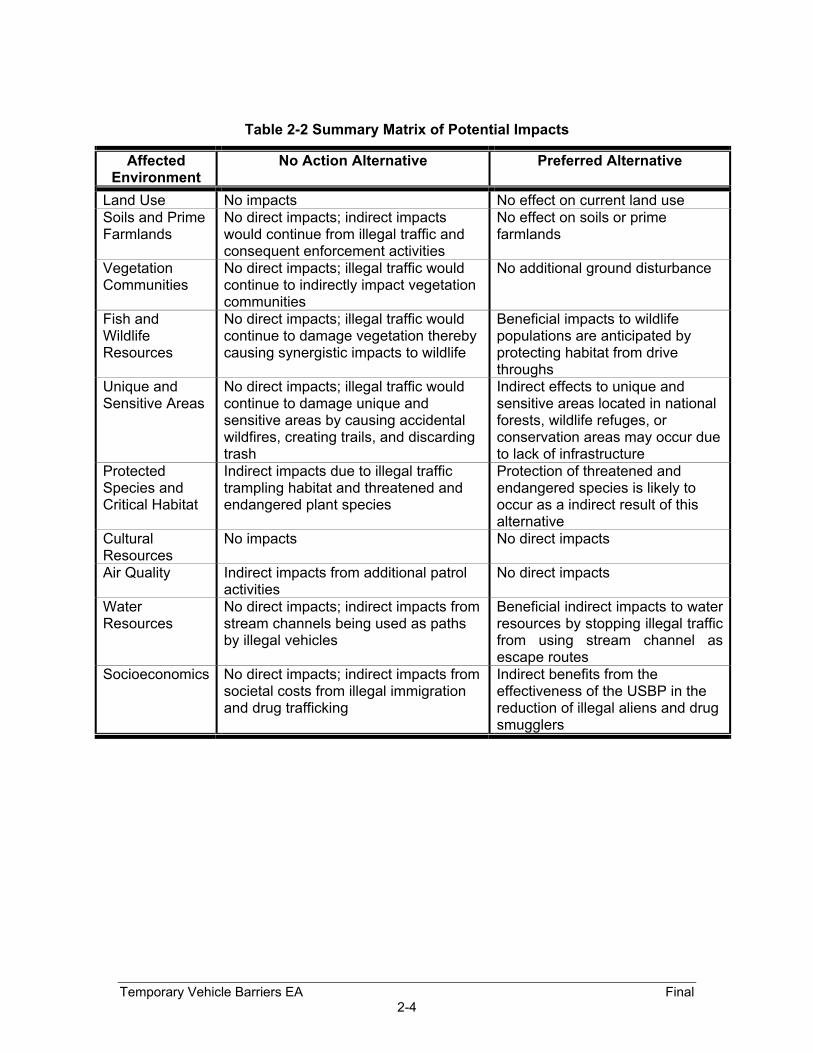
Table 2-2 Summary Matrix of Potential Impacts
Affected Environment
No Action Alternative Preferred Alternative
Land Use No impacts No effect on current land use Soils and Prime Farmlands
No direct impacts; indirect impacts would continue from illegal traffic and consequent enforcement activities
No effect on soils or prime farmlands
Vegetation Communities
No direct impacts; illegal traffic would continue to indirectly impact vegetation communities
No additional ground disturbance
Fish and Wildlife Resources
No direct impacts; illegal traffic would continue to damage vegetation thereby causing synergistic impacts to wildlife
Beneficial impacts to wildlife populations are anticipated by protecting habitat from drive throughs
Unique and Sensitive Areas
No direct impacts; illegal traffic would continue to damage unique and sensitive areas by causing accidental wildfires, creating trails, and discarding trash
Indirect effects to unique and sensitive areas located in national forests, wildlife refuges, or conservation areas may occur due to lack of infrastructure
Protected Species and Critical Habitat
Indirect impacts due to illegal traffic trampling habitat and threatened and endangered plant species
Protection of threatened and endangered species is likely to occur as a indirect result of this alternative
Cultural Resources
No impacts No direct impacts
Air Quality Indirect impacts from additional patrol activities
No direct impacts
Water Resources
No direct impacts; indirect impacts from stream channels being used as paths by illegal vehicles
Beneficial indirect impacts to water resources by stopping illegal traffic from using stream channel as escape routes
Socioeconomics No direct impacts; indirect impacts from societal costs from illegal immigration and drug trafficking
Indirect benefits from the effectiveness of the USBP in the reduction of illegal aliens and drug smugglers
Temporary Vehicle Barriers EA Final 2-4

SECTION 3.0AFFECTED ENVIRONMENT

3.0 AFFECTED ENVIRONMENT Discussions in this section will be limited to only those resources that may be potentially
affected with the installation of the temporary vehicle barriers by the USBP. Therefore,
discussions of resources such as geology, utilities, and climate are omitted. Additional
details concerning the resources and existing conditions of the environment along the
project region were presented in the EA completed for U.S. Border Patrol’s infrastructure
along the Naco-Douglas corridor in Cochise County, Arizona (INS 2000a) and the Final
Supplemental Programmatic Environmental Impact Statement for INS and Joint Task
Force Six (JTF-6) U.S./Mexican Border (INS 2001b), which is incorporated herein by
reference.
3.1 Land Use The total area of Cochise County is 6,169 square miles and the 2001 census estimated
the population to be 119,281 with a population density of 19.33 per square mile (U.S.
Census Bureau 2002). The largest land use in the entire county is in the private and
corporate ownership category (42%). The principal land use outside the urban areas is
rangeland and agriculture (cotton, alfalfa, barley, corn, and vegetables). The Federal
government controls approximately 841,000 acres of the county, with the majority of the
land being in the multiple-use Coronado National Forest. The U.S. Fish and Wildlife
Service (USFWS) manages the San Bernardino NWR, the BLM controls approximately
350,000 acres, which includes the Chiricahua National Monument, San Pedro Riparian
NCA, and numerous multiple use areas, primarily for grazing. The State of Arizona
controls approximately 1,368,000 acres (34%), which is primarily used for recreation,
historical, and natural areas. All of the above mentioned land uses are found along the
project corridor.
3.2 Soils And Prime Farmland
3.2.1 Soils Associations Arizona has a diverse assortment of soil types throughout the state, with variations in
depth, texture, chemical properties, and appropriate land uses. This diversity is directly
related to regional differences in climate, parent material, topography, and erosion
Temporary Vehicle Barriers EA Final 3-1

actions. The predominant soil associations found within the Naco corridor are Casto-
Martinez-Canelo Association, Lithic Haplustolls-Lithic Argiustolls-Rock Outcrop
Association, Lithic Torriorthents-Lithic Argiustolls-Rock Outcrop Association, Nickel-
Latene-Pinaleno Association, Tubac-Sonoita-Grabe Association, White House-
Bernardino-Hathaway Association. The Bonita-Graham-Rimrock, Karro-Gothard, Lithic
Torriorthents-Lithic Haplustolls-Rock Outcrop, Nickel-Laten-Cave, and Tubac-Grabe soil
associations dominate the Douglas corridor. More detailed information regarding the
soils in the project region is contained in previous environmental documents (INS 2000A
and INS 2001b) and is incorporated herein by reference.
3.2.2 Hydric Soils
There are no soils classified as hydric located within the study area (INS 2000A).
3.2.3 Prime and Unique Farmlands
A memorandum dated August 11, 1980 from the Council on Environmental Quality
requires federal agencies to assess the effects of their actions on lands classified by the
U.S. Natural Resources Conservation Service (NRCS) as prime and unique farmlands.
Prime farmland is defined as land best suited for producing food, feed, forage, fiber, and
oilseed crops, and also available for these uses. These soils have favorable growing
seasons and receive sufficient quantities of moisture to produce high yields 8 out of
every 10 years. Unique farmland is land other than prime farmland that is used for the
production of specific high value food and fiber crops.
3.3 Vegetation The Apachian biotic province runs west from the New Mexico-Arizona state line through
a large portion of Cochise County (Dice 1943). The province covers the grassy high
plains and mountains of southeastern Arizona and consists of plant species adapted to
semiarid conditions. There are four major vegetation communities (i.e., forest, woodland,
grassland, and desert scrub) in Cochise County (Brown 1994; Brown and Lowe 1983).
The project area is contained within the semi-desert grassland and desert scrub
designation.
Temporary Vehicle Barriers EA Final 3-2

The semi-desert grassland is found in the valley areas of Cochise County. This
vegetation type is dominated by grama grasses (Bouteloua spp.), velvet mesquite
(Prosopis velutinea), Lehmann’s lovegrass (Eragrostis lehmanniana), and Arizona
cottontop (Digitaria californica). Desert scrub vegetation is the most prevalent vegetation
type found in the project area. Vegetation associated with the desert scrub in this area
are: creosote-bush (Larrea tridentata), acacia (Acacia constricta), tarbush (Flourensia
cernua), sage (Salvia spp.), and mesquite (Prosopis spp). More detailed information on
vegetation in the project area can be found in previous environmental documents (INS
2000A and INS 2001b) and is incorporated herein by reference.
3.4 Wildlife Communities
The native fauna of southeastern Arizona, which encompass Cochise County, include
approximately 370 species of birds that have been observed in this region. The bird
population is dominated by sparrows and towhees (35 species); wood warblers (32
species); swans, geese, and ducks (31 species); tyrant flycatchers (30 species); and
sandpipers and phalaropes (26 species). The majority of these bird species occur in
spring and fall when neotropical migrants (e.g., flycatchers and warblers) pass through
on their way to summer breeding or wintering grounds in South America, and in the
winter when summer resident birds (i.e., robins, kinglets, and sparrows) from the
northern U.S. arrive to spend the winter here. The majority of the 109 mammalian
species found in the area are bats and rodents (i.e., mice, rats, and squirrels) with
rodents (e.g., pocket mice and kangaroo rats) being the most commonly encountered
mammals. Of the 23 amphibian species that inhabit southeastern Arizona, spadefoot
toads and true toads are dominant and the most widespread. A total of 72 species of
reptiles can be found in the area with the iguanid lizards and colubrid snakes being the
most prevalent along with whiptails. More information on fauna in the specific project
area can be found in the Final Environmental Assessment for Infrastructure within U.S.
Border Patrol Naco-Douglas Corridor, Cochise County, Arizona (INS 2000A).
3.5 Unique or Sensitive Areas
As a result of the unique and distinguishable changes in altitude, climate, topography,
and latitude, southeastern Arizona is a place where habitats and species come together.
Temporary Vehicle Barriers EA Final 3-3

Cochise County, Arizona has several unique or sensitive areas found near the project
areas that are set aside by both government and private entities for preservation of such
distinctive areas. Riparian areas, scenic canyons, and vast wilderness represent these
unique areas. The Coronado National Forest, Coronado National Memorial, San Pedro
Riparian NCA and San Bernardino NWR, are all located near the project area and will be
described in the following subsections.
3.5.1 Coronado National Forest The Coronado National Forest encompasses 2,475,000 acres in southeastern Arizona
and southwestern New Mexico and is managed by the USDA Forest Service. The
Coronado National Forest is located in 12 broadly spread mountain ranges which
support an eclectic group of wildlife and vegetation. There are eight wildness areas, four
small lakes, and over a thousand miles of trails spread across the Coronado National
Forest.
3.5.2 Coronado National Memorial The Coronado National Memorial, which is operated by the National Park Service, is
located 25 miles west of Bisbee in the southern Huachaca Mountains. The Memorial
preserves a broad variety of plant and animal life native to the southwestern United
States. The natural environment is representative of the Upper Sonoran Zone and the
mountains of southeastern Arizona. The Memorial includes 4,750 acres of oak
woodlands and grasslands in the park. More than 100 different species of butterflies and
birds have been documented here, as well as bobcats and mountain lions.
3.5.3 San Pedro Riparian National Conservation Area Managed by the BLM's Tucson Field Office, the San Pedro Riparian NCA contains over
58,000 acres of public land, between the international border (United States and Mexico)
and St. David, Arizona. The San Pedro River provides critical water to the area, flowing
from Sonora, Mexico, northward between the Huachuca and Mule mountains ranges,
and joins the Gila River 100 miles downstream. The San Pedro's perennial flow,
although sometimes just a trickle, is a rare occurrence in the Southwest. It provides
abundant food, water, and cover near the riparian zone for many wildlife species. The
NCA supports over 350 species of birds, 80+ species of mammals, two native and
several introduced species of fish, and more than 40 species of amphibians and reptiles.
Temporary Vehicle Barriers EA Final 3-4

3.5.4 San Bernardino National Wildlife Refuge Located 17 miles east of Douglas is the 2,309-acre San Bernardino NWR, which is
situated on the U.S./Mexico border and managed by USFWS. San Bernardino NWR is
located in a wide valley, which has an elevation of 3,720 to 3,929 feet msl. The Yaqui
River provides habitat to several federally protected species such as the Yaqui chub
(Gila purpurea), Yaqui topminnow (Poeciliopsis occidentalis sonoriensis), beautiful
shiner (Cyprinella formosa), and Yaqui catfish (Ictalurus pricei). It also supports various
mammals, numerous reptiles, and amphibians, and over 270 species of birds.
3.6 Protected Species and Critical Habitats
The Endangered Species Act (ESA) [16 U.S.C. 1531 et. seq.] of 1973, as amended, was
enacted to provide a program for the preservation of endangered and threatened
species and to provide protection for the ecosystems upon which these species depend
for their survival. All Federal agencies are required to implement protection programs for
designated species and to use their authorities to further the purposes of the Act.
Responsibility for the identification of a threatened or endangered species and
development of any potential recovery plan lies with the Secretary of the Interior and the
Secretary of Commerce.
The USFWS is the primary agencies responsible for implementing the ESA. The
USFWS is responsible for birds and terrestrial and freshwater species. The USFWS
responsibilities under the ESA include: (1) the identification of threatened and
endangered species; (2) the identification of critical habitats for listed species; (3)
implementation of research on, and recovery efforts for, these species; and (4)
consultation with other Federal agencies concerning measures to avoid harm to listed
species.
An endangered species is a species in danger of extinction throughout all or a significant
portion of its range. A threatened species is a species likely to become endangered
within the foreseeable future throughout all or a significant portion of its range. Proposed
species are those that have been formally submitted to Congress for official listing as
threatened or endangered. Species may be considered endangered or threatened when
any of the five following criteria occurs: (1) the current/imminent destruction,
Temporary Vehicle Barriers EA Final 3-5

modification, or curtailment of their habitat or range; (2) overuse of the species for
commercial, recreational, scientific, or educational purposes; (3) disease or predation;
(4) the inadequacy of existing regulatory mechanisms; and (5) other natural or human-
induced factors affect continued existence.
In addition, the USFWS has identified species that are candidates for listing as a result
of identified threats to their continued existence. The candidate (C) designation includes
those species for which the USFWS has sufficient information on hand to support
proposals to list as endangered or threatened under ESA. Nonetheless, proposed rules
have not yet been issued because such actions are precluded at present by other listing
activity.
The ESA also calls for the conservation of what is termed Critical Habitat - the areas of
land, water, and air space that an endangered species needs for survival. Critical habitat
also includes such things as food and water, breeding sites, cover or shelter, and
sufficient habitat area to provide for normal population growth and behavior. One of the
primary threats to many species is the destruction or modification of essential habitat by
uncontrolled land and water development.
3.6.1 Federal The USFS and the BLM both maintain a list of sensitive species located in the National
Forests or on the BLM lands of Arizona. A list of sensitive species is presented in the
Arizona Game and Fish Department (AGFD) letter included in Appendix A of the EA for
Infrastructure within USBP Naco-Douglas Corridor, Cochise County, Arizona (INS
2000A).
A total of 27 species listed by the USFWS as endangered, threatened, proposed
threatened, proposed endangered or candidate species occur within Cochise County,
Arizona (USFWS 2002). Thirteen of these species are listed as endangered, nine as
threatened, one as proposed endangered, one as proposed threatened, and three as
candidate. Information pertaining to federally protected species is included in Table 3-1.
Temporary Vehicle Barriers EA Final 3-6

Table 3-1 Temporary Vehicle Barriers EA
Final
3-7
Federally Listed, Proposed, and Candidate Species Potentially Occurring within Cochise County, Arizona
Common/Scientific Name Federal Status Date Listed
Designated Critical Habitat
Habitat Requirements
AMPHIBIANS
Chiricahua leopard frog Rana chiricahuensis T
6/13/02 67 FR 40789
NA Streams, rivers, backwaters, ponds, and stock tanks
Sonora tiger salamander Ambystoma tigrinum stebbinsi E 1/6/97
62 FR 665 NA Stock tanks and impounded cienegas in San Rafael Valley, Huachuca Mountains
BIRDS
Bald eagle Haliaeetus leucocephalus T 7/12/95
60 FR 35999 NA Large trees or cliffs near water (reservoirs, rivers, and streams) with abundant prey
California Brown pelican Pelecanus occidentalis californicus E 10/16/70
35 FR 16047 NA Coastal land and islands; Arizona lakes and rivers
Cactus ferruginous pygmy-owl Glaucidium brasilianum cactorum E 3/10/97
62 FR 10730 NA Mature cottonwood/willow, mesquite bosques, and sonoran desertscrub
Mexican spotted owl Strix occidentalis lucida T 4/11/91
56 FR 14678 2/1/01
66 FR 8530 Old growth forest associated with steep canyons
Mountain plover Charadrius montanus PT 2/16/99
64 FR 7587 NA Open arid plains, short-grass prairies, and cultivated forms
Northern aplomado falcon Falco femoralis septentrionalis E 1/25/86
51 FR 6686 NA Desert grasslands
Southwestern willow flycatcher Empidonax traillii extimus E 2/27/95
60 FR 10694 7/7/97
62 FR 39129 Dense riparian vegetation
FISHES
Beautiful shiner Cyprinella formosa T 8/31/84
49 FR 34490 8/13/84
49 FR 34490 Deep pools in creeks, scoured areas of cienegas, and other stream-associated quiet waters
Gila chub Gila intermedia PE
8/9/02 67 FR 51947
N/A Pools, springs, cienegas, and streams
Loach minnow Tiaroga cobitis T 10/28/86
51 FR 39468 3/8/94
59 FR 10898 Lower San Pedro River has been designated as critical habitat by USFWS

Common/Scientific Name Federal Status Date Listed
Designated Critical Habitat
Habitat Requirements
Temporary Vehicle Barriers EA
Final
3-8
Spikedace Meda fulgida T 7/1/86
51 FR 23769 2/25/00
65 FR 24327 Lower San Pedro River has been designated as critical habitat by USFWS
Yaqui catfish Ictalurus pricei T 8/31/84
49 FR 34490 8/13/84
49 FR 34490 Moderate to large streams with slow current over sand and rock bottoms
Yaqui chub Gila purpurea E 8/31/84
49 FR 34490 8/13/84
49 FR 34490 Deep pools of small streams, pools, or ponds near undercut banks
Yaqui topminnow Poeciliopsis occidentalis sonoriensis
E 3/11/67 32 FR 4001 NA Streams, springs, and cienegas between 4,000 - 5,000
feet elevation, primarily in shallow areas
INVERTEBRATES
Huachuca springsnail Pyrgulopsis thompsoni C NA NA Aquatic areas, small springs with vegetation slow to
moderate flow MAMMALS
Black-tailed prairie dog Cynomys ludovicianus C NA NA Burrows in plains and grassland habitats
Jaguar Panthera onca E 7/22/97
62 FR 39147 NA Variety of habitats including lowland wet habitats and typically swampy savannas
Lesser long-nosed bat Leptonycteris curasoae yerbabuenae
E 9/30/88 53 FR 38456 NA Desert scrub habitat with columnar cacti and agave
present as food plants
Mexican gray wolf Canis lupus baileyi E 3/11/67
32 FR 4001 NA Chapparal, woodland, and forested areas. May cross desert areas
Ocelot Leopardus pardalis E 7/21/82
47 FR 31670 NA Humid tropical and sub-tropical forests, savannas, and semi-arid thornscrub
PLANTS
Canelo Hills ladies’ tresses Spiranthes delitescens E 1/6/97
62 FR 665 NA Finely grained, highly organic, saturated soils of cienegas
Cochise pincushion cactus Coryphantha robbinsorum T 1/9/86
51 FR 952 NA Semidesert grassland with small shrubs, agave, other cacti, and grama grass
Huachuca water umbel Lilaeopsis schaffneriana ssp. recurva
E 1/6/97 62 FR 665
7/12/99 64 FR 37441 Cienegas, perennial low gradient streams, wetlands
Lemmon fleabane Erigeron lemmonii C NA NA Crevices, ledges, and boulders in canyon bottoms in pine-
oak woodlands

Common/Scientific Name Federal Status Date Listed
Designated Critical Habitat
Habitat Requirements
Temporary Vehicle Barriers EA
Final
3-9
REPTILES
New Mexico ridge-nosed rattlesnake Crotalus willardi obscurus
T 4/4/78 43 FR 34479
8/4/78 43 FR 34476
Presumably canyon bottoms in pine-oak and pin-fir communities
Legend: E = Endangered Sources: USFWS 2002; AGFD 2001 T = Threatened P = Proposed Threatened or Endangered C = Candidate

No evidence of Federally listed threatened or endangered species were found during
biological surveys conducted for this project during April 2002, or during past surveys in
the project area (USACE 1993, 1994a, 1994b, 1996, 2000, and INS 2000a, 2001b).
One ocelot (Leopardus pardalis) sighting was reported in the last two years in Mexico
near Douglas, Arizona. The AGFD has photographed (January 2002) the protected
jaguar (Panthera onca) in southwest Arizona. This jaguar is the first photographed in six
years in North America and was sighted near Nogales approximately 60 miles west of
Naco. Until the January photograph, the last confirmed sighting of the jaguar was in
1996 near the Baboquivari Mountains, approximately 100 miles to the west of the project
area in Pima County, Arizona. According to the AGFD there were no recorded sightings
of jaguarundi (Herpailurus yagouaroundi) in or near the project area in recent years
(AGFD 2001a).
The range of the lesser long-nosed bat (Leptonycteris curasoae yerbabuenae) is from
“southern Arizona and extreme southwestern New Mexico, through western Mexico, and
south to El Salvador” (Bat Conservation International 2001, University of Arizona 2001).
The occurrences in southern Arizona range from “the Picacho Mountains southwest to
the Agu Dulce Mountains, southeast to the Chiricahua Mountains” (University of Arizona
2001). Although the lesser long-nosed bat is out of the range of the project area, their
habitats, roosting areas, and feeding areas were evaluated. Assessments during field
surveys performed in 2001 and 2002 were based on the presence of the columnar cacti,
which are a preferred food source, and appropriate roosting and breeding sites, caves,
and mines (Bat Conservation International 2001, University of Arizona 2001). No such
cacti or roosting and breeding sites were observed in or near the project corridor during
the surveys.
3.6.2 Critical Habitat Critical habitat has been designated in the San Pedro Riparian NCA for the spikedace
and the loach minnow. With this in mind, no vehicle barriers would be positioned inside
the NCA. Therefore, no critical habitat is present within the project corridor.
Temporary Vehicle Barriers EA Final 3-10

3.6.3 State The AGFD maintains lists of Wildlife of Special Concern (WC). This list includes species
whose occurrence in Arizona is or may be in jeopardy, or with known or perceived
threats or population declines (AGFD 2001b). These species are not necessarily the
same as those protected by the Federal government under the ESA. There was no
evidence of or observations of any AGFD-listed species during April 2002 site visits.
The Arizona Department of Agriculture maintains a list of protected plant species within
Arizona. The Arizona Native Plant Law (1993) defined five categories of protection within
the state. These include: Highly Safeguarded, no collection allowed; Salvage Restricted,
collection only with permit; Export Restricted, transport out of state prohibited; Salvage
Assessed, permit required to remove live trees; and Harvest Restricted, permits required
to remove plant by-products. Information pertaining to state protected species potentially
occurring in Cochise County is presented in the AGFD letter included in Appendix B of
this EA.
3.7 Cultural Resources The cultural resources within the study area are extensive and diverse. Numerous
terrestrial investigations have been performed north of the U.S./Mexico border in the
project corridor. These investigations and their results are discussed in detail in the EA
completed for USBP’s infrastructure along the Naco-Douglas corridor in Cochise County,
Arizona (INS 2000a) and in the Supplemental Programmatic Environmental Impact
Statement for INS and JTF-6 Activities, U.S./Mexican border (INS 2001b), and are
incorporated herein by reference. Furthermore, Aztlan recently conducted surveys along
the entire Naco-Douglas corridor to relocate and re-evaluate sites that were previously
identified. No known sites that are considered potentially eligible for inclusion to the
National Register of Historic Places (NRHP) have been found within the footprint of this
project (INS 2001a). Additionally, the Arizona State Historic Preservation Office (SHPO)
concurred with INS that there would be no potential to effect historic properties with the
execution of this project, since there would not be any ground disturbance (see
Appendix B).
Temporary Vehicle Barriers EA Final 3-11
3.8 Air Quality
The State of Arizona has adopted the National Ambient Air Quality Standards (NAAQS)
(40 CFR Part 50) as the state’s air quality criteria (Table 3-2). Primary standards are
established to protect public health while secondary standards provide protection for the
public's welfare including wildlife, climate, recreation, transportation, and economic
values. States are required to adopt ambient air quality standards that are at least as
stringent as the Federal NAAQS; however, the state standards may be more stringent.
Cochise County is considered in attainment for all Federal NAAQS except for Douglas
and Paul Spur. The Clean Air Act requires that for areas designated “non-attainment,”
plans must be prepared and implemented to bring the area into attainment within a
specified time. More detailed information on air quality in the project area can be found
in the EA completed for U.S. Border Patrol’s infrastructure along the Naco-Douglas
corridor in Cochise County, Arizona (INS 2000A) and the Supplemental Programmatic
Environmental Impact Statement for INS and JTF-6 Activities, U.S./Mexico Border (INS
2001b) and is incorporated herein by reference.
3.9 Water Resources The project area receives water from surface runoff and groundwater via precipitation
and snowmelt in the local mountains. Geologic forces have created a regional terrain
that includes arroyos or washes (deep gullies), steep canyons, and somewhat flat
basins. Due to the arid climate of the area, most of the drainage channels are dry most
of the year. Rivers and streams that flow periodically due to fluctuations in precipitation
are referred to as being ephemeral or intermittent waterways. Due to the flash flood
tendency of the washes, sediment loads are high when water is present. Natural and
human-induced factors determine the quality of these resources. Numerous small
ephemeral drainages transect the project corridor.
The major surface water drainages near the project corridor are Black Draw, Greenbush
Draw, Whitewater Draw, and the San Pedro River. With the exception of the San Pedro
River, temporary vehicle barriers may be positioned in these streams. Again, no
vegetation or soil would be disturbed during the placement of the barriers.
Temporary Vehicle Barriers EA Final 3-12

Table 3-2: National Ambient Air Quality Standards
Pollutant Standard Value Standard Type Carbon Monoxide (CO) 8-hour average 9ppm (10mg/m3)** Primary 1-hour average 35ppm (40mg/m3)** Primary Nitrogen Dioxide (NO2) Annual arithmetic mean 0.053ppm (100µ/m3)** Primary and SecondaryOzone (O3) 1-hour average* 0.12ppm (235µg/m3)** Primary and Secondary 8-hour average* 0.08ppm (157µg/m3)** Primary and SecondaryLead (Pb) Quarterly average 1.5µg/m3 Primary and SecondaryParticulate<10 micrometers (PM-10) Annual arithmetic mean 50µg/m3 Primary and Secondary 24-hour average 150µg/m3 Primary and SecondaryParticulate<2.5 micrometers (PM-2.5) Annual arithmetic mean 15µg/m3 Primary and Secondary 24-hour Average 65µg/m3 Primary and SecondarySulfur Dioxide (SO2) Annual arithmetic mean 0.03ppm (80µg/m3)** Primary 24-hour average 0.14ppm (365µg/m3)** Primary 3-hour average 0.50ppm
(1300µg/m3)** Secondary
Source: USEPA 1995. Legend: ppm = parts per million mg/m3 = milligrams per cubic meter of air µg/m3 = micrograms per cubic meter of air *The ozone 1-hour standard applies only to areas that were designated non-attainment when the ozone 8-hour standard was adopted in July 1997. **Parenthetical value is an approximate equivalent concentration.
More information on surface and groundwater resources within the Naco and Douglas
area is described in detail in the EA for Infrastructure within USBP Naco-Douglas
Corridor, Cochise County, Arizona (INS 2000A) and the Supplemental Programmatic
Environmental Impact Statement for INS and JTF-6 Activities, U.S./Mexico Border (INS
2001b). The information contained in these two documents is incorporated herein by
reference.
Temporary Vehicle Barriers EA Final 3-13
3.9.1 Waters of the U.S. and Wetlands Section 404 of the Clean Water Act (CWA) of 1977 (P.L. 95-217) authorizes the
Secretary of the Army, acting through the Chief of Engineers, to issue permits for the
discharge of dredged or fill material into waters of the United States, including wetlands.
Deepwater aquatic habitats are “areas that are permanently inundated at mean annual
water depths greater than 6.6 feet, or permanently inundated areas less than or equal to
6.6 feet in depth that do not support rooted-emergent or woody plant species” (USACE
1987). Any area that meets these criteria is commonly classified as “Other Waters of the
United States.” Waters of the United States are further defined as all other waters such
as intrastate lakes, rivers, streams, mudflats, sand flats, wetlands, sloughs, prairie
potholes, wet meadows, playa lakes, natural ponds, or impoundments of waters,
tributaries of waters, and territorial seas. Jurisdictional boundaries for these water
resources are defined in the field by the Ordinary High Water Mark (OHWM) which is
that line on the shore established by the fluctuations of water and indicated by physical
characteristics such as clear, natural lines impressed on the bank, shelving, changes in
the character of soil, destruction of terrestrial vegetation, the presence of litter and
debris, or other appropriate means that consider the characteristics of the surrounding
areas.
Jurisdictional wetlands are defined as “areas that are inundated or saturated at a
frequency and duration sufficient to support, and that under normal circumstances do
support, a prevalence of vegetation typically adapted for life in saturated soil conditions”
(40 CFR 230.3). Three mandatory technical criteria for determining the presence of a
wetland are (1) hydric soils, (2) hydrophytic vegetation, and (3) wetland hydrology.
Jurisdictional wetlands as outlined by the USACE (1987) are referred to as “wetlands”
throughout this section.
Activities that result in the dredging and/or filling of jurisdictional Waters of the U.S.
including wetlands are regulated under Section 404 of the CWA. The USACE has
established Nationwide Permits (NWPs) to efficiently authorize common activities, which
do not significantly impact Waters of the U.S. The NWPs were modified and reissued by
the USACE in the Federal Register on 15 January 2002, with an effective date of 18
Temporary Vehicle Barriers EA Final 3-14

March 2002. All NWPs have an expiration date of 19 March 2007. The USACE has the
responsibility to authorize permitting under a NWP, or to require an Individual Permit.
The Supreme Court ruling in the Solid Waste Agency of Northern Cook County
(SWANCC) v. U.S. Army Corps of Engineers case (“SWANCC”, Case No. 99-1178) on
January 9, 2001 restricted the Environmental Protection Agency (EPA) and USACE’s
regulatory authority under Section 404 (a) of the CWA based on the migratory bird rule
(USACE 2002). Historically, the USACE exercised jurisdiction over waters (Waters of the
U.S.) that are or may be used as habitat by migratory birds are and example of water
whose, use, degradation or destruction could affect interstate or foreign commerce and
should be afforded Section 404 (a) protection. In the SWANCC case, the U.S. Supreme
Court concluded that the use of the Migratory Bird Rule (51 FR 41217 [1986]) to assert
jurisdiction over isolated, non-navigable, and interstate waters exceeds the authority
granted by Congress under the CWA. This ruling eliminates the CWA jurisdiction over
isolated, non-navigable, and intrastate waters used as habitat by migratory birds. The
court's ruling is strictly limited to only waters that are "non-navigable, isolated, and
intrastate." All other waters should continue to be regulated. By this, the USACE
qualified the impact of the court's decision by requiring that a water body have all three
characteristics for it to escape jurisdiction. However, isolated, interstate, and non-
navigable waters is possible if their use, degradation, or destruction could affect other
Waters of the U.S., thus establishing a nexus between the waters in question and other
Waters of the U.S.
Based on this, the following types of waters are not affected by the SWANCC decision: all
waters which are currently used, or were used in the past, or maybe susceptible to use, in
interstate or foreign commerce, including tidal waters, interstate waters, including
interstate wetlands, impoundments of waters otherwise defined as Waters of the U.S.,
including all tributaries to navigable waters, territorial seas, and wetlands adjacent
(bordering, contiguous, or neighboring) to other Waters of the U.S.; wetlands separated
from other Waters of the U.S. by man-made dikes or barriers, natural river berms, beach
dunes, and the like are still “adjacent”. The SWANCC ruling will apply to the entire United
States and will be enforced by the USACE along with the Environmental Protection
Agency (EPA).
Temporary Vehicle Barriers EA Final 3-15

Jurisdiction of waters under SWANCC should be analyzed on a case-by-case basis, by
the affected USACE district. The Los Angels District, USACE, Phoenix Field office, is the
regulatory agency for this region. Whitewater Draw, Greenbush Draw, and Black Draw
as well as the numerous other ephemeral streams identified in the project corridor may
be classified as jurisdictional Waters of the United States.
3.10 Socioeconomics The 2001 census estimated the population of Cochise County to be 119,281 with Naco’s
population making up approximately 833 of that number (U.S. Census Bureau 2002).
The four major communities near the study area are Huachuca City, Bisbee, Douglas,
and Sierra Vista.
More detailed information, which is incorporated herein by reference, can be found in the
EA for Infrastructure within USBP Naco-Douglas Corridor, Cochise County, Arizona (INS
2000A) and the Supplemental Programmatic Environmental Impact Statement for INS
and JTF-6 Activities, U.S./Mexican border (INS 2001b).
3.11 Noise The three common classifications of noise are: (1) general audible noise that is heard by
humans; (2) special noise, such as sonic booms and artillery blasts that can have a
sound pressure of shock component; and (3) noise-induced vibration also typically
caused by sonic booms and artillery blasts involving noise levels that can cause physical
movement (i.e., vibration) and even possible damage to natural and man-made
structures such as buildings and cultural resource structures. Most noise sources will fall
within the audible noise classification because of the rural nature of the majority of the
study area.
Audible noise typically is measured in A-weighted sound pressure levels expressed in
decibels (dBA). The A-scale de-emphasizes the low and high frequency portions of the
sound spectrum and provides a good approximation of the response of the average
human ear. On the A-scale, zero dBA represents the average least perceptible sound
Temporary Vehicle Barriers EA Final 3-16

(gentle breathing) and 140 dBA represents the intensity at which the eardrum may
rupture (jet engine at open throttle) (National Research Council 1977).
Normal rural noise levels in the study area would range from a low of 35 (dBA) over the
majority of the corridor to a high of about 60 dBA near rural communities. However,
higher ambient noise levels occur in the more developed areas of Douglas, particularly
near the POE. More detailed information on noise in the project area can be found in
previous environmental documents (INS 2000A and INS 2001b) and is incorporated
herein by reference.
Temporary Vehicle Barriers EA Final 3-17

SECTION 4.0ENVIRONMENTAL CONSEQUENCES

4.0 ENVIRONMENTAL CONSEQUENCES This section of the EA addresses potential impacts to the human and natural
environment within the Naco and Douglas AO for the No Action and Preferred
Alternatives outlined in Section 2.0.
4.1 Land Use
4.1.1 No Action Alternative Implementation of the No Action Alternative would not affect current land use along the
border road. The surrounding lands would continue to be used as open rangeland.
USBP enforcement actions to detect and apprehend illegal immigrants and smugglers
would also continue.
4.1.2 Preferred Alternative No changes in land use along the project corridor would occur from implementing this
alternative. The area surrounding the project corridor is currently used mostly as open
rangeland and would continue to be used as such.
4.2 Soils And Prime Farmland
4.2.1 No Action Alternative Implementation of the No Action Alternative would have no direct disturbances to soils.
Extant erosion problems would continue, since illegal drive throughs would continue to
occur, exacerbating erosion. Soils found in the Naco and Douglas areas have medium to
high erosion hazards, depending on slope.
Implementation of the No Action Alternative would have no effect on prime farmland in
the study area because there are no prime farmlands present.
4.2.2 Preferred Alternative
Under this alternative, no ground disturbance is expected during the placement of the
temporary vehicle barriers. Additionally, there is no unique farmland at the sites where
Temporary Vehicle Barriers EA Final 4-1

construction will occur. Therefore, this impact topic has been dismissed from further
consideration.
4.3 Vegetation
4.3.1 No Action Alternative Implementation of the No Action Alternative would continue to cause impacts to
vegetation as a result of illegal vehicle entrants.
4.3.2 Preferred Alternative The Preferred Alternative would include the placement of temporary vehicle barriers in
various locations along the Naco and Douglas border region, which have been
previously disturbed. As a result, the placement of the temporary vehicle barriers would
produce no additional direct impacts to vegetation and should substantially reduce
secondary impacts to vegetation due to illegal entry at these locations. Indirect effects
have occurred to vegetation by illegal entrants diverting around existing fences and
barriers or away from areas that are routinely patrolled. Improvements in the
infrastructure and increases in patrol activities have resulted in some illegal entrants
redirecting their efforts into other more remote areas. The rugged mountains areas that
are located in and around the Naco and Douglas AOs would not be expected to
experience a substantial increase in illegal vehicle traffic since these areas are not
readily accessible by vehicle.
During the survey performed in April 2002, several soap tree yucca (Yucca elata) where
identified outside of the project corridor. This species is not included in the highly
safeguarded category of protected native plants of Arizona, but is listed as salvage
restricted protected native plant (USACE 2001a). Plant species protected under the
Arizona Native Plant Law, such as the soap tree yucca, are not located in the corridor
where temporary vehicle barriers would be placed. Temporary vehicle barriers would be
placed in highly disturbed areas along the edge of border patrol roads where vegetation
is mostly lacking.
Temporary Vehicle Barriers EA Final 4-2

4.4 Wildlife
4.4.1 No Action Alternative The No Action Alternative would not allow the placement of the temporary vehicle
barriers. Thus, vehicle entry would persist, creating new paths of travel in order to avoid
USBP detection, which would continue to interrupt and damage wildlife habitat and
communities.
4.4.2 Preferred Alternative No additional direct impacts to wildlife resources are expected as a result of installing the
vehicle barriers since no wildlife habitat would be altered. Temporary vehicle barriers
would not be placed in any of the wildlife refuges, national monuments, or other sensitive
areas. Vehicle barriers would not hinder wildlife movements due to construction design
of these structures, which allow for animals to move freely, under or over the structures.
Additionally, wildlife communities and their habitat would be spared from constant
disturbance resulting from continuous illegal vehicle traffic in these isolated areas.
However, it is likely that other regions of the U.S./Mexico border would be targeted as
new illegal entry sites due to the lack of physical barriers.
4.5 Unique or Sensitive Areas
4.5.1 No Action Alternative The No Action Alternative would not allow the placement of the temporary vehicle
barriers. Illegal entry would continue to seek out new passages in order to avoid USBP
detection. Inevitably, unique or sensitive areas may be damaged as an indirect effect of
persistent illegal aliens and drug smuggler searching out new routes to avoid detection
and apprehension.
4.5.2 Preferred Alternative Temporary vehicle barriers would not be placed in areas classified as unique or sensitive
within the proposed project corridor. Because many of these unique and sensitive areas
are located in national forests, wildlife refuges or conservation areas, physical barriers
are not present to deter and prevent entry; as a result, an increase in illegal vehicle
traffic may occur in areas lacking temporary vehicle barriers which would cause indirect
Temporary Vehicle Barriers EA Final 4-3

impacts to unique and sensitive areas. However, it is more likely that with the temporary
vehicle barriers situated in known hotspots, USBP agents would have the flexibility to
concentrate more of their patrol efforts on areas absent of barriers, which in turn would
provide greater protection to natural resources.
4.6 Protected Species and Critical Habitats
4.6.1 No Action Alternative The No Action Alternative would have no direct effects on protected species or critical
habitats. However, increased and continued illegal traffic and the consequent
enforcement activities could have detrimental indirect effects to protected species and
critical habitats.
4.6.2 Preferred Alternative No threatened or endangered species were observed within the project area during the
biological surveys or reconnaissance survey performed in April 2002 or during past
surveys in the project area (USACE 1996, 1998a, 1998b, and INS 1998, 2001b). As
summarized in Section 3.6 of this document, no such species have been documented in
previous EAs for various projects within the Douglas and Naco areas. Furthermore, no
critical habitat designations would be disturbed since these areas would be avoided.
Therefore, no direct impacts to threatened or endangered species would be expected
upon implementation of the Preferred Alternative.
4.7 Cultural Resources
4.7.1 No Action Alternative The No Action Alternative would not result in any direct effects to cultural resources.
However, the magnitude of off-road effects to cultural resources from illegal vehicle entry
would vary depending upon the number of illegal vehicle entries and off-road pursuits in
the areas cultural resources are located. By implementing the No Action Alternative,
agents would continue to lack the deterrence factor of physical barriers to discourage
illegal vehicle entry into the U.S., thereby increasing the potential to damage known and
unrecorded cultural resource sites.
Temporary Vehicle Barriers EA Final 4-4

4.7.2 Preferred Alternative Placement of temporary vehicle barriers would not affect any cultural resource sites,
since there will be no ground disturbing activities. Less illegal traffic, as a result of the
placement of vehicle barriers would cause fewer off-road impacts to cultural resources.
Indirect beneficial effects would occur by reducing the number of illegal vehicle entries
and off-road pursuits by USBP agent, thereby protecting cultural resources in the
surrounding areas. Conversely, new routes may be sought in an effort to continue drug
smuggling operations; therefore, there is the slight potential to disturb areas that may
have intact cultural resources. Included in Appendix B is a letter received from the
Arizona SHPO stating that they concurred with INS that there is no potential for this
project to affect historical sites.
4.8 Air Quality 4.8.1 No Action Alternative The No Action Alternative would eliminate any additional emission sources associated
with the proposed project. Indirect impacts to air quality due to fugitive dust particles
created by illegal vehicular entry and off-road pursuits by USBP agents would continue
to occur with the No Action Alternative.
4.8.2 Preferred Alternative Air quality impacts from construction and maintenance activities of barriers include
emissions caused by fuel combustion of engines and fugitive dust from traveling to areas
where barriers would be placed. Particulate concentrations would be expected to be
below de minimis thresholds due to the short duration of the construction activities and
no ground disturbances. The Preferred Alternative would not violate national standards.
An air conformity analysis is not required for this project.
4.9 Water Resources 4.9.1 No Action Alternative No impacts to water resources would be expected upon implementation of this
alternative. Increased sediments in streams, arroyos, and water resources as an indirect
Temporary Vehicle Barriers EA Final 4-5

effects of runoff caused by illegal vehicle use of these natural water courses would
continue under the No Action Alternative.
4.9.2 Preferred Alternative The Preferred Alternative would not impact any water resource sites with the installation
of the temporary vehicle barriers. Barriers may be placed in arroyos, washes, draws,
etc., in order to prevent illegal vehicle entry. However, temporary vehicle barriers will not
be installed in the San Pedro River since it is in the San Pedro Riparian NCA. The
placement of temporary vehicle barriers in these stream channels are not considered fill
material and would not require a permit for this alternative (Dummer 2002). The
Preferred Alternative would substantially hinder or preclude use of these corridors as a
means of illegal entry and reduce erosion associated with drive throughs, thus protecting
water resources.
4.10 Socioeconomics 4.10.1 No-Action Alternative Socioeconomic conditions in the area would remain the same as they are now for the No
Action Alternative. The lack of vehicle barriers along areas in this region would allow
more vehicle entry and drug smugglers access to cross the U.S./Mexico border. Overall,
the No Action Alternative would not be expected to be beneficial for the Douglas and
Naco areas.
4.10.2 Preferred Alternative The Preferred Alternative would utilize USBP maintenance staff, JTF-6 personnel,
National Guard units, or private contractors to complete the mission; therefore, no
effects on population, personal income, or housing would occur unless private
contractors were used. In this event, a temporary increase in personal income may
occur. Materials and other project expenditures would also be obtained from outside the
region, providing little or no temporary direct economic benefits. No displacement is
predicted to result from this action; therefore, there would be no direct impacts to housing
in the area.
Temporary Vehicle Barriers EA Final 4-6

Some indirect, beneficial impacts would occur as a result of the operation of the system. A
reduction in illegal drug and alien traffic would have synergistic socioeconomic benefits
associated with insurance costs, property losses, law enforcement expenses, and other
social costs (i.e., drug rehabilitation, medical expenses, and labor opportunities).
4.10.3 Environmental Justice Executive Order 12898 of February 11, 1994, “Federal Actions to Address
Environmental Justice in Minority Populations and Low-Income Populations” required
each Federal agency to identify and address, as appropriate, disproportionate adverse
effects of its proposed actions on minority populations and low-income communities.
The racial mix of Cochise County is about 90% Caucasian, and less than half (34%) of
the entire county population claim to be of Hispanic origin. The proposed project would
not displace residences or commercial structures along the project corridor. Therefore,
disproportionate effects to minority populations would not be expected.
Cochise County has about 21% of its total population living at or below poverty levels.
The 1997 per capita personal income was estimated to be about $17,000, which
indicated a 28% increase since 1990. Consequently, no disproportionate adverse effects
to low-income populations would be expected from the implementation of either of the
alternatives.
On the other hand, implementation of the Preferred Alternative would enhance the
probability of success for the INS/USBP. This increased success in controlling illegal
drug activity and the increasing flow of UDAs and drug smugglers into the Naco and
Douglas area would benefit all populations, regardless of income, nationality, or
ethnicity. Long-term positive impacts would occur on local, regional, and national levels
by the reduction of illegal immigrants and drug trafficking and the associated social
costs.
Temporary Vehicle Barriers EA Final 4-7

4.11 Noise Effects 4.11.1 No Action Alternative Implementation of the No Action Alternative would result in no increases in ambient
noise levels.
4.11.2 Preferred Alternative If this alternative were selected, activities would occur to the east and west of Naco and
Douglas, Arizona, in remote areas of these AOs. Equipment, such as trucks and forklifts,
would cause temporary increases in noise levels near the installation site. Installation of
these vehicle barriers is not expected to affect any sensitive receptors (e.g. schools,
hospitals, churches, and residences), since the installation sites would be remote to any
developed areas. Based on past similar activities, construction of the vehicle barriers
would occur at the USBP stations and then transported to areas as needed, thus
reducing the Day-Night average noise levels (DNLs) and the chances of causing
annoyances.
Wildlife may at first be startled and flee the installation area; however, this would cause
no long-term effects to wildlife species. Ambient noise levels would return as soon as
each temporary vehicle barrier is placed, with no long-term, significant adverse impacts.
4.12 Cumulative Impacts This section of the EA addresses the cumulative impacts associated with the proposed
road and drainage improvements project and other projects/programs that are planned
for the region. In the following paragraphs is a general discussion regarding cumulative
effects that would be expected irrespective of the alternative selected, the various
resources that would be impacted are addressed within each alternative discussion. In
order to evaluate cumulative effects, documents from current, past, and future
operations in the region are evaluated below (INS 1998, 2000a, 2000b, 2001b; USACE
1996, 1998a, 1998b, 2000).
Temporary Vehicle Barriers EA Final 4-8

Current Projects The USBP and other entities are currently conducting projects in the region. A few of the
on-going projects in the area include:
• A new USBP complex is currently being constructed along the King’s Ranch Road near Douglas, Arizona.
• The USBP Naco and Douglas Station is installing remote video surveillance (RVS) systems and placing portable lighting in the area.
• The Douglas Station is in the process of constructing a low water crossing at Whitewater Draw.
• Performing 1.5 miles of road improvements from Whitewater Draw to Cattleman’s Road in Douglas.
• The Naco Station is completing 2 miles of vertical extensions on the extant primary fence.
• The Wilcox USBP Station is in the process of acquiring land to build a new station.
• Constructing 2 miles of new north/south access roads west of the Douglas POE.
Past Projects Sections of the border road near the proposed project have already been improved. Past
projects in the area included:
• Improving 25 miles of border east and west of the Douglas POE. • Establishing 1 mile of border fence on the west side of the Douglas POE. • Installing 3 miles of stadium style lights, east and west of the Douglas POE. • Errecting1.3 miles of decorative fence, east and west of the Douglas POE. • Placement of 99 portable generator lights in the Douglas AO. • The Douglas Station installed portable generator lights along a 25-mile corridor
east and west of Douglas POE. • The Douglas Station implemented the use of 13 RVS stations. • Installation of two miles of stadium-style lights in Naco corridor. • Construction of 6.5 miles of landing mat and picket style fence east and west of
Douglas POE. • The Naco Station erected 2 miles of fencing. • Establishing 2.5 miles of vehicle barriers in Naco corridor. • The Naco Station installed 2 miles of lighting. • The Douglas Station constructed 4.5 miles of all weather road. • The Douglas Station installed 3 miles of lighting. • Implementing 8 RVS stations in the Naco corridor. • The Naco Station performed 1.5 miles of fence extensions.
Temporary Vehicle Barriers EA Final 4-9

An analysis of each component of the affected environment was completed from the
existing EAs in order to identify which actions would have cumulative impacts as a result
of the past and proposed operations. Additional information was considered, including
real estate ownership, growth rates, and known future projects in the area. No long-term
significant impacts have been reported from past analysis of these projects.
Positive cumulative benefits have resulted from past INS activities. Improvements to
roads and the installation of other detection/deterrence methods have increased the
USBP’s apprehension and interdiction rates. Improvements to and the installation of
drainage structures may increase downstream water quality. Additional knowledge
regarding cultural resources and protected species’ locations, and distributions have
been obtained through numerous surveys and monitoring efforts associated with INS
projects. Erosion has been alleviated along some roads, and fences have precluded
illegal foot and vehicular traffic through environmentally sensitive areas.
Future Projects Known future projects from INS and USBP in the project area include:
• The Douglas station plans to erect 4 miles of landing mat fence west of the POE. • Construction of 3.5 miles of landing mat fence east of the Douglas POE. • Operation of 4 miles of stadium lights on the east and west sides of the Douglas
POE. • Drainage improvements along the border road, east of Whitewater Draw. • Road maintenance and improvements as necessary along the border road in
Douglas and Naco. • Extension of landing mat fence for 1.2 miles in Naco AO. • 10 Remote video surveillance sites in the Naco and Douglas AOs. • 4.0 miles of road improvements in Naco corridor. • Implementation of the Border Infrastructure Reference Document.
Plans by other agencies in the region that would also affect the region’s natural and
human environment include the road improvements by Arizona Department of
Transportation (ADOT) and the addition of a public park near the U.S. Highway 80
bypass near Douglas. Representatives from the San Bernardino NWR, Coronado
National Forest, Coronado National Memorial, and San Pedro Riparian NCA were
contacted about upcoming projects in their parks; none reported any anticipated projects
in the near future (Yarbrough 2002).
Temporary Vehicle Barriers EA Final 4-10

4.12.1 No Action Alternative The No Action Alternative would result in negative indirect impacts to the area. The lack
of physical barriers would continue to be a challenge to USBP due to the easy access
into the U.S., making the border more difficult to control against illegal activities such as
entry and drug trafficking. Erosion, and damage to vegetation, threatened and
endangered species and sensitive wildlife habitats would continue along the Naco and
Douglas AO due to illegal vehicle traffic.
4.12.2 Preferred Alternative There is no essential difference in cumulative adverse effects that would occur under the
Preferred Alternative, as opposed to the No Action Alternative since no ground
disturbances would occur. Furthermore, placement of the barriers would occur within
areas that are already heavily disturbed. Transporting temporary vehicle barriers would
result in a slight increase in temporary emissions and particulate matter, but they are short
term and would not be expected to add to the cumulative effects. If UDAs and smugglers
decide to shift illegal activities to other regions in an effort to avoid detection and
apprehension, indirect effects to cultural resources, wildlife, vegetation, and other
resources could occur. Much of the outlying topography in the Douglas and Naco AOs is
exceptionally rugged, making vehicle entry nearly impossible. The Preferred Alternative
will provide positive long-term effects by reducing illegal vehicle entry, protecting wildlife
and its habitat, as well as water resources, and historic sites that may be located in the
project area.
Temporary Vehicle Barriers EA Final 4-11

SECTION 5.0ENVIRONMENTAL MITIGATION MEASURES
5.0 ENVIRONMENTAL DESIGN MEASURES This chapter describes those measures that could be implemented to reduce or
eliminate potential adverse impacts to the human and natural environment. INS and
USBP have incorporated many of these measures as standard operating procedures on
past projects. The mitigation measures are presented for each resource category that
could be potentially affected. The proposed mitigation measures would be coordinated
through the appropriate agencies and land managers/administrators.
5.1 Air Quality Project-related particulate matter (PM10 ) emissions is expected to occur only during the
transportation of the temporary vehicle barriers from the Naco or Douglas station AOs, to
the sites where they would be placed. These emissions would be negligible, compared
to the amount of emissions created when an illegal vehicle tries to evade USBP agents.
Transport speed would be held to a minimum, which would be set by USBP, in order to
reduce the emissions. Proper and routine maintenance of all vehicles and other
equipment would be implemented to ensure that air emissions are within the design
standards of the piece of equipment.
5.2 Biological In an effort to preserve biological resources and reduce impacts caused by the
placement of temporary vehicle barriers, barriers would be placed along the disturbed
areas of existing border roads. Temporary vehicle barriers would not be placed in the
Coronado National Forest, Coronado National Memorial, San Pedro Riparian NCA, or
the San Bernardino National Wildlife Refuge. Barriers will be relocated as quickly as
possible to new “hot spots” before new routes are established and vegetation is
permanently damaged as a result of this. As referenced in section 4.9.2 , barriers placed
in draws and washes will not require a permit as long as no dredge or fill material is used
to install them.
Temporary Vehicle Barriers EA Final 5-1

SECTION 6.0PUBLIC INVOLVEMENT

6.0 PUBLIC INVOLVEMENT 6.1 Agency Coordination This chapter discusses consultation and coordination that has occurred during
preparation of the final versions of this document. It includes contacts that are made
during the development of the alternative development and writing of the EA. Formal and
informal coordination has been conducted with the following agencies:
• U.S. Fish and Wildlife Service (USFWS) • San Bernardino NWR • U.S. Environmental Protection Agency (USEPA) • Natural Resource Conservation Service (NRCS) • Arizona State Historic Preservation Office (SHPO) • Arizona Department of Transportation (ADOT) • Arizona Department of Game and Fish (ADGF) • Arizona Department of Environmental Quality (ADEQ) • Arizona Department of Agriculture • Bureau of Land Management (BLM) • National Park Service • U.S. Forest Service (USFS)
6.2 Public Review
The draft EA was made available for public review for a period of 30 days, and the Notice
of Availability (NOA) was published in the local newspaper. Proof of publication is included
in Appendix B of this document. One public comment letter was submitted on the draft
document and is included in Appendix B. A summary of the comments received and the
responses to the comments are presented in the following section.
The final EA will be released to the public and a NOA will be published in the local
newspaper. Exhibit 6-1 is a copy of the NOA that will be published for the final EA.
Temporary Vehicle Barriers EA Final 6-1

Exhibit 6-1
NOTICE OF AVAILABILITY
FINAL ENVIRONMENTAL ASSESSMENT for
Installation of Temporary Vehicle Barriers Naco and Douglas, Cochise County, Arizona
The public is hereby notified of the availability of the Final Environmental Assessment (EA) for temporary vehicle barrier installation along the U.S.-Mexico Border near Naco and Douglas, Cochise County, Arizona. This EA addresses the placement of temporary vehicle barriers along 25 miles adjacent to the international border in the Naco and Douglas U.S. Border Patrol Area of Operations. The Final EA will be available for review at the Douglas Library, 560 E. 10th Street, Douglas, Arizona 85607.
Temporary Vehicle Barriers EA Final 6-2

6.3 Comments and Responses The following sections address two comment letters received during the public review of
the draft EA.
6.3.1 SouthWest Alliance to Resist Militarization (SWARM) Comment 1: The commenter claims that the EA is inadequate because only two
alternatives were carried forward for analysis.
Response 1: In Section 2.3 of the draft EA, other types of permanent barrier/fence
designs were considered; however they were not carried forward due to the urgency of
establishing a vehicle deterrence solution. Construction and installation of a permanent
barrier/fence would take longer to implement, consequently extending the time smugglers
have to transport illegal drugs, aliens, and terrorists into the U.S. with the use of a vehicle.
Comment 2: The commenter states that vehicle barriers would not protect water
resources by not allowing the temporary vehicle barriers to be placed into Black Draw,
Greenbrush Draw, Whitewater Draw, and the San Pedro River, since barriers will cover
the entire stretch of the Naco and Douglas corridor.
Response 2: Since one of the goals of this project is to protect water resources,
temporary vehicle barriers would be allowed in all drainages as needed, with the exception
of the San Pedro River, which is located in the San Pedro Riparian NCA, and Black Draw,
which is out of the project area. With the implementation of the proposed action, USBP
agents will have much more flexibility to concentrate there patrols efforts on areas that
lack physical barriers, thus providing deterrence to areas (e.g. San Pedro Riparian NCA)
excluded from the placement of temporary vehicle barriers. The environmental
consequences of placing temporary vehicle barriers in drainages are discussed in section
4.9.
Comment 3: The commenter suggests that there is a conflict in the EA between impacts
from the “No Action Alternative”, and the “Proposed Action Alternative” regarding effects of
migrants shifting.
Temporary Vehicle Barriers EA Final 6-3

Response 3: Clarification was made to Sections 4.3.1 and 4.3.2 in the final EA
concerning shifting illegal vehicle traffic to remote areas with the placement of temporary
vehicle barriers.
Comment 4: Commenter disputes the statement “barriers will be in place until more
permanent solutions are developed”. Commenter indicates permanent solution is the
“border wall” and impacts of each step toward this solution should be considered.
Response 4: . As indicated in Sections 1.2 and 2.2, the USBP is in dire need of
immediate resolution to the problem of illegal vehicle traffic. Although plans are being
formulated that would provide a permanent solution (which do contain various fence
designs), these solutions require numerous years and a large amount of money to plan,
design, evaluate, and implement. The proposed action provides a temporary measure to
facilitate apprehension and deterrence in the interim. The permanent deterrence solution
will be evaluated under separate NEPA documentation, as disclosed in Section 4.12 of the
draft EA.
6.3.2 Tohono O’odham Nation Comment 1: The Cultural Affairs office of the Tohono O’odham Nation agrees INS
decision that the placement of temporary vehicle barriers has no potential to cause
impacts to cultural or natural resources.
Temporary Vehicle Barriers EA Final 6-4

SECTION 7.0REFERENCES

7.0 REFERENCES
Arizona Fish and Game Department (AGFD). 2000. List of Special Status Species for Cochise County, Arizona. Maintained by the AGFD-Heritage Data Management System. Compiled 19 June 2000.
AGFD. 2001a. Last confirmed sightings of the ocelot, jaguar, and jagarundi in southwest
Arizona. Personal communications between Ms. Lori Averill-Murray, AGFD, and Ms. Kate Koske, GSRC, 1 October 2001.
AGFD. 2001b. List of Special Status Species within 5 Miles of the Mexico/Arizona
Border. Maintained by the AGFD-Heritage Data Management System. Compiled 9 November 2001.
Bat Conservation International. 2001. Bat Species: U.S. Bats: Leptonycteris curasoae.
http://www.batcon.org. Accessed 2 October 2001. Brown, D.E. (ed.). 1994. Biotic Communities of the American Southwest-United States
and Mexico. University of Arizona. Desert Plants 4(1-4):1-342. Brown, D.E. and C.H. Lowe. 1983. Biotic Communities of the Southwest. U.S.
Department of Agriculture Forest Service General Technical Report RM-78. Rocky Mountain Forest and Range Experiment Station, Fort Collins, Colorado.
Dice, L.R. 1943. The Biotic Provinces of North America. University of Michigan Press,
Ann Arbor, Michigan. 78 p. Dummer, Robert. 2002. Personal Communication between Mr. Robert Dummer,
regulatory agent for the U.S. Army Corps Of Engineers Regulatory Branch, Los Angeles District, Phoenix Field Office and Mr. Brad Yarbrough, GSRC, 22 July 2002.
Immigration and Naturalization Service (INS). 1998. Record of Environmental
Consideration for Proposed Surveillance Equipment Installation Yuma County Arizona, and Imperial County, California. U.S. Army Corps of Engineers, Fort Worth District, Fort Worth, Texas.
INS. 2000a. Final Environmental Assessment For Infrastructure Within U.S. Border
Patrol Naco-Douglas Corridor, Cochise County, Arizona. U.S. Immigration and Naturalization Service, Washington, D.C.
INS. 2001a. Relocation and Assessment of Thirty-One Sites along the U.S.-Mexico
International Border between Douglas and Naco, Cochise County, Arizona. INS. 2001b. Supplemental Programmatic Environmental Impact Statement for INS and
JTF-6 Activities Along the U.S./Mexico Border. U.S. Army Corps of Engineers, Fort Worth District, Fort Worth, Texas.
Temporary Vehicle Barriers EA Final 7-1

National Research Council. 1977. Guidelines for Preparing Environmental Impact Statements on Noise. Prepared by the Committee on Hearing, Bioacoustics, and Biomechanics, Assembly of Behavior and Social Sciences. Office of Naval Research, Contract No. N00014. Washington D.C.
Office of National Drug Control Policy (ONDCP). 2001. DEA Congressional Testimony.
Internet website: http://www.usdoj.gov/dea/pubs/cngrtest/ct032901.htm Robison, James. G. Personal communication between Mr. James Robison of U.S.
Border Patrol, Douglas, AZ, and Mr. Brad Yarbrough. 20 June 2002. University of Arizona. Lesser Long-nosed Bat. 2001.
http://ag.arizoan.edu/~shelleyd/LN%20Bats.html. Accessed 29 October 2001. U.S. Army Corps of Engineers (USACE). 1987. Wetlands Delineation Manual, Technical
Report Y-87-1, U.S. Army Engineer Waterways Experimental Station, Vicksburg, MS.
USACE. 1993. Final Environmental Assessment for the JTF-6, Border Road
Maintenance and Repair, Naco, Cochise County, Arizona. USACE, Los Angeles District, Los Angeles, California.
USACE. 1994a. Final Environmental Assessment for the JTF-6, Border Fence and Road
Repair, Naco, Cochise County, Arizona (JT044-94). USACE, Los Angeles District, Los Angeles, California.
USACE. 1994b. Programmatic Environmental Impact Statement for JTF-6 Activities
Along the U.S./Mexico Border. USACE, Fort Worth District, Fort Worth, Texas. USACE. 1996. Final Environmental Assessment for the JTF-6 Road Maintenance and
Construction Naco-Douglas, Cochise County, Arizona (JT315-96). U.S. Army Corps of Engineers, Fort Worth District, Fort Worth, Texas.
USACE. 1998a. Final Supplemental Environmental Assessment for the Proposed JTF-6
Light Pole Installation Mission Douglas, Cochise County, Arizona. U.S. Army Corps of Engineers, Fort Worth District, Fort Worth, Texas.
USACE. 1998b. Final Environmental Assessment for the JTF-6 Fence Construction
Project Yuma County, Arizona. U.S. Army Corps of Engineers, Fort Worth District, Fort Worth, Texas.
USACE. 2000. Final Environmental Assessment Joint Task Force Six Proposed Fence
and Road Improvement Project, Naco, Cochise County, Arizona. U.S. Army Corps of Engineers, Fort Worth District, Fort Worth, Texas.
USACE. 2001a. Environmental Assessment for JTF-6 Proposed Fence, Lighting, Road Repair and Improvement Project Douglas, Cochise County, Arizona. USACE, Fort Worth District, Fort Worth, Texas.
Temporary Vehicle Barriers EA Final 7-2

USACE. 2002. SWAACC Ruling: Memorandum concerning CWA Jurisdiction over Isolated Waters. Internet website: http://www.spk.usace.army.mil/pub/outgoing/co/reg/SWANCC.pdf. Updated 12 July 02.
U.S. Census Bureau. 2002. Internet website:
http://quickfacts.census.gov/qfd/states/04/04003.html. U.S. Environmental Protection Agency (USEPA). 1995. AP-42: Compilation of Air
Pollutant Emission Factors. Volume I: Stationary Point and Area Sources. Fifth Edition.
USFWS. 2002. Arizona Ecological Services Field Office Listed, Proposed, and
Candidate Species List for Cochise County, Arizona. Internet website: http://arizonaes.fws.gov/. Updated 13 September 2002
Yarbrough, Brad. 2002. Personal communication between Mr. Brad Yarbrough of GSRC
and the resource mangers of San Bernardino NWR, Coronado National Forest, Coronado National Memorial, and San Pedro Riparian NCA.
Temporary Vehicle Barriers EA Final 7-3

SECTION 8.0ACRONYMS
8.0 ACRONYMS ADEQ Arizona Department of Environmental Quality ADOT Arizona Department of Transportation AGFD Arizona Game and Fish Department AO Area of operation BLM Bureau of Land Management CFR Code of Federal Regulations CO Carbon monoxide dBA decibel DNLs Day-Night Average Noise Levels EA Environmental Assessment ESA Endangered Species Act IBWC International Boundary and Water Commission IIRIRA Illegal Immigration Reform and Immigrant Responsibility Act INA Immigration and Nationality Act INS Immigration and Naturalization Service JTF-6 Joint Task Force Six µg/m3 Micrograms per cubic meter mg/m3 Milligrams per cubic meter msl Mean Sea Level NAAQS National Ambient Air Quality Standards NEPA National Environmental Policy Act of 1969 NMFS National Marine Fisheries Service NRHP National Register of Historic Places NRCS Natural Resource Conservation Service NOA Notice of Availability NO2 Nitrogen Dioxide NWP Nationwide Wetland Permit NWR National Wildlife Refuge NCA National Conservation Area O3 Ozone OSHA Occupational Safety and Health Administration PEIS Programmatic Environmental Impact Statement PM10 Particulate matter measuring less than 10 microns Pb Lead POE Port of Entry ppm Parts per million ROI Region of Influence RVS Remote Video Surveillance SHPO State Historic Preservation Office SO2 Sulfur dioxide UDA Undocumented Alien USACE U.S. Army Corps of Engineers USBP U.S. Border Patrol USC U.S. Code USEPA U.S. Environmental Protection Agency USFS U.S. Forest Service USFWS U.S. Fish and Wildlife Service
Temporary Vehicle Barriers EA Final 8-1

SECTION 9.0LIST OF PREPARERS

9.0 LIST OF PREPARERS Temporary Vehicle Barriers EA
Final
9-1
The following people were primarily responsible for preparing this Environmental Assessment.
NAME
AGENCY/ORGANIZATION
DISCIPLINE/EXPERTISE
EXPERIENCE
ROLE IN PREPARING EA
Eric Verwers
INS A-E Resource Center Biology
14 years in NEPA and related studies
Program manager and EA review and coordination
Charles McGregor
USACE, Ft. Worth District Chemistry 5 years technical review of
NEPA documents Technical manager, EA review and coordination
Patience Patterson
USACE, Ft. Worth District Archaeology 29 years Professional Archaeologist/Cultural Resource Manager
Technical manager and EA review and coordination
Suna Adam Knaus
Gulf South Research Corporation Forestry/Wildlife 14 years natural resources EA review
Chris Ingram Gulf South Research Corporation Biology/Ecology 25 years EA/EIS studies EA review
David Alford Gulf South Research Corporation GIS/graphics 2 years GIS/graphics
experience GIS/graphics
Brad Yarbrough Gulf South Research Corporation Forestry/Wildlife 2 years in NEPA and
related studies Project Manager

APPENDIX ASTATE PROTECTED SPECIES

Appendix A State Protected Species of Potential Occurrence in Cochise County, Arizona
Common Name
Scientific Name
Federal Status
WSCAStatus
NPL Status
MAMMALS Mexican long-tongued bat Choeronycteris mexicana SC WC -- western red bat Lasiurus blossevillii -- WC -- lesser long-nosed bat Leptonycteris curasoae yerbabuenae E WC -- jaguar Panthera onca E WC -- Arizona shrew Sorex arizonae SC WC -- BIRDS northern goshawk Accipiter gentilis SC WC -- violet-crowned hummingbird Amazilia violiceps -- WC -- Baird’s sparrow Ammodramus bairdii ammordramus SC WC -- Sprague’s pipit Anthus spragueii -- WC -- northern gray hawk Asturina nitida maxima SC WC -- common black-hawk Buteogallus anthracinus -- WC -- western yellow-billed cuckoo Coccyzus americanus occidentalis -- WC -- black-bellied whistling duck Dendrocygna autumnalis -- WC -- northern buff-breasted flycatcher Empidonax fulvifrons pygmaeus SC WC --
southwestern willow flycatcher Empidonax traillii extimus E WC --
American peregrine falcon Falco peregrinus anatum SC WC -- Mississippi kite Ictinia mississippiensis -- WC -- Mexican spotted owl Strix occidentalis lucida T WC -- elegant trogon Trogon elegans tyrannus -- WC -- thick-billed kingbird Crassirostris tyrannus -- WC -- tropical kingbird Melancholicus agosia -- WC -- REPTILES Arizona ridgenose rattlesnake Crotalus willardi willardi -- WC -- Sonoran desert tortoise Gopherus agassizii SC WC -- desert massasauga Sistrurus catenatus edwardsi -- WC -- Mexican garter snake Thamnophis eques megalops SC WC -- AMPHIBIANS Sonoran tiger salamander Ambystoma tigrinum stebbinsi E WC -- western barking frog Eleutherodactylus augusti cactorum -- WC -- plains leopard frog Rana blairi -- WC -- Chiricahua leopard frog Rana chiricahuensis PT WC -- Ramsey Canyon leopard frog Rana subaquavocalis SC WC -- lowland leopard frog Rana yavapaiensis SC WC -- FISHES gila chub Gila intermedia C WC -- Yaqui chub Gila purpurea E WC -- roundtail chub Gila robusta SC WC --
A-1

Appendix A (cont.) Common
Name Scientific
Name Federal Status
WSCAStatus
NPL Status
Yaqui catfish Poeciliopsis occidentalis sonoriensis E WC -- loach minnow Tiaroga cobitis T WC -- PLANTS plummer onion Allium plummerae -- -- SR redflower onion Allium rhizomatum -- -- SR chiricahua rock flower Apacheria chiricahueniss -- -- SR coppermine milk-vetch Cobrensis var. maguirei SC -- SR Huachuca milk-vetch Astragalus hypoxylus SC -- SR playa spider plant Cleome multicaulis SC -- SR Santa Cruz beehive cactus Coryphantha recurvata -- -- HS Cochise pincushion cactus Coryphantha robbinsorum T -- HS slender needle corycactus Coryphantha scheeri var. valida -- -- SR cob corycactus Coryphantha strobiliformis -- -- SR pinaleno hedgehod cactus Echinocereus ledingii -- -- SR
Texas rainbow cactus Echinocereus pectinatus var. pectinatus -- -- SR
needle-spined pineapple cactus
Echinomastus erectocentrus var. erectocentrus SC -- SR
button cactus Epithelantha micromeris -- -- SR chiricahua fleabane Erigeron kuschei SC -- SR lemmon fleabane Erigeron lemmonii C -- HS San Carlos wild-buckwheat Eriogonum capillare SC -- SR woodland spurge Euphorbia macropus SC -- SR Wislizeni gentian Gentianella wislizeni SC -- SR Bartram stonecrop Graptopetalum bartramii SC -- SR crested coral root Hexalectris spicata -- -- SR Texas purple spike Hexalectris warnockii SC -- HS Huachuca water umbel Lilaeopsis schaffneriana var. recurva E -- HS lemmon lily Lilium parryi SC -- SR leafy lobelia Lobelia fenestralis -- -- SR Madrean adders mouth Malaxis corymbosa -- -- SR purple adders mouth Malaxis porphyrea -- -- SR slender adders mouth Malaxis tenuis -- -- SR varied fishhook cactus Mammillaria viridiflora -- -- SR Wilcox fishook cactus Mammillaria wrightii var. wilcoxii -- -- SR catalina beardtongue Penstemon discolor -- -- HS Chiricahua rock daisy Cochisensis phyllanthus -- -- SR Thurber’s bog orchid Platanthera limosa polemonium -- -- SR blumer’s dock Rumex orthoneurus SC -- HS fallen ladies’-tresses Schiedeella parasitica -- -- SR Huachuca groundsel Senecio huachucanus -- -- HS canelo hills ladies’-tresses Spiranthes delitescens E -- HS Michoacan ladies’-tresses Stenorrhynchos michuacanus -- -- SR tepic flame flower Talinum marginatum SC -- SR limestone Arizona rosewood Vauquelinia californica spp. pauciflora SC -- SR green death camas Zigadenus virescens -- -- SR
A-2

APPENDIX BCORRESPONDENCE