Environmental Settings and Harmful Algal Blooms in the …€¦ · · 2010-03-07Environmental...
17
133 Coastal Environmental and Ecosystem Issues of the East China Sea, Eds., A. Ishimatsu and H.-J. Lie, pp. 133–149. © by TERRAPUB and Nagasaki University, 2010. Environmental Settings and Harmful Algal Blooms in the Sea Area Adjacent to the Changjiang River Estuary Mingjiang ZHOU Institute of Oceanalogy, Chinese Academy of Science, 7 Nanhai Road, Qingdao, 266071, China Abstract—The characteristics of the environmental settings of the sea area adjacent to the Changjiang River estuary include complex currents and water masses, the diluted water plume and its redirection, upwelling, front, and nutrients and their sources. The Changjiang River estuary characteristics also include the phytoplankton community, which can affect the growth, migration, assembling, resting and competition of algae to form red tides in this area.. The features of red tide events recorded in this area in terms of time, location and causative species were analyzed, and the main findings on the red tides during the recent cruises in this area are also introduced. Keywords: the Changjiang River estuary, red tide, harmful algal bloom (HAB), environmental characteristics 1. INTRODUCTION Under the joint effects of the huge water runoff (~9 300 × 10 8 m 3 ·y –1 ) and sediment (~4.86 × 10 8 t·y –1 ) from the Changjiang River (Chen et al., 2000), together with the complicated current system and the topography, the Changjiang River estuary and its adjacent sea area show many particular phenomena, including the diluted water plume and its redirection, coastal upwelling and fronts. The collective properties of the riverine input and regional oceanographic characteristics influence the unique water mass structure, the distribution of temperature and salinity, and the distribution of nutrients, by which the growth of marine organisms are restricted or promoted. The unique environmental settings are the important basis for the formation of the famous “Zhoushan Fishery”, and could also be a crucial reason for the frequently-occurring red tides in this region. Recently, red tides caused by Prorocentrum donghaiense, with an affected area over thousands of square kilometers, occurred continuously in the Changjiang River estuary and the adjacent sea area from late spring to early summer (Zhou et al., 2001). Therefore, to understand the ecological and oceanographic mechanisms for the large-scale red tides is of particular importance (http:// www.973.gov.cn/programme973/enviroment/200208200039.html). To evaluate the ecological and oceanographic mechanisms driving the frequently- occurring red tides in this region, firstly, it is necessary to have a comprehensive understanding of the environmental characteristics that may have a close relationship
Transcript of Environmental Settings and Harmful Algal Blooms in the …€¦ · · 2010-03-07Environmental...

133
Coastal Environmental and Ecosystem Issues of the East China Sea,Eds., A. Ishimatsu and H.-J. Lie, pp. 133–149.© by TERRAPUB and Nagasaki University, 2010.
Environmental Settings and Harmful Algal Blooms in the SeaArea Adjacent to the Changjiang River Estuary
Mingjiang ZHOU
Institute of Oceanalogy, Chinese Academy of Science,7 Nanhai Road, Qingdao, 266071, China
Abstract—The characteristics of the environmental settings of the sea areaadjacent to the Changjiang River estuary include complex currents and watermasses, the diluted water plume and its redirection, upwelling, front, and nutrientsand their sources. The Changjiang River estuary characteristics also include thephytoplankton community, which can affect the growth, migration, assembling,resting and competition of algae to form red tides in this area.. The features of redtide events recorded in this area in terms of time, location and causative specieswere analyzed, and the main findings on the red tides during the recent cruises inthis area are also introduced.
Keywords: the Changjiang River estuary, red tide, harmful algal bloom (HAB),environmental characteristics
1. INTRODUCTION
Under the joint effects of the huge water runoff (~9 300 × 108 m3·y–1) and sediment(~4.86 × 10⁸ t·y–1) from the Changjiang River (Chen et al., 2000), together with thecomplicated current system and the topography, the Changjiang River estuary and itsadjacent sea area show many particular phenomena, including the diluted waterplume and its redirection, coastal upwelling and fronts. The collective properties ofthe riverine input and regional oceanographic characteristics influence the uniquewater mass structure, the distribution of temperature and salinity, and the distributionof nutrients, by which the growth of marine organisms are restricted or promoted. Theunique environmental settings are the important basis for the formation of the famous“Zhoushan Fishery”, and could also be a crucial reason for the frequently-occurringred tides in this region. Recently, red tides caused by Prorocentrum donghaiense,with an affected area over thousands of square kilometers, occurred continuously inthe Changjiang River estuary and the adjacent sea area from late spring to earlysummer (Zhou et al., 2001). Therefore, to understand the ecological and oceanographicmechanisms for the large-scale red tides is of particular importance (http://www.973.gov.cn/programme973/enviroment/200208200039.html).
To evaluate the ecological and oceanographic mechanisms driving the frequently-occurring red tides in this region, firstly, it is necessary to have a comprehensiveunderstanding of the environmental characteristics that may have a close relationship
134 M. ZHOU
with the red tides in this area. These include the currents, water masses, diluted waterplume and its redirection, upwelling, fronts, nutrient variation, and the structure of theplankton community, which could affect the growth, migration, assembling, restingand competition of red tide causative species. Secondly, a review of the historicalrecords of red tide incidents in this region should be made to elucidate the spatial,temporal and species compositional patterns of the red tides, as well as theirrelationships with the aforementioned environmental characteristics. Then, from theprimary data obtained, targeted field and laboratory researches should be organizedto study the basic ecological and oceanographic characteristics in the red tide regionsto probe into the mechanisms and patterns of red tides.
A brief summary of the environmental characteristics of the sea area adjacent tothe Changjiang River estuary, and historical records of red tide events are provided.The preliminary results from the cruises carried out in 2002 by the CEOHAB project,‘’Ecology and Oceanography of Harmful Algal Blooms in China’’ (Zhou and Zhu,2006) in the red tides frequently-occurring region, are also introduced. The term “redtide” was used here since the “red tide” and “HAB (Harmful Algal Blooms)”, whichwas suggested to describe the harmful ecological phenomena in the ocean caused bythe proliferation of algae or other tiny organisms (GEOHAB, 2001), could not bediscriminated in the historical records of red tides in China. However, in the future,red tide monitoring and research in China would be better served by the adoption ofthe more scientific term of HAB.
2. ENVIRONMENTAL CHARACTERISTICS OF THE RED TIDE REGIONIN THE CHANGJIANG RIVER ESTUARY AND
ITS ADJACENT COASTAL WATERS
2.1. Currents and water masses
The red tide region in the sea area adjacent to the Changjiang River estuary isdirectly affected by the diluted water plume from the Changjiang River and theTaiwan Warm Current (TWC). Coastal currents of Subei and Minzhe, the Yellow Seacold water mass and Kuroshio also indirectly affect the Changjiang River estuary(Fig. 1). The huge discharge of the Changjiang River forms a remarkable dilutedwater plume. In “winter” (from November to April), the diluted water mainly flowssoutheastwards. During the “summer” (from May to October), however, the directionof the diluted water changes from southeastward to northeastward from the areabetween 122°10′ and 122°30′ E (Zhang and Dong, 1993). The TWC flows northwardsalong the coast of Fujiang province and Zhejiang province. A branch of TWC canflow across the runoff of the Changjiang River at the bottom and extend to the areafrom the Changjiang River estuary to latitude 34°N. However, the mainstream of theTWC turns to the East China Sea and flows northeastward parallel with Kuroshio, andbecomes a major source of the Tsushima Warm Current (Li and Ahao, 2001).Kuroshio also affects this region through the TWC. The coastal currents of Subei andMinzhe, together with the cold water mass of Yellow Sea, may affect the redirectionof the diluted water plume in spring and summer (Zhang et al., 1993; Zhu et al., 1997,1998; Lioa et al., 2001). The plume fronts and convergent zones appear at the

Environmental Settings and Harmful Algal Blooms near the Changjiang River Estuary 135
interface between the diluted water plume and the TWC, which offer optimalconditions for the growth of algae, such as abundant nutrients, sufficient illuminationand appropriate temperature. High density of algal cells is confined by the convergentzone to easily form a red tide.
2.2. Diluted water plume and its redirection
The Changjiang River is the largest river in China and the third largest in theworld. About a trillion cubic meters of freshwater is discharged into the sea areaadjacent to the Changjiang River estuary every year. The huge runoff from theChangjiang River brings not only abundant nutrients, which favor the growth of redtide algae, but also large amounts of sediments, which could inhibit the photosynthesisof the algae through reduced illumination. Therefore, any change in the regionaffected by the diluted water can affect the distribution of red tides.
Mao et al. (1964) first reported the redirection of the diluted water plume fromthe Changjiang River, which was considered as a unique character of the currents inChina seas by Su (2001). According to the published references by Mao (1964) andSu (2001), the diluted water plume extends southeastwards to the Hangzhou bay andZhoushan archipelago in winter (from November to April). However, during thesummer time (from May to October), the diluted water will turn to the northeast in thesea area between longitude 122°10′ E and 122°30′ E (Zhao, 1991). Normally, theredirection of the diluted water will be completed in less than a week (Le, 1986). It
Fig. 1. Currents in the sea area adjacent to the estuary of the Changjiang River (after Hu 2001).

136 M. ZHOU
should be noted that the stage from April in “winter” to May in “summer” is criticalfor the massive proliferation of red tide algae. Therefore, whether there is aninterrelation between the redirection of the diluted water and the large scale red tidein this region is worth studying.
The mechanism for the redirection of the diluted water has attracted attentionfrom many physical oceanographers, but there is no uniform answer to this so far.Zhao (1991) indicated that the redirection is not only related to the scale of the runofffrom the Changjiang River, but also to the slope of sea surface and wind stressvorticity. Zhang et al. (1993) analyzed the effects of the topography of the seabed andcoastal currents on the redirection. In a series of publications concerning the dilutedwater from the Changjiang River, Zhu and Shen (1997) systematically reviewed theprogress made in this field, and put forward their opinion through a three-dimensionalnon-linear baroclinic shallow-sea and shelf model under the δ coordinate system. Hefound that besides the traditional diluted water observed, which firstly flowedsoutheastwards and then turned northeastwards, there was another branch of dilutedwater, which firstly flowed northeastwards, then turned eastwards and southeastwardsand finally northeastward. The redirection observed was a result of two parts ofdiluted water. The principle reasons for the redirection being the wind and the YellowSea cold eddy (Zhu et al., 1997). Recently, Liao et al. (2001) insisted that the couplingof the Subei coastal current flowing southward in early summer and Zhedong coastalcurrent (including the TWC) flowing northward and northeastward could be one ofthe most important external forcing for the redirection of the diluted water. Moreresearch on the mechanism of redirection is clearly needed.
2.3. Upwelling
Upwelling can continuously supply nutrients to the surface seawater, whichmakes an upwelling area a highly productive region in the sea (Zhao, 1991; Lu et al.,1997). Mao (1964) predicted the existence of upwelling along the coast of Zhejiangprovince early in 1964, which was confirmed later by the following research andinvestigations. At present, two obvious upwelling areas have been found in the seaarea adjacent to the Changjiang River estuary. Cao et al. (1986) and Xu (1986)indicated that an upwelling area existed all the year round in the sea area at latitude29°00′ N and longitude 122°30′ E. Zhao (1993) indicated another obvious upwellingarea at 31°00′–32°00′ N, and 122°20′–123°00′ E, where the seawater came from themodified high-saline TWC water. The position of this upwelling area is in accordancewith the distribution of a high production zone of phytoplankton outside theChangjiang River estuary. The upwelling phenomenon in the sea area adjacent to theChangjiang River estuary was also indicated through numerical simulation by Wang(1995, 1996).
Many hypotheses have been put forward for the potential driving force of theupwelling, such as wind, seabed topography, and the TWC (Hu, 1980; Pang, 1985;Ding 2001). Liu and Su (1991) claimed that the wind stress was very important forthe formation of upwelling and fronts in the inshore area along the coast of Zhejiang

Environmental Settings and Harmful Algal Blooms near the Changjiang River Estuary 137
province, while in the offshore area, the upwelling was mainly induced by the TWCflowing northward along the coast. Yan (1991, 1992) considered that the upwellingalong the coast of Zhejiang Province was a joint effect of the currents and thelandform. For the maximum flow rate of the upwelling, the estimated values rangedfrom 8.4 × 10⁻⁴ (Yan, 1992), 1.0 × 10⁻³ (Zhao, 1991) , 6.5 × 10⁻³ (Luo, 1998), 7.0 ×10⁻³ cm·s–1 (Liu and Su, 1991) to 8.9 × 10⁻³ cm·s–1 (Wang, 1996), and the differencewas about one order of magnitude.
Through numerical simulation, Luo and Yu (1998) discussed the origin ofseawater in the upwelling area in the sea area adjacent to the Changjiang Riverestuary. He found that seawater at the depth of 10 m in the coast of Zhoushanoriginated from the seawater at the depth of 25 m in the north entrance of the Taiwanchannel 4 months ago, and seawater at the depth of 30 m in the coast of Zhoushanoriginated from the seawater at the depth of 68 m in the north entrance of the Taiwanchannel 3 months ago. It can be seen that the TWC has a crucial impact on the sea areaadjacent to the Changjiang River estuary. This result also suggests a potential sourcefor the causative species of large-scale red tides in the sea area adjacent to theChangjiang River estuary.
2.4. Front
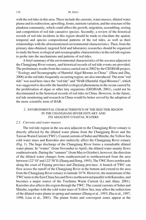
In the sea area adjacent to the Changjiang River estuary, high salinity seawateron the shelf pushes westwards at the bottom, and the diluted water plume from theChangjiang River moves outwards to the east on the surface, which leads to theformation of a plume front in the sea area near 123°E. Water of different quality fromeither side moves and mixes, and the convergent zone appears at the location of thefront where the maximum salinity gradient exists (Fig. 2). The turbidity of seawaterin this sea area decreases dramatically, but the nutrient concentration is still very high.If the temperature, light and other environmental factors are appropriate, the red tidealgae from the local water or transported from other sea areas can grow and form redtides under the convergent effect of the front. Therefore, the relationship between thefront and the distribution of red tides is also an area that requires further study.
The location of the front can change with the discharge of the Changjiang River.Based on the analysis of multiple-year satellite data and surveyed documents oftemperature and salinity in the sea area adjacent to the Changjiang River estuary, Caoand Zhang (1993) found out that the location of the front was about 90 km away fromthe shoreline on average, with a swing amplitude about 40 km. A formula on thelocation of the front and flow of the Changjiang River is given below (Cao and Zhang1993). The formula is useful for estimating the position of the front and predicting thepossible distribution of large scale red tides.
S Q Q= +45 51 44 4. .
Where S stands for the location of the front (the distance away from the shoreline,km), Q stands for the flux of the Changjiang River at Datong station (m3·s–1), and Qstands for the average flux of the Changjiang River (2.93 × 10⁴ m3·s–1).
138 M. ZHOU
2.5. Nutrients and their sources
High frequencies of red tides in the sea area adjacent to the Changjiang Riverestuary are closely related to the high concentrations of nutrients in seawater. TheChangjiang River estuary is the most eutrophic water in the China seas. Accordingto the China Marine Environmental Quality Bulletin (State Oceanic Administration,2002), seawater in this area is moderately or seriously polluted, and the majorpollutants are nutrients. There are a lot of reports about the nutrient concentrationsand their variation in this region (Shen, 1991; Lu et al., 1996; Ye et al., 2000) , but littleinformation is available on the input and sources of nutrients. It is generally acceptedthat the nutrients in this region mainly come from the discharge of the ChangjiangRiver and the TWC. Nitrate and silicate in seawater mainly come from the dischargeof the Changjiang River, since their distribution in the sea area adjacent to theChangjiang River estuary are negatively related to salinity (Shen, 1991; Wang et al.,1983, 2002). However, the sources of phosphate in this region are different fromnitrate and silicate, and the contribution of the TWC for phosphate input into thisregion cannot be ignored. According to the previous investigations, the inorganicnitrogen transported to the East China Sea by the TWC was almost equivalent to theinput from the Changjiang River, but the phosphate transported by TWC was 8–17times higher than the Changjiang River (Chung et al., 2001). In autumn, theconcentration of phosphate in the East China Sea might be controlled by the dilutedwater of the Changjiang River, biological activities and the TWC together (Hunagand Ji, 1994) , but in spring, the phosphate is mainly from the TWC (Chung et al.,2001)
Only a few data are available on the input flux of nutrients from the ChangjiangRiver into this region, which was estimated by multiplying the Changjiang Riverrunoff by the concentration of nutrients in the entrance where the salinity is zero, toroughly get the nutrient input flux into the sea. With this method, Wang et al. (1983),Shen (1991), and Shen et al. (1991) estimated the input flux of nutrients from theChangjiang River (Table 1). Meanwhile, Shen (1991) indicated that the relationship
Fig. 2. Plume front and convergent zone in the sea area adjacent to the estuary of Changjiang River (afterChen et al., 2001).

Environmental Settings and Harmful Algal Blooms near the Changjiang River Estuary 139
between the input of inorganic nitrogen (F, kg·s–1) and the runoff of the ChangjiangRiver (Q, m3·s–1) could be described with the following formula:
F = 4.899 e–0.0000518Q (r = 0.929, n = 10)
Due to the fact the increased runoff of the Changjiang River resulted from thehuge flood in 1998, Shen (2000) estimated that the input flux of inorganic nitrogenfrom the Changjiang River into the sea in 1998 was about two times that in ordinaryyears. Recently, Fu and Shen (2002) estimated the nutrient flux of the ChangjiangRiver with a more comprehensive monitoring data (Table 1). In Table 1, it can be seenthat there are dramatic differences among data of nutrient flux from those authors.This could be a result of the different date and methods employed in their studies.Therefore, in research of the relationship between the eutrophication and the red tides,the “real” nutrient flux of the Changjiang River needs a more comprehensive study.As for the nutrient input flux from the TWC, no really good data could be cited here.The nutrients from the dry or wet precipitation, biological activities, and thosereleased from the sediment also need to be studied further.
To compare with each other, the monthly fluxes estimated in the references ofShen (1991) and Wang et al. (1983) were multiplied by 12 to obtain yearly fluxes.
2.6. Plankton community and succession
Documents relating to multiple-year investigations on phytoplankton net samplescollected in the sea area adjacent to the Changjiang River estuary have been analyzed.The documents show that the phytoplankton community in the red tide region belongsto the low-salinity phytoplankton community in the Changjiang River estuary andZhejiang coast characterized by the wide-temperature and low-salinity adaptation.Meanwhile, it also forms ecotones or community cross-zones with a low-salinityphytoplankton community in Subei coastal water, a high-salinity phytoplanktoncommunity in the central Yellow Sea, and a high-salinity and high-temperaturephytoplankton community in the outside East China Sea (Fig. 3). Chen et al. (2001)and Wang et al. (1993) have reported that the species composition and populationdynamics in the phytoplankton community changed dramatically under the jointeffects of the Subei coastal current, the diluted water plume, the Yellow Sea cold
Table 1. Estimation of the nutrient flux of the Changjiang River.
Year Average flux (kg·s–1) Yearly flux (104 t) Referemce
1922–1985 0.48 21.90 1.51 69.1 [31]1980.6 2.37 161.3 [44]1985.8–1986.7 0.43 20.0 1.36 63.6 [32]1997.12–1998.11 131.0 [31]1998.2–1998.9 1.09/2.54 69.54/349.4 4.16 497.1 [7]

140 M. ZHOU
water mass and the TWC, which offered a good opportunity for the accumulation andproliferation of the red tide species. For example, the cell density of the red tidecausative species Skeletonema costatum, which inhabits the small area adjacent to theChangjiang River estuary, can reach 108 cells·m–3 and accounts for 95–99% of thetotal biomass of phytoplankton from June to July under the effect of the strong dilutedwater of the Changjiang River. The distribution pattern of S. costatum red tide isassociated with the dynamics of the diluted water plume of the Changjiang River(Guo and Yang 1982; Wang et al., 1993). S. costatum and Noctiluca scintillans maypredominant alternately lead to red tides in this region, however, the mechanism forphytoplankton community succession is not clear. Whether phytoplankton communitysuccession is driven by interogenous forcing (i.e. driven by biological processesinside phytoplankton community) or heterogenous forcing (i.e. driven byhydrodynamic factors, chemical factors and anthropogenic pollution etc.) is stilluncertain. If the succession of phytoplankton community is more heterogenous thaninterogenous, the structure and function of the phytoplankton community would beaffected by extreme forcing from outside, and the local ecosystem might collapsedunder extreme conditions.
Fig. 3. Biogeography of phytoplankton community in the southern Yellow Sea and the western EastChina Sea. 1, Winter border; 2, Summer border; I, Low-salinity community in Subei coastal water;II, High-salinity community in central Yellow Sea; III, Low-salinity community in Changjiang Riverestuary and Zhejiang coast; IV, High-salinity and high-temperature community in the outside EastChina Sea; V, Community cross-zone (Zhou et al., 2003).

Environmental Settings and Harmful Algal Blooms near the Changjiang River Estuary 141
Like other eutrophic waters, the red tide region in the sea area adjacent to theChangjiang River estuary, which include cross-zones of phytoplankton community,show edge effects of diversified species composition and high population density ofcertain species. At the initial stage of the community succession, the dominant speciesof the phytoplankton community grow under optimal conditions, due to abundantlyavailable nutrients in the seawater. At the middle stage of succession, when thenutrient concentration decreases, algal diversity increases, but the cell density of mostof the algae declines rapidly. At the late stage, most of the nutrients are depleted asnutrients assimilated by the algae and would be brought into deep water under theeuphotic zone. Therefore, both the species and biomass of the phytoplanktoncommunity decline. The mechanism of phytoplankton community succession isprobably related to the adaptive strategies of different algae species and interspecificcompetition (Margalef, 1968). To understand the formation of ecotones and theirroles in red tides is important for the elucidation of ecological mechanisms of largescale red tides and early-warning of the potential impacts.
The interspecific relationship between organisms living in the same planktoncommunity is always an issue of concern for ecologists and environmental biologists,with predation being the most important interspecies relationship. Previous studiesindicate that the grazing pressures of herbivorous zooplankton regulate algal populationdynamics. Yang (1997) analyzed the food composition in the alimentary canal ofCalanus sinicus and found that phytoplankton was predominant, accounting for98.6% of the total weight of the food. Among the phytoplankton ingested, diatomsdominated and accounted for 94.6% of the total weight of food, suggesting thatC. sinicus had obvious prey selectivity. Wang and Fan (1997) and Li et al. (2002)studied the ingestion rate and grazing pressure of natural communities of copepodsof different sizes on phytoplankton. They indicated that the grazing impact ofcopepods on phytoplankton was very high, and large copepod communities had amuch higher prey rate than meso-copepod communities. Large copepods made amajor contribution to whole pelagic copepods in their preying on phytoplankton,which accounted for 84% of the total prey amount in spring, and 67% in autumn. Sunand Qi (1993) reported that, the feeding rate of copepod Acartia spinicanda onProrocentrun micans increased with the increasing diet algal cell density, and themaximum feeding potential could reach 33000 cells·individual–1·day–1. This resultsuggested that the grazing impact of the pelagic copepods could have a significanteffect on the dynamics of red tides. Recently, Sun (personal intercommunication)found that microzooplankton communities might play an important role in thedynamics of the red tides in the sea area adjacent to the Changjiang River estuary,based on feeding pressure studies using microzooplankton. To provide biologicalevidence to elucidate the ecology of the red tides, it is important to further study andunderstand the effects of the predominant pelagic copepods in spring and summer(Calanus sinicus and Labidocera euchaeth) and Mesodinium rubrum and Noctilucascintillans on the dynamics of red tides (caused by Prorocentrun sp. and Alexandriumsp.).
142 M. ZHOU
3. RED TIDE EVENTS IN THE SEA AREA ADJACENT TO THE CHANGJIANGRIVER ESTUARY
3.1. Historical and seasonal pattern of red tides
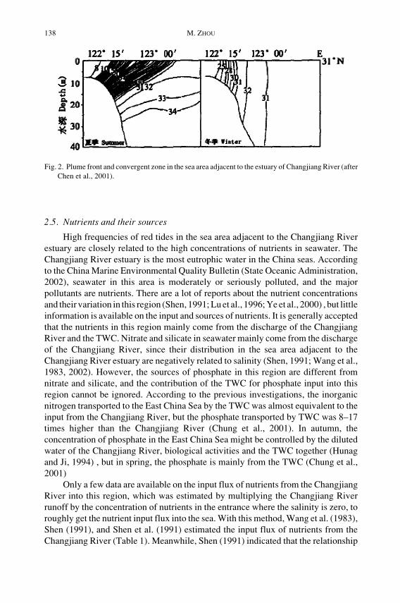
The sea area adjacent to the Changjiang River estuary is one of the mostimportant red tide regions in China (Fig. 4). About one quarter of the recorded red tideevents occurred in this region (http://www.soa.gov.cn/chichao/index.html). Sincethis region only accounts for a small part of the China seas, the significance of redtides here becomes more protruding. However, there are no formal records of red tidesin this region until the beginning of the 1980s. Red tides of N. scintillans wererecorded in June and August, 1981 and in 1982, red tides of Trichodesmium sp.,Noctiluca scintillans and Ceratium sp. were also reported. More and more red tideevents have been recorded subsequently, and there were 12 events from 1981 to 1989,and 39 events from 1990 to 2001 (Jiang et al., 1992). The increased number of red tiderecords could reflect intensified monitoring activities; however, it is believed that thefrequency of red tides in this region is increasing.
There is a clear seasonal pattern of red tides in this region (Fig. 5). The numberof red tides recorded in May is the highest of the whole year, accounting for 60% ofthe total events. Most of the red tides appear in April and May when the seasonchanges from “winter” to “summer”. Whether this phenomenon has a relationshipwith the redirection of the diluted water in April and May still requires further study.After July, the frequency of red tides decreases, and no red tides are recorded afterSeptember.
3.2. Spatial distribution of red tides
The spatial distribution of red tides in this region show that most of the red tidesare distributed along the area between 122°30′ and 123°00′ E, where there is a steepseabed, including the sea area around Huaniaoshan island outside the ChangjiangRiver estuary and the sea area around the Zhoushan island (Fig. 6). The relationship
Fig. 4. Frequency of red tides in different regions of China (Zhou et al., 2003).

Environmental Settings and Harmful Algal Blooms near the Changjiang River Estuary 143
Fig. 5. Seasonal pattern of red tide events in the sea area adjacent to the Changjiang River estuary (Zhouet al., 2003).
Fig. 6. Distribution of red tides in the sea area adjacent to the estuary of Changjiang River (Zhou et al.,2003).

144 M. ZHOU
between the red tides in this region and the characteristics of seabed landform, andthe related upwelling and front, needs to be studied carefully.
3.3. Causative species of red tides
Due to limited monitoring and statistical efforts, many records of red tides in thisregion do not list the causative species, which makes it difficult to analyze changesin causative species. The only thing clear is that the causative species in this regioninclude N. scintillans, S. costatum, Prorocentrum triestinum and Prorocentrumdentatum (=Prorocentrum donghaiense, see below), Trichodesmium spp., Ceratiumspp. and species in Cryptophyta. The remaining records only describe the color ofseawater during the red tides or the scope of the red tides.
Recently, the continuous-occurring Prorocentrum red tides, which affectthousands of square kilometers, have attracted attention worldwide. It was generallyaccepted that the bloom was caused by a single species in Genus Prorocentrum sp.A number of scientists considered the causative species as P. dentatum (Wang, 2002).However, others claimed that this species was not the P. dentatum first namedby German taxonomist Stein, and it should be assigned a new species name ofP. donghainse (Lu and Goebel, 2001; Lu et al., 2005). An international seminar washeld on this issue, and it was accepted that this species was obviously different fromthe P. dentatum described by Stein. However, this species could be the same speciesthat caused large-scale red tides in Japan, Korea, and Turkey, which was identifiedas P. dentatum by many scientists overseas. Therefore, it is important to correctlyidentify species both in China and other areas.
4. PRIMARILY RESULTS ON FIELD INVESTIGATION IN THE RED TIDEFREQUENTLY-OCCURRING REGION
IN THE CRUISE OF CEOHAB
4.1. Location of the plume front
In the cruise carried out in 2002, it was found that the location of the plume frontwas between 122°30′ and 122°30′ E, and the direction of the front was from northwestto southeast (the corner with longitude was less than 20°). Both the horizontal andvertical salinity gradients were very strong in the frontal area. The maximumhorizontal and vertical salinity gradients reached 3.6 km–1 and 2.5 km–1 respectively.The front in section C (31°N) is shown in Fig. 7. The location of the front coincideswell with the formula suggested by Cao and Zhang (1993) (Section 2.4).
4.2. Population dynamics of red tides
In the spring cruise of 2002, the red tide caused by P. donghaiense, which wasre-occurred in this area for several years, was first found on the day of May 3 in theregion between 122°30′–123°00′E. It developed in the sea area southeast of Zhoushanisland, started from about 300 km2 then extended northward gradually to the sea areanear the Zhongjieshan islands to reached about 1500 km2. The cell density couldreach 107 cell·L–1 in the surface water with a water depth between 0–10 m. The redtide finally disappeared after 30 days (Fig. 8). The continuous occurrence of

Environmental Settings and Harmful Algal Blooms near the Changjiang River Estuary 145
P. donghaiense red tides in the last several years suggest that there might be a fixedhabitat for P. donghaiense in the red tide frequently-occurring region or nearby, or thecells can arrive at the red tide region by transportation of currents and form red tidesunder optimal environmental conditions.
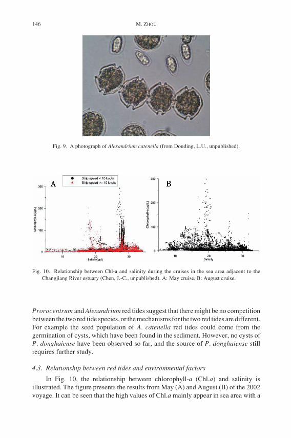
During the 2002 cruise, a large-scale bloom of Alexandrium catenella was alsofound with a maximum cell density of 105 cells·L–1. This was the first record of alarge-scale toxic red tide in China (under publication). The preliminary analysisfound that the cellular toxicity was about 8.6 pg STX eq·cell–1, which wascomparable to other moderately toxic Alexandrium species. Fig. 9 is the photographof A. catenella cells that caused the red tide. The simultaneous breakout of
Fig. 7. Front structure along 31_N found on the cruise in May, 2002 (Zhou et al., 2003).
Fig. 8. Variation of affected area of P. donghainse red tide in May, 2002 (Zhou et al., 2003).
146 M. ZHOU
Prorocentrum and Alexandrium red tides suggest that there might be no competitionbetween the two red tide species, or the mechanisms for the two red tides are different.For example the seed population of A. catenella red tides could come from thegermination of cysts, which have been found in the sediment. However, no cysts ofP. donghaiense have been observed so far, and the source of P. donghaiense stillrequires further study.
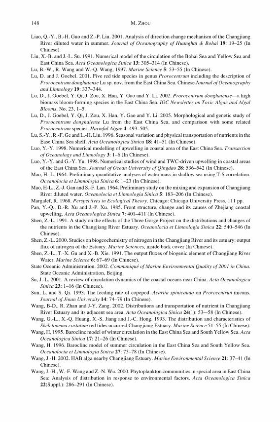
4.3. Relationship between red tides and environmental factors
In Fig. 10, the relationship between chlorophyll-a (Chl.a) and salinity isillustrated. The figure presents the results from May (A) and August (B) of the 2002voyage. It can be seen that the high values of Chl.a mainly appear in sea area with a
Fig. 9. A photograph of Alexandrium catenella (from Douding, L.U., unpublished).
Fig. 10. Relationship between Chl-a and salinity during the cruises in the sea area adjacent to theChangjiang River estuary (Chen, J.-C., unpublished). A: May cruise, B: August cruise.

Environmental Settings and Harmful Algal Blooms near the Changjiang River Estuary 147
specific salinity. In May the high values of Chl.a are mainly distributed in sea areawith a salinity of 28, with only a small proportion in sea area with a salinity of 20. Incontrast, in August, the high values of Chl.a are mainly distributed in sea area witha salinity of 20. According to the study carried out by Dr. Wang (personalcommunication), the optimal salinity for P. donghaiense, which forms red tides inMay, is around 28 (when the water temperature was higher than 16°C). ForS. costatum, which causes red tides in August, the optimal salinity ranges between13–31, with the most optimal salinity between 20–30. This is in accordance with thefield observations when the P. donghainense and S. costatum red tides were observedin May and August, respectively.
REFERENCES
Cao, X.-Z . 1986. Preliminary Study on the seasonal process of the coastal upwelling off Zhejiang in theEast Sea. Journal of Fisheries of China 10: 51–69 (In Chinese).
Cao, X.-Z. and Y.-X. Zhang. 1993. Influence of Three-Gorge engineering on the environment ofChangjiang River Estuary region. Donghai Marine Science 11: 17–22 (In Chinese).
Chen, Q.-C., Y.-Q. Chen and Y.-Z. Hu. 2001a. Preliminary study on the plankton communities in thesouthern Yellow Sea and the East China Sea. Acta Oceanologica Sinica 2: 149–157 (In Chinese).
Chen, S.-L., G.-C. Gu and F.-X. Hu. 2001b. The barrier effect of plume front on the submerged deltadevelopment of YangZe River Estuary. Marine Science 25: 55–56 (In Chinese).
Chen, Z.-Y., B.-P. Song, Z.-G. Wang and Y.-G. Cai. 2000. Late Quaternary evolution of the sub-aqueousYangtze Delta, China: sedimentation, stratigraphy, palynology, and deformation. Marine Geology162: 423–441.
Chung, S.-W., S. Jan and K.-K. Liu. 2001. Nutrient fluxes through the Taiwan Strait in Spring andSummer 1999, Journal of Oceanography 57: 47–53
Ding, Z.-X., 2001, Influence of wind on vertical structures of temperature and salinity, and upwelling offthe Zhejiang coast. Oceanologia et Limnologia Sinica 14: 14–21 (In Chinese).
Fu, R.-B. and H.-T. Shen. 2002. The fluxes of dissolved inorganic nitrogen and phosphorus at freshwaterend-member in the Changjiang Estuary. Acta Oceanologica Sinica 24: 34–42 (In Chinese).
GEOHAB. 2001. Global Ecology and Oceanography of Harmful Algal Blooms, Science Plan, P. Glibertand G. Pitcher (Eds). SCOR and IOC, Baltimore and Paris. 86 pp.
Guo, Y.-J. and Z.-Y. Yang. 1982. The ecological studies on the phytoplankton over the continental shelfof the East China Sea in the summer of 1976. Studia Marina Sinica 19: 11–32 (In Chinese).
http://www.973.gov.cn/programme973/enviroment/200208200039.html.http://www.soa.gov.cn/chichao/index.html.Hu, D.-X. 1980. Studies on Zhejiang coastal upwelling. Science Bulletin 3: 131–133 (In Chinese).Hu, D.-X. 2001. Key Processes of Ocean Fluxes in East China Sea. Ocean Press, Beijing, pp. 3–13 (In
Chinese).Huang, Z.-Q. and W.-D. Ji. 1994. The characteristics of TP, OP and PO4-P and their interrelations in
Changjiang Estuary. Acta Oceanologica Sinica 16: 51–60 (In Chinese).Jiang, X.-S., J.-C. Hong, G.-L. Wang and X.-Q. Huang. 1992. Analysis of Noctiluca scintillans red tide
occurred in red tide frequent area of Changjiang Estuary. Journal of Jinan University 13: 134–139(In Chinese).
Le, K.-T. 1986. Some aspects of the path of the Changjiang diluted water. Studia Marina Sinica 27: 221–228 (In Chinese).
Li, C.-L., R. Wang, F. Zhang and X.-G. Wang. 2002. A study on grazing of planktonic copepods in theYellow Sea and East China Sea. Ingestion rate and grazing impact. Oceanologia et Limnologia SinicaSuppl. 111–119 (In Chinese).
Li, H.-F. and B.-R. Zhao. 2001. Numerical model of the circulation of the Bohai Sea and Yellow Sea andEast China Sea. Marine Sciences 25: 28–32 (In Chinese).
148 M. ZHOU
Liao, Q.-Y., B.-H. Guo and Z.-P. Liu. 2001. Analysis of direction change mechanism of the ChangjiangRiver diluted water in summer. Journal of Oceanography of Huanghai & Bohai 19: 19–25 (InChinese).
Liu, X.-B. and J.-L. Su. 1991. Numerical model of the circulation of the Bohai Sea and Yellow Sea andEast China Sea. Acta Oceanologica Sinica 13: 305–314 (In Chinese).
Lu, B.-W., R. Wang and W.-Q. Wang, 1997. Marine Science 5: 53–55 (In Chinese).Lu, D. and J. Goebel. 2001. Five red tide species in genus Prorocentrum including the description of
Prorocentrum donghaiense Lu sp. nov. from the East China Sea. Chinese Journal of Oceanographyand Limnology 19: 337–344.
Lu, D., J. Goebel, Y. Qi, J. Zou, X. Han, Y. Gao and Y. Li. 2002. Prorocentrum donghaiense—a highbiomass bloom-forming species in the East China Sea. IOC Newsletter on Toxic Algae and AlgalBlooms. No. 23, 1–5.
Lu, D., J. Goebel, Y. Qi, J. Zou, X. Han, Y. Gao and Y. Li. 2005. Morphological and genetic study ofProrocentrum donghaiense Lu from the East China Sea, and comparison with some relatedProrocentrum species. Harmful Algae 4: 493–505.
Lu, S.-Y., R.-F. Ge and L.-H. Liu. 1996. Seasonal variation and physical transportation of nutrients in theEase China Sea shelf. Acta Oceanologica Sinica 18: 41–51 (In Chinese).
Luo, Y.-Y. 1998. Numerical modelling of upwelling in coastal area of the East China Sea. Transactionof Oceanology and Limnology 3: 1–6 (In Chinese).
Luo, Y.-Y. and G.-Y. Yu. 1998. Numerical studies of wind and TWC-driven upwelling in coastal areasof the East China Sea. Journal of Ocean University of Qingdao 28: 536–542 (In Chinese).
Mao, H.-L. 1964. Preliminary quantitative analyses of water mass in shallow sea using T-S correlation.Oceanolocia et Limnologia Sinica 6: 1–23 (In Chinese).
Mao, H-L., Z.-J. Gan and S.-F. Lan. 1964. Preliminary study on the mixing and expansion of ChangjiangRiver diluted water. Oceanolocia et Limnologia Sinica 5: 183–206 (In Chinese).
Margalef, R. 1968. Perspectives in Ecological Theory. Chicago: Chicago University Press. 111 pp.Pan, Y.-Q., D.-R. Xu and J.-P. Xu. 1985. Front structure, change and its causes of Zhejiang coastal
upwelling. Acta Oceanologica Sinica 7: 401–411 (In Chinese).Shen, Z.-L. 1991. A study on the effects of the Three Gorge Project on the distributions and changes of
the nutrients in the Changjiang River Estuary. Oceanolocia et Limnologia Sinica 22: 540–546 (InChinese).
Shen, Z.-L. 2000. Studies on biogeochemistry of nitrogen in the Changjiang River and its estuary: outputflux of nitrogen of the Estuary. Marine Sciences, inside back cover (In Chinese).
Shen, Z.-L., T.-X. Gu and X.-B. Xie. 1991. The output fluxes of biogenic element of Changjiang RiverWater. Marine Science 6: 67–69 (In Chinese).
State Oceanic Administration. 2002. Communiqué of Marine Environmental Quality of 2001 in China.State Oceanic Administration, Beijing.
Su, J.-L. 2001. A review of circulation dynamics of the coastal oceans near China. Acta OceanologicaSinica 23: 1–16 (In Chinese).
Sun, L. and S. Qi. 1993. The feeding rate of copepod. Acartia spinicauda on Prorocentrun micans.Journal of Jinan University 14: 74–79 (In Chinese).
Wang, B-D., R. Zhan and J-Y. Zang. 2002. Distributions and transportation of nutrient in ChangjiangRiver Estuary and its adjacent sea area. Acta Oceanologica Sinica 24(1): 53–-58 (In Chinese).
Wang, G.-L., X.-Q. Huang, X.-S. Jiang and J.-C. Hong. 1993. The distribution and characteristics ofSkeletonema costatum red tides occurred Changjiang Estuary. Marine Science 51–55 (In Chinese).
Wang, H. 1995. Baroclinc model of winter circulation in the East China Sea and South Yellow Sea. ActaOceanologica Sinica 17: 21–26 (In Chinese).
Wang, H. 1996. Baroclinc model of summer circulation in the East China Sea and South Yellow Sea.Oceanolocia et Limnologia Sinica 27: 73–78 (In Chinese).
Wang, J.-H. 2002. HAB alga nearby Changjiang Estuary. Marine Environmental Science 21: 37–41 (InChinese).
Wang, J.-H., W.-F. Wang and Z.-N. Wu. 2000. Phytoplankton communities in special area in East ChinaSea: Analysis of distribution in response to environmental factors. Acta Oceanologica Sinica22(Suppl.): 286–291 (In Chinese).
Environmental Settings and Harmful Algal Blooms near the Changjiang River Estuary 149
Wang, R. and C.-L. Fan. 1997. Copepods feeding activities and its contribution to downwards verticalflux of carbon in the East China sea. Oceanolocia et Limnologia Sinica 28: 597–598 (In Chinese).
Wang, Z.-F., L.-K. Yao and X.-Z. Ruan. 1983. Distribution and characteristics of nutrients (N, P, Si) inthe estuary of Changjiang River in June, 1980. Oceanolocia et Limnologia Sinica 14: 324–331 (InChinese).
Xue, J.-P. 1986. Preliminary analysis of the hydrologic structure in the coastal upwelling area offZhejiang in winter. Donghai Marine Science 4: 18–24 (In Chinese).
Yan, Y.-Z. 1991. Features and classification of coastal upwelling off China. Marine Science Bulletin 10:1–6 (In Chinese).
Yan, Y.-Z., 1992. Analysis of the causes of upwelling formation off Zhejiang and East Hainan coasts.Acta Oceanologica Sinica 14: 12–18 (In Chinese).
Yang, J.-M. 1997. Primary study on the feeding of the Bohai sea Calanus sinicus. Oceanolocia etLimnologia Sinica 28: 376–382 (In Chinese).
Ye, X.-S., Y. Zhang and Y.-T. Xiang. 2000. Characteristic of nitrate distribution in the Changjiang RiverEstuary and its cause of formation. Marine Science Bulletin 19: 89–92 (In Chinese).
Zhang, Q.-H. and C.-M. Dong. 1993. On the correlation of the diluted water of Yangtze River andecological environment of its adjacent oceanic area. Journal of Oceanography of Huanghai & Boha11: 27–29 (In Chinese)..
Zhang, Q.-H., F.-L. Qiao and Y.-M. Chen. 1993. Effects of seabed topography and coastal currents onthe distribution of Changjiang River diluted water. Acta Oceanologica Sinica 15: 1–15 (In Chinese).
Zhao, B.-R. 1991. The mechanism of the direction change of Changjiang River diluted water. ActaOceanologica Sinica 13: 601–610 (In Chinese).
Zao, B.-R. 1993. Upwelling outside of Changjiang Estuary. Acta Oceanologica Sinica 15: 108–114 (InChinese).
Zhao, B.-R., G.-F. Ren and D.-M. Cao. 2001. Characteristics of the ecological environment on upwellingarea adjacent to the Changjiang River Estuary. Oceanolocia et Limnologia Sinica 32: 327–333 (InChinese).
Zhou, M.J. and M.Y. Zhu. 2006. Progress of the project "ecology and oceanography of harmful algalblooms in China". Advances in Earth Science 21: 673–679 (In Chinese).
Zhou, M-J., M.-Y. Zhu and J. Zhang. 2001. Status of harmful algal blooms and related research activitiesin China. Life Science 13: 54–59 (In Chinese).
Zhou, M.-J., T. Yan and J.-Z. Zou. 2003. Preliminary analysis of the characteristics of red tide areas inChangjiang River estuary and its adjacent sea. Chinese Journal of Applied Ecology 14: 1031–1038
Zhou, M.-J., Z.-L. Shena and R.-C. Yua. 2008. Responses of a coastal phytoplankton community toincreased nutrient input from the Changjiang (Yangtze) river. Continental Shelf Research 28: 1483–1489.
Zhu, J.-R. and H.-T. Shen. 1997. The mechanism of the expansion of the Changjiang (Yangtze River)diluted water. East China Normal University Press, Shanghai, pp. 10–177.
Zhu, J.-R., Y.-P. Li and H.-T. Shen. 1997a. Numerical simulation of the wind field’s impact on theexpansion of the Changjiang River diluted water in summer. Oceanolocia et Limnologia Sinica 28:72–79 (In Chinese).
Zhu, J.-R., H.-T. Shen and J. Zhou. 1997b. Numerical simulation of the impact of the Subei coastal currenton the expansion of the Changjiang River diluted water in summer. Journal of the East China NormalUniversity (Natural Science) 62–67 (In Chinese).
Zhu, J.-R., C.-Y. Xiao and H.-T. Shen. 1998. The impact of Yellow Sea cold water mass on the expansionof the Changjiang diluted water. Oceanolocia et Limnologia Sinica 29: 398–394 (In Chinese).
Zhu, S.-X., J.-R. Zhu and W.-Y. Sha. 1999. A numerical study on the impact of M2 Tide on the expansionof the Changjiang River diluted water in summer. Oceanolocia et Limnologia Sinica 30: 711–718 (InChinese).
M. Zhou (e-mail: [email protected])


![MANUAL - Garmin · General settings and Training settings General settings In the menu left click on [Settings]. The General settings are for the general display. Language The standard](https://static.fdocuments.us/doc/165x107/5f9ad8bee7f94767a440344e/manual-garmin-general-settings-and-training-settings-general-settings-in-the-menu.jpg)