ENVIRONMENTAL REVIEW DOCUMENT ATTACHMENT A · ENVIRONMENTAL REVIEW DOCUMENT ATTACHMENT A REFERRAL...
47
ENVIRONMENTAL REVIEW DOCUMENT ATTACHMENT A REFERRAL APPLICATION Section 38 of the Environmental Protection Act 1999 Project: UIL Energy 2D Seismic survey, Onshore, Perth Basin, WA Document Information Operation area Onshore, Shire of Dandaragan and Shire of Coorow, WA Document No UIL-REF-EPA-ERD-01 Revision 4.0 Revision date March 2016 Register of Amendments Rev Description Date Prepared by Reviewed by Approved by 1.0 Initial Draft January 2015 LV VP VP 2.0 Amendments July 2015 LV JH & VP VP 3.0 Final Report February 2016 LV VP VP 4.0 Approval for submission to EPA March 2016 JD
Transcript of ENVIRONMENTAL REVIEW DOCUMENT ATTACHMENT A · ENVIRONMENTAL REVIEW DOCUMENT ATTACHMENT A REFERRAL...
ENVIRONMENTAL REVIEW DOCUMENT
ATTACHMENT A
REFERRAL APPLICATION
Section 38 of the Environmental Protection Act 1999
Project: UIL Energy 2D Seismic survey, Onshore, Perth Basin, WA
Document Information
Operation area Onshore, Shire of Dandaragan and Shire of
Coorow, WA Document No UIL-REF-EPA-ERD-01
Revision 4.0 Revision date March 2016
Register of Amendments
Rev Description Date Prepared by Reviewed by Approved by 1.0 Initial Draft January 2015 LV VP VP
2.0 Amendments July 2015 LV JH & VP VP
3.0 Final Report February 2016 LV VP VP
4.0 Approval for submission to EPA March 2016 JD

Report Reference: 21158-15-BISR-1Rev0_160229
2D Seismic Survey On-ground Ecological Survey November - December 2015
Prepared for UIL Energy

This page has been left blank intentionally.

UIL Energy 2D Seismic Survey – On-ground Ecological Survey, November - December 2015
Page | ii
2D Seismic Survey On-ground Ecological Survey
Prepared for UIL Energy
Job Number: 21158-15
Reference: 21158-15-BISR-1Rev0_160229
Revision Status
Rev Date Description Author(s) Reviewer
A 29/01/2016 Draft Issued for Client Review S. Stapleton J. Oates
R. Archibald
B 17/02/2016 Revised Draft Issued for Client Review
S. Stapleton J. Oates
R. Archibald
0 29/02/2016 Final Issued for Information S. Stapleton J. Oates
R. Archibald
Approval
Rev Date Issued to Authorised by
Name Signature
A 29/01/2016 L. Volkova S. Pearse
B 17/02/2016 L. Volkova S. Pearse
0 29/02/2016 L. Volkova S. Pearse

UIL Energy 2D Seismic Survey – On-ground Ecological Survey, November - December 2015
Page | iii
Abbreviations
Abbreviation Definition
Cm Centimetres
DAFWA Department of Agriculture and Food Western Australia
DBH Diameter at Breast Height
DER Department of Environment Regulation
DGPS Differential Global Position System
DoE Department of the Environment
Parks and Wildlife Department of Parks and Wildlife
EPA Environmental Protection Authority
EPBC Act Environment Protection and Biodiversity Conservation Act 1999
GPS Global Position System
ha hectare
IBA Important Bird Area
km Kilometre
m Metres
mm Millimetres
PEC Priority Ecological Community
P Priority
The ‘survey area’
The area consists of approximately 63 linear kilometres of proposed clearing of native vegetation for acquisition of 2D seismic data within UIL Energy Ltd petroleum exploration permits EP 488, EP489 and EP447. The width of the proposed clearing is up to 4.5m. The width of the search alignments is 7 m and occurs within Badgingarra National Park, Wongonderrah and Twyata Nature Reserves, unallocated crown land, road reserves and private properties.
S Schedule
T Threatened
TEC Threatened Ecological Community
TPFL Threatened and Priority Flora database
UIL Energy UIL Energy Ltd
WC Act Wildlife Conservation Act 1950
WoNS Weed of National Significance
°C Degrees celsius

UIL Energy 2D Seismic Survey – On-ground Ecological Survey, November - December 2015
Page | iv
Executive Summary Astron was engaged to undertake an ecological assessment of proposed 2D seismic lines within the locality of Badgingarra. The ecological assessment comprised a targeted conservation significant flora survey and a Level 1 fauna assessment of approximately 63 linear kilometres.
No threatened flora species were recorded within the survey area. Fifteen State-listed priority flora species were identified in the survey area; Banksia pteridifolia subsp. vernalis P3, Chordifex chaunocoleus P4, Desmocladus elongatus P4, Eucalyptus macrocarpa subsp. elachantha P4, Hensmania stoniella P3, Hypocalymma serrulatum P3, Hypocalymma sp. Dandaragan (C.A. Gardner 9014) P1, Isopogon panduratus subsp. palustris P3, Jacksonia anthoclada P3, Lepidobolus quadratus P3, Leucopogon sp. Badgingarra (R. Davis 421) P2, Lyginia excelsa P1, Onychosepalum microcarpum P2, Stylidium hymenocraspedum P3 and Verticordia argentea P2.
Five introduced flora species (weeds) were recorded in the survey area, none of which are listed as a declared pest or a Weed of National Significance.
Four broad fauna habitats were identified during the survey: Banksia woodland/shrubland, sparse eucalypt woodland, dampland and low heath. The remaining 6.4 hectares (14.4%) that was surveyed for fauna was essentially cleared tracks, plantings and part of an existing road reserve.
Sixty-nine vertebrate fauna species were recorded during the fauna survey. Three conservation significant species were recorded within, or just outside the survey area: Carnaby’s cockatoo (Endangered, Schedule 2), rainbow bee-eater (Migratory, Schedule 5) and western brush wallaby (Priority 4). Thirteen other conservation significant species were identified in the original desktop assessment. Based on changes in taxonomy and conservation listings, four species no longer need to be considered and seven species were considered to be of low likelihood to occur within the survey area. Two species: malleefowl (Vulnerable, Schedule 3) and chuditch (Vulnerable, Schedule 3) were identified as having a moderate likelihood of occurrence, although not restricted to, the survey area.
Following the field survey, the western spiny-tailed skink (Endangered, Schedule 3) was considered unlikely to occur within the survey area as no suitable habitat capable of supporting a population was recorded. However, large portions of the survey area (36.3 hectares) are consistent with the definition of ‘quality’ foraging habitat for Carnaby’s cockatoo. Although no recent evidence of foraging or live observations was observed within the survey area (partly due to the narrowness of the survey alignment and timing of survey), the Banksia woodland/shrubland, sparse eucalypt woodland and low heath habitats would be considered suitable black cockatoo foraging habitat. The amount of native vegetation requiring clearing within the survey area represents less than 1% of the potential foraging habitat contained within Department of Parks and Wildlife managed lands in the immediate vicinity of the survey area. Potential foraging habitat in sections of seismic lines that pass within Twyata Nature Reserve and Badgingarra National Park are located within 6 kilometres and 12 kilometres of possible Carnaby’s cockatoo roosting and breeding sites.
Given that clearing of more than 1 hectare of quality foraging habitat (considered a high risk of significant impacts under referral guidelines) and clearing or disturbance of areas surrounding black cockatoo breeding and roosting habitat (considered moderate/uncertain risk under referral guidelines) is likely, this report supports UIL Energy’s referral under the Environment Protection and Biodiversity Conservation Act 1999.
The proposal to clear vegetation within the survey area was considered against the terms of the 10 Clearing Principles in accordance with Department of Environmental Regulation guideline. It is considered that the proposal is likely to be at variance to four out of the 10 Clearing Principles. This

UIL Energy 2D Seismic Survey – On-ground Ecological Survey, November - December 2015
Page | v
was a general assessment made on the basis of the best available information at the time and without knowledge of the specific details of the proposal.

UIL Energy 2D Seismic Survey – On-ground Ecological Survey, November - December 2015
Page | vi
Table of Contents 1 Introduction ..................................................................................................................................... 1
1.1 Project Background ..................................................................................................... 1
1.1.1 Site Overview .............................................................................................................. 1
1.1.2 Geology, Landform and Soils ...................................................................................... 3
1.1.3 Land Systems ............................................................................................................... 3
1.1.4 Surface Water and Hydrology ..................................................................................... 4
1.2 Scope of Works ........................................................................................................... 4
2 Methodology ................................................................................................................................... 5
2.1 Desktop Assessment ................................................................................................... 5
2.2 Field Survey ................................................................................................................. 5
2.2.1 Conservation Significant Flora and Broad Vegetation ................................................ 7
2.2.2 Terrestrial Vertebrate Fauna....................................................................................... 7
2.2.3 Taxonomy and Nomenclature .................................................................................... 8
2.2.4 Limitations ................................................................................................................... 9
3 Results ........................................................................................................................................... 10
3.1 Seasonal Conditions .................................................................................................. 10
3.2 Conservation Significant Flora and Vegetation ......................................................... 10
3.2.1 Conservation Significant Flora .................................................................................. 10
3.2.2 Introduced Flora (Weeds) ......................................................................................... 11
3.2.3 Vegetation ................................................................................................................. 11
3.3 Terrestrial Vertebrate Fauna ..................................................................................... 12
3.3.1 Fauna Habitats .......................................................................................................... 12
3.3.2 Fauna Species ............................................................................................................ 14
3.3.2.1 Conservation Significant Fauna .................................................................. 15
4 Discussion ...................................................................................................................................... 17
4.1 Conservation Significant Flora ................................................................................... 17
4.2 Weeds........................................................................................................................ 18
4.3 Vertebrate Fauna ...................................................................................................... 18
5 Clearing Principles for Native Vegetation Clearing Permit Application ........................................ 20
6 References ..................................................................................................................................... 24

UIL Energy 2D Seismic Survey – On-ground Ecological Survey, November - December 2015
Page | vii
List of Figures Figure 1: Survey area location. ............................................................................................................... 2
Figure 2: Mean (1962 to 2015) monthly rainfall (mm) preceding the November and December 2015 field surveys recorded at Badgingarra Research Station (09037) (Bureau of Meteorology 2016). ...................................................................................................................................................... 10
List of Tables Table 1: Approximate survey length of each proposed seismic line. ..................................................... 6
Table 2: Field survey scope, timing and personnel. ................................................................................ 6
Table 3: Recorded priority flora species and abundance. .................................................................... 11
Table 4: Broad floristic formations recorded within the survey area. .................................................. 12
Table 5: Description of fauna habitats recorded within the survey area. ............................................ 13
Table 6: Extent of pre-European vegetation in the application area (Government of Western Australia 2014). ............................................................................................................................. 22
List of Appendices Appendix A: Desktop Assessment (UIL Energy 2015)
Appendix B: Vegetation Classification and Condition Scales, and Fauna Habitat Condition Scale
Appendix C: Conservation Categories for Flora, Fauna and Ecological Communities, and Categories for Declared Pest Species
Appendix D: Conservation Significant Flora and Introduced Species Locations and Descriptions
Appendix E: Fauna Habitat Mapping
Appendix F: Vertebrate Fauna Species List
Appendix G: Conservation Significant Fauna and Potential Breeding Habitat Tree Locations and Descriptions

UIL Energy 2D Seismic Survey – On-ground Ecological Survey, November - December 2015
Page | 1
1 Introduction
1.1 Project Background
1.1.1 Site Overview
UIL Energy Ltd (UIL Energy) petroleum exploration permits EP 488, EP489 and EP447 are located approximately 170 kilometres (km) north of Perth in the Shire of Dandaragan. The nearest town to the project area is Badgingarra.
UIL Energy is proposing to acquire approximately 264 linear km of 2D seismic data within the above-mentioned exploration permits (Figure 1). Of this area, approximately 63 linear km requires clearing of native vegetation. Clearing is proposed within the Badgingarra National Park, Wongonderrah and Twyata Nature Reserves, and unallocated crown land, road reserves and private properties.
Of the 63 linear km requiring clearing, approximately 33.2 linear km overlaps State National Park and Nature Reserves, with the remaining 30.6 linear km occurring on private properties, unallocated crown land and road reserves. For the purposes of this report the areas of proposed clearing are herein referred to as the ‘survey area’.

"
"
"
"
"
"
"
"
"
"
"
"
"
BRAND HIGHWAY
INDIAN OCEANDRIVE
COOROW GREEN HEAD ROAD
J URIEN ROAD
GREY R OAD
MUNBINEA ROAD
BIBBY ROAD
CADD A RO AD
NORTH WEST ROAD
WONGONDERRAH ROADYERRA
MULLA
H ROA
D
WADDI ROAD
BRAN
D MUD
GE RO
ADCOOLJARLOO ROAD
COOLIMBA E NEABBA ROAD
COWALLA ROAD
KOONAH ROAD
MARCHA G EE TRACK
MULLERING ROAD
PINNAC LES DRIV E
WOOLKA ROAD
ROSE THOMSON ROAD
PEN RO
AD
NILGE
N ROA
D
LEEMAN
CERVANTES
DANDARAGAN
GREEN HEAD
JURIEN BAY
ISLAND POINT
THIRSTY POINT
GAIRDNER RANGE
H IL L RIV
ER
BADGINGARRA
MOUNT LESUEUR
300000 320000 340000 360000 380000658
0000
66000
00662
0000
66400
00666
0000
66800
00670
0000
Author: N. Cadd Date: 29-02-2016Drawn: W. An Figure Ref: 21158-15-BIDR-2Rev0_160224_Fig01_Locn ±Datum: GDA 1994 - Projection: MGA Zone 50
Figure 1: Survey area locationUIL EnergyBadgingarra Ecological Survey
0 5 10 15 20Km
Legend" Towns" Localities
Principal RoadMinor RoadRiverParks and Wildlife Managed LandsGeomorphic Wetlands2D Seismic Lines
"
"
"
"
"
"
"
BUSSELTON
PERTH
MORAWA
ALBANY
NORTHAM
GERALDTON
MapExtent
BadgingarraNational Park
WongonderrahNature Reserve

UIL Energy 2D Seismic Survey – On-ground Ecological Survey, November - December 2015
Page | 3
1.1.2 Geology, Landform and Soils
The survey area occurs within two bioregions; the Geraldton Sandplains and the Swan Coastal Plain. The Geraldton Sandplains bioregion is composed mainly of sandy earths of an extensive, undulating, lateritic sandplain mantling Permian to Cretaceous strata, with outwash plains associated drainage also present in the region (Desmond and Chant 2001). The Swan Coastal Plain is a low lying coastal plain mainly covered with woodland. It includes outwash plains, swampy areas and in the east the plain rises to duricrusted Mesozoic sediments (Mitchell, Williams, and Desmond 2002).
The surface geology of the area is comprised of six units (Stewart et al. 2008):
• Alluvium 38485 – channel and flood plain alluvium; gravel, sand, silt, clay, locally calcreted.
• Bassendean Sand – basal conglomerate overlain by dune quartz sand with heavy mineral concentrations.
• Colluvium 38491 – colluvium, sheetwash, talus; gravel piedmonts and aprons over and around bedrock; clay-silt-sand with sheet and nodular kankar; alluvial and aeolian sand-silt-gravel in depressions and broad valleys in Canning Basin; local calcrete, reworked laterite.
• Ferruginous duricrust 38498 – Pisolitic, nodular or vuggy ferruginous laterite; some lateritic soils; ferricrete; magnesite; ferruginous and siliceous duricrusts and reworked products, calcrete, kaolinised rock, gossan; residual ferruginous saprolite.
• Sand plain 38498 – sand or gravel plains; quartz sand sheets commonly with ferruginous pisoliths or pebbles, minor clay; local calcrete, laterite, silcrete, silt, clay, alluvium, colluvium, aeolian sand.
• Yarragadee Formation – variegated sandstone, feldspathic sandstone, siltstone, shale, conglomerate, coal.
1.1.3 Land Systems
Land systems of the Western Australian rangelands were mapped by the Department of Agriculture and Food Western Australia (DAFWA) outlining the distributions, and providing comprehensive descriptions of, biophysical resources including soil and vegetation condition (Department of Agriculture and Food Western Australia 2013). The survey area occurs within three land systems; Bassendean, Nylagarda and Yerramullah. These land systems are described as:
• Bassendean – Swan Coastal Plain from Busselton to Jurien. Sand dunes and sandplains with pale deep sand, semi-wet and wet soil with banksia-paperbark woodlands and mixed heaths.
• Nylagarda – alluvial plains and terraces of the Hill River and major creeks of the north coastal plain. Brown deep sands and brown sandy earths predominate, with minor pale deep sand and saline wet soil, with all supporting woodlands.
• Yerramullah – subdued dissected lateritic plateau, undulating low hills and rises on lateritic weathered sandstone. Pale deep sand, sandy gravels and yellow deep sand with banksia woodlands on lower slopes/depressions, heathlands elsewhere.

UIL Energy 2D Seismic Survey – On-ground Ecological Survey, November - December 2015
Page | 4
1.1.4 Surface Water and Hydrology
In the southern half of the survey area, three of the 2D seismic lines intersect either the Mount Jetty Creek or Wongonderrah Swamp which form part of the Nambung River catchment zone (Department of Water 2014b, 2014a). Bibby Creek and Mullering Brook, which are also part of the Nambung River catchment zone, also occur within less than 2 km of the survey area. Three 2D seismic line also intersect a Hill River tributary in the northern half of the survey area (Department of Water 2014b).
1.2 Scope of Works
The scope of works was to conduct a targeted conservation significant flora survey and a Level 1 fauna assessment across the survey area, in accordance with the relevant Environmental Protection Authority (EPA) guidelines, and regulatory guidance (Environmental Protection Authority 2002, 2004b, 2004a; 2010; Department of Sustainability Environment Water Population and Communities 2012, 2011a; Department of Environment Regulation 2014a). Specifically the survey was undertaken to meet the following objectives:
• A targeted conservation significant flora survey, consisting of:
o recording any threatened or priority flora present, including location(s) and size of population(s)
o recording any introduced flora (weed) species present, including location(s) and size of population(s)
o recording broad floristic vegetation formations within the survey area.
• Level 1 fauna assessment for all seismic lines proposed for clearing within National Parks, Nature Reserves and private property and targeted black cockatoo and western spiny-tailed skink assessment.
• Assessment against the Department of Environment Regulation’s (DER’s) 10 Clearing Principles.

UIL Energy 2D Seismic Survey – On-ground Ecological Survey, November - December 2015
Page | 5
2 Methodology
2.1 Desktop Assessment
A desktop assessment was undertaken by UIL Energy, for the purpose of regulatory feedback and preparation of project related referral documentation (UIL Energy Ltd 2015). It also assisted with identification of listed conservation significant ecological communities, flora species and vertebrate fauna species within, or in close proximity to, the survey area. Results of this assessment are presented in Appendix A.
In summary, results of this assessment indicated the no State or Commonwealth listed conservation significant ecological communities occur within, or adjacent to, the survey area (UIL Energy Ltd 2015). One-hundred and sixteen State listed threatened and priority flora have been previously recorded within 5 km of the survey area (UIL Energy Ltd 2015). Of these, 19 are threatened (T) flora, nine are priority (P) 1, 20 are P2, 46 are P3 and 22 are P4 (UIL Energy Ltd 2015).
2.2 Field Survey
Native vegetation within 11 proposed seismic lines was traversed on foot to evaluate conservation significant flora and terrestrial fauna values. Approximately 63 linear km of native vegetation was surveyed, with a minimum survey corridor width of seven metres (m). A summary of the survey effort for each proposed seismic line is presented in Table 1.

UIL Energy 2D Seismic Survey – On-ground Ecological Survey, November - December 2015
Page | 6
Table 1: Approximate survey length of each proposed seismic line.
Seismic Line Area Approximate length (km)
BW16-01
Twyata Nature Reserve 0.09*
Other1 0.36*
BW16-02
Badgingarra National Park 1.14
Twyata Nature Reserve 0.10
Other 1.52
BW16-03
Badgingarra National Park 2.65
Other 1.07
BW16-04
Badgingarra National Park 3.90
Other 5.32
BW16-05
Badgingarra National Park 6.42
Other 0.31
BW16-06 Twyata Nature Reserve 0.09
Other 4.62
MAR16-05 Other 0.47
MTJ16-01
Badgingarra National Park 3.53
Other 3.49
MTJ16-02
Badgingarra National Park 4.04
Wongonderrah Nature Reserve 1.55
Other 5.21
MTJ16-03
Wongonderrah Nature Reserve 1.99
Other 4.02
MTJ16-04
Badgingarra National Park 7.65
Other 3.80
Total 63.4km *Fauna assessment conducted only. 1 ‘Other’ may refer to private property, road reserves and unallocated crown land. The ecological survey was conducted over two field trips. Field survey scope, timing and personnel are presented in Table 2.
Table 2: Field survey scope, timing and personnel.
Scope Timing Personnel
• Targeted Conservation Significant Flora Survey
• Level 1 Fauna Assessment 17 to 26 November 2015
Natalie Cadd (Senior Botanist) Janelle Atkinson (Senior Botanist) Carolyn Harding (Botanist) Ray Lloyd (Zoologist)
Targeted Conservation Significant Flora Survey 16 to 20 December 2015
Natalie Cadd (Senior Botanist) Carolyn Harding (Botanist) Dr Kellie McMaster (Botanist) Dr Jessica Oates (Senior Ecologist) Matthew Love (Senior Ecologist) John Trainer (Ecologist)

UIL Energy 2D Seismic Survey – On-ground Ecological Survey, November - December 2015
Page | 7
The surveys were undertaken in accordance with the following Department of Parks and Wildlife (Parks and Wildlife) licenses:
• Regulation 4 (CE004997 and CE005022)
• Regulation 17 (SF010486).
2.2.1 Conservation Significant Flora and Broad Vegetation
Systematic searches of the survey area were undertaken for potentially occurring threatened and priority flora, as determined by the desktop assessment. Where conservation significant flora species were identified, a Differential Global Position System (DGPS) was used to record each flora species location and abundance. The immediate area surrounding each location was also thoroughly searched, with searches extending outside of the 7 m survey area corridor where appropriate. The same methodology was employed to record introduced flora species (weeds).
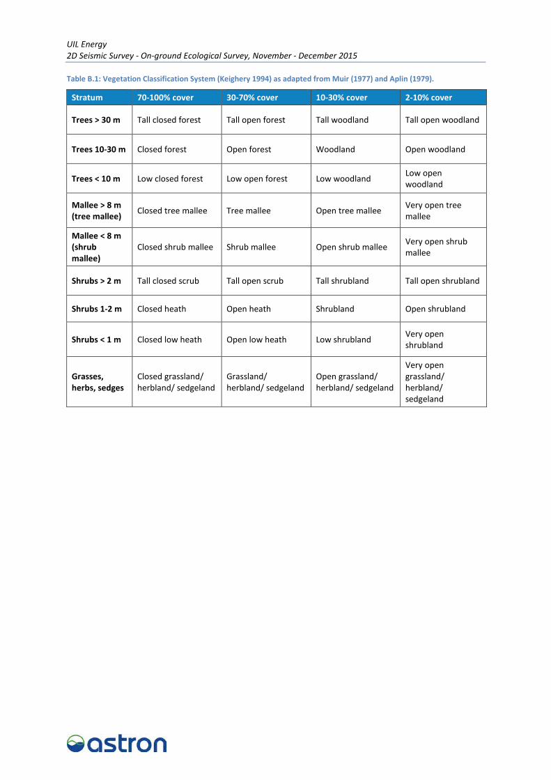
Broad floristic formations of the vegetation present in survey area were also recorded and were described according to Keighery’s (1994) modification of the vegetation classification system of Muir (1977) and Aplin (1979) (Table B.1, Appendix B), and the National Vegetation Information System level 3 (Department of the Environment 2015). Vegetation condition of the survey area was assessed according to the classification adapted by Keighery (1994) (Table B.2, Appendix B).
2.2.2 Terrestrial Vertebrate Fauna
The terrestrial fauna survey was undertaken in accordance with the requirements outlined in the EPA guidance documents (Environmental Protection Authority 2002, 2004b). In the context of a Level 1 survey, the guidance statement advises field observers to describe the fauna habitats of the survey area, which give a comprehensive list of fauna that can reasonably be expected to occur. Therefore the aim of the fauna component of the survey included descriptions of fauna habitats in the survey area and a compilation of fauna species recorded opportunistically as the survey area was traversed. The entire survey area was traversed on foot; 38 fauna habitat assessments were conducted and detailed the following:
• Location – coordinates measured using a handheld GPS (GDA94).
• Recorder and date –personnel involved in undertaking the fauna habitat assessment and the survey date.
• Habitat/landform – position in the landscape - major fauna habitat types were described based on the landform and vegetation.
• Vegetation type – a broad description of vegetation type and structure.
• Soils – a brief description of soil type.
• Microhabitat – presence of specific microhabitat features (for example, leaf litter, logs, burrows, rocky outcrops, rock crevices, hollows, permanent or semi-permanent water).
• Condition – habitat condition was assessed based on the presence of anthropogenic (human-induced) disturbances, and using the condition ratings suggested by Thompson and Thompson (2010) (Table B.3, Appendix B).
• Disturbance – any disturbance such as clearing, fire, weeds, flooding, vehicular, machinery, tracks or grazing.
• Photographs – a representative photograph was taken at each habitat assessment site.
UIL Energy 2D Seismic Survey – On-ground Ecological Survey, November - December 2015
Page | 8
The information derived from the fauna habitat assessments was used to delineate fauna habitats throughout the survey area.
Targeted searches were also undertaken for the western spiny-tailed skink (EN; S3) and Carnaby’s black cockatoo (EN; S2). The black cockatoo assessment was undertaken in accordance with the referral guidelines developed by the Department of the Environment (DoE) formerly the Department of Sustainability, Environment, Water, Population and Communities (Department of Sustainability Environment Water Population and Communities 2012). Targeted searches were undertaken within the survey area for black cockatoo foraging and breeding habitat.
To determine if the site was foraging habitat for black cockatoos, potential foraging plants were identified and recorded, and the ground was searched for any evidence of black cockatoo foraging, for example severed heads and seed cones of proteaceous plants found in the Banksia, Hakea and Dryandra genera.
To determine the breeding habitat classification of the site in accordance with Commonwealth referral guidelines (Department of Sustainability Environment Water Population and Communities 2012), a habitat assessment was undertaken. In addition native trees greater than 30 centimetre (cm) or 50 cm diameter at breast height (DBH) depending on the species, classified as mature trees with potential for breeding hollows to develop (Department of Sustainability Environment Water Population and Communities 2012), were recorded, including the species, height of tree, GPS coordinate and number of potential hollows. Photographs were taken of a representative sample of trees. To determine if trees had potential breeding hollows, the following criteria were assessed for each mature tree where possible, based on Gibbons and Lindenmayer (2002):
• height of the potential hollow in the tree
• minimum entrance width of a potential hollow
• diameter of the branch on which the potential hollow occurred
• whether the branch was living, part dead or dead
• whether the tree has multiple potential hollows.
Targeted searches for the western spiny-tailed skink were undertaken as per the threatened reptile survey guidelines (Department of Sustainability Environment Water Population and Communities 2011b). The western spiny-tailed skink leaves a single characteristic faecal pile (‘latrine’) that is usually located outside occupied log piles (How, Dell, and Robinson 2003).
2.2.3 Taxonomy and Nomenclature
Plant specimens that were not identified in the field were identified in Perth by Senior Botanists Natalie Cadd and Janelle Atkinson, and Botanists Carolyn Harding and Dr Kellie McMaster. The assigned nomenclature is consistent with the current listing of scientific names recognised by the Western Australian Herbarium.
Nomenclature and sequence for invertebrates, amphibians, reptiles, birds and mammals within this report is as per Western Australian Museum checklist for vertebrate fauna species (Western Australian Museum 2015). Field guides and accepted scientific peer review references were also used for fauna identification. There have been recent changes to the listings for conservation significant fauna species and this report has used the most recent rankings. Conservation categories and declared pest categories for flora, fauna and ecological communities are presented in Appendix C.

UIL Energy 2D Seismic Survey – On-ground Ecological Survey, November - December 2015
Page | 9
2.2.4 Limitations
Following the completion of the field survey, a review of any limitations that may affect the complete assessment of the data collected was conducted. Survey timing was broadly consistent with survey guidelines established by the EPA that ecological surveys be carried out in spring in this region (Environmental Protection Authority 2004b). However, the combination of below average annual rainfall and the timing of the survey in late spring/early summer were not optimal for the targeted conservation significant flora survey. Below average rainfall in the 12 months preceding the two field surveys, the early onset of hot dry weather conditions from the beginning of November and late spring/early summer timing resulted in the majority of plants no longer being in flower or displaying characteristics to make them easily identifiable. This impacted the potential number of positive identifications made in the field.
In an effort to obtain highly accurate location data for each conservation significant flora species, a DGPS was used for both field surveys. Due to certain topographical features within the survey area, such as occasional tall shrubs and tree canopy cover, the margin of error for accuracy, in these particular circumstances, may have been greater than originally anticipated (accuracy was expected to be in the order of 0.5 m).
The timing of surveys in November was not ideal to detect black cockatoos foraging within the survey area. The survey area is generally within the non-breeding range of Carnaby’s cockatoo and just on the edge of their breeding range (Department of Sustainability Environment Water Population and Communities 2012). At the time of the survey, Carnaby’s cockatoos would have been at their breeding sites, only leaving these sites and moving west towards the coast from late January/early February (Department of Sustainability Environment Water Population and Communities 2012).

UIL Energy 2D Seismic Survey – On-ground Ecological Survey, November - December 2015
Page | 10
3 Results
3.1 Seasonal Conditions
Weather observations recorded from the Badgingarra Research Station (09037), located approximately 6 km east of the survey area, were used to identify local rainfall and temperatures preceding the ecological survey (Bureau of Meteorology 2016). In the 12 months preceding the first survey, 339.4 millimetres (mm) of rainfall was recorded; 205 mm less than the long-term average (554.4 mm) (Figure 2). During the field surveys, daily maximum temperatures ranged between 24.4 degrees Celsius (°C) and 36.6°C (Bureau of Meteorology 2016).
Figure 2: Mean (1962 to 2015) monthly rainfall (mm) preceding the November and December 2015 field surveys recorded at Badgingarra Research Station (09037) (Bureau of Meteorology 2016). Red arrows indicate timing of field surveys.
3.2 Conservation Significant Flora and Vegetation
3.2.1 Conservation Significant Flora
No State or Commonwealth listed Threatened flora were recorded during the field survey.
Fifteen State-listed priority flora species were identified during the ecological survey (Table 3). Of these, two were P1, four were P2, six were P3 and three were P4. In total, 466 priority flora locations were recorded. Two hundred and twelve of these occurred within survey area, with the remaining 254 records occurring within 100 m of the survey area boundary. A summary of priority flora species and their recorded abundance, both within and outside of the survey area, is presented in Table 3. Detailed location information and abundance data for each recorded occurrence, along with a representative photograph of each species, are presented in Tables D.1 and D.2 (Appendix D). Conservation significant flora locations are also mapped in Figures D.1 to D.4 (Appendix D).
0
5
10
15
20
25
30
35
40
0
20
40
60
80
100
120
Max
imum
tem
pera
ture
(°C)
Rain
fall
(mm
)
Month/Year
Badgingarra Research Stn rainfall recorded 2015
Badgingarra Research Stn mean monthly rainfall (1962-2015)
Badgingarra Research Stn monthly max. temperature recorded 2015
Badgingarra Research Stn mean monthly max. temperature (1965-2015)

UIL Energy 2D Seismic Survey – On-ground Ecological Survey, November - December 2015
Page | 11
Table 3: Recorded priority flora species and abundance.
Species Recorded abundance
Total abundance Within survey
area Outside of survey area
Banksia pteridifolia subsp. vernalis P3 1 0 1
Chordifex chaunocoleus P4 1 0 1
Desmocladus elongatus P4 2 1 3
Eucalyptus macrocarpa subsp. elachantha P4 3 1 4
Hensmania stoniella P3 31 9 40
Hypocalymma serrulatum P3 13 5 18
Hypocalymma sp. Dandaragan (C.A. Gardner 9014) P1 1 0 1
Isopogon panduratus subsp. palustris P3 64 40 104
Jacksonia anthoclada P3 11 7 18
Lepidobolus quadratus P3 1 0 1
Leucopogon sp. Badgingarra (R. Davis 421) P2 80 167 247
Lyginia excelsa P1 1 0 1
Onychosepalum microcarpum P2 1 13 14
Stylidium hymenocraspedum P3 4 8 12
Verticordia argentea P2 0 1 1
Total 212 254 466
3.2.2 Introduced Flora (Weeds)
Five weed species were recorded in, or immediately adjacent to, the survey area; *Acetosa vesicaria (ruby dock), *Ehrharta calycina (perennial veldt grass), *Romulea rosea (Guildford grass), *Solanum nigrum (black berry nightshade) and *Ursinia anthemoides (ursinia). Weed species were primarily confined to an existing firebreak in the northern-most portion of seismic line MTJ16-04 and the north-eastern extent of seismic line MTJ16-01, which occurs within the Bibby Road reserve. One population of approximately 40 individuals of *A. vesicaria (ruby dock) was recorded within the Wongonderrah Road reserve, along seismic line MTJ16-02.
None of these species are listed as a Weed of National Significance (WoNS) (Australian Weeds Committee 2012), or is listed as a Declared pest plant in Western Australia under the Biodiversity and Agriculture Management Act 2007 (Department of Agriculture and Food Western Australia 2015). Locations, photographs and a description of all weeds within the survey area are presented in Tables D.3 and D.4 (Appendix D). All weed locations are also mapped in Figure D.5 (Appendix D).
3.2.3 Vegetation
Detailed survey of the vegetation within the survey area was not undertaken during the field survey. General observations were recorded while traversing the survey area for the targeted conservation significant flora survey.
No vegetation analogous with threatened ecological communities (TECs) or priority ecological communities (PECs) were observed during the survey.
UIL Energy 2D Seismic Survey – On-ground Ecological Survey, November - December 2015
Page | 12
Vegetation within the survey area was predominantly characterized by Banksia shrublands, open heath and woodlands. Table 4 outlines the broad floristic formations recorded within the survey area.
Table 4: Broad floristic formations recorded within the survey area.
Broad floristic formation Associated proposed seismic lines
Banksia open low shrubland to shrubland BW16-06, MAR16-05
Banksia shrubland to open heath BW16-02, BW16-03, BW16-04, BW16-05, MTJ16-01, MTJ16-02
Banksia shrubland to low woodland MTJ16-04, MTJ16-02
Banksia open low woodland to low woodland MTJ16-01, MTJ16-03
Vegetation in the survey area ranged from ‘degraded’ to ‘excellent’ condition (Keighery 1994). Vegetation within the Badgingarra National Park, Twyata Nature Reserve, Wongonderrah Nature Reserve and within some of the private properties was recorded to be in ‘excellent’ condition. Vegetation in the remainder of the survey area ranged from ‘good’ to ‘very good’. In these areas there was a higher level of disturbance due to human interaction such as vehicle tracks, rubbish and weeds. Dieback was also suspected to be present in some areas (for example, Wongonderrah Nature Reserve) where vegetation condition had declined.
3.3 Terrestrial Vertebrate Fauna
3.3.1 Fauna Habitats
Four fauna habitat types were identified during the field survey: Banksia woodland/shrubland, sparse eucalypt woodland, dampland and low heath (Table 5). The remaining 9.4 km of survey area (6.4 hectares (ha) or 14.5%) that was surveyed for fauna was essentially cleared tracks, plantings and part of an existing road reserve (Table 5). Fauna habitats are mapped in Appendix E. Fauna habitat assessment sites are also described in Table E.1 and mapped in Figures E.1 to E.5 (Appendix E).
Fauna habitat condition within Badgingarra National Park was considered of ‘high quality’, with only small parts of the proposed alignment that followed old and intact access tracks (100 m to 200 m of BW16-04 and a 100 m section of BW16-02) or burnt vegetation (1 km of BW16-03). Wongonderrah Nature Reserve was generally in ‘very good’ condition, displaying possible evidence of dieback infestation and approximately 2 km of previously cleared track (along MTJ16-03). Twyata Nature Reserve was considered in ‘good’ condition, as it was more degraded due to weeds, erosion and numerous tracks.
Fauna habitat within unallocated crown land, road reserves and private properties varied from ‘high quality’, along seismic lines MTJ16-03 and MTJ16-01 which passed through one private property, ‘good’ along seismic lines within unallocated crown land due to possible dieback infestation, to ‘disturbed’, along other sections of MTJ16-01 where it has been highly grazed by cattle. Cleared areas for roads, tracks, infrastructure or agriculture were considered to be ‘highly degraded’, which included sections of MTJ16-03 and MTJ16-02 seismic lines that pass through Wongonderrah Nature Reserve and UCL.

UIL Energy 2D Seismic Survey – On-ground Ecological Survey, November - December 2015
Page | 13
Table 5: Description of fauna habitats recorded within the survey area.
Habitat type Extent in survey area km/ha1/ (%)
Broad habitat/vegetation description Habitat assessment sites Habitat disturbance
Habitat suitability for Carnaby’s cockatoo and western spiny-tailed skink
Representative photos
Banksia shrubland/ woodland
44.92 linear km or 31.2 ha (71.3%)
Mixed Banksia spp. (predominantly B. attenuata and B. menziesii) shrubland to woodland generally over low heath on pale sands.
1, 2, 3, 5, 6, 7, 8, 9, 10, 12, 13, 14, 15, 17, 18, 19, 21, 22, 23, 25, 27, 28, 29, 30, 31, 32, 33, 36, 37, 38, 11a, 11d, 11e, 11f, 12a, 12b, 13b, 13c, 13d, 13g, 14a, 14b, 14c, 14d, 15a, 15b, 17a, 17c, 18a, 18b, 18c, 18d, 18e, 18f, 19c, 19e, 19g, 19h, 19i, 19j, 20b, 21a, 21b, 21c, 21d, 21f, 21g, 21h, 21i, 21j, 21k, 22a, 22b, 22c, 22d, 23a, 23d, 23f, 23g, 23h, 23i, 23j, 23k, 23m, 23n, 23o, 24a, 24b, 24g, 26b, 26c, 26d, 26e, 27a, 27b, 27c, 27d, 28b, 28c, 28e, 28f, 28g, 30a, 30b, 30c, 31a, 31c, 33a, 33b, 35d, 38b, 38c
High quality to disturbed condition. Some areas of possible dieback, roads and tracks, firebreaks and cattle grazing.
Suitable foraging habitat for Carnaby’s cockatoo. No suitable habitat for western spiny-tailed skink.
Sparse Eucalypt woodland
0.81 linear km or 0.6 ha (1.3%)
Corymbia calophylla and Eucalyptus rudis sparse woodland over mixed shrubland and grasses in riparian/major drainage zones. Eucalyptus wandoo or E. todtiana sparse woodland over Banskia woodland over low heath on sandplains.
4, 16, 20, 35, 28d, 38a
Very good to disturbed condition. Tracks, powerlines, weeds and erosion within major drainage zones. Some areas of firebreaks, cleared tracks in sandplains.
Suitable foraging habitat for Carnaby’s cockatoo. No suitable habitat for western spiny-tailed skink.
Low heath 6.46 linear km or 4.5 ha (10.2%)
Low mixed proteaceous heath with scattered Xanthorrhoea spp. and/or low shrubs on pale sands or lateritic soils.
24, 26, 34, 12c, 13a, 13e, 13f, 15c, 15d, 17b, 19a, 19b, 19d, 19f, 21e, 23l, 24d, 24f, 24i, 26a, 30d, 31b, 35a, 25f
High quality to good condition. Some areas of pipeline track and infrastucture.
Suitable foraging habitat for Carnaby’s cockatoo. No suitable habitat for western spiny-tailed skink.
Dampland 1.67 linear km or 1.2 ha (2.7%)
Kunzea and/or Melaleuca spp. dense shrubland over low heath and sedges on clayey sands.
23b, 23e, 24c, 24e, 24h, 28a High quality condition. No disturbance.
No suitable habitat for Carnaby’s cockatoo or western spiny-tailed skink.
Disturbed 9.37 linear km or 6.4 ha (14.5%)
Previously cleared or cleared tracks or burnt vegetation. 20a, 35b, 35e
Disturbed to highly degraded condition. Burnt or cleared tracks/roads.
No suitable habitat for Carnaby’s cockatoo or western spiny-tailed skink.
1 Linear km multiple on width of the search area (7 m)

UIL Energy 2D Seismic Survey – On-ground Ecological Survey, November - December 2015
Page | 14
This page has been left blank intentionally.

UIL Energy 2D Seismic Survey – On-ground Ecological Survey, November - December 2015
Page | 15
3.3.2 Fauna Species
Sixty-nine fauna species were recorded during the survey including one amphibian species, 15 reptile species, 46 bird species (including two conservation significant and one introduced species) and seven mammal species (including one conservation significant and three introduced species) (Table F.1, Appendix F). These species were identified either by sight or indirect evidence, such as calls and scats.
3.3.2.1 Conservation Significant Fauna
Three species of conservation significance were recorded within or just outside the survey area, consisting of two bird species and one mammal species (Table G.1, Appendix G). Conservation significant fauna locations are mapped in Figures G.1 to G.4 (Appendix G).
Thirteen other conservation significant species were identified in the original desktop assessment (UIL Energy Ltd 2015). Of these, one species, Baudin Island spiny-tailed skink (Ergenia stokesii aethiops) is a synonym for the western spiny-tailed skink and is no longer used (OEPA advice, 2015). Three other previously listed species: white-bellied sea-eagle (Haliaeetus leucogaster), carpet python (Morelia spilota imbricata) and woma python (Aspidites ramsayi) are no longer listed as conservation significant under the Environment Protection and Biodiversity Conservation Act 1999 (EPBC Act) and/or Wildlife Conservation Act 1950 (WC Act). Of the remaining nine conservation significant species, two – malleefowl (Leipoa ocellata) and chuditch (Dasyurus geoffroii) - were considered to be of moderate likelihood and seven were considered to be low likelihood of occurring within the survey area (Table G.2; Appendix G).
Following the field survey, the western spiny-tailed skink (Egernia stokesii badia) was considered unlikely to occur within the survey area as no suitable habitat was recorded. The most prospective habitat within the survey area was the woodland habitat in Twyata Nature Reserve. However given the condition, isolation and degradation of the habitat observed within the reserve it is considered unsuitable to support a population of this lizard.
Carnaby’s cockatoo (Calyptorhynchus latirostris); EPBC Act – Endangered; WC Act – Schedule 2
The Carnaby’s cockatoo is endemic; found only in the south-west region of Western Australia from the Murchison River to Esperance and inland to Coorow, Kellerberrin and Lake Cronin (Cale 2003). Foraging resources include seeds, nuts and flowers of a variety of native and exotic plants. Food plants include Banksia (including those previously included in the genus Dryandra), pine trees, marri, jarrah, and species of Grevillea, Allocasuarina, and Hakea (Shah 2006). The seeds of Banksia and pine trees provide the highest energetic yield (Cooper et al. 2002). Breeding has been recorded from early July to mid-December, and primarily occurs in the Wheatbelt in the semi-arid and sub-humid interior (Johnstone and Storr 1998). Threats include habitat loss due to the clearing of core breeding habitat in the Wheatbelt, the deterioration of nesting hollows, and clearing of food resources on the Swan Coastal Plain (Cale 2003). In the last 45 years the species has suffered rapid decline in numbers consisting of a 50% reduction in its abundance within its known distribution (Cale 2003).
Carnaby’s cockatoos were heard calling less than 200 m from the survey area near MTJ16-04 (Figures G.1 to G.4, Appendix G). Numerous other records of this species were observed outside the survey area (Table G.1 and Figures G.1 to G.4, Appendix G). Carnaby’s cockatoos were observed roosting within trees at the Badgingarra tavern and roadhouse every night adjacent to seismic line BW16-06.

UIL Energy 2D Seismic Survey – On-ground Ecological Survey, November - December 2015
Page | 16
The survey area provides diverse foraging potential for this species although no direct observations or recent foraging evidence was recorded within the survey area during the assessment. The Banksia woodland/shrubland (31.2 ha), sparse eucalypt woodland (0.6 ha) and low heath (4.5 ha) habitats within the survey area are considered to provide suitable foraging resources for Carnaby’s cockatoo. Seismic lines within Badgingarra National Park (BW16-04and BW16-05-s), as well as seismic line MTJ16-03 that runs through one private property contain the higher quality foraging habitat suitable for black cockatoos. Whilst the other nature reserves contain suitable foraging habitat, Wongonderrah Nature Reserve has possible areas of dieback infestation and Twyata Nature Reserve is highly degraded.
Five potential breeding trees for Carnaby’s cockatoo were recorded within the survey area corridor: two wandoo trees along MTJ16-04, one powderbark wandoo tree along BW16-06, one marri tree along BW16-01 and one coastal blackbutt tree along MTJ16-02; however, none of these trees contained hollows (Figures G.1 to G.4, Appendix G). In addition, 11 potential breeding trees were located within 5 m of the survey area corridor: three wandoo trees, one marri tree, one flooded gum and five unknown species (Figures G.1 to G.4, Appendix F). Four of the unknown species trees contained hollows but were all full of feral bees and therefore unsuitable for breeding Carnaby’s cockatoos. Twenty-nine potential breeding trees, 12 with hollows and 17 without hollows, were recorded up to 100 m from the survey area corridor (Figures G.1 to G.4, Appendix G). No trees had any signs of past or present black cockatoo use and a number of trees were occupied by feral bees or galahs (Table G.3, Appendix G).
Rainbow bee-eater (Merops ornatus); EPBC Act – Migratory; WC Act – Schedule 5
The Rainbow bee-eater is one of the most common and widespread birds in Australia. The species winters from the Gascoyne north to Indonesia, moving south mainly in late September and early October and north from February to April (Johnstone and Storr 1998). Rainbow bee-eaters tend to prefer lightly wooded, preferably sandy country near water (Johnstone and Storr 1998).
Several observations of the rainbow bee-eater were recorded along the Hill River, near Twyata Nature Reserve as well as near one private property (Table G.1 and Figures G.1 to G.4, Appendix G).
Western brush wallaby (Notamacropus irma); Parks and Wildlife P4
The western brush wallaby is generally found in open habitat forests or woodlands, particularly favouring open, seasonally-wet flats with low grasses and open scrubby thickets. It is also found in some areas of mallee and heath-land such as what is found in the survey areas.
Two individuals were recorded from within the Badgingarra National Park (Table G.1 and Figures G.1 to G.4, Appendix G).

UIL Energy 2D Seismic Survey – On-ground Ecological Survey, November - December 2015
Page | 17
4 Discussion
4.1 Conservation Significant Flora
No threatened flora species were identified during the field survey. An assessment of the Parks and Wildlife TPFL database and the Western Australia Herbarium Flora database searches indicates that 23 threatened flora species have been previously recorded within 5 km of the project area. None of these previous records are located within the survey area, although one species, Eucalyptus × balanites T, has been recorded within 50 m of the survey area boundary (Department of Parks and Wildlife 2015c, 2015e). An assessment of the likelihood of occurrence of each of these 23 threatened species, based primarily on validating the presence of suitable habitats within the survey area, combined with life form, habitat and flowering information for each species, indicates that eleven of the 23 threatened species are still considered to have the potential to occur within the survey area. These species have been previously recorded in close proximity to the survey area and suitable habitat for them was identified within the survey area. If present, these species may have gone unnoticed due to reasons such as a small habit or likely absence of flowers at the time of survey. None of these species would be restricted to the survey area if present, as indicated by the voucher records listed with the WAHerb (Western Australian Herbarium 1998-2015).
Fifteen priority flora were recorded during the field: Banksia pteridifolia subsp. vernalis P3, Chordifex chaunocoleus P4, Desmocladus elongatus P4, Eucalyptus macrocarpa subsp. elachantha P4, Hensmania stoniella P3, Hypocalymma serrulatum P3, Hypocalymma sp. Dandaragan (C.A. Gardner 9014) P1, Isopogon panduratus subsp. palustris P3, Jacksonia anthoclada P3, Lepidobolus quadratus P3, Leucopogon sp. Badgingarra (R. Davis 421) P2, Lyginia excelsa P1, Onychosepalum microcarpum P2, Stylidium hymenocraspedum P3 and Verticordia argentea P2. With the exception of V. argentea P2, all priority flora species have been previously recorded within or in close proximity to the survey area (Department of Parks and Wildlife 2015d, 2015e; Mattiske Consulting 2012). The closest recorded location of V. argentea P2 is approximately 40 km north-west of the survey area (Western Australian Herbarium 1998-2015). Following both the field and desktop assessment, it is still considered likely that additional priority flora may occur within the survey area.
There are currently numerous vouchered records for all the P3 and P4 flora species at the Western Australian Herbarium. The number of vouchered records range from 15 (Hypocalymma serrulatum P3) to 54 (Eucalyptus macrocarpa subsp. elachantha P4), and are located throughout the region. There is more limited information available for the P1 and P2 flora species, except Verticordia argentea P2 which currently has 38 vouchered records held at the Western Australian Herbarium. There are currently only five vouchered records for both of the P1 species, Hypocalymma sp. Dandaragan (C.A. Gardner 9014) and Lyginia excelsa, and six and nine vouchered records for Onychosepalum microcarpum P2 and Leucopogon sp. Badgingarra (R. Davis 421) P2 respectively.
The P1 species, Hypocalymma sp. Dandaragan (C.A. Gardner 9014) P1 and Lyginia excelsa P1, were recorded at one location each within the survey area. One individual of H. sp. Dandaragan (C.A. Gardner 9014) P1 was recorded within private property along seismic line BW16-06, while three individuals of L. excelsa P1 were recorded at the one location within the Badgingarra National Park, along seismic line MTJ16-04. Larger populations were recorded for the P2 species identified during the field assessment. Three populations of Onychosepalum microcarpum P2 were identified, with a total of 19 individuals recorded. There were also three populations of Leucopogon sp. Badgingarra (R. Davis 421) P2 recorded, with an abundance of 550 individuals. All occurrences of O. microcarpum P2 and L. sp. Badgingarra (R. Davis 421) P2 were recorded within the Badgingarra National Park. Impacts to some priority flora due to the proposed clearing are likely, as the spread of species along the width of the 7 m survey alignment would make avoidance impossible. Where only scattered

UIL Energy 2D Seismic Survey – On-ground Ecological Survey, November - December 2015
Page | 18
individuals or small groups of priority flora were recorded, it may be possible to facilitate the proposed clearing without impact.
4.2 Weeds
Five weed species were recorded in the survey area; *Acetosa vesicaria (ruby dock), *Ehrharta calycina (perennial veldt grass), *Romulea rosea (Guildford grass), *Solanum nigrum (black berry nightshade) and *Ursinia anthemoides (ursinia). None of these species are listed as a WoNS (Australian Weeds Committee 2012), or are listed as a Declared pest plant in Western Australia (Department of Agriculture and Food Western Australia 2015). The majority of weed records are restricted to the most northern extent of seismic line MTJ16-04.
4.3 Vertebrate Fauna
Four broad fauna habitat types, Banksia woodland/shrubland, sparse Eucalypt woodland, dampland and low heath, were recorded within the survey area. Approximately 9.4 km, or 6.4 ha (14.5%) of the surveyed area was considered to be disturbed from existing tracks, road reserves, agriculture or infrastructure. These habitats provide micro-habitats suitable for a wide suite of species, with 69 vertebrate species recorded during the survey.
Three conservation significant species were recorded during the survey: Carnaby’s cockatoo, western brush wallaby and rainbow bee-eater. An additional two species were considered to have a moderate likelihood of occurrence (chuditch and malleefowl); however, are not likely to be reliant upon habitat within it. Similar habitat is directly adjacent to the survey areas and the conservation significant species likely to occur could potentially move to these areas to avoid disturbance. A number of conservation significant species originally identified in the desktop assessment (UIL Energy Ltd 2015) have since been delisted. Following the field survey, the western spiny-tailed skink (Egernia stokesii badia) was considered unlikely to occur within the survey area as no suitable habitat capable of supporting a population was recorded.
Large portions of the survey area (approximately 52.19 km or 36.3 ha) are consistent with the definition of ‘quality’ foraging habitat for Carnaby’s cockatoo, in accordance with the Commonwealth referral guidelines (Department of Sustainability Environment Water Population and Communities 2012). Although no direct observation or recent evidence of foraging was observed within the survey area (partly due to the narrowness of the survey alignment and timing of survey), the Banksia woodland/shrubland, sparse eucalypt woodland and low heath habitats would be considered suitable black cockatoo foraging habitat. A regional estimate reveals that approximately 22,466 ha of potential foraging resources may be contained within Parks and Wildlife managed lands (Coomallo, Twyata and Wongonderrah Nature Reserves and Badgingarra National Park) in the vicinity of the survey. The amount of native vegetation requiring clearing within the survey area represents less than 1% of these potential resources, assuming that vegetation communities and quality are similar.
The Parks and Wildlife database search identified a number of confirmed breeding locations or nesting sites at Coomallo (Department of Parks and Wildlife 2015c) and Coomallo has also been designated as an Important Bird Area (IBA) for Carnaby’s cockatoo as it supports up to 40 breeding pairs (Department of Parks and Wildlife 2013). The Coomallo IBA is located adjacent and near to seismic lines MAR16-04, MAR15-07 and BW16-05, however these seismic lines are not vegetated and located on pastoral lands and therefore do not support black cockatoo habitat. The Coomallo IBA is however located within approximately 13 km of suitable foraging habitat in the survey area at Twyata Nature Reserve. Astron recorded Carnaby’s cockatoos roosting at the Badgingarra tavern/roadhouse, which is located within 2 km of suitable foraging habitat along seismic line

UIL Energy 2D Seismic Survey – On-ground Ecological Survey, November - December 2015
Page | 19
BWI16-05-S located in Badgingarra National Park. There is also one record from the database search for a Carnaby’s Cockatoo hollow (TFAUNA 75966; Department of Parks and Wildlife 2015c) that occurs within 500 m of a section of seismic line BW16-01 passing through Twyata Nature Reserve and within 2 km of seismic lines BW16-02, BW16-05 and BW16-06 that pass through Badgingarra National Park. The referral guidelines (Department of Sustainability Environment Water Population and Communities 2012) state that foraging habitat within a 6 km to 12 km radius of a confirmed breeding site and within 6 km of roosting sites is considered important; the nearest suitable foraging habitat within the survey area currently falls within this radius for both recorded roosting and nesting sites.
The Banksia woodland/shrubland, sparse Eucalypt woodland and low heath representing approximately 52 linear km or 36.3 ha of foraging habitat was assessed in a 7 m corridor. However, Astron understands that UIL Energy’s clearing corridor width will be 4.5 m or less. Therefore, approximately 23.5 ha of foraging habitat may be lost due to clearing vegetation for seismic line activities. The final estimates on how many hectares of foraging habitat will be cleared will be provided by UIL Energy based on final specifications for seismic survey operations.
UIL Energy 2D Seismic Survey – On-ground Ecological Survey, November - December 2015
Page | 24
6 References
Aplin, TEH 1979, 'The flora', in B. J. O'Brien (ed), Environment and Science, University of Western Australia Press, Perth.
Australian Weeds Committee 2012, Weeds of National Significance 2012, Department of Agriculture, Fisheries and Forestry, Canberra.
Beard, JS 1990, Plant Life of Western Australia, Kangaroo Press, Kenthurst, New South Wales.
Bureau of Meteorology 2016, Climate data online, <http://www.bom.gov.au/climate/data/index.shtml>.
Cale, B 2003, Carnaby’s Black-cockatoo (Calyptorhynchus latirostris) Recovery Plan, Department of Conservation and Land Management, Perth.
Cooper, C, Withers, P, Mawson, P, Bradshaw, S, Prince, J & Robertson, H 2002, 'Metabolic ecology of cockatoos in the south-west of Western Australia', Australian Journal of Zoology, vol. 50, pp. 67-76.
Department of Agriculture and Food Western Australia 2013, 'Soil-landscape Systems of Western Australia', Digital spatial dataset supplied by DAFWA on 16/08/2013.
Department of Agriculture and Food Western Australia 2015, Western Australian Organisms List, <http://www.biosecurity.wa.gov.au/western-australian-organism-list-waol>.
Department of Environment Regulation 2014a, A guide to native vegetation clearing processes under the assessment bilateral agreement between the Commonwealth of Australia and Western Australia under the Environment Protection and Biodiversity Conservation Act 1999 and Environmental Protection Act 1986, Goverment of Western Australia, Perth.
Department of Environment Regulation 2014b, A Guide to the Assessment of Applications to Clear Native Vegetation: Under Part V Division 2 of the Environmental Protection Act 1986, Government of Western Australia, Perth.
Department of Environment Regulation 2015, Identification and investigation of acid sulfate soils and acidic landscapes, Department of Environment Regulation, Perth.
Department of Parks and Wildlife 2013, Carnaby’s Cockatoo (Calyptorhynchus latirostris) Recovery Plan, Western Australian Wildlife Management Program No. 52, Perth.
Department of Parks and Wildlife 2015a, 'Department of Parks and Wildlife Managed Lands and Waters', Digital spatial dataset downloaded from the SLIP Portal (https://www2.landgate.wa.gov.au/web/guest/home) on 05/11/2015. Dataset last updated on 26/11/2014.
Department of Parks and Wildlife 2015b, 'Threatened and Priority Ecological Communities database', Department of Parks and Wildlife, Kensington.
Department of Parks and Wildlife 2015c, 'Threatened and Priority Fauna database', Department of Parks and Wildlife, Kensington.
Department of Parks and Wildlife 2015d, 'Threatened and Priority Flora database', Department of Parks and Wildlife, Kensington.
Department of Parks and Wildlife 2015e, 'Western Australian Herbarium database', Department of Parks and Wildlife, Kensington.
Department of Sustainability Environment Water Population and Communities 2011a, Survey guidelines for Australia’s threatened mammals: Guidelines for detecting mammals listed as
UIL Energy 2D Seismic Survey – On-ground Ecological Survey, November - December 2015
Page | 25
threatened under the Environment Protection and Biodiversity Conservation Act 1999, Commonwealth of Australia, Canberra.
Department of Sustainability Environment Water Population and Communities 2011b, Survey guidelines for Australia’s threatened reptiles, Commonwealth of Australia, Canberra.
Department of Sustainability Environment Water Population and Communities 2012, Environment Protection and Biodiversity Conservation Act 1999 referral guidelines for three threatened black cockatoo species: Carnaby’s cockatoo, Baudin’s cockatoo and Forest red-tailed black cockatoo, Commonwealth of Australia, Canberra.
Department of the Environment 2015, Australian Vegetation Attribute Manual, National Vegetation Information System Version 6, <http://www.environment.gov.au/erin/nvis/publications/avam/section-2-1.html#table1>.
Department of Water 2008, Public Drinking Water Source Areas of Western Australia: A Register of Drinking Water Catchments Within Each Local Government, Department of Water, Water Source Management Division, Perth.
Department of Water 2014a, 'Hydrographic Catchments', Department of Water, digital spatial dataset supplied on 05/02/2014.
Department of Water 2014b, 'Hydrography, Linear (Hierarchy)', Department of Water, digital spatial dataset supplied on 05/02/2014.
Desmond, A & Chant, A 2001, Geraldton Sandplain 3 (GS3 - Leseur Sandplain Subregion), (M. Cowan, chairman), A Biodiversity Audit of Western Australia's 53 Biogeographical Subregions in 2002, Department of Conservation and Land Management, Perth.
Environmental Protection Authority 2000, Environmental Protection of Native Vegetation in Western Australia: Clearing of Native Vegetation, with Particular Reference to the Agricultural Area, Position Statement 2, Environmental Protection Authority, Perth.
Environmental Protection Authority 2002, Terrestrial Biological Surveys as an Element of Biodiversity Protection, Position Statement 3, Environmental Protection Authority, Perth.
Environmental Protection Authority 2004a, Terrestrial Fauna Surveys for Environmental Impact Assessment in Western Australia, Guidance Statement 56, Environmental Protection Authority, Perth.
Environmental Protection Authority 2004b, Terrestrial Flora and Vegetation Surveys for Environmental Impact Assessment in Western Australia, Guidance Statement 51, Environmental Protection Authority, Perth.
Environmental Protection Authority & Department of Environment and Conservation 2010, Technical Guide – Terrestrial Vertebrate Fauna Surveys for Environmental Impact Assessment, Environmental Protection Authority, Perth.
Gibbons, P & Lindenmayer, D 2002, Tree Hollows and Wildlife Conservation in Australia, CSIRO Publishing, Collingwood.
Government of Western Australia 2014, 2014 Statewide Vegetation Statistics Incorporating the CAR Reserve Analysis (Full Report), Parks and Wildlife, Perth.
How, RA, Dell, J & Robinson, DJ 2003, 'The western spiny-tailed skink, Egernia stokesii badia: declining distribution in a habitat specialist', Western Australian Naturalist, vol. 24, no. 2, pp. 138-46.
Johnstone, RE & Storr, GM 1998, Handbook of Western Australian Birds Volume 1 - Non-passerines (Emu to Dollarbird), Western Australian Museum, Perth.

UIL Energy 2D Seismic Survey – On-ground Ecological Survey, November - December 2015
Page | 26
Keighery, B 1994, Bushland Plant Survey: A Guide to Plant Community Survey for the Community, Wildflower Society of WA (Inc.), Nedlands, Perth.
Mattiske Consulting 2012, Environmental Assessment of the Badgingarra 2D Seismic Survey Area: EP447, EP454, EP407 R1 and Adjoining Proposed Survey Areas, unpublished report to UIL Energy Limited.
Mitchell, D, Williams, K & Desmond, A 2002, Swan Coastal Plain 2 (SWA2 - Swan Coastal Plain Subregion), (M. Cowan, chairman), A Biodiversity Audit of Western Australia's 53 Biogeographical Subregions in 2002, Department of Conservation and Land Management, Perth.
Muir, BG 1977, Biological Survey of the Western Australian Wheatbelt. Part 2. Vegetation and Habitat of Bendering Reserve, Records of the Western Australian Museum. Supplement No. 3, Western Australian Museum, Perth.
Shah, B 2006, Conservation of Carnaby’s Black Cockatoo on the Swan Coastal Plain, Birds Australia, Perth.
Stewart, AJ, Sweet, IP, Needham, RS, Raymond, OL, Whitaker, AJ, Liu, SF, Phillips, D, Retter, AJ, Connolly, DP & Stewart, GR 2008, 'Surface Geology of Australia 1: 1 000 000 Scale, Western Australia [Digital Dataset]', The Commonwealth of Australia, Geoscience Australia (http://www.ga.gov.au), Canberra.
Thompson, SA & Thompson, GG 2010, Terrestrial Vertebrate Fauna Assessments for Ecological Impact Assessment, Terrestrial Ecosystems, Mt Claremont.
UIL Energy Ltd 2015, Environmental Desktop Study (Summary) – Project: UIL Energy 2D Seismic Survey, Onshore, Perth Basin, WA, UIL Energy Limited.
Western Australian Herbarium 1998-2015, 'FloraBase – the Western Australian Flora', Department of Parks and Wildlife. http://florabase.dpaw.wa.gov.au.
Western Australian Museum 2015, Western Australian Museum Checklist of the Vertebrates of Western Australia, updated April 2015, <http://museum.wa.gov.au/research/departments/terrestrial-zoology/checklist-terrestrialvertebrate-fauna-western-australia>.
UIL Energy 2D Seismic Survey - On-ground Ecological Survey, November - December 2015
Appendix B: Vegetation Classification and Condition Scales, and Fauna Habitat Condition Scale

UIL Energy 2D Seismic Survey - On-ground Ecological Survey, November - December 2015
This page has been left blank intentionally.
UIL Energy 2D Seismic Survey - On-ground Ecological Survey, November - December 2015
Table B.1: Vegetation Classification System (Keighery 1994) as adapted from Muir (1977) and Aplin (1979).
Stratum 70-100% cover 30-70% cover 10-30% cover 2-10% cover
Trees > 30 m Tall closed forest Tall open forest Tall woodland Tall open woodland
Trees 10-30 m Closed forest Open forest Woodland Open woodland
Trees < 10 m Low closed forest Low open forest Low woodland Low open woodland
Mallee > 8 m (tree mallee) Closed tree mallee Tree mallee Open tree mallee Very open tree
mallee
Mallee < 8 m (shrub mallee)
Closed shrub mallee Shrub mallee Open shrub mallee Very open shrub mallee
Shrubs > 2 m Tall closed scrub Tall open scrub Tall shrubland Tall open shrubland
Shrubs 1-2 m Closed heath Open heath Shrubland Open shrubland
Shrubs < 1 m Closed low heath Open low heath Low shrubland Very open shrubland
Grasses, herbs, sedges
Closed grassland/ herbland/ sedgeland
Grassland/ herbland/ sedgeland
Open grassland/ herbland/ sedgeland
Very open grassland/ herbland/ sedgeland

UIL Energy 2D Seismic Survey - On-ground Ecological Survey, November - December 2015
Table B.2: Summary of adapted vegetation condition scale from Keighery (1994).
Condition Description
Pristine Pristine or nearly so, no obvious signs of disturbance.
Excellent Vegetation structure intact, disturbance affecting individual species and weeds are non-aggressive species.
Very Good Vegetation structure altered obvious signs of disturbance. Disturbance to vegetation structure covers repeated fire, aggressive weeds, dieback, logging, grazing.
Good
Vegetation structure significantly altered by very obvious signs of multiple disturbances. Retains basic vegetation structure or ability to regenerate it. Disturbance to vegetation structure covers frequent fires, aggressive weeds at high density, partial clearing, dieback and grazing.
Degraded
Basic vegetation structure severely impacted by disturbance. Scope for regeneration but not to a state approaching good condition without intensive management. Disturbance to vegetation structure includes frequent fires, presence of very aggressive weeds, partial clearing, dieback and grazing.
Completely Degraded
The structure of the vegetation is no longer intact and the area is completely or almost completely without native species. These areas often described as “parkland cleared” with the flora comprising weed or crop species with isolated native trees or shrubs.

UIL Energy 2D Seismic Survey - On-ground Ecological Survey, November - December 2015
Table B.3: Fauna habitat condition scale (Thompson and Thompson 2010).
Habitat condition Condition description
High Quality Fauna Habitat
These areas closely approximate the vegetation mix and quality that would have been in the area prior to any human induced disturbance. The habitat has connectivity with other habitats and is likely to support the most natural vertebrate fauna assemblage.
Very Good Fauna Habitat
These areas show minimal signs of human induced disturbance (e.g. grazing, clearing, fragmentation, weeds) and retain almost all of the characteristics of the habitat had it not been disturbed. The habitat has connectivity with other habitats, and fauna assemblages in these areas are likely to be minimally effected by disturbance.
Good Fauna Habitat
These areas show signs of human induced disturbance (e.g. grazing, clearing, fragmentation, weeds) but generally retain many of the characteristics of the habitat had it not been disturbed. The habitat still retains some connectivity with other habitats but fauna assemblages in these areas are likely to be affected by disturbance. Fauna assemblages in these areas are likely to be similar to what might be expected in this habitat.
Disturbed Fauna Habitat
These areas show signs of human induced significant disturbance (e.g. mining, clearing, tracks and roads). Many of the trees, shrubs and undergrowth have died or have been cleared. These areas may be in the early succession and regeneration stages. Areas may show signs of significant grazing, contain an abundance of weeds or have been damaged by vehicles or machinery. Habitats are fragmented or have limited connectivity with other fauna habitats. Fauna assemblages in these areas are likely to differ significantly from what might be expected in the area had the disturbance not occurred.
Highly Degraded Fauna Habitat
These areas often have a significant human induced loss of vegetation, and / or a large number of vehicle tracks and / or have been completely cleared, and / or areas have been heavily grazed or farmed. There is limited or no fauna habitat connectivity. Fauna assemblages in these areas are likely to differ significantly from what existed prior to the disturbance, and are often depleted compared to what existed prior to the disturbance.

UIL Energy 2D Seismic Survey - On-ground Ecological Survey, November - December 2015
References
Aplin, TEH 1979, 'The flora', in B. J. O'Brien (ed), Environment and Science, University of Western Australia Press, Perth.
Keighery, B 1994, Bushland Plant Survey: A Guide to Plant Community Survey for the Community, Wildflower Society of WA (Inc.), Nedlands, Perth.
Muir, BG 1977, Biological Survey of the Western Australian Wheatbelt. Part 2. Vegetation and Habitat of Bendering Reserve, Records of the Western Australian Museum. Supplement No. 3, Western Australian Museum, Perth.

UIL Energy 2D Seismic Survey –On-ground Ecological Survey, November - December 2015
Appendix C: Conservation Categories for Flora, Fauna and Ecological Communities, and Categories for Declared Pest Species

UIL Energy 2D Seismic Survey –On-ground Ecological Survey, November - December 2015
This page has been left blank intentionally.

UIL Energy 2D Seismic Survey –On-ground Ecological Survey, November - December 2015
Table C.1: Categories and definitions for threatened flora and fauna species listed under the Environment Protection and Biodiversity Conservation Act 1999.
Conservation category Definition
Extinct Taxa with no reasonable doubt that the last member of the species has died.
Extinct in the wild
Taxa known to survive only in cultivation, in captivity or as a naturalized population well outside its past range; or it has not been recorded in its known and/or expected habitat, at appropriated seasons, anywhere in its past range, despite exhaustive surveys over a time frame appropriate to its life cycle and form.
Critically endangered (CR) Taxa facing an extremely high risk of extinction in the wild in the immediate future, as determined in accordance with the prescribed criteria.
Endangered (E) Taxa are not critically endangered; and are facing a very high risk of extinction in the wild in the near future, as determined in accordance with the prescribed criteria.
Vulnerable (V) Taxa are not critically endangered or endangered; and are facing a high risk of extinction in the wild in the medium-term future, as determined in accordance with the prescribed criteria.
Conservation dependent (CD)
Taxa are the focus of a specific conservation program the cessation of which would result in the species becoming vulnerable, endangered or critically endangered; or the following subparagraphs are satisfied:
i) the taxa is a species of fish; ii) the taxa is the focus of a management plan that provides
management actions necessary to stop the decline of, and support the recovery of, the taxa so that its chances of long term survival in nature are maximized;
iii) the management plan is in force under a law of the Commonwealth or of a State or Territory;
iv) Cessation of the management plan would adversely affect the conservation status of the taxa
Fish includes all taxa of bony fish, sharks, rays, crustaceans, molluscs and other marine organisms, but does not include marine mammals/reptiles.

UIL Energy 2D Seismic Survey –On-ground Ecological Survey, November - December 2015
Table C.2: Definitions and criteria for threatened ecological communities under the Environment Protection and Biodiversity Conservation Act 1999.
Categories of ecological communities
Critically endangered If, at that time, it is facing an extremely high risk of extinction in the wild in the immediate future, as determined in accordance with the prescribed criteria.
Endangered If, at that time, it is not critically endangered and is facing a very high risk of extinction in the wild in the near future, as determined in accordance with the prescribed criteria.
Vulnerable If, at that time, it is not critically endangered or endangered, and is facing a high risk of extinction in the wild in the medium-term future, as determined in accordance with the prescribed criteria.
Table C.3: Categories of Threatened Ecological Communities (Department of Parks and Wildlife 2015).
PD: Presumed Totally Destroyed
An ecological community that has been adequately searched for but for which no representative occurrences have been located. The community has been found to be totally destroyed or so extensively modified throughout its range that no occurrence of it is likely to recover its species composition and/or structure in the foreseeable future. An ecological community will be listed as presumed totally destroyed if there are no recent records of the community being extant and either of the following applies ( A or B): A) Records within the last 50 years have not been confirmed despite thorough searches of known or likely habitats or B) All occurrences recorded within the last 50 years have since been destroyed.
CR : Critically Endangered
An ecological community that has been adequately surveyed and found to have been subject to a major contraction in area and/or that was originally of limited distribution and is facing severe modification or destruction throughout its range in the immediate future, or is already severely degraded throughout its range but capable of being substantially restored or rehabilitated. An ecological community will be listed as Critically Endangered when it has been adequately surveyed and is found to be facing an extremely high risk of total destruction in the immediate future. This will be determined on the basis of the best available information, by it meeting any one or more of the following criteria (A, B or C): A) The estimated geographic range, and/or total area occupied, and/or number of discrete occurrences since European settlement have been reduced by at least 90% and either or both of the following apply (i or ii): i) geographic range, and/or total area occupied and/or number of discrete occurrences are continuing to decline such that total destruction of the community is imminent (within approximately 10 years); ii) modification throughout its range is continuing such that in the immediate future (within approximately 10 years) the community is unlikely to be capable of being substantially rehabilitated. B) Current distribution is limited, and one or more of the following apply (i, ii or iii): i) geographic range and/or number of discrete occurrences, and/or area occupied is highly restricted and the community is currently subject to known threatening processes which are likely to result in total destruction throughout its range in the immediate future (within approximately 10 years); ii) there are very few occurrences, each of which is small and/or isolated and extremely vulnerable to known threatening processes; iii) there may be many occurrences but total area is very small and each occurrence is small and/or isolated and extremely vulnerable to known threatening processes. C) The ecological community exists only as highly modified occurrences that may be capable of being rehabilitated if such work begins in the immediate future (within approximately 10 years).

UIL Energy 2D Seismic Survey –On-ground Ecological Survey, November - December 2015
En: Endangered
An ecological community that has been adequately surveyed and found to have been subject to a major contraction in area and/or was originally of limited distribution and is in danger of significant modification throughout its range or severe modification or destruction over most of its range in the near future. An ecological community will be listed as Endangered when it has been adequately surveyed and is not Critically Endangered but is facing a very high risk of total destruction in the near future. This will be determined on the basis of the best available information by it meeting any one or more of the following criteria (A, B, or C): A) The geographic range, and/or total area occupied, and/or number of discrete occurrences have been reduced by at least 70% since European settlement and either or both of the following apply (i or ii): i) the estimated geographic range, and/or total area occupied and/or number of discrete occurrences are continuing to decline such that total destruction of the community is likely in the short term future (within approximately 20 years); ii) modification throughout its range is continuing such that in the short term future (within approximately 20 years) the community is unlikely to be capable of being substantially restored or rehabilitated. B) Current distribution is limited, and one or more of the following apply (i, ii or iii): i) geographic range and/or number of discrete occurrences, and/or area occupied is highly restricted and the community is currently subject to known threatening processes which are likely to result in total destruction throughout its range in the short term future (within approximately 20 years); ii) there are few occurrences, each of which is small and/or isolated and all or most occurrences are very vulnerable to known threatening processes; iii) there may be many occurrences but total area is small and all or most occurrences are small and/or isolated and very vulnerable to known threatening processes. C) The ecological community exists only as very modified occurrences that may be capable of being substantially restored or rehabilitated if such work begins in the short-term future (within approximately 20 years).
VU: Vulnerable
An ecological community that has been adequately surveyed and is found to be declining and/or has declined in distribution and/or condition and whose ultimate security has not yet been assured and/or a community that is still widespread but is believed likely to move into a category of higher threat in the near future if threatening processes continue or begin operating throughout its range. An ecological community will be listed as Vulnerable when it has been adequately surveyed and is not Critically Endangered or Endangered but is facing a high risk of total destruction or significant modification in the medium to long-term future. This will be determined on the basis of the best available information by it meeting any one or more of the following criteria (A, B or C): A) The ecological community exists largely as modified occurrences that are likely to be capable of being substantially restored or rehabilitated. B) The ecological community may already be modified and would be vulnerable to threatening processes, is restricted in area and/or range and/or is only found at a few locations. C) The ecological community may be still widespread but is believed likely to move into a category of higher threat in the medium to long term future because of existing or impending threatening processes.

UIL Energy 2D Seismic Survey –On-ground Ecological Survey, November - December 2015
Possible Threatened Ecological Communities that do not meet survey criteria or that are not adequately defined are added to the Priority Ecological Community Lists under Priorities 1, 2 and 3. Ecological communities that are adequately known, and are rare but not threatened or meet criteria for Near Threatened, or that have been recently removed from the threatened list, are placed in Priority 4. These ecological communities require regular monitoring. Conservation Dependent ecological communities are placed in Priority 5 (Table B.4).
Table C.4: Definitions and criteria for Priority Ecological Communities (Department of Parks and Wildlife 2015).
P1: Priority One – Poorly-known ecological communities
Ecological communities that are known from very few occurrences with a very restricted distribution (generally ≤5 occurrences or a total area of ≤ 100ha). Occurrences are believed to be under threat either due to limited extent, or being on lands under immediate threat (e.g. within agricultural or pastoral lands, urban areas, active mineral leases) or for which current threats exist. May include communities with occurrences on protected lands. Communities may be included if they are comparatively well-known from one or more localities but do not meet adequacy of survey requirements, and/or are not well defined, and appear to be under immediate threat from known threatening processes across their range.
P2: Priority Two – Poorly-known ecological communities
Communities that are known from few occurrences with a restricted distribution (generally ≤10 occurrences or a total area of ≤200ha). At least some occurrences are not believed to be under immediate threat of destruction or degradation. Communities may be included if they are comparatively well known from one or more localities but do not meet adequacy of survey requirements, and/or are not well defined, and appear to be under threat from known threatening processes.
P3: Priority Three – Poorly-known ecological communities
(i) Communities that are known from several to many occurrences, a significant number or area of which are not under threat of habitat destruction or degradation or: (ii) communities known from a few widespread occurrences, which are either large or within significant remaining areas of habitat in which other occurrences may occur, much of it not under imminent threat, or; (iii) communities made up of large, and/or widespread occurrences, that may or not be represented in the reserve system, but are under threat of modification across much of their range from processes such as grazing by domestic and/or feral stock, and inappropriate fire regimes. Communities may be included if they are comparatively well known from several localities but do not meet adequacy of survey requirements and/or are not well defined, and known threatening processes exist that could affect them.
P4: Priority Four
Ecological communities that are adequately known, rare but not threatened or meet criteria for Near Threatened, or that have been recently removed from the threatened list. These communities require regular monitoring. (i) Rare. Ecological communities known from few occurrences that are considered to have been adequately surveyed, or for which sufficient knowledge is available, and that are considered not currently threatened or in need of special protection, but could be if present circumstances change. These communities are usually represented on conservation lands. (ii) Near Threatened. Ecological communities that are considered to have been adequately surveyed and that do not qualify for Conservation Dependent, but that are close to qualifying for Vulnerable. (iii) Ecological communities that have been removed from the list of threatened communities during the past five years.
P5: Priority Five – Conservation dependent ecological communities
Ecological communities that are not threatened but are subject to a specific conservation program, the cessation of which would result in the community becoming threatened within five years.
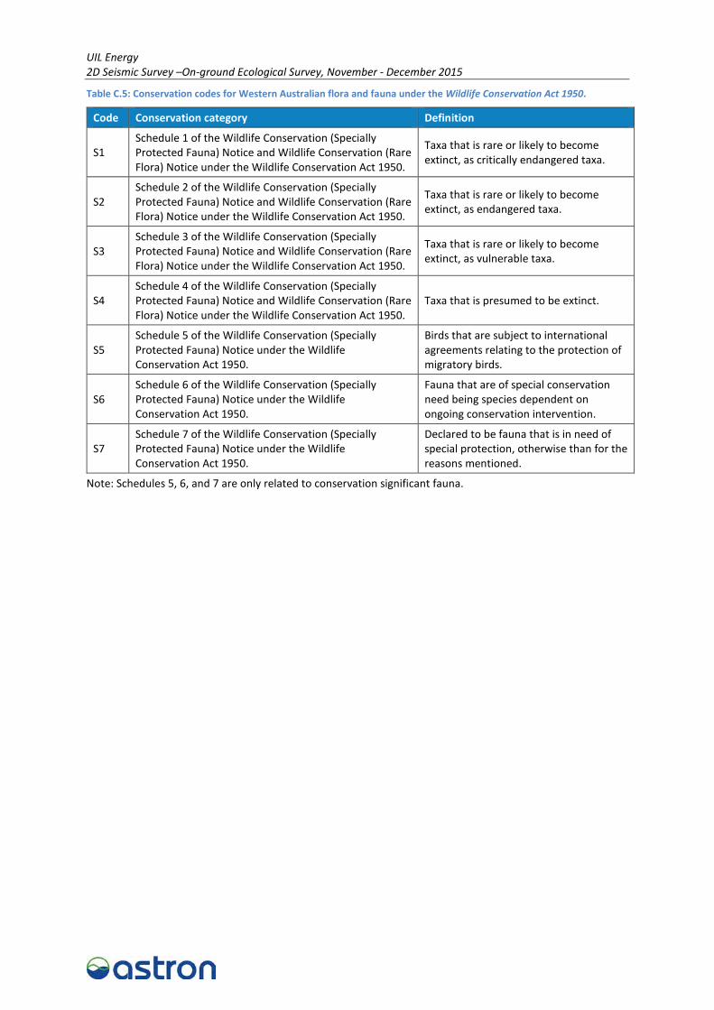
UIL Energy 2D Seismic Survey –On-ground Ecological Survey, November - December 2015
Table C.5: Conservation codes for Western Australian flora and fauna under the Wildlife Conservation Act 1950.
Code Conservation category Definition
S1 Schedule 1 of the Wildlife Conservation (Specially Protected Fauna) Notice and Wildlife Conservation (Rare Flora) Notice under the Wildlife Conservation Act 1950.
Taxa that is rare or likely to become extinct, as critically endangered taxa.
S2 Schedule 2 of the Wildlife Conservation (Specially Protected Fauna) Notice and Wildlife Conservation (Rare Flora) Notice under the Wildlife Conservation Act 1950.
Taxa that is rare or likely to become extinct, as endangered taxa.
S3 Schedule 3 of the Wildlife Conservation (Specially Protected Fauna) Notice and Wildlife Conservation (Rare Flora) Notice under the Wildlife Conservation Act 1950.
Taxa that is rare or likely to become extinct, as vulnerable taxa.
S4 Schedule 4 of the Wildlife Conservation (Specially Protected Fauna) Notice and Wildlife Conservation (Rare Flora) Notice under the Wildlife Conservation Act 1950.
Taxa that is presumed to be extinct.
S5 Schedule 5 of the Wildlife Conservation (Specially Protected Fauna) Notice under the Wildlife Conservation Act 1950.
Birds that are subject to international agreements relating to the protection of migratory birds.
S6 Schedule 6 of the Wildlife Conservation (Specially Protected Fauna) Notice under the Wildlife Conservation Act 1950.
Fauna that are of special conservation need being species dependent on ongoing conservation intervention.
S7 Schedule 7 of the Wildlife Conservation (Specially Protected Fauna) Notice under the Wildlife Conservation Act 1950.
Declared to be fauna that is in need of special protection, otherwise than for the reasons mentioned.
Note: Schedules 5, 6, and 7 are only related to conservation significant fauna.
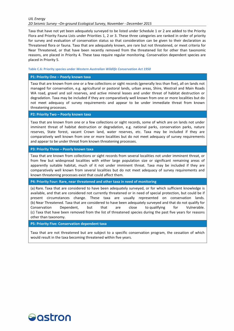
UIL Energy 2D Seismic Survey –On-ground Ecological Survey, November - December 2015
Taxa that have not yet been adequately surveyed to be listed under Schedule 1 or 2 are added to the Priority Flora and Priority Fauna Lists under Priorities 1, 2 or 3. These three categories are ranked in order of priority for survey and evaluation of conservation status so that consideration can be given to their declaration as Threatened flora or fauna. Taxa that are adequately known, are rare but not threatened, or meet criteria for Near Threatened, or that have been recently removed from the threatened list for other than taxonomic reasons, are placed in Priority 4. These taxa require regular monitoring. Conservation dependent species are placed in Priority 5.
Table C.6: Priority species under Western Australian Wildlife Conservation Act 1950
P1: Priority One – Poorly known taxa
Taxa that are known from one or a few collections or sight records (generally less than five), all on lands not managed for conservation, e.g. agricultural or pastoral lands, urban areas, Shire, Westrail and Main Roads WA road, gravel and soil reserves, and active mineral leases and under threat of habitat destruction or degradation. Taxa may be included if they are comparatively well known from one or more localities but do not meet adequacy of survey requirements and appear to be under immediate threat from known threatening processes.
P2: Priority Two – Poorly known taxa
Taxa that are known from one or a few collections or sight records, some of which are on lands not under imminent threat of habitat destruction or degradation, e.g. national parks, conservation parks, nature reserves, State forest, vacant Crown land, water reserves, etc. Taxa may be included if they are comparatively well known from one or more localities but do not meet adequacy of survey requirements and appear to be under threat from known threatening processes.
P3: Priority Three – Poorly known taxa
Taxa that are known from collections or sight records from several localities not under imminent threat, or from few but widespread localities with either large population size or significant remaining areas of apparently suitable habitat, much of it not under imminent threat. Taxa may be included if they are comparatively well known from several localities but do not meet adequacy of survey requirements and known threatening processes exist that could affect them.
P4: Priority Four: Rare, near threatened and other taxa in need of monitoring
(a) Rare. Taxa that are considered to have been adequately surveyed, or for which sufficient knowledge is available, and that are considered not currently threatened or in need of special protection, but could be if present circumstances change. These taxa are usually represented on conservation lands. (b) Near Threatened. Taxa that are considered to have been adequately surveyed and that do not qualify for Conservation Dependent, but that are close to qualifying for Vulnerable. (c) Taxa that have been removed from the list of threatened species during the past five years for reasons other than taxonomy.
P5: Priority Five: Conservation dependent taxa
Taxa that are not threatened but are subject to a specific conservation program, the cessation of which would result in the taxa becoming threatened within five years.
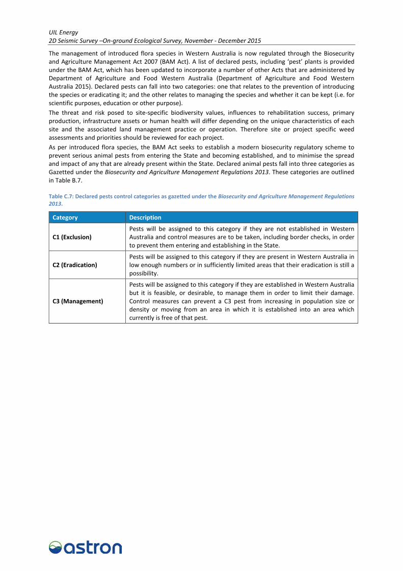
UIL Energy 2D Seismic Survey –On-ground Ecological Survey, November - December 2015
The management of introduced flora species in Western Australia is now regulated through the Biosecurity and Agriculture Management Act 2007 (BAM Act). A list of declared pests, including ‘pest’ plants is provided under the BAM Act, which has been updated to incorporate a number of other Acts that are administered by Department of Agriculture and Food Western Australia (Department of Agriculture and Food Western Australia 2015). Declared pests can fall into two categories: one that relates to the prevention of introducing the species or eradicating it; and the other relates to managing the species and whether it can be kept (i.e. for scientific purposes, education or other purpose). The threat and risk posed to site-specific biodiversity values, influences to rehabilitation success, primary production, infrastructure assets or human health will differ depending on the unique characteristics of each site and the associated land management practice or operation. Therefore site or project specific weed assessments and priorities should be reviewed for each project. As per introduced flora species, the BAM Act seeks to establish a modern biosecurity regulatory scheme to prevent serious animal pests from entering the State and becoming established, and to minimise the spread and impact of any that are already present within the State. Declared animal pests fall into three categories as Gazetted under the Biosecurity and Agriculture Management Regulations 2013. These categories are outlined in Table B.7.
Table C.7: Declared pests control categories as gazetted under the Biosecurity and Agriculture Management Regulations 2013.
Category Description
C1 (Exclusion) Pests will be assigned to this category if they are not established in Western Australia and control measures are to be taken, including border checks, in order to prevent them entering and establishing in the State.
C2 (Eradication) Pests will be assigned to this category if they are present in Western Australia in low enough numbers or in sufficiently limited areas that their eradication is still a possibility.
C3 (Management)
Pests will be assigned to this category if they are established in Western Australia but it is feasible, or desirable, to manage them in order to limit their damage. Control measures can prevent a C3 pest from increasing in population size or density or moving from an area in which it is established into an area which currently is free of that pest.

UIL Energy 2D Seismic Survey –On-ground Ecological Survey, November - December 2015
References Department of Agriculture and Food Western Australia 2015, Western Australian Organisms List,
<http://www.biosecurity.wa.gov.au/western-australian-organism-list-waol>.
Department of Parks and Wildlife 2015, Threatened and Priority Ecological Communities database, Parks and Wildlife, Kensington.