The Vascular Flora of the South Fork Native Plant Preserve, Van
ENVIRONMENTAL IMPACTS - NATIVE FLORA AND FAUNA
One of the most serious potential impacts of geothermal energy
development in Hawaii is the disruption of native forests. While air
pollution and groundwater impacts of geothermal development may be
substantially avoided by requiring full control technologies, impacts on
native forest ecosystems may only be avoided through careful siting
(EPA, 1978). Siting to avoid damage to biologically valuable forest can
prevent both degradation of the forest due to invasion of weed species
and disturbance of native bird species due to human activity and
noise.
Native forests are particularly vulnerable to invasion by exotic
species along roadways or other cleared areas (Carlquist, 1970). Once
such an invasion begins, native forest is gradually altered, and
non-native species, which initially invaded along relatively narrow
corridors, spread and multiply (Corn, 1984). Major geothermal devel
opment, with an attendant network of roads and construction
corridors, may be expected to dissect and eventually degrade
undisturbed native forest by opening it to invasion by weedy species.
Geothermal development may also be expected to have negative
impact on native forest birds, including many which are endangered.
Construction noise and human activity are factors which favor urban
nuisance species over native forest species (Berger, 1972). It is
therefore important to consider the habitat of native bird species,
particularly those which are endangered, in assessing the impact of
geothermal energy development. Any development within the habitat of
native birds will have m:'-l~ll:.g!~~teE.-~~Y1F()nrn~I!!~limpact than development outside of native bird habitat. For endangered bird species,
such environmental impacts could be critical.
In selecting areas in which geothermal development will Qlave) the
least environmental impact, it is therefore useful to assess both forest
quality and native bird habitat. Those areas with mature native forest
and significant native bird habitat will tend to be the most environ
mentally important, while those without native bird habitat and with
less intact forest will be areas in which development would have
substantially less environmental impact. Because of the broad scope of
the present study, a detailed analysis of all resource areas for these
qualities was impossible. Instead, indicators were used to distinguish,
on a broad scale, areas of high and low potential environmental impact.
For the present assessment, two indicators have been chosen, one of
native habitat importance and one of forest quality.
The indicator chosen to depict the value of an area to native
fauna is the presence of endangered species. While under some cir
cumstances a simple survey for endangered species is an unacceptably
superficial form of environmental assessment, in the present situation
the presence of endangered species correlates quite well with the value
of the area to native fauna in general.
Relative value of native forest has been assessed using a
categorization system developed by the University of Hawaii
Environmental Center based on forest type mapping done by the United
States Fish and Wildlife Service (Jacobi, 1983). This system indicates
areas in which geothermal development would have the greatest impact
(on native fores!) areas in which geothermal development would have
little or no impact on valuable native forest, and areas in which the
impact of geothermal development on native forest is uncertain.
Map overlays have been prepared which illustrate the distribution
and intersection of essential habitat and forest quality factors • (The 11/
greatest potential for environmental impact exists where valuable forest
and endangered species habitat overlap. Areas with low quality forest
and no endangered species habitat may be expected to be among those
least vulnerable to impact from geothermal development)
METHODS
For the present assessment, endangered species habitat was
considered present wherever essential habitat outlined in an approved
Endangered Species Recovery Plan existed. Endangered Species
Recovery Plans are plans of action for restoring the population of a
species pursuant to its listing as endangered by the Secretary of the
Interior. Recovery plans are drafted by teams of wildlife experts from
both state and federal agencies. and represent estimates of the range
-2-
---~------_.__. _..-
.(
and life requirements of endangered species by the foremost experts in
the field. Essential habitat outlined in an Endangered Species
Recovery Plan is therefore almost without exception the most authorita
tive estimate of the actual habitat for a particular endangered species.
Where no essential habitat has been designated, distribution was
determined from population surveys conducted by the U. S. Fish and
Wildlife Service (USFWS) or other available information (Scott, 1984).
Essential habitats have been defined for all endangered forest birds
and the Hawaiian Crow ('Alala) on the island of Hawaii and for the
Nene on both Maui and the Big Island. Essential habitat has not been
determined for the endangered Maui forest birds, and therefore U. S .
Fish and Wildlife Service population counts were used to determine
habitat boundaries for these species.
The potential for environmental impact on the flora of the
resource areas was assessed using a forest categorization system based
on USFWS vegetation type mapping. The USFWS system incorporates
information on extent of canopy cover, height of canopy, understory
composition, and vegetation association type (Jacobi, 1983). Vege
tation information has been assembled and mapped by USFWS using this
system for large portions of four of the five. main Hawaiian islands,
including Maui and Hawaii. Information in this form was available to
the present study for all or portions of each of the resource areas.
Areas not covered were lower Hana , lower Makena, Kilauea S. W. Rift,
and Lower Puna. In these areas aerial photo interpretation was used
to estimate vegetation type, and in high resource potential areas this
aerial interpretation was verified on the ground from readily accessible
roadways wherever possible. Lack of access routes made ground
verification for the Kilauea S. W. Rift site impractical. The boundaries
delineated on the aerial photographs were transferred to orthophoto
quadrangles and assigned a vegetation type code following the USFWS
system (Jacobi, 1983). Vegetation type data was then ranked accord
ing to potential for impact from geothermal development into one of
three categories described below.
-3-
FLORA AND FAUNA
Flora
Vegetation type data from USFWS mapping or the present study
were abstracted into a simplified, three category impact sensitivity
classification system (see appendix B). The three categories of this
system, which was developed by the University of Hawaii Environ
mental Center, and based on the assumption that undisturbed, closed
canopy forest would be most susceptible to disruption due to
geothermal development, are as follows:
CATEGORY 1 - Exceptional native forest;closed canopy, over 90% native cover
CATEGORY 2 - Mature native forest;over 75% native canopy
CATEGORY 2A - Native scrub or low forest
CATEGORY 3 - Cleared land; non-native forest;bare ground or lava
In this system, Category 1 forests are presumed to be areas in
which geothermal development would unquestionably result in environ
mental impact, and Category 3 lands presumed to be areas in which
geothermal development would have little or no impact. Category 1
forest is vulnerable because of its high native composition, which
indicates that it is virtually undisturbed, and because of its closed
canopy, which indicates that any development activity would result in
changes in forest structure. Category 3 lands are assumed to be of
little biological value owing to high degrees of disturbance or low
percentage of ground cover. Category 2 is comprised of areas which
did not meet the rigorous standards of category 1, but are not so
heavily disturbed or sparsely vegetated that it can be assumed that
development would not result in environmental impact. Category 2A (a
subset of Category 2» represents areas in which the vegetation is
predominantly native, but the tree layer is low and scattered and does
not warrant the designation of forest. In wet forests, Category 2A
vegetation is a sign of disturbance, but in dry regimes, particularly at
altitude or along the coast, it is a healthy native ecotype. Both
-4-
fI
Category 2 and 2A are j\classifications which convey that additional
information is needed before it can be assumed that geothermal
development would have little environmental impact.
The additional information needed to assess the biologic value of
Category 2 forest pertains to forest diversity and the presence of rare
plants. These factors were not included in the present assessment
because this information is not available in any comprehensive lorm on
such a broa;'l~~~l~: A B~da~se d~ 'thes~'lirriit~ti~ri~' ~f' i~forrn~ti~navailability, it is difficult to arrive at an objective classification for
potential for impact by geothermal development for many forest types.
There are unquestionably many excellent forest areas that have been
placed in Category 2 because they fell just short of 90% native
composition. There are equally certainly areas assigned Category 2
which are of little biological interest. Within these extremes, the
majority of Category 2 forests are areas for which the USFWS
vegetation type code tells only a part of the story, and diversity and
rare plant information is required to discern the exact value and
vulnerability to disturbance of the area. In the absence of a
compelling reason to develop these areas, a reasonable assumption is
that they are valuable and should not be disturbed. Where there is
compelling reason to consider development, field reconnaissance of
individual areas will be required to determine what, if any, level of
environmental impact would result from development. Similar con
siderations apply to Category 2A areas. Vegetation types are assigned
to Category 2A based on growth form, not biological value or environ
mental impact considerations. However, it may be worthwhile to
emphasize that in wet areas at intermediate elevations, Category 2A
usually represents a disturbed area or recent lava flow.
In summary. Category 1 areas are those in which substantial
environmental impact can be expected to result from geothermal
development. Category 2 and 2A areas are those in which geothermal
development should be assumed to result in environmental impact in the
absence of additional information. and Category 3 areas are those in
which geothermal development may be expected to have little or no
environmental impact.
-5-
I
Clearly the environmental advantage lies in developing within )\ 1f /' , \1(;
Category 3 areas. (Howeve~~ it is worthwhile to note that development r< ,'! ,.i
in Category 3 areas may result in environmental impact, especially on '7 ~-:(: i,
native foreat brrds , if development ia immediately adjacent to Category (
1 or 2 areas or endangered species habitat and in close enough )
proximity for noise or pollution to carry to the forest. ~
Rare Plants ,.Ct !.
(The presence of rare plants greatly increases the biological value
of a site, and while this factor is not incorporated in the current
categorization system, it must be considered in assessing the
sensitivity of an area to environmental impact) Of Hawaii's seven plant
species which are formally listed as endangered, only one, the
Hawaiian vetch (Vicia menziesii) is found within the resource areas.
However, Hawaii has numerous rare plants, over 800 of which have
been proposed for listing as endangered. Undoubtedly many of these
candidate species may be found within the resource areas. Currently
available information does not permit a comprehensive inventory of
these species and their location, and therefore .~~, l/9.:" ~eee l~ressed
in this study. Protection of rare plant species should be undertaken
on a project-by-project basis, where botanical surveys of specific
areas being considered for development are possible. The forest
categories presented in this study do not relate to endangered plant
species presence. It should not be assumed that Category 3 areas will
contain no rare plant individuals. Isolated rare native species are not
uncommonly found in disturbed, non-native surroundings. Such
individuals should be identified and protected, but the scope of the
present study precluded such detailed analysis. Areas with high
concentrations of rare plants are biologically valuable, and the
presence of rare plants is one criteria which should be used in
determining the potential impact of geothermal development in Category
2 areas. For example, the Category 2 forests in the southwest
quarter of the Mauna Loa East Rift area are the home range of
Vicia menziesii and should therefore be considered very sensitive to
environmental impacts, despite the fact that the forest type alone does
-6-
not warrant ranking them in Category 1. Other areas such as this
definitely exist within Category 2, and this is one reason why it is
important to more completely characterize these areas before their
sensitivity to impact is assigned.
Fauna
Forest birds found in the resource areas include the I'iwi,
Apapane, Elepaio, and others. The specific native forest birds
present at a site are not as important as the relative value of the area
as native bird habitat in general. Most native birds share habitat to
some degree, and it is this characteristic which permits use of the
existence of endangered bird habitat as an index of overall native bird
habitat value. Because the list of native birds in the resource areas
is long, discussion here will focus only on the endangered fauna found
in the resource areas.
Federally designated threatened or endangered fauna within the
resource areas include seven forest bird species, two seabird species,
the Nene, the Hawaiian Hawk (10) and Crow ('Alala), and Hawaii's only
resident mammal, the Hawaiian Hoary Bat. These species and their
treatment in the resource area overlays are outlined below.
'Alala (Corvus tropicus) - One of the most critically endangeredspecies in the United States. Population estimate 10-50 birds inthe wild. Last field census reported 7 birds. Essential habitatidentified, intersects majority of Hualalai resource area and flanksKahuku Ranch resource areas (DLNR, 1984).
Hawaii Forest Birds - Includes the Hawaii Creeper (Loxops maculatusmana), Hawaii 'Akepa (Loxops coccineus coccineus), Aldapola'auTIIemignathus wilsoni), and 'O'u (Psittirostra psittacea). All aremoderately endangered, with populations in the high 100's orabove, except the 'O'u , which is relatively rare and has a muchsmaller population. Essential habitat common to all four specieshas been identified, and intersects all of the East Mauna Loa Riftarea, most of Hualalai and Upper Puna, and flanks Kahuku Ranch(USFWS, 1982). ":(
J~ ( .>
Maui Forest Birds - Includes Crested Honeycreeper (Palmeria dolei) ,Maui 'Akepa (Loxol?s coccineus), Maui Parrotbill (Pseudonestorxanthoph). Essentull habitat not yet identified. Distributiondetermined by USFWS, intersects upper Hana (Scott, 1984).
, .L:, I"
Nene (Branta sandvicensis) - Moderately endangered, maintained by
-7-
captive breeding. Essential habitat identified, intersects all ofEast Mauna Loa Rift, most of Hualalai, and the upper elevationsof Kahuku Ranch (USFWS, 1983). An upland bird adapted tosparse vegetation, the Nene may be less sensitive to the presenceof geothermal development than other native birds.
Hawaiian Hawk (Buteo solitarius) - Relatively common over a wide (. ~ange. No essential.... habitat established. Known nesting sites L.~:(-'
A > A. (within resource areas) lie mainly in Lower Puna and East Mauna. \. :)"oa Rift, but nesting observations are far from exhaustive and lie ' )mainly along roadways and other accessible areas (Griffin, 1984).
Hawaiian Dark-Rumped Petrel (Pterodroma ghaeopygia sanwichensis) Primary nesting colonies on Maw, outside 01 resource areas. Alsoobserved within Napau Crater in Volcanoes National Park (USFWS,1983).
Hawaiian Hoary Bat (Lasiurus cinereus semotus) - A poorlycharacterized species (Kepler and Scott, 1980). No knownroosting sites within resource areas. Most frequently observed innon-native vegetation. Impact of development on foraging habitatuncertain, possibly minimal.
Newell's Manx Shearwater (Puffinu puffinus newelli) - Classified ast.hreateneg. No known nesting colonies within resource areas.May occasion Upper Puna and East Mauna Loa Rift (Jacobi, 1984).Impact of development uncertain, may be minimal.
Invertebrates
Rare invertebrates known to exist in the resource areas include
scientifically important fruit flies (giant Drosophola spp), tree snails
(Particulina spp), and special cave-adapted fauna residing in lava
tubes. The giant Drosophola species, focal point of important genetic
research, are found in the Mauna Loa East Rift and Hualalai areas,
and at upper elevations at Hana and Kahuku Ranch (Carson, 1984).
Tree and land snails, many of which, like other Hawaiian inverte
brates, are found nowhere else in the world, are associated primarily
with native forest and probably exist in all resource areas.
Cave-adapted fauna might be found in lava tubes underlying any
resource area, but are known to exist in Mauna Loa East Rift and
Kilauea East Rift. These lava tube ecosystems are dependent on intact
penetrating ohia root systems for their moisture supply, and are
vulnerable to any development which results in forest clearing. While
invertebrate species often receive less attention than vertebrate
-8-

fauna, they comprise an important part of native ecosystems. Impacts
on these species may be largely avoided by avoiding siting in native
forest areas.
RESOURCE AREA SUMMARIES
Hualalai
An upper elevation site receiving moderate to low rainfall,
Hualalai is characterized by vegetation types ranging from forest to
~::~:;dl:'lIt~v:m~~~q,;\t::do;P:~:~:~bi;;t;yp::S;~:species represented in this area include koa (Acacia koa) , mamane
(Sophora chrysophylla), and ohia (Metrosideros polymorpha).
Endangered birds found in the area include the 'Alala, Hawaii Creeper,
'Akepa , and Nene. Because virtually the entire area is endangered
bird habitat, development in almost any portion of this area would
result in considerable environmental impact.
Kahuku Ranch
The Kahuku Ranch area spans a broad range of elevation and
contains vegetation characteristic of both intermediate and upper
elevations. Rainfall in this area is generally low. The area is flanked
by endangered species habitat for 4 species and Nene essential habitat
traverses its upper reaches. Forest types are predominently 2 or 2A,
with 2A in this region representing healthy native scrub. The area is
also characterized by substantial barren area, areas which might
support geothermal development with little environmental detriment.
However, air quality and noise impacts should be carefully considered
for any of these areas due to the proximity of endangered species
habitat.
Mauna Loa East Rift
This area receives low to moderate rainfall and is remarkable for
its abundance of Category 1 forest and endangered species habitat.
The entire area falls within the essential habitat of endangered
species, including all four of the island's endangered forest birds and
the Nene. This area is of high biological value throughout and major
-9-
geothermal development in virtually any sector of this area would
result in substantial environmental impact.
Kilauea Southwest Rift
This area is poorly characterized biologically. It was not
included in USFWS vegetation mapping and seems to be of limited
research interest. The area is generally disturbed, with some pockets
of native scrub along the coast and near the boundary of the national
park. These areas are difficult or impossible to distinguish through
aerial interpretation, so their exact extent is unknown. However, the
area is primarily of little biological significance and contains no endan
gered species habitat. Development in most portions of this area
outside of the National Park would probably result in little environ
mental impact.
Kilauea Upper East Rift
This area is characterized by recent lava flows on older
substrate. The area is relatively wet and supports closed ohia-tree
fern forest with a transition to open forest and scrub at lower ele
vations. Essential endangered species habitat is found in the area,
closely associated with the closed forest. Recent lava flows in the
area are Category 3 lands, but geothermal development in these areas
would require access through and exist in close proximity to Category
1 forest and essential habitat, and therefore air quality and noise
impacts should be carefully considered. Due to the presence of
Category 1 forest and endangered species habitat, development outside
the recent lava flows would result in considerable environmental
impact.
Kilauea Lower East Rift
This area is similar in rainfall to Kilauea Upper East Rift over
much of its area, but average temperature is higher. Rainfall declines
along the coast to the south, and mesic and dry regimes are found in
this area. There is no endangered species essential habitat in Lower
Puna and the majority of land in the area is current or reverted
agricultural acreage falling into Category 3 with few exceptions, the
region is of little biological importance (DLNR, 1979, 1981). This area
-10-
seems to have high potential for geothermal development without,.environmental impact~ and is more accessible than the Southwest Rift.
It was therefore surveyed as part of this assessment. A detailed
account of this area and its forest types are appended to this report)
Hana
This area is extremely wet in its upper reaches, supporting
numerous small bogs. Forest in the upper portion of this area is also
exceptional, falling uniformly into Category 1 above 3,000 ft. and
supporting between 1 and 3 species of endangered forest birds. Below
3,000 ft. the forest is more disturbed, gradually blending into
Category 2. Below 1,000 ft., forest gives way to pastureland with
occasional forested areas. Geothermal development would be likely to
have little impact on native forest or birds in most sections of this
area below the 1, OOO-foot contour.
Makena
This is a relatively dry area which ranges in elevation from sea
level to over 7,000 ft. The predominant vegetation type, as
determined from aerial interpretation only, is native scrub. Some
exotic tree plantings are present within the area, as well as
substantial areas of pastureland, the precise extent of which is
difficult to determine from aerial interpretation. The lower portions of
the area are barren lava with isolated pockets of excellent native
forest (Medieros, 1984). There is no endangered species habitat in
this area. The middle elevations of this area contain some very
valuable, although disturbed, dry native forest. Heavily grazed
portions of this area would have the potential for geothermal
development with little environmental impact, but the exact boundaries
of grazing could not be determined within the limitations of this study.
SUMMARY
On the island of Hawaii, resource areas may be grouped into
three classes according to potential for environmental impact:
High - Mauna Loa East Rift, Hualalai, Kilauea UpperEast Rift
-11-
Mixed - Kahuku Ranch
Low - Kilauea Southwest Rift, Kilauea Lower East Rift
On Maui, both resource areas fall into the "mixed" category, with
areas with potential for low environmental impact being Hana below the
1,000 ft. contour and the heavily grazed areas of Makena.
-12-
APPENDIX A
Kilauea Lower East Rift Zone
The East Rift Zone of Kilauea Volcano stretches 28 miles
east-northeast from just south of Kilauea Caldera to Cape Kumukahi
near Kapoho, and then beyond undersea for 70 miles (MacDonald and
Abbott, 1979). The area included in this discussion is the lower
portion of the rift east of Hawaii Volcanoes National Park and south
and east of Puna Forest Reserve (Pahoa South and Kapoho Quadrangles
and portions of Kalapana and Pahoa North). Elevations within the
study area range from 1400 feet east of the Puna Forest Reserve to
almost sea level along the coast.
The climate along the lower East Rift and south to the coast is
generally wet and warm. Mean annual rainfall ranges from almost 150
inches near Pahoa to 75 inches at Kalapana on the coast. Precipitation
is moderately seasonal; summer months are somewhat drier than winter
months. Mean annual temperature varies from below 70°F above Pahoa
to more than 72°F along the coast (DLNR, 1970).
As Kilauea's East Rift is a geologically active region, much of the
substrate here is composed of bare or sparsely' vegetated recent flows.
The on-going eruption of Puu 0 near the National Park boundary has
produced flows in two directions; northeast into Kahau'alea and the
Puna Forest Reserve, and southeast into Royal Gardens Subdivision
and upper Kapa'ahu. Other notable historic flows in the lower East
Rift Zone are the 1955 series of flows near Kapoho (Kii) and from
above the Pahoa-Kalapana Road to the coast near Kehena, and the
Kapoho flow of 1960 from Kapoho to Cape Kumakahi. Most soils of the
lower East Rift (apart from recent flows and cinder cones) are either
histosols, composed of a thin layer of organic material over rock, or
inceptisols, formed from volcanic ash.
Vegetation of the lower East Rift cannot be simply characterized.
Before human occupation most of this area was probably covered by
closed lowland wet forest dominated by 'ohi'a (Metrosideros
polymorpha), hula (Pandanus sp.), and lama (Diospyros ferrea) near
-13-
the coast grading into an 'ohi'a-Iama forest with other native trees
(Psychotria hawaiiensi, Xylosma hawaiiense, Tetraplasandra
hawaiiensis), iie'ie (Freycinetia arborea), and tree ferns (Cibotium
~) at higher elevations (around 800 ft.). Another vegetation type
which undoubtedly was and still is prominent in the lower East Rift is
open to scattered, low to moderate-stature 'ohi'a scrub with uluhe
(Dicranopteris spp. ) , native shrubs, and 'uki (Machaerina
mariscoides) •
Remnants of these native vegetation types are still found on
Kilauea's lower East Rift, but many forests and woodlands here have
been disturbed to some degree or cleared for agriculture, towns, and
subdivisions. Large tracts of land in this area are planted in sugar
cane, papaya, and to a lesser extent, macadamia nuts. In addition to
these cultivated fields, much old agricultural land has been abandoned
and has a cover of weedy species of exotic trees, grasses, and
shrubs. Apart from agricultural lands, several subdivisions have been
developed in lower Puna, resulting in large parcels of forest and scrub
cut by roads and clearings. Clearing and road-cutting in the East
Rift has been followed by the invasion of forests and woodland by
exotic plants, which are the major factor of disturbance in this area.
Some of the most noxious of these exotic weeds are Malabar melastome
(Melastoma malabathricum), christmasberry (Schinus terebinthifolius) J
waiawi (Psidium cattleianum) J guava (P. guajava) , thimbleberry (Rubus
rosaefolius), melochia (Melochia umbellata), lantana (Lantana camara) ,
California grass (Brachiaria mutica) , Molasses grass (Melinis
minutiflora) J and broomsedge (Andropogon virginicus). Feral pigs are
another major factor of disturbance in the upper forests of this
region.
The most undisturbed and diverse remnants of vegetation noted
during this survey were three areas in the Pahoa South Quadrangle.
One of these is the closed 'ohi'a-lama forest of Keauohana Forest
Reserve. The canopy of this forest is intact and the secondary tree
layer is rich, containing two candidate endangered tree species
('ahakea-Bobea timonioides and 'ohe-Tetraplasandra hawaiiensis) J as
well as diversity of other native trees such as opuhe (Urera
-14-
mamaki (Pipturus sp),
Although the understory
has many native compo-
sandvicensis), maua (Xylosma hawaiiense),
kopiko (Psychotria hawaiiensis), and others.
of this forest contains exotic plants, it also
nents such as tree ferns and native shrubs.
The second most botanically rich area is in the southeast corner
of Leilani Estates and the northern part of Malama-Ki Forest Reserve
(ea. 700 ft). This is also a closed tall 'ohi'a-lama forest with 'ohe
trees and tree ferns. The third most interesting area is a small fore
above Kama'ili fronting a lobe of the 1955 lava flow at about 200 ft.
elevation. This low-elevation 'ohi'a-Iama forest is composed almost
entirely of native plants and supports a predominantly native under
story of ferns and shrubs, including the candidate endangered
ko'oko'olau (Bidens skottsbergii).
Several other relatively diverse, mostly native forests were found
in the lower East Rift Zone. The most notable of these were in
Puulena and Kahawai Craters, on the east side of Nanawale Estates, on
the slopes behind the quarry near Kalapana, in the Halepua'a section
of Nanawale Forest Reserve, and on relatively recent substrate near
Kaimu, Kehena, and Pualaa, These are 'ohi'a-lama or 'ohi'a dominated
lowland forests with a predominance of native plants; all but the
coastal forests with exposed aa are known to support candidate endan
gered plant species. In addition to these closed and open forests,
several scrub vegetation types dominated by native shrubs and low
trees (but lacking uluhe) were observed near the Hawaii Volcanoes
National Park boundary past Kalapana , on the coast at the east end of
Malama-Ki, and along the coast near Nanawale north of Kapoho and
south of Hawaiian Beaches.
As this was a broad-scope brief survey to determine as many
vegetation types within the lower East Rift Zone as possible, and not
every area differentiated on aerial photographs was ground checked.
In particular, closed forests not reached include those on the upland
slopes above Kalapana , remnant stands on the rift between Leilani
Estates and the Opihikao Road, areas bordering the east side of the
Puna Forest Reserve and several coastal areas separated from roads by
inhabited parcels near Kehena and Kapoho.
-15-
REFERENCES
Berger, A. J., Hawaiian Bird Life, University Press of Hawaii,Honolulu, 1972
Carlquist, S., Hawaii: A Natural History, Natural History Press,Garden City, New York, 1970
Carson, H.L., personal communication 5/31/84
Corn, C., personal communication 4/27/84
Christensen, C., personal communication 5/30/84
Department of Land and Natural Resources (DLNR), State of Hawaii,Division of Forestry, A Botanical Reconnaissance of Malama-KiForest Reserve, Honolulu, 1981
, A Vegetation Survey of the Halepuaa Forest Reserve,--"':":"""Honolulu, 1979
Department of Land and Natural Resources, State of Hawaii, StatewideNon-game and Endangered Species Program, Job Report1984
Environmental Protection Agency (EPA), Pollution Control Guidance forGeothermal Ener\i¥ Development; National Technical InformationService, SpringfIeld, Virginia, 1978
Griffin, C., personal communication 5/1/84
Jacobi, J., Mapping and Natural Vegetation of the Hawaiian Islands,XV Pacific Science Congress, Dunedin, New Zealand, 1983
___' personal communication 5/28/84
Kepler, C. and M. Scott, Distribution and Behavior of the HawaiianHoary Bat, unpublished manuscript, U. S . Fish and WildlifeService, 1984
Medeiros, A., personal communication 1984
Scott, 1\1., unpublished monograph, 1984
United States Fish and Wildlife Service, Alala Recovery Plan, Denver,1982
, Hawaiian Dark Rumped Petrel and Newell's Manx Shearwater--=Recovery Plan, Denver, 1983
, Hawaii Forest Birds Recovery Plan, Denver, 1983---, Nene Recovery Plan, Denver, 1983---
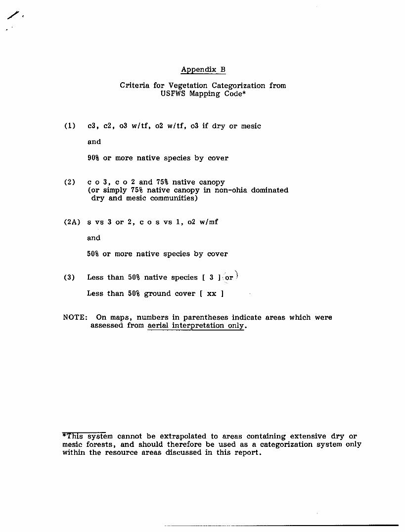
Appendix B
Criteria for Vegetation Categorization fromUSFWS Mapping Code*
(1) c3, c2, 03 w/ tf', 02 w/ tf', 03 if dry or mesic
and
90% or more native species by cover
(2) c 0 3, co2 and 75% native canopy(or simply 75% native canopy in non-ohia dominateddry and mesic communities)
(2A) s vs 3 or 2, cos vs 1, 02 w/ mf
and
50% or more native species by cover
(3) Less than 50% native species [ 3 ] .or )
Less than 50% ground cover [ xx ]
NOTE: On maps, numbers in parentheses indicate areas which wereassessed from aerial interpretation only.
*Tliis system cannot be extrapolated to areas containing extensive dry ormesic forests, and should therefore be used as a categorization system onlywithin the resource areas discussed in this report.