Environmental Impact Assessment Solar PV Park - …kspdcl.in/sp_docs/Environment Assesment impact...
66
Page 0 of 65 Environmental Impact Assessment – Solar PV Park Nagalamadike Hobli, Pavagada Taluk, Tumkur February 2016
Transcript of Environmental Impact Assessment Solar PV Park - …kspdcl.in/sp_docs/Environment Assesment impact...

Page 0 of 65
Environmental Impact Assessment – Solar PV Park
Nagalamadike Hobli, Pavagada Taluk, Tumkur
February 2016

Page 1 of 65
Table of Contents
I. Introduction .................................................................................................................................................... 4
A. Background - India’s Solar Program ................................................................................................................ 4
B. Project Overview .............................................................................................................................................. 4
C. Approach to Environmental Study ................................................................................................................... 5
D. Structure of Report ........................................................................................................................................... 7
II. Project Description ........................................................................................................................................ 0
A. Electricity generation using PV technologies ................................................................................................... 0
B. Fundamental Terminology ............................................................................................................................... 1
1. Insolation, Irradiance and Irradiating ........................................................................................................... 1
C. The proposed PV plant .................................................................................................................................... 2
III. Proposed Layout Plan ................................................................................................................................... 6
A. Site / Layout Alternatives ................................................................................................................................. 6
B. Water supply pipelines / Drainage System ...................................................................................................... 7
C. Access Roads .................................................................................................................................................. 8
D. Transmission Lines .......................................................................................................................................... 8
E. Waste Storage Areas ....................................................................................................................................... 9
F. Warehouse and Construction Camps .............................................................................................................. 9
IV. Legal Requirements..................................................................................................................................... 10
A. State Pollution Control Board Regulations ..................................................................................................... 10
B. Indian Labour Laws ........................................................................................................................................ 11
C. Land Availability / Procurement for Sub-projects ........................................................................................... 12
1. Karnataka State Solar Policy 2014- 2021 ................................................................................................. 12
2. Land Reforms Act – Karnataka ................................................................................................................. 12
D. World Bank Group Safeguard Requirements ................................................................................................ 13
1. World Bank Safeguard Requirements ....................................................................................................... 13
E. IFC Performance standards ........................................................................................................................... 14
1. Assessment and Management of Environmental and Social Risks & Impacts ......................................... 15
2. Labour and Working Conditions ................................................................................................................ 15
3. Resource Efficiency and Pollution Prevention ........................................................................................... 15
4. Community Health, Safety and Security .................................................................................................... 15
V. Public Participation Process ...................................................................................................................... 16
A. Identification of Key Stakeholders .................................................................................................................. 16
B. Public Participation Process Adopted ............................................................................................................ 16
1. Initial Consultations – Fixing of Lease Rentals .......................................................................................... 16

Page 2 of 65
C. Consultation and Public Involvement ............................................................................................................. 16
D. Key Issues identified during field visits / consultations................................................................................... 19
VI. Baseline Description of the Study Area ..................................................................................................... 23
A. Biophysical Environment ................................................................................................................................ 23
1. Location ..................................................................................................................................................... 23
2. Climate ...................................................................................................................................................... 23
3. Geology ..................................................................................................................................................... 25
4. Topography ............................................................................................................................................... 25
5. Agricultural Potential ................................................................................................................................. 26
6. Ground water resources (Hydrogeological) ............................................................................................... 26
7. Surface Water ........................................................................................................................................... 29
8. Flora and Fauna ........................................................................................................................................ 29
9. Soil Characteristics .................................................................................................................................... 30
B. Archaeological and Cultural Resources ......................................................................................................... 31
C. Social Environment ........................................................................................................................................ 31
1. Population, Gender and Age ..................................................................................................................... 31
2. Land Ownership Status ............................................................................................................................. 32
3. Employment .............................................................................................................................................. 33
4. Land Use classification for 10 kms zone ................................................................................................... 35
5. Land use classification for selected villages .............................................................................................. 36
VII. Potential Environmental Impacts ............................................................................................................... 38
A. Construction Phase Impacts .......................................................................................................................... 38
1. Water Resource Impacts – Surface Water ................................................................................................ 38
2. Water Resource Impacts – Ground Water ................................................................................................ 39
3. Vegetation Clearing and grubbing Operations .......................................................................................... 39
4. Lighting ...................................................................................................................................................... 40
5. Proposed Access Roads and Existing Road Network ............................................................................... 40
6. Waste ........................................................................................................................................................ 40
7. Noise ......................................................................................................................................................... 41
8. Air Quality .................................................................................................................................................. 41
9. Terrestrial Ecology .................................................................................................................................... 41
10. Other Construction Impacts ....................................................................................................................... 42
11. Social Impacts ........................................................................................................................................... 42
B. Operation Phase Impacts .............................................................................................................................. 42
1. Water Resource Impacts (surface and ground water) ............................................................................... 42
Page 3 of 65
2. Site Impact Assessment ............................................................................................................................ 42
3. Access Roads ........................................................................................................................................... 43
4. Waste Generation ..................................................................................................................................... 43
5. Noise ......................................................................................................................................................... 43
6. Air Quality .................................................................................................................................................. 43
7. Social Impacts ........................................................................................................................................... 43
C. Retro-fitting / Decommissioning Phase .......................................................................................................... 43
1. Water Resource – Surface and Ground Water ......................................................................................... 43
2. Air Quality .................................................................................................................................................. 43
3. Noise Quality ............................................................................................................................................. 43
4. Site Impacts............................................................................................................................................... 44
5. Waste generation ...................................................................................................................................... 44
6. Terrestrial Impacts ..................................................................................................................................... 44
VIII. Environmental Management Plan .............................................................................................................. 45
IX. Insitutitional Arrangements for Implemenation fo EMP ........................................................................... 49
X. Annexures – Soil Bearing Capacity Calculation ....................................................................................... 50
XI. Annexure - NOC from State Forest Department ....................................................................................... 51
XII. Annexure - Meeting Minutes – Lease Rent Finalization ........................................................................... 52
Page 4 of 65
I. INTRODUCTION
A. Background - India’s Solar Program
The Jawaharlal Nehru National Solar Mission (JNNSM) is a major initiative of the Government of India to promote
ecologically sustainable growth while addressing India’s energy security challenge with active participation from the
states. It will also constitute a major contribution by India to the global effort to meet the challenges of climate change.
The objective of the Mission is to establish India as a global leader in solar energy, by creating the policy conditions for
its large scale diffusion across the country as quickly as possible. The Mission had set a target, amongst others, for
deployment of grid connected solar power capacity of 20,000 MW by 2022 to be achieved in 3 phases (1000 MW in
first phase up to 2012-13, 9000 MW in second phase from 2013 to 2017 and 10,000 MW in the third phase from 2017
to 2022). Currently, the Government of India is considering to substantially scaling up targets of solar capacity additions
in the country to 100 GW by year 2022.
The mission aims at reducing the cost of solar power generation in the country and to achieve grid tariff parity by year
2022 through (i) long term policy measures; (ii) large scale deployment goals; (iii) aggressive R&D; & (iv) domestic
production of critical raw materials, components and products. Currently the mission is in Phase - 2 (2013 – 2017) of
its implementation. Phase-I of JNNSM (2010-13) has generated huge interest in the solar sector wherein Gird
connected and off-grid projects were commissioned throughout the country. Achievements of Phase-I have exceeded
the target set for the period.
The Phase-2 of Jawaharlal Nehru National Solar Mission focuses more on a state-led solar power growth through
setting up of solar ultra-mega power projects, solar parks & facilities, and promoting new financing models for
implementation through private sector participation. The success of JNNSM and state solar policies will proceed on
the basis of the technology advancements and cost reduction, which will be necessary for achieving the target of 20,000
megawatts of grid-connected solar power.
World Bank (WB) - India intends to partner in the efforts of the Ministry of New and Renewable Energy (MNRE),
Government of India (GoI) to rapidly scale-up the solar installations in the country through a long term engagement in
the program.
India is endowed with vast solar energy potential. About 5,000 trillion kWh per year energy is incident over India’s land
area with most parts receiving 4-7 kWh per sqm per day. Hence both technology routes for conversion of solar radiation
into heat and electricity, namely, solar thermal and solar photovoltaic, can effectively be harnessed providing huge
scalability for solar sector projects in India. Solar also provides the ability to generate power on a distributed basis and
enables rapid capacity addition with short lead times. From an energy security perspective, solar is the most secure of
all sources, since it is abundantly available. Theoretically, a small fraction of the total incident solar energy (if captured
effectively) can meet the entire country’s power requirements. It is also clear that given the large proportion of poor
and energy un-served population in the country, every effort needs to be made to exploit the relatively abundant
sources of energy available to the country. While, today, domestic coal based power generation is the cheapest
electricity source, future scenarios suggest that this could well change.
B. Project Overview
The Government of Karnataka (GoK) through Karnataka Renewable Energy Development Limited (KREDL) has
identified about 12000 acre land falling under five revenue villages in Pavagada Taluk (Tumkur District) for development
of a 2000 MW solar park. The Pavagada Taluk has been declared as amongst the most backward taluk’s of Karnataka
as per the findings of the Dr. Nanjundappa's Report, 2014). The proposed solar park in Pavagada Taluk may prove to
be helpful in overall development of the region.
Page 5 of 65
Development of Solar Park at Pavagada Taluk in Tumkur District shall be undertaken by a JV company “M/s. Karnataka
Solar Power Development Corporation Ltd (KSPDCL)” which has been formed by KREDL and Solar Energy
Corporation of India Ltd. (SECI).
After signing of the consent letters and lease agreements with land owners, turnkey tenders will be floated by KSPDCL
for creating infrastructure like Road, Water, Layout along with 8 Nos. of 220/66 kV pooling stations to evacuate the
power generated by the solar developers. The work will be executed through eligible EPC (Engineering, Procurement
& Construction) contractor.
It has been envisaged to develop 40 blocks of 50MW capacity each. Plots will be allotted through bidding to eligible
solar developers for installing their panels under plug and play model and generate power.
The power generated at the Solar Park will be evacuated to the Central Grid by M/s Power Grid by constructing
400/220kV station. The LTA (Long Term Access) and Grid connectivity applications have been submitted by KSPDCL
to M/s Power Grid for according approval to evacuate the power generated at Solar Park to CTU (Central Transmission
Utility) grid.
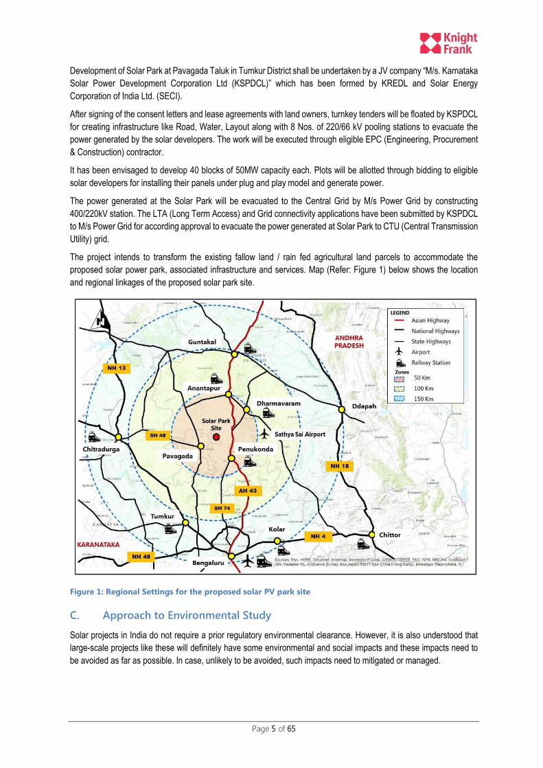
The project intends to transform the existing fallow land / rain fed agricultural land parcels to accommodate the
proposed solar power park, associated infrastructure and services. Map (Refer: Figure 1) below shows the location
and regional linkages of the proposed solar park site.
Figure 1: Regional Settings for the proposed solar PV park site
C. Approach to Environmental Study
Solar projects in India do not require a prior regulatory environmental clearance. However, it is also understood that
large-scale projects like these will definitely have some environmental and social impacts and these impacts need to
be avoided as far as possible. In case, unlikely to be avoided, such impacts need to mitigated or managed.

Page 6 of 65
M/s Knight Frank (India) Private Limited (KFIPL) was appointed by World Bank for the Environmental and Social Impact
Assessment study for the proposed project.
The scope of the work for the current ESIA study is limited to 600MW Solar-PV Park being developed by (National
Thermal Power Corporation) NTPC. The blocks allocated to NTPC are from B27 till B38 (as per the revised layout).
The proposed blocks fall under two villages i.e. Thirumani and Rayacharlu. The socio-economic questionnaire surveys
and public consultations conducted under the study were limited to households likely to be impacted due to the project
falling under the above mentioned two villages. The study approach adopted by the team is presented in the below
self-explanatory flow chart below (Refer: Figure 2)
Figure 2: Approach adapted to EIA Study

Page 7 of 65
D. Structure of Report
Chapter-1 provides a brief about the India’s solar program and proposed project context. A broad approach to the EIA
study is also presented above in the chapter;
Chapter 2 provides a brief on the technology aspects of Solar PV Park along with the basic requirements for setting up
a solar PV park.
Chapter 3 provides the details about the proposed layout plan for the solar PV Park and the changes that were
undertaken by KSPDCL during the course of EIA study to address technical concerns.
Chapter 4 provides an insight into the national and state regulatory provisions along with WB Group compliance
requirements for the proposed Solar PV Project.
Chapter 5 elaborates on the stakeholder identification process adopted and a brief of the public consultations under
taken to capture the local residents / stakeholders perceptions.
Chapter 6 describes the baseline social and environmental conditions for the proposed solar PV park site and its
immediate vicinity.
Chapter 7 identifies the potential adverse environmental impacts due to the proposed project during the various stages
of project along with its severity levels.
Chapter 8 provides details of the proposed mitigation measures along with the responsible agency for implementation
of the proposed mitigation measures.

Page 0 of 65
II. PROJECT DESCRIPTION
A. Electricity generation using PV technologies
In photovoltaic technology the power conversion source is via photovoltaic modules that convert light directly to
electricity. Solar panels produce direct current (DC) electricity, so solar parks need conversion equipment to convert
this to alternating current (AC), which is the form transmitted by the electricity grid. This conversion is done by inverters.
PV systems produce energy by converting solar irradiation into electricity. A PV system consists of PV panels that
encase the solar cells. Solar cells are solid-state semiconductor devices that convert light into direct-current electricity.
The top layer of the silicon portion of a solar panel is made from a mixture of this silicon and a small amount of
phosphorous, which gives it a negative charge. The inner layer, which constitutes the majority of the panel, is a mix of
silicon and a little bit of boron, giving it a positive charge.
The place where these two layers meet creates an electric field called a junction. When light (or photons) hits the solar
cell, before it gets to the silicon crystal to make electricity it passes through a glass cover on the panel and an anti-
reflective coating, which stops photons from reflecting off of the panel and being lost. The photons are absorbed into
the junction, which pushes electrons in the silicon out of the way. If enough photons are absorbed, the electrons are
pushed past the junction and flow freely to an external circuit.
To convert the Direct Current (DC) to Alternating Current (AC) an inverter will be used. The AC energy can then be
used to power anything that uses electricity. In fact, they are just larger versions of the cells used in solar calculators.
The front surface of the solar panel is toughened glass with an anti-reflective coating to maximise the light captured by
the solar cells and reduce glare back towards the atmosphere. The PV panels are predominantly black in appearance
– when viewed directly from the front; however, from close-up, a grid of silver contacts is clearly visible.
Panels are framed with anodised aluminium, and will be mounted as sub-arrays on frames of anodised aluminium and
hot-dipped galvanised steel. Figure 3 depicts the operational solar PV panels at the Pavagada project office installed
on the roof-top by KSPDCL.
Figure 3: Solar PV Panels operating on rooftop
In simplified terms it can be stated that the operation of a PV park entails the production of power through the conversion
of solar energy to electricity. The PV power generation process is primarily self-sufficient and is not in need of constant
supervision or management attention. The input requirements for PV power generation include:
I. Solar radiation
II. Water for cleaning operations
III. Equipment to convert / transfer solar energy to electricity
The outputs to be generated include:

Page 1 of 65
I. Electricity power
II. Solid waste generation from administrative / temporary housing / construction camps
III. Liquid waste / effluent (non-hazardous)
IV. Waste water from washing of PV panels
Operation of the facility will entail the regular maintenance of the site and infrastructure, management of waste facilities
and the replacement of consumable items and/or damaged equipment to ensure that the plant operates optimally. This
maintenance will as far as possible should be scheduled to times that the plant is not operational to improve productivity.
Unscheduled repairs and maintenance will likely occur as a result of breakdowns and emergency situations.
B. Fundamental Terminology
1. Insolation, Irradiance and Irradiating
When considering PV technology, it is important to understand the fundamental terminology. Insolation is a general-
purpose word for “incident solar radiation”. It is a measure of solar radiation energy received on a given surface during
a given time, typically in kWh/m2/day or kWh/m2/year.
Sun rays can be scattered by vapour or dust particles in air before reaching the Earth’s surface, this is known as diffuse
irradiation. Only the parallel sun rays normal to the receiving surface can be concentrated, and this is the portion known
as Direct Normal Irradiance (DNI), which has the SI unit of W/m2. In the solar power industry, irradiation with time
duration (typically in the form of Wh/day or kWh/year per unit area) is often used interchangeably with irradiance.
For consistency to international preference, DNI in this document will refer to Direct Normal Irradiation, with the unit of
kWh/m2/day or kWh/m2/year, the same with insolation for measuring energy. The solar radiation map (Refer Figure 4)
depicting the average annual DNI values for the proposed solar park location is depicted below as per the NREL
database:
Figure 4: Annual DNI value for the proposed site
Page 2 of 65
C. The proposed PV plant
The proposed 2000MW solar park will be developed in multiple lots of 250 or 500MW capacities each which will help
reduce the project implementation duration. For each 250MW solar power capacity block, one pooling sub-station of
66/220Kv is proposed in which 2 x 150MW step-up transformers are considered. 250MW block is further sub-divided
into 50MW sub blocks.
The park is likely to have fixed axis (inclined at latitude) facing south PV panels with a tilt angle of 150 due South. The
annual Global solar irradiance is 2008 kWh/m2 for the proposed site as per the DPR. The average block size would be
250 acres.
The total number of PV modules for 50MW is estimated at 166,668 units for “Canadian Solar-CS6X-300P” and 499,995
units for “FS-3100” solar PV models respectively. The total area of 12,000 acres is approximately divided into 40 blocks
and ancillary infrastructure.
The solar park facility will also include ancillary infrastructure in support of the power plant including water abstraction
/ bore wells, waste management systems, power lines, roads, warehouse and storage facilities, administration &
operations building, temporary housing facilities, construction labour camps and sub-station / switching station.
For setting up a utility level solar park facility, the key requirements include: land availability, water, connectivity and
accessibility, meteorology and favourable global irradiance, shadow free area and required infrastructure. A brief of the
above stated basic requirements is stated in the subsequent sub-sections.
a) Land
The total land (approximately 12000 acres) required for setting up of the proposed 2000MW solar park is being
undertaken on long term lease (for duration of 28 years) from private land owners at an annual rental of ₹ 21,000/-
with an escalation of 5% every two years. Consultations with the majority of land owners reveal willingness to lease
land parcels mainly due to erratic rainfall and loss in agricultural production over the last few decades. The details on
the public consultations are presented in Chapter “V” of the report.
Site visits reveal presence of a very few scattered tree cover within the proposed site which needs to be integrated in
PV plant design to minimize shading losses without any tree cutting. The site layout has been subdivided into 40
rectangular blocks (50MW each) for maximum efficiency as depicted in the proposed layout plan.
b) Water
The proposed site falls under the region where rains are uncertain and erratic, cyclic semi dry conditions are very
common. The DPR document states water for construction stage can be met from nearby tanks after necessary
approvals from the panchayat. For construction and operations stages of the project adequate availability of water need
to be ensured. For dusty areas like these, permanent water supply either on site or adjacent to site need to be ensured
to prevent losses on account of soiling during O&M stage. The O&M stage water requirements are mainly intended for
cleaning of PV surfaces and site office requirements. Modules are generally cleaned manually by spraying water and
wiping dust / bird dropping from the surface.
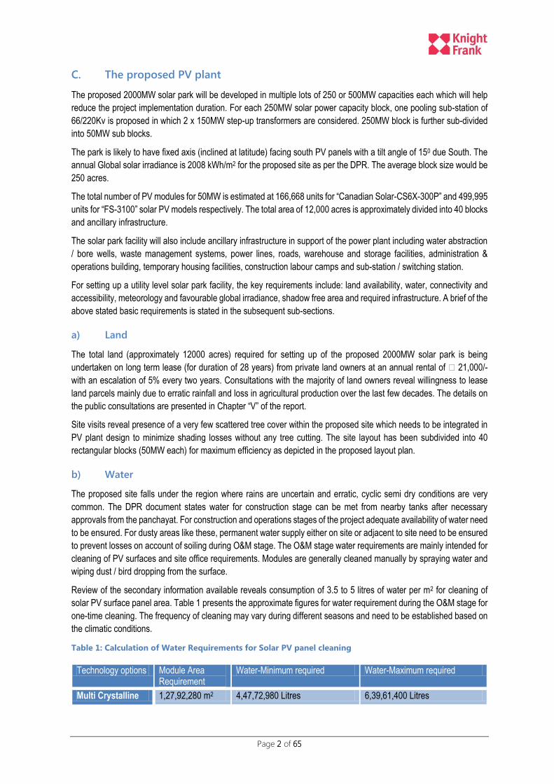
Review of the secondary information available reveals consumption of 3.5 to 5 litres of water per m2 for cleaning of
solar PV surface panel area. Table 1 presents the approximate figures for water requirement during the O&M stage for
one-time cleaning. The frequency of cleaning may vary during different seasons and need to be established based on
the climatic conditions.
Table 1: Calculation of Water Requirements for Solar PV panel cleaning
Technology options Module Area Requirement
Water-Minimum required Water-Maximum required
Multi Crystalline 1,27,92,280 m2 4,47,72,980 Litres 6,39,61,400 Litres
Page 3 of 65
Technology options Module Area Requirement
Water-Minimum required Water-Maximum required
Thin Film 1,43,99,840 m2 5,03,99,440 Litres 7,19,99,200 Litres
As per the DPR document, it has been estimated that a 50MW capacity solar PV power plant comprising of (multi
crystalline – 3,19,807 m2 or thin film – 3,59,996 m2) solar PV module area will need to be cleaned at least twice in a
month.
Considering the proposed area as a water scarce region with uncertain and erratic rainfall, adequate alternative means
need to be ensured including rain water harvesting / creation of additional tanks or increasing the storage capacity of
the existing tanks, etc to meet the O&M demands. The available technology options for reduction of water requirement
during the O&M stage may also need to be considered.
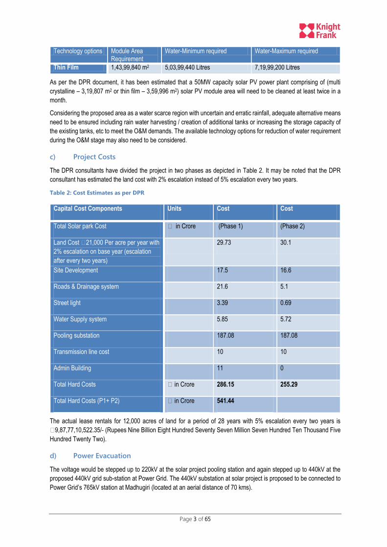
c) Project Costs
The DPR consultants have divided the project in two phases as depicted in Table 2. It may be noted that the DPR
consultant has estimated the land cost with 2% escalation instead of 5% escalation every two years.
Table 2: Cost Estimates as per DPR
Capital Cost Components Units Cost Cost
Total Solar park Cost ₹ in Crore (Phase 1) (Phase 2)
Land Cost ₹21,000 Per acre per year with
2% escalation on base year (escalation
after every two years)
29.73 30.1
Site Development 17.5 16.6
Roads & Drainage system 21.6 5.1
Street light 3.39 0.69
Water Supply system 5.85 5.72
Pooling substation 187.08 187.08
Transmission line cost 10 10
Admin Building 11 0
Total Hard Costs ₹ in Crore 286.15 255.29
Total Hard Costs (P1+ P2) ₹ in Crore 541.44
The actual lease rentals for 12,000 acres of land for a period of 28 years with 5% escalation every two years is ₹9,87,77,10,522.35/- (Rupees Nine Billion Eight Hundred Seventy Seven Million Seven Hundred Ten Thousand Five
Hundred Twenty Two).
d) Power Evacuation
The voltage would be stepped up to 220kV at the solar project pooling station and again stepped up to 440kV at the
proposed 440kV grid sub-station at Power Grid. The 440kV substation at solar project is proposed to be connected to
Power Grid’s 765kV station at Madhugiri (located at an aerial distance of 70 kms).
Page 4 of 65
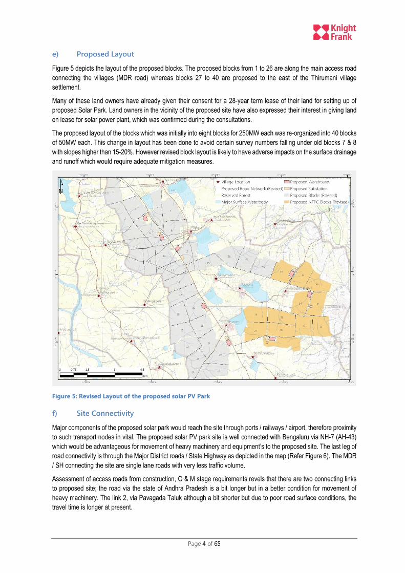
e) Proposed Layout
Figure 5 depicts the layout of the proposed blocks. The proposed blocks from 1 to 26 are along the main access road
connecting the villages (MDR road) whereas blocks 27 to 40 are proposed to the east of the Thirumani village
settlement.
Many of these land owners have already given their consent for a 28-year term lease of their land for setting up of
proposed Solar Park. Land owners in the vicinity of the proposed site have also expressed their interest in giving land
on lease for solar power plant, which was confirmed during the consultations.
The proposed layout of the blocks which was initially into eight blocks for 250MW each was re-organized into 40 blocks
of 50MW each. This change in layout has been done to avoid certain survey numbers falling under old blocks 7 & 8
with slopes higher than 15-20%. However revised block layout is likely to have adverse impacts on the surface drainage
and runoff which would require adequate mitigation measures.
Figure 5: Revised Layout of the proposed solar PV Park
f) Site Connectivity
Major components of the proposed solar park would reach the site through ports / railways / airport, therefore proximity
to such transport nodes in vital. The proposed solar PV park site is well connected with Bengaluru via NH-7 (AH-43)
which would be advantageous for movement of heavy machinery and equipment’s to the proposed site. The last leg of
road connectivity is through the Major District roads / State Highway as depicted in the map (Refer Figure 6). The MDR
/ SH connecting the site are single lane roads with very less traffic volume.
Assessment of access roads from construction, O & M stage requirements revels that there are two connecting links
to proposed site; the road via the state of Andhra Pradesh is a bit longer but in a better condition for movement of
heavy machinery. The link 2, via Pavagada Taluk although a bit shorter but due to poor road surface conditions, the
travel time is longer at present.

Page 5 of 65
Figure 6: Map showing existing site road linkages from AH-43 (NH-7)
Page 6 of 65
III. PROPOSED LAYOUT PLAN
The location of the proposed solar PV Park has been essentially identified by KREDL which is a state nodal agency of
Ministry of New and Renewable Energy (MNRE), Government of India. The preliminary site investigations were under
taken from the point of view of solar PV technologies, appropriate design approach and effective project
implementation.
While selection of site, all ineligible areas were ruled out i.e. biodiversity rich areas, military facilities, existing human
settlements, archaeological restrictions etc. KREDL during the initial stage of the project adopted the following criteria
for selection of site:-
I. The availability and accessibility of primary resources required for the operation of the power plant, such
as sun (i.e. the required Direct Normal Insolation) and water;
II. Availability of land to locate the site and associated infrastructure;
III. The availability and accessibility of infrastructure for the provision of services, manpower and social
structure for the construction and operation of the power plant;
IV. The ease of integration of the proposed solar park with central grid; and
V. General environmental acceptability in terms of social impacts, water utilisation, general ecology, etc.
In order to overcome the hurdles and processes involved in the land acquisition, KREDL opted for the long term lease
model wherein land would be taken on lease for 28-year duration from the land owners. The lease can be extended in
future on mutually agreeable terms.
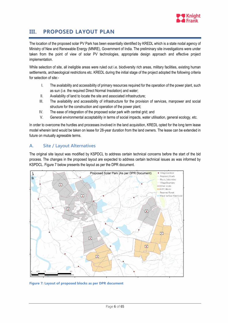
A. Site / Layout Alternatives
The original site layout was modified by KSPDCL to address certain technical concerns before the start of the bid
process. The changes in the proposed layout are expected to address certain technical issues as was informed by
KSPDCL. Figure 7 below presents the layout as per the DPR document.
Figure 7: Layout of proposed blocks as per DPR document

Page 7 of 65
KSPDCL, on 11th-Feb-2016 has uploaded a revised layout plan for the proposed solar park on their website
(www.kspdcl.in). As per the revised layout plan the proposed site has been sub-divided into 40 blocks of 50MW each
whereas the previous plan demarcated division of site in 8 Blocks of 250 MW each (with further sub-division in 5 sub-
blocks of 50 MW each).
In the revised layout there has been a shift in the land to be allocated to NTPC under Phase 1 as compared to the
previous layout plan. Blocks 5 (partial), 6 & 7 were originallly proposed for NTPC which as per the revised layout (Refer
Figure 8), blocks 27 till 38 have been allotted to NTPC. It may be noted that the revised layout does not differ much as
far as Blocks 1 to 6 are concerned, however there is a noticeable variation as far as Blocks 7 & 8 are concerned.
Figure 8: Revised Layout of Blocks as notified on 11-02-2016
As part of the agreement between KSPDCL and the private developer, KSPDCL shall develop common infrastructure
in the Solar Park like Internal Transmission System, Water Supply, Road Connectivity, Drainage System and Weather
Stations, Street Lighting for the MDRs etc. Developer shall at its own cost construct and maintain arterial roads with
street lighting to and from MDRs.
B. Water supply pipelines / Drainage System
As part of the proposed drainage system, KSPDCL plans to provide drainage channels on both sides of the proposed
7-meter and 3.75 meter wide roads. This is going to have serious adverse impacts on the existing natural drainage
unless a detailed hydrological modelling is undertaken to access the required length and number of cross drainage /
parallel drainage structures. (Refer Figure 9 below)
O&M stage, water requirements for cleaning of PV panels / administrative buildings etc. will be met by installation of
bore wells or from surface water bodies as per the DPR document.

Page 8 of 65
C. Access Roads
The anticipated impacts due to access roads would be more permanent in nature. With the revised layout, the village
settlement “Achchammanahalli” is surrounded on three sides by the proposed solar PV Park limiting access.
The proposed road cross-sections are presented below. The roads proposed include a 7-meter wide road for all main
roads and 3.75 meter road as internal block roads. The approximate length of 3.75 meter road (10/15 RoW) within the
NTPC blocks is approximately 12 kms and of the proposed 7 meter road (40 meter RoW) is approximately 9 kms. Map
below (Figure 9) of the proposed NTPC blocks depicts the alignment of the proposed roads along with typical cross-
section details.
Figure 9: Proposed Access roads as per revised layout (NTPC Blocks)
D. Transmission Lines
The proposed transmission lines is largely along the proposed 7-meter wide road having 65-metre (both sides) and 40-
meter corridor (one side) as per the revised layout.
KSPDCL through EPC Contractor is establishing 8 Nos. of 220/66 kV Pooling Sub-stations; Construction of 220kV AC
line for a distance of 18 kms; 220kV DC line for a distance of 6 kms; 220 kV multi circuit line for a distance of 14 kms
from the proposed 220/66kV substation, in solar park to Power Grid station in solar park. Power Grid is establishing
400/220 kV Grid Sub-station at Survey Nos. 56/1, 62 and 63 of Kyataganacharlu village for facilitating evacuation of
2000MW power from Pavagada Solar Park. The above length is for the complete 2000 MW solar PV Park and not just
limited to the NTPC blocks.
Page 9 of 65
E. Waste Storage Areas
There are no designated waste storage areas as per the proposed layout. The responsibility of the storage,
transportation of waste from site to safe disposal site rests with the developer. Each developer has to designate an
area within its own allotted blocks for temporary storage of waste and its final safe disposal.
F. Warehouse and Construction Camps
The location of the warehouses and sub-stations are marked on the proposed layout. However the location of storage
areas and camp site has not been identified at this stage by KSPDCL. The developer shall be responsible for setting
up of the labour camps and materials storage as per the guidelines provided in the EMP.

Page 10 of 65
IV. LEGAL REQUIREMENTS
There is a need to integrate the environmental and social consequences of the development activities and for planning
suitable measures in order to ensure sustainable development of the region. The environmental considerations in any
developmental process are necessary for achieving sustainable development.
Solar Ultra Mega Power Project (Solar UMPP) are not covered under the ambit of EIA Notification 2006 and does not
require prior EIA clearance but these projects would still require consent to establish and operate under the Air and
Water Acts from the State Pollution Control Board ensuring that the site development does not have any adverse
impacts. The withdrawal of ground water and tree cutting if any would attract additional regulatory clearances for the
proposed project. The applicable policy and regulatory framework applicable for the proposed solar PV Park is
elaborated in the following sections:
A. State Pollution Control Board Regulations
The Central Pollution Control Board (CPCB) notification dated June 02, 2014 classifies solar renewable power projects
of all capacities under the green1 category of industries. The evacuation related activities (responsible for laying power
evacuation line, connectivity to national grid and NOC from relevant departments) would need to be considered
separately for environmental and social impacts. Table 3 below presents a checklist of the likely to be applicable
legislations.
An NOC clearance from the Forest Department stating that no forest area is being impacted due to the proposed solar
park has already been undertaken by KSPDCL. However for trees cutting (if any) within the proposed site, requisite
clearance would need to be undertaken by KSPDCL.
Table 3: Checklist of Applicable legislations
Acts/Rule/Policy Year Objective Applicability to this
Project
Responsible Agency
Environmental
(Protection) Act
1986 To protect and improve the
overall environment.
All environmental
legislation is covered
in this umbrella Act
MoEFCC, GoI; CPCB; State
Pollution Control Board
National Forest Policy
(Revised)
1952/1988 To maintain ecological
stability through preservation
and restoration of biological
diversity.
NoC has been issued
by Forest Deptt;
For Trees Cutting (if
any), clearance would
be required
Forest Department, Karnataka
Water (Prevention and
Control of Pollution) Act
1974 To control water pollution by
controlling discharge of
pollutants as per the
prescribed standards.
NOC for
establishment and
operation during
construction required
Karnataka State Pollution
Control Board
Air (Prevention and
Control of Pollution) Act
1981 To control air pollution by
controlling emission of air
pollutants as per the
prescribed standards.
Yes, if generators are
used during
construction stage;
NOC for
establishment and
operation during
construction required
Karnataka State Pollution
Control Board
Batteries (Management
and Handling) Rules
2001 The Act defines the
requirements for disposal of
used batteries for bulk users.
Yes, if batteries are
used for storage of
power before being
Karnataka State Pollution
Control Board
1 The industries or projects have been classified in three broad categories viz. Red, Orange and Green in decreasing order of severity of
pollution.
Page 11 of 65
Acts/Rule/Policy Year Objective Applicability to this
Project
Responsible Agency
The developers in sub-
project would be likely bulk
users.
supplied to the central
grid.
The Electricity Act 2003 Laws relating to generation,
transmission, distribution,
trading and use of electricity,
promotion of efficient and
environmentally benign
policies.
The national grid
connectivity is being
undertaken as a
separate project and
not covered under
this ESIA scope.
Power Grid
Permission for storage of
hazardous chemical from
CPCB
Applicable in case of storage
and Import of Hazardous
Chemical
Construction stage
(Prior to initiation of
any work)
Developer
Permission for extraction
of Ground water
Applicable for construction
and operations stage
Construction &
Operations stage
(Prior to initiation of
installation of Bore
wells and abstraction
of water from such
source)
Developer for
construction/operations stage
Or Use of Surface water
sources for
construction/operation
stage
Applicable for construction
and operations stage
Operations stage to
meet the O&M
requirements
Developer for
construction/operations stage
Acts and Regulations governing LA & Social Issues
Right to fair
compensation and
transparency in land
acquisition, rehabilitation
and Resettlement Act
2013 Fair compensation for
acquisition of immovable
assets; Resettlement of
displaced population due to
LA and economic
rehabilitation of all those who
are affected due to land
acquisition.
Yes, if private land
need to be acquired
for solar park.
Under the current
arrangement land is
being taken on lease
only.
KSPDCL
Karnataka G.O. on Land Reforms / Land Lease
2014 The GO aims to facilities the transfer and conversion of agricultural land for Solar PV projects on long term lease basics
Yes KSPDCL
Seventy Third Constitution Amendment Act,
1992 The Act enables participation of Panchayat level institutions in decision-making. Panchayats at the village level will be involved for preparation and implementation of the project.
Yes, for any sub
project located in
panchayat area
Department of Panchayati Raj,
State Government
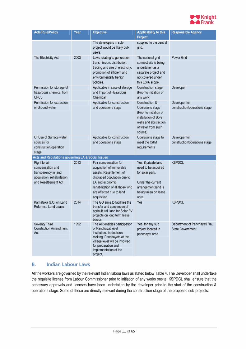
B. Indian Labour Laws
All the workers are governed by the relevant Indian labour laws as stated below Table 4. The Developer shall undertake
the requisite license from Labour Commissioner prior to initiation of any works onsite. KSPDCL shall ensure that the
necessary approvals and licenses have been undertaken by the developer prior to the start of the construction &
operations stage. Some of these are directly relevant during the construction stage of the proposed sub-projects.
Page 12 of 65
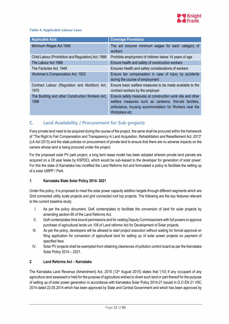
Table 4: Applicable Labour Laws
Applicable Acts Coverage Provisions
Minimum Wages Act 1948 The act ensures minimum wages for each category of
workers
Child Labour (Prohibition and Regulation) Act, 1986 Prohibits employment of children below 14 years of age
The Labour Act 1988 Ensure health and safety of construction workers
The Factories Act, 1948 Ensures Health and safety considerations of workers
Workmen’s Compensation Act, 1923 Ensure fair compensation in case of injury by accidents
during the course of employment
Contract Labour (Regulation and Abolition) Act,
1970
Ensure basic welfare measures to be made available to the
contract workers by the employer
The Building and other Construction Workers Act,
1996
Ensure safety measures at construction work site and other
welfare measures such as canteens, first-aid facilities,
ambulance, housing accommodation for Workers near the
Workplace etc
C. Land Availability / Procurement for Sub-projects
If any private land need to be acquired during the course of the project, the same shall be procured within the framework
of “The Right to Fair Compensation and Transparency in Land Acquisition, Rehabilitation and Resettlement Act, 2013”
(LA Act 2013) and the state policies on procurement of private land to ensure that there are no adverse impacts on the
owners whose land is being procured under the project.
For the proposed solar PV park project, a long term lease model has been adopted wherein private land parcels are
acquired on a 28 year lease by KSPDCL which would be sub-leased to the developer for generation of solar power.
For this the state of Karnataka has modified the Land Reforms Act and formulated a policy to facilitate the setting up
of a solar UMPP / Park.
1. Karnataka State Solar Policy 2014- 2021
Under this policy, it is proposed to meet the solar power capacity addition targets through different segments which are
Grid connected utility scale projects and grid connected roof top projects. The following are the key features relevant
to the current baseline study:
I. As per the policy document, GoK contemplates to facilitate the conversion of land for solar projects by
amending section-95 of the Land Reforms Act.
II. GoK contemplates time bound permissions and for vesting Deputy Commissioners with full powers to approve
purchase of agricultural lands u/s 109 of Land reforms Act for Development of Solar projects.
III. As per the policy, developers will be allowed to start project execution without waiting for formal approval on
filing application for conversion of agricultural land for setting up of solar power projects on payment of
specified fees.
IV. Solar PV projects shall be exempted from obtaining clearances of pollution control board as per the Karnataka
Solar Policy 2014 – 2021.
2. Land Reforms Act – Karnataka
The Karnataka Land Revenue (Amendment) Act, 2015 (12th August 2015) states that “(10) If any occupant of any
agriculture land assessed or held for the purpose of agriculture wishes to divert such land or part thereof for the purpose
of setting up of solar power generation in accordance with Karnataka Solar Policy 2014-21 issued in G.O EN 21 VSC
2014 dated 22.05.2014 which has been approved by State and Central Government and which has been approved by

Page 13 of 65
the Competent Authority, the permission applied for conversion of such land shall be deemed to have been granted for
that purpose so long as they use for purpose for which permission is granted subject to payment of the conversion fine
and all such other fees payable if any, in this regard."
If the government revenue land is recorded as forest land with small and minor trees in the revenue records or it is
defined as a forest land as per Revenue Department, then the applicant will have to take permission, as per provisions
of Forest Conservation Act 1980, from concerned authorities.
D. World Bank Group Safeguard Requirements
1. World Bank Safeguard Requirements
The implementation of the World Bank Operational Policies seek to avoid, minimize or mitigate the adverse
environmental and social impacts, including protecting the rights of those likely to be affected or marginalized by the
proposed project. Based on the information collated by the consultants during the study, following OP’s are triggered
and would require adequate measures to address the safeguard concerns.
World Bank Safe Guard Policies
Objective Applicability Safeguard Requirements
OP 4.01 Environmental Assessment
The objective of this policy is to ensure that Bank financed projects are environmentally sound and sustainable.
The environmental issues will be addressed adequately in advance. An integrated Environmental Screening and Environmental Assessment (EA) with Environmental Management Plan (EMP) will be developed to manage environmental risks and maximize environmental and social benefits wherever it is applicable.
EIA and/or EMP are being prepared to mitigate residual impacts.
OP/BP 4.12 Involuntary Resettlement
The objective of this policy is to avoid or minimize involuntary resettlement where feasible, exploring all viable alternative project designs. Furthermore, it intends to assist displaced person in improving their former living standards; community participation in planning and implementing resettlement; and to provide assistance to affected people, regardless of the legality of title of land
There will be need for limited land acquisition resulting in: relocation or loss of shelter, loss of assets or access to assets; loss of income sources or means of livelihood. This policy applies to all components of the project that result in involuntary resettlement, regardless of the source of financing including projects that are carried out, or planned to be carried out, contemporaneously with the project.
The project does not envisage any involuntary resettlement. The land is being taken on a long term lease for 28 years. All owners have given consent. Resettlement Action Plan in consultation with the community and project authorities
OP/BP 4.11 Physical Cultural Resources
This policy aims at assisting in the preservation of cultural property, historical, religious and unique natural value-this includes remains left by previous human
This policy may be triggered by sub-projects where cultural property, historical, religious and unique natural value-this includes remains
Application to be submitted to ASI in case any impact is envisaged due to the project including chance finds.
Page 14 of 65
World Bank Safe Guard Policies
Objective Applicability Safeguard Requirements
inhabitants and unique environment features, as well as in the protection and enhancement of cultural properties encountered in Bank- financed project.
left by previous human inhabitants and unique environment features may be affected due to project.
The impact on such features have been integrated with EIA / EMP
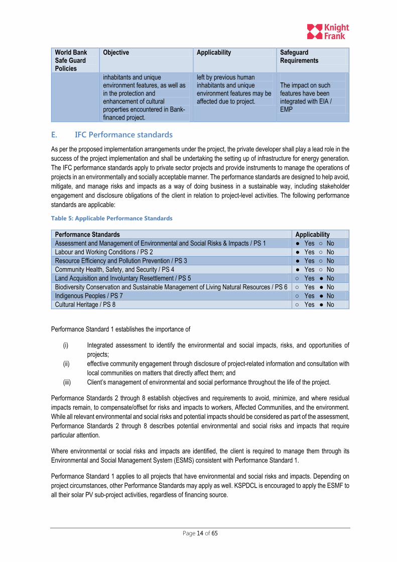
E. IFC Performance standards
As per the proposed implementation arrangements under the project, the private developer shall play a lead role in the
success of the project implementation and shall be undertaking the setting up of infrastructure for energy generation.
The IFC performance standards apply to private sector projects and provide instruments to manage the operations of
projects in an environmentally and socially acceptable manner. The performance standards are designed to help avoid,
mitigate, and manage risks and impacts as a way of doing business in a sustainable way, including stakeholder
engagement and disclosure obligations of the client in relation to project-level activities. The following performance
standards are applicable:
Table 5: Applicable Performance Standards
Performance Standards Applicability
Assessment and Management of Environmental and Social Risks & Impacts / PS 1 ● Yes ○ No
Labour and Working Conditions / PS 2 ● Yes ○ No
Resource Efficiency and Pollution Prevention / PS 3 ● Yes ○ No
Community Health, Safety, and Security / PS 4 ● Yes ○ No
Land Acquisition and Involuntary Resettlement / PS 5 ○ Yes ● No
Biodiversity Conservation and Sustainable Management of Living Natural Resources / PS 6 ○ Yes ● No
Indigenous Peoples / PS 7 ○ Yes ● No
Cultural Heritage / PS 8 ○ Yes ● No
Performance Standard 1 establishes the importance of
(i) Integrated assessment to identify the environmental and social impacts, risks, and opportunities of
projects;
(ii) effective community engagement through disclosure of project-related information and consultation with
local communities on matters that directly affect them; and
(iii) Client’s management of environmental and social performance throughout the life of the project.
Performance Standards 2 through 8 establish objectives and requirements to avoid, minimize, and where residual
impacts remain, to compensate/offset for risks and impacts to workers, Affected Communities, and the environment.
While all relevant environmental and social risks and potential impacts should be considered as part of the assessment,
Performance Standards 2 through 8 describes potential environmental and social risks and impacts that require
particular attention.
Where environmental or social risks and impacts are identified, the client is required to manage them through its
Environmental and Social Management System (ESMS) consistent with Performance Standard 1.
Performance Standard 1 applies to all projects that have environmental and social risks and impacts. Depending on
project circumstances, other Performance Standards may apply as well. KSPDCL is encouraged to apply the ESMF to
all their solar PV sub-project activities, regardless of financing source.

Page 15 of 65
The sub sections below provide a brief the objectives of each of the performance standards:
1. Assessment and Management of Environmental and Social Risks & Impacts
The objectives of the performance standard 1 are:
i. Identify and assess environmental and social impacts in the project’s area of influence.
ii. Avoid, minimize, mitigate or compensate for adverse impacts.
iii. Ensure that affected communities are engaged on issues that may affect them.
iv. Promote improved environmental and social performance through effective management systems
2. Labour and Working Conditions
The objectives of the performance standard 2 are:
i. Establish, maintain and improve the worker-management relationship.
ii. Promote fair treatment and equal opportunity for workers, in compliance with national laws.
iii. Protect workforce by addressing child labour and forced labour.
iv. Promote safe working conditions and protect / promote the health of workers
3. Resource Efficiency and Pollution Prevention
This Performance Standard outlines a project-level approach to resource efficiency and pollution prevention and control
in line with internationally disseminated technologies and practices. The objectives of the Performance Standard 3 are:
i. To avoid or minimize adverse impacts on human health and the environment by avoiding or minimizing
pollution from project activities.
ii. To promote more sustainable use of resources, including energy and water.
iii. To reduce project-related GHG emissions.
4. Community Health, Safety and Security
While acknowledging the public authorities’ role in promoting the health, safety, and security of the public, this
Performance Standard – 4 addresses the client’s responsibility to avoid or minimize the risks and impacts to community
health, safety, and security that may arise from project related-activities, with particular attention to vulnerable groups.
The objective of Performance Standard 4 is:
i. Avoid or minimize the risks to, and impacts on, the health and safety of the local community over the project
life cycle, from both routine and non-routine circumstances.
ii. Ensure that the safeguarding of personnel and property is carried out in a legitimate manner that avoids or
minimizes risks to the community’s safety and security.
.

Page 16 of 65
V. PUBLIC PARTICIPATION PROCESS
KREDL/KSPDCL has ensured participation of the land owners and other stakeholders from the project initiation stage
and this has helped gain confidence of the locals and their active participation in the consultation process. The process
involved procurement of land on lease and not acquisition which has also led to wider acceptance and participation of
the village land owners.
A. Identification of Key Stakeholders
For setting up a 2000 MW solar PV park, an estimated area required would be to the tune of 12,000 acres (5 acres per
MW of solar PV generation). A cluster of five villages (i.e. Thirumani, Balasamudra, Vollur, Kyathaganacherlu,
Rayacharlu) falling under Pavagada tehsil have been selected by KSPDCL.
The land owners and the landless labourers working in the agricultural parcels falling under these five villages are the
key stakeholders. The proposed NTPC blocks fall under two villages i.e. Thirumani and Rayacharlu. The current study
focused on the active participation of the stakeholders from the above mentioned two villages.
B. Public Participation Process Adopted
1. Initial Consultations – Fixing of Lease Rentals
A general meeting was held on 28-09-2015 presided by the Deputy Commissioner of Tumkur District. The key
participants included: Minister of Petroleum; Chitradurga MLA; Local MLA (Urgappa); District Panchayat Members
(Tumkur); Taluk and Gram Panchayat Members; District Commissioner, Tumkur; Development Officers – KREDL;
Madhugiri Sub-Division Officers; Joint Director of Agriculture Department; Executive Engineer – KPTCL; Assistant
Director, Horticulture Department; Administrative Officer, KREDL; Tahsildar, Pavagada and Landowners from the five
villages.
The participants were made aware about the proposed project, to set up a 2000 MW solar PV park in the area falling
under the five revenue villages. The land would not be acquired instead would be taken on lease for 28 years after
getting the necessary consent from land owners. Participants expressed their willingness to offer their land parcels on
lease. The consultation process resulted in the following pronouncements:
1. The lease rent was fixed at ₹21,000/acre as annual rentals after dialogue with all the participants.
2. Graveyard and other important structures shall be
protected.
3. If land has a bore well or any valuable tree, extra
compensation shall be provided.
4. Escalation of 5% in annual rent every 2 years.
5. Registration Cost to be borne by the KSPDCL.
6. Lease Period of 30 years.
7. All approvals shall be taken by the KSPDCL.
The details of the proceedings are attached as Annexure XII to this report for reference. The market value of the land
in this area is estimated at ₹35000/- per acre at the time of these consultations.
C. Consultation and Public Involvement
In addition to the socio-economic surveys being conducted under the current EIA study, separate focus group
discussion with various stakeholders, informal discussions were conducted by the team to gauge general perception
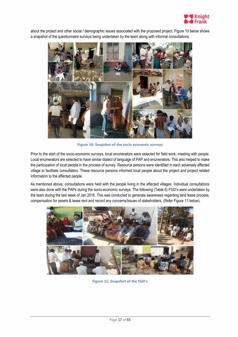
Page 17 of 65
about the project and other social / demographic issues associated with the proposed project. Figure 10 below shows
a snapshot of the questionnaire surveys being undertaken by the team along with informal consultations.
Figure 10: Snapshot of the socio economic surveys
Prior to the start of the socio-economic surveys, local enumerators were selected for field work, meeting with people.
Local enumerators are selected to have similar dialect of language of PAP and enumerators. This also helped to make
the participation of local people in the process of survey. Resource persons were identified in each adversely affected
village to facilitate consultation. These resource persons informed local people about the project and project related
information to the affected people.
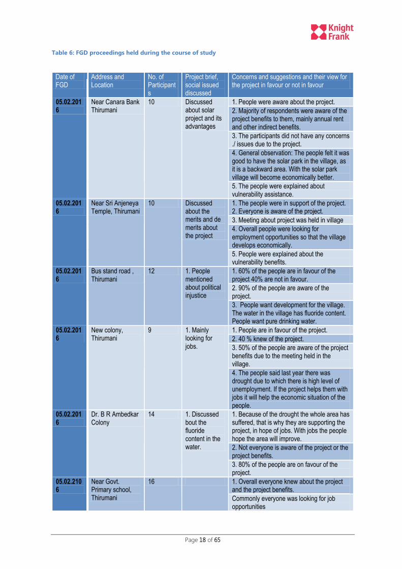
As mentioned above, consultations were held with the people living in the affected villages. Individual consultations
were also done with the PAPs during the socio-economic surveys. The following (Table 6) FGD’s were undertaken by
the team during the last week of Jan 2016. This was conducted to generate awareness regarding land lease process,
compensation for assets & lease rent and record any concerns/issues of stakeholders. (Refer Figure 11 below).
Figure 11: Snapshot of the FGD's
Page 18 of 65
Table 6: FGD proceedings held during the course of study
Date of FGD
Address and Location
No. of Participants
Project brief, social issued discussed
Concerns and suggestions and their view for the project in favour or not in favour
05.02.2016
Near Canara Bank Thirumani
10 Discussed about solar project and its advantages
1. People were aware about the project.
2. Majority of respondents were aware of the project benefits to them, mainly annual rent and other indirect benefits.
3. The participants did not have any concerns ./ issues due to the project.
4. General observation: The people felt it was good to have the solar park in the village, as it is a backward area. With the solar park village will become economically better.
5. The people were explained about vulnerability assistance.
05.02.2016
Near Sri Anjeneya Temple, Thirumani
10 Discussed about the merits and de merits about the project
1. The people were in support of the project. 2. Everyone is aware of the project.
3. Meeting about project was held in village
4. Overall people were looking for employment opportunities so that the village develops economically.
5. People were explained about the vulnerability benefits.
05.02.2016
Bus stand road , Thirumani
12 1. People mentioned about political injustice
1. 60% of the people are in favour of the project 40% are not in favour.
2. 90% of the people are aware of the project.
3. People want development for the village. The water in the village has fluoride content. People want pure drinking water.
05.02.2016
New colony, Thirumani
9 1. Mainly looking for jobs.
1. People are in favour of the project.
2. 40 % knew of the project.
3. 50% of the people are aware of the project benefits due to the meeting held in the village.
4. The people said last year there was drought due to which there is high level of unemployment. If the project helps them with jobs it will help the economic situation of the people.
05.02.2016
Dr. B R Ambedkar Colony
14 1. Discussed bout the fluoride content in the water.
1. Because of the drought the whole area has suffered, that is why they are supporting the project, in hope of jobs. With jobs the people hope the area will improve.
2. Not everyone is aware of the project or the project benefits.
3. 80% of the people are on favour of the project.
05.02.2106
Near Govt. Primary school, Thirumani
16 1. Overall everyone knew about the project and the project benefits.
Commonly everyone was looking for job opportunities
Page 19 of 65
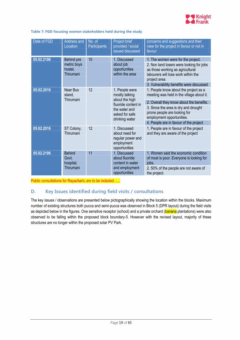
Table 7: FGD focusing women stakeholders held during the study
Date of FGD Address and Location
No. of Participants
Project brief provided / social issued discussed
concerns and suggestions and their view for the project in favour or not in favour
05.02.2106 Behind pre metric boys hostel, Thirumani
10 1. Discussed about job opportunities within the area
1. The women were for the project.
2. Non land losers were looking for jobs as those working as agricultural labourers will lose work within the project area.
3. Vulnerability benefits were discussed
05.02.2016 Near Bus stand, Thirumani
12 1. People were mostly talking about the high fluoride content in the water and asked for safe drinking water
1. People know about the project as a meeting was held in the village about it.
2. Overall they know about the benefits.
3. Since the area is dry and drought prone people are looking for employment opportunities.
4. People are in favour of the project
05.02.2016 ST Colony, Thirumani
12 1. Discussed about need for regular power and employment opportunities
1. People are in favour of the project and they are aware of the project
05.02.2106 Behind Govt. hospital, Thirumani
11 1. Discussed about fluoride content in water and employment opportunities
1. Women said the economic condition of most is poor. Everyone is looking for jobs.
2. 50% of the people are not aware of the project.
Public consultations for Rayacharlu are to be included …..
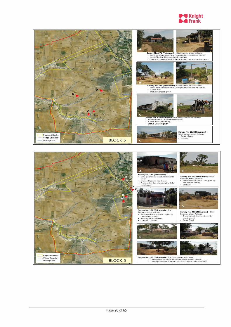
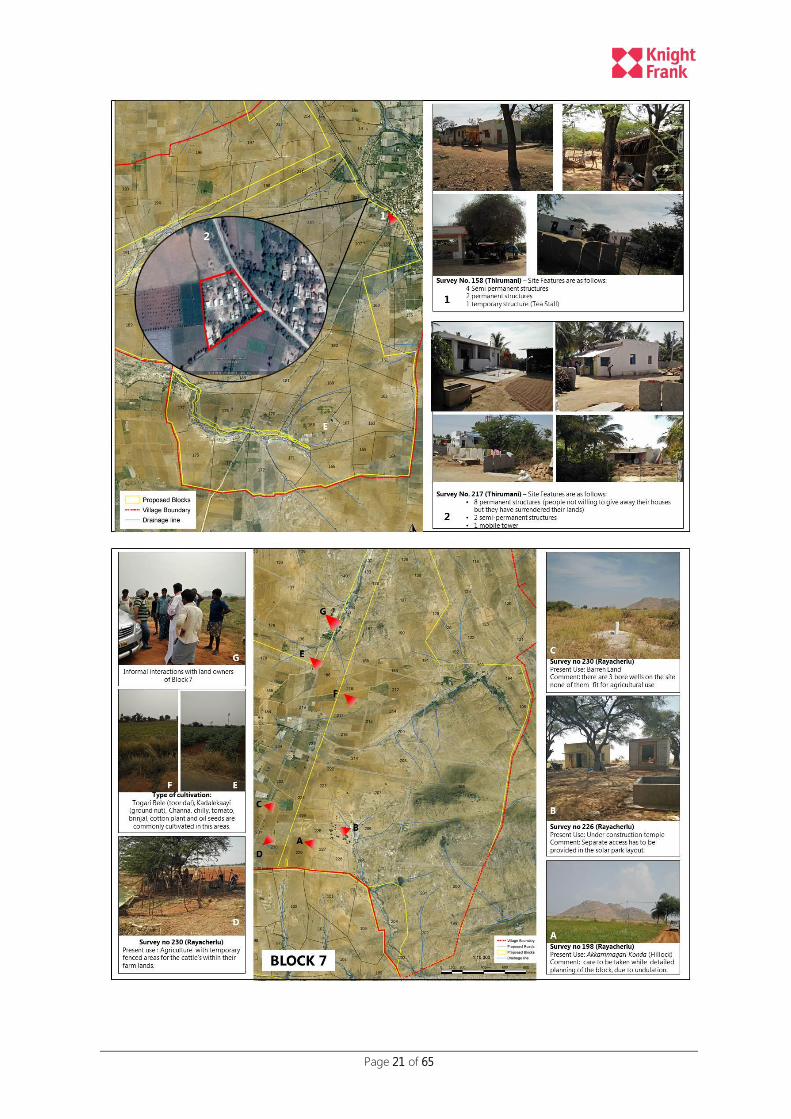
D. Key Issues identified during field visits / consultations
The key issues / observations are presented below pictographically showing the location within the blocks. Maximum
number of existing structures both pucca and semi-pucca was observed in Block 5 (DPR layout) during the field visits
as depicted below in the figures. One sensitive receptor (school) and a private orchard (banana plantations) were also
observed to be falling within the proposed block boundary-5. However with the revised layout, majority of these
structures are no longer within the proposed solar PV Park.
Page 20 of 65
Page 21 of 65

Page 22 of 65

Page 23 of 65
VI. BASELINE DESCRIPTION OF THE STUDY AREA
A. Biophysical Environment
1. Location
The proposed project site is located in the eastern part of Karnataka State between North Latitude 14013’ to 140 20’
and East Longitude 770 23’ to 770 30’; falling under five villages (i.e. Thirumani, Balasamudra, Vollur, Kyathaganacherlu
and Rayacharlu) of Pavagada Taluk in Tumkur District. The site is covered by SoI toposheet D43L7 & D43L8 Open
Series. It is 150 kms from state capital of Bengaluru. Uttara Pinakini River flows through Pavagada Taluk.
The proposed site is located at a distance of approximately 30 km from the Taluk headquarters, Pavagada and is
connected by a Major District Road (MDR). There is no rail connectivity currently available for Pavagada Taluk. The
nearest railway link is available at a distance of 100 kms at Anantpur (Andhra Pradesh) and 140 kms at Bellary Junction
(Karnataka). Table 8 below provides a brief description of the project site:
Table 8: Project Site Description
Particular Description
Project Site Villages: Kyathaganacherlu, Balasamudra, Vollur, Rayacharlu, Thirumani
Hobli / Tehsil / District / Nagalamadike / Pavagada / Tumkur (Karnataka State)
Location coordinates Latitude 14o13’ to 14o20’ North ; Longitude 77o23’ to 77o30’ East
Road Accessibility Linked by MDR to Taluk Headquarters; SH to Tumkur
Nearest Airport Bengaluru Airport (200 kms)
Land Available 12,000 Acres on long-term lease (28 years)
Proposed Capacity 2000MW park (including 600MW to be developed by NTPC)
Daily Average Solar Radiation
5.35 kWh/m2
Climate Warm & Humid
Technology Solar Photovoltaic (PV)
The current environmental and social assessment study focusses on 600MW Solar PV component being developed
by NTPC as part of the 2000 MW Solar Park. The villages falling under the proposed blocks 5 (partial), 6 and 7 being
developed by NTPC are Rayacharlu and Thirumani.
2. Climate
The climate of the district is semi-arid tropical. The district on the whole receives an average annual rainfall of 687.9
mm in 45 rainy days. The rainfall gradually decreases from the eastern parts of the district to the northern and western
portions.
The district can be further sub divided into three rainfall zones, Pavagada receives the least rainfall under the category
550-650mm. nearly 45-50% of the rainfall is received during June to September (South –west monsoon), 25-30%
during October to November (north east monsoon) and 1.5 – 3% during December to February (cold weather period).
The remaining 15 – 25% rainfall received in April and May (hot weather period) is useful in preparatory tillage of the
land. However the rainfall is uncertain, erratic and cyclic semi-dry conditions are very common. Winters are generally
mild while summers are quite warm with temperatures rising up to 380C during April and May.
Page 24 of 65
The proposed site location is suitable for solar PV installations due to availability of good sunlight for maximum time of
the year (annual GHI >1900 KWh/m2), gentle sloping land with minimal tree cover / shadow areas.
The winds are predominantly south-westerly during summer monsoon and north-easterly during winter monsoon. The
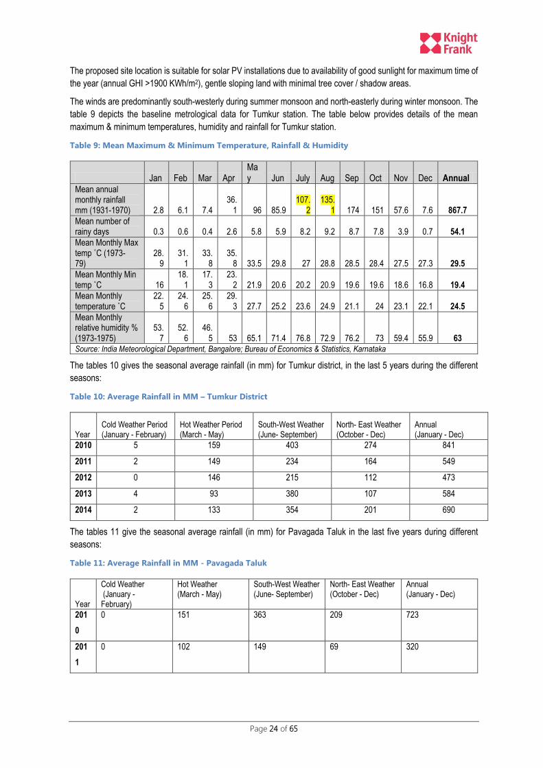
table 9 depicts the baseline metrological data for Tumkur station. The table below provides details of the mean
maximum & minimum temperatures, humidity and rainfall for Tumkur station.
Table 9: Mean Maximum & Minimum Temperature, Rainfall & Humidity
Jan Feb Mar Apr May Jun July Aug Sep Oct Nov Dec Annual
Mean annual monthly rainfall mm (1931-1970) 2.8 6.1 7.4
36.1 96 85.9
107.2
135.1 174 151 57.6 7.6 867.7
Mean number of rainy days 0.3 0.6 0.4 2.6 5.8 5.9 8.2 9.2 8.7 7.8 3.9 0.7 54.1
Mean Monthly Max temp ˚C (1973-79)
28.9
31.1
33.8
35.8 33.5 29.8 27 28.8 28.5 28.4 27.5 27.3 29.5
Mean Monthly Min temp ˚C 16
18.1
17.3
23.2 21.9 20.6 20.2 20.9 19.6 19.6 18.6 16.8 19.4
Mean Monthly temperature ˚C
22.5
24.6
25.6
29.3 27.7 25.2 23.6 24.9 21.1 24 23.1 22.1 24.5
Mean Monthly relative humidity % (1973-1975)
53.7
52.6
46.5 53 65.1 71.4 76.8 72.9 76.2 73 59.4 55.9 63
Source: India Meteorological Department, Bangalore; Bureau of Economics & Statistics, Karnataka
The tables 10 gives the seasonal average rainfall (in mm) for Tumkur district, in the last 5 years during the different
seasons:
Table 10: Average Rainfall in MM – Tumkur District
Year Cold Weather Period (January - February)
Hot Weather Period (March - May)
South-West Weather (June- September)
North- East Weather (October - Dec)
Annual (January - Dec)
2010 5 159 403 274 841
2011 2 149 234 164 549
2012 0 146 215 112 473
2013 4 93 380 107 584
2014 2 133 354 201 690
The tables 11 give the seasonal average rainfall (in mm) for Pavagada Taluk in the last five years during different
seasons:
Table 11: Average Rainfall in MM - Pavagada Taluk
Year
Cold Weather (January - February)
Hot Weather (March - May)
South-West Weather (June- September)
North- East Weather (October - Dec)
Annual (January - Dec)
201
0
0 151 363 209 723
201
1
0 102 149 69 320

Page 25 of 65
Year
Cold Weather (January - February)
Hot Weather (March - May)
South-West Weather (June- September)
North- East Weather (October - Dec)
Annual (January - Dec)
201
2
0 130 219 120 469
201
3
11 43 340 111 505
201
4
0 104 202 173 479
As per the available statistics, Pavagada Taluk received only 320 mm rainfall during year 2011 thereby seriously
affecting the agriculture activities. Year 2006 and 2012 were declared as drought years (approved calamity) in
Pavagada Taluk by the state government due to poor monsoon season.
3. Geology
The predominant geological formations for Tumkur district as a whole include Archean Complex (Granite, Gneisses
and Schists). The rock types met in the area are of the older metamorphic rocks (biotite schists, hornblende granulites,
pyroxenites and amphibolites), peninsular Gneissic complex (branded biotite gneiss, migmatite, and grey biotite
granite), equivalents of Dharwar Super Group (Hornblende schist, Hornblende granulite, chlorite schist and banned
ferruginous quartzite) and younger intrusive (pink granite, gabbro, pegmatite and quartz vein, dolerite
dyke/prophyrite/porphyritic and Anorthosite-dyke and quartz reefs. The older metamorphic rocks (equivalents of Sargur
group) occur as enclaves of varying shapes and sizes within the peninsular gneissic complex. The peninsular gneissic
complex occupy majority of the area constituting the rock type in the plains with sparse outcrops and occasionally
forming isolated tors. The grey biotite granite component constitutes hill ranges in the eastern part bordering the
schistose terrain.
The alluvial patches are generally seen along the major streams as narrow discontinuous patches particularly in granite
country. It comprises medium to coarse grained sand with silt and clay at many places and is largely controlled by
topography of the basement crystalline in the area.
The entire area is a semi-arid condition. The project site is having weathered loamy red soil. Quartzite, granite,
gneisses, dyke and schist rocks are present.
The allowable bearing pressure, T/m2 is 25 T/m2 for depth of 1 meter below ground level as per the field test results
conducted in Thirumani village. The electrical resistivity tests reveal that the project site is a natural ground and contains
loamy red soil, fine to medium grained soil. The resistance is medium up to 2m depth and is recommended to consider
for the solar power project based on the findings of the soil investigations undertaken by Department of Civil
Engineering (Bangalore University) for KSPDCL. The detailed test results are attached in Annexure XI.:
The proposed site falls under Zone-II as per the latest earthquake zoning map. Zone –II is associated with the lowest
level of seismicity.
4. Topography
The proposed site is reasonably flat for majority of the area with slopes less than 10% except for a few parcels within
blocks 7 & 8 locations. Considering large chunks of proposed land under prior agriculture use, the impacts due to
soiling would be significant during the initial years of operations till adequate ground cover could be established to
control dust pollution. No underground service networks are present in the proposed site as per the available secondary
information.
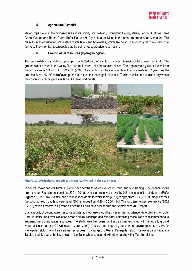
Page 26 of 65
5. Agricultural Potential
Major crops grown in the proposed site and its vicinity include Ragi, Groundnut, Paddy, Maize, Cotton, Sunflower, Red
Gram, Castor, and Horse Gram (Refer Figure 12). Agricultural activities in the area are predominantly rain-fed. The
main sources of irrigation are surface water tanks and bore-wells, which are being used only by very few well to do
farmers. The chemical test reveals that the soil is not aggressive to corrosion.
6. Ground water resources (Hydrogeological)
The area exhibits undulating topography controlled by the granite structures viz residual hills, insel bergs etc. The
ground water occurs in the valley fills, and multi mural joint intersected places. The approximate yield of the wells in
the study area is 800 GPH to 1000 GPH (4000 Litres per hour). The average life of the bore wells is 1-2 years. As the
area receives only 400 mm of average rainfall hence the recharge is also less. The bore wells are sustained only where
the continuous recharge is available like tanks and ponds.
Figure 12: Agricultural practices / crops cultivated in the study area
In general major parts of Tumkur District have depths to water levels 2 to 5 mbgl and 5 to 10 mbgl. The decadal mean
pre-monsoon & post monsoon data (2001 –2010) reveals a rise in water level by 0-2 m in most of the study area (Refer
Figure 13). In Tumkur district the pre-monsoon depth to water table (2011) ranges from 1.17 – 31.70 mbgl whereas
the post-monsoon depth to water level (2011) ranges from 0.26 – 25.84 mbgl. The long term water level trends (2002
– 2011) reveals mostly rising trend as per the CGWB data published in the Septembers 2012 report.
Sustainability of ground water resource and its judicious use should be given prime importance while planning for Solar
Park. In critical and over exploited areas artificial recharge and rainwater harvesting measures are recommended to
augment the ground water resources. The study area has been identified as over exploited with regards to ground
water utilization as per CGWB report (March 2009). The current stage of ground water development is at 74% for
Pavagada Taluk. The unit area annual recharge is in the range of 0.07m in Pavagada Taluk. The low value in Pavagada
Taluk is mainly due to the low rainfall in the Taluk when compared with other taluks within Tumkur district.

Page 27 of 65
Figure 13: Decadal Ground Water Fluctuation Map (2001- 2010)
Ground water in younger granites has more fluoride content than the gneisses. The fluoride content increases with
depth in same aquifer. The shallow aquifers are having comparatively low concentration of fluoride. In order to reduce
or control the problem, it is recommended to recharge ground water by way of artificial recharge structures like
percolation tank, desilting of silted tanks, check dams, nalla bunds, farm ponds etc.
High concentration of nitrates, chloride and fluoride is observed in northern and central parts of Pavagada as per the
CGWB findings. As per the CGWB data, high chloride concentrations are observed in central parts of Pavagada; high
concentrations of fluoride is observed in northern part of Pavagada and high concentration of nitrates in major parts of
Pavagada. Figure 14 depicts the selected villages are impacted by high nitrate contents and over exploitation of ground
water for majority of the areas. In such scenarios the withdrawal of ground water through bore wells to meet the O&M
demand for proposed Solar Park would lead to adverse impacts on the already deteriorating ground water conditions.

Page 28 of 65
Figure 14: Ground Water Status & Contamination for Selected Villages
Ground water is a major source of drinking and irrigation purposes. About 90% of the drinking requirements and 86%
of irrigations requirements are met from ground water.
a) Water Sampling Tests
Water sampling from two surface water bodies and one ground water sample within the proposed project area and its
testing was done an accredited laboratory to establish the baseline scenario. Below is a brief analysis, the test reports
are attached in Annexure -xxxxxxxxx
The analysis of the ground water sample (Refer Figure 15) reveals high concentration of Sodium, Fluoride and alkalinity
parameters.
Water is not potable as Fluoride content in water is above desirable (1.0 mg/l) and permissible (1.5 mg/l) limit.
Alkalinity is found to be above desirable limit of 200 mg/l and below permissible limit of 600 mg/l as per
Drinking water standard IS:10500:2012 and its Amendment No. 1.
pH value observed was 7.8, dissolved oxygen 7.4 mg/l. Water can be used for bathing after treatment so that
BOD level comes down from 5 mg/l to 3 mg/l as per primary water quality criteria for bathing water Table 1 of
The Environment (Protection) Rules, 1986, CPCB June 2010.
As per Schedule VI, General standards for Discharge of Environmental Pollutants, water can be used for
irrigation purposes.
The ground water sample analysis reveals that water is not potable but can be used for irrigation.
Two surface water samples were collected within the study area. The sample collected from water body in vicinity of
Balasamudra village has high fluoride content more than desirable limit but less than permissible limit. Water was found
to be turbid in both the surface water samples. Surface water body samples fall under category D as per classification
of surface water in India by Central Pollution Control Board.

Page 29 of 65
Figure 15: Location of sampling points
7. Surface Water
The study area is dotted with interconnected water bodies which act as a lifeline of the local residents providing water
for various household uses and irrigation purposes. The drainage pattern in the area can be classified as semi dendritic
to dendritic (Refer Figure 16). Overall the area is gently sloping towards north and is well drained. The area is drained
by north flowing Pennar river tributary. The river is not perennial in nature.
Although while demarcation of the proposed blocks, all major surface water bodies have been excluded however
adequate precautionary measures has been built in the EMP to ensure no changes in the drainage occurs due to the
proposed project.
8. Flora and Fauna
As the rainfall is low in Tumkur district, diversity of flora is not much and the species are restricted to Xerophytic type.
The vegetation here is shrubby, thorny and stunted. Accacia (Jali) and Taddy trees are commonly found in alkaline
soils. Ficus species such as Peepal and Banyan are found in forest as well as in the farms. Same is the case with
Tammarind, Neem, Jack, Pongamia trees.
As the area lies in the plains of the Deccan Plateau, bordering Andhra Pradesh, the wildlife found here is related to the
drier areas like monkey, wild cat, wolf, squirrel, bats, fox, deer, rabbit, wild pig, wild lizard, variety of snakes, frogs and
fishes, peacock, sparrow, crow, eagle, etc. The sighting of wild pigs, deer in vicinity of the village settlement area has
also been confirmed during the public consultations with the village residents.
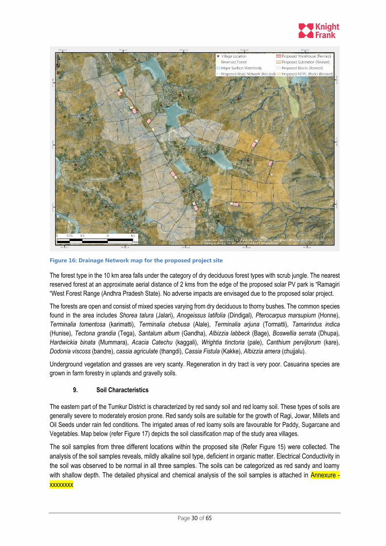
Page 30 of 65
Figure 16: Drainage Network map for the proposed project site
The forest type in the 10 km area falls under the category of dry deciduous forest types with scrub jungle. The nearest
reserved forest at an approximate aerial distance of 2 kms from the edge of the proposed solar PV park is “Ramagiri
“West Forest Range (Andhra Pradesh State). No adverse impacts are envisaged due to the proposed solar project.
The forests are open and consist of mixed species varying from dry deciduous to thorny bushes. The common species
found in the area includes Shorea talura (Jalari), Anogeissus latifolia (Dindigal), Pterocarpus marsupium (Honne),
Terminalia tomentosa (karimatti), Terminalia chebusa (Alale), Terminalia arjuna (Tormatti), Tamarindus indica
(Hunise), Tectona grandia (Tega), Santalum album (Gandha), Albizzia labbeck (Bage), Boswellia serrata (Dhupa),
Hardwickia binata (Mummara), Acacia Catechu (kaggali), Wrightia tinctoria (pale), Canthium pervijlorum (kare),
Dodonia viscoss (bandre), cassia agriculate (thangdi), Cassia Fistula (Kakke), Albizzia amera (chujjalu).
Underground vegetation and grasses are very scanty. Regeneration in dry tract is very poor. Casuarina species are
grown in farm forestry in uplands and gravelly soils.
9. Soil Characteristics
The eastern part of the Tumkur District is characterized by red sandy soil and red loamy soil. These types of soils are
generally severe to moderately erosion prone. Red sandy soils are suitable for the growth of Ragi, Jowar, Millets and
Oil Seeds under rain fed conditions. The irrigated areas of red loamy soils are favourable for Paddy, Sugarcane and
Vegetables. Map below (refer Figure 17) depicts the soil classification map of the study area villages.
The soil samples from three different locations within the proposed site (Refer Figure 15) were collected. The
analysis of the soil samples reveals, mildly alkaline soil type, deficient in organic matter. Electrical Conductivity in
the soil was observed to be normal in all three samples. The soils can be categorized as red sandy and loamy
with shallow depth. The detailed physical and chemical analysis of the soil samples is attached in Annexure -
xxxxxxxx
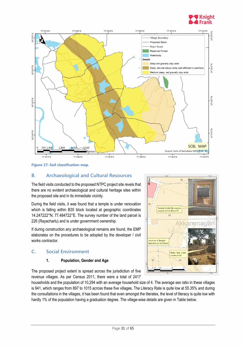
Page 31 of 65
Figure 17: Soil classification map.
B. Archaeological and Cultural Resources
The field visits conducted to the proposed NTPC project site revels that
there are no evident archaeological and cultural heritage sites within
the proposed site and in its immediate vicinity.
During the field visits, it was found that a temple is under renovation
which is falling within B35 block located at geographic coordinates
14.247222°N; 77.484722°E. The survey number of the land parcel is
226 (Rayacharlu) and is under government ownership.
If during construction any archaeological remains are found, the EMP
elaborates on the procedures to be adopted by the developer / civil
works contractor.
C. Social Environment
1. Population, Gender and Age
The proposed project extent is spread across the jurisdiction of five
revenue villages. As per Census 2011, there were a total of 2417
households and the population of 10,294 with an average household size of 4. The average sex ratio in these villages
is 941, which ranges from 897 to 1015 across these five villages. The Literacy Rate is quite low at 55.35% and during
the consultations in the villages, it has been found that even amongst the literates, the level of literacy is quite low with
hardly 1% of the population having a graduation degree. The village-wise details are given in Table below.

Page 32 of 65
Name of Village Number of
Household
Population Average HH
Size
Sex Ratio Literacy Rate
Thirumani 515 2,193 4.26 897 62.79
Balasamudra 165 914 5.54 928 61.49
Vollur 590 2448 4.15 905 53.27
Kyathaganacherlu 611 2380 3.90 1015 50.67
Rayacharlu 536 2359 4.40 953 52.95
Total 2,417 10,294 4.26 941 55.35
Over 40% of the population falls under the marginalised section of the society with nearly 22% falling under the category
of Scheduled Caste and 18% under the category of Scheduled Tribe as shown in Table below.
Name of Village SC Population % of SC ST Population % of ST
Thirumani 402 18.33 358 16.32
Balasamudra 284 31.07 156 17.07
Vollur 663 27.08 289 11.81
Kyathaganacherlu 465 19.54 693 29.12
Rayacharlu 446 18.91 415 17.59
Total 2,260 21.95 1,911 18.56
During the consultations in the project villages, it has been found that though there is nearly 18% and ST population is
very minimal and fall under the category of marginal and small farmers including the landless. These sections are
predominantly dependent on the agriculture labour requirements in the land belonging to large land owners. The ST
population in the project villages are a part and parcel of the dominant society / culture and does not practice any
traditional lifeway’s / systems.
2. Land Ownership Status
The total geographical area of the five villages in the project is about 10,333 Ha. As per the discussions with the local
people, about 20% falls under the non-agricultural use including abadi, water bodies, roads, community facilities and
amenities etc; and the balance area is under agriculture use, with only about 5% of the total area is being irrigated by
tanks / bore well.
The proposed site area of about 4994 Ha, comprising of about 4811 Ha private land and about 183 Ha of government
land has been included in the project as shown in Table below. The land included under the project is nearly 50% of
the total land under these villages that measures about 10,333 Ha. The break-up of land-holdings under the five
categories as per the Karnataka classification of land holding sizes for farmers clearly shows that the land holding of

Page 33 of 65
marginal and small farmers is merely 15%, whereas the number of land owners under these categories account for
nearly 45% as shown in subsequent Table giving the break-up of number of owners under the five categories.
Name of Village Land Holding
Marginal
(Below 1
Ha)
Small (1 to 2
Ha)
Semi-
medium (2
to 4 Ha)
Medium (4
to10 Ha)
Large
(Above 10
Ha)
Private Land
in Ha
Government
Land in Ha
Total Land
in Ha
Thirumani 34.68 90.48 155.76 381.19 539.12 1201.24 139.59 1340.83
Vallur 16.63 55.90 187.97 440.12 106.33 806.94 0 806.94
Balasamudra 68.93 169.02 240.52 211.68 32.51 722.65 14.78 737.43
Rayacharlu 57.17 160.44 392.72 629.58 303.96 1543.87 28.45 1572.32
Kyathaganacherlu 23.51 26.18 42.97 86.64 357.38 536.68 0 536.68
Total 200.93 502.01 1019.93 1749.21 1339.30 4811.39 182.81 4994.20
Percentage 4.18 10.43 21.20 36.36 27.84 100.00
There are approximately 1422 landowners whose land is getting impacted under the proposed 2000 MW solar PV
Park. The actual number of land owners (approximately 629 land owners) whose land is getting impacted by
the NTPC blocks is provided in table below:
Village Name Number of Land owners
Marginal (Below 1 Ha)
Small (1 to 2 Ha)
Semi-Medium (2 to 4 Ha)
Medium (4 to10 Ha)
Large (Above 10 Ha)
Total
Thirumani 90
(49.81 Ha)
87
(125.97 Ha)
85
(221.81 Ha)
81
(487.43 Ha)
48
(718.90 Ha)
391
(1603.94 Ha)
Rayacharlu 71
(38.08 Ha)
63
(92.50 Ha)
49
(139.81 Ha)
50
(329.51 Ha)
5
(70.52 Ha)
238
(670.43 Ha)
Total 161 150 134 131 53 629
Percentage 26% 24% 21% 21% 8% 100%
Land owners from Thirumani and Rayacharlu villages have already given their consent and land lease agreements are
being currently being prepared by KSPDCL.
3. Employment
The Work Force Participation Rate in these villages is 54.32%, with male and female participation rate of 60.56% of
47.70% respectively, as per Census. It is important to highlight here that the main workers are only about 80% of the
total workers, whereas the balance over 20% are marginal workers.

Page 34 of 65
Name of Village Work Force Participation Rate Main Workers as % of Total Workers
Total Male Female Total Male Female
Thirumani 49.66 60.29 37.80 98.99 99.43 98.21
Balasamudra 55.80 56.33 55.23 93.33 95.51 90.95
Vollur 52.08 56.11 47.64 59.45 66.30 50.54
Kyathaganacherlu 56.30 62.32 50.38 79.78 88.86 68.71
Rayacharlu 58.41 65.48 51.00 78.81 83.44 72.57
Total 54.32 60.56 47.70 79.88 85.31 72.56
The distribution of workers given in Table below clearly shows that nearly 86% of the total workers are dependent on
agriculture out of which only about 40% are cultivators whereas the remaining 46% are dependent on agriculture labour
workers:.
Name of Village Cultivators Agriculture Labour HH Industry and Other Services
Thirumani 30.03 51.79 18.18
Balasamudra 73.14 25.10 1.76
Vollur 41.33 49.18 9.49
Kyathaganacherlu 37.54 45.07 17.39
Rayacharlu 38.24 47.68 14.08
Total 40.36 46.14 13.50
During the consultations in these villages, it has been confirmed that a very large percentage of population is working
as agriculture labour on the land belonging to the medium and large farmers with male and the female labour getting
Rs. 200 and Rs. 150 per day respectively. One of the critical issues would be the impact of the project on the agriculture
labour/ landless and especially on the marginalised sections of the society including the SC and ST population.

Page 35 of 65
Figure 18: Informal Public consultations at village level
4. Land Use classification for 10 kms zone
Land cover
Area in Ha.
(GIS Database) %
Agriculture, Crop land 50480.200 62.81%
Agriculture, Plantation 526.696 0.66%
Wastelands, Barren rocky 2320.853 2.89%
Wastelands, Gullied/Ravinous Land 661.007 0.82%
Wastelands, Scrub Land 19096.541 23.76%
Wastelands, Salt Affected Land 291.051 0.36%
Mining area 51.791 0.06%
Built-up, Rural 904.950 1.13%
Forest 2129.462 2.65%
Surface Water Bodies 3905.835 4.86%
80371.831 100.00%
The land use / land cover (year 2011-12) classification for the 10 kms buffer (Refer Figure 19) revels that majority of
the area falls under agricultural land and a quarter of total land is classified as waste lands. Designated forest areas
constitute just 2.6% of the total area followed by surface water bodies constituting another 5% of the total area.
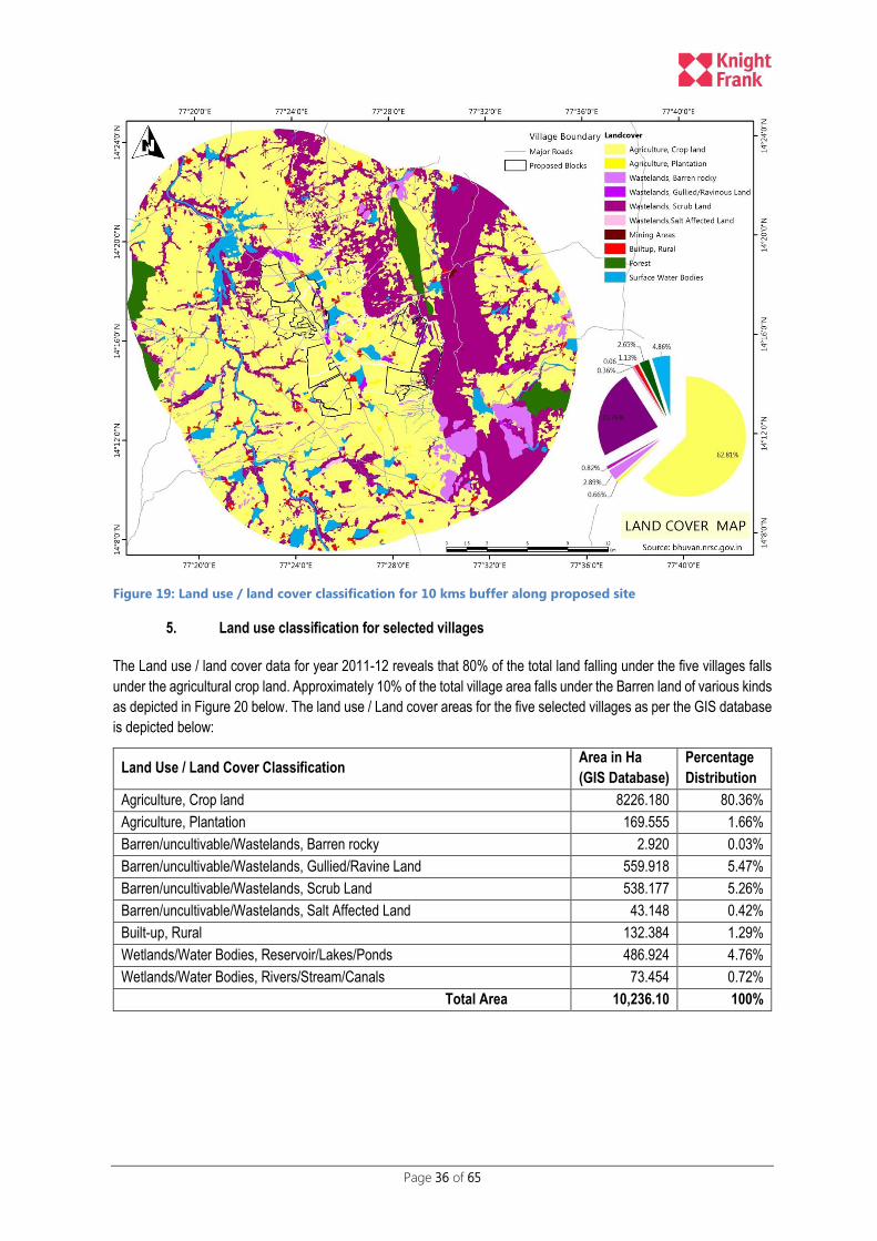
Page 36 of 65
Figure 19: Land use / land cover classification for 10 kms buffer along proposed site
5. Land use classification for selected villages
The Land use / land cover data for year 2011-12 reveals that 80% of the total land falling under the five villages falls
under the agricultural crop land. Approximately 10% of the total village area falls under the Barren land of various kinds
as depicted in Figure 20 below. The land use / Land cover areas for the five selected villages as per the GIS database
is depicted below:
Land Use / Land Cover Classification Area in Ha
(GIS Database)
Percentage
Distribution
Agriculture, Crop land 8226.180 80.36%
Agriculture, Plantation 169.555 1.66%
Barren/uncultivable/Wastelands, Barren rocky 2.920 0.03%
Barren/uncultivable/Wastelands, Gullied/Ravine Land 559.918 5.47%
Barren/uncultivable/Wastelands, Scrub Land 538.177 5.26%
Barren/uncultivable/Wastelands, Salt Affected Land 43.148 0.42%
Built-up, Rural 132.384 1.29%
Wetlands/Water Bodies, Reservoir/Lakes/Ponds 486.924 4.76%
Wetlands/Water Bodies, Rivers/Stream/Canals 73.454 0.72%
Total Area 10,236.10 100%
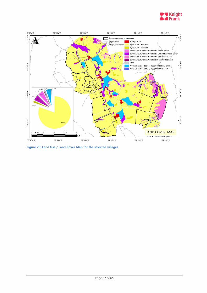
Page 37 of 65
Figure 20: Land Use / Land Cover Map for the selected villages

Page 38 of 65
VII. POTENTIAL ENVIRONMENTAL IMPACTS
The impacts due to the proposed project can be classified as pre-construction stage impacts, during construction stage
and post construction i.e. operation stage impacts. The proposed project is expected to have a life span of 25 -28
years, post which either the operations continue with upgrades/ repairs else rehabilitation of the site would be required
to regain its old status.
The following sub section is structured according to the main issues and effects resulting from the proposed project
activities across the following project phases:
1. Construction Phase Impacts: this shall involve all activities related to planning and actual civil works on site
prior to the commissioning of the plant operations
2. Operations Phase Impacts: this shall involve the commissioning stage and the power generation stage
3. Retrofit or Decommissioning phase Impacts: Post the completion of 28 year land lease tenure,
determination as to whether the project would be retrofitted to operation for next 25-30 years tenure. If
retrofitting doesn’t turn out to be feasible, then decommissioning activities would need to be undertaken
including safe disposal / recycling of defunct PV panels. The anticipated impacts during the decommissioning
stage are similar to construction stage impacts.
A. Construction Phase Impacts
The impacts during the constructions stage of the project would be inherently temporary in nature but may have long
lasting impacts e.g. pollution of water bodies that may last long after construction is over. Construction stage impacts
would potentially include:
i. Impacts on surface and ground water sources
ii. Disturbance of flora and fauna during to clearing and grubbing operations
iii. Increase in traffic volume in the vicinity of the construction site
iv. Windblown dust / exhaust emissions
v. Increased Noise pollution due to movement of heavy machinery on-site
vi. Litter / waste pollution and disposal
vii. Increased inflow of people / man power
A comprehensive EMP has been prepared and presented in subsequent chapter to regulate, mitigate and minimize
the impacts during the construction / operation / decommissioning phase.
1. Water Resource Impacts – Surface Water
The infrastructure facilities (substation, transmission lines, warehouse etc) of the proposed solar PV along with the
proposed solar PV block layout would have an impact on the surface water bodies.
Although the proposed block layout has excluded all large water bodies, however certain non-perennial drainage
channels feeding these surface water bodies could be altered during to clearing and grubbing operations. The
topographic alterations particularly in NTPC blocks B31, B34, B37 and B38 (refer Figure 21) could lead to adverse
impacts on the surface runoff. Similarly the proposed road connecting proposed blocks B31 to B40 is cutting across
non-perennial drainage channels. KSPDCL shall ensure that the adequate number, type and location of needed
culverts are constructed so as to ensure that the surface runoff to the water bodies is not adversely impacted.
The water requirements during the construction stage shall be mainly for civil works and temporary labour camp sites
being setup. The DPR states that the water requirements for construction stage shall be fulfilled from the nearby surface
water bodies after taking due approvals from the village panchayat.
The reduction / alteration of surface water runoff are considered as a significant adverse impact from the proposed
project and permanent in nature.

Page 39 of 65
Figure 21: Map highlighting impacted drainage due to proposed block layout
2. Water Resource Impacts – Ground Water
As described in the baseline, the study area has been identified as over exploited with regards to ground water
utilization as per CGWB report (March 2009). The current stage of ground water development is at 74% for Pavagada
Taluk. The unit area annual recharge is in the range of 0.07m in Pavagada Taluk. The low value in Pavagada Taluk is
mainly due to the low rainfall in the Taluk when compared with other taluks within Tumkur district.
Considering the current stressed ground resources and deteriorating water quality, any further dependence on the
ground water resources would have adverse impacts. Requisite permissions need to be obtained before withdrawing
ground water from bore well s/ tube wells. Additionally KSPDCL should work with the local villagers to enhance the
existing ground water sources and assist in building artificial ground water recharge structures.
The extraction of ground water is considered as a significant adverse impact from the proposed project and permanent
in nature.
3. Vegetation Clearing and grubbing Operations
All of the above components of the proposed development will require the clearing of vegetation to a certain extent.
Only taller vegetation would need to be cleared for installation of PV panels in the proposed block layout. Vegetation
removal could result in windblown dust which could constitute an indirect visual impact.
The underground wiring and pipeline would require a trench to be excavated along the PV panel modules resulting in
disturbance and potential erosion of the substrate. The creation of the working right of way for machinery and the
excavation of a trench would result in the clearing of all vegetation.
Surrounding areas and species present in the direct vicinity of the study area could be affected by indirect impacts resulting from construction and operation activities. The proposed site for solar park is a mix of agricultural land / barren

Page 40 of 65
rocky parcels and parcels with minimal tree and bushes. The internal layout of the solar PV panels shall be undertaken by the developer. The developer will ensure that no trees are required to be cut while installation of solar PV panels. If any tree is still required to be cut, adequate approvals from the state forest department need to be undertaken along with compensatory plantation as per the guidelines issued by the state forest department. The developer shall ensure compliance to the EMP provisions to adequately mitigate and reduce the impacts due to earthwork related activities.
The impacts due to vegetation clearing and grubbing operations are expected to be of medium impact significance and
semi-permanent in nature.
4. Lighting
The solar PV parks would be operational during daylight hours; however solar PV park facilities would include exterior
lighting around buildings, parking areas, and other work areas, as well as security and other lighting around and on
support structures (e.g., the sub-station/ warehouse building). The proposed solar PV Park is located in rural settings
where there would be little or no lighting. Visible lighting at night would also discourage the wild animals coming in
close proximity to the solar park facility.
The impacts due to lighting are expected to be low impact significance.
5. Proposed Access Roads and Existing Road Network
The likely potential impacts related to construction of access roads is the physical disturbance of substrate and
vegetation, and the creation of a physical barrier across a drainage feature that could potentially affect the hydrological
and ecological functionality of the surface water feature. It should be ensured that no additional access roads other
than those proposed as per the block layout are created which may disturb the ground cover leading to increased dust
suspension and soil erosion.
The proposed access roads do cut cross several non-perennial drainage channels and would require construction of
adequate number of cross-drainage structures to mitigate the adverse impacts on the surface runoff. A detailed
hydrological modelling study may be required to access the impacts on surface drainage and for identification of the
precise location and number of CD structures.
Traffic is expected to increase to a certain degree due to the nature of activities that will take place such as the transport
of equipment and materials to and from the site through the surrounding road network. Additional traffic load will be
evident at certain times during the day, especially if there are slow moving heavy vehicles transporting material to and
from the site.
Vehicle traffic can cause congestion on road networks around and within the site and thereby leading to potential
accidents. The impacts could be mitigated with prior sharing of information with the local residents / restricting access
to the certain road stretches during the movement of heavy machinery and equipment.
The impacts due to construction of access roads are considered as a significant adverse impact from the proposed
project and permanent in nature.
6. Waste
The construction stage activities will involve movement of materials / goods and machinery. The storage of construction
materials / PV panels / and machinery on-site will also generate waste in terms of damages in transit, spills and
maintenance of machinery including minor on-site repairs.
Improper management of waste (both hazardous and non-hazardous) during construction stage may lead to impacts
on soil, surface water bodies, visual environment in addition to the health and safety of workers. Non-hazardous waste
Page 41 of 65
would include wood, metal scrap, glass packaging materials etc. Hazardous waste would include batteries, metal
drums, chemical containers, waste oil from machinery lubricants etc.
The labour camps to be constructed on-site would also have household category waste being generated which would
require separate disposal practices. Domestic wastewater generated at site will be collected in septic tanks. These
shall be transported to the nearest approved municipal wastewater treatment facility and solid wastes shall be disposed
in a secured area for trash.
The developer shall ensure that the mitigation measures proposed as part of the EMP shall be implemented ensuring
low impacts significance and temporary in nature.
7. Noise
The solar PV park construction activities i.e. earthworks – site clearing / levelling / trench digging; construction of access
roads; construction of buildings of any type; construction camps; water pipeline / water storage reservoir construction
are likely to increase the noise levels in the project site and its vicinity.
The closest community to the project site would be the residents of the village “Achchammanahalli” which is surrounded
on three sides by the proposed NTPC solar PV park blocks. In addition to these staff working on the site would be
prone to increased noise levels. The developer shall ensure compliance to the occupational health and safety measures
proposed under the EMP.
However the impacts due to increase noise levels are significantly low and localized. This can be reduced further if the
public are made aware of the construction time schedules. The developer shall comply with the construction schedule
and timelines as specified in the EMP.
8. Air Quality
The construction stage activities, mainly movement of heavy machinery across dirt / unpaved roads and site clearing
& grubbing activities (excavation works, grading) will lead to increased level of dust.
Exhaust emissions of SOx, NOx, CO, CO2 and PM will be mainly contributed during the construction stage due to
operation of construction machinery and road vehicles. The impacts are temporary in nature and of low significance.
The emissions will be limited to the project area and dispersed rapidly.
The project developer shall be committed to control dust from such operations through the proposed dust emission
control procedures as described in the EMP included in this report.
9. Terrestrial Ecology
The activities anticipated during the construction phase will include earthworks, excavations, grading, site levelling,
asphalting, paving, construction of building (temporary & permanent structures) and the operation of construction
machinery and equipment. However as per the baseline description, the project area does not have any critical habitats
/ nature reserves etc thereby no significant impacts are envisaged.
Construction activities are not anticipated to pose any risks on the terrestrial ecology within or in the vicinity of the
project site. The construction activity would also lead to reduction in spotting of wild pigs / deer in vicinity of the village
settlement /agricultural fields due to increased noise levels. The nearest reserve forest area falling within the state of
Andhra Pradesh is at an aerial distance of 2 kms approximately from the edge of the proposed site and no adverse
impacts are anticipated due to the proposed solar PV Park. There may be temporary disturbance to the local fauna
due to noise, dust and particulate emissions which are likely to be re-established post the construction stage.
The developer shall ensure adequate measures to ensure that no illegal poaching of wild animals is being done by
construction workers. The developer shall ensure compliance to the EMP measures for setting up of the labour camp
sites etc. The impacts are of low significance and temporary in nature.
Page 42 of 65
10. Other Construction Impacts
The labour camps to be set up will need to have adequate provisions for water supply else uncontrolled interaction of
construction workers with the existing surface water bodies could lead to pollution of these water bodies e.g. dumping
of construction waste into these water bodies, washing of the construction machinery/ equipment etc.
The lack of provision of adequate sanitary facilities may lead to direct or indirect faecal pollution of surface water
resources.
Inadequate soil stabilization measures in cleared areas could lead to erosion that could cause the loss of riparian
vegetation and siltation of nearby drainage channels/ surface water bodies.
The developer shall ensure that the mitigation measures proposed as part of the EMP shall be implemented ensuring
low impacts significance and temporary in nature.
11. Social Impacts
The project is likely to bring in positive benefits either from short term job opportunities during construction stage, or
long term job opportunities during operations stage. It is important that local people are targeted for skilled and semi-
skilled tasks wherever feasible.
The implementation of the solar PV power projects will also create off-site infrastructure (hotels, restaurants, canteens,
guest houses, water tankers, vehicles etc) in the vicinity.
Additionally KSPDCL in collaboration with vocational training centres could impart training to local residents on several
relevant topics that will enable the local community to not only find employment opportunities within the solar PV park,
but to other income generation activities.
The proposed solar project would also bring about an up-gradation in the economic status of the local community in
addition to the potential increase in land prices and improvement in welfare conditions in the long run.
B. Operation Phase Impacts
Given the long term nature, operation phase impacts would require adequate mitigation measures to minimize
predicted impacts. In general, solar power generating facilities need to occupy a very large area in comparison to other
types of power generation facilities relative to the level of power output generated. This is an important component of
the visual aspect of solar power plants as they can occupy large parts of a landscape, especially when viewed from an
elevated position.
1. Water Resource Impacts (surface and ground water)
The water requirements during the operation phase would be limited to cleaning operations for PV panels and other
office building requirements including administrative buildings etc. The DPR document suggests bore wells or surface
water sources as alternative for fulfilling water requirements. However the area is over exploited and the water quality
is also not good, alternative measures for water recycling / conservation of rain water facility etc. need to be integrated
into the block layout plan.
The impacts can be medium significance and more permanent in nature.
2. Site Impact Assessment
The impacts on the soil are limited to accidental spillage of lubricants / fuel and other chemicals that may potentially
cause soil contamination. The repair works of underground pipeline / cable network may lead to increased soil erosion
in that localized pocket. The impacts would be of low significance and temporary in nature.
Any unforeseen impacts due to modification of the slope and existing drainage channels may lead to increased runoff
or waterlogging is some sections of the proposed solar park. Such unforeseen impacts could be significant in nature
Page 43 of 65
leading to permanent adverse impacts. The adverse impacts could lead to lesser inflow of water to the adjoining surface
water bodies which act as a lifeline for the local residents.
3. Access Roads
No significant impacts are envisaged from the newly built access roads during the operations phase. KSPDCL and
Developer shall ensure that the road infrastructure including built-up drainage channels are adequately maintained and
kept free of debris and other such obstructions.
4. Waste Generation
The impacts during the operation stage would be limited to waste water generation from maintenance and cleaning
activities in addition to the domestic waste being generated from the workers domestic activities and administrative
building. The impacts are of low significance and temporary in nature.
5. Noise
No significant noise generating activities are anticipated during the operations phase. As a result no impacts are
envisaged.
6. Air Quality
No emissions are expected due to the operation of the Solar PV Park. The solar PV panels do not release any
greenhouse gas emissions or any other toxic pollutants. As a result no impacts are envisaged.
7. Social Impacts
The DPR document estimates requirement of 8-10 technical manpower for each 50MW capacity and more than 25
people for regular cleaning and security. Hence there will be around 400 technical manpower; however around 1000
semi-skilled jobs will be created in the solar park for cleaning applications and post commissioning services.
The developer shall ensure that adequate facilities for workers need to be provided at the site towards accommodation
and health during operations stage.
C. Retro-fitting / Decommissioning Phase
1. Water Resource – Surface and Ground Water
The decommissioning activities which are likely to have adverse impacts are dismantling of the built up structures,
access roads and other infrastructure facilities within the solar park. The impacts would be similar to the construction
stage.
The developer shall ensure that debris and other waste materials are not disposed in the surface water bodies. The
impacts are medium significance in nature and would be semi-permanent in nature.
2. Air Quality
The decommissioning of the solar PV Park is expected to generate dust and exhaust emissions due to the dismantling,
disassembly of the various components of solar PV park facility. The site needs to be restored to its near original state
before being handed over the original land owners.
3. Noise Quality
The decommissioning activities of dismantling the solar power plant and removing the ancillary facilities are associated
with potential increased noise levels.

Page 44 of 65
The developer shall ensure compliance to the occupational health and safety guidelines during this stage. However
the impacts will be within the solar park area and of temporary nature.
4. Site Impacts
The decommissioning activities are likely to have marginal impacts on soil erosion due to demolition activities.
Therefore, proper environmental protection measures should be followed to prevent or control the occurrence of
adverse incidences. The impact is medium significance and permanent in nature.
Parcels of land under permanent structures e.g. roads / buildings / warehouse etc. need to be restored by the developer
to its near original state by re-laying of the topsoil.
5. Waste generation
The decommissioning of the solar PV Park will involve potential generation of hazardous and non-hazardous waste.
The hazardous waste would be generated from the disposal of PV panels since the project developer will opt for
recycling PV panels of the facility.
The impact is medium significance and temporary in nature.
6. Terrestrial Impacts
The temporary phase would not result in any adverse impacts on the flora and fauna within or around the proposed
project site, provided dust suppression measures and other procedures are followed.
The impact is of low significance and temporary in nature.

Page 45 of 65
VIII. ENVIRONMENTAL MANAGEMENT PLAN
KSPDCL is committed to ensuring compliance to the national and state level regulatory requirements and mitigating
potential adverse environmental impacts resulting from the proposed project activities. The proposed EMP aims at
ensuring the implementation of proposed mitigation and monitoring measures along with the responsible agency for
implementation.
Although the EIA process does not reveal any significantly high adverse impacts due to the proposed project, the
following sub-sections provides mitigation measures that further reduce the severity of identified adverse impacts on
land and environment due to the proposed activities.
Stage of Project
Key Potential Impact / Activity
Mitigation Measures Responsibility Performance Indicator Reporting to KSPDCL
Surface & Ground Water Resource
Impact on the natural drainage channel
Impact on surface water bodies
Conflicts with existing users due to scarcity of resource base
Ensuring no encroachments in the surface water bodies to be allowed.
Detailed hydrological software modelling to be conducted to access the number of CD structures.
A detailed assessment of the available resources and consent of the local panchayat for withdrawal of water from existing surface water sources shall be taken
If ground water is withdrawn, adequate approvals from the GWB / SPCB department need to be undertaken before setting up bore wells
The Developer shall ensure that detailed assessment is undertaken for the block/s allotted.
1. Percentage of land parcel wherein clearing & grubbing operations have been undertaken.
2. Layout plan of the roads and other permanent structures
3. Number of Bore wells constructed and withdrawal rates
Weekly basics during the construction stage of project
Site Preparation – Soil Erosion
Construction facilities to be placed 200 meters from water bodies, natural flow paths;
Minimize cut & fill operations.
Any disruption of socially sensitive areas with regard to human habitation and areas of cultural significance will be avoided.
The Developer shall ensure compliance
1. Number of complaints received by KSPDCL / Developer and complaints addressed.
2. Number of Trees cut / damaged due to construction activity.
Weekly basics during the construction stage of project

Page 46 of 65
Stage of Project
Key Potential Impact / Activity
Mitigation Measures Responsibility Performance Indicator Reporting to KSPDCL
The existing slope and natural drainage pattern on the site should not be altered.
Trees on private lands are felled or damaged during construction operations, compensation shall be paid to the owner as determined by the forest/horticulture departments.
The contractor shall ensure that site preparation activities do not lead to disruption of activities of the local residents.
Site Preparation – Dust Generation
Construction machinery shall be properly maintained to minimize exhaust emissions of CO, SPM and Hydrocarbons.
Dust generated as a result of clearing, levelling and site grading operations shall be suppressed using water sprinklers.
The developer shall ensure compliance
1. Measures undertaken to control dust pollution like segregation/covering of dust generating areas
2. Water sprinkling undertaken / frequency
Weekly basics during the construction stage of project
Site Preparation – Noise Pollution
Construction activity shall be restricted to daytime as far as possible to avoid disturbance to surrounding areas.
Wherever required, personal protective equipment such as ear plugs, earmuffs etc. should be provided to the persons working in high noise areas, to minimize their exposure to noise.
The developer shall ensure compliance
1. Provision of PPE for workers
Weekly basics during the construction stage of project
Health & Safety Concerns
Prevent entry of unauthorized personnel and proper control of hazardous materials on site.
The developer shall ensure compliance.
1. Fencing of site parameters
2. Display of routes / information for drivers of heavy machinery
Monthly basics to KSPDCL during the

Page 47 of 65
Stage of Project
Key Potential Impact / Activity
Mitigation Measures Responsibility Performance Indicator Reporting to KSPDCL
The site shall be secured by fencing and manned at entry points.
The movement of heavy machinery and equipment’s shall be restricted to defined routes.
Proper signage’s to be displayed at major junctions
Vehicular movement to be controlled near sensitive locations viz. schools, colleges, hospitals identified along designated vehicular transportation routes
3. Signage’s erected construction phase
Base Camp / Labour Camps Construction
Alternate arrangement for fuel wood, heating and cooking should be made to meet fuel wood requirement of the labour
Work force should be prohibited from disturbing the flora, fauna including hunting of animals. Wildlife hunting, poaching, tree felling.
Adequate facilities ensuring sanitation for labour camps.
Treated Water will be made available at Site for Labour drinking purpose.
Adequate accommodation arrangements for labour
The developer shall ensure compliance.
4. Location of camp site
5. Facilities provided
Monthly basics to KSPDCL during the construction phase
Waste Management
Land and water pollution due to indiscriminate waste disposal
Preparation of a waste management plan covering the following aspects
Construction and commissioning of solar park Temporary accommodation facilities for labour
The developer shall ensure compliance
6. Waste generated on a weekly basics
7. Type of waste – hazardous and non-hazardous
8. Disposal practices adopted by developer
Monthly basics to KSPDCL during the construction phase

Page 48 of 65
Stage of Project
Key Potential Impact / Activity
Mitigation Measures Responsibility Performance Indicator Reporting to KSPDCL
Waste generation from equipment maintenance / vehicles on-site.
The scrap material generated from erection of structures and related construction activities will be collected and stored separately in a stack yard and sold to local recyclers.
Hazardous waste viz. waste oil etc will be collected and stored in paved and bounded area and subsequently sold to authorized recyclers.
Page 49 of 65
IX. INSITUTITIONAL ARRANGEMENTS FOR
IMPLEMENATION FO EMP
The overall responsibility for implemenation of the EMP measures rests with the KSPDCL through the developer. An
“Environmental and Social Specialist” working with KSPDCL and reporting directly to the CEO shall ensure
coordination and implemention of the EMP measures. “Environmental and Social Specialist” shall be overall
responsible for EMP and RAP Implementation, coordinating and liaising with government organization as well as the
World Bank with respect to different social and environmental issues. He will also be responsible for progress
monitoring of Environmental and social safeguards during project construction and execution stage and submission
of annual report on EMP compliance to the funding Agency.
The roles and responsibilities of the Social and Environmental Expert shall be:
I. Participate in and facilitate consultations with stakeholders
II. Participate in project meetings and report on the issues related to environmental management and social
safeguards to provide for any mid-course corrections that may be required based on situation on the ground
III. Assist PAPs to resolve their grievances
IV. Coordinate on the training and capacity building initiatives
V. Review contract documents to ensure that EMP provisions related to works are included in the contract
documents
VI. Act as a resource person in trainings based on experience on implementing this project and previous relevant
work
VII. Oversee and report to CEO on implementation of EMP provisions included in the works contract for each
sub-project in the state
VIII. Prepare TOR for any studies required and qualitative dimensions to the implementation of RAP;
IX. Liaison with state administration for land acquisition and implementation of RAP
X. Report progress, highlighting social issues not addressed, to provide for mid-course correction.
XI. Develop rapport with PAFs and between PAFs and project
XII. Assist PAFs in approaching the grievance redressal mechanism
XIII. Carry out other responsibilities as required from time to time

Page 50 of 65
X. ANNEXURES – SOIL BEARING CAPACITY CALCULATION
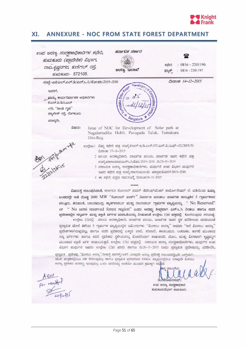
Page 51 of 65
XI. ANNEXURE - NOC FROM STATE FOREST DEPARTMENT
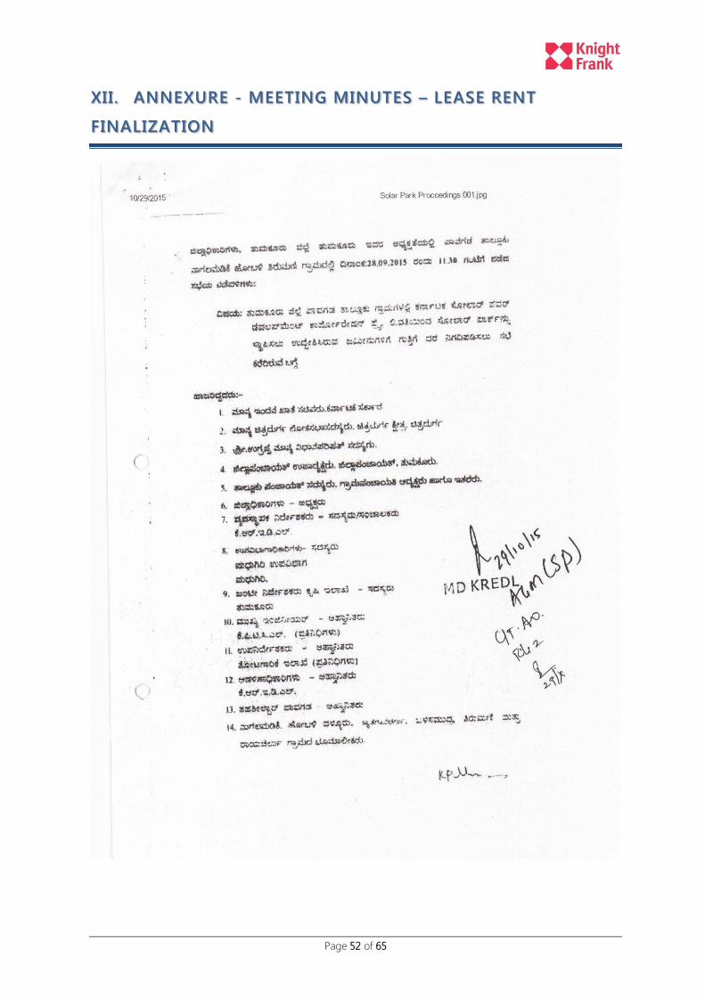
Page 52 of 65
XII. ANNEXURE - MEETING MINUTES – LEASE RENT
FINALIZATION

Page 53 of 65
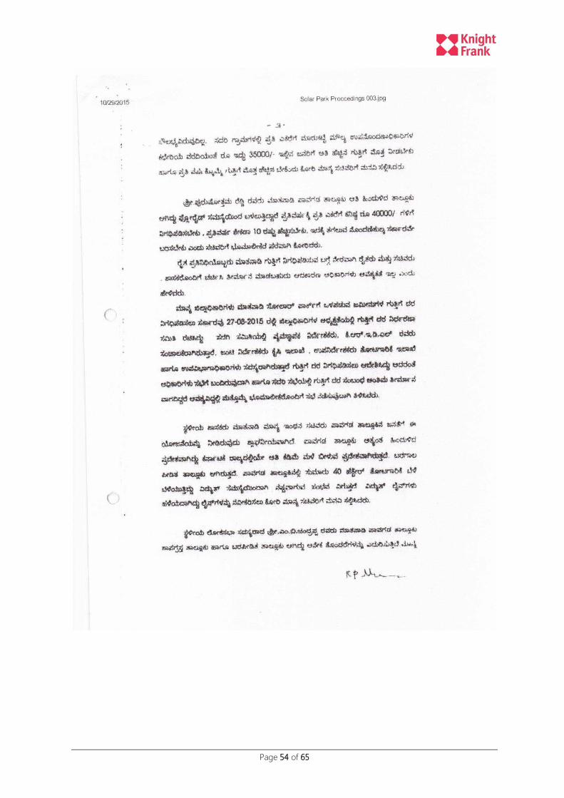
Page 54 of 65
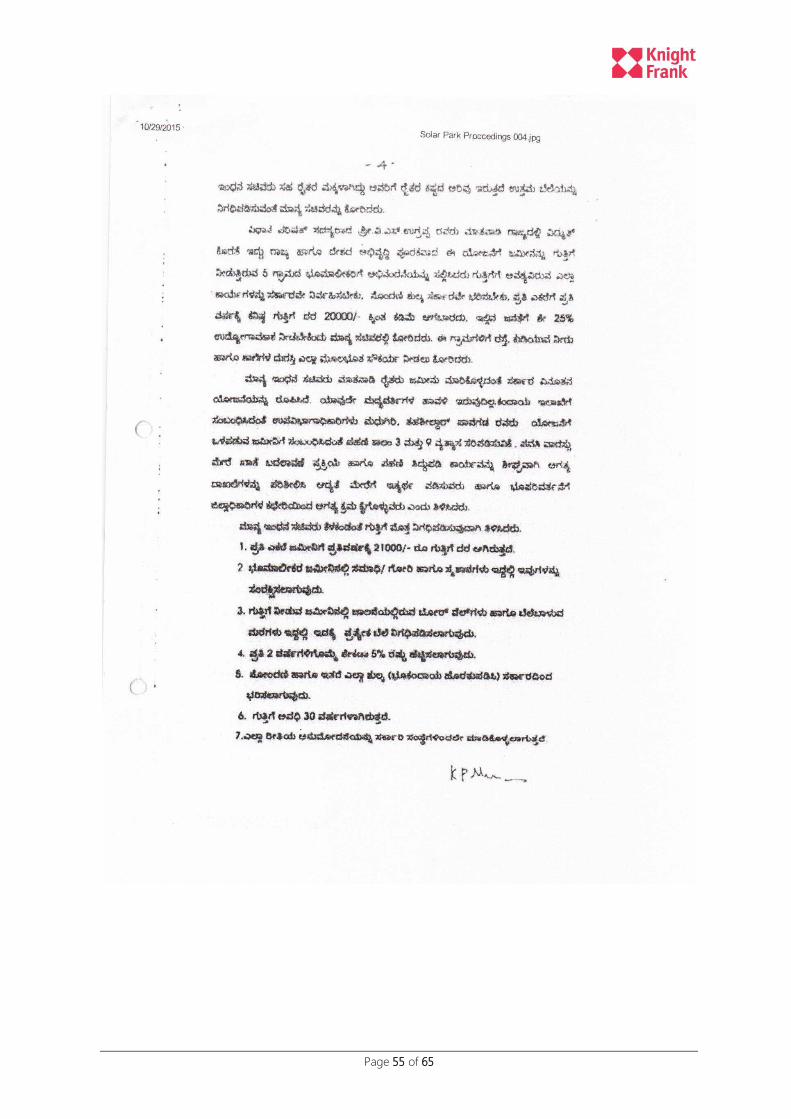
Page 55 of 65

Page 56 of 65

Page 57 of 65