Environmental Impact Assessment Screening Report · This EIA screening report contains necessary...
84
Environmental Impact Assessment Screening Report Proposed Greenway (Cycleway/Walkway) along the Former Kilbeggan Branch of the Grand Canal linking Kilbeggan Harbour in Co. Westmeath with Campbells Bridge, Ballycommon, Co. Offaly Minogue and Associates May 2019
Transcript of Environmental Impact Assessment Screening Report · This EIA screening report contains necessary...

Environmental Impact Assessment
Screening Report Proposed Greenway (Cycleway/Walkway) along the
Former Kilbeggan Branch of the Grand Canal linking Kilbeggan Harbour in Co. Westmeath with
Campbells Bridge, Ballycommon, Co. Offaly
Minogue and AssociatesMay 2019

0
Contents 1 Introduction ...................................................................................................................... 3
1.1 Project Background ............................................................................................... 3
1.2 Legislative Background .............................................................................................. 3
1.3 Screening .................................................................................................................... 5
1.3.1 Changes to the EIA Screening process. .............................................................................................. 6
1.3.2 Annex IIA: Information to be provided by the developer on the projects listed in Annex II. ........ 6
1.3.3 Article 4(5) Determination of Screening ............................................................................................ 6
1.4 Approach to this EIS Screening ................................................................................. 7
1.5 Statement of Authority ............................................................................................... 7
2 Description of the Proposed Development ...................................................................... 8
2.1. Description of Proposed development ..................................................................... 8
2.1.2 Features of the proposed development .............................................................................................. 8
2.1.3 Habitat loss to the footprint of the development .............................................................................. 9
2.2 Methodology for Greenway Construction ............................................................... 13
2.2.1 General Methodology:....................................................................................................................... 13
2.2.2 Equipment ......................................................................................................................................... 13
2.2.3 Surface Water Management ............................................................................................................. 13
2.2.4 Noise and Vibration .......................................................................................................................... 13
2.2.5 Construction sequence ..................................................................................................................... 14
2.2.6 Ecologically Sensitive Areas. ............................................................................................................ 14
2.2.7 Surface Types .................................................................................................................................... 14
2.2.8 Construction Methodology for Surface Types................................................................................. 14
2.3 Best Practice Construction Approach ..................................................................... 16
2.4 Pre-Construction ..................................................................................................... 16
2.5 Earthworks ................................................................................................................ 17
2.6 Fuel Use and Storage ................................................................................................ 17
2.7 Measures to Protect Water Quality & Surface Water Bodies .................................. 18

1
2.8 Non-Native Invasive Species ................................................................................... 19
2.9 Mitigation Measures ................................................................................................ 19
2.9.1 Mitigation by avoidance .................................................................................................................... 19
2.9.1.1 Habitats .......................................................................................................................................... 20
2.9.1.2 Fauna ............................................................................................................................................. 20
2.9.1.3 Birds ............................................................................................................................................... 20
2.10 Enhancement ......................................................................................................... 20
2.11 Ecological Clerk of Works ...................................................................................... 21
2.12 Monitoring ............................................................................................................. 21
3 Receiving Environment .................................................................................................. 22
3.1 Introduction ............................................................................................................. 22
3.1.1 Overview ............................................................................................................................................. 22
3.2 Human Beings ......................................................................................................... 23
3.3 Flora and Fauna ....................................................................................................... 26
3.3.1 Screening for Appropriate Assessment ............................................................................................ 26
3.3.2 Ecological Surveys ............................................................................................................................ 26
3.3.3 Summary of Habitats Present .......................................................................................................... 26
3.3.4 Rare and Protected Flora including orchids ................................................................................... 31
3.3.5 Ecologically Sensitive Areas (ESAs) ................................................................................................. 31
3.3.6 Invasive Species ................................................................................................................................ 32
3.4 Geology and Soil ...................................................................................................... 41
3.5 Water ........................................................................................................................ 45
3.5.1 Surface water ..................................................................................................................................... 45
3.5.2 Groundwater ..................................................................................................................................... 45
3.5.3 Flooding ............................................................................................................................................. 46
3.6 Air and Climatic Factors .......................................................................................... 50
3.7 Landscape ................................................................................................................ 50
3.8 Cultural Heritage ..................................................................................................... 52
3.9 Material Assets ........................................................................................................ 55

2
3.10 Inter-relationship between parameters ................................................................ 55
4 EIA Screening ................................................................................................................. 57
4.1 Environmental Factors to be considered in the EIA Screening. ............................. 57
4.2 Impact Assessment .................................................................................................. 57
Table 9.1 Characteristics of the Proposed Development ......................................................................... 58
Table 9.2 Location of the Proposed Development ................................................................................... 63
Table 9.3- Characteristics of Potential Impacts on environmental parameters ..................................... 66
Table 9.4 Characteristics of the potential impacts ................................................................................... 67
5 Conclusion ...................................................................................................................... 70
5.1 Screening Determination ..................................................................................................................... 70
Annex 1: Habitat Maps from 2013 Habitat Survey of Kilbeggan Branch (Atkins, 2013). 72
This report has been prepared by Minogue and
Associates with all reasonable skill, care and
diligence. Information reported herein is based on
the interpretation of data collected and has been
accepted in good faith as being accurate and valid.
This report is prepared jointly for Offaly County
Council and Westmeath County Council and we
accept no responsibility to third parties to whom
this report, or any part thereof, is made known. Any
such party relies on the report at their own risk.

3
1 Introduction
1.1 Project Background Offaly County Council and Westmeath County Council have jointly appointed Minogue and Associates to
prepare an Environmental Impact Assessment (EIA) screening report for the proposed Ballycommon
Bridge to Kilbeggan Harbour Greenway, hereafter referred to as the proposed development. The
proposed development relates to the provision of a Greenway Walking and Cycling route which deviates
between the western and eastern towpaths of the Kilbeggan Branch of the Grand Canal, from
Ballycommon Bridge in County Offaly, northwards to Kilbeggan Harbour, Co. Westmeath.
For the purposes of this Part 8 consent process, the proposed project relates to the development of a
greenway along the former Kilbeggan Branch Canal for a distance of c.13.5km in total.
This EIA screening report contains necessary information to enable the competent authority, in this case
Offaly and Westmeath County Councils, to undertake an EIA screening assessment and determine
whether an EIA is required to support the proposed development. The findings of the EIA screening
assessment are presented in this report and will inform the determination by each local authority in
advance of the Part 8 planning consent process.
1.2 Legislative Background EIA requirements derive from EU Directive 85/337/EEC (as amended by Directive 97/11/EC, Directive
2014/52/EU and S.I. 454 of 2011; S.I. 464 of 2011; S.I. 456 of 2011 and S.I. No 296 of 2018).)
http://www.irishstatutebook.ie/eli/2018/si/296/made/en/pdf on the assessment of the effects of certain
public and private projects on the environment. The purpose of this Environmental Impact Assessment
Screening Report is to determine whether this proposed development will require full Environmental
Impact Assessment.
The Directive outlines in Article 4 (1) 21 Annex 1 projects that require mandatory EIA. Article 4 (2) outlines
Annex 2 projects that require consideration for EIA further to a case by case examination or through
thresholds and criteria established by Member States. Projects requiring mandatory EIA are listed in
Schedule 5 of the Planning and Development Regulations 2001, as amended. Where developments are
under the relevant EIA threshold, planning authorities are required under Article 103 of the 2001
Regulations, as amended, to request an EIS where it considers the proposed development is likely to have
a significant effect on the environment. In these cases the significant effects of the project are assessed
relative to the criteria contained in Schedule 7a of the regulations, principally:
• The projects characteristics
• Sensitivity of the project location, and
• Characterisation of potential impacts. In addition, where the development would be located on or in an area, site etc. set out in Article 103(2),
the planning authority shall decide whether the development would or would not be likely to have
significant effects on the environment for such site, area or land etc. the implication being that if it decides

4
that it would be likely to have significant effects on the environment, it can invoke its powers to request
an EIS.
Article 103(2) sites comprise the following:
a) A European Site; b) An area the subject of a notice under section 16(2) (b) of the Wildlife (Amendment) Act, 2000; c) An areas designated as a Natural Heritage Area under section 18 of the Wildlife (Amendment) Act, 2000; d) Land established or recognised as a nature reserve within the meaning of section 15 or 16 of the Wildlife Act, 1976, as amended by sections 26 and 27 of the Wildlife (Amendment) Act, 2000; or e) Land designated as a refuge for flora or as a refuge for fauna under section 17 of the Wildlife Act, 1976,
as amended by section 28 of the Wildlife (Amendment) Act, 2000.
The proposed Greenway is located along the Kilbeggan Branch of the Grand Canal which is designated as a proposed Natural Heritage Area (site code: 002104). The Grand Canal comprises the canal channel, the canal banks and towpaths on either side of it. The Ballyduff Esker pNHA (site code: 001755), also called Murphy’s Bridge esker intersects with the Kilbeggan canal. The proposed development also falls under the EIA requirements of the Roads Act 1993 as amended by the Planning and Development Acts (2000-2011) and the Roads Act (2007) as well as regulations made under the Roads Acts, The European Communities (Environmental Impact Assessment) (Amendment) Regulations 1989-2001, and EC Directives 85/337/EC and 97/11/EC referenced above. A road within the 1993 act is defined to include: (a) any street, lane, footpath, square, court, alley or passage, (b) any bridge, viaduct, underpass, subway, tunnel, overpass, overbridge flyover, carriageway whether single or multiple, pavement or footway, (c) any weighbridge or other facility for the weighting or inspection of vehicles, toll plaza or other facility for the collection of tolls, services area, emergency, telephone, first aid post, culvert, arch, gulley, railing, fence, wall, barrier, guardrail, margin, kerb, lay-by, hard shoulder, island, pedestrian refuge, median, central reserve. Furthermore Cycleway is referred to in Section 68 of the 1993 Act as follows: (1) In this section “cycleway” means a public road or proposed pubic road reserved for the exclusive use of pedal cyclists or pedal cyclists and pedestrians. (2) (a) A road authority may construct (or otherwise provide) and maintain a cycleway. (b) Where a road authority constructs or otherwise provides a cycleway it shall by order declare either – (i) the cycleway is for the exclusive use of pedal cyclists, or (ii) that the cycleway is for the exclusive use of pedal cyclists and pedestrians. (c) any person who uses a cycleway in contravention of an order under paragraph (b) shall be guilty of an offence.

5
1.3 Screening According to European Commission Guidance (20171)
“Screening has to implement the Directive’s overall aim, i.e. to determine if a Project listed in Annex II is likely to have significant effects on the environment and, therefore, be made subject to a requirement for Development Consent and an assessment, with regards to its effects on the environment. At the same time, Screening should ensure that an EIA is carried out only for those Projects for which it is thought that a significant impact on the environment is possible, thereby ensuring a more efficient use of both public and private resources. Hence, Screening has to strike the right balance between the above two objectives.”
As previously stated, this may be considered a sub-threshold EIA development, as EIA is not mandatory for walking and cycling routes such as this Greenway. The key issue for the competent/consent authority in the context of the possible need for EIA of sub-threshold is whether or not such development is likely to have significant effects on the environment. Consideration of significant effect should not be determined by reference to size only. The nature and location of a project must also be taken into account. This EIA Screening Report is therefore being undertaken to determine in light of the criteria listed in Schedule 7a of the Planning and Development Regulations whether or not this proposed development will require full EIA.
According to the Guidelines for Planning Authorities and An Bord Pleanála on carrying out Environmental
Impact Assessment (2018):
“For all sub-threshold developments listed in Schedule 5 Part 2, where no EIAR is submitted or EIA
determination requested, a screening determination is required to be undertaken by the
competent authority unless, on preliminary examination it can be concluded that there is no real
likelihood of significant effects on the environment. This is initiated by the competent authority
following the receipt of a planning application or appeal
A preliminary examination is undertaken, based on professional expertise and experience, and
having regard to the ‘Source – Pathway – Target’ model, where appropriate. The examination
should have regard to the criteria set out in Schedule 7 to the 2001 Regulations.
Where, based on a preliminary examination of the information submitted with the application and
any other supplementary information received, the competent authority concludes that, having
considered the nature, size and location of the proposed development, there is no real likelihood
of significant effects on the environment, this should be recorded with reasons for this conclusion
stated, and no EIA required or formal determination made. The recording of the competent
authority’s view should be brief and concise, but adequate to inform the public. In many cases this
considered view will be included in the planner’s/inspector’s report on the planning application
1 Environmental Impact Assessment of Projects Guidance on Screening (Directive 2011/92/EU as amended by 2014/52/EU). European Commission 2017. Page 23.

6
and this may be cross-referenced in the competent authority’s decision. Normally, this will be
published at the time of the decision of the competent authority.”
1.3.1 Changes to the EIA Screening process.
The EIA Directive (2014/52/EU) has brought a number of changes to the EIA process with a strengthening of the Screening process as follows:
• Article 4 (4) of this Directive introduces a new Annex IIA to be used in the case of a request for a
screening determination for Annex II projects. This is information to be provided by the developer
on the projects listed in Annex II (see below):
1.3.2 Annex IIA: Information to be provided by the developer on the projects listed in
Annex II.
1. A description of the project, including in particular:
(a) a description of the physical characteristics of the whole project and, where relevant, of demolition
works (Section 2 of this report);
(b) a description of the location of the project, with particular regard to the environmental sensitivity of
geographical areas likely to be affected (Section 3 of this report)
2. A description of the aspects of the environment likely to be significantly affected by the project
(Section 3 of this report)
3. A description of any likely significant effects, to the extent of the information available on such
effects, of the project on the environment resulting from:
(a) the expected residues and emissions and the production of waste, where relevant (Section 4 of this
report) ;
(b) the use of natural resources, in particular soil, land, water and biodiversity (Section 4 of this report).
4. The criteria of Annex III shall be taken into account, where relevant, when compiling the information
in accordance with points 1 to 3 (Section 4 of this report).
Article 4(4) specifies that the developer may provide a description of any features of the project and/or
mitigation measures to avoid or prevent what might otherwise have been significant effects on the
environment. It should be noted that this does NOT include compensation measures (Mitigation
measures are provided in Section 2.2.).
1.3.3 Article 4(5) Determination of Screening
The competent authority shall make its determination, on the basis of information provided by the
developer in accordance with paragraph 4 taking into account, where relevant, the results of preliminary
verifications or assessments of the effects on the environment carried out pursuant to Union legislation
other than this Directive.
The determination shall be made available to the public and:
(a) where it is decided that an environmental impact assessment is required, state the main reasons for
requiring such assessment with reference to the relevant criteria listed in Annex III; or

7
(b) where it is decided that an environmental impact assessment is not required, state the main reasons
for not requiring such assessment with reference to the relevant criteria listed in Annex III, and, where
proposed by the developer, state any features of the project and/or measures envisaged to avoid or
prevent what might otherwise have been significant adverse effects on the environment.
The EIA Screening prepared here will inform the competent authority, in this instance Westmeath and
Offaly County Councils on the EIA Screening Determination please see Section 5 of this Report for the EIA
Screening Determination as proposed.
1.4 Approach to this EIS Screening This EIS Screening report has been prepared and informed by the following guidance and guidelines:
• Guidelines for Planning Authorities and An Bord Pleanála on carrying out Environmental Impact
Assessment, Department of Housing, Planning and Local Government, 2018;
• Environmental Impact Assessment of Projects Guidance on Screening (Directive 2011/92/EU as
amended by 2014/52/EU), European Commission, 2017.
• Environmental Impact Assessment (EIA) Guidance for Consent Authorities regarding Sub-
threshold Development, Department of Environment, Heritage and Local Government, 2003;
• Guidance on the Information to be contained in Environmental Impact Statements Environmental
Protection Agency 2002, and
• Environmental Impact Assessment (Agriculture) Regulations 2011 Guide for Farmers, Department of Agriculture, Food and the Marine,2011)
A desktop study of environmental receptors within the project area was undertaken in addition to a site
walkover by the project ecologist Pat Doherty MSc, MCIEEM in July and August 2018. A review was also
undertaken of relevant projects within the project area. The screening for Appropriate Assessment that
was prepared as part of the current application has informed this EIA Screening report.
1.5 Statement of Authority This report has been prepared by Ruth Minogue, MCIEEM. Ruth has been a practicing environmental
consultant for 20 years and has specialised in the preparation of Environmental Impact Assessment and
Strategic Environmental Assessment. Additional inputs were provided by Pat Doherty, MCIEEM, an
ecologist with 17 years practical experience and Dr. Ronan Hennessey, who provided the Geographical
Information Systems analysis and mapping outputs.
8
2 Description of the Proposed Development
2.1. Description of Proposed development The proposed project relates to the development of a greenway along the former Kilbeggan Branch Canal
of the Grand Canal for a distance of c.13.5 kilometres connecting Ballycommon Bridge in Co. Offaly with
Kilbeggan Harbour, Co. Westmeath. This part of The Grand Canal (Kilbeggan Branch), which was
constructed between 1830-36 was officially closed in 1961, but has been out of use since the end of the
nineteenth century due to the development of road and rail transportation networks. It continues to
provide an attractive environmental amenity route along an established dried out canal.
The landscape associated with this greenway is varied, encompassing boglands, esker, woodlands and
grasslands along this route. The proposed greenway encompasses predominantly lowlying, flat land and
in this regard, its gradient is conducive to all users (including the cyclist, walker, person in a wheelchair
and person pushing a buggy) without compromising on the scenic qualities of this route. The design of
this project incorporates surfacing which will be finished to a high specification in accordance with
required standards, so as to market and attract both the domestic and international tourist to this
greenway, as well as accommodating the local communities within its vicinity for recreational purposes.
2.1.2 Features of the proposed development
The proposed Kilbeggan-Ballycommon Greenway will include the following features:
c.13.5 km of shared walking and cycling Greenway along the existing towpath.
• Path widths will vary along the greenway from 1.5m to 3m at its widest. Widths will be
dictated by existing on-site features.
• Improvements to the existing towpath along the former canal through the provision of
suitable surfacing including 804 sub-base and Quarry Dust which will be the primary
surface; surface dressing/Asphalt Tarmac (to be utilised where deemed necessary and
appropriate for vehicular access (serving necessary agricultural use/ Waterways Ireland
operations only) and other material finishes will be incorporated into the scheme where
appropriate.
• Provision of access controls such as pedestrian and cycle friendly gates along the route.
• The provision of a temporary construction compound to be situated at the works yard in
Kilbeggan and close to Ballycommon Bridge. All associated ancillary works and integrated
landscape plans for the reinstatement of temporary construction footprint.
The detailed approach to the works to the Greenway is presented in the following section but primarily
comprise the following:
• Upgrading of former towpath (deviating between eastern and western side of proposed
greenway in accordance with design of route proposed) with varying surfaces proposed
having regard to sensitivities and constraints (visual, environmental, physical) of the
greenway.
• Traffic safety measures to facilitate safe pedestrian and cycling crossings.

9
• Fencing/gates to facilitate safety and permit access to agricultural lands, where required.
• There is no lighting proposed as part of this application.
• Tree removal is not proposed other than pruning of overhanging branches or limited
removal where necessary to meet minimum greenway width.
2.1.3 Habitat loss to the footprint of the development
A worst-case scenario calculation was made to estimate habitats to be lost to the footprint of the
development. The methodology employed utilised the shapefiles provided by Waterways Ireland from
the 2013 Ecology Survey, overlaid with the drawings provided by the two local authorities. The
calculations below assume a total footprint of 3m for the whole Greenway by calculating habitat loss of
1.5 m from the centre of the existing towpath. It is to be noted however that the footpath will reduce to
1.5m/2m at key areas, where due to a number of considerations (including ecological considerations,
physical constraints and/or visual sensitivities in ensuring the assimilation of the greenway into its
surroundings), a narrower footprint is required. In addition, replacement and enhancement measures are
provided in Section 2.10 to compensate for loss of important habitats and recreate in particular conditions
that will encourage reestablishment and growth of calcareous grasslands over time.
Table 1 Total Habitats (m2) along the Greenway
Fossit Code
Name Total area_m2
BC1 Arable Crops 17,621.25
BL3 Buildings and Artificial Surfaces 42,708.01
ED1 Exposed Sand, Gravel or Till 2,369.18
ED2 / ED3
Spoil and Bare Ground / Recolonising Bare Ground /Dry Meadows and Grassy Verges
2,658.77
ED3 / GA2
Recolonising Bare Ground Improved Agricultural Grassland/ Dry Meadows and Grassy Verges
9,736.60
FS1 Reed and Large Sedge Swamp 32,099.19
FS2 Tall-Herb Swamps 868.31
FW3 Canals 956.18
GA1 Improved Agricultural Grassland 74,638.59
GA2 / GS2
Amenity Grassland (Improved) / Dry Meadows and Grassy Verges 18,701.40
GA2 / GS2
Dry Meadows and Grassy Verges 31,937.34

10
GM1 Marsh 1,020.08
GS1 / GS2
Dry Calcareous and Neutral Grassland / Dry Meadows and Grassy Verges 47,101.41
GS2 Dry Meadows and Grassy Verges 77,894.88
GS2 / WS1
Dry Meadows and Grassy Verges / Scrub 4,082.93
GS4 Wet Grassland 11,191.41
PB1 / GS1
Raised Bog / Dry Calcalerous Neutral Grassland 4,937.77
Table 2 Calculated Habitat Loss from Greenway (Worst Case Scenario based on 3m towpath for full route)
Table 2 below shows the calculated habitat loss of habitats in a worst-case scenario (ie: 3m wide ) towpath.
This table shows the identified habitats outside of any Ecologically Sensitive Areas, which are shown in
the subsequent Table 3. As can be seen, the habitat which presents as the largest loss in m2 is Dry
meadows and Grassy verges at 9,570m2; followed by Wet willow Ash woodland at 6,004 m2 (note along
these areas, the footpath will not be designed for 3m width) and Dry Calcareous and Neutral Grassland,
3,612m2 and Improved Agricultural Grassland at 3,550m2.
Fossitt Habitat Code Description Area m2
WD1 (Mixed) Broadleaf Woodland 1,236.49
GA2 / GS2 Amenity Grassland (Improved) / Dry Meadows and Grassy Verges
1,817.30
BL3 Buildings and Artificial Surfaces 2,397.97
FW3 Canals 162.45
GS1 Dry Calcareous and Neutral Grassland
3,612.43
GS2 Dry Meadows and Grassy Verges 9,570.28
GS2 / WS1 Dry Meadows and Grassy Verges / Scrub
138.68
GA1 Improved Agricultural Grassland
GA1 / GS2 Improved Agricultural Grassland / Dry Meadows and Grassy Verges
3,550.55
WN2 Oak-Ash-Hazel Woodland 344.26
ED3 / GA2 Recolonising Bare Ground Improved Agricultural Grassland
711.56
FS1 Reed and Large Sedge Swamp 798.83
WS1 / GS4 Scrub and Scrub / Wet Grassland 1,452.81
ED2 / ED3 Spoil and Bare Ground / Recolonising Bare Ground /Dry Meadows and Grassy Verges
357.73

11
FS2 Tall-Herb Swamps 3.49
GS4 Wet Grassland 1,500.94
WN6 / FS1 Wet-Willow-Alder-Ash Woodland / Reed and Large Sedge Swamps
6,004.989
Table 3 Calculation of Habitat Loss due to 3m wide footprint along Ecologically Sensitive Areas (Worst Case Scenario)
Fossit Habitat Code
Description Area m2 ESA ESA Name ESA Description Annex Habitat
WN7 Bog Woodland
33.61 Y Peatland, wetland and orchid rich grassland at Bracklin Big
Assemblage of degraded raised bog, diverse marsh, reed and large sedge swamp and orchid rich calcareous grassland
N
WS1 Scrub 0.00 Y Peatland, wetland and orchid rich grassland at Bracklin Big
Assemblage of degraded raised bog, quaking bog, reed and large sedge swamp and orchid rich calcareous grassland
N
PF3 Transition mire and quaking bog
104.29 Y Peatland, wetland and orchid rich grassland at Bracklin Big
Assemblage of degraded raised bog, quaking bog, reed and large sedge swamp and orchid rich calcareous grassland
N
PF3 Transition mire and quaking bog
17.31 Y Peatland, wetland and orchid rich grassland at Bracklin Big
Assemblage of degraded raised bog, quaking bog, reed and large sedge swamp and orchid rich calcareous grassland
N
GM1 Marsh 17.55 Y Peatland, wetland and orchid rich grassland at Bracklin Big
Diverse pockets of sedge and broadleaved herb vegetation in an otherwise dried out area of the canal. Likely to be of benefit to invertebrates
N
WN2 Oak-Ash-Hazel Woodland
64.63 Y Semi-natural woodland at Bracklin Little
Semi-natural oak-ash-hazel woodland. Good habitat to support faunal activity including badger and bat. Pockets of the woodland u/s layer are species rich
N
GS2 / WS1
Dry Meadows and Grassy
120.80 Y Semi-natural woodland at Bracklin Little
Semi-natural oak-ash-hazel woodland. Good habitat to support faunal activity including badger and bat.
N

12
Fossit Habitat Code
Description Area m2 ESA ESA Name ESA Description Annex Habitat
Verges / Scrub
Pockets of the woodland u/s layer are species rich
BL3 Buildings and Artificial Surfaces
329.75 Y Murphy's Bridge Esker
Calcarous grassland strip bordering Murphy's Bridge Esker
N
GA2 / GS2
Dry Meadows and Grassy Verges
964.54 Y Potential orchid grasslands at Ahuldred
Canal towpath which supported orchid rich grassland while access to the canal was restricted. Potential for this habitat to establish again.
N
PF3 Transition mire and quaking bog
22.56 Y Peatland, wetland and orchid rich grassland at Bracklin Big
Assemblage of degraded raised bog, quaking bog, reed and large sedge swamp and orchid rich calcareous grassland
N
GS1 / GS2
Dry Calcareous and Neutral Grassland / Dry Meadows and Grassy Verges
755.32 Y Peatland, wetland and orchid rich grassland at Bracklin Big
Assemblage of degraded raised bog, diverse marsh, reed and large sedge swamp and orchid rich calcareous grassland
N
FS1 Reed and Large Sedge Swamp
197.37 Y Peatland, wetland and orchid rich grassland at Bracklin Big
Assemblage of degraded raised bog, quaking bog, reed and large sedge swamp and orchid rich calcareous grassland
N
GS1 Dry Calcareous and Neutral Grassland
3025.49 Y Peatland, wetland and orchid rich grassland at Bracklin Big
Assemblage of degraded raised bog, diverse marsh, reed and large sedge swamp and orchid rich calcareous grassland
Y
13
2.2 Methodology for Greenway Construction
2.2.1 General Methodology:
As outlined in the introduction, the proposal is to develop a greenway (cycleway and footway) upon the
towpath (deviating between eastern and western side towpath) of the former Kilbeggan Branch of the
Grand Canal from Kilbeggan Harbour to Ballycommon Bridge. Works will be completed and overseen by
the respective local authorities i.e. Westmeath County Council and Offaly County Council and will include
a subcontractor agreement with a qualified Ecological Clerk of Works.(See section 2.11)).
2.2.2 Equipment
The following will be used in the work, where necessary.
Tracked Excavator
Mini Excavator
Hand/Power Tools
Barriers
Signage
JCB Excavator
Trucks
Grader
Tractor mounted hedge cutter.
2.2.3 Surface Water Management
Surface water runoff during the construction phase will be contained (and will either drain to ground or
will drain away from the canal). Water will be prevented from draining to the canal through the retention
of the existing bank on the canal side of the towpath and where this is absent, the provision of a barrier
at such locations that will prevent the migration of surface water to the canal.
2.2.4 Noise and Vibration
Noise and vibration emissions will be generated during the construction phase. In order to minimise any
potential for noise and vibration and potential nuisance to residents located within proximity to the canal
and other ecological receptors such as otters or badgers mitigation measures will be implemented. These
measures will adhere to the best practice guidelines outlined in BS5228: Code of Practice for Noise and
Vibration Control on Construction and Open Sites – Part 1 Noise (2009 + A1 2014). These standard
guidelines offer detailed guidelines on the control of noise and vibration from construction activities. The
following mitigation measures will be implemented during the construction phase of the proposed
development to ensure noise and vibration limit values are complied with:
• The hours during which site activities are likely to create high levels of noise will be limited to a
set time period;
• A site representative will be appointed to take responsibility of all matters relating to noise and
vibration;
• Plant with low inherent potential for generating noise and/or vibration will be selected for
construction;
• Where required, noise barriers will be erected around items such as generators or high duty
compressors;

14
• Plant which have high inherent potential for generating noise will be sited as far away from
sensitive properties as permitted by site constraints.
With the implementation of the measures it is predicted that the nuisance impact of noise generated
during the construction phase will be of a short-term, slight, negative nature.
2.2.5 Construction sequence
Prior to the commencement of the construction works, the setting out of the construction footprint along
the proposed greenway will be the first item of works to be completed on the ground. The construction
footprint will be limited to the width of the existing towpath where present (as indicated on drawings)
from its boundary adjacent to the bankside verge to its boundary which is represented variously by a
grassy verge, treelines, hedgerows. In the case of the expanse of bogland and woodland areas which the
greenway will traverse, the construction corridor will be limited to encompassing lands of the greenway
and necessary construction corridor.
Once marked out on the ground the construction corridor temporary fencing will be installed. Once
fencing is in place all construction plant, machinery and personnel will be restricted from encroaching into
areas along the canal beyond the temporary construction fenceline.
Once the fenceline is in place, the subject lands will be closed to the public for the duration of the
construction phase.
2.2.6 Ecologically Sensitive Areas.
7 such areas are identified along the Kilbeggan Branch and these will be marked out as part of the initial
construction sequence, prior to commencement of construction works. Please see table within Section
3.3.3 for further details.
2.2.7 Surface Types
Tailored surface finishes shall be employed to ensure a durable and fit for purpose greenway in
accordance with National Trails Office Guidance. These surfaces will not only improve accessibility but
provide a more robust surface that will be able to withstand increased footfall. Surface dressing will also
be utilised where deemed necessary and appropriate for vehicular access (serving necessary agricultural
use/ Waterways Ireland operations only) and other material finishes will be incorporated into the scheme
where appropriate.
2.2.8 Construction Methodology for Surface Types
804 and Quarry Dust:
Geotextile Polybrane 240 Membrane or alternative equivalent product grade Sub -Base layer 4” Down
Broken Stone, then Granular sub-base, in accordance with Clause 804 of Tii Specification.
Any Stripped vegetation and excavated topsoil to be stacked neatly either side of formation tray to be
used for reinstatement of path shoulders.

15
There will be no excavation requirements in regard to the overlay of the existing surface other than to
address isolated issues with soft spots.
Surface Layer
Surface layer 0/6mm crushed limestone or quarry dust. Using either a drag box or suitable excavator lay
limestone dust to falls and levels, to form 1.5m to 3m wide path surface. Compact surface layer using a
roller until satisfactory compaction is achieved. Once rolling is finished, check levels of the surface at
regular intervals along the compacted surface layer for consistent even surface regularity. Any part of the
surface layer deviating from the required level must be raked off or topped up with additional limestone
dust and re- compacted to the correct levels.
Surface Dressing / Bitmac/Asphalt
Geotextile Polybrane 240 Membrane or alternative equivalent product grade . Sub -Base layer 4” Down
Broken Stone then Granular sub-base, in accordance with Clause 804 of Tii Specification.
Base layer 60mm Dense Bitumen Macadam base course to NRA Specification for Road Works (Series 900).
Surface layer 40mm hot rolled asphalt to NRA Specification for Road Works (Series 900) or Dense Bitumen
Macadam wearing course to NRA Specification for Road Works (Series 900).
Landscaping
Using available topsoil and turfs from excavations (and only if necessary, imported topsoil). Landscaped
verges and edges should be finished level with path surface and taper down and away from the path
surface to allow surface water to run off onto adjacent verges.
Other Surfacing
Other surface finishes (including geotextile installation) may be incorporated into the project, where
appropriate.

16
2.3 Best Practice Construction Approach All construction works, relating to the activities and construction sequence outlined in Section 2.2 above,
will be undertaken in accordance with the following:
o Inland Fisheries Ireland’s Requirements for the Protection of Fisheries Habitat during
Construction and Development Works.
o CIRIA (Construction Industry Research and Information Association) Guidance Documents
▪ Control of water pollution from construction sites (C532)
▪ Control of water pollution from linear construction projects: Technical Guidance
(C648)
▪ Control of water pollution from linear construction projects: Site Guide (C649)
▪ Environmental Good Practice on Site (C692)
o NRA Guidance Documents
▪ Guidelines for the Crossing of Watercourses during the Construction of National
Road Schemes
▪ Guidelines for the Management of Noxious Weeds and Non-Native Invasive Plant
Species on National Roads
▪ Guidelines for the Protection and Preservation of Trees, Hedgerows and Scrub
Prior to, during and Post Construction of National Road Schemes.
All work completed to be in compliance with the Wildlife Acts, 1976 – 2012;
In areas where Annex II-listed species (e.g. Badgers) or Flora Protection Order species are known to occur
the works shall be carried out under licence from the NPWS.
2.4 Pre-Construction Prior to construction commencing, Westmeath and Offaly County Councils will record sensitive areas
highlighted in either the statutory conditions and/or conditions on the ground, giving particular reference
to the site operational issues also listed below. This will include the areas identified as Ecological Sensitive
Areas identified by the 2013 Survey, and areas within the footprint of the towpath or adjacent to the
proposed greenway route identified through the habitat mapping produced as part of these surveys. The
identification of these areas on the ground and supervision of fencing off will be supervised by an
Ecological Clerk of Works, to be appointed by the Local Authority.

17
2.5 Earthworks
• Excavation and infilling will be carried out in small progressive stages;
• Any topsoil that is of use for landscaping will be stored on the site. Where this is required during
the construction phase, it will be stored suitably far away from surface water features and covered
to avoid excessive sediment run-off or wind blow;
• Whilst no significant run-off of silt laden run-off is anticipated, given the proposed construction
methodology, the site will be regularly monitored by construction staff for signs of run-off such
as silt in surrounding vegetation and measures will be put in place to prevent this where
necessary. This may include the provision of a solid containment berm (of soil) or alternatively the
erection of a silt fence. A silt fence may be constructed by attaching a sheet of geotextile
membrane to a stock fence and burying the bottom of it into the ground, thus allowing water to
pass through but not the heavier fraction of the sediment;
• Excavations will be carried out using a suitably sized excavator;
• Any excavated soil that is not re-used will be disposed of to a Local Authority approved waste
disposal facility;
• In all circumstances, excavation depths and volumes will be minimised and excavated material
will be re-used where possible.
2.6 Fuel Use and Storage The use of machinery at the site carries the potential for accidental hydrocarbon contamination of the
area, by fuel spillages or oil leaks for example. The works will be carried out in accordance with the
following measures to avoid such impacts:
• Mobile storage such as fuel bowsers will be bunded to 110% capacity to prevent spills. Tanks for
bowsers and generators shall be double skinned.
• When not in use, all valves and fuel trigger guns from fuel storage containers will be locked.
• All plant refuelling will take place on site using mobile fuel bowsers. Only dedicated trained and
competent personnel will carry out refuelling operations.

18
• Plant refuelling will take place as far as practicable from watercourses located within proximity
such as the Silver River and Grand Canal at Ballycommon. A spill kit and drip tray shall be on site
at all times and available for all refuelling operations. Equipment shall not be left unattended
during refuelling.
• All pipework from containers to pump nozzles will have anti siphon valves fitted.
• Strict procedures for plant inspection, maintenance and repairs shall be detailed in the
contractor’s method statements and machinery shall be checked for leaks before arrival on site.
• All site plant will be inspected at the beginning of each day prior to use.
• Defective plant shall not be used until the defect is satisfactorily fixed.
• All major repair and maintenance operations will take place off site.
• Care will be taken at all times to avoid contamination of the environment with contaminants other
than hydrocarbons, such as uncured concrete or other chemicals.
• The plant refuelling procedures described above shall be detailed in the contractor’s method
statements.
2.7 Measures to Protect Water Quality & Surface Water Bodies
• A number of aqueducts (five in total) occur along the proposed Greenway Route. These aqueducts
cross over watercourses such as the Silver River. To prevent the ingress of any surface water or
dust emissions to these watercourses during the construction phase, a temporary silt trap and
impermeable barrier will be placed along the edge of the aqueduct while dust screens will be
placed over the aqueduct guardrails.
• Suitable prevention measures will be put in place at all times to prevent the release of sediment
to other drainage channels associated with construction areas and migration to adjacent
watercourses.
• To reduce erosion and silt-laden runoff, the creation, where possible, of natural vegetation buffers
between the construction footprint and the canal area and other drainage channels and divert
runoff from exposed excavated areas will be undertaken.
• Disturbance to natural drainage features will be avoided during the construction and/or
maintenance of proposed greenway.
• Excavated material will not be stored immediately adjacent to watercourses.
• During maintenance works of greenway, no construction activities will be undertaken at
watercourse crossing in wet weather conditions.

19
• Any refuelling or lubrication of machinery will not be undertaken within 50m of a watercourse.
2.8 Non-Native Invasive Species The presence of non-native invasive terrestrial plant species was not identified along the proposed
Greenway Route during the 2013 habitat surveys. However, Canadian waterweed was recorded in the
2013 survey in an area south of Wood of O Bridge (Offaly County Council).
• The proposed works will involve the movement of soil on the site and will create disturbed ground
that may, in the absence of undertaking biosecurity measures at construction stage, be subject to
colonization with non-native and invasive species such as Japanese Knotweed and Butterfly Bush.
In this regard, the following biosecurity measures to be undertaken:Any vegetation clearance or
construction works to be undertaken in the vicinity of areas identified as supporting non-native
species will be undertaken in accordance with the Transport Infrastructure Ireland (TII) (formerly
the National Roads Authority (NRA)) guidance measures for the control and management of
noxious weeds and non-native invasive species (see NRA, 2010). Sites of known infestation shall
be clearly marked prior to works and avoided during construction. The importance of preventing
the spread of these species will form part of a tool box talk to all personnel prior to construction
commencing.
• In the event that additional topsoil and quarried stone is required on the site, it will be sourced
from a stock that has been screened for the presence of any invasive species and where it is
confirmed that none are present.
• Sites of known infestation shall be clearly marked prior to works and avoided during construction.
The importance of preventing the spread of these species will form part of a tool box talk to all
personnel prior to construction stage.
• All contractors should incorporate strict biosecurity protocols into their Construction
Environmental Management Plans. These protocols to include the thorough cleaning and
disinfection of all machinery prior to arrival and departure from the site, to prevent the spread of
invasive species.
2.9 Mitigation Measures
2.9.1 Mitigation by avoidance
The proposed greenway design has been underpinned by the mitigation hierarchy of avoidance,
reduction and remediation. As such the final design of the greenway has been restricted to the footprint

20
of the former towpath (combination of eastern and western side of former canal as per accompanying
drawings) and will be minimised to 1.5m to 2m width in areas of greatest sensitivity.
2.9.1.1 Habitats
The proposed greenway will not involve any new watercourse crossings and only existing crossings over
the Silver River and other watercourses will be utilised for the project. The absence of any new crossings
will ensure potential habitat loss and disturbance to fauna along the former canal is avoided.
The Ecological Clerk of Works will be employed to supervise pre-construction works, excavator works, and
reinstatement works. Where soil that includes potential calcareous grassland is removed, its supervision
including reinstatement works will also be supervised by the Ecological Clerk of Works.
2.9.1.2 Fauna
It is not proposed to include any public lighting along the greenway. The avoidance of lighting will ensure
that potential adverse effects to light sensitive species, such as bats, badgers, otters, barn owl and a range
of invertebrates will be avoided.
2.9.1.3 Birds
Impacts to breeding birds will be avoided by retaining trees, scrub and woodland occurring either side of
the greenway. Should pruning or cutting be required to facilitate construction works or allow for the
provision of minimum required greenway width, any such works will be undertaken outside of the bird
nesting season and in compliance with the Wildlife Acts as amended.
General Pre-Construction Badger Survey
Prior to any works being carried out, a pre-construction badger survey will be undertaken in the area
around Whelan’s Bridge where an active badger sett in the canal channel was identified in 2013. This
survey should be completed well in advance of the commencement of construction to allow for
derogation licence applications in the event that additional badger setts are identified. Should additional
setts be identified adjacent to the construction footprint then all measures in line with good practice will
be required to be implemented.
2.10 Enhancement Any stripped topsoil from the species rich grassland areas should be stockpiled, covered and stored
(outside species-rich areas, ESAs, areas prone to flooding or areas with tall herb vegetation). This topsoil
will contain a species-rich seed bank and should be utilised, where possible, as backfill or landscaping
material and allowed to regenerate naturally. The identification of the most appropriate areas and
supervision of same will be the responsibility of the Ecological Clerk of Works.
Calcareous grassland that may be lost due to the project works may also form part of a translocation
strategy to adjacent unaffected areas of grassland, elsewhere along the route with similar conditions (such
as aspect).
Training will be provided to local operatives in explaining the ecological importance of habitats and the
implementation of a more relaxed mowing regime for ecological areas supporting calcareous grasslands,
21
where required. This will be organised by Westmeath County Council in conjunction with Waterways
Ireland.
2.11 Ecological Clerk of Works It will be a requirement of the contractor to provide for an Ecological Clerk of Works to supervise works
at key stages of the project, in particular in relation to excavation activities. The ecological clerk of works
must be fully qualified and experienced with proof of qualifications and previous project experience and
be a member of the Institute of Ecology and Environmental Management.
2.12 Monitoring Monitoring plans (during and post construction) for protected species such as bats and Otter will be
implemented, where required, to ensure adverse environmental effects are avoided. Post construction
monitoring of calcareous grassland will be undertaken in 2, 4 and 6 years post construction. This will form
part of the planning consent.

22
3 Receiving Environment
3.1 Introduction Schedule 6 of the Planning and Development Regulations, 2001, as amended, outline the aspects of the
environment likely to be significantly affected by a proposed development. These are:
• Human beings
• Fauna and flora
• Soil
• Water
• Air/climatic factors
• Landscape
• Cultural heritage, including the architectural and archaeological heritage and cultural heritage
• Material assets
• The inter-relationship between the above factors.
3.1.1 Overview
The Grand Canal main line comprises of some 144km extending from Dublin city and connecting with the River Shannon on the Offaly/Galway boundary. It was fully constructed in 1803, whilst the Kilbeggan Branch became operational in 1836. Closed formally to navigation in 1961 the Kilbeggan branch was seeping water from the canal banks, leading to pressure on water levels on the main line. Consequently, the Kilbeggan branch was dammed at Ballycommon, immediately upstream of Campbells Bridge and allowed to dry out. Since its closure, the canal channel has infilled with reed vegetation, scrub and wet woodland whilst in some parts the towpath margins have been reclaimed for pasture. In recent years, parts of the towpath have become popular for amenity use including walking and horseriding. The Grand Canal is a focus for a wide range of uses, especially for recreation and tourism purposes. The visual quality of the surrounding areas is intrinsic to maintaining the attractiveness of the Grand Canal corridor. As an ecological corridor, the Grand Canal is of great significance as it links and connects with a number of habitats and key watercourses along an east-west orientation. It functions as an important stepping stone for a range of species. A summary of each of the above topics as they relate to the receiving environment is provided below and
each summary description is from the southern area of the former Kilbeggan Branch canal at
Ballycommon northwards to Kilbeggan.

23
3.2 Human Beings The project area is located within four Electoral Districts. The immediate area is primarily agricultural with
a dispersed settlement pattern of housing. The largest settlements close to the canal are Kilbeggan to the
north and Tullamore to the south. Table 4 below shows the breakdown for the four relevant Electoral
Districts.
Table 4 Electoral Districts
ED Name
ED
ID
To
tal P
op
ula
tio
n 2
01
1
To
tal P
op
ula
tio
n 2
01
6
Dep
riva
tion
Sco
re 2
01
1
Dep
riva
tion
Sco
re 2
01
6
Po
pu
lation
Ch
ang
e 2
01
1
Po
pu
lation
Ch
ang
e 2
01
6
Ballycommon 12059 561 599 -0.79 3.03 5.45 0.07
Rahugh 13097 297 273 -1.74 -1.23 -1.00 -0.08
Ardnaglew 13053 275 276 5.77 2.31 7.84 0
Kilbeggan 13079 1523 1604 -2.46 -3.17 23.62 0.06
Figure 1 overleaf shows the total population figures for Electoral Districts within a 15km buffer of the
proposed development and Figure 2 shows population density for the project area within a 15km buffer.

24
Figure 1Total population per Electoral District 15km buffer.

25
Figure 2Population Density per Electoral District

26
3.3 Flora and Fauna
3.3.1 Screening for Appropriate Assessment
A screening for Appropriate Assessment under Article 6 of the EU Habitats Directive has also been
prepared for this project proposal and should be read in conjunction with this EIA Screening report. The
following European Sites are located within 15km of the project site:
571 Charleville Wood SAC
572 Clara Bog SAC
582 Raheenmore Bog SAC
685 Lough Ennell SAC
1831 Split Hills And Long Hill Esker SAC
2162 River Barrow And River Nore SAC
4044 Lough Ennell SPA
The Natura 2000 sites listed above are also designated as proposed Natural Heritage Areas. Figures 3.4
and 5 present the Special Areas of Conservation, Special Protection Areas and proposed/Natural
Heritage Areas within a 15km buffer of the Greenway.
3.3.2 Ecological Surveys
A range of ecological surveys along the former Kilbeggan Branch of the Grand Canal have been completed
in 2013 (Atkins, 2013), and 2016 (ROD, 2016). A walkover of the route was also undertaken in Summer
2018 by an ecological consultant engaged on behalf of Offaly and Westmeath County Councils to
groundtruth these surveys and assess if any significant changes had occurred to the habitats along the
proposed development (DEC, 2018).
These surveys have mapped habitats occurring along this section of the former canal branch and have
gathered baseline information on the presence and distribution of protected species supported by this
section of the former branch.
Annex 1 of this EIS Screening presents the habitat maps prepared in 2013.
3.3.3 Summary of Habitats Present
The following Table 5 is adapted from the Ecological Survey Report prepared by Atkins for Waterways
Ireland 2013. The former Kilbeggan Branch Route was walked over again in August 2018 by Pat Doherty
MCIEEM who groundtruthed the above survey and assessed any significant changes to the habitat since
the 2013 survey.

27
Table 5 Summary of Habitats and Fauna noted along former Kilbeggan Branch Canal 2013
Bridge to Bridge (northwards from Grand Canal main channel)
Summary of Habitats Fauna
Campbells Bridge to Brook’s Bridge
The Canal Channel is characterised by recently developed wet willow ash woodland. Towpaths –Eastern bank dry neutral grassland, grading into dry meadows and grassy verges. Treelines and Hedgerows fringe the towpaths on both sides. Notable: A localised pocket of relatively species rich Dry Neutral Grassland present immediately south of Brooks Bridge on the towpath margins.
Like the rest of the canal the habitats likely function as commuting and foraging routes for a range of mammals. Both bridges currently contain few features that can support bat roosts. Habitat too wet to support burrowing mammals.
Brook’s Bridge to Odlum’s Bridge
Similar habitats to those described above. Immediately south east of Odlum’s Bridge the canal footprint is set within a deep channel, and this supports Reed and Large Sedge Swamp. Fringing towpaths support Dry Neutral and Calcareous grassland and towpath margins support dry meadow and grassy verges. Fragrant Agrimony, a plant species uncommon in this part of Offaly, was found on canal bank near Odlum’s Bridge.
The footprint of the canal and surrounding tall grass and hedgerow habitats are likely to be of importance for amphibians, especially common frog.
Odlum’s Bridge to Tong’s Bridge
Canal towpaths support Dry neutral and calcareous grassland, and dry meadows and grassy verge grassland. The northern towpath supports a relatively diverse mix of semi natural grassland. Hedgerows and treelines fringe the towpath with maturing Broadleaved plantation woodland closer to Odlum’s Bridge. In some areas the tree lined banks of the canal are forming a canopy over the canal channel. The calcareous grassland located on the margins of Tong’s Bridge has been selected as an Ecologically Sensitive Area due to its relative diversity (See subsequent section for further detail).
As with the previous sections, the mix of habitats presents commuting and foraging for a range of species. Confirmed sightings of pine marten and the non-native, invasive mink. The structures of the bridges do not contain features that would support bat roosts.
Tong’s Bridge to Wood Of O’ Bridge
Eastern towpath supports a gravel access track/road serving a private dwelling. Fringed on either side (Eastern towpath only) by rough grassland that supports some calcareous elements. An area approximately 10mx5m situated immediately south of the Tongs Bridge on the eastern towpath margins support a considerable diversity of
A bank vole was identified as well as a dead pygmy shrew. As with the above sections, this area likely to function as a foraging and
28
Bridge to Bridge (northwards from Grand Canal main channel)
Summary of Habitats Fauna
calcareous grassland and forbs, plus orchids. This is one of the most diverse semi-natural grassland along the canal. Western towpath is similar habitats with calcareous elements not recorded. Hedgerows and treelines fringe the towpath with a small pocket of Oak Ash Hazel woodland present along the southern towpath treeline.
commuting route for a range of species.
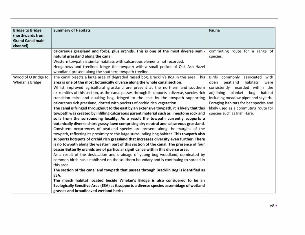
Wood of O Bridge to Whelan’s Bridge
The canal bisects a large area of degraded raised bog, Bracklin’s Bog in this area. This area is one of the most botanically diverse along the whole canal section. Whilst improved agricultural grassland are present at the northern and southern extremities of this section, as the canal passes through it supports a diverse, species rich transition mire and quaking bog, fringed to the east by the towpath supporting calcareous rich grassland, dotted with pockets of orchid rich vegetation. The canal is fringed throughout to the east by an extensive towpath, it is likely that this towpath was created by infilling calcareous parent material such as limestone rock and soils from the surrounding locality. As a result the towpath currently supports a botanically diverse short grassy lawn comprising dry neutral and calcareous grassland. Consistent occurrences of peatland species are present along the margins of the towpath, reflecting its proximity to the large surrounding bog habitat. This towpath also supports hotspots of orchid rich grassland that increases diversity even further. There is no towpath along the western part of this section of the canal. The presence of four Lesser Butterfly orchids are of particular significance within this diverse area. As a result of the desiccation and drainage of young bog woodland, dominated by common birch has established on the southern boundary and is continuing to spread in this area. The section of the canal and towpath that passes through Bracklin Bog is identified as ESA. The marsh habitat located beside Whelan’s Bridge is also considered to be an Ecologically Sensitive Area (ESA) as it supports a diverse species assemblage of wetland grasses and broadleaved wetland herbs
Birds commonly associated with open peatland habitats were consistently recorded within the adjoining blanket bog habitat including meadow pipet and skylark. Foraging habitats for bat species and likely used as a commuting route for species such as Irish Hare.

29
Bridge to Bridge (northwards from Grand Canal main channel)
Summary of Habitats Fauna
Whelan’s Bridge to Murphy’s Bridge
The canal towpaths along this section have been subsumed into the surrounding grassland. Semi natural woodlands including oak-ash-hazel woodlands, developed on esker mounds are present fringing the canal and are classified as ESAs. An aqueduct traverses the canal along this section.
A badger sett was confirmed along the canal bank, commuting and foraging for bat species provided by the relatively diverse linear woodland.
Murphy’s Bridge to Lowertown Bridge
This stretch of the canal intersects Murphy’s Bridge Esker pNHA. The eastern canal towpath supports a local access road which continues north of Murphy’s Bridge Esker before entering a private dwelling. North of the private dwelling the towpath takes the form of a well-worn access track with rough linear grassland. The western towpath supports a local access road which ends shortly after the road bridge. Thereafter the towpath supports rough grassland with strips of calcareous grassland, closer to the Silver River crossing, the towpath supports a localised opening of calcareous grassland. North of the Silver River the towpath supports semi-improved grassland and rough grassland. Hedgerows and treelines. The section of the canal that intersects with the esker pNHA is classified as an ESA The canal rises along this stretch to span the Silver River, a tributary of the Clodiagh River.
A badger sett is located within the woodland copse west of the canal and it is likely they use the canal for foraging and commuting.
Lowertown Bridge to Grange Bridge
The majority of the canal towpaths have been subsumed into the surrounding agricultural grassland in this section. Parts of the canal itself have been colonised by young, mixed broadleaved woodland. North of Lowertown Bridge, the western canal towpath supports an unpaved trackway that is bordered on both sides by mature sycamore, ash and beech trees. The eastern towpath supports an unpaved trackway bordered by linear woodland habitat.
The comparatively steep banks of the canal located at the pronounced turn at the canal provide ample habitat for burrowing mammals though this area could fill with water following extended rainfall.
30
Bridge to Bridge (northwards from Grand Canal main channel)
Summary of Habitats Fauna
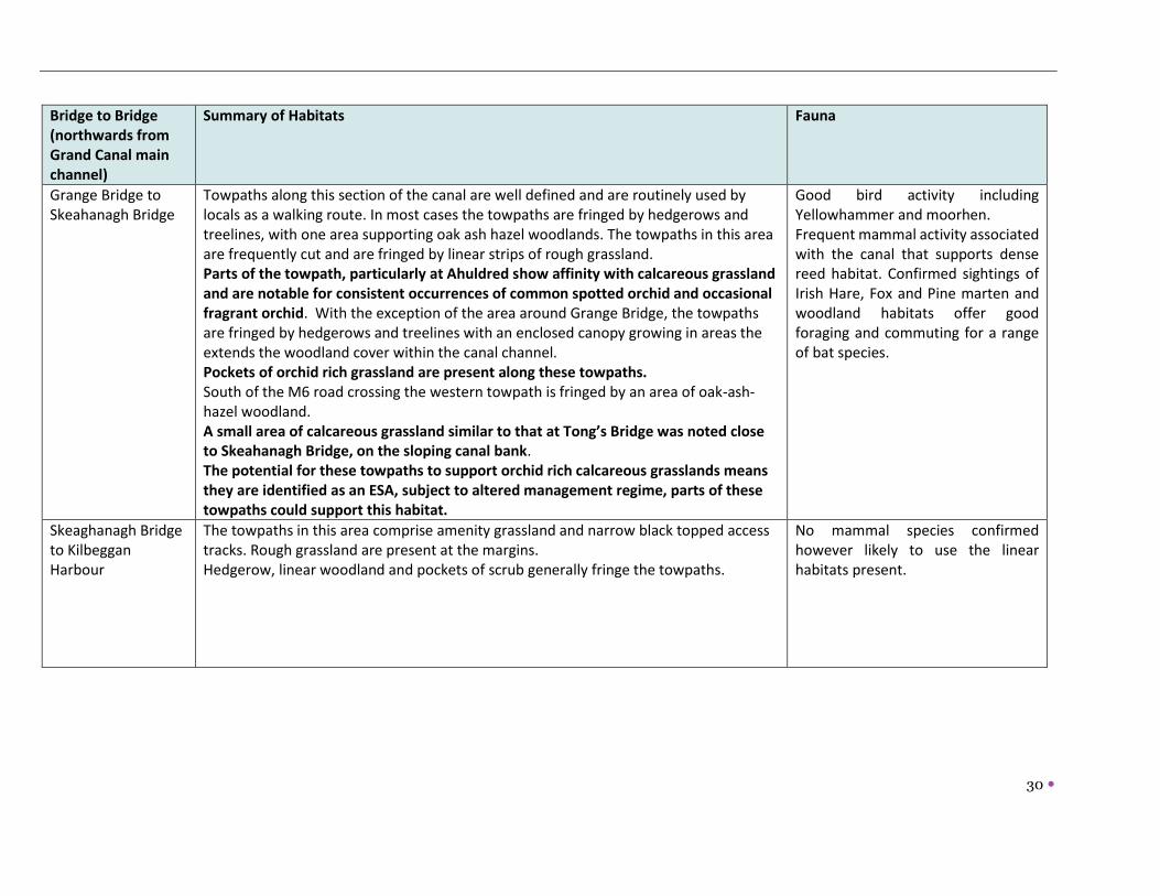
Grange Bridge to Skeahanagh Bridge
Towpaths along this section of the canal are well defined and are routinely used by locals as a walking route. In most cases the towpaths are fringed by hedgerows and treelines, with one area supporting oak ash hazel woodlands. The towpaths in this area are frequently cut and are fringed by linear strips of rough grassland. Parts of the towpath, particularly at Ahuldred show affinity with calcareous grassland and are notable for consistent occurrences of common spotted orchid and occasional fragrant orchid. With the exception of the area around Grange Bridge, the towpaths are fringed by hedgerows and treelines with an enclosed canopy growing in areas the extends the woodland cover within the canal channel. Pockets of orchid rich grassland are present along these towpaths. South of the M6 road crossing the western towpath is fringed by an area of oak-ash-hazel woodland. A small area of calcareous grassland similar to that at Tong’s Bridge was noted close to Skeahanagh Bridge, on the sloping canal bank. The potential for these towpaths to support orchid rich calcareous grasslands means they are identified as an ESA, subject to altered management regime, parts of these towpaths could support this habitat.
Good bird activity including Yellowhammer and moorhen. Frequent mammal activity associated with the canal that supports dense reed habitat. Confirmed sightings of Irish Hare, Fox and Pine marten and woodland habitats offer good foraging and commuting for a range of bat species.
Skeaghanagh Bridge to Kilbeggan Harbour
The towpaths in this area comprise amenity grassland and narrow black topped access tracks. Rough grassland are present at the margins. Hedgerow, linear woodland and pockets of scrub generally fringe the towpaths.
No mammal species confirmed however likely to use the linear habitats present.

31
3.3.4 Rare and Protected Flora including orchids
There are numerous botanical hotspots located along the former Kilbeggan Branch such as the margins
of Skeahanagh and Tong’s Bridge, the towpaths fringing the canal south of Whelan’s Bridge and the
pockets of calcareous grassland along the towpaths between Tong’s Bridge and Campbell’s Bridge
The most significant botanical area along the canal includes the section which intersects with Murphy’s
Bridge Esker pNHA. In addition to the diverse assemblages of annuals, perennials and calcicole species,
this area also supports two species listed on the Red Data List for Vascular Plants -red hemp nettle
(Galeopsis angustifolia) and blue fleabane (Erigeron acris).
In the main, the towpaths fringing the canal support low growing calcareous grassland that included the
most suitable habitat for orchid species. The most common and consistently encountered orchid species
identified along the towpath was the common spotted orchid and occasional fragrant orchid. This was
frequent along the canal, especially those areas Skeahanagh Bridge and Grange Bridge and between
Odlum’s Bridge and Campbell’s Bridge. Orchids re-established during the works to the M6 when access
was closed, however this has altered since reopening with areas walked and rutted by farm machinery.
The canal, between Whelan’s Bridge and Wood of O Bridge was identified in the 2013 survey as being the
most botanically diverse stretch along the canal. This is due to the area supporting reed and large sedge
swamp and the area fringing the towpath supporting orchid rich calcareous grassland2 The calcicole
habitats established within Murphy’s Bridge Esker supported an assemblages of orchids including
pyramidal orchid, common spotted orchid and fragrant orchid.
A grassland strip in the immediate vicinity of Tong’s Bridge supports a very diverse low growing
assemblage. This area (covering circa 10m X 5m) supports considerable diversity of calcareous grasslands
as well as orchids. Common spotted orchid occurred frequently within this habitat with up to 6 early
purple orchids occurring within this habitat also.
3.3.5 Ecologically Sensitive Areas (ESAs)
The 2013 (Atkins) report identified a total of 7 ESAs within the Kilbeggan Branch. A summary of
these is provided below following a sequence from the junction with the Grand Canal due north.
These are supported by the following criteria:
• Areas supporting species rich habitats not common within the locality
• Areas supporting rare, protected or assemblages of locally rare or notable plant species
• Areas supporting high faunal activity or potential for faunal activity.
Figure 6 shows these ESAs (Extracted from Atkins, 2013).
2 Section 3.7 Ecological Survey Report Waterways Ireland 2013

32
ESA1 Calcareous Grassland at Tong’s Bridge (Co. Offaly): A small area of calcareous grassland
was identified on the margins of Tong’s Bridge and is associated with the thin soils on the sloping
canal bank.
EAS2 Bracklin Bog (Co Offaly): This ESA includes a section of the canal towpath that passes
through Bracklin Bog with raised bog habitats adjoining the canal towpath. The presence of
orchid rich grassland and species-rich calcareous grassland alongside a diverse wetland habitat
comprising an abundance of wetland herbs and sedges makes this one of the most ecologically
and botanically significant sites within the former Kilbeggan Branch. The orchid-rich areas
correspond to Annex I habitat Semi-natural dry grasslands and scrubland facies on calcareous
substrates (Festuco Brometalia) (*important orchid sites) [6210]. (Atkins, 2013)
ESA3 Marsh at Whelans Bridge (Co Offaly) An area of marsh occurs within the canal line south
of Whelan’s Bridge supporting a tall grasses, sedges and wetland herbs. The Silver River crosses
the canal in this area.
ESA4 Bracklin Little (Co Offaly) The semi natural woodland habitats fringing the canal, i.e. hazel-
ash-oak woodland are considered as Ecological Sensitive Areas. These relatively diverse
woodlands are located on esker mounds and provide a valuable ecological resource, wildlife
corridor and refuge for a range of flora and fauna in the locality (Atkins, 2013). This ESA is located
on the area adjacent to the eastern towpath.
ESA5 Murphy’s Bridge Esker (Co Offaly). The Canal is linked to and intersects the Murphy’s
Bridge Esker pNHA which supports a diverse assemblage of annual, perennial and calcicole
vascular plant species including two Red Listed plant species, notably Red Hemp Nettle and Blue
Fleabane where they occur on the low-lying, sparsely vegetated sandy gravels and cobble
habitats. This ESA encompasses both sides of the canal towpath.
ESA6 Lowertown Esker (Co. Westmeath) This area has potential to support orchid rich
calcareous grassland. These habitats are subject to ongoing management. The ESA has woodland,
scrub, treelines, hedgerows and rough grassland in adjacent areas and provide a valuable
ecological resource, wildlife corridor and refuge for a range of flora and fauna in the locality.
ESA7 Ahuldred (Co. Westmeath): This ESA has potential to support orchid rich calcareous
grassland.
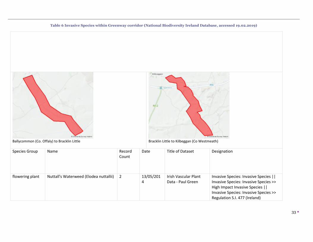
3.3.6 Invasive Species
Canadian waterweed (Elodea canadensis) was identified in 2013 along one stretch of the canal
immediately south of Wood of O Bridge. A polygon search on the National Biodiversity of Ireland database
identified the following species within a corridor of the Greenway (polygon shapes shown in table 6
below).
33
Table 6 Invasive Species within Greenway corridor (National Biodiversity Ireland Database, accessed 19.02.2019)
Ballycommon (Co. Offaly) to Bracklin Little
Bracklin Little to Kilbeggan (Co Westmeath)
Species Group Name Record Count
Date Title of Dataset Designation
flowering plant Nuttall's Waterweed (Elodea nuttallii) 2 13/05/2014
Irish Vascular Plant Data - Paul Green
Invasive Species: Invasive Species || Invasive Species: Invasive Species >> High Impact Invasive Species || Invasive Species: Invasive Species >> Regulation S.I. 477 (Ireland)

34
flowering plant Sycamore (Acer pseudoplatanus) 2 13/05/2014
Irish Vascular Plant Data - Paul Green
Invasive Species: Invasive Species || Invasive Species: Invasive Species >> Medium Impact Invasive Species
mollusc Budapest Slug (Tandonia budapestensis)
1 16/09/1977
All Ireland Non-Marine Molluscan Database
Invasive Species: Invasive Species || Invasive Species: Invasive Species >> Medium Impact Invasive Species
mollusc Common Garden Snail (Cornu aspersum)
4 17/09/1977
All Ireland Non-Marine Molluscan Database
Invasive Species: Invasive Species || Invasive Species: Invasive Species >> Medium Impact Invasive Species
mollusc Jenkins' Spire Snail (Potamopyrgus antipodarum)
2 17/09/1977
All Ireland Non-Marine Molluscan Database
Invasive Species: Invasive Species || Invasive Species: Invasive Species >> Medium Impact Invasive Species
mollusc Keeled Slug (Tandonia sowerbyi) 2 17/09/1977
All Ireland Non-Marine Molluscan Database
Invasive Species: Invasive Species || Invasive Species: Invasive Species >> Medium Impact Invasive Species
mollusc Wrinkled Snail (Candidula intersecta) 3 17/09/1977
All Ireland Non-Marine Molluscan Database
Invasive Species: Invasive Species || Invasive Species: Invasive Species >> Medium Impact Invasive Species

35
mollusc Zebra Mussel (Dreissena (Dreissena) polymorpha)
1 24/03/2003
All Ireland Non-Marine Molluscan Database
Invasive Species: Invasive Species || Invasive Species: Invasive Species >> High Impact Invasive Species || Invasive Species: Invasive Species >> Regulation S.I. 477 (Ireland)
terrestrial mammal
Eastern Grey Squirrel (Sciurus carolinensis)
1 03/12/1968
Northern Ireland Mammal Database
Invasive Species: Invasive Species || Invasive Species: Invasive Species >> High Impact Invasive Species || Invasive Species: Invasive Species >> EU Regulation No. 1143/2014 || Invasive Species: Invasive Species >> Regulation S.I. 477 (Ireland)
terrestrial mammal
European Rabbit (Oryctolagus cuniculus)
1 03/12/1968
Northern Ireland Mammal Database
Invasive Species: Invasive Species || Invasive Species: Invasive Species >> Medium Impact Invasive Species
terrestrial mammal
Fallow Deer (Dama dama) 3 27/02/1991
Badger and Habitats Survey of Ireland
Invasive Species: Invasive Species || Invasive Species: Invasive Species >> High Impact Invasive Species || Invasive Species: Invasive Species >> Regulation S.I. 477 (Ireland) || Protected Species: Wildlife Acts

36
terrestrial mammal
House Mouse (Mus musculus) 1 03/12/1968
Northern Ireland Mammal Database
Invasive Species: Invasive Species || Invasive Species: Invasive Species >> High Impact Invasive Species
flowering plant Sycamore (Acer pseudoplatanus) 1 03/08/2018
Online Atlas of Vascular Plants 2012-2020
Invasive Species: Invasive Species || Invasive Species: Invasive Species >> Medium Impact Invasive Species
mollusc Common Garden Snail (Cornu aspersum)
1 17/09/1977
All Ireland Non-Marine Molluscan Database
Invasive Species: Invasive Species || Invasive Species: Invasive Species >> Medium Impact Invasive Species
mollusc Jenkins' Spire Snail (Potamopyrgus antipodarum)
1 17/09/1977
All Ireland Non-Marine Molluscan Database
Invasive Species: Invasive Species || Invasive Species: Invasive Species >> Medium Impact Invasive Species
mollusc Keeled Slug (Tandonia sowerbyi) 1 17/09/1977
All Ireland Non-Marine Molluscan Database
Invasive Species: Invasive Species || Invasive Species: Invasive Species >> Medium Impact Invasive Species
mollusc Wrinkled Snail (Candidula intersecta) 1 17/09/1977
All Ireland Non-Marine Molluscan Database
Invasive Species: Invasive Species || Invasive Species: Invasive Species >> Medium Impact Invasive Species
terrestrial mammal
Feral Ferret (Mustela furo) 1 03/07/2006
National Feral Ferret (Mustela putoris furo) Database
Invasive Species: Invasive Species || Invasive Species: Invasive Species >> High Impact Invasive Species

37
Figure 3Special Areas of Conservation 15km of Proposed Development
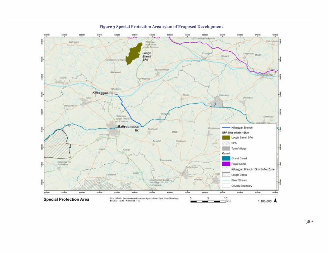
38
Figure 3 Special Protection Area 15km of Proposed Development

39
Figure 5 Natural Heritage Areas 15km of Proposed Development

40
Figure 6 ESAs identified in Ecological Survey 2013

41
3.4 Geology and Soil Geology
The former Kilbeggan branch of the Grand canal runs through an area of significant geological interest,
particularly through its intersection with eskers, as well as the use of esker derived gravel for construction. The
underlying bedrock, as with the wider midlands area is dominated by limestone. The influence of glaciation on
this wider landscape is apparent through the quaternary map which highlights the eskers identified as gravel
derived from limestone.
The esker mounds that are identified in the canal slopes have created particular localised habitats, as well as the better-known species rich calcareous grassland and calcicole species associated with esker formations. Figure 7 Bedrock Geology, Figure 8 Quaternary Geology and Figure 9 Geological Heritage Sites are shown overleaf.
Soil
The canal traverses areas dominated by luvisol soils with an increasing peat soils present around the Bracklin
Bog area and south; brown earths are present east of Grange Bridge and small alluvial soils are present west
of Grange Bridge. Figure 10 shows the canal with the national soil map. Figure 7 Bedrock Geology and Proposed Kilbeggan-Ballycommon Greenway along former Kilbeggan
Branch of the Grand Canal

42
Figure 8 Quaternary Geology and Proposed Kilbeggan-Ballycommon Greenway along former Kilbeggan Branch of the Grand Canal

43
Figure 9 Geological Heritage Sites and Proposed Kilbeggan-Ballycommon Greenway along former Kilbeggan Branch of the Grand Canal

44
Figure 10 National Soil Map and Proposed Kilbeggan-Ballycommon Greenway along former Kilbeggan Branch of the Grand Canal

45
3.5 Water The Water Framework Directive (WFD) is a key initiative aimed at improving water quality throughout the EU.
It applies to rivers, lakes, groundwater, estuarine and coastal waters. The Directive requires an integrated
approach to managing water quality on a river basin basis; with the aim of maintaining and improving water
quality. The catchments-based approach is now embedded in the WFD Programme for River Basin Management
Plan for Ireland 2018 – 2021. A catchment is an area where water is collected by the natural landscape and
flows from source through river, lakes and groundwater to the sea. The study area lands are situated within the
Lower Shannon Catchment (code:25).
This catchment covers an area of 1,248km² and is characterised by relatively flat topography with much of the
low lying areas in the catchment covered in thick deposits of peat. The majority of the catchment is underlain
by impure limestones with some purer karstified limestones located from Tyrrellspass to Kilcormac. There are
extensive sand and gravel deposits running through the catchment from Moate to Tyrrellspass and in isolated
pockets in the south of the catchment that form productive groundwater aquifers. The southern tip of the
catchment comprising part of the Slieve bloom Mountains is underlain by old red sandstones.
3.5.1 Surface water
Surface water status is classified under the WFD from ‘high’ to ‘bad’ status. In measuring this status both
ecological and chemical parameters are measured and the overall status is determined by the lower threshold
achieved for both ecological and chemical parameters.
Between Kilbeggan Harbour and the Grand Canal main channel, the Kilbeggan Branch spans a number of
watercourses including the Tonaphort River (code 010), which is located to the north of Grange Bridge. The
Tonaphort is a tributary of the Brosna and joins the Brosna main channel c. 4.4km to the west of the canal. North
of Murphy’s Bridge esker the canal spans the Silver River(code Tullamore 010) which continues south and west
of the canal before joining with the Clodiagh River. A tributary of the Tullamore River flows further south (code
030). Smaller streams and channels forming connectivity with the Tullamore River are located north of Wood of
O Bridge and south-east of Odlum’s Bridge. Figure 11 below shows data for surface water quality within the
area.
3.5.2 Groundwater
Groundwater is a further significant resource and refers to water stored underground in saturated rock, sand,
gravel, and soil. Surface and groundwater functions are closely related and form part of the hydrological cycle.
The protection of groundwater from land uses is a critical consideration and groundwater vulnerability is
becoming an important management tool. The entire island of Ireland has been designated as a Protected Area
for Groundwater under the WFD. Groundwater is important as a drinking water supply as well as the supply to
surface waters. In addition, groundwater supplies surface waters. Groundwater is exposed to higher
concentrations of pollutants that are retained in the layers of rock and soil. The exposure to pollutants lasts
much longer as groundwater moves at a slower pace through the aquifer. The quality of our drinking water
supply, fisheries and terrestrial based habitats is intrinsically linked with groundwater quality. The Geological
Survey of Ireland (GSI) aquifer categories are based on their vulnerability to pollution, i.e. the ease at which it

46
can enter the subsurface layers. The classification of extreme or high vulnerability means that the groundwater
in these areas is very vulnerable to contamination due to hydrogeological and soil factors.
The Geological Survey of Ireland’s Groundwater Vulnerability Mapping shows the groundwater vulnerability for
the study area within a catchment where groundwater vulnerability is considered Extreme and/or High, as the
Figure 12 illustrates. Groundwater overall is identified as being of good status according to the WFD
classification (catchments.ie).
3.5.3 Flooding
The Planning System and Flood Risk Management, Guidelines for Planning Authorities, 2009, issued by the
DoEHLG and undertaken in conjunction with the OPW, requires Planning Authorities to prepare a Strategic Flood
Risk Assessment (SFRA). The primary purpose of the SFRA is to determine flood risk within a particular
geographical area. It should be noted the SFRA is an ever-evolving document, which is to be reviewed and
updated on a regular basis in the light of emerging information, flood data and an improved understanding of
flood risk. Figure 13 below shows flood risk extents. Fluvial flood risk is clearly associated with the watercourses
described above.

47
Figure 11 Surface Water Status

48
Figure 12 Groundwater Vulnerability

49
Figure 13 Flood Risk map

50
3.6 Air and Climatic Factors All developments, agriculture, energy generation, industry and commercial activity and waste generation
contribute emissions to air and greenhouse gas (GHG) emissions; however the emission of pollutants from
vehicles is one of the main threats to air quality in Ireland and contributes significantly to the increase of
greenhouse gases. The latest annual report on Air Quality in Ireland 2014 (EPA 2014) states that overall air
quality in the country is good. Measured values of sulphur dioxide (SO2), nitrogen dioxide (NO2), carbon
monoxide (CO), Ozone (O3), particulate matter (PM10 and PM2.5), heavy metals, benzene and polycyclic
aromatic hydrocarbons (PAH) were all below limit and target values set out in the CAFE Directive and 4th
Daughter Directive. However, when some of these parameters are compared to the tighter WHO Air Quality
Guideline values, it highlights some potential issues. Ireland is above these guideline values with respect to
PM10, PM2.5, ozone and PAH.
The primary sources of pollutants are traffic (source of nitrogen dioxide and particulate matter), and domestic
solid fuel use (particulate matter). Longer term encouraging a modal shift from cars to walking and cycling will
benefit local air quality and reduce greenhouse gas emissions from transport at a local scale.
Air Quality for the project area, identified as Rural East is ‘good’ as of 13th December 2018.
3.7 Landscape The former Kilbeggan branch is in itself a locally important scenic, quaint and attractive landscape, given its
varying topographic forms which collectively provide a distinctive landscape area, coupled with a variety of
habitats.
Currently, the lands associated with the proposed greenway are available for recreational use (walking),
however this existing recreational route is for the most part, unsurfaced at present.
The LCA of County Westmeath identifies the former Kilbeggan branch of the Grand Canal as part of LCA 11 South
Westmeath Eskers.
Table 7 below provides a landscape character assessment of the existing landscape associated with the
proposed greenway.
Table 7 Local Landscape Character Assessment of proposed greenway
Location Chainage approx.
Bank Character
Kilbeggan to Skeahanagh Bridge
0.0 to 700 South Narrow corridor in places, high above the existing ground, wooded with glades. Existing 1m wide blacktop path
Skeahanagh Bridge to M6
700 to 1200 South The corridor is closer to existing ground level and is more expansive than the previous section with views to the open landscape and the M6. A stone overflow is at approx. ch 100.
M6 to Grange Bridge
1200 to 1600 South The corridor has a lower narrow path with an upper wider path, and a wooded slope in between.

51
Location Chainage approx.
Bank Character
1600- 3100 South The route opens out in to a glade and then returns to a linear towpath. There are small existing tracks amongst trees.
Grange Bridge to Lowertown Bridge
3100 to 3450 East The route runs along a newly fenced field in an undulating landscape. The view into the field and livestock gives a sense of place.
3450 to 3600 East This stretch is a muddy track used by farm machinery
3600-4000 East This stretch is a muddy track used by farm machinery. Ch 4000 is the start of a short cut through an esker which gives a dramatic point of interest.
4000 to 5050 East This stretch is a muddy track used by farm machinery.
Lowertown Bridge to aquaduct (county boundary)
5050 to 5636.20
East This stretch is a muddy track used by farm machinery.
County Boundary
Aquaduct to Murphy’s bridge
7500 to 6850 East This stretch is a muddy track used by farm machinery.
Murphy’s Bridge to Whelan’s Bridge
6850 to 6100 East This stretch is a muddy track used by farm machinery.
Whelan’s Bridge to Tong’s Bridge (aquaduct bridge?)
6100 to 6000 East This short stretch completes the newly fenced area across open fields to/from the bog.
Tong’s Bridge to aquaduct
6000to 4500 East This long stretch across the open bog Bracklin bog is exposed. It has long broad views across the bog in contrast to the well defined tow path corridors of the other stretches of the canal route.
Aquaduct to Wood of O bridge
4500 to 4175 East and West
This stretch is a newly fenced area across open fields to/from the bog. The fields give way to backs of houses towards the bridge.
Wood of O bridge to private house
4175 to 3700 East This short stretch is a potholed track leading to a private house. The width appears less than 3m
Private house to Odlum’s Bridge
3700 to 2200 East This long stretch is characterised by a slightly elevated towpath which appears to form a broad causeway and used by farm machinery.
Odlum’s Bridge to
2200 to 1900 East This short stretch is on a public road.

52
Location Chainage approx.
Bank Character
Brook’s Bridge
1900 to 900 East This stretch is a relatively broad towpath.
Brook’sBridge to Campbell Bridge
900 to 000 East This stretch is a relatively broad towpath.
3.8 Cultural Heritage The area around Kilbeggan is identified as an archaeological zone of potential. A number of archaeological
features are present within the wider area, whilst the industrial heritage features associated with the Kilbeggan
canal are listed as Protected Structures. Figure 14 shows the recorded sites and protected structures within
250m buffer of the Greenway, and Table 8 presents further detail on the NIAH record for structures within 150m
of the Greenway.
Table 8 National Inventory of Architectural Heritage
NAME TOWNLAND COUNTY DATEFROM DATETO RATING ORIGINAL_T
BRACKLIN LITTLE Offaly 1780 1820 Regional house
Odlum's Bridge
BALLYTEIGE BIG Offaly 1830 1840 Regional bridge
Saints Francis of Assisi and Bridget
BALLYTEIGE LITTLE
Offaly 1840 1850 Regional church/chapel
Tong's Bridge
WOOD OF O Offaly 1830 1840 Regional bridge
Wood of O Bridge
WOOD OF O Offaly 1830 1840 Regional bridge
BALLYCOMMON Offaly 1785 1805 Regional store/warehouse
Campbell's Bridge
BALLYCOMMON Offaly 1830 1840 Regional bridge
21st Lock BALLYCOMMON Offaly 1785 1805 Regional lock
BALLYCOMMON Offaly 1790 1800 Regional bridge
Grange Bridge
Westmeath 1830 1835 Regional bridge
Kilbeggan Branch Grand Canal Harbour
KILBEGGAN Westmeath 1830 1835 Regional harbour/dock/port
Kilbeggan Grand Canal Harbour
KILBEGGAN Westmeath 1830 1835 Regional store/warehouse
KILBEGGAN Westmeath 1800 1840 Regional farm house

53
KILBEGGAN Westmeath 1850 1880 Regional harbour master's house
Skeahanagh Bridge
SKEAHANAGH Westmeath 1830 1835 Regional bridge
SKEAHANAGH Westmeath 1820 1840 Regional house
SKEAHANAGH Westmeath 1880 1900 Regional outbuilding
Lowertown Bridge
LOWERTOWN Westmeath 1830 1836 Regional bridge
Silver River Aqueduct
LOWERTOWN Westmeath 1830 1835 Regional aqueduct

54
Figure 14 Recorded Archaeological Sites and Protected Structures within 100m and 250m of the project lands

55
3.9 Material Assets The M6 motorway oversails the former Kilbeggan Branch canal close to Kilbeggan, and a series of county roads
are dispersed around the project area.
The Regional Waste Management Plan 2015-2021 for the Eastern-Midlands Region encompasses the local
authorities: Dublin City, Dún Laoghaire- Rathdown, Fingal, South Dublin, Kildare, Louth, Laois, Longford, Meath,
Offaly, Westmeath and Wicklow. The regional plan provides the framework for waste management for the next
3 years and sets out a range of policies and actions in order to meet the specified mandatory and performance
targets.
There are no proposals to provide toilets or water supply as part of the proposed project works.
3.10 Inter-relationship between parameters In considering the relationships between the above parameters, an environmental sensitivity map was prepared
that combines flood risk, statutory designated sites for natural heritage, built heritage designations and water
resources. This is presented in the following Figure 15. The figure shows areas of greater environmental
sensitivity in orange-yellow tones. The area of greatest overall environmental sensitivity within the project
footprint itself is the area around the former canal channel itself; where the canal meets the Grand Canal, the
area between Wood-Of-O Bridge and Lowertown Bridge and Odlum’s Bridge. The intersection between the
Greenway corridor and the Silver River is also identified as being of higher overall sensitivity.

56
Figure 15 Environmental Sensitivity

57
4 EIA Screening
4.1 Environmental Factors to be considered in the EIA Screening. Schedule 6 of the Planning and Development Regulations, 2001, as amended, outline the aspects of the
environment likely to be significantly affected by a proposed development. These are:
◆ Population and Human Health
◆ Biodiversity
◆ Land, Soils & Geology
◆ Water
◆ Air
◆ Climate
◆ Material Assets
◆ Cultural Heritage
◆ Landscape The inter-actions between the above factors This EIA Screening report will therefore assess the development for potential impacts on the above parameters and against the criteria provided in Schedule 7a of the Regulations. The criteria contained in Schedule 7a can provide the basis for determining whether a proposed development may create significant impacts on the environment. The criteria are used to help in the screening process to determine whether a development is likely to have a significant effect on the environment. The criteria used in this EIA Screening Report are those listed in Annex III of the EIA Directive of 2014.
4.2 Impact Assessment Having considered the above environmental factors, the aim of the next section is to address likely impacts on
the environment by the implementation of the proposed development. Whether an EIA would be deemed
relevant to the scale of the project and the environment will then be determined. The following sections
presents the EIA Screening Report based on the criteria contained in Schedule 7a and are grouped under the
following headings.
1. Characteristics of the Proposed Development - Table 9.1 2. Location of the Proposed Development - Table 9.2 and
3. Characteristics of Potential Impact Tables 9.3 and 9.4
The screening process assesses the most significant potential impacts in relation to the themes outlined below in Table 9.3. These are considered as follows: The likely significant effects of projects on the environment must be considered in relation to criteria set out in points 1 and 2 of this Annex, with regard to the impact of the project on the factors specified in Article 3(1), taking into account: (a) the magnitude and spatial extent of the impact (for example geographical area and size of the population likely to be affected); (b) the nature of the impact; (c) the transboundary nature of the impact; (d) the intensity and complexity of the impact;

58
(e) the probability of the impact; (f) the expected onset, duration, frequency and reversibility of the impact; (g) the cumulation of the impact with the impact of other existing and/or approved projects; (h) the possibility of effectively reducing the impact.
Having considered the above environmental factors, the aim of the next section is to address likely impacts on
the environment by the implementation of the proposed development. A brief overview of the sensitivities and
impacts will be highlighted. Whether an EIA would be deemed relevant to the scale of the project and the
environment will then be determined. The following sections present the EIA Screening based on the criteria
contained in Schedule 7a and are grouped under the following headings:
1. Characteristics of the Proposed Development - Table 9.1
2. Location of the Proposed Development - Table 9.2 and
3. Characteristics of Potential Impact - Tables 9.3 and 9.4
Table 9.1 Characteristics of the Proposed Development
Screening Question Response
1. Characteristics of projects
The characteristics of projects must be considered, with particular regard to:
(a) the size and design of the whole
project
The greenway will commence at Kilbeggan Harbour and
follow the established line of the former Kilbeggan Branch
of the Grand Canal to Ballycommon, Co. Offaly a total
distance of 13.5km.
The proposed Greenway utilizes the former/existing
towpath associated with the former Kilbeggan Branch of
the Grand Canal and will vary in width from 1.5 to 3m at any
stage. As it uses the existing towpath and a public road,
landtake is minor.
The habitat survey of 2013 classified seven areas along the
canal as being Ecologically Sensitive Areas and this requires
a particular approach, mitigation measures and
enhancement measures to minimise and offset landtake
and reduction of habitats. The size and design of the whole
project do not result in likely significant effects on the
environment.
(b) cumulation with other existing
and/or approved projects;
There are currently no major infrastructural schemes in
preparation in the project area. Public realm
improvements are nearing completion in Kilbeggan town
(2018).

59
Screening Question Response
1. Characteristics of projects
The characteristics of projects must be considered, with particular regard to:
At a larger scale, there are proposals in train or in receipt of
planning consent for Greenway development in Counties
Offaly and Kildare along the main channel of the Grand
Canal.
Overall, the effects will relate to increased recreational use
of the Greenway over time; as this is an established
recreational route with no additional lighting proposed, it is
considered that no significant cumulative effects will arise.
The Ecological Cumulative Impact Assessment (2016) for
the Grand Canal (including the Kilbeggan branch) made the
following conclusions:
It is considered that cumulative impacts, if any, are most
likely to arise during the construction phase. The most
significant potential for adverse cumulative impact is in the
loss of habitat. The Greenway will be required to implement
strict construction management plans and provide
compensation for any loss of habitat where possible. Given
the existence of such management controls, it is considered
that the cumulative impacts can be mitigated during
construction and will be inconsequential during operational
phases in the long term. (2016, pg 60).
Measures identified in the above ECIA have been
incorporated into the Best Practice Guidelines that will
apply during construction.
The cumulative assessment does not result in likely
significant effects on the environment.
(c) the use of natural resources, in
particular land, soil, water and
biodiversity;
Natural resources will be used in terms of surfacing of the
towpath as necessary and will use a variety of surface
dressings as outlined in Section 2. The primary surface will
be compacted dust and stone for much of the Greenway
through rural areas with bound surface used only where the
existing bound surfaces are deteriorated or where
limited/necessary traffic will be permitted.

60
Screening Question Response
1. Characteristics of projects
The characteristics of projects must be considered, with particular regard to:
There may be some removal of soil to facilitate the surface
dressing but measures to conserve and manage soil are
detailed in Section 2 of this report.
Minor amounts of water and fuel will be used to clean
machinery and fuel machinery required during construction
works. The size and design of the whole project do not
result in likely significant effects on the environment.
Given the above approaches the project does not result in
likely significant effects on the environment.
(d) the production of waste; Yes, but not significant.
Solid waste may be produced during construction but
materials will be only ordered as required. Any wastes from
the construction process will either be reused within the
scheme or recycled/disposed of at an authorised waste
facility. Likely significant effects on the environment are not
identified.
(e) pollution and nuisances;
The construction phase presents the greatest risk of
pollution to water resources, and disturbance/damage to
flora and fauna. Potential sources of water pollution to
both surface and groundwater include fuel, lubricants,
suspended solids and asphalt. Silt-laden surface runoff
could arise during construction during vegetation stripping
and the resurfacing of section of grass towpath and/or
during the resurfacing of existing gravel towpath and public
roads. The input of such runoff to the former canal channel
itself although dewatered, could still affect water quality
within the wetland habitats present.
The quantities of potentially polluting materials that will be
used in the vicinity of the Greenway throughout the
construction phase will be small and their ingress to will
become quickly diluted downstream. The bulk of all
material required for the construction phase will be stored
at an existing construction compound in Kilbeggan which is
located outside of the project area. The location of the
compound away from receiving watercourses will

61
Screening Question Response
1. Characteristics of projects
The characteristics of projects must be considered, with particular regard to:
significantly minimise the potential for the discharge of
contaminated surface water runoff from this area to any
surrounding watercourse.
Potential pollution to water resources from operation
include increased surface run off containing suspended
solids associated with increased cycling or pedestrian
traffic. However this is not predicted to represent a risk to
surface water quality due to its proposed use as a cycling
and walking route, both of which are not predicted to have
the potential to generate polluting water emissions to the
canal.
However, best practice in design, construction and
operation will be implemented and adherence to
Environmental Construction Guidelines will be
implemented. Additional measures have also been
integrated in relation to the surface water quality, please
see Section 2.3 Best Practice Construction Approach.
In addition, noise disturbance during construction may
impact on bird species associated with the canal or adjacent
areas of scrub or the ponds at Bracklin Bog. However this is
temporary in duration and significant levels of machinery
are not anticipated to be used.
Given the above approach likely significant effects on the
environment are not identified.
(f) the risk of major accidents and/or
disasters which are relevant to the
project concerned, including those
caused by climate change, in
accordance with scientific knowledge;
The risks of major accidents are not considered to be
significant subject to best construction practices being
followed through the construction phase. This will include
proper site management, maintenance and operation of all
machinery and works associated with the construction
phase, on site safety and training.
Use of appropriately trained and professional staff and
specific measures for the ESA s which encompasses the
whole project area to avoid disturbance to identified
habitats associated with the ESAs.
To avoid disturbance to this ESA measures as outlined in
Section 2.3. will be applied. Given the above approaches the

62
Screening Question Response
1. Characteristics of projects
The characteristics of projects must be considered, with particular regard to:
project does not result in likely significant effects on the
environment
(g) the risks to human health (for
example due to water contamination or
air pollution).
As above, significant risks to human health are not
identified for this proposal. The environmental protection
measures, particularly for the construction phase are
detailed in Section 2 and subject to full and proper
implementation, potential risks associated with
construction activity will not arise. Given the above
approaches the project does not result in likely significant
effects on the environment
Will the proposed development create
a significant amount of nuisance during
its construction or operation?
It is not anticipated that significant noise levels will arise
during construction (they will be temporary and restricted
to machinery associated with surfacing) and operational
noise is not identified as being significant. The proposed
Greenway is contained within an established walking route
used primarily by local residents and therefore, will not
create a significant amount of nuisance during its
operation. . Given the above approaches the project does
not result in likely significant effects on the environment
Response & Clarification Conclusion: No significant effects likely to arise associated with the characteristics of the proposed
development.
Rationale: The works associated are minor in character and relate to upgrading the towpath of the former
Kilbeggan Branch. Design measures have included reducing the width of the towpath. The proposed greenway
will result in the loss of examples of calcareous grassland but a specific mitigation measure has been provided
that will identify areas of greatest botanical diversity based on the 2013 surveys, and also other areas of species
rich grassland (presented in bold in Section 3.32 that will inform the scope of works for the Ecological Clerk of
Works.
Detailed measures as presented in Section 2 as well as avoidance of the semi-natural habitats, whose presence
underpin the classification of areas as an ESA, will ensure that subject to full implementation and adherence to
same the project does not result in likely significant effects on the environment.
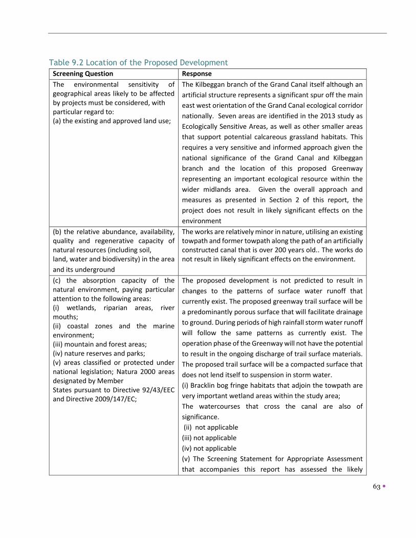
63
Table 9.2 Location of the Proposed Development
Screening Question Response
The environmental sensitivity of geographical areas likely to be affected by projects must be considered, with particular regard to: (a) the existing and approved land use;
The Kilbeggan branch of the Grand Canal itself although an
artificial structure represents a significant spur off the main
east west orientation of the Grand Canal ecological corridor
nationally. Seven areas are identified in the 2013 study as
Ecologically Sensitive Areas, as well as other smaller areas
that support potential calcareous grassland habitats. This
requires a very sensitive and informed approach given the
national significance of the Grand Canal and Kilbeggan
branch and the location of this proposed Greenway
representing an important ecological resource within the
wider midlands area. Given the overall approach and
measures as presented in Section 2 of this report, the
project does not result in likely significant effects on the
environment
(b) the relative abundance, availability, quality and regenerative capacity of natural resources (including soil, land, water and biodiversity) in the area
and its underground
The works are relatively minor in nature, utilising an existing towpath and former towpath along the path of an artificially constructed canal that is over 200 years old.. The works do not result in likely significant effects on the environment.
(c) the absorption capacity of the natural environment, paying particular attention to the following areas: (i) wetlands, riparian areas, river mouths; (ii) coastal zones and the marine environment; (iii) mountain and forest areas; (iv) nature reserves and parks; (v) areas classified or protected under national legislation; Natura 2000 areas designated by Member States pursuant to Directive 92/43/EEC and Directive 2009/147/EC;
The proposed development is not predicted to result in
changes to the patterns of surface water runoff that
currently exist. The proposed greenway trail surface will be
a predominantly porous surface that will facilitate drainage
to ground. During periods of high rainfall storm water runoff
will follow the same patterns as currently exist. The
operation phase of the Greenway will not have the potential
to result in the ongoing discharge of trail surface materials.
The proposed trail surface will be a compacted surface that
does not lend itself to suspension in storm water.
(i) Bracklin bog fringe habitats that adjoin the towpath are
very important wetland areas within the study area;
The watercourses that cross the canal are also of
significance.
(ii) not applicable
(iii) not applicable
(iv) not applicable
(v) The Screening Statement for Appropriate Assessment
that accompanies this report has assessed the likely

64
Screening Question Response
significant effects of the proposal on the conservation
management objectives of European Sites within a 15km
buffer of the route and determined a finding of no likely
significant effects.
Greenway design requires the maintenance of 1m verge
between the towpath and the former canal channel and
given that the recreational activity will take place during
daylight hours, the use of this area by otters may give rise
to temporary disturbance during construction phase only.
The habitats along the route support foraging and
commuting routes for bat populations. In addition, the
presence of canal bridges and buildings, could support bat
roosts.
Given the above approaches the project does not result in
likely significant effects on the environment.
(vi) areas in which there has already been a failure to meet the environmental quality standards, laid down in Union legislation and relevant to the project, or in which it is considered that there is such a failure;
Whilst surface water quality within the wider area is
variable, there are no direct or indirect effects identified for
the project and potential risks to these surface waters. The
greatest risk would relate to the construction phase and
detailed measures in Section 2 will apply. Given the above
approaches the project does not result in likely significant
effects on the environment
(vii) densely populated areas;
The route generally traverses lightly populated rural areas.
No negative effects are identified in relation to this
criterion; positive effects relating to increased recreational
use are identified.
(viii) landscapes and sites of historical,
cultural or archaeological significance
Given the proposal relates predominantly to the existing
towpath and having regard to the design proposed and
surface finishes, no visual intrusions that would detract
from the landscape character or visual amenity is
anticipated.
No architectural conservation areas are listed within or
adjoining this section of the canal and no impacts are
identified. The proposed development is not considered
likely to directly impact on archaeological sites or protected
structures such as canal bridges although careful
consideration will be required to balance pedestrian and

65
Screening Question Response
cycling safety and protected structures such as bridges to
avoid over use of heavy signage that result in visual clutter.
These are not identified as being impacted by the proposed
Greenway. Given the above approaches the project does
not result in likely significant effects on the environment
Conclusion: No significant effects likely to arise associated with the location of the proposed
development.
Rationale: Works relate to upgrading of existing towpath and provision of a greenway along the former route
of the Kilbeggan branch. These works are considered to result in minor to negligible impacts in terms of habitat
loss of significant habitats, landscape character, cultural heritage and visual amenity; increased use of the path
will also provide an opportunity to raise awareness of these resources and increase users appreciation of the
natural and cultural heritage. Sensitive signage and design of gates/fencing will be used where such items are
required.
The screening process assesses the most significant potential impacts in relation to the themes outlined below in Table 9.3 below. These are considered as follows: Type and characteristics of the potential impact.
The likely significant effects of projects on the environment must be considered in relation to criteria set out in
points 1 and 2 of this Annex, with regard to the impact of the project on the factors specified in Article 3(1),
taking into account:
(a) the magnitude and spatial extent of the impact (for example geographical area and size of the population
likely to be affected);
(b) the nature of the impact;
(c) the transboundary nature of the impact;
(d) the intensity and complexity of the impact;
(e) the probability of the impact;
(f) the expected onset, duration, frequency and reversibility of the impact;
(g) the cumulation of the impact with the impact of other existing and/or approved projects;
(h) the possibility of effectively reducing the impact.

66
Table 9.3- Characteristics of Potential Impacts on environmental parameters
Environmental Topic Potential Impact
Human Beings Potential temporary negative impacts to farmers and recreational users
along the canal associated with construction works; i.e,; locally
significant noise, air, dust and traffic disturbance.
Positive long term impact on completion associated with increased
accessibility of the area for walkers and cyclists. The project does not
result in likely significant effects on the environment
Flora and Fauna Temporary impacts associated with construction and longer term
operational impacts associated with increased footfall.
Invasive species recorded at one location along the canal so risk of
spreading of same is a key issue.
Biosecurity measures are provided for and presented in Section 2 of this
screening report; subject to full adherence to same this impact is
avoided.
Potential water quality impacts
Removal or clearance of vegetation close to towpath, no tree removal is
proposed, save for limited essential tree removal required to meet
minimum width, to be agreed with the Ecological Clerk of works at
construction stage.
It is acknowledged given that parts of the towpath are not managed, that
the calcareous grassland habitat will be lost due to the project footprint.
However, based on the calculations given in Section 2.13 (Tables 1 to 3)
and specific enhancement and compensation measures that will be
supervised and monitored post construction, this loss will be offset in
part.
The construction phase represents the greatest potential risk to water
quality and flora and fauna, and measures applied in Section 2 will reduce
this risk and provide good practice in construction. Given the approach
outlined in Section 2, the project does not result in likely significant
effects on the environment.
Soil and Geology Permanent and minor negative impact related to works phase,
particularly in relation to areas requiring excavation and fill works.
Significant amounts of fill are not anticipated; surface dressing only. The
project does not result in likely significant effects on the environment.
Water Potential exists for alterations to hydrology which may impact upon
watercourses and other water based habitats such as the wet grassland
although given the approach to Best Practice Construction it is
considered sufficient safeguards are included in this approach.

67
Environmental Topic Potential Impact
If not mitigated, surface water quality impacts arising from the
construction stage could arise. Given the approach outlined in Section 2,
the project does not result in likely significant effects on the environment
Air Quality and climate Localised impacts arising from machinery such as mini diggers or
excavators. Emissions during works phase will be minimized through best
practice. Traffic emissions are not considered likely to be significantly
increased and objective is to reduce non authorised traffic access and
increase pedestrian and cycling use with accompanying local positive
impacts. The project does not result in likely significant effects on the
environment.
Noise and Vibration Noise during the construction phase may result in nuisance however;
noise and vibration during works phase will be minimized through best
practice. Traffic noise and vibration are not considered likely to be
significantly increased as a result. The project does not result in likely
significant effects on the environment.
Cultural Heritage None identified; other than potential visual clutter and indirect impacts
on protected structures in absence of mitigation. The project does not
result in likely significant effects on the environment.
Landscape No significant alteration of landscape character. The project does not
result in likely significant effects on the environment.
Interrelationship
between above
parameters
The key interrelationship arises between water quality and habitats in
particular. Given the approach outlined in Section 2, the project does
not result in likely significant effects on the environment.
Conclusion: No significant effects likely to arise associated with the potential impacts on environmental
parameters.
Rationale: As the preceding table shows, potential impacts relate primarily to temporary impacts at
construction stage and the implementation of the Best Practice Construction measures will provide safeguards
to avoid significant impacts at this stage; to avoid ingress of surface water or dust emissions over watercourses
associated with the Kilbeggan branch canal, temporary silt trap and impermeable barrier will be installed as
appropriate. .
Table 9.4 Characteristics of the potential impacts
Characteristics of potential impacts
The potential significant effects of proposed development in relation to criteria set out under
Tables 9.3. and 9.2 above, and having regard in particular to:
(a) the magnitude and spatial
extent of the impact (for example
geographical area and size of the
population likely to be affected);
Minor and localized temporary impacts are identified
primarily at construction stage only.
Operational impacts will relate to increased pedestrian and
cycling usage of the canal towpath during daylight hours.

68
(b) the nature of the impact;
Impacts are identified as temporary as they relate to the construction stage and sufficient and detailed measures as shown in section 2, supervised by an Ecological Clerk of Works will provide additional oversight of the proper implementation of these measures. Post works monitoring for potential disturbance effects on species using the canal, in particular bats and otters are also provided for as part of these works, as well as post construction monitoring of enhancement measures relating to the calcareous grassland habitat.
(c) the transboundary nature of
the impact;
Potential transfrontier impacts could arise in the event of
pollution to surface waters associated with the Greenway;
dependant on significance, duration and magnitude of such an
event.
(d) the intensity and complexity
of the impact;
Whilst best practice guidelines and adherence to statutory
requirements will address and mitigate for several
environmental parameters during the design, construction and
operation process; the principal potential impacts relate to
water quality, and its subsequent impact on species dependent
on water quality of the canal itself.
(e) the probability of the impact;
The design of the proposals, , best practice construction
reduces and mitigates against significant effects arising,
particularly in relation to the construction stage which is
identified as giving rise to the greatest risk.
(f) the expected onset, duration,
frequency and reversibility of the
impact;
Subject to implementation and adherence to measures in
Section 2, impacts identified for topics are not significant and
will be temporary and reversible in nature, as they relate to
construction phase only.
(g) the cumulation of the impact
with the impact of other existing
and/or approved projects;
However, longer term there is a number of walking and cycling
routes that may give rise to increased use of the Kilbeggan
Greenway and Grand Canal Greenway by walkers and cyclists.
Overall, the effects will relate to increased recreational use of
the Greenway over time; as this is an established recreational
route with no additional lighting proposed, it is considered that
no significant cumulative effects will arise.
The Ecological Cumulative Impact Assessment (2016) for the
Grand Canal made the following conclusions:
It is considered that cumulative impacts, if any, are most likely
to arise during the construction phase. The most significant
potential for adverse cumulative impact is in the loss of habitat.

69
The Greenway will be required to implement strict construction
management plans and provide compensation for any loss of
habitat where possible. Given the existence of such
management controls, it is considered that the cumulative
impacts can be mitigated during construction and will be
inconsequential during operational phases in the long term.
(2016, pg 60).
Measures identified in the above ECIA have been incorporated
into the Best Practice Guidelines that will apply during
construction.
(h) the possibility of effectively
reducing the impact.
Measures are detailed in Section 2 and are derived from best
practice guidelines and those developed from the Ecological
Cumulative Impact Assessment of the Grand Canal.
Conclusion: No significant effects likely to arise associated with the characteristics of the potential
impacts.
Rationale: Minor, localised and temporary impacts are identified and the avoidance of the areas of Ecological
Sensitivity mitigates disturbance to the areas of greatest habitat sensitivity along the Kilbeggan-Ballycommon
Greenway. The use of the habitat maps (particularly where target notes identified invasive species) will inform
works along the canal and provide safeguards to ensure other impacts such as accidental spread of invasive
species is avoided.

70
5 Conclusion
5.1 Screening Determination
The proposed Ballycommon to Kilbeggan Greenway does not trigger the threshold for mandatory EIA/EIAR as
set out in the Roads Act 1993 (as Amended) and/or in the Road Regulations of 1994 and has been assessed as a
sub-threshold EIA development.
Article 4(5) of the EIA Directive states:
The competent authority shall make its determination, on the basis of information provided by the
developer in accordance with paragraph 4 taking into account, where relevant, the results of preliminary
verifications or assessments of the effects on the environment carried out pursuant to Union legislation
other than this Directive.
The determination shall be made available to the public and:
(a) where it is decided that an environmental impact assessment is required, state the main reasons for
requiring such assessment with reference to the relevant criteria listed in Annex III; or
(b) where it is decided that an environmental impact assessment is not required, state the main reasons
for not requiring such assessment with reference to the relevant criteria listed in Annex III, and, where
proposed by the developer, state any features of the project and/or measures envisaged to avoid or
prevent what might otherwise have been significant adverse effects on the environment.
This EIS Screening Report has concluded that the effects of the proposed development are considered not to be
of likely significance, due to the minor development footprint, the characteristics and sensitivities of the
receiving environment and design and mitigation measures. Enhancement and compensation measures are
proposed through the avoidance of areas of greatest environmental sensitivity, reduction in towpath width,
oversight of measures by ecological clerk of works and post construction monitoring.
The existence and reuse of the towpath and lands associated with the route of the former Kilbeggan Branch line
reduces any additional landtake and proposed works are minor in nature being confined to resurfacing when
required, removal of some overhanging vegetation and no tree removal envisaged. The implementation of the
environmental management practices (See Section 2.2) will also provide safeguards in relation to potential
impacts identified in the preceding tables. Given the scale and nature of the project and taking account of all
available information, the overall probability of impacts on the receiving environment arising from the proposed
development is considered to be low. No significant environmental impacts will occur once mitigation measures
outlined in Section 2 of this Report are implemented. These mitigation measures are representative of standard
industry environmental management that are implemented to minimise the impact of projects to the
environment.
The information provided in this EIA Screening Report can be used by the competent authority Westmeath County Council and Offaly County Council to conclude and determine that an EIA is not required for the proposed Ballycommon to Kilbeggan Greenway as there will be no significant effects

71
The overall conclusion for this screening appraisal is that, having considered the appropriate criteria,
Environmental Impact Assessment for the Kilbeggan-Ballycommon Greenway is not required.

72
Annex 1: Habitat Maps from 2013 Habitat Survey of Kilbeggan
Branch (Atkins, 2013).