
Environmental Impact Assessment Scoping Report · PDF fileEIA Scoping Report ... 5 2.1 History...
108
Beatrice Decommissioning Environmental Impact Assessment Scoping Report May 2017
Transcript of Environmental Impact Assessment Scoping Report · PDF fileEIA Scoping Report ... 5 2.1 History...

Beatrice Decommissioning
Environmental Impact Assessment Scoping Report
May 2017

This page is intentionally blank
Beatrice Decommissioning EIA Scoping Report
April 2017 Page i
CONTENTS GLOSSARY AND ABBREVIATIONS .................................................................................... v
1 INTRODUCTION ........................................................................................................ 1
1.1 Background ........................................................................................................... 1
1.2 Location of the Beatrice Field and Associated Facilities ........................................ 1
1.3 The EIA Process ................................................................................................... 2
1.4 The Purpose of this Scoping Document ................................................................ 3
1.5 Decommissioning Indicative Timeline .................................................................... 4
2 DESCRIPTION OF THE DECOMMISSIONING PROJECT ........................................ 5
2.1 History and Background of the Beatrice Field ........................................................ 5
2.2 Offshore Decommissioning Regulatory Context .................................................... 6
2.3 Environmental Management in Repsol Sinopec Resources UK ............................ 7
2.4 Overview of Facilities to be Decommissioned ....................................................... 9
2.5 Consideration of Potential for Alternative Uses ................................................... 13
2.6 Beatrice Platforms Topsides Removal Options ................................................... 13
2.7 Removal Options for Beatrice Jackets ................................................................. 19
2.8 Well Decommissioning Options ........................................................................... 22
2.9 Cuttings Piles Management Options ................................................................... 22
2.10 Pipeline Decommissioning Options ..................................................................... 24
2.11 Cable Decommissioning Options ......................................................................... 25
2.12 Wind Turbine, Tower and Jacket Removal Options ............................................. 26
3 ENVIRONMENTAL SETTING .................................................................................. 28
3.1 Location ............................................................................................................... 28
3.2 Seabed Topography ............................................................................................ 29
3.3 Climate and Meteorology ..................................................................................... 29
3.4 Oceanography and Hydrography ......................................................................... 29
3.5 Plankton .............................................................................................................. 30
3.6 Seabed Substrates .............................................................................................. 31
3.7 Benthos ............................................................................................................... 33
3.8 Cephalopods ....................................................................................................... 35
3.9 Fish and Shellfish ................................................................................................ 35
3.10 Birds .................................................................................................................... 40
3.11 Marine Mammals ................................................................................................. 45

Beatrice Decommissioning
EIA Scoping Report
April 2017 Page ii
3.12 Otters .................................................................................................................. 50
3.13 Conservation Sites .............................................................................................. 50
3.14 Users of the Sea and Offshore Environment ....................................................... 56
4 STUDIES COMMISSIONED IN SUPPORT OF BEATRICE DECOMMISSIONING .. 65
4.1 Studies Undertaken to Date ................................................................................ 65
4.2 Future Studies ..................................................................................................... 65
5 APPROACH AND METHOD OF EIA ........................................................................ 67
5.1 Introduction ......................................................................................................... 67
5.2 Initial Issue Identification ..................................................................................... 67
6 OVERVIEW OF POTENTIAL ENVIRONMENTAL IMPACTS ................................... 77
6.1 Introduction ......................................................................................................... 77
6.2 Physical Presence of Vessels during Decommissioning and Legacy of any
Infrastructure left in situ .................................................................................................. 77
6.3 Effects of Seabed Disturbance during Decommissioning .................................... 78
6.4 Effects of Drill Cutting Disturbance, and Cuttings Pile Management Options ...... 79
6.5 Effects of Energy Use and Atmospheric Emissions ............................................. 80
6.6 Effects of Underwater Noise from Decommissioning Activities ............................ 81
6.7 Effects Associated with Near-shore/Onshore Dismantling of Structures .............. 81
6.8 Cleaning of Marine Growth from Removed Jacket Structures ............................. 82
6.9 Fate of Materials Returned to Shore: Recycling, Reuse and Disposal ................ 82
6.10 Accidental Events ................................................................................................ 83
6.11 Effects on Natura 2000 Sites ............................................................................... 84
6.12 Cumulative Impacts ............................................................................................. 85
7 CONSULTATION ON THE EIA SCOPING REPORT ............................................... 86
7.1 Aims of the Consultation Programme .................................................................. 86
7.2 Stakeholder Consultations on the Beatrice EIA Scoping Report .......................... 89
7.3 Contacting Repsol Sinopec Resources UK ......................................................... 89
8 REFERENCES ......................................................................................................... 90

Beatrice Decommissioning EIA Scoping Report
April 2017 Page iii
LIST OF FIGURES Figure 1.1 – Location of the Beatrice Offshore Facilities .................................................... 2
Figure 2.1 – Beatrice Field Timeline .................................................................................. 5
Figure 2.2 – Repsol Sinopec Resources UK HS&E Policy ................................................. 8
Figure 2.3 – Schematic of Beatrice Facilities .......................................................................
Figure 2.4 – Beatrice AD Schematic Showing Exploded View of Topsides Modules ....... 15
Figure 2.5 – Beatrice AP Schematic showing Exploded View of Topsides Modules ........ 16
Figure 2.6 – Beatrice B Schematic Showing Exploded View of Topsides Modules .......... 17
Figure 2.7 – Beatrice C Schematic Showing Exploded View of Topsides Modules .......... 18
Figure 2.8 – Removal in Sections of the Beatrice AD and AP Jackets ............................. 20
Figure 2.9 – Removal in Sections of the Beatrice B and CSS Jackets ............................. 21
Figure 2.10 – Beatrice Field Subsea Infrastructure .......................................................... 25
Figure 2.11 – Crane Barge Installing the Second Beatrice Wind Farm Demonstrator
Turbine ...................................................................................................................... 27
Figure 3.1 – Location of the Beatrice Offshore Facilities .................................................. 28
Figure 3.2 – General Water Circulation in the North Sea ................................................. 30
Figure 3.3 – Predicted Seabed Habitats .......................................................................... 32
Figure 3.4 – Seabed Sampling Stations in the Beatrice Area, Including the Export Pipeline
and Power Cable Routes .......................................................................................... 33
Figure 3.5 – Selected Fish and Shellfish Nursery Areas .................................................. 37
Figure 3.6 – Fish and Shellfish Spawning Areas .............................................................. 38
Figure 3.7 – Monthly Seabird Oil Sensitivity Index Scores ............................................... 44
Figure 3.8 – Harbour Seal Estimated at Sea Usage ........................................................ 48
Figure 3.9 – Grey Seal Estimated at Sea Usage .............................................................. 49
Figure 3.10 – Inshore and Offshore SACs, SPAs and MPAs ........................................... 54
Figure 3.11 – Relevant Onshore SACs and SPAs ........................................................... 55
Figure 3.12 – Offshore Energy Activity around Beatrice .................................................. 56
Figure 3.13 – Total Fishing Effort by UK Vessels (all gears), 2014 .................................. 58
Figure 3.14 – Inshore Fisheries by Vessel Number and Value, 2007-2011 ..................... 59
Figure 3.15 – Military Areas and Subsea Cables Relevant to the Moray Firth ................. 61
Figure 3.16 – Wrecks Relevant to the Beatrice Area ....................................................... 62
Figure 7.1 – High Level Overview of the Beatrice Decommissioning Planning Process ... 88

Beatrice Decommissioning
EIA Scoping Report
April 2017 Page iv
LIST OF TABLES Table 2.1 – Relevant Beatrice Field Pipelines .................................................................. 25
Table 2.2 – Relevant Beatrice Field Cables ..................................................................... 26
Table 3.1 – Species with Spawning and/or Nursery Grounds in the Beatrice Area .......... 36
Table 3.2 – Summary of Bird Distribution in the Moray Firth Area throughout the Year ... 40
Table 3.3 − Most Frequently Observed Birds from Surveys Relating to the Beatrice
Demonstrator and BOWL Projects ................................................................................... 42
Table 3.5 – Live Weight and Value of Fish Taken from ICES Rectangles 45E7 and 45E6,
2013-2015 ........................................................................................................................ 57
Table 3.6 – Wrecks in the Moray Firth Protected under The Protection of Military Remains
Act 1986........................................................................................................................... 63
Table 4.1 – Studies Undertaken to date in support of Beatrice Decommissioning ........... 65
Table 5.1 – Environmental Interactions Considered Further in Section 6 and for Inclusion
in the EIA Report ............................................................................................................. 70
Table 5.2 – Assessment Criteria for Potential Environmental Effects from Beatrice
Decommissioning............................................................................................................. 72
Table 5.3 – Initial Screening Matrix for Potential Activity/Environment Interactions ......... 73

Beatrice Decommissioning EIA Scoping Report
April 2017 Page v
GLOSSARY AND ABBREVIATIONS Term Explanation
ASFB Association of Salmon Fishery Boards
BAT Best Available Techniques as defined in Appendix 1 of the OSPAR Convention (OSPAR 2007)
Beatrice AD Beatrice Alpha Drilling Platform
Beatrice AP Beatrice Alpha Production Platform
Beatrice B Beatrice Bravo Platform
Beatrice C Beatrice Charlie Platform
BEIS Department for Business, Energy and Industrial Strategy, formerly DECC (the Department of Energy and Climate Change)
BEP Best Environmental Practice as defined in Appendix 1 of the OSPAR Convention
Biota The collective term for fauna and flora at a particular location
BNOC British National Oil Corporation
CEFAS Centre for Environment, Fisheries and Aquaculture Science
CITES Convention on International Trade in Endangered Species of Wild Fauna and Flora
Concrete mattress
A series of concrete blocks usually connected by polypropylene ropes resembling a rectangular mattress, used for the weighting and/or protection of seabed structures including pipelines
CoP Cessation of Production: the stage at which, after all economic development opportunities have been pursued, an agreement is sought from the Oil & Gas Authority (OGA) that hydrocarbon production may cease at a particular field. The economic criterion for deciding CoP is typically the point at which the value of the hydrocarbons produced no longer covers the true costs of production.
CSS Conductor Support Structure (at Beatrice Bravo)
DP Dynamic Positioning: the use of thrusters and real time positional information to maintain the location of a vessel
Drill cuttings Rock from the wellbore resulting from the mechanical action of the drill bit
Drilling template A structure fixed to the seabed through which wells may be pre-drilled prior to the installation of a platform
DTI Department of Trade and Industry (relevant regulatory functions now within BEIS and OGA)
EIA Environmental Impact Assessment
ENVID Environmental Issues Identification
GHG Greenhouse gas
GWP Global Warming Potential: an emissions metric used to indicate the contribution of a certain greenhouse gas to radiative forcing, accounting for the atmospheric lifetime of a given gas relative to carbon dioxide (the principal greenhouse gas)
HAL Hartley Anderson Limited
HSE Health Safety and Environment
Hydraulic workover unit
A rig which can be constructed on site and used to perform certain well operations, including well abandonment
Jacket The structure comprising the “legs” of the installation connected together by horizontal and diagonal trusses and usually made of welded tubular steel. The jacket is typically secured to the seabed by piles
Jack-up rig A mobile floating drilling rig typically with three long triangular truss legs which can be lowered to the seabed to provide stability once on location

Beatrice Decommissioning
EIA Scoping Report
April 2017 Page vi
Term Explanation
JNCC Joint Nature Conservation Committee
km kilometre: 1,000m, equivalent to 0.54 nautical miles
LSA/NORM Low Specific Activity/Naturally Occurring Radioactive Materials: found in certain scales which deposit in wellbores and topsides production tubing
LTOBM Low Toxicity Oil Based Mud
Mariculture The cultivation of marine species such as shellfish, finfish and seaweed within coastal waters
MoD Ministry of Defence
Modular unit Similar to a hydraulic workover unit, a mobile modular rig which can be used to undertake certain well operations which generally do not require drilling
MPA Marine Protected Area
NUI Normally Unmanned Installation: an installation with minimal facilities which is not permanently crewed and is controlled from a remote location (e.g. other platform or shore)
OBM Oil Based Mud
OGA Oil & Gas Authority
OIM Offshore Installation Manager
OPEP Oil Pollution Emergency Plan
OWF Offshore Wind Farm
P&A Plug and Abandon (wells)
PMF Priority Marine Feature
ROV Remotely Operated Vehicle: a small, unmanned submersible used for inspection and the carrying out of some activities such as valve manipulation
RSPB Royal Society for the Protection of Birds
SAC Special Area of Conservation: established under the Habitats Directive
SEPA Scottish Environment Protection Agency
SFF Scottish Fishermen’s Federation
SNCB Statutory Nature Conservation Bodies: in this instance the Joint Nature Conservation Committee and Scottish Natural Heritage
SNH Scottish Natural Heritage
SOPEP Shipboard Oil Pollution Emergency Plan
SPA Special Protection Area: established under the Birds Directive
SSCV Semi-Submersible Crane Vessel: a large crane vessel comprising a series of pontoons which provide a stable platform allowing heavy lifting operations
SWT Scottish Wildlife Trust
Topsides The collective name for the many drilling, processing, accommodation and other modules which when connected together make up the upper section of the platform which rests on the installation jacket
UKCS United Kingdom Continental Shelf
UKOOA United Kingdom Offshore Operators Association (now Oil & Gas UK)
Water injection The process of injecting water into dedicated water injection wells, typically to maintain the pressure in a hydrocarbon reservoir to sustain hydrocarbon flow
WBM Water Based Mud

Beatrice Decommissioning EIA Scoping Report
April 2017 Page vii
Term Explanation
WDC Whale and Dolphin Conservation
Well conductor A short pipe initially driven into the wellbore during well construction to prevent the upper hole section, which is generally drilled in unconsolidated sediment, from collapsing

Beatrice Decommissioning
EIA Scoping Report
April 2017 Page viii
This page is intentionally blank
Beatrice Decommissioning EIA Scoping Report
April 2017 Page 1
1 INTRODUCTION Repsol Sinopec Resources UK Limited (Repsol Sinopec Resources UK) have prepared this scoping document to provide stakeholders with an overview of the proposed decommissioning activities for the Beatrice Field Development and to continue to invite early input from the stakeholders to key issues and areas of concern. Repsol Sinopec Resources UK therefore encourages comment on the proposed activities and would like consultees to bring to their attention any relevant issues that should be addressed.
1.1 Background Repsol Sinopec Resources UK is planning for the future decommissioning of the Beatrice Field which was in production from 1981 until the agreed cessation of production date in March 2015. To fulfil Repsol Sinopec Resources UK’s HS&E policy and in line with regulator guidance, the Decommissioning Programme for the Beatrice Field offshore facilities will be supported by an Environmental Impact Assessment (EIA) of the various activities associated with the decommissioning.
Repsol Sinopec Resources UK is in the process of updating and revising their Decommissioning Programme for those Beatrice facilities for which they have liability, namely:
• The Beatrice Alpha complex comprising the bridge linked Beatrice Alpha Drilling (AD) and Beatrice Alpha Production (AP) platforms, Beatrice Bravo (B) and Beatrice Charlie (C) platforms
• All subsea infrastructure associated with the above platforms including cables, flowlines, templates and mattresses
• Beatrice AD, B and C platform wells
• The main oil export line and the power import cable, both connected to Beatrice AP from coastal locations in the Moray Firth
• The two offshore wind turbines and their power cables The terms of legislative provisions relating to decommissioning such facilities, and decommissioning guidance from the regulator, are such that the Beatrice platforms and wind turbines must be removed in their entirety and a comparative assessment of options is required to determine the best decommissioning method for the pipelines and cables – more details are provided in Section 2.
The Nigg Oil Terminal is not part of the scope of the Beatrice Field decommissioning programme.
1.2 Location of the Beatrice Field and Associated Facilities The Beatrice Field is located in the outer Moray Firth (UKCS Block 11/30a) approximately 22km from the east Caithness cliffs (Figure 1.1). The Beatrice AD and Beatrice AP platforms are centrally located in the field, with the Beatrice B and Beatrice C platforms located 5.6km to the northeast and 5km to the southwest of the Alpha complex respectively.
Beatrice B is connected to Beatrice AP by flowlines and Beatrice C is no longer connected to any other facility, having ceased operation in 1998. Crude oil is exported from Beatrice AP through a 67km submarine pipeline which makes landfall at Shandwick, and a buried 9km

Beatrice Decommissioning EIA Scoping Report
April 2017 Page 2
onshore section of pipeline carries the crude to the Nigg Oil Terminal. The onshore section of pipeline from Shandwick Bay to Nigg is not part of the offshore decommissioning programme as this is covered under separate onshore legislation and an application to decommission the onshore section of pipeline will be made to SEPA. Power is supplied to the facilities from the onshore electricity grid by a 25km submarine cable from Dunbeath, and from the two offshore wind turbines which are located to the south of the Beatrice Alpha complex.
Figure 1.1 – Location of the Beatrice Offshore Facilities
1.3 The EIA Process The EIA process and resultant decommissioning EIA report will consider the range of issues relevant to the decommissioning of the Beatrice Field facilities. This will include, activities relating to the different decommissioning options available, and post-decommissioning monitoring. The assessment will consider issues from both offshore activities and the onshore disposal of the installations.
Beatrice Decommissioning EIA Scoping Report
April 2017 Page 3
Consistent with BEIS guidance (DECC 2011a), the EIA will assess the potential effects of the selected decommissioning option on the environment and climate change, and describe the proposed measures to avoid, reduce, and if possible remedy significant adverse effects. It will cover:
• All potential impacts on the marine environment, including exposure of biota to contaminants, other biological impacts arising from physical effects, impacts on mariculture, and interference with other legitimate uses of the sea
• All potential impacts on other environmental receptors, including emissions to the atmosphere, leaching to groundwater, discharges to surface fresh water and effects on the soil
• Consumption of natural resources and energy associated with reuse and recycling
• Other consequential effects on the physical environment which may be expected to result from the selected option
• Potential impacts on amenities, the activities of communities and on future uses of the environment
• The EIA will also identify any likely impacts on sites and species of designated conservation importance (including Natura 2000 sites), propose any suitable mitigation and provide sufficient information to allow the competent authority (the Department for Business, Energy and Industrial Strategy, BEIS) to conduct further appropriate assessment1 if necessary
• The results of the EIA process will be documented in an EIA Report for decommissioning, highlighting environmental sensitivities, identifying potential hazards, assessing/predicting risks to the environment and identifying practical mitigation and monitoring measures to be carried forward into the final Decommissioning Programme. The EIA Report will form part of the information base submitted to BEIS as part of the draft Decommissioning Programme for the Beatrice Field.
1.4 The Purpose of this Scoping Document This document outlines the initial scoping stage of the EIA process, the outcome of which will contribute to the assessment documented in the EIA Report. Repsol Sinopec Resources UK has contracted Hartley Anderson Limited (HAL) to prepare this document on their behalf.
To identify environmental issues associated with Beatrice decommissioning early in the planning process, Repsol Sinopec Resources UK commenced early engagement with a number of stakeholders and statutory bodies in 2014 (see Sections 5.2 and 7.2). Distribution of this scoping report adds to the early engagement. As part of scoping for the EIA, Repsol Sinopec Resources UK is consulting with a range of organisations, and the public. This consultation is intended to contribute to the assessment process by ensuring early identification of questions, concerns and potentially useful information sources so they
1 Appropriate Assessment (AA) is undertaken by the competent authority where a likely significant effect on European sites (e.g. SACs and SPAs) has been identified for certain activities as part of a plan or project.

Beatrice Decommissioning EIA Scoping Report
April 2017 Page 4
can be appropriately considered in the assessment. In particular Repsol Sinopec Resources UK wants to ensure that:
• We are aware of all relevant environmental information for the assessment
• We have identified stakeholder issues and concerns to be considered in the EIA process
To facilitate scoping consultation, this document provides:
• A brief history and overview of the field and its facilities and a summary of the proposed decommissioning options (Section 2)
• A description of the environment relevant to the decommissioning programme (Section 3) and studies commissioned to support decommissioning (Section 4)
• A description of the scoping and EIA methodology (Section 5)
• An initial identification of key environmental issues (Section 6) The consultation process associated with the EIA for decommissioning the Beatrice facilities is outlined in Section 7, including the stages in the EIA process when consultation will take place, and how stakeholders and the public can engage in the process. The outcome of the scoping consultation will be documented in the decommissioning EIA Report which will be published online2 when the Beatrice Decommissioning Programme is submitted for public consultation.
1.5 Decommissioning Indicative Timeline It is anticipated that the consultation draft Decommissioning Programme will be submitted to the regulator and be available for public consultation in Q1 2018, with approval (subject to any revision) expected in Q3 2018.
The current schedule for platform and subsea facility removal operations for the Beatrice field facilities is expected to within the window 2024 to 2027. In advance of facility removal, well plug and abandonment activities will take place, and Repsol Sinopec Resources UK will be commencing activities on Beatrice Bravo and Charlie in Q2 2017 using a jack-up rig. These abandonment activities are expected to comprise a two month scope of work on Beatrice Charlie and fifteen month scope of work on Beatrice Bravo, with activities to be completed in 2018. All relevant consents and permits for the siting of the rig and subsequent well operations will be applied for (including any environmental assessments). Well plug and abandonment on Beatrice Alpha is currently scheduled to commence in 2020 and be completed by 2024.
2 http://www.repsolsinopecuk.com/en/operations/beatrice-oil-field-decommissioning

Beatrice Decommissioning EIA Scoping Report
April 2017 Page 5
2 DESCRIPTION OF THE DECOMMISSIONING PROJECT
2.1 History and Background of the Beatrice Field The Beatrice Field was discovered in the mid-1970s by MESA Petroleum and reached peak oil production in 1985. Figure 2.1 is an illustrative timeline of the key events during the history of the Beatrice field, including monthly production profiles, installation of infrastructure and transfer of operatorships from Mesa Petroleum in 1976 through to Talisman Energy (UK) in 1996.
Ithaca Energy (UK) Limited (Ithaca) leased the offshore facilities from Talisman Energy UK Limited in 2008, including the Nigg onshore terminal and 16” export line from Beatrice to Nigg for a minimum of three years. Talisman Energy UK Limited retained decommissioning liability for the Beatrice facilities under the terms of the lease. During Ithaca’s operatorship of Beatrice, the Jacky Field (Block 12/21c) was developed, with the installation in 2009 of a normally unmanned platform 10km to the north east of Beatrice AP. The development of Jacky extended the economic viability of the Beatrice Field for several years.
Figure 2.1 – Beatrice Field Timeline
Source: Monthly Production Profile - OGA website3
Ithaca handed back the Beatrice facilities to Talisman Sinopec Energy UK in January 2014 which initiated a review of potential options for continued and future field use, and ultimately led to the cessation of production at Beatrice in March 2015. Talisman Sinopec Energy UK 3 https://www.ogauthority.co.uk/data-centre/data-downloads-and-publications/production-data/ accessed 16/01/2017

Beatrice Decommissioning EIA Scoping Report
April 2017 Page 6
a joint venture created in 2012 between Talisman Energy Inc, a global upstream oil and gas company headquartered in Canada, and Sinopec and the subsequent acquisition of the assets of Talisman Energy Inc by Repsol SA in 2015 led to the creation of Repsol Sinopec Resources UK. This new company maintains ownership and decommissioning liability of the Beatrice facilities. Ithaca will retain the decommissioning liability for the Jacky platform and its associated wells, infield pipeline and subsea structures, and these will be subject to a separate Decommissioning Programme and EIA process.
2.2 Offshore Decommissioning Regulatory Context Under Part IV of the Petroleum Act 1998 (as amended) and amendments to the Act through the Energy Act 2008 (as amended), operators proposing to decommission an offshore installation or submarine pipeline must submit a Decommissioning Programme, and guidance (DECC 2011a) indicates that this must be supported by an EIA.
OSPAR Decision 98/3 on the Disposal of Disused Offshore Installations sets out OSPAR Contracting Parties obligations on the decommissioning of offshore installations. The Decision prohibits the dumping and leaving wholly or partly in place of offshore installations. The topsides4 of all installations must be returned to shore for reuse, recycling or final disposal on land, as must all jackets weighing less than 10,000 tonnes. Recognising that there may be difficulty in removing the footings of large steel jackets weighing more than 10,000 tonnes and concrete installations that were installed prior to 1999, there is a facility for derogation and the option of leaving the jacket footings or concrete structure in place may be considered. Such exceptions to this rule may only be granted if a comparative assessment and consultation shows that there are significant reasons why an alternative decommissioning option is preferable to complete removal. None of the Beatrice platforms fall within categories under Annex I OSPAR Decision 98/3 for which derogations may be considered, and so all platform facilities must be removed on decommissioning.
The broad decommissioning options considered to date, and outlined below, involve different engineering methods for the complete removal of the platforms for reuse, recycling or disposal onshore. The pipeline and cable removal options are to be subject to a comparative assessment (the options will also be subject to EIA) consistent with regulator guidance (DECC 2011a), primarily relating to whether certain sections are left in situ or retrieved, and the methods used to achieve removal and/or remediation.
A range of permits, consents and licences are required in order to undertake any of the activities which would be required to decommission the Beatrice facilities. The EIA will support permit and consent applications in due course, and a list of the required permissions, their legislative basis and the activities to which they relate will be provided in the EIA Report.
The following sections provide an overview of the Beatrice facilities relevant to the Beatrice Field Decommissioning Programme, and the possible options under consideration for their removal. Greater detail will be provided in the EIA Report, at which time a range of studies will have been undertaken to better inform the assessments of the removal options (where applicable), including environmental aspects.
4 See the Glossary and Abbreviations section for an explanation of technical terms.

Beatrice Decommissioning EIA Scoping Report
April 2017 Page 7
2.3 Environmental Management in Repsol Sinopec Resources UK Repsol Sinopec Resources UK has an integrated Health, Safety and Environmental Management System and the environmental elements of the system have been independently verified as meeting the requirements of the OSPAR Recommendation 2003/5. The company’s environmental commitment is outlined in its Health, Safety and Environmental (HS&E) policy (see Figure 2.2).
The policy, which is endorsed by the Managing Director, acknowledges Repsol Sinopec Resources UK’s HS&E responsibilities in relation to its business activities. The policy outlines commitments to continual improvement to meet legislative requirements and accepted best practice, to assess and manage the risks and impacts associated with operations and a willingness to openly communicate these principles to company personnel and the general public.
In line Repsol Sinopec Resources UK’s HS&E policy the decommissioning project HS&E targets are:
• The project shall be delivered without harm to people and without environmental incident
• The decommissioning strategies shall be designed to meet Repsol Sinopec Resources UK’s overall goal of hazard management i.e. to reduce so far as is reasonably practicable the potential hazards to personnel, the environment, assets and the business
• That all potential Major Accident Hazard (MAH) events are identified and risk reduction measures are applied to mitigate and reduce any residual risk to a level so far as is reasonably practicable

Beatrice Decommissioning EIA Scoping Report
April 2017 Page 8
Figure 2.2 – Repsol Sinopec Resources UK HS&E Policy

Beatrice Decommissioning EIA Scoping Report
April 2017 Page 9
2.4 Overview of Facilities to be Decommissioned The Beatrice offshore facilities comprise three platform locations incorporating four topsides structures, five jacket structures, and two wind turbines centred around the main drilling and processing complex, Beatrice Alpha. The facilities to be included in the Beatrice Decommissioning Programme are summarised here (also see Figure 2.3):
Jackets, Templates and Topsides
• Beatrice Alpha complex: located approximately 22km from the Scottish mainland in a water depth of 45m. The complex comprises two bridge-linked platforms, a drilling and accommodation platform (Beatrice AD) and a production platform (Beatrice AP) which were installed in 1979 and 1980 respectively. Each platform comprises an eight-leg piled steel jacket and associated topsides. Amongst other processes, the topsides include modules for drilling and workover, oil processing and export, and water treatment and injection. An eight-slot drilling template is installed at Beatrice AD which allowed pre-drilling of several wells prior to jacket installation. The template is secured to the seabed by the well conductors. The jacket incorporates a conductor support frame, the lowest sections of which have been cut free from the jacket and now rest on the seabed.
• Beatrice B: located approximately 5.6km to the northeast of the Alpha complex in a water depth of 46m. Beatrice B comprises a six-leg piled steel jacket installed in 1983, with a smaller conductor support structure (CSS) located adjacent to the northeast of the main platform. The topsides of the Bravo jacket and CSS include modules for drilling, water injection and minimum production facilities. Beatrice B is no longer normally manned, and former accommodation, drilling and production facilities have been taken out of service. Produced fluids from Beatrice B were processed on Beatrice AP.
• Beatrice C: located 5km to the southwest of the Alpha complex in a water depth of 50m. Beatrice C comprises a four-leg piled steel jacket installed in 1984 as a water injection facility. The platform has only minimal topsides with no drilling facilities, and is no longer in use. All topside equipment has been placed out of service but is retained on the platform. A back-up generator is used during platform visits. Photovoltaic panels with battery storage are located on the platform in order to power navigation equipment, limited smoke detection and a telemetry link to Beatrice AD.
• Drill cuttings piles: a combination of water based mud (WBM), low-toxicity oil based mud (LTOBM) and oil based mud (OBM) was historically used in the drilling of some sections of wells at Beatrice AD, B and C platforms. Recent survey data (2016) indicates that there is an accumulation of discharged oil contaminated cuttings on the seabed AD which cover at least part of the seabed template and some of the lower jacket framing. No accumulations were observed at Bravo or Charlie platforms.
Wells
• There are a total of 43 wells to decommission between the three facilities: 30 at Beatrice AD, 11 at Beatrice B and 2 at Beatrice C.

Beatrice Decommissioning EIA Scoping Report
April 2017 Page 10
Pipelines and Cables
• Main oil export line: The 16" diameter crude oil export line to the Nigg Oil Terminal consists of a 67km subsea pipeline (PL165) from Beatrice AP to landfall at Shandwick Bay, and a 9km buried overland pipeline to Nigg. The subsea pipeline has an anti-corrosion coating comprising glass fibre reinforced enamel and asbestos felt, with a concrete outside coat. During installation the pipeline was trenched and buried to a depth of ~1m above the top of the pipeline with burial depth increasing to ~3m at the Shandwick Bay shore approach and over the land section to Nigg.
• In 2001, 59km of the subsea pipeline was replaced (PL1838, see Figure 1.1). The replacement section was epoxy coated (no concrete coat) and laid alongside (20-50m distance) the original line, and trenched and buried to a depth of 1m. The disused section of the original pipeline remains in situ, trenched and buried and full of inhibited water with the ends plugged.
• Water injection lines: The 5.6km 8" carbon steel, concrete coated infield pipeline (PL111) from Beatrice AP to Beatrice B was installed in 1980. The pipeline is buried to 1m along its length but is no longer in use and has been disconnected at Beatrice AP and is filled with inhibited seawater.
• The 4.8km 8" flexible infield pipeline (PL252) from Beatrice AP to Beatrice C was installed in 1984 in four 1km sections and one 9m section, connected together by mechanical joints. The pipeline was disconnected in 2005 so that the power cable from the wind turbines (PL2331) could be installed. The pipeline is disused but remains in situ, filled with inhibited seawater. The Beatrice AP end of the pipeline is secured by sandbags and a single concrete mattress.
• Infield production pipelines: The 5.6km 6" carbon steel concrete coated pipeline (PL112) from Beatrice B to Beatrice AP was originally installed in 1980, with a 1.5km section (PL112A) being replaced in 2004. The pipelines are buried to 1m along their length, with concrete mattresses covering an exposed section downstream of its tie in point. The pipeline is no longer in use and is filled with inhibited seawater.
• Subsea cables: The 26km 33kV submarine power cable from landfall at Dunbeath to Beatrice AP was installed in 1987 (Beatrice is gas deficient and power is supplied to the Beatrice Alpha complex from the onshore grid). The cable is buried to 1m along its length apart from a 2.8km section seaward of the landfall where it is contained within a steel tube due to the presence of coarse substrate.
• The 5.5km 11kV submarine power cable linking Beatrice AP to Beatrice B is buried along its length, and is protected by mattresses at the platform approaches.
Seabed deposits
• Mattresses: concrete or grout mattresses are located at a number of strategic locations along both pipeline and cable routes. These include where pipelines and cables exit the seabed prior to connections at platforms, at pipeline and cable
5 Note that the “PL” notation is used to identify all pipelines on the UKCS, each having a unique reference.

Beatrice Decommissioning EIA Scoping Report
April 2017 Page 11
crossing locations, or where exposure of a pipeline or cable has led to the requirement of seabed deposits as protection structures (e.g. grout filled mattresses at each connection point along PL252 between Beatrice AP and Beatrice C). The history of pipeline and cable installation at Beatrice has led to a substantial number (>300) of these protective structures being deposited on the seabed.
• Rock cover: there is a quantity of rock cover overlying the Jacky 8” water injection pipeline (PL2559), 6” oil pipeline (PL2557) and power cable which traverse the disused Beatrice AP to Beatrice B oil pipeline (PL112), its replacement section (PL112A) and the disused water injection pipeline (PL111). This rock cover was placed by Ithaca as part of the Jacky development and Ithaca retains decommissioning liability for these deposits.
Wind Turbine Generators
• Turbines: The Beatrice Wind Farm Demonstrator project comprises two REpower 5MW turbines, each mounted on a four-leg piled steel jacket structure, located approximately 900m apart, some 1.9km southeast of Beatrice AP in a water depth of 45m. Each turbine has three rotor blades 126m in diameter, with a hub height of 88m above Lowest Astronomical Tide (LAT).
• Cables: The turbines are connected together in series via a 0.9km cable (PL2331), with power supplied to Beatrice A via a 1.9km long submarine cable (PL2331) (Figure 2.3). These cables are buried to a depth of 1m below the seabed, with the exception of where the cable crosses the main oil export pipeline (PL16).
This scoping document considers a range of technical options with regards to the removal of the facilities upon decommissioning, consistent with the legislation and guidance outlined in Section 2.2. The broad scope of work involved in the removal of the facilities as part of decommissioning includes:
• The plugging and abandoning of all Beatrice wells
• The flushing and cleaning of topsides and the main oil export pipeline (note that all infield pipelines relevant to the decommissioning programme have already been cleaned and disconnected)
• Removal of special wastes and topside modules and return to shore for recycling or disposal
• The removal of platform jackets and shipment to shore for recycling
• The decommissioning of pipelines and other subsea infrastructure and deposits (e.g. mattresses)
• The removal of two wind turbine generators and associated jackets and recovery to shore for recycling or disposal
• The decommissioning of subsea power cables The following sections provide some more detail on the potential options considered for the removal of the Beatrice facilities.

Beatrice Decommissioning EIA Scoping Report
April 2017 Page 12
Figure 2.3 – Schematic of Beatrice Facilities

Beatrice Decommissioning EIA Scoping Report
April 2017 Page 13
2.5 Consideration of Potential for Alternative Uses A Decommissioning Programme for Beatrice for the reuse of the platforms was originally approved in 2004 by the DTI (relevant regulatory functions now within BEIS and OGA). This Programme was based on an agreement with the Ministry of Defence (MoD) to use the platforms for military training after Cessation of Production (CoP). The MoD has subsequently exercised their right to terminate the agreement, and therefore the Decommissioning Programme is required to be updated.
Cessation of Production was granted for the Beatrice Field in 2014 as continued production was not found to be a viable economic option for the Beatrice Field. In addition, the field life extension options that were investigated were all found to be sub-economic, and consequently the facilities will require decommissioning. Repsol Sinopec Resources UK are considering other reuse options for the facilities, and this will be a key consideration leading to a final decision on the nature and timing of field decommissioning.
2.6 Beatrice Platforms Topsides Removal Options Exploded views of the Beatrice facility topsides are shown in Figures 2.4 to 2.7. Two broad approaches for the removal of the Beatrice topsides have been considered to date, these are:
• Piece small removal (i.e. demolition in situ using small plant)
• Reversal of the installation process using heavy lift vessels and transport to shore for demolition
The feasibility of a third approach, a single lift removal has been considered and discounted due to the shallow water depth at Beatrice and the structural strengthening required before the lift would be possible.
The piece small and reverse installation options are considered separately below; however, there is the possibility that a combination of these methods may be most appropriate, for instance due to their age, the condition of certain modules may not be fit for reverse installation, or single lifts.
2.6.1 Piece Small Removal
The piece small removal approach would initially utilise the existing accommodation on Beatrice AD, and keep existing platform cranes in operation for as long as possible to assist in dismantling the topsides. Additional plant (e.g. a self-erecting crane and possibly a temporary platform crane) would be required following removal of the platform cranes or where the condition of these cranes is poor. The removal methods involve the use of small to medium sized plant (e.g. excavators equipped with appropriate cutting tools) and manual hot and cold cutting techniques to dismantle modules prior to loading into containers for shipment to shore via supply vessel.
An accommodation vessel with a heavy duty crane would be required for later, piece small, phases of work so that the accommodation module could be dismantled on Beatrice AD, and for the full dismantling of Beatrice B and C. Beatrice B is now a Normally Unmanned

Beatrice Decommissioning EIA Scoping Report
April 2017 Page 14
Installation (NUI), its accommodation facilities having been retired since 1992. Beatrice C is a NUI and has no accommodation facilities.
The piece small approach would not require the use of a large heavy lift vessel (HLV), but it would involve a significant amount of manual work offshore. The possible sequence of events would be:
• Preparatory removal and segregation of all regulated wastes from topsides for each platform (e.g. waste electrical and electronic equipment (WEEE), asbestos)
• Piece small removal: dismantling of Beatrice AP and most AD modules whilst using accommodation on Beatrice AD
• Piece small removal: dismantling of remaining Beatrice AD modules, and those on Beatrice B and C using an accommodation vessel with a heavy duty crane
An initial estimate is that it would take approximately 616 days to prepare for and dismantle all of the Beatrice Field topsides and jackets (excluding wind turbines), with the majority of the work involving the removal of the Beatrice Alpha complex (approximately 463 days).

Beatrice Decommissioning EIA Scoping Report
April 2017 Page 15
Figure 2.4 – Beatrice AD Schematic Showing Exploded View of Topsides Modules

Beatrice Decommissioning EIA Scoping Report
April 2017 Page 16
Figure 2.5 – Beatrice AP Schematic showing Exploded View of Topsides Modules

Beatrice Decommissioning EIA Scoping Report
April 2017 Page 17
Figure 2.6 – Beatrice B Schematic Showing Exploded View of Topsides Modules

Beatrice Decommissioning EIA Scoping Report
April 2017 Page 18
Figure 2.7 – Beatrice C Schematic Showing Exploded View of Topsides Modules
2.6.2 Reverse Installation
There is the option to reverse install the topside modules and decks. This would involve the use of a heavy lift vessel (HLV) and barge vessels to perform the removal and subsequent transport of all or most of the platform sections to an onshore disposal location (yet to be selected). Reverse installation will require the separation of all modules (e.g. cutting of connecting cables and pipes) and possible reinforcement and design of suitable lifting points where none exist or where the original lifting points have deteriorated, or were removed during installation. Module separation and preparation would be carried out before the HLV arrived on site.
This method significantly reduces time spent offshore, with complete removal, including jackets (see Section 2.4 below) and weather contingency taking approximately 88-107 days.

Beatrice Decommissioning EIA Scoping Report
April 2017 Page 19
There are a number of modules (e.g. Beatrice B integrated deck) which are of a sufficient weight that lift operations for these may not be feasible for some vessels. Either a suitable Semi-Submersible Crane Vessel (SSCV) could be utilised to ensure that such lifts were possible, or weight would have to be removed and the module would be taken off in more than one lift. Accommodation during the removal work would be on the heavy lift vessel, with gangway access provided for personnel.
2.7 Removal Options for Beatrice Jackets The two approaches being considered for jacket removal are:
• Removal in sections using multiple lifts of smaller jacket sections
• A single heavy lift of the entire jacket onto a barge for shipment to shore It should be noted that marine growth will have added weight to each of the jackets, and this will either be removed offshore or onshore.
2.7.1 Removal in Sections
The removal of the Beatrice jackets using this method requires their division into smaller component parts prior to being lifted in sections onto a jack-up lift barge for transportation to shore. One possible removal sequence for the Beatrice AD jacket would involve cutting the structure into two by removal of the central braces and cutting each section in half again such that the jacket can be lifted in four parts (Figure 2.8). The removal of the Beatrice AP jacket would be analogous to that for Beatrice AD, requiring four primary lifts in addition to the removal of the braces.
The smaller braces would be separated using a combination of hydraulic shears or diamond wire cutting tools, and (where required) the legs and caissons would be cut using a diamond wire saw or abrasive external cutting tool. The piles would be cut below the seabed surface either internally by lowering an internal abrasive cutting tool into the legs of the jacket, or by dredging a 3m deep area around each jacket leg so that an external diamond wire cutting tool and remotely operated vehicle (ROV) may reach the desired depth below seabed for cutting.
The Beatrice AD and AP jackets and the Beatrice B platform and CSS jackets have internal leg piles with a fully grouted annulus between the leg and the internal pile. Beatrice C has leg piles which are welded to the leg at the top of the jacket and un-grouted. Once cut, some piles may need to be secured to the jacket prior to the final lift. There is also the option to use an internal cutting tool which can be passed down the jacket legs and into the pile. Additionally, the Beatrice AD and Beatrice B jackets are connected to the seabed by a series of skirt piles which were driven through sleeves at the base of the jacket, and then grouted in place. These piles would similarly be cut at least 3m below the seabed. The above tools would require the use of a hydraulic power unit which would be located on the vessel deck. Risers would be secured prior to cutting so that these may be cut and lifted with each jacket section. Each jacket section would be lifted by a combination of manufacturing new lifting points and use of an internal lifting tool lowered into each jacket leg.

Beatrice Decommissioning EIA Scoping Report
April 2017 Page 20
Figure 2.8 – Removal in Sections of the Beatrice AD and AP Jackets a) central braces are removed b) legs are cut and jacket removed in four
sections
The Beatrice B jackets comprise those of the production platform and of the CSS. The removal tools and methods outlined above would also be used for Beatrice B, with the possible removal sequence involving five main lifts (Figure 2.9). The removal of the Beatrice C jacket could be made in two lifts as per the Beatrice CSS removal.

Beatrice Decommissioning EIA Scoping Report
April 2017 Page 21
Figure 2.9 – Removal in Sections of the Beatrice B and CSS Jackets a) main B platform jacket b) B CSS jacket
2.7.2 Heavy Lift Removal
The removal of the jackets using heavy lift methods involves the cutting of the jacket legs/piles approximately 3m below the seabed, prior to the jacket being removed in a single lift. The cuts required to release the jacket from the seabed could be made using those methods already outlined for the jacket medium piece removal.
Lifting points on the jacket can be made by creating “shackle holes” in the legs using high pressure water and grit or mechanical drilling methods, which would remove the need to fabricate and weld new lifting points. The jacket structures have an estimated weight in air, including removed pile sections, of between 817 tonnes (Beatrice B CSS) and 3,225 tonnes (Beatrice AD). Consideration will be made to account for the potential additional weight of the heaviest structures due to marine growth and where water has flooded members such that they would exceed the capacity of some available heavy lift vessels. In this instance, suitable vessel selection would ensure that these jackets could be lifted, alternatively a combination of heavy lift and above removal in sections options could be applied.
2.7.3 Beatrice AD Drilling Template and Conductor Framing
The drilling template at Beatrice AD was secured to the seabed by four conductor piles, and allowed for five wells to be drilled using a jack-up rig prior to the installation of the Beatrice AD platform. The template is tubular steel and measures 8.7m x 5.6m x 4.1m, with an approximate dry weight of 43 tonnes. It is envisaged that the template will be removed in a single lift following removal of the Beatrice AD jacket.
Due to the weight of drill cuttings impinging on the lower sections of the conductor support frame at Beatrice AD, the lowest level of frame was cut free from the jacket and now rests on the seabed. Options are presently being considered on how to best remove this structure.
Beatrice Decommissioning EIA Scoping Report
April 2017 Page 22
2.8 Well Decommissioning Options The decommissioning of the Beatrice platforms will require the plugging and abandoning of 43 wells, 30 of which relate to the Beatrice Alpha complex. There are no subsea well tie-backs related to Beatrice. Wells will be plugged and abandoned in accordance with Oil and Gas Guidelines for the abandonment of wells (Issue 5, July 2015) and with Repsol Sinopec UK Standards.
Beatrice B & C wells are being abandoned using a jack-up rig placed within the existing 500m safety zones of the platforms. The options for Beatrice Alpha well plug and abandonment are presently being considered and include platform rig reactivation, the use of a modular unit or the use of a jack-up rig.
2.9 Cuttings Piles Management Options Low Toxicity Oil Based Mud (LTOBM) was used to drill a number of the well sections (in combination with Water Based Muds (WBMs)) at Beatrice AD, Beatrice B and Beatrice C between 1982 and 1996, with the cuttings generated being discharged to sea. Typically such discharges led to accumulations under/immediately adjacent to the platforms (cuttings piles); these piles are subject to management under OSPAR Recommendation 2006/5. The Recommendation requires the application of a two stage appraisal of contaminated cuttings piles: the first is a screening stage to determine whether the cuttings piles may be left to naturally degrade or that further management is required, and the second stage determines best available techniques (BAT) and best available practice (BAP) to managing any given pile through a comparative assessment.
The first stage identifies two thresholds below which contaminated piles may be left in situ to degrade, and these are:
• a rate of oil loss to the water column of less than 10 tonnes/yr
• a persistence over the area of seabed contaminated of less than 500km2/yr6 Pre-decommissioning surveys and drill cuttings pile screening have been undertaken and will inform final cuttings management and decommissioning options selection. Additionally this survey data will inform a consideration of where infrastructure to be decommissioned (e.g. pipelines, risers, drilling templates, and jacket piles) interacts with any cuttings material. Where interaction with a contaminated cuttings pile is regarded to be part of the decommissioning work scope, a comparative assessment of options to minimise contaminant loss will be made, unless this is already being undertaken due to a requirement for second stage assessment under OSPAR Recommendation 2006/5.
Depending on the outcome of the cuttings pile screening and whether disturbance of the piles is necessary, the following high level management options for the Beatrice cuttings piles will be considered in accordance with OSPAR Recommendation 2006/5:
• Leave the piles in situ to naturally degrade
6 (A persistence of 500km2/yr could mean an area of 1km2 is contaminated for 500 years, or an area of 500km2 is contaminated for one year)

Beatrice Decommissioning EIA Scoping Report
April 2017 Page 23
• Leave the piles in situ, but with a covering
• Recovery of contaminated cuttings for offshore treatment and discharge of treated cleaning water. Solids would be returned to shore
• Recovery of contaminated cuttings for onshore treatment and disposal The current understanding of the potential nature and size of the cuttings piles at the Beatrice facilities is outlined below.
2.9.1 Beatrice AD
LTOBM has been used at Beatrice AD since 1982 for the drilling of the 12¼″ and deeper well sections. A combination of water based mud (WBW) and LTOBM was used to drill most wells at Beatrice AD. Prior to the ban on the discharge of oil based muds in 1996, approximately 9,200m3 of cuttings had been discharged. Subsequent wells have used a combination of WBM and LTOBM systems but with no discharge of LTOBM cuttings to the seabed, consistent with legal requirements.
A survey of the cuttings pile was undertaken by Britoil in 1989 which indicated a mound some 9m in height beneath the platform. A more recent ROV survey of the Beatrice AD drilling template in 2012 did not show an appreciable depth of cuttings, and it may be reasonably assumed that at least some of the pile has been subject to redistribution and degradation by natural hydrographic processes.
A UKCS-wide cuttings piles screening included estimates of the oil loss and persistence of cuttings piles7 (ERT 2009). ERT (2009) estimated that the Beatrice AD pile had a leaching rate of 1.98-2.78 tonnes/yr and a persistence of <141km2/yr, both of which are significantly below the above OSPAR thresholds. However, it should be noted that these were estimates which were often extrapolated and not necessarily based on actual field measurements.
Studies undertaken by AURIS (1993) and ERT (2009), and a recent ROV survey, provide an initial indication of the expected size and condition of the Beatrice AD cuttings pile; this will be augmented by more detailed field measurements (see Section 4.1) prior to a decision being made on the management options for the pile. In addition to the above consideration, at least part of the drilling template is covered by cuttings at Beatrice AD, which will be considered in relation to decommissioning options for subsea infrastructure and cuttings pile management.
2.9.2 Beatrice B
Ten wells were pre-drilled prior to the installation of the Beatrice B jacket. Only cuttings drilled with WBM were discharged during the drilling programme. Up to 1996, 2,700m3 of WBM cuttings had been discharged, with three further wells having been drilled since. A 2008 ROV survey sampled depths below and immediately adjacent to the Beatrice B platform and conductor support structure at a total of 36 locations, revealing no substantial variation in sediment topography, with depths varying between 45.3m and 46.3m, suggesting a cuttings pile was not evident. New survey data (Fugro 2016) confirmed that there is no appreciable cuttings accumulation at Beatrice B. 7 Those installations where Organic Phase Fluid (OPF) was used and discharged or other discharges have contaminated their cuttings piles.
Beatrice Decommissioning EIA Scoping Report
April 2017 Page 24
2.9.3 Beatrice C
Two wells were pre-drilled prior to the installation of the Beatrice C platform in 1984. These wells were drilled using LTOBM with an associated discharge of approximately 520m3 of cuttings. ERT (2009) estimated a leaching rate of between 0.85 and 1.20 tonnes/yr and a persistence of <141km2/yr, however an ROV survey undertaken in 1997 did not record an appreciable accumulation of drill cuttings at the base of the platform. As with Beatrice B, new survey data confirmed there are no appreciable cuttings accumulations at Beatrice C.
2.10 Pipeline Decommissioning Options In keeping with regulator guidance8, a comparative assessment will be undertaken to inform decisions relating to the decommissioning of those pipelines described in Section 2.1 and shown in Figure 2.10 and Table 2.1. Those options being considered by Repsol Sinopec Resources UK include:
• Full removal – with the pipelines being removed in their entirety. Depending on the type and condition of pipeline, reverse s-lay or reel lay methods may be used. Alternatively the pipes would be cut into sections subsea and lifted onto vessels for transport to a suitable disposal location. Pipelines would be un-buried to allow removal
• Leave in situ – any exposed ends to the pipelines would be buried and where necessary, any exposed sections trenched and buried or rock cover applied to reduce the possibility of free-spans and snagging hazards
• Removal of selected sections – the majority of the pipeline would be left in situ, but exposed sections would be selectively removed to avoid the need for additional subsea deposits and/or where they may pose a future safety risk
Where all or any part of the pipeline were to be left in situ, consideration would be given to the effects of continued degradation of the pipeline materials, and whether this could result in possible future environmental effects, including in relation to other users of the sea. The possibility of future pipeline exposure informed by past inspection survey data would also be considered.
There are a number of deposits associated with the pipelines (e.g. concrete mattresses), and the base case for these items is that they will be removed unless there are significant safety and technical reasons why they cannot be. For those concrete mattresses where survey data / ROV footage suggest that they are partially or wholly buried, their fate will be determined through the comparative assessment process.
8 Note that pipelines are not covered by OSPAR Decision 98/3, however the framework for their decommissioning is contained in The Petroleum Act 1998. See Section 10 of decommissioning guidance notes (DECC 2011a).

Beatrice Decommissioning EIA Scoping Report
April 2017 Page 25
Table 2.1 – Relevant Beatrice Field Pipelines (all currently disused)
Pipeline route Reference No. Diameter (inches) Length (km) Installation type
AP to Shandwick PL16/ PL1838 16 67 Trenched and buried Shandwick to Nigg PL16 16 9 Buried (onshore) A to C PL252 8 4.3 Trenched and buried AP to B PL111 8 5.4 Trenched and buried B to AP PL112 6 5.4 Trenched and buried B to AP PL112A 6 1.5 Trenched and buried
Figure 2.10 – Beatrice Field Subsea Infrastructure
2.11 Cable Decommissioning Options The wind turbines and their related cables were installed as “supplementary units” to the Beatrice Field facilities under the Offshore Installations and Pipeline Works (Management and Administration) Regulations 1995. They are therefore subject to decommissioning as part of the Beatrice Field facilities under the Petroleum Act 1998, and BEIS has advised

Beatrice Decommissioning EIA Scoping Report
April 2017 Page 26
Repsol Sinopec Resources UK that these and other cables (Table 2.2) must be subject to decommissioning considerations analogous to those for pipelines (i.e. in this case comparative assessment).
Table 2.2 – Relevant Beatrice Field Cables
Cable route
Reference No.
Diameter (mm)
Length (km)
Installation type Description
Status
Act
ive
Dis
used
AP to Dunbeath
N/A No data available
26 Trenched and buried
Grid connector cable from Dunbeath to AP (14MW, 33kV, 50Hz)
AP to B N/A No data available
6.3 Trenched and buried
Connector Cable between Beatrice AP and Beatrice B (6.6kV, 60Hz)
WTGA to WTGB
PL2331 119 0.9 Trenched and buried
Connecter between Wind Turbine A and Wind Turbine B
WTGA to AP
119 1.9 Trenched and buried
Connector between Wind Turbine A and Beatrice AP
2.12 Wind Turbine, Tower and Jacket Removal Options Each wind turbine was assembled at the Nigg fabrication yard and installed in 2007 as a complete unit onto a four-legged jacket foundation using a crane barge (Figure 2.11). The lifespan of the demonstrator project was designed such that it would coincide with the expected lifespan of the Beatrice Field. However, prior to installation consideration was given to the re-use of the turbines in their current position as part of a wider commercial wind development in the area (details are given in the Environmental Statement, Talisman 2005). Construction of the nearby Scottish Territorial Waters joint venture between SSE, Repsol Nuevas Energias UK and Copenhagen Infrastructure Partners (Beatrice Offshore Wind Limited, BOWL) is due to commence in 2017, and consent has been granted for the wind farms within the eastern development area of the Round 3 Moray Firth zone, to be developed by EDP Renewables (EDPR) as Moray Offshore Renewables Limited (MORL). Reuse of the demonstrator turbines as part of the larger wind farms has been explored via discussions between Repsol Sinopec Resources UK and SSE/EDPR who both advised that this would not be commercially viable in the context of their proposals.
Decommissioning will be undertaken as part of the Beatrice Field programme, most likely using a reverse installation method. The turbine blades, nacelle9 and tower will be returned as a single unit to shore for re-use or recycling. The jacket piles will be cut at 3m below the
9 The turbine housing which principally contains the drive train and generators.

Beatrice Decommissioning EIA Scoping Report
April 2017 Page 27
seabed in a manner analogous to the Beatrice platform jacket piles. It is presently proposed that the jackets would be removed in a single lift due to their comparatively small size and weight (805 tonnes, excluding piles), however, a piece small approach to removal cannot be ruled out at this stage.
Figure 2.11 – Crane Barge Installing the Second Beatrice Wind Farm Demonstrator Turbine

Beatrice Decommissioning EIA Scoping Report
April 2017 Page 28
3 ENVIRONMENTAL SETTING
3.1 Location The Beatrice Field facilities are located in the outer Moray Firth in Block 11/30a, at a minimum distance of 22km (12nm) southeast of the nearest coast (Figure 3.1). The facilities are connected to the coast by the oil export pipeline which runs southwest from Beatrice AP to a landfall at Shandwick, and then overland to the Nigg terminal, and by an electrical power cable that runs from Dunbeath to Beatrice AP. Significant information on the environment of the area has been provided by the various baseline and other surveys undertaken for the Beatrice field and these are referenced in the sections below.
Figure 3.1 – Location of the Beatrice Offshore Facilities
Beatrice Decommissioning EIA Scoping Report
April 2017 Page 29
3.2 Seabed Topography The primary topographic seabed feature in the area is Smith Bank. The Bank rises to a depth of 30-40m, notably elevated from the surrounding waters of up to 70m depth. The Beatrice facilities and wind turbines are located off the northwest edge of Smith Bank in approximately 40-50m of water. To the south and east of the Smith Bank and along the export pipeline and power cable routes, the seabed deepens slightly to between 50-60m depth, before becoming shallower towards the coast.
Sand waves occur in the inner Moray Firth (Reid 1988, cited by Andrews et al. 1990) and are present at the seabed surface in the Beatrice area (Gardline 2007a, b). Linear sand patches in the Moray Firth are aligned parallel to the Buchan coast – the southerly section of coast along the outer Moray Firth covering an area east from approximately between Lossiemouth and Banff, to Peterhead on the east coast. The sand patches indicate both east and west sediment transport directions (Andrews et al. 1990).
3.3 Climate and Meteorology The Moray Firth experiences a mild maritime climate (UKHO 2012). Wind in the open sea areas may come from any direction, with those from the southwest or north-northeast marginally more common (UKHO 2012). The 30-year average wind speed at 110m above sea level ranges from 9.6-9.8m/s in summer, varying between <8m/s to 10.2-10.4 and 11.3-11.6m/s in autumn and winter respectively (The Crown Estate 2015). Frequency of precipitation in the northwest Moray Firth is higher in winter (~30%) than in summer (~18%) summer (UKHO 2012), and sea fog is most frequent in the Moray Firth in summer during periods of southeast winds (UKHO 2012).
3.4 Oceanography and Hydrography The waters over the inner and outer Moray Firth are described as ‘coastal or a region of freshwater influence’ and ‘shelf water’, with typical salinities of 30-34ppt and 34-35ppt respectively (Connor et al. 2006). This is due to the area being influenced by both oceanic water and coastal/mixed waters of the inner Moray Firth. Oceanic waters enter the North Sea primarily from the north by Atlantic inflow along the east of the Shetland Isles, and from the northwest through the Fair Isle current (Figure 3.2). Water column characteristics of the shelf water in the Beatrice area vary from stratified in summer to well-mixed in autumn and winter, before becoming weakly stratified in spring. The nearshore and shallow areas are influenced by freshwater inputs, resulting in some weak stratification throughout the year (Connor et al. 2006).
A very weak clockwise current exists around the shores of the Moray Firth due to a south-southwest flowing current passing the east of Shetland being deflected west at Rattray Head in the south of the Moray Firth (UKHO 2012).
Over Smith Bank, tidal streams show maximum speeds of 0.5 and 0.3 knots during spring and neap tides, respectively. Tidal streams are slightly stronger closer to the coast and the strongest tidal streams (up to 1.3 knots) are found at the entrances to the inner firths (UKHO 2012). Mean annual significant wave height is approximately 1.3-1.4m across the Beatrice area, with heights lowest in summer (0.86-0.93m) and highest in winter (1.68-1.8m) (BERR 2008).

Beatrice Decommissioning EIA Scoping Report
April 2017 Page 30
Figure 3.2 – General Water Circulation in the North Sea
3.5 Plankton The plankton community in the waters around Beatrice is similar to that found over a wide area of the central North Sea. The phytoplankton community is dominated by the dinoflagellate genus Ceratium (C. fusus, C. furca, C. lineatum), with diatoms such as Thalassiosira spp. and Chaetoceros spp. also abundant (Johns & Reid 2001). The zooplankton community in the area is dominated by the Calanoid copepods Calanus finmarchicus and Calanus helgolandicus, with other calanoid genera such as Paracalanus spp. and Pseudocalanus spp. and Acartia also abundant. There is also a high biomass of Calanus larval stages present in the region. Euphausiids and decapod larvae are all important components of the zooplankton assemblage (Johns & Reid 2001). Abundant jellyfish in the region include Aurelia aurita, Cyanea capillata and Cynaea lamarckii (Pikesley et al. 2014).
Beatrice Decommissioning EIA Scoping Report
April 2017 Page 31
In the North Sea, a phytoplankton bloom occurs in spring followed by a smaller peak in the autumn. Diatoms are the first to bloom, then as nutrients essential for diatoms become depleted, other groups bloom such as flagellates, followed later by dinoflagellates. The progress of the spring bloom is dependent predominantly upon episodic turbulence following short periods of stratification, which allows the mixing of nutrients into the photic zone. Diatoms comprise a greater proportion of the phytoplankton community from November to May, when mixing in the water column is greatest (McQuatters-Gollop et al. 2007). The spring bloom in the region is stronger, relative to the autumn bloom, than elsewhere in the North Sea (Longhurst 1998).
3.6 Seabed Substrates The seafloor of the Moray Firth mainly consists of Holocene10 sediments. Offshore sediments in the area generally consist of sand and fine sand to a depth of approximately 50m, with gravelly sand and sandy gravel dominating the substrate closer to the coast (Reid & McManus 1987, Andrews et al. 1990).
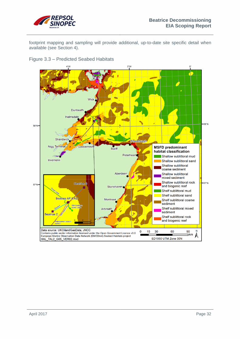
A map of predicted broadscale habitats of the Moray Firth as produced by EMODnet Seabed Habitats in support of the Marine Strategy Framework Directive is shown in Figure 3.3 (EUSeaMap2 2016). The wider area consists predominantly of shelf sublittoral sand and coarse sediments but areas of mud are also present, whilst around the Beatrice facilities and wind turbines the seabed sediment is either sand or coarse sediments, characteristic of shallow or shelf sublittoral areas (see inset in Figure 3.3).
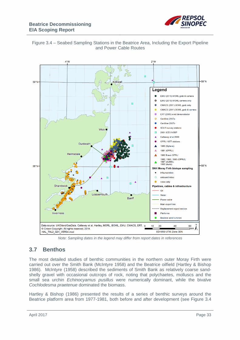
Survey data for this area (see Figure 3.4) indicate sediments comprise moderately sorted medium to fine sand with shell fragments (Hartley & Bishop 1986, DTI 2004, Holmes et al. 2004, ERT 2005, Gardline 2007b). Similar medium to fine sands are predicted to occur along most of the export pipeline and subsea power cable routes. Video and grab sampling survey results from Scottish Natural Heritage’s (SNH) biotope mapping (Foster-Smith et al. 2009) of the seabed, which covers ~7km of the export pipeline’s route as it approaches landfall, shows the presence of fine sediments with occasional shells. An area of very coarse sediment occurs within 3km of the power cable landfall, which led to this section of cable being surface laid.
Seabed contaminant concentrations (total hydrocarbons, polycyclic aromatic hydrocarbons and metals) around the Beatrice Field and wind turbine generators (AURIS 1993, ERT 2005, Gardline 2007a) generally reflect background concentrations (OSPAR 2005) and the results of nearby surveys (CMACS 2010, EMU 2011). Contaminant concentrations along the export pipeline and power cable routes are expected to be at background levels.
Contaminant concentrations may be elevated under, and immediately adjacent to, the Beatrice platforms as a result of historical drilling and discharge of cuttings drilled with low toxicity oil based muds prior to the cessation of such discharges. Elevated hydrocarbon and metal concentrations were observed within 750m of the Beatrice AD platform in 1992 (AURIS 1993). It is considered highly likely that present day concentrations will be substantially less as a consequence of natural degradation over time. Drill cuttings pile
10 Those deposited and reworked since the end of the last glacial period, ~12,000 years ago.
Beatrice Decommissioning EIA Scoping Report
April 2017 Page 32
footprint mapping and sampling will provide additional, up-to-date site specific detail when available (see Section 4).
Figure 3.3 – Predicted Seabed Habitats
Beatrice Decommissioning EIA Scoping Report
April 2017 Page 33
Figure 3.4 – Seabed Sampling Stations in the Beatrice Area, Including the Export Pipeline and Power Cable Routes
Note: Sampling dates in the legend may differ from report dates in references
3.7 Benthos The most detailed studies of benthic communities in the northern outer Moray Firth were carried out over the Smith Bank (McIntyre 1958) and the Beatrice oilfield (Hartley & Bishop 1986). McIntyre (1958) described the sediments of Smith Bank as relatively coarse sand-shelly gravel with occasional outcrops of rock, noting that polychaetes, molluscs and the small sea urchin Echinocyamus pusillus were numerically dominant, while the bivalve Cochlodesma praetenue dominated the biomass.
Hartley & Bishop (1986) presented the results of a series of benthic surveys around the Beatrice platform area from 1977-1981, both before and after development (see Figure 3.4

Beatrice Decommissioning EIA Scoping Report
April 2017 Page 34
for the locations of sampling undertaken in the Beatrice Field). The surveys indicated high species richness, both for individual sites and the area as a whole, suggesting a high natural diversity. Species abundance was also fairly high, and more comparable with inshore areas such as Sullom Voe than areas further offshore. As a result of the variable sediments in the area (and therefore the variety of habitats present), several community types were identified. These ranged from an assemblage in very fine sand sediment in slightly deeper waters in the south and west of the field, dominated by the bivalve Thyasira flexuosa, sea-pen Virgularia mirabilis and polychaete worm Aricidea catherinae, through a fine sand fauna characterised by Tellina fabula, to the coarser sand (>5% gravel) sediments of the Smith Bank in the northeast, dominated by the bivalve Tellina (Moerella) pygmaea and polychaetes such as Scoloplos armiger, Lumbrineris gracilis and Polycirrus spp. A seabed survey conducted at the Beatrice Field in 1992 found undisturbed communities were dominated numerically by the polychaete worms Spiophanes bombyx and S. armiger (AURIS 1993). More recently, infaunal analysis of samples taken at the Jacky Field (Gardline 2007a), to the north of Beatrice, indicated that in areas of medium to coarse sediment, S. bombyx, T. (M.) pygmaea, Cochlodesma praetenue and the small sea urchin Echinocyamus pusillus were dominant.
Ecological changes around the Beatrice AD and AP platforms were investigated by Addy et al. (1984) following the discharge of cuttings drilled with OBM. Results of surveys undertaken soon after OBM cuttings discharges indicated the presence of various zones of ecological effects, with the most marked effects localised (<115m) and characterised by a reduction in the number of dominant taxa and the abundance of the opportunistic polychaete Capitella capitata. Beyond 115m, progressively few C. capitata individuals were observed and faunal richness generally increased to undisturbed sediment levels.
A baseline survey from the Beatrice Wind Farm Demonstrator turbine sites revealed diversity was uniformly high across the survey area (ERT 2005). Samples were taken from water depths of 43-46m and sediments were generally fine sands. The infauna was characterised by the polychaetes Chaetozone setosa, Lumbrineris gracilis and Exogone hebes, the amphipods Urothoe elegans, Ampelisca tenuicornis and Bathyporeia spp., the bivalve mollusc Tellina fabula and Echinocyamus pusillus. Very little epifauna was observed from video footage and grab samples taken around the wind turbines and at stations to the north of the Beatrice Alpha complex (ERT 2005, Gardline 2007b). Visible epifauna included occasional hydroids and single specimens of the whelk Buccinum undatum, the scallop Pecten maximus, sea star Asterias rubens and a species of brittlestar.
Very limited benthic ecology data exists for the seabed along the export pipeline and power cable routes, with the exception of a recent broadscale biotope mapping survey by SNH (Foster-Smith et al. 2009) for the inner Moray Firth (up to the 30m bathymetric contour). This survey covers the export pipeline route from landfall at Shandwick, seaward out to approximately 7km. Video and grab samples showed sandy mud and muddy sand sediments along the route which were characterised by the presence of the brittlestars, Amphiura filiformis and Ophiura ophiura, and the gastropod Turritella communis. At depths >20m there were seabed burrows including those of the prawn Nephrops norvegicus.
Conservation species of interest found in the Moray Firth include the horse mussel (Modiolus modiolus) and the fan mussel (Atrina fragilis) (see Section 3.13). Surveys around the Beatrice facilities and wind turbines have not recorded any A. fragilis specimens and only solitary individuals of Modiolus, with no evidence of Modiolus reefs (ERT 2005, Gardline 2007a, CMACS 2010, EMU 2011).

Beatrice Decommissioning EIA Scoping Report
April 2017 Page 35
3.8 Cephalopods Cephalopods are mainly short-lived, fast growing molluscs such as squid, octopus and cuttlefish. Cephalopods play a key role in marine foodwebs; they feed opportunistically on a wide variety of prey (polychaetes, molluscs, crustaceans and fish) and constitute a major prey source for a number of marine top predators including commercially important fish species, cetaceans, seals and seabirds. In the Moray Firth, cephalopods form an important part of the diet for several top predators; the grey seal (Halichoerus grypus) and harbour seal (Phoca vitulina) have a preference for octopus (Eledone cirrhosa), while squid are regularly found in the stomach contents of bottlenose dolphin (Tursiops truncatus), harbour porpoise (Phocoena phocoena) as well as cod (Gadus morhua) (Boyle & Pierce 1994, Tollit & Thompson 1996, Daly et al. 2001, Santos et al. 1994, 1995).
The main commercial cephalopod species in Scottish waters is the veined squid (Loligo forbesii) (Boyle & Pierce 1994, ICES 2016). This species is thought to be present in all seasons; but the spatial pattern of abundance varies with season, with Scottish coastal waters yielding a clear peak in catches during October and November (Pierce et al. 1994, 1998). A fishery for Loligo forbesii has developed in the Moray Firth over the last 20 years, with fishermen taking advantage of the lack of quota restrictions on this species (DECC 2016). ICES landings data for 2014 and 2015 reveal that squid comprise almost all cephalopod landings and are a key component of landings within the Moray Firth (Scottish Government website).
Spawning grounds for L. forbesii are not fully understood; spatial patterns in fishery data suggest that spawning occurs in inshore waters, and juveniles then move offshore. It has been suggested that there are spawning grounds for L. forbesii within the Moray Firth, with spawning beginning in the winter months and small squid first appearing in July/August (Young et al. 2006, Hastie et al. 2009, Viana et al. 2009, Oesterwind et al. 2010).
3.9 Fish and Shellfish Marine Species – Spawning and Nursery Grounds
The Moray Firth area supports a number of commercially important species, several of which use the area as spawning and/or nursery grounds. The spatial and temporal distributions of spawning and nursery grounds of some commercial species in the UK were described in Coull et al. (1998) and more recently revised by Ellis et al. (2012). At the scale of the Moray Firth, some uncertainty and data gaps remain, particularly relating to spawning grounds for elasmobranchs.
The Beatrice area lies within ICES Rectangles 44E6 and 45E6. These rectangles overlap or with known spawning and nursery grounds of eight commercially important fish and shellfish species of particular commercial importance as well as nursery grounds of eighteen species (Table 3.1 and Figure 3.5 and Figure 3.6).

Beatrice Decommissioning EIA Scoping Report
April 2017 Page 36
Table 3.1 – Species with Spawning and/or Nursery Grounds in the Beatrice Area Species Spawning grounds Peak spawning Nursery
Herring (Clupea harengus)1,2 August – September (High intensity) Sprat (Sprattus sprattus)1,2 May – August Cod (Gadus morhua)1,2 January – April (High intensity) Whiting (Merlangius merlangus)1,2 February – June (High intensity) Plaice (Pleuronectes platessa)1,2 December – March (Low intensity) Lemon Sole (Microstomus kitt)1,2 April – September Sandeel (Ammodytes marinus)1,2 November – February (Low intensity) Nephrops (Nephrops norvegicus)1 January – December Mackerel (Scomber scombrus)2 - - (Low intensity) Blue whiting (Micromesistius poutassou)2
- - (Low intensity)
Haddock (Melanogrammus aeglefinus)1
- -
Saithe (Pollachius virens)1 - - European hake (Merluccius merluccius)2
- - (Low intensity)
Ling (Molva molva)2 - - (Low intensity) Monkfish (Lophius piscatorius)2 - (High intensity) Spurdog (Squalus acanthias)2 - - (Low intensity) Thornback ray (Raja clavata)2 - - (Low intensity) Spotted ray (Raja montagui)2 - - (Low intensity)
Source: Coull et al. (1998), Ellis et al. (2012)
In the Moray Firth, discrete banks of clean gravel are regularly used by spawning herring (Gordon 2003). Juvenile herring from both the Moray Firth population and those from the west coast of Scotland use the inner firths as nursery grounds (Marine Scotland website). The herring stay within the inner firths for 1-2 years, after which they move to the outer Moray Firth and offshore where they join adult populations. Sprat use deeper waters of the outer Moray Firth to spawn and adults overwinter in nearshore areas of the Firth.
The Moray Firth, and in particularly Smith Bank, is one of the most important spawning grounds in the central North Sea for plaice (Coull et al. 1998, Goldsmith et al. 2015). Smith Bank is also important for sandeel (Sparholt 2015) and cod, the latter migrating into the area from offshore to spawn (Hislop et al. 2015). The outer Moray Firth is of particular importance to adult spawning and juvenile lemon sole. Juvenile haddock remain and feed in the shallow waters of the Firth until they mature; adult haddock also feed in the Moray Firth and migrate in winter to spawn in the North Sea in spring.
Among sharks, skates and rays, the Moray Firth area is important for several commercial species including spurdog (Squalus acanthias), lesser spotted dogfish (Scyliorhinus canicula), starry ray (Amblyraja radiata) and cuckoo ray (Leucoraja naevus) as well as thornback ray (Raja clavata) and spotted ray (Raja montagui) (Ellis et al. 2004). In addition, sightings of basking shark (Cetorhinus maximus) occur regularly albeit infrequently during the summer (Solandt & Ricks 2009, Solandt & Chassin 2014).

Beatrice Decommissioning EIA Scoping Report
April 2017 Page 37
Figure 3.5 – Selected Fish and Shellfish Nursery Areas

Beatrice Decommissioning EIA Scoping Report
April 2017 Page 38
Figure 3.6 – Fish and Shellfish Spawning Areas

Beatrice Decommissioning EIA Scoping Report
April 2017 Page 39
Several shellfish species including Nephrops, edible crabs, lobsters, scallops and queen scallops, edible winkles, edible mussels, whelks and razorfish are found in the Moray Firth area (Chapman 2004). The Nephrops population is found along a strip of suitable sediment which broadens out eastwards from the inner Moray Firth to Macduff (Coull et al. 1998). Important scallop fishing grounds exist on Smith Bank, and off the northwest coast between Wick and Golspie. Edible mussels form mussel beds in muddy and sandy areas, particularly in the Dornoch, Cromarty and Inverness/Beauly Firths, and also colonise rocky shores in the area. Cockles, although widespread, are generally concentrated in the intertidal habitats of the inner firths and along the southern coast of the Moray Firth.
Diadromous and Freshwater Species
Atlantic salmon (Salmo salar) and sea lamprey (Petromyzon marinus) occur in the Moray Firth area, and are listed as Annex II protected species under the EU Habitats Directive, as well as being on the OSPAR List of Threatened and/or Declining Species and Habitats11. Several sites in the region have been designated as Special Areas of Conservation (SACs) for the presence of one or more of these species (see Section 3.13).
The waters of the Moray Firth are important for Atlantic salmon, with more than one third of Scotland’s main salmon rivers flowing into the catchment area (Moray Firth Partnership website). The main salmon rivers in the area are on the southern shore, especially the River Spey (a designated SAC with Atlantic salmon a primary feature) and its tributaries, and also the rivers Deveron, Findhorn and Nairn; these rivers are also important for sea trout (Salmo trutta). The Berriedale and Langwell Waters and the river Oykel on the northwest coast contain important populations of salmon and are designated SACs. The river Helmsdale, and to a lesser extent the rivers Fleet and Brora, are important for recreational fishing of salmon and sea trout. Further inland, the river Moriston, which drains into Loch Ness, is designated a SAC with Atlantic salmon a qualifying feature.
Atlantic salmon migrate from Scottish rivers towards distant feeding grounds and have been found West of Greenland and around the Faroe Islands but the exact migration route is not known; on their return, tagging studies have shown evidence of movement into the Moray Firth along the mainland coast from both the northwest and south (Malcolm et al. 2010). A large migration of these anadromous fish through the Moray Firth has been inferred from the feeding habits of bottlenose dolphins which have been observed to move to inshore areas of the Firth and take large salmonids during summer (Wilson et al. 1997).
Sea lamprey are jawless fish which spawn in freshwater but complete their life cycle at sea. They require clean gravel for spawning, along with silt or sand habitat to accommodate the burrowing larval phase. Sea lamprey have been recorded from several rivers in the Moray Firth area, most notably in the Spey, where they are a primary reason for the river’s designation as a SAC. Surveys of the lower river Spey in 2002 identified many areas of suitable lamprey habitat, although sea lamprey larvae were rare (Laughton & Burns 2005).
The freshwater pearl mussel (Margaritifera margaritifera) is a threatened species on the IUCN Red List. It inhabits cool, clean, fast-flowing rivers and streams with healthy native salmonid populations and it is found in several water courses draining into to Moray Firth, and is a primary reason for the designation of several SACs in the region: the rivers Oykel,
11 OSPAR List of Threatened and/or Declining Species and Habitats (Reference Number: 2008-6).
Beatrice Decommissioning EIA Scoping Report
April 2017 Page 40
Evelix, Spey and Moriston. While it remains in freshwater for the duration of its life cycle, it spends its larval stage attached to the gills of diadromous salmonids such as Atlantic salmon and so is reliant upon them for survival. The larvae attach themselves to the gills of salmonids around mid-late summer, before dropping off the following spring to settle in riverbed gravels where they grow to adulthood (JNCC website a).
3.10 Birds The Moray Firth and surrounding coastline is of year round importance for marine birds, a summary of which is presented in Table 3.2, and discussed in subsequent sections.
Table 3.2 – Summary of Bird Distribution in the Moray Firth Area throughout the Year Month Abundance in the Moray Firth blocks
January Large numbers of waders in coastal areas. Abundance of guillemots and razorbills in coastal areas. Concentrations of gannets in Smith Bank area. Herring gulls, fulmars and great black-backed gulls abundant at sea.
February Large numbers of eider ducks found along coast. Guillemots distributed at sea with main North Sea concentrations in the Moray Firth.
March Concentrations of gannets, razorbills, kittiwakes and guillemots recorded at sea, particularly in Smith Bank area. Abundance of herring gulls in inner Moray Firth area.
April Cormorant sightings in coastal waters. Small numbers of lesser black-backed gull sighted throughout the Moray Firth and offshore. Large offshore concentrations of guillemots over Smith Bank. Congregation of sea ducks in coastal waters.
May Start of breeding season for most seabirds – very few present in areas away from breeding sites. Low numbers of great skua widely distributed at sea. Small numbers of lesser black-backed gull sighted throughout the Moray Firth and offshore.
June Peak of breeding season. Majority of seabird sightings in coastal areas. July Moulting season for inshore and coastal birds. During this time some auks and ducks
are flightless. Flightless moulting adults and juveniles congregate in the Moray Firth. August Offshore congregations of flightless moulting adult and juvenile auks. Peak in number
of Arctic and great skua widely distributed in Moray Firth. Concentrations of herring gulls present over Smith Bank. Large concentrations of post-breeding puffins occur off northern Caithness coast. Density of guillemots are highest.
September Large numbers of fulmars, sooty shearwaters, Arctic skua and great skua dispersed at sea. Peak abundance of Manx shearwater in coastal area of inner Moray Firth. High abundance of gannets over northeastern part of Smith Bank. Influx of common scoter into Moray Firth.
October Continued influx of common scoter. Concentrations of gannets in Smith Bank area. Arctic skua widely dispersed over offshore area. Small numbers of lesser black-backed gull sighted throughout the Moray Firth and offshore.
November Moray Firth remains important for razorbills, guillemots and herring gulls. Area is also important for long-tailed ducks arriving from offshore.
December Peak in herring gull abundance, especially off the Moray coast. Guillemots and razorbills still present in high numbers. The area also sustains internationally important flocks of long-tailed duck, common and velvet scoter, goosander and red-breasted merganser.
Source: Tasker & Pienkowski (1987), Tasker (1996), Talisman (2006)
Seabirds
Breeding seabirds including kittiwake, guillemot and razorbill at colonies along the coastline commute offshore to feed, particularly over Smith Bank. Cormorants, shags, gulls and terns
Beatrice Decommissioning EIA Scoping Report
April 2017 Page 41
tend to feed closer to shore. The waters of the outer Moray Firth and the nearshore waters off the Moray coast are of particular importance as feeding areas (Tasker 1996). Following the breeding period adult and juvenile auks move offshore where the adults moult. The waters around Smith Bank also support important concentrations of shags, while coasts along the southern Moray Firth are of particular year round importance for herring gulls. The importance of the area is reflected in the designation of a number of international and national conservation sites on land and at sea (see Section 3.13).
The east Caithness cliffs, within 20km of the Beatrice Field facilities support vast numbers of breeding seabirds, and the area is designated as an SPA, SAC and MPA. Qualifying features for these designations include sea-cliff habitat supporting breeding populations of European importance of peregrine (Falco peregrinus), guillemot (Uria aalge), herring gull (Larus argentatus), kittiwake (Rissa tridactyla), razorbill (Alca torda), shag (Phalacrocorax aristotelis) and black guillemot (Cepphus grylle). These species, along with several others, contribute towards the area regularly supporting 300,000 individual seabirds during the breeding season (JNCC website b). The seabirds feed in both the inshore waters adjacent to the cliffs, as well as throughout other areas of the Moray Firth and beyond.
The main source of data on population size is the decadal census of British and Irish seabird colonies; the most recent, ‘Seabird 2000’, took place from 1998-2002 with results published by Mitchell et al. (2004). On an annual basis, key colonies along the Moray Firth are visited as part of the Seabird Monitoring Programme (SMP) and results on population trends and conservation status are reported regularly. The SMP aims to provide information on changes in seabird numbers at selected sites to monitor aspects of the health of the wider marine environment and inform conservation and research needs (Mavor et al. 2006, JNCC 2014). Additionally, strategic programmes including the Future of the Atlantic Marine Environment (FAME), and more recently Seabird Tracking and Research (STAR) which has sought to continue the work undertaken for FAME, have provided results on the movement of a number of seabird species since 2010 such as fulmar, guillemot, kittiwake, razorbill and shag, including in relation to a number of colonies in Scotland. Though involving relatively few birds and short tagging periods, the FAME study output did show use of the Moray Firth by fulmar, kittiwake and razorbill from Orkney colonies for foraging during the breeding season.
For the Beatrice Wind Farm Demonstrator project, baseline bird surveys were conducted from the Beatrice AP platform in 2005. Total survey effort was 171 hours and surveys were conducted in all months of the year, although with variable effort between months (Talisman 2006). The ten most frequently observed birds (and abundances) are listed in Table 3.3.
Auks showed clear peaks in abundance in April and June. Kittiwake abundance peaked in July, but was fairly high throughout spring-summer. Fulmar were abundant throughout the majority of the year, although notably less abundant from September-December. Gannet abundance was elevated from May-November, with peak numbers during October. Great black-backed gull were most abundant during autumn and winter months (Talisman 2006).
Boat-based surveys were conducted for the Beatrice Offshore Wind Farm (BOWL) project in the Moray Firth between October 2009 and September 2011 (RPS 2012). The boat based surveys took place over two days each month covering an area of approximately 383km2 which included a 4km buffer of the wind farm site boundary. A single aerial survey was undertaken in March 2011 where weather prevented the use of boat based methods. For the 22 boat-based surveys, 21,419 individuals were recorded across 22 species. Those most frequently observed species are summarised in Table 3.3. Six pre-construction digital

Beatrice Decommissioning EIA Scoping Report
April 2017 Page 42
aerial surveys were undertaken between May and August 2015 covering the BOWL site and an area extending westwards to the East Caithness cliffs covering an area of 1,142km2
(BOWL 2016). Densities of seabirds on the water and in flight were estimated for gannet, guillemot, kittiwake, puffin, razorbill, great black-backed gull and herring gull, which were found to be similar to those for the boat-based surveys undertaken in 2009 and 2011.
Table 3.3 − Most Frequently Observed Birds from Surveys Relating to the Beatrice Demonstrator and BOWL Projects
Species Beatrice AP 2005 BOWL area 2008-2011
Observations Individuals Observations Kittiwake 1384 2943 2519 Auk1 1113 5757 12249 Fulmar 887 1078 2459 Gannet 528 707 528 Great black-backed gull 246 424 502 Herring gull 137 193 415 Great skua 49 51 91 Shag 30 63 41 Meadow pipit 25 33 - Sooty shearwater 17 34 118 Arctic tern - - 29 Arctic skua - - 19
Notes: All data are totals for the year. 1All auk species aggregated (includes guillemot, black guillemot, little auk, puffin and razorbill). Source: Talisman (2006), RPS (2012)
Waterbirds
The firths, bays and other coastal areas of the Moray Firth basin are of great importance to wintering and passage wildfowl, as well as for breeding waders and other waterbirds; several Ramsar and SPA sites are designated for such features in the region (see Section 3.13).
Numbers of non-breeding waterbirds throughout the UK are regularly estimated from land-based surveys as part of the Wetland Bird Survey (WeBS). Several sites in the Moray Firth area have such high numbers of birds (5yr average of >20,000 birds) to be consistently included in the UK list of principal sites for non-breeding waterbirds; these are the Inner Moray and Inverness Firth, the Dornoch Firth, the Cromarty Firth as well as the Loch of Strathbeg (Austin et al. 2014). The area is of considerable importance for seaduck, most of which occur within 5km of the shore. Large flocks are also regularly recorded in the outer Dornoch Firth, off Culbin Sands, off Burghead Bay and in Spey Bay (Banks et al. 2006). Wintering waders are widely distributed throughout the inner Moray Firth. Major concentrations can be found on the large intertidal areas of the inner Moray Firth (Craddock & Stroud 1996, Stroud & Craddock 1996). Large aggregations of several species of geese are present at a number of sites throughout the region during winter months.
In addition, aerial surveys of wintering seaducks, divers and grebes have been conducted annually since 2000/2001 by JNCC with a particular focus on the Moray Firth area to support work progressing the identification of SPAs; long-tailed duck, common scoter and common
Beatrice Decommissioning EIA Scoping Report
April 2017 Page 43
eider were the most abundant species in all years (Wilson et al. 2006, Söhle et al. 2006, Lewis et al. 2009).
Vulnerability to Oil Pollution
The vulnerability of seabird species to oil pollution at sea is dependent on a number of factors (for example, species type in the area, number of species, number of individuals) and varies considerably throughout the year. The Seabird Oil Sensitivity Index (SOSI) was developed (see Webb et al. 2016) as an update and replacement to the Offshore Vulnerability Index (OVI) developed by JNCC (JNCC 1999, also see Williams et al. 1994). The SOSI is based on the methods of Tasker and Pienkowski (1987) and Williams et al. (1994), updated using Certain et al. (2015) and is presented as a series of monthly UKCS block gridded maps, with each block containing a score on a scale of low to extremely high. These scores indicate where the highest seabird sensitivities might lie (based on the combination of abundance and susceptibility to oil spill effects) if there were to be a pollution incident (see Figure 2.3).
Seabird sensitivity to surface pollution in the Beatrice area and adjacent blocks is classified as high, very high or extremely high for 10 months of the year (Webb et al. 2016)12 (see Figure 3.7 which shows the median values used to summarise the central point of the data owing to the skewed nature of the SOSI scores). It should be noted that low availability of recent data is indicated for a number of months, highlighted by Webb et al. (2016) as a wider issue for the index which requires extended data coverage to be improved. As context, the OVI indicates seabird vulnerability to surface pollution is very high (the highest category) across the entire Moray Firth throughout all months of the year.
12 Also see OGA (2016). 29th Round Other Regulatory Issues – version at 23rd August 2016. https://www.ogauthority.co.uk/licensing-consents/licensing-rounds/

Beatrice Decommissioning EIA Scoping Report
April 2017 Page 44
Figure 3.7 – Monthly Seabird Oil Sensitivity Index Scores
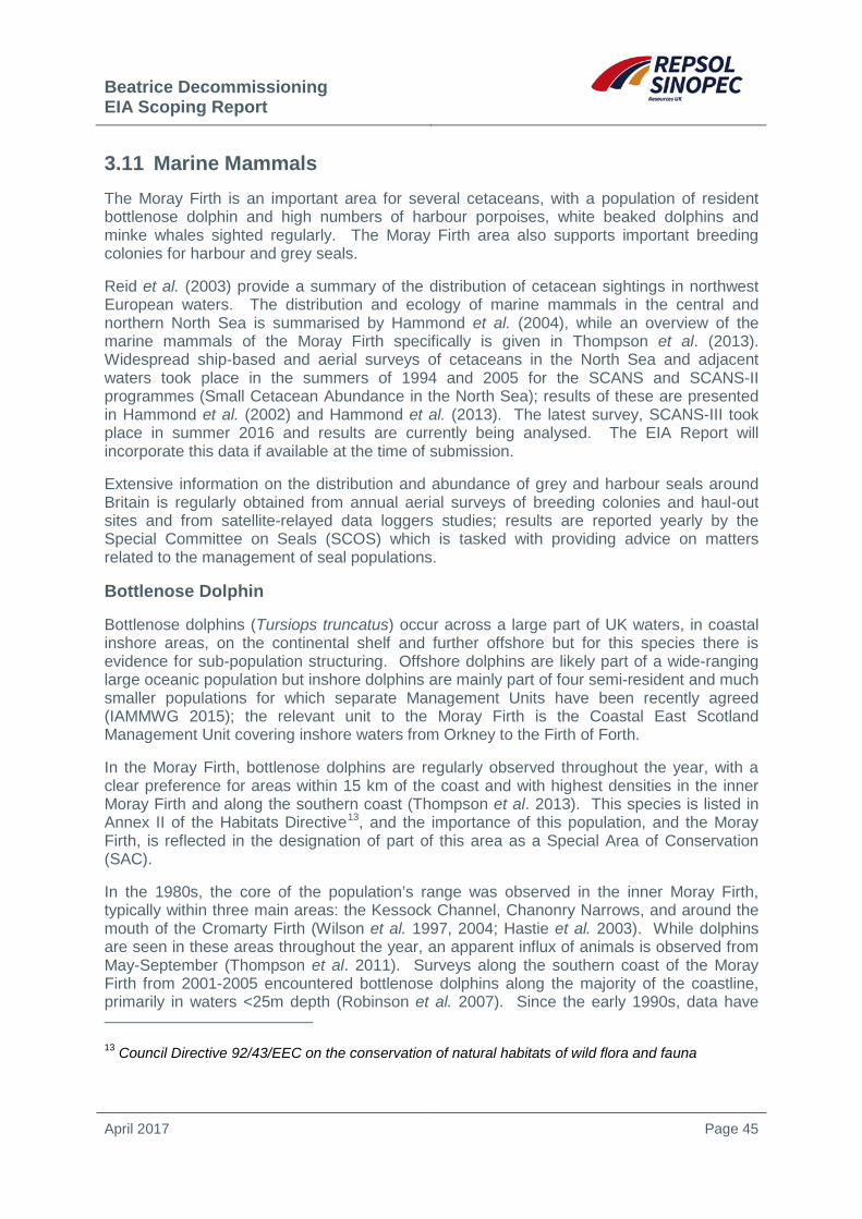
Beatrice Decommissioning EIA Scoping Report
April 2017 Page 45
3.11 Marine Mammals The Moray Firth is an important area for several cetaceans, with a population of resident bottlenose dolphin and high numbers of harbour porpoises, white beaked dolphins and minke whales sighted regularly. The Moray Firth area also supports important breeding colonies for harbour and grey seals.
Reid et al. (2003) provide a summary of the distribution of cetacean sightings in northwest European waters. The distribution and ecology of marine mammals in the central and northern North Sea is summarised by Hammond et al. (2004), while an overview of the marine mammals of the Moray Firth specifically is given in Thompson et al. (2013). Widespread ship-based and aerial surveys of cetaceans in the North Sea and adjacent waters took place in the summers of 1994 and 2005 for the SCANS and SCANS-II programmes (Small Cetacean Abundance in the North Sea); results of these are presented in Hammond et al. (2002) and Hammond et al. (2013). The latest survey, SCANS-III took place in summer 2016 and results are currently being analysed. The EIA Report will incorporate this data if available at the time of submission.
Extensive information on the distribution and abundance of grey and harbour seals around Britain is regularly obtained from annual aerial surveys of breeding colonies and haul-out sites and from satellite-relayed data loggers studies; results are reported yearly by the Special Committee on Seals (SCOS) which is tasked with providing advice on matters related to the management of seal populations.
Bottlenose Dolphin
Bottlenose dolphins (Tursiops truncatus) occur across a large part of UK waters, in coastal inshore areas, on the continental shelf and further offshore but for this species there is evidence for sub-population structuring. Offshore dolphins are likely part of a wide-ranging large oceanic population but inshore dolphins are mainly part of four semi-resident and much smaller populations for which separate Management Units have been recently agreed (IAMMWG 2015); the relevant unit to the Moray Firth is the Coastal East Scotland Management Unit covering inshore waters from Orkney to the Firth of Forth.
In the Moray Firth, bottlenose dolphins are regularly observed throughout the year, with a clear preference for areas within 15 km of the coast and with highest densities in the inner Moray Firth and along the southern coast (Thompson et al. 2013). This species is listed in Annex II of the Habitats Directive13, and the importance of this population, and the Moray Firth, is reflected in the designation of part of this area as a Special Area of Conservation (SAC).
In the 1980s, the core of the population’s range was observed in the inner Moray Firth, typically within three main areas: the Kessock Channel, Chanonry Narrows, and around the mouth of the Cromarty Firth (Wilson et al. 1997, 2004; Hastie et al. 2003). While dolphins are seen in these areas throughout the year, an apparent influx of animals is observed from May-September (Thompson et al. 2011). Surveys along the southern coast of the Moray Firth from 2001-2005 encountered bottlenose dolphins along the majority of the coastline, primarily in waters <25m depth (Robinson et al. 2007). Since the early 1990s, data have 13 Council Directive 92/43/EEC on the conservation of natural habitats of wild flora and fauna

Beatrice Decommissioning EIA Scoping Report
April 2017 Page 46
shown the population’s range to include waters off Aberdeenshire, Tayside and Fife, including the Firth of Forth with high individual variability in patterns of movement between Moray Firth SAC and Tayside and Fife areas (Wilson et al. 2004, Thompson et al. 2011, Quick et al. 2014).
The latest number of bottlenose dolphins using the SAC has been estimated at 94 individuals (95%CI 81-110) in the summer 2013; annual estimates over the period 1990-2013; show considerable inter-annual variability (range 43-134), but no significant linear trend over time has been detected (Cheney et al. 2014).
Harbour Porpoise
The harbour porpoise is the most common cetacean in the North Sea. It is widely distributed throughout the Moray Firth, with frequent sightings in nearshore and offshore waters. Although seen throughout the year, sightings are most frequent and widespread in this region between April and September.
Boat-based visual and acoustic surveys of the Moray Firth SAC (see Section 3.13) and adjacent waters from January-October 2001 encountered small schools of harbour porpoise throughout most of survey area (Hastie et al. 2003). However, porpoises were rarely encountered in inshore waters of the inner Moray Firth, where bottlenose dolphin were most frequently encountered. Passive acoustic monitoring during late summer/autumn at the Beatrice Field showed harbour porpoise to be frequently present, with short visits recorded several times per day (Talisman 2006). Widespread distribution and regular presence across the Moray Firth was confirmed in more recent studies (Thompson et al. 2013). The Smith Bank and Outer Moray Firth have been identified as persistent summer high density areas following distribution modelling of survey data across the UKCS (Heinänen & Skov 2015).
Analyses of the stomach contents of harbour porpoise stranded in Scotland from 1992-2003 (primarily the east coast) revealed sandeels and whiting to be the main prey items (Santos et al. 2004). Other small gadoids and cephalopods were also important, along with herring in some years.
White-Beaked Dolphin
White-beaked dolphins (Lagenorhynchus albirostris) are frequently sighted in the Moray Firth, primarily in offshore waters of the outer firth. Along with harbour porpoise, they are the most commonly occurring cetaceans in the central and northern North Sea. Although sightings are made throughout the year, the species is most frequently observed between June and October.
Minke Whale
Minke whales (Balaenoptera acutorostrata) are found throughout much of the Moray Firth during summer months, with sightings recorded across the outer Moray Firth, the southern coast and occasionally the inner Moray Firth. They have been recorded during both SCANS I and II (Hammond et al. 2002, Hammond et al. 2013), and the inshore waters of the southern Moray Firth (primarily between Spey Bay and Fraserburgh (Robinson et al. 2009)) are thought to provide a rich feeding ground, especially between June and October (Robinson & Tetley 2007, Paxton et al. 2014). Minke whales in this area appear to have a strong preference for water depths between 20 and 50m, steep shelf slopes and sandy-

Beatrice Decommissioning EIA Scoping Report
April 2017 Page 47
gravel sediment type, and as a consequence, are a feature of the proposed Southern Trench MPA (see Section 3.13).
Other Cetaceans
While mainly seen along the shelf break and over deeper waters such as the Faroe-Shetland Channel, long-finned pilot whale (Globicephala melas) are occasionally sighted in the Moray Firth; most sightings have occurred in June-August. Atlantic white-sided dolphin (Lagenorhynchus acutus) is common along the continental slope and deeper waters to the north and west of Scotland; they are occasionally seen in the northern North Sea, particularly from July-August, and may be occasionally present in the outer Moray Firth. Risso’s dolphin (Grampus griseus) has been recorded in the outer Moray Firth area with sightings most common between May and September. Robinson et al. (2017) reviewed killer whale (Orcinus orca) sightings in the Moray Firth between 2001 and 2015; the majority of sightings were in the outer Moray Firth, particularly along the northern coastline. Killer whales were seen throughout the year, with peak observations between May and July.
Harbour Seal
Harbour (or common) seals (Phoca vitulina) haul out on tidally exposed areas of rock, sandbank or mud throughout the Moray Firth area, with the greatest concentration found in the inner Moray Firth particularly during June, July and August (breeding season and moult) (Thompson et al. 1996). Important haul-out sites are found at Ardersier (at the mouth of Inverness Firth), the Beauly, Cromarty and Dornoch Firths, with smaller haul out groups near Brora, at Spey Bay and Findhorn. The harbour seal is listed in Annex II of the Habitats Directive and the importance of its presence in the region is reflected in the designation of Dornoch Firth and Morrich More as a SAC.
In the area surveyed annually (Helmsdale to Findhorn) 705 harbour seals were counted in 2015, compared with 693 counted in 2014 (Duck & Morris 2016). These are the two lowest counts, but in contrast with the extreme declines experienced elsewhere on the East Coast of Scotland (in particular Shetland, Orkney and Forth of Firth) these represent a decline of just over 20% than the mean count between 2002 and 2013 (909 seals). Considerable variability between years across different sites within the Moray Firth have been recorded; for example, in 2015 Cromarty Firth had the lowest count (n=22), but Culbin and Findhorn had the highest (330) (Duck & Morris 2016).
Following a period of decline, harbour seal counts in the Moray Firth have stabilised, while general declines have continued across several areas, in particular Shetland, Orkney and the Firth of Tay; research into the causes of the decline is ongoing14 (SCOS 2015).
Harbour seals tend to forage within 60km of their haul out sites, and foraging areas can change depending on fish abundance (Thompson et al. 1996). In the Moray Firth, important foraging areas, include east of Tarbat Ness, north of Burghead, as well as the deep water of the inner Moray Firth. Larger seals appear to travel further out into the Moray Firth to forage than smaller seals. They also feed in rivers flowing into the Moray Firth. More recently, studies of harbour seal foraging distribution using satellite telemetry have revealed this species to forage much further offshore that previously thought and to display a large degree
14 http://synergy.st-andrews.ac.uk/harbourseals/

Beatrice Decommissioning EIA Scoping Report
April 2017 Page 48
of individual variation in foraging patterns and behaviour (Hammond et al. 2004, Sharples et al 2008, Sharples et al. 2012). In addition to seals from local haul-out sites, tagging studies have shown the Moray Firth to be part of the foraging range of seals from Orkney (Sharples et al. 2012). Maps displaying modelled estimates of at sea usage by harbour seals (Jones et al. 2013, also see Jones et al. 2015), show low to moderate seal density in the Moray Firth, including around the Beatrice facilities (Figure 3.8)
Figure 3.8 – Harbour Seal Estimated at Sea Usage
Grey Seal
Grey seals (Halichoerus grypus) breed on rocky beaches and in caves on the Moray Firth coast north of Helmsdale and also use haul out sites in the Dornoch Firth and on the South coast, particularly Culbin and Findhorn. Grey seals forage over a wider area than harbour seals, travelling up to 145km from haul out sites (Thompson et al. 1996). Numbers of seals at haul out sites are generally greatest from June-September. Grey seals are an Annex II
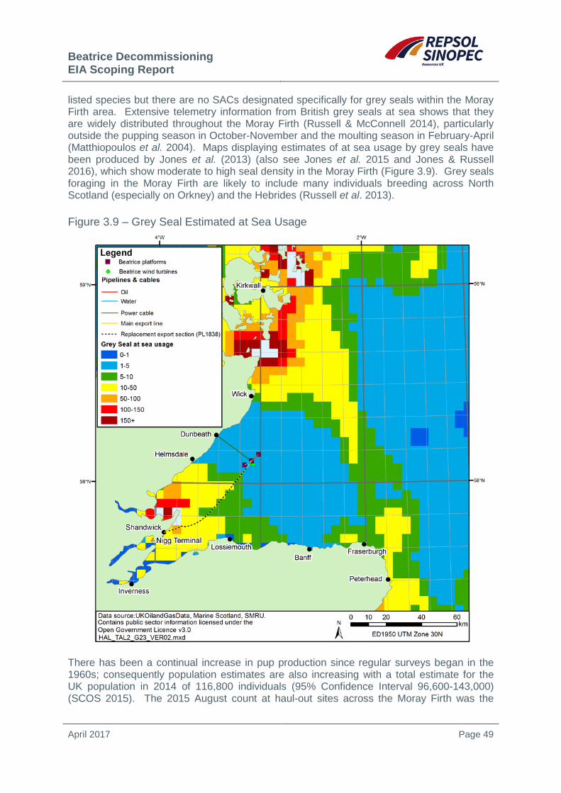
Beatrice Decommissioning EIA Scoping Report
April 2017 Page 49
listed species but there are no SACs designated specifically for grey seals within the Moray Firth area. Extensive telemetry information from British grey seals at sea shows that they are widely distributed throughout the Moray Firth (Russell & McConnell 2014), particularly outside the pupping season in October-November and the moulting season in February-April (Matthiopoulos et al. 2004). Maps displaying estimates of at sea usage by grey seals have been produced by Jones et al. (2013) (also see Jones et al. 2015 and Jones & Russell 2016), which show moderate to high seal density in the Moray Firth (Figure 3.9). Grey seals foraging in the Moray Firth are likely to include many individuals breeding across North Scotland (especially on Orkney) and the Hebrides (Russell et al. 2013).
Figure 3.9 – Grey Seal Estimated at Sea Usage
There has been a continual increase in pup production since regular surveys began in the 1960s; consequently population estimates are also increasing with a total estimate for the UK population in 2014 of 116,800 individuals (95% Confidence Interval 96,600-143,000) (SCOS 2015). The 2015 August count at haul-out sites across the Moray Firth was the

Beatrice Decommissioning EIA Scoping Report
April 2017 Page 50
highest ever recorded (n=1917) but variability is very high, with only 532 seals recorded in 2014 and ranging between 392 and 1917 between 1997 and 2015 (Duck & Morris 2016).
3.12 Otters The otter (Lutra lutra) is a semi-aquatic mammal occurring throughout a range of ecological conditions, including inland freshwater and coastal habitats. The northern and eastern Highlands surrounding the Moray Firth are important areas for otters, with a number of SACs designated for their presence. Of these, the River Spey SAC and Dornoch Firth and Morrich More SAC include coastal and/or estuarine habitats.
The Dornoch Firth and Morrich More SAC is the most northerly large, complex estuary in the UK and is virtually unaffected by industrial development. The estuarine system, comprising sand dunes, woodlands and lochans provide an excellent habitat for otters, as do the Rivers Evelix and Oykel, which both feed into the site. It is the only specifically estuarine site designated as a SAC for otter on the east coast of Scotland. The estuary supports a good population of otters and observations of cub tracks provide evidence of breeding (Strachan 2007).
The River Spey maintains a persistently large population of otters. Reedbeds and islands, important riverine features for otters, are abundant and populations of prey species are healthy. Evidence of breeding, including breeding holts, cub tracks and sightings of family groups were noted (Strachan 2007). The lochs, lochans and ditches of the nearby Insch Marshes, provide ideal sites for feeding, resting and shelter for otters.
3.13 Conservation Sites International Conservation Sites
To give appropriate protection to the many habitats and species of international conservation importance in the Moray Firth area, a number of marine, coastal and inland sites have been designated or are currently proposed for designation.
European designations comprise Special Protection Areas (SPAs) established under Birds Directive15, and Special Areas of Conservation (SACs) under the Habitats Directive16. SPAs and SACs collectively form part of the European ecological network of Natura 2000 sites. Ramsar sites are wetlands of international importance designated under the Ramsar Convention17. Globally, the value of the Moray Firth in bird conservation has been recognised with five sites listed as Important Bird Areas by BirdLife International; protection for these areas has been provided for through SPA and Ramsar site designations. The suite of SPAs on land in Scotland is well established, but further work is needed to complete a network at sea. Results to date have identified important seabird aggregations in the Moray Firth (Kober et al. 2012). Some of these have been taken forward for potential designation (pSPAs) and were subject to public consultation in 2016 and 2017, with a decision on designation to be made by Ministers thereafter.
15 Council Directive 2009/147/EC on the conservation of wild birds 16 Council Directive 92/43/EEC on the conservation of natural habitats of wild flora and fauna 17 The Convention on Wetlands of International Importance, especially as Waterfowl Habitat
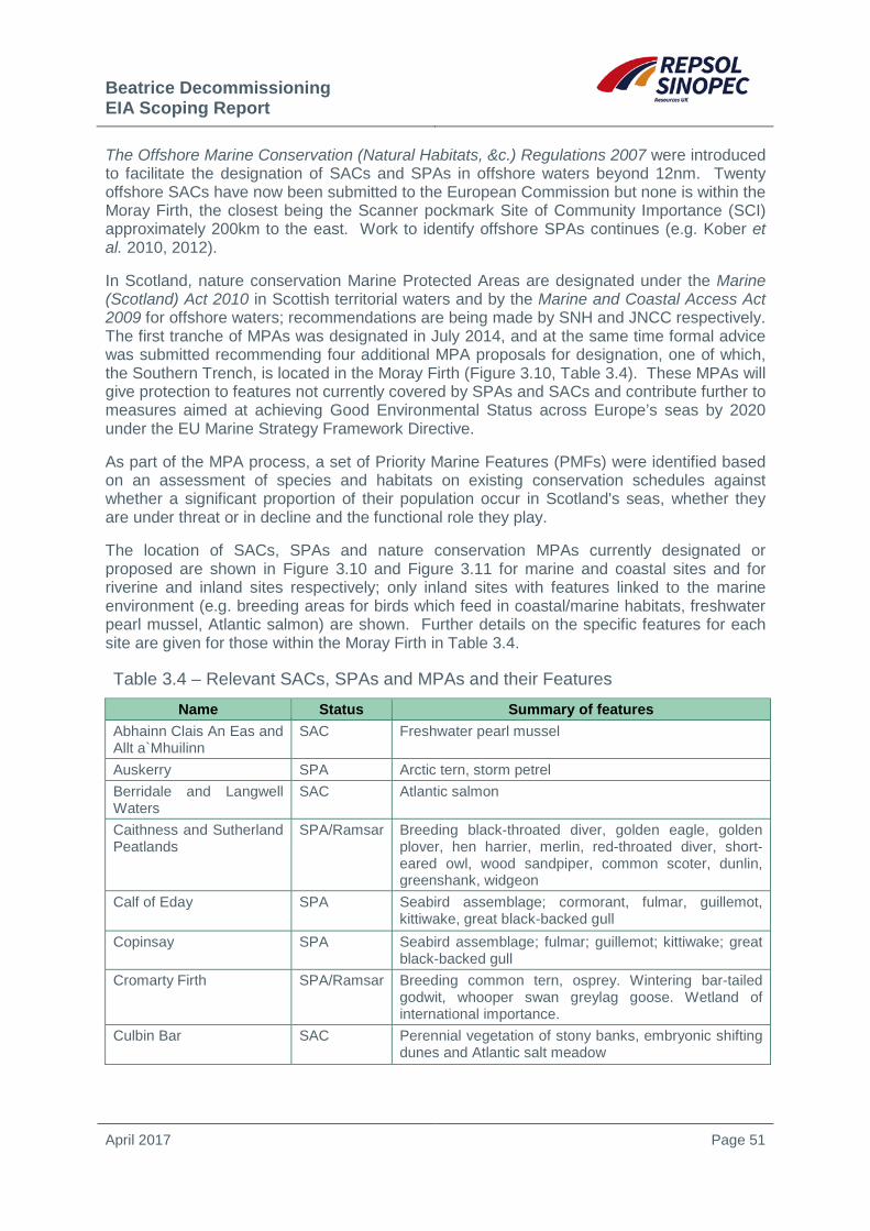
Beatrice Decommissioning EIA Scoping Report
April 2017 Page 51
The Offshore Marine Conservation (Natural Habitats, &c.) Regulations 2007 were introduced to facilitate the designation of SACs and SPAs in offshore waters beyond 12nm. Twenty offshore SACs have now been submitted to the European Commission but none is within the Moray Firth, the closest being the Scanner pockmark Site of Community Importance (SCI) approximately 200km to the east. Work to identify offshore SPAs continues (e.g. Kober et al. 2010, 2012).
In Scotland, nature conservation Marine Protected Areas are designated under the Marine (Scotland) Act 2010 in Scottish territorial waters and by the Marine and Coastal Access Act 2009 for offshore waters; recommendations are being made by SNH and JNCC respectively. The first tranche of MPAs was designated in July 2014, and at the same time formal advice was submitted recommending four additional MPA proposals for designation, one of which, the Southern Trench, is located in the Moray Firth (Figure 3.10, Table 3.4). These MPAs will give protection to features not currently covered by SPAs and SACs and contribute further to measures aimed at achieving Good Environmental Status across Europe’s seas by 2020 under the EU Marine Strategy Framework Directive.
As part of the MPA process, a set of Priority Marine Features (PMFs) were identified based on an assessment of species and habitats on existing conservation schedules against whether a significant proportion of their population occur in Scotland's seas, whether they are under threat or in decline and the functional role they play.
The location of SACs, SPAs and nature conservation MPAs currently designated or proposed are shown in Figure 3.10 and Figure 3.11 for marine and coastal sites and for riverine and inland sites respectively; only inland sites with features linked to the marine environment (e.g. breeding areas for birds which feed in coastal/marine habitats, freshwater pearl mussel, Atlantic salmon) are shown. Further details on the specific features for each site are given for those within the Moray Firth in Table 3.4.
Table 3.4 – Relevant SACs, SPAs and MPAs and their Features Name Status Summary of features
Abhainn Clais An Eas and Allt a`Mhuilinn
SAC Freshwater pearl mussel
Auskerry SPA Arctic tern, storm petrel Berridale and Langwell Waters
SAC Atlantic salmon
Caithness and Sutherland Peatlands
SPA/Ramsar Breeding black-throated diver, golden eagle, golden plover, hen harrier, merlin, red-throated diver, short-eared owl, wood sandpiper, common scoter, dunlin, greenshank, widgeon
Calf of Eday SPA Seabird assemblage; cormorant, fulmar, guillemot, kittiwake, great black-backed gull
Copinsay SPA Seabird assemblage; fulmar; guillemot; kittiwake; great black-backed gull
Cromarty Firth SPA/Ramsar Breeding common tern, osprey. Wintering bar-tailed godwit, whooper swan greylag goose. Wetland of international importance.
Culbin Bar SAC Perennial vegetation of stony banks, embryonic shifting dunes and Atlantic salt meadow

Beatrice Decommissioning EIA Scoping Report
April 2017 Page 52
Table 3.4 – Relevant SACs, SPAs and MPAs and their Features Name Status Summary of features
Dornoch Firth and Loch Fleet
SPA/Ramsar Breeding osprey, wintering bar-tailed godwit, greylag goose and widgeon. Wetland of international importance
Dornoch Firth and Morrich More
SAC Otter, harbour seal. Estuaries, mudflats and sandflats, Salicornia and other annuals colonising mud and sand and Atlantic salt meadow. Embryonic shifting dunes, white dunes, grey dunes, decalcified fixed dues with crowberry, Atlantic decalcified fixed dunes, coastal dunes with juniper, humid dune slacks. Sandbanks which are slightly covered by sea water all the time and reefs
East Caithness Cliffs SAC Vegetated sea cliffs East Caithness Cliffs SPA Breeding peregrine, guillemot, herring gull, kittiwake,
razorbill and shag. Seabird assemblage of international importance
East Caithness Cliffs MPA Black guillemot East Sanday Coast SPA/Ramsar Aggregations of non-breeding birds (turnstone, purple
sandpiper) Hoy SAC Vegetated sea cliffs, blanket bogs, dystrophic lochs and
pools, wet heaths Hoy SPA Seabird assemblage (breeding), Arctic skua, great
black-backed gull, guillemot, kittiwake, red-throated diver, fulmar, puffin, great skua, peregrine
Inner Moray Firth SPA/Ramsar Breeding common tern, osprey. Wintering bar-tailed godwit, greylag goose, red-breasted merganser, redshank. Wetland of international importance
Lairg & Strathbrora Lochs SPA Breeding black-throated diver Loch Ashie SPA Breeding Slavonian grebe. On passage Slavonian
grebe Loch Flemington SPA Breeding Slavonian grebe Loch of Strathbeg SPA/Ramsar Breeding sandwich terns, wintering teal, greylag goose,
pink-footed goose, goldeneye, whooper swan, Wetland of international importance
Loch Ruthven SPA/Ramsar Breeding Slavonian grebe Lower River Spey-Spey Bay
SAC Perennial vegetation of stony banks. alluvial forests
Marwick Head SPA Guillemot, kittiwake, seabird assemblage (breeding) Moray & Nairn Coast SPA/Ramsar Breeding osprey, wintering greylag goose, pink-footed
goose and redshank. Wetland of international importance
Moray Firth SAC Bottlenose dolphins; sandbanks which are slightly covered by sea water all the time
Moray Firth pSPA Great northern diver, red-throated diver, Slavonian grebe, greater scaup, common eider, long-tailed duck, common scoter, velvet scoter, common goldeneye, red-breasted merganser, European shag

Beatrice Decommissioning EIA Scoping Report
April 2017 Page 53
Table 3.4 – Relevant SACs, SPAs and MPAs and their Features Name Status Summary of features
North Caithness Cliffs SPA Peregrine, seabird assemblage (breeding), fulmar, guillemot. Kittiwake, razorbill, puffin
North Inverness Lochs SPA Breeding Slavonian grebe North Orkney pSPA Great northern diver, Slavonian grebe, red-throated
diver, Arctic tern, common eider, long-tailed duck, velvet scoter, red-breasted merganser, European shag
North-west Orkney MPA Sandeels Noss Head MPA Horse mussel beds (largest known horse mussel bed in
Scottish waters) Papa Westray MPA Black guillemot Papa Westray (North Hill and Holm)
SPA Breeding Arctic tern
Pentland Firth pSPA Arctic tern, common guillemot, Arctic skua, breeding seabird assemblage.
Scapa Flow pSPA Great northern diver, red-throated diver, black-throated diver, Slavonian grebe, European shag, common eider, long-tailed duck, common goldeneye, red-breasted merganser.
Pentland Firth Islands SPA Breeding Arctic tern River Evelix SAC Freshwater pearl mussel River Oykel SAC Freshwater pearl mussel, Atlantic salmon River Spey SAC Freshwater pearl mussel, sea lamprey, Atlantic salmon,
otter River Thurso SAC Atlantic salmon Rousay SPA Arctic tern and seabird assemblage (breeding)
Sanday SAC Reefs; harbour seal Southern Trench Proposed
MPA Burrowed muds, fronts, minke whale; shelf deeps
Switha SPA Non-breeding Greenland barnacle goose Troup, Pennan and Lion’s Head
SPA Breeding guillemot. Seabird assemblage (breeding)
West Westray SPA Arctic tern, guillemot, seabird assemblage (breeding)
Wyre and Rousay Sounds MPA Kelp and seaweed communities on sublittoral sediment; maerl beds
Source: JNCC website (http://jncc.defra.gov.uk/page-162, accessed 17/01/2017), SNH website (http://www.snh.gov.uk/protecting-scotlands-nature/protected-areas/proposed-marine-spas/, accessed 17/01/2017)

Beatrice Decommissioning EIA Scoping Report
April 2017 Page 54
Figure 3.10 – Inshore and Offshore SACs, SPAs and MPAs
There are several Sites of Special Scientific Interest (SSSIs) in the Moray Firth (e.g. Culbin Sands, Culbin Forest and Findhorn Bay, Cromarty Firth). SSSIs are designated for both biodiversity and geodiversity. In the case of biodiversity, several SSSIs have also acquired European protection by being included within SPAs and SACs. The designation of geological and geomorphological features is underpinned by the identification along the Moray Firth coastline of approximately 35 Geological Conservation Review (GCR) sites. Most of the sites are some distance from the Beatrice facilities, the closest site being Culgower Bay, 30km from the Beatrice Field on the east Caithness coastline, with Cadh`-an-Righ approximately 3km from the pipeline landfall at Shandwick.

Beatrice Decommissioning EIA Scoping Report
April 2017 Page 55
Figure 3.11 – Relevant Onshore SACs and SPAs
Species Conservation
In addition to the designation of specific conservation sites within the area, a number of individual marine species are afforded protection throughout their range. At a European level, strict protection is afforded to species on Annex IV (Animal and Plant Species of Community Interest in Need of Strict Protection) of the Habitats Directive, including all cetacean species, otters, marine turtles and a number of fish and invertebrate species. Under this Annex, the ‘deliberate capture, killing or disturbance18 is an offence, as is their keeping, sale or exchange’. Nationally, several marine species are protected under Schedule 5 of the Wildlife and Countryside Act, 1981. These include all cetacean species, otters, all turtle species, a range of fish including sturgeon, allis shad, twaite shad and
18 See JNCC (2008) for information regarding the definition of disturbance.
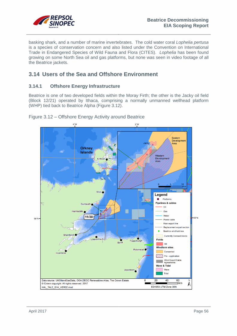
Beatrice Decommissioning EIA Scoping Report
April 2017 Page 56
basking shark, and a number of marine invertebrates. The cold water coral Lophelia pertusa is a species of conservation concern and also listed under the Convention on International Trade in Endangered Species of Wild Fauna and Flora (CITES). Lophelia has been found growing on some North Sea oil and gas platforms, but none was seen in video footage of all the Beatrice jackets.
3.14 Users of the Sea and Offshore Environment
3.14.1 Offshore Energy Infrastructure
Beatrice is one of two developed fields within the Moray Firth; the other is the Jacky oil field (Block 12/21) operated by Ithaca, comprising a normally unmanned wellhead platform (WHP) tied back to Beatrice Alpha (Figure 3.12).
Figure 3.12 – Offshore Energy Activity around Beatrice

Beatrice Decommissioning EIA Scoping Report
April 2017 Page 57
The Beatrice facilities are partly located within the Moray Firth Round 3 wind farm zone, and are immediately adjacent to the Beatrice Scottish territorial waters wind farm leasing zone. The Beatrice Offshore Wind farm was granted consent in March 2014 and a final investment decision was made in 2016, with construction due to commence in 2017. The Round 3 area contains two sections; the Eastern Development Area 11km to the east of Beatrice B comprises the consented Telford, Stevenson and MacColl offshore wind farms; and the Western Development Area which to date has been subject to scoping for a development of up to 90 turbines with a capacity of 750MW.
Cable export agreement areas are in place for the Beatrice and Moray Firth wind farm zones which both have their landfall on the southern Moray Firth coast at Portgordon and near Banff respectively.
3.14.2 Fisheries
Commercial Fisheries in the Region
ICES rectangles are subareas of larger ICES sub-divisions, and are used for fisheries data recording and management. The northwest outer Moray Firth area lies in ICES sub-division IVa, and the Beatrice platforms, turbines and pipelines are within ICES rectangles 44E6 and 45E6.
Over the period 2013-2015, fisheries in these ICES rectangles were exploited using a variety of fishing gears, with trawls and dredges being most common. The liveweight and value at first sale of fish and shellfish taken by all gears from 44E6 and 45E6 are shown in Table 3.5. Reported landings were dominated by shellfish in both weight and value. Demersal fish was the second most important group in terms of weight and value, while pelagic fish were landed in very small numbers with a generally low value. The catch mainly comprised scallops, Nephrops, lobster, squid, crab and haddock.
Table 3.5 – Live Weight and Value of Fish Taken from ICES Rectangles 45E7 and 45E6, 2013-2015
Species type
2013 2014 2015 Liveweight
(tonnes) Value (£) Liveweight (tonnes) Value (£) Liveweight
(tonnes) Value (£)
ICES rectangle 44E6 Demersal 56.0 45,712 65.1 80,646 22.0 35,304 Pelagic 1.4 1,256 5.0 5,173 10.3 10,063 Shellfish 558.0 1,584,822 900.7 2,289,443 599.8 2,037,583 Total 615.4 1,631,790 970.8 2,375,261 632.1 2,082,950
ICES rectangle 45E6 Demersal 79.8 67,394 18.3 20,397 27.8 39,661 Pelagic 5.3 2,008 55.4 14,216 1.7 1,187 Shellfish 606.0 1,332,589 542.6 1,222,466 418.9 893,889 Total 691.1 1,401,991 616.3 1,257,079 448.4 934,737 Total 44E6 +45E6 1,306.5 3,033,781 1,587.1 3,632,340 1,080.5 3,017,687
Percentage of UK total 0.20% 0.40% 0.26% 0.55% 0.20% 0.53%
Source: Scottish Government website (accessed 19/01/17).
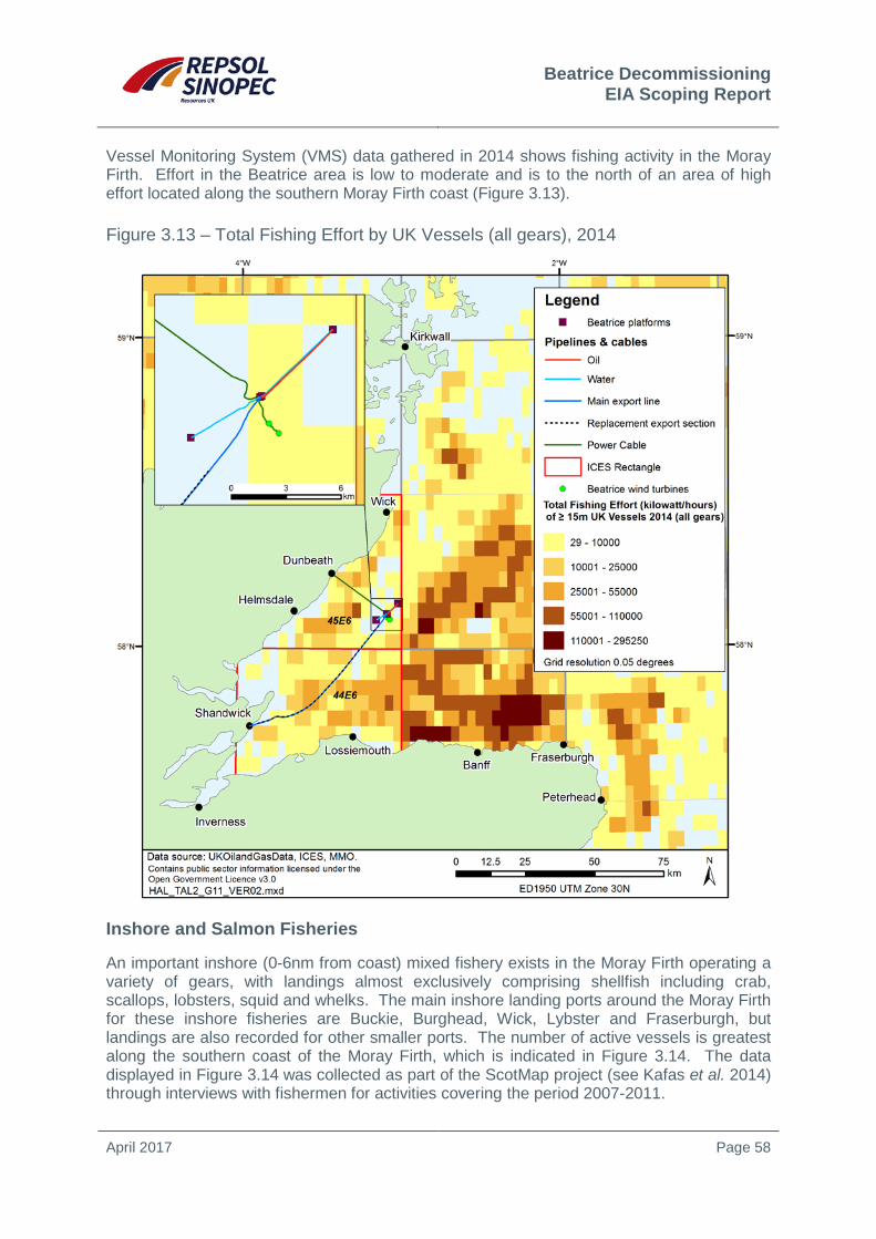
Beatrice Decommissioning EIA Scoping Report
April 2017 Page 58
Vessel Monitoring System (VMS) data gathered in 2014 shows fishing activity in the Moray Firth. Effort in the Beatrice area is low to moderate and is to the north of an area of high effort located along the southern Moray Firth coast (Figure 3.13).
Figure 3.13 – Total Fishing Effort by UK Vessels (all gears), 2014
Inshore and Salmon Fisheries
An important inshore (0-6nm from coast) mixed fishery exists in the Moray Firth operating a variety of gears, with landings almost exclusively comprising shellfish including crab, scallops, lobsters, squid and whelks. The main inshore landing ports around the Moray Firth for these inshore fisheries are Buckie, Burghead, Wick, Lybster and Fraserburgh, but landings are also recorded for other smaller ports. The number of active vessels is greatest along the southern coast of the Moray Firth, which is indicated in Figure 3.14. The data displayed in Figure 3.14 was collected as part of the ScotMap project (see Kafas et al. 2014) through interviews with fishermen for activities covering the period 2007-2011.

Beatrice Decommissioning EIA Scoping Report
April 2017 Page 59
Figure 3.14 – Inshore Fisheries by Vessel Number and Value, 2007-2011
Additionally, the Moray Firth area supports an important salmon and trout fishery; in 2013, the region contributed 15% of the total wild salmon and 8% of the total wild sea trout caught and retained in Scotland (data from Marine Scotland 2014). Fixed engine boats and rod and line anglers are responsible for the majority of catches, however net and cob techniques are also used but to a lesser extent. Various initiatives have been set up in recent years to collect data to monitor and support inshore fisheries in the region. The Scottish Inshore Fisheries Integrated Data System (SIFIDS) project19 (led by the Marine Alliance for Science and Technology for Scotland (MASTS)) aims to collate and analyse inshore fisheries data in 19 http://www.masts.ac.uk/research/emff-sifids-project
Beatrice Decommissioning EIA Scoping Report
April 2017 Page 60
order to support fisheries management and marine planning. Projects to further monitoring of inshore fisheries using AIS are also being developed by MASTS20, while the Fisheries Local Action Group (FLAG) for Highland and Moray21 aims to initiate a community-led approach to the sustainable development of local fisheries. Repsol Sinopec Resources UK plans to carry out a detailed study of fishing activity in the area of the Beatrice facilities to inform the CA and EIA processes.
3.14.3 Ports and Shipping
There are several important ports in the Moray Firth for fish landings, the transport of oil industry supplies and products, as well as general cargo. Fraserburgh and Buckie are important fishing ports and were the base for 284 vessels in 2015 (Marine Scotland 2016). The port of Inverness, located in the Beauly Firth, is of strategic importance to the north of Scotland supporting cargo, cruise ship and renewable energy industry related activities. Slightly further north in the Cromarty Firth, the port of Invergordon receives approximately 100,000 cruise ship passengers between March/April and October each year.
Shipping density in and around the Beatrice Field area and along the pipeline and cable routes is very low, with the exception of moderate levels near the entrance to the Beauly and Cromarty Firths (OGA website22). There are no IMO routeing measures close to the Beatrice Field area or in the wider Moray Firth. A number of primary navigation routes are identified in ship Automatic Identification System (AIS) data along the southern and outer Moray Firth. Lower levels in the area are associated with ‘non-route-based’ traffic such as fishing vessels, naval vessels, tugs, dredgers, yachts, supply vessels to mobile drilling installations and non-routine traffic. Relevant vessel traffic surveys will be undertaken to inform the decommissioning work.
3.1.1 Military Activity
Several areas of the inner and outer Moray Firth are used by the Royal Air Force for radar training, high and low-angle gunnery and air to sea or ground firing (Figure 3.15). The Beatrice Field area, along with the majority of the Moray Firth, lies within the large Air Force Area D712D, used for air combat training and high energy manoeuvres.
3.14.4 Cables
There are no telecommunications or subsea power cables in the Beatrice area, though the Shefa-2 telecommunications cable and the proposed Caithness-Moray HVDC transmission project cable are located 27km and 26km to the east of Beatrice respectively (Figure 3.15). The latter is due to be completed by 2018.
20 http://www.masts.ac.uk/research/sustainable-scottish-inshore-fisheries 21 http://www.highlandmorayflag.co.uk/ 22OGA website – https://www.ogauthority.co.uk/licensing-consents/licensing-rounds/ accessed 17/01/2017
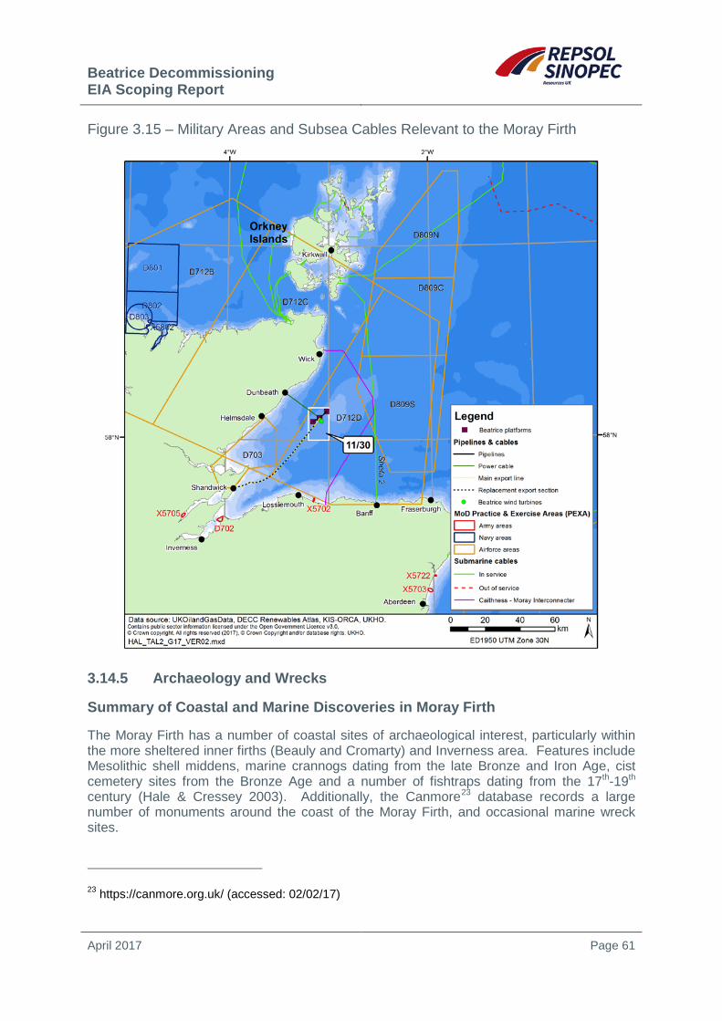
Beatrice Decommissioning EIA Scoping Report
April 2017 Page 61
Figure 3.15 – Military Areas and Subsea Cables Relevant to the Moray Firth
3.14.5 Archaeology and Wrecks
Summary of Coastal and Marine Discoveries in Moray Firth
The Moray Firth has a number of coastal sites of archaeological interest, particularly within the more sheltered inner firths (Beauly and Cromarty) and Inverness area. Features include Mesolithic shell middens, marine crannogs dating from the late Bronze and Iron Age, cist cemetery sites from the Bronze Age and a number of fishtraps dating from the 17th-19th century (Hale & Cressey 2003). Additionally, the Canmore23 database records a large number of monuments around the coast of the Moray Firth, and occasional marine wreck sites.
23 https://canmore.org.uk/ (accessed: 02/02/17)

Beatrice Decommissioning EIA Scoping Report
April 2017 Page 62
Wrecks
No Historic Marine Protected Areas24 are located in the Moray Firth. Three protected wrecks are located in the Moray Firth (Table 3.6), designated under The Protection of Military Remains Act 198625. Additionally, the wreck of San Tiburcio was recorded in close proximity to the main oil export pipeline in an as-laid survey of the pipe, and is also shown on Figure 3.16.
Figure 3.16 – Wrecks Relevant to the Beatrice Area
24 Note that HMPAs replaced those designations under the Protection of Wrecks Act 1993, which was repealed in Scotland in November 2013. 25 The Protection of Military Remains Act 1986 (Designation of Vessels and Controlled Sites) Order 2012

Beatrice Decommissioning EIA Scoping Report
April 2017 Page 63
Table 3.6 – Wrecks in the Moray Firth Protected under The Protection of Military Remains Act 1986
Wreck Location Closest Distance to Beatrice Surface or Subsurface Facilities
HMS Natal (WWI)
Cromarty Firth, an area 100m radius around 57°41’244”N 4°05’310”W
15km
HMS Exmouth (WWII)
Northeast outer Moray Firth, an area 750m radius around 58°18’467”N 2°28’938”W
36km
HMS Lynx Moray Firth, approximately 57°57’35.8”N 3°14’39.5”W
3km
Information obtained from the UK Hydrographic Office (see below) and previous site surveys indicate that no wreck features occur within several kilometres of the Beatrice Platforms. Similar wreck information was obtained within a 10nm radius of the Jacky Field to inform the EIA for that development. This provided coverage of the seabed throughout the pipeline route to the Beatrice Alpha complex, within which six live and two dead wrecks26 were identified (the closest being 11.5km to the northwest of the Jacky platform, and one 5km to the southeast of Beatrice AP which is recorded as an anchor). Further information will be obtained to inform decommissioning, however work will be largely undertaken within areas which have already been developed.
The strategic importance of the North Sea area during WWI and WWII; the concentration of much of the North Sea fishing fleet in coastal ports; the importance of maritime trade routes in the region and the treacherous nature of nearshore waters, have led to a large number of ship and aircraft wrecks. While many of the locations of these wrecks have been identified and listed by the UK Hydrographic Office, the locations of many more remain uncharted.
Potential Coastal and Marine Pre-historic Sites
There is a low probability of prehistoric submarine archaeological remains occurring in the Beatrice area given the strong prevailing current conditions, exposure to North Atlantic storms, thin sediment cover in many places and the large areas of exposed bedrock. There is no evidence of such from historic surveys.
3.14.6 Tourism and Recreation
The Moray Firth coastline and adjacent land and waters provides for a variety of recreational activities which make tourism and leisure an important contribution to the local economy (see LUC 2016), with approximately 700,000 visitors bringing around £106 million to the Moray area in 201527. There are a large number of easily accessible beaches in the area, several of which are designated by the Scottish Environment Protection Agency (SEPA) as
26 Live wrecks are charted and considered to exist; dead wrecks are not considered to exist (e.g. may be fragmented and dispersed) and not shown on charts. 27 http://www.parliament.scot/parliamentarybusiness/28877.aspx?SearchType=Advance&ReferenceNumbers=S5M-02563 (accessed 18/01/17)

Beatrice Decommissioning EIA Scoping Report
April 2017 Page 64
bathing water sites under the Bathing Water Directive (Directive 2006/07/EC) (SEPA 2016). Sailing is popular in the area with Moray Firth harbours being home to several hundred recreational vessels. In addition to this, boat-based dolphin watching attracts many tourists to the Moray Firth, with numerous boats operating cruises during summer months (Moray Firth Partnership 2011). Angling is important in the area with several rivers (e.g. River Spey) supporting internationally important populations of Atlantic salmon. Other popular activities include land-based wildlife watching, cycling, walking/hiking, sea kayaking/canoeing, scuba-diving and surfing (Moray Firth Partnership 2011, LUC 2016).
3.14.7 Land and Seascape
A number of relevant coastal areas have been subject to landscape character assessment for SNH, including the inner Moray Firth, Moray and Nairn, and Caithness and Sutherland. The reports associated with these assessments provide an overview of landscape features and character, including a consideration of key issues relating to these landscapes, and their sensitivity to particular activities, some of which are predicted to expand in these areas (e.g. onshore wind farms). Most recently the landscapes of the area have been characterised through The Landscapes of Scotland28 project, which provides a high level overview of Scotland’s landscapes which complement the more specialist analysis in landscape character assessments. Additionally, a seascape assessment was undertaken by Scott et al. (2005) to evaluate the sensitivity of seascape units in Scottish waters to the installation of offshore wind turbines, however some of the information provided in the characterisation is more generally applicable.
There are relatively few landscape designations within the Moray Firth. The Dornoch Firth National Scenic Area (NSA) is the closest designated site with policy protection (52km to the west of the Beatrice surface facilities). Additionally, there are a number of non-statutory local landscape designations, including on the south coast of the Black Isle and inner Moray Firth, and along the east Caithness coastline. Such sites are designated at a local level, are shown on local development plans, and have associated policies to safeguard their valued features29.
28 www.snh.gov.uk/about-scotlands-nature/scotlands-landscapes/landscapes-varieties/ (accessed 18/01/17). 29 Scottish Planning Policy, published June 2014.

Beatrice Decommissioning EIA Scoping Report
April 2017 Page 65
4 STUDIES COMMISSIONED IN SUPPORT OF BEATRICE DECOMMISSIONING
4.1 Studies Undertaken to Date A list of studies of relevance to the appraisal of decommissioning options for the Beatrice Field is provided in Table 4.1. These include reports detailing the facilities to inform the initial “appraise” phases of work and related environmental screening and survey, and the engineering options for removal of the facilities. In addition to these, a range of previous environmental and maintenance survey work, including as-laid surveys of pipelines, cables and associated deposits, have been used to inform the initial stage of work.
Table 4.1 – Studies Undertaken to date in Support of Beatrice Decommissioning Title Year Summary
Beatrice Platform ROV Structural Inspection Report – AD, AP, B, B CSS, C.
2012 A visual appraisal was made of each platform structure and the status of marine growth, including species community and estimates of hard and soft growth recorded.
Beatrice Decommissioning Appraise Project – Basis of Design
2013 Defines the key information on the wells, facilities and associated pipelines and cables to inform subsequent phases of work and establish where information gaps are present.
Beatrice Decommissioning Appraise – Environmental Screening Report
2013 A high level desktop screening of environmental issues relating to the three main potential alternative uses (see Section 2.2) to inform the subsequent phases of work.
Beatrice Platform Piece Small Removal Study
2013 Outlines the methods and timescales of removal of the Beatrice facilities by small/medium piece removal.
Beatrice Platform Heavy Lift Removal Study
2013 Outlines the methods and timescales of removal of the Beatrice facilities by using heavy lift vessels.
Beatrice Decommissioning Scoping ENVID Workshop Report
2014 The output of a workshop to identify the main issues to be taken forward for consideration in decommissioning planning and the environmental impact assessment.
Beatrice Pre-Decommissioning Environmental and Subsea Survey
2016 Environmental survey in the vicinity of the Beatrice facilities (Alpha, Bravo, Charlie, WTGs) and pipelines, including habitats assessment, identification of the presence of historic drill cuttings pile, drill cuttings sampling at Alpha. Subsea survey of pipeline burial depths.
4.2 Future Studies A number of additional studies are presently being undertaken or planned to inform the Beatrice decommissioning (e.g. comparative assessment work for pipelines). It is proposed that the following survey work is undertaken to inform the EIA and wider decommissioning planning and engineering:
• Pipeline material inventory, status and historical review

Beatrice Decommissioning EIA Scoping Report
April 2017 Page 66
• Pipeline decommissioning option screening study
• Pipeline and subsea infrastructure removal methods and technical feasibility assessment
• Comparative assessment for pipeline decommissioning options
• Jacket removal methods
• HAZID for pipeline and jacket derogation candidate removal options
• Safety risk to fishermen assessment
Beatrice Decommissioning EIA Scoping Report
April 2017 Page 67
5 APPROACH AND METHOD OF EIA
5.1 Introduction To comply with company policy and regulator guidance, the Beatrice Decommissioning Programme will be supported by an EIA. The EIA will be documented in an EIA Report which will be made publicly available. The EIA will build on the description of the existing environment which is summarised in Chapter 3, augmented through the studies commissioned to inform the decommissioning programme including the CA (Section 4), and the outcome of this scoping exercise and ongoing stakeholder engagement.
5.2 Initial Issue Identification This section describes the process used to make an initial assessment during the EIA scoping process of the relative significance of potential environmental issues associated with the options outlined in Section 2. The activities have been initially screened for their potential interactions with the environment, other users and against legislative and policy requirements. The activity and environment interactions were identified and screened using a range of data sources, including:
• Regional and site specific environmental data
• Typical vessel specifications (e.g. for pipeline removal and support)
• Typical jack-up drilling rig specifications
• Experience of analogous projects in the North Sea and elsewhere
• Reviews and assessments of the environmental effects of offshore oil and gas operations
• Peer reviewed scientific papers describing the effects of specific interactions
• Other publicly available “grey” literature
• Offshore Energy Strategic Environmental Assessment Environmental Reports and underpinning studies (DECC 2016)
• OSPAR Quality Status Report 2010 (OSPAR 2010) and Defra’s Charting Progress 2 (Defra 2010)
• Conservation site designation, potential designations and related information
• Initial consultation (see below)
• Applicable legislation, guidance and policies

Beatrice Decommissioning EIA Scoping Report
April 2017 Page 68
To inform initial identification of environmental issues and stakeholder concerns, Repsol Sinopec Resources UK has already undertaken early engagement with a number of stakeholders and statutory bodies (see Section 7.2). Issues raised during these meetings included:
• Full environmental pre-decommissioning baseline survey and habitats assessments
• Potential for presence of horse mussel habitats
• Impacts from cuttings pile disturbance and plumes
• Impact of cuttings pile if left in situ
• Impacts of sediment disturbance and plumes
• Impacts of noise and disturbance from vessels
• Potential for corkscrew injuries to seals from unshielded ducted propellers30
• Potential new conservation sites to be designated in the area (harbour porpoise, black guillemot)
• Cumulative impacts from multiple activities e.g. on birds and marine mammals
• Cumulative impacts from multiple developments e.g. fisheries and other users
• Importance of Smith Bank for scallop and squid fishing
• Potential for effects on salmon and sea trout migration
• Presence of static gear and squid fishing along the cable route in the nearshore area towards Dunbeath
• The importance of herring, haddock, crab and lobster in the Moray Firth
• The impact of removal of trenched and buried pipelines.
• Potential for cables to present a snagging risk to fishing gear if not properly buried Repsol Sinopec Resources UK also undertook an Environmental Impact Identification (ENVID) scoping workshop. The workshop further contributed to the initial identification of activity/environment interactions, as well as raising awareness within the Repsol Sinopec Resources UK decommissioning team of the baseline environment, and potential sources of environmental effect from decommissioning activities.
30 While further research may be necessary before interactions from ducted propellers can be entirely discounted, it is now considered very likely that the use of such vessels may not pose any increased risk to seals over and above normal shipping activities (see Thompson et al. 2015 and SNCB 2015).

Beatrice Decommissioning EIA Scoping Report
April 2017 Page 69
5.2.1 Initial Screening of Sources of Potential Environmental Effect
The topics potentially having an environmental impact identified as relevant to the EIA at this stage include:
• Climate/air quality
• Water quality
• Seabed condition
• Benthic fauna
• Plankton
• Fish and shellfish
• Marine mammals
• Water and seabirds
• Fisheries
• Other users of the sea (Defence, Offshore renewables, Oil and gas, Recreational activities)
• Shipping
• Landfill resource
• Communities
• Landscape/seascape
• Conservation sites/species
• Cultural heritage
• Cumulative effects
• Transboundary issues Based on the current level of definition on the potential decommissioning/removal options, a screening has been undertaken for the topics to identify an initial list of issues to be considered in the EIA (see matrix in Table 5.3).
From the screening process, a number of environmental interactions have been initially identified with the potential to result in significant effects. These are summarised in Table 5.1 and considered in greater detail in Section 6, where mitigation and potential cumulative effects are identified. These issues will be taken forward for detailed assessment in the EIA.

Beatrice Decommissioning EIA Scoping Report
April 2017 Page 70
Table 5.1 – Environmental Interactions Considered Further in Section 6 and for Inclusion in the EIA Report
Issue Potential Source of Effect Section in Scoping
Document Physical presence of Vessels during decommissioning and legacy of any infrastructure left in situ
• Rig, supply and other vessel presence/movements (e.g. jack-up vessel, heavy lift vessel, barges), including when in transit and within-field movements
• Disturbance of seabirds (noise and light), marine mammals and migratory salmon
• Legacy of pipelines, cables and associated protection materials
6.2
Seabed disturbance during decommissioning
• Disturbance of seabed from rig installation (spud cans), vessel presence (anchors, use of taut wire DP systems or jack-up vessel)
• Excavation of jacket and Beatrice AD drilling template piles
• Dredging of seabed under partial or full pipeline and cable removal options
• Removal of mattresses and other pipeline or cable protection
• Seabed condition (e.g. presence of clay mounds) following pipeline and cable removal, and excavation
6.3
Drill cuttings disturbance, and cuttings pile management options
• Resuspension and release of contaminants from pile disturbance
• Legacy of cuttings left in situ
6.4
Energy use and atmospheric emissions
• Combustion emissions from rig power generation, vessel operations and ancillary power generation for cutting tools and cranes.
6.5
Underwater noise • Underwater noise from drilling associated with well abandonment, underwater cutting of jacket legs, piles and conductors (3m below seabed), and the removal of pipeline or cable sections
• Underwater noise from rig and vessels
6.6

Beatrice Decommissioning EIA Scoping Report
April 2017 Page 71
Table 5.1 – Environmental Interactions Considered Further in Section 6 and for Inclusion in the EIA Report
Issue Potential Source of Effect Section in Scoping
Document Near-shore and onshore dismantling of structures: cleaning of marine growth from removed jacket structures and the fate of materials returned to shore: recycling, reuse and disposal
• The landfill resource for waste generated by facilities removal
• Muds and cuttings contained (including of historic cuttings pile under the removal option)
• Landscape/noise and disruption to communities and other users
• Air quality effects (dust, fumes, decaying marine growth)
6.7, 6.8 and 6.9
Accidental events • Diesel and other spills • Collision risk • Chemical spills • Dropped objects • Loss of containment of residual hydrocarbons or
contaminated cuttings under the removal option
6.10
Natura 2000 sites • Noise and disturbance effects 6.11
Cumulative effects • Possibility of interactions between decommissioning activities and those ongoing or proposed activities/developments in the Moray Firth
6.12
Transboundary effects • Possibility for the disposal of parts of the facilities outside of the UK
6.9
The EIA will take both qualitative and quantitative approaches to the identification of the likely magnitude of effects, as appropriate, and will use defined severity criteria to assist in describing the magnitude of environmental effect from the decommissioning options. For scoping, these are primarily based on the UKOOA Environmental Impact Assessment Guidelines (UKOOA 1998), and allow for the consideration of the likelihood, scale and frequency of potential effects (see Table 5.2).

Beatrice Decommissioning
EIA Scoping Report
April 2017 Page 72
Table 5.2 – EIA Scoping Assessment Criteria for Potential Environmental Effects from Beatrice Decommissioning Effect Consequences None Foreseen No detectable effects
Positive Activity may contribute to recovery of habitats Positive benefits to local, regional or national economy
Negligible Change is within scope of existing variability but potentially detectable.
Moderate
Change in ecosystem leading to short term damage with likelihood for recovery within 2 years to an offshore area less than 100 hectares or less than 2 hectares of a benthic fish spawning ground Possible but unlikely effect on human health Possible transboundary effects Possible contribution to cumulative effects Issue of limited public concern May cause nuisance Possible short term minor loss to private users or public finance
Major
Change in ecosystem leading to medium term (2+ year) damage with recovery likely within 2 - 10 years to an offshore area 100 hectares or more or 2 hectares of a benthic fish spawning ground or coastal habitat, or to internationally or nationally protected populations, habitats or sites Transboundary effects expected Moderate contribution to cumulative effects Issue of public concern Possible effect on human health Possible medium term loss to private users or public finance
Severe
Change in ecosystem leading to long term (10+ year) damage with poor potential for recovery to an offshore area 100 hectares or more or 2 hectares of a benthic fish spawning ground or coastal habitat, or to internationally or nationally protected populations, habitats or sites Major transboundary effects expected Major contribution to cumulative effects Issue of acute public concern Likely effect on human health Long term, substantial loss to private users or public finance
Frequency with which Activity or Event Might Occur Likelihood
Unlikely to occur during the lifetime of operation Unlikely
Once in the life of the rig or facility Low
Once a year Medium
Once a month or regular short term events High
Continuous or regular planned activity Very High
Likelihood Consequences Very High High Medium Low Unlikely Severe Major Moderate Negligible Positive None foreseen
Issues requiring detailed consideration in the EIA Report Positive or minor or negligible issues No effects expected

Beatrice Decommissioning EIA Scoping Report
April 2017 Page 73
Table 5.3 – Scoping Screening Matrix for Potential Activity/Environment Interactions
Potential for significance
Environment Receptors
Clim
ate/
air q
ualit
y
Wat
er Q
ualit
y
Seab
ed c
ondi
tion
Ben
thic
Fau
na
Plan
kton
Fish
and
She
llfis
h
Mar
ine
Mam
mal
s
Wat
er &
Sea
bird
s
Fish
erie
s
Oth
er O
ffsho
re U
sers
1
Ship
ping
Land
fill r
esou
rce
Com
mun
ities
Land
scap
e/se
asca
pe
Con
serv
atio
n si
tes/
spec
ies
Cul
tura
l her
itage
Tran
sbou
ndar
y is
sues
Minor issue
Activity/Source of Potential Impact
Topsides Removal
Flushing and cleaning of topsides
Removal of asbestos
Removal of radioactive materials
Removal of other hazardous materials (PCBs, Halons, refrigerants, mercury)
Removal of WEEE
Internal clearance (insulation removal etc.)
Cutting and rigging of structures to be lifted
Utilities preparation and accommodation refurbishment
Removal of items with poss. residual hydrocarbons e.g. drains caisson
Jacket Removal
Abrasive cutting (internal and external cuts)
Excavation of piles (also see cuttings piles management)
Airlift tool (if used)
Marine growth removal (offshore)
Lift of jacket and template
Well Decommissioning
Jack-up tow in & out
Jack-up positioning (anchors)
Jack-up positioning (spud cans)
Potential for introduction of alien species in ballast
Physical presence of jack-up (within existing 500m safety zone)

Beatrice Decommissioning
EIA Scoping Report
April 2017 Page 74
Table 5.3 – Scoping Screening Matrix for Potential Activity/Environment Interactions
Potential for significance
Environment Receptors
Clim
ate/
air q
ualit
y
Wat
er Q
ualit
y
Seab
ed c
ondi
tion
Ben
thic
Fau
na
Plan
kton
Fish
and
She
llfis
h
Mar
ine
Mam
mal
s
Wat
er &
Sea
bird
s
Fish
erie
s
Oth
er O
ffsho
re U
sers
1
Ship
ping
Land
fill r
esou
rce
Com
mun
ities
Land
scap
e/se
asca
pe
Con
serv
atio
n si
tes/
spec
ies
Cul
tura
l her
itage
Tran
sbou
ndar
y is
sues
Minor issue
Activity/Source of Potential Impact
Discharge of mud, cement & chemicals from operational wells
Disposal of Organic-Phase Fluid mud/cuttings from suspended wells
Discharge of chemicals from suspended wells
Power generation on jack-up
Fugitive emissions from fuel & chemical storage
Drainage, sewage & other discharges from rig
Solid & liquid wastes to shore
Underwater noise
Rig surface noise & light
Mechanical cutting of casings
Removal of conductors
NORM/LSA contaminated equipment/tubulars
Venting
Flaring
H2S within well fluids
Pipelines & Cables
Flushing & cleaning
Disconnection of pipelines from jacket
Cutting of pipeline (including at intermediate locations)
Rock placement/burial at cut ends
Seabed disturbance (full removal)
Seabed disturbance (partial removal)
Pipeline degradation/exposure (left in situ)
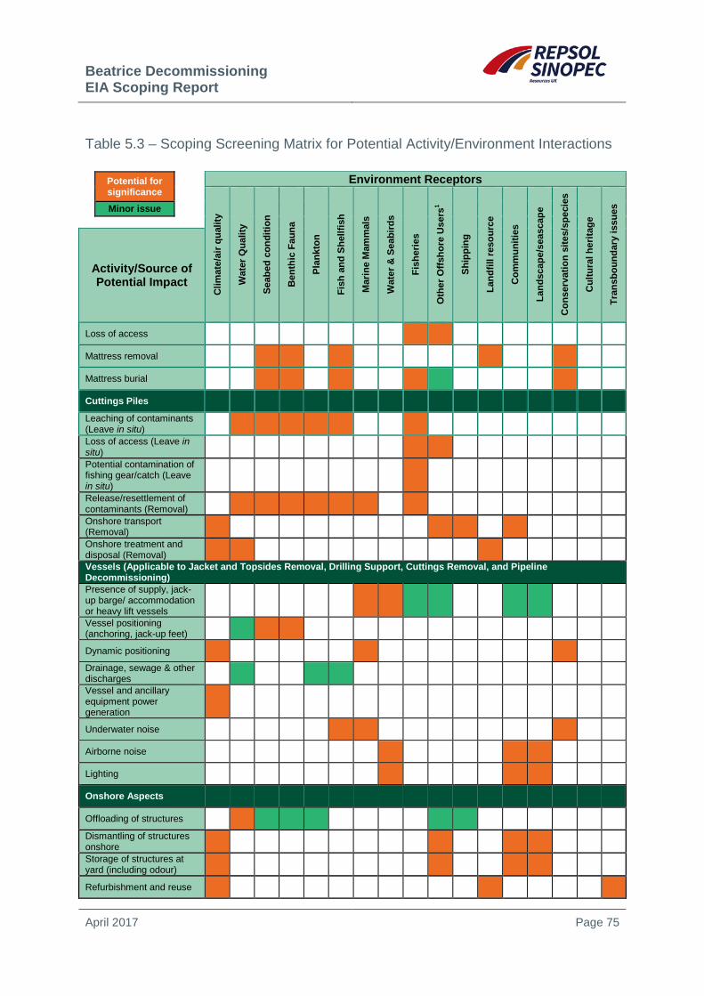
Beatrice Decommissioning EIA Scoping Report
April 2017 Page 75
Table 5.3 – Scoping Screening Matrix for Potential Activity/Environment Interactions
Potential for significance
Environment Receptors
Clim
ate/
air q
ualit
y
Wat
er Q
ualit
y
Seab
ed c
ondi
tion
Ben
thic
Fau
na
Plan
kton
Fish
and
She
llfis
h
Mar
ine
Mam
mal
s
Wat
er &
Sea
bird
s
Fish
erie
s
Oth
er O
ffsho
re U
sers
1
Ship
ping
Land
fill r
esou
rce
Com
mun
ities
Land
scap
e/se
asca
pe
Con
serv
atio
n si
tes/
spec
ies
Cul
tura
l her
itage
Tran
sbou
ndar
y is
sues
Minor issue
Activity/Source of Potential Impact
Loss of access
Mattress removal
Mattress burial
Cuttings Piles
Leaching of contaminants (Leave in situ)
Loss of access (Leave in situ)
Potential contamination of fishing gear/catch (Leave in situ)
Release/resettlement of contaminants (Removal)
Onshore transport (Removal)
Onshore treatment and disposal (Removal)
Vessels (Applicable to Jacket and Topsides Removal, Drilling Support, Cuttings Removal, and Pipeline Decommissioning) Presence of supply, jack-up barge/ accommodation or heavy lift vessels
Vessel positioning (anchoring, jack-up feet)
Dynamic positioning
Drainage, sewage & other discharges
Vessel and ancillary equipment power generation
Underwater noise
Airborne noise
Lighting
Onshore Aspects
Offloading of structures
Dismantling of structures onshore
Storage of structures at yard (including odour)
Refurbishment and reuse

Beatrice Decommissioning
EIA Scoping Report
April 2017 Page 76
Table 5.3 – Scoping Screening Matrix for Potential Activity/Environment Interactions
Potential for significance
Environment Receptors
Clim
ate/
air q
ualit
y
Wat
er Q
ualit
y
Seab
ed c
ondi
tion
Ben
thic
Fau
na
Plan
kton
Fish
and
She
llfis
h
Mar
ine
Mam
mal
s
Wat
er &
Sea
bird
s
Fish
erie
s
Oth
er O
ffsho
re U
sers
1
Ship
ping
Land
fill r
esou
rce
Com
mun
ities
Land
scap
e/se
asca
pe
Con
serv
atio
n si
tes/
spec
ies
Cul
tura
l her
itage
Tran
sbou
ndar
y is
sues
Minor issue
Activity/Source of Potential Impact
Materials recycling
Energy recovery from materials
Onshore waste treatment
Landfill of residual waste
Road transport of waste/materials
Treatment of NORM/LSA scale
Hazardous materials
Accidental Events
Dropped objects
Accidental releases to atmosphere (including refrigerants)
Accidental spills of fuel/lubricants/crude to sea
Vessel collision
Hydraulic fluid loss from subsea tools and equipment
Mud and other chemical spills
Litter
Cuttings pile removal option – loss of containment
Accidental discharge of muds, chemicals from installations
Accidental discharge of muds, chemicals from rig
Notes: 1includes offshore renewables, oil and gas, military activities, subsea cables, recreational yachting etc.

Beatrice Decommissioning EIA Scoping Report
April 2017 Page 77
6 OVERVIEW OF POTENTIAL ENVIRONMENTAL IMPACTS
6.1 Introduction For each broad source of effect (e.g. physical presence, disturbance and discharges), descriptions of the potential impacts are expanded upon below, providing an initial indication of how these are to be considered in the EIA Report, what mitigation would be possible, and how any information gaps are to be filled during the EIA process. In all instances, pre- and post-decommissioning survey and monitoring31 will contribute to the prediction, recording and mitigation of any environmental effects.
In addition to the preparation and acceptance of a decommissioning programme, most activities to be undertaken to decommission the Beatrice facilities are regulated and will be subject to individual consenting mechanisms which the EIA Report will support (e.g. under the Offshore Chemical Regulations 2002, Marine (Scotland) Act 2010, Energy Act 2008), in addition to requirements of the Offshore Safety Directive32, for example as implemented through The Offshore Installations (Offshore Safety Directive) (Safety Case etc.) Regulations 2015. Repsol Sinopec Resources UK will also maintain awareness of any additional provisions which come into force during decommissioning planning and implementation. All third party contractors (including waste disposal yards) will be audited to ensure that they comply with relevant legislation (e.g. various Merchant Shipping Regulations), and operate in a way which is consistent with Repsol Sinopec Resources UK’s HS&E policy, and programme specific HS&E targets.
6.2 Physical Presence of Vessels during Decommissioning and Legacy of any Infrastructure left in situ
6.2.1 Impacts, Approach to Assessment and Mitigation
The decommissioning programme will involve the use of a number of vessels for supply and support during well abandonment, to provide machinery and personnel for platform dismantling, and transport of waste and other materials to shore. The number of movements will partly depend on the decommissioning option chosen, with a greater number of vessel transits and time in the field required for small/medium piece removal methods. The physical presence of vessels has the potential to disrupt other users of the sea, including shipping and fishing. However, the main source of effect will relate to vessels in transit, as most vessels undertaking work would be located within close proximity to the Beatrice facilities and/or within their respective 500m safety zones.
In addition to potential socio-economic effects, ecological effects could arise for birds (e.g. from surface noise and light), marine mammals and migratory salmon (e.g. shipping noise), particularly during the peak smolt run (spring-summer), rather than when adult salmon are returning to rivers. The likelihood of such effects will be considered in detail within the EIA, including with regards to potential effects on conservation sites or species.
31 Note that the liability for any structure left in situ remains with the facility owner in perpetuity. 32 Directive 2013/30/EU on the safety of offshore oil and gas operations.

Beatrice Decommissioning
EIA Scoping Report
April 2017 Page 78
Available information indicates that vessel traffic in the Beatrice Field area is low, and a vessel traffic survey will also be undertaken to inform decommissioning, particularly where activities will be undertaken outside of existing safety zones.
The physical presence of vessels will be temporary and localised, and there is the potential to reduce the scale of any possible impact through the optimisation of schedules of work to make use of vessel synergies. Relevant consent to locate permits will be applied for, in addition to reporting of activities through Notices to Mariners and the Kingfisher bulletins. The potential for cumulative effects from vessel presence and movements should wind farm construction activity coincide with that of the decommissioning programme will also be a consideration of the EIA Report (see Section 6.12).
The physical presence of any pipelines, cables (or sections of these) and associated protection materials, could pose a longer term source of potential effect for other users (e.g. fisheries). Were all or part of the pipelines to be left in situ, consideration will be given to the long-term effects of their degradation and possible future exposure. Protection materials will be removed unless there are significant safety and technical reasons why they cannot be.
6.2.2 Further Studies
A vessel traffic survey will be undertaken and if required a Collision Risk Assessment. The EIA will be informed by the selection of likely vessel types, their number, number of transits and likely onshore disposal locations.
A comparative assessment will be undertaken to inform the likely scale of any removal works for the pipelines, cables and associated seabed protection.
6.3 Effects of Seabed Disturbance during Decommissioning
6.3.1 Impacts, Approach to Assessment and Mitigation
Depending on the final decommissioning options selected, seabed disturbance could occur due to the placement of a jack-up rig (and possible anchoring during positioning), the anchoring of a heavy-lift vessel or other vessels (including during reverse s-lay), or placement of a jack-up barge, seabed excavation (e.g. trenching associated with partial or full removal of pipelines, cables and seabed protection materials, excavation to cut platform piles below seabed) and deposits such as rock dump, and the excavation of piles. Overall, the extent of physical disturbance will likely be equivalent to installation activities, with any seabed deposits having a relatively small footprint.
Seabed disturbance will result in direct physical effects which may include mortality as a result of physical trauma, smothering by excavated sidecast and re-suspended sediment, and habitat modification due to changed physico-chemical characteristics, including from the introduction of hard substrates through rock cover. The excavation of the platform piles and the complete or partial removal of the pipelines and cables would involve the resuspension of some sediments and the creation of mounds on the seabed surface. Given the present understanding of the shallow sediments in the area (see Section 3.2), there is the possibility that some of the excavated sediment may be clay which has the potential to generate persistent mounds and unless remediated could hinder towed fishing gears. Additionally, there are significant fixed fisheries within the Moray Firth (particularly nearshore) which could be temporarily disturbed should complete or partial removal options be chosen for the export pipeline and power cable.
Beatrice Decommissioning EIA Scoping Report
April 2017 Page 79
The impact of physical disturbance on benthic communities will be informed by the existing broadscale and site specific information gathered to date (e.g. see Section 3.6) and the results of new pre-decommissioning surveys which were conducted in October-November 2016. Previous surveys have not indicated the presence of any Annex I habitats in the Beatrice Field area. However, the Moray Firth SAC includes “Sandbanks which are slightly covered by sea water all the time” as a qualifying feature; the export pipeline traverses the SAC and dependent on the outcome of the CA work may need to be undertaken within site boundaries to either remove or make safe the pipeline if left in situ.
Mitigation may be possible, including careful planning of anchoring locations to avoid sensitive features, the minimisation of rig and vessel movements which require anchoring, and the use of dynamic positioning (DP) to reduce anchor deployment (however, see Sections 6.2 and 6.5).
6.3.2 Further Studies
Pre-decommissioning surveys have been undertaken and will augment existing broadscale and site specific seabed survey data. Repsol Sinopec Resources UK will maintain a dialogue with fishermen to understand the location, timing and sensitivities of fishing activities in relation to the potential decommissioning options. If appropriate, sediment dispersion modelling will be undertaken to inform the EIA.
6.4 Effects of Drill Cutting Disturbance, and Cuttings Pile Management Options
6.4.1 Impacts, Approach to Assessment and Mitigation
The final management option for the drill cuttings piles at the Beatrice Alpha platform (see Section 2.9) will depend on the outcome of a screening assessment conducted using the results of the recent environmental survey when the results become available. Should the leaching and persistence of cuttings contamination be found to be above the OSPAR Recommendation 2006/533 thresholds, a second stage comparative assessment of the Best Available Techniques (BAT) and Best Environmental Practice (BEP) will be carried out to inform cuttings management options. If the leaching and persistence of cuttings contamination are found to be below OSPAR 2006/5 thresholds such that the pile may be left in situ, the possibility of cuttings pile disturbance during decommissioning will be considered. Repsol Sinopec Resources UK propose to carry out modelling of the disturbance of the cuttings pile
The removal of the Beatrice AD drilling template, excavation associated with jacket removal and possibly also the disconnection and removal of cables and pipelines, has the potential to result in the resuspension and settlement of contaminated sediment associated with historic cuttings piles under the Alpha jacket. Disturbance of the drill cuttings has the potential to negatively affect local seabed and water quality, with associated local impacts on benthic fauna, fish and shellfish. Additionally, should appreciable cuttings be recorded during the screening assessment, leaving such cuttings piles in situ following decommissioning
33 (A persistence of 500km2/yr could mean an area of 1km2 is contaminated for 500 years, or an area of 500km2 is contaminated for 1 year)

Beatrice Decommissioning
EIA Scoping Report
April 2017 Page 80
presents a possible economic risk to fishing interests should they be over-trawled, leading to the possible loss of the catch and damage to fishing gear.
Should a complete removal option be regarded as appropriate, a review of recovery options will be undertaken to ensure that removal would not result in significant redistribution of material and that loss of containment risks were minimised.
The EIA will consider the proposed decommissioning methods, including engineering options to minimise cutting disturbance identified above, and pre-decommissioning survey results (see below), to inform an assessment of the likely scale and impact of cuttings piles disturbance. Dialogue will be maintained with fisheries interests, Marine Scotland, JNCC and others on the chosen cuttings pile management option.
6.4.2 Further Studies
Recent pre-decommissioning survey data (2016) has demonstrated that there are no historic, contaminated cuttings piles beneath the Beatrice B and Beatrice C platforms, and the survey of the Beatrice AD jacket and drilling template did not show an appreciable depth of cuttings. Results of the pre-decommissioning surveys will characterise the piles and inform cuttings management and decommissioning options selection, and will be available to inform the EIA. Additionally, the results of this survey will indicate where there is interaction between the infrastructure to be decommissioned (e.g. pipelines and jacket piles) and cuttings material. If appropriate, sediment dispersion modelling will be undertaken to inform the EIA.
6.5 Effects of Energy Use and Atmospheric Emissions
6.5.1 Impacts, Approach to Assessment and Mitigation
The principal source of emissions from the decommissioning programme will be those from energy generation through fuel combustion during well abandonment operations, vessel transits, any helicopter journeys used for crew changes, and ancillary power generation (e.g. for cutting tools and lifting). Gas emissions will primarily comprise carbon dioxide (CO2), carbon monoxide (CO), oxides of nitrogen (NOx), sulphur dioxide (SO2), methane (CH4) and volatile organic compounds (VOCs) which will contribute to atmospheric greenhouse gas (GHG) concentrations linked to global climate change and related effects (e.g. sea-level rise), ocean acidification (dissolved CO2 decreasing seawater pH), regional acid loading (release of SO2 into the atmosphere) and tropospheric ozone (resulting from reactions of NOx, CO and VOCs).
Emissions of relevant gas species and their associated Global Warming Potential (GWP) will be calculated for combustion activities associated with each of the decommissioning options. These calculations will be informed by the latest information base (e.g. IPCC 2013), those studies already undertaken to inform decommissioning options selection (see Sections 2 and 4) and any additional engineering planning undertaken during the assessment process. The contribution of these emissions to air quality and global GHG concentrations will be assessed with reference to relevant regional and national data. The potential loss of other gases including refrigerants or other ozone depleting substances will also be considered in decommissioning planning and in the EIA Report.
Work schedules will be optimised to make use of vessel synergies and therefore minimising energy use and emissions.

Beatrice Decommissioning EIA Scoping Report
April 2017 Page 81
6.5.2 Further Studies
The EIA will be informed by the selection of likely vessel numbers and types, fuel specification, number of transits and likely onshore disposal locations and routes.
6.6 Effects of Underwater Noise from Decommissioning Activities
6.6.1 Impacts, Approach to Assessment and Mitigation
Of all marine organisms, marine mammals are regarded as the most sensitive to acoustic disturbance. This is due to their use of acoustics for echolocation and vocal communication and their possession of lungs which are sensitive to rapid pressure changes. The Moray Firth is an important area for several cetaceans, including a resident bottlenose dolphin population, and high numbers of harbour porpoises, white beaked dolphins and minke whales are sighted regularly (see Section 3.11). The Moray Firth area also supports important breeding colonies for grey and harbour seals. The likely presence of particular marine mammals will be assessed based on existing studies relating to the Moray Firth and proposed wider management units (see Section 3.11 for references).
Underwater noise will be generated during decommissioning by a combination of rig and vessel noise, and abrasive or mechanical cutting techniques used in the removal of the jackets and pipeline sections. Whilst individual rig, vessel and cutting tool noise is not considered to be a significant source of disturbance, the cumulative effect of multiple vessel presence and movements and other activities will be considered, and potential effects assessed. The potential effects will be assessed by defining the type, frequency and source level of noise generated.
The potential for mitigation will be identified in the EIA Report and could include the optimisation of schedules of work to make use of vessel synergies, the selection, use and operation of cutting machinery to minimise noise magnitude/duration.
6.6.2 Further Studies
The noise assessment will be informed by the selection of likely vessel numbers and types, time in the field and the potential noise source levels and durations for the types of cutting tools likely to be used.
6.7 Effects Associated with Near-shore/Onshore Dismantling of Structures
6.7.1 Impacts, Approach to Assessment and Mitigation
The dismantling of the Beatrice facilities following their transport to shore has the potential to generate a range of impacts including visual intrusion, noise, dust, fumes and odour (also see Section 6.8). The level of work to be undertaken onshore will in part depend on the chosen decommissioning option, with much demolition and waste segregation taking place offshore if using piece small/medium methods.
The location for the dismantling of the Beatrice facilities is yet to be chosen, but will be an established yard to which the decommissioning programme will generate incremental activity, rather than the creation of any new site which could generate additional sources of effect. The visual, noise and other effects on communities and environmental receptors will

Beatrice Decommissioning
EIA Scoping Report
April 2017 Page 82
be a consideration of the EIA. Mitigation is possible through yard selection and contractor audit, to ensure that any effects are minimised.
6.7.2 Further Studies
The location of the onshore yards and disposal site or sites is yet to be selected but will be based on site selection criteria including the potential environmental effects. All sites and waste carriers will have appropriate environmental and other operating licences in order to carry out this work and will be managed within contractor assurance processes.
6.8 Cleaning of Marine Growth from Removed Jacket Structures
6.8.1 Impacts, Approach to Assessment and Mitigation
The Beatrice jackets have a covering of marine growth below the splash zone, which when recovered constitutes a controlled waste under the Environmental Protection Act 1990 (as amended). The marine growth consists of seaweeds, soft corals, anemones, hydroids, mussels and barnacles, as confirmed in ROV inspection surveys conducted in 2012. This marine growth, which may represent between 5 and 15% of the jacket weight, is likely to be transported on the jacket in situ and removed onshore. Species on the CITES (Convention on International Trade in Endangered Species of Wild Fauna and Flora) list, including Lophelia pertusa, are not present on the Beatrice installations and therefore would not require additional measures to be undertaken during jacket disposal.
Disposal options are likely to include landfill or composting. The decay of marine growth at the yard location is likely to cause short-term deterioration in air quality (primarily odour). The intensity and duration of the smell produced by decaying organisms will depend on the time of year and environmental conditions such as temperature, with dominant winds being responsible for the range and location of areas affected.
6.8.2 Further Studies
A review of existing marine growth data will be undertaken to ensure that sufficient data is available, and if required further analysis of ROV inspection video of each jacket will be undertaken to characterise the marine growth present.
6.9 Fate of Materials Returned to Shore: Recycling, Reuse and Disposal
6.9.1 Impacts, Approach to Assessment and Mitigation
A number of controlled, hazardous (e.g. insulation containing asbestos) and other (e.g. NORM) wastes will be returned to shore for treatment and disposal at licensed dismantling yards in keeping with relevant legislative provisions (e.g. the Environmental Protection Act 1990 (as amended), The Waste (Scotland) Regulations 2011 and 2012 (as amended)). The eventual fate of materials will in part be controlled by the type of waste and how it is regulated, and also the potential for material reuse and recycling. All waste will be documented in a waste register, which will be used to record the types, quantities and fate of all waste.
Beatrice Decommissioning EIA Scoping Report
April 2017 Page 83
To limit the quantity of waste requiring eventual landfill disposal, Repsol Sinopec Resources UK will ensure appropriate waste segregation and treatment is undertaken, and will consider a waste hierarchy whereby opportunities for the reuse or recycling of equipment and materials will be maximised. Should the destination of any part of the facilities be a non-UK yard, Repsol Sinopec Resources UK will ensure that waste is exported in a manner consistent with relevant waste shipment Regulations (e.g. The Transfrontier Shipment of Waste Regulations 2007 (as amended)).
6.9.2 Further Studies
An inventory of items and materials on each platform and any subsea infrastructure will be made to identify the potential quantities of wastes and the options for reuse and recycling, as well as items or materials which will require special handling and disposal.
6.10 Accidental Events
6.10.1 Impacts, Approach to Assessment and Mitigation
Risk assessment of accidental events involves the identification of credible accident scenarios, evaluation of the probability of incidents and assessment of their ecological and socio-economic consequences. Evaluating spill risk requires consideration of the probability of an incident occurring and the consequences of the impact. Given the nature of the activities which could take place as a result of decommissioning, the following potential sources of spill risk have been identified:
• Loss of vessel through collision
• Worst case loss of fuel inventory from a vessel
• Worst case loss of diesel from the drilling rig
• Small scale spillages of diesel during bunkering
• Loss of drilling chemical containment, including of legacy chemicals from suspended wells
• Loss of residual hydrocarbons from topsides or subsea infrastructure during dismantling
Other users of the Beatrice area and transportation routes will be alerted to the decommissioning activities via publication of Notices to Mariners detailing rig and vessel positions, activities and timing and by full navigation lighting on the rig and vessels. Current information indicates that shipping density in the Beatrice area is low, however a vessel traffic survey will be undertaken to inform rig siting, decommissioning planning and the wider EIA process. All vessels and rigs to be used during well and wider facility decommissioning will be subject to audit by Repsol Sinopec Resources UK (against, for example, Marpol standards) and will have in place the relevant, current Shipboard Oil Pollution Emergency Plan (SOPEP) and/or OPEP, which would be implemented in the event of an accidental event. Further spill response resources would be available to Repsol Sinopec Resources UK via contracted spill management contractors.
In the unlikely event of a diesel spill, these would rapidly spread and disperse to form a sheen on the sea surface. Diesel is not persistent and would rapidly evaporate.

Beatrice Decommissioning
EIA Scoping Report
April 2017 Page 84
All of the platform topsides and pipelines would be flushed and cleaned prior to decommissioning work commencing. This should reduce the potential for the loss of any hydrocarbons to sea once the installations start to be engineered down, however there is the possibility that small residues will remain. It is unlikely that these residues would be of a quantity to generate pollution events.
It is understood that some of the chemicals contained in suspended wells may no longer be permitted for discharge, therefore containment for onshore treatment and disposal may be necessary.
6.10.2 Further Studies
A vessel traffic survey and, if required, a Collision Risk Assessment will be undertaken to inform the relevant consent to locate applications. Modelling of a worst case diesel loss scenario from the drilling rig would be undertaken as part of OPEP preparation for well decommissioning. An appraisal of historic well data is required to understand the nature and quantity of chemicals contained in suspended wells and the appropriate management option and permitting requirements for their discharge or containment.
6.11 Effects on Natura 2000 Sites
6.11.1 Impacts, Approach to Assessment and Mitigation
The Moray Firth has a number of Natura 2000 sites (SACs and SPAs) designated for habitats and species which may be sensitive to activities associated with decommissioning the Beatrice Field (e.g. noise, physical disturbance). Though the surface facilities are outside of Natura 2000 site boundaries (at least 11km distant), mobile species, such as grey and habour seals which are qualifying features of both SACs and SPAs may forage in the Beatrice area. Additionally, any offshore work which is undertaken along the pipeline route (e.g. removal of subsea deposits or pipeline sections) and nearshore section of the cable route would fall within SAC and SPA site boundaries, and may have the potential to generate disturbance effects to both species and supporting habitats.
The decommissioning activities which could take place as a result of the options presented in Section 2 will be considered in relation to the relevant Natura 2000 sites described in Section 3.13. Sufficient information will be presented in the EIA Report so that the Secretary of State can undertake Appropriate Assessment under the Habitats Regulations if likely significant effects are predicted.
Mitigation will be identified in the EIA process and documented in the EIA Report.
6.11.2 Further studies
The comparative assessment of pipeline and cable decommissioning options is required to inform the likely scale of any removal works within conservation site boundaries. In addition, the pre-decommissioning surveys and cuttings pile disturbance and spill modelling referred to in earlier sections are required to inform the assessment of potential effects on conservation sites features.

Beatrice Decommissioning EIA Scoping Report
April 2017 Page 85
6.12 Cumulative Impacts
6.12.1 Impacts, Approach to Assessment and mitigation
The EIA will seek to set the potential impacts arising from decommissioning activities in the context of all other activities taking place in the area and determine the additive or cumulative effects, as required by BEIS (DECC 2011a). It is considered that given the existing uses of the sea and the potential decommissioning options available, that cumulative effects have the potential to arise with other activities, notably:
• Fishing
• Shipping and navigation
• Military activity
• The construction of offshore wind farms The sources of effect from these activities, in-combination with those from the decommissioning options, will be considered in the EIA to identify the potential for cumulative effects assessment. Depending on the outcome of this assessment, mitigation measures may be proposed to avoid or reduce such impacts. The optimisation of schedules and making use of vessel synergies will be considered in order to minimise any interactions with other users, for instance in the generation of additional vessel traffic.
6.12.2 Further studies
A good level of information is available on the scale and intensity of activities undertaken by other users in the Moray Firth. Repsol Sinopec Resources UK will continue to monitor progress with the planning and deployment of offshore wind farms in the Moray Firth in order to understand the potential overlap of activity timing, and whether project phasing may negate potential interactions.

Beatrice Decommissioning
EIA Scoping Report
April 2017 Page 86
7 CONSULTATION ON THE EIA SCOPING REPORT
7.1 Aims of the Consultation Programme Repsol Sinopec Resources UK commenced early stakeholder engagement in 2014 with the purpose of informing the pre-decommissioning environmental survey scope of work that was conducted in 2016; to identify potential stakeholders with an interest in the Beatrice decommissioning project; to identify further data information sources available for the Beatrice area and to identify environmental issues associated with the Beatrice decommissioning project early in the planning process to inform this EIA scoping report.
The aim of this consultation is to ensure that Repsol Sinopec Resources UK is aware of all environmental information and stakeholder issues relevant to the potential activities which could be undertaken as part of the decommissioning options proposed, to inform the EIA and the decommissioning project planning.
7.1.1 Repsol Sinopec Resources UK Stakeholder Engagement Strategy
The major components of the stakeholder engagement strategy can be summarised as follows:
1) Establishment of good engagement with BEIS, OGA and other regulatory agencies to ensure visibility and understanding of intentions as well as opportunities to anticipate potential stumbling blocks for the decommissioning planning
2) Early contact with government advisory bodies, fishermen, environmental NGOs and marine scientists to help anticipate and design-out environmental issues so that they are properly addressed in relevant studies
3) Involvement of selected stakeholders at key stages of pre-planning to review scoping of the environmental impact assessment (this document), comparative assessment of pipeline and cable decommissioning options, and initial recommendations from the comparative assessment prior to DP submission
The strategy will be underlined by an approach which:
1) Establishes and builds on a personal approach to engagement wherever possible
2) Builds trust by being as open and transparent as possible (while respecting boundaries on the need for commercial confidentiality with respect to certain matters, including cost)
3) Seeks to engage on the basis of learning, demonstrating willingness to explore new ideas and ways of thinking in order to optimise the decommissioning plans
4) Shows how inputs have been taken forward (or not) at appropriate stages to ensure meaningful stakeholder engagement
5) Recognises that while some stakeholders will want to engage, provide input and share information, others will be more interested in merely being kept informed in the context of other interests and opportunities
Scoping is the first stage of engagement with stakeholders on the EIA process. Scoping is being undertaken early in the EIA and project planning process, but at a stage where

Beatrice Decommissioning EIA Scoping Report
April 2017 Page 87
sufficient definition is available on the likely decommissioning activities. This allows the initial consideration of potential environmental effects which may arise, the identification of information gaps to be filled and possible mitigation measures. These will be refined as the EIA and engineering planning progresses, informed by stakeholder engagement. Scoping feedback will be considered throughout the EIA process, and will be documented in a final post-consultation version of this scoping draft, and in the EIA Report. Where necessary, Repsol Sinopec Resources UK may contact individual stakeholders for further clarifications on particular issues raised.
At a later date (see Figure 7.1), certain stakeholders will also be contacted to participate in a review of the comparative assessment (CA) of pipeline decommissioning options to inform pipeline decommissioning and the final comparative assessment report. The CA report and the EIA Report will accompany the submission of the draft Decommissioning Programmes to BEIS.
Following submission of these documents, both the EIA Report and draft Decommissioning Programme will be made available to stakeholders and the public so that interested parties have the opportunity to make representations to the Secretary of State for Business, Energy and Industrial Strategy. The issue of the draft Decommissioning Programme and supporting documents (including the EIA Report) will be advertised in relevant newspapers, and be made available to view in hard copy at a number of selected venues and via download through the Beatrice decommissioning webpages.
Following completion of the above consultation, the draft Decommissioning Programme will be revised incorporating feedback/comments. When the Secretary of State considers the programme suitably developed, BEIS will invite Repsol Sinopec Resources UK to submit the final Programme which will update the approved 2004 version (which has been discussed in Section 2.5 and was originally based on reuse of the platform by the MoD, this option has subsequently been withdrawn by the MoD).

Beatrice Decommissioning
EIA Scoping Report
April 2017 Page 88
Figure 7.1 – High Level Overview of the Beatrice Decommissioning Planning Process
Engineering studies commissioned to inform Beatrice decommissioning pre-planning, start of decommissioning
options appraisal
Draft Scoping Report for the Environmental Impact Assessment published for stakeholder comment
Comparative assessment of pipeline decommissioning options
Scoping Report updated following consultation feedback
EnvironmentalIm
pact Assessment
Stakeholder review of emerging thinking on pipeline removal options and broader decommissioning proposals
Preparation on Decommissioning Programme on basis of selected options
Consultation draft of the Decommissioning Programme submitted to BEIS
Consultation responses reviewed and reported in final Decommissioning Programme, which is then submitted to the
SoS
Approval of Decommissioning Programme
EIA Report submitted with the Decommissioning Programme
EIA process considers environmental aspects of ongoing options appraisal and comparative assessment
Environmental studies commissioned to inform initial considerations
Decom
missioning Program
me
Decommissioning Programme implemented, including close-out reporting and post-decommissioning monitoring
Relevant permits and consents applied for to cover decommissioning activities
Review redevelopment opportunities for the Beatrice field
Regulator review of EIA Report
Consultation

Beatrice Decommissioning EIA Scoping Report
April 2017 Page 89
7.2 Stakeholder Consultations on the Beatrice EIA Scoping Report
On the basis of the type, location and environmental sensitivities (including other users) of the Beatrice decommissioning project, the following stakeholders have been consulted as part of ongoing early engagement (see Section 5.2):
• The Association of Salmon Fishery Boards
• Cetacean Rescue and Retrieval Unit
• The Crown Estate
• Department for Business, Energy and Industrial Strategy (formerly DECC)
• EDPR (for Beatrice Offshore Wind Limited)
• Historic Environment Scotland (formerly Historic Scotland)
• Joint Nature Conservation Committee
• Marine Conservation Society
• Marine Scotland
• Moray Council
• Moray Firth Partnership
• Moray Firth Trout Initiative
• Royal Society for the Protection of Birds
• Scottish Fishermen's Federation
• Scottish Natural Heritage
• Scottish Wildlife Trust
• University of Aberdeen (Lighthouse Field Station)
• Whale and Dolphin Conservation
• WWF Scotland
7.3 Contacting Repsol Sinopec Resources UK Comments on this scoping document may be directed to Repsol Sinopec Resources UK via the Beatrice decommissioning website: (http://www.repsolsinopecuk.com/en/operations/beatrice-oil-field-decommissioning) or by letter or email addressed to:
Glenn Wilson Decommissioning Programme Manager Beatrice Decommissioning Repsol Sinopec Resources UK Limited 163 Holburn Street Aberdeen AB10 6BZ
Comments are requested by the close of business on Friday 30th June 2017.
Repsol Sinopec Resources UK may wish to contact you following scoping to respond directly to any issues raised, or to request additional information where relevant. Feedback may be made public by Repsol Sinopec Resources UK in relation to the EIA process. If you do not want your name, organisation or all or part of your response made public, please state this clearly in the response.

Beatrice Decommissioning
EIA Scoping Report
April 2017 Page 90
8 REFERENCES
Addy JM, Hartley JP & Tibbetts PJC (1984). Ecological Effects of Low Toxicity Oil-based Mud Drilling in the Beatrice Oilfield. Marine Pollution Bulletin 15(12): 429-436.
Andrews IJ, Long D, Richards PC, Thomson AR, Brown S, Chesher JA & McCormac M (1990). United Kingdom offshore regional report: the geology of the Moray Firth. London: HMSO for the British Geological Survey, 96pp.
AURIS (1993). Environmental survey of the Beatrice Field. Report No. BE69. Report to BP Exploration Operating Company Ltd. URIS Environmental, Aberdeen, UK, 200pp plus appendices.
Austin, GE, Calbrade NA, Mellan HJ, Musgrove AJ, Hearn RD, Stroud DA, Wotton SR & Holt CA (2014). Waterbirds in the UK 2012/13: The Wetland Bird Survey. Annual Report published by the British Trust for Ornithology, Royal Society for the Protection of Birds and Joint Nature Conservation Committee. Thetford. 40pp. http://www.bto.org/volunteer-surveys/webs/publications/webs-annual-report/waterbirds-in-the-uk/wituk-2012-13
Banks AN, Collier MP, Austin GE, Hearn RD & Musgrove AJ (2006). Waterbirds in the UK 2004/05: The Wetland Bird Survey. Annual Report published by the British Trust for Ornithology, Wildfowl and Wetlands Trust, Royal Society for the Protection of Birds and Joint Nature Conservation Committee. Thetford. 213pp plus appendices.
Beatrice Offshore Wind Farm Limited (2016). Pre-Construction Aerial Survey Report. Prepared by MacArthur Green, 60pp.
BERR (2008). Atlas of UK marine renewable energy resources. www.renewables-atlas.info (accessed 26th August 2014).
Boyle PR & Pierce GJ (1994). Fishery biology of northeast Atlantic squid: an overview. Fisheries Research 21: 1-15.
Certain G, Jørgensen LL, Christel I, Planque B & Bretagnolle V (2015). Mapping the vulnerability of animal community to pressure in marine systems: disentangling pressure types and integrating their impact from the individual to the community level. ICES Journal of Marine Science 75: 1470-1482.
Chapman CJ (2004). Northern North Sea Shellfish and Fisheries, Technical Report produced for the Department of Trade and Industry SEA5, 69pp. https://www.gov.uk/government/publications/strategic-environmental-assessment-5-supporting-documents
Cheney B, Graham IM, Barton TR, Hammond PS & Thompson PM (2014). Site Condition Monitoring of bottlenose dolphins within the Moray Firth Special Area of Conservation: 2011-2013. Scottish Natural Heritage Commissioned Report No. 797 30pp
CMACS (2010). Benthic survey 2010 Technical Report. CMACS report reference: J3151 for Beatrice Offshore Wind Farm Ltd. 208pp.
Connor DW, Gilliland PM, Golding N, Robinson P, Todd D & Verling E (2006). UKSeaMap: the mapping of seabed and water column features of UK seas. Joint Nature Conservation Committee, Peterborough, UK, 107pp. http://jncc.defra.gov.uk/page-3918
Coull KA, Johnstone R & Rogers SI (1998). Fisheries Sensitivity Maps in British Waters. Report to United Kingdom Offshore Operators Association, Aberdeen, 58pp. http://www.cefas.co.uk/Publications/fsmaps/sensi_maps.pdf
Craddock DM & Stroud DA (1996). Other breeding birds. In: JH Barne, CF Robson, SS Kaznowska, JP Doody & NC Davidson Eds. Coasts and seas of the United Kingdom. Region 3 North-East Scotland: Cape Wrath to St Cyrus. Joint Nature Conservation Committee, Peterborough.
Daly HI, Pierce GJ, Santos MB, Roye J, Cho SK, Stowasser G, Robin J-P & Henderson SM (2001) Cephalopod consumption by trawl-caught fish in Scottish and English Channel waters. Fisheries Research 52, 51–64.
DECC (2011a). Guidance Notes: Decommissioning of Offshore Oil and Gas Installations and Pipelines under the Petroleum Act 1998. Version 6, URN 09D/734, 134pp.
https://www.gov.uk/government/publications/strategic-environmental-assessment-5-supporting-documents

Beatrice Decommissioning EIA Scoping Report
April 2017 Page 91
DECC (2011b). Decommissioning of Offshore Renewable Energy Installations under the Energy Act 2004: Guidance Notes for Industry. URN 10D/1025, 63pp.
DECC (2016). Offshore Energy Strategic Environmental Assessment 3, Environmental Report. Department of Energy and Climate Change, UK, 652pp plus appendices.
Defra (2010). Charting Progress 2: An assessment of the state of UK seas. Published by the Department for Environment Food and Rural Affairs on behalf of the UK Marine Monitoring and Assessment Strategy community, London, 194pp.
DTI (2004). Strategic Environmental Assessment of parts of the northern and central North Sea to the east of the Scottish mainland, Orkney and Shetland SEA 5. Consultation document. Report to the Department of Trade and Industry. https://www.gov.uk/government/publications/strategic-environmental-assessment-4-supporting-documents
Duck CD & Morris CD (2016). Surveys of harbour and grey seals on the south-east (border to Aberlady Bay) and south-west (Sound of Jura to Solway Firth) coasts of Scotland, in Shetland, in the Moray Firth and in the Firth of Tay in August 2015. Scottish Natural Heritage Commissioned Report No. 929.
Ellis JR, Cruz-Martinez A, Rackham DB & Rogers SI (2004). The distribution of Chondrichthyan Fishes around the British Isles and Implications for Conservation. Journal of Northwest Atlantic Fishery Science 35: 195-213.
Ellis JR, Milligan SP, Readdy L, Taylor N & Brown MJ (2012). Spawning and nursery grounds of selected fish species in UK waters. Science Series Technical Report, Cefas, Lowestoft, 147: 56pp.
EMU (2011). Telford, Stevenson, MacColl Wind Farms and associated Transmission Infrastructure Environmental Statement. Technical Appendix 4.2A – Benthic Ecology Characterisation Survey (Wind Farm Sites). Moray Offshore Renewables Ltd. 236pp.
ERT (2005). Benthic investigations at Beatrice Wind farm Demonstrator Sites, Moray Firth. Report No. ERT 1399. Report to Talisman Energy (UK) Ltd. ERT (Scotland) Ltd, Edinburgh, UK, 355pp plus appendices.
ERT (2009). Data review for an industry-wide response to cuttings pile management. Report to Oil and Gas UK. 61pp.
Flemming NC (Ed.) (2004c). Submarine archaeology of the North Sea: Research priorities and collaboration with industry. Council for British Archaeology Research Report 141, York 141pp.
Flemming NC, Bailey GN & Sakellariou D (2012). Migration: Value of submerged early human sites. Nature 486: doi:10.1038/486034a (correspondence).
Foster-Smith R, Sotheran I & Foster-Smith D (2009). Sublittoral biotope mapping of the Moray Firth SAC. Scottish Natural Heritage Commissioned Report no. 338. 166pp plus appendices.
Gardline (2007a). UKCS 12/21 site and habitat assessment survey, final survey report. Gardline project ref. 6909. Floyd & Associates Ltd for Senergy/Ithaca Energy (UK) Ltd. Gardline Geosurvey Limited, Great Yarmouth, UK, 86pp plus appendices.
Gardline (2007b). Jacky to Beatrice pipeline route survey, final survey report. Gardline project ref. 7332. Floyd & Associates Ltd for Senergy/Ithaca Energy (UK) Ltd. Gardline Geosurvey Limited, Great Yarmouth, UK, 24pp plus appendices.
Goldsmith D, Rijnsdorp A, Vitale F & Heessen H (2015). Right-eyed flounders (Pleuronectidae). In: HJL Heessen, H Daan & JR Ellis (2015). Fish Atlas of the Celtic Sea, North Sea and Baltic Sea. Wageningen Academic Publishers, the Netherlands, pp. 452-471.
Gordon JDM (2003). Fish and fisheries in the SEA 4 area. Report to the Department of Trade and Industry. Scottish Association for Marine Science, Oban, UK, 97pp. https://www.gov.uk/government/publications/strategic-environmental-assessment-4-supporting-documents
Hale A & Cressey M (2003). Assessment Survey: The Inner Moray Firth. In: Dawson T (Ed.) Coastal archaeology and erosion in Scotland. Historic Scotland, Edinburgh, pp. 99-106.
https://www.gov.uk/government/publications/strategic-environmental-assessment-4-supporting-documents
https://www.gov.uk/government/publications/strategic-environmental-assessment-4-supporting-documents

Beatrice Decommissioning
EIA Scoping Report
April 2017 Page 92
Hammond PS, Berggren P, Benke H, Borchers DL, Collet A, Heide-Jørgensen MP, Heimlich S, Hirby AR, Leopold MF & Øien N (2002). Abundance of harbour porpoise and other cetaceans in the North Sea and adjacent waters. Journal of Applied Ecology 39: 361-376.
Hammond PS, Macleod K, Berggren P, Borchers DL, Burt L, Cañadas A, Desportes G, Donovan GP, Gilles A, Gillespie D, Gordon J, Hiby L, Kuklik I, Leaper R, Lehnert K, Leopold M, Lovell P, Øien N, Paxton CGM, Ridoux V, Rogan E, Samarra F, Scheidat M, Sequeira M, Siebert U, Skov H, Swift R, Tasker ML, Teilmann J, Van Canneyt O & Vázquez JA (2013). Cetacean abundance and distribution in European Atlantic shelf waters to inform conservation and management. Biological conservation 164: 107-122.
Hammond PS, Northridge SP, Thompson D, Gordon JCD, Hall AJ, Sharples RJ, Grellier K & Matthiopoulos J (2004). Background information on marine mammals relevant to Strategic Environmental Assessment 5. Report to the Department of Trade and Industry. Sea Mammal Research Unit, St. Andrews, 73pp. https://www.gov.uk/government/publications/strategic-environmental-assessment-5-supporting-documents
Hartley JP & Bishop JDD (1986). The macrobenthos of the Beatrice Oilfield, Moray Firth, Scotland. Proceedings of the Royal Society of Edinburgh Section B 91: 221-245.
Hastie GD, Barton TR, Grellier K, Hammond PS, Swift RJ, Thompson PM & Wilson B (2003). Distribution of small cetaceans within a candidate Special Area of Conservation; implications for management. Journal of Cetacean Resource Management 5: 261-266.
Hastie LC, Nyegaard M, Collins MA, Moreno A, Pereira JMF, Piatkowski U & Pierce GJ (2009). Reproductive biology of the loliginid squid, Alloteuthis subulata, in the north-east Atlantic and adjacent waters. Aquatic Living Resources 22: 35-44.
Heinänen S & Skov H (2015). The identification of discrete and persistent areas of relatively high harbour porpoise density in the wider UK marine area. JNCC Report No. 544, Joint Nature Conservation Committee, Peterborough, UK, 108pp.
Hislop J, Bergsat OA, Jakobsen T, Sparholt H, Blasdale T, Wright P, Kloppmann M, Hillgruber N & Heessen H (2015). Codfishes (Gadidae). In: HJL Heessen, H Daan & JR Ellis (2015). Fish Atlas of the Celtic Sea, North Sea and Baltic Sea. Wageningen Academic Publishers, the Netherlands, pp.186-236.
Holmes R, Bulat J, Henni P, Holt J, James C, Kenyon N, Leslie A, Long D, Musson R, Pearson S & Stewart H (2004). DTI Strategic Environmental Assessment Area 5 (SEA5): Seabed and superficial geology and processes. British Geological Survey Report CR/04/064N, 86pp.
IAMMWG (2015). Management Units for cetaceans in UK waters (January 2015). JNCC Report No. 547, Joint Nature Conservation Committee, Peterborough, UK, 42pp.
ICES (2016). ICES Ecosystems Overviews: Greater North Sea Ecosystem. ICES Advice, Book 6, 22pp.
IECS (2012). Causes and consequences of odours from marine growth organisms. Institute of Estuarine and Coastal Studies, report to Oil and Gas UK, 33pp. http://www.oilandgasuk.co.uk/cmsfiles/modules/publications/pdfs/OP086.pdf
IPCC (2013). Climate Change 2013: The Physical Science Basis. Contribution of Working Group I to the Fifth Assessment Report of the Intergovernmental Panel on Climate Change. TF Stocker, D Qin, G.-K. Plattner, M Tignor, SK Allen, J Boschung, A Nauels, Y Xia, V Bex and P.M. Midgley Eds. Cambridge University Press, Cambridge, United Kingdom and New York, NY, USA. http://www.ipcc.ch/report/ar5/wg1/
JNCC (1999). Seabird vulnerability in UK waters: block specific vulnerability. Joint Nature Conservation Committee, Aberdeen, 66pp.
JNCC (2008). The deliberate disturbance of marine European Protected Species: Guidance for English and Welsh territorial waters and the UK offshore marine area. Draft for consultation. Joint Nature Conservation Committee, 41pp plus appendices. http://www.jncc.gov.uk/PDF/consultation_epsGuidanceDisturbance_all.pdf
https://www.gov.uk/government/publications/strategic-environmental-assessment-5-supporting-documents

Beatrice Decommissioning EIA Scoping Report
April 2017 Page 93
JNCC (2014) Seabird Population Trends and Causes of Change: 1986-2013 Report (http://www.jncc.defra.gov.uk/page-3201). Joint Nature Conservation Committee. Updated August 2014. (Accessed August 2014).
JNCC website a (http://jncc.defra.gov.uk/protectedsites/sacselection/species.asp?FeatureIntCode=s1029) accessed 26/04/17
JNCC website b (http://jncc.defra.gov.uk/default.aspx?page=1858) accessed 2604/17
Johns DG & Reid PC (2001). An overview of plankton ecology in the North Sea – Technical report produced for SEA 2. Report to the Department of Trade and Industry. The Sir Alister Hardy Foundation for Ocean Science (SAHFOS), 29pp. https://www.gov.uk/government/publications/strategic-environmental-assessment-2-supporting-documents
Jones E, McConnell B, Sparling C & Matthiopoulos J (2013). Grey and harbour seal usage maps. Marine Mammal Scientific Support Research Programme MMSS/001/11. Sea Mammal Research Unit Report to Scottish Government, 36pp.
Jones EL & Russell DJF (2016). Updated grey seal (Halichoerus grypus) usage maps in the North Sea. Report for the Department of Energy and Climate Change (OESEA-15-65), Sea Mammal Research Unit, 15pp.
Jones EL, McConnell BJ, Smout S, Hammond PS, Duck CD, Morris CD, Thompson D, Russell DJF, Vincent C, Cronin M, Sharples RJ & Matthiopoulos J (2015). Patterns of space use in sympatric marine colonial predators reveal scales of spatial partitioning. Marine Ecological Progress Series 534: 235-249.
Kafas A, McLay A, Chimienti M & Gubbins M (2014). ScotMap Inshore Fisheries Mapping in Scotland: Recording Fishermen’s use of the Sea. Scottish Marine and Freshwater Science Volume 5 Number 1, 32pp.
Kober K, Webb A, Win I, Lewis M, O’Brien S, Wilson LJ & Reid JB (2010). An analysis of the numbers and distribution of seabirds within the British Fishery Limit aimed at identifying areas that qualify as possible marine SPAs. JNCC Report No 431. Joint Nature Conservation Committee. Peterborough. 83pp plus appendices. http://jncc.defra.gov.uk/page-5622
Kober K, Wilson LJ, Black J, O’Brien S, Allen S, Win I, Bingham C & Reid JB (2012). The identification of possible marine SPAs for seabirds in the UK: The application of Stage 1.1 – 1.4 of the SPA selection guidelines. JNCC Report No 461. Joint Nature Conservation Committee. Peterborough. 85pp. http://jncc.defra.gov.uk/pdf/461_final_web.pdf Laughton R & Burns S (2005). Assessment of sea lamprey distribution and abundance in the River Spey: Phase III. Scottish Natural Heritage Commissioned Report No. 043. ROAME No. F02AC604, 22pp. http://www.snh.org.uk/pdfs/publications/commissioned_reports/F02AC604.pdf
Lepper PA, Gordon J, Booth C, Theobald P, Robinson S P, Northridge S & Wang L (2014). Establishing the sensitivity of cetaceans and seals to acoustic deterrent devices in Scotland. Scottish Natural Heritage Commissioned Report No. 517, 121pp.
Lewis M, Wilson LJ, Söhle I, Dean BJ, Webb A & Reid JB (2009). Aerial surveys of aggregations of seaducks, divers and grebes in UK inshore areas outside the breeding season in 2007/08. JNCC Report No. 434. Joint Nature Conservation Committee. Peterborough. 32pp. http://jncc.defra.gov.uk/PDF/JNCC434_web.pdf
Longhurst A (1998). Ecological geography of the sea. Academic Press, San Diego, 398pp.
LUC (2016). Scottish Marine Recreation and Tourism Survey 2015. Prepared by Land Use Consultants on behalf of the Scottish Government, the Firth of Clyde Forum, The Crown Estate, and the Scottish Coastal Forum, 82pp + Appendices.
Lucke K, Siebert U, Lepper PA & Blanchet M-A (2009). Temporary shift in masked hearing thresholds in a harbor porpoise (Phocoena phocoena) after exposure to seismic airgun stimuli. Journal of the Acoustical Society of America 125: 4060-4070.
https://www.gov.uk/government/publications/strategic-environmental-assessment-2-supporting-documents

Beatrice Decommissioning
EIA Scoping Report
April 2017 Page 94
Malcolm IA, Godfrey J & Youngson AF (2010) Review of migratory routes and behaviour of Atlantic salmon, sea trout and European eel in Scotland’s coastal environment: implications for the development of marine renewable. Scottish Marine and Freshwater Science Report Series vol1 No. 14. Marine Scotland Science, 60pp. http://www.scotland.gov.uk/Resource/Doc/295194/0111162.pdf
Marine Scotland (2014). Provisional Salmon Fishery Statistics – 2013 Season. Topic Sheet No.94 V3, and associated data: http://www.scotland.gov.uk/Resource/0044/00449008.xlsx (accessed 26th August 2014).
Marine Scotland (2016). Scottish sea fisheries statistics 2015. The Scottish Government. 112 pp plus appendices. http://www.gov.scot/Resource/0050/00506391.pdf (accessed 19th January 2017)
Matthiopoulos J, McConnell B, Duck C & Fedack M (2004). Using satellite telemetry and aerial counts to estimate space use by grey seals around the British Isles. Journal of Applied Ecology 41: 476-491.
Mavor RA, Parsons M, Heubeck M & Schmitt S (2006). Seabird numbers and breeding success in Britain and Ireland, 2005. Joint Nature Conservation Committee, Peterborough, UK, 107pp. http://www.jncc.gov.uk/pdf/pub06_Seabird_numbers2005.pdf
McQuatters-Gollop A, Raitsos DE, Edwards M & Attrill MJ (2007). Spatial patterns of diatom and dinoflagellate seasonal cycles in the NE Atlantic Ocean. Marine Ecology Progress Series 339: 301-306.
Mitchell IP, Newton SF, Ratcliffe N & Dunn TE (2004). Seabird populations of Britain and Ireland. T & AD Poyser, London, 511pp.
Moray Firth Partnership (2011). Towards sustainable recreation, tourism and conservation of the Moray Firth – A report looking at current and future issues facing the Moray Firth. http://www.morayfirth-partnership.org/assets/files/SMT%20files/Sustainable%20Marine%20Tourism%20Report%20Aug-11.pdf
National Marine Fisheries Service (2016). Technical guidance for assessing the effects of anthropogenic sound on marine mammal hearing: underwater acoustic thresholds for onset of permanent and temporary threshold shifts. U.S. Department of Commerce, NOAA. NOAA Technical Memorandum NMFS-OPR-55, 178 pp. http://www.nmfs.noaa.gov/pr/acoustics/guidelines.htm
Oesterwind D, ter Hofstede M, Harley B, Brendelberger H & Piatkowski U (2010). Biology and meso-scale distribution patterns of North Sea cephalopods. Fisheries Research 106: 141-150.
OSPAR (2003). Recommendation 2003/5 to Promote the Use and Implementation of Environmental Management Systems by the Offshore Industry (OSPAR Recommendation 2003/5). OSPAR Commission, 5pp OSPAR (2005). Agreement on background concentrations for contaminants in seawater, biota and sediment (OSPAR Agreement 2005-6). OSPAR Commission, 4pp. OSPAR (2006). OSPAR Recommendation 2006/5 on a Management Regime for Offshore Cuttings Piles (OSAPR Recommendation 2006-5). OSPAR Commission, 6pp
OSPAR (2007). The Convention for the Protection of the Marine Environment of the North-East Atlantic, 1992 (subsequently amended in 1998, 2002, 2005, 2006 and 2007), 33pp.
OSPAR (2010). Quality Status Report 2010. OSPAR Commission, London, 176pp.
Paxton CGM, Scott-Hayward LAS & Rexstad E (2014). Statistical approaches to aid the identification of Marine Protected Areas for minke whale, Risso’s dolphin, white-beaked dolphin and basking shark. Scottish Natural Heritage Commissioned Report No. 594. 125pp. http://www.snh.org.uk/pdfs/publications/commissioned_reports/594.pdf
Pierce GJ, Bailey N, Stratoudakis Y & Newton A (1998). Distribution and abundance of the fished population of Loligo forbesi in Scottish waters: analysis of research cruise data. ICES Journal of Marine Science 55: 14-33.
Pierce GJ, Boyle PR, Hastie LC & Shanks AM (1994). Distribution and abundance of the fished population of Loligo forbesi in UK waters: analysis of fishery data. Fisheries Research 21: 193-216.

Beatrice Decommissioning EIA Scoping Report
April 2017 Page 95
Pikesley SK, Godley BJ, Ranger S, Richardson PB & Witt MJ (2014). Cnidaria in UK coastal waters: description of spatio-temporal patterns and inter-annual variability. Journal of the Marine Biological Association of the United Kingdon 94: 1401-1408.
Quick N, Arso M, Cheney B, Islas V, Janik V, Thompson PM & Hammond PS (2014). The east coast of Scotland bottlenose dolphin population: improving understanding of ecology outside the Moray Firth SAC. Document produced as part of UK Department of Energy and Climate Change’s offshore energy Strategic Environmental Assessment Programme. URN 14D/086, 87pp.
Reid G & McManus J (1987). Sediment exchanges along the coastal margin of the Moray Firth, Eastern Scotland. Journal of the Geological Society 144: 179-185.
Reid J, Evans PGH & Northridge S (2003). An atlas of cetacean distribution on the northwest European continental shelf. Joint Nature Conservation Committee, Peterborough, UK, 77pp. http://jncc.defra.gov.uk/page-2713
Robinson KP & Tetley MJ (2007). Behavioural observations of foraging minke whales (Balaenoptera acutorostrata) in the outer Moray Firth, northeast Scotland. Journal of the Marine Biological Association of the UK 87: 85-86.
Robinson KP, Bamford CCG, Airey A, Bean TS, Bird C, Haskins GN, Sim TMC & Evans PGH (2017). Killer whale (Orcinus orca) occurrence in the Moray Firth, Northeast Scotland: Incidental sightings, behavioural observations, and photo-identification. Aquatic Mammals 43: 26-32
Robinson KP, Baumgartner N, Eisfeld, SM, Clark NM, Culloch RM, Haskins GN, Zapponi L, Whaley AR, Weare JS & Tetley MJ (2007). The summer distribution and occurrence of cetaceans in the coastal waters of the outer southern Moray Firth in northeast Scotland (UK). Lutra 50: 13-26.
Robinson KP, Tetley MJ & Mitchelson-Jacob EG (2009). The distribution and habitat preference of coastally occurring minke whales (Balaenoptera acutorostrata) in the outer southern Moray Firth, northeast Scotland. Journal of Coastal Conservation 13: 39-48.
RPS (2012). Beatrice Offshore Wind Farm Ornithological Technical Report. Final version: January 2012, 223pp.
Russell DJF & McConnell B (2014). Seals at-sea distribution, movements and behaviour. Sea Mammal Research Unit (SMRU) Report to the Department of Energy and Climate Change. 25pp. plus appendices. https://www.gov.uk/government/publications/uk-offshore-energy-strategic-environmental-assessment-2-supporting-documents
Russell DJF, McConnell B, Thompson D, Duck, Morris C, Harwood J & Matthiopoulos J (2013) Uncovering the links between foraging and breeding regions in a highly mobile mammal. Journal of Applied Ecology 50:499-509.
Santos MB, Pierce GJ & Learmonth JA (2004). Variability in the diet of harbour porpoises (Phocoena phocoena) in Scottish waters 1992-2003. Marine Mammal Science 20: 1-27.
Santos MB, Pierce GJ, Reid RJ, Patterson IAP, Ross HM & Mente E (2001). Stomach contents of bottlenose dolphins (Tursiops truncatus) in Scottish waters. Journal of the Marine Biological Association of the United Kingdom 81: 873-878.
Santos MB, Pierce GJ, Ross HM, Reid RJ & Wilson B (1994). Diets of small cetaceans from the Scottish coast. ICES CM 1994/N:11.
Santos MB, Pierce GJ, Wijnsma G, Ross HM & Reid RJ (1995). Diets of small cetaceans stranded in Scotland 1993-1995. ICES CM 1995/N:6.
SCOS (2015) Scientific advice on matters related to the management of seal populations: 2015. Special Committee on Seals, 211pp. http://www.smru.st-andrews.ac.uk/research-policy/scos/ Scott KE, Anderson C, Dunsford H, Benson JF & MacFarlane R (2005). An assessment of the sensitivity and capacity of the Scottish seascape in relation to offshore windfarms. Scottish Natural Heritage Commissioned Report No.103 (ROAME No. F03AA06), 193pp.

Beatrice Decommissioning
EIA Scoping Report
April 2017 Page 96
Scottish Government website. Fishing effort and Quantity and Value of Landings by ICES Rectangle, http://www.scotland.gov.uk/Topics/Statistics/Browse/Agriculture-Fisheries/RectangleData (accessed 23rd October 2014).
SEPA (2016). Scottish bathing waters 2016. Scottish Environment Protection Agency report. Available at: http://apps.sepa.org.uk/bathingwaters/ (accessed 18th January 2017)
Sharples RJ, Moss SE, Patterson TA & Hammond PS (2012) Spatial Variation in Foraging Behaviour of a Marine Top Predator (Phoca vitulina) Determined by a Large-Scale Satellite Tagging Program. PLoS 7:1-14.
SNCB (2015). Interim advice on risk of seal corkscrew injuries (February 2015), 1pp.
Söhle I, Wilson LJ, Dean BJ, O’Brien SH, Webb A & Reid JB (2006). Surveillance of wintering seaducks, divers and grebes in UK inshore areas: Aerial surveys and shore-based counts 2005/06. Report No. 392. Joint Nature Conservation Committee, Peterborough, UK, 62pp. http://www.jncc.gov.uk/pdf/jncc392r_web.pdf
Solandt J-L & Chassin E (2014). Basking shark watch – overview of data from 2009-2013. Report by the Marine Conservation Society, 6pp.
Solandt J-L & Ricks N (2009). Marine Conservation Society basking shark watch – 2009 annual report. Marine Conservation Society, 18pp. http://www.mcsuk.org/downloads/wildlife/basking_sharks/2009_annual_report.pdf
Southall BL, Bowles AE, Ellison WT, Finneran JJ, Gentry RL, Greene Jr. CR, Kastak D, Ketten DR, Miller JH, Nachtigall PE, Richardson WJ, Thomas JA & Tyack PL (2007). Marine mammal noise exposure criteria: Initial scientific recommendations. Aquatic Mammals 33: 411-522.
Sparholt H (2015). Sandeels (Ammodytidae). In: HJL Heessen, H Daan & JR Ellis (2015). Fish Atlas of the Celtic Sea, North Sea and Baltic Sea. Wageningen Academic Publishers, the Netherlands, pp.377-381.
Strachan R (2007). National survey of otter Lutra lutra distribution in Scotland 2003-04. Report No. 211. Report to Scottish Natural Heritage, Inverness, UK, 96pp. http://www.snh.gov.uk/pdfs/publications/commissioned_reports/Report%20No211.pdf
Stroud DA & Craddock DM (1996). Migrant and wintering wildfowl. In: JH Barne, CF Robson, SS Kaznowska, JP Doody & NC Davidson Eds. Coasts and seas of the United Kingdom. Region 3 North-East Scotland: Cape Wrath to St Cyrus. Joint Nature Conservation Committee, Peterborough.
Talisman (2006). Beatrice Wind Farm Demonstrator Project. Environmental Statement. Talisman Energy (UK) Limited, Aberdeen, UK, 419pp. http://www.beatricewind.co.uk/downloads/statement.asp Tasker ML & Pienkowski MW (1987). Vulnerable concentrations of birds in the North Sea. Nature Conservancy Council, Peterborough, 38pp.
Tasker ML (1996). Seabirds. In: JH Barne, CF Robson, SS Kaznowska, JP Doody & NC Davidson Eds. Coasts and seas of the United Kingdom. Region 3 north-east Scotland: Cape Wrath to St Cyrus. Joint Nature Conservation Committee, Peterborough, UK, pp112-115.
The Crown Estate (2015). UK Offshore Wind Resource Dataset 2015. http://www.marinedataexchange.co.uk/ItemDetails.aspx?id=4383 (accessed: 17/01/2017).
Thompson D, Onoufriou J, Brownlow A & Bishop A (2015). Preliminary report on predation by adult grey seals on grey seal pups as a possible explanation for corkscrew injury patterns seen in the unexplained seal deaths. Sea Mammal Research Unit report to Scottish Government, 15pp.
Thompson PM (2003). Seals, dolphins and salmon in the Moray Firth. Moray Firth Partnership Salmon Fisheries Seminar, 8th October, 2003. http://www.morayfirth-partnership.org/ext/extdocs/Centre/MFP_Salmon_PT.pdf
Thompson PM, Brookes K, Cordes L, Barton T, Cheney B, & Graham I (2013) Assessing the potential impact of oil and gas exploration operations on cetaceans in the Moray Firth. Final Report to the Department of Energy and Climate Change, Scottish Government, COWRIE, and Oil & Gas UK. 144pp. gov.uk/Moray_Firth_Final_Report_-_November_2013.pdf

Beatrice Decommissioning EIA Scoping Report
April 2017 Page 97
Thompson PM, Cheney B, Ingram S, Stevick P, Wilson B & Hammond PS (Eds.) (2011). Distribution, abundance and population structure of bottlenose dolphins in Scottish waters. Scottish Natural Heritage Commissioned Report No. 354, 94pp. http://www.snh.org.uk/pdfs/publications/commissioned_reports/354.pdf Thompson PM, McConnell BJ, Tollit DJ, Mackay A, Hunter C & Racey PA (1996). Comparative distribution, movements and diet of harbour and grey seals from Moray Firth, N.E. Scotland. Journal of Applied Ecology 33: 1572-1584.
Tollit DJ & Thompson PM (1996). Seasonal and between-year variations in the diet of harbour seals in the Moray Firth, Scotland. Canadian Journal of Zoology 74: 1110-1121.
Tyler-Walters H, James B, Carruthers M (eds.), Wilding C, Durkin O, Lacey C, Philpott E, Adams L, Chaniotis PD, Wilkes PTV, Seeley R, Neilly M, Dargie J & Crawford-Avis OT (2016). Descriptions of Scottish Priority Marine Features (PMFs). Scottish Natural Heritage Commissioned Report No. 406, 140pp.
UKHO (2012). North Coast of Scotland Pilot: North and North-east Coasts of Scotland from Cape Wrath to Rattray Head including the Caledonian Canal, Orkney Islands, Shetland Islands and Føroyar (Faroe Islands). 8th edition. The UK Hydrographic Office, Taunton, UK, 322pp.
Viana M, Pierce GJ, Illian J, MacLeod CD, Bailey N, Wang J & Hastie LC (2009). Seasonal movements of veined squid Loligo forbesi in Scottish (UK) waters. Aquatic Living Resources 22:291-305.
Webb A, Elgie M, Irwin C, Pollock C & Barton C (2016). Sensitivity of offshore seabird concentrations to oil pollution around the United Kingdom. Report to Oil and Gas UK. http://jncc.defra.gov.uk/page-7373 (accessed February 2017).
Williams JM, Tasker ML, Carter IC & Webb A (1994). Method for assessing seabird vulnerability to surface pollutants. Ibis 137: 147-152.
Wilson B, Reid RJ, Grellier K, Thompson PM and Hammond PS (2004). Considering the temporal when managing the spatial: a population range expansion impacts protected areas-based management for bottlenose dolphins. Animal Conservation 7: 331-338.
Wilson B, Thompson PM & Hammond PS (1997). Habitat use by bottlenose dolphins: seasonal distribution and stratified movement patterns in the Moray Firth, Scotland. Journal of Applied Ecology 34: 1365-1374.
Wilson LJ, Dean BJ, Webb A, McSorley CA & Reid JB (2006). Wintering seaducks, divers and grebes in UK inshore areas: Aerial surveys and shore-based counts 2004/05. Report No. 371. Joint Nature Conservation Committee, Peterborough, UK, 104pp. http://www.jncc.gov.uk/pdf/jncc371_web.pdf.
Young IAG, Pierce GJ, Stowasser G, Santos MB, Wang J, Boyle PR, Shaw PW, Bailey N, Tuck I & Collins MA (2006). The Moray Firth directed squid fishery. Fisheries Research 78: 39-43.

April 2017 Page 98
Beatrice Decommissioning: Environmental Impact Assessment Scoping Report April 2017