Environmental Impact Assessment PROPOSED DREDGING...
80
Environmental Impact Assessment PROPOSED DREDGING WORKS AT MONTEGO FREEPORT HARBOUR, MONTEGO BAY, JAMAICA. Submitted to Port Authority of Jamaica 15 – 17 Duke Street Kingston Jamaica Prepared by Environmental Solutions Ltd. 20 West Kings House Road Kingston 10 JUNE 2002
Transcript of Environmental Impact Assessment PROPOSED DREDGING...

Environmental Impact Assessment
PROPOSED DREDGING WORKS AT MONTEGO FREEPORT HARBOUR,
MONTEGO BAY, JAMAICA.
Submitted to
Port Authority of Jamaica 15 – 17 Duke Street
Kingston Jamaica
Prepared by Environmental Solutions Ltd. 20 West Kings House Road Kingston 10
JUNE 2002
PAJ: Montego Freeport Dredging EIA ____________________________________________________________________________________
____________________________________________________________________________________ Environmental Solutions Ltd.
i
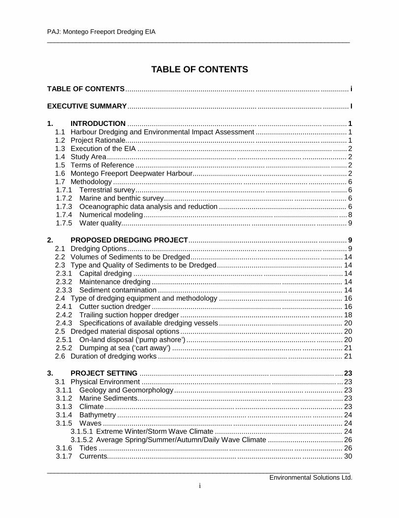
TABLE OF CONTENTS TABLE OF CONTENTS ................................................................ ................................ .............. i EXECUTIVE SUMMARY................................................................ ................................ ............. I 1. INTRODUCTION ................................................................ ................................ ............ 1
1.1 Harbour Dredging and Environmental Impact Assessment ............................................. 1 1.2 Project Rationale................................................................ ................................ ............. 1 1.3 Execution of the EIA ................................................................ ................................ ....... 2 1.4 Study Area................................................................ ................................ ...................... 2 1.5 Terms of Reference ................................................................ ................................ ........ 2 1.6 Montego Freeport Deepwater Harbour................................................................ ............ 2 1.7 Methodology ................................................................ ................................ ................... 6 1.7.1 Terrestrial survey................................................................ ................................ ........ 6 1.7.2 Marine and benthic survey................................................................ .......................... 6 1.7.3 Oceanographic data analysis and reduction ............................................................... 6 1.7.4 Numerical modeling................................................................ ................................ .... 8 1.7.5 Water quality................................................................ ................................ ............... 9
2. PROPOSED DREDGING PROJECT................................................................ .............. 9
2.1 Dredging Options................................................................ ................................ ............ 9 2.2 Volumes of Sediments to be Dredged................................................................ ........... 14 2.3 Type and Quality of Sediments to be Dredged.............................................................. 14 2.3.1 Capital dredging ................................................................ ................................ ....... 14 2.3.2 Maintenance dredging ................................................................ .............................. 14 2.3.3 Sediment contamination ................................................................ ........................... 14 2.4 Type of dredging equipment and methodology ............................................................. 16 2.4.1 Cutter suction dredger ................................................................ .............................. 16 2.4.2 Trailing suction hopper dredger ................................................................ ................ 18 2.4.3 Specifications of available dredging vessels ............................................................. 20 2.5 Dredged material disposal options ................................................................ ................ 20 2.5.1 On-land disposal (‘pump ashore’) ................................................................ ............. 20 2.5.2 Dumping at sea (‘cart away’) ................................................................ .................... 21 2.6 Duration of dredging works ................................................................ ........................... 21
3. PROJECT SETTING ................................................................ ................................ .... 23
3.1 Physical Environment ................................................................ ................................ ... 23 3.1.1 Geology and Geomorphology................................................................ ................... 23 3.1.2 Marine Sediments................................................................ ................................ ..... 23 3.1.3 Climate ................................................................ ................................ ..................... 23 3.1.4 Bathymetry ................................................................ ................................ ............... 24 3.1.5 Waves ................................................................ ................................ ...................... 24
3.1.5.1 Extreme Winter/Storm Wave Climate ............................................................... 24 3.1.5.2 Average Spring/Summer/Autumn/Daily Wave Climate ..................................... 26
3.1.6 Tides ................................................................ ................................ ........................ 26 3.1.7 Currents................................................................ ................................ .................... 30

PAJ: Montego Freeport Dredging EIA ____________________________________________________________________________________
____________________________________________________________________________________ Environmental Solutions Ltd.
ii
3.1.7.1 Offshore Deep Water Currents ................................................................ ......... 30 3.1.7.2 Inshore Shallow Water Coastal Currents .......................................................... 31
3.1.8 Surface hydrology................................................................ ................................ ..... 38 3.1.9 Marine water quality................................................................ ................................ .. 38 3.2 Biological Environment................................................................ ................................ .. 39 3.2.1 Terrestrial ecology ................................................................ ................................ .... 39
3.2.1.1 Flora................................................................ ................................ ................. 39 3.2.1.2 Fauna................................................................ ................................ ............... 41
3.2.2 Marine Ecology................................................................ ................................ ......... 41 3.2.3 Protected Areas – The Montego Bay Marine Park and Bogue Lagoon Fish Sanctuary ................................................................ ................................ ................. 46 3.3 Socio-economic Environment................................................................ ........................ 46 3.3.1 Demographics and livelihoods ................................................................ .................. 46 3.3.2 Transportation ................................................................ ................................ .......... 48 3.3.3 Land use and livelihoods. ................................................................ ......................... 48 3.3.4 Shipping ................................................................ ................................ ................... 49 3.3.5 Fishing Beaches................................................................ ................................ ....... 49 3.3.6 Recreation and Marina ................................................................ ............................. 50 3.3.7 Community perceptions of the proposed dredging project ........................................ 50 3.3.8 Natural and technological hazard vulnerability.......................................................... 50 3.3.9 Submarine cables................................................................ ................................ ..... 51
4. ENVIRONMENTAL POLICY, LEGISLATION AND REGULATORY FRAMEWORK ....51
4.1 Acts and associated Orders & Regulations ................................................................ ... 51 4.2 Policies and Regulations................................................................ ............................... 53 4.3 International Conventions ................................................................ ............................. 54
5. POTENTIAL ENVIRONMENTAL IMPACTS................................................................ .55
5.1 Dredging ................................................................ ................................ ....................... 55 5.1.1 Digging and excavation ................................................................ ............................ 55
5.1.1.1 Sediment dispersal and turbidity................................................................ ....... 55 5.1.1.2 Impedance of regular shipping ................................................................ ......... 56
5.1.2 Pipeline transport of dredged dredged material ........................................................ 56 5.1.3 Dredged material pipeline leakage................................................................ ............ 56 5.1.4 Hopper dredge spillage and leakage ................................................................ ........ 57
5.1.4.1 Deliberate spillages ................................................................ .......................... 57 5.1.4.2 Accidental spillages................................................................ .......................... 57
5.1.5 Noise ................................................................ ................................ ........................ 57 5.1.6 Visual/landscape impacts ................................................................ ......................... 57 5.1.7 Impairment of fishing activities................................................................ .................. 57 5.1.8 Modification of wave and current pattern inside harbour ........................................... 58 5.2 Dredged material disposal ................................................................ ............................ 58 5.2.1 Land disposal ................................................................ ................................ ........... 58
5.2.1.1 Contained storage disposal site................................................................ ........ 58 5.2.1.2 Earth materials sourcing................................................................ ................... 59 5.2.1.3 Earth materials transport ................................................................ .................. 59
5.2.2 Sea disposal................................................................ ................................ ............. 59 5.3 Summary of Impacts ................................................................ ................................ ..... 60

PAJ: Montego Freeport Dredging EIA ____________________________________________________________________________________
____________________________________________________________________________________ Environmental Solutions Ltd.
iii
6. PROJECT ALTERNATIVES................................................................ ......................... 64 6.1 ‘No Project’ Scenario ................................................................ ................................ .... 64 6.2 Hydraulic Cutter Suction Dredge vs. Trailing Suction Hopper Dredge........................... 64 6.3 Disposal Sites ................................................................ ................................ ............... 64 6.3.1 On-land disposal site ................................................................ ................................ 64 6.3.2 Deep sea disposal ................................................................ ................................ .... 65
7. IMPACT MITIGATION MEASURES ................................................................ ............. 66
7.1 Mitigation Measures................................................................ ................................ ...... 66 7.2 Mitigation Costs ................................................................ ................................ ............ 66 7.3 Recommended Mitigation ................................................................ ............................. 66
8. IMPACT MONITORING PLAN ................................................................ ..................... 70 9. EMERGENCY CONTINGENCY PLAN ................................................................ ......... 71
9.1 Oil Spill ................................................................ ................................ ......................... 72 9.3 Slurry Pipeline Leakage ................................................................ ................................ 72
10. PUBLIC CONSULTATIONS ................................................................ ......................... 72 11. CONCLUSIONS AND RECOMMENDATIONS ............................................................. 73
11.1 General Conclusions................................................................ ................................ . 73 11.2 Specific Conclusions – Option 2................................................................ ................ 74 11.2.1 Capital dredging with a TSHD................................................................ ................... 74 11.2.2 Maintenance dredging with a TSHD ................................................................ ......... 74 11.3 Option 2 –Monitoring Methods and Procedures for Dredging .................................... 74 11.4 Recommendations ................................................................ ................................ .... 75
12. REFERENCES ................................................................ ................................ ............. 76 13. APPENDICES ................................................................ ................................ .............. 78
Appendix 1. PAJ Project brief................................................................ ................................ 79 Appendix 2. List of attendees at public consultation to review Terms of Reference for the EIA held on 20 March 2002, Grandiosa Hotel, Montego Bay. ............................ 81 Appendix 3. Terms of Reference for Montego Bay Dredging EIA approved by NEPA........... 83
14. ACKNOWLEDGEMENTS................................................................ ............................. 86 15. PLATES ................................................................ ................................ ....................... 87

PAJ: Montego Freeport Dredging EIA ____________________________________________________________________________________
____________________________________________________________________________________ Environmental Solutions Ltd.
I
EXECUTIVE SUMMARY 1. Purpose of Study The Port Authority of Jamaica (PAJ) intends to restore the capacity of the deep-water harbour at the Montego Freeport, Montego Bay, so as to be able to accommodate larger vessels. To do so, the Authority proposes to carry out mostly maintenance dredging in the basin and along either side of the entrance channel leading into the harbour. The proposed dredging would seek to re-establish the original design depths of 10.4m and to increase the radius of the ship turning area. Port and harbour development is on the prescribed list of development activities for which a permit from the National Environment & Planning Agency (NEPA) is required. Given the potentially significant adverse environmental impacts associated with dredging, NEPA has requested the preparation and submission of an Environmental Impact Assessment (EIA) report to inform the permit application review process. This document presents that assessment. The EIA focuses solely on the potential issues directly related to the dredging activities. 2. Propo sed Project Of the several options under review, two have been selected for the purposes of this EIA. These are the options that entail the most and the least amount of capital dredging and so represent the ‘worst’ and ‘best’ case dredging scenarios. The two dredging options are shown at Figures 1 and 2. These will be referred to as Option 1 and Option 2 respectively for the remainder of the document. 2.1 Volumes of Sediments to be Dredged Dredging will be done to establish depths of 10.4m. The estimated quantities for dredged material generated by each option is given at Table 1. It can clearly be seen that Option 2 will generate the least amount of sediments requiring disposal and thus, in this regard, have the least potential environmental impact.
Table 1. Approximate dredging quantities associated
with the two proposed dredging options. � � � � � � � � � �
� � � � � � � � � � � � � � � � � � � � � � � � � ! " # $ % & ' ( ( ) * + , , , - - . / 0 1 12 - - 1 / 1 1 1 3 4 / 1 1 1 0 4 / 1 1 1
2.2 Type and Quali ty of Sediments to be Dredged 2.2.1 Capital dredging The new material to be removed from the western side of the basin comprises loose to firm coral sands and gravel, overlain by a thick layer of fine grey silt.
PAJ: Montego Freeport Dredging EIA ____________________________________________________________________________________
____________________________________________________________________________________ Environmental Solutions Ltd.
IV
2.2.2 Maintenance dredging The material to be cleared from the toes of the submerged slopes bordering the basin and the channel are mostly loose materials that have slumped down from unstable areas of the side slopes that are overlain by soft grey silts, up to two feet deep. 2.2.3 Potential for sediment contamination There are no major industrial operations in the vicinity of the Freeport and the watersheds of the Montego and Pies Rivers. It is therefore very unlikely that the any of sediments to be dredged would contain significant levels of contaminants that could cause concern with regard to their re-suspension and disposal during dredging works. The brand of hull anti-fouling paint used exclusively at the Montego Bay Yacht Club, situated within the Montego Freeport harbour, does not contain toxic tributyltin (TBT) and is USEPA approved. There are no boatyards in the vicinity of the project area that would be a source of TBTs. 2.3 Type of dredg ing equipment and methodo logy The PAJ proposes to use the services of either one or both dredging vessels presently working in Kingston Harbour. These are a hydraulic cutter suction dredge (HCSD) and a trailing suction hopper dredge (TSHD). The HCSD operates by suctioning up seabed materials macerated by a rotating head and transporting that material as a slurry in a pipeline to a nearby disposal site on land. The TSHD drags a pipe over the sea floor and sucks up the loose materials, placing them in a hopper container on the vessel. This material is then carried to the marine disposal site and discharged by opening the hopper gates at the bottom of the vessel. 2.3.1 Option 1 This option entails the greater amount of capital dredging at the western end of the harbour for which the HSCD would probably be best suited. This dredged material would likely contain reusable sediments (after drying), and the EIA study identified three possible sites for onshore disposal of this material. It favoured that site, located at the eastern side of the mouth of the harbour channel, used during dredging of the freeport in 1991. The maintenance dredging in the channel and along the sides of the port would best be performed by the TSHD. These dredged materials are likely to be too muddy for other beneficial uses and would best be disposed of at sea. The area identified for dredged material disposal is located 7-8 km north east of Montego Bay at the 1000m contour. Here, the prevailing current runs westerly and there would be no risk of suspended materials being transported inshore over sensitive coastal habitats such as coral reefs and fishing grounds. 2.3.2 Option 2 Involving relatively little capital dredging, this option is best undertaken using the TSHD alone. Since the dredged material would be predominantly mud, with little alternative beneficial use, this would be disposed of at sea at the deep-sea disposal site described above. This is the option that the PAJ has now selected for implementation.
PAJ: Montego Freeport Dredging EIA ____________________________________________________________________________________
____________________________________________________________________________________ Environmental Solutions Ltd.
V
2.4 Duration of dredg ing works Dredging would be carried out day and night. Option 1 could be accomplished in one to two weeks with the dredging equipment available. Option 2 would likely be completed in less than a week. 3. Potential Environmental Impacts Tables 5.1 & 5.2 in the main text provide summaries of the potential impacts, and their classification, related to cutter suction dredging and suction hopper dredging respectively. In most cases measures can be taken to avoid or reduce the severity of the impact, and the appropriate mitigation measures are identified below in Section 4. In a few cases the impacts cannot be avoided or successfully mitigated and these represent residual impacts. However, none of these are significant. Those impacts considered as most significant and relevant to the project options considered in this assessment are:
Dredging excavation – Positive (Options 1 &2) 1. Increased foreign exchange earnings and economic activity arising from expansion of
port facilities and increased cruise ship visits related directly to harbour dredging. 2. Creation of opportunities for employment and provision of materials during construction
of dredged material containment areas in the event of on-land disposal. 3. Opportunity for re-use of dredged material, if on-land dredged material disposal (Option
1) is selected.
Dredging excavation – Negative (Options 1 &2) 1. Loss of benthic habitat at dredging sites. 2. Sedimentation and turbidity at coral reefs at MBMP west of channel due to suspension
and dispersal of fine sediments at the northern end of the channel generated by dredging activities.
3. Possible short-term disruption of ship traffic due to dredging activities.
On-land d isposal – Positive (Option 1) 1. Relatively safe containment of any contaminated sediments. 2. Availability of sediments for re-use.
On-land d isposal – Negative (Option 1) 1. Loss of alternative land use of disposal site/s over short- to medium-term. 2. Release of liquid supernatant with suspended solids from containment cells into the
coastal marine environment, potentially threatening a section of the MBMP reef at the northern end of ‘Seawind Island’ with turbidity and sedimentation.
Deep sea disposal – Positive (Options 1 &2) 1. Relatively easy disposal option that pre-empts threat of sedimentation and turbidity
arising from land disposal site/s. 2. Removal from inshore waters, and dispersion and dilution of contaminated sediments (if
any).
PAJ: Montego Freeport Dredging EIA ____________________________________________________________________________________
____________________________________________________________________________________ Environmental Solutions Ltd.
VI
Deep sea disposal - Negative (Options 1 &2) 1. Accidental or deliberate release of dredged sediments from hopper during transport to
open sea disposal site, potentially threatening sensitive inshore coastal habitats west of Montego Bay.
2. Lost opportunity for reuse of dredged materials. 4. Impact Mitigation Tables 4.1 and 4.2 below list the potential impacts identified above and describe the corresponding mitigation measures that should be put in place during implementation of the dredging works. 5. Impact Monitoring Programme The monitoring programme should focus on:
1. use of the appropriate and specified dredging equipment for maintenance and capital dredging;
2. confinement of dredging to the specified dredging areas; 3. monitoring of the density of transported material in the pipeline, in the case of Option 1; 4. frequent measurements (say every two hours) of water turbidity at the active dredging
areas; 5. frequent measurements (say every two hours) of water turbidity at the storage cell
effluent release area (in the case of Option 1) 6. frequent measurements (say every two hours) of water turbidity over the coral reef at the
northern end of ‘Seawind Island’, particularly when dredging is taking place in the channel; and
7. constant on-board surveillance, supplemented by aerial observations, of the operations of the TSHD during filling, and transit to, and sediment release at, the approved deep sea disposal site.
6. Conclusions This EIA has been carried out on the premise that: a. It is necessary to carry out maintenance dredging to maintain the navigational safety of the
Montego Freeport; and b. Capital dredging is required in order to increase the capacity of the harbour to accommodate
larger cruise ship vessels. 6.1 General Conclusions 1. The sediments to be removed by maintenance dredging are comprised of materials that
have slumped from the slopes of the channel and harbour basin, and possibly of fine sediments taken by water currents into the Montego Freeport harbour from the outside bay. The latter would occur particularly after heavy rainfall when levels of suspended sediments in the bay are high.
2. Given the absence of major industrial and boatyard activity in the vicinity of the Freeport, it is unlikely that the dredged material will contain any significant levels of contaminants.
3. Fishing areas currently used by fishermen from River Beach and Whitehouse will not be adversely affected by dredging since the dredging will not be carried out in traditional fishing areas, the dredging operations will be of short duration, and dispersal of suspended sediments will be fairly contained.

PAJ: Montego Freeport Dredging EIA ____________________________________________________________________________________
____________________________________________________________________________________ Environmental Solutions Ltd.
X
4. There are no significant marine biological resources at risk in the Montego Freeport harbour. 5. Properly controlled dredging, the short duration of dredging works, and deployment of silt
screens when necessary will prevent any significant levels of suspended sediments reaching the coral reefs adjacent to the channel mouth.
6. It is possible to carry out the proposed dredging works for either Option 1 or Option 2 at Montego Freeport harbour without unacceptable adverse environmental effects.
7. The selection of Option 2 would incur less environmental risks since it: a) involves the least amount of dredging (54,000 cu.m. vs 227,000 cu.m.); b) uses only one type of dredge (TSHD), making it a simpler operation to implement and to
monitor environmentally; c) uses a type of dredging technology that generates relatively little turbidity; d) utilizes deep sea disposal of the dredged sediments, thereby avoiding environmental
risks associated with on-shore disposal; and e) implies little or no extension of Berth 6 and therefore will not exacerbate existing wave
reflection impacts at western shore of harbour basin. N.B. Option 2 is the dredging programme that has now been selected by PAJ for
implementation and for which specific approval from NEPA is now being sought.
6.2 Specific Conclusions - Option 2 6.2.1 Capital dredging with a TSHD
1. It is possible to carry out the proposed capital dredging works at the western end of the basin without unacceptable adverse environmental effects because: a) The relatively small amount of capital dredging involved with this option make it
feasible to use a TSHD for the dredging works, a type of machine that generates less turbidity than a HSCD;
b) Sediments placed in suspension by dredging activities will not affect any sensitive habitats in the basin and these should not have any more negative impact than that of the turbidity normally generated by ship traffic in the harbour;
c) Dredged materials will be removed and disposed of at a deep sea location, therefore avoiding any potential environmental issues related to on-shore disposal;
d) It is possible to avoid turbidity caused by hopper overfilling and/or early release during transit to disposal site by instituting proper vigilance and environmental management controls.
6.2.2 Maintenance dredging with TSHD
1. It is possible to carry out the proposed maintenance dredging works at the channel and in the basin without unacceptable adverse environmental effects because: a) Only a relatively small volume (approximately 34,000 cu.m.) of sediment needs to be
removed; b) A TSHD generates comparatively little turbidity during dredging; c) The potential effects of sediment suspension and turbidity can be mitigated by use of
silt screens near ecologically sensitive areas; d) It is unlikely that the sediments will be significantly contaminated; e) Dredged materials will be removed and disposed of at a deep sea location, therefore
avoiding any potential environmental issues related to on-shore disposal; f) It is possible to avoid turbidity caused by hopper overfilling and/or early release
during transit to disposal site by instituting proper vigilance and environmental management controls.

PAJ: Montego Freeport Dredging EIA ____________________________________________________________________________________
____________________________________________________________________________________ Environmental Solutions Ltd.
XI
7. Option 2 –Monitoring Methods and Procedures for Dredg ing 1. Consultations will be convened between the consulting engineers, the dredging
contractors, the environmental monitoring consultants, NEPA and MBMP before the commencement of dredging to detail and discuss implementation of the mitigation and monitoring procedures outlined below, and to agree on the appropriate compliance standards.
2. Consultations will be held with NEPA at an early stage to obtain approval of the proposed deep-sea disposal site for the dredged material.
3. The Montego Freeport port operators will be consulted in order to schedule the dredging works so as to cause the least impacts on shipping traffic.
4. Prior to commencement of dredging works, background measurements of water turbidity at two stations located east and west of the channel entrance will be taken. These readings will be made with reference to prevailing rainfall conditions and the state of river outflows into Montego Bay.
5. Silt screens will be deployed along the western side of the channel entrance prior to dredging operations in the channel. These will be placed so as to extend at least 300m from the tip of ‘Seawind Island’ towards the channel mouth.
6. Measurements of turbidity at three locations on along both sides of the screens will be done twice a day during dredging operations in the channel.
7. The other mitigation measures presented in Table 4.2 above will be implemented. 8. An environmental monitor will be present on site throughout the dredging operations to
verify compliance by the dredging contractor to the conditionalities of the dredging licence and to respond to any unforeseen situations that may arise.
9. The dredging works will be carried out in compliance with the NEPA licence. 8. Recommendations
1. To achieve the objectives of restoring the original depths of the Montego Freeport harbour and improving ship manoeverability and safety it is recommended that Option 2 be implemented in preference to Option 1 since it entails the least amount of capital dredging and incurs the least environmental risks.
2. Implementation of those dredging works should conform to the methods and procedures outlined above.

PAJ: Montego Freeport Dredging EIA ____________________________________________________________________________________
____________________________________________________________________________________ Environmental Solutions Ltd.
1
1. INTRODUCTION 1.1 Harbour Dredg ing and Environmental Impact Assess ment The Port Authority of Jamaica (PAJ) intends to increase the capacity of the deep-water harbour at the Montego Freeport, Montego Bay, so as to be able to accommodate larger vessels. To do so, the Authority proposes to carry out mainly maintenance dredging in the harbour basin and along the sides of the entrance channel. Some capital dredging at the western side of the harbour will be required to increase space for the ship turning area. The proposed dredging works would ultimately seek re-establish the original design depths of 10.4m. The project brief provided by PAJ is shown at Appendix 1. Dredging can be defined as the process of removal of submerged material from the seabed or from other water bodies by use of various types of excavation machinery. In the trade, dredging projects are categorized under three broad headings: 1. Capital dredging has the following features; relocation of large quantities of materials,
compact and undisturbed soil, low contaminant content (if any), significant layer thickness, and non-repetitive dredging activity.
2. Maintenance dredging is the term used to describe the type of dredging that has to be carried out periodically in order to maintain sufficient depth for safe navigation in waterways used by floating craft. Maintenance dredging is therefore usually concerned with removal of loose sediments that have accumulated relatively recently.
3. Remedial dredging applies to the removal of contaminated material and is usually linked to the further treatment, reuse or relocation of such materials. This type of dredging does not apply to the present project.
Port and harbour development is on the prescribed list of development activities for which a development permit from the National Environment & Planning Agency (NEPA) is required. Given the potentially significant adverse environmental impacts associated with dredging, NEPA has requested the preparation and submission of an Environmental Impact Assessment (EIA) report to inform the permit application review process. 1.2 Project Rationale Worldwide, cruise shipping is currently experiencing a period of substantial growth and cruise ship lines are increasing their capacities to meet this demand. This is taking the form of fourth generation mega-liners, vessels with overall lengths exceeding 1,000 feet and carrying 3,000+ passengers. Within this context, the Caribbean has emerged as the world’s most popular cruising area and Jamaica is a favoured destination. After Ocho Rios, Montego Bay is the second busiest cruise ship port in Jamaica, and it’s proximity to the Sangster International Airport makes it an ideal location for home berthing. One cruise shipping line has so far designated Montego Bay as such a port. The PAJ plans to expand the existing port facilities to take advantage of the expanding market opportunities as well as the anticipated increased size of vessels that will be plying the Western Caribbean circuit. At the present time, a suction cutter dredge and a hopper dredge are working in Jamaica at Kingston Harbour and will become available to undertake ancillary dredging works on the island

PAJ: Montego Freeport Dredging EIA ____________________________________________________________________________________
____________________________________________________________________________________ Environmental Solutions Ltd.
2
for a limited period of time after June 2002. The PAJ is seeking to have the dredging that is required for the port at Montego Bay done at this time.
1.3 Execution of the EIA This EIA was carried out by Environmental Solutions Ltd. The multidisciplinary team engaged to carry out the assessment included local expertise in environmental impact assessment, coastal engineering, oceanography, marine and coastal ecology, environmental chemistry, socio-economics and tourism planning. The team members were:
◊ Mr. Peter Reeson, M.Sc. - EIA Specialist and Team Leader ◊ Mr. Cowell Lyn, M.Sc. - Coastal Engineer ◊ Mr. David Narinesingh, M.Sc. – Oceanographer and Ecologist ◊ Mrs. Eleanor Jones, M.Sc. – Social Ecologist and Planner ◊ Mrs. Sharonmae Shirley – Environmental Chemist
1.4 Study Area The area encompassed by this study, shown at Figure 1.4.1, included the Montego Bay Freeport area and the adjacent coastal bay. Particular attention was also given to that area of the Montego Bay Marine Park in the vicinity of the deep-water port, the Bogue Lagoon and Fish Sanctuary, and the fishing beaches at River Bay and Whitehouse. The scope of work for the study was in part informed by a public consultation held at the Grandiosa Hotel on 20 March 2002 at which the proposed dredging project was outlined and the draft Terms of Reference for the EIA were presented. A list of those leaders and members of the Montego Bay community who attended the forum is provided at Appendix 2. 1.5 Terms of Reference The NEPA-approved TOR for the EIA of the proposed dredging works are provided at Appendix 3. They were adapted from World Bank and NEPA environmental assessment guidelines and make reference to NEPA Guidelines for the Planning and Executing of Coastal and Estuarine Dredging Works and Disposal of the Dredged Materials. The TOR also address specific NEPA requirements for this EIA as given in letters to PAJ dated 21 February 2002 and 8 April 2002. They were also informed by the public commentary during the public consultation process. It is to be noted that this EIA is solely concerned with the proposed dredging works in the Montego Freeport harbour. It is the intention of the PAJ to carry out a separate EIA, if required, of any plans for future berth development when these have been completed and are ready for implementation. The PAJ’s objective at present is to take advantage of the foreign dredging vessels presently in Jamaica and to carry out those dredging works which would have to be done eventually. 1.6 Montego Freeport Deepwater Harbour Montego Freeport is a 150 hectare seacoast resort complex, with some industrial/commercial elements (Plate 1.6.1). This area is the locus of a significant portion of the economic activity that supports the city of Montego Bay, the third largest urban concentration on the island.
PAJ: Montego Freeport Dredging EIA ____________________________________________________________________________________
____________________________________________________________________________________ Environmental Solutions Ltd.
3
Figure 1.4.1 PAJ Montego Freeport Dredging EIA - Study area and site location map.

PAJ: Montego Freeport Dredging EIA ____________________________________________________________________________________
____________________________________________________________________________________ Environmental Solutions Ltd.
4
The harbour embayment was created from a program of dredging and reclamation works carried out in 1967 by a group of private investors. Between March and September of that year, a total of 4.8 million cubic yards of coral rock and sand was dredged from an area inside the Bogue Islands, near to the original mouth of the Montego River. The dredged materials were deposited over several existing mangrove islets to achieve land reclamation for the development. The main borrow areas for the reclamation were planned so that the dredged-out areas would form the approach channel and turning basin for the deep-water berths which were to be constructed (Plates 1.6.2 & 1.6.3). By the end of 1969, the developers had completed construction of three deep-water berths, (Berths 2, 3 & 4), and a large transit shed, and the port began receiving calls from several cruise ships as well as some general cargo vessels. In 1982, Government of Jamaica acquired controlling interest in the entire Montego Freeport complex and in 1986, ownership of the port facilities was legally transferred to the Port Authority of Jamaica. During 1989/90, a new cruise ship terminal was constructed, including two additional Berths (#5 & #6) and some onshore reception facilities. The Harbour was last dredged in 1991 and the situation at the end of that episode was as follows:
◊ the access channel was widened by 30m, making it a minimum width of 168m (widening of the channel involved cutting the reef at the northern end of the outer promontory);
◊ the dimensions of the turning basin were enlarged to 416m in the north/south direction, and 425m in the east/west direction;
◊ the channel and turning basin were maintained down at their original depths of 10.4m; and
◊ the depth of water alongside the new Berths 5 & 6 was 10.4m. At present, the existing berthing facilities at the Montego Freeport, shown at Figure 1.6.1, are as follows:
◊ Berth #1 - not yet built. Since the original development in 1969, space was reserved at the northern end of the turning basin for construction of this berth and the space is still vacant.
◊ Berth #2 - can take vessels up to 213m long, with up to 9.1m draft; ◊ Berth#3 - can take vessels up to 160m long, with up to 6.2m draft; ◊ Berth#4 - can take vessels up to 160m long, with up to 5.9m draft; ◊ Berths #5 & #6 – are dedicated cruise ship docks, and can each take a single cruise ship
of up to 198m in length. Alternatively, both berths together can take one vessel of up to 268m in length, with draft of up to 9.6m (Plate 1.6.4).
The Montego Bay Yacht Club (MBYC) pier is located along western side of the basin and currently has about 30 recreational sailing and powerboats tied to it (Plate 1.6.5). A few adjacent shorefront properties also have small jetties on the harbour (Plate 1.6.6) and several small boats anchor in the corner of the basin (Plate 1.6.7).
PAJ: Montego Freeport Dredging EIA ____________________________________________________________________________________
____________________________________________________________________________________ Environmental Solutions Ltd.
6
1.7 Methodo logy 1.7.1 Terrestrial survey In the event that the sediment material arising from the dredging exercise was suitable for reuse (e.g. beach nourishment, construction, land reclamation, etc.) the dredged material could be
temporarily stored at one or all of three possible onshore storage sites. The sites (Ε1, Ε2, and
Ε3) are shown in Figure 1.4.1. A simple ‘walk through’ terrestrial survey of flora and fauna was conducted on 7 May 2002 at each of the three potential sites. Plant species were identified, the presence of rare and endemic plants was determined, and an indication of biodiversity at the sites was obtained.
Avifauna observed during the three terrestrial surveys and a shoreline survey between Site Ε3 and Montego River, were also recorded, based on actual sightings and bird calls. Species not immediately identifiable were noted and field guides (Bond, 1985; Downer et al, 1990) were used to verify their identity. 1.7.2 Marine and b enthic survey The benthos at twelve stations (GS1 - GS12) was sampled using a 0.25 m2 Van Veen grab on May 8, 2002. These stations are shown in Figure 1.7.1. The sediment was collected within plastic bags and a simple visual qualitative examination of the twelve samples was subsequently conducted to determine the presence of above-substrate and within-substrate marine flora and fauna. Sediment colour, smell and particle size was described. Seagrass and coral reef extent within (a) Montego Bay Harbour, (b) River Bay, and (c) Montego Bay were assessed by a combination of boat patrolling and exploratory grab sampling. The reef environment, immediately offshore of Site 1 (in the vicinity of the north Seawind Island fringing reef (see Figure 1.4.1)), was assessed by SCUBA diving on May 8, 2002. 1.7.3 Oceanog raphic data analysis and reduction Two hydrodynamic surveys were conducted within Bogue Lagoon and Montego Bay by Louis Berger International, Inc. in 1996. Continuous recording Interocean S4 current meters were deployed for two weeks at three stations in each water body. Figure 1.4.1 shows the location of the LBII OS4, OS5 and OS6 current meter stations in Montego Bay. The deployment depth at each station was approximately in the middle of the water column and current speed and direction was recorded by each meter at 10 minute intervals (LBII, 1996) The deployment information for the three instruments is summarised in Table 1.7.1.
Table 1.7.1 Summary information for the LBII (1996) OS current meters, deployed in Montego Bay in April 1993.
5 6 7 8 9 : ; < => ? @ A B C A D @ E F G H I J K L M I N K L M O P Q RS T U U V W X Y V X V U Y Z Z U [ W \ ] V ^ X _` a b c d e a ` f g h i c j
k l c m c n c
o p q r s t o r u v s w x r y q z { | } ~ � � � � � �� � � � � � � �
� � � � � � � � � � �� � � � � � � �
� � � � � � � � � � �� � � � � � � �
� � � � � � � � � � � � � � � � � � � � � � � ¡¢ £ ¤ ¥ £ ¤ ¢ ¢
� � � � � � � � ¡¢ ¦ ¤ � � ¤ ¢ ¢
� � � � � � � � ¡¢ ¦ ¤ ¡ ¢ ¤ ¢ ¢
PAJ: Montego Freeport Dredging EIA ____________________________________________________________________________________
____________________________________________________________________________________ Environmental Solutions Ltd.
8
LBII (1996) also recorded tidal elevations in Montego Bay in October 1992, during a precursor survey to their April 1993 spring survey. However, no tidal data was collected during the latter spring survey, due to tide gauge equipment failure (LBII, 1996). The location of the LBII 1992 tide gauge station is shown at Figure 1.4.1. Under the present EIA, the original LBII (1996) 10-minute time series plots of current velocities and tidal elevations were digitised at hourly intervals. The resulting hourly digitised data was subjected to detailed harmonic and spectral analyses and the digitised data for OS5 was used to drive the lateral western and northern open boundaries of the hydrodynamic model used during the present study. Details of the methodology and procedures employed are found in Narinesingh (2002) and Narinesingh (in prep). In the absence of time series wind data, in the LBII (1996) study, April 2002 wind data for Donald Sangster International Airport was used to drive the surface boundary of the hydrodynamic model. Comparison wind rose plots, for April 1993 (LBII, 1996) and April 2002, show that winds impacting Montego Bay in April of both years were very similar and justified the use of the April 2002 wind data in the absence of 1993 data (Narinesingh, 2002). Details of the hydrodynamic model and the Narinesingh (2002) hydrodynamic modeling exercise are summarised in the following subsection. 1.7.4 Numerical modeling The numerical model used during the exercise was the Princeton Ocean Model (POM). POM is a finite difference, three-dimensional, time-dependent, estuarine-, coastal- and deep-ocean circulation numerical model, designed by Alan Blumberg and George Mellor, for both coastal and open ocean studies. Given its ability to simulate both shallow water and deep ocean dynamics, POM is used by a large number of research and academic institutes around the world for a variety of applications ranging from small-scale coastal management problems to general circulation studies of the Atlantic Ocean (Blumberg and Mellor, 1987). The model accommodates realistic coastline geometry and bottom topography and can handle open boundaries through appropriate user-defined boundary conditions. A detailed description of POM, its numerics and its governing equations is found in Blumberg and Mellor (1987), Galperin and Mellor (1990), Mellor (1998) and Narinesingh (2001). Pre-project bathymetry was digitised from Admiralty Chart No. 468 of Montego Bay (UK Hydrographic Office, 1995). This chart had a scale of 1:12500 and has been routinely updated over the years. It contained corrections as recent as 2001. Post-project bathymetry was digitised from electronic “.pdf” file plans of the proposed dredging works, supplied to ESL by the project engineers. The XYZ digitised datum points were subsequently converted to Digital Elevation Model (DEM) grid files, by scattered data interpolation, using a Kriging method interpolation algorithm. The finite difference (FD) grids used during the model runs were then generated from these DEM grid files. The final FD grids represented a 2.65 km wide and 2.25 km long area and were comprised of a total of 2438 (rectilinear) horizontal grid points (IM=53,JM=46), regularly spaced 50 m apart (i.e. x and y were both equal to 50 m). For the model runs (and maximum FD grid depth of 22.7 m within the model domain), four (4) vertical, linear grid points were used. This effectively meant that a vertical resolution of 7.57 m was achieved during all the runs.
PAJ: Montego Freeport Dredging EIA ____________________________________________________________________________________
____________________________________________________________________________________ Environmental Solutions Ltd.
9
In all, a total of six (6) different model runs were performed. These six (6) run scenarios are briefly summarised in Table 1.7.2. Bathymetry was read into the model as a formatted ASCII file and POM was run in prognostic mode (i.e. mode 3), which is essentially a three-dimensional calculation (Mellor and Blumberg, 1983, 1987; Mellor, 1998). The model was initialised from a state of rest, starting on 07-Apr-1993 at 09:10:00 hours, and was allowed to run for a total run length of 14 days; ending on 21-Apr-1993 at 09:10:00 hours. With regards to model spin-up time, time history plots----for a preliminary run---indicate that the Montego Bay adapted POM achieves spin-up after a run length of 108 hours (i.e. 4.5 days). Model output prior to a run length of 120 hours/5 days (i.e. 12-Apr-1993 09:10:00) was therefore “discarded”/excluded during the analysis of the run results. 1.7.5 Water quali ty Six marine water quality stations were established in the study area to measure background levels of relevant parameters. Stations #1 - #3 were situated beside the navigation beacons on the western side of the entrance channel, Stations # 4 and #5 were located to the north of the proposed dredged material disposal Site #3 and at the mouth of the Montego River respectively. The locations of these stations are shown on Figure 1.7.2. The stations were occupied on the morning of 8 May 2002 and the parameters measured were: salinity, pH, temperature, total suspended solids (TSS), turbidity (Secchi disc), dissolved oxygen (DO), biological oxygen demand (BOD5), nitrates, phosphates, total and faecal coliform bacteria. Samples were collected at a depth of 0.5m. and collection was facilitated by use of a boat. All samples were collected in pre-cleaned 2 litre polyethylene sample bottles and placed on ice. Bacterial samples are collected at the water surface in sterilized 100 ml glass bottles. Salinity, temperature, and dissolved oxygen were measured in situ at all sampling stations using a YSI Model 57 Salinity/Conductivity/Temperature (SCT) meter and YSI Model 33 Oxygen meter respectively. Measurements were taken at the surface (0.5m depth) of the water column. Environmental Solutions Limited Laboratory performed or supervised the analysis of all parameters. Laboratory analyses used certified methodology, primarily from the text ‘Standard Methods for Examining Water and Wastewater’.
2. PROPOSED DREDGING PROJECT 2.1 Dredg ing Options The PAJ has engaged consulting engineers, Mott MacDonald (MM), to prepare plans for the dredging of the Montego Freeport harbour. Several options have been de veloped and ship handling and manoevering simulations are presently being carried out to determine the best one. For the purposes of this EIA, the two options that entail the most and the least amount of capital dredging will be considered since they represent the ‘worst’ and ‘best’ case dredging scenarios respectively. The two dredging options are shown at Figures 2.1.1 and 2.1.2. These will be referred to as Option 1 and Option 2 respectively for the remainder of the text.

PAJ: Montego Freeport Dredging EIA ____________________________________________________________________________________
____________________________________________________________________________________ Environmental Solutions Ltd.
14
2.2 Volumes of Sediments to be Dredged The Survey Department, Ministry of Land and Environment, carried out a bathymetric survey of the Montego Freeport harbour in February 2001. Based on that information, the estimated quantities for dredged material generated by each option is given at Table 2.1.
Table 2.1. Approximate dredging quantities associated
with the two proposed dredging options. § ¨ © ª « ¬ « ® ¯
° ± ² ³ ¨ ´ µ ¶ ± ³ ² ¶ © · ¶ ³ ´ ² ¬ ´ ¶ ´ ¸ ¬ ¹ ¨ ² ¶ ©º » » ¼ ½ ¾ ¿ À À ½ Á ¾ À À À   à ¾ ¿ À Àº   À ¾ À À À ½ Á ¾ À À À ¿ Á ¾ À À À
The depths of the sediments to be dredged at the western end of the harbour basin range between 2.4m and 10.2m with a mean depth approximating 6m for Option 1, and between 5.2m and 10.2m with a mean depth approximating 9.5m for Option 2. For either option, the depths of the areas to be dredged on either side of the harbour channel range between 1.1m and 10.3m, with a mean depth of about 9.8m. From the above it can be seen clearly that Option 2 will generate the least amount of sediments requiring disposal and thus, in this regard, have the least potential environmental impact. 2.3 Type and Quali ty of Sediments to be Dredged 2.3.1 Capital dredging Available borehole records from previous construction episodes at Montego Freeport suggest that the material which would have to be removed from the western end of the basin near to Berth 6 would be loose to firm coral sands and gravel, with some silt. However, anecdotal information from a knowledgeable local yachtsman (B. Langford, pers. com.) and the visual inspection of the sediment grab samples collected from this area indicate that these sediments are likely to be, for the most part, a deep, fine grey material with a low specific gravity. 2.3.2 Maintenance dredging Copies of the post-dredge records from the 1967 dredging program show clearly that the access channel and the turning basin were both originally dredged down to minimum -10.4m. Therefore, it can be expected that the material that will have to be cleared out from the toes of the submerged slopes bordering the basin and the channel, will be mostly loose materials that have slumped down from unstable areas of the side slopes. Also, It is felt that some of the loose sediments that have accumulated on the seafloor at the entrance of the access channel could be fine sediments, which may have settled out from turbidity plumes from the Pies River and Montego River during past rainy seasons. The sediment grab survey indicated that these sediments also were comprised of soft grey silts, up to two feet deep. 2.3.3 Sediment contamination Although dredging and dredged material disposal has the potential to redistribute and reintroduce toxic chemicals deposited in the sediments into the water column, it was decided at the outset of the EIA study not to carry out chemical determinations for potential contaminants in the harbour sediments owing to the absence of any industrial operations in the vicinity of the Freeport.

PAJ: Montego Freeport Dredging EIA ____________________________________________________________________________________
____________________________________________________________________________________ Environmental Solutions Ltd.
15
Many of the major shipping ports of the world are situated in estuaries, where siltation/sedimentation gives rise to the need for regular maintenance dredging so as to keep waterways open for navigation. These obstructive accumulations which have to be periodically removed result from seasonal inflows of sediment brought down from erosion of upland sections of the rivers and watercourses that debouch into the estuaries. In many cases, the rivers and waterways that discharge into the port areas of modern cities receive significant discharges of sewage and industrial effluent at up-stream locations, and these contaminants are continually mixing with and being absorbed by the sediments accumulated on the bottoms of the estuaries. This typical situation is much in evidence in Kingston Harbour, where studies have shown that the Rio Cobre and Sandy Gully bring down an average of around 1.5 million tonnes of sediment into Hunts Bay each year, The inflows also bring much contamination from sewage and industrial wastes. And so, the question of how to dispose of the contaminated sediments from the regular maintenance dredging that has to be done for Kingston Harbour, has been the cause of great concern for PAJ and NEPA and other interested parties. However, at Montego Freeport, siltation/sedimentation and contamination of harbour sediments is likely to be very much less of a problem than at Kingston. In the first instance, the Montego River and Pies River are very much smaller watercourses than the Rio Cobre and Sandy Gully. Their catchment areas are comprised of types of material which are less erodable than the Rio Cobre and Sandy Gully catchments and the volume of sediment that is washed down annually into Montego Bay is far less than in Kingston. Secondly, the human settlements, and the industrial activities taking place within the catchment areas of the Montego River and the Pies River, are relatively smaller, compared to those affecting Kingston Harbour. It therefore follows that the inflows from these watercourses would bring much less contamination into Montego Bay. It is only a relatively small quantity of maintenance dredging (34,000 cu. m.) that needs to be done to restore the Montego Freeport channel and turning basin to the 10.4m depth to which they were dredged in 1991, over ten years ago. The current accumulations of excess material are located mainly at the toes of the submerged slopes bordering the channel and basin (see Figure 2.1.1 above). This suggests very strongly that much of the sediments that now need to be removed would consist largely of materials originally used to fill the area in the late 1960s and which have subsequently slumped down to the bottom from unstable areas of the slopes. In view of all of the above-mentioned circumstances, it seems very unlikely that the maintenance dredging needed at Montego Freeport harbour would involve the removal of any significant amount of contaminated material, if any at all. (Since the above was written, the International Maritime Organisation workshop on ‘Pollution Prevention and Environmental Management in Ports in the Wider Caribbean Region’, held in Ocho Rios on 20 – 24 June 2002, brought to light recent information on the world-wide extent and severity of toxic tributyltin (TBT) contamination of sediments in ports and along shipping routes. TBT has been used as a biocide in marine anti-fouling paints since the early 1970s and although its use is now being discontinued it is likely that it is still being released from the hulls of older ships and from sailing vessels. The present existence or level of TBT contamination in the Montego Freeport harbour is not known. Potentially, the MBYC could be a source of anti-fouling paint releases in the basin. The Vice Commodore, Mr. Rpbert Mallasch, has confirmed that the anti-fouling paint used exclusively at the yacht club is the following:

PAJ: Montego Freeport Dredging EIA ____________________________________________________________________________________
____________________________________________________________________________________ Environmental Solutions Ltd.
16
Pettit Marine Paint Trinidad Anti Fouling Kop-Coat Inc., Pettit Paint Div. Active ingredients:
Cuprous oxide 65.0% Inert ingredients 35.0%
Copper as metalli c 57.7%
EPA Registration Number 60061-49
The boats are scraped and painted on land and the paint scrapings collected and disposed of in the usual garbage bin. It therefore seems unlikely that the MBYC would be a source of TBT. Otherwise, there are no boatyards at the Montego Freeport.) 2.4 Type of dredg ing equipment and methodo logy 2.4.1 Cutter suction d redger In both previous episodes of dredging works that have been carried out at Freeport, in 1967 and 1991, the type of equipment that was used was a hydraulic cutter suction dredger (HCSD) (Figure 2.4.1). Hydraulic dredgers are the most suitable type of equipment for dealing with firm granular materials such as that which may be encountered in carrying out the proposed capital dredging at the western end of Berth 6. Hydraulic dredging equipment use centrifugal pumps to provide the digging and lifting force to “suck up” excavated seabed material in slurry form. HCSDs have “cutter heads”, fitted with tough metal teeth, that rotate and bore into the seabed material, thereby enhancing the effectiveness of the excavation force. Nowadays, the more powerful types of cutter suction machines can deal efficiently with very compact sands and gravels, and even some types of soft, brittle rock, such as coral. HCSDs remain stationary while excavating, supported on legs called “spuds” which anchor them in position. The cutter does its digging supported on the tip of the dredger’s “ladder”, along with its suction pipeline. The ladder is swung from side to side in small arcs while digging, leaving a scalloped pattern to the edges of the dug out areas. The product from seabed excavation done by a HCSD is usually transported away from the dredged area by one or the other of the following two methods: i) The “pump ashore” method
In this method, the excavated sediments are pumped as slurry through a pipeline attached to the dredger, which conveys the dredged materials directly to a prepared on-shore deposition site. The deposition site can either be relatively close to the excavation site, or it can be quite remote. Currently, there are instances of projects where dredged material has been pumped to deposition sites located up to several miles distant from the dredge site. In such cases, it is often necessary to incorporate one or more booster stations in the pipeline, in order to overcome delivery rate inefficiencies due to friction in the pipelines.

PAJ: Montego Freeport Dredging EIA ____________________________________________________________________________________
____________________________________________________________________________________ Environmental Solutions Ltd.
18
ii) The “cart-away” method In this method, the dredged materials from the excavation are carted away from the dredge site in bottom-opening hopper barges. The usual way for the excavated dredged materials to be transferred from the cutter machine into the transporter barge is for the cutter dredge to pump its product directly into the attending hopper barge. This then transports the dredged materials to a pre-determined disposal site, where it is let out through the bottom gates of the barge. In some cases, if the rate of production of the cutter machine is inevitably slow, such as when hard material is being excavated, it becomes uneconomical to keep attendant transporter barges waiting at the site, while successive loads of excavated material are accumulated. In such cases, it is more economical for the cutter dredge to deposit the excavated material temporarily in loose heaps at locations in close proximity to the dredge site; and then the loosely stockpiled material can subsequently be picked up by a TSHD, and carted away for dumping.
The dredged materials from the dredging works that were carried out at Montego Freeport in 1991 were disposed of by the pump-ashore method. The dredged materials were deposited in a prepared disposal site on land near the harbour entrance. The disposal site was prepared ahead of commencement of the actual dredging works by trucking in marl, and using the marl to construct bund walls to form a containment reservoir for receiving the dredged materials. The bunding of the 1991 disposal site can be seen in the photograph at Plate 2.4.1. Plate 2.4.1 also shows a HSCD at work and a pipeline from the dredger discharging dredged material into the pre-constructed disposal reservoir located immediately behind the waterfront space reserved for construction of future Berth 1. Pipe outlets were inserted at appropriate locations in the bund walls to allow water mixed with the dredged material to flow out into the open bay. Whenever necessary turbidity screens were erected at the run-off outlets to prevent/reduce excessive amounts of very fine sediment from flowing out into the bay waters. Evidently the environmental protection authorities were satisfied in 1991 that this method of disposal of the dredged materials would not cause any unacceptable negative environmental impacts. Indeed, the following are a number of important advantages and benefits that were realized as a result of carrying out the dredging in the manner shown at Plate 2.4.1: a) Throughout the process of negotiations for award of the 1991 dredging contract the
method described above was identified as being by far the quickest and most economical method of getting the job done;
b) The method offered much flexibility in regard to accommodating normal ship traffic through the harbour and there was no loss of revenue reported during the time when the actual dredging was being carried out due to obstructions of ship traffic caused by the deployment of dredging equipment and disposal pipelines.
c) The dredged material captured in the onshore containment area proved to be a very valuable commodity and, within a relatively short period of time, all of the coarser material was taken away from the disposal site for utilization in several construction projects carried out in the Montego Bay area by the PAJ and other developers.
2.4.2 Traili ng suction hopp er dredger One type of machine that is very frequently used to carry out maintenance dredging is a trailing suction hopper dredger (TSHD) (Figure 2.4.2). TSHDs are self-propelled ships that can have either one or two tubular “drag-arms” extending from the side(s) of the vessel down into the water, with the tips of the tubes close to the floor of the waterway that is to be dredged. By
PAJ: Montego Freeport Dredging EIA ____________________________________________________________________________________
____________________________________________________________________________________ Environmental Solutions Ltd.
20
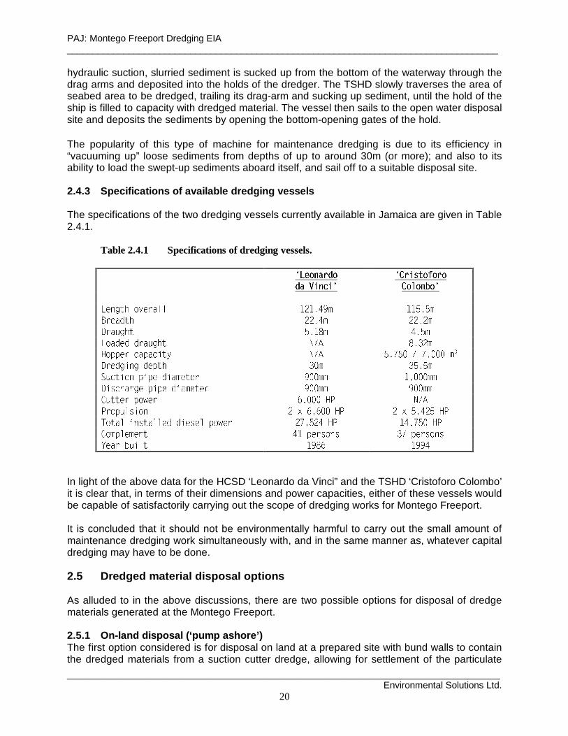
hydraulic suction, slurried sediment is sucked up from the bottom of the waterway through the drag arms and deposited into the holds of the dredger. The TSHD slowly traverses the area of seabed area to be dredged, trailing its drag-arm and sucking up sediment, until the hold of the ship is filled to capacity with dredged material. The vessel then sails to the open water disposal site and deposits the sediments by opening the bottom-opening gates of the hold. The popularity of this type of machine for maintenance dredging is due to its efficiency in “vacuuming up” loose sediments from depths of up to around 30m (or more); and also to its ability to load the swept-up sediments aboard itself, and sail off to a suitable disposal site. 2.4.3 Specifications of available dredging vessels The specifications of the two dredging vessels currently available in Jamaica are given in Table 2.4.1.
Table 2.4.1 Specifications of dredging vessels. Ä Å Æ Ç È É Ê Ë Ç
Ì Í Î Ï Ð Ñ Ï ÒÓ Ô Õ Ö × Ø Ù Ú Ù Õ Ù
Û Ü Ý Ü Þ ß Ü à
á â ã ä å æ ç è â é ê ë ë ì í ì î ï ð ñ ò ò ó ô ó õö ÷ ø ù ú û ü ý ý þ ÿ � ý ý þ ý �� � � � � � � � � � � �� � � � � � � � � � � � � � � � � � � � � ! " " # $ % & " & % ' ( ) * + , - . / - 0 1 / . 0 0 0 2 34 5 6 7 8 9 : 8 7 6 ; < = > ? @ > A B A @
C D E F G H I J G J K L G M N K F K O P Q Q N N R S Q Q Q N NT U V W X Y Z [ \ ] U ] \ ^ U Y _ \ ` \ Z a b b _ _ a b b _ _
c d e e f g h i j f g k l m m m n o p q ro s t u v w x y t z { | } ~ } � � � � { | � ~ � { � � �
� � � � � � � � � � � � � � � � � � � � � � � � � � � � � � � � � � � � � � � � �� � � � � � � � � � � � � � � � � � � � � � � � � � � �� � � ¡ ¢ £ ¤ ¥ ¦ § ¨ © ¦ § § ª
In light of the above data for the HCSD ‘Leonardo da Vinci” and the TSHD ‘Cristoforo Colombo’ it is clear that, in terms of their dimensions and power capacities, either of these vessels would be capable of satisfactorily carrying out the scope of dredging works for Montego Freeport. It is concluded that it should not be environmentally harmful to carry out the small amount of maintenance dredging work simultaneously with, and in the same manner as, whatever capital dredging may have to be done. 2.5 Dredged material disposal op tions As alluded to in the above discussions, there are two possible options for disposal of dredge materials generated at the Montego Freeport. 2.5.1 On-land d isposal (‘pump ashore’) The first option considered is for disposal on land at a prepared site with bund walls to contain the dredged materials from a suction cutter dredge, allowing for settlement of the particulate

PAJ: Montego Freeport Dredging EIA ____________________________________________________________________________________
____________________________________________________________________________________ Environmental Solutions Ltd.
21
content, and discharging the supernatant liquid to the sea. There are three sites in the immediate vicinity of the Freeport that potentially lend themselves to that purpose: Site 1 the undeveloped tract of land at the northern tip of the Freeport promontory (Plate 2.5.1),
and Site 2 the empty lot of land behind and south of Berth 6 (Plate 2.5.2). Site 3 the site used for dredged material disposal during the 1991 dredging operation located
east of the entrance channel and north of Berth 2 (Plate 2.5.3), Site 1 could be used for dredged material taken from the eastern side of the channel, Site 2 for dredged material from the western side of the channel, and Site 3 for material dredged at the western end of the basin. On the other hand, Site 3 alone could be used to contain the estimated 227,500 cu.m. of dredged materials generated by Option 1, bearing in mind that this site contained the approximately 300,000 cu.m. of material generated during the 1991 dredging works. This site is owned by PAJ. 2.5.2 Dumping at sea (‘cart away’) This option is worthy of consideration particularly if a hopper dredge is employed and if the particle size of the sediments is so small that it is not worthwhile to retain them on land for reuse as fill material. In this instance, it would be proposed to carry the dredged material to sea for disposal out as far as the 1000m contour north of the island where the prevailing westerly current (approx. 2 knots) would carry the suspended material away from land. Referring to Admiralty Chart 256, a suitable site should be available within 7 - 8 km of the harbour basin as shown at Figure 2.5.1. The site identified for this purpose would have to be approved by NEPA and the Maritime Authority of Jamaica. 2.6 Duration of dredg ing works The amount of dredging to be performed at the Montego Freeport harbour is considered to be a minor operation. In terms of the capacity of the large dredging vessels currently available in Jamaica and it should not take either type of dredger more than one to two weeks to accomplish the task, working around the clock. The more immediate consideration in this respect would be the time taken to prepare the disposal site if a land-based disposal option were selected. This could require several weeks. Completion of dredging is signaled by conduct of a post-dredging hydrographic survey to confirm conformance to the dredging design.

PAJ: Montego Freeport Dredging EIA ____________________________________________________________________________________
____________________________________________________________________________________ Environmental Solutions Ltd.
23
3. PROJECT SETTING 3.1 Physical Environment 3.1.1 Geology and Geomorpho logy The coastal area of Montego Bay (inclusive of Montego Bay City) is situated on a coastal limestone platform which forms part of the Pleistocene raised reefal limestone formations generally found exposed along large sections of the north coast of Jamaica. Thin layers of marine calcareous sand and silty sand deposits, less than 35 cm (14 in.) in depth, tend to overlie this coastal limestone platform. The open bay-harbour estuary, immediately offshore of the city of Montego Bay, is approximately 2 km wide and 2.5 km long. It is comprised of Montego Bay (in the north/northwest), River Bay (in the east/southeast) and the engineered basin of Montego Bay Harbour/Montego Freeport (to the southwest). This is shown at Figure 1.4.1. Land surrounding the coupled bay-harbour system is flat and lies, on average, 2 m to 3 m above sea level. Most of it was created during a dredging and land reclamation exercise, carried out by a group of private investors in the 1967 (Lyn, 2002). Between March and September 1967, a total of 3.7 million cubic meters (4.8 million cubic yards) of coralline rock and sand was dredged from an area inside of the Bogue Islands and used to fill (and connect) several mangrove islands between the Seawind Island and the shoreline at the time (op. cit.). 3.1.2 Marine Sediments The majority of the sediment samples, collected during the 8 May 2002 marine survey (see Figure 1.7.1), indicate that the sediments in the Montego Freeport harbour are comprised of a muddy/silty sediment layer greater than 0.5 m in thickness. The collected sediments were all dark grey in colour, odourless, and did not support any obvious above- or within-substrate marine flora or fauna. Exceptions to these observations were the samples collected at GS5 and GS6 (see Figure 1.7.1), i.e. stations located, respectively, at the edge and center of the cruise ship turning circle in the harbour. Samples collected at these two stations were comprised of terrigenous stones and rocks, generally having a diameter greater than 5 cm. The GS5 and GS6 samples were both devoid of the dark grey muddy sediment found at the other sampling stations. The probable reason for this is that any fine sediments that accumulate in the middle of the basin continuously are re-suspended and dispersed towards its sides by propeller wash from cruise ships and freighters. 3.1.3 Climate Montego Bay has a subtropical to tropical climate with temperatures ranging between 20oC and 27oC, in the winter, and 30oC and 32oC, in the summer. Mean annual rainfall is in the order of 1371.6 mm with two distinct rainy seasons between May - June and September - November annually. Mean monthly rainfall varies from 45 mm in March to 184.4 mm in October. Winds impacting Montego Bay are blow predominantly from the E and ENE throughout the greater part of the year. Some seasonal changes occur within this pattern, as a result of the relative position of the sun and the earth’s surface. In general, these seasonal changes in the annual wind regime may be described as follows:
◊ December to February: winds are primarily from the NE to ENE.

PAJ: Montego Freeport Dredging EIA ____________________________________________________________________________________
____________________________________________________________________________________ Environmental Solutions Ltd.
24
◊ March to May: winds are mainly from the East. ◊ June to August: winds are primarily from the E to ESE. ◊ September to November: winds are mainly from the E to SE.
Mean wind speed at Donald Sangster International Airport is typically 9 m/s (17 knots) and maximum sustained winds speeds are generally between 5 m/s (10 knots) and 12 m/s (25 knots) (Louis Berger International, Inc., 1996). 3.1.4 Bathymetry Montego Freeport is a relatively well protected harbour, largely due to the presence of Seawind Island and its associated fringing reef (see Figure 1.4.1). The approach to the harbour is by means of a 200 m wide, 800 m long, 10 m deep channel which opens directly into Montego Bay. Water depths in the center of Montego Freeport harbour (i.e. within the existing cruise ship turning basin) are typically between 10 m and 14 m (see Figure 1.4.1). Closer to the shoreline, particularly within the southwestern corner of the harbour, water depths are shallower and are generally between 1 - 6 m. Water depths outside the harbour increase gradually out to the 20m depth contour in Montego Bay (i.e. greater than 1 in 5 slope). In River Bay and Montego Bay water depths are typically between 0 - 6 m and 6 - 130 m respectively (see Figure 1.4.1). 3.1.5 Waves 3.1.5.1 Extreme Winter/Storm Wave Climate Donovan Rose & Associates (1991) provide a detailed and numerically plausible description of wave conditions in Montego Bay and Montego Freeport harbour during extreme winter wave/storm wave conditions. Their inferences and descriptions were supported by, and based upon, (i) a wave refraction numerical modeling study, and (ii) data obtained from the Montego Bay Coastal Development and the British Maritime Technology (BMT) publications. A brief summary of the DRA (1991) study, its findings and conclusions, is presented below. The DRA (1991) wave refraction numerical modeling programme incorporated (i) a 50 m x 50 m square refraction grid, (ii) bathymetry before and after the proposed PAJ 1991 dredging exercise, and (iii) model runs for wave periods of 6, 8 and 10 seconds (which effectively encompassed both ‘sea’ and ‘swell’ wave conditions). Input data from the Montego Bay Coastal Development study, done for the Urban Development Corporation in 1971, included a range of design wave periods ranging from 4 to 10 seconds. This data also included estimates of extreme wave heights for a 2 year (2.4 m (7.8 ft)) return period and a 100 year (4.4 m (14.3 ft)) return period. Input data from the BMT publication included a scatterplot of ‘all direction’ waves (with periods ranging from 3 to 12 seconds) and deep water wave heights (ranging from 0.5 to 6.0 meters) (DRA, 1991). Output from the DRA (1991) model runs included wave refraction plots, predicted wave crest angles and KrKs values. KrKs values are the resulting product of the refraction coefficient (Kr) and the shoaling coefficient (Ks) and are related to water depth and predicted wave height by the following equation, which is based upon Snell’s Law (US Army Coastal Engineering Research Center, 1984):
H/Ho = KrKs
PAJ: Montego Freeport Dredging EIA ____________________________________________________________________________________
____________________________________________________________________________________ Environmental Solutions Ltd.
25
where: H = model predicted wave height (m) Ho = water depth (m) KrKs = the product of the wave refraction coefficient and shoaling coefficient; i.e. Kr multiplied by Ks.
Using the above equation, model-predicted wave heights may, therefore, be calculated from the DRA study. Overall, the findings of the DRA (1991) study suggest that, during extreme ‘wind’ wave conditions (i.e. surface waves with a period less than 9 s), Montego Freeport harbour experiences wave heights in the order of 0.5 m - 1.3 m. Under extreme ‘swell’ wave conditions (i.e. surface waves with a period between 9 s and 15 s), the DRA (1991) study suggests that wave heights can reach a maximum predicted height of 1.8 m (for a NNW, 10 second period wave) within the engineered harbour basin. The predicted DRA (1991) wave orthogonals (i.e. the directions of the approaching waves) varied depending upon (a) the angle of the approaching wave crest, and (b) the wave period. The DRA (1991) wave climate study generally concluded that: a) coral reefs to the west of the entrance of the ship channel (GPS coordinates:-UTM Zone 18
189777E 2044451N (WGS84)), and those north of the Doctors Cave Bathing Club (GPS coordinates:-UTM Zone 18 190377E 2047409N (WGS84)), have the profound overall effect of sheltering the inner harbour against the prevailing wave climate; and
b) the inner harbour is very well sheltered and protected. Appendix 5 of the DRA (1991) study also suggests that although most of the wave energy from 0.5 m - 1 m ‘swell’ waves (which enter the harbour basin during maximum sustained 15 - 20 knot NE wind conditions) tend to dissipate by the time the waves reach Berth 5, waves with a reflected wave height of 0.15 m - 0.31 m are believed to reflect off the vertical face of the latter berth and continue their line of propagation towards the Montego Bay Yacht Club. The resolution of the DRA (1991) model (as well as that of the model used during the present study) was too coarse to actually depict this qualitative, albeit plausible, suggestion. Although it is quite possible that this type of wave reflection may be occurring at Berth 5, (a) there is presently no concurrent numerical/model/field data for Montego Freeport harbour to either support or refute this claim, and (b) any such occurrences are thought to be solely a feature of extreme winter storm wave events, as suggested by DRA (1991). This phenomenon, therefore, is unlikely to occur throughout the greater part of the year; or during a typical, average, daily wave cycle. However, as infrequent as these occurrences may be, they merit a more comprehensive and detailed coastal engineering investigation (which was beyond the scope, timeframe and the TOR of this EIA) to: a) quantify their magnitude and impact, and b) provide the basis for determining suitable mitigation measures. This recommendation is justified in light of the reports that the wave reflection occurrences are the cause of the shoreline erosion presently taking place between ‘Ocean Pines’ and the MBYC (Plate 3.1.1). Concerns were voiced at the TOR public consultations for the present study, and elsewhere, that any future extension of Berth 6 could exacerbate this erosion problem.

PAJ: Montego Freeport Dredging EIA ____________________________________________________________________________________
____________________________________________________________________________________ Environmental Solutions Ltd.
26
3.1.5.2 Average Spring/Summer/Autumn/Daily Wave Climate Observations made during the marine survey of 8 May 2002, coupled with conversations and interviews held with local fishermen, indicate that the daily (i.e. average) wave climate in Montego Bay and Montego Bay Harbour is characterised by wind-generated ripples which have wave heights in the order of 0.07 - 0.15 m and wavelengths less than 0.3 m. The daily prevailing easterly wind does not appear to result in wave heights greater than 0.5 m during April and May. Figures 3.1.1 and 3.1.2 show wave heights and wave crest orientations predicted by the ocean model used during the hydrodynamic simulations conducted under the present EIA study. Specifically, Figure 3.1.1 shows predictions for a rising tide condition, (a) prior to the proposed 2002 dredging exercise (top), and (b) subsequent to the proposed project (bottom); while Figure 3.1.2 shows similar predictions for a falling tide condition. Model-predicted sea surface elevation, and observations made during the May 2002 marine survey, suggest that waves with a wavelength equal to and greater than 50 m are negligible and tend to have wave heights in the order of millimeters (cp. Figures 3.1.1 and 3.1.2). These model predictions and observations are based on a typical of April/May seasonal wind, wave and current velocity condition (cp. LBII, 1996). April and May, however, are generally quieter, calmer and less energetic (in terms of daily wind and wave conditions) than the ensuing summer, autumn and winter months (Narinesingh, in prep) and are probably a poor indication of wave conditions during the latter seasons. 3.1.6 Tides Figure 3.1.3 (top) shows an hourly time series plot of the original LBII (1996) 10-minute tide data set, digitised from the original LBII two-week (i.e. 16 day) October 1992 tide curve. This plot, coupled with harmonic and spectral analyses carried out on the digitised data set, clearly indicate that tides in Montego Bay (at least in October/November1992) were semi-diurnal mixed (unequal) tides. The results of the harmonic analysis are presented in Table 3.1.1. A total of 17 harmonic constituents were obtained from the analysis. Concurrently, the spectral analysis results are shown in Figure 3.1.3 (bottom). Two main peak frequencies (namely 0.08051 - 0.08333 cph and 0.03873 - 0.04178 cph) were obtained from the exercise (see Figure 3.1.3 (bottom)). These frequencies translate into periods of 12.42 - 12.00 hours and 25.82 - 23.93 hours, respectively, suggesting strong semi-diurnal (i.e. M2,S2) and diurnal (i.e. K1,O1) components in the original tide signal. The second point worth noting is that the magnitude of the M2,S2 semi-diurnal peak is approximately 2.5 times that of the K1,O1 diurnal peak. This indicates that the semi-diurnal component of the tide tends to predominate over its corresponding diurnal component and contributes more to overall tidal amplitude/height than the diurnal component of the tide. Table 3.1.1 supports these finding and suggests that the main tidal constituents in Montego Bay are the semi-diurnal Moon (i.e. M2) and the semi-diurnal Sun (i.e. S2) tides, with tidal amplitudes of 0.0929 m and 0.0648 m, respectively. Overall, LBII (1996) report that tide heights in Montego Bay, during the October 1992 survey, ranged between 0.20 m and 0.45 m; with an approximate average of 0.30 m.

PAJ: Montego Freeport Dredging EIA ____________________________________________________________________________________
____________________________________________________________________________________ Environmental Solutions Ltd.
27
Figure 3.1.1 POM rising tide pre-project (top) and po st-project (bottom) surface
elevation p redictions.

PAJ: Montego Freeport Dredging EIA ____________________________________________________________________________________
____________________________________________________________________________________ Environmental Solutions Ltd.
28
Figure 3.1.2 POM falli ng tide pre-project (top) and po st-project (bottom) surface
elevation p redictions.
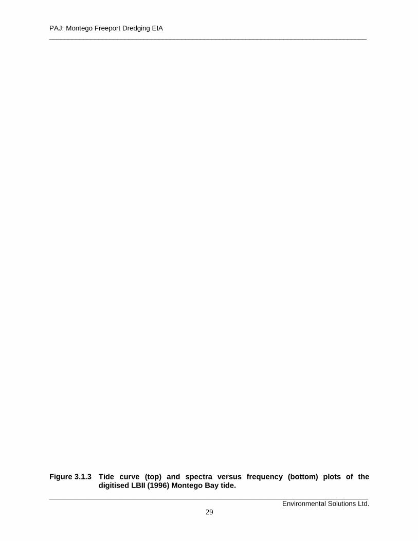
PAJ: Montego Freeport Dredging EIA ____________________________________________________________________________________
____________________________________________________________________________________ Environmental Solutions Ltd.
29
Figure 3.1.3 Tide curve (top) and spectra versus frequency (bottom) plots of the
digitised LBII (1996) Montego Bay tide.
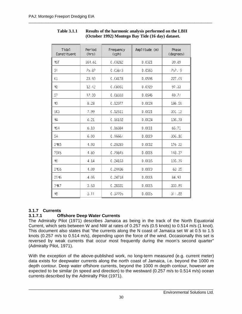
PAJ: Montego Freeport Dredging EIA ____________________________________________________________________________________
____________________________________________________________________________________ Environmental Solutions Ltd.
30
Table 3.1.1 Results of the harmonic analysis performed on the LBII (October 1992) Montego Bay Tide (16 day) dataset.
« ¬ ® ¯
° ± ² ³ ´ µ ´ ¶ · ² ´¸ ¹ º » ¼ ½
¾ ¿ À Á ÂÃ Ä Å Æ Ç Å È É Ê
Ë É Ì Í ÎÏ Ð Ñ Ò Ó Ô Õ Ö × Ø Ð Ù Ú Û Ü Ý ×
Þ ß à á â à à ã ä
å æ ç è é ê ë ì í î ë î î ï ð ï î ë î è ï í è ñ ë ð ñ
ò ó ô õ ö ÷ ô ø ö ø ù ÷ ú ù ø ö ø ù û ù ô õ ô ö ó ü
ý þ ÿ � � � � � � � � þ � � � � � � � � ÿ ÿ � � � �
ÿ þ ÿ � � ÿ � � � � � � þ � � � � ÿ � � � � � �
ÿ þ ÿ � � � � � � � � � � � � � � � � � � � ÿ �
� � � ÿ � � � þ ÿ � � � � � � � ÿ � þ � � � � �
ý � � � � � � � þ ÿ � þ þ � � � � ÿ þ � � þ � þ ÿ
� � � ÿ þ � � þ � þ � ÿ � � � � ÿ � þ � � � � �
� � � þ � � � þ � � � � � � � � þ þ � � � � þ
� � � � � � � þ � � � � � � � � � � � � � � � �
ÿ ý � � � � � � � ÿ � ÿ � � � � � � þ ÿ þ � � � � ÿ
ÿ ý � � � � � � � ÿ � � � � � � � � � � þ � � � � ÿ
� � � þ � � � ÿ � þ � � � � � � þ � þ � � � � �
ÿ � � � � � � � ÿ � � � � � � � � � � � � � � �
ÿ � � � � � � � ÿ � � þ � � � � � � � � � � � �
� ý � � � � � � � ÿ � � � þ � � � � � � � � � � � �
� � � þ þ � � � ÿ ÿ � � � � � � � � � þ þ � � �
3.1.7 Currents 3.1.7.1 Offshore Deep Water Currents The Admiralty Pilot (1971) describes Jamaica as being in the track of the North Equatorial Current, which sets between W and NW at rates of 0.257 m/s (0.5 knots) to 0.514 m/s (1 knot). This document also states that "the currents along the N coast of Jamaica set W at 0.5 to 1.5 knots (0.257 m/s to 0.514 m/s), depending upon the force of the wind. Occasionally this set is reversed by weak currents that occur most frequently during the moon’s second quarter" (Admiralty Pilot, 1971). With the exception of the above-published work, no long-term measured (e.g. current meter) data exists for deepwater currents along the north coast of Jamaica, i.e. beyond the 1000 m depth contour. Deep water offshore currents, beyond the 1000 m depth contour, however are expected to be similar (in speed and direction) to the westward (0.257 m/s to 0.514 m/s) ocean currents described by the Admiralty Pilot (1971).

PAJ: Montego Freeport Dredging EIA ____________________________________________________________________________________
____________________________________________________________________________________ Environmental Solutions Ltd.
31
3.1.7.2 Inshore Shallow Water Coastal Currents Introduction - General Circulation Computer modeling, conducted for the present EIA, reveals a residual circulation in Montego Bay Harbour, River Bay and Montego Bay, inclusive of the presence gyres which persist in general form, pattern, and direction on both the rising and falling limbs of the Montego Bay tide (Figures 3.1.4 and 3.1.5). With the exception of minor fluctuations in the speed of the gyres, the pattern, form, and direction of the overall residual circulation patterns remain unchanged and are remarkably similar, regardless of the stage of the tide. This type of horizontally unidirectional circulation pattern is not uncommon to bidirectional tidal reversal flows, which occur through shallow inlets. This unidirectional flow pattern has been observed and documented by several authors in the Gulf of Maine (Bigelow, 1927; Tee, 1987) and during studies involving tidally driven inlet-estuary systems and their resulting shelf flow (Csanady, 1974; Wheless and Valle-Levinson, 1996). In Montego Bay, the observed unchanging residual circulation pattern is primarily attributable to the closed geometry of the system’s shoreline (which essentially has a single open boundary to the north and, for all intents and purposes, is confined to the east, south and west). The low rate of flushing of the system, coupled with the inability of the weak observed LBII (1996) tidal reversal currents at overturning the residual circulation pattern (particularly their associated predicted gyres), means the unidirectional residual pattern is maintained throughout all stages of the tidal cycle. Model predictions, during the study, were validated through comparison of the modeled data with observed current meter data from two currents meters moored in Montego Bay (in April 1993) by Louis Berger International, Inc. (LBII, 1996). The location of these two stations (OS4 and OS6) are shown in Figure 1.4.1. Data from OS5 (see Figure 1.4.1) was used to drive the model during the simulations. Scatterplots of the LBII (1996) 14 day, April 7 to April 21, 1993, OS4, OS5 and OS6 current meter data sets are shown in Figure 3.1.6 and a detailed account of the comparison/validation exercise may be found in Narinesingh (2002). Overall, comparison with the modeled and observed current velocity data was good. A drogue tracking exercise, conducted on May 8, 2002, also agrees well with the model predictions and lends credence to the study. Figure 3.1.7 shows the resulting drogue tracks, overlayed on the rising and falling depth-average predicted current vectors and current speed contour plots of the modeling exercise. Figure 3.1.8, in turn, shows the drogue tracks overlayed on the UK Hydrographic Office (1995) Admiralty Chart of Montego Bay. The reader is referred to Narinesingh (2002) for details on the drogue tracking exercise and the resulting comparison with model predicted data. Currents in Montego Freeport Harbour The model simulations suggest that there are two poorly formed, weak, anti-clockwise gyres located, respectively, in the center of the harbour (i.e. within the cruise ship turning basin) and just south of the harbour entrance (see Figures 3.1.4 and 3.1.5 (top)). These gyres, respectively, have diameters of 300 m and 200 m and tend to drive longshore currents which sweep southwest (along the western shoreline of the harbour), east (along the southern shoreline and existing cruise ship berths) and northeast (along the eastern shoreline of the harbour). The latter longshore currents, however, are generally weak and have current speeds less than 0.02 m/s (see Figures 3.1.4 and 3.1.5 (top)).
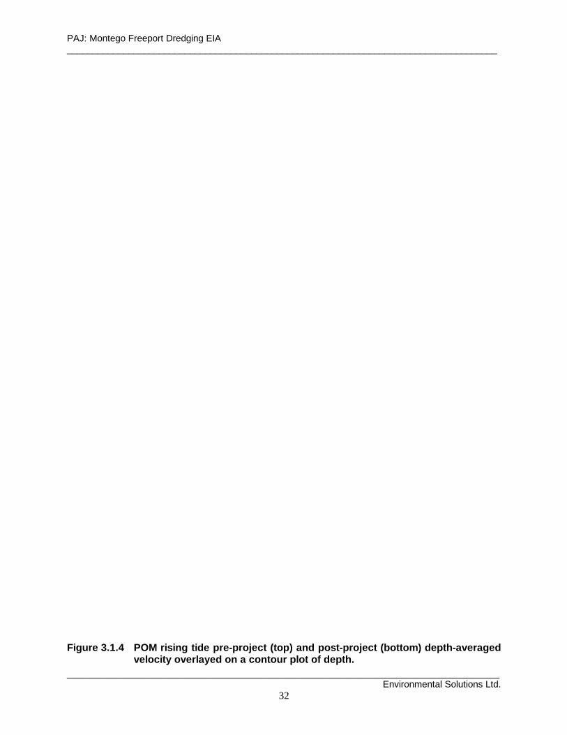
PAJ: Montego Freeport Dredging EIA ____________________________________________________________________________________
____________________________________________________________________________________ Environmental Solutions Ltd.
32
Figure 3.1.4 POM rising tide pre-project (top) and po st-project (bottom) depth-averaged
velocity overlayed on a contour plot of depth.

PAJ: Montego Freeport Dredging EIA ____________________________________________________________________________________
____________________________________________________________________________________ Environmental Solutions Ltd.
33
Figure 3.1.5 POM falli ng tide pre-project (top) and po st-project (bottom) depth-averaged
velocity overlayed on a contour plot of depth.
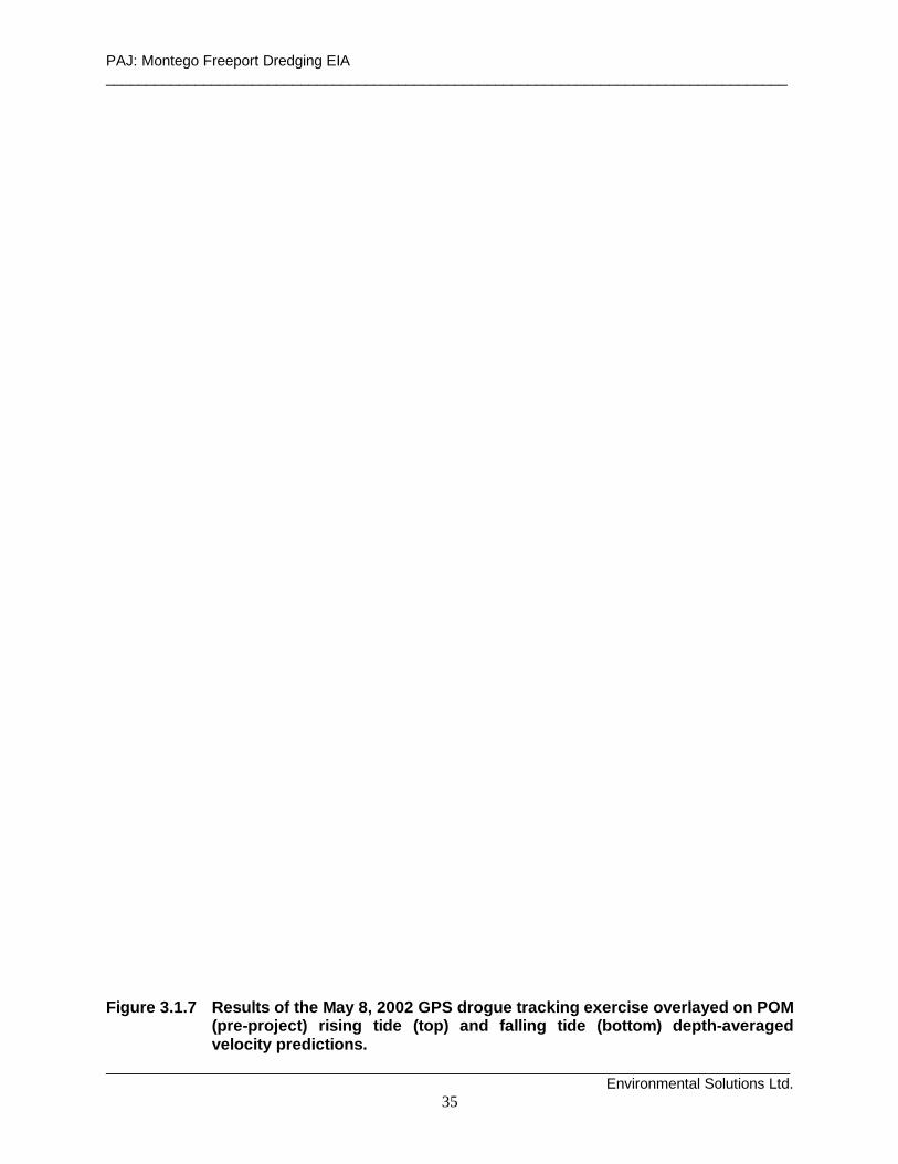
PAJ: Montego Freeport Dredging EIA ____________________________________________________________________________________
____________________________________________________________________________________ Environmental Solutions Ltd.
35
Figure 3.1.7 Results of the May 8, 2002 GPS drogu e track ing exercise overlayed on POM
(pre-project) rising tide (top) and falli ng tide (bottom) depth-averaged velocity predictions.

PAJ: Montego Freeport Dredging EIA ____________________________________________________________________________________
____________________________________________________________________________________ Environmental Solutions Ltd.
37
Smaller clockwise eddies (50 - 100 m in diameter) are found at the entrance to Berths 3 and 4, and within the southwestern corner of the harbour (offshore of PAJ’s proposed onshore temporary dredged material disposal Site 2—cp. As shown at Figures 3.1.4 and 3.1.5 (top) and Figure 1.4.1). These smaller clockwise eddies are driven primarily by lateral shear from the main anticlockwise gyre located within the harbour’s turning basin. Overall, average current speed in Montego Bay Harbour is generally less than 0.03 to 0.04 m/s and is, on average, 0.01 m/s or less. Model simulations suggest that post-project bathymetry (see Figures 3.1.4 and 3.1.5 (bottom)) is unlikely to affect the overall circulation pattern within Montego Freeport Harbour. The pre-project predicted gyre located in the center of the harbour (i.e. within the cruise ship turning basin) is likely to persist and remain the dominant feature of circulation in the harbour. The smaller predicted clockwise eddies, at the entrance to Berths 3 and 4 and within the southwestern corner of the harbour, are also likely to persist and will continue to be offshoots of the main anticlockwise turning basin gyre. Overall net sediment transport directions and patterns are likely to remain the same. However, increased current speeds, particularly along the western shoreline, are likely to increase resulting longshore sediment transport rates. These increased longshore sediment transport rates are likely to aid and abet wave-induced erosion along the shoreline in this area, i.e. through increased horizontal transport of sediments resuspended along the shore by existing/increased wave activity. Any sediment plume, released offshore of the northern shoreline of temporary storage Site 2 (i.e. during dredge dredged material associated run off from the site), will most likely be advected around, but restricted to, the confines of the Montego Freeport Harbour. Currents in River Bay and Montego Bay Model simulations using pre-project and post-project bathymetry are shown in Figures 3.1.4 and 3.1.5 for rising and falling stages of the Montego Bay tide. The simulations suggest that circulation within River Bay is dominated by a 400 m diameter clockwise gyre which has average current speeds varying between 0.03 and 0.04 m/s. Concurrently, the simulations suggest that flow within Montego Bay is dominated by a large 600 - 700 m (diameter) anticlockwise gyre which has average current speeds varying between 0.05 and 0.12 m/s. The model runs suggest that these gyres persist on both the rising and falling stages of the Montego Bay tide. Pertinent to the present EIA is the fact that all the simulations suggest that currents offshore of Site 3 are primarily towards the northwest. (Site 3 is the favoured site, in the event that onshore spoil disposal is considered a viable option.) Drogue tracking, immediately offshore of Site 3, confirms the fact that this is the prevailing current direction in this section of River Bay (see Figure 3.1.8). A sediment plume, released off the northern shoreline of Site 3, will therefore most likely be advected towards the stressed fringing reef along the northern shoreline of Seawind Island. A corresponding sediment plume released north and offshore of Site 1 is likely to be advected in a northwestward/westward direction, out of Montego Bay-----provided the discharge point is 500 m offshore of Seawind Island and not on top, or within the back reef, of the latter.
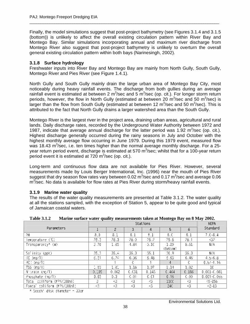
PAJ: Montego Freeport Dredging EIA ____________________________________________________________________________________
____________________________________________________________________________________ Environmental Solutions Ltd.
38
Finally, the model simulations suggest that post-project bathymetry (see Figures 3.1.4 and 3.1.5 (bottom)) is unlikely to affect the overall existing circulation pattern within River Bay and Montego Bay. Similar simulations incorporating annual and maximum river discharge from Montego River also suggest that post-project bathymetry is unlikely to overturn the overall general existing circulation pattern within both bays (Narinesingh, 2002). 3.1.8 Surface hydrology Freshwater inputs into River Bay and Montego Bay are mainly from North Gully, South Gully, Montego River and Pies River (see Figure 1.4.1). North Gully and South Gully mainly drain the large urban area of Montego Bay City, most noticeably during heavy rainfall events. The discharge from both gullies during an average rainfall event is estimated at between 2 m3/sec and 5 m3/sec (op. cit.). For longer storm return periods, however, the flow in North Gully (estimated at between 20 m3/sec and 50 m3/sec) is larger than the flow from South Gully (estimated at between 12 m3/sec and 50 m3/sec). This is attributed to the fact that North Gully drains a larger watershed area than the South Gully. Montego River is the largest river in the project area, draining urban areas, agricultural and rural lands. Daily discharge rates, recorded by the Underground Water Authority between 1972 and 1987, indicate that average annual discharge for the latter period was 1.92 m3/sec (op. cit.). Highest discharge generally occurred during the rainy seasons in July and October with the highest monthly average flow occurring in June 1979. During this 1979 event, measured flow was 18.43 m3/sec, i.e. ten times higher than the normal average monthly discharge. For a 25-year return period event, discharge is estimated at 570 m3/sec; whilst that for a 100-year return period event it is estimated at 720 m3/sec (op. cit.). Long-term and continuous flow data are not available for Pies River. However, several measurements made by Louis Berger International, Inc. (1996) near the mouth of Pies River suggest that dry season flow rates vary between 0.02 m3/sec and 0.17 m3/sec and average 0.06 m3/sec. No data is available for flow rates at Pies River during storm/heavy rainfall events. 3.1.9 Marine water quali ty The results of the water quality measurements are presented at Table 3.1.2. The water quality at all the stations sampled, with the exception of Station 5, appear to be quite good and typical of Jamaican coastal waters. Table 3.1.2 Marine surface water quality measurements taken at Montego Bay on 8 May 2002. � � � � � � �
� � � � � � � � � � � � � �� � � �
! " # $ " % $& ' ( ) * ( ) + ( ) + ( ) + ( ) * ( ) + , ) * - ( ) .
/ 0 1 2 0 3 4 5 6 3 0 7 8 9 : ; < = > ; < = ? ; < = ? ; < = ; ; < = < ; < = @ A B CD E F G H I F E J G K L M N O P Q R S T U R V W X R V X Y R U T U R Q Z
[ \ ] ^ ^ ] _ `a b c d e f g
h i j k l k m n o p p m q r s t r r s t u r s t r r s t v r w t x r s t r e f gy z o { | f j q } t r v } t ~ u } t r } } t u � } t } r } t u } u t s � } t �� � � � � � � � � � � � � � � � � � � � � � � �
� � � � � � � � � � � � � � � � � � � � � � � � � � � � � � � � � � �� � � � � � � � � � � � � � � � � � � � � � � � � � � � � � � � � � � � � � � � � � � � � � � � � � � � � �� ¡ ¢ £ � � � � � � � � � � � � � � � � � � � � � � � � � � � � � � � � � � � � � � � � � � � �
� ¡ � � � ¤ ¡ � � ¥ ¡ � � � ¦ � � � � � � � � � � § � § � § � � � � � § � � � � � � �¨ � � ¤ � � ¤ ¡ � � ¥ ¡ � � � ¦ � � � � � � � � � § � § � § � § � � � � § � § � � � �
© ª « ¬ ¬ ® ¯ ® ° ± ¯ ® ² ³ « ´ « µ ¶ · · ¬ ³
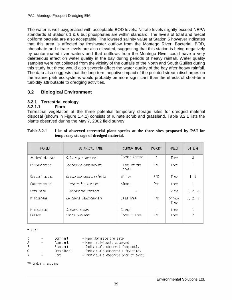
PAJ: Montego Freeport Dredging EIA ____________________________________________________________________________________
____________________________________________________________________________________ Environmental Solutions Ltd.
39
The water is well oxygenated with acceptable BOD levels. Nitrate levels slightly exceed NEPA standards at Stations 1 & 6 but phosphates are within standard. The levels of total and faecal coliform bacteria are also acceptable. The lowered salinity value at Station 5 however indicates that this area is affected by freshwater outflow from the Montego River. Bacterial, BOD, phosphate and nitrate levels are also elevated, suggesting that this station is being negatively by contaminated river waters and that outflows from the Montego River could have a very deleterious effect on water quality in the bay during periods of heavy rainfall. Water quality samples were not collected from the vicinity of the outfalls of the North and South Gullies during this study but these would also severely affect the water quality of the bay after heavy rainfall. The data also suggests that the long-term negative impact of the polluted stream discharges on the marine park ecosystems would probably be more significant than the effects of short-term turbidity attributable to dredging activities. 3.2 Biolog ical Environment 3.2.1 Terrestrial ecology3.2.1.1 Flora Terrestrial vegetation at the three potential temporary storage sites for dredged material disposal (shown in Figure 1.4.1) consists of ruinate scrub and grassland. Table 3.2.1 lists the plants observed during the May 7, 2002 field survey. Table 3.2.1 List of observed terrestrial plant species at the three sites proposed by PAJ for
temporary storage of dredged material.
¸ ¹ º » ¼ ½ ¾ ¿ À Á Â Ã Ä Á Å Â Á Æ Ç Ä ¿ Æ Æ ¿ Â Â Á Æ Ç È É Ê Ë Ì Í Î Ï Ð Ñ Ò Ó Ô Õ Ö ×
Ø Ù Ú Û Ü Ý Þ ß à ß Ú Ü ß Ü á â ã ä å æ ä ç è é ç æ ä ê ë æ â ì í î ï ð ñ ò ó ô ô ó ï õ ö í î î ÷ø ù ú ï ó ï ù û ð î û î ü ý þ ÿ � � � � þ � þ � ý þ � � � þ ÿ þ � � � � � �
� � � �� � � � � �
� � � � � � � � � � � � � ! � " # $ � % & ! # % ' # ( ) * # � + , - - . / 0 1 2 3 4 5 5 6 7 89 : ; < = > ? @ A > @ > B C D E F G H I F H J H K K H L H M N O P Q R S T U V W X X Y
Z [ \ ] ^ _ ` \ ` a b c d c e c f g h i j k i l g h m n o p q r r s t u t v
w x y z r q { | q | } ~ � � � ~ � � � ~ � � � � ~ � � � � � � � � � � � � � � � � � � � � � �� � � �
� � � � �
� � � � � � � � � � � � � ¡ ¢ � £ � � ¡ ¤ � � ¥ ¦ � § � � � � �¨ � © � � � ª « ¬ « £ ¡ ¬ ® ¯ ¢ ° � ± � � � ¥ � ² � � � � § � ³ � � � � �
´ µ ¶ · ¸
¹ º » ¼ ½ ¾ ¿ À ¿ Á º Â À ¿ Ã Ä ¼ ½ ¾ ¿ À Á Å Á Æ Å Ç ¾ Á ÅÈ º É Ê Ë ¿ Ä À ¿ Á º Â À ¿ Ã ¾ ¿ Ä ¾ Ì ¾ Ä Ë À Í Ç ¼ Ê Ç Å Î Ì Å Ä
Ï º Ð Ñ Ò Ó Ô Ò Õ Ö × Ø Ù Ú Û Ü Û Ú Ý Þ ß à á â à ã ä Ü ã Ú å ä ã æ Ý ã Ù ç ß èé ê ë ì ì Þ à Û á Ù Þ ß ê Ø Ù Ú Û Ü Û Ú Ý Þ ß à á â à ã ä Ü ã Ú Þ å ã í ç Û î ã àï ê ð Þ ä ã ê Ø Ù Ú Û Ü Û Ú Ý Þ ß à á â à ã ä Ü ã Ú á Ù ì ã á ä ç í Û ì ã
ñ ñ ò ó ô õ ö ÷ ø ù ú õ ø ÷ õ ù
PAJ: Montego Freeport Dredging EIA ____________________________________________________________________________________
____________________________________________________________________________________ Environmental Solutions Ltd.
40
No rare, endangered or endemic terrestrial plant species were observed during the site visits. With the exception of a fringing mangrove stand along the eastern shoreline of Site 1, mangroves were absent at the three surveyed sites. Mangroves tended to be restricted to Bogue Lagoon and the basinal mangrove ecosystem associated with the northern bank of Pies River. Site 1 The vegetation community at Site 1 is best described as ruinate shrubland/grassland (see Plate 2.5.1). Approximately 60 % - 70 % of the site was covered by grasses, shrubs or bare ground. The remaining 30 % - 40 % of the site was characterised by Willow (Casuarina equisetifolia) and Almond (Terminalia cattapa) trees, with the occasional Lead Tree (Leucaena leucocephala), Flame of the Forest (Spathodea campanulata) and Guango (Samanea saman) trees scattered throughout the site. The canopy was generally open and the grassy undergrowth was dominated by Sporobolus indicus. A fringing white mangrove stand was observed along the eastern shoreline of the site, obscuring the overview towards the city of Montego Bay and Montego Bay Harbour. This site is part of an area zoned for resort/residential development. Site 2 Ground cover at Site 2 was predominantly the grass, Sporobolus indicus. The Willow (Casuarina equisetifolia) and Coconut (Cocos nucifera) occurred on the site and along the barbed-wire fence bordering its southern and western boundaries (see Plate 2.5.2). This site is zoned for coastal recreational purposes. Site 3 When examining and describing the terrestrial environment at Site 3, it needs to be borne in mind that this was the site used for temporary dredged material storage during the 1991 maintenance dredging exercise at Montego Bay Harbour. It is also worth noting that the site is a part of the major land reclamation works of the late 1960's that lead to the dumping up of Seawind Island and the creation of the Montego Freeport and Montego Bay waterfront. It was described as sparse vegetated ‘scrubland’ in the EIA prepared by Donovan Rose & Associates (DRA) in 1991. Today, the plant community at Site 3 is much the same as it was 10 years ago during the DRA (1991) study. Very little change has taken place over this period of time and, if anything, plant biodiversity has decreased over the years. Approximately 60 % - 70 % of the site is bare, open, exposed ground, partly covered by fine sediments (see Plate 2.5.3). These are the remains of the original stockpile of dredged material not taken up by persons needing fill material for use elsewhere. This material is sparsely colonised by salt tolerant species such as Ipomea pes-caprae and Batis maritima, attesting to the high salt content of these sediments. Sporobolus indicus is found in scattered areas throughout the center of the site and tends to be more prevalent around the its edges. Leucaena leucocephala dominates the shrub vegetation at the site, tending to be also restricted to areas around the edges of the site. The terrestrial environment at Site 3 is perhaps best described as wasteland, characterised by salinised, exposed and highly insolated soils with a correspondingly low species diversity. The site has been heavily impacted by human activity over the years and the onsite soil and

PAJ: Montego Freeport Dredging EIA ____________________________________________________________________________________
____________________________________________________________________________________ Environmental Solutions Ltd.
41
microclimatic conditions are harsh and generally unfavourable to rapid floral recolonisation. Part of the site being used for ad hoc solid waste disposal. This site is zoned for industrial/commercial development. 3.2.1.2 Fauna No avifauna (or terrestrial fauna) were observed at the three terrestrial during the site visit, which was carried out at mid-day. Table 3.2.2 lists the bird species observed during the survey conducted along the shoreline between Site 3 and the Montego River on May 7, 2002. These species are all coastal/wetland species and were observed foraging at the mouth of Montego River. A total of four species were recorded, none of which were endemic. Table 3.2.2 Bird species observed on 7/05/02 along the shoreline between Site 3 and the Montego River.
û ü ý þ ÿ � � � � � þ � � � ü ý � � � ý ý � � � ü ý � � � � � �
� � � � � � � � � � � � � � � � � � � � � � � � � � !" � # � $ # � � % & ' ( ) ) * ) + , - * . / 0 1 2 3 4 5 6 7 8 9: 5 ; 6 < ; = 6 % & ' ( ) ) * > * ( ' , - ( * ? < 7 7 @ 6 A @ B 6 C 6 5 0 / 8 98 D = 5 = ; 5 < < ; = 6 E F G H G I H J K L M J N L O P J G Q R S T U V W X Y Z [ \ ] ^ _ `
a b c d e f g h i g j h e k l m n o o g hp q r r s
t u v t g w w g h u e d x f e h o
3.2.2 Marine Ecology No seagrass beds were observed in the areas traversed during the boat surveillance, SCUBA diving and grab sampling exercises carried out at Montego Freeport harbour, River Bay and Montego Bay on 8 May 2002. The Nature Conservancy (1994) and DRA (1991) report that Thalassia testudinum beds are found along the northwestern and western (windward) sides of Seawind Island. These are removed from the bay, the project area and the areas slated for dredging. A shallow protective fringing reef is located along the northern, northwestern and western shorelines of Seawind Island, just outside the area slated for dredging (see Figure 1.4.1). This fringing reef is the closest coral reef to the project site and the area most at risk to poor water quality caused by eutrophic discharges from the Montego River and the North and South Gullies, as well as from any poorly mitigated activities associated with the proposed dredging works. Substrate composition on the reef is summarised at Table 3.2.3, and the algal species, observed during the SCUBA survey, are listed in Table 3.2.4. Coral, fish and invertebrate species, observed on the Seawind Island fringing reef are listed respectively in Tables 3.2.5, 3.2.6, & 3.2.7.

PAJ: Montego Freeport Dredging EIA ____________________________________________________________________________________
____________________________________________________________________________________ Environmental Solutions Ltd.
42
Massive Starlet Coral (Siderastrea siderea), Lettuce Coral (Agaricia agaricites), Yellow Pencil Coral (Madracis mirabilis) and Symmetrical Brain Coral (Diplora strigosa) were the dominant stony coral species in the fore reef environment; while colonies of Blade Fire Coral (Millepora complanata) and Corky Sea Finger (Briareum asbestinum) were the frequent and dominant soft coral species on the reef. Turf and macrophytic algae accounted for 60% of substrate cover. Elkhorn coral (Acropora palmata) were conspicuously absent, although one or two individuals of Staghorn coral (Acropora cervicornis) were observed during the dive. Overall, the fringing reef is presently dominated by algal growth, under stress and is in poor to moderate condition. It is, however, showing some signs of recovery. Table 3.2.3 Summary of substrate composition on the Seawind Island fringing reef.
y z { | } ~ � � � � � } � � | � � � | � � � � � � � � � � � � �� � � � � � � � �� � � � � � �� � � � � � � ¡ ¢ £ ¤ ¥ ¦§ ¨ © ª « ¬ ¨ ® ¨ ¯
° ± « ® ² ³ ´ µ ¶ · ¸ ¹ º » ¼ ½ » ¾ ¹ ¿ ¾ ¸ ¾ À Á ¸ µ ¶ Â ¸ Ã Ä
° ³ ¨ ² ª ¨ ° ° Å Æ Ç È É Ê Ë Ì Í Ë É Î Ï Ð Ñ Ò Ó Ô Õ Ð Î Ó Ó Ö × Ò Ø Ò Ù ÚÛ Ü Ý Û Þ ß Ø Ö Ï à Î Ï Ó Ô Ð Ï Î á â ã Ø Ò Ðä å æ Û Ü ß ç Ï Ô × Ð â Ò × è é ç Î Ö Ñ ê Ù Ï Î Ï Ù × Ð Ï Ö Ú Ø Ò × èë Û ä æ å ì Û í î Û ß ï ð ñ ò ó ô õ ö ÷ ø ó ö ø õ ù ú ò û ü û ü ï ó ü ï õ ö ø õ ù ú ø õ ò ý ï õ ò ù ï ó þ ï ø õ ð ñ ö ÷ ù
ÿ � � � � � � � � ò ù ñ � ú ï ó ö õ ü ï ó ò õ ô ó ù ð ö õ ü� � ÿ � ÿ � ÿ � � � � � � ø ó ò ó ï ô � ú ó � ò ú ù ø õ ÷ ï ó ý ÷
Table 3.2.4 Marine algal species observed on the Seawind Island fringing reef.
� � � � � � � � � � � � � � � � � � � � � �
� ! ! " # $ % & ! ' ( ) $ * * + ) , - & . / 0 1 2 3 4 5 6 7 89 : ; < = > ? ; @ A < B
C D E F G H I DJ C K L E L M K N O I P
Q R S T U V W X U V X Y R S T U V W Z [ X\ ] ^ _ ` _ a a b c d b e ] f g c b ch i j k l m n i o p q i
r s t u v w u x y s z x { s t x u x | } ~ � � � � � � � � � � �� � � � � � � � � � � � � � � �
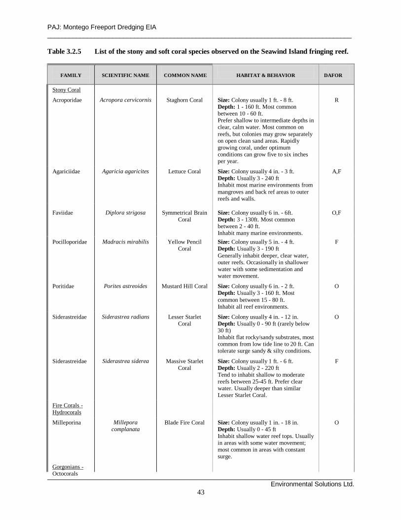
PAJ: Montego Freeport Dredging EIA ____________________________________________________________________________________
____________________________________________________________________________________ Environmental Solutions Ltd.
43
Table 3.2.5 List of the stony and soft coral species observed on the Seawind Island fringing reef.
FAMILY
SCIENTIFIC NAME
COMMON NAME
HABITAT & BEHAVIOR
DAFOR
Stony Coral
Acroporidae
Acropora cervicornis
Staghorn Coral
Size: Colony usuall y 1 ft. - 8 ft. Depth: 1 - 160 ft. Most common between 10 - 60 ft. Prefer shallow to intermediate depths in clear, calm water. Most common on reefs, but colonies may grow separately on open clean sand areas. Rapidly growing coral, under optimum conditions can grow five to six inches per year.
R
Agariciidae
Agaricia agaricites
Lettuce Coral
Size: Colony usuall y 4 in. - 3 ft. Depth: Usuall y 3 - 240 ft Inhabit most marine environments from mangroves and back ref areas to outer reefs and wall s.
A,F
Faviidae
Diplora strigosa
Symmetrical Brain
Coral
Size: Colony usuall y 6 in. - 6ft. Depth: 3 - 130ft. Most common between 2 - 40 ft. Inhabit many marine environments.
O,F
Pocill oporidae
Madracis mirabili s
Yellow Pencil
Coral
Size: Colony usuall y 5 in. - 4 ft. Depth: Usuall y 3 - 190 ft Generall y inhabit deeper, clear water, outer reefs. Occasionall y in shallower water with some sedimentation and water movement.
F
Poriti dae
Porites astreoides
Mustard Hil l Coral
Size: Colony usuall y 6 in. - 2 ft. Depth: Usuall y 3 - 160 ft. Most common between 15 - 80 ft. Inhabit all reef environments.
O
Siderastreidae
Siderastrea radians
Lesser Starlet
Coral
Size: Colony usuall y 4 in. - 12 in. Depth: Usuall y 0 - 90 ft (rarely below 30 ft) Inhabit flat rocky/sandy substrates, most common from low tide li ne to 20 ft. Can tolerate surge sandy & silt y conditions.
O
Siderastreidae
Siderastrea siderea
Massive Starlet
Coral
Size: Colony usuall y 1 ft. - 6 ft. Depth: Usuall y 2 - 220 ft Tend to inhabit shallow to moderate reefs between 25-45 ft. Prefer clear water. Usuall y deeper than similar Lesser Starlet Coral.
F
Fire Corals - Hydrocorals
Mill eporina
Mill epora
complanata
Blade Fire Coral
Size: Colony usuall y 1 in. - 18 in. Depth: Usuall y 0 - 45 ft Inhabit shallow water reef tops. Usuall y in areas with some water movement; most common in areas with constant surge.
O
Gorgonians - Octocorals

PAJ: Montego Freeport Dredging EIA ____________________________________________________________________________________
____________________________________________________________________________________ Environmental Solutions Ltd.
44
Octocorals Briareidae
Briareum asbestinum
Corky Sea Finger
Size: Colony height � - 24 in. Depth: Usuall y 3 - 100 ft Inhabit most reef environments, especiall y shallow fringing, patch and back reef areas. Abundant to common in the Caribbean.
O
Gorgoniidae
Gorgonia flabellum
Venus Sea Fan
Size: Colony height 2 - 3 � ft. Depth: Usuall y 3 - 100 ft Prefer clear water with some movement. Commonly inhabit the seaward side of shallow reef slopes and patch reefs. Only occasionall y on reefs and along the li ps of drop-offs deeper than 35 ft. In the Caribbean often inhabit shallow back reef areas.
R
Table 3.2.6 List of the fish species observed on the Seawind Island fringing reef.
FAMILY
SCIENTIFIC NAME
COMMON NAME
HABITAT & BEHAVIOR
ABUND-
ANCE
Acanthuridae Acanthurus bahianus
Ocean Surgeonfish
Size: 6 - 12 in ., max. 15 in. Depth: Usuall y 15 - 80 ft Inhabit reefs. May swim in loose aggregations that can include Blue Tangs and look-ali ke Doctorfish.
F
Chaetodontidae
Chaetodon capistratus
Foureye
Butterflyfish
Size: 3 - 4 in ., max. 6 in. Depth: Usuall y 10 - 60 ft Flit about reef tops; often in pairs. Common to occasional in the Caribbean.
F
Holocentridae
Holocentrus rufus
Longspine
Squirrelfish
Size:5 - 10 in ., max. 12� in. Depth: Usuall y 4 - 100 ft During the day, drift inconspicuously in shaded areas near bottom.
F
Labridae
Thalassoma bifasciatum
Bluehead Wrasse
Size: 4 - 5 in ., max. 6 in. Depth: Usuall y 6 - 80 ft Usuall y inhabits most reefs environments. May act as cleaners, removing parasites and debris from larger fish. Often swims in schools.
F
Pomacentridae
Abudefduf saxatili s
Sergeant Major
Size: 4 - 6 in ., max. 7 in. Depth: 1 - 40 ft Swim in all habitats, most often in midwater. Usuall y in loose aggregations.
F
Pomacentridae
Chromis cyanea
Blue Chromis
Size: 3 - 4 in ., max. 5 in. Depth: 35 - 80 ft Swim in midwater above reefs, feeding on plankton
F
Pomacentridae
Stegastes fuscus
Dusky Damsel
Size: 3 - 5 in ., max. 6 in. Depth: 5 - 40 ft Inhabit rocky areas. Territorial; pugnaciously chasing away intruders
F

PAJ: Montego Freeport Dredging EIA ____________________________________________________________________________________
____________________________________________________________________________________ Environmental Solutions Ltd.
45
pugnaciously chasing away intruders Serranidae
Hypoplectrus indigo
Indigo Hamlet
Size: 3 - 4� in., max. 5� in. Depth: Usuall y 30 - 130 ft Swim about reefs, near bottom. Rare to occasional in the Caribbean.
F
Serranidae
Hypoplectrus puella
Barred Hamlet
Size: 3� - 4� in., max. 6 in. Depth: Usuall y 10 - 50 ft Swim about reefs, near bottom. Common in the Caribbean.
F
ABUNDANCE CODE: S - Single - One (1) sighting F - Few - Two (2) to ten (10) sightings M - Many - Eleven (11) to one hundred (100) sightings A - Abundant - Over one hundred (100) sightings
Table 3.2.7 List of the invertebrate species on the Seawind Island fringing reef.
SCIENTIFIC NAME
COMMON NAME
HABITAT & BEHAVIOR
ABUND-
ANCE
Anemones
Condylactis gigantea
Giant Anemone Size: 6 -12 in. across tentacles & body Depth: 15 - 100 ft Inhabit reef and lagoonal areas
S
Crustaceans Panuli rus argus
Spiny Lobster
Size: 6 - 10 in. Max. 2 ft. Depth: 15 - 60 ft Inhabit reefs.
S
Feather Duster Worms Bispira brunnea
Social Feather Duster
Size: Crown � - 1� in. Depth: 15 - 60 ft Inhabit reefs. Prefer areas with some water movement.
F
Porifera- Demospongiae Cinachyra sp.
Orange Ball Sponge
Size: 4� - 6� in. Depth: Usuall y 15 - 100 ft Inhabit protected areas of coral reef. Common in the Caribbean.
F
Zoanthids
Zoanthus pulchellus
Mat Zoanthid Size: Disc � - � in. Depth: 20 - 60 ft Inhabit reef tops.
F
ABUNDANCE CODE: S - Single - One (1) sighting F - Few - Two (2) to ten (10) sightings M - Many - Eleven (11) to one hundred (100) sightings A - Abundant - Over one hundred (100) sightings

PAJ: Montego Freeport Dredging EIA ____________________________________________________________________________________
____________________________________________________________________________________ Environmental Solutions Ltd.
46
3.2.3 Protected Areas – The Montego Bay Marine Park and Bogu e Lagoon F ish Sanctuary
Figure 3.2.1 shows the subzones and park boundaries of the Montego Bay Marine Park (MBMP), relative to Montego Bay and the proposed project. The new and expanded MBMP (formerly the Cornwall Beach Marine Park of the early 1970s) was established in 1989 under the Protected Areas Resource Conservation (PARC) Project, and was officially opened on 23 July 1992. It covers an approximate area of 15.3 km2, which extends from the shoreline mean high tide mark to the 100 m depth contour, and encompasses 9 km of coastline extending from the Donald Sangster International Airport to just east of Great River. Montego Bay, and Montego Bay Harbour, both lie within the boundaries of the MBMP. The Bogue Lagoon, situated adjacent to and south of Montego Freeport, also is a declared protected area. It is currently zoned as a fish sanctuary (under the MBMP legislation), because of its extensive mangrove ecosystem, which functions as a fish nursery and feeding ground. 3.3 Socio-economic Environment The social environment in which the dredging project will occur must be described in terms of the setting of the Greater Montego Bay Area (GMBA) rather than solely the project area itself. This is significant because the port serves the GMBA, which in turn includes western Jamaica in its sphere of influence. Operations of the port area therefore have implications for the wider baliwick. Montego Bay has had city status for over eighteen years, and is an important political and regional center. The sphere of influence of the city extends throughout the highly urbanized parish of St. James and into the adjacent parishes of Trelawny and Hanover, and south into Westmoreland and St. Elizabeth. In the National Settlement Strategy for Jamaica, which was outlined in the National Physical Plan 1978-1998, Montego Bay is categorized as a regional centre having the necessary social and physical infrastructure to satisfy the needs of the parish of St. James (of which it is the capital) as well as the adjoining four parishes. It is the regional headquarters of a number of government agencies, as well as private service industries such as banking, insurance and shopping. The city’s development has been dominated by tourism, although over the past decade manufacturing and services have grown significantly. 3.3.1 Demographics and livelihood s Montego Bay (GMBA) continues to be a rapidly growing urban center, which has a current population conservatively estimated at 140,000. It is estimated that the 2% annual growth rate experienced during the 1981-1991 inter-censal period has continued, if not accelerated. The fast growing informal communities, which characterize the city, perhaps accommodate more persons than was reflected in the census. It is noteworthy that population increased by more than 100% during the intercensal period in settlements such as inter alia Bogue, Montego River, Rose Mount, Tucker, and Fairfield. Some inner city communities and peripheral areas experienced decline, but significant population movement took place within the GMBA especially into the informal communities.

PAJ: Montego Freeport Dredging EIA ____________________________________________________________________________________
____________________________________________________________________________________ Environmental Solutions Ltd.
48
The age structure of GMBA indicates large 0-19 and 19-30 cohorts which means a relatively large and growing labour force, but also a high demand for social support systems – educational institutions, recreational facilities, day care centers and housing. The labour force is estimated to be 65,000 based on an estimated 47% labour force to population ratio (GMRC 1997). The male/female ratio for the Montego Bay area is 0.92. This compares with 0.959 for the entire parish of St James and 0.958 for Jamaica. An interesting analysis of weekday population in the Central Business District (CBD) of Montego Bay revealed a total of 214,000 persons with commuter inflow accounting for approximately 28%, residents 65% and tourists 7%. It has been suggested that by the year 2014 the weekday population of Montego Bay will be approximately 10% the population of Jamaica, up from 4.5% in 1991 (GMRC, 1997). The Freeport Area accommodates approximately 500 residents and a commuting population of approximately 5,000. The implications for the dredging project relate to the need for minimum disruption to transportation and traffic flow between the Freeport and GMBA . Traffic is a major constraint to mobility within the GMBA as the roads quickly become choked particularly during peak hours. 3.3.2 Transportation As a regional center and major tourist destination, the city of Montego Bay has a number of transportation modes: 1. The public transit system is characterized by both a formal and informal system of ‘taxis’.
These taxis range from registered minibuses and cars to unregistered cars. Buses and minibuses commute between outlying districts within the city as well as between parishes. The public transport system is inadequate and the problem is exacerbated by the need to meet the significant demand of work force commuters who travel within the GMBA as well as from the neighbouring parishes.
2. A primary and secondary road network facilitates movement of private and commercial vehicular traffic throughout the city and from surrounding settlements.
The Freeport is well connected by road to the city of Montego Bay. Howard Cooke Boulevard and Alice Eldemire Drive are the main roads connecting to the north and west respectively, and work to dualize both these arteries is now underway. Construction will further hamper free movement of traffic, but the dredging project is not expected to add to the problem. A proposal for a bypass road is also under active consideration and it is anticipated that the current traffic gridlocks will be alleviated by the on-going and proposed road improvements. The road network within the Freeport is well developed, but some road surfaces need to be upgraded. 3.3.3 Land u se and livelihood s. The Montego Freeport Area is the single most significant economic enclave in the city of Montego Bay. It is unique in that it houses the commercial port and a 95-acre free zone industrial estate, along with a cruise ship port. Significant residential/resort complexes, the Montego Bay Yacht Club, and fuel farms add to the diversity of land use. The area was created to provide expanded port facilities for the city of Montego Bay, and to accommodate export industry, a hotel, townhouses and apartments, as well as commercial and service enterprise. Sunset Beach Resort, with 420 rooms, is the main tourism facility and the clusters of apartments/condominiums include The Lagoons (105 units), Ocean Pines (40-60 units), Seawind on the Bay (104 units), Anchorage (12 3-bedroom units) and Bay Pointe (53 units). Tourism is the economic base of Montego Bay, which has been described as an urban resort.

PAJ: Montego Freeport Dredging EIA ____________________________________________________________________________________
____________________________________________________________________________________ Environmental Solutions Ltd.
49
Urban services and employment augment the tourism base, and light manufacturing and export industry now occur in the Bogue/Reading and Montego Freeport Area respectively. At Montego Freeport there are currently five factories as well as hotel suppliers, commercial and service enterprises, offices, warehousing, a rice mill and petroleum storage facilities. Recent closures in garment manufacturing plants in the Freeport Area have added to the pool of unemployed and the economic fallout being experienced in the city, but commerce and wholesale activities along with port services have increased. In addition to resort/recreational activities, there are two fishing villages which use the beach zone, and which could be vulnerable to the effects of dredging. 3.3.4 Shipping Shipping and port facilities constitute the major land use within the Freeport Area and therefore shipping schedules need to be considered with respect to potential dislocation from dredging works. Montego Bay receives 250 – 350 ships calls per year: two cargo vessels per week, one hundred and fifty cruise vessels per year and an additional fifty “ad hoc” vessels. The shipping schedule for July and August 2002 (the period within which dredging is planned to take place) is shown at Table 3.3.1.
Table 3.3.1. Montego Freeport shipping schedule for July-August 2002. � � � � � � � � � � � � � � ¡
¢ £ ¤ ¥ ¦ § ¦ ¨ ¥ © ¦ ª« ¬ ® ¯ ° ¬ ± ² ® ³ ´ ¯ ¬ µ ¯ ¶ ® · ¸ ¹ º º » ¼ ½ ¾ ¿ À ¾ » ¿ ¹ Á »  à ¸ ¹ º º » ¼ ½ ¾ ¿ À ¾ » ¿ ¹ Á » ÂÄ Å Æ Ç È É Ê Ë Ë Ê Ì Ë ÍÎ Ï Ð Ñ Ò Ð Ó Ô Õ Ö × Ó Ï Ø Ø Ù Ú Û Ü Ü Ý Þ ß à á Ý â Û ã Ý ä Ù Ú Û Ü Ü Ý Þ ß à á Ý â Û ã Ý äå Ï æ ç Ð Ó è é Ï Î × Ó è é ê Ù Ú Û Ü Ü Ý Þ ß à á Ý â Û ã Ý ä ë Ú Û Ü Ü Ý Þ ß à á Ý â Û ã Ý äì í î ï ð î ñ ò ó í ô õ ö ñ í ÷ ø ù ú ú û ü ý þ ÿ � ù � û � ÷ ø ù ú ú û ü ý þ ÿ � ù � û �� � � � � � � � � � � � � � � � �� � � � � � � � � � � � � � � � � � � � � � � � �� � � � � ! " # $ % & ' ( ) % � � * ( ) % � � *
+ , - . / 0 . / / 1 2 3 4 5 3.3.5 Fishing Beaches River Bay and Whitehouse are the two fishing villages. River Bay, the smaller and less organized of the two, is located immediately north of the mouth of the Montego River and accommodates approximately 15 boats (Plate 3.3.1). Whitehouse located north of the Sangster International Airport also includes fishermen from the Flankers area and accommodates 30 boats and approximately 75 fishermen. Fishermen at Whitehouse report that fishing ‘seasons’ vary throughout the year coinciding with direction of currents, and air mass and tropical systems. Reportedly, currents flow east to west from January to June and from west to east between June and December. If dredging occurs during June, turbidity could conceivably affect the Whitehouse area to the east whereas later in the year, fishing areas west as far as Sandy Bay could potentially be affected. Currents are reportedly “very strong” during the hurricane season (June to November). At River Bay, fishermen mainly use nets and traps in the Montego harbour. Traps are set near to the Fletcher’s Beach/Pelican Grill area from May – Sept during the ‘Jack’ season, and at the edge of the insular shelf (‘the drop off’). Whitehouse fishermen use rod and reel, and traps, and fish along the coastline from Sandy Bay in the west to as far as Discovery Bay in the east,
PAJ: Montego Freeport Dredging EIA ____________________________________________________________________________________
____________________________________________________________________________________ Environmental Solutions Ltd.
50
traveling out to deep waters to catch ‘deep sea’ fish with rod and reel (mainly dolphin, tuna, bonito, and blue marlin). Traps are items of gear to the fishermen at both locations and clear visibility in the water column is important for them to find their traps as floats or landmarks (reportedly) are not used. Water turbidity would therefore pose hardships for the industry. 3.3.6 Recreation and Marina The quality of coastal waters and beaches is significant to the resort based economy of Montego Bay. Diving and recreational boating are major activities, and in the Freeport bay around the yacht club, diving for boat maintenance also requires good visibility. The Montego Yacht Club operates a small marina in the Freeport harbour and accommodates about 60 boats including four residential units, pleasure yachts and a catamaran. The silt bottom of the bay facilitates small boat anchoring, and the bay serves as an important hurricane refuge (safe haven) for boats from along the north coast. Scheduled activities associated with the resort, recreational boating and the marine park can be affected by dredging activities and therefore activity coordinators should be advised of dredging schedules. Activities include:
Easter Regatta Annually Feb 2003 Pineapple Cup (biannually) June 14 – 9 2002 America’s Sail 2002 (tall ships regatta) July weeks 1 & 2 Fish count (internationall event) End of July Sumfest Sept-Oct Fishing tournament (Tag and Release) Dec. 1st week Jamaica Invitational (International) J22s Every other Sun. J22s local sailing competition
3.3.7 Community perceptions of the propo sed dredging p roject The project has the potential to provide certain benefits to Montego Bay, but there are concerns regarding potential pollution of coastal waters and disposal of dredged material. In terms of benefits, Montego Bay needs a well-sized marina to accommodate docking for the diverse range of boats which need to use the harbour and to enhance the international competitiveness of the port of Montego Bay (e.g. coast guard/marine police, search and rescue, fire boats, large yachts). The Freeport harbour is the best location for this and therefore the dredging project could facilitate provision of the necessary depth and land space to facilitate marina development. 3.3.8 Natural and techno logical hazard vulnerabili ty Storm surge as a result of hurricanes, and storm waves from ‘northers’ are the major natural hazards affecting the study area. An OAS storm surge vulnerability assessment was conducted for Montego Bay between 1994 and 1998 and the results showed significant impact for the Freeport area. A 1.7m surge height was calculated for a 25-year return period and it was predicted to inundate the area of the Freeport occupied by port, commercial and resort activity. Surge would impact the outer shores of the Freeport peninsula as well as the project area of the inner channel. ‘Northers’ are annual phenomena associated with northern air mass/cyclonic systems. Wind generated waves under these circumstances exert considerable wave energy on the shoreline and residents report that waves strike Berth 5 of the port and are refracted toward the western shoreline, occupied by condominiums and the yacht club. Considerable erosion from undercutting was evident along the shore (see Plate 3.1.1).

PAJ: Montego Freeport Dredging EIA ____________________________________________________________________________________
____________________________________________________________________________________ Environmental Solutions Ltd.
51
Dredging activities could be affected if they are carried out during the hurricane season and a tropical storm or hurricane passes over or in close proximity to Montego Bay. ‘Northers’ tend to be most active from December through March and therefore any dredging carried out during that period could be affected. Montego Bay is also seismically active and records the second highest level of earthquake activity in Jamaica. Areas of fill such as the Freeport are prone to liquefaction and an earthquake can generate tsunami. There is however no record of tsunami for the Montego Bay area. Technological hazards associated with the study area include oil spills, fires, accidents, and polluted discharges from vessels. Oil supply for the entire western Jamaica enters the Montego Bay port, and storage tank farms are located adjacent to the port area. 3.3.9 Submarine cables Cable & Wireless has underwater cables connecting to land near the western end of the runway at the Sangster International Airport. The routing of the submarine cable running to the west is shown at Figure 2.5.1.
4. ENVIRONMENTAL POLICY, LEGISLATION AND REGULATORY FRAMEWORK
The environmental laws and regulations of Jamaica and the international conventions to which it is a signatory that are relevant to the proposed PAJ dredging project at Montego Freeport are listed and annotated below. 4.1 Acts and associated Orders & Regulations Natural Resources Conservation Authority Act (1991) This is the main environmental legislation that relates to the proposed dredging of Montego Freeport. This Act establishes the Natural Resources Conservation Authority (NRCA) with primary responsibility for ensuring sustainable development through the protection and management for the country’s natural resources and the control of pollution. Sections 9 and 10 of the NRCA Act stipulate that an Environmental Impact Assessment (EIA) is required for new projects and existing projects undergoing expansion that are listed under its list of prescribed categories of development activities. The Act also incorporates the earlier Beach Control Act, Wildlife Protection Act and Watersheds Act. ◊ Beach Control Law (1955) and Beach Control Act (1978) (subsequently re-authorized under
the NRCA Act and currently under review) The regulations of 1978 relate to hotels, commercial and public recreational beaches, regulated beach activities, care of beaches and rights of license. The Beach Control Act extends only to the foreshore; while it provides for the designation of protected areas, it does not address the basis for such designation, nor does it deal with the management of coastal resources landward or seaward of the foreshore. The Beach Control Law requires

PAJ: Montego Freeport Dredging EIA ____________________________________________________________________________________
____________________________________________________________________________________ Environmental Solutions Ltd.
52
that an application be made for the modification of any beach/coastline and sets out requirements for the posting of public notices.
◊ Wild Life Protection Act (1945) Prohibits removal, sale or possession of protected animals, use of dynamite, poisons or other noxious material to kill or injure fish, prohibits discharge of trade effluent or industrial waste into harbours, lagoons, estuaries and streams. It authorizes the establishment of Game Sanctuaries and Reserves. Protected under the Wildlife Protection Act are six species of sea turtles.
The Natural Resources (Prescribed Areas) (Prohibition of Categories of Enterprise, Construction and Development) Order (1996) The island of Jamaica and the Territorial Sea of Jamaica has been declared as a Prescribed Area. No person can undertake any enterprise, construction or development of a prescribed description of category except under and in accordance with a permit. The Natural Resources Conservation (Permits and Licenses) Regulations (1996) These regulations give effect to the provisions of the Prescribed Areas Order. Port and harbour developments are included on the prescribed list.
NEPA Environmental Review and Permitting Process The environmental Permit and License System (P&L), introduced in 1997, is a mechanism to ensure that all developments in Jamaica meet required standards in order to minimize negative environmental impacts. The P&L System is administered by the National Environmental and Planning Agency (NEPA), formerly the Natural Resources Conservation Authority (NRCA), through the Permit and License Secretariat. Permits are required by persons undertaking new developments, which fall within a prescribed category. Under the NRCA Act of 1991, the NRCA is authorized to issue, suspend and revoke permits and licences if facilities are not in compliance with the environmental standards and conditions of approval stipulated. An applicant for a Permit or License must complete an application form as well as a Project Information Form (PIF) for submission to the NRCA. Natural Resources Conservation (Montego Bay Marine Park) (Declaration) Order (1992) The Montego Bay Marine Park was established in 1992. The Order describes the area and includes a map with boundaries. This order bans dredging, excavating, discharge of pollutants, littering, use of explosives and poisons and fishing except subject to permit, and allows research and collection for educational and research purposes under permit. Water Quality NRCA Act (1990) The NRCA has primary responsibility for control of pollution in Jamaica’s environment, including pollution of water. National standards exist for industrial and sewage discharge into rivers and streams. Fishing Industry (Fish Sanctuaries) Order (1979) The Fishing Industry Act of 1975 is related to the regulation of the fishing industry and serves to conserve and manage the fisheries resources by addressing such issues as licensing. Under the 1979 Order fish sanctuaries may be declared by the Minister, in which no fishing is allowed. The Bogue Islands Lagoon have been declared as a Fish Sanctuary and this is incorporated within the boundaries of the Montego Bay Marine Park. Town and Country Planning Act (1958) Established the Town and Country Planning Authority with responsibility for Development Orders to control both rural and urban land development, ensure proper sanitary conveniences, co-
PAJ: Montego Freeport Dredging EIA ____________________________________________________________________________________
____________________________________________________________________________________ Environmental Solutions Ltd.
53
ordinate building of roads and other public services. Planning approvals for the project will have to be obtained from the Town Planning Authority. Marine Board Act (1985) The Marine Board which is comprised mainly of Port Authority offices, is empowered to regulate and control Jamaica’s harbours and their shipping channels. The Act prohibits the discharge of rubbish, stones, ballast, mud, or oil into any harbour or shipping channel. Harbours Act (1976) The Harbours Act authorizes the Port Authority of Jamaica to declare, establish or alter the boundaries of harbours. The PAJ has ultimate management responsibility for all harbours in the island. Maritime Authority of Jamaica Act (1998) The Maritime Authority of Jamaica was primarily set up for Jamaica to comply with the International Maritime Organisation London Convention / London Protocol and is responsible for, inter alia, issuance and review of dredging permits, setting of monitoring conditions and designation of approved disposal sites. Quarries Control Act (1983) This Act repeals the Quarries Act of 1958 and makes provisions for quarry zones and licenses, quarry tax, enforcement and safety. The proposed PAJ project should ensure that any earth materials used for the construction of bunds for the dredged material retention basins are only obtained from licenced quarries. National Heritage Trust Act (1985) Provides for protection of areas, structures and objects of cultural significance to Jamaica by declaration of any structure as a national monument where preservation is of public interest due to historic, architectural, traditional, artistic, aesthetic, scientific or archaeological importance. This includes the floor of the sea within the territorial waters or the Exclusive Economic Zone. There are no known historical or archaeological sites that could be affected by the proposed dredging works. The Office of Disaster Preparedness and Emergency Management Act (1998) This Act established the Office of Disaster Preparedness and Emergency Management (ODPEM) to develop and implement policy and programmes to achieve and maintain an appropriate state of national and sectoral preparedness for coping with emergency situations. The proposed project should ensure that it collaborates with this agency in the preparation of the appropriate emergency response plans in relation to potential oil spills and dredged material transport pipe breakage/leaks. 4.2 Policies and Regulations National Policy for the Conservation of Seagrasses (1996) This policy guides the issuing of licenses, or permits for activities such as dredging, disposal of dredged material, beach development and effluent disposal, which directly or indirectly affect seagrass communities. Seagrass meadows occur in the bay beyond the Montego Freeport harbour.

PAJ: Montego Freeport Dredging EIA ____________________________________________________________________________________
____________________________________________________________________________________ Environmental Solutions Ltd.
54
Policy for Jamaica’s System of Protected Areas (1997) The System of Protected Areas is an expression Jamaica’s commitment to protect the environment and its resources through the protection of parks and protected areas. The policy lists six goals, which include, economic development, environmental conservation, sustainable use of resources, recreation and public education, public participation and financial sustainability. The proposed dredging project is located within the boundaries of the Montego Bay Marine Park.
Mangrove and Coastal Wetlands Protection - Draft Policy and Regulations (April 1996) A review of the issues affecting wetlands in Jamaica as well as Government’s role and responsibility. Five main goals are outlined which include guidelines for wetlands development, cessation of destructive activities, maintenance of natural diversity, maintenance of wetland function and values and integration of wetland functions in planning and development. The proposed PAJ project should undertake to protect the mangroves in the Bogue Lagoon. Coral Reef Protection and Preservation Policy and Regulation (Draft - 1996) This document reviews the ecological and socio-economic functions of coral reefs, issues affecting coral reefs and Government’s role and responsibility. Five main goals are outlined which include reduction of pollutants, reduction of over-harvesting of reef fish, reduction of physical damage from recreational activities, improving the response capability to oil spills, and control of coastal zone developments. The proposed PAJ project must endeavour to ensure that its dredging activities do not threaten or harm the coral reefs around Montego Bay. 4.3 International Conventions The conventions listed below apply to the project in so far as Jamaica is a signatory to them and because they relate to the operations of the dredging vessels. London Convention (Prevention of Marine Pollution by Dumping of Wastes and other Matter) (1972) and Protocol (1996) Established to protect and preserve the marine environment (sea and sea-bed) from all sources of pollution, and to take effective measures to prevent, reduce, and eliminate marine pollution caused by dumping or incineration at sea. The project should meet the provisions of the Convention and associated Protocol, to which Jamaica is a signatory. MARPOL Convention (Prevention of Pollution from Ships)(1973) and Protocol (1978) This international agreement covers vessel-source pollution by oil (Annex I), chemicals (Annex II), harmful substances in packaged form (Annex III), sewage (Annex IV), garbage (Annex V) and air pollution (Annex VI). Annexes I and II are conpulsory. The annexes of relevance to this project are Annex I, Annex IV and Annex V. The Annex I, which applies, inter alia, to ships over 400Gross Tonnes (GT), regulates the rate of discharges of oil, establishes prohibited zones within which no discharges may take place, and introduces equipment requirements and procedures to minimise the amount of oil discharged. It also specifies measures to prevent oil being spilled as a result of accident or collision, grounding, etc. Annex IV applies to ships over 200GT carrying more than 10 persons. The discharge of sewage is prohibited within 4 nautical miles of the nearest land unless the vessel has an approved sewage plan and facilities for comminuting and disinfecting the sewage before discharge.

PAJ: Montego Freeport Dredging EIA ____________________________________________________________________________________
____________________________________________________________________________________ Environmental Solutions Ltd.
55
Annex V applies to all types of ships (including yachts and fishing vessels) and offshore platforms. It prohibits the disposal of synthetic fishing nets (silt screens?), ropes and plastic bags. The Protocol makes provision for the declaration of Special Areas and the Caribbean Sea has been so declared. However, zero tolerance discharge standards cannot be enforced until adequate port reception facilities are put in place. Jamaica does not yet have such facilities. Cartagena Convention (Convention for the Protection and Development of the Marine Environment of the Wider Caribbean Region) (1983) Adopted in March 1983 in Cartagena, Colombia, the Convention is the only legally binding environmental treaty for the Wider Caribbean. The Convention came into force in October 1996 as a legal instrument for the implementation of the Caribbean Action Plan and represents a commitment by the participating governments to protect, develop and manage their common waters individually and jointly. Ratified by twenty countries, the Cartagena Convention is a framework agreement, which sets out the political and legal foundations for actions to be developed. The operational Protocols, which direct these actions, are designed to address special issues and to initiate concrete actions. The Convention is currently supported by three Protocols. These are: ◊ The Protocol Concerning Co-operation in Combating Oil Spills in the Wider Caribbean
Region (The Oil Spills Protocol), which was adopted and entered into force at the same time as the Cartagena Convention.
◊ The Protocol Concerning Specially Protected Areas and Wildlife in the Wider Caribbean Region (The SPAW Protocol), which was adopted in two stages, the text in January, 1990 and its Annexes in June, 1991. The Protocol entered into force in 2000. Jamaica is not yet a signatory.
◊ The Protocol Concerning Pollution from Land-based Sources and Activities in the Wider Caribbean Region (LBS Protocol), which was adopted in October, 1999. Four of the Contracting Parties have already signed the Protocol and the remaining sixteen, including Jamaica, are expected to sign.
Article 6 refers to the international laws that apply with respect to dumping.
5. POTENTIAL ENVIRONMENTAL IMPACTS The proposed dredging project will entail maintenance dredging on either side of the harbour channel so as to re-establish design depths of 10.4m. It will also involve capital dredging at the western corner of the harbour to increase the depths and size of the turning basin. As discussed at Section 2.2, the amount of capital dredging involved would be much less if Option 2 were to be implemented. This section of the report identifies the possible environmental issues that could arise from dredging works using either a cutter suction dredge or a trailing head hopper dredge. 5.1 Dredg ing 5.1.1 Digging and excavation 5.1.1.1 Sediment dispersal and turbidity The rotary action of the head of the cutter, in the case of a cutter suction dredge, and of the suction pipe dragged along the bottom, in the case of a hopper dredge, will disturb the substrate and place sediments into suspension. It is anticipated that the turbidity so caused would be
PAJ: Montego Freeport Dredging EIA ____________________________________________________________________________________
____________________________________________________________________________________ Environmental Solutions Ltd.
56
minimised as in both modes of dredging powerful suction pumps suck up most of these materials out of the water column. The potential impacts due to the actual excavation procedure is considered to be of high significance at the northern end of the channel where suspended fine sediments may get caught up in the westerly currents occurring in the area. These currents would tend to carry any suspended sediments over coral reefs at the northern section of the marine park at ‘Seawind Island’. It should be noted that the reef in this area is in a relatively poor condition (see Section 3.2.2) and, therefore, the possible impacts of sedimentation and turbidity would not be as severe as it would be in the case of healthier reefs. Further into the basin, however, the ecological concerns related to transport of suspended sediments are lessened given the small and enclosed nature of the port and the relatively weak water current transport mechanisms. Also, the potential impacts of suspended sediments on the existing biota would be less significant inside the basin, bearing in mind that the wash from ship propellers and thrusters normally creates more sediment suspension and turbidity in the basin on a regular basis than would dredging operations over a fortnight period. Such turbidity is easily seen in aerial photographs taken of the port when ships are manoevouring in the basin. 5.1.1.2 Impedance of regular shipping In terms of shipping, whereas a HCSD remains stationary during excavation, being fixed in position by spuds at each dredging location, a TSHD excavates by dragging the suction head over the sea floor. Presumably therefore, it is more easily able to move out of the path of ships, and thus less likely to interfere with normal shipping routines in the port. 5.1.2 Pipeline transport of dredged dredged material In the case of a cutter suction dredge, the excavated dredged material is pumped via a pipeline made up of jointed sections, either supported at the surface of the water or laid on the sea floor, to the dredged material disposal site. Depending on the position of the dredge vessel relative to the disposal site, a floating pipeline could restrict movement of normal ship and small boat traffic in the harbour for the duration of the dredging operations. Alternatively, the pipeline may be laid on the sea floor but this has logistical implications and increases dredging costs. The significance of this potentially negative impact would be determined by the extent of the disruption to vessel traffic. It is anticipated, given the sizes and types of dredging vessels available to do the job, that the dredging operation could be completed within a two-week period. From Table 3.3.1 it can be seen that the worst case scenario would be the delay/rescheduling of the itineraries of about 10 cargo vessels and 2 cruise ship vessels in any two-week period during July and August 2002. The disruption of shipping is considered to be a significant impact given the economic benefits derived from the industry. 5.1.3 Dredged material pipeline leakage Although not a common occurrence, It is possible for accidental leaks/spills of dredged materials to occur from improperly sealed or broken joints along the cutter suction dredge pipeline during dredging operations. Under such circumstances, the dredge pumps are shut down until the leak is repaired. Leakages would result in the release of the dredged materials to the water column and cause water turbidity and sedimentation of material near the vicinity of the leak. The severity of the environmental impact would depend on the location and duration of the leak. Inside the harbour basin a spill of dredged materials is not considered to be very significant
PAJ: Montego Freeport Dredging EIA ____________________________________________________________________________________
____________________________________________________________________________________ Environmental Solutions Ltd.
57
since the weak currents in the harbour are not likely to result in dispersal of turbidity out of the harbour and the resultant turbidity and sedimentation would be localised. It would also be of short duration if controlled quickly. However, should a spill occur near the mouth of the channel, it is conceivable that the westerly currents beyond the harbour (see Section 3.1.7.2) could entrain the suspended sediments and disperse them over the coral reef (marine park) west of the harbour entrance. Such an impact could be significant. 5.1.4 Hopp er dredge spill age and leakage 5.1.4.1 Deliberate spillages It is a common practice by dredgers to maximise the amount of solid material in the hopper hold by allowing the water originally mixed with the dredged material to overflow from the vessel. In the case where fine sediments are being dredged, this results in high turbidity of the water surrounding the vessel, which could find its way over sensitive habitats, e.g. the marine park. A second means of deliberate spillage occurs when the bottom gates of the hopper hold are opened slightly so as to release sediments while the vessel is on route to the disposal site. This practice shortens the turn-around duration of the vessel’s trip, and has obvious financial benefits. The resulting impacts of turbidity and sedimentation would be most severe in the vicinity of the marine park reefs when the vessel was moving out to sea through the ship channel into the outer bay. It should be noted that such practice is not condoned by large and reputable dredging contractors. 5.1.4.2 Accidental spillages The amount of material leaking from the bottom gates of a hopper dredge (or hopper barge) would normally be insignificant. However, if a hard object or rock becomes lodged between the gates, then material will steadily spill out of the ship’s hold into the water column. As applies above, the resulting impacts of turbidity and sedimentation would be most severe in the vicinity of the marine park reefs when the vessel was moving out to sea through the ship channel into the outer bay. 5.1.5 Noise Given the proximity of the dredging operation to residential areas and the yacht club situated on the adjacent shoreline, the noise generated by the dredging vessels may cause a level of auditory discomfort which is difficult to evaluate in the absence of any noise measurements for dredging operations. However, given the relatively short-term nature of the dredging works, it is not expected that these would be intolerable. 5.1.6 Visual/landscape impacts The dredging vessels could be considered to be an eyesore to local community members, particularly when they are operating in the western end of the basin and thus in proximity to residential areas. However, given the normal nature of shipping vistas in this area and the short-term nature of the dredging operation, this impact is not considered to be significant. 5.1.7 Impairment of f ishing activities Dredging operations could have an impact on local fishery activities through the generation of turbidity and dispersed sediments which prevent fishermen being able to see and find their fish pots or by the clogging of gill nets respectively. Apart from incidental recreational-type hand fishing done from the shoreline, no commercial fishing activities normally take place in the harbour. One fisherman from River Bay admitted that he occasionally set a fish pot in the channel but readily acknowledged that he would be unable

PAJ: Montego Freeport Dredging EIA ____________________________________________________________________________________
____________________________________________________________________________________ Environmental Solutions Ltd.
58
to do so during the dredging operations. Very few fish traps, if any, are set on the marine park reef in the vicinity of channel dredging activities. 5.1.8 Modification o f wave and current pattern inside harbou r As discussed in Section 3.1.7.2 above, the modification of the bathymetry of the Montego Freeport harbour is not likely to dramatically change the existing pattern of currents and sediment transport. 5.2 Dredged material disposal 5.2.1 Land d isposal Disposal of dredged materials produced by the cutter suction dredge on land would directly cover and destroy any biological resources in the disposal area and, at least in the short- to medium-term, pre-empt any alternative land-use of that site. Uncontained dredged materials would spread over the disposal site and, in the context of possible disposal sites around the Montego Freeport, inevitably reach the sea, where it would cause unacceptable levels of turbidity and sedimentation of suspended materials over ecologically valuable marine areas (esp. MBMP and Bogue Lagoon Fish Sanctuary). Unmitigated disposal of dredged sediments would be the single most environmentally significant impact associated with the proposed dredging works. This would be especially so if the dredged material was comprised mainly or solely of fine materials. 5.2.1.1 Contained storage disposal site Given the above scenario, any consideration for disposal of the dredged materials on land would have to include the construction of a containment cell with bunds capable of retaining the volume of sediments intended for storage. A bermed structure is essential to prevent spreading of the dredged materials into areas where it could impact adversely on adjacent terrestrial or marine ecosystems or affect other land uses. Construction of the containment cell would partially if not completely destroy the existing terrestrial habitat at the site. After construction and during filling with dredged sediments, the deliberate release from the cell of the supernatant water (after coarse sediment settlement) would lead to increased turbidity in the receiving waters. The complete mitigation measures required for any contained land disposal site proposed for this project is described below in Section 6. The three possible sites identified around Montego Freeport that could be considered for contained land disposal have been described earlier in Section 3.2.1 and shown on Figure 1.4.1. These are further discussed below.
Site 1 (northern tip of ‘Seawinds Island’) This site has an area sufficient to temporarily store sediments arising from maintenance dredging along the western side of the entrance channel (approx. 17,000 cu. m.) and would possibly allow for use of the cutter suction dredge in a manner that would not impede shipping through the channel. On the other hand, inspection of the site revealed that a section of it had recently been cleared and surveyed, indicating current plans for new residential construction and activities incompatible with dredged material storage and its recovery for re-use. Furthermore, accidental rupture of the containment bund and resultant sediment spillage would threaten the reefs in the marine park and the recreational bathing waters along the western shore.

PAJ: Montego Freeport Dredging EIA ____________________________________________________________________________________
____________________________________________________________________________________ Environmental Solutions Ltd.
59
The substrate is comprised of fill material placed there during the construction of the Freeport area in 1967. The existing vegetation on this artificial site is comprised of opportunistic, ruinate scrub species and loss of this habitat, slated for residential development, is not considered as being significant. Site 2 (behind Berth 6 and western corner of harbour basin) As is the case for the site discussed above, this site is comprised of fill material. This site has an area sufficient to temporarily store sediments arising from capital dredging in the western corner of the basin (193,500 cu. m.) and would allow for use of the cutter suction dredge in a manner that would not impede other use of the port. On the other hand, the pile of stored material (approximately 3-4 metres high) would create an eyesore (which could be hidden to a certain extent by planting ground cover). Accidental collapse of the berm wall could also lead to blockage of the main access road and spillage of fine sediments into Bogue Lagoon and/or the harbour basin. Use of this site would also lead to the inevitable covering and loss of the Casuarina and cocnut trees presently on the site, although neither could reasonably be considered as species worth saving at all costs. Site 3 (east of entrance channel, used for dredged material storage during 1991 dredging works) This site has an area sufficient to temporarily store sediments arising from maintenance dredging along the eastern side of the entrance channel (17,000 cu. m.) and may, perhaps, allow for use of the cutter suction dredge in a manner that would not impede shipping through the channel. This site also has the capacity to retain all of the sediments dredged by the proposed project (227,500 cu. m.). Rupture of the bund could release materials either into the channel or into the outer bay. In the latter instance, westerly currents could carry suspended materials across the channel entrance and then over sections of the marine park at the northern end of ‘Seawinds Island’.
The obvious advantage of contained land disposal is that it allows for recovery of the dredged sediments, after settlement and dewatering, for re-use. 5.2.1.2 Earth materials sourcing Appropriate earth materials (e.g. marl) would have to be obtained for construction of the berm walls for the dredged material containment/storage area. Unless deliberate measures were taken to ensure the supply of such materials from officially licenced quarries, it is possible that the purchase of materials from illegal quarry operations could lead to indirectly to health and safety impacts, and terrestrial resource degradation, at the source. 5.2.1.3 Earth materials transport Related to the above would be the transport of earth materials to the dredged material storage construction area. Improperly sealed trucks transporting the material could lead to material spillages on the road as well as the release of fugitive dust – both creating potential hazards to public health and safety. An estimated ?? cu.m. of marl would be required to construct the berm walls and this would, in turn, require the movement of ?? dunper truck trips. This level of traffic would lead to a short-term worsening of local traffic conditions, which are already congested. 5.2.2 Sea disposal Disposal of sediments at sea will cause turbidity in the water column and, perhaps, with settlement of the material over deep-water benthic communities. The latter is not likely to be severe if the sediments are fine grained and therefore become dispersed over a wide area. The

PAJ: Montego Freeport Dredging EIA ____________________________________________________________________________________
____________________________________________________________________________________ Environmental Solutions Ltd.
60
severity of the impact would be dependent on the location of the disposal site relative to valuable shallow water ecosystems (e.g. coral reefs, mangroves, recreational bathing waters). Such sites should be located in deep water where prevailing currents will not bring suspended material back inshore. The above is not to suggest that the deep-water benthos does not contain valuable biological resources but these are, presumably, not as vulnerable to diffused sedimentation as would be shallow water coastal ecosystems. The proposed deep sea disposal site lies to east of the route of the Cable & Wireless submarine cables (see Figure 2.5.1). Cable & Wireless have confirmed that any settlement of fine sediments on the cables would not affect them adversely (J. Martinez/P.Reeson, pers. comm). This disposal option precludes any re-use of the dumped materials but avoids the potential impacts associated with on-land disposal. As pointed out above in Section 5.1.4, leakage of materials to be dumped while the hopper vessel is in transit through inshore waters could have an adverse short-term impact on inshore biological resources. 5.3 Summary of Impacts Tables 5.1 & 5.2 below provide summaries of the potential impacts, and their classification, related to cutter suction dredging and suction hopper dredging respectively. In most cases measures can be taken to avoid or reduce the severity of the impact, and the appropriate mitigation measures are identified below in Section 6. In a few cases the impacts cannot be avoided or successfully mitigated and these represent residual impacts. However, none of these are significant. Those impacts considered as most significant and relevant to the two dredging options assessed are:
Dredging excavation – Positive (Options 1 & 2) 1. Increased foreign exchange earnings and economic activity arising from expansion of
port facilities and increased cruise ship visits related directly to harbour dredging. 2. Creation of opportunities for employment and provision of materials during construction
of dredged material containment areas in the event of on-land disposal. 3. Opportunity for re-use of dredged material, if on-land dredged material disposal option is
selected. Dredging excavation – Negative (Options 1 & 2) 1. Loss of benthic habitats at dredging sites. 2. Sedimentation and turbidity at coral reefs at MBMP west of channel due to suspension
and dispersal of fine sediments at the northern end of the channel due to dredging activities.
3. Possible short-term disruption of ship traffic due to dredging activities. On-land d isposal – Positive (Option 1) 1. Relatively safe containment of any contaminated sediments. 2. Availability of sediments for re-use. On-land d isposal – Negative (Option 1) 1. Loss of alternative land use of disposal site/s over short- to medium-term.

PAJ: Montego Freeport Dredging EIA ____________________________________________________________________________________
____________________________________________________________________________________ Environmental Solutions Ltd.
61
2. Release of liquid supernatant with suspended solids from containment cells into the coastal marine environment, potentially threatening that section of the MBMP reef at the northern end of ‘Seawind Island’ with turbidity and sedimentation.
Deep sea disposal – Positive (Options 1 & 2) 1. Relatively easy disposal option that pre-empts threat of sedimentation and turbidity
arising from land disposal site/s. 2. Removal from inshore waters, and dispersion and dilution of contaminated sediments (if
any). Deep sea disposal - Negative (Options 1 & 2) 1. Deliberate release of dredged sediments from hopper during transport to open sea
disposal site, potentially threatening sensitive inshore coastal habitats west of Montego Bay.
2. Lost opportunity for reuse of dredged materials.

PAJ: Montego Freeport Dredging EIA ____________________________________________________________________________________
____________________________________________________________________________________ Environmental Solutions Ltd.
64
6. PROJECT ALTERNATIVES 6.1 ‘No Project’ Scenario The entrance channel leading to the Montego Freeport harbour and the ship turning basin are becoming occluded with sediments slumping from the sides of the channel and/or by terrigenous sediments arising from river and gully discharges into Montego Bay proper. Regular maintenance dredging of these areas is required to ensure navigational safety for cargo and cruise ships that use the harbour, and not implementing the project eventually implies not being able to accommodate the size of vessels that are currently able to use the harbour. The economic consequences are obvious and severe, bearing in mind particularly that the Montego Freeport harbour is the major port for the western end of the island. The opportunity offered by dredging to increase the size of the ship turning basin and to increase the capacity of the harbour to accommodate larger vessels of the size now plying the Caribbean circuit also has obvious economic benefits accruing to the tourism capital of Jamaica. The significant negative impacts identified in Section 5 above are short-term in nature (approximately two to three weeks) and those that could pose a risk to the health of the MBMP can be avoided and/or mitigated as discussed below in Section 7. Without having to carry out a cost-benefit analysis, it is obvious that the benefits of implementing the dredging project far outweigh the costs of mitigation. 6.2 Hydraulic Cutter Suction Dredge vs. Traili ng Suction Hopp er Dredge These two dredger vessel types are presently available in Jamaica to undertake dredging at the Montego Freeport harbour. The selection of dredge type to be used will ultimately be based on technical and financial considerations, and perhaps both types of machinery will be used to accomplish the task. From a purely environmental perspective both options have relative advantages but none that would absolutely militate against the use of either vessel type, as shown in Table 6.2.1. Use of the HCSD requires transport of the dredged materials via a pipeline to the disposal site. If the pipeline is floated at the surface it could impede ship traffic. The dredging operations may be suspended and the pipeline separated to allow passage of ships but this implies delays in the dredging operations and risk of dredged materials leakage. Alternatively, the pipeline may be laid on the seabed but this also implies extra logistical effort and a corresponding increase in dredging costs. Use of a TSHD implies less hindrance to shipping traffic. 6.3 Disposal Sites The land-based and deep-sea disposal sites considered for this project have been discussed above at Section 5.2. 6.3.1 On-land d isposal site Although three possible land disposal sites have been identified immediately adjacent to the harbour, the time and costs related to site preparation and containment cell construction, and the dredging-related logistics involved in having multiple sites for such a short-term project militate against having more than one on-shore disposal site.

PAJ: Montego Freeport Dredging EIA ____________________________________________________________________________________
____________________________________________________________________________________ Environmental Solutions Ltd.
65
Table 6.2.1 Comparison of environmental factors related to type of dredge vessel (based on
Smits (1998)). 6 7 8 9 : ; 7 < = 7 > ? @ 6 A A = B > C
D : 9 > = : 9 ? D E > > = : F E B > 9 ; 7G : = H I = J
: ? 9 @ 9 7 I F E B > 9 ; 7 K ; L L = :G : = H I =
M N N O P Q N R S T U V N Q W Q X U Y Z P S T [ \ U ] S S Y ^ Q _ S O X ` a N b c d e S f ^ g d a h i j k l m n o p q r r s t uh i v j w x m o y x z n q r r s { |
} z p m l q ~ l x � ~ � ~ � l z � l � ~ l � o j l z n ~ � q m o q � r l � � l � l z � ~ x z r q � � l m~ � o z � ~ � l l � � p � n n l m w l q �m x n q n o x z ~ � l l � { |
� x � q n � m q � w l q � | � q z � l w o � wq n � m l � � l ~ o n l o � r x q � o z �
p x z n o z � l ~ � o n w x k l m � r x � x �l � p l ~ ~ � q n l m | � m x z x � z p l � o zp q ~ l x � � o z l ~ l � o j l z n ~ |
� o � o z � x � � o � � l m l z n ~ x o r r q s l m ~ � l � n w x � ~ l � o j l z n ~ w x � r � � l� m l q n l m n w q z ~ o y l x � p � n n l mw l q � |
� p p � m q n l p x z n m x r q p w o l k q � r l |
� m l q n o x z x � r x x ~ l � j x � o r l { ~ � o r r r q s l m ~ � l z � l z p s n x r l q k l n w o p �~ � o r r r q s l m o z ~ x � n~ l � o j l z n ~ |
� o n n r l m l ~ o � � q r ~ � o r r r q s l mq n � m q � w l q � | � q m � l m ~ � o r rr q s l m o � r q m � l � � q z n o n o l ~ x �
x k l m � r x � q r r x � l � |� o r � n o x z � q m o q � r l q j x � z n x � � q n l m
q � � l � � l � l z � o z � x z ~ l � o j l z nn s � l |
� o � z o � o p q z n q j x � z n ~ x � � q n l mq � � l � � � m o z � ~ � p n o x z
� m x p l ~ ~ |� x o ~ l � l z l m q n o x z � o � w � i v v h i i � � � o z
o j j l � o q n l k o p o z o n s t � v h � v� � q n � l � w � z � m l � j l n l m ~ { |
� o � w � i v v h i i v � � o zo j j l � o q n l k o p o z o n s | � v h � v
� � q n � l � w � z � m l � j l n l m ~ { |� x m j q r x � n � � n m q n l � v h � t v v v j � � � � � � � � ¡ � ¢ � � � £ � � � � The preferred site for this purpose is Site #3, located at the eastern side of the channel, north of Berth 2. This site was used for disposal of dredged material arising during the 1991 dredging works, it is more or less vacant at the present time, and it has the capacity to hold the estimated 227,500 cu. m. that would be generated by the presently proposed dredging works. This site would have to be used for sediment disposal if the cutter suction dredger is used. On land disposal would offer the advantage of making the disposed material available for re-use (as happened in 1991) if the material is of a suitable grain size. If the dredged materials are predominantly muds, then the incidence of turbidity of the supernatant water released from the containment cell during de-watering will be high and the process will require special mitigation measures (see Section 7) to control turbidity and dispersal of fine suspended solids in the inshore coastal waters. 6.3.2 Deep sea disposal Sea disposal (see Section 2.5.2) is the sole option available for a trailing suction hopper dredge. This mode of disposal would also be preferred if the dredged sediment arisings are predominantly muds, as was indicated by the superficial sediment survey carried out as part of this study (see Section 3.1.2), since they would have limited re-use value and difficult to treat and de-water on land.
PAJ: Montego Freeport Dredging EIA ____________________________________________________________________________________
____________________________________________________________________________________ Environmental Solutions Ltd.
66
7. IMPACT MITIGATION MEASURES 7.1 Mitigation Measures Tables 7.1 and 7.2 below list the potential impacts identified above in Section 5 and describe the corresponding mitigation measures that should be put in place during implementation of the dredging works. 7.2 Mitigation Costs The mitigation measures associated with significant costs, beyond those of dredge equipment rental and deployment, and good dredging practice, are identified below along with the major cost elements. 1. Sediment containment structure at Site #3.
Based on the use of marl for bund construction and obtaining that marl from nearby (< 13km) licenced quarries, the cost of constructing the containment cells to receive the dredged materials is estimated at US$ 80,000 – 100,000. The residual value of the marl would be at least half of the estimated cost of the bunding. Other costs to be included are: • Purchase/rental of silt screens • Monitoring equipment and personnel
2. Site #3 fugitive dust control
• Planting material • Labour • Maintenance • Monitoring equipment and personnel
3. Monitoring of deep sea disposal
• Employment of environmental person to monitor TSHD during deep sea dredged material disposal
7.3 Recommended Mitigation The most environmentally sensitive habitats in the vicinity of the dredging project are those in the MBMP, particularly corals in the area at the northern tip of ‘Seawind Island’. The greatest environmental threats to these are sedimentation by suspended sediments and from light attenuation by high turbidity plumes. These could arise from dredging activities at the mouth of the channel and from the release of turbid supernatant water from the sediment containment Site #3. In order to mitigate these potential impacts, it is recommended that a TSHD be used to carry out all the maintenance dredging required for the Montego Freeport, especially in the channel, as this type of equipment is better able to handle soft sediments than an HCSD. This would help to minimise the suspension of sediments in the vicinity of the marine park and the consequent threats to sensitive biota.
PAJ: Montego Freeport Dredging EIA ____________________________________________________________________________________
____________________________________________________________________________________ Environmental Solutions Ltd.
70
This dredged material, likely to be comprised largely of fines, should be disposed of at the 1000m contour northwest of Montego Bay, a distance roughly 7-8km from the port. Should these sediments be contaminated in any way, then this method offers the safest means of disposal. During dredging, if deemed necessary, silt screens could be deployed along the top of the western slope at the mouth of the channel. However, it should be noted that it would likely be difficult to maintain these screens in position given the prevailing currents, which could then possibly cause direct physical damage to the corals. Should Option 1 be selected for implementation, It is suggested that an HCSD be employed to carry out the capital dredging at the western end of the harbour basin where there is a greater likelihood of encountering coarser, uncontaminated material that could be deposited at disposal Site #3. There, it could be de-watered and made available for future use. The release of suspended material in the supernatant could be minmised by building a two-cell containment area to maximise settlement of the sediments in the dredged materials. Suspended sediments in the discharge effluent would further be reduced by decanting from the first cell into the other and eventually releasing the supernatant from the second cell over a stable sill into an inshore area surrounded by a silt screen. The release point proposed is situated east of the stone groyne at the eastern side of the channel.
8. IMPACT MONITORING PLAN The impact monitoring plan (IMP) is presented below in outline form. It should be detailed and completed when the final dredging methodology and action plan has been determined. The purpose of the IMP is to monitor or control the environmental effects of the dredging process. It should be based on compliance, verification, feedback, and know-how. It should be able to provide responses to the following three questions:
i) Why is monitoring being conducted? ii) What specifically is being carried out? iii) How are the data and information to be used in planning and decision-making?
In the case of the proposed dredging works, environmental monitoring is particularly necessary to ensure that suspended sediments generated during excavation and sediment transport, and during disposal of the dredged materials, do not adversely affect the health of the coastal ecosystems within the MBMP, and indeed, elsewhere along the coast. For Option 1 this could be achieved by: 1. ensuring that the deliberate disturbance and removal of bottom sediments during
dredging are done technically (i.e. appropriate dredge type and operational procedures) in a manner that minimises the degree and extent of fugitive sediment suspension;
2. ensuring that there is no leakage of sediments from the dredged materials transport pipeline between the HCSD and the proposed storage site;
3. ensuring that the material in the pipeline is being transported at the highest possible density;
4. ensuring that the sediment content of the water released into the open environment from the on-shore sediment storage cells is minimised by effective settlement; and
5. ensuring that the fine sediments generated by maintenance dredging are only released at the approved deep sea disposal site.

PAJ: Montego Freeport Dredging EIA ____________________________________________________________________________________
____________________________________________________________________________________ Environmental Solutions Ltd.
71
For Option 2, the main concern would be when dredging takes place at the mouth of the channel and during dredged material transport to, and its disposal at the deep-sea release site. Reducing the potential impacts on coastal ecosystems could be achieved by: 1. ensuring that the deliberate disturbance and removal of bottom sediments during
dredging is done technically in a manner that minimises the degree and extent of fugitive sediment suspension;
2. ensuring that the TSHD is not overfilled; 3. ensuring that the dredged material is not deliberately leaked from the hopper during
transit to the disposal site; 4. ensuring that the dredged material is only released at the approved deep sea disposal
site; and 5. ensuring that, after each dredging cycle, the hopper dredge is only washed out at the
deep sea disposal site. The monitoring programme should therefore focus on; 1. use of the appropriate and specified dredging equipment for maintenance and capital
dredging; 2. confinement of dredging to the specified dredging areas; 3. monitoring of the density of transported material in the pipeline (in the case of Option 1); 4. frequent measurements (say every two hours) of water turbidity at the active dredging
areas; 5. frequent measurements (say every two hours) of water turbidity at the storage cell
effluent release area (in the case of Option 1) 6. frequent measurements (say every two hours) of water turbidity over the coral reef at the
northern end of ‘Seawind Island’, particularly when dredging is taking place in the channel; and
7. constant on-board surveillance, perhaps supplemented by aerial observations, of the operations of the TSHD during filling, transit to, and sediment release at, the approved deep sea disposal site.
The turbidity compliance standards will have to be established for the project, particularly for the reef area, after consultation with NEPA. The standards set should take into account the prevailing water quality conditions and the relatively short duration of the dredging works. The results of the turbidity measurements, which should be taken independently with in situ instrumentation (perhaps using an on-board (?) nuclear density probe), should immediately be recorded formally and made available to the dredging supervisor so that any corrections and adjustments to dredging operations can be made quickly. The environmental monitor must have the authority to halt dredging and/or sediment disposal operations should this become necessary to protect the reef ecosystems at risk.
9. EMERGENCY CONTINGENCY PLAN In an environmental context, the critical emergency situations that could arise during dredging are: 1. collision between the dredge vessels and other ships in the harbour, resulting in large
release of oil, and
PAJ: Montego Freeport Dredging EIA ____________________________________________________________________________________
____________________________________________________________________________________ Environmental Solutions Ltd.
72
2. breakage of the dredged material transport pipeline, resulting in spillage of sediments into the water column.
9.1 Oil Spill Reference should be made to the national oil spill response procedures. Adequate oil spill containment equipment should be available for immediate deployment at or near the project site during the dredging works. Major spills should immediately be reported to the JDF Coast Guard, the Office of Disaster Preparedness and Management, and to the Montego Bay Marine Park. Emergency contact numbers should be made available to the dredging contractor. 9.3 Slurry Pipeline Leakage In the event of pipeline rupture or leakage, the dredged material transport pumps must immediately be shut down, and the pipe repaired. Constant vigilance over such an occurrence should be maintained by the dredge operators and the environmental monitor.
10. PUBLIC CONSULTATIONS Public consultations were an integral part of this study and this took various forms. An initial meeting was held with key stakeholders in Montego Bay on 8 March 2002 at the Montego Freeport in order to gather preliminary reactions to the proposed dredging project and to ascertain perceptions of the major issues. A wider public consultation meeting was subsequently held at the Grandiosa Hotel in Montego Bay on 20 March at which the draft terms of reference for the EIA was presented. This meeting was attended by a broad cross section of the Montego Bay community (see Appendix 2) and generated much useful discussion. The transcript of this meeting is available at the offices of PAJ and ESL. The main issues raised at this meeting are outlined below:
• dredged material piles around project area (especially Site #2) will be unsightly, may become 'permanent', and would adversely impact on the Bogue Lagoon Fish Sanctuary and the Freeport road in the event of bund wall rupture and dredged materials spillage;
• dredged material could be used to develop a site for a coast guard post and improve facilities for drug interdiction;
• dredged material could be used to create a breakwater at mouth of channel to reduce the impact of ‘northers’;
• reflection of northerly storm waves by Berths 5 & 6 onto shoreline at Yacht club side of bay presently causes shoreline erosion and any proposed extension of Berth 6 could exacerbate this problem;
• PAJ should consider the possibility of dredging a little more than planned and create a basin to accommodate a new marina in vicinity of yacht club that could also accommodate a commercial ferry to take passengers straight to town rather than having to contend with traffic on Howard Cooke Highway;
• PAJ needs to come back to the community with a clearer plan for port development, identifying all options;
• existing impacts from river and gully discharges - floatables are blown by wind into the port basin;
• ensure provision of normal dredging mitigation measures (silt screens, etc.); • PAJ had promised to pave all of the port area but this has not yet been done; and • fishermen from Whitehouse and River Bay beaches expressed concerns about impacts
of dredging on fishing industry which supplies the population with essential fish protein.
PAJ: Montego Freeport Dredging EIA ____________________________________________________________________________________
____________________________________________________________________________________ Environmental Solutions Ltd.
73
In addition to the above formal processes, several members of the community were interviewed informally as part of the data gathering process during the socio-economic and the ecological fieldwork.
11. CONCLUSIONS AND RECOMMENDATIONS This EIA has been carried out on the basis that: a. It is necessary to carry out maintenance dredging to maintain the navigational safety of the
Montego Freeport; and b. Capital dredging is required in order to increase the capacity of the harbour to accommodate
larger cruise ship vessels. 11.1 General Conclusions 1. The sediments to be removed by maintenance dredging are comprised of materials that
have slumped from the slopes of the channel and harbour basin, and possibly of fine sediments taken by water currents into the Montego Freeport harbour from the outside bay. The latter would occur particularly after heavy rainfall when levels of suspended sediments in the bay are high.
2. Given the absence of major industrial and boatyard activity in the vicinity of the Freeport, it is
unlikely that the dredged material will contain any significant levels of contaminants. 3. Fishing areas currently used by fishermen from River Beach and Whitehouse will not be
adversely affected by dredging since the dredging will not be carried out in traditional fishing areas, the dredging operations will be of short duration, and dispersal of suspended sediments will be fairly contained.
4. There are no significant marine biological resources at risk in the Montego Freeport harbour. 5. Properly controlled dredging, the short duration of dredging works, and deployment of silt
screens when necessary will prevent any significant levels of suspended sediments reaching the coral reefs adjacent to the channel mouth.
6. It is possible to carry out the proposed dredging works for either Option 1 or Option 2 at
Montego Freeport harbour without unacceptable adverse environmental effects. 7. The selection of Option 2 would incur less environmental risks since it:
a) involves the least amount of dredging (54,000 cu.m. vs 227,000 cu.m.); b) uses only one type of dredge (TSHD), making it a simpler operation to implement and to
monitor environmentally; c) uses a type of dredging technology that generates relatively little turbidity; d) utilizes deep sea disposal of the dredged sediments, thereby avoiding environmental
risks associated with on-shore disposal; and e) implies little or no extension of Berth 6 and therefore will not exacerbate existing wave
reflection impacts at western shore of harbour basin.

PAJ: Montego Freeport Dredging EIA ____________________________________________________________________________________
____________________________________________________________________________________ Environmental Solutions Ltd.
74
N.B. Option 2 is the dredging programme that has now been selected by PAJ for implementation and for which specific approval from NEPA is now being sought.
11.2 Specific Conclusions – Option 2 11.2.1 Capital dredging with a TSHD
1. It is possible to carry out the proposed capital dredging works at the western end of the basin without unacceptable adverse environmental effects because: a) The relatively small amount of capital dredging involved with this option make it
feasible to use a TSHD for the dredging works, a type of machine that generates less turbidity than a HSCD;
b) Sediments placed in suspension by dredging activities will not affect any sensitive habitats in the basin and these should not have any more negative impact than that of the turbidity normally generated by ship traffic in the harbour;
c) Dredged materials will be removed and disposed of at a deep sea location, therefore avoiding any potential environmental issues related to on-shore disposal;
d) It is possible to avoid turbidity caused by hopper overfilling and/or early release during transit to disposal site by instituting proper vigilance and environmental management controls.
11.2.2 Maintenance dredging with a TSHD
1. It is possible to carry out the proposed maintenance dredging works at the channel and in the basin without unacceptable adverse environmental effects because: a) Only a relatively small volume (approximately 34,000 cu.m.) of sediment needs to be
removed; b) A TSHD generates comparatively little turbidity during dredging; c) The potential effects of sediment suspension and turbidity can be mitigated by use of
silt screens near ecologically sensitive areas; d) It is unlikely that the sediments will be significantly contaminated; e) Dredged materials will be removed and disposed of at a deep sea location, therefore
avoiding any potential environmental issues related to on-shore disposal; f) It is possible to avoid turbidity caused by hopper overfilling and/or early release
during transit to disposal site by instituting proper vigilance and environmental management controls.
11.3 Option 2 –Monitoring Methods and Procedures for Dredg ing
1. Consultations are to be convened between the consulting engineers, the dredging
contractors, the environmental monitoring consultants, NEPA and MBMP before the commencement of dredging to detail and discuss implementation of the mitigation and monitoring procedures outlined below, and to agree on the appropriate compliance standards.
2. Consultations are to be held with NEPA at an early stage to obtain approval of the proposed deep-sea disposal site for the dredged material.
3. The Montego Freeport port operators are to be consulted in order to schedule the dredging works so as to cause the least impacts on shipping traffic.
4. Prior to commencement of dredging works, background measurements of water turbidity at two stations located east and west of the channel entrance are to be taken. These

PAJ: Montego Freeport Dredging EIA ____________________________________________________________________________________
____________________________________________________________________________________ Environmental Solutions Ltd.
75
readings will be made with reference to prevailing rainfall conditions and the state of river outflows into Montego Bay.
5. Silt screens are to be deployed along the western side of the channel entrance prior to dredging operations in the channel. These will be placed so as to extend at least 300m from the tip of ‘Seawind Island’ towards the channel mouth.
6. Measurements of turbidity at three locations on along both sides of the screens are to be done twice a day during dredging operations in the channel.
7. The other mitigation measures presented in Table 4.2 above will be implemented. 8. An environmental monitor will be present on site throughout the dredging operations to
verify compliance to the conditionalities of the dredging licence and to respond to any unforeseen situations that may arise.
9. The dredging works are to be carried out in compliance with the NEPA licence. 11.4 Recommendations
1. To achieve the objectives of restoring the original depths of the Montego Freeport harbour
and improving ship manoeverability and safety Option 2 should be implemented in preference to Option 1 since it entails the least amount of capital dredging and incurs the least environmental risks.
2. Implementation of those dredging works should conform to the methods and procedures outlined above at Section 11.3.

PAJ: Montego Freeport Dredging EIA ____________________________________________________________________________________
____________________________________________________________________________________ Environmental Solutions Ltd.
76
12. REFERENCES Admiralty Pilot (1971). West Indies Pilot (North Western Part), Vol. 1, The Hydrographer of the Navy, Taunton, NP70. Bigelow, H.B. (1927). Physical oceanography of the Gulf of Maine. Bull. U.S. Bur. Fish., 40, 511-1027. Blumberg, A.F., and Mellor, G.L. (1987). A description of a three-dimensional coastal ocean circulation model. In: Three-dimensional Coastal Ocean Models, Coastal and Estuarine Sciences, Vol.4. (Heaps, N.S. ed.). AGU, Washington, DC, pp.1-16. Bond , J. (1985). Birds of the West Indies (Fifth Edition). London, Great Britain: Collins. 256 pages. Csanady, G.T. (1974). Barotropic currents over the Continental Shelf. Journal of Physical Oceanography, 4, 357-371. Downer, A. and R. Sutton (1990). Birds of Jamaica (A Photographic Field Guide). Cambridge, Great Britain: Cambridge University Press. 152 pages. Dono van Rose & Associates (1991). Environmental Impact Assessment of the Montego Bay Freeport Dredging Project. Kingston, Jamaica. WI. 35 pp.. Galperin, B., and Mellor, G.L. (1990). A time-dependent, three-dimensional model of the Delaware Bay and River system. Part 1: Description of the model and tidal analysis. Estuarine, Coastal and Shelf Science, 31, 231-253. Lou is Berger International, Inc. (1996). Montego Bay Environmental Monitoring Programme. Northern Jamaica Development Project. USAID CONTRACT NO. 532-0168-C-2004-00. Volumes I. & II. East Orange, NJ, USA. Lyn, C.L. (2002). Issues Pertaining to Potential Environmental Impacts from the Proposed Dredging Works for Expansion of Montego Freeport Cruiseship Berthing Facilities. Report submitted to Environmental Solutions Limited, April 18th, 2002. 17 pp. Mellor, G. L. (1998). User’s guide for a three-dimensional, primitive equation, numerical ocean model (July 1998 version), Prog. in Atmos. and Ocean. Sci, Princeton University. 41 pp. Narinesingh, D.D. (2001). The Princeton Ocean Model and Its Adaptation for the Southeast Island Shelf of Jamaica (WI), M.Sc. thesis submitted to the University of East Anglia, Norwich (Norfolk), The United Kingdom. 69 pp. Narinesingh , D.D. (2002). Environmental Impact Assessment Hydrodynamic Modeling Report: Port Authority of Jamaica Montego Bay Dredging Project, St. James. Report submitted to Environmental Solutions Limited.
PAJ: Montego Freeport Dredging EIA ____________________________________________________________________________________
____________________________________________________________________________________ Environmental Solutions Ltd.
77
Narinesingh , D.D. (in prep). Numerical Modeling of Physical Oceanographic Features of the Southeast Palisadoes Coastal Shelf of Jamaica(WI). PhD thesis. Faculty of Pure and Applied Sciences, University of the West Indies, Mona Campus, Jamaica. Smits, J. (1998). Environmental aspects of dredging. Machines, methods and mitigation. Vol. 4. IADC/CEDA, The Netherlands, pp. 80. Tee, K.T. (1987). Simple models to simulate three-dimensional tidal and residual currents. In: Three-dimensional Coastal Ocean Models, Coastal and Estuarine Sciences, Vol.4. (Heaps, N.S. ed.). AGU, Washington, DC, pp.125-147. The Nature Conservancy (1994). A Rapid Ecological Assessment of the Montego Bay Marine Park, Jamaica, Arlington, Virginia, USA. 86 pp. UK Hydrographic Off ice (1995). Admiralty Charts and Publications: West Indies, Jamaica - North Coast, MONTEGO BAY (Chart #468), Taunton, Somerset, U.K.. UK Hydrographic Off ice (1999). Admiralty Charts and Publications: West Indies - Western Approaches to Jamaica. (Chart #256), Taunton, Somerset, U.K.. US Army Coastal Engineering Research Center (1984). Shore Protection Manual: Volume I. Department of the Army/Waterways Experiment Station, Vicksburg, Mississippi. Wheless, G. H., and Valle-Levinson, A. (1996). A modeling study of tidally driven estuarine exchange through a narrow inlet onto a sloping shelf, J. Geophys. Res., 101(C11), 25, 675-25,687.
PAJ: Montego Freeport Dredging EIA ____________________________________________________________________________________
____________________________________________________________________________________ Environmental Solutions Ltd.
78
13. APPENDICES

PAJ: Montego Freeport Dredging EIA ____________________________________________________________________________________
____________________________________________________________________________________ Environmental Solutions Ltd.
79
Appendix 1. PAJ Project brief The following is a transcript of the project brief provided to the environmental consultants by PAJ and which formed the basis for subsequent discussions leading to the preparation of the Terms of Reference for the EIA. The Consultants were specifically instructed to confine their attention at this time to the impacts directly attributable to the proposed dredging works and not to any consideration of options for future port development and construction.
PORT OF MONTEGO BAY The recommended maximum length of vessels to enter and berth at the cruise ship berths 5/6 (880 feet) With the surge in building of mega cruise ships; there has been increasing request for larger vessels to call at Montego bay. They include ‘Carnival Conquest’ – 295m (967 feet). There are also request for more berths to accommodate additional cruise ships. The objective of this exercise is to: ◊ determine the area to be dredged in order for cruise vessels of approximately 1000 feet to safely
manoeuvre and turn in the port to berth alongside berths #5 and #6. ◊ determine the area to dredge in the basin off the western end of berth #6 in the likelihood that berth
#6 is extended westward to accommodate a second mega cruise ship. ◊ Ensure that a depth of 10.4m is available in the channel and navigable area of the basin. A survey sheet of February 2001 is attached which shows the limit of the area enclosed by the 10.4m depths and the proposed area to be dredged to 10.4m to accommodate the larger cruise ships. Channel During the last dredging in 1991 the channel was widened and dredged to a depth of 10.4m. The hydrographic survey of February 2001 shows some areas on the eastern side of the channel at 9.5m thereby reducing the available channel width. This section of the channel will need to be dredged to return the area to the designed depth of 10.4m. Turning Basin The ships entering the basin from the channel would turn in the basin off the eastern end of berth #5 in order to berth starboard side alongside berth#5/6. The width of the basin limits the size of the vessel capable of safely turning within the harbour. With the proposed increase in width of the turning basin to approximately 460m (1508 feet), larger vessels such as the “Carnival Conquest” 295m (967 feet) should safely be accommodated in the port.

PAJ: Montego Freeport Dredging EIA ____________________________________________________________________________________
____________________________________________________________________________________ Environmental Solutions Ltd.
80
Berth #6 Extension With the request for additional berths, one of the proposals is to extend berth #6 westward by approximately 400 feet, plus using mooring dolphins to accommodate a second mega cruise liner alongside berth #5/6. In order for the vessels to berth on the extension of berth #6, the vessel may: Proceed directly to the berth, mooring portside alongside i.e. with the bow facing westward or turn around in the basin and back down into the berth starboard side alongside which generally the preferred manoeuvre. Either way, the area off the berth would need to be dredged in order for the vessels to get to the berth safely. Berth #2 – North End To maintain the controlloing depth of 10.4m, a small area off the north end would need to be dredged. Conclusion A simulation exercise is recommended in order to confirm the size of vessels capable of safely manoeuvring in the port and also to possibly reduce the proposed area of dredging. October 11 2001

PAJ: Montego Freeport Dredging EIA ____________________________________________________________________________________
____________________________________________________________________________________ Environmental Solutions Ltd.
81
Appendix 2. List of attendees at public consultation to review Terms of Reference for the EIA held on 20 March 2002, Grandiosa Hotel, Montego Bay.
Name Address Telephone
U. Wright Bay West Centre 952-2599 Desmond Tomlinson JCAL Tours 952-7574 M. James-Campbell Sunset Beach Rest 979-8800 Ripton Macpherson Ripton MacPherson & Co 952-5593 Feli x Hunter Seawind Apartments &
Montego Bay Yacht Club 979-8046
Bryan Langford Charter Boats Association Montego Bay Yacht Club Logoons
381-4995
Charmaine Clarke Jamaica Observer 971-4620 Nevill e Wilson Marine Poli ce 381-1998 Krishna Desai Peter Wilson-Kell y Sean Green
NEPA 10 Caledonia Avenue Kingston 10
Ian Smith Red Cap Porter 381 1355 Amanda Thompson Heart Trust 979-0484
952-0172 Andrea Steele NEPA 754-7550-1 D.B. Guy MoBay Fishermen Coop
Howard Cooke Boulevard 830-8811
C. James MoBay Fishermen Coop Howard Cooke Boulevard
830-8811
K. Levtan Newport Commercial Centre 757-7076 J Lawrence JACAL Tours 952-7574 Latoya Campbell JACAL Tours 952-7574 Noel Donaldson 17 Humber Avenue 971-5630 H. Horwod Whitehouse Fishermen 952-1733 Omar Hudson Whitehouse Fishermen 808-4453 Clarence Nelson Suite 44
Freeport Shopping Center 684-9704
Victor Azan Bay PointStrata Montego Bay Freeport
979-8412
Duncan & Joan Sharp Heritage & Duncan & Sharp Assoc. 953-8349 Jill Willi ams Montego Bay Marine Park 952-5619 Damaine Bell Whitehouse Fishermen 799-7382 Nigel Tulloch Whitehouse Fishermen 799-7382 Wells Whitehouse Fishermen 772-8464 Dalton Grey MoBay Fishermen Coop 830-8811 N. Wedderburn MoBay Fishermen 830-8811 Laina Vajda MoBay Yacht Club 790-0059 Ceryl Windeatt MoBay Yacht club 684-9988 Jjudy Morreson MoBay Yacht club 684-9966 L. Foster 952-1084 Bianca Young Ashley Foster
979-8034 979-8015
W. Wott Half Moon Club 953-2211 Theo Smit Montego Bay Marine Park 956-7630 F. Norman Whitehouse 953-2213 Marcia Forsythe Edward Gayle & Co. Ltd 971-8988 G. Davies . 784-8082 J. Brassington Montego Bay Yacht Club 979-8042 Rita Simpson Seawind on the Bay 979-8392 Denny Chavdiram Bijoux Jewellers 952-2630
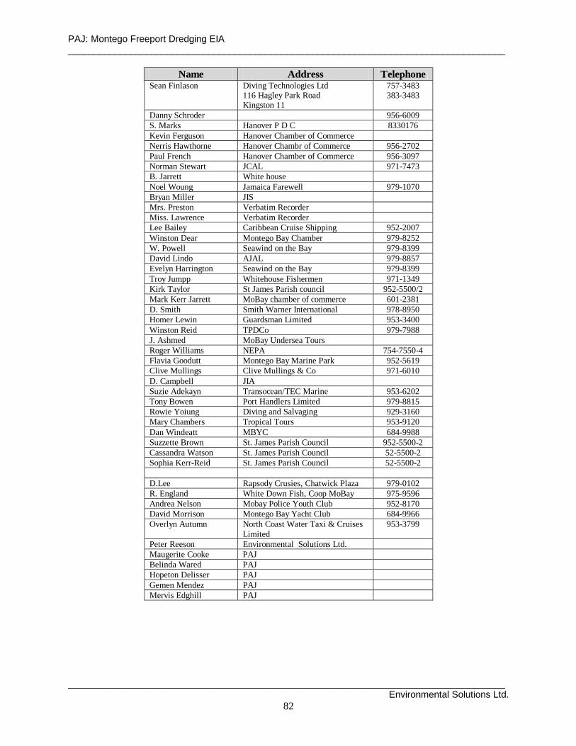
PAJ: Montego Freeport Dredging EIA ____________________________________________________________________________________
____________________________________________________________________________________ Environmental Solutions Ltd.
82
Name Address Telephone Sean Finlason Diving Technologies Ltd
116 Hagley Park Road Kingston 11
757-3483 383-3483
Danny Schroder 956-6009 S. Marks Hanover P D C 8330176 Kevin Ferguson Hanover Chamber of Commerce Nerris Hawthorne Hanover Chambr of Commerce 956-2702 Paul French Hanover Chamber of Commerce 956-3097 Norman Stewart JCAL 971-7473 B. Jarrett White house Noel Woung Jamaica Farewell 979-1070 Bryan Mill er JIS Mrs. Preston Verbatim Recorder Miss. Lawrence Verbatim Recorder Lee Bailey Caribbean Cruise Shipping 952-2007 Winston Dear Montego Bay Chamber 979-8252 W. Powell Seawind on the Bay 979-8399 David Lindo AJAL 979-8857 Evelyn Harrington Seawind on the Bay 979-8399 Troy Jumpp Whitehouse Fishermen 971-1349 Kirk Taylor St James Parish council 952-5500/2 Mark Kerr Jarrett MoBay chamber of commerce 601-2381 D. Smith Smith Warner International 978-8950 Homer Lewin Guardsman Limited 953-3400 Winston Reid TPDCo 979-7988 J. Ashmed MoBay Undersea Tours Roger Willi ams NEPA 754-7550-4 Flavia Goodutt Montego Bay Marine Park 952-5619 Cli ve Mulli ngs Clive Mulli ngs & Co 971-6010 D. Campbell JIA Suzie Adekayn Transocean/TEC Marine 953-6202 Tony Bowen Port Handlers Limited 979-8815 Rowie Yoiung Diving and Salvaging 929-3160 Mary Chambers Tropical Tours 953-9120 Dan Windeatt MBYC 684-9988 Suzzette Brown St. James Parish Council 952-5500-2 Cassandra Watson St. James Parish Council 52-5500-2 Sophia Kerr-Reid St. James Parish Council 52-5500-2 D.Lee Rapsody Crusies, Chatwick Plaza 979-0102 R. England White Down Fish, Coop MoBay 975-9596 Andrea Nelson Mobay Poli ce Youth Club 952-8170 David Morrison Montego Bay Yacht Club 684-9966 Overlyn Autumn North Coast Water Taxi & Cruises
Limited 953-3799
Peter Reeson Environmental Solutions Ltd. Maugerite Cooke PAJ Belinda Wared PAJ Hopeton Deli sser PAJ Gemen Mendez PAJ Mervis Edghill PAJ

PAJ: Montego Freeport Dredging EIA ____________________________________________________________________________________
____________________________________________________________________________________ Environmental Solutions Ltd.
83
Appendix 3. Terms of Reference for Montego Bay Dredg ing EIA approved by NEPA.
______________________________________________________________________
ENVIRONMENTAL SOLUTIONS LTD. 20 WEST KINGS HOUSE ROAD
KINGSTON 10 __________________________________________________________________
FINAL AND APPROVED EIA TOR
FOR
PORT AUTHORITY OF JAMAICA
Montego Bay Harbour Dredging Project
Terms of Reference for Environmental Impact Assess ment
The following TOR for the EIA of the proposed dredging works in Montego Bay Harbour are adapted from World Bank and NEPA environmental assessment guidelines. They make reference to NEPA Guidelines for the Planning and Executing of Coastal and Estuarine Dredging Works and Disposal of the Dredged Materials and also address specific NEPA requirements for this EIA as given in letters to PAJ dated 21 February 2002 and 8 April 2002.
1. Introduction - Identify the development project to be assessed and explain the executing
arrangements for the environmental assessment. Describe the rationale for the development and its objectives. Describe the context for the proposed dredging works in relation to future plans for development of Montego Bay port.
2. Background Information –Briefly describe the major components of the proposed project,
the implementing agents, a brief history of the project and its current status. 3. Study Area - Specify the boundaries of the study area for the assessment as well as any
adjacent or remote areas that should be considered with respect to the project (e.g. dredged material disposal site/s).
4. Scope of Work - The following tasks will be performed:
Task 1. Description of the Proposed Project - Provide a full description of the relevant parts of the project, using maps at appropriate scales where necessary. This is to include: quality and volume of sediments to be excavated in each area to be dredged; type of dredging equipment to be used and the manner of deployment including handling, transportation, and disposal of dredged material, sediment containment settling and turbidity control measures; alternative dredging methods considered; project schedule; and life span.

PAJ: Montego Freeport Dredging EIA ____________________________________________________________________________________
____________________________________________________________________________________ Environmental Solutions Ltd.
84
Task 2. Description of the Environment - Assemble, evaluate and present baseline data on the relevant environmental characteristics of the study area (and disposal sites), including the following:
a) Physical environment: geomorphology, meteorology (rainfall, wind, waves and
tides), sea currents and bathymetry, surface hydrology, estuarine/marine receiving water quality, and ambient noise.
b) Biological environment: terrestrial and marine vegetation and fauna, rare or
endangered species, wetlands, coral reefs, and other sensitive habitats, species of commercial importance, and species with the potential to become nuisances or vectors.
c) Socio-cultural environment: shipping activities and use of the port, population,
land use, planned development activities, employment, recreation and public health, community perception of the development, vulnerable occupants.
d) Hazard vulnerability; vulnerability of area to flooding, hurricanes, storm surge,
and earthquakes.
Characterise the extent and quality of the available data, indicating significant information deficiencies and any uncertainties associated with the prediction of impacts.
Task 3. Legislative and Regulatory Considerations - Describe the pertinent legislation, regulations and standards, and environmental policies that are relevant and applicable to the proposed project, and identify the appropriate authority jurisdictions that will specifically apply to the project. Task 4. Determine the Potential Impacts of the Proposed Project – Identify impacts related to dredging, dredged material disposal and possible land filling. Distinguish between significant impacts that are positive and negative, direct and indirect (= triggering), and short and long term. Identify impacts that are cumulative, unavoidable or irreversible. Identify any information gaps and evaluate their importance for decision-making. Special attention will be paid to:
• Effects of the project (dredging and dredged material disposal) on water quality and
existing coastal ecosystems and resources with specific reference to the Montego Bay Marine Park and the Bogue Lagoon Fish Sanctuary,
• Effects of storm water drainage from proposed dredged material disposal sites,
including potential for off-site flooding, • Effects of dredging on the coastal stability of adjacent shorelines, • Effects of dredging works on the existing operations of the port, the adjacent yacht
club, fishermen, and on the rights/operations of any other stakeholders, • Effects of the project on future port development and the tourism sector,
• Effects of the project on maritime, boating and road traffic,
PAJ: Montego Freeport Dredging EIA ____________________________________________________________________________________
____________________________________________________________________________________ Environmental Solutions Ltd.
85
• Effects of the project on ambient noise levels, and
• Effects of the project on any historical resources.
Task 5. Analysis of Alternatives to the Proposed Project. – Describe the alternatives examined for the proposed project that would achieve the same objective including the “no action alternative. This includes dredging vessel types and disposal sites. Distinguish the most environmentally friendly alternatives. Task 6. Mitigation and Management of Negative Impacts – Identify possible measures to prevent or reduce significant negative impacts to acceptable levels with particular attention paid to dredge spoil disposal and dispersal/sedimentation control, as well as measures to minimise disruption to existing port and yacht club operations. Cost the mitigation measures, equipment and resources required to implement those measures. Propose mechanisms for investigating claims for compensation put forward by affected stakeholders.
Task 7. Development of a Monitoring Plan – Identify the critical issues requiring monitoring to ensure compliance to mitigation measures and present impact management and monitoring plan for dredging/disposal operations.
Task 8. Assist in Inter-Agency Coordination and Public/NGO Participation – Identify appropriate mechanisms for providing information on dredging activities and progress of project to stakeholders. Assist in co-ordinating the environmental assessment with the relevant government agencies and in obtaining the views of local stakeholders and affected groups. (It is anticipated that there will be considerable public interest concerning issues of sediment disposal and turbidity with respect to the marine park, and the economic benefits to be derived from the project.)
Report - The environmental impact assessment report, to be presented in digital format, will be concise and focus on significant environmental issues. It will contain the findings, conclusions and recommended actions supported by summaries of the data collected and citations for any references used in interpreting those data. The environmental assessment report will be organized according to, but not necessarily limited by, the outline suggested below. • Executive Summary • Description of Proposed Project • Policy, Legal and Administrative Framework • Description of the Environment and Hazard Vulnerability • Significant Environmental Impacts • Impact Mitigation Measures • Impact Monitoring Plan • Inter-Agency and Public/NGO Consultation Process • Appendices/List of References

PAJ: Montego Freeport Dredging EIA ____________________________________________________________________________________
____________________________________________________________________________________ Environmental Solutions Ltd.
86
14. ACKNOWLEDGEMENTS The consultants would like to place on record their appreciation of the hospitality, the time, and the assistance extended to them by members of the Montego Bay community from all walks of life during the preparation of this report. They are too numerous to mention individually. However, special expressions of gratitude are due to Jill Williams, Executive Director, Montego Bay Marine Park, Bryan Langford, Director of Water Sports, Round Hill Hotel, and Robert Mallasch, Construction Consultant.

PAJ: Montego Freeport Dredging EIA ____________________________________________________________________________________
____________________________________________________________________________________ Environmental Solutions Ltd.
87
15. PLATES