ENVIRONMENTAL IMPACT ASSESSMENT (EIA) OF ......EGASPIN Environmental Guidelines and Standards for...
299
The Shell Petroleum Development Company of Nigeria Limited Operator for the NNPC/Shell/NAOC/TEPNG ENVIRONMENTAL IMPACT ASSESSMENT (EIA) OF AGBADA NON ASSOCIATED GAS (NAG) PROJECT IN OBIO AKPOR LGA, RIVERS STATE FINAL REPORT SUBMITTED TO THE FEDERAL MINISTRY OF ENVIRONMENT, ABUJA DECEMBER, 2015
Transcript of ENVIRONMENTAL IMPACT ASSESSMENT (EIA) OF ......EGASPIN Environmental Guidelines and Standards for...

The Shell Petroleum Development Company of Nigeria Limited Operator for
the NNPC/Shell/NAOC/TEPNG
ENVIRONMENTAL IMPACT ASSESSMENT (EIA) OF AGBADA
NON ASSOCIATED GAS (NAG) PROJECT IN OBIO AKPOR
LGA, RIVERS STATE
FINAL REPORT
SUBMITTED TO THE FEDERAL MINISTRY OF
ENVIRONMENT, ABUJA
DECEMBER, 2015

Environmental Impact Assessment of Agbada Non Associated Gas (NAG) Project
i
Status Page
TITLE: ENVIRONMENTAL IMPACT ASSESSMENT (EIA) OF AGBADA NON
ASSOCIATED GAS (NAG) PROJECT IN OBIO - AKPOR LGA, RIVER STATE
Originator: The Shell Petroleum Development Company of Nigeria Limited
Author:
Approved by:
Document Number: SPDC
Date:
Version: 02
Security:
Change History:
Version Date Pages Reason
02 Whole Document Final Report

Environmental Impact Assessment of Agbada Non Associated Gas (NAG) Project
ii
Table of Contents
Status Page .................................................................................................................................. i
Table of Contents ....................................................................................................................... ii
List of Tables ............................................................................................................................ vi
List of Figures .......................................................................................................................... vii
List of Plates .......................................................................................................................... viii
List of Acronyms and Abbreviations ........................................................................................ ix
Executive Summary .................................................................................................................. ix
EIA Preparers ....................................................................................................................... xxiii
Acknowledgements ............................................................................................................... xxiv
CHAPTER ONE ........................................................................................................................ 1
INTRODUCTION ..................................................................................................................... 1
1.1: General ................................................................................................................................ 1
1.2: The Project Location ........................................................................................................... 1
1.3: The Proponent ..................................................................................................................... 3
1.4: EIA Objectives .................................................................................................................... 3
1.5: EIA Methodology ............................................................................................................... 4
1.6: Legal and Administrative Framework ................................................................................ 4
1.6.1: International Laws and Regulations ................................................................................ 4
1.6.2: Legislations guiding Environmental management in Nigeria ......................................... 6
1.6.3: Legislations guiding Environmental Management in Rivers State ................................. 8
1.6.4: SPDC Policies and Principles .......................................................................................... 8
1.7: Structure of this EIA Report ............................................................................................. 10
CHAPTER TWO ..................................................................................................................... 12
PROJECT JUSTIFICATION................................................................................................... 12
2.1: Background ....................................................................................................................... 12
2.2: Need for the Project .......................................................................................................... 12
2.3: Value of the Project .......................................................................................................... 12
2.4: Envisaged Sustainability ................................................................................................... 12
2.4.1: Economic and Commercial Sustainability ..................................................................... 12
2.4.2: Technical Sustainability ................................................................................................. 13
2.4.3: Environmental Sustainability ......................................................................................... 13
2.5: Project Options ................................................................................................................. 13
2.5.1: The ‘No Project’ Option ................................................................................................ 13
2.5.2: Eastern Domestic Gas Supply Development Options ................................................... 14
2.5.3: Details of the Recommended Option ............................................................................. 15
2.5.4: Agbada NAG Development – Concept Selection Criteria ............................................ 16
CHAPTER THREE ................................................................................................................. 19
PROJECT DESCRIPTION ...................................................................................................... 19
3.0: General .............................................................................................................................. 19
3.1: The Project Location ......................................................................................................... 19
3.2: Conceptual and Detailed Design ....................................................................................... 22
3.3: Quality Assurance of Design ............................................................................................ 22

Environmental Impact Assessment of Agbada Non Associated Gas (NAG) Project
iii
3.4: Applicable Standards and Codes ...................................................................................... 22
3.5: Design Considerations: ..................................................................................................... 22
3.6: Project Activities............................................................................................................... 23
3.6.1: Land Take ...................................................................................................................... 23
3.6.2: Location Preparation, Land Clearing and Excavation ................................................... 23
3.6.3: Drilling Location Platform Preparation ......................................................................... 23
3.6.4: Site Preparation for GHF Installation ............................................................................ 24
3.6.5: Drilling, Workover and Completion of Wells ............................................................... 24
3.3.6: Pipelines ......................................................................................................................... 25
3.3.7: Laying of Flow lines and Pipeline Networks................................................................. 26
3.3.8: Commissioning and Handover....................................................................................... 30
3.3.9: Site Clean-up and Demobilization from Site ................................................................. 31
3.3.10: Operations and Maintenance of Manifold and Pipeline .............................................. 32
3.4: Operating and Maintenance Philosophy ........................................................................... 32
3.5: Technical Risk and Uncertainties ..................................................................................... 33
3.6: Execution Risks ................................................................................................................ 33
3.7: Decommissioning and Abandonment ............................................................................... 34
3.8: By-products and Waste Generation .................................................................................. 34
3.9: Project Schedule ............................................................................................................... 37
CHAPTER FOUR .................................................................................................................... 38
DESCRIPTION OF THE EXISTING ENVIRONMENT ....................................................... 38
4.1: General .............................................................................................................................. 38
4.2: Data Acquisition ............................................................................................................... 38
4.3: Climate and Meteorology ................................................................................................. 38
4.4: Ambient Air Quality ......................................................................................................... 41
4.5: Noise Level ....................................................................................................................... 41
4.6: Rain Water Characteristics ............................................................................................... 42
4.7: Soil Studies ....................................................................................................................... 43
4.8: Geology and Hydrogeology .............................................................................................. 46
4.8.1: Geology .......................................................................................................................... 46
4.8.2: Hydrogeology ................................................................................................................ 47
4.8.3: Ground Water Quality ................................................................................................... 48
4.9: Vegetation ......................................................................................................................... 51
4.9.1: Structure and Floristic Composition .............................................................................. 51
4.9.2: Plant tissue analysis ....................................................................................................... 53
4.9.3: Plant pathological studies .............................................................................................. 54
4.9.4: Economic crops.............................................................................................................. 54
4.10: Wildlife ........................................................................................................................... 54
4.11: Conservation Status of study area ................................................................................... 55
4.12: Socioeconomic Survey ................................................................................................... 55
4.12.1: Consultation ................................................................................................................. 55
4.12.2: Socio-Economic Survey .............................................................................................. 58
4.12.3: Study Approach / Design ............................................................................................. 59

Environmental Impact Assessment of Agbada Non Associated Gas (NAG) Project
iv
4.12.4: People, Governance and Hierarchical structure ........................................................... 60
4.12.5: Settlement History ....................................................................................................... 61
4.12.6: Land ownership/acquisition ......................................................................................... 62
4.12.7: Settlement Pattern ........................................................................................................ 62
4.12.8: Major Language ........................................................................................................... 63
4.12.9: Population structure and distribution ........................................................................... 63
4.12.10: Infrastructures and Services ....................................................................................... 65
4.12.11: Local Economy .......................................................................................................... 68
4.12.12: Lifestyle Culture ........................................................................................................ 70
4.12.13: Peoples’ Perceptions, Fears and Expectations of the Project .................................... 72
4.13: Health Profile .................................................................................................................. 73
4.13.1: Health Infrastructure .................................................................................................... 73
4.13.2: Housing and Environment ........................................................................................... 75
4.13.3: Disease Prevalence ...................................................................................................... 75
4.13.4: Availability of Potable Water ...................................................................................... 76
4.13.5: Lifestyle ....................................................................................................................... 76
4.13.6: Immunization coverage ................................................................................................ 76
4.13.7: Nutrition ....................................................................................................................... 76
CHAPTER FIVE ..................................................................................................................... 78
ASSOCIATED AND POTENTIAL ENVIRONMENTAL IMPACTS .................................. 78
5.1: Introduction ....................................................................................................................... 78
5.2: Principles of Impact Prediction and Evaluation ............................................................... 78
5.3: Impact Assessment Methodology ..................................................................................... 79
5.4: Screening and Scoping of the Potential Impacts .............................................................. 79
5.5: Impact Identification ......................................................................................................... 81
CHAPTER SIX ........................................................................................................................ 90
MITIGATION MEASURES ................................................................................................... 90
6.1: General .............................................................................................................................. 90
6.2: Process Monitoring and Control Technology ................................................................... 90
6.3: Equipment Selection ......................................................................................................... 90
6.4: Safeguarding Systems ....................................................................................................... 90
6.5: Instrumentation ................................................................................................................. 90
6.6: Impact Mitigation Measures ............................................................................................. 91
CHAPTER SEVEN ............................................................................................................... 103
ENVIRONMENTAL MANGEMENT PLAN ...................................................................... 103
7.1: General ............................................................................................................................ 103
7.2: The Objectives of EMP................................................................................................... 103
7.3: Management Organization .............................................................................................. 103
7.4: Implementation of Mitigation Measures ......................................................................... 104
7.5: Transport operations ....................................................................................................... 104
7.6: Prevention of Accidents/incidents: ................................................................................. 104
7.7: Training and Awareness: ................................................................................................ 105
7.8: Maintenance Programme ................................................................................................ 106

Environmental Impact Assessment of Agbada Non Associated Gas (NAG) Project
v
7.9: Construction guidelines .................................................................................................. 106
7.10: Spills ............................................................................................................................. 109
7.11: Gaseous Emissions (CO2, CH4, SOx, NOx, H2S, VOCs including BTEX) ................. 109
7.12: Decommissioning and Abandonment Plan ................................................................... 110
7.13: Remediation Plans After Decommissioning /Abandonment / Closure ........................ 110
7.14: Environmental Audit..................................................................................................... 111
7.15: Environmental Monitoring Plan ................................................................................... 111
CHAPTER EIGHT ................................................................................................................ 131
CONCLUSION ...................................................................................................................... 131
REFERENCES ...................................................................................................................... 132
APPENDICES ....................................................................................................................... 135

Environmental Impact Assessment of Agbada Non Associated Gas (NAG) Project
vi
List of Tables
Table 2.1: The Concept Selection criteria and associated weightings ..................................... 16
Table 2.2: Scoring and Ranking Table .................................................................................... 17
Table 2.3: Overall Assessment Chart....................................................................................... 18
Table 3.1: Waste Streams from the FDP Project ..................................................................... 35
Table 3.2: Timing and Implementation Schedule Project Level 1 Schedule ........................... 37
Table 4.1: Climatic Conditions at Agbada NAG Area (Oct-Nov 2008).................................. 38
Table 4.2: Climatic Conditions at Agbada NAG Area (January 2009) ................................... 39
Table 4.3: Mean Noise Level around the Proposed Project Area ............................................ 41
Table 4.4: Co-ordinates and elevations of boreholes ............................................................... 47
Table 4.5: Forest data summary in the SPDC project area (VGT 1) ....................................... 51
Table 4.6: Forest data summary in the SPDC project area (VGT 2) ....................................... 52
Table 4.7: Mean concentrations of heavy metals in foliage of plant species in the area ......... 53
Table 4.8: plant species with potential utilitarian benefits in the project area ......................... 54
Table 4.9: Sampled Communities and their LGAs .................................................................. 58
Table 4.10: Communities Sampled and total number of Questionnaires filled ....................... 60
Table 4.11: Distribution of - Land Ownership by sampled communities................................ 62
Table 4.12 Distribution of communities by type of Settlement ............................................... 62
Table 4.13: Distribution of sampled communities by language spoken .................................. 63
Table 4.14: Population of Males and Females in 2006 Projected to 2009 in the sampled Obio
Akpor and Ikwere LGAs .......................................................................................................... 63
Table 4.15: Sex and dependency ratios of communities.......................................................... 64
Table 4.16 presents the age distribution in the area ................................................................. 64
Table 4.17: Distribution of Communities by Educational Level of Respondents ................... 66
Table 4.18: Housing type in the study area.............................................................................. 67
Table 4.19: Distribution of Sampled Households by Occupational groups in - Ikwerre and
Obio Akpor LGAs of Rivers State ........................................................................................... 69
Table 4.20: Distribution of Respondents by income classes in Naira per month .................... 69
Table 4.21: Summary of Community Needs ........................................................................... 73
Table 4.22: Inventory of Health Care Facilities /Personnel in Study Area ............................. 75
Table 4.23: Prevalence of Diseases in Study Area .................................................................. 75
Table 5.1: Environmental Components and Potential Impact Indicator .................................. 80
Table 5.2: Characterization/Evaluation of Potential Impacts of the Proposed Agbada Field
Development Project ................................................................................................................ 83
Table 6.1 Impacts and Mitigation ............................................................................................ 92
Table 7.1: Expected types of Waste Streams from the FDP Project ..................................... 108
Table 7.2: Environmental Management Plan for Implementation of Mitigation Measures .. 112
Table 7.3: Environmental Monitoring Plan for the Agbada Non Associated Gas (NAG) (PRE-
MOBILIZATION AND CONSTRUCTION PHASE) .......................................................... 129

Environmental Impact Assessment of Agbada Non Associated Gas (NAG) Project
vii
List of Figures
Fig. 1.1: Map of Nigeria showing Rivers State ......................................................................... 2
Fig. 1.2: Map of Rivers State showing Local Government Areas ............................................. 2
Fig. 2.1: Agbada wells only produced to Okoloma ................................................................. 14
Fig. 2.2: Schematics of Agbada Gas Plant ............................................................................... 15
Fig. 3.1: Map of Rivers State showing the proposed project LGAs (Arrowed) ...................... 19
Fig. 3.2: Map of the proposed EIA project location – Agbada (OML 17) .............................. 21
Fig. 4.1: Average Monthly Temperatures for Port Harcourt Synoptic Station ....................... 40
Fig. 4.2: Trend in Rainfall from 1997 – 2003 in the Study Area. ............................................ 40
Fig. 4.3: Trend in Relative Humidity from 1997 – 2003 in the Study Area ............................ 41
Fig. 4.3: Borehole Lithologic Logs for the Study .................................................................... 48
Fig 4.5: Distribution of Age groups and Sex in the study area ................................................ 65
Fig. 5.1: Schematic Representation of Potential Impact Assessment Approach ..................... 79

Environmental Impact Assessment of Agbada Non Associated Gas (NAG) Project
viii
List of Plates
Plate 4.1: Ground cover species at transect 1 .......................................................................... 52
Plate 4.2: Oil palm (Elaeis guineensis) as emergent canopies................................................. 53
Costus afer ............................................................................................................................... 54
Plate 5.1: The Chief Christian Emerengwa of Omunike Omunobo and some community
members ................................................................................................................................... 57
Plate 5.2: Team with Dr. Eric C. Amadi of Rumuijima Eledo Rukpokwu and community
members ................................................................................................................................... 57
Plate 5.3: Team with Chief Charles O. . Nyemachi of Rumuluwada Eledo Rukpokwu ......... 57
Plate 5.4: Group photograph with Chief L. I. Oobo of Elikpokwodu Rukpokwu .................. 58
Plate 5.5: Team with Chief (Capt.) Elechi Amadi (Rtd) (3rd
from left – standing, 1st row) and
some Mbodo Aluu Community Elders .................................................................................... 58
Plate 4.3: A secondary school at recess during the survey at Rukpokwu ................................ 66
Plate 4.4: State Primary School 1, Aluu .................................................................................. 67
Plate 4.5: One of the churches in the study area ...................................................................... 71
Plate 4.6: A health care center at Aluu .................................................................................... 74
Plate 4.7: A Patent medicine store in the study area ................................................................ 74

Environmental Impact Assessment of Agbada Non Associated Gas (NAG) Project
ix
List of Acronyms and Abbreviations
AG Associated Gas
AQ Air Quality (Sample Station)
ALARP As Low As Reasonably Practicable
APHA American Public Health Association
ASTM American Society for Testing and Materials
Ba Barium
Ca Calcium
CAP Community Assisted Projects
CAPEX Capital Expenditure
CBR
CBO
Crude Birth Rate
Community Based Organization
Cd Cadmium
CDC Community Development Committee
CLO Community Liaison Officer
CO Carbon monoxide
COD Chemical Oxygen Demand
CTB Confirmatory Time Break
Cr Chromium
CRNI Crude Rate of National Increase
Cu Copper
DC Direct Current
DO Dissolved Oxygen
DOMGAS Domestic Gas
DPR Department of Petroleum Resources
DPT Diphtheria, Pertussis and Tetanus
EAR Environmental Audit Report
EDG Eastern Domestic Gas
EER Environmental Evaluation Report
EIA Environment Impact Assessment
EIS Environmental Impact Statement
EGASPIN Environmental Guidelines and Standards for the Petroleum Industry in
Nigeria
EMP Environmental Management Plan
EPA Environmental Protection agency
EPIRBs Emergency Position Indicating Radio Beacons
Fe Iron
FMA Federal Ministry of Aviation
FEPA Federal Environmental Protection Agency
FMEnv Federal Ministry of Environment
GDP Gross Domestic Product
GHF Gas Handling Facility
GHG Green House Gas
GPS Global Positioning System

Environmental Impact Assessment of Agbada Non Associated Gas (NAG) Project
x
HB Heterotrophic Bacteria
HUB Hydrocarbon Utilising Bacteria
HSE Health Safety and Environment
HSE MS Health Safety and Environment Management System
IAGC International Association of Geophysical Contractors
IMDG International Maritime Dangerous Goods
IUCN International Union for the Conservation of Nature
ISO International Organization for Standardization
ITCZ Inter tropical Convergence Zone
K Potassium
LGA Local Government Area
LTO License to operate
LVL Low Velocity Layer
Mg Magnesium
MARPOL International Convention for Prevention of Pollution from Ship
NAG Non-Associated Gas
NAPIMS National Petroleum Investment Management Services
NDT Non-Destructive Testing
NDI
NGO
National Days On Immunization
Non-Governmental Organization
Ni Nickel
NIMET Nigerian Meteorological Agency
NNPC Nigerian National Petroleum Corporation
NO2 Nitrogen dioxide
NPC National Population Commission
NPDC Nigerian Petroleum Development Company
NPI National Programme on Immunization
NTU Nephelometric Turbidity Units
OML Oil Mining Lease
OPEC
OPL
Organization of Petroleum Exporting Countries
Oil Prospecting License
OPTS Oil Producers’ Trade Section
OSHA
PAC
Occupational Safety and Health Administration
Project Advisory Committee
Pb Lead
pH Hydrogen ion concentration
PIA Post Impact Assessment
PPE Personal Protective Equipment
PSD Particle Size Distribution
Q1 First Quarter
Q2 Second Quarter
QC Quality Control
QHSE Quality, Health, Safety and Environment

Environmental Impact Assessment of Agbada Non Associated Gas (NAG) Project
xi
RF Radio Frequency
SO2 Sulphur dioxide
SOLAS International Convention for the Safety of Life at Sea
SPDC Shell Petroleum Development Company of Nigeria Limited
SPM Suspended Particulate Matter
SREM Security Risk Exposure Matrix
STD Sexually Transmitted Diseases
STOIIP
TDS
Stock Tank Oil Initially in Place
Total Dissolved Solids
TOC Total Organic Carbon
ToR Terms of Reference
THC Total Hydrocarbon Content
TPH Total Petroleum Hydrocarbon
TSS Total Suspended Solids
UN United Nations
UNEP United Nations Environmental Programme
UPTH University of Port Harcourt Teaching Hospital
cfu/ml Colony forming unit per millilitre
cm Centimeter
Eh Oxidation Reduction Potential
ft Feet
g Grammes
g/l Grammes per litre
g/kg Grams per kilogramme
km Kilometre
km2 Square kilometere
m Metre
m/s Metre per second
m3 Metre cube
m2 Metre square
meq/100g Milliequivalent per 100 gramme
mg/kg Milligramme per kilogramme
mg/l Milligramme per litre
mg/m3 Milligramme per metre cubic
ml Millilitre
mm Millimetre
mm/hr Millimetre per hour
mS/cm MilliSiemens per centimetre
NTU Nephelometric Turbidity Units
ppm Parts per million
ppt Part per thousand
STOIIP Stock Tank Oil Ini
ton Tonne
V Vanadium
VGT Vegetation
WCMC World Conservation Monitoring Centre

Environmental Impact Assessment of Agbada Non Associated Gas (NAG) Project
xii
% Percentage
S/cm MicroSiemens per centimetre
s Second oC Degrees Celcius
" Inches

Environmental Impact Assessment of Agbada Non Associated Gas (NAG) Project
ix
Executive Summary
ES 1: Introduction
ES 1.1: Background
Shell Petroleum Development Company of Nigeria Limited is a major oil & gas exploration
and production (E&P) Company in Nigeria. It operates a Joint Venture Partnership with
Nigerian National Petroleum Corporation (NNPC), ELF Petroleum Nigeria Ltd (EPNL) and
Nigerian Agip Oil Company (NAOC). The partnership participation are 55%, 30%, 10% and
5% for NNPC, SPDC, ELF and NAOC, respectively. Shell Petroleum Development
Company (SPDC) on behalf of Joint venture partners viz: Nigerian National Petroleum
Corporation (NNPC), ELF Petroleum Nigeria Ltd (EPNL) and Nigerian Agip Oil Company
(NAOC) plans to develop its Agbada field in Oil Mining Lease (OML) 17. The field
development is aimed at increasing gas production from Agbada field. The proposed project
will involve the drilling and completion of two Non Associated gas (NAG) wells and re-
completion of one of the wells in 2014, laying of 2Nos. 8” x 8km flowlines from wells at
Agbada I to NAG plant at Agbada II.
ES.1.2: Administrative and Legal Framework
In line with SPDC’s sustainable development goals and in keeping with applicable
regulations (DPR Environmental Guidelines and Standards for the Petroleum Industry in
Nigeria, 2002, the Federal Ministry of Environment (FMEnv) Procedural / Sectoral
Guidelines for the Oil and Gas Industry (1995), and the EIA Act 86 of 1992), the company
has carried out an Environmental Impact Assessment (EIA) prior to the commencement of
the proposed project. The Environmental Impact Assessment (EIA) Act No. 86 of 1992,
DPR’s EGASPIN, state legislations and all other applicable National legislations, and
International Agreements and Conventions to which Nigeria is a signatory shall guide the
implementation of the proposed project.
ES 1.3: Project Location
The Agbada field is located in SPDC's OML - 17 and it is situated approximately 16 km
North-East of Port Harcourt in Rivers State. Agbada field is located in SPDC’s OML 17 and
falls within Rivers State (Ikwerre, Obio/Akpor, Etche, and Port Harcourt Local Government
Areas). Latitudinal and longitudinal positioning of the Flow stations I and II were found to be
6.58°72'E, 4.56°02'N and 7.00°95'E, 4.55°94'N respectively using a GARMI Global
Positioning System (GPS) on the field. The field is located on the same mega structural trend
as the Obigbo North field. The planned field development activity falls within Rivers State
(Ikwerre, Obio/Akpor, and Etche Local Government Areas).
ES 2.0: EIA Objectives
The main objectives of the EIA study include the following:
Determine the current status of the Environment and impacts of the existing SPDC
facilities and operations in the project area;
Determine baseline conditions of the environment as well as the socio-economic and
health conditions of the host communities;

Environmental Impact Assessment of Agbada Non Associated Gas (NAG) Project
x
Evaluate the residual impacts of the existing facilities on the receiving environment;
Determine and evaluate the potential impacts of the proposed project activities on the
environment, using the current environmental conditions as the baseline;
Identify and evaluate the potential socio-economic effects of the project on the
communities including impacts on cultural properties, social infrastructures, natural
resources and impact on lifestyles/values as well as analysis of the opportunity cost to
chemical spills during project activities;
Identify health hazards that may result from the different phases of the project during
execution (including operation & decommissioning) and evaluate local population
exposure to these hazards;
Develop cost effective mitigation measures and appropriate Environmental
Management Plan (EMP) for all identified impacts.
ES.2.1: EIA Methodology
The study was carried out, using standard scientific methods for data acquisition. It generally
involved desktop studies, field research, consultation, laboratory analysis, impact assessment,
recommendation of mitigation measures and development of an environmental management
plan (EMP).
ES 3.0: Project Justification
In Nigeria, the Power Holding Company of Nigeria (PHCN) is empowered to maintain, co-
ordinate and supply electricity to the Nigerian nation. It has nine (9) generating stations,
made up of three (3) hydro stations: and six (6) thermal stations. In addition, some
independent power plant projects have been commissioned. The total energy generated by the
stations is grossly inadequate to meet the 6,000 MW of electricity target by end of 2009.
Current power generation is believed to be below 4,000MW. This is because the hydro based
stations, due to water level fluctuation and limitation, are not efficient throughout the year,
while the gas stations are affected by inadequate supply.
Also, one major source of environmental problems and agitation in the Niger Delta in Nigeria
is gas flaring. The World Bank reported in 2004 that, Nigeria currently flares between 70 and
75% of the gas it produces. Almost no vegetation can grow in the area directly surrounding
the flare due to the tremendous heat it produces. Gas flaring emits carbon dioxide, carbon
monoxide, methane, nitrogen dioxide, nitrogen monoxide, sulphur dioxide and in some cases
hydrogen sulphide. Other substances released in the course of gas flaring are soot and smoke.
Developing and ultimately producing NAG from Agbada field would facilitate SPDC’s
efforts to increase its gas utilization efforts and also enable Nigeria meet her target of
increased gas utilization for power production and thus reduce gas flaring and its attendant
environmental consequences.

Environmental Impact Assessment of Agbada Non Associated Gas (NAG) Project
xi
ES 3.1: Envisaged Sustainability
Economic and Commercial Sustainability
This facility is envisaged to be economically and commercially sustainable because of the gas
volume present in the Agbada field and the gas reserves in other nearby fields that can be
produced in the future on depletion of the Agbada NAG reserves (circa 5years). With the
Federal Government Power Plants (Alaoji & Ibom Power Plants) and ALSCON as major
users and given the political drive for power development in the country as well as other
domestic users, market for the gas is assured.
Technical Sustainability
The proposed project is expected to be technically sustainable because of the proven
technology for the drilling and production operations being used. Strict adherence to
internationally accepted engineering design and construction standards as well as codes of
practice that shall be adopted at all stages of the project are expected to ensure technical
sustainability.
Environmental Sustainability
Incorporation of the recommendations of this EIA at the appropriate stages of the project
development is expected to ensure that the proposed Agbada Eastern Domgas Interim Growth
Project is environmentally sustainable. The project will provide AG solutions for surge vessel
gas from the existing Agbada 2 flowstation that is currently being flared thereby leading to a
reduction in Green House Gas (GHG) emissions. Project has been planned in such a way that
there will be minimal environment effect especially with respect to land take. The new NAG
plant shall be sited at the location of existing disused gas lift compressor plant, which is
currently being decommissioned and the wells drilled from an existing well location. Also,
the flowlines shall pass through the existing SPDC RoW (Right of Way). In addition, strict
adherence to the EMP shall ensure that every aspect of the proposed project is sustainable
with minimum impact, especially as it concerns the natural environment and the people who
inhabit it.
ES.3.2: Project Development Options
Project development options considered for the proposed field development project include:
Option 1: Do nothing/No Project Option
This option implies that the Agbada NAG development project would not be carried out and
gas supply to the Eastern DOMGAS network to feed the proposed Alaoji power plant and
other customers on the network will not be available. This will result in a shortfall in gas
supply, frustrating Government’s plan to boost electrical power generation in the country and
hindering industrial activity and economic growth.
Decision: Not recommended
Option 2: Agbada wells only produced to Okoloma
This option involves the following:
Procurement and installation of flowlines from Agbada wells to the cluster manifold.

Environmental Impact Assessment of Agbada Non Associated Gas (NAG) Project
xii
Procurement and installation of Flowline (bulkline) from Agbada to Okoloma Gas
Plant.
Procurement and installation of Manifolds.
Installation of gas receiving facilities at Okoloma Gas Plant.
Installation of surge vessel compressor at Agbada.
Decision: Not recommended
Option 3: Develop and Produce Agbada
This concept involves installation of 120mmscfd capacity gas plant as was proposed in the
SPDC JV’s Business Plan with an estimated start-up date of end 2010. Two wells have been
identified to fill the plant
Decision: Recommended
ES 4.0: Project Description
The proposed Agbada NAG Field Development project activities consist of the following:
Location preparation
Drilling and Completion of 2 NAG wells (W67 and W68) Casing, logging,
cementation and completion of all the wells;
Well testing and hook-up
Decommissioning of existing gas lift compressor
Installation of GHF
Installation of screw booster compressor at Agbada II
Land acquisitions and claims settlement
Right-of-way clearing(8.9316 hectares)
Trench excavation
Cleaning, bevelling and pipe bending
Laying 2Nos. 8” x 8km flowlines from Wells at Agbada I to NAG plant at Agbada II
Welding
Field joint coating
Inspection, testing and NDT of welds
Lowering and backfilling
Manifold works
Site re-instatement
Demobilization
Drilling Location Platform Preparation
This will include the following activities:
Bush clearing to the appropriate size of location platform, including shoulders;
Stripping of existing location platform earthworks;
Reconstruction to suit the rig;
Construction of generator platform;
Excavation/concrete lining of standard waste pit;

Environmental Impact Assessment of Agbada Non Associated Gas (NAG) Project
xiii
Construction of ancillary facilities such as perimeter drains and oil traps; and
Block work fencing of location platform.
The size of the drilling site shall be approximately 1ha. The projected well depths well depths
for W67/68 is 11,774ftah. Both wells (67/ 68) had the following casing sizes 24’’ stove pipe
- /(354ft), 10 ¾’’ 60.7ppf- /(120ft) and 9 5/8’’ 47ppf -/ (11,725ft). The well was drilled with
Pseudo Oil based Mud (POBM) and the drill –in fluid across the reservoir was Thixal mud to
reduce the reservoir impairment, thereby increasing the production potential. The POBM is
recovered and treated for use in other wells by the Mud supplier. Single string completion per
reservoir has been adopted to target gas reservoirs. The completion is 4 ½’’ 13cr upper
completions with external Gravel pack in the sand face. This is to enable 40Mmscf/day gas
production
Laying of Flow lines and Pipeline Networks
The activities associated with Installation of 2Nos. 8” x 8 km flowline from well locations at
Agbada I to the NAG facility at Agbada II consists of the following activities:
RoW bush clearing;
Trenching;
Stringing;
Welding;
Radiography;
Field joint coating;
Lowering;
Backfilling; and
Hydrotesting.
These activities which shall be carried out in respect of laying of flow lines and pipeline
networks include the installation of 2Nos. 8” x 8 km flow line from well locations at Agbada
I to the NAG facility at Agbada II in accordance with existing SPDC practice, flow lines,
pipelines and field manifold have been designed for unmanned operations. Thus, by means of
the fitted trim chokes and instrument, the manifold shall be monitored from the flow stations.
However, adequate access shall be provided to enable personnel operate the manifold as
necessary. Scheduled operations activities (e.g. pigging and well testing) shall be carried out
by operations staff when they visit.
The flow lines shall be equipped with on-line access sampling points. To enhance bulk line
operations and increase service life, the lines shall be operated at full capacity flow, thus
minimizing the chances of deposits that are likely to arise from low flow conditions. The
design shall provide for safe and efficient means of freeing the bulk lines of all hydrocarbons.
The proposed project was scheduled for commissioning by Quarter 3 of 2010.

Environmental Impact Assessment of Agbada Non Associated Gas (NAG) Project
xiv
ES 5.0: Environmental Baseline Description
The environmental baseline data acquisition involved two season field exercise, carried out
between 24th October (late wet season) and 5th
November 2008 (early dry season). Sampling
of bio-physical components was completed by 30th
October whilst socio-economic and health
data gathering was completed on 5th
November (early dry season). The dry season sampling
was carried out from 26th
– 30th
January, 2009 (mid dry season). The field work was followed
by laboratory analyses and interpretation of results. Environmental components studied
include vegetation, soil, air quality / noise, surface and ground water, hydrobiology, socio-
economics and health status.
Climate
The study area has equatorial rain forest climatic conditions where the temperatures and
humidity are high all the year round. Also, high and persistent rainfall even in the dry months
characterizes the proposed project area. The wind is predominantly in the South Western
direction accounting for about 75% of the annual winds. The North-Easterly winds
predominate during the dry season (November – March), this makes up about 25 % of the
annual winds within the study area. Its penetration into the Niger Delta region between
December and February is characterized by dry and low humidity with dusty haze.
Temperature ranged from 26.60 – 33.60 o
C while relative humidity ranged from 61.00 –
92.00%.
Generally, the wettest period of the year within the area is July - September with the peak
period in July while lower rainfall values are usually recorded in the months of December,
January, February and March. A brief period (few days to one week) of low rainfall usually
occurs anytime between late July and early September in the study area and is often referred
to as August break.
Ambient Air Quality and Noise
Suspended particulate matter (SPM) ranged from 20.50 – 27.00µg/m3 during the wet season
and 30.40 – 36.00µg/m3 during the dry season. Carbon monoxide (CO) ranged from 4.00 –
19.00 ppm for wet season and 1.80 – 8.20 ppm for the dry season. Nitrogen IV Oxide ranged
from 0.60 – 1.00 ppm and 0.90 – 1.90 ppm for wet and dry seasons respectively.
The mean noise levels recorded for wet season ranged from 32.60 – 63.80 dB (A) while that
of dry season ranged from 36.65 – 59.55 dB (A). These values are well within FMEnv and
Occupational Safety and Health Administration (OSHA) permissible exposure limits of 90dB
(A) per day for an 8-hour working period.
Geology
The study area lies within the Niger-Delta; its geology is therefore typical of the Niger Delta
Basin. The area forms part of a geological sequence of the Quaternary and Tertiary
formations of the Niger-Delta, consisting mainly of three main geologic formations, which
are: Benin Formation, Agbada Formation, and Akata Formation.
Environmental Impact Assessment of Agbada Non Associated Gas (NAG) Project
xv
The sub-surface soil revealed by the boreholes show clayey sand, sandy and gravely sand soil
horizons. The clayey sand horizon is dark at the surface. The dark colour fades out with
increasing depth. The sandy horizon is brownish, and its colour also becomes lighter with
depth. The gravelly sand horizon has very light colour tending towards colourless. It contains
the aquifer material.
Soil Characteristics
The soils from Agbada FDP project area are predominantly loamy sand at top and mid-depth
horizons and sandy clay loam at bottom soil horizons. The colour of the soil is dark-greyish-
brown to black on top, changing to light brown in the subsoil. The soil is arable and weakly
acidic to slightly alkaline with the pH of the project area in the wet season varying between
5.80 and 6.89 (top soil) and 5.70 and 6.77 (bottom soil) while the recorded value during the
dry season ranged from 5.4 – 7.3 (top sol) and 5.7 – 7.6 (bottom soil). Conductivity of soil
from the project area ranged from 18.00 – 60.00 µS/cm for both top and bottom soils in the
wet season and 10.00 – 58.00 µS/cm for the same samples during the dry season.
The nitrate values ranged from 6.90 – 13.98 mg/kg for top soil and 7.31 -14.43 mg/kg for
bottom soil in the wet season while the values for dry season were 2.84 – 7.14 mg/kg for top
soil and 2.98 – 6.41 mg/kg for bottom soil. The concentration of sulphate ranged from 2.00 –
18.81 mg/kg for top soil and 2.03 -18.99 mg/kg for bottom soil in the in the wet season while
the values for dry season were 2.37 – 22.69 mg/kg for top soil and 2.27 – 20.85 mg/kg for
bottom soil. Phosphate concentration for wet season ranged from 0.06 – 0.11mg/kg and 0.06
– 0.12 mg/kg for top and bottom soil, respectively while the values for dry season were 0.18
– 0.57 mg/kg and 0.33 – 0.56mg/kg for top and bottom soil, respectively. The concentrations
of oil and grease in the soil of the study area obtained during the wet season for top and
bottom soil ranged from 0.13 - 1.40 mg/kg and 0.44 - 0.88 mg/kg, respectively while the dry
season values ranged from 0.10 – 1.20 mg/kg and from 0.22 – 0.72 mg/kg for top and bottom
soil, respectively. Cation exchange capacity (CEC) values for topsoil ranged from 3.41 – 4.88
meq/100g and from 2.30 and 3.98meq/100g for top and bottom soil respectively, while that
of dry season ranged from 3.13 – 4.12 meq/100g and from 2.01 – 3.65 meq/100g for top and
bottom soil, respectively.
The concentrations of heavy metals in top soil of Agbada FDP area during the wet season
were: lead (Pb): 0.06-0.98mg/kg, Nickel (Ni):6.40 - 8.50 mg/kg, Chromium (Cr):15.70-24.30
mg/kg, Zinc (Zn):0.53-9.87 mg/kg, Cadmium (Cd):0.45 - 0.68 mg/kg, Iron (Fe):35.56-148.23
mg/kg, Manganese (Mn): 9.10-46.50 mg/kg, Vanadium (V):0.02-0.16 mg/kg and Copper
(Cu):5.65-6.45 mg/kg while concentrations of heavy metals in bottom soil for the wet season
were: lead (Pb):0.01-0.85 mg/kg, Nickel (Ni): 6.00 - 8.00 mg/kg, Chromium (Cr):15.30 -
23.80 mg/kg, Zinc (Zn):0.42 - 9.10 mg/kg, Cadmium (Cd):0.41 - 0.64 mg/kg, Iron (Fe):32.67
- 145.47 mg/kg, Manganese (Mn): 8.90 - 42.00 mg/kg, Vanadium (V):0.03 - 0.09 mg/kg and
Copper (Cu):5.42-6.13 mg/kg.

Environmental Impact Assessment of Agbada Non Associated Gas (NAG) Project
xvi
The concentrations of heavy metals in top soil of Agbada FDP area during the dry season
were: lead (Pb):0.04 - 0.89 mg/kg, Nickel (Ni):6.10 - 8.10 mg/kg, Chromium (Cr):14.56-
24.00 mg/kg, Zinc (Zn):0.46 - 9.42 mg/kg, Cadmium (Cd):0.35 -9.41 mg/kg, Iron (Fe):32.20
-142.19 mg/kg, Manganese (Mn):7.80 - 42.30 mg/kg, Vanadium (V):0.01 - 0.11 mg/kg and
Copper (Cu):5.25-6.12 mg/kg while in bottom soil, the concentrations of heavy metals for
the same season were: Lead (Pb):0.01- 0.74 mg/kg, Nickel (Ni):5.60 - 7.70 mg/kg,
Chromium (Cr):1.70 -22.50 mg/kg, Zinc (Zn): 0.37 – 8.69 mg/kg, Cadmium (Cd):0.31-0.57
mg/kg, Iron (Fe):30.14 -140.73 mg/kg, Manganese (Mn):7.10-40.10 mg/kg, Vanadium
(V):0.01-0.07 mg/kg and Copper (Cu):5.12-5.89 mg/kg.
The oil degrading bacteria genera in the soils in all the fields are mainly Bacillus,
Pseudomonas, Acinetobacter, Micrococcus and Actinomyces. The hydrocarbon utilizing
fungal genera in the soil were Penicillium, Aspergillus, Fusarium and yeasts.
Groundwater
The temperature of the groundwater from the study area was slightly warm, with values
ranging from 27.00 – 29.700C during the wet season and 28.00 – 30.60
0C during the dry
season. The result for the Total Dissolved Solid (TDS) showed relatively low values with a
range of 22.80-72.00 mg/l during the wet season and 62.10 – 94.00 mg/l during the dry
season while the level of total suspended solids varied between 0.04and 0.15mg/l and 0.04 –
1.38 mg/l for the wet and dry seasons, respectively.
The conductivity levels ranged from 0.09-0.10 µS/cm and from 0.03 – 0.07 µS/cm for wet
and dry seasons respectively. The pH of the groundwater of Agbada field ranged from 6.43 –
8.95 and 6.30 – 7.30 for wet and dry seasons, respectively, indicating relatively acidic to
alkaline pH. The COD concentration in the groundwater sample ranged from 26.50-
31.00mg/l and from 21.70 – 28.10mg/l for wet and dry seasons, respectively while the BOD
values ranged from 8.50-9.40mg/l and from 4.37 – 5.00mg/l for wet and dry seasons,
respectively. The regulatory limit for COD is <75mg/l. The THC of ground water ranged
0.30 – 1.30mg/l for the wet season while the dry season value ranged from 0.12 – 1.32 mg/l.
The concentration of nitrates (NO3-) in groundwater from the study area ranged from 7.26 –
8.73 mg/l, phosphate levels varied between 0.06 and 0.12mg/l while Sulphate (SO42-
) ranged
from1.02 mg/l – 2.11mg/l for wet season. In the dry season, the concentrations ranged from
5.77 – 6.68mg/l, 0.07 mg/l and 1.41 – 1.79mg/l for nitrate, phosphate and Sulphate,
respectively.
The following concentrations were recorded for heavy metals during the wet season: Lead:
0.005 - 0.008mg/l, Iron: 0.20 – 0.75 mg/l, Zinc: 0.09 - 0.117 mg/l, Nickel: 0.03 mg/l,
Copper: 0.002 – 0.004 mg/l, Cadmium: 0.002 – 0.004 mg/l. Chromium, mercury, arsenic,
vanadium and were mostly below detection limits. In the dry season, the heavy metal
concentrations recorded ranged as follows: Lead: 0.001- 0.003mg/l, Iron: 0.06 – 0.43 mg/l,
Zinc: 0.03-0.06 mg/l, Nickel: 0.68-1.02 mg/l, Copper: 0.56 – 1.05 mg/l, Cadmium:0.001 –

Environmental Impact Assessment of Agbada Non Associated Gas (NAG) Project
xvii
0.003 mg/l. The results showed that in the wet season, the THBC of groundwater ranged from
0.10 x 10² – 0.20 x 10
2 cfu/ml and HUB ranged from 0.0 to 0.80 x 10
2 cfu/ml. The Total
Fungal Counts (THFC) for groundwater ranged from 0.10 x 10² – 0.20 x 10
2cfu/ml. HUF
range was between 0 and 0.07 x 10² cfu/ml. Total coliform ranged from 0.0 – 0.3 x 10
2
cfu/ml. In the dry season, THBC of groundwater ranged from 0.20 x 10² – 0.80 x 10
2 cfu/ml
and HUB ranged from 0 to 0.30 x 10²cfu/ml. The Total Fungal Counts (THFC) for
groundwater ranged from 0.30 x 10² – 0.50 x 10
2. Hydrocarbon utilizing fungal counts
ranged from 0.0 to 0.30 x 10². Total coliform ranged from 2.50 – 4.00 x 10
2 cfu/ml.
Vegetation
Vegetation in most of the study area would be classified as the oil palm variant. This is
indicative of (dry-land) lowland rain forest that is undergoing active regeneration. Such areas
have been long under cultivation with the oil palm (Elaeis guineensis) being the dominant
emergent canopy species. The species diversity index in the area ranged from 1.05 to 1.99.
The dominant emergent canopy species included Musanga cecropioides, Hunteria
umbellatum, Raphia hookeri (wine palm), Anthocleista vogelii, Musanga cecropioides,
Alstonia boonei, Hevea brasiliensis, and Pycnanthus angolensis.
The ground vegetation in the area was dominated by a variety of shrubs, herbs and weeds
including Nephrolepis biserata, Selaginella myosurus, Lycopodium cernuum, Chromolaena
odorata, Ipomoea involucrate, Panicum maximum, Scleria vogelii, Dissotis rotundifolia,
Dissotis erecta, Sporobolus pyramidalis, Aspilia africana, Sida acuta, Paspalum orbiculare,
Stachytarpheta indica and Datura stramoniu.
The levels of heavy metal concentrations in representative plant species from the study area
were within the usual range of such elements in plant tissues. The concentrations of Iron,
Zinc and Manganese ranged from 83.75-189.10mg/kg, 20.0-28.0mg/kg and 20.0-37.80mg/kg
dry weight respectively. Chromium, Cadmium, Nickel and Lead which are toxic even at low
concentrations were either not detected or found at very low concentrations of 0.01 –
0.07mg/kg.
Generally vegetation was luxuriant with no obvious signs of stress. Leaf spots were the
dominant disease symptoms on the foliage of unhealthy plants. Fusarium, Aspergillus and
Penicillium spp were the pathogens with the highest relative incidence. The major farm crop
found in the project area was Manihot esculenta (cassava). Trees which offer non-timber
forest products (barks, fruits, roots etc) that play roles in traditional medicine and nutrition
included Elaeis guineensis (oil palm), Raphia vinifera (wine palm), Musanga cercropioides,
Costus afer, Alchornia cordifolia and Harungana madagascariensis (blood tree).
Wildlife
All the four classes of vertebrates were found in the study area. The mammals and avifauna
were the dominant groups (with 11 species of each class identified). The mammalian species
included some primates (Cercopithecus mona) and some rodents (small mammals) like

Environmental Impact Assessment of Agbada Non Associated Gas (NAG) Project
xviii
Thryonomys swinderianus (cane rat), Protoxerus strangeri (forest tree squirrel) and
Atherurus africanus sp (brush tailed porcupine). The avifauna included guinea fowls weaver
birds (Plesiositagra cucullatus), hawks (Polyboroides radiatus) and kites (Milvus nigrans).
Herpetofaunal species (amphibians and reptiles) lizards and snakes.
Consultation and Socioeconomic Survey
Consultation exercise commenced at the very early stage of the Environmental Impact
process and it is planned to continue throughout the project duration in line with
recommended approach to Project Consultation Process. One of the stages of consultation
was carried out by the Community Relations Department of SPDC and involved paying
homage to the selected communities, and informing them of the proposed project and the
visit of the impact assessment consultants for the EIA studies.
SPDC shall sustain consultations with the Regulatory Agencies, the host communities, all
stakeholders concerned with or likely to be affected by the project at all stages of project
development. The consultations will continue throughout the duration of the proposed
project. The socio-economic survey for the proposed Agbada FDP project area covered 6
communities from 2 Local Government Areas LGAs in Rivers State. The Local Government
Areas were Obio Akpor and Ikwerre, Etche LGAs. In 2006 Obio-Akpor LGA had an
estimated population of 464,789 persons while Ikwerre LGA had a population of 654,515. In
2009 Obio-Akpor LGA had a population of 504,934 persons while Ikwerre had a population
of 206,113 persons. In 2015 Obio-Akpor had an estimated population of 512, 927 persons
while Ikwerre has an estimated population of 707,653 persons.
The local language of the indigenous people of the area is either Ikwerre or Etche. There
were strong similarities in the culture, tradition, beliefs and taboos from the groups studied.
The Chieftaincy and Traditional hierarchical structure are similar. Each community is headed
by a village head who is lower in hierarchy than the clan head. The clan head is in turn lower
than the paramount ruler. Within the community, the people are governed by the leaders of
the various groups with which they have affiliation.
History shows that people from the communities sampled during the study came from diverse
stocks. Nonetheless, many of the communities however are related to one another as some of
them are of the same stock of the children of Apara, Evo and Akpor. Eledo who is the father
of the Eledo group of communities in Rukpokwu is the sixth son of Apara. The children of
Apara form the Obio part of Obio-Akpor. These are said to have come from the Akaloka tribe
in the old Bendel State. The people of Omunike and Omonoba, on the other hand are believed
to have migrated from the ancient Benin Empire. The traditional dances and masquerades in
the area are many and varied. The common ones were the eregbu dance, arungu, egelege,
others include ogumabiri, egbukele, mkpa, obini, etc. These dances feature during merry
making and general celebrations in the communities.

Environmental Impact Assessment of Agbada Non Associated Gas (NAG) Project
xix
The level of infrastructural development in the communities varied slightly from place to
place. The sampled communities lacked one basic infrastructure or the other. The fears of the
people in the communities visited were quite similar and said to be based on their experiences
of similar operations in the past. The fears expressed on the proposed project included:
destruction of farm land, inadequate compensations, destruction of existing earth roads,
noise, possible gas leaks and fire outbreaks. The expectations and needs of the people as
gathered in each community varied in other of priority. However, the most common needs in
order of priority across the communities were community roads, proper drainage system,
employment for locals, adequate compensation for land-take, provision of healthcare
facilities and potable water.
Community Health
Most communities in the study area lacked functional healthcare facilities. There were a few
private clinics and patient medicine stores in the area. The health centres in the area,
included, Community Health Center, Mbodo Aluu – (SPDC provided), Bon Maria Clinic,
Rukpokwu and Patfare Clinic, Rukpokwu which are both privately owned. Despite the
scarcity of health facilities, traditional birth attendants, traditional medicine practitioners and
other forms of alternative medical practice were also few. Most patients were usually taken to
the University of Port Harcourt Teaching Hospital (UPTH) since most private clinics charges
were high. The commonest ailments and diseases in the area are: malaria, typhoid fever,
measles, diarrhea, hypertension and diabetes.
ES 6.0: Potential and Associated Impacts
Environmental Impacts were assessed using ISO 14001 method. Both Beneficial and Adverse
impacts were identified and quantified. The identified Impacts include:
Positive Impacts
Gainful utilization of flared gas
Employment opportunities for members of the communities.
Increased power generation
Contract opportunities for locals
Cleaner environment from reduction in gas flaring
Community development programmes such as good roads, potable water, improved
health care facilities etc.
Stimulation of local economy
Negative Impacts
Increased usage of roads with risks of accidents leading to injury / death of personnel
and loss of asset
Damage to the road infrastructure as a result of movement of heavy equipment
Loss of vegetation during camp sites construction leading to increased access for
hunting and poaching activities

Environmental Impact Assessment of Agbada Non Associated Gas (NAG) Project
xx
Possible gas leaks and fire outbreak
Interference with other public and private transport activities during transportation of
materials and personnel.
Workplace accidents / incidents
Lack of /inadequate compensation for acquired land
Increased rate of social vices (theft, prostitution, etc.) within the communities due to
population increase
Risk of invasion, hostage situation, theft and robbery leading to loss of belongings
and possible injury / death
Emission of atmospheric pollutants from machineries and vehicle exhaust.
Alteration of land use pattern and loss of arable lands.
Loss of biodiversity (floral and faunal) including loss of plants of economic value.
Fragmentation of habitats; Disruption of wildlife migration routes.
Injury from abandoned heavy metals in the environment
ES 7.0: Mitigation Measures
In order to mitigate negative impacts, SPDC shall:
as much as possible carry out community development programmes in line with the
desires and needs of the people.
employ locals from the host communities as much as feasible.
maintain an open door policy to enhance flow of information to and from host
communities to maintain a cordial relationship.
enforce journey management rules and ensure that its drivers are well trained on
safety
avoid, as much as possible, movement of equipment during peak traffic periods
ensure the development of an appropriate contingency plan
ensure that all work crew use appropriate PPEs
ensure that safety briefing are conducted prior to work
ensure that all drilling wastes are managed in accordance with regulatory standards
ensure that certified-damaged earth roads by the project activities are repaired.
ES 8.0 : Environmental Management Plan
The Environmental Management Plan (EMP) for the proposed Agbada Field Development
Project incorporates various mitigation measures to ensure that adverse impacts associated
with the project are reduced to As Low As Reasonably Practicable (ALARP) levels. The
long-term objectives of the programme of environmental management for the proposed
project shall be achieved by:
ensuring compliance with existing legislation and SPDC’s HSE policy;
enhancing and demonstrating excellent environmental performance built around the
principle of continuous improvement;
integrating environmental issues fully into the field development;

Environmental Impact Assessment of Agbada Non Associated Gas (NAG) Project
xxi
rationalizing and streamlining environmental activities to add value in efficiency and
effectiveness;
enabling management to establish environmental priorities for the proposed project;
ensuring that appropriate recovery preparedness is in place in the event that control is
lost during the implementation and operation of the proposed project;
providing the basis and standards to be used in overall planning, monitoring, auditing
and reviewing of socio-economic and environmental performance throughout the
project life cycle;
assigning roles and responsibilities to appropriate personnel to ensure effective EMP
implementation.
The EMP addresses waste management, environmental audit and environmental monitoring
programmes of the proposed project using SPDC’s document – SPDC 2004-0002714 volume
V as the guideline for its management system. Wastes generated during the proposed project
shall be handled, stored, treated, recycled, and disposed based on the nature of each waste
stream. The project-specific waste management guidelines shall take into consideration the
nature of each waste stream to be generated during the lifetime of the proposed project.
Environmental audit will be conducted on a regular basis for all operations facilities
throughout the life span of the proposed project. The EMP audit programme shall be
conducted bi-annually during construction and start-up, and during operations in accordance
with SPDC policy and regulatory requirements. The Environmental Monitoring Programme
for the proposed project, which shall cover environmental components and discharge types,
shall comply with DPR/FMEnv regulatory requirements. Generally the monitoring shall
check alterations in the interactions between project activities and environmental sensitivities,
and interactions between the sensitivities.
ES 9.0: Site Closure / Decommissioning
The FMEnv/DPR Guidelines for decommissioning of oil and gas facilities shall be employed
to decommission the proposed project. All assets (including pipeline) which have reached the
end of their useful life, will be decommissioned and either abandoned, dismantled and
removed, or will be left in a state compatible with the next expected use in accordance with
prevailing statutory requirements and standards. Management of wastes during this process
will be in accordance with applicable Nigerian requirements and the SPDC Waste
Management Plan.
ES 10.0: Conclusion
The Environmental Impact Assessment of the Agbada Field Development Project showed
that the project shall have significant benefits as well as some temporary negative impacts
particularly on the soil and air quality. The potential impact on the components will be
largely short-term, occurring mostly during the drilling activities.

Environmental Impact Assessment of Agbada Non Associated Gas (NAG) Project
xxii
The economic gains of the proposed project to the government and people of Nigeria cannot
be overemphasized. The EIA of the proposed project shows that the project can be executed
and operated within minimal negative impacts on the surrounding environment and personnel
by strict implementation of the recommended mitigation measures. The EIA has also
developed an Environmental Management Plan (EMP), which incorporates various
mitigation measures that will eliminate or reduce the potential impacts of the proposed
project implementation on the environment. The EMP shall be implemented and maintained
throughout the duration of the project with the adverse impacts mitigated to as low as
reasonably practicable levels. Impact mitigation monitoring shall also be carried out with the
involvement of regulators to check compliance with the EMP.

Environmental Impact Assessment of Agbada Non Associated Gas (NAG) Project
xxiii
EIA Preparers
S/N Name Specilaization
1 Mr. Bassey Akpan Overall Project Management
2 Mr. Fidelis Effiom Geology/Hydrogeology - Project Manager
3 Prof A. Nkang Vegetation/Wildlife
4 Engr. Sunny Okonkwo Air quality/Meteorology
5 Dr. D. Agom Social Impact Assessment
6 Mr. Ekanem Etuk Social Impact Assessment
7 Dr. Inem Akpan Health Impact Assessment
8 Mr. Ayodeji Fadayomi Health Impact Assessment
9 Mr. Edet Eyo Soil studies
10 Dr. Rim-Rukeh A. Impact Assessment
11 Mr. Sixtus Ibekwe Water Chemistry/Microbiology
12 Mr. Richard Stanislaus Water Chemistry
13 Mr. Moses Abah Borehole Sampling
14 Mrs. Assumpta Okere Report Compilation
15 Miss. Ocheze Njoku Report Compilation
Regulators
S/N Name Role
1 Mrs. Oto-Obong Umoh Federal Ministry of Environment
2 Mr. Chucks Osode Department of Petroleum Resources
3 Mrs. Nimi Jamaica Rivers State Ministry of Environment and Natural
Resources
SPDC Reviewers
S/N Name Role
1 Moore, Oby Environmental Manager
2 Nick Tangney Environmental Assurance Manager
3 Mrs. Ebun Umoren Lead Impact Assessment and Management
4 Mr. Temitope Ajibade Senior Impact Assessment Adviser
5 Mr. Bornu G.M HIA Adviser
6 Mr. Richard Michael HSE Inspector
7 Prof. Henry Onyibe Environmental Adviser
8 Dr. Exmai Peju Impact Assessment Subject Matter Expert
9 Mr. Davids Caleb SIA Officer
10 Mr. Tunde Ogunbiyi Geomatics
11 Prof L.O. Odokuma Principal Environmental Adviser
12 Adesola Ojesanmi Environmental Inspector

Environmental Impact Assessment of Agbada Non Associated Gas (NAG) Project
xxiv
Acknowledgements
The Shell Petroleum Development Company of Nigeria Limited wishes to express sincere
appreciation to the Federal Ministry of Environment (FMEnv) and Department of Petroleum
Resources (DPR), for their support, advice and invaluable assistance throughout the period of
this study. The efforts of our environmental consultants, relevant Non-Governmental
Organizations (NGOs) and Community Based Organizations (CBOs) are also highly
commendable. Finally, we give special thanks to the Paramount Rulers, Clan Heads, Village
Heads, Women and Youth Groups, Local Government Councils, etc. for their co-operation
and willingness to express their views, concerns as well as expectations.

Environmental Impact Assessment of Agbada Non Associated Gas (NAG) Project
1
CHAPTER ONE
INTRODUCTION
1.1: General
Shell Petroleum Development Company (SPDC) on behalf of its joint venture partners
Nigerian National Petroleum Corporation (NNPC), ELF Petroleum Nigeria Ltd (EPNL) and
Nigerian Agip Oil Company (NAOC) plans to develop its Agbada Field to boost oil and gas
output. The major activities associated with the proposed project include the drilling and
completion of two (2) Non-Associated Gas (NAG) wells and re-completion of one of the
wells in 2014, as well as the laying of two 8” x 8km flowlines from wells at Agbada I to
NAG plant at Agbada II.
In line with SPDC’s corporate Safety, Health and Environment (SHE) policy and in keeping
with applicable regulations (Environmental Guidelines and Standards for the Petroleum
Industry in Nigeria, DPR; 2002), the FMEnv Procedural / Sectoral Guidelines for the Oil and
Gas Industry (FEPA, 1995) and the EIA Act 86 (1992) the company has carried out an
Environmental Impact Assessment (EIA) prior to the commencement of the proposed project.
1.2: The Project Location
The planned onshore Agbada field development project is located in SPDC’s OML 17 and
falls within Rivers State (Ikwerre, Obio/Akpor, Etche, and Port Harcourt Local Government
Areas).
Easting Northing
1 492156.4 95203.2
2 492125.2 113491.8
3 516334.3 113491.8
4 516334.3 95172.0
5 492156.4 95203.2

Environmental Impact Assessment of Agbada Non Associated Gas (NAG) Project
2
Fig 1.1: Map of Nigeria showing Rivers State
Fig 1.2: Map of Rivers State showing Local Government Areas
Environmental Impact Assessment of Agbada Non Associated Gas (NAG) Project
3
1.3: The Proponent
Shell Petroleum Development Company of Nigeria Limited is a major Oil & Gas exploration
and production (E&P) Company in Nigeria. It operates a joint venture partnership with
NNPC, EPNL and NAOC. The partnership participation is 55%, 30%, 10% and 5% for
NNPC, SPDC, ELF and NAOC, respectively. SPDC first discovered oil in commercial
quantities in Nigeria in 1956, although it had been operating in Nigeria since 1938. The
company finally adopted the name Shell Petroleum Development Company of Nigeria
Limited in 1978 after previously changing its name from Shell D’ Arcy to Shell-BP. Shell
Petroleum Development Company has two operational divisions: the Eastern Division based
in Port Harcourt, Rivers State, and the Western Division based in Warri, Delta State. These
divisions together operate more than one thousand (1,000) oil and gas wells and a network of
2,700km of pipelines with export terminals in Forcados and Bonny, serving the Western and
Eastern Divisions respectively. The oil and gas wells are spread across 92 producing oil
fields. These fields, including the Agbada Field, are located in the sedimentary basin of the
Niger Delta region. Agbada field was the first land-based oil-field in the Eastern Division of
SPDC.
Agbada NAG project is located within Agbada field in SPDC’s OML 17 and falls within
Rivers State (Ikwerre, Obio/Akpor, Etche, and Port Harcourt Local Government Areas).
There are two Flow Stations in this field. The two flowstations, Agbada I and II were
commissioned in 1960 and 1965 respectively with a combined capacity of 90,000 bbl/d.
Agbada I is a single bank flowstation with a nominal capacity of 30,000 bbl/d having 30
flowlines laid to the station while Agbada II is a double bank flowstation with a nominal
capacity of 60,000 bbl/d and having 57 flowlines. The project centers on six (6) communities
from two (2) Local Government Areas LGAs in Rivers State. The Local Government Areas
are Obio Akpor and Ikwere LGAs. The communities Omuoda Aluu, Mbodo Aluu, Omunike
Omunoba and Omuigwe Aluu in Ikwere LGA and Rumujima Eledo Rukpokwu and
Elikpokwodu Rukpokwu in Obio Akpor LGA
1.4: EIA Objectives
The objectives of the EIA study include the following:
determine the baseline ecological conditions of the study area;
determine the environmental sensitivities prevalent in the area;
identify, evaluate, and predict the impact of the project on the ecological, socio-
economic and cultural settings with adequate interfacing and project interaction;
identify health hazards that may result from the different phases of the project and
evaluate local population exposure to these hazards.
develop control strategies with a view to mitigating and ameliorating significant
impacts that the projects would have on the totality of measurable environmental
characteristics;
develop a cost effective Environmental Management Plan (EMP) for the impacts
identified.

Environmental Impact Assessment of Agbada Non Associated Gas (NAG) Project
4
1.5: EIA Methodology
The EIA study of the proposed Agbada FDP was carried out in accordance with the FMEnv
Procedural and Sectoral Guidelines (FEPA, 1995), the DPR’s Environmental Guidelines and
Standards for the Petroleum Industry (DPR; 2002) and the new SPDC EIA Manual. The
study involved a blend of a multidisciplinary team and standard methods from pure science,
engineering, social and health sciences in order to obtain basic data for impact identification
and establishment of mitigation and amelioration measures. The study generally involved
desktop studies, field research, consultation, impact assessment and proffering of mitigation
measures and development of an EMP.
Desktop Studies
Desktop studies were undertaken to acquire information on climate, geology, soil, vegetation,
socio-economics, and other environmental components of the proposed Agbada FDP Area.
The materials consulted include textbooks, articles, and previous study reports on the
proposed project area.
Field Research
A field research was used to harmonize and verify information gathered from desktop studies
and also to fill data gaps identified. The fieldwork was carried out in line with the FMEnv
Procedural Guidelines (FEPA, 1995) and Environmental Guidelines and Standards for
Petroleum Industry in Nigeria (DPR, 2002) whilst maintaining SPDC HSE and QA/QC
standards. The data gathered from the field investigation were used in determining relevant
baseline ecological, socio-economic and health conditions of the proposed project area.
Consultation
Consultation was carried out with the proposed project stakeholders (FMEnv, Rivers State
Ministry of Environment, communities and community-based organizations (CBOs). Some
of these were consulted during the scoping stage, prior to the start of the field campaign. This
was done to ensure that the views and opinions of all stakeholders regarding the proposed
project and its associated and potential impacts are integrated into the EIA.
1.6: Legal and Administrative Framework
There are legislations, guidelines and standards that govern the assessment of environmental
impacts of development projects in the oil and gas industry in Nigeria. These regulations can
be classified as follows:
1.6.1: International Laws and Regulations
Nigeria is signatory to several laws, treaties and regulations that govern the environment.
Among these are:
World Bank Guidelines on Environmental Assessment {EA} (1991)
International Union for Conservation of Nature and Natural Resources(IUCN)
Guidelines
Convention on the Migratory Species of Wild Animals (Bonn Convention)

Environmental Impact Assessment of Agbada Non Associated Gas (NAG) Project
5
Convention of Biological Diversity
Convention Concerning the Protection of the World Cultural and National Heritage
Sites (World Heritage Convention)
Basel Convention on the Control of Trans-boundary Movements of Hazardous Wastes
and their Disposal and.
United Nations Framework Convention on Climate Change (1992)
World Bank Guidelines on Environmental Assessment {EA} (1991)
The World Bank requires the execution of an EIA on a proposed industrial activity by a
borrower as a pre-requisite for granting any financial assistance in form of loans. Details of
World Bank’s EIA procedures and guidelines are published in the Bank’s EA Source Book
vols. I - III of 1991. Potential issues considered for EIA in the upstream oil and gas industry
include the following:
Biological Diversity
Coastal and Marine Resources Management
Cultural Properties
Hazardous and Toxic Materials and
International waterways.
International Union for Conservation of Nature and Natural Resources (IUCN)
Guidelines
The IUCN in conjunction with the Oil Industry International Exploration and production
Forum presented a set of guidelines for oil and gas exploration and production in mangrove
areas. These guidelines are aimed at conservation of mangroves and enhancing the protection
of marine ecosystems during E & P activities. The document also discusses the policy and
principles for environmental management in mangrove areas as well as EIA procedures,
Environmental Audit and Monitoring.
Convention on the Conservation of Migratory Species of Wild Animals (Bonn
Convention)
The Bonn Convention concerns the promotion of measures for the conservation and
management of migratory species.
Convention on Biological Diversity
The objectives of the Convention include the conservation of biological diversity, the
sustainable use of its components, and the fair and equitable sharing of benefits arising out of
the utilization of genetic resources.
Convention Concerning the Protection of the World Cultural and Natural Heritage
Sites (or World Heritage Convention)
The convention sets aside areas of cultural and natural heritage for protection. The latter is
defined as areas with outstanding universal value from the aesthetic, scientific and
conservation points of view.

Environmental Impact Assessment of Agbada Non Associated Gas (NAG) Project
6
Basel Convention on the Control of Trans-boundary Movements of Hazardous Wastes
and their Disposal
The convention focuses attention on the hazards of the generation and disposal of hazardous
wastes. The convention defines the wastes to be regulated and control their trans-boundary
movement to protect human and environmental health against their adverse effects.
United Nations Framework Convention on Climate Change (1992)
In order to achieve sustainable social and economic development, energy consumption for
developing countries needs to grow taking into account the possibilities for achieving greater
energy efficiency and for controlling greenhouse gas emissions in general. This also includes
the application of new technologies on terms which make such an application economically
and socially beneficial, determined to protect the climate system for present and future
generations.
1.6.2: Legislations guiding Environmental management in Nigeria
The Mineral Oil (Safety) Act CAP 350 LFN 1990
Sections 37 and 40 of the Mineral Oil (Safety) Act CAP 350 LFN 1990 require provision of
Personal Protective Equipment (PPE) and the safety measures for workers in drilling and
production operation in accordance with international standards.
Federal Environmental Protection Agency (Now FMEnv) Act No. 58, 1988
This Act, which was issued in 1988 and amended by Act No. 59 of 1992, provides the setting
up of the Federal Environmental Protection Agency, as the apex organization for the overall
protection of the Environment and Conservation of Natural Resources. The act also makes
environmental impact assessment (EIA) mandatory for all new major projects. In compliance
with its mandate, FEPA issued the procedure, guidelines and standards for the execution of
EIA with emphasis on the significance associated with current and potential impacts of such
projects. The procedure also indicates the steps to be followed (in the EIA process) from
project conception to commissioning in order to ensure that the project is executed with
adequate consideration for the environment.
EIA Sectoral Guidelines for Oil and Gas Industry Projects, 1995
In compliance with its mandate, FEPA issued the EIA Sectoral Guidelines for Oil and Gas
Industry Projects, 1995. Contained in the Procedural Guidelines (pg. 8) are Category I
projects (mandatory study activities) and listed under item 15, sub-item (a) on page 10)
(Petroleum) is Oil and Gas Fields Development, making an EIA mandatory for the proposed
project. The Procedural Guidelines also indicate the steps to be followed (in the EIA process)
from project conception to commissioning in order to ensure that the project is executed with
adequate consideration for the environment. Annex C contains the EIA writing format as
required by FMEnv. The guidelines are intended to assist in the proper and detailed execution
of EIA studies of projects in consonance with the EIA Act.

Environmental Impact Assessment of Agbada Non Associated Gas (NAG) Project
7
S.I. 15 - National Environmental Protection Management of Solid and Hazardous
Wastes Regulation (1991) (FMEnv)
This provides that the objective of solid and hazardous waste management shall be to:
Identify solid, toxic and extremely hazardous wastes dangerous to public health and
environment,
Provide for surveillance and monitoring of dangerous and extremely hazardous wastes
and substances until they are detoxified and safely disposed,
Provide guidelines necessary to establish a system of proper record keeping, sampling
and labelling of dangerous and extremely hazardous wastes,
Establish suitable and provide necessary requirements to facilitate the disposal of
hazardous wastes;
Research into possible re-use and recycling of hazardous wastes.
Environmental Impact Assessment Act CAP E12 LFN 2004
This Act provides guidelines for activities of development projects for which EIA is
mandatory in Nigeria. The Act also stipulates the minimum content of an EIA as well as a
schedule of projects, which require mandatory EIAs.
FEPA (Now FMEnv) Nigeria's National Agenda 21 (1999)
Nigeria's National Agenda 21 was developed to:
Integrate environment into development planning at all levels of government and the
private sector,
Intensify the transition to sustainable development,
Address Sectoral priorities, plans, policies and strategies for the major sectors of the
economy and,
Simultaneously foster regional and global partnerships.
FEPA (Now FMEnv) National Policy on the Environment (1989)
This gave the policy goals, conceptual framework and strategies for implementation.
Forestry Law CAP 51 LFN 1994
The Forestry Act 1958 which was amended as the Forestry Law CAP 51 LFN 1994 prohibits
any act that may lead to the destruction of or cause injury to any forest produce, forest growth
or forestry property in Nigeria. The law prescribes the administrative framework for the
management, utilization and protection of forestry resources in Nigeria, which is applicable
to the mangrove, and other forests of the Niger Delta.
Land Use Act CAP 202 LFN 1990
The land-use Act of 1978 states that “… it is also in the public interest that the rights of all
Nigerians to use and enjoy land in Nigeria in sufficient quality to enable them to provide for
the sustenance of themselves and their families should be assured, protected and preserved”.

Environmental Impact Assessment of Agbada Non Associated Gas (NAG) Project
8
National Environmental Standards Regulatory and Enforcement Agency (NESREA),
2007
The National Environmental Standards and Regulations Enforcement Agency (NESREA)
was established as a parastatal of the Federal Ministry of Environment. NESREA is charged
with the responsibility of enforcing all environmental laws, guidelines, policies, standards
and regulations in Nigeria.
Endangered Species Act CAP E9 LFN 2004
This Act prohibits hunting, capture and trade of some endangered species like crocodile,
alligator, turtles, Parrot, etc. The Endangered (Control of International Trade and Traffic)
Decree (No. 11 of 1985) has been enacted by the Federal Republic of Nigeria specifically to
implement CITES. It is broader than CITES in that it also covers domestic taking of listed
species. Two schedules are included: Schedule I (Endangered Species – Animals in relation
to which International Trade is absolutely Prohibited), and Schedule 2 (Animals in Relation
to which International Trade may only be conducted under License). The decree prohibits
taking of Schedule 1 species and requires that taking of Schedule 2 species be in accordance
with a license issued under the decree.
Petroleum Act CAP 350 LFN 1990
An Act to provide for the exploration of petroleum from the territorial waters and the
continental shelf of Nigeria and to vest the ownership of, and all on-shore and off-shore
revenue from petroleum resources derivable therefrom in the Federal Government and for all
other matters incidental thereto.
1.6.3: Legislations guiding Environmental Management in Rivers State
The Rivers State regulations guiding Environmental management includes but not limited to
the following:
Rivers State Private Health and Allied Establishments Authority Law, 2001;
Rivers State Public Health Law, 1999;
Rivers State Noise Pollution Control Law of 1984;
Rivers State Environmental Protection Agency Law No. 2 of 1994.
1.6.4: SPDC Policies and Principles
Shell Petroleum Development Company (SPDC) operates under the guidelines of Shell
International and complies strictly with them. Where national standards and regulations are
more stringent than Shell guidelines, SPDC’s policy is to comply with the existing national
legislation.
(a) Business Principles
Shell companies have a systematic approach to health, safety, security and environmental
management in other to achieve continuous performance improvement. To this end, Shell
companies manage these matters as critical business activities, set standards and targets for
improvement, and measure, appraise and report performance externally.

Environmental Impact Assessment of Agbada Non Associated Gas (NAG) Project
9
(b) Governing Policies
The SPDC 1998 Corporate Policies emerged with five Business Governing policies. Of
interest to this document is the section on HSE referred to as ‘Health, Safety and
Environment Policy’. This policy addresses the health, safety, and environmental risks to the
business and the potential impacts on staff, personnel, and the host communities. The policy
reflects good practice and is mandatory.
(c ) HSE Policy
It is SPDC’s Policy that all activities shall be planned and executed in a manner that,
Preserves the health, safety and security of all Company and contractor personnel and
members of the public;
Preserves the integrity and security of Company assets;
Minimizes the impact of operations on the environment; and
Is sensitive to the needs and concerns of the Host Communities.
The implications of implementing this policy are that,
All activities shall be analyzed to systematically identify related hazards, risks and
sensitivities;
Arrangements shall be put in place to control the hazards, risks and sensitivities and to
deal with consequences should they arise;
Any activity which is unhealthy, unsafe, environmentally unsound or may adversely
impact relations with the community, shall be suspended until an acceptable solution is
found;
All personnel, including those of contractors, shall be trained and made fully aware of
the hazards, risks, sensitivities and controls in place; and
Plans and procedures shall be in place to respond to any emergency or loss of control.
Every employee and contractor employee must plan and perform his work in accordance with
this policy. Each employee is required to report, and where necessary, suspend any activity
considered to be in contravention of this policy.
(e) SCiN Biodiversity Policy
‘’In Shell, we recognize the importance of biodiversity. Therefore, we are committed to:
Work with others to maintain Ecosystems
Respect the basic concept of Protected Areas
Partner with others to make positive contributions towards the conservation of
biodiversity in our areas of operations
Conduct Environmental Assessments with increased focuson impacts on biodiversity
Engage and collaborate with other stakeholders to manage biodiversity responsibly
especially in sensitive environments‘’

Environmental Impact Assessment of Agbada Non Associated Gas (NAG) Project
10
(f) Waste Management Policy
It is the policy of SPDC to:
Take all practical and reasonable measures to minimize the generation of solid and
liquid wastes, as well as emissions from construction equipment and otherwise;
Manage and dispose off wastes in an environmentally responsible manner;
Track and maintain records of waste streams and provide an auditable trail as to their
management and disposal.
(g) Emergency Response Policy
This states that the response to any emergency within SPDC will be directed towards
Saving life
Care for the injured
Protection of the environment
Limitation of damage to assets
Defence of SPDC’s good corporate image
SPDC shall provide appropriate organization, facilities, procedures and training so that
immediate coordinated action can be taken to manage the situation in line with the
above
Maintenance of emergency equipment shall receive high priority. Close liaison will be
maintained with appropriate Government and industry organization and communities
Regular exercises will be carried out to confirm effectiveness, and any necessary
improvements made promptly so as to maintain our readiness at all times.
(h) Community Relations Policy
In order to pursue mutually beneficial relations with host communities, SPDC shall:
Establish and maintain close relationships with all segments of the local population to
better understand their concerns, needs and aspirations
Continuously assess and abate social and economic impact of all business activities and
take needed preventive or mitigating measures
Respond to formal community request in an appropriate and timely manner
Bring relevant issues affecting host communities to the attention of appropriate
authorities and other bodies that can be of assistance
Manage settlement of compensation for land acquired for company operations and for
damages in a demonstrably fair, accountable and transparent manner and in accordance
with statutory provisions and approved procedures.
1.7: Structure of this EIA Report
Chapter One - Introduction presents the background information, EIA objectives,
Legal and administrative framework.
Chapter Two - Project Justification, discusses the project background, project
objectives, rationale for the project, envisaged sustainability, and development options
considered;

Environmental Impact Assessment of Agbada Non Associated Gas (NAG) Project
11
Chapter Three - Project Description, describes the type of project, scope, location,
material input/output and by-products, waste generation, technical layout and process,
operation and maintenance, project schedule;
Chapter Four - Description of Existing Environment - provides information on the
baseline environmental conditions of the project area describing the physical,
chemical, biological social, and health environment
Chapter Five - Associated and Potential Environmental Impacts - highlights the
Associated and Potential Environmental Impacts of the proposed project;
Chapter Six – Mitigation Measures/Alternatives – describes the mitigation options of
impacts;
Chapter Seven - Environmental Management Plan - provides the proposed plans for
environmental management;
Chapter Eight - Conclusion and Recommendations – provides remediation plans after
decommissioning/abandonment.

Environmental Impact Assessment of Agbada Non Associated Gas (NAG) Project
12
CHAPTER TWO
PROJECT JUSTIFICATION
2.1: Background
The Agbada field is located in the Eastern Land Area operation of Shell Petroleum
Development Company (SPDC) in OML 17 situated approximately 16 km North-East of Port
Harcourt in Rivers State. The field was discovered in 1960 by SPDC and to date sixty-six
(66) wells have been drilled in the field.
2.2: Need for the Project
The drivers for this project are as follows:
Targets meeting the Federal Government aspiration to make gas available to the
Federal Government (FGN) Power Plants in Alaoji (Abia State) and in Ikot Abasi (in
Akwa Ibom); to the Geometric Independent Power Plant (IPP) and to local industries
like the Notore Chemical Industries & ALSCON.
To supplement the identified 250MMscf/d shortfall in short term gas supply to the
Eastern Domestic Gas (EDG) network.
AG Solution provision for the existing SV gas from Agbada 2 flowstation, which is
currently being flared in line with Government flares out position.
2.3: Value of the Project
The benefits of the project include:
Supply of gas to the Federal Government Power Plants and thereby supporting the
provision of a reliable power generation capacity for the Nigerian electricity grid.
Supporting the Nigerian economy by provision of gas to local industries.
Increased production. The project will potentially contribute about 100MMscfd
of gas to the EDG market.
Functional excellence in the maximum use of ullage in existing facilities thereby
eliminating provision of separate gas export lines
The total estimated CAPEX for the Agbada GHF, wells and facilities is about $(US) 122M.
2.4: Envisaged Sustainability
2.4.1: Economic and Commercial Sustainability
This facility is envisaged to be economically and commercially sustainable because of the gas
volume present in the Agbada field and the gas reserves in other nearby fields that can be
produced in the future on depletion of the Agbada NAG reserves (circa 5years). With the
Federal Government Power Plants (Alaoji & Ibom Power Plants) and ALSCON as major
users and given the political drive for power development in the country as well as other
domestic users, market for the gas is assured.

Environmental Impact Assessment of Agbada Non Associated Gas (NAG) Project
13
2.4.2: Technical Sustainability
The proposed project is expected to be technically sustainable because of the proven
technology for the drilling and production operations being used. Strict adherence to
internationally accepted engineering design and construction standards as well as codes of
practice that shall be adopted at all stages of the project are expected to ensure technical
sustainability.
2.4.3: Environmental Sustainability
Incorporation of the recommendations of this EIA at the appropriate stages of the project
development is expected to ensure that the proposed Agbada Eastern Domgas Interim Growth
Project is environmentally sustainable. The project will provide AG solutions for surge vessel
gas from the existing Agbada 2 flowstation that is currently being flared thereby leading to a
reduction in Green House Gas (GHG) emissions. Project has been planned in such a way that
there will be minimal environment effect especially with respect to land take. The new NAG
plant shall be sited at the location of existing disused gas lift compressor plant, which is
currently being decommissioned and the wells drilled from an existing well location. Also,
the flowlines shall pass through the existing SPDC RoW (Right of Way). In addition, strict
adherence to the EMP shall ensure that every aspect of the proposed project is sustainable
with minimum impact, especially as it concerns the natural environment and the people who
inhabit it.
2.5: Project Options
The alternatives considered are the “No Project” Alternative and Project alternatives with
respect to carefully selected criteria. The weighting of the concept selection criteria is a
reflection of the measure with which each criterion impacts the ability to achieve the business
objective, hence the emphasis on Schedule, Capex (Facilities and Drilling), Constructability,
Government and Community issues. These alternatives are discussed in detail in the
following sections.
2.5.1: The ‘No Project’ Option
This option implies that the Agbada NAG development project would not be carried out and
gas supply to the Eastern DOMGAS network to feed the proposed Alaoji power plant and
other customers on the network will not be available. This will result in a shortfall in gas
supply, frustrating Government’s plan to boost electrical power generation in the country and
hindering industrial activity and economic growth. Also, existing Agbada facilities will
continue to operate below installed capacities (sub-economic) and a proven hydrocarbon
resource base will be under-exploited thereby depriving Nigeria of increased hydrocarbon
production and potential revenue. This will also imply that the current situation where Surge
Vessel gas is being flared will continue. Since the main objective of this project is to
supplement the anticipated short-term shortfall in gas supply to the Federal Government
Power Plants and Eastern Domestic gas market and also increase production and mature more
reserves, this option was rejected.

Environmental Impact Assessment of Agbada Non Associated Gas (NAG) Project
14
Decision: Not recommended
2.5.2: Eastern Domestic Gas Supply Development Options
To address the identified gas supply shortfall in the short-term, the gas supply options in the
catchment area were revisited with the intention of proposing only quick win projects that can
be delivered in the tight timeframe of achieving first gas by end 2010.
Option 1: - Agbada wells only produced to Okoloma
The schematic below shows Agbada wells producing to Okoloma Gas Plant. Located at
Okoloma Gas Plant is a gas treatment package that can be used for gas dehydration and
hydrocarbon dew pointing of the gas from Agbada. Where the twister may not be able to
dehydrate to the required gas specification as already envisaged, there will be need to install a
GHF at Okoloma to handle the Agbada incoming streams. The Agbada Wells produced in
Okoloma is presented in fig. 2.1.
Figure 2.1: Agbada wells only produced to Okoloma
Concept - 1 Work scope
Procurement and installation of flowlines from Agbada wells to the cluster manifold.
Procurement and installation of Flowline (bulkline) from Agbada to Okoloma Gas
Plant.
Procurement and installation of Manifolds.
Installation of gas receiving facilities at Okoloma Gas Plant.
Installation of surge vessel compressor at Agbada.
Decision: Not recommended

Environmental Impact Assessment of Agbada Non Associated Gas (NAG) Project
15
Option 2: Develop and produce Agbada
This concept involves installation of 120mmscfd capacity gas plant as was proposed in the
SPDC JV’s Business Plan with an estimated start-up date of end 2010. Two wells have been
identified to fill the plant with drilling planed this year Q4 2009. The schematics of Agbada
Gas Plant is presented in fig. 2.2
Figure 2.2: Schematics of Agbada Gas Plant
Concept - 2 work scope
Drill wells
Install Packaged Gas Handling Facility.
Install Surge vessel gas compressor.
Install 2 nos. 8’’x 8.0km flowlines from existing well location-3 at Agbada-1 to
proposed NAG plant at Agbada-2.
Decision: Recommended
(A lease NAG plant will be considered if it offers better schedule and cost gains)
2.5.3: Details of the Recommended Option
Sub-surface scope
The following subsurface developments are planned to ensure the delivery of the additional
100 MMscf/d of gas from the Agbada field:
Drill and complete one NAG well in Q4 2009 on the G6000 reservoir with a 50
MMscf/d potential. This well will appraise the G4000 and H block reservoirs.
Drill and complete a 2nd new NAG well on the G8000 Reservoir with a 50 MMscf/d
potential in Q4 2009/Q1 2010.
Environmental Impact Assessment of Agbada Non Associated Gas (NAG) Project
16
Re-complete a 3rd NAG well on the G4000 reservoir with a 50 MMscf/d potential in
Q1 2014.
Surface scope
The proposed surface development scope is summarized below:
Flowlines
The flowline scope at Agbada field involves the following:
o Lay 2 nos. 8” x 8km carbon steel NAG flowlines from Agbada 1 to Agbada 2 NAG
plant (including well hook-up) in Q1/Q2 2010.
o Install a corrosion inhibitor system in Agbada 1 plus 2" x 1.5km flowline, a kill
manifold and tubings to take the inhibitor to the 2 NAG wellheads.
Facilities
The facilities scope involves the following at Agbada Field:
Purchase and Installation of 120MMscf/d NAG processing plant complete with inlet
gas heating, gas/liquid separation, dehydration, dew point control, metering,
gas/condensate stabilization, liquid export pumping, and corrosion inhibition at
Agbada 2.
Install screw booster compressor to gather gas from the surge vessel operating at 0.2
barg at Agbada 2 flowstations.
2.5.4: Agbada NAG Development – Concept Selection Criteria
Table 2.1 shows a set of concept selection criteria used for the selection of the best feasible
option that will deliver the project in line with the project and business objectives. These
criteria have been carefully selected as they cover not just the surface facilities but also the
impact on sub-surface realizations of current and future reserves, cost, schedule, operability,
and value chain contribution and reputation issues.
The weighting of the concept selection criteria is a reflection of the measure with which each
criterion impacts the ability to achieve the stated business objective, hence the emphasis on
Schedule, Capex (Facilities and Drilling), Constructability, Government and Community
issues.
Table 2.1: The Concept Selection criteria and associated weightings
S/N Selection criteria Description Weight
1 Facilities Capex Sum of total project net facilities capex over
field life. On-costs excluded.
20%
2 Drilling Capex Sum of total net drilling and flowlines capex 15%
3 Schedule The total period and time required to execute
the proposed work or concept.
30%

Environmental Impact Assessment of Agbada Non Associated Gas (NAG) Project
17
S/N Selection criteria Description Weight
4 Scalability Assessment of the ability of the selected
facility concept to accommodate future
development (e.g. Buguma and new fields) by:
(1) Providing nearby infrastructure
(2) Offering future ullage in a reasonable time
scale
10%
5 Constructability and
Operability
Ease of construction with minimal disruption 15%
6 Government and
Community issues.
Mainly how the project impacts on the
communities
10 %
Total 100 %
For the overall assessment, position ranking have been used in relation for scoring levels is
presented in Table 2.2.
Table 2.2: Scoring and Ranking Table
Criteria considered equal for all development scenarios are not carried in the above table,
these include: Nigerian content: the level of local content will only be defined during FEED,
and cannot be a differentiator at this stage. It is relatively insensitive to the scenarios, except
for the absolute volume of work. This should not be used at this stage.
Overall Assessment
An assessment of the scores for each concept was evaluated against the six broad criteria and
came up with overall positions of the concepts. Criteria / issues that have potential delivery
exposures such as schedule, cost and constructability were considered more critical than
those with shorter exposure to the overall project delivery. The overall scores are shown in
Table 2.3.
The result for the well drilling capex criteria shows no change in scoring because whichever
option is selected the wells have to be drilled at Agbada, but for all other criteria used for
evaluation, Concept –2 scored better than Concept –1. Hence, the option of developing and
producing the Agbada field through a NAG facility at Agbada was selected as the concept of
choice. The option though of a leased NAG plant is now being considered, should it offer
better schedule and cost gains it will be the option of choice.

Environmental Impact Assessment of Agbada Non Associated Gas (NAG) Project
18
Table 2.3: Overall Assessment Chart
Overall Assessment Chart
Fact
or
Desc
ription
Faci
lity
Capex
Drillin
g C
apex
Sch
edule
Sca
lability
Const
ruct
ion a
nd
Opera
bility
Govern
ment
and
Com
munity I
ssues
Total Position
Weighting 20 15 30 10 15 10 100
Concept-1 4 2 3 2 1 2
80 30 90 20 15 20 255 2
Concept-2 5 2 4 4 3 5
100 30 120 40 45 50 385 1

Environmental Impact Assessment of Agbada Non Associated Gas (NAG) Project
19
CHAPTER THREE
PROJECT DESCRIPTION
3.0: General
This chapter presents a concise description of the project and all the activities to be carried
out during each phase, including timeline and project schedule.
3.1: The Project Location
The planned onshore Agbada field development project is located in SPDC’s OML 17 and
falls within Rivers State (Ikwerre, Obio/Akpor, Etche, and Port Harcourt Local Government
Areas). Latitudinal and longitudinal positioning of the Flowstations I and II were found to be
6.58o72'E, 4.56o02'N and 7.00o95'E, 4.55o94'N respectively using a GARMI Global
Positioning System (GPS) on the field. Agbada field was the first land-based oil-field in the
Eastern Division of SPDC. The two flowstations, Agbada I and II were commissioned in
1960 and 1965 respectively with a combined capacity of 90,000 bbl/d. Agbada I is a single
bank flowstation with a nominal capacity of 30,000 bbl/d having 30 flowlines laid to the
station while Agbada II is a double bank flowstation with a nominal capacity of 60,000 bbl/d
and having 57 flowlines. The Map of Rivers State showing the proposed Local Government
Areas were the Agbada Non Associated Gas is located is presented in fig. 3.1.
Fig. 3.1: Map of Rivers State showing the proposed project LGAs (Arrowed)
Environmental Impact Assessment of Agbada Non Associated Gas (NAG) Project
20
The scope of the EIA are within the area with the following coordinates below:
Easting Northing
1 492156.4 95203.2
2 492125.2 113491.8
3 516334.3 113491.8
4 516334.3 95172.0
5 492156.4 95203.2
The project centers on six (6) communities from two (2) Local Government Areas LGAs in
Rivers State. The Local Government Areas are Obio Akpor and Ikwere LGAs. The
communities Omuoda Aluu, Mbodo Aluu, Omunike Omunoba and Omuigwe Aluu in Ikwere
LGA and Rumujima Eledo Rukpokwu and Elikpokwodu Rukpokwu in Obio Akpor LGA.
The Map of the proposed EIA Project location is presented in fig. 3.2.

Environmental Impact Assessment of Agbada Non Associated Gas (NAG) Project
21
Fig. 3.2: Map of the proposed EIA project location – Agbada (OML 17)

Environmental Impact Assessment of Agbada Non Associated Gas (NAG) Project
22
3.2: Conceptual and Detailed Design
The conceptual design for the new facilities involves pipeline sizing, process simulation, slug
catcher, material selection and requisition. Others include preliminary sizing of the
separators, compressors and dehydration facilities, which is part of in-house design
responsibility. The detailed design is part of the Engineering Procurement and Commission
(EPC) contract, which covers plant layout, survey, soil investigation, foundation, and inter-
skid piping system. Also included in the detailed design contract are slug catcher, separators,
corrosion inhibition plant, instrumentation, electrical, detailed process and pipeline design
including interface to the existing facilities, material requisition, start-up/commissioning
procedures and production of operators and maintenance manuals. The design contractor is to
ensure a fit-for-purpose design.
3.3: Quality Assurance of Design
In a design of a system such as this project, it is imperative that certain basic parameters must
be defined in the overall project specification to ensure that the full objectives of the project
are realised. SPDC has therefore, specified the following quality objectives for the design:
Compliance with statutory requirements;
System must meet performance requirements;
Production availability;
Environment and safety;
Operationability and maintainability;
Life expectancy;
Extendibility;
Compatibility with existing facilities.
3.4: Applicable Standards and Codes
The engineering design, procurement and installation will be in accordance with the latest
revisions of the following Statutory Codes and Standards: Federal Republic of Nigeria
National Standards, SHELL Design and Engineering Practices (DEPs), SPDC Standard
Facility Design Manuals, and applicable International standards and Manuals.
3.5: Design Considerations:
The facilities and pipeline, which shall have a design life of 25 years, shall be constructed in
accordance with SPDC’s DEPs, standard construction specifications and relevant government
and other regulatory standards. Innovative technology that will reduce negative impact of
facilities construction on the environment shall be utilized during the construction phase. All
wastes generated during construction shall be disposed off in accordance with approved
industry regulations (DPR and FMEnv). Emission to the atmosphere and noise pollution shall
be minimized to acceptable regulatory limits. All the facilities shall have in-built special
containment facilities for hydrocarbon spills, if any. Bulk/flowlines in marshy/swampy areas
and at water crossings shall have a yard applied tape wrapping over the anti-corrosion
priming. The wrapping shall be done in a pipe yard before transportation to the site. The

Environmental Impact Assessment of Agbada Non Associated Gas (NAG) Project
23
handling, loading and stacking of wrapped pipes shall be carried out strictly in accordance
with the SPDC standard specifications.
3.6: Project Activities
The proposed Agbada NAG Field Development project consists of the following activities:
Location preparation
Drilling and Completion of 2 NAG wells (W67 and W68) Casing, logging,
cementation and completion of all the wells;
Well testing and hook-up
Decommissioning of existing gas lift compressor
Installation of GHF
Installation of screw booster compressor at Agbada II
Land acquisitions and claims settlement
Right-of-way clearing (8.9316 hectares)
Trench excavation
Cleaning, beveling and pipe bending
Laying 2Nos. 8” x 8.15km flowlines from wells at Agbada I to NAG plant at Agbada
II
Welding
Field joint coating
Inspection, testing and NDT of welds
Lowering and backfilling
Manifold works
Site re-instatement
Demobilization
3.6.1: Land Take
There shall be additional land take 10% (8.9316 hectares) along the RoW. The GHF & SV
compressor will be located within SPDC owned Agbada 2 facility, the NAG wells will be
drilled from existing SPDC acquisition and the flowlines will be along existing SPDC ROW.
3.6.2: Location Preparation, Land Clearing and Excavation
Site preparation activities shall be necessary prior to rig entry, flow line and GHF installation
activities.
3.6.3: Drilling Location Platform Preparation
The size of the drilling site shall be approximately 1ha. This will involve:
Bush clearing to the appropriate size of location platform, including shoulders;
Stripping of existing location platform earthworks;
Reconstruction to suit the rig;
Construction of generator platform;
Excavation/concrete lining of standard waste pit;
Environmental Impact Assessment of Agbada Non Associated Gas (NAG) Project
24
Construction of ancillary facilities such as perimeter drains and oil traps; and
Block work fencing of location platform.
Drilling Camp Site Preparation
The campsite preparation activities will also involve bush clearing, earth works and surface
dressing of campsite. The drilling camp layout will accommodate the following:
Offices;
Kitchen;
Soak away toilets, showers and sumps;
Sleeping units for senior and intermediate staff;
Stores and workshops; and
Fuel store/dump.
3.6.4: Site Preparation for GHF Installation
This will involve:
Bush clearing;
De-commissioning of old gas lift compressor & utilities;
Excavation;
Equipment foundations;
Sand and earth fill for levelling of ground; and
Fencing.
3.6.5: Drilling, Workover and Completion of Wells
The drilling activities will involve the following major activities, details of which shall be in
accordance with Standard Methods as clearly stated in the SPDC Drilling Engineering
Procedures Manual (SPDC, 2003) and the DPR Environmental Guidelines and Standards for
the Petroleum Industry in Nigeria (EGASPIN, 2002).
Surface Hole/Intermediate/Production Drilling
Both wells will have the following 67/ 68;24’’ stove pipe - /(354ft10 ¾’’ 60.7ppf- /(120ft) 9
5/8’’ 47ppf -/ (11,725ft). The operation will include driving a 24” stovepipe to refusal depth.
A 12-1/4” surface hole will be drilled to isolate the upper unconsolidated sands to a depth just
before the topmost hydrocarbon sand and a 9-5/8” casing set. An 8 ½ - 10½” hole will be
drilled to TD penetrating the reservoir and a 7” liner set. Communication with the reservoir
will be established by perforating the casing with deep penetrating charges. The well will
then be completed with 4 ½” chrome tubing based on the well potential. The projected well
depths for W67/68 is /11,774ftah.
Single completion per reservoir has been adopted for the development of the target gas
reservoirs due to the favourable reservoir properties that support one well adequacy to drain

Environmental Impact Assessment of Agbada Non Associated Gas (NAG) Project
25
each reservoir. The target reservoirs are consolidated and do not require sand control, hence
through tubing recompletion can be achieved.
The well was drilled with Pseudo oil based Mud (POBM) and the drill –in fluid across the
reservoir was Thixal mud to reduce the reservoir impairment, thereby increasing the
production potential The POBM is recovered and treated for use in other wells by the Mud
supplier.
Logging
This is the electrical/nuclear investigation of the drilled well to ascertain the lithology and
fluid content. The interpretation of the log data gives an indication of the presence and the
quantity of hydrocarbon (oil and gas) in the formation.
Completion
This is the process of hooking up a well for production. The process involves logging, well-
bore clean-up, perforation, production testing, sand consolidation and installation of the
Christmas tree. The completion is 4 ½’’ 13cr upper completions with external Gravel pack in
the sand face. This is to enable 40Mmscf/day gas production. The completion of the drilling
will be the hooking up to the field manifold. Casing strings are an important element of the
protection of groundwater resources as they ensure the isolation of fresh water zones and
groundwater inside the well. Casing is further used to transmit flowback fluids from well
treatment and is the first line of defense and a second layer of protection for groundwater,
We also carry out frequent sampling and laboratory analysis of waters from boreholes drilled
within the location to provide a groundwater monitoring array that will enable the setting of
an environmental baseline and the ability to study and record groundwater conditions
throughout the lifecycle of the operation.
This frequent monitoring, sampling and laboratory analysis is regulated by Nigerian Laws &
International Standards viz;
EGASPIN (2002) Part III Section E3.8
Federal Ministry of Environment Regulation (Guidelines and Standards for
Environmental Pollution Control in Nigeria),
American Public Health Association (APHA, 1998),
American Society for Testing and Materials (ASTM), and
American Petroleum Institute (API)
3.3.6: Pipelines
Design will be in accordance with the requirements of SPDC's Pipeline and Flowlines Design
Manual and Shell DEP 31.40.00.10-Gen., Pipeline Engineering and other relevant DEP's.
Pipelines routing shall be as per the completed route survey. Pipelines shall be designed
according to the Design case.

Environmental Impact Assessment of Agbada Non Associated Gas (NAG) Project
26
Design parameters
Pipe design is determined based on the maximum fluid flow rate without an additional design
margin. Pipe size selection is to be in accordance with DEP 31.38.01.11-Gen. “Piping
General Requirements”. All designs shall be based on site survey findings of the terrain, soil
resistivity, stray currents and other possible interactions with neighbouring pipelines' cathodic
protection systems. All inter-field gas gathering pipelines shall be buried. Pipelines shall be
trenched and back filled such that there is 1.5 meter of fill above the pipe.Three-layer
polyethylene coating will be used as external anti-corrosion coating for the pipelines.
Concrete coating shall be applied to swamp sections and river/estuary crossings. Intelligent
pigging facilities shall be provided for all pipelines. Pipeline between flowstations and
adjacent or nearby (less than 200 meter) booster stations are considered plant piping and
designed accordingly. Slugcatcher surge volumes shall be sized to accommodate sphere
generated slugs during controlled pigging under reduced flow operations.
Selection of pipe grade will be made on the basis of the following criteria:
Pressure containment and stresses
Construction lay stresses
Pipe standardization
Corrosion allowance and mitigation
Design life of pipeline
3.3.7: Laying of Flow lines and Pipeline Networks
The activities associated with Installation of 2Nos x 8” x 8.15km flow lines (i.e. Total length
of both flow lines is 16.3km) from NAG Wells at Agbada-1 to the pig receiver at Agbada-2
NAG plant consist of: RoW bush clearing;
Trenching;
Stringing;
Welding;
Radiography;
Field joint coating;
Lowering;
Backfilling; and
Hydrotesting.
ROW survey and bush clearing
Prior to commencement of any construction works, SPDC shall perform a detailed pipeline
corridor survey to establish all crossings (road, creeks and rivers) including locations of
existing facilities. SPDC surveyors shall re-open the pipeline Right of Way (RoW) and
confirm all set out boundaries along the ROW including those at all manifolds. SPDC shall
also be responsible for ensuring that the existing survey pillars are maintained and not
destroyed by construction activities.
SPDC shall clear, grade and strip as need be, the ROW and prepare the areas where the new
lines shall be laid. Grading operations shall be carried out only on dry land. The RoW shall

Environmental Impact Assessment of Agbada Non Associated Gas (NAG) Project
27
be cleared for its complete width. At road crossings, removal of topsoil shall be kept to a
minimum, and surface materials shall be removed (where necessary) only at the time of
crossing. SPDC shall provide adequate room for handling of materials and equipment on site.
All worksites shall be prepared in accordance with Shell Standard Construction
Specifications sections 2, 3 and 4.
Trenching
Trench dimensions shall be at least 30cm more than the outside diameter of the coated pipe.
Trench depth and width shall be increased as necessary where the pipeline approaches
crossings or other specialized route sections. Where required, the excavated trench shall be
secured against collapse by suitable means e.g. timber planks, sheet piles, etc. All existing
structures shall be located by manual excavation. After completion of pipeline installation
activities, timber planks, sheet piles, etc. shall be completely removed.
Road Crossing
The pipeline will be 3m beneath the road at road crossings.
Stringing & Bending
8” PE coated carbon steel pipes (L450/X65 grade) for flow lines and (L360/X52 grade) for 2”
corrosion inhibition lines. The choice considerations for the flow lines from design
parameters includes; the design well flow rates, NAG production forecast, NAG temperature,
pressure and composition.
SPDC shall string the line pipes along the ROW beside the open ditch with suitable
equipment and handling tools. Stringing of pipes shall be interrupted where necessary to
allow passage of vehicles, livestock, etc. Coated pipes shall rest on padded supports or
timbers to avoid damage to coating. This shall apply also during transportation of pipes.
Strung pipes shall be provided with caps at both joint ends to keep the joint free from dirt and
extraneous materials. Joint and weld numbers shall be permanently marked on the external
surface of the pipe at suitable locations to allow proper recording of welds.
Factory-made hot bends having a minimum bend radius of 15D shall be used in the project.
Horizontal and vertical deviations shall be obtained as much as possible by stress free elastic
bends. Stringing and Bending shall be carried out in accordance with Section 25 of the Shell
Standard Construction Specification.
Bevelling, Welding and Non-destructive Weld Inspection
The welding procedure specification (WPS) approved for manual welding is in line with
ASME B31.8 (Gas transmission and distribution piping systems), DEP 61.40.20.30-Gen
(Welding of pipelines and related facilities -amendment/supplement to API 1104), DEP
31.40.00.10-Gen (Pipeline Engineering) and Standard Construction Specification Section
21(Welding).

Environmental Impact Assessment of Agbada Non Associated Gas (NAG) Project
28
An approved pipe cutter or thermal cutting and bevelling machine shall be used to perform
joint bevelling. Manual cutting shall not be permitted. Bevels shall conform to the
requirements of the welding specification. Pups required for tie-ins shall be cut from
undamaged pipes. The minimum length of pup to be inserted in the line shall be 1.0m. The
line pipes will be laid and welded by separate crews. They will be laid on padded supports or
timber skids for welding along the ditch.
All field bends, required lengths of cut pipes and welds shall be in accordance with section 21
and 25 of Shell Standard Construction Specifications. Non-destructive testing of welds using
radiographic procedures, which expose the full circumference of the joint, will be carried out
following the completion of the weld. One hundred percent radiography of all weld joints
shall be employed. All radiography films will be processed and interpreted on site to facilitate
quick repairs of defective welds. Fillet weld joints shall be subjected to dye penetration tests.
SPDC QA/QC representative on site prior to acceptance must certify the entire weld joints
okay.
Pipeline Coating
The coating system for the proposed condensate line will be as follows:
Anti-Corrosion Coating: Polyethylene-coated line pipes with shrink sleeve used for
field joints; and
Weight Coating: The section of the delivery line that falls in seasonal swamp area and
river crossings will be coated with concrete to protect the anti-corrosion coating and
to overcome negative buoyancy during installation.
The thickness of concrete coating will be determined after detailed buoyancy calculations are
carried out as part of the detailed design. Heat shrinkable sleeves or repair patches shall be
used for repairs of defective field joint coatings taking into account the extent of the portion
to be repaired. Holiday test shall be conducted on all field joint coatings. SPDC QA/QC
representative on site must certify this okay before lowering can commence. Defective
coatings shall be clearly marked. All repairs shall be inspected visually and with a holiday
detector to confirm that they are acceptable. All riser sections shall be protected using Riser
clad.
Lowering and Backfilling
The welded pipe shall be lowered gently into the ditch without subjecting the line to any
stress. The pipes will conform to the ditch and substantially supported by the ditch bottom.
The bed underneath the pipe shall be prepared by installation of soft material (medium sand
bed) to obtain a soft surround for the installed pipe. The material shall be free of stones,
rocks, timber, roots, debris and any other material, which may damage the pipe coating. The
sand bed shall have a minimum depth of 150mm.

Environmental Impact Assessment of Agbada Non Associated Gas (NAG) Project
29
During lowering in dry land special care shall be taken to ensure the pipe coatings sustain no
damage. Coated pipes shall be handled with rubber-covered broadband slings adequate for
the pipe diameter. Strings shall be constructed so that they can be removed from under the
pipe without dragging any metal parts against the pipe coating.
Backfilling
Initial backfilling shall be carried out by installation of soft material (medium sand bed) to
obtain a dampened surround for the installed pipe. Initial backfill material shall be free of
stones, rocks, timber, roots, debris and any other material, which may damage the pipe
coating. The sand bed shall have a minimum depth of 150mm. Stockpiled spoil and shall
crown it (heap up) along the top of the trench line. Backfilling operations shall be carried out
with due attention to avoid pipeline uplifting.
Cathodic Protection
The cathodic protection test stations will be done in two phases. The below ground
installation (cable connections) will be carried out soon after lowering-in prior to backfilling.
The above ground installation will be carried out on completion of the back-filling exercise.
The sacrificial anode design lifespan is 5years. This would be replaced by a deep ground bed
cathodic protection system upon commissioning.
Cleaning, Gauging, Pressure testing and De-watering
Pipeline Cleaning:
In line with SPDC standard Construction Specification procedure on completion of pipeline
construction, pre-commissioning activities will include cleaning by introducing swabbing and
brushing pigs into lines via the pig traps.hydrotest of pipelines to 1.25 of the design operating
pressure for 24h using tested borehole water (will most likely be used and the time the water
kept in the pipes will be kept to a minimum so to eliminate the use of inhibitors).
Pipelines were properly cleaned by running air-driven swabbing and brushing pigs in order to
ensure the lines were free of debris. Filling of the lines with tested potable water followed
and introduction of two swabbing pigs in order to ensure removal of air. On arrival of water
filling pigs, flushing continued until an acceptable clean level of the lines were achieved.
Water pressure-driven gauging pigs were thereafter introduced and deformity checks carried
out upon arrival at the exit point. Thereafter, hydrostatic pressure was applied moderately up
to 30% of the test pressure ensuring that the air content in the line does not exceed 0.5% of
volumetric capacity and held for 2hours to confirm no pressure loss. On satisfactory
completion, pressure was moderately raised to 70% of the test pressure with a maximum
pressure of 20bar/hour. After attaining 70% of the specified test pressure, raising of the
pressure continued moderately at 15% of the test pressure (or 10bar/hour) until the specified
test pressure was achieved. This was held for 2hours and thereafter, the pressure was reduced
to 50% of the test pressure at a rate of 20bar/hour for the first hour and later 60bar/hour. This
process was repeated in order to achieve the required test pressure. Then the ambient and
water in the line temperatures were recorded. After ensuring stabilization of the lines, the

Environmental Impact Assessment of Agbada Non Associated Gas (NAG) Project
30
chart recorder was now connected and monitored for 24hours with the initial temperature and
pressure readings taken. Also, gauge pressure and temperature readings were recorded on
hourly basis. On successful completion of the hydrostatic pressure test, the lines were
depressurized immediately at a rate of 20bar/hour at first and thereafter 60bar/hour. The
specified test pressures used are 1.25 of the design operating pressure for flow lines and 1.5
for piping. Water in the lines were properly discharged into an impermeable containment pit
using air-driven high density foam pigs. Drying process followed immediately by introducing
low density foam pigs through the pig traps and blowing of the lines continuously with air in
order to remove moisture and achieved the required dew point of -20ºc.
Gauging and Pressure Testing:
Hydrotest of pipelines to 1.25 of the design operating pressure for 24h using tested borehole
water will be used and the time the water kept in the pipes will be kept to a minimum so to
eliminate the use of inhibitors.
Dewatering:
There will also be depressurizing and drying of the lines with compressed air-driven high and
low density foam pigs in order to remove moisture from the lines to the required dew point of
-20ºc were all carried out. Thereafter, leak test, purging/preservation of lines with nitrogen
and awaiting final commissioning which will involve introducing the products. SPDC site
representative shall supervise the pressure test. Calibrated pressure and temperature charts
shall be used to record pressure and temperature respectively during the pressure test. The
new line shall be de-watered after pressure testing using compressed air and foam pig.
Corrosion inhibitors will be injected continuously via an injection skid at each wellhead to
help reduce internal corrosion and extend the lifespan of the flow lines. The effluent during
the chemical treatment will be transferred to the SPDC Produced water system in the Agbada
I and II flowstations for subsequent export to Bonny terminal.
Concrete Works
All civil works involved in the hook-up of the new line shall be carried out in accordance
with the SPDC Standard Construction Specification Section 12. All existing concrete works
damaged by the construction exercise shall be re-instated to its original grade.
3.3.8: Commissioning and Handover
A pre-commissioning audit of the new lines to verify their conformity with the construction
drawings shall be carried out. All spades and temporary connections shall be removed and a
physical check will also be carried out on all facilities to confirm their operability prior to
commissioning the lines.
SPDC personnel shall return all manifold valves to normal operating positions open up the
flow stations and commission the new line. Crew support shall be provided during start-up
and introduction into the line. Baseline Cathodic Protection (CP) Survey and intelligent

Environmental Impact Assessment of Agbada Non Associated Gas (NAG) Project
31
pigging shall be carried out prior to handover to the asset owner (SPDC Area Team A
Manager).
3.3.9: Site Clean-up and Demobilization from Site
At the end of site works, SPDC shall ensure that the ROW and work site are properly cleaned
and reinstated. All identified scrap/surplus materials shall be documented and returned to
SPDC’s scrap yard at Kidney Island, Port Harcourt.
Installation of GHF
The EPIC contractor shall establish a construction base near the work site in a location to be
approved by SPDC. Contractor will fabricate the NAG plant in standardised modules off-site
in his fabrication yard. The modulus shall then be transported to site and installed on pre-
constructed foundations, after which the balance of plant and inter plot pipe works will be
carried out.
Decommissioning of disused gas-lift compressor
The existing disused gas-lift compressor and associated utilities occupying the proposed
location of the Gas Handling Facility shall be decommissioned. Decommissioning will
involve dismantling compressors and carting away from site, flushing of pipes, cutting, back
loading and carting away from site. Also all utilities and other non-required concrete
structures and facilities of the old compression station shall be dismantled and transportation
to SPDC dumpsite at Kidney Island.
Civil/ Foundation Works
All civil works involved in the installation of the GHF shall be carried out in accordance with
the SPDC Standard Construction Specification Sections 3,4 and 12. All existing concrete
works damaged by the construction exercise shall be re-instated to its original grade. Civil
works to be executed in clued the construction of equipment foundations, drains, perimeter
fence, control building, utility sheds etc.
Modules fabrication
The main vendor packages such as dehydration package, dew pointing package, metering
package and power generation package will be prefabricated and pre-commissioned in the
vendor works. They will subsequently undergo full power, full pressure, and full load tests at
the vendor works before shipping out.
Modules delivery to site
The Contractor shall be responsible for the transportation of materials after custom clearance
from Onne terminal and for transportation to the construction site(s). The contractor is
expected to conduct a route survey to determine weight and height restrictions imposed by
existing roads between the construction site and the Onne terminal.
Environmental Impact Assessment of Agbada Non Associated Gas (NAG) Project
32
Installation of modules at site
Fabrication at site and installation of the modules shall be in accordance with SPDC Standard
Construction Specifications sections 12 and 14.
Pre-commissioning
A pre-commissioning audit of the installed facilities will be carried out to ascertain that
relevant construction documentation is in place and to prove and validate the functioning of
equipment. The activities will be conducted by the contractor, agreed by the Commissioning
team and fully documented.
Tie-in/ flowlines hook-up
When the new modules are fully installed and pre-commissioned, a 5-day shutdown will be
required to carry out tie-ins to the flowlines, sales gas header, condensate export pipeline, and
any other tie-in identified by the Contractor and agreed by SPDC.
Site clean-up and demobilisation
At the end of site works, SPDC shall ensure that the ROW and work site are properly cleaned
and reinstated. All identified scrap/surplus materials shall be documented and returned to
SPDC’s scrap yard at Kidney Island, Port Harcourt.
3.3.10: Operations and Maintenance of Manifold and Pipeline
In accordance with existing SPDC practice, flow lines, pipelines and field manifold have
been designed for unmanned operations. Thus, by means of the fitted trim chokes and
instrument, the manifold shall be monitored from the flow stations. However, adequate
access shall be provided to enable personnel operate the manifold as necessary. Scheduled
operations activities (e.g. pigging and well testing) shall be carried out by operations staff
when they visit.
The flow lines shall be equipped with on-line access sampling points. To enhance bulk line
operations and increase service life, the lines shall be operated at full capacity flow, thus
minimizing the chances of deposits that are likely to arise from low flow conditions. The
design shall provide for safe and efficient means of freeing the bulk lines of all hydrocarbons.
3.4: Operating and Maintenance Philosophy
For standardization, and to enable easy maintainability, the facilities provided in this project
shall, as far as possible, and with the exception of unavoidable new technology, be similar to
facilities already installed and operated elsewhere by SPDC. All maintenance and inspection
activities shall be carried out with the objective of achieving or restoring 100% design
integrity and availability at minimum cost throughout the lifecycle of the facility.

Environmental Impact Assessment of Agbada Non Associated Gas (NAG) Project
33
3.5: Technical Risk and Uncertainties
The key technical risks and uncertainties identified include:
Pressure Depletion:
Pore pressure data shows depletion in the D2.0, D5.2, D6.0, E3.0 and F2.0 reservoirs, the
lowest being 0.41psi/ft due production.
Mitigation: To mitigate expected pressure depletion in these reservoirs sufficient stock of
loss circulation material (LCM) will be made available on the rig, mud over balance will be
minimized and long stationary string time will be avoided
Collision Risk:
These wells will be drilled from existing Agbada-03 location.
Mitigation: During top hole drilling deviation survey will be monitored rigorously, if
necessary the well will be nudged away to avoid collision. Collision risk will be managed by
continuously updating the anti-collision plot.
3.6: Execution Risks
The following execution risks have been identified.
Social Performance & Community Interface:
The Global Memorandum of Understanding (GMoU) is the corporate platform for managing
community interface as well as the delivery of social benefits to communities in the project
site area. The GMoU structure consists of Community Trusts (CTs) for each host community
and a Cluster Development Board (CDB) for clustered communities. Though the project will
affect a limited number of communities in Ikwerre cluster, community issues could impact
negatively on project execution if not properly managed from the onset.
Mitigation: A 5-year GMoU was signed with Ikwerre Cluster, to which Agbada Fields belong
in February 2007,and there is an active Cluster Development Board and as well as
Community Trusts in place as platform for managing community interface. SPDC is
currently up-to-date with payment and development projects are currently ongoing as a result.
Additionally, a percentage of project base CAPEX cost is expected to be paid into the GMoU
account to support requisite funding for the cluster. Also adequate resources will be provided
by the project for pro-active management of community issues throughout project duration.
Security Threats During Project Execution
In view of the security situation in the country and the Niger Delta there is the possibility of
security threats such as armed robbery and kidnapping during project execution especially
during flowline installation. An attack in line with the overall MEND stated objectives can
not be ruled out.
Mitigation: Contract stipulates that the contractor shall provide adequate security
arrangements during the execution period. These will be detailed in Contractor's Security

Environmental Impact Assessment of Agbada Non Associated Gas (NAG) Project
34
Plan, which shall be approved by SPDC Security department. In addition to this, the project
team will also provide for security coverage during project execution. Links will be created
with the Security Information Centre (SINC) to enable the flow of Early Warning.
FDP And Well Proposal Approvals:
Subsurface work is concluded; Field Development Plan (FDP) has been approved internally.
However DPR approval is being awaited.
Mitigation: FDP and Well proposal have been submitted to NAPIMS and DPR for approval
and a formal FDP presentation was made to DPR in June 2009. Agbada field has associated
gas-gathering (AGG) facilities; hence approval of the NAG wells proposed is not expected to
be a major challenge.
Procurement Delays & Alignment of NAG Projects:
Delay on placement of orders for long lead items will have considerable impact on project
completion.
Mitigation: Contract was awarded in 01/09/08 for Gas Handling Facilities including Agbada
gas handling facility. FEED has commenced and it is hoped that orders for long lead items
will be placed before the end of 2009.
3.7: Decommissioning and Abandonment
The design of the facilities recognized the need to decommission at the end of their
operational life. The activities planned for this phase of the project include:
Dismantling of all surface equipment.
Excavation to remove buried facilities
Removal and disposal of concrete works and pipes.
Methods and procedures for wells which have no foreseeable future use shall be as contained
in the SPDC’s Drilling Engineering Procedures Manual. The abandonment procedure
involves removal of all equipment and machinery from the site, removal and disposal of
wastes and re-instatement of adversely impacted sites. All drilling camp facilities shall be
removed from the campsite and the site re-instated to be as close as possible to the original
state.
3.8: By-products and Waste Generation
Drilling wastes expected to be generated during the drilling operations are:
Drill cuttings / excess or spent drilling mud and completion fluids
Rig wash (Detergent) water.
Cementing waste.
Discarded consumables.
Domestic waste (solid and sewage).

Environmental Impact Assessment of Agbada Non Associated Gas (NAG) Project
35
Drilling effluents.
Drilling a hole/well shall be achieved by making up the bottom-hole assembly (BHA) below
pipes. Rotating this assembly would generate formation cuttings. During this operation, a
special fluid (mud) is continuously pumped through the pipe and comes out of the drilling bit.
The mud carries the drilled cuttings through the annular space between the drill string and the
hole to surface. The drilling mud is a mixture of inert bentonite suspended in a liquid phase
with barite as weighting material. The liquid phase may be made up either water or Pseudo-
oil. The main constituents of the water-based mud are bentonite, calcium carbonate and
barites, both of which are natural minerals. The type of mud generally in use is made up of
the following components: Spud (Gel Suspension) mud for the upper hole section. This
contains bentonite, polymer additives {e.g. CMC HV}, KCl (shale inhibitors). Pseudo Oil
Based Mud (POBM) system for the lower section of the hole (below 9-5/8” casing depth).
The wells will be drilled with POBM and the drill –in fluid across the reservoir will be Thixal
mud to reduce the reservoir impairment, thereby increasing the production potential.
The functions of the mud are to:
Exert hydrostatic pressure on the down-hole and prevent the entry/migration of the
formation fluid into the well bore;
Suspends drill cuttings in the hole when the mud pumps are not running;
Lubricate and cool the drill bit and drill string;
Deposit an impermeable cake on the wall of the ‘well bore’ effectively sealing and
stabilizing the bore of the hole being drilled.
Waste water shall be treated/flocculated and used for building new mud and also for the rig
and equipment washing. The POBM will be recovered and treated for use in other wells by
the Mud supplier. The drilling waste management principles in this project will focus on
waste minimization and recycling. Typical wastes expected in this Project and
options/methods for managing them are summarized in Table 3.1.
Table 3.1: Waste Streams from the FDP Project
S/No. Waste Types Classification Management Options/Methods
1. Domestic
wastes
Non-hazardous Move to Government.-approved dump sites
at East-West road, location road in
Mgbuoba, Elekahia, Abuloma and Wimpy
for disposal
Hazardous Move to re-cycling depot at Shell I.A in
Port Harcourt
2. Sanitary waste Grey water Well-engineered soak-away system at the
NAG plant location
Water treatment plant, Agbada site
Black water Well-engineered soak-away system at the
NAG plant location

Environmental Impact Assessment of Agbada Non Associated Gas (NAG) Project
36
S/No. Waste Types Classification Management Options/Methods
Sanitary treatment plant, Agbada
Accommodation site
3. Drill cuttings Top hole cuttings Wash, land farm and use to fill up waste
pits, or use for construction
Synthetic mud
cuttings
Slurrify and treat at TDU in Onne
4. Waste fluids Spent mud Re-inject and treat at TDU in Onne
Deck wash-offs Treat on site and transfer to Agbada
produced water system for onward export
to Bonny terminal
Storm water Treat on site and transfer to Agbada
produced water system for onward export
to Bonny terminal
5. Work over
fluids
Brine, inhibited
water, etc.
Treat on site and transfer to Agbada
produced water system for onward export
to Bonny terminal
6. Construction
waste
Pipe off-cuts, metal
scraps, etc.
Move to the SPDC dumpsite at K.I for
segregation and subsequent move to Metal
Recycling Depot.
Welding electrode
stumps
Move to I.A. Waste Dumpsite for
segregation and subsequent move to Metal
Recycling Depot.
7. Vegetation Non-Hazardous Allow for turn to mulch for use by
community members or move to
government approved dumpsite for
disposal. Do not burn.
8. Paper Non-Hazardous Move to I.A. Waste Dumpsite for
segregation and subsequent move to paper
mill for recycling.

Environmental Impact Assessment of Agbada Non Associated Gas (NAG) Project
37
3.9: Project Schedule
The planning and implementation schedule of the Agbada FDP project is shown in Table 3.2.
Table 3.2: Timing and Implementation Schedule Project Level 1 Schedule

Environmental Impact Assessment of Agbada Non Associated Gas (NAG) Project
38
CHAPTER FOUR
DESCRIPTION OF THE EXISTING ENVIRONMENT
4.1: General
Environmental Impact Assessment procedure involves the use of adequately planned and
well structured analyses to establish the environmental condition of the proposed project area.
This environmental status will provide the basis for identification of potential impacts of the
project activities on ecological system and the resource use of the area. In addition,
information on the existing environmental status of the proposed project area shall serve as a
reference data for further studies and environmental monitoring. This chapter presents the
environmental baseline description of the proposed Agbada Field Development Project (FDP)
Area. The details of the methodologies adopted for data acquisition for each of the
environmental components and the Impact indicators are described in Appendix II while the
sampling location map is provided in Appendix 1.
4.2: Data Acquisition
The ecological, social and health data was produced using a two-season field data gathering
exercise carried out between 24th October (late rainy season)- 5th
November 2008(early dry
season) and 26th
– 30th
January, 2009. Data was acquired on vegetation, soil, air quality/noise,
rain and ground water, socio-economics and health. A multi-disciplinary approach was
employed in the acquisition of baseline data of the proposed project area. Desktop research
was carried out to augment information obtained from the field data gathering. Relevant
textbooks, articles, research publications, previous study reports were adequately searched to
generate the desktop information. The data generated from these processes include maps,
demographic data, meteorological data and soil/ground water characteristics of the study
area. A map of the study area showing sampling points is shown in Appendix I.
4.3: Climate and Meteorology
Temperature, rainfall, relative humidity, wind speed and direction are the climatic factors
considered in the proposed field development project. Table 4.1 and 4.2 presents the trend of
temperature; rainfall and relative humidity during the period of study (24th
October - 5th
November 2008 and 26th
– 30th
January, 2009).
Table 4.1: Climatic Conditions at Agbada NAG Area (Oct-Nov 2008)
S/No Sampling Location Temp. oC
Wind
Speed
(m/s)
Relative
Humidity %
Wind
Direction Latitude Longitude
1 497200.339 102450.430 32.90 0.20 68.20 SW
2 505095.077 98885.770 26.60 0.60 92.00 NE
3 502195.647 104534.072 33.60 0.20 69.30 SW
4 502195.647 104534.072 32.10 1.00 81.30 SW
Environmental Impact Assessment of Agbada Non Associated Gas (NAG) Project
39
S/No Sampling Location Temp. oC
Wind
Speed
(m/s)
Relative
Humidity %
Wind
Direction 5 506625.912 103565.753 32.80 0.50 69.00 NE
Table 4.2: Climatic Conditions at Agbada NAG Area (January 2009)
S/No Sampling Location Temp. oC
Wind
Speed
(m/s)
Relative
Humidity %
Wind
Direction Latitude Longitude
1 497287.066 102833.556 29.50 0.00 58.20 SW
2 504361.758 100596.078 32.00 0.00 56.00 SW
3 501932.496 104410.445 34.30 0.50 58.50 SW
4 506386.143 106243.046 31.00 1.80 53.00 SW
5 507302.44 103515.454 28.30 0.50 51.40 SW
Wind Pattern
The prevalent wind direction within the study area is generally the South-West (210 –240o)
for 8 months. Wind speed in the study area for dry season ranged from 0.5m/s to 1.8m/s
while the wet season wind speed ranged from 0.2 to 1.00m/s. The wind is predominantly in
the South Western direction accounting for about 75% of the annual winds. The North-
Easterly winds predominate during the dry season (November – March); this makes up about
25 % of the annual winds within the study area. Its penetration into the Niger Delta region
between December and February is characterized by dry and low humidity with dusty haze
(Ayoade, 1982).
Sunshine
The mean daily sunshine is between three and six hours in dry season and it often falls to less
than two hours in the wet season. The mean annual solar radiation varies from 1.5 – 1.9
J/cm2/day (Oguntoyinbo and Hayward, 1987). The longest monthly sunshine hours occur in
December/January in the dry season while July usually experiences the lowest values of
sunshine hours. This can be attributed to constant cloudiness from rain clouds in the wettest
months. Sunshine hours are directly proportional to the net radiation. Net radiation and air
temperature are highest during the dry season except when relatively cold harmattan winds
occur.
Temperature
Figure 4.1 shows the 10-year average maximum, minimum and the mean monthly
temperatures for the project area. Temperatures are usually high and vary little year round
which is typical of the equatorial belt. The mean temperature for the hottest months
February/March is 34 oC while that of the coolest month (August) is 28
oC. The average
temperature difference between the hottest and coolest months is about 3 oC while the mean

Environmental Impact Assessment of Agbada Non Associated Gas (NAG) Project
40
daily temperatures range is over twice that (at about 6.5 oC). The temperatures measured in
the field during the dry season ranged from 28.30oC and 34.30
oC while temperature range
measured during the wet season was 26.60 – 33.60 oC.
Fig. 4.1: Average Monthly Temperatures for Port Harcourt Synoptic Station
Source: Nigerian Meteorological Agency, NIMET (Port Harcourt Zone)
Rainfall
Fig 4.2 shows rainfall pattern within the study area. Generally, the wettest period of the year
within the area is July - September with the peak period in July while lower rainfall values
are usually recorded in the months of December, January, February and March. However, a
brief period of low rainfall usually occurs between late July and early September in the study
area most often referred to as August break.
Fig 4.2: Trend in Rainfall from 1997 – 2003 in the Study Area.
Source: Nigerian Meteorological Agency, NIMET (Port Harcourt Zone)
Relative Humidity
The relative humidity recorded in Agbada FDP area ranged from 51.40% - 58.50% in the dry
season and 68.20% - 92.00% in the wet season. Fig. 4.3 shows the trend in relative humidity
from 1997 to 2003 in the study area.
0100200300400500600700800900
mm
Month
1997
1998
1999
2000
2001
2002
2003
0
5
10
15
20
25
30
35
40
45
Jan Feb Mar Apr May Jun Jul Aug Sep Oct Nov Dec
Max Min
0
5
10
15
20
25
30
35
40
45
Jan Feb Mar Apr May Jun Jul Aug Sep Oct Nov Dec
Average

Environmental Impact Assessment of Agbada Non Associated Gas (NAG) Project
41
Fig 4.3: Trend in Relative Humidity from 1997 – 2003 in the Study Area
Source: Nigerian Meteorological Agency, NIMET (Port Harcourt Zone)
4.4: Ambient Air Quality
The results of in-situ air quality in the Agbada FDP area are presented in Table 1a of
Appendix III (Dry season) and Table 1b of Appendix III (Wet season). Some of the pollutants
measured during the study and their ranges are as follows: Suspended particulate matter
(SPM) ranged from 20.50 – 27.00µg/m3 during the wet season and 30.00 – 36.00µg/m
3
during the dry season. Carbon monoxide (CO) ranged from 4.00 – 19.00 ppm for wet season
and 1.80 – 8.20 ppm for the dry season. Nitrogen IV Oxide ranged from 0.60 – 1.00 ppm and
0.90 – 1.90 ppm for wet and dry seasons, respectively.
Other parameters measured include Volatile organic carbon (VOC) which ranged from <0.01
– 0.03 ppm and <0.01 ppm for wet and dry seasons respectively. The values of ammonia for
both seasons were below 0.01 ppm for both seasons.
4.5: Noise Level
Table 4.3 presents the mean noise levels recorded in the study area. The wet season mean
value ranged from 43.30 – 63.80 dB (A) while that of dry season value ranged from 36.65 –
59.55 dB (A). These values are well within FMEnv and OSHA permissible exposure limits of
9+0dB (A) per day for an 8-hour working period. The ambient noise level recorded around
the study area is presented in Appendix III, Tables 2a and 2b.
Table 4.3: Mean Noise Level around the Proposed Project Area
STN. CODE Mean Noise Level (DBA-Wet Season) Mean Noise level (DBA-Dry Season)
NSS1 49.65 36.65
NSS2 43.30 55.55
NSS3 56.55 36.80
NSS4 51.45 59.55
NSS5 63.8 55.95
FMENV 90 90
0
20
40
60
80
100
120%
Month
1997
1998
1999
2000
2001
2002
2003

Environmental Impact Assessment of Agbada Non Associated Gas (NAG) Project
42
4.6: Rain Water Characteristics
The physico-chemical characteristics of rainwater from the study area are presented in Table
6a of Appendix III. Rainwater temperature ranged from 30.40 to 32.10oC for the wet season
and 31.70 – 32.30 o
C for the dry season. The electrical conductivity of water refers to its
ability to carry electric current, which in turn is related to the total concentration of ions, their
mobility, valence, and their relative concentration. The conductivity of natural waters ranged
from 50 to 1500mS/cm (GEMS, 1992). The conductivity level at the sampled stations ranged
from 0.03 to 0.06µS/cm for the wet season and 0.02 to 0.05mS/cm for the dry season. The
total dissolved solids (TDS) ranged from 37.10 to 45.00mg/l for the wet season and 48.40 to
113.00mg/l for the dry season. The dissolved oxygen (DO) level ranged from 1.30 – 2.20
mg/l for the wet season and 1.90 – 2.40 mg/l for the dry season. The biochemical oxygen
demand (BOD), which gives a measure of the relative oxygen consuming properties of rain
water ranged from 6.50 to 6.80mg/l for the wet season and 1.8 – 2.0mg/l for the dry season.
The chemical oxygen demand (COD) measures the oxidisable organic material present in the
sample. The COD concentration levels in the area ranged from 10.50 to 12.40mg/l for the wet
season and 9.30 – 10.20mg/l for the dry season. The levels of BOD and COD in the sampled
areas indicate a low amount of bio-chemically degradable organic matter in the sampled
areas.
The pH is the negative logarithm of the hydrogen ion concentration. The practical pH scale
extends from 0 (very acidic) to 14 (very alkaline) with the value of 7 corresponding to
neutrality. The pH measurements of rainwater within the study area indicated slightly acidity
with pH ranges of 6.01 – 6.18 for the wet season and 5.11 – 6.02 for the dry season. pH is a
major factor in chemical reactions associated with the formation, alteration and dissolution of
minerals. The pH of water also affects transformation processes among the various forms of
nutrients and metals, and influences the toxicity of pollutants consisting of acids and bases
because of the effects of ionization of these compounds. A drastic change in pH will affect
all other physicochemical parameters of the water and aquatic life. Extreme pH values cause
stress to fish and other aquatic organisms (GEMS, 1992, RPI, 1985).
The total suspended solids (TSS) levels ranged from 0.03 to 0.04mg/l for the wet season and
0.19 – 1.0mg/l for the dry season. Suspended solids are composed of clay, silt, sand, finely
divided organic and inorganic matter and other microorganisms in water. High
concentrations of suspended solids affect water clarity, and light penetration and is
aesthetically unsatisfactory for recreational activities.
Ammonia is one of the nutrients important to phytoplankton growth. Ammonia in water
consists of un-ionized (NH3) and ionized form (NH4+). The level of ammonia in the study
area ranged from 0.09 to 0.10mg/l for the wet season and 0.31 – 0.34mg/l for the dry season.
Nitrite, which is an intermediate product in the nitrification of ammonia to nitrate, ranged
from 5.44 to 5.61mg/l for the wet season and <0.01mg/l for the dry season. Usual
concentrations of nitrite in natural waters are in the range of tenths of mg/l. At higher
concentration, nitrite is toxic to fish and other aquatic organisms and is used as an indicator
for biologically purified effluent and polluted waters (GEMS, 1992).
Environmental Impact Assessment of Agbada Non Associated Gas (NAG) Project
43
The value of nitrate ranged from 7.35 to 7.58mg/l for the wet season and 6.36 – 6.54mg/l for
the dry season. Nitrate is the final product of nitrification and is a major phytoplankton
nutrient in marine environment. It is the least toxic of the inorganic compounds. Unpolluted
natural waters contain only minute amount of nitrate. Excessive concentration of nitrate
(above 10mg/l) in water is considered hazardous to human. (GEMS, 1992).
The phosphorous concentration in the water is closely related to the primary productivity of
the water. The value of phosphorous measured as phosphate recorded in the sampled stations
ranged from 0.05 to 0.06mg/l for the wet season and 0.06 – 0.08mg/l for the dry season. In
higher concentration, above 5mg/l phosphate may produce secondary pollution, being
essential nutrients, by stimulating the growth of photosynthetic aquatic micro and macro
organisms to nuisance quantities (GEMS, 1992).
The concentration of THC was from 0.84 to 0.94mg/l for the wet season and 0.41 – 0.53mg/l
for the dry season. The heavy metals status of rain waters in the study area showed that the
concentrations of mercury, copper, arsenic, chromium and vanadium in the rainy season and
the same metals as well as nickel in the dry season were below detection limits.
Sulphate concentration in rain water samples ranged from 1.15 - 1.22 mg/l (wet season) to
1.72 - 2.10 mg/l. Other parameters were found to have the ranges of concentration; residual
chlorine - 12.41 - 12.56 mg/l (wet season) to 7.44 – 8.15 mg/l (dry season), total hardness:
4.0 – 10.0 mg/l (wet season) to 5.0 – 20.0 mg/l (dry season), hydrogen sulphide: 13.1 – 13.4
mg/l (wet season) to 30.0 – 31.0 mg/l (dry season), Alkalinity: 40.0 – 50.0 mg/l (wet season)
to 5.0 mg/l (dry season), bicarbonate (HCO3): 9.76 - 4.0 – 10.0 mg/l (wet season) to 6.1 mg/l
(dry season), salinity: 16.50 – 26.40 mg/l (wet season) to 19.20 – 22.40 mg/l (dry season),
chloride: 10.0 – 16.0 mg/l (wet season) to 12.0 – 14.0 mg/l (dry season) and oil & grease:
2.53 -2.62 mg/l (wet season) to 2.71 – 2.84 mg/l (dry season).
Rain Water Microbiology
The ranges of abundance of total heterotrophic bacteria (THB), total heterotrophic fungi
(THF), Hydrocarbon Utilizing Bacteria (HUB) and fungi (HUF) in rain water of the study
area are as follows: The abundance of THB in water ranged from 1.4 to 2.4 x 10² cfu/ml (wet
season) and from 4.0 to 4.5 x 10² cfu/ml ( dry season) while that of THF ranged from 0.5 –
1.2 x 10² cfu/ml (wet season) and from 0.8 to 2.7 x 10
2 cfu/ml (dry season). The number of
HUB in the water samples ranged from 0 to 0.6 x 10² cfu/ml (wet season) and from 0.3 to 0.7
x 102 cfu/ml (dry season), while that of HUF varied from 0.3 to 0.5x 10
2 cfu/ml (wet season)
and from 0 to 1.7 x 10² cfu/ml ( dry season). Total coliform ranged from 0.3 – 0.5 x 10
2
cfu/ml and from 0 to 3.1 x 10² cfu/ml in the wet and dry seasons respectively.
4.7: Soil Studies
General Description
Samples were collected at 0 –15 and 15 – 30cm depths within the study area. Soil samples
were distributed within the study area along the pipeline RoW, location of the GHF and in the

Environmental Impact Assessment of Agbada Non Associated Gas (NAG) Project
44
control stations. There was no record of spills within the area otherwise a soil sampling
station would have been located at the site.Two soil profile pits were located 50m from each
of the flow stations(Agbada 1 and Agbada II). The objective was to determine whether the
locations of the two Flow stations had a different soil profile. The soil of the project area are
mainly of the rainforest type. It is mineral soil formed as a result of the weathering of
siliceous sandstone fragments over varying periods of time. The soil ranged from the recently
formed Entisols and Inceptisols, to mature Alfisols and Oxisols.
Soil Physico-chemistry
Soil pH and Conductivity
The pH of the soil of the project area in the wet season varied between 5.80 and 6.89 (top
soil) and 5.70 and 6.77 (bottom soil) while the recorded values during the dry season ranged
from 5.4 – 7.3 (top sol) and 5.7 – 7.6 (bottom soil). This shows a range of weak acidity to
slight alkalinity. Conductivity of soil from the project area ranged from 18.00 – 60.00 µS/cm
for both top and bottom soils in the wet season and 10.00 – 58.00 µS/cm for the same
samples during the dry season.
Nitrate, Sulphate and Phosphate
The nitrate values ranged from 6.90 – 13.98 mg/kg for top soil and 7.31 -14.43 mg/kg for
bottom soil in the wet season while the values for dry season were 2.84 – 7.14 mg/kg for top
soil and 2.98 – 6.41 mg/kg for bottom soil. The concentration of sulphate ranged from 2.00 –
18.81 mg/kg for top soil and 2.03 -18.99 mg/kg for bottom soil in the in the wet season while
the values for dry season were 2.37 – 22.69 mg/kg for top soil and 2.27 – 20.85 mg/kg for
bottom soil. Phosphate concentration for wet season ranged from 0.06 – 0.11mg/kg and 0.06
– 0.12 mg/kg for top and bottom soil respectively while the values for dry season were 0.18 –
0.57 mg/kg and 0.33 – 0.56mg/kg for top and bottom soil respectively.
Total organic carbon and Cation Exchange capacity (CEC)
The total organic carbon content in soil from study area ranged between 3.76 – 4.67 mg/kg
and 3.04 – 4.44 for top and bottom soil respectively, for wet season while that of dry season
ranged from 0.70 – 3.49 mg/kg and 0.56 – 2.89 mg/kg for top and bottom soil, respectively.
CEC values for topsoil ranged from3.41 – 4.88meq/100g and 2.30 and 3.98meq/100g for top
and bottom soils respectively while that of dry season ranged from 3.13 – 4.12 meq/100g and
from 2.01 – 3.65 meq/100g for top and bottom soil respectively.
Oil and grease
The concentrations of oil and grease in the soil of the study area obtained during the wet
season for top and bottom soil ranged from 0.13 - 1.40mg/kg and 0.44 - 0.88mg/kg,
respectively while the dry season values ranged from 0.10 – 1.20 mg/kg and 0.22 – 0.72
mg/kg for top and bottom soil, respectively.
Available Water Holding Capacity
The water holding capacity of soil from the study area varied between 19.41 – 23.44% for top
soil and 19.48 – 23.47% for bottom soil during the wet season. The dry season values

Environmental Impact Assessment of Agbada Non Associated Gas (NAG) Project
45
recorded in the study area ranged from 10.35 – 23.19% and 10.56 – 23.38 % for top soils and
for the bottom soils. The water holding capacity is sufficient to satisfy agricultural needs.
Heavy metals
The concentrations of heavy metals in top soil of Agbada FDP area during the wet season
were: lead (Pb) – 0.06-0.98 mg/kg, Nickel (Ni) - 6.40 - 8.50 mg/kg, Chromium (Cr) – 15.70-
24.30 mg/kg, Zinc (Zn) – 0.53-9.87 mg/kg, Cadmium (Cd) – 0.45-0.68 mg/kg, Iron (Fe) –
35.56-148.23 mg/kg, Manganese (Mn) – 9.10-46.50 mg/kg, Vanadium (V) – 0.02-0.16 mg/kg
and Copper (Cu) – 5.65-6.45mg/kg while concentrations of heavy metals in bottom soil for
the wet season were: lead (Pb) – 0.01-0.85 mg/kg, Nickel (Ni) - 6.00 - 8.00 mg/kg,
Chromium (Cr) – 15.30-23.80 mg/kg, Zinc (Zn) – 0.42-9.10 mg/kg, Cadmium (Cd) – 0.41-
0.64 mg/kg, Iron (Fe) – 32.67-145.47 mg/kg, Manganese (Mn) – 8.90-42.00 mg/kg,
Vanadium (V) – 0.03-0.09 mg/kg and Copper (Cu) – 5.42-6.13 mg/kg.
The concentrations of heavy metals in top soil of Agbada FDP area during the dry season
were: lead (Pb) – 0.04-0.89 mg/kg, Nickel (Ni) - 6.10 - 8.10 mg/kg, Chromium (Cr) – 15.20-
24.00 mg/kg, Zinc (Zn) – 0.46 - 9.42 mg/kg, Cadmium (Cd) – 0.35 -9.41 mg/kg, Iron (Fe) –
32.20 -142.19 mg/kg Manganese (Mn) – 7.80 - 42.30 mg/kg, Vanadium (V) – 0.02 - 0.11
mg/kg and Copper (Cu) – 5.25-6.12 mg/kg while in bottom soil, the concentrations of heavy
metals for the same season were: lead (Pb) – 0.01-0.74 mg/kg, Nickel (Ni) - 5.60 - 7.70
mg/kg, Chromium (Cr) – 14.90 -22.50 mg/kg, Zinc (Zn) – 0.37 – 8.69 mg/kg, Cadmium (Cd)
– 0.31-0.57 mg/kg Iron (Fe) – 30.14 -140.73 mg/kg, Manganese (Mn) – 7.10-40.10 mg/kg,
Vanadium (V) – 0.01-0.07 mg/kg and Copper (Cu) – 5.12-5.89 mg/kg
Soil Microbiology
During the wet season, the total heterotrophic bacterial counts in the topsoil and bottom soil
in the proposed project area ranged from 0.4 x 10² to 1.4.0 x 10
2 cfu/g and 0.3 to 1.10 x 10
2
cfu/g respectively. The total fungal count for top and bottom soil ranged from 2.0 to 16.0 x10
cfu/g while bottom soils had a range of 4.1 to 10.0 x10² cfu/g. Hydrocarbon utilizing fungi in
the soil of the proposed project area range from 0.10 x 10² to 0.30 x 10
2 for topsoil and 0.10 x
102 to 0.20 x10
2 cfu/g for bottom soils. HUB was between 0.10 x 10
2 to 0.4 x 10
2 for and 0.1
x 102
– 0.2 x10² cfu/g for top and bottom soils respectively. The low hydrocarbon utilizing
microbial load indicates an environment not grossly contaminated with hydrocarbon.
The oil degrading bacterial genera in the soils in all the fields are mainly Bacillus,
Pseudomonas, Acinetobacter, Micrococcus and Actinomyces. The hydrocarbon utilizing
fungal genera in the soil were Penicillium, Aspergillus, Fusarium and yeasts. These
filamentous hydrocarbon utilizing fungi spread rapidly within the soil, exposing their large
surface area to oil spilled on the soil, and consequently utilize greater quantities of oil than
bacteria.

Environmental Impact Assessment of Agbada Non Associated Gas (NAG) Project
46
4.8: Geology and Hydrogeology
4.8.1: Geology
The study area lies within the Niger-Delta; its geology is therefore typical of the Niger Delta
Basin. The Tertiary delta covers approximately 211,000 sq km and developed south-
westwards out of the Anambra Basin and the Benue Trough. It lies south of the West African
shield, and west of the Oban Massif and the Tertiary Cameroon Volcanic Trend. The delta is
located east of the Benin Basin, and its southern margin is characterized by seafloor
escarpments that lie over oceanic crust. The fact that oceanic crust is believed to extend
beneath this prolific oil province, even under parts of the onshore delta, makes it unique
among major oil provinces.
The area forms part of a geological sequence of the Quaternary and Tertiary formations of the
Niger-Delta, consisting mainly of three main geologic formations (Reijers, 1994), which are:
i. The Benin Formation,
ii. The Agbada Formation, and
iii. The Akata Formation.
The Benin Formation is the uppermost unit and extends its limit from West to East side for
the whole Niger Delta area and southward beyond the present coastline. This formation is
composed of 90% sandstone with shale intercalations. Its thickness is variable but generally
exceeds 1800 metres.
The Agbada Formation, which consists of sandstone and shales, underlies the Benin
Formation. It consists of an upper predominantly sandy unit with minor shale intercalations
and a lower shale unit, which is thicker than the upper one.
The Akata Formation consists of mainly dark grey sandy, silty shale with plant remains at the
top. This Formation is over 1200m thick and ranges in age from Eocene to Recent.
The younger sediments (Holocene) found near the present shoreline consists of barrier
beaches, coastal-barrier sands and river mouth sand bars which merge into laminated sandy
and silty clays and eventually into fine clays on the continental shelf, edge and continental
slope seaward. The Niger Delta is a coarsening upward regressive sequence of Tertiary
clastics that prograded over a passive continental margin sequence of mainly Cretaceous
sediments. The site of the Niger Delta was established at the initial rift separation of the
African and the South American plates from Jurassic to Neocomian times.
There are 11 proven plays in the Niger Delta Basin. The Agbada group of plays are the main
contributors of reserves. The most significant play is Agbada Stratigraphic-structural Play
which accounts for 58% of the basin recoverable oil reserves (34,603 MMb) and 55% of the
basin recoverable gas reserves (114,925 Bcf). The Agbada Structural Play accounts for
another 40% of hydrocarbon reserves. The structures for both of these plays are best
developed at the proximal margin of each successive depobelt, i.e at the point of major

Environmental Impact Assessment of Agbada Non Associated Gas (NAG) Project
47
growth faulting and associated roll-over. The stratigraphic trap elements are typically facies-
related pinchout features (channel fills) with the growth faults providing the structural
element. Apart from the Agbada plays, the other plays, which are really marginal, are related
to the Benin, Isongo and Nkporo formations. The known onshore and nearshore Tertiary
reservoirs of the Niger Delta Basin are all units of the Agbada Formation. These paralic and
deltaic sands are comprised mainly of quartz arenites and, except for occasional shale
laminae, they are very clean. Due to the high sedimentation rates of this formation, the sands
are under-compacted. Deepwater channel and turbidite equivalents of these sands have been
found seawards within the Akata Formation.
4.8.2: Hydrogeology
Ground water samples were collected from 3 boreholes within study area. The bearing and
depth of the boreholes are presented in Table 4.4.
Table 4.4: Co-ordinates and elevations of boreholes
Borehole No. Eastings (m) Northings (m) Depth (m)
BH1 501399.163 104037.794 42.06
BH2 505798.164 103076.422 41.50
BH3 504118.192 101085.705 40.23
Data from borehole drilling indicate that the static water level ranged from 5.24 – 8.17m. The
groundwater in the project area flows in a South-Westerly direction. The sub-surface soil
revealed by the boreholes show clayey sand, sandy and gravely sand soil horizons. The
clayey sand horizon is dark at the surface which could be attributed to the presence of silt.
The dark colour fades out with increasing depth. The sandy horizon is brownish, and its
colour also becomes lighter with depth. The gravelly sand horizon has very light colour
tending towards colourless. It contains the aquifer material.

Environmental Impact Assessment of Agbada Non Associated Gas (NAG) Project
48
Water table
elevation
Well 1
Well 3 Well 2
Fig. 4.3: Borehole Lithologic Logs for the Study
4.8.3: Ground Water Quality
Physicochemical Characteristics of Ground Water
The chemistry of groundwater varies depending on the nature of the subsoils and rocks that it
passes through (Daly, 1994). Groundwater is usually considered pure and potable as it
undergoes a filtering and cleaning process through a subsoil cover and rock medium that
surface waters do not have. However, this does not guarantee groundwater purity. Problems
can arise either due to the natural conditions in the ground or pollution by human activities.
The physicochemical characteristics of the groundwater in Agbada Field are presented in
Tables 5a and 5b of Appendix III.
Temperature
The temperature of the groundwater from the study area was slightly warm, with values
ranging from 27.00 – 29.700C during the wet season and 28.00 – 30.60
0C during the dry
season. These temperature values compared well and corroborated the report of the NDES
(2002) on groundwater temperatures of the Niger Delta to be warm with a range of 25.8 –
30.5oC.
Depth to water
= 5.73m
Water
table
elevation
Depth to water
= 5.24m
Depth to water
= 6.42m
Water table
elevation
Environmental Impact Assessment of Agbada Non Associated Gas (NAG) Project
49
Total Dissolved Solid (TDS)/ Total Suspended solid (TSS)
Total Dissolved Solid (TDS) of water is the difference between the total solid (TS) and the
suspended solid (SS). Result shows that Total Dissolved Solid (TDS) ranged from 22.80-
72.00 mg/l during the wet season and 62.10 – 94.00 mg/l during the dry season. The level of
total suspended solids varied between 0.04-0.15mg/l and 0.04 – 1.38 mg/l for the wet and dry
seasons respectively. The values for the total dissolved solids were below the regulatory limit
of 500 mg/l GEMS, 1992.
Conductivity
Conductivity is the ability of a solution to allow the electrical current flow through it. The
conductivity of a solution is dependent on the number and type of ions in that solution. The
conductivity in water is proportional to the concentration of dissolved solids, mostly
inorganic salts. The higher the salinity of water the higher the conductivity value (Kiely,
1998). The conductivity level ranged from 0.09-0.10 µS/cm and 0.03 – 0.07 µS/cm for wet
and dry seasons, respectively.
pH
The pH of most mineral waters is 6 to 9 and unless there are natural or anthropogenic
influences adding acidity or basicity, the pH of water remains reasonable constant (Kiely,
1998). The pH of groundwater depends largely on the types of rock/soil from which
acid/alkaline compounds erode. The pH of the groundwater of Agbada field ranged from 6.43
– 8.95 and 6.30 – 7.30 for wet and dry seasons, respectively.
Chemical Oxygen Demand (COD) and Biochemical Oxygen Demand (BOD)
The COD concentration in the groundwater sample ranged from 26.50-31.00mg/l and 21.70 –
28.10mg/l for wet and dry seasons respectively while the BOD values ranged from 8.50-
9.40mg/l and 4.37 – 5.00mg/l for wet and dry seasons, respectively. The FMEnv regulatory
limit for COD is <75mg/l.
Total Hydrocarbon (THC)
Total hydrocarbon (THC) causes taste and odour problems in groundwater. The THC of
ground water in the project area ranged from 0.30 – 1.30mg/l for the wet season while the dry
season value ranged from 0.12 – 1.32 mg/l. The THC concentration of the groundwater at the
time of the study is below the permissible DPR and FMEnv levels of 10mg/l.
Nutrients
Nutrients include the ionic forms (NO-3, SO4
2, and PO4
2 -) and utilization forms of nitrogen,
sulphur and phosphorus respectively. Nitrate (NO3-) is one of the most common identified
groundwater contaminant. It is highly mobile and under wet conditions is easily leached out
of the rooting zone, through soil and permeable subsoil. NO3- is a good indication of
contamination by fertilizer and waste organic matter. The consumption of nitrate rich water
by children may give rise to a condition known as methaemoglobinaemia, also called blue

Environmental Impact Assessment of Agbada Non Associated Gas (NAG) Project
50
boy syndrome (Kiely, 1998). Sulphate (SO42-
) is also a good indicator of contamination by
fertilizer and waste organic matter.
The concentration of nitrate (NO3-) in groundwater from the study area ranged from 7.26 –
8.73 mg/l, phosphate levels varied from 0.06 – 0.12mg/l while Sulphate (SO42-
) ranged from
1.02 mg/l to 2.11mg/l for wet season. In the dry season, the concentrations of the nutrients
ranged from 5.77 – 6.68mg/l, 0.07mg/l and 1.41 – 1.79mg/l for nitrate, phosphate and
sulphate, respectively. The values of nitrate and sulphate were also found to be below their
respective compliance limits (10 mg/l and 400 mg/l). The chloride values ranged from 10.00
– 12.00mg/l and 14.00 – 30.00mg/l for wet and dry seasons, respectively. This was below the
regulatory requirements (250 mg/l). The concentration of ammonia ranged between 0.21-
0.25mg/l and 0.20 – 0.32 mg/l for wet and dry seasons, respectively in the groundwater
samples.
Total Hardness
Hard water is water that has high mineral content, mainly of calcium and magnesium ions
(Ca2+
, Mg2+
) and possibly other dissolved metals, bicarbonates and sulphates. Hard water is
beneficial to health; it helps to build strong bones and teeth. In addition, it gives a pleasant
taste. Conversely, very high levels can be a nuisance, resulting in soap wastage as it does not
lather easily and causes scale formation in Kettles, pipes and boilers. The hardness of the
groundwater from the project area ranged from 8.00 mg/l to 20.00 mg/l in wet season while
the dry season values ranged from 4.00 to 12.00 mg/l. These values were far below the
regulatory limit of 500 mg/l.
Heavy Metal in Groundwater
Concerns about heavy metals in groundwater bother on toxicity, bioaccumulation and hazards
to human health (GEMS 1992). The heavy metals concentration in boreholes water of the
study area is presented in Tables 5a and 5b of Appendix III. The following concentrations
were recorded during the wet season: Lead – 0.005-0.008mg/l, Iron – 0.20 – 0.75 mg/l, Zinc
– 0.09-0.11 mg/l, Nickel – 0.03-0.03 mg/l, Copper – 0.002 – 0.004 mg/l, Cadmium – 0.002 –
0.004 mg/l. Chromium, mercury, Arsenic, and Vanadium were below detection limits.
In the dry season, the heavy metal concentrations recorded ranged as follows: Lead – 0.001-
0.003mg/l, Iron – 0.06 – 0.43 mg/l, Zinc – 0.03-0.06 mg/l, Nickel – 0.68-1.02 mg/l, Copper –
0.56 – 1.05 mg/l, Cadmium – 0.001 – 0.003 mg/l. Chromium, Mercury and Arsenic were
mostly below detection limits.
Groundwater Microbiology
The results of Total Heterotrophic bacterial Count (THB), Hydrocarbon Utilizing Bacteria
(HUB), Total Fungi Count and Hydrocarbon Utilizing Fungi for the ground water samples
collected within the project area are presented in Table 5 of Appendix III. The results
showed that in the wet season, the THBC of groundwater ranged from 0.1 x 10² – 0.2 x 10
2
(cfu/ml) and HUB ranged from 0 to 0.8 x 10². The Total Fungal Counts (THFC) for

Environmental Impact Assessment of Agbada Non Associated Gas (NAG) Project
51
groundwater ranged from 0.1 x 10² – 0.4 x 10
2. HUF range was between 0 and 0.7 x 10
2.
Total coliform ranged from 0.0 – 0.3 x 10² cfu/ml.
In the dry season, THBC of groundwater ranged from 2.0 x 10² – 8.0 x 10
2 (cfu/ml) and HUB
ranged from 0 to 3.0 x 10². The Total Fungal Counts (THFC) for groundwater ranged from
3.0 x 10² – 5.0 x 10
2. HUF range was between 0.0 and 3.0 x 10
2. Total coliform ranged from
2.50 – 4.00 x 10² cfu/ml.
4.9: Vegetation
The study area has relatively flat topography and is presently a mosaic of farmlands,
secondary forests at varying stages of re-growth and remnant lowland tropical moist forests
(freshwater swamp and dry-land rainforests). Vegetation in most of the study area would be
classified as the oil palm variant. This is indicative of (dry-land) lowland rain forest that is
undergoing active regeneration. Such areas have been long under cultivation with the oil
palm (Elaeis guineensis) being the dominant emergent canopy species.
4.9.1: Structure and Floristic Composition
VEG Transect 1
The vegetation in this location comprised farmlands (cassava) and forest re-growth of
approximately 3 years. Oil palms were the main growing canopy species, with a frequency of
38.1%. The secondary nature of the vegetation was further indicated by the occurrence of
forest species such as Anthocleista vogelii and Ceiba pentandra. The mean height of the five
tallest trees (excluding palms) was 13m, further signifying that trees of timber stature were
lacking. Species composition and species diversity index (1.67) were low. The dominant
ground cover species included Aspilia africana, Chromolaena odorata, Sida acuta, Costus
afer and Panicum maximum. Table 4.5 presents the forest data for the area and Plate 4.1
shows ground cover species at the transect.
Table 4.5: Forest data summary in the SPDC project area (VGT 1)
Sample area (40m x 40m) 0.16 ha
Number of species in transect 8
Number of families in transect 8
Stand density (trees/0.16 ha) 21
Number of trees/ ha 131.3
Palm density (number/ 0.16 ha) 8
Number of palms/ ha 50
Palm frequency of occurrence (%) 38.1
Mean height, five tallest trees in transect (m)* 13.0
* Exclusive of palms

Environmental Impact Assessment of Agbada Non Associated Gas (NAG) Project
52
Plate 4.1: Ground cover species at transect 1
VEG Transect 2
The predominant vegetation type is the transition secondary forest (approximately of 3- 4
years duration). The complex structure (physiognomy) and species richness of the natural
vegetation has been largely eliminated. Trees of timber size were lacking, suggesting that the
area has been disturbed in the recent past (about 20- 30 years). Oil palm (Elaeis guineensis)
(Plate 4.2), with a frequency of 37.5 %, was the dominant emergent canopy species. The
secondary nature of the vegetation was further indicated by low species diversity index
(1.41), low height of the tallest trees (11m) and the presence of lowland forest species such as
Anthocleista vogelii, Alstonia boonei and Ceiba pentandra. The common shrubs included
Alchornia cordifolia, Ficus exasperate, Manniophyton fulvum and Baphia nitida. The ground
vegetation was dominated by a variety of shrubs, herbs and weeds including Aspilia africana,
Ageratum conyzoides, Panicum maximum, Sida acuta, Ipomoea involucrata, Costus afer,
Schrankia leptocarpa, Heliotropium indicum and Pankia sp. Table 4.6 presents the forest
data for the area.
Table 4.6: Forest data summary in the SPDC project area (VGT 2)
Sample area (40m x 40m) 0.16 ha
Number of species in transect 8
Number of families in transect 7
Stand density (trees/0.16 ha) 16
Number of trees/ ha 100
Palm density (number/ 0.16 ha) 6
Number of palms/ ha 37.5
Palm frequency of occurrence (%) 37.5
Mean height, five tallest trees in transect (m)* 11.0
* Exclusive of palms

Environmental Impact Assessment of Agbada Non Associated Gas (NAG) Project
53
Plate 4.2: Oil palm (Elaeis guineensis) as emergent canopies
4.9.2: Plant tissue analysis
The levels of essential elements in plant tissues from the study area were within the usual
concentrations found in higher plant tissues (Table 4.7). Heavy metal concentrations in
representative plant species from the study area were also within the usual range of such
elements in plant tissues. The observed values are adequate to sustain maximum plant
growth. Furthermore, results indicate that plants in the study area were essentially free of
heavy metals contamination.
Table 4.7: Mean concentrations of heavy metals in foliage of plant species in the area
Sample code
Parameter (mg/Kg dry weight)
Fe
Zn
Cr
Mn
Mg
Cd
Ni
Pb
Alchornia cordifolia 83.75 ND <0.10 25 659.7 0.06 0.05 0.01
Anthocleista vogelii 189.1 21 <0.10 37.8 670 0.07 0.07 0.01
Manihot esculenta) 166.5 28 <0.10 ND 700 0.06 0.03 0.02
Elaeis guineensis 164.5 nd <0.10 ND 690.0 0.07 0.06 0.01
*Minimum values for
maximum plant growth
(mg/kg)
100 20 Toxic
even in
Low
concs.
20 200 Toxic
even in
low
concs.
Toxic
even in
low
concs.
Toxic
even in
low
concs.
ND= not determined

Environmental Impact Assessment of Agbada Non Associated Gas (NAG) Project
54
4.9.3: Plant pathological studies
Generally vegetation was luxuriant with no obvious signs of stress. Leaf spots were the
dominant disease symptoms on the foliage of unhealthy plants. Fusarium, Aspergillus and
Penicillium spp were the pathogens with the highest relative incidence.
4.9.4: Economic crops
The major farm crop found in the project was Manihot esculenta (cassava). Trees that offer
non-timber forest products (barks, fruits, roots etc) that play roles in traditional medicine and
nutrition included Elaeis guineensis (oil palm), Raphia vinifera (wine palm), Musanga
cercropioides, Costus afer, Alchornia cordifolia and Harungana madagascariensis (blood
tree). Plant species with utilitarian values are presented in Table 4.8.
Table 4.8: plant species with potential utilitarian benefits in the project area
Species Uses
Harungana madagascariensis Bark decoction used as blood tonic.
Alchornia cordifolia Treatment of foot rot (Taenia paedis)
Costus afer Extract used as medicine for insect bites
Dalbergia spp Extract used for malaria cure
Alstonia boonei Soap making, cooking oil
Musanga cercropioides Wine and alcohol production
Elaies guineensis Extract used as medicine for jaundice
Raphia hookeri Fruits edible, decoction used to treat gonorrhea,
diarrhea and sore throat.
Ipomoea involucrata Plant medicine
Spondias mombin Plant medicine
Hevea brasiliensis Latex used as rubber
4.10: Wildlife
The wildlife resources have been grouped under the following major headings: mammals
(primates, small mammals), avifauna, reptiles and amphibians. All the four classes of
vertebrates were found in the study area. The mammals and avifauna were the dominant
groups. The mammalian species included some primates (Cercopithecus mona) and some
rodents (small mammals) like Thryonomys swinderianus (cane rat), Protoxerus strangeri
(forest tree squirrel) and Atherurus africanus sp (brush tailed porcupine).
The avifauna included guinea fowls weaver birds (Plesiositagra cucullatus.), hawks
(Polyboroides radiatus) and kites (Milvus nigrans). The avifauna were typically forest
species. Herpetofaunal species (amphibians) included lizards and snakes. The snakes
included vipers (Bitis gabonica), black cobra (Naja melanoleuca) and python (Python

Environmental Impact Assessment of Agbada Non Associated Gas (NAG) Project
55
regius). Some of the mammalian (Cercopithecus mona) and reptilian (Python regius) species
occurring in the area are threatened or endangered and international trade is either absolutely
prohibited or require licenses (Decree 11, 1985). A checklist of the wildlife is shown on
Appendix III.
4.11: Conservation Status of study area
The tree species diversity (Shannon Wiener) indices for the proposed project area were very
low and ranged from 0.93 to 1.99. Ordinarily the index could be higher than 4.0 in
particularly diverse areas. These and other dendrometric indices suggested that trees of
timber size/value were lacking and that the study community is of recent origin or affected by
recent changes (i.e. past 30-40 years). Preferred height classes (of economic value) might
have been selectively removed, contributing to the poor species composition.
Some of the mammalian (Cercopithecus mona) and reptilian (Crocodylus niloticus) species
occurring in the area are threatened or endangered and international trade is either absolutely
prohibited or requiring licenses (Decree 11, 1985; NEST, 1991). These species would be
considered as rare by virtue of their limited distribution. The conservation status of small
mammals is considered satisfactory (survival not threatened). The small mammals have
naturally high fecundity as well as adaptability to changing habitat conditions (Happold,
1987). Most of the other vertebrate wildlife encountered would, however, be characterized as
rare (and therefore vulnerable).
The only chance of survival of representative habitat and species assemblages in this eco-
region lies in the continued protection and expansion of the remnant lowland swamp forests.
Further fragmentation of these forests should be avoided as they form part of wildlife
migration routes. Therefore, any future development should conserve the remnant swamp
forests in view of the fragile nature of the vegetation. Such a conservation area would serve
as in situ gene banks and have an additional positive effect on the conservation of fauna.
(IUCN 1992, 1994).
4.12: Socioeconomic Survey
4.12.1: Consultation
The key objective of the consultation is to notify the stakeholders of the nature, scale and
timing of the proposed project, thereby eliminating any fears or apprehensions. Secondly, it
facilitates information gathering between SPDC and other stakeholders. This two-way
communication enables SPDC to learn from its stakeholders and neighbours and avoid
misunderstandings about the project. Consultation also provides a mechanism by which
stakeholders will be carried along all through the project’s lifetime, as well as a forum of
addressing community’s concerns, issues and needs.
Consultation equally helps the proponent learn through the input of local knowledge, enhance
the acceptability of the projects, limit unrealistic expectations and focus on the delivery of
benefits.

Environmental Impact Assessment of Agbada Non Associated Gas (NAG) Project
56
Throughout the lifespan of the project, SPDC shall maintain effective communications with
authorities and other relevant stakeholders. The intention of this is to:
avoid conflicts by addressing issues promptly;
ensure that fears and apprehensions about the nature, extent and impact of the
operation have been addressed; and
avoid any misunderstanding about the development.
SPDC will make the draft EIA available to the regulatory agencies (DPR and FME). The
document will also be made available to public for comments through the regulatory
agencies. One of the stages of consultation was carried out in the Scoping Workshop
organized for all the communities likely to be impacted by the proposed project. The
workshop was held on 26th March 2008 in Port Harcourt.
Detailed activities of the project were discussed at the workshop and the communities raised
issues and concerns based on the following themes: Project impacts, stakeholders likely to be
affected, sensitive/vulnerable environmental components that could be impacted as well as
measures to enhance beneficial impacts and reduce/eliminate identified adverse impacts. All
these were collated and integrated into the Terms of Reference for this study. Another stage
of consultation was done by the Community Relations Department of SPDC and involved
paying homage to the selected communities, and informing them of the proposed project and
the visit of the impact assessment consultants for the EIA studies. The last stage was during
the focus group discussions held with the various groups at the community level. During the
consultations, the consultants explained the scope and justification of the project and took
note of the people’s fears, impressions and expectations concerning the proposed project.
Future Consultations
SPDC shall continue to consult with the Regulatory Agencies, the host communities, all
stakeholders concerned with or likely to be affected by the project at all stages of project
development. The consultations will be sustained throughout the lifespan of the proposed
project. Plates 5.1 – 5.5 show sessions during the consultation exercise for proposed Agbada
Field Development project.

Environmental Impact Assessment of Agbada Non Associated Gas (NAG) Project
57
Plate 5.1: The Chief Christian Emerengwa of Omunike Omunobo and some community
members
Plate 5.2: Team with Dr. Eric C. Amadi of Rumuijima Eledo Rukpokwu and
community members
Plate 5.3: Team with Chief Charles O. . Nyemachi of Rumuluwada Eledo Rukpokwu

Environmental Impact Assessment of Agbada Non Associated Gas (NAG) Project
58
Plate 5.4: Group photograph with Chief L. I. Oobo of Elikpokwodu Rukpokwu
Plate 5.5: Team with Chief (Capt.) Elechi Amadi (Rtd) (3rd
from left – standing, 1st row)
and some Mbodo Aluu Community Elders
4.12.2: Socio-Economic Survey
The socio-economic survey for the proposed Agbada Field Development project centers on
six (6) communities from two (2) Local Government Areas LGAs in Rivers State. The Local
Government Areas are Obio Akpor and Ikwere LGAs. Table 4.9 presents a list of the
sampled communities and their LGAs.
Table 4.9: Sampled Communities and their LGAs
S/N Community LGA
1 Omuoda Aluu Ikwere
2 Mbodo Aluu Ikwere
3 Omunike Omunoba Ikwere
4 Omuigwe Aluu Ikwere
5 Rumujima Eledo Rukpokwu Obio Akpor
6 Elikpokwodu Rukpokwu Obio Akpor
Environmental Impact Assessment of Agbada Non Associated Gas (NAG) Project
59
4.12.3: Study Approach / Design
A combination of several data collection techniques was adopted in the socio-economic
survey in order to achieve the objectives of the study. The methods below were combined and
adopted at varying degrees for the different communities:
Questionnaire interview
Focus Group Discussion (FGD)
Consultations/Key informants information (KI)
Participant observation and estimation.
Data was collected on various socio-economic parameters and were analyzed using different
appropriate tools. Some of these analytical techniques for demographics are presented
below:
Two population projection models were used, (linear and exponential) to project - from
available base year statistics the population of the communities.
a) Linear Extrapolation Model
Where:
P0 = the base year population,
a = some fixed percentage of the base population (growth rate), and
n = time elapsed in years.
b) Exponential Growth Model
Source: Palmore and Gardner, 1983
Where:
P0 = base year population;
r = rate of growth (-annual growth rate) and
n = time period in years.
(c) Age Dependency Ratio:
The age-dependency ratio is the ratio of persons in the “dependent” ages (generally under age
15 and over age 64) to 100 persons in the “economically productive” ages (15-64 years) in a
population.
The Dependency Ratio is given by the formula:
…………………………….(1)
Pn = P0 (1 + r)n
…………………………. (2)
Pn = P0 + P0na
……………………(3) -Number. of Persons Under 18 or Over 64 x 100
-Number. of Persons 18-64 yrs old

Environmental Impact Assessment of Agbada Non Associated Gas (NAG) Project
60
(d) Gender Ratio:
The sex ratio is the ratio of males to females in a given population, usually expressed as the
number of males for every 100 females.
The Sex Ratio is expressed as:
Source: Haupt and Kane, 2004
The - survey involved sampling households within the community using a set of
questionnaire. The study was to cover two LGAs namely Ikwere and Obio Akpor. Table 4.10
presents the communities sampled and the total number of questionnaires filled. The number
of questionnaires filled was proportional to the size of the community based on the 1991
national census - data.
Table 4.10: Communities Sampled and total number of Questionnaires filled
4.12.4: People, Governance and Hierarchical structure
The observations showed that the people around the study area are spread over two LGAs:
namely Ikwerre and Obio Akpor. The indigenous language spoken by locals in the study area
is Ikwere. There were strong similarities in - culture, tradition, beliefs and taboos -of the
communities studied. The Chieftaincy and Traditional hierarchical structure was - the same in
all communities involved in this study. A village head who is lower in hierarchy than the clan
head heads each community. The clan head is in turn lower than the paramount ruler. Within
the community, the leaders of the various groups with which they have affiliation govern the
people. One of such is the Community Development Council (CDC). This council is a strong
S/N Communities Local
Government
Area
No of filled Questionnaires
Informants Households Social
Groups
Total
1. Mbodo Aluu Ikwere 35 5 4 44
2. Omuigwe Aluu Ikwere 33 4 6 43
3. Omuoda Aluu Ikwere 35 3 2 40
4. Omunike
Omunobo
Ikwere 45 3 5 53
5. Rumujima
Eledo
Rukpokwu
Obio Akpor 40 5 5 50
6. Elikpokwodu
Rukpokwu
Obio Akpor 51 3 3 57
Total 287
…………….…(4) -Number. of Males x 100
-Number. of Females

Environmental Impact Assessment of Agbada Non Associated Gas (NAG) Project
61
body in the area usually headed by a committed member of the community with a sense of
development of the community. The youths - have a leader who coordinates their affairs in -
the community. The youth president was a common title used for their leader - and -is a
rallying point for the youths. - The youth President is subject to the elders -who regard him as
a driving force behind the authority of the elders and chiefs. - The youth president, elders,
and chiefs ensure smooth running and administration of the communities. Figure 4.4
illustrates the line of power in the communities.
Figure 4.4: Administrative structure of Communities in the Study Area
Age grades were also found in some communities while in others they were not organized
and developed. The Chieftaincy succession was found to vary among the sampled
communities. The unique case however was the case of selection by the ancestors speaking
through a soothsayer in Akpor Kingdom. The traditional administration works side by side
and in collaboration with the government administration as the Federal, State and Local
Governments function to maintain- the rule of law in all the communities.
4.12.5: Settlement History
History shows that people from the communities sampled during the study came from diverse
stocks. Nonetheless, many of the communities are related to one another as some of them are
of the same stock of the children of Apara, Evo and Akpor. Eledo who is the father of the
Eledo group of communities in Rukpokwu is the sixth son of Apara. The children of Apara
form the Obio group that is part of Obio-Akpor. These are said to have come from the
Akaloka tribe in the old Bendel State. The people of Omunike and Omonoba, on the other
hand are believed to have migrated from the ancient Benin Empire. The Akpor people on the
other hand say that documentary evidence exist to prove that they did not migrate from
Paramount Ruler
Youth Association Women
Association
Community Dev. Comm. (CDC)
Clan Head
Village Head

Environmental Impact Assessment of Agbada Non Associated Gas (NAG) Project
62
anywhere, this implies that they were created in their present location. It could also mean that
the people have been in the location for so long that they have lost track of where they
migrated.
4.12.6: Land ownership/acquisition
Three levels of land ownership exist in the sampled communities viz: community, family and
individual ownerships. All the communities sampled had the three options as presented in
Table 4.11. Land belonged to either families or communities. Communally owned lands are
allocated to individuals and to families for use.
Table 4.11: Distribution of - Land Ownership by sampled communities
S/NO Communities Land ownership pattern
1. Rumujima Eledo Rukpokwu Individual, Family, Communal
2. Elikpokwodu Rukpokwu Individual, Family, Communal
3. Mbodo Aluu Individual, Family, Communal
4. Omuigwe Aluu Individual, Family, Communal
5. Omuoda Aluu Individual, Family, Communal
6. Omunike Omunoba Individual, Family, Communal
4.12.7: Settlement Pattern
Land availability and urbanization to an extent, determine the settlement pattern. All the
sampled communities had compact nucleated linear settlements (Table 4.12). This was made
by the pressure of urbanization on people to build houses linearly along marked roads on the
available land. Houses built were close to one another (nucleated) and accommodated
households with hardly any spaces between compounds. Some of the communities were more
densely populated than others.
Table 4.12 Distribution of communities by type of Settlement
S/NO Communities Settlement pattern
1 Rumujima Eledo Rukpokwu Nucleated linear
2 Elikpokwodu Rukpokwu Nucleated linear
3 Mbodo Aluu Nucleated linear
4 Omuigwe Aluu Nucleated linear
5 Omuoda Aluu Nucleated linear
6 Omunike Omunoba Nucleated linear

Environmental Impact Assessment of Agbada Non Associated Gas (NAG) Project
63
4.12.8: Major Language
Table 4.13 shows that Ikwere is the indigeneous language spoken in the study area. The
ancestral relationship of the people permitted the speaking of Ikwere language in the area.
Among the non indigenous residents in the area, the Ibos were in majority in most of the
communities. The Yorubas were also in good number and so were the Ibibios and Annangs
from Akwa Ibom State. Present in the area also were people from Edo and Delta States. Table
4.13 also gives the major non-indigenous residents in all the sampled communities in order of
prevalence. The Ibos are the major non-indigenous group in most of the sampled
communities.
Table 4.13: Distribution of sampled communities by language spoken
S/N Communities Indigeneous
Language spoken
Major non indigenous -
language in order of
prevalence
1 Mbodo Aluu Ikwere Ibos,Ibibios,Yorubas,
2 Omuigwe Aluu Ikwere Ibos,Ibibios,Yorubas,Tiv
3 Omuoda Aluu Ikwere Ibos,Ibibios,Yorubas,Tiv
4 Omunike Omunoba Ikwere Ibos,Yorubs,Edos,Ibibios
5 Rumujima Eledo Rukpokwu Ikwere Ibos,Ibibios,Yorubas,Hausa
6 Elikpokwodu Rukpokwu Ikwere Yorubas,Ibos,Ibibio
4.12.9: Population structure and distribution
2006 population figures for the Ikwere and Obio Akpor Local Government areas were
projected to the 2009 using both the linear and exponential population growth at a rate 2.8%
per annum. The total expected population in the local governments to be affected by the
project under the linear projection was 709,494 while the exponential projection was 711,047
people. The population figures are presented in Table 4.14.
Table 4.14: Population of Males and Females in 2006 Projected to 2009 in the sampled
Obio Akpor and Ikwere LGAs
S/N Local Government
Areas
Males
(2006)
Females
(2006)
Total
(2006)
Total
(2009)
Linear
Total (2009)
Exponential
1 Obio Akpor 244,875 219,914 464,789 503,831 504,934
2 Ikwere 101,080 88,646 189,726 205,663 206,113
Total 345,955 308,560 654,515 709,494 711,047
Source: NPC, 2007

Environmental Impact Assessment of Agbada Non Associated Gas (NAG) Project
64
Population Structure
The population structure analyses the content of the population in terms of sex and age
groups. The population of the sampled local government areas was based on 2006 census by
the National Population Commission. The community figures were not available yet, at the
time of the study. The analysis of sex ratios of the sampled local government areas is
presented in Table 4.15.
Table 4.15: Sex and dependency ratios of communities
S/N Local Government Areas Sex ratio
1. Ikwere 114
2. Obio Akpor 111
Source: Computed from 2006 census figures.
The age-sex distribution of the sampled communities shows that there were more people in
the lower age brackets and less in the older age brackets see table 4.16. There was also a good
proportion of the working age group in the population. When this happens, the dependency
ratio is low as many working age adults work to take care of the dependents who are either in
the lower ages (0-18years) and the older population that can no longer work (65 years and
above). The distribution of the age groups by sex gives a pyramid structure presented in
Table 4.16 and Figure 4.5. This indicates that the younger age classes were more in number
than the older age classes giving a pyramidal shape.
Table 4.16 presents the age distribution in the area
Age Group Population
Male Female
0 - 4 850 830
5 - 9 720 730
10 – 14 680 715
15 – 19 450 450
20 – 24 430 410
25 – 29 400 410
30 – 34 360 370
35 – 39 300 308
40 – 44 230 225
45 – 49 218 210
50 – 54 115 118
55 – 59 80 86
60 – 64 40 50
65+ 20 40

Environmental Impact Assessment of Agbada Non Associated Gas (NAG) Project
65
Figure 4.5: Distribution of Age groups and Sex in the study area
4.12.10: Infrastructures and Services
The level of infrastructural development in the communities sampled varied very slightly
from place to place as most of the communities were either rural (Mbodo Aluu, Omuigwe
Aluu, Omuoda Aluu) or semi urban (Omunike Omunobo, Rumujima Eledo Rukpokwu,
Elikpokwodu Rukpokwu).
Roads and Transporting
The major roads leading to the communities (Mbodo Aluu Omuigwe Aluu Omuoda Aluu
Omunike Omunoba Rumujima Eledo Rukpokwu Elikpokwodu Rukpokwu) are tarred.
However within the communities, the roads were all earth roads some were in a state of
disrepair. The means of transport used was a function of where the individual wanted to visit
and how far the place was from his/her domicile. Motorbikes were used for short distances
while buses were used for longer distances.
Telecommunication
Telecommunication services in the study area are provided by the global satellite for mobile
communication (GSM) operators namely MTN, Zain, Globacom, etc. The quality of network
signal was observed to reduce significantly as one moves away from the urban areas towards
the rural areas.
1000 800 600 400 200 0 200 400 600 800 1000
Population
0 - 4
5 – 9
10 – 14
15 – 19
20 – 24
25 – 29
30 - 34
35 - 39
40 - 44
45 - 49
50 – 54
55 – 59
60 – 64
65 +
Age G
roups
Males
Females

Environmental Impact Assessment of Agbada Non Associated Gas (NAG) Project
66
Availability of infrastructure generally influences living standards and level of urbanization.
The level of infrastructure determines whether a community is urban, semi urban or rural.
Education
The distribution of respondents by level of education attained is presented in Table 4.17 and
shows respondents attaining similar levels of education in the area. The trend shows that 50%
of the respondents had secondary education, many of the respondents (14%) attained tertiary
education. The communities had at least a primary school or shared one with some
neighbouring communities. Plates 4.3 and 4.4 show some schools in the study area.
Table 4.17: Distribution of Communities by Educational Level of Respondents
S/N Communities Number of
Respondents
No formal
education
Primary
education
Secondary
education
Tertiary
education
1. Mbodo Aluu 35 10 15 60 15
2. Omuigwe Aluu 33 15 22 52 11
3. Omuoda Aluu 35 10 20 57 13
4. Omunike Omunoba 45 18 21 50 20
5. Rumujima Eledo
Rukpokwu
40 17 22 43 18
6. Elikpokwodu
Rukpokwu
51 22 19 46 13
Plate 4.3: A secondary school at recess during the survey at Rukpokwu

Environmental Impact Assessment of Agbada Non Associated Gas (NAG) Project
67
Plate 4.4: State Primary School 1, Aluu
Acquisition of formal education could have influence on income potential of people since
better educated people stand better chance of being placed on jobs that attract higher income.
Housing
The structure and types of houses in the communities are good indicators of the income level
of the households. The least house quality were the houses with mud walls and thatch roof,
this is followed by mud walls and corrugated iron roofing sheets. The next classes of houses
were those made of mud walls plastered with cement and corrugated iron roofing sheets,
while the class with the highest quality was those made of cement block walls with
corrugated iron roofing sheets. The housing types found in the communities in the study area
were mostly cement blocks with corrugated iron roofing sheets. A few of the houses were
mud walls plastered with cement in the semi urban communities sampled. The proportions of
the housing types in the community are presented in Table 4.18. In the community, the
proportion of the housing types gave an indication as to whether the community is urban,
semi urban or rural.
Table 4.18: Housing type in the study area
S/NO L.G.A. Community Major Housing Type
1 Ikwere Mbodo Aluu Semi-temporary
2 Ikwere Omuigwe Aluu Permanent
3 Ikwere Omuoda Aluu Permanent
4 Ikwere Omunike Omunobo Semi-temporary
5 Obio Akpor Rumujima Eledo Rukpokwu Permanent
6 Obio Akpor Elikpokwodu Rukpokwu Permanent

Environmental Impact Assessment of Agbada Non Associated Gas (NAG) Project
68
Temporal – houses made with wood and thatch or corrugated iron roofing sheets
Semi-temporal – houses made with mud and thatch or corrugated iron roofing sheets
Permanent – houses made with cement blocks and corrugated iron roofing sheets
4.12.11: Local Economy
The economy of the sampled locations can be said to be mostly private sector driven. The
people were mostly self-employed or employed outside government establishments, as the
government establishments could not employ the large population available. Trading was a
major occupation as many families were involved in one form of trading or the other. The
demand for a wide variety of tradesmen and skilled workers in the area had given room to the
growth of large business concerns in the area. There are welders, furniture makers, food
processors, etc. that have developed at different levels operating in the area.
Farming was still the traditional occupation of the people but with urbanization and oil
exploration, most of the farmlands have been taken up and are currently used as residential or
industrial areas. The people now have to farm on marginal lands in the outskirts of the town.
Their produce are mostly for subsistence and only the excess of family needs is offered for
sale. The other category of people is involved in trade, buying wares from major markets and
retailing the goods to community members. The presence of artisans of all types within the
sampled communities gave indication of diversity of the economy as the demand for these
services were the driving force for their supply.
The agricultural sector dominated the proportion of those involved in other economic
ventures. The crops grown were similar in all sampled communities and were mostly made
up of mixture of food crops in the farms and some tree crops around the compounds.
Common food crops grown in the area include Cassava, Coco yam, yam, maize and
vegetables while tree crops include oil palm Mango, Orange, etc.
Occupational Distribution
The distribution of occupational groups available in the communities are presented is Table
4.19. The types of occupational groups found was a function of the level of urbanization.
Type of community influences the demand for certain services. In rural communities, most
people are farmers while in urban communities; there is a wider range of employment due to
enlarged demand. The distribution shows that farming was a major occupation but we had a
good distribution of other forms of occupational groups in all the communities.

Environmental Impact Assessment of Agbada Non Associated Gas (NAG) Project
69
Table 4.19: Distribution of Sampled Households by Occupational groups in - Ikwerre
and Obio Akpor LGAs of Rivers State
S/N Communities Number of
Respondents
Farming
(%)
Trading
(%)
Fishing
(%)
Civil
service
(%)
AArtisan
(%)
1. 1 Mbodo Aluu 35 25 18 27 15 15
2. Omuigwe Aluu 33 23 20 25 15 15
3. Omuoda Aluu 35 20 21 23 20 16
4. Omunike Omunoba 45 27 19 21 12 21
5. Rumujima Eledo
Rukpokwu
40 24 21 19 19 17
6. Elikpokwodu Rukpokwu 51 24 18 25 17 16
Income Distribution
The distribution of income levels in the sampled communities is presented in Table 4.20.
Table 4.20: Distribution of Respondents by income classes in Naira per month
COMMUNITIES
MONTHLY INCOME OF HOUSEHOLDS (NAIRA)
- Number of
Respondents
1,000
–
10,000
10,001
–
20,000
20,001
–
30,000
30,001
-
40,000
40,001
–
50,000
50,001
–
60,000
60,001
–
70,000
Above
70,000
Mbodo Aluu 35 21 18 15 11 10 8 9 9
Omuigwe Aluu 33 17 16 15 14 11 12 9 6
Omuoda Aluu 35 16 15 17 10 13 9 10 10
Omunike Omunoba 45 16 16 14 14 13 10 11 6
Rumujima Eledo
Rukpokwu
40 20 18 14 15 13 8 4 8
Elikpokwodu
Rukpokwu
51 20 14 12 10 13 12 13 6
The money income level –supports household consumption expenditure. The money income
level in the sampled communities were relatively similar. These could be attributed to the
relative proximity of the communities to Port Harcourt town were many respondents worked.
The money income level of a household determines liquidity status as to whether the
household can support itself with at least daily one-dollar expenditure or less. This helps to
rank their poverty level. Poverty status of households could as well be determined with
indices like ownership of properties (land, cars, etc.), quality of living apartments, access to
potable drinking water, access to good health care, and level of nutrition.
Environmental Impact Assessment of Agbada Non Associated Gas (NAG) Project
70
Markets and marketing:
Markets in the area function either every 3, 5 or 8 days in a week. There are also daily
markets in many of the communities. The markets that hold every 5 days, or 3 days or 8 days
assemble daily for business at relatively lower scale than the designated market days. On
business days, inhabitants of the various communities and other stakeholders bring their
wares to the market for sale and in the course of doing that interact with fellow participants.
Market days in these communities were not only days for income generation but days in
which special meals are prepared and eaten with some merriment. They are thus occasions
for economic exchange of goods and services and for social interactions.
4.12.12: Lifestyle Culture
Taboos, Sacred Places and Festivals
Urbanization has affected the level at which the communities adhered to traditional norms.
Communities with a high proportion of visitors found it difficult to enforce traditional laws
and taboos. Christianity also had reduced the beliefs and adherence to traditional taboos in
most of the communities. The communities visited had several common beliefs and taboos
that were common especially given their common origin. It was common for instance that
people were forbidden from having sex in the bush or on the floor. It was found to be the
most common taboo across the communities.
The King of Akpor kingdom does not see any corpse; he does not share his plates, cup or
stool with any other human being. Violation of this traditions and rules demands offering
sacrifices to atone for the deed before the person involved can be freed. Otherwise, violations
often resulted in illnesses and finally death. In Aluu, sacred sites include, Minita, Obizor,
Odunai, and Ngara. Apart from having sex in the bush, it is also a strong taboo for a woman
to climb a tree in Aluu. The traditional dances and masquerades in the area are many and
varied. The common ones were the eregbu dance, arungu, egelege, others include ogumabiri,
egbukele, mkpa, obini, etc. These dances feature during merry making and general
celebrations in the communities.
Religion
There were three main religions to which inhabitants belong in the sampled communities.
These are Christianity, Islam and African Traditional Religion. Christianity was the most
popular amongst the people as most of the people -worshipped their creator in churches of
different denominations. The most common denomination was the Anglican Church (Plate
4.5), which is seen as the traditional church of the people of Rivers State.

Environmental Impact Assessment of Agbada Non Associated Gas (NAG) Project
71
Plate 4.5: One of the churches in the study area
Church worship was observed to be mostly on Sunday mornings. The Muslims were the
minority of the population of religious group. Most Muslims in the areas were residents from
either the Hausa or Yoruba speaking areas of the country. The indigenes that are Muslims
were very few and not common in several communities. One Mosque at Rukpokwu served
Muslims from several communities in the study area.
Inhabitants practicing African Traditional Religion in some instance combined it with
Christianity. The adherents to traditional religion maintain the community shrines and sacred
places. It was noted that most communities had denounced or remained very cold with value
to the shrines – on basis of their adherence to Christianity.
Recreational Facilities
Create a Table to show number, type, provider/year of provision and use status of recreational
facilities as seen in your survey of the area. Recreational facilities were grossly lacking
inspite of a great need for them in Obio Akpor and Ikwerre Local Government areas. The
youth make use of school fields to play football and other games. Wrestling contests also
entertain spectators in the school fields. People were observed relaxing with draft boards and
other indoor games. Other recreational facilities in the area included ply grounds and town
hall/Civic Centers. The civic centers were not equipped and were calling for refurbishing
attention to enable them serve their purposes.

Environmental Impact Assessment of Agbada Non Associated Gas (NAG) Project
72
4.12.13: Peoples’ Perceptions, Fears and Expectations of the Project
Perceptions
The people’s perception of the proposed project was discussed in each of the FGDs and the
perceptions were quite similar to those recorded for such projects in the past. There were
several complains, requests and views expressed by the communities concerning the
operations of SPDC in the area. One of the complaint was that the rent paid by SPDC on
acquired land had not been reviewed since the early 1980s and this makes the rent value very
little, unreasonable, and unfashionable.
On the other hand, concerning the project being proposed, the surveyed communities -
pledged to cooperate with SPDC to ensure the project goes on successfully. All the sampled
communities said they desired development and would like to see development around their
respective communities.
Fears
The fears of the people in the communities visited were based on their experiences of
previous developments. Amongst other fears, some community members expressed some
doubts about the sincerity of SPDC as regards the proposed project. The fears expressed were
listed from community to community and summarized follows:
destruction of farm land;
inadequate compensation for land take;
reduced crop yields;
deleterious effect of noise on humans (children and babies in particular) and
wild life
destruction of roads during the operations;
disruption of traffic on roads during movement of equipment and personnel;
possible fire outbreaks at the well heads;
deleterious effect of gas flaring.
Expectations and Needs of Communities
The expectations and needs of the people were gathered in each community during the FGDs.
The needs of the people were listed in order of priority for each of the communities. -
Creating and restoring water drainage and repair of bad roads were prominent among the
needs of the inhabitants.- - Some communities lacked good drinking water while others had
no schools and/or health centre. These formed the basis for - prioritization of community
needs during the survey. A summary of the needs of the people in the sampled communities
is presented in Table 4.21.

Environmental Impact Assessment of Agbada Non Associated Gas (NAG) Project
73
Table 4.21: Summary of Community Needs
S/N Community Needs Number Needed
1 Repair of Community Roads 10
2 Water drainage repairs 20
3 Provision of Employment 45
4 Equipping the Health Centers -
5 Provision of Portable water 20
6 Granting of Scholarships -
7 Provision of Electricity -
8 Provide/equip Schools -
9 Provision of moderrn Market 6
10 Provision of Town hall 6
11 Pay Homage to Chiefs -
4.13: Health Profile
A wide range of economic factors determines health and well-being of individuals and
communities. They include social and environmental conditions as well as factors like family
history and access to health services (Taylor and Plaair-Stephen, 2002). According to
Dorland’s Medical Dictionary 2007, and Park, 2005, health is defined as a state of optimal
physical, mental, and social well-being and not merely the absence of disease. Countries
under the umbrella of the World Health Organization are working towards prevention of
diseases, promotion of health and improvement of the quality of life of individuals and
groups or communities.
4.13.1: Health Infrastructure
An inventory of health care facilities in the study areas shows inadequate provision of
government health facilities in the communities. There were private clinics in the area and
patent medicine stores. Private medical clinics and patent medical stores are providing
healthcare at high prices forcing residents to patronize University of Port Harcourt Teaching
Hospital (UPTH).
Survey records show that only three health centers were seen in the communities studied
(Table 4.22). The health centres in the area, included, Community Health Center, Mbodo
Aluu – (SPDC provided), Bon Maria Clinic, Rukpokwu and Patfare Clinic, Rukpokwu which
are both privately owned. At Aluu, only one health care center (Plate 4.6) serves all the
communities in the area and this health center lack equipment as well as qualified personnel.
Serious cases of ailments and accidents were taken to the University of Port Harcourt
teaching Hospital.

Environmental Impact Assessment of Agbada Non Associated Gas (NAG) Project
74
Plate 4.6: A health care center at Aluu
The patent medicine stores (Plate 4.7) served for the purchase of drugs and for treatment of
minor injuries. These stores are relatively small in size and have limited range of drugs in
stock. Some members of the communities were satisfied patronizing these stores whilst a
greater part says they do so on ground of no better alternative. Table 4.22 presents a record of
health facilities in the study area.
Plate 4.7: A Patent medicine store in the study area

Environmental Impact Assessment of Agbada Non Associated Gas (NAG) Project
75
Table 4.22: Inventory of Health Care Facilities /Personnel in Study Area
Community LGA Types
of
facility
Personnel Lab Services
Doctors Nurses Attendants
Mbodo-Aluu Ikwere None None None None None None
Omuoda-Aluu Ikwere None None None None None None
Omoigwe-Aluu Ikwere Health
center
(1)
None 11 None None Antenatal
care, out
patient
Omunike
Omunobo
Ikwere None None None None None None
Eledo-Rukpokwu Obio
Akpor
None None None None None None
Elikpowodu
Rukpokwu
Obio
Akpor
Health
center
(1)
None 1 None None Antenatal
care, out
patient
4.13.2: Housing and Environment
In order to study the role environment plays in health and disease, the environment may be
categorized into three: biological physical and social. It is of utmost importance to manage all
the factors in the environment which may have harmful effects on the physical development
as well as health and survival of the inhabitants. (Gupta and Mahajan, 2007). Most houses in
the sampled communities were built with cement and roofed with corrugated iron sheets.
Some of the rooms are poorly ventilated, and share sanitary conveniences. Exhausts fumes
and noise from power generators pollute not only the rooms but also the immediate
compounds.
4.13.3 Disease Prevalence
Table 4.23 shows disease prevalence in the areas of study. Malaria and typhoid fever ranked
highest with prevalence of 99% and 80% respectively, respiratory infections 50%, measles
5%. Diarrhea diseases were surprisingly low, being about 4%. Hypertension and diabetes had
high prevalence too (72%, and 64% respectively).
Table 4.23: Prevalence of Diseases in Study Area COMMUNITY NUMBER OF
RESPONDEN
TS
MALARI
A
TYPHOID
FEVER
HYPERTENSION DIABETES RESPIRATORY
INFECTIONS
Ikwere LGA
a) Mbodo-Aluu 30 30 26 24 23 16
b) Omuoda-Aluu 33 33 23 27 22 16

Environmental Impact Assessment of Agbada Non Associated Gas (NAG) Project
76
COMMUNITY NUMBER OF
RESPONDEN
TS
MALARI
A
TYPHOID
FEVER
HYPERTENSION DIABETES RESPIRATORY
INFECTIONS
Omoigwe-Aluu 35 30 26 20 18 17
Omunike-
Omunnobo
33 30 27 26 20 16
Obio –AkporLGA
a) Eledo-
Rukpokwu
30 30 25 18 16
b)Elikpokwodu-
Rukpokwu n
30 27 20 23 18 18
4.13.4: Availability of Potable Water
It is desirable to make - potable water available to all communities members for proper
health and cleanliness (Gupta and Mahajan, 2007). All the respondents in the communities’
sampled use water from borehole, none use stream water and rain water. Out of the 100% that
use borehole water, only 5% treat the water before usage, and about 2% boil their water
before drinking.
4.13.5: Lifestyle
The lifestyle has serious social, economic and public health implications and contributes to
the overall health and well-being of the people. People’s indulgence in alcohol consumption
and cigarette smoking in the study area were examined. Focus Group Discussion (FGD)
suggested moderate alcohol consumption and low cigarette smoking.
4.13.6: Immunization coverage
Report shows that Immunization of children was carried out in the communities. These
include BCG (Bacillus, Calmette, Gueerin), OPV (Oral Polio Virus), and DPT (Diphtheria,
Pertusis, Tetanus). Effective enlightenment campaign by government in the communities was
responsible for the high immunization status observed in the sampled communities. Health
care personnel carrying out immunization were also reported to be regular to the communities
during rounds of immunization-.
4.13.7: Nutrition
Good nutrition is an important index in enhancing resistance to infections. Individual
responses to questionnaires and oral interview revealed that the commonly consumed food
rich in carbohydrates (garri, plantain, yam, rice and other forms of cassava other than garri).
Few of the respondents in the communities took seafood and fishes regularly instead beef was
more consumed than the sea foods. Vegetables such as fluted pumpkin, bitter leaves and
fruits such as banana, paw-paw and so on form sources of micro nutrients.

Environmental Impact Assessment of Agbada Non Associated Gas (NAG) Project
77
The nutrition conditions of children under 5 (2 – 4 years) were not left out but were
determined by anthropometric method. This included measurement of weight, height, head
and upper arm circumference. They were equally examined for indications of anaemia,
muscle wasting, jaundice and skin lesions. Majority (89.5%) of the children examined
appeared adequately nourished while 3.4% were anaemic and 9.1% had skin lesions.
Environmental Impact Assessment of Agbada Non Associated Gas (NAG) Project
78
CHAPTER FIVE
ASSOCIATED AND POTENTIAL ENVIRONMENTAL IMPACTS
5.1: Introduction
All major public and private projects that might significantly affect the status of the
environment require impact assessment. It is proposed to provide reasonable predictions of
the possible consequences of policy decisions on perceived receptors and thus, to permit
wiser choices among alternative courses of action. The potential impacts of the various
project activities of the proposed field development project by SPDC on the environment are
assessed in this chapter.
SPDC in pursuance of its environmental policy and in compliance with relevant national and
international laws and conventions, and acceptable industry standards embarked on this
impact assessment prior to the commencement of the project. This EIA study is intended to
predict, identify, interpret and communicate the impacts of the various phases of the project
on the environment of the proposed project. Fig. 5.1 illustrates the stepwise approach adapted
for this assessment.
The objectives of this Impact Assessment are:
To establish the significant potential impacts of the proposed project activities on
the environment;
To evaluate alternatives for environmental impact that could lead to sustainable
development; and
To incorporate the recommendations of the EIA into the decision making process of
the field development project.
A screening and scoping exercise were carried-out in accordance with FMEnv and DPR
specifications and guidelines in order to achieve the above objectives.
5.2: Principles of Impact Prediction and Evaluation
A sound methodological framework should form the basis of impact prediction and
evaluation irrespective of the impact and the technique used in analyzing it. The principles
include:
The overall prediction and evaluation process
Choice of prediction technique
Criteria for evaluating significance
The design of mitigation measures
Indirect impacts, long range impacts and uncertainty

Environmental Impact Assessment of Agbada Non Associated Gas (NAG) Project
79
Fig. 5.1: Schematic Representation of Potential Impact Assessment Approach
5.3: Impact Assessment Methodology
There are several approaches and techniques developed for evaluating potential impacts of
any project on the environment. Some of which were developed in the early 1970s and lean
heavily upon approaches used in other spheres of environmental management (Wathern,
1986). The Overlays techniques (McHarg, 1968); Leopold matrix (Leopold et al., 1971);
Battelle Environmental Evaluation System (Dee et al., 1973) and Peterson Matrix (Peterson
et al., 1974) are among the most widely used methods for impact assessment. Conversely, in
this study, the ISO 14001 guideline (method) is used for the impact prediction and evaluation.
5.4: Screening and Scoping of the Potential Impacts
It has become necessary to undertake an early and open process for determining the scope of
issues to be addressed and for identifying the significant issues relating to a proposed action.
It is important that the effective screening of actions take place in all environmental
assessment systems without which, unnecessarily large numbers of actions would be assessed
and some actions with significant adverse impacts may be overlooked. The determination of
whether or not an environmental assessment is to be prepared for a particular action should
Fig. 6.1 Schematic Representation of Potential Impact Assessment Approach
Identification
of Project
Activities and
Process [using
knowledge of
project/technic
al description]
Assessment of
Interaction of
Project
Activities with
environmental
components
[using opinion
of experts and
stakeholders and
design
assumptions.]
Evaluation of
Impact Significance
Comparative
analysis
Evaluation of
importance of
ecosystem.
Ecosystem
vulnerability
juxtaposed with
project
activities.
Weigh Significant
Impacts Against
Existing
Regulations.
DPR
FMENV
International
Conventions.
Natural
concentrations

Environmental Impact Assessment of Agbada Non Associated Gas (NAG) Project
80
hinge upon the likely significance of its environmental impacts. Lee and George (2000)
identified two broad approaches to the identification of such action and they include:
The assemblage of a list of actions, accompanying thresholds and criteria (which may include
locational characteristics) to assist in determining which actions should be assessed, and the
establishment of a procedure which may include the preparation of a preliminary or
intermediate environmental assessment report for the case by case (discretionary)
determination of which actions should be assessed. The rationale for screening the likely
significant potential impacts of the proposed project on the environmental components,
characteristics and indicators are derived from the following:
Status of the baseline of the environment;
Findings of other EIA studies on similar projects;
Knowledge of the project activities, equipment types, layout of the project facilities;
Experience on similar project; and
Series of expert group discussions and meetings.
The potential impacts scoping involves identifications of interactions between project
activities and environmental impacts indicators. This stage of the impact assessment process
indicates whether an impact is beneficial or adverse. The majority of the adverse effects will
originate from the pipeline installation. Most of these impacts are predicted to be short-term
and shall cease with the completion of the project while impacts from operational phase are
expected to be long-term.
The environmental impact indicators are defined and adopted so as to identify potential
environment impacts. The Impact indicators are the easily observable environmental
components, which readily indicate changes. Table 5.1 presents the impact indicators used
for this study.
Table 5.1: Environmental Components and Potential Impact Indicator
Environmental components Impact Indicators
Climate Temperature, Rainfall, Relative humidity, Wind speed and
direction
Air Quality SPM, NOx, SOx, Cl2, CO, H2S, VOC, NH3 etc
Soil Characteristics Physicochemical and microbiological characteristics of the soil
Ground water characteristics Dissolved and suspended Solids; Turbidity and Toxicity, BOD,
COD, pH, temperature, electrical conductivity, THC
Ecology Species diversity, Abundance, Productivity, Yield.
Socio-economics/Health Needs and concern of host communities, perception on the
proposed project /Health risks, Population, Education level,
income level, Disease prevalence, mortality rate Waste streams,
handling, treatment and disposal etc
Environmental Impact Assessment of Agbada Non Associated Gas (NAG) Project
81
5.5: Impact Identification
Impact Prediction Methodology
Table 5.2 presents the ISO 14001 guidelines used for the impact prediction and evaluation of
this proposed field development project. This makes room for interactive and descriptive
analysis of relationships between the proposed project activities and the various
environmental components (biophysical, health and social). The criteria adopted for the
evaluation of the identified impacts are as follows:
Adverse/Beneficial (A/B)
Duration (D)
Legal / regulatory requirement (L)
Risk Factor (R)
Frequency of occurrence (F)
Importance of impact on affected environmental components (I) and
Public perception / interest (P)
The various criteria were weighted on a scale of 0 – 5 as follows:
Adverse/Beneficial (A/B)
A – Adverse
B - Beneficial
Duration (D)
ST – Short term (<6 months)
LT – long term (>6 months)
Legal/Regulatory Requirements (L)
0 – No legal/regulatory requirement
3 – legal/regulatory requirement present
5 – Permit required
Risk Factor (R)
0 – No Risk
1 – Low Risk Factor
3 - Intermediate risk factor
5 – High Risk Factor
Frequency of Impact (F)
1 – Low Frequency
3 – Intermediate Frequency
5 – High Frequency
Environmental Impact Assessment of Agbada Non Associated Gas (NAG) Project
82
Importance (I)
1 – Low Importance
3 – Intermediate Importance
5 – High importance
Public Interest/Perception (P)
1 – Low
3 – Intermediate
5 – High
The basis for rating the level of significance of the impact as either ‘high’, ‘medium’ or ‘low’
is as follows:
High significance (L+R+F+I+P) > 15 or (F+I) > 6 or P =5
Medium significance (L+R+F+I+P) > 8 but < 15
Low significance (L+R+F+I+P) < 8
The impact assessment and ranking for the Field Development Project activities are presented
in Table 5.2.

Environmental Impact Assessment of Agbada Non Associated Gas (NAG) Project
83
Table 5.2: Characterization/Evaluation of Potential Impacts of the Proposed Agbada Field Development Project
Project Phase Project activity Description of
Impact
IMPACT RANKING CRITERIA
A/B D L R F I P F+I L+R+F+I+P Overall
Ranking
Pre-mobilization
Phase
Land acquisitions and
claims settlement
Community protest
over
compensations, land
disputes, wrong
landowner
identification,
leadership tussles
A
ST
3
1
3
3
3
6
13
Medium
Significance
Mobilization
Phase
Transport of
Equipment and
Personnel to Site
Workplace
accidents / incidents
during loading and
offloading of
materials /
equipment
A LT 0 5 1 1 1 6 8 Medium
Interference with other
public and private
transport t activities
A
ST
0
1
1
3
3
4
8
Medium
Significance
Risk of road accident A ST 0 3 1 5 2 6 11 Medium
Significance
Traffic jam on local
roads due to
movement of heavy
duty truck
A ST 3 1 3 3 3 6 13 Medium
significance

Environmental Impact Assessment of Agbada Non Associated Gas (NAG) Project
84
Project Phase Project activity Description of
Impact
IMPACT RANKING CRITERIA
A/B D L R F I P F+I L+R+F+I+P Overall
Ranking
Noise/Vibration
from trucks
A ST 3 3 1 5 1 6 13 Medium
significance
Pollution - spillage /
leakage of fuel or
lube oil onto land
during
transportation
A ST 3 3 1 3 3 6 13 Medium
significance
Emission of
atmospheric
pollutants from
machineries and
vehicle exhaust.
A ST 0 1 5 3 3 6 12 Medium
significance
Accidents from use of
forklifts, cranes etc.
used to move materials
and equipment
A LT 0 5 1 5 2 6 13 Medium
significance
Creation of
employment
opportunities
B ST 0 0 3 5 5 8 13 High
significance

Environmental Impact Assessment of Agbada Non Associated Gas (NAG) Project
85
Project Phase Project activity Description of
Impact
IMPACT RANKING CRITERIA
A/B D L R F I P F+I L+R+F+I+P Overall
Ranking
Reduction in
aesthetic and
recreational value of
drilling site
A ST 0 1 3 3 3 6 10 Medium
significance
Movement of large
number of persons
to the area
A ST 0 1 3 5 5 8 14 High
significance
Incidence of STDs,
marriage breakages,
abortions
A LT 0 3 1 5 5 6 14 High
significance
Increased noise
levels
A ST 3 1 1 3 3 4 11 Medium
significance
Site Preparation /
Construction and
drilling Phase
Vegetation Clearing
and Removal of
Topsoil, rehabilitation
of campsite, drilling of
well
Recruitment of
Local labour/
generation of
economic activities
B ST 0 0 3 5 5 8 13 High
significance
Alteration of land
use pattern and loss
of arable lands
A LT 0 3 3 5 5 8 16 High
significance
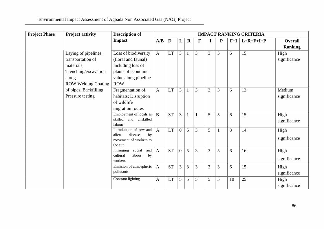
Environmental Impact Assessment of Agbada Non Associated Gas (NAG) Project
86
Project Phase Project activity Description of
Impact
IMPACT RANKING CRITERIA
A/B D L R F I P F+I L+R+F+I+P Overall
Ranking
Laying of pipelines,
transportation of
materials,
Trenching/excavation
along
ROW,Welding,Coating
of pipes, Backfilling,
Pressure testing
Loss of biodiversity
(floral and faunal)
including loss of
plants of economic
value along pipeline
ROW
A LT 3 1 3 3 5 6 15 High
significance
Fragmentation of
habitats; Disruption
of wildlife
migration routes
A LT 3 1 3 3 3 6 13 Medium
significance
Employment of locals as
skilled and unskilled
labour
B ST 3 1 1 5 5 6 15 High
significance
Introduction of new and
alien disease by
movement of workers to
the site
A LT 0 5 3 5 1 8 14 High
significance
Infringing social and
cultural taboos by
workers
A ST 0 5 3 3 5 6 16 High
significance
Emission of atmospheric
pollutants
A
ST 3 3 3 3 3 6 15 High
significance
Constant lighting A LT 5 5 5 5 5 10 25 High
significance

Environmental Impact Assessment of Agbada Non Associated Gas (NAG) Project
87
Project Phase Project activity Description of
Impact
IMPACT RANKING CRITERIA
A/B D L R F I P F+I L+R+F+I+P Overall
Ranking
Igniting by welding
flames, red-hot metals
or flying sparks causing
fires/explosion and
injury/loss of lives
A
LT
0
5
1
5
1
6
12
Medium
significance
Possible pollution of
ground water due to
drilling activities
A ST 3 5 1 3 3 4 15 High
Significance
Localized increase in
baseline concentration
of physicochemical
parameters of the
environment from
routine discharge of
spent mud, drill
cuttings/mud, chemicals,
sewage etc
A ST 3 1 3 3 3 6 13 Medium
Significance
Increase in noise levels A ST 3 3 3 3 3 6 15 High
significance
Invasion of ROW by
exotic species
A LT 0 3 1 3 5 4 12 Medium
Significance
Alteration of natural
drainage patterns A LT 3 3 3 3 3 6 15 High
significance
Soil erosion and run off
from pipeline ROW A LT 3 5 3 5 3 8 19 High
significance

Environmental Impact Assessment of Agbada Non Associated Gas (NAG) Project
88
Project Phase Project activity Description of
Impact
IMPACT RANKING CRITERIA
A/B D L R F I P F+I L+R+F+I+P Overall
Ranking
Obstruction of traffic by
construction equipment
at road crossing
A LT 0 1 1 3 3 4 8 Low
significance
Personnel injury from
welding burns A MT 3 1 3 3 1 6 11 Medium
significance
Personnel injury/death
resulting from
malfunction and mal-
operation
excavator/cranes
A LT 0 5 3 5 3 8 16 High
significance
Possible Kidnap of
construction workers A LT 0 5 3 5 3 8 16 High
significance
Operations Phase Noise from the use of
operation engines and
motors
A LT 3 1 5 1 3 6 13 Medium
significance
Water/Soil pollution,
resulting from disposal
of pigging waste
A LT 3 5 3 5 3 8 19 High
significance
Employment of locals
and subsequent
stimulation of local and
national economy
B LT 0 5 5 5 5 10 20 High
significance
Community
development
programmes
B LT 0 5 5 5 5 10 20 High
significance
Atmospheric pollution
from gas leaks
A ST 3 5 1 5 3 6 17 High
significance

Environmental Impact Assessment of Agbada Non Associated Gas (NAG) Project
89
Project Phase Project activity Description of
Impact
IMPACT RANKING CRITERIA
A/B D L R F I P F+I L+R+F+I+P Overall
Ranking
Continuous lighting A LT 5 5 5 5 5 10 25 High
significance
Possible Kidnap of
construction workers A LT 0 5 3 5 3 8 16 High
significance
Outbreak of fire due to
equipment failure or
sabotage
A ST 0 5 1 5 3 6 14 Medium
Significance
Decommissioning
and Abandonment
Phase
Decommissioning and
Abandonment
Destruction of the
ecosystem of the area
A LT 3 3 1 5 3 6 15 High
significance
Injuries from abandoned
heavy metals/ buried
pipes in the environment
A LT 3 3 3 5 5 8 19 High
significance
Pollution /
contamination of the
affected environment
A LT 3 5 3 5 3 8 19 High
significance
Hydrocarbon leak from
the abandoned wellhead
and pipelines
A LT 3 5 3 5 3 8 19 High
significance
Availability of land for
alternative use by locals
B LT 3 0 3 5 5 8 16 High
significance
Abandoned wells as
potential hazards to
humans and animals in
the area
A LT 3 3 3 5 3 8 17 High
significance

Environmental Impact Assessment of Agbada Non Associated Gas (NAG) Project
90
CHAPTER SIX
MITIGATION MEASURES
6.1: General
This chapter presents the measures and alternatives developed to mitigate the significant
negative impacts of all phases of the proposed Agbada Field Development Project (FDP).
Equally stated here are details of the control technology and compliance with health and
safety hazards requirements including a table showing potential impacts of the proposed
project with proffered mitigation measures. Mitigation measures for the identified potential
and associated impacts of the project were proffered in order to minimize the impacts of the
proposed Project on the environmental components of the project area. Enhancement,
Reduction, Avoidance and Compensation were some of the approaches employed for
mitigation measures.
6.2: Process Monitoring and Control Technology
The process control and shut down systems shall be made safe with minimum operator
intervention. This shall be considered as a key part of mitigation measures for the proposed
project. All other equipment/installations shall also be according to specifications in line with
SPDC policies and standards. In accordance to regulations (Mineral Oil Safety Regulations of
1995), emergency shutdown system checks shall be done at six-monthly interval to ensure
integrity while wellhead checks shall be done weekly.
6.3: Equipment Selection
A major determinant for rig selection is SPDC’s drive to reduce impact on the environment.
A land drilling rig that meets the minimum requirements (as specified in chapter three) shall
be used for this project to reduce potential impacts to as low as reasonably practicable
(ALARP). New flow lines shall be designed to withstand maximum closed-in tubing head
pressure (CITHP) attainable in the network, according to the standard flow line design
philosophy. This shall be done along existing right of way in order not to further impact on
the environment.
6.4: Safeguarding Systems
In high-risk areas like transfer pumps, generators etc, fire detection systems shall be provided
in line with the company policy. In addition, fire hydrants and portable fire extinguishers
shall be placed at strategic locations to fight small developing fires. In the occurrence of an
uncontrollable fire outbreak, personnel shall be evacuated according to laid down evacuation
procedures. The two levels of shut down systems namely Emergency shutdown system and
Operational shutdown system shall be maintained in the facility.
6.5: Instrumentation
Instrumentation will be designed for remote status monitoring, calibration and configuration.
Reliability of the instruments will allow for no failure maintenance.

Environmental Impact Assessment of Agbada Non Associated Gas (NAG) Project
91
6.6: Impact Mitigation Measures
The proffered mitigation measures for the identified impacts are presented in Table 7.1.
These measures are predictable to eliminate or reduce to the barest minimum the potential
and associated impacts of the proposed project.

Environmental Impact Assessment of Agbada Non Associated Gas (NAG) Project
92
Table 6.1 Impacts and Mitigation
Project Phase Project Activities
Description of Impacts Proffered Mitigation Measures
Pre-mobilization
Land acquisitions and
settlement of claims
Community agitation over
compensations, land disputes,
wrong landowner identification,
leadership tussles
SPDC shall ensure
Identification of all legacy issues and applicable
stakeholders
Adequate consultations are carried out for Stakeholder
(Communities, Govt., NGOs, CBOs, land owners, etc.)
Compensations/rent for land is paid to identified
owners as agreed.
Mobilization
Transport of personnel and
equipment to site
Workplace accidents/incidents
during loading and offloading of
materials/equipment
SPDC shall ensure
Use of competent personnel, trained in basic HSE
awareness
Safety briefings/inductions are carried out daily before
work commences
Use of adequate PPE

Environmental Impact Assessment of Agbada Non Associated Gas (NAG) Project
93
Project Phase Project Activities
Description of Impacts Proffered Mitigation Measures
Traffic jam on local roads as a
result of movement of heavy
truck. Risk of road traffic
accidents causing injury/death of
personnel and/or loss of assets
SPDC shall ensure:
Maintenance of vehicles at optimal operating condition
to avoid break down and obstruction of roads.
Application of effective journey management
All vehicles are pre-mobilized
Compliance with visible warning signs on roads and
vehicle
Defensive driving course for SPDC and contractor
drivers
Enforcement of vehicle monitoring device/SPDC
journey management policy/night driving/alcohol
policy
First aid training for work force is conducted and
provision of first aid boxes in operational vehicles
Mobilization
…contd
Transport of personnel and
equipment to site
…contd
Noise/Vibration from trucks
SPDC shall ensure that:
Periodic maintenance of Vehicles are carried out to
retain noise levels within acceptable limits
Noise is reduced by restricting movement to daytime.
Pollution due to spillage/leakage
of fuel or lube oil on land during
transportation
SPDC shall ensure that vehicles are regularly maintained and
checked for leaks
Mobilization
…contd
Transport of personnel and
equipment to site
Emission of atmospheric
pollutants from exhaust
SPDC shall ensure the use of vehicles with pre-mobilization
certificates only.

Environmental Impact Assessment of Agbada Non Associated Gas (NAG) Project
94
Project Phase Project Activities
Description of Impacts Proffered Mitigation Measures
…contd
Movement of large number of
persons to the area
SPDC shall ensure that:
All logistics arrangements are put in place to avoid
prolonged journey time.
Host communities are employed
Reduction in aesthetic and
recreational value of drilling site.
SPDC shall ensure new infrastructural facilities are
provided and maintenance of the existing ones in the area.
Excavation and other activities that may result in the
alteration of the landscape and condition of the land cover
shall be closely monitored and if possible avoided
Creation of employment
opportunities
SPDC shall ensure that:
At least 60% of the workforce are employed from the host
communities
Prompt communication of employment policy are made to
host communities during meetings
Compliance with MoU signed with communities as regards
labour engagement
Socio-cultural conflicts between
the workers and members of host
communities
SPDC shall ensure that:
Adequate consultation with community leaders are carried
out and maintained
Cordial and good working relationship are established with
the local communities
Liaison with host community leaders at inception to
educate workers on the cultural norms of the area is done

Environmental Impact Assessment of Agbada Non Associated Gas (NAG) Project
95
Project Phase Project Activities
Description of Impacts Proffered Mitigation Measures
Incidence of STDs, marriage
breakages, abortions, theft etc.
SPDC shall ensure:
all personnel are screened for communicable diseases
before mobilization and equally maintain regular medical
check for all staff
health and safety awareness course for all personnel is
conducted
social awareness campaign for workers and members of
host communities are carried out as well as encouraging
abstinence/safe sex
Site
Preparation/constr-
uction and Drilling
Phase
Vegetation Clearing;
removal of topsoil;
Construction of generator
platform, ancillary
facilities such as perimeter
drains and oil traps and
rehabilitation of campsite
Recruitment of Local labour/
generation of economic activities
SPDC shall ensure the employment of locals
Alteration of land use pattern
and loss of arable lands
SPDC shall ensure that vegetation clearing activities are
reduced to the barest minimum required.
Site
Preparation/constru
ction and Drilling
Phase
Vegetation Clearing;
removal of topsoil;
Construction of generator
platform, ancillary
facilities such as perimeter
Loss of biodiversity (floral and
faunal) including loss of plants
of economic value along pipeline
ROW
SPDC shall ensure that re-vegetation of cleared areas that are
not required during operation are carried out.

Environmental Impact Assessment of Agbada Non Associated Gas (NAG) Project
96
Project Phase Project Activities
Description of Impacts Proffered Mitigation Measures
…contd drains and oil traps and
rehabilitation of campsite
…contd
Fragmentation of habitats;
disruption of wildlife migration
routes
SPDC shall ensure the utilization of the existing ROWs to
avoid habitat disturbances and losses of ecological species.
Threat to health of workers e.g.
snake bites, insect stings.
Injuries etc.
SPDC shall ensure
HSE briefings and awareness talk on potential for contact
with wildlife are carried out daily before work
commencement
Availability of fully equipped first aid boxes on site at all
times as well as a functional site clinic
Availability of trained First aiders
Appropriate use of PPEs is enforced
Provision of Anti-venom is on site to ease snakebites and
insect stings.
Communication of MEDEVAC procedures to personnel
Introduction and spread of
diseases by movement of
workers to the site
SPDC shall ensure that:
all personnel are screened for communicable diseases
before mobilization and regular medical check for all staff
is maintained
a health and safety awareness course for all personnel is
carried out
social awareness campaign for workers is conducted
encourage abstinence/safe sex

Environmental Impact Assessment of Agbada Non Associated Gas (NAG) Project
97
Project Phase Project Activities
Description of Impacts Proffered Mitigation Measures
Infringing social and cultural
taboos by workers
SPDC shall ensure that:
all personnel are briefed with acceptable social behaviours
and taboos of the host community.
Constant lighting
SPDC shall ensure
the communities are informed before time of the
activities that are likely to increase periods of lighting
worksites are not close to human settlement. Half a
kilometer away would be ideal
Site
Preparation/constru
ction and Drilling
Phase
…contd
Vegetation Clearing;
removal of topsoil;
Construction of generator
platform, ancillary
facilities such as perimeter
drains and oil traps and
rehabilitation of campsite
…contd
Igniting by welding flames, red-
hot metals or flying sparks
causing fires/explosion and
injury/loss of lives
SPDC shall ensure
HSE briefings are conducted daily prior to work
commencement
Strategic positioning of fire fighting equipment,
manned by trained personnel.
Possible pollution of ground
water due to drilling activities
SPDC shall ensure
Ground water monitoring practice will be sustained

Environmental Impact Assessment of Agbada Non Associated Gas (NAG) Project
98
Project Phase Project Activities
Description of Impacts Proffered Mitigation Measures
Localized increase in baseline
concentration of
physicochemical parameters of
the environment from routine
discharge of spent mud, drill
cuttings/mud chemicals, sewage
etc
SPDC shall ensure
Supervision of all activities and put in place all
logistics arrangement that will guarantee least adverse
interference with the environment that will warrant
localized increase in baseline concentration of
physicochemical parameters.
Installation of waste water detention pond and waste
water treatment systems in order to dilute effluent from
these activities before discharging it to surface drainage
system
Increase in noise levels
SPDC shall ensure
the communities are informed in advance of likely
increase in noise level during trenching
exposure to high noise equipment is restricted to the
recommended 8-hour a day limit (90dbA)
Strict enforcement of use of earmuffs for all employees
using high noise equipment/ machinery in high noise
zones.
Prohibition of night operations
Construction of Sound proof walls around stationary
power generating walls

Environmental Impact Assessment of Agbada Non Associated Gas (NAG) Project
99
Project Phase Project Activities
Description of Impacts Proffered Mitigation Measures
Alteration of natural drainage
patterns
SPDC shall ensure
Utilization of existing access road to avoid more
environmental destruction.
Maintenance of existing facility access road and
construction of culverts where necessary to ensure
flood control.
Soil erosion off from pipeline
ROW
SPDC shall ensure drainage systems are opened up around the
project areas for flood control
Obstruction of traffic by
construction equipment at road
crossing
SPDC shall ensure
Placement of caution signs at appropriate locations
Engagement and use of traffic control wardens
Personnel injury from welding
burns
SPDC shall ensure
Provision and enforcement of the use of PPE for all
workers
Only competent and certified welders/
personnel are used
Personnel injury/death resulting
from malfunction and mal-
operation excavator/cranes
SPDC shall ensure
Proper maintenance and adequate calibration of
equipment before usage
Equipment operation shall be by competent personnel
with years of experience in excavator/crane safety.

Environmental Impact Assessment of Agbada Non Associated Gas (NAG) Project
100
Project Phase Project Activities
Description of Impacts Proffered Mitigation Measures
Possible kidnap of construction
workers
SPDC shall ensure that:
Strict enforcement of security procedures and
continuous improvement based on updated risk
information;
An ongoing cordial relationship with the stakeholder
communities is maintained.
Operations &
Maintenance
Material transport
Noise from the use of operation
engines and motors
SPDC shall
ensure exposure to high noise equipment is restricted to
the recommended 8-hour a day limit
use of earmuffs in high noise zones and for all
employees using high noise equipment/ machinery is
enforced.
Disturbance/ interference with
transportation system and
general way of life of locals
SPDC shall
ensure that movement of personnel and materials is not
carried out during peak traffic periods.
Enlighten its workers to respect the traditions and beliefs of
locals and avoid interactions where possible.
Employ a good number of youths from the hos
communities.
Possible kidnap of workers
SPDC shall:
Ensure strict enforcement of security procedures and
continuous improvement based on updated risk
information
Sustain ongoing cordial relationship with the host
communities

Environmental Impact Assessment of Agbada Non Associated Gas (NAG) Project
101
Project Phase Project Activities
Description of Impacts Proffered Mitigation Measures
Outbreak of fire due to
equipment failure or sabotage
SPDC shall ensure
Strategic placement of alarms/extinguishers within all
operational facilities.
Suitable maintenance and calibration of equipment
before usage
Competent personnel operate equipment
HSE training and job hazard analysis shall be carried
out to ascertain that all staff observes safety rules at
work places.
Decommissioning
and Abandonment
Phase
Decommissioning and
Abandonment
Destruction of the ecosystem of
the area
SPDC shall
Embark on effective remediation and restoration of the
environment
that native species are employed in restoration
activities
Injuries from abandoned heavy
metals/ buried pipes in the
environment
SPDC shall ensure
Provision and enforcement of the use of PPE for all
workers
Only competent and certified welders/
adequate calibration of equipment before usage
Equipment operation shall be by competent personnel
with years of experience in excavator/crane safety.
Pollution / contamination of the
affected environment
SPDC shall ensure
Ground water monitoring practice will besustained
Supervision of all activities and put in place all
logistics arrangement that will guarantee least adverse
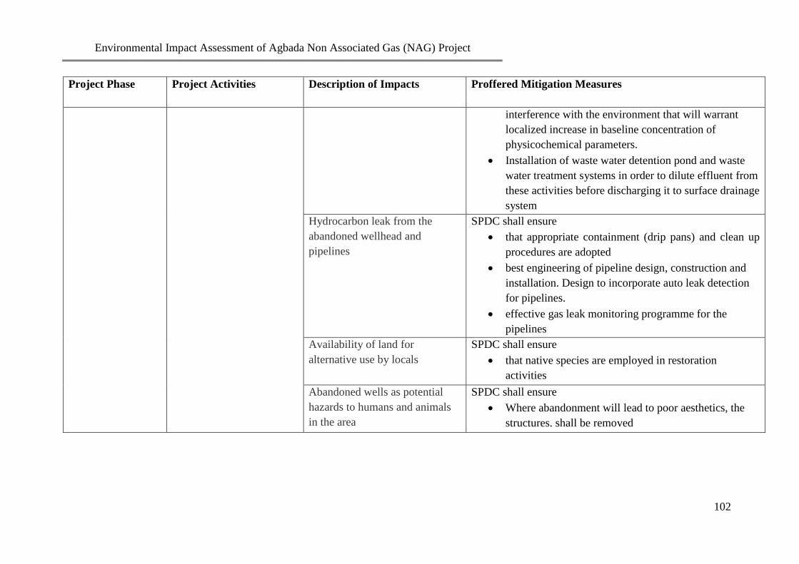
Environmental Impact Assessment of Agbada Non Associated Gas (NAG) Project
102
Project Phase Project Activities
Description of Impacts Proffered Mitigation Measures
interference with the environment that will warrant
localized increase in baseline concentration of
physicochemical parameters.
Installation of waste water detention pond and waste
water treatment systems in order to dilute effluent from
these activities before discharging it to surface drainage
system
Hydrocarbon leak from the
abandoned wellhead and
pipelines
SPDC shall ensure
that appropriate containment (drip pans) and clean up
procedures are adopted
best engineering of pipeline design, construction and
installation. Design to incorporate auto leak detection
for pipelines.
effective gas leak monitoring programme for the
pipelines
Availability of land for
alternative use by locals
SPDC shall ensure
that native species are employed in restoration
activities
Abandoned wells as potential
hazards to humans and animals
in the area
SPDC shall ensure
Where abandonment will lead to poor aesthetics, the
structures. shall be removed

Environmental Impact Assessment of Agbada Non Associated Gas (NAG) Project
103
CHAPTER SEVEN
ENVIRONMENTAL MANGEMENT PLAN
7.1: General
The World Bank (1999) defines Environmental Management Plan (EMP) as the set of
mitigation, monitoring and institutionalized measures that must be ensured during the
implementation and operation of a project to eliminate adverse environmental and social
impacts or at least reduce them to acceptable levels.
The EMP outlines strategies and procedures for ensuring that mitigation measures prescribed
in an EIA are implemented at all phases of the project development. In addition to this
function, the EMP may also be used to ensure compliance with statutory requirements,
corporate safety and environmental policies. In line with SPDC HSE policy of best
environmental practice, the EMP of the Agbada Field Development Project has been
designed to comply with regulatory specifications.
7.2: The Objectives of EMP
The objectives are to:
Demonstrate that a systematic procedure ensuring that all project activities are
executed in compliance with applicable legislations and SPDC policies on Health,
Safety, Environment, Security and Community Relations have been established for
the project.
Show that mitigation measures for all impacts and effects have been established and
should be maintained throughout the project’s life cycle, so that impact risk level will
remain ALARP
Demonstrate that emergency response measures will be in place. This will ensure that
adequate responses in case of emergency have been established for the project; and
Present an effective monitoring plan that shall be used for assuring the effectiveness
of mitigation measures proffered and for identifying unforeseen impacts arising
during project implementation.
7.3: Management Organization
SPDC shall ensure that environmental commitments are not ignored during the life cycle of
the project. It shall put in place a responsibility and training schedule on environmental
matters. Issues on the environment shall be a line responsibility where all personnel are
accountable at all levels. Top management shall be saddled with ensuring that all
environmental considerations are incorporated into the project implementation.
An Environmental Monitoring Team (EMT) shall be appointed for effective execution of the
EIA and its management plan. The team shall comprise project team representatives, HSE
and Security departments. The EMT shall communicate with contractors, engineers, quality
assurance officers, supervisors and relevant departments on environmental issues at a
specified period. The team shall be a focal point for all environmental issues as regards

Environmental Impact Assessment of Agbada Non Associated Gas (NAG) Project
104
detailed design and monitoring of construction, drilling, workover and completion of wells,
laying of flow and pipeline networks, operation, decommissioning, restoration of sites and
abandonment of the project.
7.4: Implementation of Mitigation Measures
The mitigation measures for impacts presented in chapter five of this report have been drafted
into an EMP. It specifies detailed action plan with roles and responsibility for their
implementation. EMT shall ensure that all the mitigation measures proposed to cater for the
significant negative impacts as well as enhancement measures for positive impacts are
implemented.
7.5: Transport operations
SPDC shall manage all transportation operations in line with the following guidelines in
order to avert accidents/incidents.
Pre-mobilization of Vehicles:
Pre-mobilization shall be conducted for all vehicles which shall used for transportation of
equipment, materials and personnel shall be pre-mobilized. This shall be done to ascertain
that the vehicles are okay for the operations. The exercise shall equally ensure that the drivers
and their assistants have the necessary proficiencies which the job requires. Pre-mobilization
exercise is equally an avenue to establish that a job hazard analysis (JHA) for the project has
been carried out as well as adoption of all recommended mitigation measures.
Journey Management Plan:
The contractor shall collaborate with the HSE and Security team leaders of SPDC to manage
the day to day transportation needs in conformity with SPDC’s standards. Journey
management shall include the following:
Planning takes place before traveling
Distances traveled are minimized
Unnecessary journeys are avoided
Right vehicle and right driver for the job are selected
The safest times and routes are selected
No night driving unless absolutely necessary and waiver obtained.
7.6: Prevention of Accidents/incidents:
Developed Job Hazard Analysis (JHA) and written work instructions (WIs) shall be
implemented in order to prevent workplace accidents and incidents during the proposed
project. The HSE and Security team leaders have the responsibility of ensuring that JHA for
all HSE critical activities is carried out. Written and explicit work instructions from such
activities shall be developed.
Observance of standards, operations/maintenance codes and specifications as required by law

Environmental Impact Assessment of Agbada Non Associated Gas (NAG) Project
105
as well as SPDC HSE guidelines shall form the bedrock for the implementation of the
proposed project. Nonetheless, emergency situations could still occur as a result of equipment
failure, weather, negligence and/or sabotage. An emergency plan shall be in operation so as
to support other containment systems set to cater for such occurrences. As a minimum, the
contingency plans that shall apply to both SPDC and contractors shall address the following
emergency situations.
Fires and explosions
Serious injury or illness
Spills and blow outs
Weather related disasters
Vehicle mishaps
The HSE and Security team leaders shall ensure that sufficient security arrangement for the
project is provided for and that host communities are carried along in the plans.
7.7: Training and Awareness:
The project management shall establish, maintain and operate a training and awareness
programme on health, safety and environmental issues in order to determine proficiency and
consciousness amongst SPDC personnel and Contractor staff. Additional attention shall be
given to the locals in the contractors’ teams. Accident emergency practices, basic first aid,
and the use of personal protective equipment and so on shall make up the components of the
training. Environmental induction course and subsequent refresher course concerning the
work shall be organized. Periodic review of the training and awareness programme shall be
conducted by top management and shall embrace but not limited to the following aspects:
HSE induction course
Emergency response drill
Community interaction and relations management
Basic first aid for first aiders
Defensive driving
Permit to work system
Fire fighting
HSE on site
Successful participants shall receive certificates of attendance. SPDC shall equally carry out
HSE awareness campaign for the host communities and the general public with the intention
of notifying them of the potential impacts and hazards associated with its operations as well
as the proper response to accidents/incidents. There shall be public awareness campaigns
performed from time to time and the actions documented for audit.

Environmental Impact Assessment of Agbada Non Associated Gas (NAG) Project
106
7.8: Maintenance Programme
The maintenance officer for the project shall put a comprehensive maintenance programme
for all equipment and machines in place. The schedule for the maintenance shall be planned
to comply with the manufacturer’s specification for each of the equipment. A maintenance
logbook which shall be regularly audited by HSE and security team leaders shall be in
operation. The state of maintenance of the equipment and machines (last and next service
dates) shall be proper and clearly displayed at visible points on each equipment and machine.
7.9: Construction guidelines
Site Preparation/Clearance
Site preparation/clearance works shall be carried out within defined borders and only when
necessary. To make for safe operations, the acceptable time lapse between site clearing and
commencement of construction operations shall be shortened as much as possible. Excess
cleared areas shall be restored with indigenous topsoil and vegetation.
Use of public rights of way
Transportation, construction and drilling works shall be executed in such a manner that will
minimize traffic disruption. Nonetheless, blockage of public highways or roads can be done if
safety in operations demands that it be done. Before this action is approved and carried out,
SPDC Agbada Field development project manager would have arranged for temporary traffic
control and diversion. Dumping or storage of litter/debris, tools and equipment in public or
private highways and roads shall not be allowed. Contractors shall come up with plans on
how roads shall be cleared to ensure that roads are kept clear, safe and passable.
Archaeological/Heritage sites
Contractors and SPDC personnel working at the sites shall preserve the Preservation of the
cultural heritage of the host communities shall be the responsibility of Contractors and SPDC
personnel working at the sites. All known existing sites of heritage or cultural value shall be
isolated and avoided. If the need arises that any such site be moved, SPDC shall consult with
the affected community before relocation.
Health and safety of workers
Hazard and effects management process (HEMP) shall be developed and applied throughout
the project development. This shall consist of IACR approach of identifying, assessing and
controlling hazards and putting in place measures to recover from the consequences of
hazards if the controls fail. Operations at all work sites shall be subject to government,
industry and SPDC HSE policies and guidelines. All facilities shall equally be designed to
enhance safety planning and activities shall be executed within the confines of relevant
legislation and stakeholders’ interest.
For effective management of project activities, careful planning along with application of
relevant HSE policies shall be included. The relevant HSE policies shall include the
following:
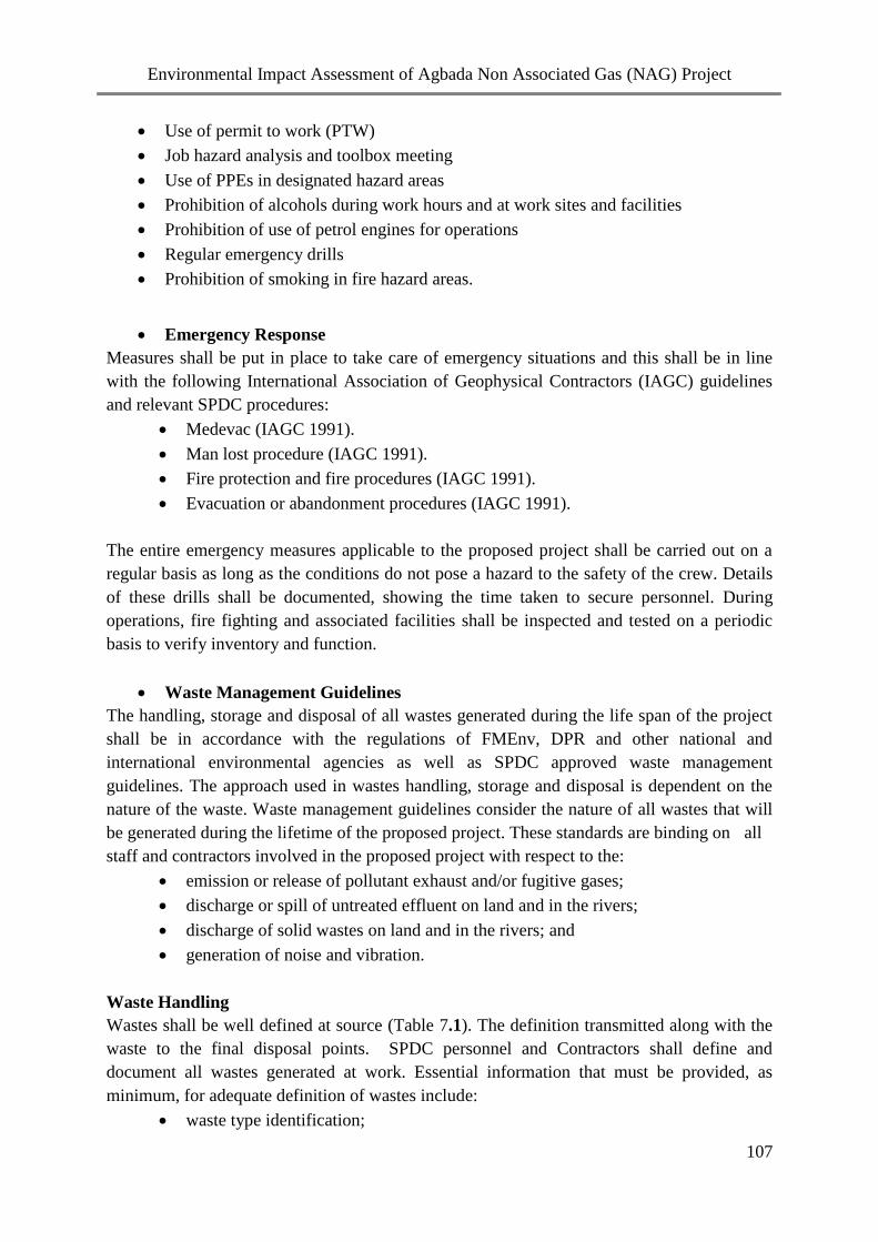
Environmental Impact Assessment of Agbada Non Associated Gas (NAG) Project
107
Use of permit to work (PTW)
Job hazard analysis and toolbox meeting
Use of PPEs in designated hazard areas
Prohibition of alcohols during work hours and at work sites and facilities
Prohibition of use of petrol engines for operations
Regular emergency drills
Prohibition of smoking in fire hazard areas.
Emergency Response
Measures shall be put in place to take care of emergency situations and this shall be in line
with the following International Association of Geophysical Contractors (IAGC) guidelines
and relevant SPDC procedures:
Medevac (IAGC 1991).
Man lost procedure (IAGC 1991).
Fire protection and fire procedures (IAGC 1991).
Evacuation or abandonment procedures (IAGC 1991).
The entire emergency measures applicable to the proposed project shall be carried out on a
regular basis as long as the conditions do not pose a hazard to the safety of the crew. Details
of these drills shall be documented, showing the time taken to secure personnel. During
operations, fire fighting and associated facilities shall be inspected and tested on a periodic
basis to verify inventory and function.
Waste Management Guidelines
The handling, storage and disposal of all wastes generated during the life span of the project
shall be in accordance with the regulations of FMEnv, DPR and other national and
international environmental agencies as well as SPDC approved waste management
guidelines. The approach used in wastes handling, storage and disposal is dependent on the
nature of the waste. Waste management guidelines consider the nature of all wastes that will
be generated during the lifetime of the proposed project. These standards are binding on all
staff and contractors involved in the proposed project with respect to the:
emission or release of pollutant exhaust and/or fugitive gases;
discharge or spill of untreated effluent on land and in the rivers;
discharge of solid wastes on land and in the rivers; and
generation of noise and vibration.
Waste Handling
Wastes shall be well defined at source (Table 7.1). The definition transmitted along with the
waste to the final disposal points. SPDC personnel and Contractors shall define and
document all wastes generated at work. Essential information that must be provided, as
minimum, for adequate definition of wastes include:
waste type identification;

Environmental Impact Assessment of Agbada Non Associated Gas (NAG) Project
108
proper waste categorization;
waste segregation information; and
recommended management practices.
Waste Minimization
Waste minimization entails reduction to the greatest extent possible of the volume or toxicity
of waste materials. The four principles of waste minimization process; recycle, reduce, reuse
and recover, shall be adopted as applicable. Opportunities to achieve significant waste
reduction during this proposed project are functions of activity level, age, depreciation and
maintenance level of facilities and operating equipment. As much as possible, excavated
materials shall be used for landscaping or other remedial works. In addition, all drill mud,
oils, hydraulic fluids, oily sump water, etc. shall be treated before disposal.
Waste Segregation
For useful implementation of suitable waste disposal methods, wastes shall be segregated at
source into clearly designated bins positioned at strategic locations to be defined in the
field.
Waste Disposal Protocol
All wastes shall be cleared regularly from the site and disposed off at SPDC or Government
designated areas and facilities. Instructions on material safety data sheet (MSDS) shall be
strictly adhered to and shall form the basis for the disposal of wastes related to such products.
Wastes in transit shall be accompanied and tracked by consignment notes. The consignment
shall contain the following information as a minimum:
date of dispatch;
description of waste;
waste quantity/container type;
consignee name and means of transportation; and
confirmation of actual disposal (time and date).
Table 7.1: Expected types of Waste Streams from the FDP Project
S/No Waste Types Classification Management Options/Methods
1. Domestic wastes Non-hazardous Move to Government.-approved dump sites at
East-West road, location road in Mgbuoba,
Elekohia, Abuloma and Wimpy for disposal
Hazardous Move to re-cycling depot at Shell I.A in Port
Harcourt
2 Sanitary waste Grey water Well-engineered soak-away system at the
NAG plant location
Black water Well-engineered soak-away system at the
NAG plant location
3. Drill cuttings Top hole
cuttings
Wash and subject to land farming
Synthetic mud Transport the Thermal Desorption Unit at
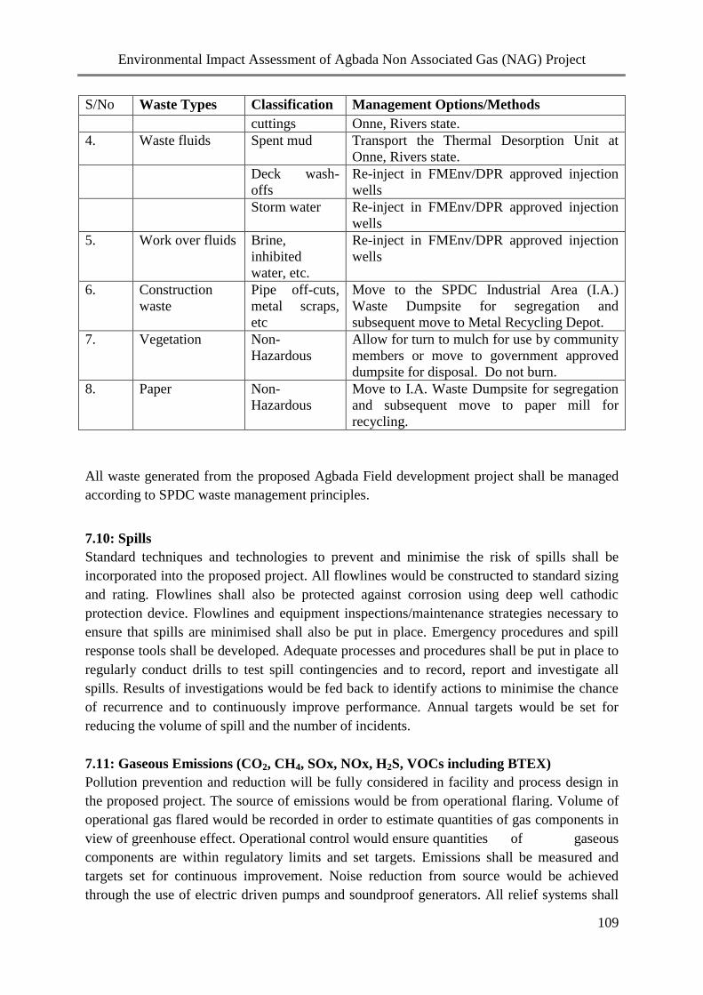
Environmental Impact Assessment of Agbada Non Associated Gas (NAG) Project
109
S/No Waste Types Classification Management Options/Methods
cuttings Onne, Rivers state.
4. Waste fluids Spent mud Transport the Thermal Desorption Unit at
Onne, Rivers state.
Deck wash-
offs
Re-inject in FMEnv/DPR approved injection
wells
Storm water Re-inject in FMEnv/DPR approved injection
wells
5. Work over fluids Brine,
inhibited
water, etc.
Re-inject in FMEnv/DPR approved injection
wells
6. Construction
waste
Pipe off-cuts,
metal scraps,
etc
Move to the SPDC Industrial Area (I.A.)
Waste Dumpsite for segregation and
subsequent move to Metal Recycling Depot.
7. Vegetation Non-
Hazardous
Allow for turn to mulch for use by community
members or move to government approved
dumpsite for disposal. Do not burn.
8. Paper Non-
Hazardous
Move to I.A. Waste Dumpsite for segregation
and subsequent move to paper mill for
recycling.
All waste generated from the proposed Agbada Field development project shall be managed
according to SPDC waste management principles.
7.10: Spills
Standard techniques and technologies to prevent and minimise the risk of spills shall be
incorporated into the proposed project. All flowlines would be constructed to standard sizing
and rating. Flowlines shall also be protected against corrosion using deep well cathodic
protection device. Flowlines and equipment inspections/maintenance strategies necessary to
ensure that spills are minimised shall also be put in place. Emergency procedures and spill
response tools shall be developed. Adequate processes and procedures shall be put in place to
regularly conduct drills to test spill contingencies and to record, report and investigate all
spills. Results of investigations would be fed back to identify actions to minimise the chance
of recurrence and to continuously improve performance. Annual targets would be set for
reducing the volume of spill and the number of incidents.
7.11: Gaseous Emissions (CO2, CH4, SOx, NOx, H2S, VOCs including BTEX)
Pollution prevention and reduction will be fully considered in facility and process design in
the proposed project. The source of emissions would be from operational flaring. Volume of
operational gas flared would be recorded in order to estimate quantities of gas components in
view of greenhouse effect. Operational control would ensure quantities of gaseous
components are within regulatory limits and set targets. Emissions shall be measured and
targets set for continuous improvement. Noise reduction from source would be achieved
through the use of electric driven pumps and soundproof generators. All relief systems shall

Environmental Impact Assessment of Agbada Non Associated Gas (NAG) Project
110
be designed as to be piped to the flare to eliminate venting. Gaseous emissions monitoring
would be carried out regularly and values checked against regulatory limits as we strive
towards zero flaring.
7.12: Decommissioning and Abandonment Plan
At the completion of the proposed project, SPDC shall follow regulatory standard procedures
for decommissioning. A decommissioning team shall plan and implement the guidelines for
decommissioning to ensure that the best and practicable methods available to clean up the
project site have been used. The following activities are involved in
decommissioning/abandonment:
Demolition and site clean up
Disposal of wastes; and
Final site review.
7.13: Remediation Plans After Decommissioning /Abandonment / Closure
The statutory (National) regulations cited in Chapter 1 of this report require the operator of a
field to rehabilitate the area to be relinquished to the satisfaction of the DPR/FMEnv. The
biological objective, amongst others, of any such rehabilitation programme is to ensure that
an ecologically functional system to enable satisfactory plant growth is achieved. In line with
this and company standards, SPDC shall put in place a policy to carry out a restoration
programme at the end of project’s economic life. In carrying out this programme, the
following shall be considered.
(i) Subsurface abandonment – the objective here shall be to isolate formations and
prevent fluid migration. Basically, this will involve cementing a large section of
the borehole and cutting and removal of casing below cellar depth;
(ii) Surface facilities abandonment here, all redundant surface facilities and concrete
shall be removed by SPDC. After removal, the facility shall be cleaned and
disposed off by land filling at a suitable location with regards to regulatory
guidelines. There are no established markets for scraps around here so it may not
be in SPDC’s interest to recycle the metals as scraps. The concrete slabs removed
from locations may be used as landfill materials in designated sites. Underground
pipelines shall be cleaned, filled with water and left in place, as is the practice in
the industry.
(iii) Field restoration upon completion (suspension or abandonment), all excavation
shall be filled. Beyond this, the procedures to be applied in the restoration of
cleared areas shall be the subject of a detailed integrated study.
This study shall utilize the services of ecological and hydrological specialists who will assist
in determining strategies for site restoration. The goal of the study shall be a detailed field-
specific restoration plan. The success of any restoration process is measured by the similarity

Environmental Impact Assessment of Agbada Non Associated Gas (NAG) Project
111
of the vegetation on the restored land to that of its surroundings. However, this success is a
manifestation of the reinstatement of the physical, chemical and hydrological characteristics
of the soil, bearing in mind that the single most significant factor, which will likely inhibit re-
vegetation, is compaction / cementing of soil surface. The ripping apart of the compacted /
cemented areas will be a major key to a successful restoration programme. The restoration
operations will take intensive management for a number of years to ensure success.
7.14: Environmental Audit
Environmental audit shall be conducted on the site before mobilization and during operations.
The audit process shall be used to check the predictions in the EIA as well as assess the
environmental performance during the operation phase of the project development. This will
demonstrate that environmental protection and management procedures as specified in the
EIA are implemented. Environmental audit shall be conducted on the site before mobilization
and during operations. The audit process shall be used to check the predictions in the EIA as
well as assess the environmental performance during the operation phase of the project
development. This will demonstrate that environmental protection and management
procedures as specified in the EIA are implemented.
7.15: Environmental Monitoring Plan
The objective of monitoring shall be to identify any unexpected changes to the biophysical,
health and social environment brought about by the Agbada Field Development Project.
Baseline information against which development and post development impacts and
mitigation measures can be measured and compared has been established. SPDC shall ensure
that deviations from the baseline beyond reasonable limits shall trigger corrective actions so
that monitoring becomes a dynamic activity as opposed to passive collection of data.
To ensure that the mitigation measures outlined in Chapter Six of this report are carried out as
required, a comprehensive listing of the mitigation measures that SPDC and the contractor
shall implement in the course of the proposed project, timing and monitoring programme for
ensuring full implementation of the actions are outlined in Table 7.2. The relevant regulatory
bodies (FMEnv/DPR) shall also be consulted at all phases of the implementation of the
monitoring programme. Table 7.3: shows monitoring programme for environmental
components.

Environmental Impact Assessment of Agbada Non Associated Gas (NAG) Project
112
Table 7.2: Environmental Management Plan for Implementation of Mitigation Measures
Project
Activities
Impact Rating
Before
Mitigatio
n
Description of
mitigation
Residua
l Impact
Rating
Action
Party
Timing Parameters for
monitoring
Monitoring
Frequency
Responsible
Party
Premobilization phase
Temporary land
use for base
camp or use of an
existing camp
facility
Community
agitations over
compensations,
land disputes,
wrong landowner
identification,
leadership tussles,
etc
High SPDC shall
ensure:
All relevant
stakeholders and
legacy issues are
identified
Stakeholders
(communities,
Govt., NGOs,
CBOs, land
owners, etc.) are
adequately
consulted and
relevant issues
discussed
Agreed
compensation /
rent for land are
paid to identified
owners
Low SPDC
field
developme
nt Team
and
Contractor
Pre-mobilisation and
during operations
Community / other
stakeholder
engagement reports
Quartely SPDC
Project
Manager
Mobilization phase
Transportation of
equipment,
personnel and
materials to site
Workplace
accidents /
incidents during
loading and
offloading of
materials /
equipment
Medium SPDC shall ensure:
Use competent
personnel trained
in basic HSE
awareness in all
operations
Safety briefings /
inductions are
carried out prior to
Low SPDC
Field
developme
nt Team
and
Contractor
During mobilization
/ project execution
Site HSE report
Reports of induction
meetings
PPE Issuing register
Daily /
Weekly
SPDC
Project
Manager

Environmental Impact Assessment of Agbada Non Associated Gas (NAG) Project
113
Project
Activities
Impact Rating
Before
Mitigatio
n
Description of
mitigation
Residua
l Impact
Rating
Action
Party
Timing Parameters for
monitoring
Monitoring
Frequency
Responsible
Party
commencement of
work
Adequate use of
PPE
Increased usage
of roads with
risks of accidents
leading to injury /
death of
personnel and
loss of assets
Medium SPDC shall ensure:
Effective journey
management is
implemented to
limit the amount
of traffic
Regular
maintenance /
checks of vehicles
Relevant
personnel undergo
driving training
and certification
before
mobilisation
Compliance with
Warning signs are
established where
required
Night driving is
prohibited
Adequate PPE are
used
Low SPDC
Field
developme
nt Team
and
Contractor
During mobilisation
/ project execution
Inventory of
approved journey
management forms
DEP certificates
Vehicle certification
reports
In-vehicle
monitoring system
checks / reports.
Personnel driving
certificates
Reports of all
training sessions
Daily /
Weekly /
Monthly
SPDC
Project
Manager
Nuisance (noise,
vibration etc)
from trucks, etc
Medium SPDC shall ensure:
Periodic
maintenance of
vehicles are
carried out to
maintain noise
levels within
Low SPDC
Field
developme
nt Team
and
Contractor
During mobilisation
/ project execution
Equipment
maintenance report
Camp site noise
mapping
Journey
Weekly SPDC
Project
Manager

Environmental Impact Assessment of Agbada Non Associated Gas (NAG) Project
114
Project
Activities
Impact Rating
Before
Mitigatio
n
Description of
mitigation
Residua
l Impact
Rating
Action
Party
Timing Parameters for
monitoring
Monitoring
Frequency
Responsible
Party
acceptable limits
Movement is
limited to day time
to reduce nuisance
issues
management records
Pollution -
spillage / leakage
of fuel or lube oil
onto land during
transportation
Medium SPDC shall ensure:
Vehicles are
regularly
maintained and
checked for leaks
Low SPDC
Field
developme
nt Team
and
Contractor
During mobilisation
/ acquisition
campaign
Community
engagement reports
Equipment
maintenance report
Monthly SPDC
Project
Manager
Creation of
opportunities for
employment
Beneficia
l
SPDC shall ensure
workers are advised on
judicious use of
income
Benefici
al
SPDC
Field
developme
nt Team
and
Contractor
Prior to mobilisation
and during
operations
Employment records
and community
engagement reports
Prior to
mobilisation
and during
operations
SPDC
Project
Manager
Conflicts /
community
agitations over
employment
issues
Medium SPDC shall ensure:
At least 60% of
the unskilled
workforce are
hired from the
host communities
during the project
construction phase
Prompt
communication of
employment
policy are made to
host communities
during meetings
Compliance with
MOU signed with
communities as
Low SPDC
Field
developme
nt Team
and
Contractor
Prior to mobilisation
and during project
execution
Pre-recruitment
Employment records
and community
engagement reports
Prior to
mobilisation
and during
operations
SPDC
Project
Manager
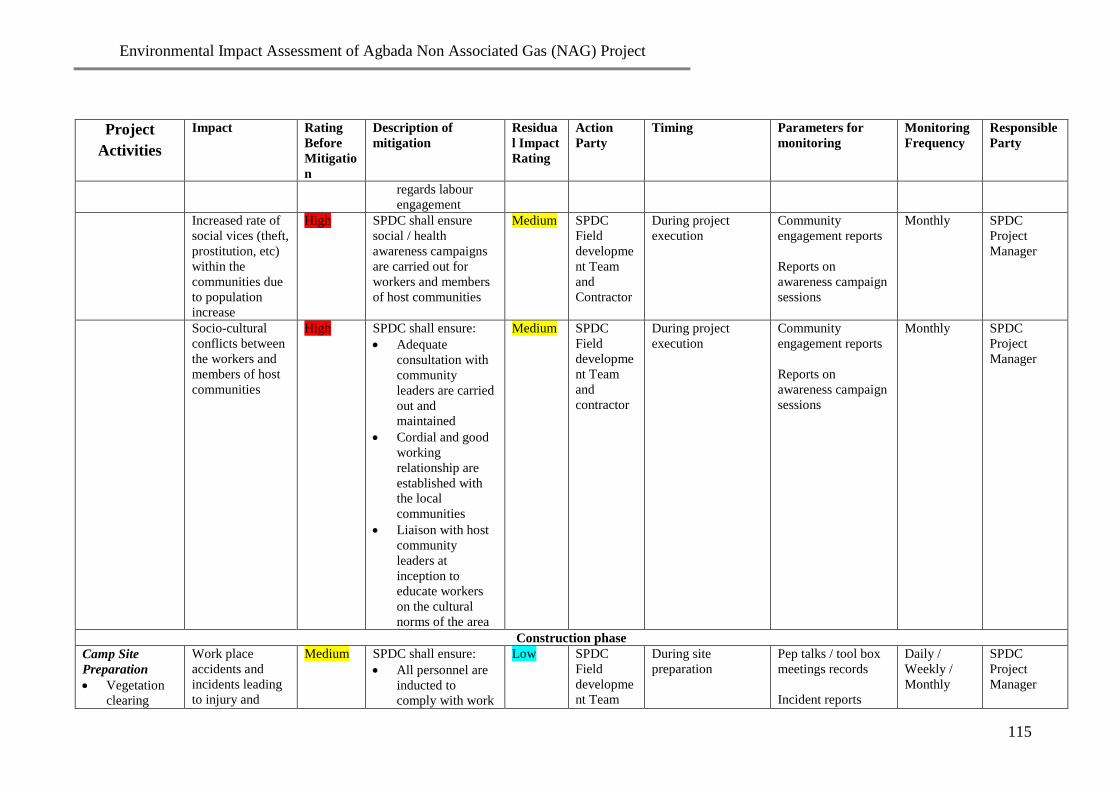
Environmental Impact Assessment of Agbada Non Associated Gas (NAG) Project
115
Project
Activities
Impact Rating
Before
Mitigatio
n
Description of
mitigation
Residua
l Impact
Rating
Action
Party
Timing Parameters for
monitoring
Monitoring
Frequency
Responsible
Party
regards labour
engagement
Increased rate of
social vices (theft,
prostitution, etc)
within the
communities due
to population
increase
High SPDC shall ensure
social / health
awareness campaigns
are carried out for
workers and members
of host communities
Medium SPDC
Field
developme
nt Team
and
Contractor
During project
execution
Community
engagement reports
Reports on
awareness campaign
sessions
Monthly SPDC
Project
Manager
Socio-cultural
conflicts between
the workers and
members of host
communities
High SPDC shall ensure:
Adequate
consultation with
community
leaders are carried
out and
maintained
Cordial and good
working
relationship are
established with
the local
communities
Liaison with host
community
leaders at
inception to
educate workers
on the cultural
norms of the area
Medium SPDC
Field
developme
nt Team
and
contractor
During project
execution
Community
engagement reports
Reports on
awareness campaign
sessions
Monthly SPDC
Project
Manager
Construction phase
Camp Site
Preparation
Vegetation
clearing
Work place
accidents and
incidents leading
to injury and
Medium SPDC shall ensure:
All personnel are
inducted to
comply with work
Low SPDC
Field
developme
nt Team
During site
preparation
Pep talks / tool box
meetings records
Incident reports
Daily /
Weekly /
Monthly
SPDC
Project
Manager

Environmental Impact Assessment of Agbada Non Associated Gas (NAG) Project
116
Project
Activities
Impact Rating
Before
Mitigatio
n
Description of
mitigation
Residua
l Impact
Rating
Action
Party
Timing Parameters for
monitoring
Monitoring
Frequency
Responsible
Party
Construction
of generator
platform,
ancillary
facilities
such as
perimeter
drains and
oil traps;
rehabilitation
of camps and
associated
facilities
death
procedures e.g.
buddy system
All personnel are
provided with
appropriate PPE
Competent first
aiders and first aid
facilities are
provided on site
MEDEVAC
procedures are
communicated to
personnel
and
Contractor
Induction report
Number of existing
old camp sites used
Camp Site
Preparation
Vegetation
clearing
Construction
of generator
platform,
ancillary
facilities
such as
perimeter
drains and
oil traps;
rehabilitation
of camps and
associated
facilities
… cont’d
Risk of wildlife
(bees, snakes,
scorpions, wasps,
etc.) attack on
personnel /
contact with
poisonous plants
leading to injury
and death
Medium SPDC shall ensure:
HSE briefings and
awareness talk on
potential for
contact with
wildlife is
conducted prior to
work.
All personnel are
inducted to
comply with work
procedures e.g.
buddy system
All personnel are
provided with
appropriate PPE
Competent
designated first
aiders and first aid
facilities are
provided on site
Low SPDC
Field
developme
nt Team
and
Contractor
During site
preparation
Pep talks / tool box
meetings records
Health records
Induction report
Number of existing
old camp sites used
Incident reports
Daily /
Weekly /
Monthly
SPDC
Project
Manager

Environmental Impact Assessment of Agbada Non Associated Gas (NAG) Project
117
Project
Activities
Impact Rating
Before
Mitigatio
n
Description of
mitigation
Residua
l Impact
Rating
Action
Party
Timing Parameters for
monitoring
Monitoring
Frequency
Responsible
Party
Emergency drills
are planned and
complied with
MEDEVAC
procedures are
communicated to
personnel
Increase in Noise
level
Medium SPDC shall ensure
that:
HSE policy of
wearing ear
muffs/plug are
enforced at all
camp sites
Site construction
are done within
the shortest
possible time
Night operations
are prohibited
Machinery with
low noise levels
shall be used
Workers with
hearing
impairment are
deployed to other
areas of activity
with reduced noise
level
Low SPDC
Field
developme
nt Team
and
Contractor
During construction Compliance
monitoring report
Site inspection
report
Pre-employment
medical report
Daily /
Weekly
SPDC
Project
Manager
Camp Site
Preparation
Vegetation
clearing
Increase in
financial flow
resulting in:
social vices, (drug
High SPDC shall ensure
that:
Awareness
campaigns are
Low SPDC
Field
developme
nt Team
During construction Community
engagement report
Health Report
Weekly /
Monthly
SPDC
Project
Manager

Environmental Impact Assessment of Agbada Non Associated Gas (NAG) Project
118
Project
Activities
Impact Rating
Before
Mitigatio
n
Description of
mitigation
Residua
l Impact
Rating
Action
Party
Timing Parameters for
monitoring
Monitoring
Frequency
Responsible
Party
Construction
of generator
platform,
ancillary
facilities
such as
perimeter
drains and
oil traps;
rehabilitation
of camps and
associated
facilities
… cont’d
abuse, exposure
to HIV/AIDS,
unwanted
pregnancies,
violence, etc),
boom and bust
phenomenon
associated with
temporary labour
contracts etc.
carried out against
HIV/AIDS, drug
and alcohol abuse
Implementation /
enforcement of the
company’s HSE
and other policies
(security, alcohol
and drug, etc) at
the site
Workers are
advised on
judicious use of
income
and
Contractor
Increased
financial flow due
to compensations
leading to
improved
standard of living
Beneficia
l
SPDC shall ensure
that:
Workers are
advised on
judicious use of
income
Adequate and
prompt payment
of compensations
as per OPTS rates
Benefici
al
SPDC
Field
developme
nt Team
and
Contractor
Prior to mobilisation Community / other
stakeholder
engagement reports
During
project
activities
SPDC
Project
Manager
Littering /
environmental
pollution from
poor handling of
wastes
Medium SPDC shall ensure
that:
Segregation of
solid wastes is
appropriately
carried out and
liquid effluents are
treated, and
analysed to meet
Low SPDC
Field
developme
nt Team
and
Contractor
Daily / Weekly /
Monthly
Equipment
maintenance log
Site inspection
report
Compliance
monitoring report
Weekly /
Monthly
SPDC
Project
Manager

Environmental Impact Assessment of Agbada Non Associated Gas (NAG) Project
119
Project
Activities
Impact Rating
Before
Mitigatio
n
Description of
mitigation
Residua
l Impact
Rating
Action
Party
Timing Parameters for
monitoring
Monitoring
Frequency
Responsible
Party
regulatory
requirements /
specifications
All solid/liquid
wastes are
disposed in
compliance with
SPDC waste
management
standards and
procedures (Govt.
/ SPDC approved
site in Port
Harcourt, etc)
Scheduled
periodic
maintenance of
equipment and
vehicles are
enforced to reduce
exhaust emissions
Waste generated /
disposal
management data
Sewage / grey water
analysis report
Camping and
accommodation
of workers
Risk of fire and
explosion from
storage of fuel for
power generating
units
Medium SPDC shall ensure
that:
“No smoking”
signs are posted
within the vicinity
of fuel storage
areas
Provision of
functional fire
extinguishers at
strategic point
around the facility
and train
Low SPDC
Field
developme
nt Team
and
Contractor
During project
execution
Site inspection
report
Site HSE report
Daily /
Weekly /
Monthly
SPDC
Project
Manager

Environmental Impact Assessment of Agbada Non Associated Gas (NAG) Project
120
Project
Activities
Impact Rating
Before
Mitigatio
n
Description of
mitigation
Residua
l Impact
Rating
Action
Party
Timing Parameters for
monitoring
Monitoring
Frequency
Responsible
Party
personnel in its
use
Activation of
emergency
response
procedure when
required
Groundwater
pollution from
discharge of
sewage / sanitary
wastes into septic
tanks / pits
Medium SPDC shall ensure
that:
Checks are carried
out to ensure
septic tank / pit
designs meet
regulatory
requirements
Groundwater
monitoring
boreholes are
drilled and
monitored at area
susceptible to
groundwater
pollution.
Proper treatment
before evacuation
/ discharge of
sewage to govt.
approved sites
Low SPDC
Field
developme
nt Team
and
Contractor
During tenure of
project
Pre-mobilisation /
site check reports
Site inspection
report/Groundwater
monitoring.
Sewage / grey water
analysis report
monthly
groundwater
monitoring.
SPDC
Project
Manager
Public nuisance /
wildlife scare
from generator
noise
Medium SPDC shall ensure
that:
generators with
low noise capacity
are used
periodic
Low SPDC
Field
developme
nt Team
and
Contractor
During tenure of
project
Camp noise
mapping report
Community
engagement report
During
tenure of
project
SPDC
Project
Manager

Environmental Impact Assessment of Agbada Non Associated Gas (NAG) Project
121
Project
Activities
Impact Rating
Before
Mitigatio
n
Description of
mitigation
Residua
l Impact
Rating
Action
Party
Timing Parameters for
monitoring
Monitoring
Frequency
Responsible
Party
maintenance of
generators are
Scheduled and
implemented
mufflers are used
to further reduce
generator noise
Personnel
complaints
Camping and
accommodation
of workers
… cont’d
Risk of attack,
hostage situation,
theft and robbery
leading to loss of
belongings and
possible injury /
death
Medium SPDC shall ensure:
Armed security
operatives are
stationed around
the camp
Use of T-card
system for access
control within the
camp
Periodic
consultations with
communities
Use of SREM
Medium SPDC
Field
developme
nt Team
and
Contractor
Mobilization and
construction.
Community
engagement report
Security report
Movement records
SREM
Daily /
Weekly /
Monthly
SPDC
Project
Manager
Increase in
financial flow due
to increased
opportunities for
supply of food
and other items
by indigenes
Beneficia
l
SPDC shall ensure
indigenous contractors
are used
Benefici
al
SPDC
Field
developme
nt Team
and
Contractor
Mobilization/
Construction
Community
engagement report
Weekly SPDC
Project
Manager
Well Drilling Localised
increase in
baseline
concentration of
physicochemical
parameters of the
environment from
High SPDC shall ensure:
Drilling waste and
other chemicals
shall be collected
and managed in
line with SPDC
waste
Medium SPDC well
operations
Team and
Contractor
During drilling Compliance
monitoring
report.
Waste
consignment
note.
Weekly /
Monthly
SPDC
Project
Manager

Environmental Impact Assessment of Agbada Non Associated Gas (NAG) Project
122
Project
Activities
Impact Rating
Before
Mitigatio
n
Description of
mitigation
Residua
l Impact
Rating
Action
Party
Timing Parameters for
monitoring
Monitoring
Frequency
Responsible
Party
discharge of spent
mud, drill
cuttings/mud,
chemicals,
sewage etc.
management plan
and regulatory
requirements and
standards.
activate her waste
management plan
Well Drilling Pollution of
surface/groundwa
ter from
chemicals, waste
materials,
including spent
mud, oily waste
water, additives,
etc
High SPDC shall ensure:
Drilling waste and
other chemicals
shall be collected
in such a manner
as to avoid surface
water
contamination.
Thereafter, the
wastes shall be
managed in line
with SPDC waste
management plan
wastes generated
are managed in
accordance with
regulatory
requirements and
standard practices.
Implementation of
ground water
monitoring
Drill cuttings and
spent mud wil be
transported to
TDU at Onne
Rivers State
Medium SPDC well
operations
Team and
Contractor
During/after drilling Site inspection
report/Groundwater
monitoring
report/and waste
consignment note.
MSDS
Daily /
Monthly
SPDC
Project
Manager
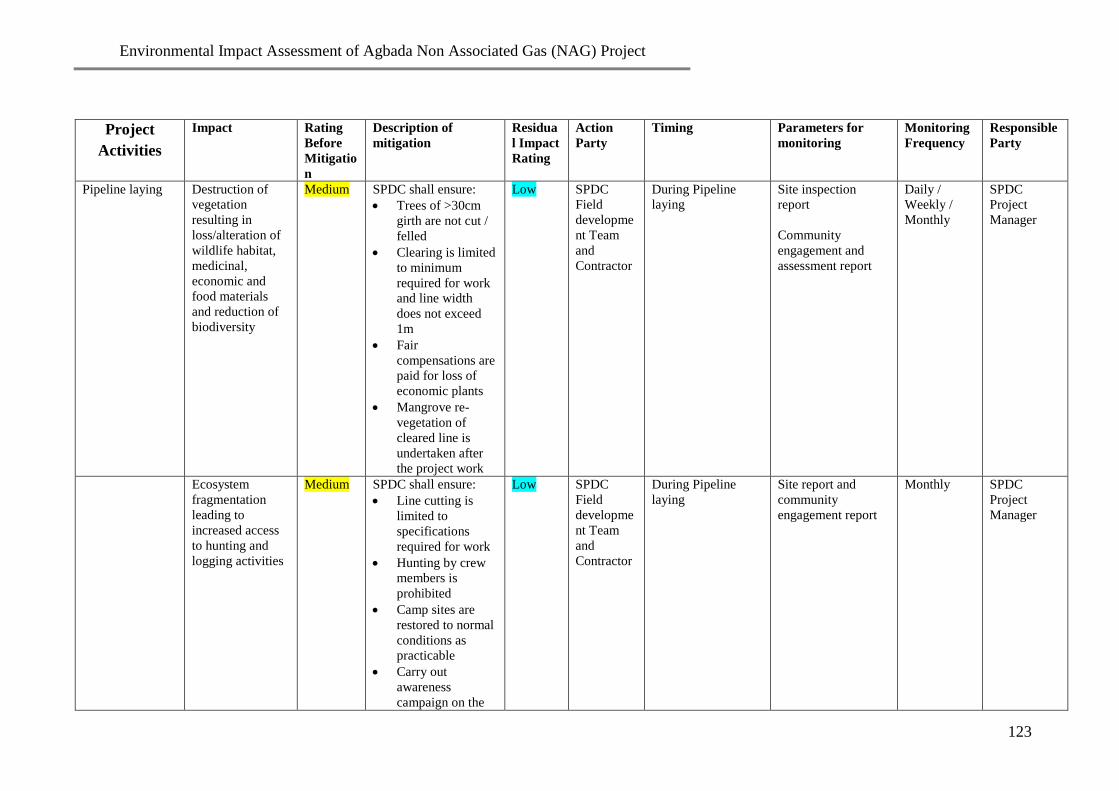
Environmental Impact Assessment of Agbada Non Associated Gas (NAG) Project
123
Project
Activities
Impact Rating
Before
Mitigatio
n
Description of
mitigation
Residua
l Impact
Rating
Action
Party
Timing Parameters for
monitoring
Monitoring
Frequency
Responsible
Party
Pipeline laying Destruction of
vegetation
resulting in
loss/alteration of
wildlife habitat,
medicinal,
economic and
food materials
and reduction of
biodiversity
Medium SPDC shall ensure:
Trees of >30cm
girth are not cut /
felled
Clearing is limited
to minimum
required for work
and line width
does not exceed
1m
Fair
compensations are
paid for loss of
economic plants
Mangrove re-
vegetation of
cleared line is
undertaken after
the project work
Low SPDC
Field
developme
nt Team
and
Contractor
During Pipeline
laying
Site inspection
report
Community
engagement and
assessment report
Daily /
Weekly /
Monthly
SPDC
Project
Manager
Ecosystem
fragmentation
leading to
increased access
to hunting and
logging activities
Medium SPDC shall ensure:
Line cutting is
limited to
specifications
required for work
Hunting by crew
members is
prohibited
Camp sites are
restored to normal
conditions as
practicable
Carry out
awareness
campaign on the
Low SPDC
Field
developme
nt Team
and
Contractor
During Pipeline
laying
Site report and
community
engagement report
Monthly SPDC
Project
Manager

Environmental Impact Assessment of Agbada Non Associated Gas (NAG) Project
124
Project
Activities
Impact Rating
Before
Mitigatio
n
Description of
mitigation
Residua
l Impact
Rating
Action
Party
Timing Parameters for
monitoring
Monitoring
Frequency
Responsible
Party
adverse effects of
hunting and
logging
Work place
accidents and
incidents (e.g.
machete cuts, etc)
Medium SPDC shall ensure:
Use of trained
personnel only
Use of appropriate
PPE
HSE briefing prior
to work are
Conducted
Strict adherence to
work procedures
Work tools are in
good condition
Low SPDC
Field
developme
nt Team
and
Contractor
During Pipeline
laying
Inspections (audits) /
daily field reports
Line inspection
reports
Incident / Unsafe
Acts, Unsafe
conditions, etc.
reports
Daily /
Weekly /
Monthly
SPDC
Project
Manager
Pipeline laying
… cont’d
Risk of
encroachment
into sensitive
locations,
property, sacred
sites, public
utilities, etc.
leading to strife
Medium SPDC shall ensure:
Scouting is done
by contact
personnel to
identify sacred
areas and
conservation areas
within the
communities in
order to avoid
interference
Strict adherence to
guidelines given
by contact
personnel and
survey crews are
enforced
Fair
compensations are
Low SPDC
Field
developme
nt Team
and
Contractor
During pipeline
laying
Contact personnel
report / community
engagement report
Monthly SPDC
Project
Manager

Environmental Impact Assessment of Agbada Non Associated Gas (NAG) Project
125
Project
Activities
Impact Rating
Before
Mitigatio
n
Description of
mitigation
Residua
l Impact
Rating
Action
Party
Timing Parameters for
monitoring
Monitoring
Frequency
Responsible
Party
paid for certified
damaged property
as per OPTS rates
Third party
agitation over
damage to
property,
encroachment and
compensations
High SPDC shall ensure:
Identification of
appropriate
beneficiaries of
damaged property
and evaluate the
loss
Consultation with
the relevant
communities and
property owners
Prompt payment
of fair
compensation
when liable
Low SPDC
Field
developme
nt Team
and
Contractor
After Pipeline laying Site inspection
report
Community
engagement report
Monthly SPDC
Project
Manager

Environmental Impact Assessment of Agbada Non Associated Gas (NAG) Project
126
Project
Activities
Impact Rating
Before
Mitigatio
n
Description of
mitigation
Residua
l Impact
Rating
Action
Party
Timing Parameters for
monitoring
Monitoring
Frequency
Responsible
Party
Wildlife attack
leading to
personnel injury
and death
Medium SPDC shall ensure:
All work crew use
appropriate PPE
Safety briefing are
conducted prior to
work
Availability of
trained bee
fighters as well as
pre-employment
inductions against
bee attacks before
commencement of
work
Activation of
MEDEVAC plan,
when needed
Low SPDC
Field
developme
nt Team
and
Contractor
During Pipeline
laying
Site inspection
report
Incident report
Daily /
Weekly
SPDC
Project
Manager
Decommissionning and Abandonmennt
Transportation of
equipment,
personnel and
materials from
site
Workplace
accidents /
incidents during
loading and
offloading of
materials /
equipment
Medium SPDC shall ensure:
Use of competent
personnel trained
in basic HSE
awareness in all
operations
Safety briefings /
inductions are
carried out prior to
commencement of
work
Adequate use of
PPE
Low SPDC
field
developme
nt
Team and
Contractor
During mobilisation
/ project execution
Site HSE report
Reports of induction
meetings
Daily /
Weekly
SPDC
Project
Manager
Increased usage Medium SPDC shall ensure: Low SPDC During mobilization Inventory of Daily / SPDC

Environmental Impact Assessment of Agbada Non Associated Gas (NAG) Project
127
Project
Activities
Impact Rating
Before
Mitigatio
n
Description of
mitigation
Residua
l Impact
Rating
Action
Party
Timing Parameters for
monitoring
Monitoring
Frequency
Responsible
Party
of roads with
risks of accidents
leading to injury /
death of
personnel and
loss of assets
Effective journey
management is
implemented to
limit the amount
of traffic
Regular
maintenance /
checks of vehicles
Relevant
personnel undergo
driving training
and certification
before
mobilisation
Compliance with
speed and load
limits are enforced
Warning signs are
established where
required
Night driving is
prohibited
field
developme
nt Team
and
Contractor
/ project execution approved journey
management forms
Vehicle certification
reports
In-vehicle
monitoring system
checks / reports.
Personnel driving
certificates
Reports of all
training sessions
Weekly /
Monthly
Project
Manager
Transportation of
equipment,
personnel and
materials from
site
…. cont’d
Risk of armed
attacks leading to
hostage situations
/ injury / death of
personnel
High SPDC shall ensure:
Security
operatives (Mopol
etc) accompany
vehicles uring
routine and non-
routine trips
Adequate
consultations are
carried out with
stakeholders
Medium SPDC
field
developme
nt Team
and
Contractor
During mobilisation
/ project execution
Site inspection
report
Community
engagement report
Security reports
Daily /
Weekly
SPDC
Project
Manager

Environmental Impact Assessment of Agbada Non Associated Gas (NAG) Project
128
Project
Activities
Impact Rating
Before
Mitigatio
n
Description of
mitigation
Residua
l Impact
Rating
Action
Party
Timing Parameters for
monitoring
Monitoring
Frequency
Responsible
Party
Transportation of
equipment,
personnel and
materials from
site
…. cont’d
Use of SREM
Nuisance (noise,
vibration, etc.)
from trucks
Medium SPDC shall ensure:
Periodic
maintenance of
vehicles are
carried out to
maintain noise
levels within
acceptable limits
Movement is
limited to day time
to reduce nuisance
issues
Low SPDC
field
developme
nt Team
and
Contractor
During mobilisation
/ project execution
Equipment
maintenance report
Camp site noise
mapping
Journey
management records
Weekly SPDC
Project
Manager
Pollution -
spillage / leakage
of fuel or lube oil
onto land during
transportation
Medium SPDC shall ensure:
Vehicles are
regularly
maintained and
checked for leaks
Low SPDC
field
developme
nt Team
and
Contractor
During mobilisation
/ acquisition
campaign
Site inspection and
community
engagement reports
Equipment
maintenance report
Monthly SPDC
Project
Manager
Removal of
structures
Restoration
of site
Litter of
environment with
base camp
rubbles, line pegs,
markers, etc
Medium SPDC shall ensure
enforcement of
responsible waste
handling from cradle
to grave in line with
the company’s and
regulatory
requirements
Low SPDC
field
developme
nt Team
and
Contractor
During facilities
decommissioning
Community
engagement report
Waste generated /
disposal
management data
End of the
project
SPDC
Project
Manager
Increased
opportunity for
employment and
contracting
resulting in
increased income
level
Beneficia
l
SPDC shall
ensure:
Indigenous
contractors are
used
Benefici
al
SPDC field
developme
nt Team
and
Contractor
During site
restoration
Community
engagement report
Site restoration
certificate
End of the
project
SPDC
Project
Manager

Environmental Impact Assessment of Agbada Non Associated Gas (NAG) Project
129
Table 7.3: Environmental Monitoring Plan for the Agbada Non Associated Gas (NAG) (PRE-MOBILIZATION AND CONSTRUCTION
PHASE) Environmental
component
ASSOCIATED LIMITATIONS MONITORING PROGRAMME Responsibility
Regulation/ Standard Requirements/ Limits Parameters to be monitored Sampling Location Frequency Data collection method
Groundwater EGASPIN Appendix V-1
page 108: Limits for
Substances and
characteristic affecting the
acceptability of water for
domestic use (WHO
standards)
Total solids: 1500mg/l
p H: 6.5 – 9.2
Mineral Oil: 0.3mg/l Chloride as Cl: 600mg/l
Copper: 1.5mg/l
Iron: 1.0mg/l Zinc: 15mg/l
Sulphate: 400mg/l
Total Hardness: 500mg/l Calcium: 200mg/l
Magnesium: 150mg/l
Manganese: 0.5mg/l Colour: 50units
Coliform: 0MPN/100ml
Physico-chemical parameters (pH,
TDS, Mineral Oil, Phenolic
compounds, Salinity as Chloride, Copper, Iron, Zinc, Sulphate, Total
Hardness, Calcium, Magnesium,
Manganese, Anionic detergents, Colour, Odour, Taste
Monitor one (1) borehole
within 200 m radius around
the NAG wells taking recognizance of the direction
of groundwater flow.
Quarterly Sample collection and
analysis in an external
approved laboratory.
SPDC Project Manager
Air Quality EGASPIN: National Air quality Guidelines for
maximum exposure
Daily average/mean CO = 10ppm
Total SPM: 60 -
90µg/m3 SO2 = 100 – 150 µg/m3
NO2 = 150 µg/m3
Noise: 90dB(A)
CO, Total SPM, SO2, NO2, Noise, VOC, H2S, Ozone, Cadmium,
Chromium, Lead, NH3, Atmospheric
temperature, Relative humidity, Wind speed, Wind direction,
Pressure, Wind turbulence, Sun
Radiation
Meteorology, Air quality and noise measurements
shall be sampled 200m away
from the NAG wells along the direction of the
prevailing wind.
Weekly Portable Environmental sensor meters
SPDC Project Manager/FMEnv/DPR
Vegetation/
Wildlife
Food and Agricultural Organization : Conservation
Agriculture (2007)
25% Forest cover Noise levels, Records of wildlife kill, or sighting
of wildlife
Around the vegetation ecotypes in the project area
Annually during
construction
and thereafter.
Standard methods as recommended by FMEnv,
WHO, World Bank,
UNEP and DPR; Direct Observation
SPDC Project Manager/FMEnv/DPR
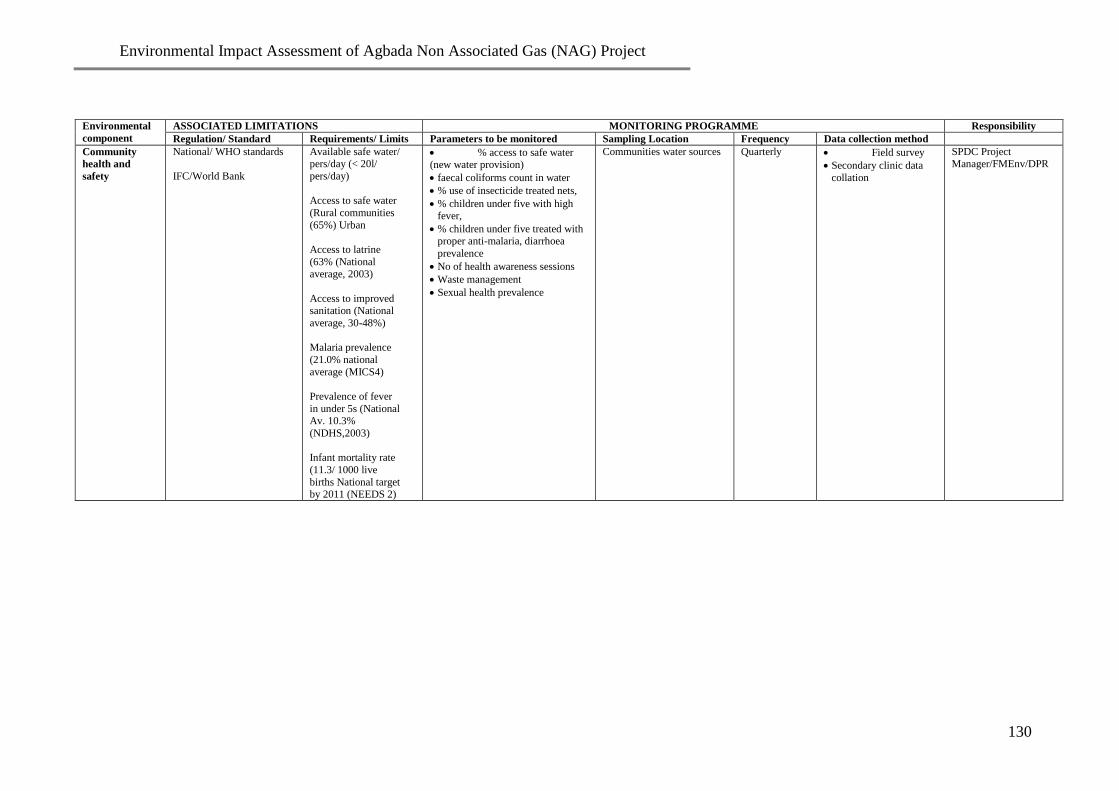
Environmental Impact Assessment of Agbada Non Associated Gas (NAG) Project
130
Environmental
component
ASSOCIATED LIMITATIONS MONITORING PROGRAMME Responsibility
Regulation/ Standard Requirements/ Limits Parameters to be monitored Sampling Location Frequency Data collection method
Community
health and
safety
National/ WHO standards
IFC/World Bank
Available safe water/ pers/day (< 20l/
pers/day)
Access to safe water
(Rural communities
(65%) Urban
Access to latrine
(63% (National average, 2003)
Access to improved sanitation (National
average, 30-48%)
Malaria prevalence
(21.0% national
average (MICS4)
Prevalence of fever
in under 5s (National
Av. 10.3%
(NDHS,2003)
Infant mortality rate
(11.3/ 1000 live
births National target by 2011 (NEEDS 2)
% access to safe water (new water provision)
faecal coliforms count in water
% use of insecticide treated nets,
% children under five with high fever,
% children under five treated with proper anti-malaria, diarrhoea
prevalence
No of health awareness sessions
Waste management
Sexual health prevalence
Communities water sources
Quarterly
Field survey
Secondary clinic data
collation
SPDC Project Manager/FMEnv/DPR

Environmental Impact Assessment of Agbada Non Associated Gas (NAG) Project
131
CHAPTER EIGHT
CONCLUSION
The status and sensitivities of the various ecological and socio-economic components of the
project environment have been carefully established and assessed through literature research,
field sampling and measurements/testing within the proposed project area, using a multi-
disciplinary team of experts. The interactions of the various ecological and socio-economic
components of the existing environment with the known activities of the proposed project
were used along with other source references to identify, characterise and evaluate the
potential and associated impacts. Mitigation measures were subsequently developed for
adverse impacts based on industry best practice, available technology and HSE
considerations.
Consultations with the project communities, regulatory authorities and other stakeholders
have been carried out and shall continue through-out the project lifecycle. The impact
assessment of the proposed Agbada Field Development Project indicated that it would impact
positively on the socio-economic life of the people by way of semiskilled and unskilled
employment and provision of social amenities. Subsequent production of gas in the area will
impact positively on the national, State and local economy as well as on the revenue base of
the project proponents. The environmental benefits of a reduction in gas flaring are also
enormous. The proposed project will also contribute to significant socio-economic
development within the host communities and result in long term economic empowerment
for the indigenes, residents and other professionals. These would be by way of skilled,
semiskilled and unskilled employment opportunities, and award of contract for supplies and
services etc.
The potential adverse impacts of the proposed project on ground water, air quality,
vegetation and socio-economics/health, are localised and can be significantly controlled.
Also, the EMP developed shall ensure that the procedures for managing the adverse impacts
of the proposed project and the implementation of the environmental and social commitments
are developed and maintained throughout the project lifecycle. It will therefore form the
basis for the actual project implementation. The proposed project can thus be executed within
the ambit of sustainable development.

Environmental Impact Assessment of Agbada Non Associated Gas (NAG) Project
132
REFERENCES
Arthur Haupt and Thomas T. Kane (2004): Population Reference Bureau’s Population
Handbook, 5th edition.
Ayoade, J. O. (1988). Introduction to Climatology for the Tropics. Spectrum Books
Limited.
Daly, D. 1994. Chemical pollutants in groundwater: a review of the situation in Ireland.
In: Chemicals – A Cause for Concern? Cork 3-4 November 1994, Sherkin Island. Marine
Station.
Dorland’s Illustrative Medical Dictionary, 2007. Dorland (Author), Douglas Anderson
(Editor) Publisher: W.B. Saunders Company.
The Department of Petroleum Resources – DPR (2002), Environmental Guidelines and
Standards for the Petroleum Industry in Nigeria - EGASPIN, Revised Edition, Lagos.
Dussart, B. H. (1980): Copepods: In Durrand, J-R and Leveque, C. (eds) (1990): Flore et
faune aquatiques de l’ Afrique Sahelo-Soudanienne. Editions de ORSTOM documentations
Technique no. 44 Paris. 608pp.
Environmental Impact Assessment (EIA) Act (1992): Act no. 86. Federal Replublic og
Nigeria Official Gazette. Vol. 79
Ekundayo, E.O and Aghatise, V.O (1997): Soil properties of termite mounds under different
land use types in a typical paleudult of Midwestern Nigeria. Environmental Monitoring and
Assessment.
FEPA (1991). Guidelines and Standards for Environmental Pollution Control in Nigeria.
Federal Environmental Protection Agency (FEPA).
Global Environmental Monitoring System GEMS (1992): An Operational Guide (third
Edition). GEMS/W.92.1. Edited by Martin Allard, National Water Research Institute,
Inland Waters Directorate, Conservation and Protection, Canada.
Gupta C and Majahan K (2007); A textbook of Preventive and Social Medicine. New Delhi.
Happold, D.C. (1987) ed.; Mammals of Nigeria. Publ. Clarendon Press, Oxford, U.K.
International Association of Geophysical Contractors (IAGC). 1991. Land geophysical
operations: Safety manual. Printed by Conoco Inc., Ponca City, Oklahoma.
(International Trade and Traffic) Species, Decree No 11 of 1985

Environmental Impact Assessment of Agbada Non Associated Gas (NAG) Project
133
International Union for the Conservation of Nature and Natural Resources (IUCN) (1992).
Coastal and marine biodiversity report for UNEP: Identification, establishment, and
management of specially protected areas in the WACAF region. Gland, Switzerland
ISO 14001. 2004. Environmental management systems. Specification with guidance for use.
Kiely G (1998). Environmental Engineering, Mc Graw International editions, chemical and
petroleum Engineering services, Baston
McBride, M. B. (1989). Reaction controlling heavy metal solubility in soils. Advances in
Soil Science 10, 1 – 56.
NEST. 1991. Nigeria’s Threatened Environment. A National Profile. Nigerian
Environmental Study and Action Team, Lagos.
Niger Delta Environmental Survey (NDES, 2002): Draft Final Report of the Niger Delta
Environmental Survey, Lagos.
Oguntoyinbo, J. and Hayward, D. (1987). Climatology of West Africa. Published by
Hutchinson (South Africa) and Noble Books (Totowa, New Jersey, USA).
Palmore, J.A. and Gardner, R.W. (1983): Measuring Mortality, Fertility and Natural
Increase. Honolulu: East-West Centre.
Park K. (2005) Preventive and Social Medicine, 18th
Ed. Banarsidas Bhanot Publishers,
India.
Reijers, T.J.A. (1994.): Selected Chapters on Geology. Sedimentary Geology and sequence
stratigraphy in Nigeria and three case studies and a field guide.
The Rivers State Ministry of Environment Interim Guidelines and Standards on
Environmental Pollution Control and Management
SPDC (2003): Drilling Engineering Procedures Manual. The Shell Petroleum Development
Company of Nigeria Limited.
UNESCO 1972: Convention concerning the protection of the world cultural and natural
heritage. Paris, United Nations Educational, Scientific and Cultural Organization - UNESCO.
United Nations (1972): The United Nations Environment Programme - Declaration of the
United Nations Conference on the Human Environment, 21st plenary meeting Stockholm,
Sweden16 June 1972.
United Nations Conference on Environment and Development (UNCED), 1992. Held in Rio

Environmental Impact Assessment of Agbada Non Associated Gas (NAG) Project
134
de Janeiro, Brazil from 3-14 June 1992. Editor: Peter Saundry
World Bank (1999). Environmental Assessment Source-book Vol. 111. Guidelines for
Environmental Assessment of Energy and Industry Projects. World Bank Technical Paper
Number 154, Environment Department.

Environmental Impact Assessment of Agbada Non Associated Gas (NAG) Project
135
APPENDICES
Appendix 1
The Shell Petroleum Development Company of Nigeria Limited
Operator of the NNPC/Shell/TEPNG/Agip
TERMS OF REFERENCE (ToR)
FOR THE
ENVIRONMENTAL IMPACT ASSESSMENT (EIA)
OF
AGBADA FIELD DEVELOPMENT PROJECT
May 2008

Environmental Impact Assessment of Agbada Non Associated Gas (NAG) Project
136
Table of Content Page
1.0 INTRODUCTION 5
1.1 Executing Arrangements 6
1.2 Objectives of the EIA 6
1.3 Institutional And Legislative Framework 6
1.3.1 Federal Regulations/Guidelines 6
1.3.2 State Regulations 7
1.3.3 Relevant International Conventions and Guidelines 7
2.0 PROJECT ACTIVITY DESCRIPTION 9
2.1 Project Objectives 9
2.2 Project Location 9
2.3 Nature of the Project 12
2.4 Project Activities 12
2.4.1 Pre-Construction 13
2.4.2 Drilling 16
2.4.3 Flowlines Construction 19
2.4.4 Commissioning and Operation 20
2.4.5 Decommissioning and Abandonment 21
2.5 Project Schedule 23
3.0 THE TERMS OF REFERENCE (TOR) 24
3.1 Scope of Work/ EIA Scope 24
3.1.1 Review of Regulatory Requirements 24
3.1.2 Baseline Data Acquisition 25
3.1.2.1 Literature Review 25
3.1.2.2 Field Data Acquisition 26
3.1.3 Consultation/Stakeholder Engagement 38
3.1.4 Evaluation and Prediction of Potential Impacts 39
3.1.5 Determination of Appropriate Mitigation Measures 39
3.1.6 Environmental Management Plan (EMP) 40
3.1.7 Report Preparation 41
4.0 CONSULTING TEAM 43
4.1 Deliverables 43
Appendices 44
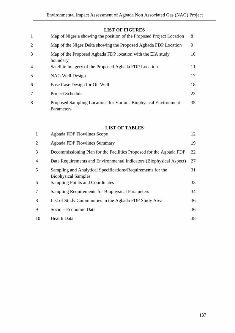
Environmental Impact Assessment of Agbada Non Associated Gas (NAG) Project
137
LIST OF FIGURES
1 Map of Nigeria showing the position of the Proposed Project Location 8
2 Map of the Niger Delta showing the Proposed Agbada FDP Location 9
3 Map of the Proposed Agbada FDP location with the EIA study
boundary
10
4 Satellite Imagery of the Proposed Agbada FDP Location 11
5 NAG Well Design 17
6 Base Case Design for Oil Well 18
7 Project Schedule 23
8 Proposed Sampling Locations for Various Biophysical Environment
Parameters
35
LIST OF TABLES
1 Agbada FDP Flowlines Scope 12
2 Agbada FDP Flowlines Summary 19
3 Decommissioning Plan for the Facilities Proposed for the Agbada FDP 22
4 Data Requirements and Environmental Indicators (Biophysical Aspect) 27
5 Sampling and Analytical Specifications/Requirements for the
Biophysical Samples
31
6 Sampling Points and Coordinates 33
7 Sampling Requirements for Biophysical Parameters 34
8 List of Study Communities in the Agbada FDP Study Area 36
9 Socio – Economic Data 36
10 Health Data 38

Environmental Impact Assessment of Agbada Non Associated Gas (NAG) Project
138
LIST OF ACRONYMS
AGG Associated Gas Gathering
ALARP As Low As Reasonably Possible
Bopd Barrels of Oil Per day
CBO Community-Based Organization
CD Community Development
CITES Control of International Trade in Endangered Species
DPR Department of Petroleum Resources
EGASPIN Environmental Guidelines & Standards for the Oil Industry in Nigeria
EIA Environmental Impact Assessment
EMP Environmental Management Plan
ERP Emergency Response Plan
ESH Environment, Social and Health
ESHIA Environment, Social and Health Impact Assessment
ESHMP Environmental, Social and Health Management Plan
FEPA Federal Environmental Protection Agency
FGD Focus Group Discussion
FMEH & UD Federal Ministry of Environment, Housing & Urban Development
GEM Gender Empowerment Measure
HAZID Hazard Identification
HAZOP Hazard and Operability
HDI Human Development Index
HIA Health Impact Assessment
HPI Human Poverty Index
HRA Health Risk Assessment
HSE Health, Safety and Environment
HSE-MS Health, Safety and Environment Management System
IFC International Finance Corporation
LTO License to Operate
MEDEVAC Medical Evacuation
MMscf/d Million Standard Cubic Feet of Gas per Day
MoU Memorandum of Understanding
NGO Non-Governmental Organization
NIWA National Inland Waterways Authority
OML Oil Mining Lease
OPTS Oil Producers Trade Section
PAC Project Advisory Committee
PIA Post Impact Assessment
QA/QC
QRA
Quality Assurance / Quality Control
Qualitative Risk Assessment
SCD Sustainable Community Development
SIA Social Impact Assessment
SMART Specific, Measurable, Achievable, Realistic and Time-Bound
SPDC Shell Petroleum Development Company of Nigeria

Environmental Impact Assessment of Agbada Non Associated Gas (NAG) Project
139
STOIIP Stock Tank Oil Initially in Place
ToR Terms of Reference

Environmental Impact Assessment of Agbada Non Associated Gas (NAG) Project
140
1.0: INTRODUCTION
The Agbada field is located in the Eastern Land Area operation of Shell Petroleum
Development Company (SPDC) in OML 17 situated approximately 16 km North-East of Port
Harcourt in Rivers State. The field was discovered in 1960 by the Agbada-1 well and has a
Stock Tank Oil Initially in Place (STOIIP) of 1.5 Billion barrels. To date sixty-four (64)
wells have been drilled in the field and some 18 percent of its original oil in place to date has
been produced. Significant recoverable oil volumes remain in the field, which have not been
developed. Current field production stands at around 28,000 bopd and 9.6MMscf/d gas
production, which is processed and sold to the domestic market. There is 90Mbopd capacity
in the field’s two flow stations while Agbada Associated Gas Gathering (AGG) was
commissioned with a capacity of 68MMscf/d. The field has been further divided into two oil
fields, Agbada 1 and Agbada 2, for administrative purposes.
A Field Review/ Field Development Plan was carried out in 2004 to identify and develop
Non Associated Gas (NAG) reserves to accommodate the expected demand increase in the
Eastern Domestic Gas market. The plan is to drill four (4) NAG wells into the G6000, G8000
or G4000 reservoirs. Furthermore a Field Review/ Field Development Plan was carried out in
2007 to identify and further develop oil reserves in order to maximize economic recovery of
hydrocarbons, grow reserves base, increase production and keep the existing facilities full.
To achieve this, a plan has been put in place to drill four (4) oil wells into the E4000 and
E8000 reservoirs.
In line with statutory requirements for the conduct of Environmental Impact Assessment of
the proposed Agbada FDP, a Scoping Workshop was held on the 26th
of March 2008 to
which various stakeholders were invited as follows:
Department of Petroleum Resources (DPR)
Regulators - Federal Ministry of Environment Housing and Urban Development
(FMEH & UD), Abuja
Rivers State Ministry of Environment
Representatives of River State Ministry of Health,
Representatives of Rivers State Ministry of Local Government and Chieftaincy
Affairs,
SPDC
EIA Consultants
Representatives of stakeholder communities relevant to the project.
The aim of the workshop was to present the project to the stakeholders and obtain their issues
and concerns that would guide the EIA study and decision-making process for the project.
Stakeholders were made to express their perceptions and expectations, identify potential
impacts (adverse and beneficial), propose measures to mitigate the negative and enhance the
positive impacts from the proposed project.

Environmental Impact Assessment of Agbada Non Associated Gas (NAG) Project
141
This Terms of Reference (ToR) highlights the various issues raised during the scoping
workshop. It is developed in an integrated manner to include the scope of work for
biophysical, social and health Impact Assessments. This is in compliance with the regulatory
requirements and the SPDC EIA process, which aims at giving equal coverage to the
biophysical, social and health aspects of the environment. The purpose of the Terms of
Reference is to define the study boundary and scope for the proposed Agbada Field
Development Project.
1.1: Executing Arrangements.
SPDC is responsible for the preparation of the EIA, which shall conform to the approved
DPR, FMEH & UD guidelines and regulations as well as the SPDC EIA Process Manual.
SPDC intends to carry out the EIA through a contractual arrangement with accredited EIA
consultants.
1.2: Objectives of the EIA
The objectives of the EIA study are to:
Determine the baseline conditions of the environment (biophysical, socio-economic and
health).
Determine and evaluate the potential impacts of the proposed project activities on the
biophysical environment of the area.
Identify and evaluate the potential socio-economic effects of the project on the
communities including impacts on cultural properties, social infrastructures, natural
resources and lifestyles / values.
Identify and evaluate health impacts that may result from the different phases of the
project.
Develop cost-effective mitigation measures and appropriate Environmental Management
Plan (EMP) for sustainable development.
1.3: Institutional and Legislative Framework
Environmental Impact Assessment in Nigeria is regulated by Federal, State and Local
Government legislation and the proposed EIA shall conform to these guidelines as well as
relevant international guidelines / conventions including those of the World Bank / IFC. The
regulatory framework is outlined below:
1.3.1: Federal Regulations/Guidelines
The Environmental Impact Assessment (EIA) Act No. 86 of 1992.
Department of Petroleum Resources (DPR) Environmental Guidelines and Standards for
Petroleum industry in Nigerian, (EGASPIN) 2002 Guidelines
Department of Petroleum Resources (DPR) Mineral Oils and Safety Regulations 1997
FEPA EIA Procedural Guidelines, 1995
FEPA EIA Sectoral Guidelines (Oil and Gas), 1995
Revised National Policy on Environment - 1995
S.I.8 - National Environmental Protection (Effluent Limitations) Regulations of 1991

Environmental Impact Assessment of Agbada Non Associated Gas (NAG) Project
142
S.I.9 – National Environmental Protection (Pollution Abatement in Industries and
Facilities Generation Wastes)
S.I.15 – National Environmental Protection (Management of Solid and Hazardous
Wastes) Regulations of 1991
The Petroleum Act No. 51 of 1969
Endangered Species Control Act of 1985
Land Use Act of 1978
National Inland Waterways Authority (NIWA) Act 13 of 1997
Factory Act 1992
Revised National Health Policy - 2004
National Health Act 2005
National Guidelines and Standards for Environmental Protection 1991
1.3.2: State Regulations
Rivers State Environmental Protection Agency Law No. 2 of 1994
Rivers State Private Health and Allied Establishments Authority Law, 2001
Rivers State Public Health Law, 1999
Public Health Law – CAP 103 of the Laws of Eastern Nigeria, 1963
1.3.3: Relevant International Conventions and Guidelines
International Union for Conservation of Nature and Natural Resources (IUCN)
Guidelines 1996
World Bank Guidelines on Environmental Assessment, 1991
World Bank Operational Directive 4.00, Annex A: "Environmental Assessment"
Convention on the Conservation of Migratory Species of Wild Animals (Bonn
Convention) 1979.
Convention on Biological Diversity (Rio Summit) 1992
Convention Concerning the Protection of the World Cultural and Natural Heritage Sites
(World Heritage Convention) 1978.
Basel Convention on the Control of Trans-Boundary Movements of Hazardous Wastes
and their Disposal 1989.
United Nations Framework Convention on Climate Change 1994
Convention to Regulate International Trade in Endangered Species of Fauna and Flora
(CITES) 1973
2.0: PROJECT ACTIVITY DESCRIPTION
Project Objectives
The objectives of the project are as follows:
1. Supply a plateau gas rate of about 100 MMscfd to supplement the gas supply to the
Eastern Domestic Gas network.
2. Achieve flares down at Agbada 2 Flowstation by gathering surge vessel gas.
3. Optimise the ultimate recovery of oil and gas from all reservoirs developed.
4. Increase booked reserves

Environmental Impact Assessment of Agbada Non Associated Gas (NAG) Project
143
5. Maximise implementation of Sustainable Development initiatives in the operational
area covered by the project.
The Project Location
The planned Agbada Field development Project is located in Etche, Ikwerre and Obio-Akpor
Local Government Areas of Rivers State within the Niger Delta area of Nigeria (Figs. 1, 2
and 3).
Fig. 1: Map of Nigeria Showing the Proposed Project Location

Environmental Impact Assessment of Agbada Non Associated Gas (NAG) Project
144
Fig. 2: Map of the Niger Delta showing the proposed Agbada FDP Location
The Agbada field, which is further subdivided into two subfields consists of two flow
stations namely Agbada 1 and Agbada 2, wells and flowlines; which are hosted by several
communities in Ikwerre, Obio - Akpor and Etche Local Government Areas of Rivers State.
However, the proposed EIA surface area coverage extends beyond the immediate vicinity of
the flow stations, lines and wells. The Agbada FDP EIA study area covers five-kilometre
radius of each of the flow stations. This includes the proposed NAG plant, a two kilometre
radius of the wells and two kilometre buffer zone on either side of the flowline Right of Way
(ROW) for transporting gas from Agbada 1 to Agbada 2 as shown in Figure 3.
Proposed
project
location

Environmental Impact Assessment of Agbada Non Associated Gas (NAG) Project
145
Fig. 3: Map of the Proposed Agbada FDP location with the overlapping EIA study
boundary (in brown highlight)
Satellite imagery (Fig. 4) of the area shows that the predominant land cover consists of
mainly secondary vegetation and fallow farm lands undergoing varying degrees of
successional changes with sparse vegetation. Relics of primary forest occur occasionally.
Also visible on the satellite imagery are areas of urban industrial developments.

Environmental Impact Assessment of Agbada Non Associated Gas (NAG) Project
146
Fig. 4: Satellite Imagery of the proposed Agbada FDP location (with the EIA study
boundary)

Environmental Impact Assessment of Agbada Non Associated Gas (NAG) Project
147
2.3 Nature of the Project
The development concepts that are considered involve the following:
Install 120 MMscf/d NAG processing plant at Agbada-2 Flowstation.
Install 1 MMscf/d AG compressor to gather surge vessel gas at Agbada-2 Flowstation.
Drill 3 NAG and 2 oil wells and hook-up.
Lay 2 No. 8” x 8km NAG flowline from wells at Agbada-1 to NAG plant at Agbada-2.
Lay 1 No. 8” x 0.5km NAG flowline to connect well to already laid 8” flowline.
Lay 2 No. 4” x 5km oil flowlines from well location to Flowstation
Details of the flowlines scope are shown in Table 1.0
Table 1: Agbada FDP Flowlines Scope
S/N Field Flowlines Status RoW Width
1 Agbada
(NAG)
2 Nos. 8 x 8 km (gas)
1 Nos. 8” x .5 km(gas)
On existing RoW
On existing RoW
15m
2 Agbada
(OIL)
2 Nos. 4” x 5km (oil)
On existing RoW 15m
2.1 Project Activities
Based on the nature of the project as indicated earlier, the activities come under the following
categories:
Pre-construction
Survey
Pre-mobilisation and inspection
Mobilisation of equipment and workforce to site
Well Location preparation (Land clearing, sand-filling etc)
Construction of camps sites, lay-down areas, access roads and other civil works
Drilling/Workover
Rig move
Well Drilling
Well Completion and testing
Hook up

Environmental Impact Assessment of Agbada Non Associated Gas (NAG) Project
148
Construction
Flowline Execution
Excavation and trenching
Flowline laying
Welding and coating
Radiography
Hydrotesting of flowlines
Backfilling
Facilities
NAG plant (dehydration, fuel gas) installation.
AG booster compressors (surge vessel gas) installation
Tie-ins
Commissioning and Operations
Operation of NAG, AG and associated facilities
Operation of wells and manifolds
Maintenance of flowline RoW
Decommissioning and Abandonment
Demobilization
Excavation
Removal of facilities
Restoration
The primary considerations in the selection of project sites and adopted technology include
the following:
Impact on and benefit to the local communities
Impact on environment sensitivities
Minimal land take
Capital cost impacts
Operability of the plant and facilities
Distance to oil and gas reserves
Location of current facilities and production operations
Safety
Impact on schedule to First gas

Environmental Impact Assessment of Agbada Non Associated Gas (NAG) Project
149
Specific details of the activities under these categories are as follow:
2.1.1 Pre-construction
Pre-construction activities shall involve minimal land acquisition; topographic surveys and
soil investigation; vegetation clearing; earth works (e.g. sandfilling); and construction of
slabs (for cellar, generator, chemicals etc), access road, and campsite/storage areas for
Drilling. For Flowlines, they include: route selection and survey; material selection; pre-
mobilization inspection and mobilization; pegging and fencing; route clearing; probing for
existing facilities; and construction of access road, and campsite/storage areas.
Minimal Land Acquisition
A feasibility study for the re-use of existing locations has been undertaken in order to
minimize land take. The aim is to use drilling slots on already acquired land. However, where
an existing well location is found unsuitable for the drilling, additional land may be acquired
as the need arises. In addition, cluster-drilling strategy will be adopted for the project to
minimize land take and other impacts on the environment.
Well Locations Preparations
Single well pads will be designed for both oil and gas wells. Each location will be surfaced
with asphalt to prevent groundwater and soil contamination. In addition, pits will be
constructed to capture surface run-off. The pads will be graded so that rainfall on the active
portions of the pad will be directed into the pit.
Sizes of the well locations are estimated to be approximately 60 x 110 m for one-wellhead
location. Exact dimensions for each well pad will depend on surface constraints that may
impact construction of individual locations. Well site construction is typically completed
over 12 months in a seasonally flooded terrain like Agbada.
Access Roads Preparations
There are existing access roads to the existing and proposed well sites. However these roads
shall be maintained in good conditions during the course of the project.
Flowline Design
Flowlines have been designed according to the relevant regulations, codes, and standards as
summarized below:
Guidelines & Procedure for the Construction, Operation & Maintenance of Oil & Gas
Flowlines (1990)
Oil and Gas Flowline Regulation (1995)
Oil Flowlines Act, 1956, Cap 338, Vol XIX P.12363
Primary Codes and Standards
Standard Flowline and Flowline Design Package (ENGL/21/34/01)
Environmental Impact Assessment of Agbada Non Associated Gas (NAG) Project
150
Shell Group Flowline Engineering DEP (31.40.00.10-Gen)
ASME B31.4 - Liquid Transportation Systems for Hydrocarbons & other Liquids
(Applicable to the Oil Export Flowline)
ASME B31.8 - Gas Transmission & Distribution Piping System (Applicable to the
NAG flowlines)
The design life for the various categories of flowlines has been established to ensure the
integrity of the flowlines and bulklines throughout their operating life. The applicable design
life is given as follows:
NAG bulklines and flowlines - 30 years
Bulklines and flowlines - 20 years
Route Selection and Survey
Routes for the flowlines will be selected and surveyed to ensure consistency with the
philosophy of shortest possible distance between start and end points with environmental,
social, economic and technical considerations. This is to reduce the exposure of communities
to potential hazards associated with high-pressure flowlines, and the risk of third party
interference.
Materials Selection
Materials of appropriate grades will be selected for the flowlines to ensure the highest
integrity to withstand the anticipated pressure and environmental conditions without risk of
failure. All the NAG flowlines shall be of carbon steel.
All the flowlines shall be coated with three-layer polyethylene (PE) anti-corrosion coating.
Coating shall be carried out in a pipe coating yard before transportation to the site. Line
pipes, fittings and other flowline construction accessories shall be transported and stored in
such a manner as not to impact on the integrity of the materials.
Pre-mobilisation Inspection and Mobilisation
Prior to mobilisation, SPDC shall carry out pre-mobilisation inspection of all items/personnel
to be mobilised to site. All equipment and personnel mobilised to site shall be certified fit for
purpose and approved by SPDC before deployment to site. Key construction equipment to be
mobilised include: Back hoe, Side boom, Prime mover, Trailer, Self loading truck, Crane,
Crew bus, 4WD truck, Welding sets, Flushing pumps, Hydro testing unit, Generators,
Compressors, Bending Machine, Grit blasting unit, Oxy acetylene torch, Line up clamps,
Cold cutter, X-ray units, Thrust boring machine, etc. The contractor shall mobilise all
necessary personnel, materials and equipment to site after setting up of the Project Advisory
Committee (PAC), resolving community issues and obtaining necessary approvals.
Survey and Staking of Flowline Routes
Survey shall be carried out to re-establish and clearly mark out boundaries of the permanent
RoW and temporary working strip required for construction activities. For example, a single
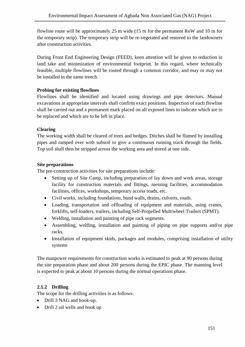
Environmental Impact Assessment of Agbada Non Associated Gas (NAG) Project
151
flowline route will be approximately 25 m wide (15 m for the permanent RoW and 10 m for
the temporary strip). The temporary strip will be re-vegetated and restored to the landowners
after construction activities.
During Front End Engineering Design (FEED), keen attention will be given to reduction in
land take and minimization of environmental footprint. In this regard, where technically
feasible, multiple flowlines will be routed through a common corridor, and may or may not
be installed in the same trench.
Probing for existing flowlines
Flowlines shall be identified and located using drawings and pipe detectors. Manual
excavations at appropriate intervals shall confirm exact positions. Inspection of each flowline
shall be carried out and a permanent mark placed on all exposed lines to indicate which are to
be replaced and which are to be left in place.
Clearing
The working width shall be cleared of trees and hedges. Ditches shall be flumed by installing
pipes and ramped over with subsoil to give a continuous running track through the fields.
Top soil shall then be stripped across the working area and stored at one side.
Site preparations
The pre-construction activities for site preparations include:
Setting up of Site Camp, including preparation of lay down and work areas, storage
facility for construction materials and fittings, messing facilities, accommodation
facilities, offices, workshops, temporary access roads, etc.
Civil works, including foundations, bund walls, drains, culverts, roads.
Loading, transportation and offloading of equipment and materials, using cranes,
forklifts, self-loaders, trailers, including Self-Propelled Multiwheel Trailers (SPMT).
Welding, installation and painting of pipe rack segments.
Assembling, welding, installation and painting of piping on pipe supports and/or pipe
racks.
Installation of equipment skids, packages and modules, comprising installation of utility
systems
The manpower requirements for construction works is estimated to peak at 90 persons during
the site preparation phase and about 200 persons during the EPIC phase. The manning level
is expected to peak at about 10 persons during the normal operations phase.
2.1.2 Drilling
The scope for the drilling activities is as follows:
Drill 3 NAG and hook-up.
Drill 2 oil wells and hook up

Environmental Impact Assessment of Agbada Non Associated Gas (NAG) Project
152
Drilling shall be done using a land rig for surface hole, intermediate and production drilling.
Water-based drilling mud will be used for the top-hole sections while pseudo oil based mud
shall be used for the intermediate and deeper sections. The expected wastes include drilling
mud, drill cuttings and spent chemicals.
Well Design Concepts
For NAG wells the design shall be a conventional vertical (or slightly deviated) well with a 4
1/2” completion, utilising existing experience and standard well construction equipment and
materials. The concept selection for the oil wells is a conventional horizontal or deviated well
with a 4-1/2” completion. A generic sketch of the base case NAG well design and the base
case Oil well design are illustrated in Figures 5 and 6 respectively
Drilling Process
The wells will be drilled using water based mud system from surface to 13-3/8” or 9-5/8”
casing depth at + 6,000 ft. Thereafter, Pseudo Oil Based Mud (POBM) will be used to drill to
total depth (10,000 ftss) i.e. the lower section of the hole (below surface casing depth). The
two mud systems will be salvaged for re-use. Approximately 160 m3 of drill cuttings is
expected to be generated from each drilling operation. Spud (Gel Suspension) mud contains
bentonite, polymer additives (e.g. CMC HV) and KCl (shale inhibitors).
Drilling a well is achieved by making up the bottom-hole assembly (BHA) below pipes.
Rotating this assembly generates formation cuttings. During this operation, a special fluid
(drilling mud) is continuously pumped through the pipe and comes out of the drilling bit. The
mud carries the drilled cuttings through the annular space between the drill string and the hole
to surface.
The mud shall be tested/checked regularly (every 15 minutes on site) to ensure that the
properties and weight are in order. The primary safeguard against a blow out is the pressure
exerted by the drilling mud. The secondary control is the equipment referred to as Blow Out
Preventer (BOP) with surface safety valves. This equipment shall be used to close in a well at
the slightest detection of formation fluid ingress/flow into the well bore (mud system).
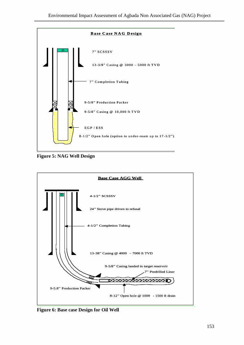
Environmental Impact Assessment of Agbada Non Associated Gas (NAG) Project
153
1 3 -3 /8 ” C asin g @ 3 0 0 0 – 5 0 0 0 ft T V D
9 -5 /8 ” C asin g @ 1 0 ,0 0 0 ft T V D
8 -1 /2 ” O pen h ole (op tion to u n d er -rea m u p to 1 7 -1 /2 ” )
E G P / E S S
B a se C a se N A G D esig n
7 ” C o m p le tion T ub in g
7 ” S C S S S V
9 -5 /8 ” P rodu c tion P acke r
1 3 -3 /8 ” C asin g @ 3 0 0 0 – 5 0 0 0 ft T V D
9 -5 /8 ” C asin g @ 1 0 ,0 0 0 ft T V D
8 -1 /2 ” O pen h ole (op tion to u n d er -rea m u p to 1 7 -1 /2 ” )
E G P / E S S
B a se C a se N A G D esig n
7 ” C o m p le tion T ub in g
7 ” S C S S S V
9 -5 /8 ” P rodu c tion P acke r
Figure 5: NAG Well Design
24 ” Stove pipe driven to refusal
9 - 5/8 ” Casing landed in target reservoir
13 - 38 ” Casing @ 4000 – 7000 ft TVD
8 - 12 ” Open hole @ 1000 - 1500 ft drain
9 - 5.8 ” Production Packer
7 ” Predrilled Liner
Base Case AGG Well
4 - 1/2 ” Completion Tubing
4 - 1/2 ” SCSSSV
24 ” Stove pipe driven to refusal
9 - 5/8 ” Casing landed in target reservoir
13 - 38 ” Casing @ 4000 – 7000 ft TVD
8 - 12 ” Open hole @ 1000 - 1500 ft drain
9 - 5.8 ” Production Packer
7 ” Predrilled Liner
Base Case AGG Well
4 - 1/2 ” Completion Tubing
4 - 1/2 ” SCSSSV
Figure 6: Base case Design for Oil Well
Environmental Impact Assessment of Agbada Non Associated Gas (NAG) Project
154
Drilling Wastes
The wastes that will be generated during the drilling operations include:
Drill cuttings
Spent drilling mud and completion fluids
Drilling effluents (waste water)
Cementing waste
Rig wash (Detergent) water
The drilling waste management principles in this project will focus on waste minimization
and recycling. Wastewater shall be treated/flocculated and used for building new mud and
also for the rig and equipment washing. The wastewater and drilled cuttings from the drilling
operations will be channelled into waste pits. A pay loader shall be used to scoop out the
drilling waste from the waste pit into cutting skips. The cuttings will be mixed with water to
form slurry and taken to a Thermal Desorption Unit (TDU) Onne in compliance with
FMEH&UD/DPR directives.
Associated Wastes
Discarded consumables include unused drilling chemicals, chemical/material bags, scrap
metals used in constructions etc, will be trucked to SPDC facility for recycling. A strict
inventory control of all chemicals in use shall be maintained. All chemicals, lubricating oils
and fuels will be stored in containers and safely placed in a sheltered area on the rig.
Appropriate Safe Handling of Chemicals (SHOC) cards will be provided for every chemical
on board the rig for the safety of personnel and the environment. International standard in-
built biological sewage treatment plants shall be put in place to manage human waste
expected from the rig personnel who are not expected to exceed one hundred (100).
2.1.3 Flowlines Construction
The gas wells are within 8km of the proposed NAG facility location. Flowlines will be
constructed from the wells to the proposed NAG facility. The flowlines will be installed with
pigging facilities. The pigging facilities shall consist of an outgoing pig launcher and an
incoming pig receiver.
The flowline construction shall include the following specific activities:
Welding, installation and painting of pipe supports.
Assembling, welding, installation and painting of pipes
The overall flowline scope of Agbada FDP requires the construction of flowlines of 4” and
8” by approximately 26km cumulative. The flowline material is predominantly carbon steel.
A summary of the flowlines list for the project is given in Table 2.

Environmental Impact Assessment of Agbada Non Associated Gas (NAG) Project
155
TABLE 2 : Agbada FDP Flowlines Summary
From
To Fluid Length
(Km)
Flow
Rate
MMScfd
Pipeline
Size
(inches)
Pipeline
Inlet
Pressure
(bars)
Arrival
Pressure
(bars)
Material ANSI
Rating /
Design
Pressure
Well
09
Agbada
2
(GHF)
Wet
Gas
8 100 8 115 110 Carbon
Steel
1500
Well
09
Agbada
2
(GHF)
Wet
Gas
8 100 8 115 110 Carbon
Steel
1500
Well
09
Existing
pipeline
Via
Agbada
1
Wet
Gas
0.5 100 8 115 115 Carbon
Steel
1500
Well
04
Agbada
1
Oil 5 6Mbpd 4 14 13 Carbon
Steel
600
Well
06
Agbada
1
Oil 5 6Mbpd 4 14 13 Carbon
Steel
600
Trenching
A trench, 0.3 - 0.6 m wider than the pipe diameter and deep enough to provide minimum
cover, will be excavated for the flowline burial. Where the flowlines cross major roads the
option of trust-boring will be considered.
Stringing and bending
Stringing and bending involves the handling and positioning of flow lines or joints on
wooden skids along a line parallel on one side of the trench in preparation to welding into a
continuous flowline. Strung pipes shall be provided with caps at both joint ends to keep the
joint free from dirt and extraneous materials. Where the flowline changes direction, factory
manufactured bends will be used or, if the change in direction is less severe, bends will be
fabricated at site. As much as possible, deviations will be achieved via elastic bending.
Welding
Before welding, each item shall be visually inspected to ensure that the integrity and general
condition of the pipes and fittings have not been compromised during transportation and
storage, that they are clean internally and that the ends are correctly prepared for welding.
Welding of the joints shall be in accordance with sections 21, 25 and 34 of Shell’s
construction specifications.

Environmental Impact Assessment of Agbada Non Associated Gas (NAG) Project
156
Inspection testing and NDT of welds (Radiography)
Quality assurance and control of the weld shall be achieved by visual inspection and
radiographic inspection. All radiography films will be processed and interpreted on site to
facilitate quick repairs of defective welds.
Lowering-in and Backfilling
The welded pipe shall be lowered gently into the ditch without subjecting the line to any
stress. The pipes will conform to the ditch and substantially supported by the ditch bottom.
Initial backfilling shall be carried out by installation of soft material (medium sand bed) to
obtain a soft surround for the installed pipe. The material shall be free of stones, rocks,
timber, roots, debris and any other material, which may damage the pipe coating. The sand
bed shall have a minimum depth of 150 mm. After the trench has been backfilled, the
material shall be tamped down as much as possible and the finish surface levelled with the
adjacent grounds.
Cathodic Protection
Permanent cathodic protection (CP) facilities shall be installed to protect all flowlines.
Protection source shall be from deep well ground bed installed at the flowstations and any
other locations to be determined during the design. All CP materials and installations shall
conform to the relevant International Standard Construction Specifications (ISCS).
2.1.4 Commissioning and Operations
Operation of NAG Plant and AG Booster Compressor and Associated Facilities
A NAG Plant and an AG Booster compressor will be installed at Agbada-2 flowstation
Station. Liquids from the NAG plant shall be piped to the existing flowstations and a
dehydration system will be installed for gas conditioning.
Operation of wells and flowlines
Pre-commissioning and commissioning activities for flowlines shall include:
Thorough cleaning and flushing of the internals of the system piping to ensure no
debris.
Draining, blowing out and drying of piping systems.
Installation and removal of temporary blinds used for isolation and testing of joints.
Hydro testing, pneumatic testing, leak testing to full system pressure, strength or
other non-destructive testing of all pressure containing parts of the system.
Testing of all electrical system.
Calibration and testing of all instruments including those installed on packages or
skids.
Testing of power and instrument cables (continuity tests).
Electrical and instrumentation loop checks.
Testing of set points and action of alarm and shutdown devices.
Full operational testing of all communication systems.
Checking to ensure that safety equipment is installed, charged and fully functional.
Pre-commissioning of systems including service and potable water.

Environmental Impact Assessment of Agbada Non Associated Gas (NAG) Project
157
Effluent and drainage, fire protection, instrument air, blow down and interconnecting
lines.
Installation and checking of hazardous area equipment in accordance
with the requirements of the certification.
Operating areas to be cleared of debris and construction equipment.
Completion and submission of appropriate test sheets and documentation.
Purging of the entire facilities including the flowlines with Nitrogen.
Full simulation of all systems and sub-systems necessary for the
introduction of hydrocarbons;
Complete cause and effect checks including commissioning of all safety
detection systems like fire detection, smoke detection, gas detection,
public address system, manual alarm/call points.
Full emergency shutdown system test.
Cleaning, Testing, De-watering and Drying of all flowline and manifold sections will be
carried out. Flowlines will be cleaned using flush water with brush and bi-directional pigs.
Caliper pig inspection of the flowline will be run to identify positions of features such as
bends, kinks and ovality. Defects observed would be rectified. Baseline Intelligent Pig (IP)
inspection of the flowlines will be carried to identify any base case anomalies and provide a
fingerprint for comparison with subsequent IP inspections.
Hydrostatic pressure testing shall be carried out on all flowlines to determine the structural
integrity of the constructed flowlines. Water shall be the testing medium. Water used shall be
lab-tested to prove that it will not damage the flowline integrity during testing or the
environment during disposal.
The new line shall be de-watered immediately after pressure testing using compressed air and
foam pig. All water recovered from the line shall be tested and treated (where necessary), and
sent to Bonny Terminal for further treatment to meet regulatory limits before disposal into
Bonny River.
Gas flowlines shall be dried, when required, to prevent internal corrosion due to presence of
water. Drying methods include nitrogen or air-drying with pigs, glycol or methanol
swabbing, and vacuum drying.
2.1.5 Decommissioning and Abandonment
The decommissioning of the project facilities shall involve these main activities:
Determining the regulatory requirements Evolving a community involvement strategy
Establishing future land use objectives
Determining objectives of the mothballing plan
Determining remediation requirements
Determining reclamation objectives
Developing a HSE plan

Environmental Impact Assessment of Agbada Non Associated Gas (NAG) Project
158
Table 3: The decommissioning plan for the facilities proposed for the Agbada FDP:
Facilities Decommissioning
Wells Leave potable water wells as agreed with local
authorities; isolate production interval to prevent
communication between aquifers of different nature
or salinity; isolate from the surface; plug and
abandon downhole according to applicable DPR
guidelines; place surface cement plug below the
cellar to allow removal of surface components;
backfill to surface.
Production, processing and utility
facilities including remote oil and
NAG manifolds, vessels, heaters,
coolers, glycol contactor, regeneration
system, storage tanks, pumps,
compressors, generators including all
piping, instrument and electric
cables/tubing and fencing.
Purge and clean to remove lubricants, residues, etc;
reuse, recycle or scrap redundant equipment such as
generators, compressors, etc.
Flowlines Purge and flush with water to remove residues;
remove or plug and abandon below grade lines.
Redundant buried structures,
foundations and cables.
Purge and clean to remove residues; abandon in
place or remove completely according to proposed
end land use.
Concrete and steel structures including
concrete foundations, wellhead cellars,
skid foundations and telecom masts,
gratings, buildings (including
workshops, offices, houses, etc.) and
bridges.
Remove steel structures for reuse or recycling;
remove wellhead cellar to 1 m below soil surface;
remove concrete foundations and slabs down to soil
level (unless abandoned in place for future use);
break up concrete slabs at ground level into 1 m2 to
allow vegetation to re-grow through the fissures or
remove completely according to proposed end land
use; remove buildings or leave in place for reuse;
provide access controls for physical structures
remaining on-site, that are unsafe or hazardous to
humans or animals.
Earthworks such as roads, quarries,
asphalt covered areas and walls.
Reach agreement with local authorities &
communities for use of usable assets such as roads,
remove asphalt for remediation and/or land filling;
level mounds and dispose of waste rock; remove
and recycle or reuse gravel (if clean); decompact
subsoils and re-establish vegetation.
All wastes generated in the course of project execution will be handled in line with existing
statutory and SPDC Waste Management guidelines.

Environmental Impact Assessment of Agbada Non Associated Gas (NAG) Project
159
2.5 Project Schedule
Fig. 7: Project Schedule
DomGas East
O N D J F M A M J J A S O N D J F M A M J J A S O N D J F M A M J J A S O N D
Pre FID activities
GIP Approved
1st Gas
Agbada Wells Delivery
Conceptual Design
Cost Control Estimate
Detail Design
Procurement & Fabrication
Install and Hook Up Modules
Procure Long Lead items
Tie-ins to existing Plant
Commissioning & Start-Up
Flowline Installation/Comm
ESHIA
Reliability Test Run Period
VAR5
MILESTONE DESCRIPTION
PROJECT SCHEDULE Vs PROGRESS
201007 2008 2009
TIME
NOWPROGRESS
LE
PLAN
50/50 1st Gas
Civilworks

Environmental Impact Assessment of Agbada Non Associated Gas (NAG) Project
160
3.0: THE TERMS OF REFERENCE (TOR)
The specific objective of the ToR is to provide a framework for achieving the overall
objectives of the EIA. Other objectives include:
Outlining the general scope of the EIA study including the overall data requirements
for the proposed project and the affected environment.
Defining the relevant framework of the legal and administrative requirements for
the proposed project.
Defining the procedures and protocols for identification and assessment of
associated and potential impacts, and for selection of appropriate mitigation
(prevention, recovery, control) measures for such impacts; and
Defining the elements expected to be included in the Environmental Management
Plan (EMP).
3.1: Scope of Work / EIA Scope
This Scope of Work defines the objectives, methodology, deliverables, applicable
standards, and other execution information for the conduct of the EIA. It covers all the
activities that constitute the Agbada FDP and outlines the techniques and methodologies to
be used in generating data including the description of the data sources. The EIA scope
covers the following broad task categories:
i. Review of regulatory requirements
ii. Baseline data acquisition
Literature review
Field work
Laboratory and data analyses
iii. Consultation/Stakeholder engagement
iv. Evaluation and prediction of potential impacts
v. Determination of appropriate mitigation measures
vi. Environmental management plan
vii. Report preparation
The scope of work incorporates the issues and concerns that arose from the Scoping
Workshop and (attached as Appendix 2) as well as the experience and professional
judgements of consultants and regulators from similar projects. The detailed scope for each
of the environmental components is presented as follows:
3.1.1: Review of Regulatory Requirements
The EIA shall review the applicable environmental regulatory framework for the project
both at the national, state and local government levels as well as outline the applicability of
international environmental regulations as they relate to the conduct oil filed development.

Environmental Impact Assessment of Agbada Non Associated Gas (NAG) Project
161
The review shall include, but not limited to, the regulatory framework outlined in Section
1.3 above.
Baseline Data Acquisition
Literature Review
Biophysical
Review relevant DPR and FMEH & UD approved EIA reports and previous baseline
studies for the proposed project area, as well as other available literature on Niger Delta
ecology. The review shall focus on:
Defining the spatial boundaries of the study.
Identifying data gaps, if any, in the previous environmental studies, in order to
enable proper characterisation of the environmental components.
Establishing the conservation status of the area and its relationship to any protected
areas in the country.
Obtaining relevant secondary data on regional environmental features from local
and national agencies (Nigerian Meteorological Agency, Nigerian Institute for
Oceanography and Marine Research, etc).
Social
Identifying and obtaining all relevant data from government agencies (such as National
Population Commission, Federal Office of Statistics, Police authorities and National
Orientation Agency), Regulators, SPDC, Reports, Journals, etc.
Establishing baseline data on the project area, including its people, culture, tradition,
and local governance, trend of population change, geographical area, activity systems,
infrastructure, archaeological and historical artifacts, traffic analysis and potential
impacts of the project.
Identifying all stakeholders including national and international authorities, non-
Governmental organisations (NGOs), community based organisations (CBOs), local/
state government authorities, regulators, community leaders and groups that could be
involved in the project and state the basis of their involvement.
Health
Identifying and obtaining all relevant data on the health conditions of the communities
over time from Rivers State Ministry of Health and private health institutions in the
study area.
Determining the population and disease trend over time in the study communities from
the National Population Commission, State Ministry of Health, and Bureau of National
Statistics.

Environmental Impact Assessment of Agbada Non Associated Gas (NAG) Project
162
Collating information on health budget, local health situation, policies and programmes,
regulations and conflicting goals/priorities.
Establishing history of any health issues in the study communities.
Determining effects of seasonal changes on the health of the people from the Public
Health Department of Rivers State Ministry of Health.
Identifying necessary minimum health requirements and standards.
The baseline conditions for biophysical, social and health parameters will be determined
through fieldwork, laboratory and data analyses.
Field Data Acquisition
In addition to the air / water quality and soil monitoring data being collected for the Agbada
1 and 2 fields on weekly and monthly basis for the past two years, a two season data
gathering shall be embarked upon as detailed below.
Biophysical
The fieldwork for data gathering will involve determination of relevant environmental
parameters under appropriate quality control/quality assurance measures. The status of the
environmental parameters / components and indices that should be established during the
baseline data acquisition are outlined in Table 4

Environmental Impact Assessment of Agbada Non Associated Gas (NAG) Project
163
Table 4: Data Requirements and Environmental Indicators (Biophysical Aspect)
Environmental
Component
Environmental
Aspect
Data Acquisition Potential Environmental Impact Indicator
Climate/
Meteorology
Microclimate/Regional
Climatic features
In situ measurement,
secondary data
Temperature, Rainfall, Relative humidity, Wind direction and
speed and their local effects.
Air Quality Local and Regional In situ / laboratory
analysis
Particulate, NOx, SOx, CO2, CO, VOC, H2S
Heavy metals (Fe, Cd, Cr, Pb, Ni, V, Zn)
Noise Local In situ measurement Ambient noise level dB (A), communication interference.
Surface Rain Water
Characteristics
Physicochemical
Features
In situ measurements,
Composite samples for
laboratory analysis
Colour, alkalinity, TDS, TSS, Turbidity, EC, THC, pH, DO,
Redox potential, BOD5, COD, Oil & Grease, Anions/Cations,
NH4+, NO3, NO2, PO4, SO4, SiO2, Na, K, Ca, Mn, Mg,
Heavy metals (Fe, Cd, Cr, Ni, V, Pb, Zn, Hg).
Surface Rain /Portable
Water Characteristics
Microbiology Composite samples for
laboratory analysis
Total heterotrophic bacteria, fungi, Total hydrocarbon
degrading bacteria and fungi, total and faecal coliforms.
Water Use Direct observation/
Interviews
Traditional use of rivers and water bodies (navigation, sand
mining, food processing, aquaculture, domestic uses etc)

Environmental Impact Assessment of Agbada Non Associated Gas (NAG) Project
164
Table 4: Data Requirements and Environmental Indicators (Biophysical Aspect) contd.
Environmental Component Environmental Aspect Data Acquisition Potential Environmental Impact Indicator
Ground Water
Characteristics
Physicochemical Features In situ / laboratory
analysis
Colour, odour, alkalinity, TDS, TSS, Turbidity, EC,
THC, DO, pH, Redox potential, BOD5, COD, Oil &
Grease, Anions/Cations, NH4+, NO3, NO2, PO4, SO4,
SiO2, Na, K, Ca, Mn, Mg,
Heavy metals (Fe, Cd, Cr, Ni, V, Pb, Zn, Hg).
Microbiology Composite samples for
laboratory analysis
Total heterotrophic bacteria, fungi, Total hydrocarbon
degrading bacteria and fungi, total and faecal coliforms.
Groundwater dynamics In situ Static Water Level (SWL), Flow direction/ Flow Rate.
Ground Water
Characteristics
Hydrogeology Laboratory analysis,
secondary data sources
Stratigraphy, Aquifer characteristics
Geology
Local and Regional Secondary data,
laboratory analysis
Regional geology, Stratigraphic/Lithologic properties
Soil Physical characteristics In situ/ composite auger
samples for lab analysis,
Soil profile pits
Permeability, porosity, bulk density, texture (grain
size), colour,

Environmental Impact Assessment of Agbada Non Associated Gas (NAG) Project
165
Table 4: Data Requirements and Environmental Indicators (Biophysical Aspect) contd.
Environmental
Component
Environmental Aspect Data Acquisition Potential Environmental Impact Indicator
Soil Chemical characteristics Composite samples for
laboratory analysis
pH, cation exchange capacity (CEC), THC, heavy
metals, Soil capability
Soil microbiology Composite samples for
laboratory analysis
Total heterotrophic bacteria, fungi, Total hydrocarbon
degrading bacteria and fungi, total and faecal coliforms
Land Use/Cover Satellite Imagery of Land
cover
Secondary data sources Land Use types: Recreational, agricultural, industrial,
residential, institutional, commercial. Trends and time-
lapse mapping.
Bio-diversity:
Status and relevant issues
Wildlife Transect, direct
observation, interviews,
secondary data sources
Species composition/distribution (vegetation map of
locality), seasonality, exploitation methods/level (kill
rates/month/year, estimates of wildlife population etc)
Vegetation Transect, herbarium
studies, tissue analysis
Habitat status, floral composition, density and
distribution, vegetation structure, plant pathology
Conservation In situ observation,
interviews, secondary
data
Conservation status (rare, threatened and endangered
species), conservation areas (forest reserves etc),
environmentally sensitive areas – wetlands and swamps),
local conservation practices.

Environmental Impact Assessment of Agbada Non Associated Gas (NAG) Project
166
Laboratory Analyses
Relevant samples collected during the fieldwork will be analysed for the different parameters as listed in Table 5 below.
Table 5: Sampling and Analytical Specifications/Requirements for Biophysical Samples
S/N Sample Sample
Type
Analysis Parameters
1 Soil Surface
(0 –15cm)
Subsurface
(15-30cm)
Physico-
chemical
pH, THC, Percent carbon, Available PO4-P, Total-N, NH4+, NO3, NO2, Na, K,
Ca and Mg, Redox potential, cation exchange capacity, (CEC), conductivity,
oil & grease, heavy metals (Fe, Cd, Cr, Pb, Cu, Ni, V and Zn)
Soil
characterisation
/ classification,
Texture, grain size analysis, porosity, permeability, bulk density, erosion
potential
Microbiology
Total heterotrophic bacteria and fungi, Total hydrocarbon degrading bacteria
and fungi as CFU/g
2. Surface
rain
water
Composite Physico-
chemical Colour, alkalinity, TDS, TSS, Turbidity, EC, THC, pH, DO, Redox potential,
BOD5, COD, Oil & Grease, Anions/Cations, NH4+, NO3, NO2, PO4, SO4,
SiO2, Na, K, Ca, Mn, Mg, Heavy metals (Fe, Cd, Cr, Ni, V, Pb, Zn, Hg).
Microbiology Total heterotrophic bacteria and fungi, Total hydrocarbon degrading bacteria
and fungi

Environmental Impact Assessment of Agbada Non Associated Gas (NAG) Project
167
Table 5: Sampling and Analytical Specifications/Requirements for Biophysical Samples contd.
S/N Sample Sample Type Analysis Parameters
3. Ground-
water
Composite Physico-chemical Temperature, pH, salinity, EC, DO, Turbidity, THC, Redox
potential, oil & grease, anions and cations, heavy metals (Fe,
Cd, Cr, Pb, Cu, Ni, V and Zn)
Hydrodynamics Water table depth, flow direction and rate.
Microbiology Total heterotrophic bacteria and fungi, Total hydrocarbon
degrading bacteria and fungi
Hydrogeology Stratigraphy of the initial underground layers.
Log analysis Physico-chemical and heavy metal characterisation.
4. Vegetation *Transect area In situ study Vegetation types, floral composition
Herbarium studies Sampled /field unidentifiable plant species
Plants and crops pathological
studies
Identification of health conditions, insect pests, fungi, bacteria
and viral disease of crops around the field and associated
villages, farmlands or plantations, plant tissue analysis
5. Wildlife Transect/ Visual
observation
Mammals, reptiles, birds,
amphibians and invertebrates
Diversity, distribution, density, conservation status,
formal/traditional conservation practices, wildlife exploitation
methods.
6. Air
Quality
Physico-chemical SOx, NOx, VOC/HC, Particulates, CO, CO2, N2O, NH3, soot
* The width and length of transect shall be determined by the nature and type of terrain and field topographical status.
The limit to the number of transects shall be dependent on features of interest.

Environmental Impact Assessment of Agbada Non Associated Gas (NAG) Project
168
Sample Locations and Numbers (Biophysical)
Soil samples shall be arranged along the flowline corridor, near the wells and NAG plant
and by the settlements in such a manner as to cover the entire area. Sampling locations for
other environmental parameters such as vegetation and ground water characteristics have
been chosen with due reference to land cover features of the area.
Table 6: Sampling Points and Coordinates
Samples Pt XFIELD YFIELD
Soil Sample
SS1 510030.036 105134.962
SS2 508090.888 99274.900
SS3 507153.279 104580.920
SS4 505682.936 105071.034
SS5 505491.152 102407.370
SS6 504979.728 101107.501
SS7 502997.962 100212.510
SS8 501762.022 101469.760
SS9 502294.755 102769.628
SS10 503765.098 102663.081
SS11 505110.126 103218.267
SS12 500227.751 102492.607
SS13 497628.015 104261.280
SS14 502145.590 107628.152
SS15 501953.806 104367.827
SS16 505832.101 104197.352
SS17 504766.635 99828.943
SS18 509305.519 99722.396
Vegetation Sample
Samples XFIELD YFIELD
Veg1 501514.296 104712.165
Veg2 509753.015 105156.271
Air Quality
Samples XFIELD YFIELD
AQ1 497287.066 102833.556
AQ2 504361.758 100596.078
AQ3 501932.496 104410.445
AQ4 506386.143 106243.046
AQ5 507302.444 103515.454
Borehole
Samples XFIELD YFIELD
Environmental Impact Assessment of Agbada Non Associated Gas (NAG) Project
169
BH1 501971.980 103161.838
BH2 505816.384 103055.419
BH3 504093.718 101099.961
Profile Pit
Samples XFIELD YFIELD
PP1 502294.755 103771.166
PP2 507046.732 103600.691
Rain Water Samples
Samples XFIELD YFIELD
RWS1 501485.001 103131.886
RWS2 505661.627 103110.577
SS = Soil Samples; BH = Boreholes; VEG = Vegetation Transects; AQ = Air Quality;
RWS = Rain Water Sample; WS/SD = Water Samples/Sediment; PP = Soil Profile Pits
Geographical coordinates for the various biophysical parameters are provided in Table 6
and mapped in Fig. 8. Table 4 shows summary of sampling requirements for biophysical
environmental parameters.
Table 7: Sampling Requirements for Biophysical Parameters
S/No Parameter No. of Samples
1. Soil (surface, deep) 18
2. Soil Profile Pits 2
3. Air Quality (out door) 5
4. Vegetation transects 2
5. Surface Rain Water 2
6. Groundwater 3
7. Noise level measurements 5

Environmental Impact Assessment of Agbada Non Associated Gas (NAG) Project
170
Fig 8: Proposed Sampling Locations for Various Biophysical Environmental Parameters

Environmental Impact Assessment of Agbada Non Associated Gas (NAG) Project
171
Social
The fieldwork will involve gathering of socio-economic and socio-cultural data using
interview schedules, questionnaire administration, Focus Group Discussion (FGD) and
key informants. The relevant communities identified in the project area which shall be
covered in the social impact assessment, have been listed in Table 8. Photographic and
video documentation of pertinent socio-economic attributes shall also be obtained.
Table 8: List of Study Communities in the Agbada FDP Study Area
Social data and information to be collected from the identified communities are detailed
in Table 9.
S/N COMMUNITIES LGA STATE
1 Omuoda-Aluu Ikwerre Rivers
2 Elikpokwodu-Rukpokwu Obio/Akpor Rivers
3 Agboga-Igwuruta Ikwerre Rivers
4 Omuohia-Igwuruta Ikwerre Rivers
5 Omoluta-Igwurutali Ikwerre Rivers
6 Mbodo-Aluu Ikwerre Rivers
7 Omummah-Igwuruta Ikwerre Rivers
8 Omuigwe-Aluu Ikwerre Rivers
9 Omunwei-Igwuruta Ikwerre Rivers
10 Eledo-Rukpokwu Obio/Akpor Rivers
11 Rukpokwu Obio/Akpor Rivers
12 Rumuesara-Eneka Obio/Akpor Rivers
13 Umuokwa-Etche Etche Rivers
14 Rumuoji-Eneka Obio/Akpor Rivers
15 Rumuowha-Eneka Obio/Akpor Rivers
16 Omuike-Aluu Ikwerre Rivers
17 Omunike-Omunobo Ikwerre Rivers
18 Omuchi Ikwerre Rivers
19 Omueke-Igwuruta Ikwerre Rivers
20 Umuokoji-Igwuruta Ikwerre Rivers
21 Rumujima-Rukpokwu Obio/Akpor Rivers

Environmental Impact Assessment of Agbada Non Associated Gas (NAG) Project
172
Table 9: Socio-Economic Data Parameters
S/N Social
Features
Variables
1 Demography Population size and distribution (age, gender, ethnic groupings,
population density, dependency and sex ratio), marital status,
educational attainment, primary and secondary school drop out
rates, history and trend of migration, net enrolment ratios for
primary and secondary schools, etc.
2 Livelihood Income distribution and consumption patterns, employment
status, occupation, occupational mobility and adjustment, poverty
profile, land use and tenure system, and other economic
activities.
3 Social
Infrastructure
Major means of transport; educational institutions, water supply,
electricity, communication, recreational facilities, waste
management facilities, housing (type, pattern and quality), etc.
Table 9: Socio-Economic Data Parametres contd.
S/N Social Features Variables
4 Cultural
Properties
Value system, social norms, location and spatial distribution of
historical sites, archaeological artefacts, shrines, sacred forests/scenic
areas; religion, plants/animal species of cultural value, festivals,
marriage practices, cultural calendar, etc.
5 Natural
Resources and
Land Use
Values and use of natural resources including rights over private,
rental, common ownership and access to resources – especially with
respect to women; local conservation practices (closed seasons/closed
locations), etc.
6 Perception of
the project
Perception of associated project risks and impacts on quality of life,
rating of relationship with SPDC, pleasure/displeasure with proposed
project, expectations, etc.
7 The role of
women and
children
Rights and privileges, contribution to socio-economic development;
activity systems and political organization, women trafficking, child
labour, etc.
8 Social
Structure and
Organisation
Settlement history, ethnic groups, social organization and traditional
governance – power and authority structure; history of conflicts and
their resolution including the role of women
9 Vehicular
Traffic
Vehicular volume count, origin and destination survey

Environmental Impact Assessment of Agbada Non Associated Gas (NAG) Project
173
S/N Social Features Variables
Analysis
Health
The fieldwork will involve in situ determination, study of health determinants and
conditions in the communities. The fieldwork data gathering approach will be via:
Oral Interviews
Physical observation
Focus group discussion (FGD)
Administration of questionnaires
Environmental sample collection (potable water, air quality-indoor/out door, soil
with emphasis on bio-chemical contaminants like parasites, heavy metals etc)
The following health data that is detailed in Table 10 shall be acquired:
Table 10: Health Data Parameters
S/N Health Parameters Data Requirements
1 Demographic profile of the
Communities
Population, age-sex distribution, migration pattern,
occupation, religion, marital status, educational
attainment, Fertility rate, Crude Birth Rate (CBR),
life expectancy.
2 Morbidity/Mortality
Patterns
Pattern of morbidity and mortality in the area;
computation of crude death rate (CDR); age-
specific death rate (infant mortality rate, under 5
mortality rate, maternal mortality rate), etc
Table 10: Health Data Parameters Contds.
S/N Health Parameters Data Requirements
3 Healthcare facilities Inventory of existing healthcare facilities and the
types/ quality of services rendered; health
programs available and their providers etc.
Qualifications, experience and competence of local
health professionals; availability of Medical
Emergency Response Facilities (MEDEVAC)
5 Maternal and Child Health Maternal mortality rate; <5 mortality rate;
Immunization Status; number, distribution and
patronage of traditional birth attendants
6 Knowledge, Attitude Behaviour/Lifestyle that could influence Health
(e.g. Substance abuse, reproductive health

Environmental Impact Assessment of Agbada Non Associated Gas (NAG) Project
174
S/N Health Parameters Data Requirements
Practices and behaviour,
behaviour; health care seeking behaviour
(traditional medicine utilisation, spiritual healing,
etc) Key household practices e.g. personal
hygiene, intake of proteinous food like egg, meat,
etc by children.
7 Environmental health
factors
Water supply, sanitation, housing, waste
management practices (disposal of human and
domestic wastes), noise levels, air quality (indoor
and outdoor) and levels of radioactivity
Consultation/Stakeholder Engagement
The relevant stakeholders have been engaged during the scoping exercise. Consultation is
a continuous process that spans the life cycle of the project. Stakeholder engagement shall
be encouraged at various phases of the EIA process (Preparation of Terms of Reference,
fieldwork, laboratory analysis, open fora, etc). Prior to field data gathering, project
proponent and consultant should undertake a reconnaissance exercise/community entry
formalities as part of the consultation process.
Evaluation and Prediction of Potential Impacts
From all facets of data gathering and analysis, the EIA shall identify the associated and
potential impacts of the proposed project, specifically covering the following:
Identification and prediction of potential environmental, social and health impacts
associated with the various phases of the project:
Pre-consruction,
Drilling/Workover,
Construction,
Commissioning and operations,
Decommissioning and abandonment,
The assessment should distinguish between significant positive and negative impacts,
direct/indirect, immediate, short and long term impacts, which are unavoidable and
irreversible. As much as possible, impacts shall be described quantitatively in terms of
environmental costs and benefits explaining any uncertainties and deficiencies associated
with impact predictions
Targeting on the valued ecosystem resources of the considered area of influence
Quantification, evaluation and prediction of the significance of the identified impacts
using appropriate models and indicators [air dispersion models, Human Development
Index (HDI), Human Poverty Index (HPI), Gender Empowerment Measure (GEM)
etc.)]

Environmental Impact Assessment of Agbada Non Associated Gas (NAG) Project
175
Comprehensive risk analysis covering all aspects of project activity on environmental
components – biophysical, socio-economic and health status of project area.
Evaluation and prediction of the cumulative impacts of project activities on the
environment
Determination of Appropriate Mitigation Measures
The proposed mitigation measures shall be SMART (Specific, Measurable, Achievable,
Realistic and Time-based). Mitigation measures proposed should include:
Recommendations on feasible and cost-effective measures to prevent or reduce
significant negative impacts to acceptable levels.
Suggestion of strategies to enhance beneficial impacts of the project.
Determination of the residual impacts.
Evaluation of the effectiveness of any mitigation measures identified.
Provision of a comprehensive and detailed plan covering mitigation of impacts.
The mitigation plan should include the following:
a) Strategies to manage all environmental, social and health issues to ALARP (as
low as reasonably practicable).
b) Strategies to establish communication and trust of the stakeholders.
c) Action Plan for implementing appropriate mitigation strategies in a tabular format
to address:
- Impacts
- Prevention
- Reduction
- Enhancement
Environmental Management Plan (EMP)
The EMP shall be prepared and reported as a stand-alone chapter as outlined in the
FMEH & UD`s EIA Procedural Guidelines and DPR`s EGASPIN (revised edition 2002)
under the following sub-headings to cover all the stages of the life-cycle of the project:
Project activities and their Impacts
Proposed mitigation measures
Rating before and after mitigation
Scope of monitoring
Parameters to be monitored and frequency of monitoring
Methodology
Monitoring schedule
Responsible and action parties
The EMP shall therefore:-

Environmental Impact Assessment of Agbada Non Associated Gas (NAG) Project
176
Identify and discuss the management and/or implementation of commitments to
stakeholders, as identified during the Stakeholders Scoping Workshop exercise
and other consultation procedures identified in the report.
Discuss how to implement the mitigation measures, as identified in the report.
Design and implement appropriate post-EIA monitoring process according to the
identified schedule for implementation.
Confirm the availability of budget for implementation measures and monitoring.
Put in place a system for obtaining all necessary regulatory approvals for all the
aspects of the project from the start to de-commissioning.
Propose appropriate waste management plans to include management and disposal
of wastes throughout the lifecycle.
Report Preparation
The EIA report of the proposed project shall be in the format laid down by the
Department of Petroleum Resources and Federal Ministry of Environment, Housing and
Urban Development as outlined below:
Title Page
Table of Contents
List of Tables
List of Figures
List of Maps
List of Plates
List of Acronyms and Abbreviations
List of Preparers
Acknowledgement
Executive Summary
Chapter One – Introduction: - Background information, Administrative and Legal
framework, Terms of reference, Declaration
Chapter Two – Project Justification: - Project background, project objectives, need for the
project, value of the project, envisaged sustainability, alternatives considered (including
no project alternative), development options considered, site selection.
Chapter Three - Project Description: - Type of project, scope, location, material
input/output and by-products, waste generation, technical layout and process, operation
and maintenance, schedule.
Chapter Four – Description of the biophysical, socio-economic and health environment -
Study approach, literature review, baseline data acquisition method and quality assurance/
quality control, geographical location, field data, climatic conditions, air quality, noise
level, vegetation cover characteristics, land use and landscape pattern, ecologically

Environmental Impact Assessment of Agbada Non Associated Gas (NAG) Project
177
sensitive areas, terrestrial fauna and wildlife, soil studies, aquatic studies including
hydrobiology and fisheries, ground water resources, social, economic and health studies,
prediction of changes in the baseline condition without the development in place.
Chapter Five – Consultation, - Identification of stakeholders, consultation with regulators,
consultation with communities, community concerns and observations, and Participatory
Rural Appraisal (PRA).
Chapter Six, - Associated and Potential Environmental Impacts, - Scoping, impact
prediction methodology, impacts of project activities (site clearing, dredging,
construction, transportation, excavation, sand filling, etc), impacts on resource utilisation,
process impacts (operation), short term/long term impacts, reversible/irreversible impacts,
cumulative impacts, direct/indirect impacts, adverse/beneficial impacts, risk assessment
(HAZOP, HAZID, QRA), social impacts, health impacts, etc.
Chapter Seven, - Mitigation Measures and Alternatives, - Control technology,
compensation, alternative site, alternative route or location, compliance with health and
safety hazards requirements.
Chapter Eight, - Environmental Management and Community Development Plans, -
Guidelines for specific project activities, emergency response procedures, mitigation plan,
costing of alternatives and budget requirements, monitoring program (scope, parameters,
frequency, location, methodology), auditing and inspection procedures, waste handling
procedures, training program, roles and responsibilities.
Chapter Nine, - Conclusions and Recommendations
References
Appendices
4.0 CONSULTING TEAM
A competent consulting team accredited by DPR, FMEH&UD and Rivers State
Authorities shall be engaged by SPDC to prepare the EIA report.
4.1 Deliverables
1. Program for field studies
2. EIA specific program for stakeholder consultation.
3. Defined SIA/HIA programme that meets EIA requirements
4. Environmental Management Plan (EMP) that is/or can be integrated within HSE
Cases and ISO 14001
5. Field Reports
6. EIA Draft Report.
7. EIA Final Report.

Environmental Impact Assessment of Agbada Non Associated Gas (NAG) Project
178
Appendix 2
List of Participants

Environmental Impact Assessment of Agbada Non Associated Gas (NAG) Project
179

Environmental Impact Assessment of Agbada Non Associated Gas (NAG) Project
180

Environmental Impact Assessment of Agbada Non Associated Gas (NAG) Project
181

Environmental Impact Assessment of Agbada Non Associated Gas (NAG) Project
182

Environmental Impact Assessment of Agbada Non Associated Gas (NAG) Project
183

Environmental Impact Assessment of Agbada Non Associated Gas (NAG) Project
184

Environmental Impact Assessment of Agbada Non Associated Gas (NAG) Project
185

Environmental Impact Assessment of Agbada Non Associated Gas (NAG) Project
186
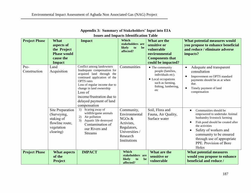
Environmental Impact Assessment of Agbada Non Associated Gas (NAG) Project
187
Appendix 3: Summary of Stakeholders’ Input into EIA
Issues and Impacts Identification Table
Project Phase What
aspects of
the Project
Phase would
cause the
Impact
Impact Which
stakeholders are
likely to be
affected?
What are the
sensitive or
vulnerable
environmental
Components that
could be impacted?
What potential measures would
you propose to enhance beneficial
and reduce / eliminate adverse
impacts?
Pre-
Construction
Land
Acquisition
Conflict among landowners
Inadequate compensation for
acquired land through the
continued application of the
OPTS rates
Loss of regular income due to
change in land ownership
Loss of
income/frustration due to
delayed payment of land
compensation
Communities The community
people (families,
individuals etc).
Local occupations
such as farming,
fishing, lumbering,
etc
Adequate and transparent
consultation
Improvement on OPTS standard
payments should be as at when
due.
Timely payment of land
compensation
Site Preparation
(Surveying,
staking of
flowline route,
vegetation
clearing)
1) Scaring away of
wildlife/game animals
2) Air pollution
3) Aquatic life destroyed
Contamination of
our Rivers and
Streams
Community,
Environmental
NGOs &
Activists,
Regulators,
Universities /
Research
Institutions
Soil, Flora and
Fauna, Air Quality,
Surface water
Communities should be
empowered to undertake Animal
husbandry livestock farming
Fish pond should be created after
the activities
Safety of workers and
community to be ensured
through use of appropriate
PPE. Provision of Bore
Holes
Project Phase What aspects
of the
Project
IMPACT Which
stakeholders are
likely to be
affected?
What are the
sensitive or
vulnerable
What potential measures
would you propose to enhance
beneficial and reduce /

Environmental Impact Assessment of Agbada Non Associated Gas (NAG) Project
188
Project Phase What
aspects of
the Project
Phase would
cause the
Impact
Impact Which
stakeholders are
likely to be
affected?
What are the
sensitive or
vulnerable
environmental
Components that
could be impacted?
What potential measures would
you propose to enhance beneficial
and reduce / eliminate adverse
impacts?
Phase would
cause the
Impact
environmental
Components that
could be impacted?
eliminate adverse impacts?
Mobilization
(Movement of
equipment &
personnel to
site)
1) Roads may be
damaged
2) Increase Accident
rates.
3) Increase in
population
4) Increase in social
vices
Community
Company and
other road users
Social Amenities /
infrastructure
Demography
Air quality and noise
levels increase
Community Health
Effect repairs to damaged roads
Create awareness
Adequate road signs
Proper Journey management
Use local labour
Awareness/Enlightenment
campaigns on social and health
issues
Construction
ROW Clearing
Loss of Vegetation Community Flora and Fauna,
Air quality, surface
water and aquatic life
Limit clearing to ROW only
Trench
Excavation
- Effect on wildlife from
noise and vibration of
machinery
- Impacts on Air Quality
- Enhanced Employment
opportunities
Communities
Workers,
Environmental
Activists/NGOs
- Farm land
- Vegetation
(Economic Trees)
- Social life
- Community Health
Water bodies
Timely Back filling and use of
properly serviced machinery to
reduce noise /vibration
Timing of activity; use of water
sprinklers to reduce dust
- Put all safety measures in

Environmental Impact Assessment of Agbada Non Associated Gas (NAG) Project
189
Project Phase What
aspects of
the Project
Phase would
cause the
Impact
Impact Which
stakeholders are
likely to be
affected?
What are the
sensitive or
vulnerable
environmental
Components that
could be impacted?
What potential measures would
you propose to enhance beneficial
and reduce / eliminate adverse
impacts?
place
- Adequate compensation
- Use skill personnel specially
in the use of technical
equipment
Project Phase What aspects of
the Project
Phase would
cause the Impact
IMPACT Which
stakeholders
are likely to be
affected?
What are the
sensitive or
vulnerable
environmental
Components that
could be impacted?
What potential measures
would you propose to
enhance beneficial and
reduce / eliminate adverse
impacts?
Construction
(contd.)
Pipe welding, Joint
coating, inspection
and testing of welds
Radiographic testing of
welds operation affects
work force
Communities,
Workforce
Humans Adequate compensation
Provision of Medical care
Lowering and
backfilling
Air pollution
Noise
Communities and
Work force
Humans Use of PPE
-Operational Timeliness
-Public Enlightenment
Camp site
construction
Loss of Vegetation
-Waste generation
-Spread of STDs
Communities
Work force
Flora and Fauna
Environmental health
Routine Medical check of
workers
Proper waste management

Environmental Impact Assessment of Agbada Non Associated Gas (NAG) Project
190
Project Phase What aspects of
the Project
Phase would
cause the Impact
IMPACT Which
stakeholders
are likely to be
affected?
What are the
sensitive or
vulnerable
environmental
Components that
could be impacted?
What potential measures
would you propose to
enhance beneficial and
reduce / eliminate adverse
impacts?
Drilling
Well
locations/Contrac
tors camp site
Drilling of new
wells
Laying of new
flowlines
Employment
opportunities
Provision of
infrastructure/
sustainable development
Creation of
subcontractors
Pollution of soil and
water
Ozone layer depletion
Increase in prostitution
Communities
Workers
Soil
- Humans
- Water
Conduct EIA
Proper evacuation of waste
materials
Compensation to affected
communities
Project Phase What aspects of
the Project
Phase would
cause the
Impact
IMPACT Which
stakeholders are
likely to be
affected?
What are the
sensitive or
vulnerable
environmental
Components that
could be
impacted?
What potential measures
would you propose to
enhance beneficial and reduce
/ eliminate adverse impacts?
Operation Operational /
maintenance
venting and
occasional flaring
Operational job
opportunities
Health Hazards
Employment
Communities
Work force
Communities
Air
Humans
Reduce Venting and Flaring to
ALARP
Employ /Train Communities
members as much as possible

Environmental Impact Assessment of Agbada Non Associated Gas (NAG) Project
191
Project Phase What aspects of
the Project
Phase would
cause the
Impact
IMPACT Which
stakeholders are
likely to be
affected?
What are the
sensitive or
vulnerable
environmental
Components that
could be
impacted?
What potential measures
would you propose to
enhance beneficial and reduce
/ eliminate adverse impacts?
Decommissioning
and Abandonment
Abandonment of
NAG plant and
associated facilities,
Wells, flowlines etc
Health hazards
Unemployment
Land wastage
Waste of
resources
Waste Generation
Communities
Air ,
Soil ,
water,
Social life
- Stakeholders should be
engaged before
decommissioning to agree on
plan.
- Use of best available
technology for
decommissioning
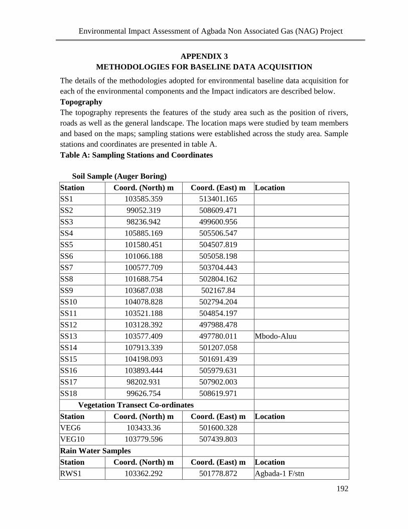
Environmental Impact Assessment of Agbada Non Associated Gas (NAG) Project
192
APPENDIX 3
METHODOLOGIES FOR BASELINE DATA ACQUISITION
The details of the methodologies adopted for environmental baseline data acquisition for
each of the environmental components and the Impact indicators are described below.
Topography
The topography represents the features of the study area such as the position of rivers,
roads as well as the general landscape. The location maps were studied by team members
and based on the maps; sampling stations were established across the study area. Sample
stations and coordinates are presented in table A.
Table A: Sampling Stations and Coordinates
Soil Sample (Auger Boring)
Station Coord. (North) m Coord. (East) m Location
SS1 103585.359 513401.165
SS2 99052.319 508609.471
SS3 98236.942 499600.956
SS4 105885.169 505506.547
SS5 101580.451 504507.819
SS6 101066.188 505058.198
SS7 100577.709 503704.443
SS8 101688.754 502804.162
SS9 103687.038 502167.84
SS10 104078.828 502794.204
SS11 103521.188 504854.197
SS12 103128.392 497988.478
SS13 103577.409 497780.011 Mbodo-Aluu
SS14 107913.339 501207.058
SS15 104198.093 501691.439
SS16 103893.444 505979.631
SS17 98202.931 507902.003
SS18 99626.754 508619.971
Vegetation Transect Co-ordinates
Station Coord. (North) m Coord. (East) m Location
VEG6 103433.36 501600.328
VEG10 103779.596 507439.803
Rain Water Samples
Station Coord. (North) m Coord. (East) m Location
RWS1 103362.292 501778.872 Agbada-1 F/stn

Environmental Impact Assessment of Agbada Non Associated Gas (NAG) Project
193
Station Coord. (North) m Coord. (East) m Location
RWS2 103358.116 506020.117 Agbada-2 F/stn
Profile Pit Coordinates
Station Coord. (North) m Coord. (East) m Location
PF1 102708.379 501589.42 Agbada-1 F/stn
PF2 99748.27 507840.689 Rumuchiolu-Eneka
Boreholes Coordinates
Station Coord. (North) m Coord. (East) m Location
BH1 103340.908 501726.443 Agbada-1 F/stn
BH2 100945.468 504096.589 Nkpoku manifold
BH3 103076.422 505798.164 Agbada-2 F/stn
Air Quality Coordinates
Station Coord. (North) m Coord. (East) m Location
AQ1 103433.36 501600.328
AQ2 106100.994 506523.758 Igwuruta
AQ3 103779.596 507439.803
AQ4 102860.264 497044.994 Umu-ahunwa Aluu
AQ5 112650.203 494880.88 Rumu-ogwu
Economic/Social/Health Quality & Infrastructures' Coordinates
Station Coord. (North) m Coord. (East) m Location/Description
Rukpokwu 100395.135 504292.549 Rukpokwu Portable Water
100450.341 504332.729 Rukpokwu Mosque
100453.302 504382.035 Rukpokwu Shrine
100219.843 504375.348 Rukpokwu Church
100140.2 504273.488 Rukpokwu School
Omuigwe 104316.558 496999.132 Omuigwe Indoor Air Quality
103411.299 497872.056 Omuigwe Church & School
104095.024 497143.424 Omuigwe Town Hall
Mbodo 103512.579 499228.016 Mbodo-Aluu Hall

Environmental Impact Assessment of Agbada Non Associated Gas (NAG) Project
194
Climate/Meteorology
Meteorological information namely wind speed, wind direction, humidity and
temperature were acquired during the fieldwork from predetermined locations within the
proposed project area. The measurements of the various meteorological parameters were
carried out using portable in situ equipment. The information obtained was supported
with data from the Port Harcourt Zone of the Nigeria Meteorological Agency.
The entire study area was traversed using a vehicle and in most cases by foot. The
distribution and pattern of the physical features defining the terrain in the project area
was the basis of landscape description and assessment. Physiographic or land system
approach was used to identify the units forming the terrain.
Air Quality
A total of five air quality-sampling stations were established in the study area. The
sampling stations were established based on upwind and downwind directions. The
measurements of the various air quality parameters were carried out using in situ
equipment (Digital Gas monitors).
Plate A: Air quality measurement during the field exercise

Environmental Impact Assessment of Agbada Non Associated Gas (NAG) Project
195
TABLE B: ENVIRONMENTAL COMPONENTS AND IMPACTS INDICATORS
S/NO ENVIRONMENTAL
COMPONENTS
ENVIRONMENTAL IMPACT INDICATORS
1.
2.
3.
4.
5.
6.
7.
Relief / Topography & Hydrology
Air Quality, Climate and
Meteorology
Geology / Hydrogeology
Soil, Agriculture & Land Use
Vegetation / Forestry
Wildlife
Noise / Vibration / Radiation
Drainage / Discharge, Hydrologic balance,
soilation, erosion, topography.
SPM, NOx, SOx, CO2, CO, NH3VOC, etc., Wind
speed & direction, Relative humidity, Rainfall,
cloud, etc
Borehole drilling for Stratigraphical / Lithologic
characteristics, ground water level, direction and
quality (Physicochemical and microbiological
characteristics).
Soil type and structure, physico-chemical and
microbiological characteristic land use types;
recreational, industrial, agricultural, residential,
institutional and commercial. Species checklist,
characterization of plant pollution, taxonomy,
diversity and productivity load, locations and
characteristics.
Identification of types and economic importance of
trees in the study area.
Identification of wildlife types, parks, estimate
population, behavioral pattern and habitat
requirement; endangered species and ecological
interactions.
Ambient noise level, exposure limits of impulsive
and persistent noise generated in the environment,
the proximity of noise sources to human and
ecological habitants; day and night disturbance,
hearing loss communication interference.

Environmental Impact Assessment of Agbada Non Associated Gas (NAG) Project
196
S/NO ENVIRONMENTAL
COMPONENTS
ENVIRONMENTAL IMPACT INDICATORS
8.
9.
0.
Health Risk Assessment
Community / Socio-Economic
Impact Assessment
Waste Management
Health risks, public health and medical services,
water supply and demand, analysis of medical
records.
Needs and concern of host communities, Data on
settlement, man-made features, socio-economic /
historical rites, population, income, recreational
facilities, social organizations and institutions,
occupation and employment structure, culture,
heritage, etc.
Waste streams, handling, treatment and disposal,
etc.
Noise and Vibration
Noise levels were measured at the same locations where air quality parameters were
taken using a sound indicator model Cs 15C decibel noise meter. Readings were taken
after allowing the meter to stabilize at each point. The range of the noise level was noted
and the true mean computed.
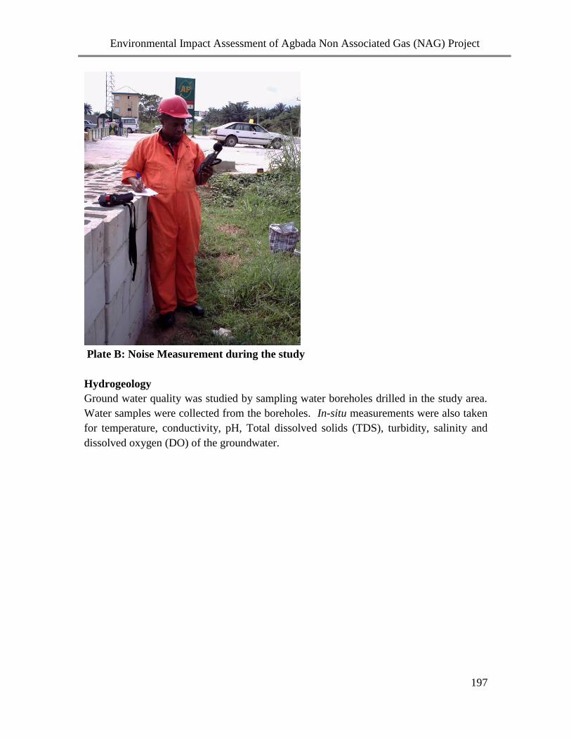
Environmental Impact Assessment of Agbada Non Associated Gas (NAG) Project
197
Plate B: Noise Measurement during the study
Hydrogeology
Ground water quality was studied by sampling water boreholes drilled in the study area.
Water samples were collected from the boreholes. In-situ measurements were also taken
for temperature, conductivity, pH, Total dissolved solids (TDS), turbidity, salinity and
dissolved oxygen (DO) of the groundwater.

Environmental Impact Assessment of Agbada Non Associated Gas (NAG) Project
198
Plate C: One of the boreholes being drilled
Land Use
Land use study was conducted by undertaking a walk-through of the entire study area.
Observations were made of land cover/land use systems, crops and built up areas.
Vegetation/Forestry
Vegetation sampling was undertaken in designated sampling loations (VEG 1 and VEG
2). At both sampling location, plants were identified from 20m x 20m quadrats.
Unidentified plants were collected for mounting and identification later in the University
of Calabar herbarium. For each station information on habitat, vegetation structure and
species was recorded. Habitat data include vegetation description, latitude, longitude and
signs of wildlife. Vegetation structure (biomass stratification) is described in terms of
heights of plants, which have grouped into ground layer (less than 2 m), shrub layer (2-5
m) and tree layer (more than 5m). A pair of binoculars (Model: Helios Fieldmaster 8 x
40) was employed to aid field identification of tall trees. Dendrometric parameters
recorded included height (m) and diameter (cm) of trees. Abundance of herbaceous
genera is expressed semi-quantitatively (dominant, frequent, occasional, rare) (Pryor,
1981). On this basis a species having a wide distribution with many stands would be
classified as a common, abundant, widespread species. Alternatively, a species may have
a similarly wide distribution but with very few stands and would be classified as an
infrequent, restricted or occasional species. Species of limited geographic distribution and
with a few stands are classified as rare. Some species are considered rare where little is
known about their distribution. Features of ecological interest will be recorded with a
digital camera (Sony DCR- TRV 340).

Environmental Impact Assessment of Agbada Non Associated Gas (NAG) Project
199
Vegetation was also observed for any health defects. Samples of diseased plants
were taken in polythene bags to the laboratory for analysis. Samples of diseased
plants were examined microscopically and cultured on Agar plates using the surface
spreading plate technique. Fungal and bacterial pathogens were identified
microscopically using such features as cultural morphology and pigmentation.
Foliar samples from representative plant species were used for tissue analysis. Samples
were cut up and dried, for 48 hours, to constant weight in an oven at 70 oC. The dried
tissue sample was ground into a fine powder and 0.5 g digested by boiling in 10 ml of a
1:2 mixture of nitric and hydrochloric acids in a fume hood. The resulting solution was
diluted to 50 ml with distilled water, filtered and the chemical composition analyzed by
atomic absorption spectrophotometry.
Plate D: Vegetation sample being collected for further studies
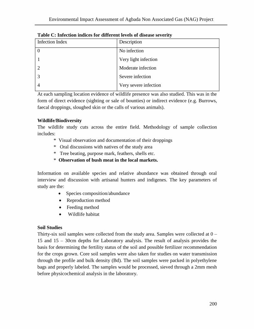
Environmental Impact Assessment of Agbada Non Associated Gas (NAG) Project
200
Table C: Infection indices for different levels of disease severity
Infection Index Description
0
1
2
3
4
No infection
Very light infection
Moderate infection
Severe infection
Very severe infection
At each sampling location evidence of wildlife presence was also studied. This was in the
form of direct evidence (sighting or sale of bounties) or indirect evidence (e.g. Burrows,
faecal droppings, sloughed skin or the calls of various animals).
Wildlife/Biodiversity
The wildlife study cuts across the entire field. Methodology of sample collection
includes:
* Visual observation and documentation of their droppings
* Oral discussions with natives of the study area
* Tree beating, purpose mark, feathers, shells etc.
* Observation of bush meat in the local markets.
Information on available species and relative abundance was obtained through oral
interview and discussion with artisanal hunters and indigenes. The key parameters of
study are the:
Species composition/abundance
Reproduction method
Feeding method
Wildlife habitat
Soil Studies
Thirty-six soil samples were collected from the study area. Samples were collected at 0 –
15 and 15 – 30cm depths for Laboratory analysis. The result of analysis provides the
basis for determining the fertility status of the soil and possible fertilizer recommendation
for the crops grown. Core soil samples were also taken for studies on water transmission
through the profile and bulk density (Bd). The soil samples were packed in polyethylene
bags and properly labeled. The samples would be processed, sieved through a 2mm mesh
before physicochemical analysis in the laboratory.

Environmental Impact Assessment of Agbada Non Associated Gas (NAG) Project
201
Plate E: Soil Sampling using an Auger
Plate F: A soil profile pit dug during the field exercise
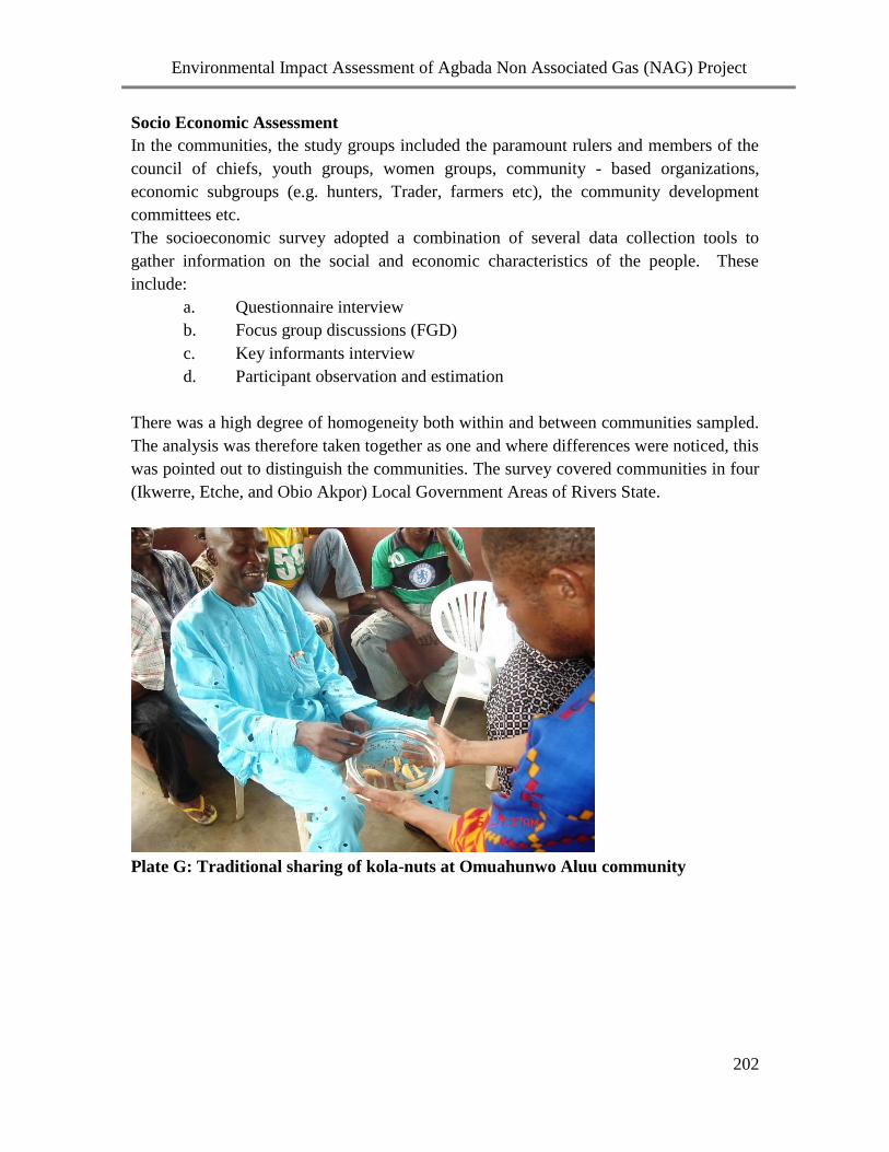
Environmental Impact Assessment of Agbada Non Associated Gas (NAG) Project
202
Socio Economic Assessment
In the communities, the study groups included the paramount rulers and members of the
council of chiefs, youth groups, women groups, community - based organizations,
economic subgroups (e.g. hunters, Trader, farmers etc), the community development
committees etc.
The socioeconomic survey adopted a combination of several data collection tools to
gather information on the social and economic characteristics of the people. These
include:
a. Questionnaire interview
b. Focus group discussions (FGD)
c. Key informants interview
d. Participant observation and estimation
There was a high degree of homogeneity both within and between communities sampled.
The analysis was therefore taken together as one and where differences were noticed, this
was pointed out to distinguish the communities. The survey covered communities in four
(Ikwerre, Etche, and Obio Akpor) Local Government Areas of Rivers State.
Plate G: Traditional sharing of kola-nuts at Omuahunwo Aluu community

Environmental Impact Assessment of Agbada Non Associated Gas (NAG) Project
203
Plate H: Focus group discussion with women group in the study area
Consultations
The consultation exercise involved an explanation of the proposed field development
project and the mission of the consultants as well as introduction of the team members to
the village chiefs and council members. The consultation process was very similar in the
communities visited.
Health Survey
The communities of the study area regarding the proposed project were surveyed for
baseline health situation and availability of health services.
The following techniques were adopted for the study:
o Focus group discussions and community consultations
o Community health surveys through interviews and administration of
questionnaires,
o On the spot observation and visual appraisal,
o Use of relevant health center statistics, and
o Experience and professional judgment of the consultant.
Questionnaires were distributed to literate members of the host communities. Those who
were not literate were interviewed.

Environmental Impact Assessment of Agbada Non Associated Gas (NAG) Project
204
Water and Sediment Chemistry
Total Dissolved Solid (TDS)
Total Dissolved Solid was measured using Nyron calibrated TDS meter with range of 0-
100,000ppm.
Conductivity
pH:
The pH was measured with Ele pH meter.
Turbidity
Turbidity measurement was carried out in situ with Hach turbidity with sensitivity of 0-
1000 NTU
Chloride
Chloride was measured titrimetrically (Argentometric Method) in slightly alkaline
solution with silver nitrate (AgNO3) solution in the presence of potassium chromate as
indicator (APHA, 1975). Prior to sample analyses the silver nitrate is standardized with
sodium chloride.
Oil and Grease
Oil and grease in water was measured, after pre-extracting 100 ml sample with 10.0 ml
carbon tetrachloride, using a Horiba Oil Content Analyzer (OCMA-200, range 0-100
ppm).
Total Suspended Solid
100ml of sample was filtered through a pre-weighted filter paper using Buckner flask and
suction pump. The filter paper was dried in an oven at about 1030c – 105
0c for 1 hour and
coked in a dessicator. The TSS was then calculated after reweighing.
Dissolved Oxygen
Dissolved Oxygen was measured in-situ using YS1 model 54A oxygen meter.
Biochemical Oxygen Demand
A known volume of the sample was treated with dilution water containing nutrients to
one litre mark and the initial DO recorded. Some portion of the diluted sample was
incubated for 5 days at 200C. The final DO was measured after the incubation. The initial
DO minus final DO and divided by the dilution decimal fraction gave the BOD result in
mg/l.

Environmental Impact Assessment of Agbada Non Associated Gas (NAG) Project
205
Chemical Oxygen Demand
The sample (50ml) and standardized dichromate solution in a 5% by volume sulphuric
acid/silver sulphate is refluxed for a 2-hour digestion period. Excess dichromate, after the
digestion period, is titrated with a standard ferrous ammonium sulphate solution, using
ortho-phenanthroline ferrous complex as indicator.
Total Hydrocarbon Content
The spectrophotometric method was adopted using SPEC-20 genesys for measuring oil
and grease. This involved extraction of the oil and grease from 500ml of sample with
50ml of xylene in a separatory flask. The extract was measured at 500nm using 10mm
unit path length.
Total Hardness
Total hardness was determined by EDTA Titrimetric method using Eriochrome Black T
as indicator. EBT was added to a portion of the sample at a pH of 10.0+0.1 and titrated
with EDTA solution to blue coloured end point.
Sulphate
The turbidimetric method was used for measuring the concentration of sulphate in a
portion of the sample. The sulphate reacts with Barium ion in the presence of sodium
chloride – hydrochloric acid solution containing glycerol and ethyl alcohol. The turbidity
so developed was measured at 450nm.
Phosphate
Ascorbic acid reduction method was adopted in determining the phosphate concentration
in the sample. Ammonuim molybdate and antimous potassium tartrate react with
orthophosphate to form an antimony phosphate-molybdate complex. The complex is
reduced with ascorbic acid to form a deep-colored, blue molybdeuum complex. The
colour intensity is proportional to the phosphate concentration, which is measured at a
wavelength of 880nm using 25mm cell.
Nitrate
Brucine method was used for nitrate concentration determination in the sample. The
reaction between nitrate and brucine produces a yellow colour that is used for
colorimetric estimation of nitrate. The intensity of colour is proportional to the nitrate
concentration and measured at a wavelength of 410nm using 25mm cell.

Environmental Impact Assessment of Agbada Non Associated Gas (NAG) Project
206
Heavy Metals
Heavy Metals concentrations were determined using Unican Atomic Absorption
Spectrophotometer (AAS). The concentrations of the metals were recorded by aspirating
the filtered samples directly with no chemical pretreatment.
Ammonium
Nesslerization method was used for measuring ammonia concentration. 50ml samples or
a portion diluted to 50ml with ammonia-free water treated with nessler reagent and allow
the reaction to proceed for at least 10min after addition of nessler reagent. The
concentration was measured photometrically at a wavelength of 425nm.
Soil Analysis(Soil mechanical analysis (percentage sand, silt and clay)
Hydrometer method was used to determine the percentage of sand, silt and clay in the air-
dried soil sample. 51.0 of silt sieved sample was treated with 5% sodium
hexametaphosphate along with 100ml of distilled water. The mixture was stirred
severally and allowed to settle in a glass cylinder and soil hydrometer was immediately
placed into the suspension.
Total Organic Carbon (Walkley Black)
1g of sample was weighed each into a 250ml standard volumetric flask. A known
volume of standard solution of potassium dichromate was added accurately
followed by the addition of a known volume of concentrated sulphuric acid. The
sample and reagents were immediately mixed and the content allowed to stand for
30 minutes. The contents after 30 minutes were diluted with 100ml each of distilled
water. Three to four drops of Ferroin indicator was added and titrated against a
standard solution of ferrous sulphate. A blank titration was carried out in the same
manner (but without soil). Results obtained were then calculated for total organic
carbon.
Bulk Density – core method (Vomocil)
A core, 10cm long, 8cm internal diameter was used to collect core sample. The core
sample was oven-dried at 1050C to a constant weight. Bulk density was obtained
from mass-volume relationship.
Particle Density – Pycnometer method (Blake, 1965)
Air-dried, 2mm sieved soil sample was used for the determination. The sample was
boiled with distilled water to remove air in the pycnometer bottle. Boiled and
cooled distilled water was added to the content of the bottle after cooling. The bottle
and content were weighed. The particle density of the soil was calculated as the
Environmental Impact Assessment of Agbada Non Associated Gas (NAG) Project
207
ratio of the total mass of the solid particles to their total volume excluding pore
spaces between particles.
Total porosity (Vomocil)
This was calculated from particle and bulk densities.
Alkaline/Alkaline – earth Metals (Na, k, Ca & Mg)
5g of sample was extracted with three times ammonium acetate buffer solution. The
entire extract was made up to a known volume and used to analyze for Na and K
using a flame photometer (Corning 410) and AAS model 320 was used to measure
calcium and magnesium.
Cation exchangeable Capacity (CEC)
This was obtained from the summation of the results obtained from Na, K, Ca, Mg
and exchangeable acidity. Results were expressed in Meq/100g.
Moisture Content
The homogenate was mixed with a spoon for at least 20s, especially taking care to scrape
the walls and the bottom. About four grams of sediment was added accurately to the
petri dish. Drying at 1050C was carried out until constant weight was obtained. The
fraction of dry sediment in the sample was then determined.
Heavy Metals: Dutch Standard Methods Draft NVN 5770 (leaching), draft NEN
6426 (metals, exclusive mercury), NEN 6449 (Mercury)
Sample Extraction: The physical condition of the sample was noted together with the
odour detected. Approximately 5g of soil was placed in a Teflon pressure vessel, a
mixture of 18ml hydrochloric acid and 6ml nitric acid was added. The vessel was heated
for 150 minutes till 180oC. The sample was cooled for 30 minutes. The extract was
filtered over a paper and added up to 100ml with de-ionised water.
Sample Analysis: Samples were analysed for Ni, V, Pb, Fe, Cr, Zn, Cd, Mn and Cu using
the AAS-flame technique (ASTM – D1886, E885, D3559, D2972, D1068, D1687,
D3223, D3651, D1687, D3557, D3866 respectively.
pH/Conductivity (Electrometric)
20g of sieved air dried soil sample was treated with 20ml of distilled water and allowed
to stand for 30 minutes and stirred occasionally with glass rod. Calibrated Ele pH meter

Environmental Impact Assessment of Agbada Non Associated Gas (NAG) Project
208
was used to measure the pH and a Hach conductivity meter for conductivity
measurement.
Chloride
A known weight of soil was measured and soaked in a known volume of water with
an occasional stirring. A known volume of extract was then analyzed by Mohr’s
method using direct titration against standard silver nitrate, with potassium
chromate as the indicator. The results obtained was then used to calculate for
chloride.
Available Phosphate
Bray No.1 method was adopted, 1g of air-dried soil sample was treated with 7ml of the
extracting solution and centrifuged for 15 minutes. 2ml of the clear supernatant was
treated with 2ml of ammonium molybdate solution and 1ml of stannous chloride. %
transmittance was measured after 5 minutes at a wavelength of 660nm.
Total Hydrocarbon Carbon (THC)
5g of air-dried soil sample was soxhlet-extracted with distilled xylene for 3 hours.
The extract was made up to a known volume after cooling and the absorbance
measured at 420nm. Results obtained were compared with reference calibration
curve, which was prepared using crude oil.
Nitrate
5g of air-dried soil sample was treated with activated carbon and extracting solution. 1ml
aliquot of the soil extract was transferred to a vial and treated with brucine reagent and
conc. Sulphuric acid and mixed with 2ml of distilled water added and contents allowed to
set for 15mins and transmittance measured with spectronic – 20 Genesys at 470nm.
Microbiological Analysis
Preparation procedure
The glasswares were sterilized in hot oven at 160ºC for 1 hour and media in the
autoclave at 121ºC, 15 Pascal for 15 minutes. The bench was swabbed with absolute
ethanol. 0.85% normal saline was prepared and used for serial dilution of the samples
(9ml normal saline + 1ml sample or 1g sample in 9ml normal saline for soil and sediment
samples.
Total Heterotrophic Bacteria Count (THBC) APHA 9215B
28g of nutrient agar media was dissolved in 1litre of distilled water. The media was
sterilized in the auto-clave at 121ºC and 15 Pascal for 15minutes and allowed to cool to
Environmental Impact Assessment of Agbada Non Associated Gas (NAG) Project
209
47ºC and poured into sterilized petri dishes. The surface of the poured media was flamed
with Bunsen burner flame allowed to solidify.
The surface of the media was dried in the hot air oven at 40ºC for 5minutes and the
sample was inoculated using pour plate method and incubated at 37ºC in Incubator for 24
hours. The colonies in the plate were counted and the total heterotrophic bacteria
recorded.
Total Heterotrophic Fungal Count (THFC) APHA 9610C
65g of Sabouraud Glucose Agar media was dissolved in 1litre of distilled water and the
media sterilized in the autoclave at 121ºC and 15Pascal for 15 minutes. The media was
allowed to cool to 47ºC and chloramphenicol capsule was added into the media and
stirred to mix (this chloramphenicol is used to prevent the growth of bacteria. The media
was poured into sterilized petri dishes and the surface of the poured media was flamed
and allowed to solidify. The surface of the solidify media was dried in the hot air oven at
40ºC for 5 minutes. The sample was inoculated using pour plate method and incubated
at 20ºC in Incubator for 48 hours. The colonies in the plate were counted and the total
number of hetero-tropic fungi recorded.
Hydrocarbon Utilizing Bacteria Count (HUBC) APHA 9215C
The following reagents were weighed out : 0.42g of MgSO4.7H2O, 6.28g of KCl 1.25g
of KH2(PO4), 0.83g of K2HPO4, 0.42g of NH4NO3, 10-20g of NaCl, 15g of Agar-Agar
and dissolved in 1litre of distilled water. The media was sterilized in the auto-clave at
121ºC and 15 Pascal for 15 minutes and allowed to cool to 47ºC. The media was poured
into sterilized petri dishes. The surface of the poured media flamed with Bunsen burner
and allows to solidify. The surface of the media was dried in the hot air oven at 40ºC for
5minutes. The sample was inoculated using pour plate method and incubated at 37ºC in
incubator for 14days. The colonies in the plate were counted and the total number of
hydrocarbon utilizing bacteria recorded.
Note: Before incubation, one-quarter size of Watman filter paper was soaked in crude oil
and placed on the cover of the petri dish and the plate inverted while incubating
Hydrocarbon Utilizing Fungi Count (HUFC) APHA 9610C
The following reagents were weighed out; 0.42g of MgSO4.7H2O, 6.28g of KCl 1.25g of
KH2(PO4), 0.83g of K2HPO4, 0.42g of NH4NO3, 10-20g of NaCl 15g of Agar-Agar
dissolve all these in 1litre of distilled water. The media was sterilized in the auto-clave at
121ºC and 15 Pascal for 15 minutes and allowed to cool to 47ºC. 250mg of
chloramphenicol capsule was added into 1litre of the media and stirred to mix (this
chloramphenicol prevent the growth of bacteria) The media was poured in sterilized petri

Environmental Impact Assessment of Agbada Non Associated Gas (NAG) Project
210
dishes, the surface of the poured media. Flamed with Bunsen burner and allowed to
solidify. The surface of the media dried in hot air oven at 40ºC for 5 minutes. The sample
was inoculated using pour plate method and incubated at 20-25ºC for 14 days. The
colonies in the plate were counted and the total number of hydrocarbon utilizing fungi
recorded.
Note: before incubation one- quarter size of watman filter paper was soaked in crude oil
and placed on the cover of the petri dishes and the plate inverted while incubating. The
media is called mineral salt media. Samples from offshore have high salt content and
media for HUB and HUF are salt media, hence the need to acidify the media. The
acidification help to raise the pH of media for bacteria and fungi growth. This is done by
adding 0.1ml of H2SO4 to the media.
Total Coliform Count APHA 9215B
48.5g of MacConkey agar media was dissolved in 1litre of distilled water.
The media was sterilized in the auto-clave at 121ºC and 15 Pascal for 15minutes and
allowed to cool to 47ºC. The media was poured into sterilized petri dishes and the surface
of the poured media flamed and allowed to solidify. The surface of the media was dried
in the hot air oven at 40ºC for 5minutes. The sample was inoculated using pour plate
method and incubated 37ºC in Incubator for 24 hours for bacteria. The colonies in the
plate were counted and the total number of coliform recorded.
Quality Assurance/Control Measures Adopted for the Sampling
Sample Collection
Standard procedure adopted for sample collection involved:
Obtaining a representative portion of the material concerned, and which
represents the conditions existing at the point taken and time of sampling.
Samples were of sufficient volume to permit reproducibility of testing requisites
for the desired objectives.
Samples were preserved prior to analysis in a manner that safeguards against
change in the particular constituents or properties to be examined.
Contact with any material other than the original container was avoided to prevent
possible contamination or alteration on the sample quality.
Before obtaining water sample, containers were rinsed out two to three times with
the seawater being collected.
Sample containers were made of materials that cannot be contaminated. The
containers were cleaned thoroughly to remove all extraneous surface dirt before
use. These included glass bottles and metal containers with cap for hydrocarbon

Environmental Impact Assessment of Agbada Non Associated Gas (NAG) Project
211
oil and grease analysis, rigid and collapsible plastic containers of polyethylene for
others.
Sample Labeling
Adhesive sample label were affixed onto each sample bottle or container. The following
information was written in an indelible marker on the label.
Sample number.
Date and time of sampling.
Point of sampling
Types and quantity of preservatives added.
Signature of sampler.
Sample Storage & Transport
As required, all samples were suitably contained to preserve their quality during
transportation from field to the laboratory. Samples were stored in appropriate
containers and stored in the vessel freezers.
Sample Custody
Samples were placed immediately in a cooling box and transported to the laboratory.
Sample handling and preservation conformed to DPR standards as shown in Table D.
Table D: Recommended Preservatives and Sample Storage
S/N PARAMETER REQUIRED
(ML)
CONTAINER PRESERVATI
ON
MAXIMU
M
HOLDING
PERIOD
1. PH 35 P,G Cool, 4 0C Det.
On site
6 hours
2. Electrical
Conductivity
100 P,G Cool, 4 0C 24 hours
3. Colour 50 P,G Cool, 4 0C 24 hours
4. Odour 200 G, only Cool, 4 0C 24 hours
5. Turbidity 100 P,G Cool, 4 0C 7 days
6. Total Dissolved
Solids (TDS)
50 - Filter on site
cool 4 0C
24 hours
7. Total Suspended
Solid
50 - Filter on site 6 months
8. Total Hardness 100 P,G Cool, 4 0CHNO3
To pH <2
7 days

Environmental Impact Assessment of Agbada Non Associated Gas (NAG) Project
212
S/N PARAMETER REQUIRED
(ML)
CONTAINER PRESERVATI
ON
MAXIMU
M
HOLDING
PERIOD
9. Acidity and
alkalinity
100 P,G Cool, 4 0C 24 hours
10. Salinity as Cl 50 P,G None required 7 days
11. Chemical Oxygen
Demand
50 P,G 2ml H2SO4 per
litre
7 days
12. Biochemical
Oxygen Demand
(BOD)
1,000 P,G Refrigeration at
4 0C
6 hours
13. Surfactants as
(MBAS)
250 P,G Cool, 4 0C 24 hours
14. Dissolved
Oxygen (DO)
300 G, only Det. On site No holding
15. Ammonia 400 P,G Cool, 4 0C
H2SO4 or pH<2
24 hours
16. Oil and Grease 1,000 G, only Cool, 4 0C
H2SO4 or pH<2
24 hours
17. Nitrate NO3 100 P,G Cool, 4 0C
H2SO4 or pH<2
24 hours
18. Sulphate (SO2/4) 50 P,G Cool, 4 0C 7 days
19. Carbonate (CO3)
free CO2 & HCO3
- P,G - -
20.
Cyanides 500 P,G Cool, 4 0C
NaOH to pH 12
24 hours
21. Phosphorous - - 40mg, HgCL2
per litre 40C
7 days
22. Phenolics 500 G, only Cool, 4 0C
H2SO4 or pH<
41.g CuSO4/ litre
24 hours
23. Chromium 100 P,G HNO3 to pH<2 -
24. Arsenic 100 P,G HNO3 to pH<2 6 months
25. Cadmium 100 P,G HNO3 to pH<2 6 months
26. Cobalt - P,G HNO3 to pH<2 6 months
27. Copper - P,G HNO3 to pH<2 6 months
28. Iron - P,G HNO3 to pH<2 6 months

Environmental Impact Assessment of Agbada Non Associated Gas (NAG) Project
213
S/N PARAMETER REQUIRED
(ML)
CONTAINER PRESERVATI
ON
MAXIMU
M
HOLDING
PERIOD
29. Mercury 100 P,G Filter, HNO3 to
pH<2
38 days
(GLASS)
Lead 100 P,G HNO3 to pH<2 6 months
30. Nickel 100 P,G HNO3 to pH<2 6 months
31. Zinc 100 P,G HNO3 to pH<2 6 months
32. Vanadium 100 P,G HNO3 to pH<2 6 months
33. Calcium 100 P,G None required 6 months
34. Magnesium 100 P,G 6 months
P = Plastic, G = Glass
Source: Environmental Guidelines and Standards for Petroleum Industry in Nigeria (EGASPIN,
2002), by the Department of Petroleum Resources, Lagos.
Quality Assurance Measures Adopted for Equipment
The following were carried out to ensure that the equipment is in good condition for
generation of quality data:
Field instruments were fully calibrated/standardized and cross-checked before use
and from time to time when in use. This entailed establishing
instruments/equipment operating conditions (supplied by the manufacturer, and
the response validation.
Instrument calibration technique, the validation technique and the results were
recorded in the instrument log.
All instruments were calibrated after each service or repair
Data Review, Validation and Verification
Data Verification was done at several points of the collection and analysis process. Field
data sheets were carefully kept and inspected daily. Data from instrumental and
titrimetric measurements were used to calculate the concentration of the various analytes,
using standardized formula. Data, which do not fall within the expected range, (especially
in relation to water sample) were noted. Laboratory data for wet chemistry were
subjected to analysis to draw attention to the station whose values fell outside the
observed range. Such stations were subjected to further scrutiny during data analysis so
as to provide explanation for the values

Environmental Impact Assessment of Agbada Non Associated Gas (NAG) Project
214
Data Analysis and Reporting
Data Storage and Treatment
The data obtained from the study locations were analysed using appropriate statistics to
bring out the salient points and trends on each location and to establish relationship (s)
between the stations.
Data Evaluation
Raw data obtained from instrumental and titrimetric measurements were used in
calculating the concentration of the various analyses, using standardized formula.
Outliers were identified and deleted from the replicate data before calculation of mean
concentrations.

Environmental Impact Assessment of Agbada Non Associated Gas (NAG) Project
215
APPENDIX 4
Table 1a: Meteorological and Ambient Air Quality for Wet Season
Sampling
point
NO2
ppm
SO2
ppm
H2S
ppm
CO
ppm
CH4
ppm
NH3
ppm
VOC
ppm
SPM
µg/m3
R/H
%
TEMP oC
WS
m/s
WD
AQ 2
25/10/2008
1.00 <0.01 <0.01 4.00 <0.01 <0.01 <0.01 27.00 92.00 26.60 0.60 NE
AQ 3
27/10/2008
0.70 <0.01 0.30 4.00 <0.01 <0.01 <0.01 23.00 69.30 33.60 0.20 SW
AQ1
28/10/2008
0.60 <0.01 <0.01 19.00 <0.01 <0.01 <0.01 25.20 68.20 32.90 0.20 SW
AQ 4
30/10/2008
0.80 <0.01 <0.01 13.00 <0.01 <0.01 0.03 24.90 81.30 32.10 1.00 SW
AQ 5
2/11/2008
0.90 0.03 0.10 6.00 <0.01 <0.01 <0.01 20.50 69.00 32.80 0.50 NE
Table 1b: Meteorological and Air Quality
Sampling
point
NO2
ppm
SO2
ppm
H2S
ppm
CO
ppm
CH4
ppm
NH3
ppm
VOC
ppm
SPM
µg/m3
R/H
%
TEMP oC
WS
m/s
WD
AQ 2
26/01/2009
1.30 <0.01 0.02 8.20 <0.01 <0.01 <0.01 36.00 56.00 32.00 0.00 SW
AQ 5
27/01/2009
0.90 0.03 <0.01 7.00 <0.01 <0.01 <0.01 30.40 51.40 28.30 0.50 SW
AQ 3
27/01/2009
1.70 <0.01 0.04 4.00 <0.01 <0.01 <0.01 30.00 58.50 34.30 0.50 SW
AQ 1
28/01/2009
1.30 <0.01 <0.01 3.00 <0.01 <0.01 <0.01 32.20 58.20 29.50 0.00 SW
AQ 4
28/01/2009
1.90 0.01 0.01 1.80 <0.01 <0.01 <0.01 33.00 53.00 31.00 1.80 SW

Environmental Impact Assessment of Agbada Non Associated Gas (NAG) Project
216
Table 2a: Noise Values for wet season
SAMPLING POINT NOISE dB(A)
1st Reading
NOISE dB(A)
2nd
Reading
NSS 2 43.70 42.90
NSS 3 57.70 55.40
NSS 1 50.00 49.30
NSS 4 52.00 50.90
NSS 5 68.60 59.00
Table 2b: Noise Values for dry season
S/N SAMPLING POINT NOISE dB(A)
1st
NOISE dB(A)
2nd
1. NSS 2 56.40 54.70
2. NSS 5 61.50 50.40
3. NSS 3 33.60 40.00
4. NSS 1 37.40 35.90
5. NSS4 59.30 59.80

Environmental Impact Assessment of Agbada Non Associated Gas (NAG) Project
217
Table 3a
Diversity and relative
abundance of plant
species in Agbada
ID_Point Species Common name Family Count
Trees
(>4 m
height)
Shrubs
(0.5 to
4 m
height)
Trees (>4
m height)
(%)
Height
(m)
Stem
diameter
(cm)
VEG 1 Trees/shrubs
Elaeis guineensis Oil palm tree Arecaceae 8 8 0 38.1 20 30.5
Alstonia booneii Stoolwood Apocynaceae 1 1 0 4.8 7 12.5
Ceiba pentandra Silk cotton Bombacaceae 1 1 0 4.8 20 45.5
Anthocleista vogelii Cabbage tree Potaliaceae 1 1 0 4.8 15 38
Bambusa vulgaris Bamboo Bambusae 3 3 0 14.3 10 11.4
Mallotus oppositifolius
Euphorbiaceae 5 5 0 23.8 5 7.6
Anthonotha macrophylla
Caesalpiniceae 2 0 2 _ _ _
Vitex doniana Black plum Verbenaceae 2 2 0 9.5 7 12.7
Herbs/Weeds
Eleusine indica Bull grass Poaceae Common
Sporobolus pyramidalis Cat's tailgrass Poaceae Common
Panicum maximum Guinea grass Poaceae Common
Eragrostus tremula
Poaceae Common
Costus afer Bush cane Costaceae Common
Smilax kraussiana W. African sarsaparilla Smilacaceae Rare
Sida acuta Broomweed Malvaceae Occasional

Environmental Impact Assessment of Agbada Non Associated Gas (NAG) Project
218
Table 3a
Diversity and relative
abundance of plant
species in Agbada
ID_Point Species Common name Family Count
Trees
(>4 m
height)
Shrubs
(0.5 to
4 m
height)
Trees (>4
m height)
(%)
Height
(m)
Stem
diameter
(cm)
Urena lobata Cadillo Malvaceae Common
Commelina benghalensis Wandering Jew Commelinaceae Rare
Aspilia africana haemorrhage plant Asteraceae Occasional
Emilia coccinea False tassle flower Asteraceae Occasional
Chromolaena odorata Siam weed Asteraceae Common
Mimosa pudica Sensitive plant Mimosaceae Occasional
Crotolaria retusa Rattlebox Papilionaceae Occasional
Ipomoea involucrata Cover crop Convolvulaceae Occasional
Phyllanthus amarus
Euphorbiaceae Rare
Pandiaka heudelotii
Amaranthaceae Abundant
VEG 2 Trees/shrubs
Elaeis guineensis Oil palm tree Arecaceae 6 6 0 37.5 18 30.5
Alchornia cordifolia Christmas bush Euphorbiaceae 6 4 2 25 5 6.5
Manniophyton fulvum
Euphorbiaceae 2 0 2 _ _ _
Anthocleista vogelii Cabbage tree Potaliaceae 1 1 0 6.3 15 17.5
Ceiba pentandra Silk cotton Bombacaceae 1 1 0 6.3 10 19.3
Baphia nitida Cam wood Papilionaceae 2 0 2 _ _ _
Bambusa vulgaris Bamboo Bambusae 6 4 2 25 10 10.5
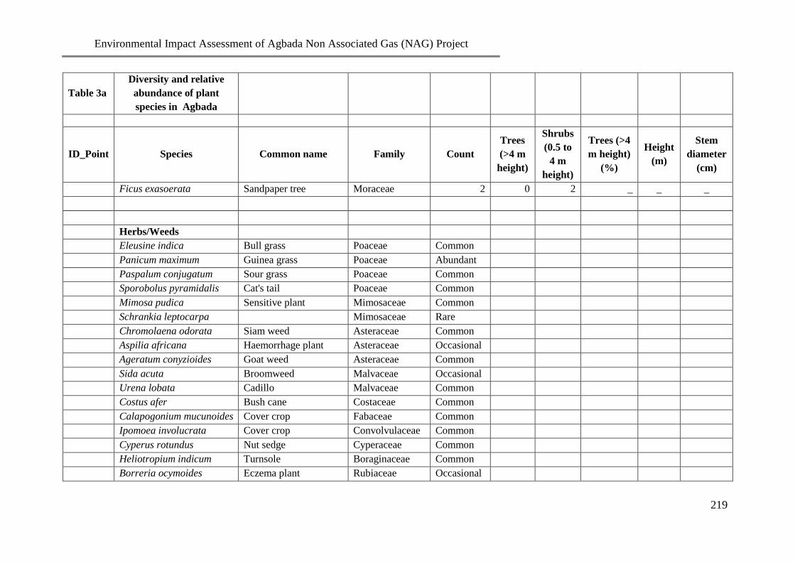
Environmental Impact Assessment of Agbada Non Associated Gas (NAG) Project
219
Table 3a
Diversity and relative
abundance of plant
species in Agbada
ID_Point Species Common name Family Count
Trees
(>4 m
height)
Shrubs
(0.5 to
4 m
height)
Trees (>4
m height)
(%)
Height
(m)
Stem
diameter
(cm)
Ficus exasoerata Sandpaper tree Moraceae 2 0 2 _ _ _
Herbs/Weeds
Eleusine indica Bull grass Poaceae Common
Panicum maximum Guinea grass Poaceae Abundant
Paspalum conjugatum Sour grass Poaceae Common
Sporobolus pyramidalis Cat's tail Poaceae Common
Mimosa pudica Sensitive plant Mimosaceae Common
Schrankia leptocarpa
Mimosaceae Rare
Chromolaena odorata Siam weed Asteraceae Common
Aspilia africana Haemorrhage plant Asteraceae Occasional
Ageratum conyzioides Goat weed Asteraceae Common
Sida acuta Broomweed Malvaceae Occasional
Urena lobata Cadillo Malvaceae Common
Costus afer Bush cane Costaceae Common
Calapogonium mucunoides Cover crop Fabaceae Common
Ipomoea involucrata Cover crop Convolvulaceae Common
Cyperus rotundus Nut sedge Cyperaceae Common
Heliotropium indicum Turnsole Boraginaceae Common
Borreria ocymoides Eczema plant Rubiaceae Occasional

Environmental Impact Assessment of Agbada Non Associated Gas (NAG) Project
220
Table 3a
Diversity and relative
abundance of plant
species in Agbada
ID_Point Species Common name Family Count
Trees
(>4 m
height)
Shrubs
(0.5 to
4 m
height)
Trees (>4
m height)
(%)
Height
(m)
Stem
diameter
(cm)
Pandiaka heudelotii
Amaranthaceae Abundant
Table 3b: Checklist of wildlife species identified in the Agbada project area
Class Family Species Common name Detection
Method Habitat
DECREE
11/1985
NARESCON/
Biodiversity***
Mammalia Cercopithecidae Cercopithecus mona** Mona monkey SH Forest Threatened
Muridae Cricetonys gambianus Giant rat BU Forest Satisfactory
Muridae Rattus rattus Common rat DS House/
Garden Satisfactory
Bovidae Tragelaphus scriptus Bush buck SH Forest Satisfactory
Bovidae Cephalophus maxwelli Maxwell duiker SH Forest Endangered
Bovidae Neotragus batesi Dwarf antelope SH Forest Threatened
Sciuridae Protoxerus strangeri Giant forest tree
squirrel DS Forest Satisfactory
Thryonomidae Atherurus africanus Brush tailed
porcupine SH Forest Threatened
Thryonomidae Thryonomys Cane rat DS Forest Satisfactory

Environmental Impact Assessment of Agbada Non Associated Gas (NAG) Project
221
Class Family Species Common name Detection
Method Habitat
DECREE
11/1985
NARESCON/
Biodiversity***
swinderianus
Canidae Lycaon pictus Hunting dog SH House/ Forest Endangered
Chiroptera Pteropus sp Fruit bat DS Forest Satisfactory
Reptilia Agamidae Agamma agamma Common lizard DS House/
Garden Satisfactory
Boidae Naja melanoleuca Black cobra SH Forest/
Swamp Satisfactory
Viperidae Bitis gabonica SH Forest Rare
Veranidae Veranus
exanthematicus Monitor lizard SH Forest/Garden Endangered
Pythonidae Python regius* Royal python DS Forest/swamp Endangered
Amphibia Bufonidae Bufo regularis Toads DS Forest/
Garden Satisfactory
Ranidae Dicroglosus
occipitalis Frogs DS
Forest/
Garden Satisfactory
Ranidae Rana temporalis Frogs DS Forest/
Garden Satisfactory
Aves Accipitridae Necrosyrtes
monarchus
Common
vulture DS
Garden/ Road
sides Satisfactory

Environmental Impact Assessment of Agbada Non Associated Gas (NAG) Project
222
Class Family Species Common name Detection
Method Habitat
DECREE
11/1985
NARESCON/
Biodiversity***
Accipitridae Milvus nigrans Black kite SH River bank/
pond sides Satisfactory
Accipiter erythropus Chicken Hawk DS Forest/
Garden
Endangered
Crinifer piscator Plantain eater DS Forest
Satisfactory
Corvidae Corvus albus Pied crow DS Forest/road
sides Satisfactory
Ardeidae Ardeola ibis Cattle egret DS Garden/ Road
sides Endangered
Pycnomonus barbatus Common
garden bulbul DS
Garden/ Road
sides Satisfactory
Ploceidae Plesiositagra
cucullatus Weaver birds DS
Garden/ Road
sides Satisfactory
Bucerotidae Polyboroides radiatus Carrier hawk DS Garden/ Road
sides Satisfactory
Strix wordfordii African hood
owl SH
Garden/ Road
sides Satisfactory
Hirundo nigrita Swallow DS Forest/road
sides Satisfactory
*International
trade is absolutely
prohibited
** International trade
requires licence
***First
National
Biodiversity
Report (2006)

Environmental Impact Assessment of Agbada Non Associated Gas (NAG) Project
223
Table 4a: Physico-chemical and Microbiology Characteristics of Soil for wet season
PARAMETERS SS1 (0-
15)cm
SS1
(15-
30)cm
SS2 (0-
15)cm
SS2
(15-
30)cm
SS3 (0-
15)cm
SS3
(15-
30)cm
SS4
(0-
15)cm
SS4
(15-
30)cm
SS5 (0-
15)cm
SS5
(15-
30)cm
SS6 (0-
15)cm
SS6 (15-
30)cm
SS7 (0-
15)cm
SS7 (15-
30)cm
SS8 (0-
15)cm
SS8
(15-
30)cm
pH 5.85 5.72 6.87 6.44 6.32 6.21 6.44 6.23 6.85 6.45 6.54 6.44 6.55 6.17 6.45 6.48
Conductivity (µS/cm) 50.0 50.0 48.0 47.0 40.0 40.0 18.0 18.0 20.0 20.0 58.1 58.0 60.0 60.0 57.0 57.0
TOC (%) 3.76 3.12 3.76 3.08 3.98 3.23 4.66 4.08 4.58 4.33 3.76 3.04 4.27 3.56 4.50 3.90
Moisture Content(%) 12.23 12.87 14.87 13.80 13.23 14.89 16.94 12.34 13.87 12.87 12.98 12.33 13.76 12.98 12.80 10.34
Bulk density 3.76 3.56 3.67 3.46 3.43 3.40 3.45 3.34 3.49 3.23 3.67 3.45 3.56 3.23 3.45 3.31
Porosity (%) 33.67 32.54 32.45 32.25 33.55 32.19 33.25 32.89 33.10 32.13 32.56 32.26 33.33 32.67 33.34 32.58
Chloride(mg/kg) 3.2 1.2 26.2 22.6 0.1 0.8 27.2 24.8 26.6 24.4 24.8 24.4 25.8 23.6 26.9 24.4
CEC (meq/100g) 3.66 2.30 4.88 3.98 3.41 3.15 3.58 3.34 3.45 3.12 3.76 3.56 3.56 2.66 3.89 2.98
Phosphate(mg/kg) 0.08 0.06 0.07 0.08 0.08 0.07 0.10 0.09 0.07 0.07 0.08 0.08 0.07 0.06 0.09 0.08
Sulphate(mg/kg) 2.32 2.53 3.67 3.15 2.96 3.36 2.00 2.03 2.67 2.74 3.36 5.12 2.59 2.94 2.66 2.83
Nitrate(mg/kg) 12.62 8.14 13.98 13.75 6.90 7.31 9.33 9.69 10.60 12.17 10.39 10.69 10.87 11.41 10.51 11.76
Calcium(mg/kg) 0.42 0.40 30.21 30.00 2.06 2.00 25.52 25.12 31.12 30.42 34.62 33.41 37.20 36.10 40.10 39.80
Sodium (mg/kg) 439 435 369 364 298 294 355 351 371 369 370 366 368 362 378.0 374
Potassium(mg/kg) 26.33 18.30 12.30 12.00 25.67 19.10 13.60 13.20 13.40 12.30 24.30 18.60 26.40 23.30 25.00 23.00
Lead (mg/kg) 0.07 0.02 0.98 0.78 0.06 0.01 0.76 0.70 0.89 0.85 0.55 0.44 0.56 0.34 0.34 0.23
Nickel(mg/kg) 7.1 6.9 7.9 7.3 8.0 7.6 7.6 7.1 8.0 7.4 7.7 7.1 7.6 7.2 7.8 7.3
Chromium(mg/kg) 17.30 17.00 17.80 17.30 18.60 18.20 17.90 17.30 18.50 18.10 18.90 18.20 19.70 19.10 20.70 20.10
Zinc(mg/kg) 7.06 6.86 0.67 0.56 7.16 7.09 0.89 0.40 0.87 0.66 0.56 0.45 0.76 0.65 0.98 0.88
Cadmium(mg/kg) 0.46 0.42 0.48 0.43 0.54 0.50 0.45 0.42 0.49 0.45 0.46 0.41 0.47 0.42 0.45 0.41
Iron(mg/kg) 92.03 90.12 45.78 42.56 61.31 59.12 101.23 106.98 78.31 73.90 43.89 41.23 35.56 32.67 39.56 36.76
Manganese(mg/kg) 10.30 10.00 42.10 39.60 9.10 8.90 39.20 37.80 41.30 39.20 43.00 40.40 45.00 41.20 46.5 42.00
Vanadium(mg/kg) 0.02 0.03 0.07 0.06 0.05 0.03 0.16 0.07 0.14 0.09 0.12 0.08 0.06 0.03 0.09 0.07
Copper 6.45 6.13 5.78 5.49 5.65 5.57 5.88 5.56 6.15 5.99 5.78 5.44 5.65 5.43 6.25 6.11
THC(mg/kg) 0.92 0.71 0.87 0.66 0.78 0.60 0.34 0.28 0.78 0.54 1.07 0.73 1.23 0.89 0.98 0.76
Oil &Grease (mg/kg) 1.23 0.67 0.76 0.54 0.82 0.54 0.13 0.55 0.34 0.65 0.78 0.66 0.89 0.56 1.43 0.78
Hydrogen Sulphide
(mg/kg)
1.45 0.85 1.45 1.23 1.59 4.34 1.76 1.23 1.44 1.33 3.23 3.67 4.54 3.54 1.53 0.87
Available Water
Holding Capacity (%)
23.19 23.34 22.32 22.38 23.31 23.35 22.43 22.46 22.43 22.48 22.45 22.55 22.56 22.61 22.34 22.43
THBC (x102cfu/g) 1.2 0.8 0.7 0.4 1.4 0.9 0.8 0.4 0.9 0.4 0.4 0.3 0.6 0.3 0.5 0.3
HUB (x102cfu/g) 0.3 0.2 0.2 0.1 0.3 0.1 0.1 NG 0.3 0.2 0.3 0.1 0.2 NG 0.1 NG

Environmental Impact Assessment of Agbada Non Associated Gas (NAG) Project
224
PARAMETERS SS1 (0-
15)cm
SS1
(15-
30)cm
SS2 (0-
15)cm
SS2
(15-
30)cm
SS3 (0-
15)cm
SS3
(15-
30)cm
SS4
(0-
15)cm
SS4
(15-
30)cm
SS5 (0-
15)cm
SS5
(15-
30)cm
SS6 (0-
15)cm
SS6 (15-
30)cm
SS7 (0-
15)cm
SS7 (15-
30)cm
SS8 (0-
15)cm
SS8
(15-
30)cm
THF (x102cfu/g) 0.7 0.4 0.3 0.2 0.4 0.1 0.2 0.1 0.4 0.1 0.4 0.2 0.2 0.1 0.3 0.1
HUF (x102cfu/g) 0.3 0.1 0.3 NG 0.3 0.1 NG NG 0.2 0.1 0.1 NG 0.2 NG 0.3 0.1
Table 4a: Physico-chemical and Microbiology Characteristics of Soil for wet season (cont’d)
PARAMETERS SS9
(0-
15)cm
SS9
(15-
30)cm
SS10
(0-15)cm
SS10
(15-
30)cm
SS11 (0-
15)cm
SS11
(15-
30)cm
SS12
(0-
15)cm
SS12
(15-
30)cm
SS13
(0-15)
SS13
(15-
30)cm
SS14 (0-
15)cm
SS14
(15-
30)cm
SS15
(0-
15)cm
SS15
(15-
30)cm
SS16 (0-
15)cm
SS16
(15-
30)cm
pH 6.54 6.67 6.77 6.55 6.78 6.77 5.9 5.7 6.80 6.60 6.89 6.65 5.8 5.7 6.70 6.60
Conductivity 20.0 20.0 30.0 30.0 20.0 20.0 60.0 60.0 60.0 60.0 20.0 20.0 35.0 35.0 50.0 50.0
TOC (mg/kg) 4.35 3.25 4.28 3.12 4.67 4.44 4.63 3.28 4.55 3.65 4.56 3.45 4.53 3.32 3.88 3.09
Moisture Content(%) 14.89 15.65 15.10 15.87 12.98 12.45 12.88 13.98 13.23 13.89 15.24 15.67 13.23 14.78 17.67 17.98
Bulk density 3.67 3.34 3.76 3.45 3.67 3.54 3.65 3.45 3.92 3.67 3.56 3.34 3.67 3.56 3.68 3.34
Porosity 32.56 32.26 33.43 32.67 32.82 32.48 33.25 32.99 33.05 32.23 33.23 32.78 32.64 32.35 33.01 32.26
Chloride(mg/kg) 1.6 1.0 0.7 0.4 25.8 24.6 27.2 23.3 26.7 24.2 1.6 0.9 25.4 23.1 26.6 24.4
CEC (meq/100g) 3.76 3.55 3.69 2.36 3.67 3.41 3.68 3.14 3.65 3.10 3.66 2.30 3.77 3.23 3.78 3.45
Phosphate (mg/kg) 0.07 0.08 0.08 0.07 0.08 0.08 0.07 0.08 0.11 0.19 0.09 0.07 0.06 0.08 0.08 0.07
Sulphate (mg/kg) 3.92 4.51 3.36 4..32 18.81 18.99 11.74 11.54 2.85 3.00 2.11 2.37 2.91 3.07 2.03 2.13
Nitrate (mg/kg) 10.07 10..37 10.75 10.91 9.69 9.20 9.06 9.69 13.08 14.43 9.24 9.69 9.69 10.37 9.20 9.92
Calcium(mg/kg) 1.04 1.01 1.23 1.12 29.67 27.12 23.50 21.30 1.23 1.20 22.12 20.31 19.08 18.90 0.98 0.93
Sodium(mg/kg) 164 161 155 150 359 352 334 330 452 448 128 123 321 318 470 468
Potassium(mg/kg) 13.50 10.30 13.10 11.20 14.50 13.40 24.60 17.10 26.20 18.40 12.00 9.00 24.15 19.30 23.50 28.30
Lead(mg/kg) 0.65 0.23 0.52 0.32 0.56 0.45 0.08 0.04 0.09 0.04 0.45 0.31 0.09 0.05 0.09 0.04
Nickel(mg/kg) 7.6 7.1 7.5 7.0 8.2 7.5 8.5 7.9 6.4 6.0 7.8 7.3 8.4 8.0 8.3 8.0
Chromium(mg/kg) 19.20 18.90 19.00 18.80 19.80 19.30 20.30 19.40 15.70 15.30 18.90 18.30 22.90 22.10 24.30 23.80
Zinc(mg/kg) 5.86 5.32 5.62 4.90 0.55 0.43 0.87 0.46 3.23 3.05 5.46 5.08 0.53 0.42 9.87 9.10
Cadmium(mg/kg) 0.52 0.47 0.45 0.42 0.47 0.42 0.68 0.64 0.56 0.50 0.47 0.42 0.67 0.61 0.67 0.61
Iron(mg/kg) 52.75 50.05 56.15 53.50 120.78 115.76 63.89 60.38 67.56 64.21 111.24 109.67 66.49 60.12 148.23 145.47
Manganese(mg/kg) 15.90 15.30 15.70 15.10 42.10 40.30 13.00 12.60 14.20 13.50 38.90 36.70 12.80 12.10 34.30 30.10
Vanadium(mg/kg) 0.04 0.03 0.06 0.05 0.16 0.05 0.04 0.05 0.06 0.05 0.05 0.04 0.05 0.03 0.04 0.05
Copper(mg/kg) 5.78 5.49 5.78 5.44 5.78 5.63 5.78 5.59 6.12 5.89 5.65 5.43 5.79 5.66 5.65 5.42
THC(mg/kg) 1.02 0.71 1.09 0.84 0.45 0.43 0.38 0.30 0.72 0.49 0.91 0.69 0.51 0.47 0.36 0.29

Environmental Impact Assessment of Agbada Non Associated Gas (NAG) Project
225
PARAMETERS SS9
(0-
15)cm
SS9
(15-
30)cm
SS10
(0-15)cm
SS10
(15-
30)cm
SS11 (0-
15)cm
SS11
(15-
30)cm
SS12
(0-
15)cm
SS12
(15-
30)cm
SS13
(0-15)
SS13
(15-
30)cm
SS14 (0-
15)cm
SS14
(15-
30)cm
SS15
(0-
15)cm
SS15
(15-
30)cm
SS16 (0-
15)cm
SS16
(15-
30)cm
Oil Grease(mg/kg) 0.87 0.64 0.90 0.56 0.43 0.44 0.15 0.58 0.37 0.68 1.12 0.88 0.33 0.54 0.15 0.51
HydrogenSulphide(mg
/kg)
1.37 0.78 1.20 0.87 1.78 0.98 1.67 1.34 1.53 1.37 1.54 0.98 1.72 0.93 1.68 1.18
Available Water
Holding Capacity (%)
19.52 19.66 19.41 19.56 22.38 22.40 23.44 23.47 22.23 22.25 19.45 19.48 23.34 23.40 22.42 22.45
THBC (x102cfu/g) 1.3 1.1 1.0 0.9 0.7 0.3 0.7 0.3 1.4 0.9 1.2 1.1 0.9 0.5 1.3 0.8
HUB (x102cfu/g) 0.3 1 2 1 2 NG 1 NG 2 1 4 2 NG NG NG NG
THF (x102cfu/g) 0.5 0.2 0.6 0.3 0.3 0.2 0.3 0.1 1.5 1.0 0.8 0.5 0.4 0.1 0.7 0.2
HUF (x102cfu/g) 0.3 0.2 0.2 0.1 NG NG 0.1 NG 0.3 0.2 0.3 0.1 0.2 0.1 NG NG

Environmental Impact Assessment of Agbada Non Associated Gas (NAG) Project
226
Table 4a: Physico-chemical and Microbiology Characteristics of for wet season Soil (cont’d)
PARAMETERS SS17 (0-15)cm SS17 (15-30)cm SS18 (0-15)cm SS18 (15-30)cm
pH 6.32 6.34 6.02 6.00
conductivity 30.0 30.0 25.0 25.0
TOC 4.21 3.25 4.56 3.67
Moisture Content 12.23 13.98 12.34 14.37
Bulk density 3.67 3.56 3.65 3.46
Porosity 33.10 32.13 32.82 32.48
Chloride(mg/kg) 4.2 3.0 2.8 5.2
CEC 3.45 3.00 3.73 3.43
Phosphate 0.09 0.07 0.08 0.08
Sulphate 4.10 4.96 11.36 9.92
Nitrate 7.76 8.20 8.16 7.89
Calcium 1.97 1.94 2.10 1.89
Sodium 291 289 290 287
Potassium 24.50 17.30 25.12 19.37
Lead 0.07 0.03 0.09 0.03
Nickel 7.9 7.4 7.6 7.1
Chromium 18.80 18.10 17.60 17.10
Zinc 6.52 6.16 6.54 6.21
Cadmium 0.49 0.45 0.51 0.48
Iron 53.24 50.74 112.45 109.32
Manganese 9.60 9.10 9.70 9.10
Vanadium 0.06 0.07 0.05 0.04
Copper 6.02 5.87 5.69 5.64
THC 0.79 0.44 0.43 0.47
Oil & Grease 0.38 0.68 0.46 0.46
Hydrogen Sulphide 1.24 1.37 1.88 0.95
Available Water Holding Capacity 23.26 23.35 23.14 23.20

Environmental Impact Assessment of Agbada Non Associated Gas (NAG) Project
227
PARAMETERS SS17 (0-15)cm SS17 (15-30)cm SS18 (0-15)cm SS18 (15-30)cm
THBC (x102cfu/g) 1.3 0.7 1.2 1.0
HUB (x102cfu/g) NG NG 0.2 NG
THF (x102cfu/g) 0.3 0.1 0.5 0.1
HUF (x102cfu/g) NG NG 0.1 NG
Table 4b: Physico-chemical and microbiology characteristics of soil for dry season
PARAMETER
S
SS1
(0-
15)cm
SS1
(15-
30)cm
SS2 (0-
15)cm
SS2
(15-
30)cm
SS3
(0-
15)cm
SS3
(15-
30)cm
SS4
(0-
15)cm
SS4
(15-
30)cm
SS5
(0-
15)cm
SS5
(15-
30)cm
SS6
(0-
15)cm
SS6
(15-
30)cm
SS7
(0-
15)cm
SS7
(15-
30)cm
SS8
(0-
15)cm
SS8 (15-
30)cm
pH 5.4 5.7 6.4 6.7 6.1 6.5 6.3 6.8 5.9 6.3 5.6 5.9 6.3 6.7 6.2 6.6
Conductivity
(µS/cm)
17.0 17.0 18.0 18.0 16.0 16.0 17.0 17.0 18.0 18.0 15.0 15.0 58.0 58.0 50.0 50.0
TOC (%) 2.34 2.19 1.84 1.76 2.50 2.00 2.15 2.07 2.33 2.19 1.88 1.72 1.52 1.32 0.70 0.56
Moisture
Content (%)
10.30 9.87 12.31 12.09 11.23 10.97 15.45 10.25 11.34 10.32 10.34 9.89 12.45 11.32 12.23 10.12
Bulk density 2.95 2.91 2.93 2.90 2.89 2.86 2.85 2.80 2.95 2.87 2.93 2.92 2.87 2.84 2.88 2.83
Porosity (%) 30.92 30.09 31.23 30.67 30.78 30.32 31.12 30.12 31.23 30.65 32.01 31.67 31.68 31.03 31.09 30.87
Chloride(mg/kg) 12.75 12.43 12.70 12.43 7.52 7.10 8.88 8.45 10.65 10.34 14.20 13.90 14.20 13.80 25.12 23.10
CEC
(meq/100g)
3.23 2.01 4.12 3.65 3.13 3.00 3.23 3.12 3.21 3.09 3.45 3.27 3.24 2.32 3.65 2.56
Phosphate(mg/k
g)
0.18 0.51 0.57 0.55 0.52 0.51 0.55 0.54 0.35 0.33 0.42 0.38 0.48 0.43 0.40 0.38
Sulphate(mg/kg) 2.37 2.27 2.45 2.37 4.14 4.10 2.98 2.94 22.69 20.85 3.30 2.88 3.07 3.02 3.26 3.20
Nitrate(mg/kg) 7.14 6.41 5.67 6.40 4.12 3.89 4.21 3.85 4.07 3.30 2.88 3.07 3.02 3.26 3.20 2.98
Calcium(mg/kg) 0.37 0.33 29.4 28.00 1.97 1.90 23.00 22.90 30.49 29.89 32.90 31.78 34.00 33.41 38.41 37.49
Sodium (mg/kg) 42.1 41.8 34.9 33.8 28.5 27.8 34.1 33.9 36.1 35.3 36.5 35.9 34.6 34.1 36.4 35.8
Potassium(mg/k 22.15 16.37 11.40 11.20 23.40 18.70 12.10 12.50 12.10 11.80 22.20 16.34 24.10 21.20 23.00 21.00

Environmental Impact Assessment of Agbada Non Associated Gas (NAG) Project
228
PARAMETER
S
SS1
(0-
15)cm
SS1
(15-
30)cm
SS2 (0-
15)cm
SS2
(15-
30)cm
SS3
(0-
15)cm
SS3
(15-
30)cm
SS4
(0-
15)cm
SS4
(15-
30)cm
SS5
(0-
15)cm
SS5
(15-
30)cm
SS6
(0-
15)cm
SS6
(15-
30)cm
SS7
(0-
15)cm
SS7
(15-
30)cm
SS8
(0-
15)cm
SS8 (15-
30)cm
g)
Lead (mg/kg) 0.04 0.01 0.89 0.65 0.04 0.01 0.70 0.64 0.78 0.74 0.48 0.40 0.49 0.30 0.30 0.20
Nickel(mg/kg) 6.7 6.0 6.9 6.4 7.50 7.10 7.00 6.80 7.50 7.00 7.20 6.90 7.10 6.80 7.20 6.90
Chromium(mg/k
g)
16.70 16.30 17.20 16.90 18.20 17.79 17.30 16.80 18.10 17.80 18.30 17.80 19.10 18.80 20.10 17.00
Zinc(mg/kg) 6.80 6.45 0.59 0.48 7.01 6.80 0.78 0.38 0.81 0.60 0.51 0.41 0.70 0.60 0.98 0.80
Cadmium(mg/k
g)
0.42 0.38 0.43 0.39 0.46 0.43 9.41 0.39 0.44 0.40 0.41 0.38 0.42 0.39 0.41 0.38
Iron(mg/kg) 88.70 87.00 41.68 40.19 56.00 56.09 99.21 102.12 72.13 70.50 40.12 39.10 32.2 31.20 33.00 30.14
Manganese(mg/
kg)
9.70 9.20 39.80 36.70 7.80 7.10 35.70 34.60 39.40 37.00 40.20 38.10 41.00 39.80 42.30 40.10
Vanadium(mg/k
g)
0.02 0.02 0.05 0.04 0.03 0.02 0.01 0.05 0.11 0.07 0.09 0.06 0.04 0.01 0.07 0.05
Copper 6.12 5.89 5.43 5.12 5.25 5.19 5.45 5.31 5.97 5.58 5.47 5.21 5.39 5.23 5.92 5.81
THC(mg/kg) 0.85 0.65 0.81 0.61 0.72 0.52 0.28 0.22 0.71 0.47 0.99 0.70 1.09 0.83 0.93 0.71
Oil &Grease
(mg/kg)
1.10 0.58 0.71 0.50 0.75 0.49 0.10 0.48 0.31 0.61 0.71 0.61 0.81 0.51 1.20 0.72
Hydrogen
Sulphide
(mg/kg)
1.24 0.62 1.21 1.10 1.33 2.94 1.42 1.09 1.21 1.10 3.12 3.41 4.22 3.29 1.28 0.71
Available Water
Holding
Capacity (%)
20.81 20.86 20.12 21.15 20.23 21.38 20.13 20.28 19.95 20.21 20.05 20.15 19.87 20.31 21.09 21.87
THBC(x102cfu/
g)
1.0 0.6 0.5 0.3 1.0 0.6 0.5 0.3 0.6 0.2 0.2 0.1 0.4 0.2 0.3 0.1
HUB
(x102cfu/g)
0.2 0.1 0.1 0.1 0.2 0 0 0.1 0.1 0.1 0.2 0.1 0.1 0 0.1 0
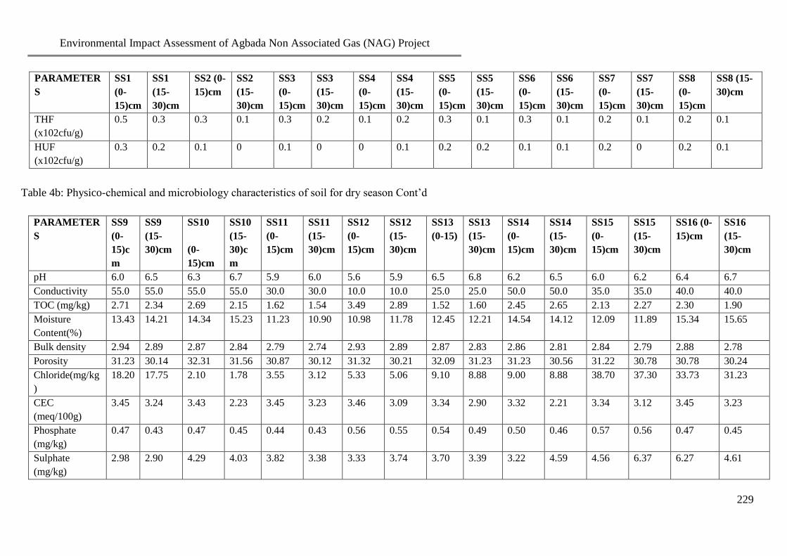
Environmental Impact Assessment of Agbada Non Associated Gas (NAG) Project
229
PARAMETER
S
SS1
(0-
15)cm
SS1
(15-
30)cm
SS2 (0-
15)cm
SS2
(15-
30)cm
SS3
(0-
15)cm
SS3
(15-
30)cm
SS4
(0-
15)cm
SS4
(15-
30)cm
SS5
(0-
15)cm
SS5
(15-
30)cm
SS6
(0-
15)cm
SS6
(15-
30)cm
SS7
(0-
15)cm
SS7
(15-
30)cm
SS8
(0-
15)cm
SS8 (15-
30)cm
THF
(x102cfu/g)
0.5 0.3 0.3 0.1 0.3 0.2 0.1 0.2 0.3 0.1 0.3 0.1 0.2 0.1 0.2 0.1
HUF
(x102cfu/g)
0.3 0.2 0.1 0 0.1 0 0 0.1 0.2 0.2 0.1 0.1 0.2 0 0.2 0.1
Table 4b: Physico-chemical and microbiology characteristics of soil for dry season Cont’d
PARAMETER
S
SS9
(0-
15)c
m
SS9
(15-
30)cm
SS10
(0-
15)cm
SS10
(15-
30)c
m
SS11
(0-
15)cm
SS11
(15-
30)cm
SS12
(0-
15)cm
SS12
(15-
30)cm
SS13
(0-15)
SS13
(15-
30)cm
SS14
(0-
15)cm
SS14
(15-
30)cm
SS15
(0-
15)cm
SS15
(15-
30)cm
SS16 (0-
15)cm
SS16
(15-
30)cm
pH 6.0 6.5 6.3 6.7 5.9 6.0 5.6 5.9 6.5 6.8 6.2 6.5 6.0 6.2 6.4 6.7
Conductivity 55.0 55.0 55.0 55.0 30.0 30.0 10.0 10.0 25.0 25.0 50.0 50.0 35.0 35.0 40.0 40.0
TOC (mg/kg) 2.71 2.34 2.69 2.15 1.62 1.54 3.49 2.89 1.52 1.60 2.45 2.65 2.13 2.27 2.30 1.90
Moisture
Content(%)
13.43 14.21 14.34 15.23 11.23 10.90 10.98 11.78 12.45 12.21 14.54 14.12 12.09 11.89 15.34 15.65
Bulk density 2.94 2.89 2.87 2.84 2.79 2.74 2.93 2.89 2.87 2.83 2.86 2.81 2.84 2.79 2.88 2.78
Porosity 31.23 30.14 32.31 31.56 30.87 30.12 31.32 30.21 32.09 31.23 31.23 30.56 31.22 30.78 30.78 30.24
Chloride(mg/kg
)
18.20 17.75 2.10 1.78 3.55 3.12 5.33 5.06 9.10 8.88 9.00 8.88 38.70 37.30 33.73 31.23
CEC
(meq/100g)
3.45 3.24 3.43 2.23 3.45 3.23 3.46 3.09 3.34 2.90 3.32 2.21 3.34 3.12 3.45 3.23
Phosphate
(mg/kg)
0.47 0.43 0.47 0.45 0.44 0.43 0.56 0.55 0.54 0.49 0.50 0.46 0.57 0.56 0.47 0.45
Sulphate
(mg/kg)
2.98 2.90 4.29 4.03 3.82 3.38 3.33 3.74 3.70 3.39 3.22 4.59 4.56 6.37 6.27 4.61
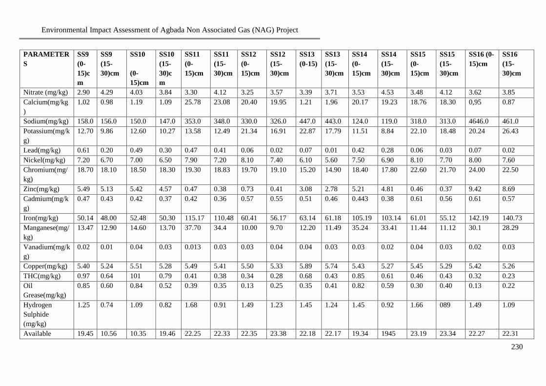
Environmental Impact Assessment of Agbada Non Associated Gas (NAG) Project
230
PARAMETER
S
SS9
(0-
15)c
m
SS9
(15-
30)cm
SS10
(0-
15)cm
SS10
(15-
30)c
m
SS11
(0-
15)cm
SS11
(15-
30)cm
SS12
(0-
15)cm
SS12
(15-
30)cm
SS13
(0-15)
SS13
(15-
30)cm
SS14
(0-
15)cm
SS14
(15-
30)cm
SS15
(0-
15)cm
SS15
(15-
30)cm
SS16 (0-
15)cm
SS16
(15-
30)cm
Nitrate (mg/kg) 2.90 4.29 4.03 3.84 3.30 4.12 3.25 3.57 3.39 3.71 3.53 4.53 3.48 4.12 3.62 3.85
Calcium(mg/kg
)
1.02 0.98 1.19 1.09 25.78 23.08 20.40 19.95 1.21 1.96 20.17 19.23 18.76 18.30 0,95 0.87
Sodium(mg/kg) 158.0 156.0 150.0 147.0 353.0 348.0 330.0 326.0 447.0 443.0 124.0 119.0 318.0 313.0 4646.0 461.0
Potassium(mg/k
g)
12.70 9.86 12.60 10.27 13.58 12.49 21.34 16.91 22.87 17.79 11.51 8.84 22.10 18.48 20.24 26.43
Lead(mg/kg) 0.61 0.20 0.49 0.30 0.47 0.41 0.06 0.02 0.07 0.01 0.42 0.28 0.06 0.03 0.07 0.02
Nickel(mg/kg) 7.20 6.70 7.00 6.50 7.90 7.20 8.10 7.40 6.10 5.60 7.50 6.90 8.10 7.70 8.00 7.60
Chromium(mg/
kg)
18.70 18.10 18.50 18.30 19.30 18.83 19.70 19.10 15.20 14.90 18.40 17.80 22.60 21.70 24.00 22.50
Zinc(mg/kg) 5.49 5.13 5.42 4.57 0.47 0.38 0.73 0.41 3.08 2.78 5.21 4.81 0.46 0.37 9.42 8.69
Cadmium(mg/k
g)
0.47 0.43 0.42 0.37 0.42 0.36 0.57 0.55 0.51 0.46 0.443 0.38 0.61 0.56 0.61 0.57
Iron(mg/kg) 50.14 48.00 52.48 50.30 115.17 110.48 60.41 56.17 63.14 61.18 105.19 103.14 61.01 55.12 142.19 140.73
Manganese(mg/
kg)
13.47 12.90 14.60 13.70 37.70 34.4 10.00 9.70 12.20 11.49 35.24 33.41 11.44 11.12 30.1 28.29
Vanadium(mg/k
g)
0.02 0.01 0.04 0.03 0.013 0.03 0.03 0.04 0.04 0.03 0.03 0.02 0.04 0.03 0.02 0.03
Copper(mg/kg) 5.40 5.24 5.51 5.28 5.49 5.41 5.50 5.33 5.89 5.74 5.43 5.27 5.45 5.29 5.42 5.26
THC(mg/kg) 0.97 0.64 101 0.79 0.41 0.38 0.34 0.28 0.68 0.43 0.85 0.61 0.46 0.43 0.32 0.23
Oil
Grease(mg/kg)
0.85 0.60 0.84 0.52 0.39 0.35 0.13 0.25 0.35 0.41 0.82 0.59 0.30 0.40 0.13 0.22
Hydrogen
Sulphide
(mg/kg)
1.25 0.74 1.09 0.82 1.68 0.91 1.49 1.23 1.45 1.24 1.45 0.92 1.66 089 1.49 1.09
Available 19.45 10.56 10.35 19.46 22.25 22.33 22.35 23.38 22.18 22.17 19.34 1945 23.19 23.34 22.27 22.31

Environmental Impact Assessment of Agbada Non Associated Gas (NAG) Project
231
PARAMETER
S
SS9
(0-
15)c
m
SS9
(15-
30)cm
SS10
(0-
15)cm
SS10
(15-
30)c
m
SS11
(0-
15)cm
SS11
(15-
30)cm
SS12
(0-
15)cm
SS12
(15-
30)cm
SS13
(0-15)
SS13
(15-
30)cm
SS14
(0-
15)cm
SS14
(15-
30)cm
SS15
(0-
15)cm
SS15
(15-
30)cm
SS16 (0-
15)cm
SS16
(15-
30)cm
Water Holding
Capacity (%)
THBC
(x102cfu/g)
0.1 1.0 0.7 0.8 0.6 0.4 0.8 0.5 1.2 0.7 1.0 1.3 0.8 0.4 1.4 0.8
HUB
(x102cfu/g)
0.3 0.2 0.3 0.1 0.3 0.1 0.2 0 0.3 0.1 0.3 0.1 0.1 0.1 0 0
THF
(x102cfu/g)
0.6 0.3 0.4 0.2 0.4 0.3 0.3 0.1 1.2 0.8 0.7 0.3 0.3 0.4 0.8 0.4
HUF
(x102cfu/g)
0.2 0.1 0.3 3.1 0.2 0 0.1 0 0.2 0.3 0.4 0.2 0.1 0.1 0 0
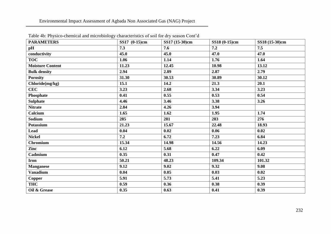
Environmental Impact Assessment of Agbada Non Associated Gas (NAG) Project
232
Table 4b: Physico-chemical and microbiology characteristics of soil for dry season Cont’d
PARAMETERS SS17 (0-15)cm SS17 (15-30)cm SS18 (0-15)cm SS18 (15-30)cm
pH 7.3 7.6 7.2 7.5
conductivity 45.0 45.0 47.0 47.0
TOC 1.06 1.14 1.76 1.64
Moisture Content 11.23 12.45 10.98 13.12
Bulk density 2.94 2.89 2.87 2.79
Porosity 31.30 30.53 30.89 30.12
Chloride(mg/kg) 15.1 14.2 21.3 20.1
CEC 3.23 2.68 3.34 3.23
Phosphate 0.41 0.55 0.53 0.54
Sulphate 4.46 3.46 3.38 3.26
Nitrate 2.84 4.26 3.94
Calcium 1.65 1.62 1.95 1.74
Sodium 285 281 283 276
Potassium 21.23 15.67 22.48 18.93
Lead 0.04 0.02 0.06 0.02
Nickel 7.2 6.72 7.23 6.84
Chromium 15.34 14.98 14.56 14.23
Zinc 6.12 5.68 6.22 6.09
Cadmium 0.35 0.31 0.47 0.42
Iron 50.21 48.23 109.34 101.32
Manganese 9.12 9.02 9.32 9.08
Vanadium 0.04 0.05 0.03 0.02
Copper 5.91 5.73 5.41 5.23
THC 0.59 0.36 0.38 0.39
Oil & Grease 0.35 0.63 0.41 0.39

Environmental Impact Assessment of Agbada Non Associated Gas (NAG) Project
233
PARAMETERS SS17 (0-15)cm SS17 (15-30)cm SS18 (0-15)cm SS18 (15-30)cm
Hydrogen Sulphide 1.12 1.28 1.69 0.91
Ava Water Holding Cap. % 21.34 21.43 21.12 21.19
THBC(x102cfu/g) 1.0 0.5 0.9 0.7
HUB (x102cfu/g) 0.0 0.0 0.1 0.0
THF (x102cfu/g) 0.2 0.1 0.4 0.1
HUF (x102cfu/g) 0.0 0.0 0.1 0.0
Table 5a: Physico-chemical and microbiology characteristics of ground water for wet season
PARAMETER BH1 BH2 BH3
pH 8.95 8.42 6.43
Temperature (oC) 27.00 29.70 29.50
Dissolved Oxygen (mg/l) 1.40 1.60 1.20
Conductivity (mS/cm) 0.10 0.09 0.09
TDS(mg/l) 22.80 36.30 72.00
Nitrate(mg/l) 8.73 7.26 7.26
Nitrite (mg/l) 6.47 5.38 5.38
Ammonium(mg/l) 0.24 0.21 0.25
Phenols (mg/l) <0.001 <0.001 <0.001
BOD (mg/l) 8.83 9.40 8.50
Sulphate(mg/l) 2.11 1.02 1.17
Phosphate(mg/l) 0.12 0.06 0.06
THC(mg/l) 0.97 1.30 0.30
Residual Chlorine(mg/l) 11.23 12.34 10.25
Total Hardness(mg/l) 20.00 18.00 8.00

Environmental Impact Assessment of Agbada Non Associated Gas (NAG) Project
234
PARAMETER BH1 BH2 BH3
H2S(mg/l) 14.00 15.30 12.50
Alkalinity(mg/l) 90.0 0.00 48.0
HCO-3(mg/l) 21.96 0.00 11.71
COD 26.50 31.00 30.10
Salinity(mg/l) 19.80 16.50 16.50
Chloride(mg/l) 12.00 10.00 10.00
Manganese(mg/l) 0.04 0.05 0.04
Zinc(mg/l) 0.10 0.11 0.09
Chromium(mg/l) <0.001 <0.001 <0.001
Lead(mg/l) 0.005 0.008 0.006
Iron (mg/l) 0.75 0.20 0.54
Nickel (mg/l) 0.030 0.032 0.026
Copper (mg/l) 0.002 0.003 0.004
Mercury (mg/l) <0.001 <0.001 <0.001
Arsenic (mg/l) <0.001 <0.001 <0.001
Vanadium (mg/l) <0.001 <0.001 <0.001
Cadmium (mg/l) 0.002 0.002 0.004
TSS (mg/l) 0.04 0.15 0.08
Oil and grease 1.81 2.45 1.97
Microbiology
THBC(x102cfu/ml)
0.2 0. 2 0.1
HUB (x102cfu/ml)
0.3 0.8 NG
THF (x102cfu/ml)
0.2 0.2 0.1
HUF (x102cfu/ml)
0.7 1.0 NG

Environmental Impact Assessment of Agbada Non Associated Gas (NAG) Project
235
PARAMETER BH1 BH2 BH3
T. Coliform (x102cfu/ml)
0.3 NG NG
Table 5b: Physico-chemical and microbiology characteristics of ground water for dry season
PARAMETER BH1 BH2 BH3
pH 6.3 7.3 7.0
Temperature (oC) 30.60 30.40 28.00
Dissolved Oxygen (mg/l) 2.20 2.00 2.60
Conductivity (mS/cm) 0.07 0.04 0.03
TDS (mg/l) 73.00 94.00 62.10
BOD (mg/l) 4.80 5.00 4.37
COD (mg/l) 21.70 28.10 26.30
Nitrate(mg/l) 5.77 6.68 5.90
Nitrite (mg/l) <0.01 <0.01 <0.01
Sulphate(mg/l) 1.41 1.49 1.79
Phosphate(mg/l) 0.07 0.07 0.07
THC(mg/l) 1.32 0.12 0.72
Residual Chlorine(mg/l) 4.25 7.80 5.32
Total hardness(mg/l) 4.00 9.00 12.00
H2S(mg/l) 33.00 34.00 36.00
Alkalinity(mg/l) 6.00 7.00 5.00
HCO-3(mg/l) 7.32 8.54 6.10
Salinity(mg/l) 32.00 48.00 22.40
Chloride(mg/l) 20.00 30.00 14.00
Manganese(mg/l) 0.03 0.03 0.02
Zinc(mg/l) 0.03 0.06 0.04
Chromium(mg/l) <0.001 <0.001 <0.001
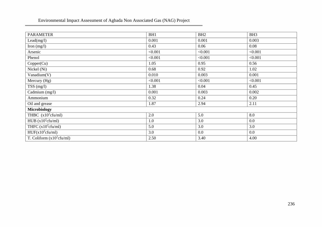
Environmental Impact Assessment of Agbada Non Associated Gas (NAG) Project
236
PARAMETER BH1 BH2 BH3
Lead(mg/l) 0.001 0.001 0.003
Iron (mg/l) 0.43 0.06 0.08
Arsenic <0.001 <0.001 <0.001
Phenol <0.001 <0.001 <0.001
Copper(Cu) 1.05 0.95 0.56
Nickel (Ni) 0.68 0.92 1.02
Vanadium(V) 0.010 0.003 0.001
Mercury (Hg) <0.001 <0.001 <0.001
TSS (mg/l) 1.38 0.04 0.45
Cadmium (mg/l) 0.001 0.003 0.002
Ammonium 0.32 0.24 0.20
Oil and grease 1.87 2.94 2.11
Microbiology
THBC (x102cfu/ml)
2.0 5.0 8.0
HUB (x102cfu/ml)
1.0 3.0 0.0
THFC (x102cfu/ml)
5.0 3.0 3.0
HUF(x102cfu/ml)
3.0 0.0 0.0
T. Coliform (x102cfu/ml)
2.50 3.40 4.00

Environmental Impact Assessment of Agbada Non Associated Gas (NAG) Project
237
Table 6a: Physico-chemical and Microbiology Characteristics of rain water for wet season
PARAMETER RW1 RW2
pH 6.18 6.01
Temperature (oC) 32.10 30.40
Dissolved Oxygen (mg/l) 2.20 1.30
Conductivity (mS/cm) 0.03 0.06
TDS(mg/l) 37.1 45.0
Nitrate(mg/l) 7.35 7.58
Nitrite(mg/l) 5.44 5.61
Ammonium(mg/l) 0.09 0.10
Phenols(mg/l) <0.001 <0.001
BOD (mg/l) 6.80 6.50
Sulphate(mg/l) 1.15 1.22
Phosphate(mg/l) 0.06 0.05
THC(mg/l) 0.84 0.94
Residual Chlorine(mg/l) 12.56 12.41
Total hardness(mg/l) 4.0 10.0
H2S(mg/l) 13.10 13.40
Alkalinity(mg/l) 40.0 50.0
HCO3(mg/l) 9.76 12.20
COD (mg/l) 10.50 12.40
Salinity(mg/l) 26.40 16.50
Total Nitrogen 0.03 0.14
Chloride(mg/l) 16.0 10.0
Manganese(mg/l) 0.001 0.002

Environmental Impact Assessment of Agbada Non Associated Gas (NAG) Project
238
Zinc(mg/l) 0.08 0.06
Chromium(mg/l) <0.001 <0.001
Lead(mg/l) 0.007 0.008
Iron (mg/l) 0.20 0.12
Nickel (mg/l) 0.03 0.03
Copper (mg/l) <0.001 <0.001
Mercury (mg/l) <0.001 <0.001
Arsenic (mg/l) <0.001 <0.001
Vanadium (mg/l) <0.001 <0.001
Cadmium (mg/l) 0.002 0.003
TSS (mg/l) 0.03 0.04
Oil and grease(mg/l) 2.53 2.62
Microbiology
THBC (x102cfu/ml)
2.4 1.4
HUB (x102cfu/ml)
0 0.6
THFC (x102cfu/ml)
1.2 0.5
HUF (x102cfu/ml)
0.3 0.5
T. Coliform (x102cfu/ml)
0.5 0.3

Environmental Impact Assessment of Agbada Non Associated Gas (NAG) Project
239
Table 6b: Physico-chemical and Microbiology Characteristics of rain water for dry season
PARAMETER RW1 RW2
pH 6.02 5.11
Temperature (oC) 31.70 32.30
Dissolved Oxygen (mg/l) 1.90 2.40
Conductivity (mS/cm) 0.02 0.05
TDS(mg/l) 48.40 113.0
Nitrate(mg/l) 6.54 6.36
Nitrite (mg/l) <0.01 0.01
Sulphate(mg/l) 2.10 1.79
Phosphate(mg/l) 0.08 0.06
THC(mg/l) 0.41 0.53
Residual Chlorine(mg/l) 8.15 7.44
Total hardness(mg/l) 20 5
H2S(mg/l) 31 30
Alkalinity(mg/l) 5.0 5.0
HCO3(mg/l) 6.1 6.1
Salinity(mg/l) 19.20 22.40
Total Nitrogen 0.04 0.02
Phenol(mg/l) <0.001 <0.001
BOD (mg/l) 1.8 2.0
COD (mg/l) 9.30 10.20
Copper (mg/l) <0.001 <0.001
Nickel (mg/l) <0.001 <0.001
Vanadium (mg/l) <0.001 <0.001
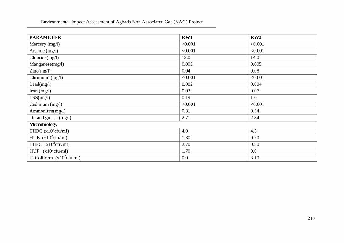
Environmental Impact Assessment of Agbada Non Associated Gas (NAG) Project
240
PARAMETER RW1 RW2
Mercury (mg/l) <0.001 <0.001
Arsenic (mg/l) <0.001 <0.001
Chloride(mg/l) 12.0 14.0
Manganese(mg/l) 0.002 0.005
Zinc(mg/l) 0.04 0.08
Chromium(mg/l) <0.001 <0.001
Lead(mg/l) 0.002 0.004
Iron (mg/l) 0.03 0.07
TSS(mg/l) 0.19 1.0
Cadmium (mg/l) <0.001 <0.001
Ammonium(mg/l) 0.31 0.34
Oil and grease (mg/l) 2.71 2.84
Microbiology
THBC (x102cfu/ml)
4.0 4.5
HUB (x102cfu/ml)
1.30 0.70
THFC (x102cfu/ml)
2.70 0.80
HUF (x102cfu/ml)
1.70 0.0
T. Coliform (x102cfu/ml)
0.0 3.10

Environmental Impact Assessment of Agbada Non Associated Gas (NAG) Project
241
Appendix 5
Participant List of the Scoping Workshop held on the 26th
of March 2008

Environmental Impact Assessment of Agbada Non Associated Gas (NAG) Project
242
Environmental Impact Assessment of Agbada Non Associated Gas (NAG) Project
243

Environmental Impact Assessment of Agbada Non Associated Gas (NAG) Project
244

Environmental Impact Assessment of Agbada Non Associated Gas (NAG) Project
245

Environmental Impact Assessment of Agbada Non Associated Gas (NAG) Project
246

Environmental Impact Assessment of Agbada Non Associated Gas (NAG) Project
247

Environmental Impact Assessment of Agbada Non Associated Gas (NAG) Project
248
Environmental Impact Assessment of Agbada Non Associated Gas (NAG) Project
249

Environmental Impact Assessment of Agbada Non Associated Gas (NAG) Project
250
Appendix 6
RESPONSE TO FEDRAL MINISTRY OF ENVIRONMENT COMMENTS FOR AGBADA NAG EIA
S/N FMEnv Comments Chapter/Section/Page SPDC Response
Cover Pages
1 The cover page should read submitted to
Federal Ministry of Environment
Preliminary Pages Done
2 The status page of the report should be paged Preliminary Pages i
3 The report does not have table of contents
include Table of contents in the final report
Preliminary Pages ii to v
4 Page XVIII report preparers: the list of EIA
preparers should include individual area of
qualification, specialization and study function
Preliminary Pages Done
5 Page XX acknowledgement: the correct
acronym for Federal Ministry of Environment
is “’FMEnv” Correct it wherever it is in the
report
Preliminary Pages Done
6 List of Figures, List of Plates, List of Plates,
List of appendices have been omitted in the
preliminary page of the EIA draft report.
Preliminary Pages vi to viii
7 Page xvii: On the list of Regulators at field
sampling “Housing and Urban Development”
should be expunged from the Federal Ministry
of Environment. The Ministry no longer has
that nomenclature but simply Federal Ministry
of Environment
Preliminary Pages Housing and Urban development has
been expunged
8 List of acronyms/abbreviations: some
acronyms and abbreviations used in the text
were not listed and some listed were wrongly
defined. Update list of abbreviations in the
final report
Preliminary Pages ix
9 Correct the wrong paginations that
characterized the preliminary pages of this
Done

Environmental Impact Assessment of Agbada Non Associated Gas (NAG) Project
251
S/N FMEnv Comments Chapter/Section/Page SPDC Response
report
EXECUTIVE SUMMARY
10 The executive summary should be paged using
roman numerals
ES Done
11 Page 1 ES 1.3 Coordinates of the Project
location should be provided
ES ix
12 Page 1 ES 2 EIA objectives: the EIA Terms of
Reference(ToR) should be provided under this
section
ES Done
13 Page 3 Project Justification: The envisaged
sustainability should be centered on the
technical, economic and environmental
sustainability of proposed project and not
economic value of the project alone
ES Technical and environmental
sustainability have been included.
Page xi.
14 Page ES 3 to 4 Project alternatives: in the
executive summary there is no Project
alternatives mentioned. What was highlighted
is different from Project alternatives.
ES This has been corrected to Project
Development Options. Page xi to xii
15 ES Page 3. On paragraph1 line 7, the DPR
Director was quoted as saying that the quantity
of Nigeria Gas daily flared was at a minimum
of 2.5 billion standard feet of Natural Gas and
a daily loss of about US $10. This has not been
a stagnant figure over the years. The time this
claim was made needs to be stated along.
ES This statement has been deleted because
the figures are no more correct
16 On paragraph 4 line 1 an acronym AG was
used, this was not defined in the list of
ACRONYMNS and ABBREVIATIONS
provided.
ES Associated Gas (AG). This has now been
included in the list of acronyms.
Page ix.
17 ES Page 4, Paragraph 4 line 3 under Project
description, it was stated that drilling and
ES Drilling and Completion of 2 NAG wells
(W67 and W68). Page xii.

Environmental Impact Assessment of Agbada Non Associated Gas (NAG) Project
252
S/N FMEnv Comments Chapter/Section/Page SPDC Response
completions of two (2) NAG wells and
recompletions of one of the wells in 2014.This
statement is not coherent technically. Is SPDC
planning to drill and complete two new wells
and recomplete an old existing one? The final
report needs to clarify this.
18 The foot note numbering style are not
consistent with the one applied in the
remaining part of the report
This has been removed
19 The information on provided especially on
current population and its projection of the
affected LGA’s are not current
ES The information on current population
has been updated. Page xviii
20 There is gross lack of information on drilling
and completion scope as well as on the pipe
laying
Included in chapter 3/Section 3.3.3 Information on the drilling and
completion scope and pipe laying has
been included. Page 24.
21 Drilling: How man strings are we looking for
at each of the wells and what are respective
Casing sizes viz a viz the drilling bits
considered?
Included in chapter 3/Section 3.3.3 Both wells had the following 67/ 68;
24’’ stove pipe - /(354ft)
10 ¾’’ 60.7ppf- /(120ft)
9 5/8’’ 47ppf -/ (11,725ft)
Page 24.
22 What are the respective projected well depths?
Included in chapter 3/Section 3.3.3 Projected well depths for W67/68;
/11,774ftah
Page 24.
23 What are the Mud alternatives for the
respective well s and what are the factors being
considered to make a choice?
Included in chapter 3/Section 3.3.3 The well was drilled with POBM and the
drill –in fluid across the reservoir was
Thixal mud to reduce the reservoir
impairment, thereby increasing the
production potential. Page 25.
24 How would the mud be handled after the
project?
Included in chapter 3/Section 3.3.3 The POBM is recovered and treated for
use in other wells by the Mud supplier.

Environmental Impact Assessment of Agbada Non Associated Gas (NAG) Project
253
S/N FMEnv Comments Chapter/Section/Page SPDC Response
Page 36.
25 What type of completion would be embarked
upon and what is the justification?
Included in chapter 3/Section 3.3.3 The completion is 4 ½’’ 13cr upper
completions with external Gravel pack in
the sand face. This is to enable
40Mmscf/day gas production
26 Is it going to be single string, dual strings or
single selection type of completions?
Included in chapter 3 Single string completion
27 On the pipeline would it just be constructed
and the products introduced like that?
Included in chapter 3/Section 3.3.5.8 On completion of pipeline construction,
pre-commissioning activities which
includes cleaning by introducing
swabbing and brushing pigs into lines via
the pig traps, hydrotest of pipelines to
1.25 of the design operating pressure
using tested potable water, depressurizing
and drying of the lines with compressed
air-driven high and low density foam pigs
in order to remove moisture from the
lines to the required dew point of -20ºc
were all carried out. Thereafter, leak test,
purging/preservation of lines with
nitrogen and awaiting final
commissioning which will involve
introducing the products.
28 What grade of pipe does SPDC have in mind
and what are the choice considerations?
Included in chapter 3/Section 3.3.5.4 8” PE coated carbon steel pipes
(L450/X65 grade) for flow lines and
(L360/X52 grade) for 2” corrosion
inhibition lines. The choice
considerations for the flow lines from
design parameters includes; the design
well flow rates, NAG production forecast,

Environmental Impact Assessment of Agbada Non Associated Gas (NAG) Project
254
S/N FMEnv Comments Chapter/Section/Page SPDC Response
NAG temperature, pressure and
composition.
29 What type of welding procedure to be
approved for the construction?
Included in chapter 3/Section 3.3.5.4 The welding procedure specification
(WPS) approved for manual welding is in
line with ASME B31.8 (Gas transmission
and distribution piping systems), DEP
61.40.20.30-Gen (Welding of pipelines
and related facilities -
amendment/supplement to API 1104),
DEP 31.40.00.10-Gen (Pipeline
Engineering) and Standard Construction
Specification Section 21(Welding).
30 What about the pipeline cleaning and
hydrotesting phases?
Included in chapter 3/Section 3.3.5.8 Pipelines were properly cleaned by
running air-driven swabbing and brushing
pigs in order to ensure the lines were free
of debris. Filling of the lines with tested
potable water followed and introduction
of two swabbing pigs in order to ensure
removal of air. On arrival of water filling
pigs, flushing continued until an
acceptable clean level of the lines were
achieved. Water pressure-driven gauging
pigs were thereafter introduced and
deformity checks carried out upon arrival
at the exit point. Thereafter, hydrostatic
pressure was applied moderately up to
30% of the test pressure ensuring that the
air content in the line does not exceed
0.5% of volumetric capacity and held for
2hours to confirm no pressure loss. On
satisfactory completion, pressure was
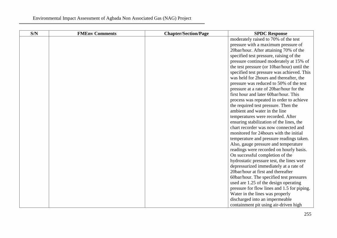
Environmental Impact Assessment of Agbada Non Associated Gas (NAG) Project
255
S/N FMEnv Comments Chapter/Section/Page SPDC Response
moderately raised to 70% of the test
pressure with a maximum pressure of
20bar/hour. After attaining 70% of the
specified test pressure, raising of the
pressure continued moderately at 15% of
the test pressure (or 10bar/hour) until the
specified test pressure was achieved. This
was held for 2hours and thereafter, the
pressure was reduced to 50% of the test
pressure at a rate of 20bar/hour for the
first hour and later 60bar/hour. This
process was repeated in order to achieve
the required test pressure. Then the
ambient and water in the line
temperatures were recorded. After
ensuring stabilization of the lines, the
chart recorder was now connected and
monitored for 24hours with the initial
temperature and pressure readings taken.
Also, gauge pressure and temperature
readings were recorded on hourly basis.
On successful completion of the
hydrostatic pressure test, the lines were
depressurized immediately at a rate of
20bar/hour at first and thereafter
60bar/hour. The specified test pressures
used are 1.25 of the design operating
pressure for flow lines and 1.5 for piping.
Water in the lines was properly
discharged into an impermeable
containment pit using air-driven high

Environmental Impact Assessment of Agbada Non Associated Gas (NAG) Project
256
S/N FMEnv Comments Chapter/Section/Page SPDC Response
density foam pigs. Drying process
followed immediately by introducing low
density foam pigs through the pig traps
and blowing of the lines continuously
with air in order to remove moisture and
achieved the required dew point of -
20ºC.
31 How will the pipeline be chemically treated?
Included in chapter 3/Section 3.3.5.8 Corrosion inhibitors will be injected
continuously via an injection skid at each
wellhead to help reduce internal corrosion
and extend the lifespan of the flow lines.
32 What measures are in place to handle the
effluent following the chemical treatment?
Included in chapter 3/Section 3.3.5.8 The effluent during the chemical
treatment will be transferred to the SPDC
Produced water system in the Agbada I
flowstation for subsequent export to
Bonny Terminal
33 All these need to be reported as part of project
summary
Included in chapter 3/Section 3.3.5.8 Noted
34 Project alternative should key into the
alternative project location, alternative
technology(facilities and equipment)” best
available technology
Included in chapter 3 This has been done
35 ES page 5 the proposed project scheduled for
commissioning by 3rd
quarter of 2010 should
be revised in line with the current status of the
Included in chapter 3 Project schedule has been updated
36 ES page 5 Environmental Baseline description;
the period that both wet and dry seasons were
carried out 24th
October to 5th
November and
26th
to 30th
January 2009 is more less dry
season sample for both season
Chapter 4, page 3 of 10 and Executive
summary (ES 5)
October is late rainy season (March to
July and September to October) why
November is early dry season (November
to February)
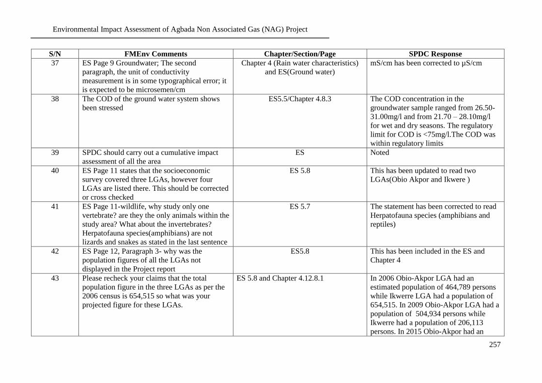
Environmental Impact Assessment of Agbada Non Associated Gas (NAG) Project
257
S/N FMEnv Comments Chapter/Section/Page SPDC Response
37 ES Page 9 Groundwater; The second
paragraph, the unit of conductivity
measurement is in some typographical error; it
is expected to be microsemen/cm
Chapter 4 (Rain water characteristics)
and ES(Ground water)
mS/cm has been corrected to µS/cm
38 The COD of the ground water system shows
been stressed
ES5.5/Chapter 4.8.3 The COD concentration in the
groundwater sample ranged from 26.50-
31.00mg/l and from 21.70 – 28.10mg/l
for wet and dry seasons. The regulatory
limit for COD is <75mg/l.The COD was
within regulatory limits
39 SPDC should carry out a cumulative impact
assessment of all the area
ES Noted
40 ES Page 11 states that the socioeconomic
survey covered three LGAs, however four
LGAs are listed there. This should be corrected
or cross checked
ES 5.8 This has been updated to read two
LGAs(Obio Akpor and Ikwere )
41 ES Page 11-wildlife, why study only one
vertebrate? are they the only animals within the
study area? What about the invertebrates?
Herpatofauna species(amphibians) are not
lizards and snakes as stated in the last sentence
ES 5.7 The statement has been corrected to read
Herpatofauna species (amphibians and
reptiles)
42 ES Page 12, Paragraph 3- why was the
population figures of all the LGAs not
displayed in the Project report
ES5.8 This has been included in the ES and
Chapter 4
43 Please recheck your claims that the total
population figure in the three LGAs as per the
2006 census is 654,515 so what was your
projected figure for these LGAs.
ES 5.8 and Chapter 4.12.8.1 In 2006 Obio-Akpor LGA had an
estimated population of 464,789 persons
while Ikwerre LGA had a population of
654,515. In 2009 Obio-Akpor LGA had a
population of 504,934 persons while
Ikwerre had a population of 206,113
persons. In 2015 Obio-Akpor had an

Environmental Impact Assessment of Agbada Non Associated Gas (NAG) Project
258
S/N FMEnv Comments Chapter/Section/Page SPDC Response
estimated population of 512, 927 persons
while Ikwerre has an estimated
population of 707,653 persons
44 ES page 13 paragraph 1; are there no health
centres in the study area
ES 5.9 /Chapter 4.13.1 The Health centers in the area, included,
Community Health Center, Mbodo Aluu
– (SPDC provided), Bon Maria Clinic,
Rukpokwu and Patfare Clinic, Rukpokwu
which are both privately owned
45 ES page 14 NEGATIVE IMPACTS; A
negative impact not mentioned here is a
damage to the road infrastructure as a result of
movement of heavy equipment but the
mitigation measures was captured in page 15
last bullet
ES 7.2 Damage to the road infrastructure as a
result of movement of heavy equipment
has been included in the ES
46 The Executive Summary did not capture
surface water as one of the study parameters
under environmental baseline data
Surface water was not captured because
there was no surface water body within
the study area (see map of study area)
CHAPTER ONE:INTRODUCTION
47 Map of Nigeria showing Rivers State was
conspicuously missing in this section
2 It has been included
48 River State map showing LGAs was not
included
2 It has been included
49 Credible information about the proposed
project environment should be stated in this
chapter
4 More information about the proposed
project environment have been included
50 Page 20 of 21 Structure of the Report; Chapter
five(5) which presents the consultation and
identification of stakeholders, host
communities and regulators should be moved
to chapter 4 under socioeconomic status of the
55 Consultation section has been moved to
the Social Economics section of Chapter
4.

Environmental Impact Assessment of Agbada Non Associated Gas (NAG) Project
259
S/N FMEnv Comments Chapter/Section/Page SPDC Response
project area
51 Chapter 5 to chapter 8 should be revised to
confirm with EIA report writing format
Chapter 4 has been merged with Chapter
5, so Chapter 6 is now Chapter 5 ,
Chapter 7 is now Chapter 6 while Chapter
8 is now Chapter 7
52 Chapter 5 described under this section should
be merged with chapter 4.
Chapter 4 and 5 have been merged
CHAPTER TWO: PROJECT JUSTIFICATION
53 Page 1 of 8 on Project justification: Section 2.1
Background line; Line 1 is it Agbada 1 well
that discovered the field….. please re-visit the
phrase
12 The Agbada field is located in the Eastern
Land Area operation of Shell Petroleum
Development Company (SPDC) in OML
17 situated approximately 16 km North-
East of Port Harcourt in Rivers State. The
field was discovered in 1960 by SPDC
and to date sixty-six (66) wells have been
drilled in the field.
54 On paragraph 2 section 2.2 page 1 of 8,
NAFCON was mentioned as one of the target
consumers of the product from this project;
events have overtaken this; the name of the
current and potential consumer needs to be
updated in the final report
12 Notore Chemical Industries
55 The envisaged sustainability of the Project
should include the following:
Technical sustainability; the conceptual design
phase should include the optimization of site
layout wells and pipeline routes as proposed
12 to 13 This has been included
56 Environmental sustainability; compliance with Chapter 3 section 3.1. Page 19. This has been included in Chapter 3
section 3.1
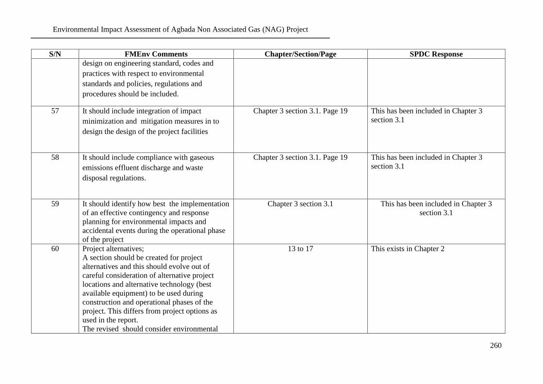
Environmental Impact Assessment of Agbada Non Associated Gas (NAG) Project
260
S/N FMEnv Comments Chapter/Section/Page SPDC Response
design on engineering standard, codes and
practices with respect to environmental
standards and policies, regulations and
procedures should be included.
57 It should include integration of impact
minimization and mitigation measures in to
design the design of the project facilities
Chapter 3 section 3.1. Page 19 This has been included in Chapter 3
section 3.1
58 It should include compliance with gaseous
emissions effluent discharge and waste
disposal regulations.
Chapter 3 section 3.1. Page 19 This has been included in Chapter 3
section 3.1
59 It should identify how best the implementation
of an effective contingency and response
planning for environmental impacts and
accidental events during the operational phase
of the project
Chapter 3 section 3.1 This has been included in Chapter 3
section 3.1
60 Project alternatives;
A section should be created for project
alternatives and this should evolve out of
careful consideration of alternative project
locations and alternative technology (best
available equipment) to be used during
construction and operational phases of the
project. This differs from project options as
used in the report.
The revised should consider environmental
13 to 17 This exists in Chapter 2

Environmental Impact Assessment of Agbada Non Associated Gas (NAG) Project
261
S/N FMEnv Comments Chapter/Section/Page SPDC Response
implications of alternatives
CHAPTER 3 PROJECT DESCRIPTION
61 Page 1 of 19 the project location lacks
coordinates
19 Agbada Field is located in Ikwerre Local
Government Area of Rivers State and
within SPDC's OML 17. Latitudinal and
longitudinal positioning of the
Flowstations I and II were found to be
6.58o72'E, 4.56
o02'N and 7.00
o95'E,
4.55o94'N respectively using a GARMI
Global Positioning System (GPS) on the
field. Agbada field was the first land-
based oil-field in the Eastern Division of
SPDC. The two flowstations, Agbada I
and II were commissioned in 1960 and
1965 respectively with a combined
capacity of 90,000 bbl/d. Agbada I is a
single bank flowstation with a nominal
capacity of 30,000 bbl/d having 30
flowlines laid to the station while Agbada
II is a double bank flowstation with a
nominal capacity of 60,000 bbl/d and
having 57 flowlines.
62 Figure 3.1 under project location the political
map of Rivers state should be updated with
conventional geographical features that
enhance map reading
19 This has been updated
63 Page 1 of 19-Project location; Identify and
mention the host communities in the LGAs
where the project will traverse. Each LGA will
be highlighted
19 The project centers on six (6)
communities from two (2) Local
Government Areas LGAs in Rivers State.
The Local Government Areas are Obio
Akpor and Ikwere LGAs. The

Environmental Impact Assessment of Agbada Non Associated Gas (NAG) Project
262
S/N FMEnv Comments Chapter/Section/Page SPDC Response
communities Omuoda Aluu, Mbodo
Aluu, Omunike Omunoba and Omuigwe
Aluu in Ikwere LGA and Rumujima
Eledo Rukpokwu and Elikpokwodu
Rukpokwu in Obio Akpor LGA
64 Page 2 of 19-Table 3.1;” proposed EIA outline
coordinates” what exactly is meant by
proposed EIA coordinates
Chapter 3.2. Page 20. The scope of the EIA are within the area
with the following co-ordinates below
65 The map in page 3 of 19 should be replaced
with a bigger GIS generated map(attached as
an appendix) to illustrate the project locations
in Rivers State and should be given proper
titles with legends and indicate geographical
coordinates
Appendix This has been done
66 Page 4-19 of the report Project activities;
Bullet point 12 it was indicated that the
component of the project will also involve
“laying Nos of 8”x8km flow lines from wells
at Agbada 1 to NAG plant at Agbada II. While
on the ToR submitted 8”x20km was indicated.
What is the correct length of the proposed
flowlines?
Chapter 3. Page 23. The correct length is 2Nos x 8” x 8.15km
flow lines (i.e. Total length of both flow
lines is 16.3km) from NAG Wells at
Agbada-1 to the pig receiver at Agbada-2
NAG plant.
67 Page 4-19 Landtake; It was stated that there
will be no additional landtake while under
project activities bullet 8 it was indicated that
there would be land acquisition and claim
settlements. Provide the accurate detail in the
revised report
Chapter 3. Page 26. Pipelines will be buried to a minimum
depth of 1.5m at road crossings (i.e.
minimum cover between road surface and
the top of pipeline).
68 Page 4-19 to page 18 of19; For each project
activities, you are expected to list all the
Chapter 3. Page 23 There shall be additional land take
(8.9316 hectares) along the RoW

Environmental Impact Assessment of Agbada Non Associated Gas (NAG) Project
263
S/N FMEnv Comments Chapter/Section/Page SPDC Response
environmental disturbances eg air pollution,
noise, waste streams etc. SPDC claims there
will be no additional land take yet she has
proffered mitigation measures for land
acquisition. SPDC should clarify this
69 Page 6, 3.3.3. Drill workers and Completion of
Wells; During the drilling exercise SPDC
should show how the ground water would be
protected as the flow direction is south-
westerly
Chapter 3. Page 25. Ground water will be protected using
casing strings as they ensure the isolation
of fresh water zones and groundwater
inside the well,
Casing is further used to transmit
flowback fluids from well treatment and
is the first line of defense and a second
layer of protection for groundwater,
We also carry out frequent sampling and
laboratory analysis of waters from
boreholes drilled within the location to
provide a groundwater monitoring array
that will enable the setting of an
environmental baseline and the ability to
study and record groundwater conditions
throughout the lifecycle of the operation
70 Page 7, 3.3.4.1 RoW Survey and Bush
Clearing; SPDC was not specific at what depth
pipeline should be buried at road crossing
Chapter 3. Page 27 Pipeline will buried 3m beneath the road
at road crossings
71 Page 10, 3.34.7 Cathodic Protection: this is a
device to protect the main carrier pipe. How
long should the cathodic pipe last i.e. the
sacrificial anode and what method would you
use to replace it when it is used up
Chapter 3. Page 29 The sacrificial anode design lifespan is
5years. This would be replaced by a deep
ground bed cathodic protection system
upon commissioning.

Environmental Impact Assessment of Agbada Non Associated Gas (NAG) Project
264
S/N FMEnv Comments Chapter/Section/Page SPDC Response
72 Page 19 of 19, Section 3.10 Project Schedule:
this should be revised to include Project EIA
key activities and the current timeline for the
Project implementation
Chapter 3. Page 37. This has been revised
73 This chapter over summarized the description
of the Project scope(especially the drilling and
completion) while the pipeline construction,
handling and treatment facets were not given
adequate coverage
Chapter 3, Page 24 to 30 This section has been expanded
CHAPTER 4; DESCRIPTION OF THE EXISTING ENVIRONMNT
74 Page 1 of 45, section 4.1, Appendix 1 is not in
the report as claimed.
Appendix This (GIS map) has been included
75 Page 1 of 45 to page 5 of 45- on climatic and
meteorological data should be revised with
NIMET data of at least 30 years. This is
necessary as an environment is dynamic as
well as to take care of climate change
Information for 30 years not readily
available
76 Rainfall data presented in this study depict
rainfall trend and represent data for only seven
years. No attempt was made to show some
historical data of rainfall trend in the study area
in the report
Chapter 4. Section 4.3. Page 40. We could not lay our hands on any
recorded historical data specific to
Agbada. Closest information was
obtained from NIMET Port Harcourt
Zone. The area is very close Port
Harcourt (2km)
77 Similarly temperature data reflected only the
period of field data collection with no
historical data presented to reflect changes over
time
Chapter 4. Section 4.3. Page 40. Historical data has been included
78 Two soil profile pits and 36 soil sampling
points were presented in the report of soil
studies. Mention is not made in the report of
the basis for the choice of the number of soil
Chapter 4, section 4.7. Page 43 to 45 Samples were collected at 0 –15 and 15 –
30cm depths within the study area. Soil
samples were distributed within the study
area along the pipeline RoW, GHF

Environmental Impact Assessment of Agbada Non Associated Gas (NAG) Project
265
S/N FMEnv Comments Chapter/Section/Page SPDC Response
profile pits/sampling points such as
physiographic factors, major soil types and
land use patterns etc
location and in control stations. There
was no record of spills within the area
otherwise a soil sampling station would
have been located at such a site. Two soil
profile pits were located 50m from each
of the flow stations (Agbada 1 and
Agbada II). The objective of the profile
pits was to determine whether the
locations of the two Flow stations had a
different soil profile
79 Surface water data was omitted in field data
acquisition and analysis. This is not acceptable
for a study with potential impact on such an
important environmental component
Not Available ToR did not contain samples for surface
water because of the absence of surface
water (streams, rivers and ponds) within
4km of the study area. As a result rain
water samples was collected in the
absence of surface water
80 Equally in evaluating the environmental
components and potential impact indicators the
monitoring program for environmental
components identified surface water quality as
one of the major components to be monitored.
Without a baseline data on surface water
quality there will be no basis of the proposed
surface water quality monitoring. This
omission is a major deficiency in analyzing the
potential impact of this project on a key
environmental component
Not Available Impact of Project activities on surface
water and mitigation actions to reduce
the impact on surface water have been
expunged
81 Page 41 of 45 section 4.13; update health status
as Health Impact Study of the project location
is scanty
Chapter 4.13. Page 73 to 77 This has been updated: The health centres
in the area, included, Community Health
Center, Mbodo Aluu – (SPDC provided),

Environmental Impact Assessment of Agbada Non Associated Gas (NAG) Project
266
S/N FMEnv Comments Chapter/Section/Page SPDC Response
Bon Maria Clinic, Rukpokwu and Patfare
Clinic, Rukpokwu which are both
privately owned.
CHAPTER FIVE: POTENTIAL AND ASSOCIATED IMPACTS
82 Chapter 5 on consultation should be merged
with chapter 4 in line with National EIA
reporting format
Chapter 4. Section 4.12.1, Page 55 to 58 This has been done
83 Page 1 of 3 and 3 of 3 evidence of consultation
provided is not sufficient. The evidence of
consultation in terms of list of participants
venue of meeting concerns expressed, list of
attendance, signatures and telephone numbers
etc
Appendix IV This has been included in the appendix
IV
SOCIOECONOMIC SURVEY(CONSULTATION)
84 In the report restricted photographs shown are
not an adequate representative of pictures for
the entire 3 LGAs communities claimed as host
of the project
More photographs have been included
CHAPTER SIX IMPACT MITIGATION MEASURES
85 Table 6.2 and 7.1 of 7 on
characterization/evaluation of potential impacts
and impacts/mitigation should be harmonized
as there is disparity
Mitigation measures were only provided
for impacts that had ranking of medium
to high significance
Table 6.2 and 7.1 have been harmonized.
Table 6.2 is now 5.2 and Table 7.1 is now
6.1
CHAPTER SEVEN MITIGATION MEASURES
86 This chapter on mitigation measures should be
moved to chapter six to conform to EIA report
format
Chapter 6 This has been done
87 Page 3 of 8 to 8 of 8 Table 7.1project phase ;
only proffer mitigation measures for
Chapter 6, Table 6.1 Mitigation measures for
decommissioning and abandonment have

Environmental Impact Assessment of Agbada Non Associated Gas (NAG) Project
267
S/N FMEnv Comments Chapter/Section/Page SPDC Response
premobilization, mobilization, operation and
maintenance, while Decommissioning and
Abandoned phase ranked high significance in
chapter 6, Table 6.2 pages 7 of 11 to 11 of 11.
Appropriate mitigation measures should be
presented.
been included in Table 6.1 page 9 of 9
88 Page 3 of 8-Impact Mitigation Measure Table
7.1; On land acquisition and claim settlement,
3rd
bullet point, it was agreed that
compensation /rent for land are paid to
identified owners. While in the report it was
not fully stated if there will be additional land
take
Chapter 3. Page 23 There will be additional land take 8.9316
hectares along the RoW
Page 5 of 8 Construction and Drilling Phase
89 Fragmentation of habitat is a residual impact.
SPDC has in the project location or RoW, that
has not been acknowledged, had led to species
severance. Has this been researched upon and
documented; having in mind the long stay at
the location
Noted
90 All correction made in chapter 5 should be
incorporated into chapter 7 as would be moved
to chapter 6
Chapter 7, Table 7.2 This has been effected
CHAPTER EIGHT ENVIRONMENTAL MANAGEMENT PLAN
91 Management options for drill cuttings, waste
fluids and work over are not specific
Chapter 7, Page 108 to 109 This has been modified to read transport
to Thermal Desorption Units(TDS) at
Onne in Rivers State for treatment
92 Table 8.1presented expected types of waste
streams from FDP but the waste quantification
especially for drill cuttings and waste fluids is
absent
Chapter 7, Table 7.1

Environmental Impact Assessment of Agbada Non Associated Gas (NAG) Project
268
S/N FMEnv Comments Chapter/Section/Page SPDC Response
93 Since the Rivers State Ministry of Environment
Interim Guidelines and Standards on
Environmental Pollution Control and
Management was not cited and reviewed
elements of industrial waste management in the
State Principle are not referred to and
consulted, SPDC should consider it necessary
to replace their operations within the State
Government confine or else why would SPDC
promise to take some of the waste to the
Government approved dumpsites
The Rivers State Ministry of
Environment Interim Guidelines and
Standards on Environmental Pollution
Control and Management has been
included in the reference section

Environmental Impact Assessment of Agbada Non Associated Gas (NAG) Project
269
Appendix 7
Sampling Map

Environmental Impact Assessment of Agbada Non Associated Gas (NAG) Project
XVI