Environmental Data In Support of Search & Rescue Operations in ...
12
Cathleen Turner [email protected] Eric Comerma [email protected] 1 Environmental Data In Support of Search & Rescue Operations in the Central Mediterranean Sea CALYPSO Follow On Final Meeting, Sicily, 2 Dec. 2015
Transcript of Environmental Data In Support of Search & Rescue Operations in ...

Cathleen Turner
Eric Comerma
1
Environmental Data In Support of
Search & Rescue Operations
in the Central Mediterranean Sea
CALYPSO Follow On Final Meeting,
Sicily, 2 Dec. 2015

RPS ASA – Ocean Sciences
• Applied Science Associates, environmental scientist and
engineers, based in Rhode Island (USA).
• Member of the RPS Group plc since October 2011.
• ASA has been providing environmental modeling, data
management services and scientific support for more than
three decades to public & private sector.
• Developers of OILMAP/SARMAP/CHEMMAP, modeling and
response tools provided to multiple Coast Guards worldwide.
2
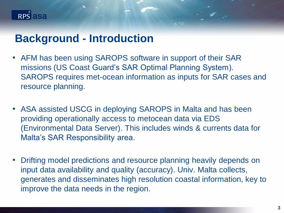
Background - Introduction
• AFM has been using SAROPS software in support of their SAR
missions (US Coast Guard’s SAR Optimal Planning System).
SAROPS requires met-ocean information as inputs for SAR cases and
resource planning.
• ASA assisted USCG in deploying SAROPS in Malta and has been
providing operationally access to metocean data via EDS
(Environmental Data Server). This includes winds & currents data for
Malta’s SAR Responsibility area.
• Drifting model predictions and resource planning heavily depends on
input data availability and quality (accuracy). Univ. Malta collects,
generates and disseminates high resolution coastal information, key to
improve the data needs in the region.
3

Operational Data Dissemination & Analysis
• Metocean information must be available in near-real-time to
SAR Operators for their prediction and planning tools
(ex SAROPS and SARMAP).
• Ocean mapping applications allows SAR Operators to do ‘on-the-fly’
evaluation of metocean data products and decide which sources are
better suited to be used in a particular SAR case.
• Data from model predictions provides a larger spatial and time
coverage (past/present/future). Meanwhile, observations (like HF
Coastal Radar measurements) provide ground-truth information.
Ideally, Operators would have access to both complementary types of
data sources.
4

EDS – Environmental Data Server
• EDS was developed and implemented to serve data operationally to the
USCG’s SAROPS program. It collects and manages a wide variety of
oceanographic and meteorological data products from a large variety of
sources, both observations and model predictions.
• Data from the EDS is being accessed on-line and used worldwide by
the SAR operators and other organizations in charge of marine
emergency response (e.g. AFM, EMSA, SASEMAR, Irish CG)
• Currents and winds model predictions are available in near-real-time to
SAR operators for their SAR modeling tools (ex SAROPS and
SARMAP) via on-line requests to EDS.
5

CALYPSO – HF Radar current observations
• Fully operational HF coastal
radar system in the Malta
Channel: real-time
measurement of sea surface
currents and waves in the strip
of sea between Malta and Sicily.
• Malta’s HF Radar data has been
made operationally available to
AFM Operators via EDS.
6

CALYPSO HF Radar in EDS Viewer
7

CALYPSO HF Radar in EDS Viewer
8
Currents
And
Wind
Legend
Date & Time
Zoom
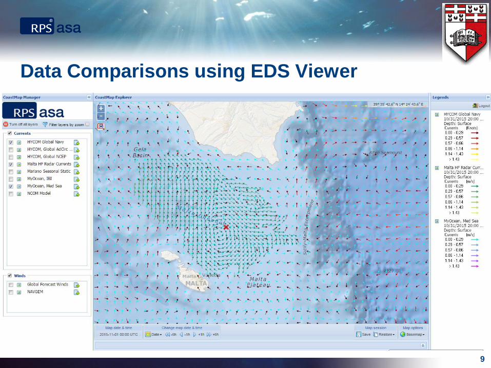
Data Comparisons using EDS Viewer
9

Data Comparisons using EDS Viewer
10
View Time Series

1. SAR exercise simulation parameters:
Date: November 1st 2015
Location: 36.2 N, 14.6 E
Time of Incident: 12:00 AM
2. SAR simulations using different current data inputs (HF Radar –
observations, HYCOM & MyOcean – model prediction). Two different SAR
modeling/tools (SAROPS & SARMAP).
3. SAR Operator can compare results using different data inputs, helping
him/her make informed decisions.
11
Using HF Radar in Search And Rescue Planning

SAROPS & SARMAP – Obtaining data via EDS
12