
Environmental Assessment Document
83
Environmental Assessment Document Initial Environmental Examination Loan: 3260 July 2017 Earthquake Emergency Assistance Project: Panchkhal-Melamchi Road Project Main report-I Prepared by the Government of Nepal The Environmental Assessment is a document of the borrower. The views expressed herein do not necessarily represent those of ADB’s Board of Directors, Management, or staff, and may be preliminary in nature.
Transcript of Environmental Assessment Document

Environmental Assessment Document
Initial Environmental Examination Loan: 3260 July 2017
Earthquake Emergency Assistance Project: Panchkhal-Melamchi Road Project Main report-I Prepared by the Government of Nepal The Environmental Assessment is a document of the borrower. The views expressed herein do not necessarily represent those of ADB’s Board of Directors, Management, or staff, and may be preliminary in nature.


Government of Nepal
Ministry of Physical Infrastructure and Transport
Department of Roads Project Directorate (ADB)
Earthquake Emergency Assistance Project (EEAP)
(ADB LOAN No. 3260-NEP)
INITIAL ENVIRONMENTAL EXAMINATION
OF
PANCHKHAL - MELAMCHI ROAD
JUNE 2017
Prepared by MMM Group Limited Canada in association with ITECO Nepal (P) Ltd, Total Management Services Nepal and Material Test Pvt Ltd. for Department of Roads, Ministry of Physical Infrastructure and Transport for the Asian Development Bank.

Earthquake Emergency Assistance Project (EEAP)
Initial Environmental Examination Report on Panchkhal-Melamchi Road i
ABBREVIATIONS
AADT Average Annual Daily Traffic
AC Asphalt Concrete
ADB Asian Development Bank
ADT Average Daily Traffic
AP Affected People
BOD Biological Oxygen Demand
CBOs Community Based Organization
CBS Central Bureau of Statistics
CFUG Community Forest User Group
CITIES Convention on International Trade in Endangered Species
CO Carbon Monoxide
COI Corridor of Impact
DBST Double Bituminous Surface Treatment
DDC District Development Committee
DFID Department for International Development, UK
DG Diesel Generating
DHM Department of Hydrology and Metrology
DNPWC Department of National Parks and Wildlife Conservation
DOF Department of Forest
DoR Department of Roads
DSC Design and Supervision Consultant
EA Executing Agency
EAG Environmental Assessment Guidelines
EEAP Earthquake Emergency Assistance Project
EIA Environmental Impact Assessment
EMG Environmental Management Guidelines
EMP Environmental Management Plan
EPR Environment Protection Rules
ES Environmental Specialist
FIDIC International Federation of Consulting Engineers
FS Feasibility Study
GESU Geo-Environment and Social Unit
GHG Green House Gas
IA Implementing Agency
IEE Initial Environmental Examination
IUCN International Union for Conservation of Nature
JICA Japan International Co-operative Agency
Earthquake Emergency Assistance Project (EEAP)
Initial Environmental Examination Report on Panchkhal-Melamchi Road ii
LPG Liquefied Petroleum Gas
MCT Main Central Trust
MoPE Ministry of Population and Environment
MoSTE Ministry of Science, Technology and Environment
MoPIT Ministry of Physical Infrastructure and Transport
MWSP Melamchi Water Supply Project
NAAQS Nepal Ambient Air Quality Standard
NEP Nepal
NGO Non-Governmental Organization
NOx Nitrogen Oxide
NRA National Reconstruction Authority
PD Project Directorate
PDNA Post Disaster Needs Assessment
PPE Personal Protective Equipment
PIP Priority Investment Plan
PIU Project Implementation Unit
RAP Rural Access Programmme -DFID
REA Rapid Environmental Assessment
RoW Right of Way
RSSDU Road Sector Skills Development Unit
SC Supervision Consultant
SDC Social Development Consultant
SEA Strategic Environmental Assessment
SRN Strategic Road Network
TA Technical Assistance
TMO Transport Management Office
TPPF Transport Project Preparation Facility – ADB
VDC Village Development Committee
ZOI Zone of Influence

Earthquake Emergency Assistance Project (EEAP)
Initial Environmental Examination Report on Panchkhal-Melamchi Road iii
WEIGHTS AND MEASURES
dBA decibels A
KWH Kilowatt-Hour
K VA Kilo-Volt- Ampere
MLD Millions of Litres Per Day
ppb Parts Per Billion
pph Persons Per Hectare
ppm Parts Per Million
CURRENCY EQUIVALENTS (AS OF 01 JUNE 2017)
Currency Unit- Nepalese Rupee (NRs)
$1=NRs 103.52
Notes: The Nepalese calendar year (B.S) runs from mid-April to mid-April. Unless otherwise
stated, year ranges written in the form 2015/016 denote a single calendar year.
The fiscal year (FY) of the Government ends on 15 July. FY before a calendar Year denotes
the year in which the fiscal year ends (For example, FY 2015 begins on 16 July 2014 and
ends on 15 July 2015).
Acts and Regulations are cited under the name of the ministry from which they originate.
The official version of Acts and Regulations is published in the Nepal Gazette (in Nepali).
Some Acts and Regulations are published by other Government agencies in English
(Unofficial translations).

Earthquake Emergency Assistance Project (EEAP)
Initial Environmental Examination Report on Panchkhal-Melamchi Road iv
EXECUTIVE SUMMARY
Introduction
The proposed loan and grant (the Project) under Earthquake Emergency Assistance Project
(EEAP) will finance improvements of three feeder roads, a total of 100 km, in the central and
western regions of Nepal. While the Project will contribute to development and expansion of
the Strategic Road Network (SRN), it will include an institutional capacity assessment in the
areas of road safety and road maintenance, which will form the basis for a capacity
development program. Gender and social inclusion will be addressed through a livelihood
program that will be targeting women involved in road construction activities in the project-
affected area.
The project roads are: (i) Dolakha – Singati (34.490 km feeder road), (ii) Dhadingbesi –
Arughat -- Gorkha (42.18 km feeder road excluding 25 km overlap with Mid-Hill highway),
and (iii) Panchkhal – Melamchi Road (22.977 km feeder road).The Department of Roads
(DoR) intends to improve these roads to an all-weather bituminous double-lane Feeder
Road Standard. Project roads have been selected based on environment, resettlement,
social and economic impacts; and project readiness. The Project is relevant to achieving
results of the Country Strategy and Program (2013-2017), enhancing global-local
connectivity to facilitate regionally balanced economic growth.
The Department of Roads (DoR) intends to upgrade the Panchkhal (Zero kilo) – Melamchi
Section (km 0+000 to 22+977) to meet the Intermediate Lane Standard i.e. formation width
of 7.0 m and the pavement width of 5.50 m with AC surface pavement as per the DoR
standard.
Policy, Legal and Administrative Framework
The ADB SPS, 2009 aims to avoid, minimise or mitigate harmful environmental and social
impacts and help the borrower strengthen their safeguard system. It also provides a platform
for participation by affected community in project design and implementation.
All roads proposed to be upgraded under the Earthquake Emergency Assistance Project
(EEAP) were screened and categorized using Rapid Environmental Assessment (REA). The
REA consist of questions relating to: (i) the sensitivity and vulnerability of environmental
resources in the sub-project area, and (ii) the potential for the sub-project to cause
significant adverse environmental impacts. All project roads under the EEAP have been
classified as Category ―B‖.
Description of Project
Panchkhal – Melamchi Road upgrading works is going to be funded by Asian Development
Bank (ADB) under ADB loan No. 3260-NEP under Earthquake Emergency Assistance
Project (EEAP). It connects the Paanchkhal with Melamchi and rural area of the
Sindhupalchowk district. This road also serves as the access road for one of the national
pride project, Melamchi Water Supply Project.

Earthquake Emergency Assistance Project (EEAP)
Initial Environmental Examination Report on Panchkhal-Melamchi Road v
Government of Nepal would be responsible to meet the expenses against compensation,
acquisition of land/ building, royalty, tax refund, maintenance of handed over section,
administrative cost, etc. Department of Road will implement the Project.
Panchkhal – Melamchi Road is located in the Central Development region of Nepal,
Bagmati Zone, Kavrepalanchowk and Sindhupalchowk District. The project road starts at the
junction separating Arniko (Kodari) Highway at Zero Kilo, Panchkhal, and Kavrepalanchowk
District. Road section from km 0+000 to km 9+500 falls on Kavrepalnchowk District and the
remaining part falls on Sindhupalchowk District. The existing width of road is 5.5m with otta
seal pavement up to km 22+977.
Initially, this road was constructed by District Development Committee of Kavrepalnchowk
and Sindhupalchowk and later on from Zero Kilo to Melamchi Bazaar about 22 km road was
constructed up to Blacktopped Standard (Otta Seal Surface) as a part of construction of the
main access road and the construction of Melamchi Pul Bazaar - Timbu Section of road had
been completed up to graveled standard by the Melamchi Water Supply Project, Melamchi
Water Supply Development Board/GoN as an access road for construction of intake of
Melamchi Water Supply Project funded by ADB in 2011. This road has been categorized as
a Feeder road F030 and its right of way is 15 m from the center line on either side.
The Department of Roads (DoR) intends to improve Panchkhal - Melamchi road section to
an all-weather sealed intermediate-lane Feeder Road Standard. It is proposed to upgrade
the Panchkhal – Melamchi Section (km 0+000 to 22+977) of Panchkhal – Melamchi - Timbu
Road to meet the Intermediate Lane Standard i.e. formation width of 7.0 m and the
pavement width of 5.5 m with AC surface pavement as per the DoR standard. Proposed
road improvement works requires improvement and replacement of existing side drainage
throughout the road for better drainage management, replacement and improvement of
existing cross drainage structures, retaining structures, rehabilitation of existing structures
and provision of additional structures, replacement/improvement or replacement of road
safety measures etc.
This Initial Environmental Examination (IEE) Study Report has been prepared for the
environmental assessment of the proposed road upgrading. Potential environmental
impacts have been identified, their significance assessed, and mitigation measures devised
to avoid these impacts or reduce them to an acceptable level. Then, these mitigation
measures have been incorporated in the Environmental Management Plan (EMP).
The anticipated impacts through improvement of the proposed road are minor, local, short
term and reversible with negligible residual effects. Upgrading works of the Panchkhal –
Melamchi road has been classified as Category B in accordance with ADB`s Safeguard
Policy Statement, 2009. The road project involves key upgrading activities including
geometry improvement, pavement upgrade, drainage improvement, retaining structures,
slope protection/stabilization; other off-road works, and works on traffic management and
road safety.
Description of Environment
Physiographically, the proposed road subproject lies in mid-hills region. Climatologically, the
sub-project area lies in subtropical region. The average maximum and minimum
temperature of Kavrepalanchwk district is 31ºC and 10ºC respectively and average annual

Earthquake Emergency Assistance Project (EEAP)
Initial Environmental Examination Report on Panchkhal-Melamchi Road vi
rainfall in the district is 1582 mm. Similarly, the average annual rainfall in Sindhupalchowk
district is 1615 mm and the average maximum and minimum temperatures of this district is
32.5°C and 5°C respectively (District Profile of Sindhupalchowk, 2014). Project districts have
complex physiographic features like the warm and dry tropical belt to the alpine region
where harsh and cold weather prevails.
Geologically, proposed road alignment traverses on the rocks of schist to phyllite formation,
of Lesser Himalaya. Exposed rocks are moderately to slightly weathered whereas valley
slope have thick residual/filling and colluvial soil. Colluvial deposits and rocks are found
along the road alignment. The road mainly passes through cultivated land, barren land,
forest and settlements. Approximately, 45% of road alignment passes through cultivated
land, about 35% passes through alluvial to colluvial deposits (in general engineering on
boulder mix soil), about 14% over soft phyllitic to schistic weathered rock mass and
remaining 6% over fresh to slightly weathered and slightly fractured hard rock of (Phyllite to
schist with quartzite).
There are 8 small and large streams (including dry streams) across the road alignment as
water resources. There are six (6) irrigation canal crossings along the road alignment (Chainages: 9+795, 10+090, 15+700, 17+080, 20+100 and 21+640). Ambient air and water
quality in the proposed project area is found to be good and there‘s also no noise pollution.
The dominant tree species along the corridor of the road alignment is Sal (Shorea robusta).
Other major species include Chilaune (Schima wallichii), Katus (Castanopsis indica), Uttis
(Alnus nepalensis), Salla (Pinus roxburghi), Rhododendrons (Rhododendron arboretum) etc.
Wild animals reported in the project area are Leopard (Panthera pardus), Jackal (Canis
aurieus), Dumsi (Hystrix indica), Beer (Ursus thibetanus), Monkey (Macaca mulatta) etc.
Major bird species reported in the road corridor are Kalij (Lophura leucomelana), Kaag
(Corvus splendens), Bhangera (Passer domesticus), Dangree (Acridotheres fuscus),
Peacock (Pavo cristatus), Jureli (Pycnonotus spp.), Chibe Chara (Dicrurus aeneus), Nyauli
(Megalaima zeylanica), Kuthurke (Megalaima lineate), Dhukur (Streptopelia spp. &
Chalcophaps spp.), Karangkurung (Anthropoides virgo) etc. The road section does not fall
under any protected or buffer zone area.
The road passes through two municipalities (Panchkhal of Kavrepalanchowk and Melamchi
of Sindhupalchowk district) and 4 VDCs of Kavrepalanchowk district namely Jaisithok,
Mahadevsthan, Chandeni Mandan and Gaire Bisauna Deupur of Kavrepalanchowk.
The road section passes through various settlements such as Zero kilo bazaar,
Narbadapati, Saudeli bazaar, Kunta bazaar, Sipaghat, Milanchowk, and Melamchi bazaar.
Total population residing along the 2 municipalities and 4 VDCs is 82,572 persons (18,336
households) and average family size of 4.50. The predominant ethnic groups residing along
the road alignment is Brahmin, Newar, Chhetri and Dalits. The other major castes are Lama,
Tamang, Sherpa, Rai and Magar.
The main occupation of the people residing in the ZoI of the proposed road alignment is
agriculture and livestock (25.79%). People are carrying out other economic activities like
employment as labor (10.40%), working in government and non-government organizations
(9.08 %), trade and business (13.03 %), foreign employment (5.92%). Moreover, significant
section of the economically active male population also migrates to various places including

Earthquake Emergency Assistance Project (EEAP)
Initial Environmental Examination Report on Panchkhal-Melamchi Road vii
Kathmandu and India seasonally during slack farming season for employment which is the
source of livelihood.
Agriculture, business, and domestic and foreign remittance are the main sources of income
of the people in the project area. Agriculture is still in subsistence level, though gradually
shifting from traditional cereal crops to high value horticultural crops. The major religion
followed by the people in the project area is Hinduism and Buddhism. The project area does
not contain any renowned religious, cultural, archaeological and historical sites along the
road corridor.
Anticipated Environmental Impacts and Mitigation Measures
The significant impacts during construction stage are air quality deterioration due to increase
in fugitive dust emissions from materials hauling and unloading, ground shaping, hot mix
plant operation, quarry operation, and unpaved road travel. Other impacts include nuisance
to nearby residents due to increase in noise from heavy equipment operation, hindrance in
accessibility to common property resources, and increase in traffic on road sections where
construction is on-going. Minimum land use conversion from agricultural or residential to
built-up area (road) will take place due to widening of road width adequate for an
intermediate-lane carriageway. Surface water quality deterioration of the rivers and rivulets,
and siltation of waterways from silt-laden surface runoff coming from the construction site
will also take place and there will be health and safety risk due to increase in heavy traffic
particularly to children and near pedestrian crossing points. Other impacts may be due to
the presence of outside construction workers which may cause some degree of social
disruption and even activate disputes with the local community as a result of social/cultural
differences.
During operation stage, the main impact may be on the surface water hydrology since the
construction of a road across several river/rivulets in the flood-affected sections can act as
impediment to natural flow of water. Other than the permanent change in land use, all
identified impacts are of short-duration and co-terminus with the construction stage, and are
easy to mitigate.
Public Consultation and Information Disclosure
In order to accomplish the IEE, public consultations were organized at three levels namely,
(i) district headquarters, and (ii) project level. During consultation, local beneficiaries,
affected people and stakeholders expressed various ideas and opinions. Following issues
and concerns were raised commonly by local stakeholders:
Land acquisition and compensation issues,
Possibility of displacement of persons and resettlement of the displaced persons,
Community involvement in the project activities, and
Support programs/ training needs to the community.
After the incorporation of their idea, opinions and suggestions in the IEE report, Information
will be disclosed through public consultation and more formally by making documents and

Earthquake Emergency Assistance Project (EEAP)
Initial Environmental Examination Report on Panchkhal-Melamchi Road viii
other materials available in a form and at a location they can be easily accessed by
stakeholders.
Environmental Management Plan and Grievance Re-dress Mechanism
Environmental management plan (EMP) in the IEE report has identified key issues likely to
arise from project implementation, and has proposed mitigation measures, including
responsibility. A separate Social Analysis and Resettlement Studies Report have also been
prepared by the Social Development Specialist and the Resettlement Specialist,
respectively under the EEAP. However, the correlated issues such as safety of community
and construction crews, safe passages for public, protection of common physical, cultural,
religious, historical, archaeological and public utilities/facilities reinstatement are covered
under the mitigation plan. Environmental monitoring is an essential component in the
implementation of IEE recommendation. The environmental monitoring programme (EMoP)
has been prepared to monitor the implementation performance of the EMP.
Grievance Re-dress mechanism will be established to resolve grievance from public or
stakeholders concerning the project. This mechanism will be made effective by establishing
mandatory grievance register book at the office of PIU. The grievances in the register book
will be assessed in the case of genuine grievance or acceptable suggestion. Accordingly,
the response will be given by the concerned PIU in consultation with supervision consultant
or by DoR/Geo-environment and Social Unit (GESU) if the supervision consultants and
contractor are unable to resolve the issue. The outcome will also be included in the quarterly
report of ADB.
Conclusion and Recommendation
The IEE study of the proposed Panchkhal – Melamchi road subproject reveals that the
benefits from the implementation of the proposed road project are more significant and long
term in nature against the adverse impacts most of which could be mitigated or avoided.
Therefore, this IEE is sufficient for approval of the proposed project. This subproject is
recommended for the implementation with incorporation of mitigation measures and
environmental monitoring plan.

Earthquake Emergency Assistance Project (EEAP)
Initial Environmental Examination Report on Panchkhal-Melamchi Road ix
TABLE OF CONTENT
ABBREVIATIONS ...................................................................................................... I
WEIGHTS AND MEASURES ................................................................................... III
CURRENCY EQUIVALENTS (AS OF 01 JUNE 2017) ............................................ III
EXECUTIVE SUMMARY .......................................................................................... IV
1. INTRODUCTION ............................................................................................... 1
1.1 Project Background ............................................................................................................. 1
1.2 Purpose of the IEE Study .................................................................................................... 2
1.3 Extent of IEE Study ............................................................................................................. 2
1.4 IEE Report Content ............................................................................................................. 2
1.5 Methods Adopted to Prepare the IEE Study Report ........................................................... 3
1.6 Sources of Information and Data ........................................................................................ 3
1.7 Public Consultation ............................................................................................................. 4
2. POLICY, LEGAL AND ADMINISTRATIVE FRAMEWORK .............................. 5
2.1 ADB Safeguard Policy Statement, 2009 ............................................................................. 5
2.2 Permissions and Clearance Required for the Project ......................................................... 5
2.3 Environmental Clearance Process ...................................................................................... 7
2.4 Country‘s Legal Framework and Regulatory Requirements for the Project ....................... 8
2.5 Policies ................................................................................................................................ 8
2.5.1 Constitution of Nepal, 2015 .................................................................................... 8
2.5.2 The Thirteenth Three Year Plan (2013/14-2015/16).............................................. 8
2.6 Acts and Rules .................................................................................................................... 8
2.6.1 Environment Protection Act, 1996 ......................................................................... 8
2.6.2 Environment Protection Rules, 1997 (with amendments)...................................... 9
2.6.3 Public Roads Act, 1974 .......................................................................................... 9
2.6.4 Forest Act, 2014 ..................................................................................................... 9
2.6.5 Forest Rule, 1995................................................................................................. 10
2.6.6 Forest Products Collection and Sales Distribution Guidelines, 2001 .................. 10
2.6.7 Local Self-Governance Act, 1999 ........................................................................ 10
2.6.8 Land Acquisition Act, 1977 .................................................................................. 10
2.6.9 Child Labour Prohibition and Regulation Act 2001 .............................................. 10
2.6.10 Soil and Watershed Conservation Act, 1982 ....................................................... 11
2.6.11 Water Resources Act, 1992 ................................................................................. 11
2.6.12 The Aquatic Animal Protection Act, 1961 (with amendment) .............................. 11
2.6.13 Motor Vehicle and Transportation Management Act, 1993 ................................. 11
2.7 Guidelines for the Road Sector ......................................................................................... 11
2.7.1 Environmental Management Guidelines, GESU/DoR ......................................... 11
2.7.2 Other Guidelines and Manuals ............................................................................ 12
2.8 International Conventions and Treaties ............................................................................ 13
3. DESCRIPTION OF THE PROJECT ................................................................ 14
3.1 The Project ........................................................................................................................ 14
3.2 Project Location ................................................................................................................ 14
3.3 Characteristics of the Existing Road ................................................................................. 15
3.4 Environmental Classification of the Proposed Road Rehabilitation Work ........................ 17
3.5 Need for the project road .................................................................................................. 17
3.6 Existing and Projected Traffic ........................................................................................... 17
3.7 Key Upgrading Activities ................................................................................................... 17
3.8 Materials Required and Sourcing ...................................................................................... 18

Earthquake Emergency Assistance Project (EEAP)
Initial Environmental Examination Report on Panchkhal-Melamchi Road x
3.9 Project Implementation Schedule and Cost ...................................................................... 18
4. DESCRIPTION OF THE ENVIRONMENT ....................................................... 21
4.1 Physical Resources........................................................................................................... 21
4.1.1 Meteorology and Climate ..................................................................................... 21
4.1.2 Topography and Soils .......................................................................................... 21
4.1.3 Land Use Pattern ................................................................................................. 22
4.1.4 Hydrology and Drainage ...................................................................................... 22
4.1.5 Geology/Seismology ............................................................................................ 22
4.2 Ecological Resources........................................................................................................ 24
4.2.1 Forest/Vegetation ................................................................................................. 24
4.2.2 Endangered and Protected Species .................................................................... 25
4.2.3 Non-Timber Forest Product (NTFP)..................................................................... 25
4.2.4 Trees on Farm land .............................................................................................. 25
4.2.5 Terrestrial Wildlife ................................................................................................ 25
4.2.6 Birds ..................................................................................................................... 25
4.2.7 Fish, Amphibians and reptiles .............................................................................. 26
4.3 Economic Development .................................................................................................... 26
4.3.1 Industries .............................................................................................................. 26
4.3.2 Infrastructure Facilities ......................................................................................... 27
4.3.3 Power Sources and Transmission ....................................................................... 28
4.3.4 Agriculture Development ...................................................................................... 29
4.3.5 Potential Development area ................................................................................. 29
4.4 Social and Cultural Resources .......................................................................................... 30
4.4.1 Population and Communities ............................................................................... 30
4.4.2 Religion and Ethnicity .......................................................................................... 30
4.4.3 Literacy Rate and Education Level ...................................................................... 31
4.4.4 Health facilities ..................................................................................................... 31
4.4.5 Sanitation ............................................................................................................. 31
4.4.6 Drinking Water ..................................................................................................... 32
4.4.7 Occupational Status ............................................................................................. 32
4.4.8 Educational Facilities ........................................................................................... 32
4.4.9 Physical or Cultural Heritage ............................................................................... 32
5. ANTICIPATED ENVIRONMENTAL IMPACTS AND ITS MITIGATION
MEASURES .................................................................................................... 34
5.1 Impacts on Physical Environment ..................................................................................... 34
5.1.1 Micro-Climate ....................................................................................................... 34
5.1.2 Air Quality ............................................................................................................. 35
5.1.3 Noise Level .......................................................................................................... 36
5.1.4 Impact on Land and Soil ...................................................................................... 38
5.1.5 Landslide and Soil Erosion .................................................................................. 38
5.1.6 Borrow Pits and Quarry Sites ............................................................................... 39
5.1.7 Soil Contamination and Compaction.................................................................... 40
5.1.8 Siltation and Surface Water Quality of Streams .................................................. 41
5.1.9 Hydrology and Drainage ...................................................................................... 42
5.1.10 Management of Construction Spoils/Wastes ....................................................... 43
5.1.11 Natural Hazard ..................................................................................................... 43
5.2 Ecological Resources........................................................................................................ 44
5.2.1 Forestry and biodiversity ...................................................................................... 44
5.2.2 Aquatic biodiversity .............................................................................................. 45
5.2.3 Fauna ................................................................................................................... 45
5.3 Socio Economic Impacts ................................................................................................... 46
5.3.1 Beneficial impacts ................................................................................................ 46

Earthquake Emergency Assistance Project (EEAP)
Initial Environmental Examination Report on Panchkhal-Melamchi Road xi
5.3.2 Anticipated adverse impacts ................................................................................ 48
5.3.3 Impact on Common Property Resources ............................................................. 51
5.4 Cumulative Impacts........................................................................................................... 52
5.5 Climate Change Consideration ......................................................................................... 53
6. PUBLIC CONSULTATION AND INFORMATION DISCLOSURE................... 55
6.1 Consultation Method and Information Disclosure ............................................................. 55
6.2 Compliance with Relevant Regulatory Requirements ...................................................... 55
6.3 Information Disclosure ...................................................................................................... 56
6.4 Public Consultation and Communication Plan for future .................................................. 57
7. ENVIRONMENTAL MANAGEMENT PLAN .................................................... 59
7.1 Formulation of the Management and Monitoring Plan ...................................................... 59
7.2 Social Analysis Study ........................................................................................................ 59
7.3 Resettlement Study ........................................................................................................... 59
7.4 Environmental Monitoring Programme (EMoP) ................................................................ 59
7.5 Institutional Setting and Proposed Implementation Arrangement .................................... 60
7.5.1 Institutional setting and Capacity Building ........................................................... 60
7.6 Reporting ........................................................................................................................... 61
8. GRIEVANCE RE-DRESSAL MECHANISM .................................................... 63
9. CONCLUSION AND RECOMMENDATION .................................................... 66
10. SELECTED REFERENCES ............................................................................ 67
List of Tables
Table 1.1: Primary and Secondary Sources of Information and Data .................................................... 3
Table 2.1: Permissions and Clearance Required ................................................................................... 5
Table 3.1: Salient Features of the project ............................................................................................ 14
Table 4.1: Soil Type along the Road Alignment ................................................................................... 21
Table 4.2: Land Use Pattern along Road Alignment ............................................................................ 22
Table 4.3: Rivers/Streams crossed by the Road Section ..................................................................... 22
Table 4.4: Community Forests (CF) Along Road Alignment ................................................................ 24
Table 4.5: Protected Vegetation in the Subproject Area ...................................................................... 25
Table 4.6: List of Small, Cottage and Agro-based Industries ............................................................... 26
Table 4.7: List of Micro-Enterprises ...................................................................................................... 26
Table 4.8: Households by main source of drinking water..................................................................... 27
Table 4.9: Households by usual source of lighting ............................................................................... 29
Table 4.10: Population Distribution by Project affected District, Municipality/VDCs ............................ 30
Table 4.11: Households by Type of Toilets Available .......................................................................... 31
Table 5.1: Probable Locations for Spoil Disposal ................................................................................. 43
Table 6.1: Consultation with Affected People and Stakeholders ......................................................... 55
List of Figures
Figure 2.1: Environmental Clearance Procedure in Nepal ..................................................................... 7
Figure 3.1: Project Location Map .......................................................................................................... 16
Figure 3.2: Proposed Cross-sections of the Road ............................................................................... 19
Figure 4.1: Probabilistic Seismic Hazard Map of Nepal ....................................................................... 24
Figure 6.1: Public Consultation Photographs ....................................................................................... 57
Figure 7.1: Project Organisation Structure for EMP Implementation ................................................... 62
Figure 8.1: Grievances Resolution Steps and Processes .................................................................... 65
Earthquake Emergency Assistance Project (EEAP)
Initial Environmental Examination Report on Panchkhal-Melamchi Road xii
LIST OF APPENDICES
Appendix A: REA
Appendix B: Environmental Management Plan
Appendix C: Environmental Monitoring Plan
Appendix D: NAAQS
Appendix E: Noise Quality Standard
Appendix F: Drinking Water and Irrigation Water Quality Standards
Appendix G: Borrow Pits and Quarry Sites Management Guidelines
Appendix H: Photographs

Earthquake Emergency Assistance Project (EEAP)
Initial Environmental Examination Report on Panchkhal-Melamchi Road 1
1. INTRODUCTION
1.1 Project Background
The proposed loan (the Project) under Earthquake Emergency Assistance Project (EEAP)
will finance improvements of three feeder roads, a total of 100 km, in the central and
western regions of Nepal. While the Project will contribute to development and expansion of
the Strategic Road Network (SRN), it will include an institutional capacity assessment in the
areas of road safety and road maintenance, which will form the basis for a capacity
development program. Gender and social inclusion will be addressed through a livelihood
program that will be targeting women involved in road construction activities in the project-
affected area.
The project roads are: (i) Dolakha – Singati (34.490 km feeder road), (ii) Dhadingbesi –
Arughat -- Gorkha (42.18 km feeder road excluding 25 km overlap with Mid-Hill highway),
and (iii) Panchkhal – Melamchi Road (22.977 km feeder road).The Department of Roads
(DoR) intends to improve these roads to an all-weather bituminous double-lane Feeder
Road Standard. Project roads have been selected based on environment, resettlement,
social and economic impacts; and project readiness. The Project is relevant to achieving
results of the Country Strategy and Program (2013-2017), enhancing global-local
connectivity to facilitate regionally balanced economic growth.
Project roads have been selected based on environment, resettlement, social and economic
impacts; and project readiness.
Impact and Outcome
The Project‘s impact will be accelerated economic and social recovery in Nepal‘s earthquake affected districts. The outcome will be critical economic and social services
resumed with disaster-resilient infrastructures.
Outputs
In response to and in line with the PDNA findings, the project has envisaged four outputs:
(i) Output 1: Schools are re-built and upgraded. At least 700 schools will be rebuilt
or retrofitted in line with school reconstruction plans to disaster-resilient standards
and equipped with water and sanitation facilities, including sex-disaggregated toilets.
About five will be model schools built with information and communication technology
equipment, science laboratories, and improved learning spaces.
(ii) Output 2: Roads and bridges are rehabilitated and/or reconstructed. About 135
km of strategic roads and about 450 km of rural roads damaged by the earthquake
and landslides will be rehabilitated. Project roads and bridges will have built back
better features for road safety and climate resilience. Construction and maintenance
equipment will also be procured.
(iii) Output 3: District-level government facilities constructed and/or rebuilt. About
300 district level government buildings will be rebuilt or retrofitted to disaster-resilient
standards with basic utilities, and furnished. Transitional district level government
offices will also be established to enable services to continue throughout the
reconstruction period.

Earthquake Emergency Assistance Project (EEAP)
Initial Environmental Examination Report on Panchkhal-Melamchi Road 2
(iv) Output 4: Disaster preparedness and management capacities strengthened. All
outputs are assured to be disaster risk resilient. Engineering divisions of all
implementing agencies will be strengthened.
Panchkhal-Melamchi road is one of the three project roads considered for the upgrading
under the funding of ADB Loan No. 3260-NEP. The project road is located in
Kavrepalanchowk and Sindhupalchowk districts in Bagmati zone in central development
region of Nepal and is an important access road to the Melamchi Water Supply Project area.
The existing situation the road generally meets district road standard.
The Department of Roads (DoR) intends to upgrade the Panchkhal (Zero kilo) – Melamchi
Section (km 0+000 to 22+977) to meet the Intermediate Lane Standard i.e. formation width
of 7.0 m and the carriageway width of 5.5 m with AC surface pavement as per the DoR
standard.
1.2 Purpose of the IEE Study
Objectives: The main objective of the IEE study is to identify the impacts from the
construction and operation of the Proposal on the physical, biological, socio-economic and
cultural environment of the Subproject area. The IEE study recommends practical and site
specific environmental mitigation and enhancement measures, prepare and implement
environmental monitoring plan and make sure that IEE is sufficient for the proposed road
project.
Need: An IEE study of the Proposal is a legal requirement according to the Environment
Protection Act, 1997; and Environment Protection Rule, 1997 (Amendment 2007) of GoN;
and according to the provisions of the Environmental Assessment Guidelines, 2003; and
Safeguard Policy Statement, 2009 of ADB.
1.3 Extent of IEE Study
The scope of the present study is to prepare a comprehensive IEE study Report for
Panchkhal – Melamchi road for its improvement and upgrading. The environmental study is
one of the components of the ADB`s safeguard requirements viz., environment, resettlement
and socio-economic studies. This IEE Report has been prepared based on the information
and data available through the engineering design studies including socio-economic and
resettlement studies; and field visits, public consultations and discussions, collection of
primary and secondary information and data by the present study itself. The study has
established a core zone of impact for 100 metres on either side of the existing road. Apart
from this, up to 7 km on either side of road alignment has been considered for broader
analysis of biophysical, socio-economic and cultural environment components and
components.
1.4 IEE Report Content
The IEE has been prepared based on the requirements of the Environment Protection Act
(EPA), 1996 and Environment Protection Rules (EPR), 1997 of the Government of Nepal
(GoN), and the ADB Safeguard Policy Statement (SPS), 2009. The content covers following
eight chapters, including this introduction chapter:
Chapter – 1: Introduction
Chapter – 2: Policy, Legal and Administrative Framework

Earthquake Emergency Assistance Project (EEAP)
Initial Environmental Examination Report on Panchkhal-Melamchi Road 3
Chapter – 3: Description of Project
Chapter – 4: Description of Environment
Chapter – 5: Anticipated Impacts and Mitigation Measures
Chapter – 6: Public Consultation and Information Disclosure
Chapter - 7: Environmental Management Plan
Chapter – 8: Grievance redress Mechanism
Chapter - 9: Conclusion and Recommendation
1.5 Methods Adopted to Prepare the IEE Study Report
Appropriate methods were adopted to accomplish the IEE study. The ADB Safeguard Policy
Statement (2009) and ADB Environmental Assessment Guidelines (2003) were reviewed for
outlining the contents of the study. Then, the relevant documents were collected and
reviewed for the study purpose. Information and data pertaining to all components of
environment namely, physical, biological and socio-economic and cultural environment were
gathered through both the primary and secondary sources. The stepwise activities
comprise:
Consultation with DoR, ADB Directorate, GESU/DoR, MoPIT officials
Consultation with TPPF Consultants
Review of ADB and GoN policy including legal requirements
Completion of REA Checklists and Project Description and submit to ADB
Project visits and consultation with affected people and stakeholders including primary information collection
Review of relevant documents for secondary information and data collection
Preparation of Draft updated IEE Report and submit to ADB for comments and feedback
Institutional review and finalization of EMP in consultation with EA
1.6 Sources of Information and Data
Important sources of information have been presented in Table 1.1
Table 1.1: Primary and Secondary Sources of Information and Data
Environmental Component Sources of Information and Data
Project technical details Objectives Present road condition Proposed improvement
activities Other technical aspects
Engineering Design Consultants Inception Report, September, 2015 Detail Design Report, March 2016
Physical environment: Climate, geology, soil, topography, river hydrology and morphology, drainage and flooding patterns, land use, soil erosion/landslides, sedimentation, natural hazards
GoN, DoHM; District profiles; environmental statistics of Nepal, NPC/CBS, 2013; ESMF, 2008; TOPO Maps of the respective districts; project walkover survey/group discussions; engineering study/2015

Earthquake Emergency Assistance Project (EEAP)
Initial Environmental Examination Report on Panchkhal-Melamchi Road 4
Environmental Component Sources of Information and Data
Biological environment: Forestry and biodiversity: flora- tree species, shrub species, grasses species; fauna- mammals, birds, butterflies; amphibians and reptiles; aquatic fauna-fish
DoF, DFO, DNPWC, District profiles of respective districts, field visits and consultation including group discussions/2012; Environmental statistics of Nepal, 2013
Socio-economic and cultural environment: Economic characteristics, Industrial development, and social and cultural resources;
NPC/CBS, 2011; field survey by environmental, social and resettlement studies, 2015; District profiles,
1.7 Public Consultation
Consultation meetings were organized systematically by informing stakeholders and
affected people, 1-2 days earlier and requesting the VDC representatives including key
personnel interested in social works, school teachers, and other users groups for large and
diverse participation. Various types of people from the communities and stakeholders
participated in the consultation meetings. To make the consultation more meaningful various
types of agendas for discussions were prepared and raised among the participants. Among
them, major subject matters for discussions included were: need of the proposed road
improvements; likely beneficial and adverse impacts from the improvement activities on
environment; people‘s concerns, opinions, ideas, suggestions including types of mitigation measures needed to be pursued during different stages of the road improvement activities.
Group discussions were also held for collecting primary information. For this purpose,
checklists were developed in order to include all necessary important information. Opinions,
ideas and suggestions received were incorporated in the design and referred to for
formulating mitigation measures in the environmental management plan. List of participants
of the public consultations is given in Appendix A. The summary of the discussion at
Kavrepalanchowk and Sindhupalchowk Districts is shown as below:
S.N Date No. of
Participants Location
Type of People Attended
Issues Raised
1 25/9/2015 Male: 5 Female: 1
Mahadevsthan
Farmers, service holders, businessmen, politicians, students
Land acquisition, involvement of the community in the project activities, anti-trafficking programs
2 22/9/2015 Male: 11 Female: 5
Narbada Farmers, politician, students, teachers, business men
Compensation distribution package , support programs/ training needs to the community
3 24/9/2015 Male: 11 Female: 9
Sipaghat Farmers, teachers, local politicians
Land acquisition, Resettlement of the Displaced persons, involvement of the community in the project activities, training needs
4 24/9/2015 Male: 4 Female: 3
Melamchi bazar
Farmers, businessmen, local politicians
Land acquisition, Resettlement of the Displaced persons, community involvement in the development activities, and support program to the community.

Earthquake Emergency Assistance Project (EEAP)
Initial Environmental Examination Report on Panchkhal-Melamchi Road 5
2. POLICY, LEGAL AND ADMINISTRATIVE FRAMEWORK
2.1 ADB Safeguard Policy Statement, 2009
The ADB SPS, 2009 aims to avoid, minimise or mitigate harmful environmental and social
impacts and help the borrower strengthen their safeguard system. It also provides a platform
for participation by affected community in project design and implementation.
All roads proposed to be upgraded under the Strategic Road Improvement Project (SRIP)
were screened and categorized using Rapid Environmental Assessment (REA). The REA
consist of questions relating to: (i) the sensitivity and vulnerability of environmental
resources in the sub-project area, and (ii) the potential for the sub-project to cause
significant adverse environmental impacts. These roads are then classified into one of the
following categories:
Category A. Projects with potential for significant adverse environmental impacts. An
Environmental Impact Assessment (EIA) is required to address significant impacts.
Category B. Projects judged to have some adverse environmental impacts, but of lesser
degree and/or significance than those for category A projects. An IEE is required to
determine whether or not significant environmental impacts warranting an EIA are likely.
If an EIA is not needed, the IEE is regarded as the final environmental assessment
report.
Category C. Projects unlikely to have adverse environmental impacts. No EIA or IEE is
needed although environmental implications are still reviewed.
All project roads under the EEAP were classified as Category ―B‖.
All ADB investments are subject to an environmental assessment to address environmental
impacts and risks. The environmental assessment starts with screening and categorization;
followed by baseline data collection, impact analysis, environmental management planning,
information disclosure, consultation and participation, grievance Redressal Mechanism
development, EMP implementation, and reporting.
2.2 Permissions and Clearance Required for the Project
The legal framework of the country consists of several acts, notifications, rules, and
regulations to protect environment and wildlife. List of required clearances / permissions
related to environment has been summarized in Table 2.1 below.
Table 2.1: Permissions and Clearance Required
S.N. Clearance Act/Rule/Notification
/Guideline Concerned Agency Responsibility
A. Pre-construction Stage
1
Environmental
Clearance (categorized
as ―B‖ with IEE requirement)
Environment Protection
Act 1996 and
Environment Protection
Rules, 1997 (with
amendments).
Ministry of Physical
Infrastructure and
Transport
Department of
Roads / PD,
DOR (ADB)

Earthquake Emergency Assistance Project (EEAP)
Initial Environmental Examination Report on Panchkhal-Melamchi Road 6
S.N. Clearance Act/Rule/Notification
/Guideline Concerned Agency Responsibility
2
Land Acquisition and
Compensation
Land Acquisition Act ,
1977(with amendments)
Ministry of Physical
Infrastructure and
Transport
Department of
Roads / PD,
DOR (ADB)
3
Forestry clearance for
felling of Trees
Forest Act, 1993 (with
amendment), Forest Rule,
1995, Forest Products
Collection and Sales
Distribution Guidelines,
2001 and Local Self-
Governance Act, 1999
Ministry of Forest
and Soil
Conservation,
Department of
Forest
Department of
Roads / PD,
DOR (ADB)
B. Implementation Stage
4
Permission for
construction material
quarrying (stone,
cobble, sand, gravel,
soil etc)
Local Self-Governance
Act, 1999 and Soil and
Watershed Conservation
Act, 1982 and Watershed
Conservation Rule, 1985.
PA,1996 and EPR, 1997
(with amendments)
Concerned Project
and
Concerned VDC,
DDC and
Municipality
Contractor
5
Consent to operate Hot
mix plant, Crushers,
Batching Plant
Local Self-Governance Act,
1999
Concerned Project
and Concerned
VDC, DDC and
Municipality
Contractor
6
Consent for disposal of
sewage from labour
camps
Water Resource Act, 1992 Concerned Project Contractor
7
Pollution Under Control
Certificate
Motor Vehicle and
Transportation
Management Act, 1993
Department of
Transport
Management
Contractor
Earthquake Emergency Assistance Project (EEAP)
Initial Environmental Examination Report on Panchkhal-Melamchi Road 7
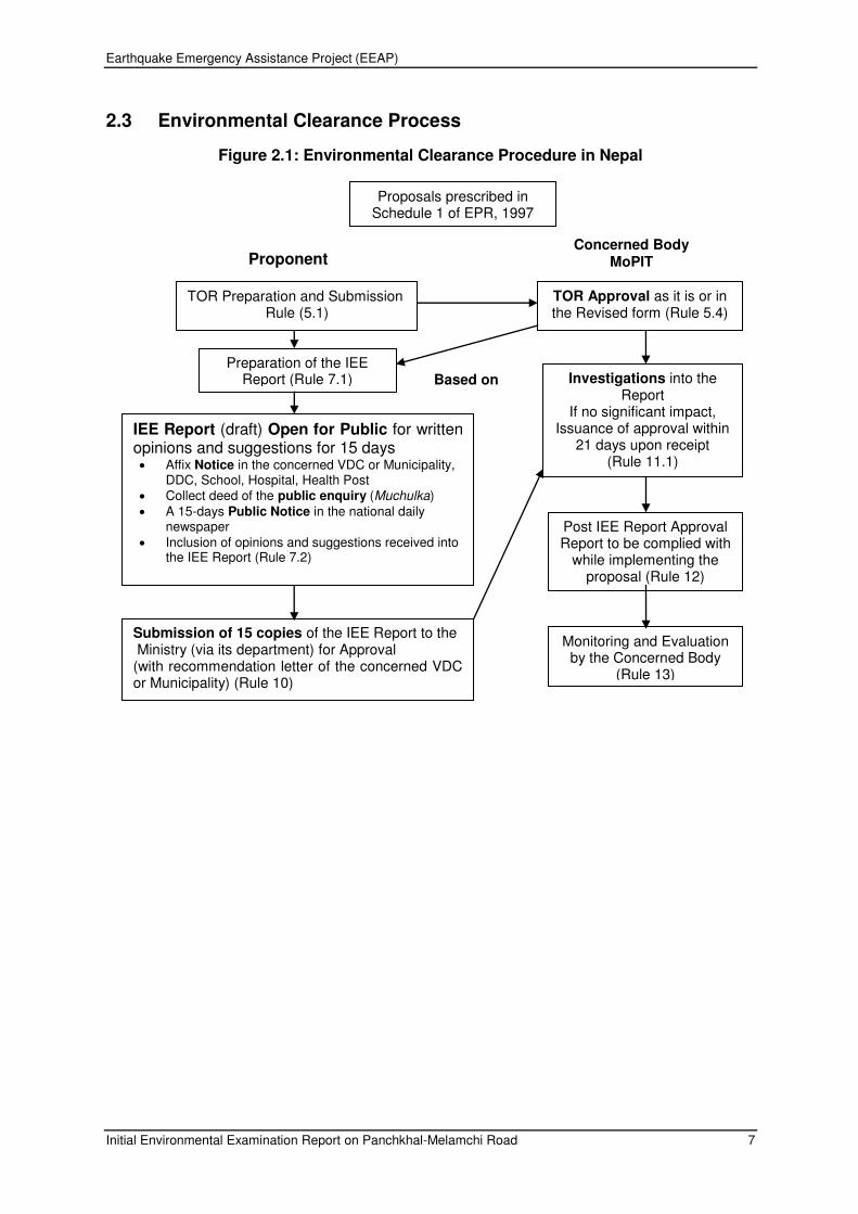
2.3 Environmental Clearance Process
Figure 2.1: Environmental Clearance Procedure in Nepal
TOR Preparation and Submission Rule (5.1)
Post IEE Report Approval Report to be complied with
while implementing the proposal (Rule 12)
TOR Approval as it is or in the Revised form (Rule 5.4)
Preparation of the IEE Report (Rule 7.1)
Submission of 15 copies of the IEE Report to the Ministry (via its department) for Approval (with recommendation letter of the concerned VDC or Municipality) (Rule 10)
Monitoring and Evaluation by the Concerned Body
(Rule 13)
IEE Report (draft) Open for Public for written opinions and suggestions for 15 days Affix Notice in the concerned VDC or Municipality,
DDC, School, Hospital, Health Post Collect deed of the public enquiry (Muchulka) A 15-days Public Notice in the national daily
newspaper Inclusion of opinions and suggestions received into
the IEE Report (Rule 7.2)
Proposals prescribed in Schedule 1 of EPR, 1997
Proponent Concerned Body
MoPIT
Based on TOR
Investigations into the Report
If no significant impact, Issuance of approval within
21 days upon receipt (Rule 11.1)

Earthquake Emergency Assistance Project (EEAP)
Initial Environmental Examination Report on Panchkhal-Melamchi Road 8
2.4 Country’s Legal Framework and Regulatory Requirements for the Project
In Nepal, various legal instruments are in place to ease the integration of environmental
aspects in development proposals. The study team has reviewed, but not limited to the
following legislative provisions and guidelines of Nepal.
2.5 Policies
2.5.1 Constitution of Nepal, 2015
Article 30 (1) mentioned that every citizen has the right to live in a clean and healthy
environment. Under state policy, Article 51 (5) mentioned that by increasing awareness of
general public regarding environmental cleanness, minimizing the risk of industrial and
physical development on environment conservation, promotion and sustainable use of
forest, wildlife, birds, flora and biodiversity. Article 51 (6) explains about applying appropriate
minimization or mitigation measures for negative impact on nature, environment or
biodiversity.
2.5.2 The Thirteenth Three Year Plan (2013/14-2015/16)
The government has recently endorsed the Thirteenth Three Year Plan (2070/71–2072/73).
This plan will cover the period of 2013/14 2015/2016. Its long-term vision is to promote
Nepal from its current status of a least developed country to a developing country by 2022.
Its aim is to reduce human and economic poverty, bring change in the living standard of
citizen by promoting green economy focusing on poverty reduction and reducing the
percentage of population living below the poverty line from 23.8% to 18.0% during the plan
period. The plan also aims to achieve 6.0% of annual economic growth rate. The priority
areas of the plan are hydropower, energy, agriculture, basic education, health, drinking
water, good governance, tourism, and environment. The GON will increase the participation
and contribution of private sector, public sector, and cooperatives for the promotion and
development of the priority areas during the plan period.
2.6 Acts and Rules
2.6.1 Environment Protection Act, 1996
The Environment Protection Act, 1996 and Environment Protection Rules, 1997 (with
amendment) contain several provisions to institutionalize the integration of environmental
aspects in development projects including road sector, and empowers Ministry of
Environment approve EIA report. Similarly, in case of IEE level study, line Ministry, which is
Ministry of Physical Planning and Works is authorized to approve the Final IEE Report. The
following are the highlights of the EPA, 1996;
The Act recognizes the interdependence between development and the environment and
shows the concerns for minimizing the impacts of environmental degradation on people,
animal, and plant species and their physical surroundings. The Act obliges the proponent to
undertake IEE and EIA of proposal, plans or projects which may cause changes in existing
environmental condition and authorizes Ministry of Environment to clear all EIA and line
Ministry for IEE study,

Earthquake Emergency Assistance Project (EEAP)
Initial Environmental Examination Report on Panchkhal-Melamchi Road 9
The act empowers Ministry of Population and Environment to prohibit the use of any matter,
fuel, equipment or plant, which has adverse effects on the environment. The Act has
provisions for polluters to compensate affected persons from polluting activities and
empowers government to provide additional incentives to any industry, occupation,
technology or process, which has positive impacts on environmental conservation. It
provisions to establish an Environmental Protection Fund to be used for environmental
protection, pollution control and heritage conservation, and it gives the government authority
to declare specific area as environmentally protected areas.
2.6.2 Environment Protection Rules, 1997 (with amendments)
In the process of implementing EPA (1996) effectively the Environment Protection Rule
(EPR) came into force in 1997 and was amended in 1999. The EPR contains elaborate
provisions for the process to be followed during the preparation and approval of projects
requiring EIAs and IEEs including scoping documents, terms of reference, public
consultations and hearings, and environmental monitoring and auditing. The environmental
legislation empowers the concerned Ministry to monitor the environmental activities
including mitigation measures and Ministry of Environment for environmental auditing. For
IEE, the concerned Ministry, which is the Ministry of Physical Planning and Works in case of
the road projects, is authorized to approve the Final IEE Report. The EPR also lists the
types of development activities requiring IEE or EIA level Study. It also gives an outline of
content of the terms of reference document, IEE and EIA report.
2.6.3 Public Roads Act, 1974
The Department of Roads may temporarily acquire the land and other property adopting
compensatory measures during the construction, rehabilitation and maintenance of the
public roads according to the Act (Article 14 &15). The Act also empowers the DoR to
operate quarries, borrow pits and other facilities during the road construction (Article 17). In
sum, the Act facilitates the acquisition of land and property for the extraction of construction
materials and development of other facilities as well as to maintain greenery along the
roadside with adoption of compensatory measures.
2.6.4 Forest Act, 2014
The Forest Act, 2014 recognizes the importance of forests in maintaining a healthy
environment. The Act requires decision makers to take account of all forest values, including
environment services and biodiversity, not just production of timber and other commodities.
The basis of Act is resource oriented rather than use oriented.
The Forest Act, 2014 contains several provisions to ensure the development, conservation,
management and sustainable use of forest resources, based on approved work plan. The
work plan should contain a list of activities that should be implemented in the different forest
categories - national forests, community forests, leasehold forests, private forests, and
religious forests. Section 23 of the Act empowers the government to delineate any part of
the national forest, which has ‗special environmental, scientific or cultural importance‘, as a protected forest. Section 49 of the Act prohibits reclaiming lands, setting fires, grazing cattle,
removing and damaging forest products, felling trees of plants, wildlife hunting and
extracting boulders sand and soil from the National forest without the prior approval.
However, the government may enforce Section 68 of the Forest Act to provide parts of any

Earthquake Emergency Assistance Project (EEAP)
Initial Environmental Examination Report on Panchkhal-Melamchi Road 10
type of forest for the implementation of a national priority plan with the assurance that it
does not adversely affect the environment significantly. As provisioned under the Act, while
clearing the forest on the RoW of road, the implementing authority will co-ordinate with the
District Forest Office. If necessary, the compensatory re-plantation will also be carried out at
the rate of 1:25 under the provision of the Act.
2.6.5 Forest Rule, 1995
The Forest Rules 1995 (with amendment) further elaborate legal measures for the
conservation of forests and wildlife. Based on forest legislation, thirteen plant species are
included in the level protection list. Of them, GoN has banned the felling, transportation and
export of Champ (Michelia champacta), Khayer (Acacia catechu) and Sal (Shorea robusta).
The Rule also stipulates that the entire expenses for cutting and transporting the forest
products in a forest area to be used by the approved project shall be borne by the
proponents of the project.
2.6.6 Forest Products Collection and Sales Distribution Guidelines, 2001
Clause 3 to 10 of the Guideline have specified various procedure and formats for getting
approvals for vegetation clearance, delineation of lands for vegetation clearance, evaluation
of the wood volume etc. and government offices and officials responsible for the approval,
delineation and valuation.
2.6.7 Local Self-Governance Act, 1999
The Local Self-Governance Act, 1999 empowers the local bodies for the conservation of
soil, forest, and other natural resources and implementation of environmental conservation
activities. The Village Development Committees (VDCs), Municipalities and District
Development Committees (DDCs) are mandated to take up the responsibilities for the
formulation and implementation of a programme relating to the protection of the environment
and biodiversity, and to give adequate priority for the protection of the environment during
the formulation of local level plans and programme.
2.6.8 Land Acquisition Act, 1977
The Land Acquisition Act (1977, as amended 1993) guides the compulsory acquisition of
land. GoN can acquire land at any place and in any quantity by giving compensation
pursuant to the Act for the land acquired for any public purpose(s) or for operation of any
development project initiated by GoN institutions.
2.6.9 Child Labour Prohibition and Regulation Act 2001
Section 3 of the act prohibits a child from engaging in work, sub clause 1 of the clause 3
states ―Nobody shall engage in work a child who has not completed fourteen years of age
as a labour and sub clause 2 states ―Nobody shall engage a child in a risk full occupation or work set forth in the Schedule‖. The section 4 states ―Child not to be engaged in work against his will by temptation or fear or pressure or by any other means‖. Child labor will be
strictly prohibited in the project work under EEAP.

Earthquake Emergency Assistance Project (EEAP)
Initial Environmental Examination Report on Panchkhal-Melamchi Road 11
2.6.10 Soil and Watershed Conservation Act, 1982
Soil and Watershed Conservation Act makes provision to control floods landslides
(watershed conservation rules, 1985). The watershed conservation office is authority and
district watershed conservation committee must implement watershed conservation
practices and public participation for soil and land protection
2.6.11 Water Resources Act, 1992
Water Resources Act (1992) makes provision for the rational use of surface and
underground water. The act seeks to prevent environment and hazardous effects from the
use of water and prohibit water pollution by chemicals, industries waste. Water may only be
used in manner that does not permit soil erosion, landslide or flood. Pollution of drinking
water is prohibited under the Nepal drinking water corporation act (1989).
2.6.12 The Aquatic Animal Protection Act, 1961 (with amendment)
This Act indicates an early recognition of the value of wetlands and aquatic animals. Section
3 renders punishment to any party introducing poisonous, noxious or explosive materials
into a water source, or destroying any dam, bridge or water system with the intent of
catching or killing aquatic life. Under Section 4 of the Act, Government is empowered to
prohibit catching, killing and harming of certain kinds of aquatic animals by notification in
Nepal Gazette.
2.6.13 Motor Vehicle and Transportation Management Act, 1993
This act sets standard for vehicles emission and mechanical condition for vehicle
registration by the Transport Management Office (TMO) and the TMO can deny a permit
based on environmental factor. Standards are set for petrol and diesel engines under the
Nepal vehicle mass emission standard 1999.
2.7 Guidelines for the Road Sector
Guidelines, including the draft EIA Guidelines for Road Sector, 1996, facilitate the
proponents to prepare environmental assessment reports. These guidelines have been
thoroughly reviewed and all pertinent issues have been incorporated during the preparation
of this Report. The DoR Environmental Management Guidelines (EMG), 1997 provides
guidance to the Proponent to integrate environmental mitigation measures, particularly on
the management of quarries, borrow pits, stockpiling of materials and spoil disposal,
earthworks and slope stabilization, location of stone crushing plants, etc. The
Environmental Guidelines for Local Development also encourages the Proponent to
incorporate environmental issues during project design and implementation.
2.7.1 Environmental Management Guidelines, GESU/DoR
Initially, a Unit was set up in 1988 as the ―Environmental Management Coordination Unit‖ of the DoR to support the Arun Access Road for the proposed Arun-III Hydropower Project and
reformed as a permanent cell under Planning & Design Branch with a new name as Geo-
Environment Unit (GEU) in the year 1994.
In 2005, DoR, in its Master Plan for Strategic Road Network, stressed on development of
road to supplement Poverty Reduction Program. After the initiation of implementation of

Earthquake Emergency Assistance Project (EEAP)
Initial Environmental Examination Report on Panchkhal-Melamchi Road 12
enhancing poverty reduction impacts in some road projects in 2006, assisted by Asian
Development Bank (ADB), the role of GEU was further expanded to incorporate the social
aspects of road development projects. Thus DoR has renamed GEU into Geo-
Environmental & Social Unit (GESU) to cover the social aspect and render prompt and
efficient services with the development & strengthening of the roads.
Environmental Management Guidelines, GESU/DOR, July 1999 have been prepared as part
of the program undertaken jointly by GoN and the World Bank under the Road Maintenance
and Rehabilitation Project. These Guidelines were formally approved by Minister level
decision on Kartik 22, 2053 BS (1997). The Guidelines are the part of operational practices
for all road maintenance, rehabilitation and construction activities under DoR. The guideline
consists of environmental mitigation measures to be incorporated into DOR Subprojects,
procedures for public participation, and socio-economic considerations. The environmental
mitigation measures are broken down into twelve categories including (i) quarries; (II)
borrow pits; (iii) spoil and construction waste disposal; (iv) work camp location and
operation; (v) labour camp location and operation; (vi) earthwork/slope stabilization; (vii) use
of bitumen; (viii) stockpiling of materials; (ix) explosive, combustible and toxic materials
management; (x) setting up and operation of stone crushing plants; (xi) water management;
(xii) air and water pollution.
Implementation methods for undertaking mitigation measures for each of the activities are
also given in the guideline. The Guideline suggests methods for determining how and when
the public should be included in the environmental analysis. The guidelines also advise on
socio-economic impacts and strategies for reducing or avoiding the potential negative
impacts and for maximizing the beneficial impacts to local residents. The socio-economic
impacts include important issues of land acquisition and compensation and other economic
impacts with markets for agriculture production, agriculture inputs, nutrition, extraction of
natural resources beyond replenishment, migration and influx of migrants, land speculation,
illegal logging and mining, portering, etc. It also includes impacts on cultural heritage.
The Environmental and Social Management Framework (ESMF), DoR/GESU, 2008. The
Environmental and Social Management Framework (ESMF) is prepared to compile in an
overview and guidance manner, various safeguard and compliance aspects of
environmental and social issues related with the road construction and development.
The ESMF intends to provide technical and managerial inputs and guidance into the design
of the strategic roads (both designated for rehabilitation and, to lesser extent, to new
construction), through identification of key environmental and social issues related to the
foreseen projects, mitigate potential impacts and concerns and, devise opportunities to
enhance the benefits. The framework integrates in a step-wise approach the most important
environmental and social considerations into all stages of project preparation,
implementation, monitoring and operation.
2.7.2 Other Guidelines and Manuals
The following guidelines were reviewed and applied during the preparation of the report.
Reference Manual for Environmental and Social Aspects of Integrated Road Development; MPPWD/DoR.HMGN,2003
Environmental Management Guidelines for Roads and Bridges, GEU/DoR,1997

Earthquake Emergency Assistance Project (EEAP)
Initial Environmental Examination Report on Panchkhal-Melamchi Road 13
Public Work Directives, HMGN,2002
Guide to Road Slope Protection Works, DoR,
2.8 International Conventions and Treaties
Nepal is a signatory to many international agreements, conventions etc. related to
environmental conservation:
The Basel Convention on the Control of Transboundary Movements of Hazardous Wastes and Their Disposal, 1989
The Vienna Convention for Protection of Ozone Layer, 1985
UN Framework Convention on Climate Change, 1992
The Plant Protection Agreement for the South East Asia and the Pacific (as amended), 1956,
The Convention on International Trade in Endangered Species of Wild Fauna and Flora, (CITES), 1973
The Ramsar Convention (Convention on Wetlands of International Importance Especially as Water Fowl Habitat), 1971
The Convention for Protection of the World Cultural and Natural Heritage, 1972
The UN Convention to Combat Desertification, 1994

Earthquake Emergency Assistance Project (EEAP)
Initial Environmental Examination Report on Panchkhal-Melamchi Road 14
3. DESCRIPTION OF THE PROJECT
3.1 The Project
The Department of Roads (DoR) intends to upgrade the Panchkhal – Melamchi Section (km
0+000 to 22+977) to meet the Intermediate Lane Standard i.e. formation width of 7.0 m and
the pavement width of 5.50 m with AC surface pavement as per the DoR standard.
3.2 Project Location
This existing Panchkhal–Melamchi single lane road is located in Kavrepalanchowk and
Sindhupalchowk districts in the central mid-hills of Nepal. The road starts from Paanchkhal
(Zero kilo) at an elevation of 860.221 m asml of Panchkhal municipality and ends at
Melamchi Bazaar (km 22+977) at an elevation of 827.375 m amsl. This road originates at
the junction separating Kodari Highway at Panchkhal in Kavrepalanchowk district and
passes through different settlements and ending at Melamchi Bazaar of Sindhupalchowk
District.
The salient features of the project improvement are presented in Table 3.1
Table 3.1: Salient Features of the project
Name of the Project Earthquake Emergency Assistance Project
Name of the Road Section
Panchkhal – Melamchi Road
LOCATION
Development Region Central
District Kavrepalanchowk and Sindhupalchowk
Municipality/VDCs Paanchkhal Municipality, Mandan Deupur Municipality1 (Jaisithok, Mahadevsthan mandan, Chandeni Mandan and Gairi Bisauna Deupur VDCs) of Kavrepalanchowk district and Melamchi municipality of Sindhupalchowk district
Panchkhal – Melamchi Section
Start Point Zero Kilo Bazar, Panchkhal (km 00+000)
End Point Melamchi Bazaar (km 22+977)
GEOGRAPHICAL FEATURES
Terrain Mountainous
Altitude Start Point: 860.21 m at Paanchkhal (Zero kilo),
End Point: 827.375 m at Melamchi Bazaar
Climate Sub-tropical
Road Type
Classification of road Intermediate Lane Feeder Road, Class III
Length of Road 22.977 km
Type of Pavement Asphalt Concrete Surface
1 As per new structure, Jaisithok, Mahadevsthan mandan, Chandeni Mandan and Gairi Bisauna Deupur
VDCs have been merged into Mandan Deupur Municipality.

Earthquake Emergency Assistance Project (EEAP)
Initial Environmental Examination Report on Panchkhal-Melamchi Road 15
Name of the Project Earthquake Emergency Assistance Project
Name of the Road Section
Panchkhal – Melamchi Road
Standard of Pavement Overseas Road Note 31 (RN 31) and/or AASHTO design method
Design Parameters
Design Speed 40 km/hr
Right of Way 30 m
Carriageway Width 5.50 m
Total Formation Width 7.0 m
Shoulder Width 0.75 m paved on Valley side and 0.75 m shoulder on Hill Side
Cross Drainage Structures
Bridges 7 Slab culvert 13 Pipe culvert 900 mm dia.
26
Irrigation pipe crossings 4 Causeway 2 Side Drain 22.588 km Total Project Cost NRs. 984,246,888.00 (including 13% VAT)
Source: Detail Design Report, Panchkhal-Melamchi Road, 2017
3.3 Characteristics of the Existing Road
The project road starts at the junction separating Arniko (Kodari) Highway at Zero Kilo,
Panchkhal of Kavrepalanchowk District. The road section from km 0+000 to km 9+500 falls
on Kavrepalnchowk District and the remaining part falls on Sindhupalchowk District, The
existing width of road is 5.5m with otta seal pavement up to km. 22+900 and 4.5 m width
gravel pavement road from km. 22+900 till the end of Melamchi Pul Bazaar to Timbu Bridge
(approx. km 39+866).
Initially, this road has been constructed by District Development Committee of
Kavrepalnchowk and Sindhupalchowk and later on from Zero Kilo to Melamchi Bazaar about
22km road was constructed up to Blacktopped Standard (Otta Seal Surface) as a part of
construction of the main access road and the construction of Melamchi Pul Bazaar - Timbu
Section of road had been completed up to graveled standard by the Melamchi Water Supply
Project, Melamchi Water Supply Development Board/GoN as an access road for
construction of Intake of Melamchi Water Supply Project funded by ADB in 2011. This road
has been classified as a Feeder road and its right of way is 30 m (15 m either side from the
center line). The project road passes through the Panchkhal municipality, Jaisithok,
Mahadevsthan, Chandeni Mandan, and Gairi Bisauna Deupur VDCs of Kavrepalnchowk
Disrtict and Melamchi Municipality of Sindhupalchowk District.
The road mostly runs in northeast direction following moderate sloping terrain and passes
through river valley and ends at Melamchi Bazaar. The average width of existing road is
about 6-7 m in general. As most of the alignment passes through river valley, some
stretches have problem of seepage and small slides. Most of the valley alignment has
retaining structure in valley side.

Earthquake Emergency Assistance Project (EEAP)
Initial Environmental Examination Report on Panchkhal-Melamchi Road 16
Figure 3.1: Project Location Map
KAVREPALANCHOK
Melamchi (km. 22+977)
Panchkhal (Zero Kilo)

Earthquake Emergency Assistance Project (EEAP)
Initial Environmental Examination Report on Panchkhal-Melamchi Road 17
3.4 Environmental Classification of the Proposed Road Rehabilitation
Work
The Asian Development Bank‘s- Roads and Highways-Rapid Environmental Assessment
(REA) Checklist (Appendix A) along with the Project/Site Description were prepared. The
project road alignment passes through the ridges of cultivated land, and forests,
settlements/villages, rock-outcrops and banks and beds of rivulets. The project area does
not fall under any sensitive areas - historical, cultural, archaeological; ecologically sensitive
and wetland area; national park, wildlife reserve and conservation area, hunting reserves.
The anticipated impacts from the improvement of the proposed road are minor, local, short
term and reversible. The project road has been classified as Category- B in accordance with
ADB`s Safeguard Policy Statement, 2009.
3.5 Need for the project road
Panchkhal-Melamchi road is one of the three project roads considered for the upgrading
under the funding of ADB Loan No. 3260-NEP. This is one of the three priority roads
considered for upgrading by ADB under Earthquake Emergency Assistance Project (EEAP)
in the recent 2015 earthquake affected districts, namely Kavrepalanchowk, Sindhupalchowk,
Dolakha, Dhading and Gorkha districts. This road is also used as an access road for
construction of Intake of Melamchi Water Supply Project.
The project road will connect Panchkhal Bazaar with Melamchi Bazaar and rural area of
Kavrepalanchowk and Sindhupalchowk districts. The road is expected to play a vital role in
improving the socioeconomic conditions of the people of Kavrepalanchowk and
Sindhupalchowk districts by enhanced accessibilities of various services and economic
diversification.
3.6 Existing and Projected Traffic
The traffic study has predicted the 2015 annual average daily traffic (AADT) for the
Panchkhal - Melamchi Bazaar section of the road as 1921 vehicle per day total including
motorcycle. Traffic forecasts, excluding motorcycle for this section indicates 1814, 2941,
3333, 3999 and 7327 vehicle per day for the years 2017, 2022, 2024, 2027 and 2037,
respectively.
3.7 Key Upgrading Activities
The proposed project involves key upgrading activities including geometry improvement,
pavement upgrading, drainage improvement, retaining structures; slope
protection/stabilization, other off-road works, and works on traffic management and road
safety. Proposed cross-section of the road is given in the Figure 3-1 .
Geometry Improvement: This involves widening of road width to 7.0 m (Panchkhal-
Melamchi Section) to meet the design standards including sections along rock falls,
landslides, religious and cultural sites, markets, and built-up areas. Along selected major
built-up areas and market fronts consideration has been made in preliminary design to
widen the road to full width. This road is difficult to ply for heavy vehicles because of
geometry constraints. Currently, the road has narrow road formation, high grade sections,
and narrow bends at places. The geometry improvement will enhance serviceability of road,
provide hard stand to parking/stopping vehicles and better drainage management.

Earthquake Emergency Assistance Project (EEAP)
Initial Environmental Examination Report on Panchkhal-Melamchi Road 18
Pavement upgrading: The road pavement activities involve strengthening, resurfacing and
partial reconstruction on existing sections including new construction on re-aligned sections.
It also covers shoulder improvement and sealing of shoulder on hill side for the road. The
existing road surface is earth or natural material (i.e. rocky, gravel). As part of its upgrading,
full pavement with Asphalt Concrete (AC) is designed for this road. Based on terrain
evaluation, suitable subgrade strength has been assumed for various sections of the road.
Generally, the road sections are assumed to fall under two subgrade strength categories as
per TRL: S2 (5-7%) and S3 (8-14%).
Drainage Improvement: This involves lining of side drains, improvement of existing natural
drainage systems, culverts and causeways and construction of new culverts and
causeways, and side drains along main market fronts. The road has earth ditches at places
for side drainage and cross-drainage works comprising minor bridge, pipe culverts and
causeways.
Retaining Structures: This involves construction of new retaining structures including
repair/rehabilitation of existing ones.
Slope protection/stabilization: This involves landslide stabilization and slope protection
activities. Both civil engineering and bioengineering activities will be under consideration.
Road Safety Measures: This includes provision of signs, delineators, barriers and
pavement markings, minor realignment at identified black spots including pedestrian foot
paths in market areas. No existing posts, traffic signs and delineators exist in this road. The
project has proposed for installation of 305 traffic signs and 1333 delineators.
3.8 Materials Required and Sourcing
As per construction material study, Indrawati River (Ch. 9+600, Ch.12+060), Talamaryang khola (Ch. 29+000) and Melamchi River Basin (Ch. 37+500) are probable sources situated in the vicinity of the project road.
3.9 Project Implementation Schedule and Cost
The detailed design and preparation of bid documents for EEAP roads has been carried out
under TPPF/PPC-2. The construction work is expected to begin at the middle of 2016. A 24
month construction period is estimated followed by a 12-month defects liability period for
Panchkhal-Melamchi section enabling the completed project roads to be opened by 2019
AD. The total capital cost is estimated at NRs. 984.25 million for Panchkhal-Melamchi
section.

Earthquake Emergency Assistance Project (EEAP)
Initial Environmental Examination Report on Panchkhal-Melamchi Road 19
Figure 3.2: Proposed Cross-sections of the Road
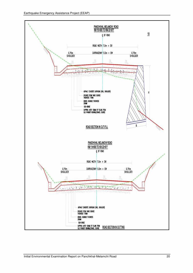
Earthquake Emergency Assistance Project (EEAP)
Initial Environmental Examination Report on Panchkhal-Melamchi Road 20

Earthquake Emergency Assistance Project (EEAP)
Initial Environmental Examination Report on Panchkhal-Melamchi Road 21
4. DESCRIPTION OF THE ENVIRONMENT
4.1 Physical Resources
4.1.1 Meteorology and Climate
The project area has Sub-Tropical climate in the lower part, while the upper part has Cool
Temperate climate. Upper part of Melamchi valley receives more rainfall than in the lower
part. Heavy rainfall occurs in June, July and August. Rainfall in January and February is the
lowest. The annual average rainfall in the Melamchi basin is about 2800 mm which is
concentrated mostly during four months of the monsoon of mid-June to mid-September.
Average annual rainfall conditions vary considerably by location in the valley. In general,
average annual rainfall is low at lower elevation and is relatively high in the higher elevation.
The average maximum and minimum temperatures of Kavrepalanchwk district is 31ºC and
10ºC respectively and average annual rainfall in the district is 1582 mm. Similarly, average
annual rainfall in Sindhupalchowk district is 1,615 mm and the average maximum and
minimum temperatures of this district is 32.5°C and 5°C respectively (District Profile of
Sindhupalchowk, 2014).
4.1.2 Topography and Soils
The road runs in northeast direction following moderate sloping terrain and passes by river
valley and ends at Melamchi Bazaar at Km 22+977. Major portion of the alignment passes
through river valley. The Melamchi Valley is typically narrow, steep Himalayan River-Valley.
The lower valley slopes are very steep, rocky and "V" shaped in the high mountain whereas
in the middle the valley slopes are dissected by rolling alluvial tars at the bottom. The middle
mountain slopes, have gentler aspect and are the sites of settlements. The upper mountain
slopes are very steep, rocky and with pointed ridgeline.
Soil type along the alignment can be classified as alluvial, colluvial, residual, boulder mixed
soil, and hard and soft rock. Approximately, 45% of road alignment passes through
cultivated land, about 35% passes through alluvial to colluvial deposits (in general
engineering on boulder mix soil), about 14% over soft phyllitic to schistic weathered rock
mass and remaining 6% over fresh to slightly weathered and slightly fractured hard rock of
(Phyllite to schist with quartzite). Thickness of alluvial and colluvial deposits (more than 5 m)
at some sections are found along the road. These exposed rocks are slightly to moderately
weathered on surface.
Majority of road alignment traverses through cultivated soil and boulder mixed soil (75.85%)
followed by cultivated soil, boulder mixed soil and soft rock (24.15%).
Table 4.1: Soil Type along the Road Alignment
S.N. Chainage Range Length (m) Soil type Percent (%)
1 0+000 to 4+800 4800 CS+BMS 20.89
2 4+800 to 10+350 5550 CS+BMS+SR 24.15
3 10+350 to 22+977 12627 CS+BMS 54.96
Total 22977 100.00
Source: TPPF Field Survey, 2015, Legend: CS: Cultivated Soil, BMS: Boulder Mixed Soil, SR: Soft
Rock, HR: Hard Rock

Earthquake Emergency Assistance Project (EEAP)
Initial Environmental Examination Report on Panchkhal-Melamchi Road 22
4.1.3 Land Use Pattern
Land use pattern of the area through which the road alignment passes have been classified
into four types: market area, settlement area, agriculture land, and forest area.
The detailed existing land use patterns along the road corridor are depicted in Table 4.2.
Table 4.2: Land Use Pattern along Road Alignment
SN Land use Length (m) Percent (%)
1 Market Area 2200 5.53
2 Settlement Area 2255 5.67
3 Agricultural Lands 3455 8.68
4 Forest Area 3843 9.66
5 Agricultural Land and Forest Area 10550 26.52
6 Settlement Area and Cultivated Land 2990 7.52
7 Forest + Cultivated Land + Settlement Area 14487 36.42
Total 39780 100
Source: Field Survey, 2015 Legend: FA- Forest Area, MA- Market Area, SA- Settlement
Area, CL- Cultivated Land
4.1.4 Hydrology and Drainage
There are 8 small and large streams (including dry streams) across the road alignment as
water resources. There are six (6) irrigation canal crossings along the road alignment
(Chainages: 9+795, 10+090, 15+700, 17+080, 20+100 and 21+640). In addition, there are
many dry streams along the road alignment. No wetlands are found within the vicinity of the
road. Table below shows the list of rivers/streams crossed by the Panchkhal-Melamchi Road
Section.
Table 4.3: Rivers/Streams crossed by the Road Section
S. No. River/Streams Chainage(m)
1 Phedi Khola 1+297
2 Cha Khola 2+100
3 Dhad Khola 10+480
4 Jarke Khola 15+940
5 Sindhu Khola 16+660
6 Dhakal Khahare 18+525
7 Dunde Khola 20+030
8 Jageshwori Khola 21+970
Source: TPPF/PPC-2 Field Study 2015
4.1.5 Geology/Seismology
Geologically, proposed road alignment passes on the rocks of schist to phyllite formation, of
Lesser Himalaya. Exposed rocks are moderately to slightly weathered whereas valley slope
have thick residual/filling and colluvial soil.
The road section comprises of different types of quartzite, phyllite and schists. The road
alignment passes through slightly weathered to moderately weathered and fractured rocks

Earthquake Emergency Assistance Project (EEAP)
Initial Environmental Examination Report on Panchkhal-Melamchi Road 23
of phyllite to schist. Residual colluvial having thickness of 2 to 5 m and alluvial deposit of
more than 5 m thick lies on most of the slope above rock.
Specific information on seismic hazard of the project road corridor is not available. Such
type of information is available only in regional basis (Figure 4.1). Central Nepal in general
has experienced fewer earthquakes than the rest of Nepal in the past. Nepal is a high risk
earthquake zone, sitting over several seismic thrust and fault zones and it experiences
several earthquakes every year. Two earthquakes measuring 5.5 and 4.5 on the Richter
scale (at Listikot in the Sindhupalchowk district, 80km east of Kathmandu close to Nepal's
border with Tibet) rocked central and eastern Nepal on 3rd January 2004.
Recently, the April 2015 Nepal earthquake (also known as the Gorkha earthquake) killed
more than 8,800 people and injured more than 23,000. It occurred at 11:56 NST on 25 April,
2015, with a magnitude of 7.6 Richter scale (7.8 reported by USGS) and a maximum
Mercalli Intensity of IX (Intense). Its epicenter was in Gorkha and its hypocenter was at a
depth of approximately 15 km (9.3 mi). It was the worst natural disaster to strike Nepal since
the 1934 Nepal–Bihar earthquake. A major aftershock occurred on 12 May 2015 with a
magnitude of 6.8 (7.3 reported by USGS). The epicenter was in Sindhupalchowk/Dolakha.

Earthquake Emergency Assistance Project (EEAP)
Initial Environmental Examination Report on Panchkhal-Melamchi Road 24
Figure 4.1: Probabilistic Seismic Hazard Map of Nepal
4.2 Ecological Resources
4.2.1 Forest/Vegetation
The major forest types according to field survey that are found in the subproject area are Schima wallichii, Castanopsis indica, and Pinus roxburghii. The forest is sparse with dominant species observed in the road alignment are Uttis (Alnus nepalensis), Chilaune (Schima wallichii), Salla (Pinus roxburghii), and Katus (Castanopsis indica), Lapsi (Choerospondias axillaries), Phalant (Quercus lamellose).
Other vegetation found in the community forests within the ZoI are Mayal (Pyrus pushir),
Shirish (Albizia procera), Painyu (Prunus cerasoides). NTFPs found within the ZoI are
Timbur, Kafal (Myrica esculenta), Lapsi (Choerospondias axillaris) and Lemon (Citrus
aurantifolia). There are four (4) Community forests along the road alignment. The road
section does not fall under any protected or buffer zone area.
Table 4.4: Community Forests (CF) Along Road Alignment
S. No.
Name of CFUG Chainage Location
1 Panchkhal Bokse 00+060 – 00+900 Panchkhal-6, Kabhrepalanchok 2 Khanikhola 01+635 – 02+100 Jaisithok-4, Kabhre 3 Phatteko 17+500 – 18+600 Melamchi-5, Sindhupalchok 4 Ram Dunde 21+400 – 21+600 Melamchi, Sindhupalchok
Source: Field survey, 2015

Earthquake Emergency Assistance Project (EEAP)
Initial Environmental Examination Report on Panchkhal-Melamchi Road 25
4.2.2 Endangered and Protected Species
The protected vegetation found in the subproject area contains three tree species
and one herb species (Table 4.5). However, Swertia chirayita is not affected by the
upgrading activities of the road.
Table 4.5: Protected Vegetation in the Subproject Area
SN Local Name
Scientific Name Remarks
IUCN Category
CITES Code
Forest Rules, 1995
1. Okhar
Juglans regia - Appendix II Banned for collection, use, sale and transport
2. Chiraito Swertia chirayita V 3. Sal Shorea robusta Banned for felling,
transportation and export for commercial purposes.
4. Lapsi Choerospondias axillaris
R
Source: Source: Field survey, 2015 E= Endangered V= Vulnerable T= Threatened, R=Rare
4.2.3 Non-Timber Forest Product (NTFP)
Non-timber forest products (NTFPs) are defined as any kind of products derived from forest
species other than timber and fuel wood. The major NTFP species found in the along the
road are Amala (Emblica officinalis), Chutro (Berberis aristata), Chiraito (Swertia Chirayita),
Koiralo (Bahunia variegata), Timur (Zanthoxylum armatum), Ghodtapre (Centella asiatica)
and Majitho (Rubia manjith).
4.2.4 Trees on Farm land
Trees have been planted on farm land. The species are mainly fodder species and common
species are Chilaune, Sal, and Uttis etc.
4.2.5 Terrestrial Wildlife
Common wildlife including Common Mongoose (Herpetes edwardsii), Jackal (Canis aureus),
Monkey (Macaca mulatta), Barking Deer (Muntiacus muntijak), Jungle Cat (Felis chaus),
Squirrel (Ratuta sp) and Porcupine (Hystrix indica) are the mammals and House Sparrow
(Passer domesticus), House Crow (Corvus splendens), Kalij Pheasant (Lophura
leucomelana), Blue Rock Pegion (Columba livia) are common birds found in the surrounding
forests along the road alignment. Among the fauna present in the forest area along the road
alignment, Common Mongoose (Herpeks edwardsi) is listed in CITES Appendix iii, Jakal
(Canis aureus) is listed is listed in CITES Appendix iii, Squirrel (Rauta sp) is listed in CITES
Appendix ii.
4.2.6 Birds
Major species of birds reported in the subproject area are Kalij (Lophura leucomelana),
Kaag (Corvus splendens), Bhangera (Passer domesticus), Dangree (Acridotheres fuscus),
Mayur (Pavo cristatus), Jureli (Pycnonotus spp.), Chibe Chara (Dicrurus aeneus), Nyauli

Earthquake Emergency Assistance Project (EEAP)
Initial Environmental Examination Report on Panchkhal-Melamchi Road 26
(Megalaima zeylanica), Kuthurke (Megalaima lineate), Dhukur (Streptopelia spp. &
Chalcophaps spp.), Karangkurung (Anthropoides virgo) etc.
4.2.7 Fish, Amphibians and reptiles
The major species reported in the subproject area are Sahar (Tor spp.), Eel (Anguilla
bengalensis), Jalkapoor (Ompac bimaculatus), Katle (Acrossocheilus hexagonolepis) and
Asla (Schizothorax spp. & Schizothoraichthus spp.), Pani Bhyaguta (Rana tigrina), Paha
(Bufo spp.) and Gohoro (Varanus spp.) are recorded amphibians and reptiles respectively in
the project area.
The road does not fall under any protected or buffer zone area.
4.3 Economic Development
4.3.1 Industries
Project districts are basically agricultural based districts. The occupation pattern of the
district is approximately 77.3% of the active populations are involved in agricultural sector.
Subsistence agriculture farming, mainly small scale livestock is the main source of
occupation and livelihood of the majority of the population, with 79% of the population active
in this sector. Although there is availability of raw materials in the district for small and
cottage industries, utilization of those materials and development of such industries is not
satisfactory. Lack of adequate skills, lacks of market and limited production are the some of
the reason behind lagging in the development of this sector.
Table 4.6: List of Small, Cottage and Agro-based Industries
SN Type of Industry Registered Operation Closed Remarks
1 Agro-based 359 176 183 Rice mill, Bakery, Chhurpi
2 Forest-based 89 60 29 Furniture, Nepali paper, Herbal
3 Mines 36 9 27 Lime, Cement
4 Energy 15 5 10
5 Tourism 5 3 2 Travel/ Trekking
6 Service-based
256 100 156
Construction, Computer, Typing, Press, Arts, Grill, Consultancy, Hair cutting, Radio/TV repairing
7 Hotel/Restaurants 10 10 -
8 Slate
13 13 - Tatopani, Listi, Ghumthang(2), Karthali, Golche(5), Baramchi, Hagam, Gumba
9 Stone Crushers
11 9 - Indrawati 6, Sunkoshi 3, 2 on process
10 Others
312 53 259
Leather-shoes, Leather process, Allo knitting, Cutting & Knitting, Hosiery, Radi/Pakhi, Gold/Silver, HH Utensils etc.
Source: District Cottage and Small Industry Development Office/District Profile 2067
Table 4.7: List of Micro-Enterprises
S. N. Main Micro Enterprises Nos. S.N. Main Micro Enterprises Nos.
1 Handicraft/Dhaka knitting 13 2 Nepali Kagaj, Bio-bricket 83

Earthquake Emergency Assistance Project (EEAP)
Initial Environmental Examination Report on Panchkhal-Melamchi Road 27
S. N. Main Micro Enterprises Nos. S.N. Main Micro Enterprises Nos.
3 Vegetables farming 176 4 Goat rearing 331
5 Mushroom farming 170 6 Leather product 48
7 Lapsi processing 227 8 Sewing 140
9 Dhoop (Incense) Making 40 10 Allo processing/knitting 40
11 Fisheries & Pig farming 34 12 Bamboo products 73
13 Furniture 24 14 Others 583
Source: District Profile, Sindhupalchowk, 2067
The area has the potentiality of agro based industries such as dairy products, juice
production, food processing as well as furniture, bamboo products. Goods of daily
commodities are major imports in the project area, which includes salt, sugar, packed food
items, spices, clothes and other items of daily uses. Similarly, major items exported from the
project area are milk, amliso (broom grass), vegetables, fruits, timber especially of Uttis
(Alnus nepalensis), bamboo products etc. whereas cereal crops such as rice, maize are also
export and import items.
4.3.2 Infrastructure Facilities
Water Supply
In the project area, major (68.15%) source of drinking water was found to be from piped
water supplied through community made water tanks. About 12.56 % of the household also
use spout water as a source of drinking water. Other source of drinking water is river/stream.
About 17.93 % of the households use well/spring for the purpose of drinking water. The use
of underground water for drinking water is very insignificant.
Table 4.8: Households by main source of drinking water
District/Municipality/VDC T
ota
l h
ou
seh
old
s Main Source of Drinking Water
Tap
/pip
ed
w
ate
r
Tu
bew
ell /
h
an
dp
um
p
Co
vere
d
well/k
uw
a
Un
co
vere
d
well/k
uw
a
Sp
ou
t w
ate
r
Riv
er
/str
eam
Oth
ers
No
t S
tate
d
Kavrepalanchowk 80,651 63,832 217 4,983 5,205 4,760 540 417 697 Sindhupalchowk 66,635 53,799 3 731 1,264 9,904 368 198 368 Panchkhal Municipality
7,457 4,657 13 1,386 867 390 18 89 37
Jaisithok Mandan 667 538 1 18 72 36 0 1 1 Chandeni Mandan 782 610 0 4 32 134 0 0 2 Mahadevsthan Mandan
1,873 1,316 0 61 155 336 0 1 4
Gairi Bisouna Deupur 1,203 813 1 97 160 123 1 0 8 Melamchi Municipality
6354 4562 0 216 220 1284 38 6 28
Total 18,336 12,496 15 1,782 1,506 2,303 57 97 80
Percent (%) 100 68.15 0.08 9.72 8.21 12.56 0.31 0.53 0.44
Source: CBS Nepal, 2011

Earthquake Emergency Assistance Project (EEAP)
Initial Environmental Examination Report on Panchkhal-Melamchi Road 28
Market Centres
The major market centres in the project districts include Panchkhal, Chautara, Bahrabise,
Khadichaur, Melamchi. Other major business centres are Talamarang, Bahunepati,
Gyalthum, Chanaute and Sipaghat. These market centres are famous for agricultural and
industrial products.
Communication
Telephone service is available in all municipalities and VDCs of project districts. Nepal
Telecom and NCell are two telephone service provider companies in the district. Similarly,
Mobile communication system both the CDMA and GSM are available in almost all parts of
the district. After laying optical fibers along Araniko Highway, the telephone accessibility of
Internet/E-mail services has been improved significantly. Internet/Email services are easily
available to general public from main market centers namely Chautara, Tatopani, Barhabise,
Khadichaur, and Melamchi. In addition, Internet service from CDMA mobiles is also
accessible in the district.
Transportation
Kabhrepalanchowk district have just over 1723.70 km of roads, including 153.97 km of
strategic roads and 181.77 km of urban roads. Thirty eight (38) rural roads with a length of
681.60 km make up the district road core network (DRCN), and the remaining 708.10 km
are classified as village roads. Existing DRCN roads link up 87 of the VDC headquarters. All
of the DRCN roads are earthen fair‐weather roads. Kavreplanchock district has 7 Feeder
Road totalling 59.23 km. There are mainly two highways in Kavreplanchock district (BP
Highway, Arniko Highway). All of the highways are blacktopped totalling 93 kilometres. The
DRCN consists of 87 district roads with a total length of 681.80 km. The remaining 708.10
km of existing rural roads are not considered to be DRCN roads and are classified as village
roads under the responsibility of the VDCs. All DRCN roads are currently earthen roads
some are gravel and are considered fair‐weather only.
Similarly, Sindhupalchok district has total 2484.72 km road length comprising 145.81 km
(5.9%) strategic roads, 1417.20 km (57%) district roads and village roads 921.71 km
(37.10%). In terms of type of road surface, black topped is 119.31 km (4.8%), graveled is
46.50 km (1.9%), earthen road 2318.91 km (93.3%). Of the total length of 2484.72 km,
2257.55 km is motorable road (vehicles can only ply during fair weather), of which 647.12
km (28.7%) is easily vehicle passable, 1610.43 km (71.3%) is vehicle operable with difficulty
during fair weather and 227.17 Km is non-motorable bearing 9.14% of total 2484.72 km.
Many roads are under construction (track opening) width having less than 3.00m (leaving
some major district roads constructed following rural road standards). Accordingly, the total
road density is 97.75 per 100 Sq. km. and motorable road density is 88.80 per 100 sq.km of
area (DTMP, Sindhupalchowk District, 2011).
4.3.3 Power Sources and Transmission
Electricity and Energy
In Kavrepalanchowk district, about 87.30% households use electricity from national grid for
lighting. About 8.30% households use kerosene and 2.18% households use solar energy for
lighting. Similarly in Sindhupalchowk, about 88.30% households use electricity from national

Earthquake Emergency Assistance Project (EEAP)
Initial Environmental Examination Report on Panchkhal-Melamchi Road 29
grid for lighting. About 9.20% households use kerosene and 1.30% households use solar
energy for lighting.
In the project area, about 93.40% households use electricity from national grid for lighting.
About 5.39% households use kerosene and 0.28% households use solar energy for lighting.
Table 4.8 below shows the source of lighting used in the project affected municipalities and
VDCs.
Table 4.9: Households by usual source of lighting
Municipality/VDCs Total HHs
Source used for lighting
Electricity
Kerosene Bio-gas
Solar Others Not
Stated
Kavrepalanchowk 80,651 70,415 6,692 147 1,756 939 702
Sindhupalchowk 66,635 58,827 6,124 3 837 460 384
Project Affected Municipality/VDCs
Panchkhal Municipality 7,457 7,005 311 22 38 43 38
Jaisithok Mandan 667 637 28 0 1 0 12
Chandeni Mandan 782 763 9 3 0 5
Mahadevsthan Mandan 1,873 1,821 39 3 3 2 5
Gairi Bisouna Deupur 1,203 1,146 42 3 3 1 8
Melamchi Municipality 6354 5,753 560 0 7 6 28
Total 18,336 17,125.00 989 31 52 57 91
Percent (%) 100 93.40 5.39 0.17 0.28 0.31 0.50
Source: National Census, CBS, 2011
4.3.4 Agriculture Development
Main cereal crops grown in the project districts are rice/paddy, maize, wheat, millet. Maize
covers the largest area of production of approximately 42075 ha. However, the wheat has
the highest productivity per ha. Similarly, vegetables (both seasonal and off seasonal),
potatoes are produced widely which has comparatively about five times the productivity of
cereal crops. Sindhupalchowk has high potential for vegetables including potatoes
production. Citrus fruits mainly orange, jyamir and lemon are also largely produced.
Livestock is an important component of farming system in Sindhupalchowk district.
Chicken/Ducks is the largest number of livestock population then followed by Goat/Sheep,
buffaloes, cattle and others. Similarly, the livestock production mainly milk, meat, egg and
wool are significantly produced.
4.3.5 Potential Development area
Both the project districts are agricultural based districts. Majority of the active population are
involved in agricultural sector. With this involvement of large population and significant
production, project districts are expected to have high potential for the agricultural
production.
Sindhupalchowk is a very famous destination for religious visit both for Hindu and Buddhist
due to well-known Panchpokhari, Tatopani, Palchok Bhagawati, Fatkeshwar Mahadev,
Gaurati Bhimeshwar, Bhairabkunda, and so on. If this particular spot is well developed with

Earthquake Emergency Assistance Project (EEAP)
Initial Environmental Examination Report on Panchkhal-Melamchi Road 30
good infrastructure and facilities, more tourists are expected to visit. Similarly, the mountain
peaks like Langpoghyang (7085m), Jugal Himal (6799m) are the nearest mountain from
Kathmandu. In addition, numbers of trekking routes are in operation in the district namely;
Palchokghyang - Kakani - Sermathan - Tarkeghyang, Sundarijal - Shivapuri – Patibhanjyang
-Golphubhanjyang - Kutumsang - Ghopteghyang - Tartung - Melamchighyang, Melamchi -
Helambu and Ganjala pass (5623m) etc. From Tamchebhanjyang (Attarpur VDC), a unique
view to various Mountains, Dugunagadhi, Sindhuligadhi and many parts of Sindhupalchowk
as well as Kavrepalnchok, Dolakha, and Ramechhap districts. Other potential areas for
tourism includes Bungy jump (Naya pul) and Rock climbing sites, Natural spring/Bhemtang
mul (Helambu; 108 water jets), Natural caves viz. Patal Gufa, Sadashiva Gufa, Swami
Abhayananda Gufa etc.
4.4 Social and Cultural Resources
4.4.1 Population and Communities
As per National Census 2011, total population of Kabhrepalanchowk district is 381937
comprising 199001 female (52.10%) and 182936 male (47.10%) having 80720 households.
The average family size is 4.73. As per National Census 2011, total population of
Sindhupalchowk district is 287798 comprising 149447 female (51.93%) and 138351 male
(48.07%) having 66688 households. The average family size is 4.32.
The road passes through two municipalities (Panchakhal of Kavrepalanchowk and Melamchi
of Sindhupalchowk district) and 4 VDCs of Kavrepalanchowk district namely Jaisithok,
Mahadevsthan, Gaire Bisauna Deupur and Chandeni Mandan of Kavrepalanchowk District.
The road section passes through various settlements such as Zero kilo bazaar,
Narbadapati, Saudeli bazaar, Kunta bazaar, Sipaghat, Milanchowk, Melamchi bazaar.Total
population residing along the Project affected municipalities and VDCs is 82,572 persons
(18,336 households) and average family size of 4.50.
Table 4.10: Population Distribution by Project affected District, Municipality/VDCs
Municipality/VDC Total HHs Population Average
HH Size Total Male Female
Kavrepalanchowk 80,720 381,937 182,936 199,001 4.73
Sindhupalchowk 66,635 287,798 138,351 149,447 4.32
Panchkhal Municipality 7,457 33,847 16,092 17,755 4.54
Jaisithok Mandan 667 2,965 1,358 1,607 4.45
Chandeni Mandan 782 3,265 1,500 1,765 4.18
Mahadevsthan Mandan 1,873 8,166 3,890 4,276 4.36
Gairi Bisouna Deupur 1,203 5,374 2,497 2,877 4.47
Melamchi Municipality 6354 28955 13953 15002 4.55
Total 18,336 82,572 39,290 43,282 4.50
Source: District Development Profile of Nepal, CBS, 2011
4.4.2 Religion and Ethnicity
The predominant ethnic groups residing along the road section is Brahmin, Newar, Chhetri
and Dalits. The other major castes are Lama, Tamang, Sherpa, Rai and Magar. In the

Earthquake Emergency Assistance Project (EEAP)
Initial Environmental Examination Report on Panchkhal-Melamchi Road 31
project affected municipality/VDCs, Brahmin – Hill is the largest ethnic population with
25.30% followed by Tamang (21.89%), Chhetri (13.32%), Danuwar (9.71%), Newar (8.40%),
Sarki (3.57%), Kami (2.69%), Sanyasi/Dashnami (1.89%), Damai/Dholi (2.24%), Majhi
(1.96%), and others (5.31%). (Source: CBS Nepal, 2011)
In the project districts, language wise, 62.69% of total population speak Nepali and 20.52%
of people speak Tamang. Danuwar language is spoken by 8.75% followed by Newari
language with 6.50%. Along with these languages there are also other languages having
users less than 1%. (Source: CBS, Nepal, 2011)
4.4.3 Literacy Rate and Education Level
Kabhrepalanchok and Sindhupalchowk districts have literacy rate of 69.80% and 59.59%
respectively. As per 2011 Census, about 66.30% of population aged 5 years and above can
read and write, 30.77% cannot read and write and 2.85% can read only. (Source: CBS, Nepal,
2011)
4.4.4 Health facilities
There are different health institutions such as government hospital, private clinics which are
providing health services to the people of the project influence area. There is one District
Hospital in Chautara with fifteen beds, three Primary Healthcare Center. Other health
service institutions are listed below. For the major and emergency cases, most often people
use to travel to Kathmandu. There is another private hospital recently established in
Khadichaur. Sindhupalchowk district has 1 district hospital, 1 district ayurvedic center, 3
primary health center, 65 sub-health post, 249 village clinic, 264 immunization center and 10
ambulance service providers(District Profile 2067/District Health Office, Sindhupalchowk.
4.4.5 Sanitation
In the project influence area 68.30 % of the households have toilet facilities. Those who
have toilet mostly possess either pan or pit type toilet with flush system.
Table 4.11: Households by Type of Toilets Available
V.D.C. / Municipality Total HHs
Households without toilet
facility
Households with toilet facility of
Toilet facility
not stated Flush toilet
Ordinary toilet
Kavrepalanchowk 80,651 21,708 46,701 11,539 703
Sindhupalchok 66,635 23,900 23,538 18,834 363
Paanchkhal Municipality
7,457 1,962 4,629 828 38
Chandeni Mandan 782 264 337 179 2
Jaisithok Mandan 667 197 395 74 1
Mahadevsthan Mandan 1,873 480 1,079 309 5
Gairi Bisouna Deupur 1,203 426 630 139 8
Melamchi Municipality 6354 2403 2161 1764 26
Total 18,336 5,732 9231 3,293 80
Percent (%) 100 31.26 50.34 17.96 0.46
Source: CBS, 2011

Earthquake Emergency Assistance Project (EEAP)
Initial Environmental Examination Report on Panchkhal-Melamchi Road 32
4.4.6 Drinking Water
In the project area, major (68.15%) source of drinking water is found to be from piped water
supplied through community made water tanks. About 12.56 % of the household also use
spout water as a source of drinking water. Other source of drinking water is river/stream.
About 17.93 % of the households use well/spring for the purpose of drinking water. The use
of underground water for drinking water is very insignificant.
4.4.7 Occupational Status
The main occupation of the people residing in the ZoI of the proposed road alignment is
agriculture and livestock (25.79%). People are carrying out other economic activities like
employment as labor (10.40%), working in government and non-government organizations
(9.08 %), trade and business (13.03 %), foreign employment (5.92%). Moreover, significant
section of the economically active male population also migrates to various places including
Kathmandu and India seasonally during slack farming season for employment which is the
source of livelihood.
Now a day, the trend of foreign migration for work is also rising. Remittance from foreign
employment is also one of the main sources of income. Especially, the skill workers migrate
to Gulf Countries for certain years. Similarly the non-skilled workers of southern part
seasonally migrate to India in search of work.
4.4.8 Educational Facilities
In Kavrepalanchok district, there are 690 primary schools, 306 lower secondary schools,
195 Secondary schools and 278 higher secondary schools (Source: CBS, 2011).
There are altogether 546 education institutions at present, of which seven campuses, 102
secondary school level (34 with higher secondary level), 75 lower secondary level schools
and 362 primary level schools. Similarly 8 secondary school, 2 lower secondary school and
19 primary schools are in operational under institutional management (Source: District
Profile Sindhupalchowk, 2067).
In the project influence area, there are 44 primary schools, 13 lower secondary schools, 8
high schools and 3 higher secondary schools.
4.4.9 Physical or Cultural Heritage
The project districts host several religious and cultural structures. People in the project area
have different cultural values amongst the different ethnic groups. The major festivals are
Buddha Jayanti, Dashain, Tihar, Mha Puja, Bala Chaturdasi, Lhoshar and Ramnawami.
Most of the ethnic groups celebrate the major festivals such as Dashain and Tihar, although
these are Hindu festivals. The major Buddhist celebration is Buddha Jayanti.
Kavrepalanchowk district is famous for temples and monasteries. Palanchowk Bhagwati,
Chandeshwori, Namo Buddha, Mahadev temples (Indreshwor, Dhaneshwor, Ladkeshwor),
Shaileshwor Gosainsthan etc. are some of the famous pilgrimage sites.Sindhupalchowk is a
very famous destination for religious visit both for Hindu and Buddhist due to well-known
Panchpokhari, Tatopani, Palchok Bhagawati, Fatkeshwar Mahadev, Gaurati Bhimeshwar,
Bhairabkunda, and so on. If this particular spot is well developed with good infrastructure
and facilities, more tourists are expected to visit. Similarly, the mountain peaks like
Langpoghyang (7085m), Jugal Himal (6799m) are the nearest mountain from Kathmandu. In

Earthquake Emergency Assistance Project (EEAP)
Initial Environmental Examination Report on Panchkhal-Melamchi Road 33
addition, numbers of trekking routes are in operation in the district namely; Palchokghyang -
Kakani - Sermathan - Tarkeghyang, Sundarijal - Shivapuri - Patibhanjyang -
Golphubhanjyang - Kutumsang - Ghopteghyang - Tartung - Melamchighyang, Melamchi -
Helambu and Ganjala pass (5623m) etc. From Tamchebhanjyang (Attarpur VDC), a unique
view to various Mountains, Dugunagadhi, Sindhuligadhi and many parts of Sindhupalchowk
as well as Kavrepalnchok, Dolakha, and Ramechhap districts. Other potential areas for
tourism includes Bungy jump (Naya pul) and Rock climbing sites, Natural spring/Bhemtang
mul (Helambu; 108 water jets), Natural caves viz. Patal Gufa, Sadashiva Gufa, Swami
Abhayananda Gufa (Cave) etc.

Earthquake Emergency Assistance Project (EEAP)
Initial Environmental Examination Report on Panchkhal-Melamchi Road 34
5. ANTICIPATED ENVIRONMENTAL IMPACTS AND ITS MITIGATION
MEASURES
Environmental impacts of the proposed road improvement activities or actions during pre-
construction, construction and operation stages including induced impacts have been
identified and assessed. Appropriate qualitative and quantitative methods were applied for
determining the likely direct and indirect impacts. The impacts have been predicted in terms
of their magnitude (i.e. minor, moderate and major); extent (i.e. local, regional, national and
trans-boundary) and duration (i.e. short-term, medium-term and long-term) along with their
nature, (i.e., direct and indirect; reversible and irreversible).
Mitigation measures are actions taken by DoR mainly through its contractors that avoid,
reduce or compensate the potential adverse environmental consequences of the project
activities. The mitigation measures are of preventive, curative and compensatory types.
Mitigation measures that have been proposed for the augmentation of beneficial impacts
and minimization of the adverse impacts of the proposed road improvement activities also
incorporate the outcomes arrived t through consultations and discussions with affected
people and stakeholders. The anticipated impacts through the proposed improvement
activities have been discussed along with the mitigation measures.
5.1 Impacts on Physical Environment
Project road improvement activities will have no impact on physical environment during pre-
construction stage.
5.1.1 Micro-Climate
Construction Stage
There is a risk of impact on the micro-climate due to change in land use from the removal of
70 trees from five (5) community forests; namely: Panchkhal Bokse, Khanikhola, Phurke
Sallo, Phatteko, and Ram Dunde CFUGs and increase in paved surface which will increase
the change in micro climate.
Mitigation Measures
Compensatory plantation will be carried out at the rate of 25 saplings for each felled tree.
Altogether plantation of 12,375 saplings will be carried out as the compensatory
plantation in order to ameliorate the micro - climate of the project area.
Attempts shall be made from every aspect to protect trees during construction to
minimize impacts on the micro-climate.
Roadside plantation of pollution absorbent tree species especially nearby settlements
and other public places will be done.
Operation Stage
The compensatory plantation will help to reduce the effects of greenhouse gas emission
from vehicle to a certain extent. Further additional plantation of tree will maintain the micro
climate of the whole corridor.

Earthquake Emergency Assistance Project (EEAP)
Initial Environmental Examination Report on Panchkhal-Melamchi Road 35
Mitigation Measures
As part of transport rules condition of vehicles will be monitored regularly and rules will be
enforced effectively. In addition, compensatory plantation will reduce the level f GHGs in
atmosphere.
5.1.2 Air Quality
Construction Stage
Potential sources of air pollution during the construction stage include: dust emission from
earth works; emissions from the operation of construction equipment and machines; fugitive
emissions from vehicles plying on the road; fugitive emissions during transport of
construction materials; air pollution from combustion of hydrocarbons particularly from the
hot mix plants, and localised increased traffic congestion in construction areas.
Most of the emissions will be in the form of coarse particulate matter and will settle down in
close vicinity of construction site. Installation of crusher unit will also lead to air pollution.
Hot mix plant will generate carbon monoxide (CO), un-burnt hydrocarbon, sulphur di-oxide
(SO2), particulate matters, and nitrogen oxides (NOx) emissions. This may affect the air
quality of nearby areas especially due to emission discharge from low height stack. The
impact will be minor, local, short-term, direct and reversible.
Construction materials will be transported from Indrawati River, Melamchi river,
Talamaryang Khola, Ganesya Khola and Melamchi River and Timbu Khola confluence and
these area are away from settlements. The vehicles that transport construction materials will
be covered with tarpaulin. Hence, minimal impact is envisaged.
Mitigation Measures
Following mitigation measures shall be applied to avoid or minimize the impacts during
construction. They include:
Water sprinkling, water fogging, broom sweeping shall be carried out in dust prone locations, unpaved haulage roads2, earthworks, stockpiles including asphalt mixing plant areas.
Open burning of solid wastes (plastic, paper, organic matters) shall be prohibited.
Use of dust control methods (such as covers, water suppression on unpaved road surfaces, or increase moisture content for open materials storage piles) shall be practiced.
Very old vehicles emitting gases beyond prescribed standard shall be checked and avoided.
Masks and personal protective equipment shall be provided to the construction workers to minimize inhalation of suspended particulate matters.
Mixing plants and asphalt (hot mix) plants including crushers and the batching plants shall be located at least 1 km downwind from the nearest settlement only after receiving permission from the Supervision Consultant. Hot mix plant shall be fitted with
2 Water Flushing/Broom Sweeping can reduce emission from 0-96%

Earthquake Emergency Assistance Project (EEAP)
Initial Environmental Examination Report on Panchkhal-Melamchi Road 36
stack/chimney of adequate height as prescribed by Supervision Consultant to ensure enough dispersion of exit gases.
Heaters shall be used for heating purpose to the extent feasible.
Only crushers licensed by GoN shall be used.
LPG or kerosene shall be used as fuel source in construction camps instead of wood. Tree cutting for fuel wood shall be restricted.
Diesel Generating (DG) sets shall be fitted with adequate height.
Diesel with low sulphur content shall be used in DG sets as well as other machineries.
Air quality shall be monitored during construction stage and if monitored parameters are above the prescribed limit, suitable control measures shall be applied.
Operation Stage
Vehicular emission3 will be the main source of air pollution during operation stage. The
project road runs mostly through settlements, forests including agriculture lands and grazing
patches. Forests will serve as a sink for pollutants and reduce the flow of dust/gaseous
pollutants. Generated traffic on the project road will be minimal. Hence, emission impacts
will be minimal as well. In addition uninterrupted flow of existing vehicles and improved road
conditions will restrict air pollution in settlement areas.
Mitigation Measures
Roadside plantation of pollution absorbent tree like the Eucalyptus species, Azadirachta indica, Melia azediarch, Grevelia robusta etc. species especially nearby settlements and other public places will help to reduce pollution due to dust.
DoR will coordinate with relevant agencies on the implementation on and enforce Nepal Vehicle Mass Emission Standard, 1999 and will stipulate vehicle owners to engage in proper and regular vehicle maintenance.
Air pollution by dust will be controlled with provision of paved shoulders, especially in the sensitive/built up areas.
DoR will partner with Development organizations (NGO, INGO and CBOs) motivate the local communities to maintain greenery along the road apart from their houses by planting fodder, fuel wood and fruit trees including flowering plants.
5.1.3 Noise Level
Construction Stage
Level of ambient noise may increase temporarily in the close vicinity of various construction
activities including maintenance of workshops and vehicles, and earthmoving equipment.
These activities are expected to produce noise levels in the range of 80 - 95 dB (A) (at a
distance of about 5 m from the source). Although this level of noise is higher than the
permissible limit for ambient noise level for residential/commercial areas, but this range will
occur only intermittently and temporary. This noise level will attenuate fast with increase in
distance from noise source. Impact due to noise during construction activities will be minor
to sensitive receptors since most of the settlements are located at safer distance from the
road.
3 Similar to other combustion processes, emissions from vehicles include CO, NOx, SO2, PM and VOCs

Earthquake Emergency Assistance Project (EEAP)
Initial Environmental Examination Report on Panchkhal-Melamchi Road 37
Mitigation Measures
Following mitigation measures shall be applied to avoid and/or reduce impact of noise
arising through various activities during construction. These include:
Temporary construction facilities such as labour camps, vehicle maintenance workshop and earth moving equipment shall be located away from settlements and other sensitive areas as far as possible.
Noise sources such as stone crushers, vehicles movements and work at stone quarry and borrow pit shall be re-located to less sensitive areas to take advantage of distance and shielding.
Opportunity shall be explored to take advantage of the natural topography as a noise buffer such as behind the ridge that break the line of sight between the source of noise and the receptors during facility design.
Silencers shall be installed to construction equipment and machinery and maintained properly.
Equipment and machinery with lower sound power levels shall be selected for the use.
Protection devices such as ear plugs/ or ear muffs shall be provided to the workers during period of operating high noise generating machines.
Noise levels shall be measured to ensure the effectiveness of mitigation measures.
Construction activities shall be carried out only between 6 A. M. to 8 P. M. to avoid disturbance to nearby communities at night.
Multi-layered plantation shall be initiated during construction near the built up areas close to the project. This shall serve as mitigation for operation stage.
Noise barriers such as earth mounts or walls of wood, metal that form a solid obstacle between the road and roadside community shall be used, especially in the schools and hospitals.
A Grievance Redress Mechanism shall be developed to record and respond to complaints on noise by the local communities.
Operation Stage
Noise generated by traffic movement will be the main source of noise during operation
stage. Traffic congestion and pedestrian interferences may increase the use of horns. This
may disturb nearby sensitive locations such as hospitals, schools, religious and cultural
sites.
Mitigation Measures
Effective traffic management and good riding conditions shall be maintained to reduce the noise level throughout the stretch and speed limitation and honking restrictions shall be enforced near sensitive locations such as hospitals, schools etc.,
Effectiveness of the multi-layered plantation shall be monitored.
Awareness shall be created amongst the residents about likely noise levels from road operation at different distances.

Earthquake Emergency Assistance Project (EEAP)
Initial Environmental Examination Report on Panchkhal-Melamchi Road 38
5.1.4 Impact on Land and Soil
Construction Stage
Land and soil will be contaminated through inappropriate construction methods and
management of spoils. Pollution risks may originate from transportation of hazardous
materials during road construction and subsequent traffic operation. There will be temporary
change in the land use patterns by access road and labour camp. This will also result in loss
of soil productivity.
Mitigation Measures
The top soil (0-25 cm) from the productive land (borrow areas, road widening areas, etc.,) shall be preserved and reused for plantation and restoration purposes.
It shall be ensured that any private land taken on lease, used community or/ government land for access road and construction/labour camp shall be restored back to its original land use before handing it over back to land owner.
Operation Stage
Better access can lead to conversion of agriculture land close to roads, especially in bazaar
area for residential and commercial purposes. This will result in loss of productive land and
agricultural production.
Mitigation Measures
DoR has policy of 15 m RoW protection in the feeder roads4. However, GON policies and guidelines suggest most economical and practical way possible and make best uses of appropriate technology5. Accordingly the technical design of project road is based on the design standard by (i) utilizing the existing alignment and (ii) considering 8 metres corridor of impact (COI) for 5.0 m of formation width.
5.1.5 Landslide and Soil Erosion
Construction Stage
Major landslides are reported at Km. 0+700 to 1+350, and Km. 8+000 to 8+500. At around
Chainage 8+000 to 8+500 is problematic due to deep seated and active in nature.
Otherwise most of the roadside slopes are naturally vegetated with good vegetation covers.
Mitigation Measures
Soil erosion shall be stabilised by applying engineering as well as bioengineering techniques.
During road improvement only required vegetation shall be cleared and eroded bare slopes shall be re-vegetated.
4 According to ESMF, the standard ROW of feeder road in Nepal is 15 m on either side from the centreline of the
road. 5 DoR, The Design Standards of Feeder Roads, (Third Revision, GON, DOR, 1997)

Earthquake Emergency Assistance Project (EEAP)
Initial Environmental Examination Report on Panchkhal-Melamchi Road 39
Operation Stage
Landslides and soil erosion occur due to both natural and induced phenomena thus
continuous monitoring of the road condition is imperative; especially during and after rainy
season.
Mitigation Measures
DoR has established a system of employing Length-Persons (road maintenance staffs) and
their supervisor. They are responsible for routine and recurrent maintenance of roads like
cleaning up drains, soil deposited on the roads due to slope failures and erosion.
5.1.6 Borrow Pits and Quarry Sites
Construction Stage
Collection of construction materials may have long-term and sometimes irreversible effects,
for instances, roadside quarry operation may pose slope failure and if left unmanaged may
damage road also. Detail investigation has been carried out during detailed design for
borrow pits and quarry sites.
Apart from the availability of suitable quality of the construction materials, selection of
locations for borrows pits and quarry sites depend on a large number of other factors. Such
factors include fragility of landscape, legal aspects, aesthetic value of the landscape, and
ownership of lands, protected and sensitive areas including approval from the prescribed
authority.
Mitigation Measures
Borrow pits and quarry sites shall be selected avoiding protected and sensitive areas, nearby settlements, water sources, and in forest areas and fertile agriculture lands. The potential sites shall be the waste and low quality of barren lands.
Approval from authorities of government and land owners shall be taken.
Suitable size of borrow pits and quarry sites shall be operated as per required volume of materials.
Top soil shall be stockpiled and preserved to spread during reinstatement of sites. In turn, preserved top soil shall be spread and grasses seeding with long mulch and tree planting shall be carried out as a part of bioengineering. Leguminous plant species shall be planted in order to restore nitrogen in the soil.
Monitoring of borrow pits and quarry sites restoration plan in tune with the proposed restoration plan is given in Appendix G.
Operation Stage
In Nepal, generally borrow pits and quarry sits are developed nearby the alignment and left
without restoring. Such sites eventually have become causes of landslides and soil erosion.
Not only that they have also damaged road alignments.
Mitigation Measures
DoR will orient Supervisor of Length-Persons in order to check and maintain drains and erosion and also to protect vegetative covers on the restored sites of borrows and quarries.

Earthquake Emergency Assistance Project (EEAP)
Initial Environmental Examination Report on Panchkhal-Melamchi Road 40
5.1.7 Soil Contamination and Compaction
Construction Stage
Soil of the cultivated land nearby road may be contaminated from mixing of construction
materials such as stones, sands, gravels including bitumen, lubricants, paints and other
chemicals.
Soil of haulage roads including labour camps and workshop areas will be compacted due to
movement of construction vehicles, machineries, and equipment if haulage roads are
unpaved. Such activities will impair productive potentiality of the soil especially in cultivated
lands.
Soil will be contaminated due to inappropriate disposal of liquid wastes (lubricating oil and
fuel spills, and vehicle/equipment washing effluent) and solid wastes (fuel filters, oily rags)
likely to be generated from repair and maintenance of transport vehicles, construction
equipment and machinery. Further, soil will also be contaminated due to mixing with
domestic solid waste, sewage from labour camps, if not disposed of safely and carefully.
Mitigation Measures
Detailed plan of action including locations shall be prepared by the Contractor for labour
camps, haulage roads, workshop and storage of area for different materials and
approval shall be taken through the Supervision Consultant.
Fuel and lubricants shall be stored as per the plan. Storage area shall be paved with
gentle slope to a corner and connected with a chamber to collect and recover any spills
of oils.
All efforts shall be made to avoid and/ minimise the solid and liquid wastes generation.
Unavoidable solid and liquid wastes shall be stored at designated places prior to
disposal. To avoid soil contamination at the wash-down and re-fuelling areas, ―oil interceptors‖ shall be provided. Oil and grease spill and oil soaked materials shall be
collected and stored in labelled containers (Labelled: WASTE OIL; and hazardous sign
be displayed).
Attempt shall be made to minimise soil compaction in the adjoining farm lands through
movement of construction vehicles, machinery and equipment. Their movement shall be
restricted to designated haulage route.
Efforts shall be made to design approach roads through the waste/barren land and rocky
area to reduce compaction induced impact on soil.
Farm land shall be restored after the completion of road improvement activity.
Temporary latrine pits shall be provided in labour camps and shall be restored after
completion of the activity.
Solid wastes generated from labour camp shall be segregated into biodegradable and
non-biodegradable wastes. The non-biodegradable and recyclable wastes shall be sold
off. Efforts shall be made to compost biodegradable wastes in small size compost pits by
the Contractor. Non-biodegradable and non-saleable wastes shall be disposed of in a
secured and safe location. They shall not be burnt in any case.

Earthquake Emergency Assistance Project (EEAP)
Initial Environmental Examination Report on Panchkhal-Melamchi Road 41
Operation Stage
No impact on soil is anticipated during operation stage of the project except near low lying
areas where unexpected rainfall may erode soil and deterioration of borrow areas if not
rehabilitated properly.
Mitigation Measures
Rehabilitated labour camp sites including side drains and cross drainage structures shall be
monitored regularly to check for blockage.
Locations of quarry sites and borrow pits shall be monitored and if found not restored
properly then the Contractor shall be asked for correction of these works until defect labiality
period also.
5.1.8 Siltation and Surface Water Quality of Streams
Construction Stage
The project area belongs to hilly ecological region where the ground water table is deep and
no use of ground water exists except natural dug well. Thus no impact is anticipated through
project improvement activities on ground water.
The project corridor contains few seasonal streams and rivulets. Thus, there may be scarcity
of water sources for labour camp sites including construction activities. Although the
secondary information on the quality of these water resources is not available, they are
originated from natural spring sources and quality is assumed to be acceptable as per the
MoPE, GoN standard. Further, these sources of water are being used for drinking and other
household purposes by the people of road corridor since many years.
Accidental oil and chemicals spills can contaminate the streams water.
Mitigation Measures
The Contractor are prohibited to dispose excavated spoils and wastes into streams
water.
All chemicals and oil shall be stored away from water and shall be stored at concreted
platform with catchments pits for spills collection.
The Contractor shall arrange training programme to all equipment operators, drivers,
and warehouse personnel on immediate response for spill contamination and eventual
clean-up. Further, emergency procedures and reports preferably written in easy to
understand local dialects shall be distributed to the workers as well as local people.
Silt fencing and/or brush barrier shall be installed for collecting sediments before letting
them into the water body. Silt/sediment shall be collected and stockpiled for possible
reuse as surfacing of slopes for re-vegetation.
All wastes arising from the construction sites shall be disposed off in an environmentally
acceptable manner. The wastes shall be collected, stored and transported at approved
disposal sites.
No vehicles or equipment shall be washed, parked or refuelled near streams water, so
as to avoid contamination of streams water from fuel and lubricants.

Earthquake Emergency Assistance Project (EEAP)
Initial Environmental Examination Report on Panchkhal-Melamchi Road 42
Large labour camps shall be avoided along the alignment and shall be located away
from settlements and river sides. Construction labourers shall be preferably recruited
from the local community. Sewage from labour camps shall be managed in such a way
that it shall not be polluted streams water and other public and private areas. No
untreated sanitary wastewater shall be discharged into the streams water.
Detailed mitigation measures to protect from solid wastes, chemicals including other
hazardous materials have been dealt with under soil contamination and compaction in
the study.
Operation Stage
No major or long-term impact is anticipated during the operation stage on the streams water
due to the project implementation activities. Oil-contaminated runoff from the road during
monsoon will have minimal impacts considering their low concentration.
The road alignment passes mainly through ridge tops and hill slopes. Hence, impact from
the project improvement activities on water will be minimum.
Mitigation Measures
As in the other roads, DoR will engage road Length-Persons. They will check road
condition including cleaning up soils deposited on roads by erosion and slides drain
blockage/ chocking. The Length- Person‘s supervisor will inform to Divisional Engineer in case of large landslides and major roads blockage.
5.1.9 Hydrology and Drainage
Construction Stage
Obstruction of natural drainage pattern by road may modify the natural flow of surface runoff
by concentrating flow at certain points. As a result, velocity of flow may increase. In turn,
diversion or disruption of natural surface water and drainage patterns is inevitable.
Information about rainfall intensities and their temporal and spatial distributions are vital
information for hydrological characteristics of the project area. Flows of the streams are high
during the monsoon season (June-September). In general, the peak flood flow in the
streams occurs in July and August but sometimes it may occur in June or September
depending on rainfall amount and duration in the drainage basin.
Mitigation Measures
Existing natural drainage system shall not be disturbed. Causeways shall be provided in
each perennial and seasonal streams as well as rivulets. In addition, adequate cross
drainage structures shall also be provided to avoid natural flow of water especially for
unusual rainfall events.
The size of the drainage structures shall be designed to accommodate increasing
volumes of water.
Operation Stage
The road side is prone to erosion due to soil and geological characteristics', hence the
process occurs continuously. Consequently, drain blockage/chocking will be perpetual
problem. However, these problems will be more severe during rainy season.

Earthquake Emergency Assistance Project (EEAP)
Initial Environmental Examination Report on Panchkhal-Melamchi Road 43
Mitigation Measures
As in the other roads under it, DoR will engage Length- Persons for regular check-up of the road condition including cleaning up erosion, slides, drain blockage/ chocking etc, Length-Person‘s supervisor will inform Divisional Engineer in case of large landslides and major road blockage.
5.1.10 Management of Construction Spoils/Wastes
Construction Stage
Careful management of construction spoils/wastes is essential. Spoils generated through
excavation of existing roads constitute bitumen and other pavement materials with various
chemicals, oils, grease, etc. pose hazards to human health. Safe and careful management
of such wastes generated through road excavation is vital.
Probable location of spoil disposal with available area is presented in the table 5.1 below.
Table 5.1: Probable Locations for Spoil Disposal
S. No.
Location/Chainage Side S. No. Location/Chainage Side
1 00+400~01+200 RHS 6 12+200~12+700 LHS
2 03+300~03+500 LHS 7 14+400~14+550 LHS
3 06+500~06+600 LHS 8 17+650~17+850 LHS
4 07+500~8+000 RHS 9 19+950~20+100 LHS
5 08+400~08+900 RHS 10 21+150~21+200 LHS
Source: Construction Material Survey Report, 2016
Mitigation Measures
The Contractor shall prepare a detailed management plan including suitable disposal
locations for spoils/wastes and that shall be approved by the Supervision Consultant.
Locations for disposal shall be selected with the consent of local community, local body
representatives, and the sites shall be located at least 1 km away from the settlements,
schools, hospitals, religious and cultural sites, water sources including other sensitive
areas from environmental point of view.
The Contractor shall use such spoils/wastes for construction purposes as far as
possible.
No spoils or waste is allowed to be disposed on the valley side of the road.
5.1.11 Natural Hazard
Construction Stage
Flood and Siltation: There are 17 small and large streams (including dry streams) across
the road alignment as water resources. Cross drainage structures are designed based on
100 years return period flood.
Earthquake: The Central Region of Nepal where the project lies has experienced several
major earthquakes. Recent one is the April 2015 Nepal earthquake (also known as the
Gorkha earthquake).

Earthquake Emergency Assistance Project (EEAP)
Initial Environmental Examination Report on Panchkhal-Melamchi Road 44
Mitigation Measures
Road embankment level has been designed to be 0.90 m higher than the highest flow level and/or flood level of the streams and rivulets.
The project structures been designed with the consideration of seismic factors.
Operation Stage
The road improvement design and construction assure that it will be better able to cope with
natural hazards.
5.2 Ecological Resources
5.2.1 Forestry and biodiversity
The project corridor is rich in ecological resources such as forestry and biodiversity. It
contains various types of trees, shrubs and bushes, and grasses. They comprise diverse
values and offer habitat for different types of mammals, birds and butterflies. The road
alignment passes through different types of forests where protected species of plants such
as Bombax ceiba, Schima wallichii, and Alnus nepalensis is found and around 250 trees
need to be cleared. However, the road improvement activities will have minor impact on
forestry and biodiversity.
Construction Stage
Around 250 trees will be required to be felled during the construction period including the
clearing of bushes and shrubs.
Mitigation measures
The DoR will fix number and types of trees to be felled through the detailed design/or its
site verification and will coordinate with CFUGs and then will secure at DFO for
clearance.
Trees shall be felled only after receiving permissions from the concerned authorities.
The Contractor shall coordinate with CFUGs and manage felled trees as per their
suggestions.
The Contractor shall support/involve CFUGs to carry out compensatory plantation at the
rate of 25 saplings for each felled tree in available locations and their management till
the age of 5 yrs.
Plantation and protection of shrubs and bushes including grass seeding shall increase
aesthetic value of the area. Thus it is recommended that the project shall arrange for
planting suitable species of shrubs and small trees including grass seeding at available
spaces and protection of natural forest vegetation.
During construction only necessary hillside slopes with vegetative covers shall be cut
and cleared. The cleared bushes and grasses shall be replanted on bare slopes.
No spoils including bitumen containers and other waste/spoil generated from roads
excavation shall be thrown in and around the forest areas.
If slopes with the vegetative covers are cleared they shall be re-vegetated by the
suitable species.

Earthquake Emergency Assistance Project (EEAP)
Initial Environmental Examination Report on Panchkhal-Melamchi Road 45
Operation Stage
Positive impacts on forestry and biodiversity are expected during the project operation
due to increasing vegetative covers and aesthetic value of landscapes along the road
alignment. No adverse impacts are anticipated during operation stage.
Mitigation Measures
The project will involve CFUGs in plantation and other forest management activities.
5.2.2 Aquatic biodiversity
Construction Stage
Through the project improvement activities accidental spill of materials, chemicals, and oils
will deteriorate quality of streams water.
Mitigation Measures
All chemicals, bitumen, oil and fuel shall be stored on impervious floor with drainage
facility, so that no leakage or spillage will reach water bodies.
Used oil and lubricants shall be stored in drums to transport them away from the work
site.
Operation Stage
No impact is anticipated during operation stage, hence no mitigation measures proposed.
However, periodic observation will be carried out by DoR to check siltation, bank erosion
and others.
5.2.3 Fauna
Construction Stage
Movement of wildlife like monkey, leopard, langur, fox, and jungle cat were reported by the
local people in the project corridor
Mitigation Measures
Efforts shall be made to avoid disturbance to these animals to the extent possible.
Every precaution shall be taken to minimise noise and other human activities during
construction within the road corridor.
Construction activities shall be carried out during day time to prevent disturbance to
wildlife.
The contractor shall ensure that hunting and poaching activities will not be carried out.
Operation Stage
The operation of the road may disturb the movement of wild animals, especially along the
forest area.
Mitigation Measures
Efforts shall be made to avoid disturbance to these animals to the extent possible.
The upgrading activities near forest area shall be appropriately managed so that there shall be minimum disturbance to the wildlife and birds.

Earthquake Emergency Assistance Project (EEAP)
Initial Environmental Examination Report on Panchkhal-Melamchi Road 46
No construction work during night time. (6:00 AM to 8: 00 PM only)
Prohibit wildlife harassment from the construction worker
Coordination with DFO and CFUGs to control the activities like illegal hunting and poaching of wild fauna, especially listed in CITES and IUCN red data book by enforcing acts and regulations strictly.
5.3 Socio Economic Impacts
Improvement of proposed road will have many socioeconomic beneficial impacts compared
to adverse ones. In the consultation meetings with communities and stakeholders, they had
expressed that improvement of road is vital for the enhancement of quality of life of the
people of sub-project area. Furthermore, following benefits will be achieved from the
improvement of the project road.
5.3.1 Beneficial impacts
(i) Construction Stage
Following beneficial impacts are anticipated during construction stage:
(a) Generation of Employment
The road upgrading works offers employment opportunity to approximately 100,000
unskilled and 35,000 skilled laborers throughout the construction period. The amount of
money flowing into the rural economy in the form of wage earnings will enhance the initiation
of various ancillary economic activities and enterprise development.
(b) Opportunities for new income-generating activities
During the construction period, different types of commercial activities will come into
operation in the project area in order to meet the demand of construction crews. They will
regularly demand for different types of food, beverage and other daily necessary items. To
meet these demands, many local and outside people can operate a number of small shops
and restaurants around the vicinity of the construction sites. Various farm based enterprises
including wide range of agricultural and livestock products will also gain momentum as a
result of increased demand by labours during the construction period. This will help enhance
local trade and business in the area and provides opportunities for new income generating
activities as well.
(c) Enhancement of Technical Skills
The upgrading of the road will also help in providing the skills and technical know-how to the
local labourers. Labourer will be given on the job training during road upgrading which will
enhance their skills and capability in trades like masonry, gabion wires, upgrading of dry and
foundation walls as well as bioengineering works. This upgrading project will also contribute
to local human resource development.
(ii) Operation Stage
Following beneficial impacts are anticipated during operation stage of the improved road.

Earthquake Emergency Assistance Project (EEAP)
Initial Environmental Examination Report on Panchkhal-Melamchi Road 47
(a) Harnessing of potential local resources
In the project road district, there is the existence of few non-metallic as well as metallic
mineral resources in the district. The major mineral resources recorded are iron, copper,
magnetite, marble, and glass ores at different places of the district. Besides these, other
non-metallic resources of the area include slate-stones, sulphur, limestone, sand and clay.
The project area has potentiality of off-season vegetables and sweet orange and
pomegranate farming. According to local people, the road improvement can accelerate
vegetables, fruits and other high value crops/commodities development in the project area.
Improvement of Panchkhal-Melamchi Road will help immensely in harnessing the
potentiality of local resources.
(b) Increase in opportunities of cash crops cultivation
The improved access to market centers due to the upgrading of road will encourage farmers
to grow more crops in accordance with the market demand. There will be a plenty of
demand for citrus fruits, vegetables, milk, eggs, chicken and other agricultural products from
the accumulation of workforce in the area. These will encourage local farmers to grow more
vegetables, produce more milk, raise chickens and produce other agriculture products.
(c) Improved access to services and reduced transportation cost
Once the road improvement work is completed, the people living within the road corridor will
have easy access to district headquarters Dhulikhel and Chautara, Capital city, Kathmandu
and other parts of Nepal. This will enhance the transaction of goods and services.
Furthermore, local people will have safe and fast mobility within the area as well as to the
market centres. People from remote VDCs of the district also get benefited due to easy
access to market centres after the upgrading of this road. Due to better accessibility to
market centre, mainly in Kathmandu, more people will go to the city for employment
opportunities in agriculture slack season. It means there will be increase in flow of
remittance from urban to rural area, which will not only strengthen the linkage between rural
and urban area, but also improve the overall economic situation of the rural areas and
contribute to reduce rural poverty.
(d) Increased Crop Productivity and Sale of Farm Products
The operation of improved road will benefit the local communities in terms of increased
productivity and diversification of crops including cereals as well as cash crops. Due to easy
and cheaper availability of agricultural inputs and technologies, productivity will be increased
in the project influence area.
(e) Appreciation in Land Value
The upgrading of road leads to appreciation of land values particularly near the market and
settlement areas. The land price would increase due to the availability of reliable
transportation facilities. There will be rapid increase in the commercial production of
agricultural crops due to road accessibility which is also a major factor to raise the land
value.

Earthquake Emergency Assistance Project (EEAP)
Initial Environmental Examination Report on Panchkhal-Melamchi Road 48
(f) Development of Tourism
Project districts are famous for religious and adventure tourism. More pilgrims and tourists
will visit this area due to easy accessibility. Flow of domestic as well as international tourists
due to road improvement will contribute in the enhancement of economic activities of the
area which will increase the living condition of the people in the project area.
(g) Enhancement of Community Development Services
Due to increase in employment opportunities, trade, business and agricultural income, it is
expected that there will be improvement in social service facilities such as education, health,
government offices, saving and credits. The improvement can also be expected with more
frequent visit of extension workers, longer stay of professionals such as teacher, doctors to
their rural duty areas. Similarly, enhanced income level will encourage local people to spend
more on health and sanitation, development of education facilities by employing qualified
and professional teachers and upgrading the existing health posts. Production of educated
manpower will also help to increase the number of employees in government/non-
government services.
(h) Promotion of Green House Gas Reduction due to Improved Access
The proposed road will offer easy, comfortable and quick access facility to traffic that will
reduce costs and travel times. The local people will also be benefitted by upgrading of the
road as their farm products will have easy access to market. The road will reduce traffic
hazard thereby reducing vehicular emissions and will consequently increase fuel efficiency.
This entails in reduction of CO2 emissions. Though CO2 emissions magnitude driven by
transportation sector in Nepal is relatively insignificant, the upgraded access itself will
somehow be beneficial in fuel efficiency.
5.3.2 Anticipated adverse impacts
Project road improvement activities will have no impact on socio-economic environment
during pre-construction stage.
5.3.2.1 Impacts due to Construction/Labour Camp
(i) Construction Stage
Impacts anticipated from construction camp establishment and operation include disposal of
solid waste (organic waste, plastic and metal scrap, domestic effluent, etc.), pressure on
public facilities (drinking water sources, health facilities, schoolings, etc.), impairment of
aesthetic value of the landscape (loss of vegetation, compaction and contamination of soil
and land), poor sanitation (unhygienic latrine, poor drainage facility), transmission of
communicable diseases (sexually transmitted diseases, insect borne diseases, etc.), poor
drinking water supply, use of alcohol, gambling and conflict with local communities.
However, in contract package, contactor will establish camp if he brings labors from outside
of the area. Siting of camp may cause encroachment of forest, agriculture land, and
alteration of drainage, solid waste and waste water problems. Petrol, diesel and grease
required for vehicle to operate and kerosene to workers to cook meals. Spillage of these
chemicals also damage soil productivity.

Earthquake Emergency Assistance Project (EEAP)
Initial Environmental Examination Report on Panchkhal-Melamchi Road 49
Mitigation Measures
Efforts shall be made to establish construction camp at such sites so as to utilise the
existing houses/ infrastructure as far as possible.
The Contractor shall be required to prepare detailed plan for construction camp including
location (distance from settlements, drainage facility, outdoor facilities, and surrounding
areas), housing facilities (site roads, drainage, waste management and other facilities)
and need to get approval from the Supervision Consultant.
Basic facilities such as fire precaution, lavatories and showers, potable water supply,
clean eating area, lighting, safe access, air supply, LPG /kerosene, and others shall be
provided.
Appropriate facilities for women and children shall be provided in the construction
campsites.
First aid facilities shall be made available at camp sites. In addition to this, collaboration
with VDC level health/sub-health posts for major injury cases including a contingency
plan for emergency cases shall be prepared.
The Contractor shall ensure that all workers, drivers, delivery crew, as well as the
communities are aware of the risk of communicable diseases such as HIV virus, STD
and AIDS. In order to prevent the risk of transmission of such diseases, awareness
raising programmes such as information education, posters, and consultation and
communication campaigns about primary health care shall be organized regularly.
The Contractor shall be responsible to control open space defecation and pollution of
stream sites and public places by workers.
The Contractor shall ensure that sufficient and good quality of food stuff at reasonable
price including adequate and safe drinking water has been supplied to the workers.
5.3.2.2 Safety of Construction Workers and Accident Risk to Local Community
Construction Stage
This aspect include (i) safety of general public, (ii) safety of construction workers, (iii) safety
of road users, (iii) safety to cattle, (iv) Unsafe/ hazardous traffic conditions due to
construction vehicle movement during design and construction stage, and, (v) conduct of
safety audit.
Children are one of the most vulnerable to injury from collisions with moving vehicles due to
their lack of understanding of traffic hazards, behaviour while at play, and their small size
makes it difficult for the motorist to see.
Mitigation Measures
The Contractor shall ensure that internationally accepted and practiced safety measures
are adopted during (i) road works (ii) handling of large construction equipment and
machineries (iii) handling of chemicals including hazardous materials and inflammable
substances (iii) welding/hot work (iv) electrical works etc. A set of mitigation measures
for construction workers have been provided in EMP matrix Appendix B.

Earthquake Emergency Assistance Project (EEAP)
Initial Environmental Examination Report on Panchkhal-Melamchi Road 50
The occupational health and safety (OHS) Clauses established by the DoR shall be
included in the work contracts. This refers basically the FIDIC rules for road construction
works encompassing all accident prevention measures which can happen at work sites
and in the camps.
The Contractor shall keep at site a full time Safety and Environment Monitoring Officer
and a Medical Officer. Safety Officer shall ensure proper safety measures undertaken at
camps and work sites. Regular safety drill shall be conducted and safety signs shall be
kept at work areas.
The Contractor shall arrange all personal protective equipment (PPEs) for workers,
including first aid facilities at construction sites. An emergency plan shall be prepared
duly approved by the Supervision Consultant to respond to any instance of safety
hazard.
Entry of unauthorised persons to the construction sites and equipment storage sites
shall be restricted.
Workers shall not be allowed to enter work areas without wearing proper safety gear
(hard hat, work boot, gloves, ear muffles, face mask, reflective jacket, goggles, safety
belt etc. as appropriate)
General medical centre with a bed shall be established at the campsite to treat
simple/minor injuries or illness. Arrangement shall be made with the District Hospital to
keep a dedicated bed for emergency treatment of project staff and workers, and a doctor
of the hospital shall periodically make a visit to the site office for health check-up of
workers
The Contractor shall arrange to prepare a comprehensive traffic management plan to
avoid disruption of the existing traffic due to construction activities.
The Contractor shall be responsible for erecting signs and signals on sensitive and risky
areas, which should be visible from long distance.
Use of delineators, traffic cones, empty bitumen drums, barricades, and flag men shall
be used to ensure traffic management and safety.
Regular safety audit on safety measures shall be conducted during construction. The
audit shall cover manpower and their safety, machinery, temporary works, equipment
and vehicles, materials storage and handling, construction procedures and environment,
site safety guidelines, and miscellaneous services.
Operation Stage
The provision of service roads and crossings has been made in the road design for safe
movement of people and animals across the roads. Other issues related during operational
stage are monitoring of emergencies and establishing procedures to carry out rescues
during sudden disasters such as floods and accidents.
Mitigation Measures
Monitoring and supervision by DoR is required to ensure safe travelling.

Earthquake Emergency Assistance Project (EEAP)
Initial Environmental Examination Report on Panchkhal-Melamchi Road 51
5.3.2.3 Impact due to Transportation and Storage of Materials
Construction Stage
In general, the sources of construction materials include (i) locally available resources, and
(ii) materials that need to be transported from large markets of the country. Locally available
resources consist of soil, water, stone, sand, gravel, aggregates and other similar items.
Materials that will be transported from large markets/outside the project area include
cement, iron, pipes, bitumen large and small equipment and machineries and fuels and
lubricating oils. The locally available materials will be transported from nearby locations
along the road alignment.
Mitigation Measures
These materials shall be stored nearby the construction sites without damaging farm
lands. While oils, fuels, bitumen and other chemicals shall be stored on concreted
platform with spill collection pits and cement shall be covered by water proof tarpaulin.
They shall be located at least 500 m away from the habitat.
Use of haulage trucks heavier than the carrying capacity of the haulage roads and
existing roads shall be avoided. The contractor shall be responsible for repair and
maintenance of damaged existing road by the haulage trucks.
5.3.2.4 Impact on Land and Private Properties
Construction Stage
There will be impact on land and private properties of the people falling within the CoI of
road alignment. The upgrading work will impact on approximately 0.69 ha of total land.
There will be eight (8) private structures (4 residential and 4 residential/commercial) which
need to be acquired and 8 households will be displaced. (Source: Resettlement Plan, 2016)
Mitigation Measures
The project will provide compensation for all land and private properties before
commencing road construction. The resettlement study will deal all these aspects in
detail.
5.3.3 Impact on Common Property Resources
Construction Stage
Although the scope of project is improvement of existing road, but possibility of finding
archaeological or other religious and culturally important objects cannot be denied.
Furthermore, there is likelihood of impact on the public utilities/facilities such as 45 electric
poles, 5 public tap stands.
Mitigation Measures
The Contractor shall avoid any actions that bear the risk to destroy the sites or alter their
scientific or aesthetic or social values.
In the case of accidental damage of infrastructure of archaeological importance, the
Contractor shall be obliged to inform the DoR immediately through Supervision
Earthquake Emergency Assistance Project (EEAP)
Initial Environmental Examination Report on Panchkhal-Melamchi Road 52
Consultant. Further, the Contractor shall also be obliged to carry out immediate
corrective and repair measures, as suggested by the concerned authority.
The Contractor shall reinstate the public and private utilities/facilities that shall be
affected by the project improvement activities.
Operation Stage
Due to the movement or plying of vehicles nearby the archaeological sites, there is
possibility of nuisance such as air pollution, vibration and noise.
Mitigation Measures
The DoR shall install traffic signals such as ―NO HORN‖ and ―SPEED LIMIT‖ nearby the archaeological sites.
5.4 Cumulative Impacts
According to the ADB Environment Safeguards Sourcebook6 cumulative impact is described
as: ―The combination of multiple impacts from existing projects, the proposed project, and
anticipated future projects that may result in significant adverse and/or beneficial impacts
that cannot be expected in the case of a stand-alone project.‖ The sourcebook also describes induced impacts as: ―Adverse and/or beneficial impacts on areas and
communities from unintended but predictable developments caused by a project, which may
occur at later or at a different location‖.
Economic activities supporting transport like fuel stations, automotive repair shops, lodging,
and restaurants are expected to increase with increase of traffic and induce development in
the project area. The improved road will provide better connectivity and result in (i) reduction
in travel time (ii) better mode and frequency of transport (iii) access to quality health care
facilities, educational and other infrastructural facilities (iv) enhanced tourism activities in the
project area and the region which in many terms will boost the local economy (v) better
investment climate for industries creating more employment opportunities to local people.
In terms of environment safeguard issues, the improved road surface is expected to result in
less dust and noise due to traffic plying on the damaged roads. However, the increased
traffic due to the improved road will generate more air pollution due to vehicle exhaust and
noise. The smoother road conditions will also result in increase of traffic speeds, hence
creating more risks for accidents amongst traffic users as well as the local communities in
the project area.
For addressing the impacts of air pollution and noise, regular maintenance of the road
surface, maintenance and monitoring of newly planted trees and installation of noise barriers
where necessary have been included in the EMP for implementation during operation stage.
For addressing safety related impacts, regular maintenance of the road furniture include
safety related furniture, enforcing rules against encroachment of structures and sensitive
structures (schools, temples etc.) inside the RoW and appropriate mitigation measures has
been included in the EMP for implementation during operation stage.
6 Environment Safeguards, A Good Practice Sourcebook, Draft Working Document, December 2012

Earthquake Emergency Assistance Project (EEAP)
Initial Environmental Examination Report on Panchkhal-Melamchi Road 53
This road is the gateway to the national pride water supply project, Melamchi Water Supply
Project (MWSP). Besides the important (MSWP), there are numbers of other hydropower
projects being identified and some under construction in the Melamchi valley and other
rivers. This road provides service for development of other medium and large hydroelectric
projects and access to the rural and mountainous villages of Sindhupalchowk District.
5.5 Climate Change Consideration
Climate change refers to any significant change in the measures of climate lasting for an
extended period of time. Climate change may cause more flooding of roads, bridges and
airport runways, especially in low land areas as a result of erratic rains. A range of
adaptation responses can be employed to reduce risks through redesign or relocation of
infrastructure, increased redundancy of critical services, and operational improvements.
Roads, bridges, tunnels and railway lines will be vulnerable to increased precipitation,
groundwater levels, temperatures and winds.
The detail engineering design of project road have been done considering the potential
effects of climate change. From a road development perspective in Nepal, impact of climate
change mainly takes the form of concentrated high rainfall resulting in the accelerated
surface run-off from slopes and increased flows in gullies, drainage channels, streams, and
rivers. These phenomena have a consequent effect on the stability and performance of road
sections, bridges, and other structures.
The road section falls on hilly terrain so particularly susceptible because of the location.
Effects of climate change could include the possibility of flash floods/rapids, mud flows in
rivers/streams, and an increase in incidence of landslides along the alignment. Other
existing roads in the Hilly areas are also susceptible to landslides due to the limited drainage
capability and nature of the soil type. For this reason, particular consideration has been
given in the detail design of road formation and embankment heights and the size of
waterways and soffit levels of cross drainage structures.
During detailed design, detail hydrological study/analysis has been conducted to determine
water ways, span/length and height (i.e. soffit, invert levels) of major cross-drainage works.
Design flood has been calculated considering 50 years return period for cross drainage and
5 years for side drains. The road structures have been designed considering the probability
of natural hazards (i.e. floods, earthquakes etc.). Pavement surface has been designed
considering the effect of temperature variation.
To ameliorate the impact on micro-climate due to cutting of trees, compensatory plantation
(6875 saplings) at the ratio of 1:25 has been proposed in this road project, which will also
help to reduce the level of GHG in the atmosphere. The road improvement design assures
that it will be better able to cope with the effects of climate change impacts.
The Anticipated Components and Activities
Upgrading of the existing road to increase its resilience to climate change will include:
Raising embankment and strengthening the road pavement- to avoid deterioration due
to high flood,

Earthquake Emergency Assistance Project (EEAP)
Initial Environmental Examination Report on Panchkhal-Melamchi Road 54
Strengthening the road surface- improving resistance to traffic wear and tear, and
enhancing runoff, thereby reducing deterioration,
Improving longitudinal and cross-drainage – to avoid surface flooding which contributes
to road deterioration,
Improving protection of road embankment – to avoid erosion of road works during
extreme rainfall
The specific intervention can be considered as three components, which will involve the
following activities:
(j) Road carriageway/upgrading of existing road
The existing carriageway is single lane, mostly 4.0-5.0 meters wide, with otta seal and grave
surface in poor condition. Depending on the detailed assessment of the road condition, the
scope of urgrading of existing road is fixed and the following interventions are proposed:
Construction have been proposed for Panchkhal – Melamchi Section with new 300 mm sub-
base with river gravel, 150 mm crushed stone base course, and 50 mm AC surface over
existing sub-grade.
(ii) Shoulder improvements. As the existing road is Ottaseal/gravel only, the proposed
road needs upgrading to AC and bituminous paved standard. But for upgrading of the
road section, 0.75 m paved shoulder on both sides for Panchkhal – Melamchi Section
has been proposed.
(iii) Drainage:
Drainage system has been upgraded in new design and has been designed for drainage
requirement along the road as per hydrological data for extreme rainfall of the year.
The drainage design and proposed drainage works have been reviewed hydrologically
and hydraulically, on the basis of extreme rainfall data of the year.
The existing 60 diameter pipe has been replaced by 90 diameter RCC hume pipe due to
climate change consideration (flash flood).

Earthquake Emergency Assistance Project (EEAP)
Initial Environmental Examination Report on Panchkhal-Melamchi Road 55
6. PUBLIC CONSULTATION AND INFORMATION DISCLOSURE
6.1 Consultation Method and Information Disclosure
Public consultations were organized at three levels namely, (i) district level, and (ii) Project.
The key objectives of consultations were to disseminate the project concept, activities, and
policies, rules, and regulations and effects and impacts of the project activities on the
environment and to seek suggestions and opinions from all stakeholders and affected
people. The more vigorous consultations were held at the project levels among the affected
people and stakeholders.
6.2 Compliance with Relevant Regulatory Requirements
As per GoN rule, a 15 days Public Notice on the project is published in a national daily
newspaper and inclusion of opinions and suggestions received into the IEE report is
mandatory (EPR 97, clause 7.2). The ADB SPS 2009, requires consultation to be carried
out during the early stage of IEE report preparation. Public consultations were undertaken
consistent with the ADB requirements. All the five principles of information dissemination,
information solicitation, integration, coordination and engagement into dialogue were
incorporated in the consultation process.
The consultation purposes and methods that were undertaken during the process are
highlighted in Table 6.1.
Table 6.1: Consultation with Affected People and Stakeholders
Stakeholders Purpose Method
Dis
tric
t le
vel
To brief the project and project and objectives Request for the relevancy of the project To asses protected areas, wildlife reserves, forest situation, community managed forests, and other projects and programs ongoing in the district Request for relevant secondary information
Official letter Formal and informal meeting with district level stakeholders. viz. officials of Chief District Development Office, District Development Committee, District Forest Office, District Soil Conservation Office, and other relevant district level agencies
VD
C L
evel
Disseminate all five principles of ADB Safeguard Policy including information dissemination, information solicitation, integration, co-ordination and engagement into dialogue Information dissemination about the project, project approach, likely environmental impacts-both: beneficial and adverse, and enhancement measures for beneficial and mitigation measures for adverse impacts and sharing on ideas, suggestions and perception
Earlier requests were made to stakeholders (affected people, NGOs, vulnerable groups of people, including the poor and Indigenous people) through VDC to attend meeting. Group meetings/consultations, individual meeting/sharing including focus group discussions
Collection of ideas, opinions and suggestions from affected peoples, stakeholders Welcomed the project Shared experiences on difficulties faced due to bad condition of road especially risk of accidents, problem during monsoon season, increased dust pollution, marketing problem of agriculture

Earthquake Emergency Assistance Project (EEAP)
Initial Environmental Examination Report on Panchkhal-Melamchi Road 56
Stakeholders Purpose Method
production, increased cost of commodities, difficult access to neighbouring villages and districts. Shared encouragement in high value crops production if the road is improved. But due to bad condition of the road production of high value crops such as lapsi (hog plum), pomegranate, ginger, potato, etc., are not being sold with reasonable profit margins. Shared possibility of internal tourism development in many potential sites after road improvement. Expressed concern on protection of religious and cultural sites and their reinstatement. Expressed concern on land and private properties compensation.
6.3 Information Disclosure
1. Information was disclosed through public consultation and more formally by making
documents and other materials available in a form and at a location in which they can be
easily accessed by stakeholders. This involved making a summary of draft reports
available (in the local language) at public locations/VDC in the community and providing
a mechanism for the receipt of comments and making documents available more widely.
In this regard, ADB encourages governments to upload all documents onto their own
website. The full IEE report will be disclosed on the ADB and DoR website and made
available to the interested parties upon request.
2. Monitoring is one of the components of EMP. Monitoring of physical, biological and
socio-economic parameters of the environment of this project will be carried out. The
outcomes of the monitoring activities will be maintained in a database. The results of
monitoring will also be disclosed in the form of charts, figures, graphs, and samples, etc.,
to the local people, school students and other interested stakeholders. In the process of
compliance monitoring of the project construction, local people and construction workers
will be consulted. The monitoring reports will also be disclosed on the ADB website.
3. The Implementing Agency (DoR) will extend and expand the consultation and disclosure
process during the implementation (construction) of the project. The feedback of the
affected people, stakeholders and the public has been incorporated in the detailed
project design for implementation during construction.
Several meetings, and focus group discussions (FGDs) were held with stakeholders and
affected people to keep them abreast of the EEAP and to get feedback and incorporated
in the Detailed Design. DoR will also make copies of the IEE report and any other project
reports for interested people available in the Nepali language.

Earthquake Emergency Assistance Project (EEAP)
Initial Environmental Examination Report on Panchkhal-Melamchi Road 57
Figure 6.1: Public Consultation Photographs
Consultation with local community Consultation at project level
Consultation with local community Consultation with local people
6.4 Public Consultation and Communication Plan for future
This IEE and other relevant project documents will be made available at public locations in
the project affected municipality/VDCs and posted on the websites of executing agency and
ADB. The consultation process will be continued and expanded during the project
implementation to ensure stakeholders participate fully in project execution, as well as to
implement comprehensive information, education, and communication plan.

Earthquake Emergency Assistance Project (EEAP)
Initial Environmental Examination Report on Panchkhal-Melamchi Road 58
The public consultation and disclosure program with all interested and affected parties will
remain a continuous process throughout the project implementation, and shall include the
following:
(i) Consultations during construction phase
(a) Public meetings with affected communities to discuss and plan work programs and allow
issues to be raised and addressed once construction has started; and
(b) Smaller-scale meetings to discuss and plan construction work with individual
communities to reduce disturbance and other impacts, and to provide a mechanism
through which stakeholders can participate in project monitoring and evaluation.
(ii) Project disclosure
(a) Public information campaigns (via newspaper, flyers, and media) to explain the project to
the wider population of the project area and prepare them for disruptions they may
experience once construction is underway;
(b) Public disclosure meetings at key project stages to inform the public of progress and
future plans, and to provide copies of summary documents in local language;
(c) Formal disclosure of completed project reports by making copies available at convenient
locations in the project area, and informing the public of their availability; and
(d) Providing a mechanism through which comments can be made.
For the benefit of the community, relevant information from the IEE will be translated in the
local language and made available at (i) Offices of executing and implementing agencies, (ii)
Division offices, (iii) Consultant teams‘ offices; and (iv) Contractor‘s campsites. It will be ensured that the hard copies of IEE are kept at places which are conveniently accessible to
people, as a means to disclose the document and at the same time creating wider public
awareness. An electronic version of the IEE Report will be placed in the official website of
executing and implementing agencies and the ADB website after approval of the IEE by
ADB.

Earthquake Emergency Assistance Project (EEAP)
Initial Environmental Examination Report on Panchkhal-Melamchi Road 59
7. ENVIRONMENTAL MANAGEMENT PLAN
7.1 Formulation of the Management and Monitoring Plan
The Environmental Management Plan (EMP) for the project road, consisting of impact
mitigation and monitoring plan, are prepared as part of this IEE. The EMP is designed in
accordance with the requirements stated in ADB-SPS 2009, moreover adapted to the
specific requirements of the project road. Based on preliminary designs and construction
scope and methodologies the impacts to the physical and social environment were
developed along with the corresponding mitigation measures.
To be more effective during implementation the EMP will be attached to the tender
documents (Particular Conditions of Contract of the FIDIC format). As part of the
environmental management, the procedures for workers‘ health and safety; public safety and reducing inconvenience and disposal of construction wastes, etc., are also included.
A Site Specific EMP (SEMP) is to be prepared by the contractor based on the generic EMP
provided in the IEE. The SEMP will perform a risk assessment of all mitigation options and
will propose site specific mitigation options that would be appropriate and commensurate
with the actual impact. The contractor shall submit SEMP for Engineer‘s endorsement. The Contractor will not be able to start the construction works before the approval of SEMP from
the Engineer.
A detailed EMP is prepared and presented in Appendix B.
The total budget for implementing the EMP (environmental mitigation works and
bioengineering) is NRs. 27,647,641.00. The cost for the mitigation measures other than the
compensatory plantation and bioengineering are dealt under the engineering (civil works)
and resettlement (compensation) cost estimate.
7.2 Social Analysis Study
A separate Social Analysis Study Report has been prepared by Social Development
Specialist under the TPPF, PPC-2. The study covers all social issues related with the project
area. However, the correlated issues such as safety of community and workers, protection
of common physical cultural resources, safe passages for public are covered under the IEE
mitigation plan.
7.3 Resettlement Study
Under the TPPF, PPC-2, a separate Resettlement Study has been carried out by the
Resettlement Specialist for the project. The study covers detailed information about the
resettlement programmes for the project including entitlement matrix for the affected
peoples (APs).
7.4 Environmental Monitoring Programme (EMoP)
Environmental monitoring is an essential component of the implementation of IEE
recommendation. The environmental monitoring programme (EMoP) is prepared to monitor
the implementation performance of the EMP.
Environmental monitoring plan is prepared focussing the following objectives:
To ensure that impacts do not exceed the established legal standards

Earthquake Emergency Assistance Project (EEAP)
Initial Environmental Examination Report on Panchkhal-Melamchi Road 60
To check the implementation of mitigation measures in the manner described in the IEE
report
To monitor implementation of the EMP.
To provide an early warning of potential environmental damage
To check whether the proposed mitigation measures have achieved the intended results,
and or/ other environmental impacts occurred
The monitoring plan will be used for performance monitoring of the project. A monitoring
plan defining all parameters to be monitored, with tentative location, project stages for
measurements, implementation and institutional responsibility for different environmental
components is prepared for all stages of project and presented in Appendix C.
7.5 Institutional Setting and Proposed Implementation Arrangement
7.5.1 Institutional setting and Capacity Building
Project Organisation
National Reconstruction Authority (NRA) will be the Executing Agency (EA) and DoR will be
the Implementing Agency (IA) for EEAP. In the road infrastructure component the detailed
design has been completed by an international consulting firm as part of TPPF while the
construction supervision will be done by an international construction Supervision
Consultant as part of EEAP. The civil works will be awarded to domestic and international
Contractors. DoR‘s Geo-Environment and Social Unit (GESU) will be responsible for
environmental and social impact monitoring.
In the capacity development component, the formal training will be managed by DoR. The
Sector Skills Development Unit and the technical assistance support for environmental and
social impact monitoring will be given to DoR‘s GESU. The Supervision Consultant will provide support to GESU for environmental monitoring through their Environmental
Specialist and to RSSDU for selection of training courses through their Project Management
Specialists. The overall organisation structure of EEAP is shown in Figure 7-1.
Project Management
Both the EA and the IE have extensive experience in implementing ADB-financed road
projects. The Project Directorate (ADB), established in 1987, will be maintained within DoR
and serve as the Project Implementation Unit (PIU). The Project Director will have overall
responsibility for all aspects of project implementation and management including
procurement, contract administration, progress monitoring, financial management, reporting,
land acquisition and resettlement.
Consulting Services
It is envisaged that consulting services in four areas will be required. Under EEAP a
Supervision Consultant firm (SC) will be recruited for construction supervision and to assist
DoR in procurement. The SC will be an international consulting engineering company
working in association with one or more national consulting engineering companies with
relevant experience.
In order to reduce the number of consultant contracts, for the capacity development
component, it is recommended that the SC will provide environmental specialist technical

Earthquake Emergency Assistance Project (EEAP)
Initial Environmental Examination Report on Panchkhal-Melamchi Road 61
support to the GESU in environmental monitoring and contract and project management
technical support in the selection of formal training to the RSSDU. These services can be
included in the SC‘s terms of reference.
Environmental and Social Safeguards Monitoring
It is proposed that DoR‘s GESU with the support of the supervision consultants is given responsibility for monitoring implementation of the Environmental Management Plan (EMP)
in the construction contract, the Resettlement Plan and the poverty reduction programme.
GESU has developed technical capacity to carry out these functions on behalf of DoR and
has completed environmental monitoring in several DoR projects. SRIP should support the
sustainability of this capacity in DoR by involving GESU in EEAP. It is proposed that EEAP
provide support for transport, field visits and acquiring national environmental and social
consultant support.
The project shall have four (4) months intermittent annual input of Environmental Monitoring
Consultant. The Consultant shall coordinate and report PID and GESU. GESU shall submit
Semi-annual environmental compliance monitoring report.
Capacity Building
Capacity building encompasses a range of activities in addition to training including
enactment of enabling legislation, provision of budget support, and organization of
appropriate government agencies. One vital prerequisite for building capacity is public
awareness of environmental problems and support for measures necessary to address
those problems. The capacity building will need to address adequate public concern for the
environment, which is often the underlying cause of depletion of natural resources and
deterioration of the environment. In this regards, to enhance the capacity of staff for effective
implementation of proposed mitigation measures and monitoring the resultant effect, as well
as create awareness amongst workers and public the trainings and awareness programmes
will be prepared by the Supervision Consultant-Environmental Specialist in consultation with
the GESU/DoR.
7.6 Reporting
Following reports shall be prepared and submitted for ADB approval and disclosure:
Environmental Safeguards Matrix for Quarterly Country Program Review
Environmental Safeguards Monitoring Chapter in the Quarterly Project Progress Report
Semi-annual Environmental Compliance Monitoring Report (Jan-June in July, and July-
Dec in January next year)
Analytical Project Completion Report on Environmental Performance of the Project

Earthquake Emergency Assistance Project (EEAP)
Initial Environmental Examination Report on Panchkhal-Melamchi Road 62
Figure 7.1: Project Organisation Structure for EMP Implementation
Executing Agency Ministry of Physical Infrastructure and Transport Asian Development Bank
Implementing Agency Department of Roads
Project Implementation Unit Project Directorate ADB
Project Director
Geo- Environmental and Social Unit (GESU)
Road Sector Skill
Development Unit
(RSSDU)
Design Consultant (TPPF)
Supervision Consultant
Civil Works Contractor GESU-EEAP
Social Development Consultant Environmental Specialist Consultants
Detailed Design and Construction Supervision
Construction
Capacity Development Component
Capacity Development Component

Earthquake Emergency Assistance Project (EEAP)
Initial Environmental Examination Report on Panchkhal-Melamchi Road 63
8. GRIEVANCE RE-DRESSAL MECHANISM
The concern/grievances from local/affected people may come up related to inappropriate
implementation of various components of EMP or the overall road upgrading itself. These
issues will be addressed through acknowledgement, evaluation and corrective action and
response approach. A grievance redress mechanism (GRM) will be established to receive,
evaluate, and facilitate the resolution of affected people‘s concerns, complaints, and grievances about the social and environmental performance of the project. The GRM aims
to provide a trusted way to voice and resolve concerns linked to the project, and to be an
effective way to address affected people‘s concerns. The GRM for the project is outlined below, and consists of three levels with time-bound schedules and specific persons to
address grievances.
First Level GRM
The first level and most accessible and immediate contact for the fastest resolve of
grievances are the contractors, and design and supervision consultants on site. Prior to
construction of any works, the PIU and DIU will ensure local community meetings are held to
notify local residents and businesses of any temporary disturbances, and to inform them of
the Project. If a local area committee (LAC) exists in the area, they should also be informed.
If any complaints arise, the contractors, consultants, and DIU can immediately resolve the
complaint on site. The PIU can also be involved in grievance redress at this stage. The PIU
and DIU office phone number will be posted in public areas within the project area and
construction sites. Any person with a grievance related to the project works can contact the
project to file a complaint. The DIU offices will have a safeguards focal person to field and
resolve complaints. The safeguards (environment and resettlement) focal person will
document the complaint, and immediately address and resolve the issue with the contractor
within 1-2 days, if the complaint remains unresolved at the field level. The DIU may seek the
assistance of the consultant safeguards specialists (the environmental specialist or social
safeguards specialist) to resolve the issue. The DIU safeguards focal person will notify the
PIU safeguards focal person that a complaint was received, and whether it was resolved.
The DIU safeguards focal person will fully document the following information: (i) name of
the person; (ii) date complaint was received; (iii) nature of complaint; (iv) location, and (v)
how the complaint was resolved.
Second Level GRM
Should the grievance remain unresolved; the DIU will forward the complaint to the PIU
safeguards focal person. The person filing the grievance will be notified by DIU safeguards
focal person that the grievance was forwarded to the PIU safeguards focal person. The PIU
will address the grievance. Grievances will be resolved through continuous interactions with
affected persons, and the PIU will answer queries and resolve grievances regarding various
issues including environmental or social impacts. Corrective measures will be undertaken at
the field level by the PIU safeguards focal person within 7 days. He/she will fully document
the following information: (i) name of the person; (ii) date complaint was received; (iii) nature
of complaint; (iv) location and (v) how the complaint was resolved.
Third Level GRM
Should the grievance remain unresolved, the PIU‘s project director will activate the third level of the GRM by referring the issue (with written documentation) to a Grievance Redress

Earthquake Emergency Assistance Project (EEAP)
Initial Environmental Examination Report on Panchkhal-Melamchi Road 64
Committee (GRC) constituted by the EA, which will, based on review of the grievances,
address them in consultation with the PMU, PIU, DIU, and affected persons. The GRC will
consist of PMU leadership, affected persons, and local area committee, among others—determined to provide impartial, balanced views on any issues. The GRC should consist of
at least five persons. A hearing will be called with the GRC, if necessary, where the affected
person can present his/her concern and issues. The process will promote conflict resolution
through mediation. The GRC will meet as necessary when there are grievances to be
addressed. The GRC will suggest corrective measures at the field level and assign clear
responsibilities for implementing its decision within 15 days. The functions of the GRC are
as follows: (i) to provide support to affected persons on problems arising from environmental
or social disruption, asset acquisition (where required), and eligibility for entitlements,
compensation, and assistance; (ii) to record grievances of affected persons, categorize and
prioritize them, and provide solutions within 15 days; and (iii) to report to the aggrieved
parties developments regarding their grievances and decisions of the GRC. The PMU
safeguards focal person will be responsible for processing and placing all papers before the
GRC, recording decisions, issuing minutes of the meetings, and taking follow-up action to
see that formal orders are issued and the decisions carried out.
Fourth Level GRM
In the event that a grievance is not addressed by the contractor, DSC, DIU, PIU or GRC, the
affected person can seek legal redress of the grievance in the appropriate courts, the fourth
level of the GRM, which is the formal legal court system. The GRM however does not
prevent affected persons from seeking legal redress at any time. The grievance redress
mechanism and procedure is depicted in Figure 8.1.

Earthquake Emergency Assistance Project (EEAP)
Initial Environmental Examination Report on Panchkhal-Melamchi Road 65
Figure 8.1: Grievances Resolution Steps and Processes
Note: DIU-district implementation unit, DSC-design and supervision consultant, PIU= project
implementation unit
Source: Draft Environmental Assessment and Review Framework, Nepal: Earthquake Emergency
Assistance Project, June 2015

Earthquake Emergency Assistance Project (EEAP)
Initial Environmental Examination Report on Panchkhal-Melamchi Road 66
9. CONCLUSION AND RECOMMENDATION
The project area does not fall under any national park, wildlife reserve, and conservation area, hunting area, buffer zone and world heritage site of historical, archaeological, paleontological or architectural significance. The IEE study of the proposed Panchkhal-Melamchi road Subproject will have minimal adverse impact associated with loss of forest and agricultural land. Most of the adverse impacts predicted are of low significance and short term as well as reversible. The rehabilitated/improved road will provide better access to market and social services, and is expected to enhance productivity and improving quality of life of the people. Local people will get direct employment opportunity as workers during construction works, which will contribute in improving their income. The beneficial impacts from the implementation of the proposed road are more significant and long term in nature against the adverse impacts most of which could be avoided or minimized or compensated.
The initial environmental examination of the project ascertains that the project is unlikely to
cause any significant environmental impacts. No additional studies or need of undertaking
detailed EIA is envisaged at this stage. The Executing Agency shall ensure that EMP and
EMoP is included in Bill of Quantity (BoQ) and forms part of bid document and civil works
contract. The same shall be revised if necessary during project implementation or if there is
any change in the project design and with approval of ADB. The proposed road project is
recommended for implementation with incorporation of mitigation measures and
environmental monitoring plan.
Earthquake Emergency Assistance Project (EEAP)
Initial Environmental Examination Report on Panchkhal-Melamchi Road 67
10. SELECTED REFERENCES
ADB, 2009. ADB Policy Paper: Safeguard Policy Statement. The Asian Development Bank,
Manila.
ADB, 2003. Environmental Assessment Guidelines. The Asian Development Bank, Manila.
DDC Sindhupalchowk, 2010. District Profile (Nepali) of Sindhupalchowk. District
Development Committee, Sindhupalchowk, Nepal.
DDC Kabhrepalanchowk, 2005. District Profile (Nepali) of Kabhrepalanchowk. District
Development Committee, Kabhrepalanchowk, Nepal.
DOR, 2002. Twenty Year Road Plan 2002. The Department of Roads, Ministry of Physical
Planning and Works, Kathmandu.
DOR, GESU. 2003. Reference Manual for Environmental and Social Aspects of Integrated
Road Development, the Department of Roads, Ministry of Physical Planning and Works,
Kathmandu.
DOR, GESU. 2009. Roadside Geotechnical Problems: A Practical Guide to Their Solution,
Geo-Environment and Social Unit, Department of Roads, Ministry of Physical Planning and
Works, Kathmandu.
DOR, GESU, 2008. Environmental and Social Management Framework, Geo-Environment
and Social Unit, Department of Roads Ministry of Physical Planning and Works, Kathmandu.
DOR, GESU, 2000. Policy Document (Draft), Environmental Assessment in the Strategic
Road Network, Geo-Environment and Social Unit, Department of Roads Ministry of Physical
Planning and Works, Kathmandu.
DOR, GESU, 1997. Environmental Management Guidelines, MoWT, Kathmandu.
HMGN. 1995. Forest Act, 1992, and its Rules, 1995. Ministry of Forest and Soil
Conservation, Kathmandu, A guide to the Environment and Social Issues Associated with
New Road Construction and Upgrading.
HMGN. 1973. National Parks and Wildlife Conservation Act, 1973 and Conservation Area
Management Rules, 1996. Ministry of Forest and Soil Conservation, Kathmandu.
HMGN. 2000. Local Self-Governance Act, 1999, and Local Self-Governance Rules, 2000.
HMGN
HMGN, Ministry of Physical Planning and Works 2001 (2058 BS). The National Transport
Policy, Kathmandu.
HMGN. 2000. Environment Protection Act, 1997 and Environment Protection Rules, 1997
(amended in 1999). Ministry of Law, Justice and Parliamentary Affairs, Law Books
Management Board for MoPE, Kathmandu.
IUCN. 2005. Nepal's Illustrated Biodiversity Primer. The World Conservation Union,
Kathmandu.
MOFSC, 2014. Revised Forestry Sector Policy. Ministry of Forest and Soil Conservation
(MOFSC) GON, Kathmandu.