ENVIRONMENTAL ADDENDUM DOCUMENT TO WETLAND … assessment report … · ESA Environmental Science...
53
LONGMEADOW EXTENSION 11 ADDENDUM DOCUMENT TO WETLAND REHABILITATION PLAN SUBMITTED IN NOVEMBER 2009 ENVIRONMENTAL AND WETLAND ASSESSMENT REPORT FOR NEMA SECTION 24G APPLICATION REFERENCE NUMBER: S24G/03/09-10/0153 FINAL REPORT FOR: IMPROVON (PTY) LTD March 2010 ENVIRONMENTAL SCIENCE ASSOCIATES POSTAL ADDRESS PO Box 2950 Saxonwold 2132 PHYSICAL ADDRESS 9 Victoria Street Oaklands 2192 TELEPHONE +27 11 7282683 FACSIMILE +27 866 106703 WEBSITE www.escience.co.za EMAIL [email protected]
Transcript of ENVIRONMENTAL ADDENDUM DOCUMENT TO WETLAND … assessment report … · ESA Environmental Science...

LONGMEADOW EXTENSION 11
ADDENDUM DOCUMENT TO WETLAND REHABILITATION PLAN SUBMITTED IN NOVEMBER 2009
ENVIRONMENTAL AND WETLAND
ASSESSMENT REPORT FOR
NEMA SECTION 24G APPLICATION REFERENCE NUMBER: S24G/03/09-10/0153
FINAL REPORT
FOR: IMPROVON (PTY) LTD
March 2010
ENVIRONMENTAL SCIENCE
ASSOCIATES
POSTAL ADDRESS PO Box 2950 Saxonwold
2132
PHYSICAL ADDRESS 9 Victoria Street
Oaklands 2192
TELEPHONE +27 11 7282683
FACSIMILE +27 866 106703
WEBSITE www.escience.co.za
EMAIL [email protected]

ENVIRONMENTAL ASSESSMENT REPORT FOR AN ENVIRONMENTAL IMPACT ASSESSMENT
IN TERMS OF SECTION 24G OF THE NATIONAL ENVIRONMENTAL MANAGEMENT ACT
REFERENCE NUMBER: S24G/03/09-10/0153
LONGMEADOW EXTENSION 11, EDENVALE, GAUTENG
PREPARED FOR: IMPROVON PROPERTY FUND 3 (PTY) LTD
PO Box 63279, Marshalltown, 2107 SOUTH AFRICA
Tel +27 11 4099300
Fax +27 11
PREPARED FOR APPROVAL BY:
GAUTENG DEPARTMENT OF AGRICULTURE & RURAL DEVELOPMENT PO Box 8769, Johannesburg, 2000
SOUTH AFRICA
Tel +27 11 3551900 Fax +27 11 3551043
PREPARED BY: ENVIRONMENTAL SCIENCE ASSOCIATES
PO Box 2950, Saxonwold, 2132 9 Victoria Street, Oaklands, 2192
Tel +27 11 7282683 Fax +27 866 106703
e-mail: [email protected]
March 2010

Final Environmental Assessment Report for NEMA s24G EIA – LONGMEADOW EXT. 11
Environmental Science Associates
Page 1
TABLE OF CONTENTS
1 INTRODUCTION .........................................................................................................................................4
2 LEGAL BACKGROUND .............................................................................................................................5
2.1 LISTED ACTIVITIES ...................................................................................................................................5
3 LOCATION ..................................................................................................................................................7
4 BRIEF DESCRIPTION OF THE ENVIRONMENT .......................................................................................8
4.1 GEOLOGY .............................................................................................................................................8 4.2 SURFACE WATER ...................................................................................................................................8 4.3 SOILS .....................................................................................................................................................8 4.4 CLIMATE ................................................................................................................................................8 4.5 VEGETATION ..........................................................................................................................................8 4.6 ANIMAL LIFE ..........................................................................................................................................9 4.7 ALIEN SPECIES .......................................................................................................................................9
5 PROJECT DETAILS .................................................................................................................................... 11
5.1 PROJECT NEED AND DESIRABILITY ........................................................................................................ 11 5.2 ALTERNATIVES (INCLUDING NO-GO ALTERNATIVE) .............................................................................. 11 5.3 PROJECT MOTIVATION ......................................................................................................................... 12 5.4 COMMENTS FROM DWA ON WATER USE LICENSE AND EAP RECOMMENDATIONS ............................ 12 5.5 WRITTEN CONSENT FROM LANDOWNER TO UNDERTAKE ACTIVITY ........................................................ 13 5.6 A SIGNED SUBMISSION FROM IMPROVON............................................................................................ 13 5.7 PWV – 3 FRONTAGE ROADS EIA AND DECISIONS .............................................................................. 13
6 ENVIRONMENTAL AND WETLAND ASSESSMENT .............................................................................. 15
6.1 SENSITIVITY MAPS AND DISCUSSION. ..................................................................................................... 15 6.2 IMPACTS FROM SURROUNDING DEVELOPMENTS - TIME SERIES ANALYSIS OF ARIEL PHOTOGRAPHS ...... 18
6.2.1 Conclusions made from the time-series analysis ........................................................................ 23 6.3 PUBLIC PARTICIPATION PROCESS ......................................................................................................... 25
6.3.1 Public participation timeframe ................................................................................................... 25 6.3.2 List of registered Interested and Affected parties ....................................................................... 25 6.3.3 Meeting with concerned stakeholders ........................................................................................ 26 6.3.4 Comments and responses report ................................................................................................. 26
6.4 STORM WATER MANAGEMENT ............................................................................................................. 28 6.5 BUILDING DESIGN AND SITE DEVELOPMENT PLAN CONSIDERATIONS ................................................... 29
6.5.1 proposed rehabilitation in line with S24G application .............................................................. 29 6.5.2 Initial site development plan before wetland was known ........................................................... 29 6.5.3 Currently proposed development since the wetland line was determined .................................. 29
6.6 WASTE MANAGEMENT PLAN ................................................................................................................ 30 6.7 TRAFFIC ASSESSMENT ........................................................................................................................... 31 6.8 HERITAGE AND ARCHAEOLOGY ASSESSMENT ...................................................................................... 31 6.9 AGRICULTURAL POTENTIAL ASSESSMENT .............................................................................................. 32 6.10 POLLUTION ISSUES ................................................................................................................................ 32 6.11 SOIL SCIENTIST ASSESSMENT (HYDROMORPHIC SOILS) .......................................................................... 32 6.12 WETLAND SPECIALIST ASSESSMENT ....................................................................................................... 33 6.13 ENVIRONMENTAL MANAGEMENT PLAN ............................................................................................. 35 6.14 CONCLUSIONS .................................................................................................................................... 36
7 REFERENCES ............................................................................................................................................. 39
8 APPENDIX 1: GDARD LETTER TO IMPROVON. .................................................................................. 40
9 APPENDIX 2: NEEDS AND DESIRABILITY REPORT .................................................................... 41
Final Environmental Assessment Report for NEMA s24G EIA – LONGMEADOW EXT. 11
Environmental Science Associates
Page 2
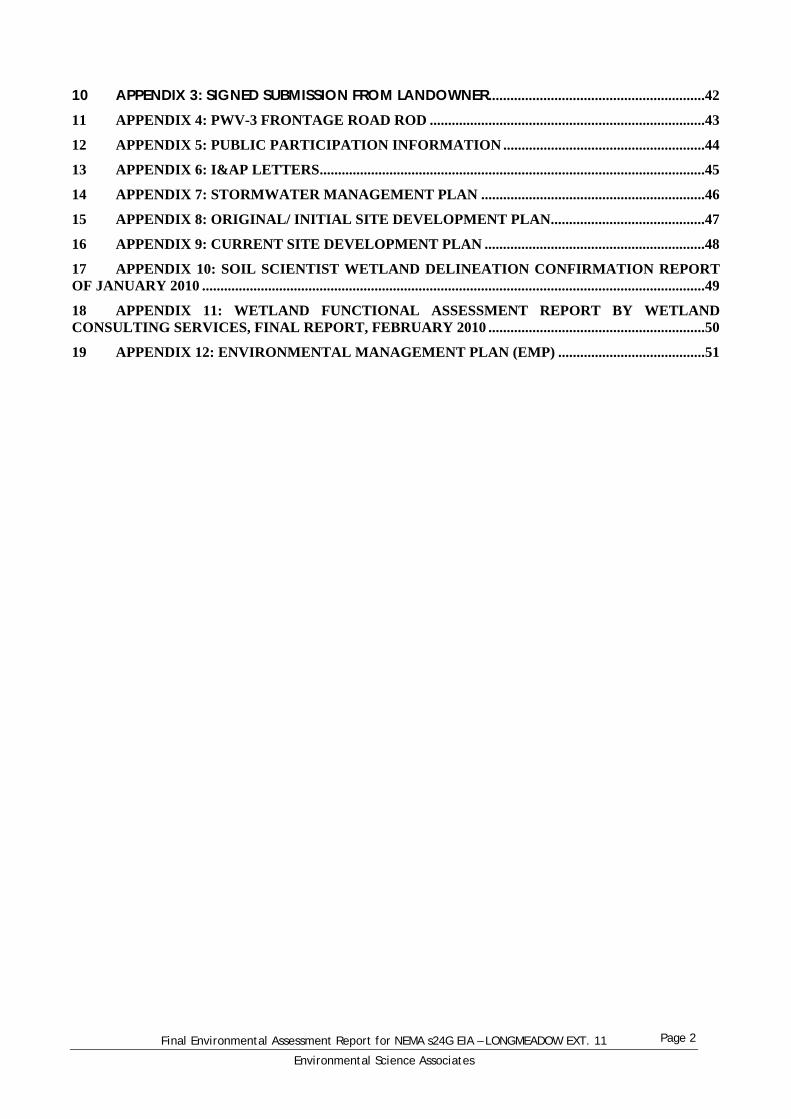
10 APPENDIX 3: SIGNED SUBMISSION FROM LANDOWNER ........................................................... 42
11 APPENDIX 4: PWV-3 FRONTAGE ROAD ROD ........................................................................... 43
12 APPENDIX 5: PUBLIC PARTICIPATION INFORMATION ....................................................... 44
13 APPENDIX 6: I&AP LETTERS ......................................................................................................... 45
14 APPENDIX 7: STORMWATER MANAGEMENT PLAN ............................................................. 46
15 APPENDIX 8: ORIGINAL/ INITIAL SITE DEVELOPMENT PLAN.......................................... 47
16 APPENDIX 9: CURRENT SITE DEVELOPMENT PLAN ............................................................ 48
17 APPENDIX 10: SOIL SCIENTIST WETLAND DELINEATION CONFIRMATION REPORT OF JANUARY 2010 ......................................................................................................................................... 49
18 APPENDIX 11: WETLAND FUNCTIONAL ASSESSMENT REPORT BY WETLAND CONSULTING SERVICES, FINAL REPORT, FEBRUARY 2010 ........................................................... 50
19 APPENDIX 12: ENVIRONMENTAL MANAGEMENT PLAN (EMP) ........................................ 51
Final Environmental Assessment Report for NEMA s24G EIA – LONGMEADOW EXT. 11
Environmental Science Associates
Page 3
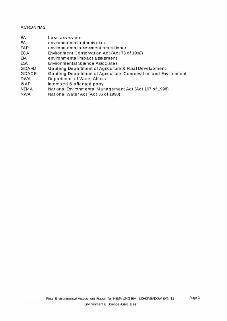
ACRONYMS BA basic assessment EA environmental authorisation EAP environmental assessment practitioner ECA Environment Conservation Act (Act 73 of 1998) EIA environmental impact assessment ESA Environmental Science Associates GDARD Gauteng Department of Agriculture & Rural Development GDACE Gauteng Department of Agriculture, Conservation and Environment DWA Department of Water Affairs I&AP interested & affected party NEMA National Environmental Management Act (Act 107 of 1998) NWA National Water Act (Act 36 of 1998)

Final Environmental Assessment Report for NEMA s24G EIA – LONGMEADOW EXT. 11
Environmental Science Associates
Page 4
1 INTRODUCTION Improvon Property Fund 3 (Pty) Ltd (“Improvon”) are developing a site at Longmeadow Extension 11 in Edenvale, Gauteng, for a commercial office building. On 9 September 2009, officials from Gauteng Department of Agriculture & Rural Development (GDARD) and the City of Johannesburg visited the site and made a verbal statement that the activities taking place required an environmental authorisation (EA) and, in the absence of an EA, construction inside the wetland/river area should cease. Improvon immediately ceased all activity in the wetland and river area on the site and initiated an investigation. At that point, the services of Environmental Science Associates (ESA) were employed to act as an independent environmental assessment practitioner (EAP). Site visits and an investigation by ESA staff and a specialist soil scientist, Professor Andries Claassens, confirmed that the activities on site did require an EA. This report briefly explains the legal background to the requirement for an EA, provides a brief description of the environment and then proposes a rehabilitation strategy for the site.
Final Environmental Assessment Report for NEMA s24G EIA – LONGMEADOW EXT. 11
Environmental Science Associates
Page 5
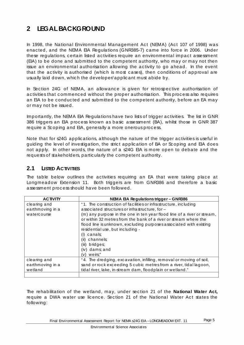
2 LEGAL BACKGROUND In 1998, the National Environmental Management Act (NEMA) (Act 107 of 1998) was enacted, and the NEMA EIA Regulations (GNR385-7) came into force in 2006. Under these regulations, certain listed activities require an environmental impact assessment (EIA) to be done and submitted to the competent authority, who may or may not then issue an environmental authorisation allowing the activity to go ahead. In the event that the activity is authorised (which is most cases), then conditions of approval are usually laid down, which the developer/applicant must abide by. In Section 24G of NEMA, an allowance is given for retrospective authorisation of activities that commenced without the proper authorisation. This process also requires an EIA to be conducted and submitted to the competent authority, before an EA may or may not be issued. Importantly, the NEMA EIA Regulations have two lists of trigger activities. The list in GNR 386 triggers an EIA process known as basic assessment (BA), whilst those in GNR 387 require a Scoping and EIA, generally a more onerous process. Note that for s24G applications, although the nature of the trigger activities is useful in guiding the level of investigation, the strict application of BA or Scoping and EIA does not apply. In other words, the nature of a s24G EIA is more open to debate and the requests of stakeholders, particularly the competent authority.
2.1 LISTED ACTIVITIES The table below outlines the activities requiring an EA that were taking place at Longmeadow Extension 11. Both triggers are from GNR386 and therefore a basic assessment process should have been followed.
ACTIVITY NEMA EIA Regulations trigger – GNR386 clearing and earthmoving in a watercourse
“1. The construction of facilities or infrastructure, including associated structures or infrastructure, for – (m) any purpose in the one in ten year flood line of a river or stream, or within 32 metres from the bank of a river or stream where the flood line is unknown, excluding purposes associated with existing residential use, but including - (i) canals; (ii) channels; (iii) bridges; (iv) dams; and (v) weirs;”
clearing and earthmoving in a wetland
“4. The dredging, excavation, infilling, removal or moving of soil, sand or rock exceeding 5 cubic metres from a river, tidal lagoon, tidal river, lake, in-stream dam, floodplain or wetland.”
The rehabilitation of the wetland, may, under section 21 of the National Water Act, require a DWA water use licence. Section 21 of the National Water Act states the following:
Final Environmental Assessment Report for NEMA s24G EIA – LONGMEADOW EXT. 11
Environmental Science Associates
Page 6
21. For the purposes of this Act, water use includes (a) taking water from a water resource; (b) storing water; (c) impeding or diverting the flow of water in a watercourse; (d) engaging in a stream flow reduction activity contemplated in section 36; (e) engaging in a controlled activity identified as such in section 37(1) or declared under section 38(1); (f) discharging waste or water containing waste into a water resource through a pipe, canal, sewer, sea outfall or other conduit; (g) disposing of waste in a manner which may detrimentally impact on a water resource; (h) disposing in any manner of water which contains waste from, or which has been heated in, any industrial or power generation process; (i) altering the bed, banks, course or characteristics of a watercourse; (j) removing, discharging or disposing of water found underground if it is necessary for the efficient continuation of an activity or for the safety of people; and (k) using water for recreational purposes. Sub-sections 21 (c) and (i) are highlighted above, as these two activities are ones which will be undertaken for the rehabilitation of the wetland area. However, further considerations can be given by the DWA under section 22 (3) of the NWA, which is discussed further in section 5.4 of this report.
Final Environmental Assessment Report for NEMA s24G EIA – LONGMEADOW EXT. 11
Environmental Science Associates
Page 7
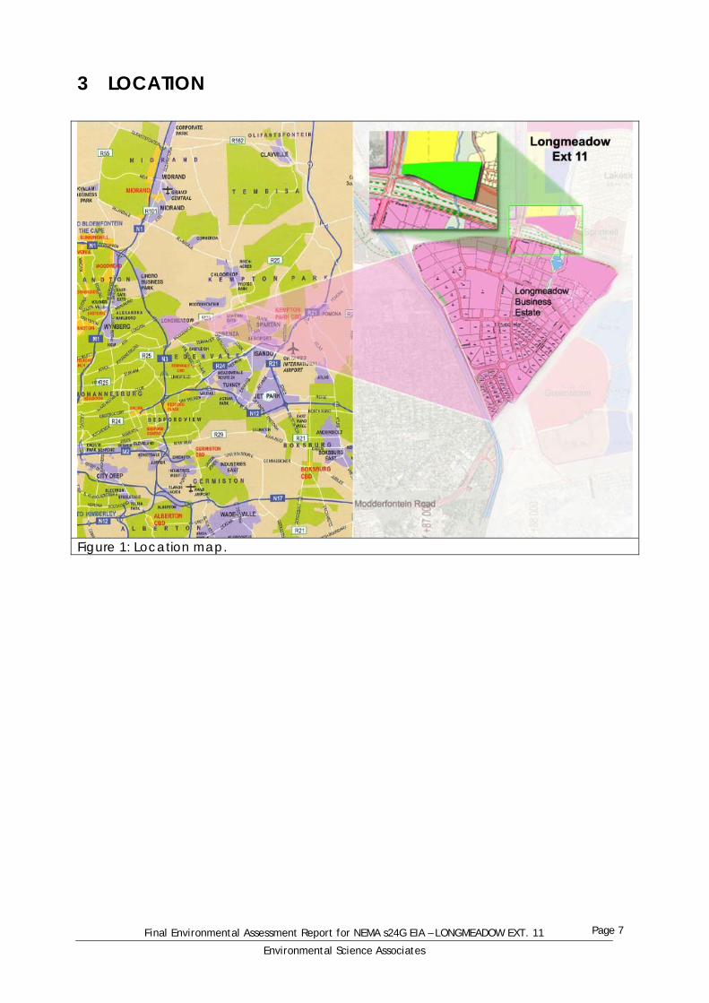
3 LOCATION
Figure 1: Location map.

Final Environmental Assessment Report for NEMA s24G EIA – LONGMEADOW EXT. 11
Environmental Science Associates
Page 8
4 BRIEF DESCRIPTION OF THE ENVIRONMENT
4.1 GEOLOGY The area is close to the contact with the Archaean Halfway House granite to the north and Archaean metamorphic rocks, such as gneisses and schists to the south (Barnard, 1999). No outcrops occur on the site.
4.2 SURFACE WATER A small stream flows north through the site and eventually joins the Jukskei River, after flowing through various furrows, canals and Modderfontein Dam No. 3 and the Modderfontein Conservation area. The stream flows all year round. The source of the stream is in the Longmeadow Business Estate, a few hundred metres south of the site, where several sites have stormwater detention ponds that then release water into the streamline. This water then flows under two culverts under the dual carriageway that forms the southern boundary to the site, and then onto the site.
4.3 SOILS On the east of the stream, soils of Avalon form were encountered, whereas on the west of the stream, soils of Longlands to Katspruit forms occurred. Hydromorphic soils were detected and were used to delineate the wetland zone paralleling the stream (see Error! Reference source not found.) (Claassens, 2009).
4.4 CLIMATE The area experiences a cool subtropical climate, with cold winter temperatures due to the high altitude (1700m). The year round average is 16°C. Rainfall averages 700mm/a and falls mostly during summer, October to March, and mainly from thunderstorms.
4.5 VEGETATION The area falls within the Grassland biome, one of 9 biomes in South Africa. The veld type has been classified as Rocky Highveld Grassland or a mixture of Egoli Granite Grassland and Carletonville Dolomite Grassland. Rocky Highveld Grassland is only 1.4% conserved and Egoli Granite Grassland is only 0.7% conserved (Ross, 2006). The site was highly disturbed when surveyed in 2006, prior to the recent activities (Ross, 2006). Ploughing, landscaping, overgrazing, trampling, overly frequent burning and other activities all led to the degradation of the veld to such a point that the natural veld types are absent.

Final Environmental Assessment Report for NEMA s24G EIA – LONGMEADOW EXT. 11
Environmental Science Associates
Page 9
grasses forbs (herbs) trees/large shrubs Trachypogon spicatus Sphenostylis angustifolia Protea caffra Tristachya leucothrix Senecio coronatus Acacia caffra Elionurus muticus Senecio incomatus Celtis africana Heteropogon contortus Helichrysum acutatum Protea welwitschii Panicum natalenses Helichrysum pallidum Xerophyta retinervis Diheteropogon amplectens Nidorella hottentotica Kiggeleria africana Schizachyrium sanguineum Indigofera hilaris Halleria lucida Loudetia simplex Indigofera fastigiata Leucosidea sericea Brachiaria serrata Indigofera velutina Buddleja salvifolia Tristachya serrata Geigeria burkei Bewsia biflora Justicia anagalloides Monocymbium ceresiiforme Cycnium adonense Digitaria monodactyla Pearsonia cajanifolia Digitaria tricholaeoides Vernonia natalensis Setaria flabellate Pentanisia prunelloides Setaria nigrirostris Castalis spectabilis Eragrostis racemosa Parinari capensis Eragrostis chloromelas Pygmaeothamnus zeyheri Eragrostis capensis Helichrysum kraussii Eragrostis sclerantha Stoebe vulgaris Eragrostis gummiflua Themeda triandra Urelytrum agropyroides Arastida aequiglumis Rhynchelytrum nerviguime Cymbopogon excavatus Hyparrhenia hirta Table 1: List of dominant species that could be found in Rocky Highveld Grassland in a natural state.
4.6 ANIMAL LIFE As with the vegetation, many species could have occurred at the site, but in the highly degraded state prior to the current development, very few species were likely to inhabit the site. The following were confirmed as living on the site (Ross, 2006): African Grass Owl (Tyto capensis) Common River Frog (Afrana angolensis) Guttural Toad (Bufo gutturalis) three different tadpole species. Likely species include (Ross, 2006): rodents and other small mammals (shrews, moles, etc.) snakes (based on presence of prey: amphibians and rodents).
4.7 ALIEN SPECIES The site was dominated by kikuyu grass (Pennisetum clandistenum) that spread from the lawn growing operation that had occupied the site. Kikuyu is an invasive alien, especially along streamlines and in wetlands. Other aliens, mostly also invasive, that occurred at the site were:

Final Environmental Assessment Report for NEMA s24G EIA – LONGMEADOW EXT. 11
Environmental Science Associates
Page 10
Datura ferox Datura stramonium Tagetes minuta Conyza albida Amaranthus hybridus Bidens bipinnata Bidens formosa.

Final Environmental Assessment Report for NEMA s24G EIA – LONGMEADOW EXT. 11
Environmental Science Associates
Page 11
5 PROJECT DETAILS This application for rectification relates to the infringement of the wetland and river system, and the removal or soil or rock within the wetland area. Please refer to the GDARD letter dated 8 February 2010. Letter attached hereto as appendix 1. The primary perceived problem with the degradation and negative impact of the wetland system is the upstream development and more specifically the construction of the culvert under the PWV-3 frontage roads. The construction of this road, along with the construction of the culvert under the road were given a positive Record of Decision (RoD) by GDARD (Formally GDACE), When GDACE signed off on the road ROD and approved the culvert, they were effectively signing off on the degradation of the downstream wetland. The culvert is of a poor design, as it is too narrow, thereby increasing flow velocity and concentrating the flow of water, causing undue erosion on the downstream section of the wetland. At the time of issuing the RoD for the PWV-3 frontage roads, it should have been proposed that in order to preserve some of the wetland characteristics and decreased flow velocity, the hydrogeologists/ wetland specialists at GDACE should have prescribed 2 culverts, or one wider culvert, with flow suppressing structures, thus slowing down and spreading flow out more on the downstream sites (including Longmeadow Ex 11), and thus helping to conserve the wetland.
5.1 PROJECT NEED AND DESIRABILITY As discussed, this project involves the rehabilitation of the river and “wetland” system. The need and desirability of the rehabilitation is discussed: Project need: The project is needed as the wetland is in a severely degraded state, and rehabilitation needs to commence as soon as possible, to prevent further degradation, and prevent the healthier wetland downstream of the site from also becoming further negatively impacted upon. Project desirability: The rehabilitation of the wetland will strive to increase the functioning of the wetland system as a whole, and the site and river system will also become more visually appealing than in its current state. The rehabilitation is highly desirable as the wetland is in a very degraded state, and will help to protect and sustain the downstream wetland. Furthermore, the eastern extent of the site is being developed. Attached in Appendix 2 is the need and desirability report for this development. This development des not form part of the S24G application.
5.2 ALTERNATIVES (INCLUDING NO-GO ALTERNATIVE) Alternative 1: Rehabilitate according to scientific recommendations. This is the preferred and most advisable alternative. Wetland specialists and other scientists have made recommendations, and these will be adhered to fully. Alternative 2: Rehabilitate by altering road culvert construction only: This alternative could also be considered. This would involve the redesign and reengineering of the
Final Environmental Assessment Report for NEMA s24G EIA – LONGMEADOW EXT. 11
Environmental Science Associates
Page 12
culverts to decrease flow velocity of the river by widening the culvert and constructing flow suppressing structures inside the culvert and at the mouth of the culvert to disperse the water. This alternative will however take months, if not a year or two to come to operational phase, and this time-frame is too long. The wetland area needs more urgent intervention. No-go option: Do not rehabilitate: The no-go option would mean that there would be no intervention or rehabilitation whatsoever in the river/wetland system. This would further lead to severe degradation of the river system and will eventually cause the entire watercourse and drainage region to become eroded, degraded, invaded with invasive plants and severe sedimentation will occur.
5.3 PROJECT MOTIVATION The rehabilitation of this wetland is of paramount importance for site specific aesthetics, reducing the erosion and further degradation of the river channel onsite and downstream, and the loss of river system and wetland functioning within the entire catchment. This project should be considered very favourably, as the rehabilitation of the wetland would enhance the system functioning as a whole and increase ecological viability of the entire drainage area. One of the primary motivations for this application is for GDARD to strongly consider the need for a buffer on the site, Longmeadow Ex 11. It is felt that after strong scientific common-sense motivation that a buffer for the wetland rehabilitation area is not required. Please also refer to section 6.2 “time series analysis” for further motivation of the unnecessary need for a buffer.
5.4 COMMENTS FROM DWA ON WATER USE LICENSE AND EAP RECOMMENDATIONS Various legislation was reviewed and verbal comment was received from Department of Water Affairs (DWA). A site meeting was also undertaken with Mr Pule Makena of the DWA, and the issues and concerns were outlined to him. It was determined that a water use licence will be required under section 21 of the NWA. This issue is however currently with the DWA, and the Department is reviewing the need for a water use licence. The DWA is also taking into consideration the RoD issued for the PWV-3 frontage road, and the proposed use of the water use licence obtained for that project to be used for this rehabilitation. However, it must be firmly conveyed that if a water use licence is deemed necessary by the competent authority (Department of Water Affairs - DWA) a water use licence will be obtained prior to rehabilitation commencing. It is hereby requested that this process of the water use licensing does not hold up the GDARD decision making and issuing of an RoD, but should however include in the GDARD RoD a pre-emptive condition that a water use licence is obtained prior to commencement of rehabilitation. This water use licence application can be a lengthy process with DWA, and this rehabilitation matter is considered urgent. An urgent application for this water use licence or exemption for the licence under section 22(3) of the NWA is submitted to the DWA for consideration.

Final Environmental Assessment Report for NEMA s24G EIA – LONGMEADOW EXT. 11
Environmental Science Associates
Page 13
Section 20 of the NWA makes provision for “Control or emergency situations”. Under this section, it is stated:
1. In this section “incident” includes any incident or accident in which a substance (a) Pollutes or has potential to pollute a water resource (b) Has, or is likely to have a detrimental effect on a watercourse.
From the above explanation, and evidence on site, it can be strongly motivated that degradation of the wetland and watercourse is an emergency incident, as contemplated in section 20, subsection 1 (b), as erosion and sedimentation WILL have a detrimental effect on the watercourse. To this extent, and in accordance with subsection (5) of section 20 of the NWA, a verbal directive can be given within 14 days of the relevant department being informed. In this case, a verbal directive can be given by DWA for the rehabilitation, once they have reviewed documents submitted to them. Further to this, and taking into consideration Section 22 sub-section 3, which states: 22. Permissible water use. (3) A responsible authority may dispense with the requirement for a licence for water use if it is satisfied that the purpose of this Act will be met by the grant of a licence, permit or other authorisation under any other law The DWA may dispense with the requirement for a licence for water use, as an application for the rehabilitation of the wetland and the rectification of what can be described as an “emergency situation” has been submitted to GDARD for consideration, which falls under NEMA. It is strongly recommended that the DWA and GDARD take into consideration section 22 (3) of the NWA and dispense with the requirement of a water use licence, as rehabilitation is urgent and the process of a full water use licence application will take an unnecessarily long time and further negative impacts will occur within the wetland onsite and downstream during this time. After reviewing the legislation, it was further determined that according to section 19 of the NWA, it is the landowner’s responsibility to remediate damage on their property. This will be done in accordance with the specialist recommendations.
5.5 WRITTEN CONSENT FROM LANDOWNER TO UNDERTAKE ACTIVITY The applicant for the rehabilitation IS the landowner, so a written consent is not necessary.
5.6 A SIGNED SUBMISSION FROM IMPROVON Please see appendix 3 for the landowners (Improvon) signed submission, in line with bullet point 17 in the GDARD letter to Improvon, contained in Appendix 1
5.7 PWV – 3 FRONTAGE ROADS EIA AND DECISIONS The PWV-3 frontage road that was built to the south of the site has undoubtedly

Final Environmental Assessment Report for NEMA s24G EIA – LONGMEADOW EXT. 11
Environmental Science Associates
Page 14
impacted upon the entire wetland system downstream. A positive record of decision from the then GDACE was issued for the road, under the regulations promulgated under the ECA. The full road RoD is contained in Appendix 4, attached hereto. Contained below are two decisions made in the ROD for the PWV-3 frontage roads: In section 2.2 (a), it clearly stated: From the above, one can see that GDACE prescribed the construction of culverts, so as to “ensure the natural flow of water”. This has happened; however, that “natural flow” through the culvert is what has caused substantial damage to the downstream wetland area. By merely building the culvert, the natural flow and functioning of the wetland ecosystem has been altered. In section 2.2 (h), it further stated: It is understood that this condition was given for the construction phase of the road building activity. However, the subsequent northern facing side slope/ embankment have eroded and has caused extensive sedimentation in the downstream wetland and river system. There are no mechanisms in place for adequate erosion control and water energy dissipation. This can be clearly seen in section 6.2.1 of this report.

Final Environmental Assessment Report for NEMA s24G EIA – LONGMEADOW EXT. 11
Environmental Science Associates
Page 15
6 ENVIRONMENTAL AND WETLAND ASSESSMENT
6.1 SENSITIVITY MAPS AND DISCUSSION. The diagram above indicates the surrounding land uses to the site, and more specifically to the wetland area on site. The newly built PWV-3 frontage roads are not indicated on the map, but do however run east-west along the southern boarder of the site. As one can see, the predominate land use within 500m of the onsite wetland is commercial, industrial and low-density residential.

Final Environmental Assessment Report for NEMA s24G EIA – LONGMEADOW EXT. 11
Environmental Science Associates
Page 16
The diagram above represents the on-site sensitivity of the site. The orange indicating the actual river channel (the area where water flows), with the red indicating the delineated wetland area and the blue is everything onsite, but outside of the delineated wetland area, which is considered to have LOW sensitivity. There are no ridges, significant heritage sites or red data plants or animals on the entire site.

Final Environmental Assessment Report for NEMA s24G EIA – LONGMEADOW EXT. 11
Environmental Science Associates
Page 17
The diagram above represents the on-site and off-site sensitivity of the site. The darker blue line indicating the actual river channel (the area where water flows), with the red area indicating the delineated wetland area, (which has medium sensitivity) including that downstream of the site. The partly transparent blue area is considered to have LOW sensitivity. The position of the PWV-3 frontage roads is also indicated on this sensitivity map. There are no ridges, significant heritage sites or red data species present.
Final Environmental Assessment Report for NEMA s24G EIA – LONGMEADOW EXT. 11
Environmental Science Associates
Page 18
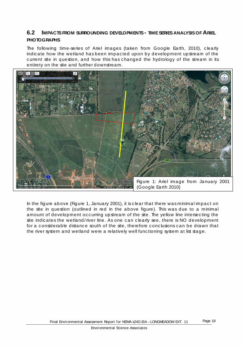
6.2 IMPACTS FROM SURROUNDING DEVELOPMENTS - TIME SERIES ANALYSIS OF ARIEL PHOTOGRAPHS The following time-series of Ariel images (taken from Google Earth, 2010), clearly indicate how the wetland has been impacted upon by development upstream of the current site in question, and how this has changed the hydrology of the stream in its entirety on the site and further downstream. In the figure above (Figure 1, January 2001), it is clear that there was minimal impact on the site in question (outlined in red in the above figure). This was due to a minimal amount of development occurring upstream of the site. The yellow line intersecting the site indicates the wetland/river line. As one can clearly see, there is NO development for a considerable distance south of the site, therefore conclusions can be drawn that the river system and wetland were a relatively well functioning system at list stage.
Figure 1: Ariel image from January 2001 (Google Earth 2010)

Final Environmental Assessment Report for NEMA s24G EIA – LONGMEADOW EXT. 11
Environmental Science Associates
Page 19
In the figure above (Figure 2, March 2004), it is very clear that within a 3 year period from 2001 to 2004 that there was increased impact on the wetland/river system south of the site. The yellow line again intersecting the site indicates the wetland/river line, and one can see the difference from the previous figure (Figure 1). Roads and infrastructure are now being built over the river/wetland, and the hydrology is undoubtedly being altered. These developments south of the site in 2004 (present day Longmeadow Business Estate) started having a profound effect on the river system and the integrity of the wetland.
Figure 2: Ariel image from March 2004 (Google Earth 2010)

Final Environmental Assessment Report for NEMA s24G EIA – LONGMEADOW EXT. 11
Environmental Science Associates
Page 20
In the figure above (Figure 3), it is very clear that further impact on the wetland occurred between March 2004 and November 2005, as indicated by the above photo. The yellow line intersecting the site indicates the wetland/river line, and one can now see the vast difference from the previous photos (Figure 1 & 2), that roads and infrastructure are now being built over the river/wetland, as well as buildings and impermeable surfaces, which both directly and indirectly effect the integrity of the wetland and the river system as a whole.
Figure 3: Ariel image from November 2005 (Google Earth 2010)

Final Environmental Assessment Report for NEMA s24G EIA – LONGMEADOW EXT. 11
Environmental Science Associates
Page 21
In the figure above (Figure 4), it is very clear that further impact on the wetland occurred between November 2005 and October 2007 due to the expansion and further development of the Longmeadow Business Estate. The Figure above (Figure 4), clearly shows more development around the periphery of the wetland area. The yellow line intersecting the site indicates the wetland/river line, and one can now see the vast difference from the previous figures (Figure 1, 2 and 3), as to how development surrounding the river has increased. This increase in development, as stated before, will both directly and indirectly affect the integrity of the wetland and the river system as a whole.
Figure 4: Ariel image from October 2007 (Google Earth 2010)

Final Environmental Assessment Report for NEMA s24G EIA – LONGMEADOW EXT. 11
Environmental Science Associates
Page 22
In the Ariel photograph (Figure 5, October 2007), indicated the latest imagery available on Google Earth 2010. The yellow lines are a rough indication of the alignment of the new PWV-3 frontage road which has been built bisecting the area. This road was only completed in 2009. The road was built over the wetland, and the water has been canalized under the road through a culvert. This culvert has constricted the flow of water in the river system, which was once a wetland area, and has subsequently constricted the flow to such an extent as to completely alter the hydrology of the river, and cause an increase in flow velocity at the exit of the culvert, which is on the site in question. This increased velocity has caused substantial erosion in the river channel, and has caused the river channel on the site (red boundary on Figure 5) to be severely incised and eroded.
Figure 5: Ariel image from October 2007 (Google Earth 2010)

Final Environmental Assessment Report for NEMA s24G EIA – LONGMEADOW EXT. 11
Environmental Science Associates
Page 23
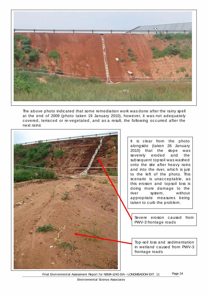
6.2.1 CONCLUSIONS MADE FROM THE TIME-SERIES ANALYSIS From the photographic analysis done, it is quite clear that the wetland and river system running through the Longmeadow Extension 11 site has been impacted upon negatively for many years, thus severely altering the overall habitat integrity and hydrology of the river system. The first and foremost impact on the wetland system has been the building of impermeable surfaces in the Longmeadow Business Estate, which do not allow water to permeate into the ground and has thereby allowed a fast flow of water towards the stream, directly affecting the hydrology of the river. The second major impact on the river system is the construction of the new PWV-3 frontage road directly to the south of the site. The water flowing from the south is now forced into a culvert under the road, thereby speeding up the flow velocity of the water, creating an incised river channel downstream of the culvert, which inevitably affects the hydrology and habitat of that system. The building of the road has also had other disastrous consequences on the Longmeadow Extension 11 site, as the side slope of the road was not adequately retained and revegetated before the rainy season, thereby allowing huge erosion to take place, spilling topsoil onto the site and into the river system. This is a concern, as the road’s side slope is not on the property in question, and it is not the duty of the Longmeadow Ex 11 developer to remediate this poor engineering. This slope needs to be adequately rehabilitated with fabric, restoration bricking and vegetation to stop the wash of topsoil into the river system. The following series of photos indicate the seriousness of this matter:
Side slope erosion after a rainy spell near the end of 2009
Final Environmental Assessment Report for NEMA s24G EIA – LONGMEADOW EXT. 11
Environmental Science Associates
Page 24
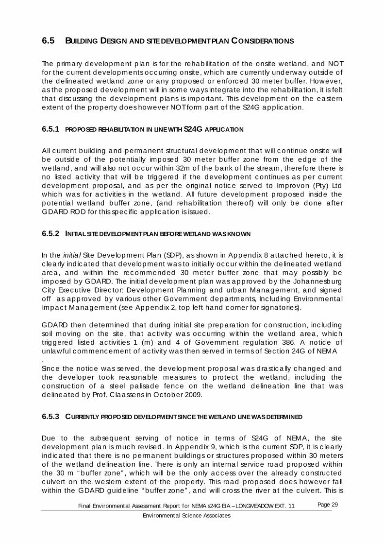
The above photo indicated that some remediation work was done after the rainy spell at the end of 2009 (photo taken 19 January 2010), however, it was not adequately covered, terraced or re-vegetated, and as a result, the following occurred after the next rains:
It is clear from the photo alongside (taken 26 January 2010) that the slope was severely eroded and the subsequent topsoil was washed onto the site after heavy rains and into the river, which is just to the left of the photo. This scenario is unacceptable, as this erosion and topsoil loss is doing more damage to the river system, without appropriate measures being taken to curb the problem.
Severe erosion caused from PWV-3 frontage roads
Top-soil loss and sedimentation in wetland caused from PWV-3 frontage roads

Final Environmental Assessment Report for NEMA s24G EIA – LONGMEADOW EXT. 11
Environmental Science Associates
Page 25
6.3 PUBLIC PARTICIPATION PROCESS The public participation (PP) process that will be followed for this S24G application was undertaken under the normal Basic assessment and general guidelines for public participation. Public participation for this project incorporates the following:
Site notices erected on site on the start date of PP, and will be left on site for the entire 30 day PP period.
Letters will be sent to all landowners within 100 meters of the property boundary, as well as all other relevant government departments, councils and agencies that may have interest in this application.
An advertisement was placed in The Star newspaper and in the Bedfordview and Edenvale news, under the legal classifieds section, stating the nature of the project, with all relevant information.
6.3.1 PUBLIC PARTICIPATION TIMEFRAME Start Date of Public Participation process Wednesday 27th January 2010
End Date of Public participation Thursday 25th February 2010
Please refer to Appendix 5 (attached hereto) for copies of all public participation information including:
Proof of site notice List of interested and affected parties to whom which the letter was sent
(stamped by the Post Office to prove that they were sent out) Proof of advertising in “The Star” and “The Bedfordview and Edenvale News” on
the 27th of January 2010. Copy of letter and locality map sent to Interested and affected parties (I&AP’s)
6.3.2 LIST OF REGISTERED INTERESTED AND AFFECTED PARTIES There have been a number of letters received from various people and organisations, either making comment, or registering as I&AP’s Letters were received from the following companies, (who indicated that the rehabilitation did not affect any of their processes). They did not formally register as I&AP’s: Please see full letters in Appendix 6
Gauteng department of roads and transport (GDRT) Sasol gas Limited (no objection or concerns raised) TFMC property solutions – acting on behalf of Telkom SA Ltd
The following list are individuals that officially registered as I&AP’s, and have sent comment for this application, and have requested to be kept informed. These I&AP’s include (Please see full registration letters in Appendix 6):
Modderfontein Environmental Community Initiative (MECI) (represented by MJ

Final Environmental Assessment Report for NEMA s24G EIA – LONGMEADOW EXT. 11
Environmental Science Associates
Page 26
Barker, A Bartman and N Woodward) Paul Fairall – representing Lakeside village Homeowners association and
Gauteng Wetland Forum – Wetlands in crisis.
6.3.3 MEETING WITH CONCERNED STAKEHOLDERS During the Public Participation phase, there were only 2 parties who formally registered and showed genuine concern and interest on the process. It was therefore decided to engage with these stakeholders correctly and a meeting was subsequently held. Minutes of this meeting are contained in Appendix 5 (Public Participation Information). The meeting comprised members from MECI, Mr Paul Fairall, representatives from Improvon and EScience Associates. In summary, some of the conclusions that can be taken from the meeting were:
PWV – 3 frontage road and culvert is almost entirely responsible for degradation of the watercourse and wetland downstream of the culvert.
It was indicated that support would be given to the construction of a permeable parking lot in the “buffer” zone, with the construction of a swale to be below the parking lot, to polish any run-off water before it reaches the attenuation facility.
Pressure must be put on GDARD to allow the rehabilitation to commence, before further degradation occurs.
6.3.4 COMMENTS AND RESPONSES REPORT Comments from EAP in response to some of the points brought up by the I&AP’s: Comment/ concern: brought up by TFCM property solutions – “we would like to inform you that if the applicant is busy with digging up soil etc., it should be done with care (especially within sidewalk areas) as our client (Telkom) might have underground telecommunication cables that could be damaged in the process”. Response: The rehabilitation of the wetland will NOT involve the digging up of sidewalks, but will involve the digging up and landscaping of soil within the wetland area. This will not have any impact on Telkom cables, as these cables do not run in wetland areas. Comment/ concern: Brought up by GDRT – “Provincial road PWV 3 is affected, as such when an application for township establishment, change of land use…. The said application must be lodged with the department for evaluation” Response: A township was established on the site many years ago. The rehabilitation of the wetland will have no impact on the PWV 3 road, as the rehabilitation will be completed long before the main PWV 3 road is built, and no traffic will result after the rehabilitation is complete. In term of the current site development, which DO NOT fal under this application, the Johannesburg Roads agency signed off on these plans (see appendix 9) for the current onsite developments. In fact, the PWV-3 frontage road is having a severe negative impact on he site and the wetland currently. Comment/ concern: Raised by Modderfontein Environmental Community Initiative when they registered as an I&AP: “… concerns are that the site will not be rehabilitated

Final Environmental Assessment Report for NEMA s24G EIA – LONGMEADOW EXT. 11
Environmental Science Associates
Page 27
properly and that loop holes will be exploited. Large amounts of soil and rubble have been dumped in the wetland area and buffer zone area which needs to be properly removed and the site planted with appropriate vegetation.” Response: The Wetland Functional Assessment was undertaken by a reputable and highly respected Wetland Consultancy. This consultancy has provided a rehabilitation plan, which will be implemented on site. This will be done in accordance with the Environmental Management plan and the recommendations from specialists. The process of rehabilitating the area will involve the removal of soils and rubble from within the area. These materials may be used in the rehabilitation and landscaping of the wetland area. Comments received from MECI after review of DRAFT report: “…We have found the report and remedial recommendations presented by Wetland Consulting Services acceptable, but must add that we would like Paul Fairall to be nominated as the ECO for the project, for reasons previously explained. Paul's added recommendations as our advisor are also of importance to us.” (Email comment in Appendix 6) Response: MECI advised that they are happy with the WCS report and the rehabilitation recommendations. The appointment of an ECO is the ultimate responsibility of Improvon, once a RoD for the rehabilitation has been given by GDARD. The appointment of an ECO is contained in the EMP. Comments/ concerns: Raised by Mr Paul Fairall, Chairperson of Gauteng Wetlands in Crisis Forum:
- “Firstly you are to be commended for appointing a soil scientist to do the delineation in the absence of vegetation. Secondly Wetland CS (referring to Wetland Consulting Services) is one of the best out there.
- There is continuous, erroneous, reference to a stream or a river. It is a valley bottom wetland with a gully. Badly compounded by the road building contractor on the Improvon site.
- Where ever the parking is placed I would insist on a Hydro carbon precipitation device”. (Email comment in Appendix 6)
Response: Mr Paul Fairall is very happy with the Wetland Consultants used, as they are highly respected in their field, and in Gauteng. Note has been taken to the reference to a stream or river in the report. It is felt that with the strong scientific evidence given by specialists, highlighting the enormous impact that the road and upstream activities have had on the site, it is strongly felt that the valley bottom wetland is not a functioning wetland as it used to be, but merely a stream/ river channel carrying water across the site. It is however not disputed that lower down the same river course, to the north of the site, that the wetland has adequate functionality. The aspect of “hydro-carbon precipitation devices”, or bio-retention swales was discussed at the stakeholder meeting, and it was agreed by Improvon that bio-retention swales would be installed below the parking area, acting as more of a buffer between water runoff from the parking lot and the river. Please see more information on bio-retention swales in the next section (section 6.4 Storm Water Management).

Final Environmental Assessment Report for NEMA s24G EIA – LONGMEADOW EXT. 11
Environmental Science Associates
Page 28
6.4 STORM WATER MANAGEMENT As noted in project motivation, this application is for the rehabilitation of the wetland area. This rehabilitation will have positive spin-offs for storm water management, as the water will be slowed down, potentially cleaned somewhat by the bio-filtering ability of wetland plants before being released downstream. It is however critical to note that there is current onsite development occurring on the eastern extent of the site. The current site development plan (as seen in Appendix 9) clearly shows the proposed insulation of a stormwater attenuation facility. This facility will provide an area for precipitation runoff to be slowed down before being gradually released into the river system. Also attached hereto is the storm water management plan for the development (see appendix 7). It must also be made clear that a permeable parking area is proposed, where best option permeable paver blocks allowing water to infiltrate and grass to grow through will be installed. This parking area will NOT be an impermeable tar surface. After stakeholder consultation, and discussion, it was further agreed that a bio-retention Swale will be installed on the lower section of the permeable parking area. The overall purpose of this stormwater management system is to maximize the trapping of coarse and medium sediments (as well as potential oil-drip hydrocarbons) and to retain same within the retention device for later cleanout and removal from site (Harding, 2009).
The figure alongside is an example of a bio-retention swale. Similar to the one which is planned on this site. (Photo: Harding, 2009)
Final Environmental Assessment Report for NEMA s24G EIA – LONGMEADOW EXT. 11
Environmental Science Associates
Page 29
6.5 BUILDING DESIGN AND SITE DEVELOPMENT PLAN CONSIDERATIONS The primary development plan is for the rehabilitation of the onsite wetland, and NOT for the current developments occurring onsite, which are currently underway outside of the delineated wetland zone or any proposed or enforced 30 meter buffer. However, as the proposed development will in some ways integrate into the rehabilitation, it is felt that discussing the development plans is important. This development on the eastern extent of the property does however NOT form part of the S24G application.
6.5.1 PROPOSED REHABILITATION IN LINE WITH S24G APPLICATION All current building and permanent structural development that will continue onsite will be outside of the potentially imposed 30 meter buffer zone from the edge of the wetland, and will also not occur within 32m of the bank of the stream, therefore there is no listed activity that will be triggered if the development continues as per current development proposal, and as per the original notice served to Improvon (Pty) Ltd which was for activities in the wetland. All future development proposed inside the potential wetland buffer zone, (and rehabilitation thereof) will only be done after GDARD ROD for this specific application is issued.
6.5.2 INITIAL SITE DEVELOPMENT PLAN BEFORE WETLAND WAS KNOWN In the initial Site Development Plan (SDP), as shown in Appendix 8 attached hereto, it is clearly indicated that development was to initially occur within the delineated wetland area, and within the recommended 30 meter buffer zone that may possibly be imposed by GDARD. The initial development plan was approved by the Johannesburg City Executive Director: Development Planning and urban Management, and signed off as approved by various other Government departments, Including Environmental Impact Management (see Appendix 2, top left hand corner for signatories). GDARD then determined that during initial site preparation for construction, including soil moving on the site, that activity was occurring within the wetland area, which triggered listed activities 1 (m) and 4 of Government regulation 386. A notice of unlawful commencement of activity was then served in terms of Section 24G of NEMA . Since the notice was served, the development proposal was drastically changed and the developer took reasonable measures to protect the wetland, including the construction of a steel palisade fence on the wetland delineation line that was delineated by Prof. Claassens in October 2009.
6.5.3 CURRENTLY PROPOSED DEVELOPMENT SINCE THE WETLAND LINE WAS DETERMINED Due to the subsequent serving of notice in terms of S24G of NEMA, the site development plan is much revised. In Appendix 9, which is the current SDP, it is clearly indicated that there is no permanent buildings or structures proposed within 30 meters of the wetland delineation line. There is only an internal service road proposed within the 30 m “buffer zone”, which will be the only access over the already constructed culvert on the western extent of the property. This road proposed does however fall within the GDARD guideline “buffer zone”, and will cross the river at the culvert. This is
Final Environmental Assessment Report for NEMA s24G EIA – LONGMEADOW EXT. 11
Environmental Science Associates
Page 30
however not an ideal development situation, as any imposed 30 meter buffer seriously limits the scope of development on the site, including the construction of a narrow access road which is proposed to be built in order to access the remainder of the Longmeadow Ext 11 site, which is Erf 142 of Longmeadow Ext 11. If this internal access road is not built, then Erf 142 will be landlocked, and have no access. The current development plan indicates that a parking area is proposed to the south of the building, outside of any potential “buffer zone” (see Appendix 9), however, this is very limiting and is not the most cost effective and ideal development option. The more cost effective and sustainable development solution is to have the parking area to the west of the buildings, within 30meters of the wetland delineation line (or within the “buffer” zone), but not in the wetland line. Even if a decreased buffer is advised in the ROD by GDARD, there will still be NO BUILDINGS in this area, only a permeable parking area and small access road will be established within 30 meters of the wetland line, however, NO structural development will occur within the designated wetland zone. This development plan in Appendix 9 will however be under review once an ROD has been issued, to re-incorporate the parking area into the SDP. As discussed in section 6.4, the parking area will be a permeable parking area, where best option permeable paver blocks allowing water to infiltrate and grass to grow through will be installed. This parking area will NOT be an impermeable tar surface. It is also further reiterated that a bio-retention Swale will be installed on the lower section of the permeable parking area. Swales effectively trap suspended solids which catch the trace metals and Total Suspended Solids (TSS) and essentially “polish” the water of impurities. If the buffer is to be imposed, another course of action for the parking lot will be to have an underground parking lot. The construction of this underground lot will require underground dewatering, and hence lowering of the water table, which will have even more of a detrimental effect on the wetland within the delineation area, causing less seepage and a faster drying of the sub-terrarium hydromorphic soils. Due to this consideration, it is highly advised that an underground parking lot not be considered, as it will affect the wetland seepage area even more than a semi-permeable above ground lot within the “buffer zone”. It is quite clear from the difference in the initial and current SDP’s that the developer is strongly considering the wetland and its’ value in the current SDP, and is showing compliance with GDARD guidelines and environmental regulations. Many development changes have been made to accommodate for it. Due to this, it is furthermore reiterated that the developer WILL rehabilitate the wetland in accordance with GDARD guidelines and Specialist Wetland Consultants Guidelines and take reasonable measures to manage the wetland system. Rehabilitation will be done in line with the Rehabilitation Plan submitted by EScience Associates in November 2009, and in line with specialist Wetland Consulting Services recommendations.
6.6 WASTE MANAGEMENT PLAN During the construction phase of the rehabilitation project, there will be various soil waste created. This soil waste will however be deposited at other areas on the site and within the rehabilitation area, in order to landscape the rehabilitated area. Therefore there will be little is no waste created during the construction phase, and NO waste during the operational phase.

Final Environmental Assessment Report for NEMA s24G EIA – LONGMEADOW EXT. 11
Environmental Science Associates
Page 31
It is however critical to note that there is current onsite development occurring on the eastern extent of the site. All waste created during the operational phase of the office park development will be taken away to a waste disposal facility, and disposed of accordingly. As indicated on the Site Development Plan, there is an area made available for refuse sorting and for the collection of the refuse during the operational phase of that particular development. As indicated on the left hand top corner of the original SDP, PIKITUP stamped and approved the plan.
6.7 TRAFFIC ASSESSMENT The rehabilitation of the wetland will increase construction traffic slightly. Whilst the construction is occurring, there will be a very limited number of trucks and TLB machines moving and landscaping soil on the site. The “operational phase” of the wetland rehabilitation (i.e. after rehabilitation has been completed) there will be no traffic associated with the rehabilitated area. It is however critical to note that there is current onsite development occurring on the eastern extent of the site. The new PWV-3 frontage road has recently been completed to the south of the site, along with a north-south running access road to the east of the site (Westfield Road), which gives access to the site. The already constructed and functioning Westfield Road to the east of the site will be the primary access to the site. No other external roads will need to be built for access to the main site. These roads are large enough to cope with the additional traffic to and from the site, and were built with this foreseeable influx in mind.
6.8 HERITAGE AND ARCHAEOLOGY ASSESSMENT From site visits to the site, there is nothing of value from a heritage or archaeological perspective. There are no ruins, rocky outcrops or evidence of historical importance present on the site. Section 38 of the National Heritage Resources Act (NHRA) (25 of 1999), which states the following: “38. (1) Subject to the provisions of subsections (7), (8) and (9), any person who intends to undertake a development categorised as- (a) the construction of a road, wall, powerline, pipeline, canal or other similar form of linear development or barrier exceeding 300m in length; (b) the construction of a bridge or similar structure exceeding 50 m in length; (c) any development or other activity which will change the character of a site- (i) exceeding 5 000 m2 in extent; or (ii) involving three or more existing erven or subdivisions thereof; or (iii) involving three or more erven or divisions thereof which have been consolidated within the past five years; or (iv) the costs of which will exceed a sum set in terms of regulations by SAHRA or a provincial heritage resources authority; (d) the re-zoning of a site exceeding 10 000 m2 in extent; or (e) any other category of development provided for in regulations by SAHRA or a
Final Environmental Assessment Report for NEMA s24G EIA – LONGMEADOW EXT. 11
Environmental Science Associates
Page 32
provincial heritage resources authority, must at the very earliest stages of initiating such a development, notify the responsible heritage resources authority and furnish it with details regarding the location, nature and extent of the proposed development”. It can be determined that NO comment is needed from the South African Heritage Resources Agency (SAHRA), as none of the activities that Section 38 of the NHRA describe are relevant to this application (i.e wetland rehabilitation). This rehabilitation will be less than 5000m², will not include rezoning etc… and does therefore not need SAHRA comment.
6.9 AGRICULTURAL POTENTIAL ASSESSMENT From old Ariel photographs, it is evident that agricultural practices on a very small scale did occur on and around the site many years ago. The site now falls within the urban edge, and has been within a zone of development for many years, and has therefore remained fallow for many years. The wetland area is however not conducive to agriculture, as the area has shallow soils, with clay and hydromorphic soils occurring less than 50cm from the surface in the delineated wetland zone, therefore is can be said that there is no agricultural potential on the site.
6.10 POLLUTION ISSUES The rehabilitation of the wetland may in some way cause slight pollution (in the form of sediment transported in the stream), during the “construction” or commencement of the rehabilitation. This will be minimal pollution as to what is currently occurring due to the erosion and sedimentation in the stream system. Once all rehabilitation is complete, there will be LESS pollution in the watercourse than is currently experienced, therefore appropriate measures should be taken urgently. It is however critical to note that there is current onsite development occurring on the eastern extent of the site. The proposed development is an Office park, and not an industry. An industry could create various forms of effluent, which could pose a problem. However, the development is an office park, will have little or no pollution during the operational phase. Water runoff from the site will be attenuated and released accordingly. Waste will be collected and disposed of off-site in a registered waste disposal facility.
6.11 SOIL SCIENTIST ASSESSMENT (HYDROMORPHIC SOILS) Extract from Professor Claassens Revised Wetland Delineation report of January 2010 (please refer to the full report in Appendix 10): “The wetland area is going to be altered for two main reasons: Firstly, due to the road that was built through the river with a deep infilling the water from upstream will be channelled through the culverts only and will flow in the deep furrow that was made beneath the culverts. The normal flooding of the banks directly beneath the culverts will there for not take place in future only lower down the river it will normalise again.
Final Environmental Assessment Report for NEMA s24G EIA – LONGMEADOW EXT. 11
Environmental Science Associates
Page 33
Secondly, Due to the development on the eastern side of the river it could be expected that a lot of the rain that will fall in the area would be in the form of surface run off and less water will infiltrate into the soil to feed the sub surface water that is responsible of the sustainability of the wetland. It could be expected that over time although the hydromorphic properties will still be visible, the water table along the slope will be lowered and the wetland land will theoretically decline meaning that the border of the wetland land area will be closer to the river. For the reasons mentioned above it could be argued that the buffer area that is often required or requested is not necessary in with such a small development directly below the road where the wetland is going be affected by other developments rather than the development next to the river”
6.12 WETLAND SPECIALIST ASSESSMENT A Wetland Functional assessment was conducted by Dieter Kassier and Allan Batchelor of Wetland Consulting Services (WCS), the Draft report is attached hereto in Appendix 11. The following points noted are summary points from the report by WCS: General description of current conditions (starting on Page 12 of the WCS report)
The wetland has however also been severely degraded due to the change in hydrology of the system brought about by urbanisation within the wetlands catchment.
The excavated channel, approximately 5-8m wide, is devoid of vegetation for large portions of the study area, with the upper reaches of the channel immediately below the culvert being characterised by an incised erosion gully (approx 1.2m deep and 1m wide).
Along the western side of the channel, Extensive sediment deposition has occurred due to erosion of the road
embankment associated with the new PWV 3 road, while erosion gullies have also started forming at the base of each of the stormwater discharge points off the road. Further sediment has been washed into the wetland from the west along old informal roads.
… this raises the concern that further hydrological changes to the wetland or its catchment, or a continuation of the status quo, will accelerate this process and thus pose a very significant erosion risk.
Functional assessment (Starting on Page 15 of the WCS report)
The altered hydrology brought about by increased flows due to urbanisation within the wetland catchment as well as concentration of flows through the road culvert and the excavated channel within the wetland, have significantly increased the volumes and velocities of flow through the wetland.
The increased velocities and concentrated nature of the flows have also dramatically reduced the contact time between the water and the wetland soils and vegetation, effectively preventing the trapping of nitrates and pollutants by the wetland.
To summarise, the wetland on site currently acts as a means of conveying water
Final Environmental Assessment Report for NEMA s24G EIA – LONGMEADOW EXT. 11
Environmental Science Associates
Page 34
across the study area and is not considered to perform any significant other functions.
Present ecological state of the wetland on the site (Starting on Page 17 of the WCS report) The PES assessment classed the wetland on site as being Critically Modified (F), based on the critical modification of the hydrology supporting the wetland system, the modification of the key driver (in this case the diffuse, subsurface flows that would have characterised the unimpacted wetland) and the change in species composition and richness that has taken place within the wetland. It is important to note that the current state of the wetland is as a result of various impacts brought about by numerous activities that have taken place on site and within the catchment, both recently and within the last couple of years. Impact assessment (Starting on Page 20 of the WCS report)
The greatest impacted of the proposed development is the increase in impermeable surfaces which will result in a further increase in run-off which will be conveyed via the stormwater management system (which will include an on site attenuation pond) into the wetland on site.
… Stormwater Management Plan should have as its aim to maintain post-development flows off the site, in terms of quantity and quality, at pre-development levels.
While the effectiveness of buffers in many situations is recognised, it is our opinion that the 30m buffer zone will serve little purpose in this specific instance, as the major contributing factor to the degradation of the wetland on site is the altered hydrology due to urbanisation in the wetland catchment.
The buffer will serve no purpose in ameliorating this impact or protecting the wetland from the erosion risk associated with the altered hydrology. In addition, there are no biodiversity issues associated with the wetland on site that might require a buffer zone.
It is thus recommended that emphasis be placed on the implementation of the mitigation measures and rehabilitation projects recommended below to “buffer” the wetland and downstream wetland from the impacts of the development and the altered hydrology, rather than the blanket implementation of a 30m buffer zone around the wetland area which will serve little purpose and probably provide only a seed bank for alien vegetation to invade the wetland area.
Rehabilitation plan (Starting from Page 23 of the WCS report) It is thus recommended that the rehabilitation plan has as its goal the implementation of interventions that will significantly reduce the threat posed to the downstream wetlands by the altered hydrology, while at the same time creating a wetland that will be aesthetically pleasing and support, at a minimum, general biodiversity. The following 4 main “projects” were recommended for rehabilitation:
Establishment of natural vegetation across the entire wetland To reduce erosion within the wetland on site To spread flows across the full width of the wetland. Reduce sediment inputs into the wetland.

Final Environmental Assessment Report for NEMA s24G EIA – LONGMEADOW EXT. 11
Environmental Science Associates
Page 35
Conclusions (Page 28 of the WCS report) The wetland on site has been critically modified due to numerous past and present activities that have taken place on site and within the wetland catchment. The degradation has resulted in a wetland that retains little if any functionality other than conveying water across the site. The downstream wetland is however considered of importance and the prevention of erosion in this area is a priority. Summary of impacts and their likely causes (contained in the conclusion and executive summary sections of the report):
6.13 ENVIRONMENTAL MANAGEMENT PLAN Please see the attached Environmental Management Plan (EMP), in appendix 12
Final Environmental Assessment Report for NEMA s24G EIA – LONGMEADOW EXT. 11
Environmental Science Associates
Page 36
6.14 CONCLUSIONS Having provided a full description of various impacts to the wetland, mitigation options and specialist reports, the following conclusions can be made:
The wetland onsite has been critically modified due to various activities over the years, and rehabilitation of the area is urgently required.
It is strongly recommended that the DWA and GDARD take into consideration section 22 (3) of the NWA and dispense with the requirement of a water use licence, as rehabilitation is urgent and the process of a full water use licence application will take an unnecessarily long time and further negative impacts will occur within the wetland onsite and downstream during this time
There will be no building or foundation development in the wetland area, as proposed in the current SDP.
A bio-retention Swale will be installed on the lower section of the permeable parking area.
An underground parking lot should not be considered, as dewatering will lower the water table and dry out the sub-terrarium soils, causing more of an impact on the wetland than a parking lot within the “buffer” zone.
The wetland area which has been delineated will be fully rehabilitated in accordance with the rehabilitation plan and specialist recommendations contained in the Wetland Consulting Services report.
The wetland has been proved to be severely degraded, due to onsite and off-site activity. Activity which has occurred upstream of the site and surrounds has drastically altered the hydrology and the overall integrity of the river system.
The owners and maintainers (which is JRA) of the road servitude where the PWV-3 frontage road runs to the south of the site should be forced to comply with a GDARD directive and adequately rehabilitate the side slope/ embankment, to avoid further impact of topsoil loss and sedimentation in the downstream river system.
A GDARD recommended buffer of 30 meters over-and-above the wetland delineation is not required, in fact, it is concluded by the soil scientist (Prof. Claassens), and by the Wetland Specialists (Dieter Kassier and Allan Batchelor of Wetland Consulting Services) that the predictably imposed buffer is not required, as the wetland is severely affected by other surrounding developments, including the recently constructed road to the south of the property, and not specifically by the site development.
If no action is taken quickly, the “wetland” and river system downstream will be even more negatively affected. A decision from GDARD is required urgently.
GDARD RoD for this project should provide a cluse for pre-emptive condition that a water use licence is obtained prior to commencement of rehabilitation, or a directive given by the DWA that a licence is not required under Section 20 (3) of the NWA.
It is paramount that GDARD has to separate the various issues which are affecting the wetland and stream system as a whole. These issues must not focus solely on the S24G application. It has to be incorporated into a holistic approach, taking into consideration the stream system as a whole.
From the table of conclusions drafted by WCS, it is very clear that most of the impacts that are occurring onsite are from urbanization in the upper catchment and from the PWV3 frontage roads. To this extent, GDARD is challenged to amend PWV-3 frontage roads EIA and RoD, and stand fast on the recommendations contained in its EMP to rectify culvert design and side slope/

Final Environmental Assessment Report for NEMA s24G EIA – LONGMEADOW EXT. 11
Environmental Science Associates
Page 37
embankment erosion control and include the downstream wetland rehabilitation, due to damaged caused by the culvert and roads (side bank erosion, sediment deposition in river, increased flow velocity and impermeable surface (tar road) runoff etc…). Furthermore to enforce the implementation of stream velocity abatement measures and retention dams in the upper catchment.
All registered I&AP’s (including MECI) are happy with the rehabilitation recommendations, and indicated that prompt action needs to be taken.
Summary table adapted from WCS report:
Activities that occurred in the wetland
Potential impacts from other onsite activities (non-listed)
PWV 3 frontage roads Urbanisation is upper catchment
Impacts: Dumping of rubble Removal of soil Alien plant increase Erosion
Impacts: Increased stormwater runoff Erosion of bare soil
Impacts: Concentrated water flows Increased runoff from road surface Canalization of flows downstream of culvert Increased sediment transport Increased flow velocity
Impacts: Altered hydrology Increased water volume Increased flow velocity Deteriorated water quality
Mitigation: Remove dumped material Re-landscape area Re-vegetate with indigenous species Remove alien species
Mitigation: Minimize generation by implementing permeable pavements Encourage Infiltration Construct attenuation facilities (this is in the site development plan) Re-vegetate open areas appropriately to avoid erosion
Mitigation: Erosion control measures on embankment of PWV 3 frontage roads (geo-textiles) Energy dissipaters for culvert Reshape wetland area to encourage diffuse flow
Mitigation: Adopt a sub-catchment approach to management Envisage instream attenuation facility
It is very clear that there are a number of separate issues affecting this site and the functioning if the wetland. This issues need to be seriously dealt with from a high management level with GDARD. Sites within this catchment cannot be deal with separately. There has now been substantial evidence supplied to GDARD to make an informed and scientific decision with regards to the wetland rehabilitation and the buffer area. It is recommended that GDARD consider the findings of the specialist soil scientist and wetland scientist to make an informed decision on reducing the guideline 30 meter buffer. At most, the sewer line running roughly north-south on the

Final Environmental Assessment Report for NEMA s24G EIA – LONGMEADOW EXT. 11
Environmental Science Associates
Page 38
eastern side of the stream should be considered as the buffer zone limit, (as this area has already been severely disturbed by the construction of the sewer), if a buffer is to be imposed at all. GDARD are also requested to challenge the builders and owners of the PWV-3 frontage roads to rehabilitate the damage they have caused within the catchment area.
Final Environmental Assessment Report for NEMA s24G EIA – LONGMEADOW EXT. 11
Environmental Science Associates
Page 39
7 REFERENCES
Barnard HC 1999 Johannesburg 1:500 000 hydrogeological map. Department of Water Affairs and Forestry, Pretoria. Claassens AS 2009 and 2010 Delineation of Soils with Hydromorphic Properties on the Longmeadow Improvement. Multi-disciplinary Plant and Soil Consultants, unpublished report. Ross M 2006 Flora and Fauna Study, in Nemai Consulting, Proposed Development of the PWV/N3 Interchange and Frontage Roads. Unpublished report. Kassier, D and Batchelor A, 2010 Wetland Functional Assessment for a NEMA Section 24G Application for Rectification on Erf 142 and 143 in Longmeadow Ext. 11, Gauteng. Wetland Consulting Services (Pty) Ltd, unpublished report. Text of the National Heritage Resources Act (Act 25 of 1999) Text of the National Water Act (Act 36 of 1998) Harding, W, 2009 Montague Park (Milnerton, Cape Town). Stormwater treatment - Wetland Assessment. DH Environmental Consulting. Unpublished report

Final Environmental Assessment Report for NEMA s24G EIA – LONGMEADOW EXT. 11
Environmental Science Associates
Page 40
8 APPENDIX 1: GDARD LETTER TO IMPROVON. Letter from GDARD Dated 8 February 2010

Final Environmental Assessment Report for NEMA s24G EIA – LONGMEADOW EXT. 11
Environmental Science Associates
Page 41
9 APPENDIX 2: NEEDS AND DESIRABILITY REPORT

Final Environmental Assessment Report for NEMA s24G EIA – LONGMEADOW EXT. 11
Environmental Science Associates
Page 42
10 APPENDIX 3: SIGNED SUBMISSION FROM LANDOWNER
Final Environmental Assessment Report for NEMA s24G EIA – LONGMEADOW EXT. 11
Environmental Science Associates
Page 43
11 APPENDIX 4: PWV-3 FRONTAGE ROAD ROD

Final Environmental Assessment Report for NEMA s24G EIA – LONGMEADOW EXT. 11
Environmental Science Associates
Page 44
12 APPENDIX 5: PUBLIC PARTICIPATION INFORMATION
Final Environmental Assessment Report for NEMA s24G EIA – LONGMEADOW EXT. 11
Environmental Science Associates
Page 45
13 APPENDIX 6: I&AP LETTERS Letters contained herewith:
Gauteng department of roads and transport (GDRT) Sasol gas Limited (no objection or concerns raised) TFMC property solutions – acting on behalf of Telkom SA Ltd. Modderfontein Environmental Community Initiative (MECI) (represented by MJ
Barker, A Bartman and N Woodward) Paul Fariall – representing the Gauteng Wetlands Forum – wetlands in Crisis and
the Lakeside village homeowners association.
Final Environmental Assessment Report for NEMA s24G EIA – LONGMEADOW EXT. 11
Environmental Science Associates
Page 46
14 APPENDIX 7: STORMWATER MANAGEMENT PLAN Please see separate wire-bound stormwater management report.
Final Environmental Assessment Report for NEMA s24G EIA – LONGMEADOW EXT. 11
Environmental Science Associates
Page 47
15 APPENDIX 8: ORIGINAL/ INITIAL SITE DEVELOPMENT PLAN

Final Environmental Assessment Report for NEMA s24G EIA – LONGMEADOW EXT. 11
Environmental Science Associates
Page 48
16 APPENDIX 9: CURRENT SITE DEVELOPMENT PLAN
Final Environmental Assessment Report for NEMA s24G EIA – LONGMEADOW EXT. 11
Environmental Science Associates
Page 49
17 APPENDIX 10: SOIL SCIENTIST WETLAND DELINEATION CONFIRMATION REPORT OF JANUARY 2010

Final Environmental Assessment Report for NEMA s24G EIA – LONGMEADOW EXT. 11
Environmental Science Associates
Page 50
18 APPENDIX 11: WETLAND FUNCTIONAL ASSESSMENT REPORT BY WETLAND CONSULTING SERVICES, FINAL REPORT, FEBRUARY 2010

Final Environmental Assessment Report for NEMA s24G EIA – LONGMEADOW EXT. 11
Environmental Science Associates
Page 51
19 APPENDIX 12: ENVIRONMENTAL MANAGEMENT PLAN (EMP)