Environment Plan AC/P 52 Summary
23
Shell Australia (ACN 14 009 663 576) Environment Plan AC/P 52 Summary
Transcript of Environment Plan AC/P 52 Summary
Shell Australia (ACN 14 009 663 576)
Environment Plan AC/P 52
Summary

Shell Australia Version: 1.0
AC/P 52 Environment Plan Summary 17/10/2014
Document No: HSE_GEN_004615 Unrestricted Page 2 of 23
TABLE OF CONTENTS 1. Introduction ........................................................................................................ 3 2. Location of the Activity ...................................................................................... 3 3. Description of the Activity ................................................................................. 4 4. Description of the Environment ........................................................................ 4
4.1. Regional Setting .......................................................................................... 4 4.2. Physical ....................................................................................................... 5 4.3. Ecological Environment ............................................................................... 6 4.3.1. Benthic and Pelagic Communities ............................................................... 6 4.3.2. Protected Marine Fauna .............................................................................. 6 4.4. Socio-Economic Environment .................................................................... 10
5. Management Approach .................................................................................... 11 6. Environmental Hazards and Controls ............................................................. 13 7. Stakeholder Consultation ................................................................................ 14 8. Contact Details ................................................................................................. 15 APPENDIX A: Summary of response strategies in the oil pollution emergency plan 16
Response Actions .................................................................................................. 16 APPENDIX B: Summary of key environmental hazards and control measures to be
applied to the drilling activity .......................................................................... 18
Shell Australia Version: 1.0
AC/P 52 Environment Plan Summary 17/10/2014
Document No: HSE_GEN_004615 Unrestricted Page 3 of 23
1. Introduction
Shell Australia Pty Ltd (Shell), on behalf of its joint venture participants (Finder Exploration Pty Ltd & Sasol Petroleum Australia Ltd) proposes to drill a single exploration well, Cronus-1, in the Exploration Permit AC/P 52. The proposed exploration well is planned to be drilled using a dynamically positioned drillship supported by offshore support vessels working from Shell’s main supply base in Broome, WA.
This Environment Plan summary has been prepared as per the requirements of Regulation 11 of the Offshore Petroleum and Greenhouse Gas Storage (Environment) Regulations, 2009.
2. Location of the Activity
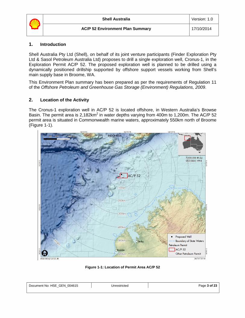
The Cronus-1 exploration well in AC/P 52 is located offshore, in Western Australia’s Browse Basin. The permit area is 2,182km2 in water depths varying from 400m to 1,200m. The AC/P 52 permit area is situated in Commonwealth marine waters, approximately 550km north of Broome (Figure 1-1).
Figure 1-1: Location of Permit Area AC/P 52
Shell Australia Version: 1.0
AC/P 52 Environment Plan Summary 17/10/2014
Document No: HSE_GEN_004615 Unrestricted Page 4 of 23
The Cronus-1 exploration well is planned in approximately 780m of water depth to a planned total vertical depth of approximately 4,750m subsea.
The preliminary coordinates for Cronus-1 are:
Latitude: -12.745°S
Longitude: 122.62°E
3. Description of the Activity
Drilling of the Cronus-1 exploration well is scheduled to commence in Q1 2015 at the earliest, and is planned to take approximately three months to complete.
The AC/P 52 drilling activity scope-of-work comprises conventional exploration activities, which includes drilling, casing, cementing, integrity checks, open hole logging, sampling, vertical seismic profiling (VSP), and permanent plug and abandonment.
Cronus-1 will be drilled using a dynamically positioned drillship. Aviation support and crew changes to the drillship will be conducted via Broome International Airport. Due to the long flying distance involved (approximately 3 hrs flying time one way), helicopter refuelling on the drillship and Djarindjin Airport will be required.
The marine operations supply base to support the activity will be located at Broome, utilising the Port of Broome wharf with a one way sailing time of approximately 30 hrs to/from the activity area.
Once on location in AC/P 52, the drillship will be supported by approximately 2 support vessels. The support vessels will be dynamically positioned as operationally required. At least one of the support vessels is planned to remain with the drillship, while the other vessel travel to and from the supply base to support the drillship activities.
The support vessels’ duties include safety standby duties, support of helicopter operations and monitoring the 500m radius exclusion zone maintained around the drillship. The support vessels will remove waste from the drillship and also supply the drillship with fresh water, food, fuel, cement casings, drilling fluid materials (including fluids and bulk products) and drilling equipment.
4. Description of the Environment
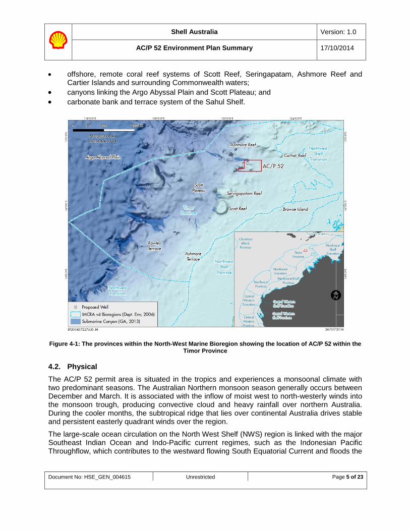
4.1. Regional Setting AC/P 52 permit area is located in the Commonwealth marine waters of the Timor Province within the wider North-west Marine Bioregion (NWMB). The Timor Province is approximately 350km northwest of Broome and in water depths ranging from 400m - 1,200m. The Timor Province is located on the continental slope (Figure 4-1) and has several biodiversity and geomorphologic features which include:
Shell Australia Version: 1.0
AC/P 52 Environment Plan Summary 17/10/2014
Document No: HSE_GEN_004615 Unrestricted Page 5 of 23
• offshore, remote coral reef systems of Scott Reef, Seringapatam, Ashmore Reef and Cartier Islands and surrounding Commonwealth waters;
• canyons linking the Argo Abyssal Plain and Scott Plateau; and • carbonate bank and terrace system of the Sahul Shelf.
Figure 4-1: The provinces within the North-West Marine Bioregion showing the location of AC/P 52 within the Timor Province
4.2. Physical The AC/P 52 permit area is situated in the tropics and experiences a monsoonal climate with two predominant seasons. The Australian Northern monsoon season generally occurs between December and March. It is associated with the inflow of moist west to north-westerly winds into the monsoon trough, producing convective cloud and heavy rainfall over northern Australia. During the cooler months, the subtropical ridge that lies over continental Australia drives stable and persistent easterly quadrant winds over the region.
The large-scale ocean circulation on the North West Shelf (NWS) region is linked with the major Southeast Indian Ocean and Indo-Pacific current regimes, such as the Indonesian Pacific Throughflow, which contributes to the westward flowing South Equatorial Current and floods the
Shell Australia Version: 1.0
AC/P 52 Environment Plan Summary 17/10/2014
Document No: HSE_GEN_004615 Unrestricted Page 6 of 23
NWS with relatively warm, low-salinity water. Wind-induced currents are most pronounced during tropical cyclones. After the passage of such strong events, transient oscillations in the ocean (called inertial currents) may arise.
The AC/P 52 permit area is located on the continental slope, which is a well known habitat for demersal fish communities. The closest observed seabed features are 65km away (Ashmore Reef) and 108km (Cartier Island) to the north-east of the activity location.
4.3. Ecological Environment
4.3.1. Benthic and Pelagic Communities The variety of geomorphic features in the Timor Province, together with its varying bathymetry, results in several distinct habitats and biological communities, many of which occur in close proximity to one another (e.g. shallow reefs on the shelf break occur in close proximity to adjacent deepwater muddy seabeds) on the continental slope. The reefs and islands of the bioregion are regarded as biodiversity hotspots and include a range of important pelagic and benthic ecological communities. In shallower coastal waters of the continental shelf, and on reefs and shoals in less than 50m water depth, epibenthic communities are abundant and diverse. However, epibenthic communities in deeper waters are generally less abundant and diverse due to the lack of hard substrates.
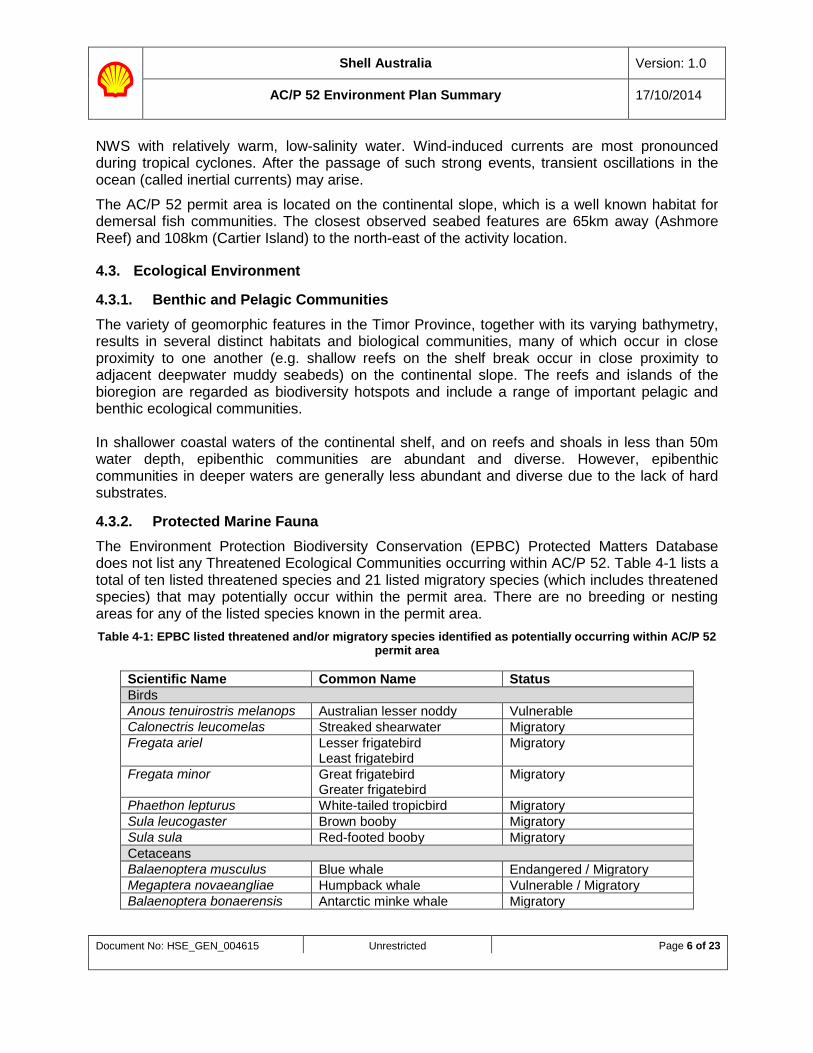
4.3.2. Protected Marine Fauna The Environment Protection Biodiversity Conservation (EPBC) Protected Matters Database does not list any Threatened Ecological Communities occurring within AC/P 52. Table 4-1 lists a total of ten listed threatened species and 21 listed migratory species (which includes threatened species) that may potentially occur within the permit area. There are no breeding or nesting areas for any of the listed species known in the permit area. Table 4-1: EPBC listed threatened and/or migratory species identified as potentially occurring within AC/P 52
permit area
Scientific Name Common Name Status Birds Anous tenuirostris melanops Australian lesser noddy Vulnerable Calonectris leucomelas Streaked shearwater Migratory Fregata ariel Lesser frigatebird
Least frigatebird Migratory
Fregata minor Great frigatebird Greater frigatebird
Migratory
Phaethon lepturus White-tailed tropicbird Migratory Sula leucogaster Brown booby Migratory Sula sula Red-footed booby Migratory Cetaceans Balaenoptera musculus Blue whale Endangered / Migratory Megaptera novaeangliae Humpback whale Vulnerable / Migratory Balaenoptera bonaerensis Antarctic minke whale Migratory
Shell Australia Version: 1.0
AC/P 52 Environment Plan Summary 17/10/2014
Document No: HSE_GEN_004615 Unrestricted Page 7 of 23
Scientific Name Common Name Status Balaenoptera edeni Bryde’s whale Migratory Orcinus orca Killer whale Migratory Physeter macrocephalus Sperm whale Migratory Reptiles Caretta caretta Loggerhead turtle Endangered / Migratory Dermochelys coriacea Leatherback turtle Endangered / Migratory Lepidochelys olivacea Olive ridley turtle Endangered / Migratory Chelonia mydas Green turtle Vulnerable / Migratory Eretmochelys imbricate Hawksbill turtle Vulnerable / Migratory Natator depressus Flatback turtle Vulnerable / Migratory Fish and Sharks Rhincodon typus Whale shark Vulnerable / Migratory Isurus oxyrinchus Shortfin mako Migratory Isurus paucus Longfin mako Migratory
4.3.2.1. Mammals – Cetaceans
The EPBC Act Protected Matters Database lists 22 mammal species that may occur in the permit area. Two of these mammal (cetacean) species are listed as Threatened under the EPBC Act (Table 4-1):
• humpback whale (Megaptera novaeangliae); and • blue whale (Balaenoptera musculus).
Humpback whales
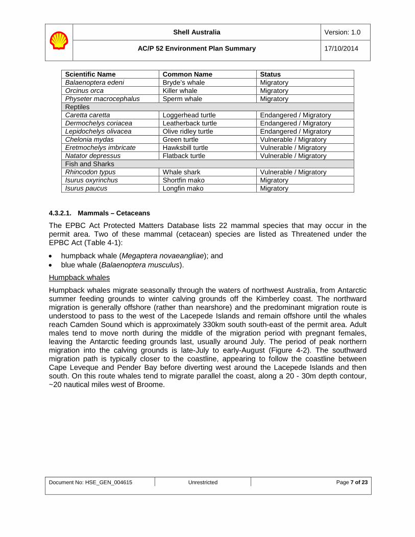
Humpback whales migrate seasonally through the waters of northwest Australia, from Antarctic summer feeding grounds to winter calving grounds off the Kimberley coast. The northward migration is generally offshore (rather than nearshore) and the predominant migration route is understood to pass to the west of the Lacepede Islands and remain offshore until the whales reach Camden Sound which is approximately 330km south south-east of the permit area. Adult males tend to move north during the middle of the migration period with pregnant females, leaving the Antarctic feeding grounds last, usually around July. The period of peak northern migration into the calving grounds is late-July to early-August (Figure 4-2). The southward migration path is typically closer to the coastline, appearing to follow the coastline between Cape Leveque and Pender Bay before diverting west around the Lacepede Islands and then south. On this route whales tend to migrate parallel the coast, along a 20 - 30m depth contour, ~20 nautical miles west of Broome.
Shell Australia Version: 1.0
AC/P 52 Environment Plan Summary 17/10/2014
Document No: HSE_GEN_004615 Unrestricted Page 8 of 23
Figure 4-2: Humpback Whale Migratory Routes and Calving Grounds
Blue whales
Blue whales have an extensive oceanic distribution and have been recorded from all Australian states. Australian migration paths are widespread and have not been observed to follow coastlines or oceanographic features. The whales are rarely seen in large numbers outside recognised aggregation areas.
There are two recognised subspecies of blue whale in Australia, the 'true' blue whale and the ‘pygmy' blue whale.
‘True’ blues appear to feed mainly, if not exclusively, in the Antarctic and during summer months, therefore, unlikely to be found in the vicinity of the activity area.
The Western Australian continental slope, from the Perth Canyon, is a likely migratory path between feeding areas in the south and an undetermined northern calving area. A total of seven pygmy blue whales where observed during a 2008 cetacean study. One pygmy blue whale was sighted migrating north in an area east of Browse Island during June, while six pygmy blue whales were sighted at Scott Reef, migrating south in October/ November.
Shell Australia Version: 1.0
AC/P 52 Environment Plan Summary 17/10/2014
Document No: HSE_GEN_004615 Unrestricted Page 9 of 23
Migratory pygmy blue whales may therefore transit through AC/P 52 permit area but numbers are expected to be low given the offshore location and the documented broad and dynamic migratory routes. 4.3.2.2. Reptiles - Turtles
The EPBC Act Protected Matters Database lists up to six species of marine turtle species which may occur in the AC/P 52 permit area; all of which are listed as ‘Threatened species’ under the EPBC Act:
• flatback turtle (Natator depressus); • green turtle (Chelonia mydas); • leatherback turtle (Dermochelys coriacea); • hawksbill turtle (Eretmochelys imbricate); • olive ridley turtle (Lepidochelys olivacea); and • loggerhead turtle (Caretta caretta).
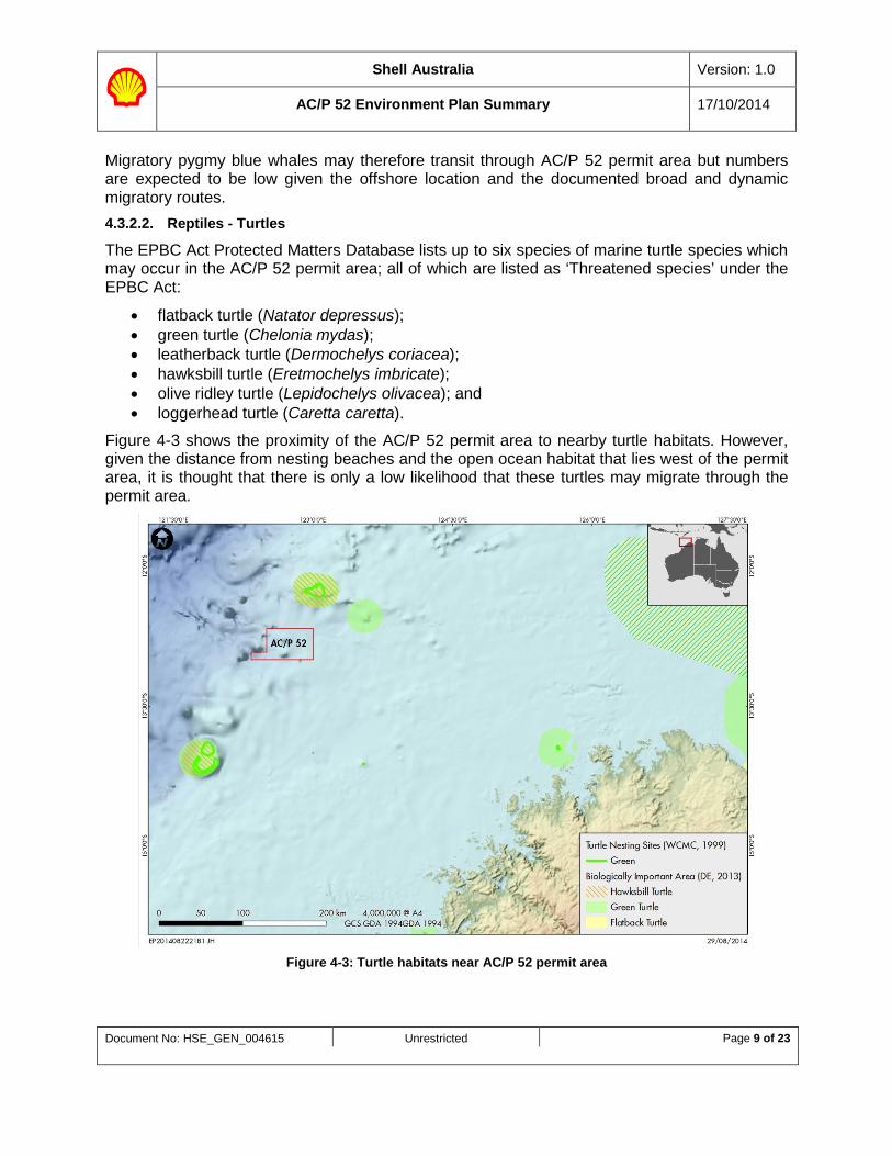
Figure 4-3 shows the proximity of the AC/P 52 permit area to nearby turtle habitats. However, given the distance from nesting beaches and the open ocean habitat that lies west of the permit area, it is thought that there is only a low likelihood that these turtles may migrate through the permit area.
Figure 4-3: Turtle habitats near AC/P 52 permit area
Shell Australia Version: 1.0
AC/P 52 Environment Plan Summary 17/10/2014
Document No: HSE_GEN_004615 Unrestricted Page 10 of 23
4.3.2.3. Fish and Sharks
The EPBC Act Protected Matters Database lists up to three species of Threatened and/or Migratory fish and shark species which may occur in AC/P 52 permit area:
• Whale shark (Rhincodon typus); • shortfin mako (Isurus oxyrinchus);and • longfin mako (Isurus paucus).
4.3.2.4. Birds
The EPBC Act Protected Matters Database identified one bird as a Threatened species under the EPBC Act; the Australian lesser noddy (Anous tenuirostris melanops).
Low densities of migratory shorebirds and seabirds protected under the Japanese-Australia Migratory Bird Agreement (JAMBA), China-Australia Migratory Bird Agreement (CAMBA) and Republic of Korea-Australia Migratory Bird Agreement (ROKAMBA) bilateral agreements may pass through the activity area. Ashmore Reef (approximately 65km away), in particular, is an important site for both migratory birds and seabirds.
4.4. Socio-Economic Environment There are no World Heritage Sites or National Heritage Sites within AC/P 52 permit area.
The AC/P 52 permit area is within area of the Memorandum of Understanding (MoU) between the Governments of Australia and Indonesia which enables Indonesian traditional fishermen to continue their customary practices and harvest species such as trepang, trochus, clams, finfish, abalone, shark (for dried fins) and sponges within Australian waters. Traditional Indonesian fishermen are likely to be found in deepwater areas only during transit to and from the reef locations. Since the proposed activity period is outside of the months during which low numbers of Indonesian fishermen are likely to be in transit, they are unlikely to be found within AC/P 52 permit area and hence unlikely to be impacted by the planned drilling activity.
There are several shipwrecks some distance away from the AC/P 52 permit area. The closest shipwrecks are Mandela 1999 and Sinar Bonerate 1999 as well as some unnamed Indonesian fishing vessels being some 65km away from the activity location.
The AC/P 52 permit area lies within various commercial fishing management areas. Commercial fisheries include tuna and tropical finfish, particularly high-value emperors, snappers and cods. Within the NWMB there are also significant commercial fisheries for Spanish mackerel, barramundi, threadfin salmon and shark. WA State managed commercial fisheries permitted within the AC/P 52 permit area include the Mackerel Managed Fishery, Nothern Demersal Scalefish Fishery, Northern Shark Fisheries, Pearl Oster Fishery and West Coast Deep Sea Crustacean Fishery. Commonwealth managed commercial fisheries, which are permitted within the AC/P 52 permit area include the Southern Blue Fin Tuna Fishery, Western Tuna and Billfish Fishery, Western Skipjack Fishery and North West Slope Trawl Fishery.
Whilst charter fishing companies frequent the broader region, there are no known tourist attractions or destinations within the AC/P52 AC/P 52 permit area. Tourism, however, has a much larger presence along the coast from Exmouth to Broome, largely confined to coastal waters and inshore islands. Fishing and diving charters operate out of Broome and Derby and
Shell Australia Version: 1.0
AC/P 52 Environment Plan Summary 17/10/2014
Document No: HSE_GEN_004615 Unrestricted Page 11 of 23
the occasional charter vessel may visit Scott Reef, Ashmore Reef, and Browse and Adele Islands. Recreational fishing in the northwest region of Western Australia is not known to take place within the AC/P 52 permit area.
Petroleum exploration has been active in the Browse Basin since the early 1980s, with several commercial discoveries since that time. The closest facility is the Montara production Floating Production Storage and Offloading (FPSO) facility which is located some 167km to the east of the AC/P 52 permit area.
None of the major commercial shipping routes through the Timor Sea passes through the AC/P 52 permit area. Vessel movements in closer proximity to the permit area are coastal ships servicing Western Australian and Northern Territory ports or supporting other petroleum activities.
5. Management Approach
The Shell Commitment and Policy on Health, Safety, Security, Environment and Social Performance (HSSE and SP) applies globally across Shell and is designed to protect people and the environment.
Key features of the policy are:
• Systematic approach to HSSE and SP management designed to ensure compliance with the law and to achieve continuous performance improvement;
• Targets for improvement and measurement, appraisal and performance reporting; • Requirement for contractors to manage HSSE and SP in line with this policy; and • Effective engagement with neighbours and impacted communities.
All of Shell’s operations comply with the Shell HSSE and SP Control Framework, a comprehensive corporate management framework, comprising of a simplified set of mandatory standards applicable to every Shell Company, contractor and joint venture under Shell’s operational control.
Within Shell, the HSSE and SP Control Framework requires people in HSSE Critical Positions to have their HSSE-MS competence assured. These people have to attain a set proficiency level in three competences: HSSE Lead; HSSE Prepare; and HSSE Apply. People in HSSE Critical Positions are responsible for the development and maintenance of effective barriers to prevent incidents.
This activity will be managed to comply with the relevant State and Commonwealth Acts and Regulations, industry standards and applicable international agreements.
Shell Drilling Supervisors are Shell’s representative aboard the drillship. They are responsible for ensuring the monitoring and operational requirements of the environment plan are communicated to the crew and implemented. The drilling supervisors will also conduct regular informal HSE checks of the rig activities to ensure that the EP commitments are implemented and attend the daily drillship operations meetings.

Shell Australia Version: 1.0
AC/P 52 Environment Plan Summary 17/10/2014
Document No: HSE_GEN_004615 Unrestricted Page 12 of 23
As part of broader HSE auditing, an EP compliance audit will be undertaken to determine compliance with the requirements of this EP. The audit will assess and report against the performance outcomes, standards and measurement criteria.
If any new or increased risks are identified during the activities, an assessment of the risk and review of the environment plan will be undertaken and, if determined to be a significant new or significantly increased risk, the activity leading to the new risk will not continue until acceptance of the management approach to the new / changed risks has been provided to NOPSEMA. The Shell Project Manager is responsible for the management of any change.
All environmental incidents and non-conformances are managed in accordance with the Shell HSSE Incident Reporting, Investigation and Follow Up Procedure that describes the process of reporting, classification, investigation, follow-up and close out.
Shell’s overall environmental objective for the activity is to avoid or reduce environmental risks to as low as reasonably practicable (ALARP). Specific performance outcomes, standards and measurement criteria for each aspect of the activities that has the potential to cause adverse environmental impacts have been identified. Environmental performance will be measured and reported against these standards and criteria as part of Shell’s commitment to continuous improvement of environmental, health and safety performance.
An Environmental Performance report will be submitted to NOPSEMA as required by OPGGS (E) Regulations 2009. This report will be submitted within 3 months of completion of the activity, given the activity is less than 1 year long, one report is deemed sufficient. The Shell Project Manager will review environmental performance upon completion of the activity.
As required by the OPGGS (E) Regulations 2009, Shell will store and maintain environmental documents and records from these activities for the period of 5 years.
The Oil Pollution Emergency Plan will be tested prior to the commencement of the activity by way of a walk-through by Shell’s Emergency Response Team to test the communication, emergency response team functionality, Emergency Response Plans, and to ensure that the emergency response team members are aware of their roles and responsibilities in the unlikely event that an incident would occur. A summary of Shell’s response strategies in the Oil Pollution Emergency Plan is provided in Appendix A.
An Implementation Strategy has been incorporated into the Environment Plan per the OPGGS (E) Regulations 2009. This includes:
• Measures, systems and practices to ensure environmental performance objectives and standards are met;
• Chain of Command; • Measures to ensure workers are aware of their responsibilities; • Monitoring and management; • Records and reporting; • Oil Pollution Emergency Plan (OPEP); and • Consultation.
Shell Australia Version: 1.0
AC/P 52 Environment Plan Summary 17/10/2014
Document No: HSE_GEN_004615 Unrestricted Page 13 of 23
6. Environmental Hazards and Controls
A risk analysis has been undertaken for all aspects of operations, in accordance with the Shell HSSE and SP Control Framework and in line with the principles outlined in the Australian Standard AS/NZS ISO 31000:2009 Risk Management and HB 203:2006 Environmental Risk Management.
The risks for each planned and unplanned event have been determined using a qualitative assessment process. The level of risk has been determined by assessing risk likelihood and consequence using the Shell Risk Assessment Matrix.
This is a 6 by 5 matrix that is used for qualitative assessments of risk and assists determination of appropriate controls and mitigation measures:
• The vertical axis represents increasing consequence (severity levels 0 to 5) in terms of harm to people, damage to assets, effect on the environment and impact on reputation with 5 being the greatest severity; and
• The horizontal axis represents increasing likelihood (levels A to E) of the consequence under consideration, with E being the highest observed frequency of an event (or consequence) occurring.
To demonstrate that risks are as low as reasonably practicable and at an acceptable level, all mitigation measures have been considered and where these measures are practical, they have been included.
Incidents with a consequence severity equal to or greater than level 3 (i.e. moderate to massive) are considered ‘Reportable Incidents’ in line with Regulation 26 of the OPGGS (E) Regulations 2009. For this activity, based on the risk assessment, though the probability of occurrence is low, four possible events are considered to have a moderate or greater consequence, if they occur:
• Introduction of invasive marine species; • Support vessel collision with marine life (that is a threatened or migratory species listed
under the EPBC Act 1999); • Hydrocarbon spill resulting from vessel collision; and • Hydrocarbon spill resulting from well blow-out.
Recordable incidents in the OPGGS (E) Regulation 2009 are defined as ‘an incident arising from the activity that breaches a performance outcome or standard in the Environment Plan that applies to the activity and is not a reportable incident’.
A summary of the key environmental hazards / risks and control measures to be applied to the activities is provided in Appendix B. These are consistent with Shell and project-specific environmental outcomes, standards and measurement criteria. All control measures associated with the hazards will be used to reduce environmental risk to ALARP and will be of an acceptable level.
Shell Australia Version: 1.0
AC/P 52 Environment Plan Summary 17/10/2014
Document No: HSE_GEN_004615 Unrestricted Page 14 of 23
7. Stakeholder Consultation
Shell has undertaken consultation with key stakeholders who have an interest in the activities within the permit area. Consultation for this activity is built upon the relationships developed during the consultations undertaken for previous Shell activities in the Browse Basin.
In the process of initially identifying and engaging with relevant persons, Shell considered relevant government agencies and persons or organisations whose functions, interests or activities may be affected by the activity. Stakeholders consulted include:
• Australian Marine Oil Spill Centre (AMOSC); • Australian Marine Safety Authority (AMSA); • Commonwealth Department of Foreign Affairs and Trade (DFAT); • WA Department of Transport (DoT); • WA Department of Parks and Wildlife (DPAW); • WA Department of Environment Regulation (DER); • Shire of Broome; • Broome Port Authority; • WA Department of Mines and Petroleum (DMP); • Commonwealth Department of Industry (DoI); • WA Department of Fisheries (DoF); • NT Seafood Council; • NT Department of Resources; • National Offshore Petroleum Titles Administrator (NOPTA); • Australian Fisheries Management Authority (AFMA); • Commonwealth Fisheries Association; • Relevant individual Commonwealth Commercial Fisheries; • Western Australian Fishing Industry Council (WAFIC); • RecFish; • Kimberley Professional Fisherman’s Association; • Kimberley Marine Tourism Association; • Relevant individual State Commercial Fisheries; • Environs Kimberley; • Australian Conservation Foundation; • World Wildlife Fund (WWF); • Conservation Council WA; • Djarindjin Aboriginal Corporation; • Djarindjin Airport; • Lombadina Council; and • Various contractors.
Ongoing stakeholder engagement is determined by an analysis of each stakeholder’s potentially changing functions, activities and interests in the AC/P 52 drilling activity. Shell will engage and respond as appropriate if contacted. All other stakeholders will be informed of project progress, when issues arise or planned activities change in accordance with the stakeholder engagement plan.
Shell Australia Version: 1.0
AC/P 52 Environment Plan Summary 17/10/2014
Document No: HSE_GEN_004615 Unrestricted Page 15 of 23
Engagement on the AC/P 52 drilling activity will continue throughout 2014/2015 leading up to and post the completion of the activity. Shell will ensure that all stakeholders are kept informed of changes to the project scope. The AC/P 52 stakeholder engagement plan details project milestones that require further stakeholder consultation.
Shell Australia has developed a Community Feedback Mechanism to support exploration activities such as AC/P 52. The mechanism consists of an email address and 24hr, 7 days/week free-call hotline (1800 059 152). All calls and emails are answered by Shell staff, with experience in community engagement. Both the email address and hotline are listed on the Shell Australia website and distributed at community forums.
Shell will ensure that all stakeholders are kept informed of project progress and outcomes, and are able to raise questions/concerns at any time, where appropriate. Stakeholders can raise their questions/concerns via direct communication, primarily through Shell’s website, the provided email address ([email protected]) and through the Community Feedback Mechanism.
WA Department of Fisheries requested Shell to contact all individual commercial fisheries licence holders that may be impacted by the activity. As a result Shell provided details of the activity to all individual licence holders identified by the WA Department of Fisheries.
No other concerns / queries were raised by stakeholders during the consultation process. Stakeholders have been and are currently able to raise their concerns via direct communication, primarily through Shell’s provided email address and the Community Feedback Mechanism.
8. Contact Details
For further information about this activity, please contact the titleholders nominated liaison person:
Kelly Lamperd 2 Victoria Ave Perth, WA 6000 Australia Tel: + 61 8 9338 6000 Email: [email protected]
Shell Australia Version: 1.0
AC/P 52 Environment Plan Summary 17/10/2014
Document No: HSE_GEN_004615 Unrestricted Page 16 of 23
APPENDIX A: Summary of response strategies in the oil pollution emergency plan
The AC/P 52 Oil Pollution Emergency Plan (OPEP) sets out the Shell and Contractor responsibilities and response actions in the unlikely event of an oil spill during the drilling activities.
The responsibility for an oil spill is dependent on location and spill origin. The National Plan for Maritime Environmental Emergencies sets out the divisions of responsibility for an oil spill response. For offshore petroleum exploration and production activities, Shell is the control agency for spills emanating from its offshore facilities and AMSA is the Control Agency for spills emanating from vessels in Commonwealth waters, including the vessels utilised for the drilling activities.
AMSA (Australian Maritime Safety Authority) was established under the Australian Maritime Safety Authority Act 1990 with responsibilities for maritime safety and combat of pollution in the marine environment or other environmental damage caused by shipping. AMSA manages the National Plan and associated arrangements on behalf of the Australian Government. AMSA and Shell have signed a Memorandum of Understanding (MoU) that outlines roles and responsibilities. The MoU ratifies that AMSA will take over the control of spills originating from vessels for all spill volumes, and that Shell would support AMSA in this response.
Response Actions Should an oil spill incident occur, Shell will immediately take the following actions:
• Follow the Vessel’s procedures (incl. Shipboard Oil Pollution Emergency Plans - SOPEP) to protect human life and equipment and reduce the risk of fire or explosion;
• Cut off supply to the spillage, contain spill on deck if safe to do so; • Gain situational awareness: i.e. identify the substance, the volume, the location of the spill,
where is it travelling to, and how long before it reaches any sensitivities, what is happening to it (e.g. weathering) and define the worst credible scenario; and
• Provide notification of spill to NOPSEMA and other relevant authorities (e.g. AMSA, Department of Fisheries and Department of Transport).
For spills extending beyond the initial actions, an Incident Action Plan (IAP) will be developed at the time of a spill, appropriate to the nature, size and scale of the activity and utilising the appropriate response strategies. The pre-spill planning assessment of the applicability of each response strategy, including the Net Environmental Benefit Assessment (NEBA), will be revisited and updated if required based on the actual characteristics of the spill at hand.
Primary response strategies that may be employed in parallel with monitor and evaluate in worst-case oil spill scenarios include operational and scientific monitoring program (OSMP).
Monitor and Evaluate
The monitor and evaluate strategy will be conducted for all spills to inform response decision making, maintain situational awareness and keep the IAP current. The options for the monitor and evaluate strategy include:
• Satellite imagery;
Shell Australia Version: 1.0
AC/P 52 Environment Plan Summary 17/10/2014
Document No: HSE_GEN_004615 Unrestricted Page 17 of 23
• Observation from vessels; • Modelling; • Metocean Data; and • Aerial Surveillance.
Operational and Scientific Monitoring Program
The operational and scientific monitoring program may be implemented, if a spill is deemed significant to trigger this response. Shell is in the process of developing an Operational and Scientific Monitoring Program for exploration activities to determine the fate and ecological consequences of a spill to enable environmental impacts and recovery to be measured.

Shell Upstream Australia Version: 1.0
AC/P52 Environment Plan Summary 17/10/2014
Document No: HSE_GEN_004615 Unrestricted Page 18 of 23
APPENDIX B: Summary of key environmental hazards and control measures to be applied to the drilling activity
Hazard / Risks Potential Environmental Impact Controls – Mitigation Measures
Planned Activities
Physical presence of the drillship
Disruption of commercial or recreational fishing or shipping activity.
The Australian Hydrographic Service (AHS) and the Australian Maritime Safety Authority (AMSA) will be notified of the presence of the drillship prior to the commencement of the activity. The drillship will be equipped with suitable navigation aids and regulatory equipment. Competent crew maintaining 24 hr visual, radio and automatic identification system (AIS), bridge vessel watch when vessels in 500 m exclusion zone. Communication with the Australian Fisheries Management Authority (AFMA) and WA Fisheries so that they are aware of the activity prior to commencement.
Noise generated by drilling activities
Disruption to behaviour patterns of sensitive marine fauna from drillship operations and/ or noise generated by support vessel movements.
Location of drilling location in open ocean, well away from coastal environments and fauna migration routes. Routine drilling and support vessel noise thoroughly studied and documented - below levels likely to cause physiological damage to marine fauna. Adherence to EPBC Regulations 2000 – Part 8 Division 8.1 (Regulation 8.04) – Interacting with cetaceans. VSP procedures in line with the EPBC Act, to manage potential interactions between VSP and threatened and migratory cetacean species listed under the EPBC Act.
Discharge of bilge and deck drainage into the sea
Localised and temporary acute toxic effects caused by contaminants in waste stream.
Prior to discharge, bilge and deck drainage water treated in accordance with MARPOL 73/78 Annex I – Regulation for the Prevention of Pollution by Oil from Ships under the Commonwealth Protection of the Sea (Prevention of Pollution from Ships) Act 1983 (Part II Prevention of pollution from oil); and Marine Order 91: (Marine pollution prevention – oil) 2006.
Potentially contaminated bilge and deck drainage directed to oily water separator prior to discharge at <15 ppm or stored for onshore disposal. Discharge quality of oily water separator automatically monitored with diversion if oil-in-water concentration is > 15ppm. Oily water separator maintained.
Shipboard Oil/Marine Pollution Emergency Plans (SOPEP/SMPEP)s in place.
Deck spills cleaned up using adsorbents (spill kits) and/ or diverted to the contaminated drainage system.
Location of well in open ocean, well away from coastal environments.

Shell Upstream Australia Version: 1.0
AC/P52 Environment Plan Summary 17/10/2014
Document No: HSE_GEN_004615 Unrestricted Page 19 of 23
Hazard / Risks Potential Environmental Impact Controls – Mitigation Measures
Discharge of sewage, grey water and putrescible waste into the sea
Localised and temporary acute toxic effects caused by contaminants in waste stream (e.g. nutrient enrichment).
Sewage and grey water treated in accordance with MARPOL 73/78 Annex IV, as applied in Australia under the Commonwealth Protection of the Sea (Prevention of Pollution from Ships) Act 1983 (Part IIIB Prevention of pollution by sewage); and Marine Order 96: (Marine pollution prevention – sewage) 2009.
Putrescible waste treated in accordance with MARPOL 73/78 Annex V, as applied in Australia under the Commonwealth Protection of the Sea (Prevention of Pollution from Ships) Act 1983 (Part IIIC Prevention of pollution from garbage); and Marine Order 95 (Marine pollution prevention – garbage) 2013.
Location of well in open ocean, well away from coastal environments.
Drill cuttings and bulk water based mud (WBM) discharge
Disturbance to benthic communities as a result of smothering and pelagic communities as a result of increased turbidity from WBM/ cuttings disposal.
42” and 26” sections drilled riserless with seawater / pre-hydrated bentonite sweeps; cuttings deposited directly on seafloor minimising zone of impact and turbidity.
Water-based drilling fluids used for 17½”, 12¼” and 8½” sections, planned to be returned to surface using a circulating closed mud system and water-based drilling fluid cuttings directed over the shale shakers to recover water-based drilling fluid for reuse prior to cuttings discharging to ocean. Fines sent to a settling pit to recover water-based drilling fluid prior to cuttings discharge.
Utilise the most acceptable fluid following the acceptability criteria.
Contingency use of Synthetic based mud (SBM) resulting in SBM coated drill cuttings discharge
Disturbance to benthic communities as a result of smothering and burial with SBM coated cuttings.
SBM is not planned to be used and only considered as a contingency for the lower section in the event of wellbore instability, as technically required.
Utilise the most acceptable fluid following the acceptability criteria.
No bulk SBM discharged to ocean at any time throughout the duration of the activity.
Unplanned synthetic based fluid remaining on cuttings discharge is less than 10% dry weight averaged over SBM sections.
Excess Pipe Thread Compounds
Potential localised and temporary toxic effects to benthic communities.
Utilise the most acceptable chemicals that meet the acceptability criteria.
Disposal of excess or contaminated cement
Impacts to benthic communities as a result of smothering and pelagic communities as a result of increased turbidity of cement disposal.
Cements meet the chemical selection acceptability criteria. Mixing of cement in small batches greatly limits the volume of cement that could require disposal. Unused additives returned to shore for reuse or disposal.
Shell Upstream Australia Version: 1.0
AC/P52 Environment Plan Summary 17/10/2014
Document No: HSE_GEN_004615 Unrestricted Page 20 of 23
Hazard / Risks Potential Environmental Impact Controls – Mitigation Measures
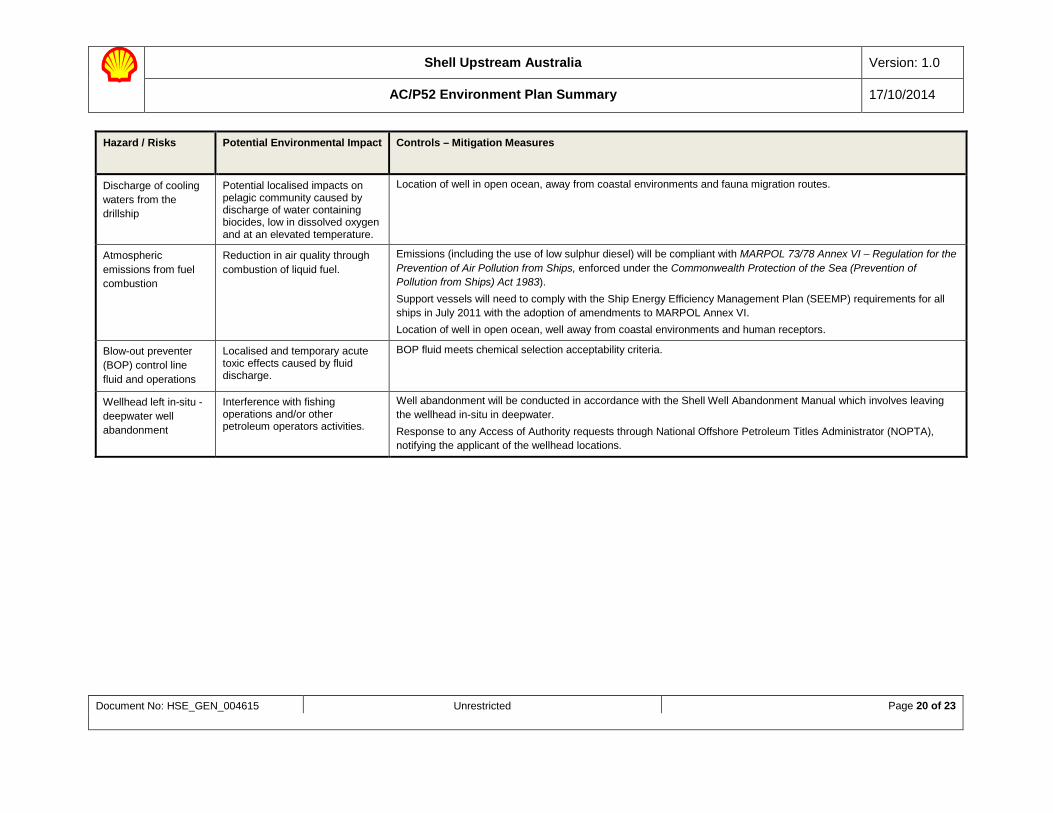
Discharge of cooling waters from the drillship
Potential localised impacts on pelagic community caused by discharge of water containing biocides, low in dissolved oxygen and at an elevated temperature.
Location of well in open ocean, away from coastal environments and fauna migration routes.
Atmospheric emissions from fuel combustion
Reduction in air quality through combustion of liquid fuel.
Emissions (including the use of low sulphur diesel) will be compliant with MARPOL 73/78 Annex VI – Regulation for the Prevention of Air Pollution from Ships, enforced under the Commonwealth Protection of the Sea (Prevention of Pollution from Ships) Act 1983). Support vessels will need to comply with the Ship Energy Efficiency Management Plan (SEEMP) requirements for all ships in July 2011 with the adoption of amendments to MARPOL Annex VI. Location of well in open ocean, well away from coastal environments and human receptors.
Blow-out preventer (BOP) control line fluid and operations
Localised and temporary acute toxic effects caused by fluid discharge.
BOP fluid meets chemical selection acceptability criteria.
Wellhead left in-situ - deepwater well abandonment
Interference with fishing operations and/or other petroleum operators activities.
Well abandonment will be conducted in accordance with the Shell Well Abandonment Manual which involves leaving the wellhead in-situ in deepwater. Response to any Access of Authority requests through National Offshore Petroleum Titles Administrator (NOPTA), notifying the applicant of the wellhead locations.
Shell Upstream Australia Version: 1.0
AC/P52 Environment Plan Summary 17/10/2014
Document No: HSE_GEN_004615 Unrestricted Page 21 of 23
Hazard / Risks Potential Environmental Impact Controls – Mitigation Measures
Unplanned Impacts
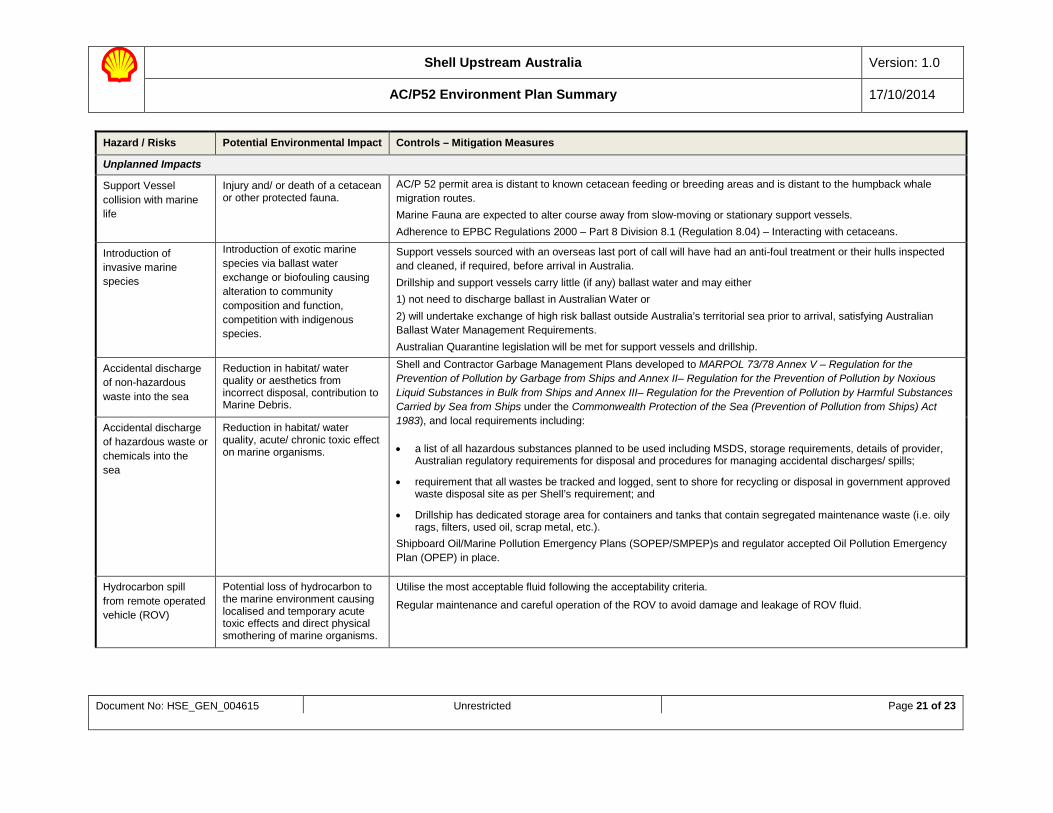
Support Vessel collision with marine life
Injury and/ or death of a cetacean or other protected fauna.
AC/P 52 permit area is distant to known cetacean feeding or breeding areas and is distant to the humpback whale migration routes. Marine Fauna are expected to alter course away from slow-moving or stationary support vessels. Adherence to EPBC Regulations 2000 – Part 8 Division 8.1 (Regulation 8.04) – Interacting with cetaceans.
Introduction of invasive marine species
Introduction of exotic marine species via ballast water exchange or biofouling causing alteration to community composition and function, competition with indigenous species.
Support vessels sourced with an overseas last port of call will have had an anti-foul treatment or their hulls inspected and cleaned, if required, before arrival in Australia. Drillship and support vessels carry little (if any) ballast water and may either 1) not need to discharge ballast in Australian Water or 2) will undertake exchange of high risk ballast outside Australia’s territorial sea prior to arrival, satisfying Australian Ballast Water Management Requirements. Australian Quarantine legislation will be met for support vessels and drillship.
Accidental discharge of non-hazardous waste into the sea
Reduction in habitat/ water quality or aesthetics from incorrect disposal, contribution to Marine Debris.
Shell and Contractor Garbage Management Plans developed to MARPOL 73/78 Annex V – Regulation for the Prevention of Pollution by Garbage from Ships and Annex II– Regulation for the Prevention of Pollution by Noxious Liquid Substances in Bulk from Ships and Annex III– Regulation for the Prevention of Pollution by Harmful Substances Carried by Sea from Ships under the Commonwealth Protection of the Sea (Prevention of Pollution from Ships) Act 1983), and local requirements including:
• a list of all hazardous substances planned to be used including MSDS, storage requirements, details of provider, Australian regulatory requirements for disposal and procedures for managing accidental discharges/ spills;
• requirement that all wastes be tracked and logged, sent to shore for recycling or disposal in government approved waste disposal site as per Shell’s requirement; and
• Drillship has dedicated storage area for containers and tanks that contain segregated maintenance waste (i.e. oily rags, filters, used oil, scrap metal, etc.).
Shipboard Oil/Marine Pollution Emergency Plans (SOPEP/SMPEP)s and regulator accepted Oil Pollution Emergency Plan (OPEP) in place.
Accidental discharge of hazardous waste or chemicals into the sea
Reduction in habitat/ water quality, acute/ chronic toxic effect on marine organisms.
Hydrocarbon spill from remote operated vehicle (ROV)
Potential loss of hydrocarbon to the marine environment causing localised and temporary acute toxic effects and direct physical smothering of marine organisms.
Utilise the most acceptable fluid following the acceptability criteria.
Regular maintenance and careful operation of the ROV to avoid damage and leakage of ROV fluid.
Shell Upstream Australia Version: 1.0
AC/P52 Environment Plan Summary 17/10/2014
Document No: HSE_GEN_004615 Unrestricted Page 22 of 23
Hazard / Risks Potential Environmental Impact Controls – Mitigation Measures
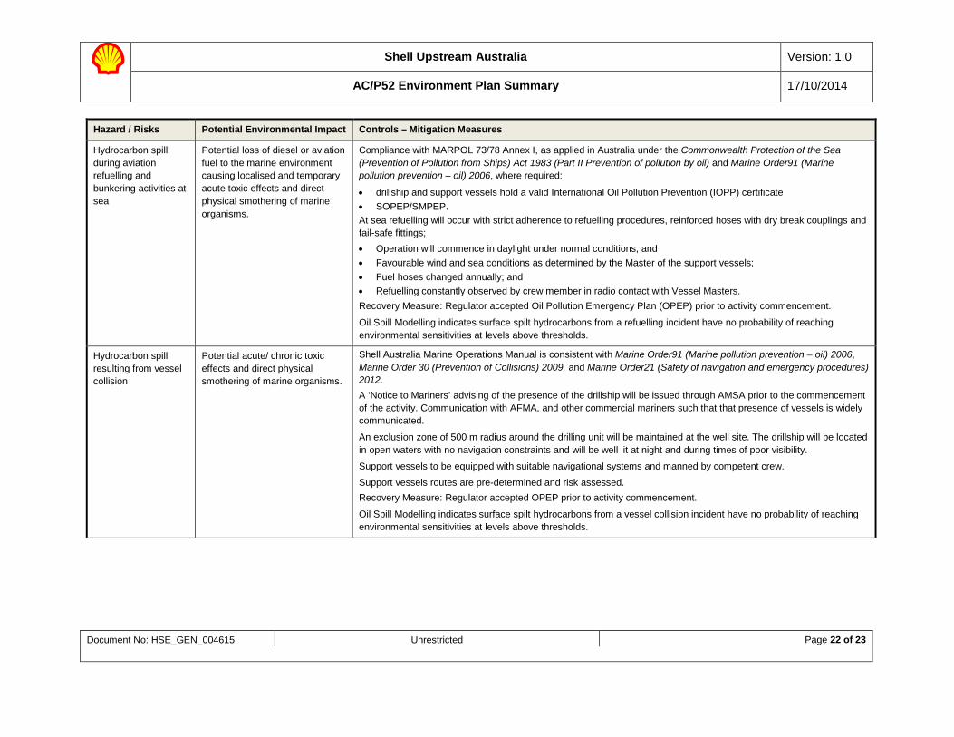
Hydrocarbon spill during aviation refuelling and bunkering activities at sea
Potential loss of diesel or aviation fuel to the marine environment causing localised and temporary acute toxic effects and direct physical smothering of marine organisms.
Compliance with MARPOL 73/78 Annex I, as applied in Australia under the Commonwealth Protection of the Sea (Prevention of Pollution from Ships) Act 1983 (Part II Prevention of pollution by oil) and Marine Order91 (Marine pollution prevention – oil) 2006, where required:
• drillship and support vessels hold a valid International Oil Pollution Prevention (IOPP) certificate • SOPEP/SMPEP. At sea refuelling will occur with strict adherence to refuelling procedures, reinforced hoses with dry break couplings and fail-safe fittings; • Operation will commence in daylight under normal conditions, and • Favourable wind and sea conditions as determined by the Master of the support vessels; • Fuel hoses changed annually; and • Refuelling constantly observed by crew member in radio contact with Vessel Masters. Recovery Measure: Regulator accepted Oil Pollution Emergency Plan (OPEP) prior to activity commencement.
Oil Spill Modelling indicates surface spilt hydrocarbons from a refuelling incident have no probability of reaching environmental sensitivities at levels above thresholds.
Hydrocarbon spill resulting from vessel collision
Potential acute/ chronic toxic effects and direct physical smothering of marine organisms.
Shell Australia Marine Operations Manual is consistent with Marine Order91 (Marine pollution prevention – oil) 2006, Marine Order 30 (Prevention of Collisions) 2009, and Marine Order21 (Safety of navigation and emergency procedures) 2012. A ‘Notice to Mariners’ advising of the presence of the drillship will be issued through AMSA prior to the commencement of the activity. Communication with AFMA, and other commercial mariners such that that presence of vessels is widely communicated.
An exclusion zone of 500 m radius around the drilling unit will be maintained at the well site. The drillship will be located in open waters with no navigation constraints and will be well lit at night and during times of poor visibility.
Support vessels to be equipped with suitable navigational systems and manned by competent crew.
Support vessels routes are pre-determined and risk assessed. Recovery Measure: Regulator accepted OPEP prior to activity commencement.
Oil Spill Modelling indicates surface spilt hydrocarbons from a vessel collision incident have no probability of reaching environmental sensitivities at levels above thresholds.
Shell Upstream Australia Version: 1.0
AC/P52 Environment Plan Summary 17/10/2014
Document No: HSE_GEN_004615 Unrestricted Page 23 of 23
Hazard / Risks Potential Environmental Impact Controls – Mitigation Measures
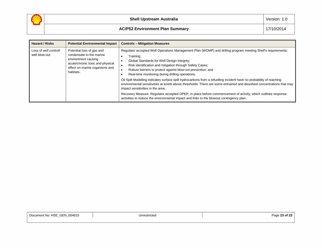
Loss of well control/ well blow-out
Potential loss of gas and condensate to the marine environment causing acute/chronic toxic and physical effect on marine organisms and habitats.
Regulator accepted Well Operations Management Plan (WOMP) and drilling program meeting Shell’s requirements:
• Training; • Global Standards for Well Design Integrity; • Risk identification and mitigation through Safety Cases; • Robust barriers to protect against blow-out prevention; and • Real-time monitoring during drilling operations.
Oil Spill Modelling indicates surface spilt hydrocarbons from a refuelling incident have no probability of reaching environmental sensitivities at levels above thresholds. There are some entrained and dissolved concentrations that may impact sensitivities in the area.
Recovery Measure: Regulator accepted OPEP, in place before commencement of activity, which outlines response activities to reduce the environmental impact and links to the blowout contingency plan.