Enviromental Modelling Introduction to TerraME
169
Enviromental Modelling Introduction to TerraME Tiago Garcia de Senna Carneiro (UFOP) Gilberto Câmara (INPE)
-
Upload
hashim-lucas -
Category
Documents
-
view
44 -
download
1
description
Enviromental Modelling Introduction to TerraME. Tiago Garcia de Senna Carneiro (UFOP) Gilberto Câmara (INPE). Dynamic Spatial Models. f (I t ). f (I t+1 ). f (I t+2 ). f ( I t+n ). F. F. - PowerPoint PPT Presentation
Transcript of Enviromental Modelling Introduction to TerraME

Enviromental Modelling
Introduction to TerraME
Tiago Garcia de Senna Carneiro (UFOP)Gilberto Câmara (INPE)
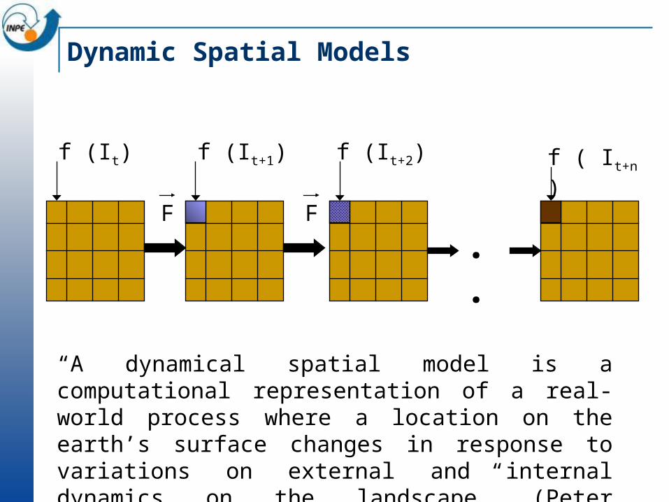
f ( It+n )
. . FF
f (It) f (It+1) f (It+2)
Dynamic Spatial Models
“A dynamical spatial model is a computational representation of a real-world process where a location on the earth’s surface changes in response to variations on external and internal dynamics on the landscape” (Peter Burrough)
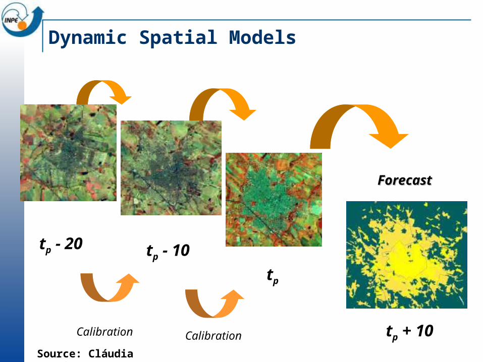
tp - 20 tp - 10
tp
Calibration Calibration tp + 10
ForecastForecast
Dynamic Spatial Models
Source: Cláudia Almeida
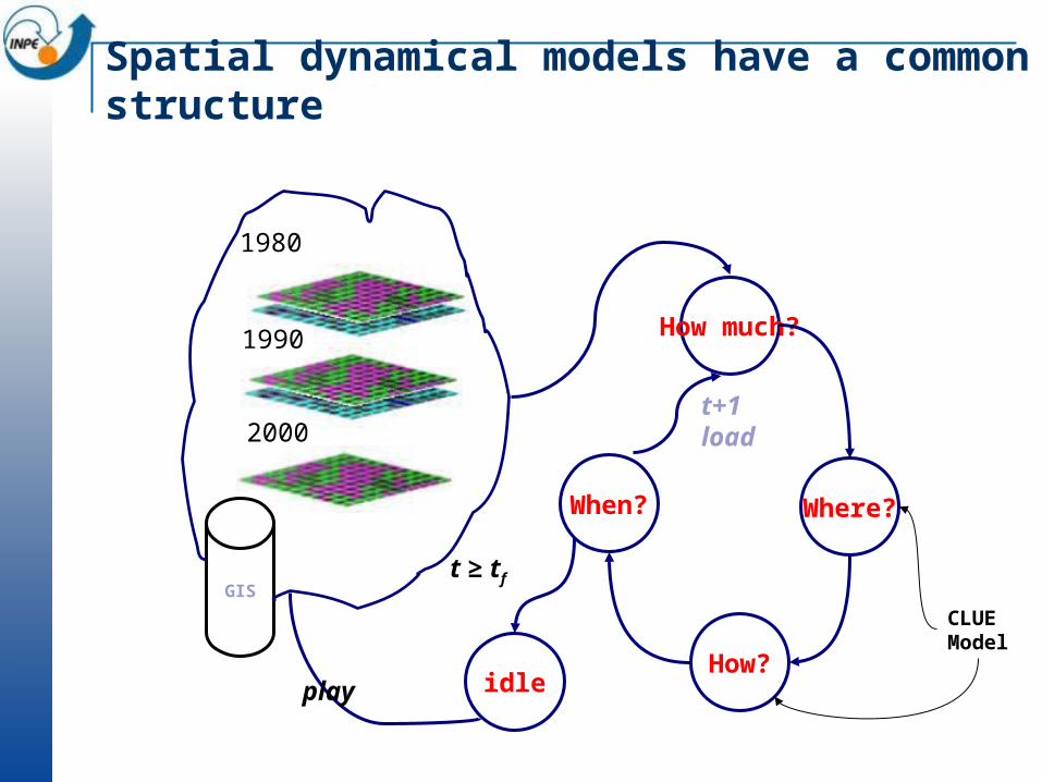
Spatial dynamical models have a common structure
How much?
Where?
How?
When?
t+1load
t ≥ tf
idle
1980
1990
2000
GIS
play
CLUEModel
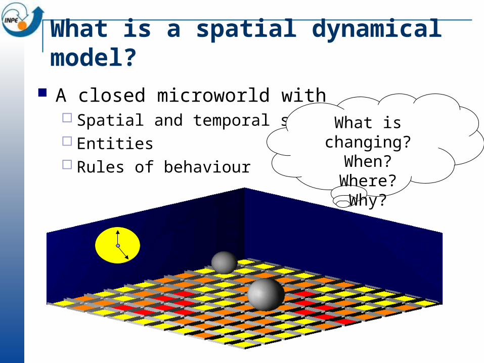
What is a spatial dynamical model?
A closed microworld with Spatial and temporal structure Entities Rules of behaviour
What is changing?
When?Where?Why?
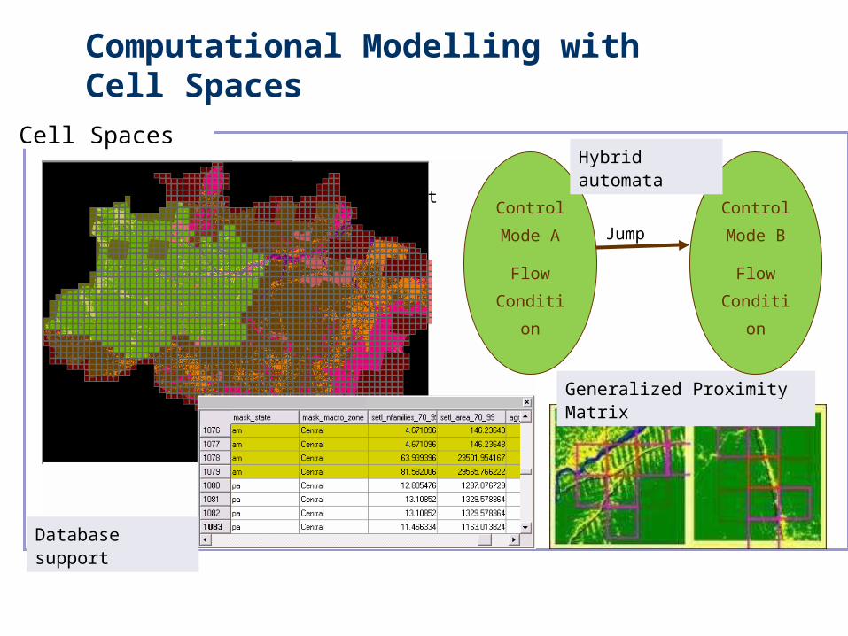
Computational Modelling with Cell Spaces
Cell Spaces
Generalized Proximity Matrix
Control
Mode B
Flow
Conditio
n
Jump
EventControl
Mode A
Flow
Conditio
n
Hybrid automata
Database support
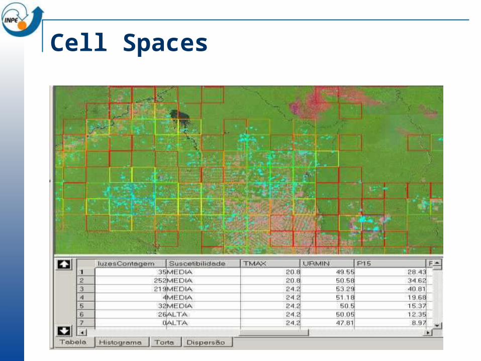
Cell Spaces
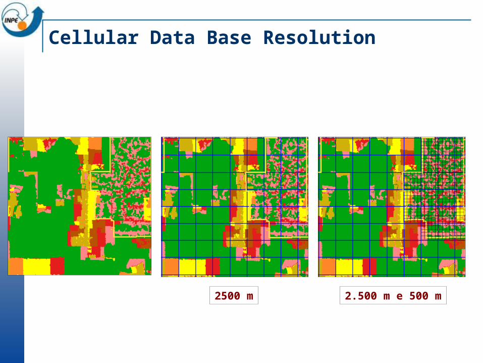
2500 m 2.500 m e 500 m
Cellular Data Base Resolution
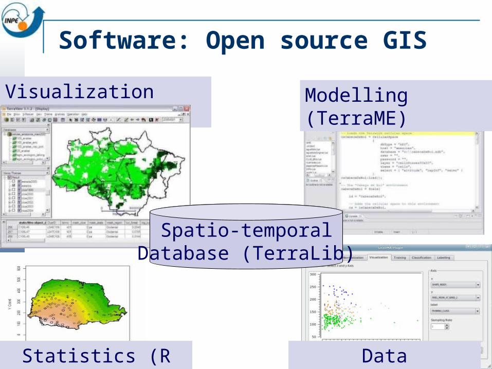
Software: Open source GIS
Visualization (TerraView)
Spatio-temporalDatabase (TerraLib)
Modelling (TerraME)
Data Mining(GeoDMA)Statistics (R interface)
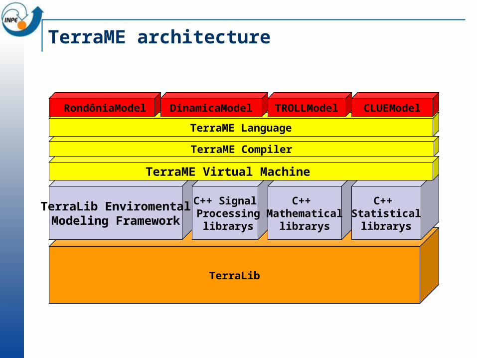
TerraLib
TerraLib EnviromentalModeling Framework
C++ Signal Processing
librarys
C++ Mathematical
librarys
C++ Statisticallibrarys
TerraME Virtual Machine
TerraME Compiler
TerraME Language
RondôniaModel DinamicaModel TROLLModel CLUEModel
TerraME architecture
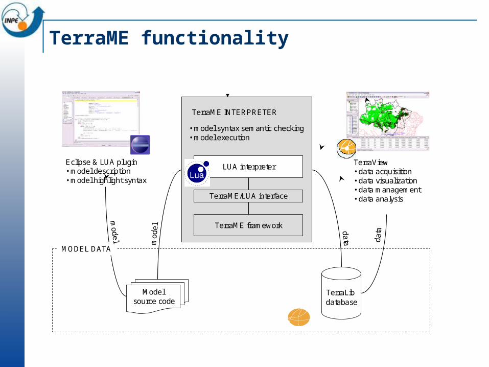
TerraME functionality
Eclipse & LUA plugin• model description• model highlight syntax
TerraView• data acquisition• data visualization• data management• data analysis
TerraLibdatabase
da
ta
Model source code
MODEL DATA
mod
el
• model syntax semantic checking• model execution
TerraME INTERPRETER
LUA interpreter
TerraME framework
TerraME/LUA interface
model d
ata
Enviromental Modelling
Introduction to LUA
Tiago Garcia de Senna Carneiro (UFOP)Gilberto Câmara (INPE)
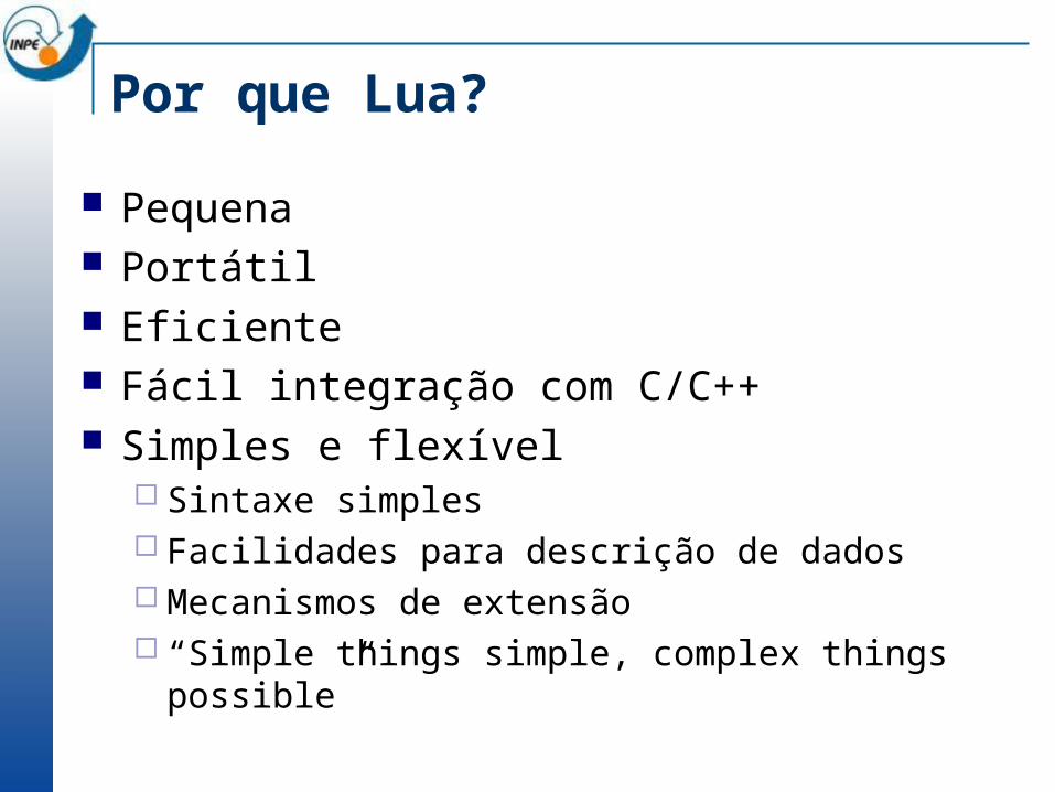
Por que Lua?
Pequena Portátil Eficiente Fácil integração com C/C++ Simples e flexível
Sintaxe simples Facilidades para descrição de dados Mecanismos de extensão “Simple things simple, complex things possible”
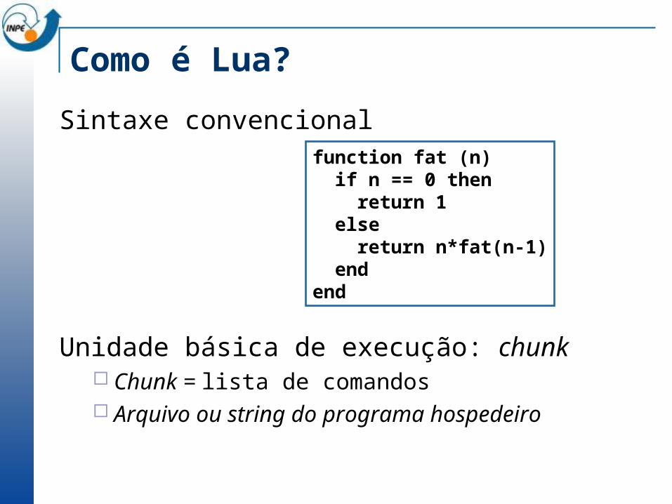
Como é Lua?
Sintaxe convencional
Unidade básica de execução: chunk Chunk = lista de comandos Arquivo ou string do programa hospedeiro
function fat (n) if n == 0 then return 1 else return n*fat(n-1) endend
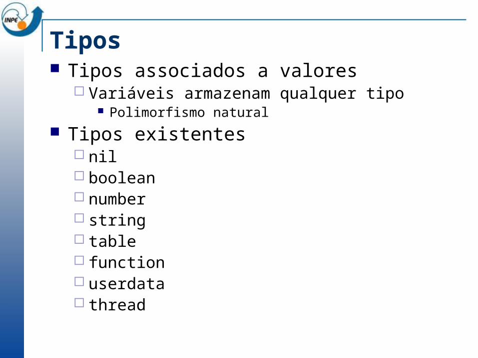
Tipos Tipos associados a valores
Variáveis armazenam qualquer tipo Polimorfismo natural
Tipos existentes nil boolean number string table function userdata thread
Tipo nil
Propósito maior: ser diferente dos demais
Tipo do valor default das variáveis
Também significa o falso booleano Qualquer valor de outro tipo significa verdadeiro
Com exceção de false
Tipo boolean
Valor booleano Falso (false) ou verdadeiro (true)
if (choveu == true) then ....

Tipo number
Único tipo nativo para valores numéricos double (por default)
local a = 3local b = 3.5local c = 4.5e-8
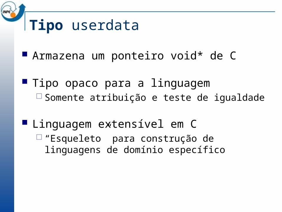
Tipo userdata
Armazena um ponteiro void* de C
Tipo opaco para a linguagem Somente atribuição e teste de igualdade
Linguagem extensível em C “Esqueleto” para construção de linguagens de domínio
específico
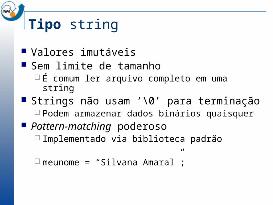
Tipo string
Valores imutáveis Sem limite de tamanho
É comum ler arquivo completo em uma string Strings não usam ‘\0’ para terminação
Podem armazenar dados binários quaisquer Pattern-matching poderoso
Implementado via biblioteca padrão
meunome = “Silvana Amaral”;
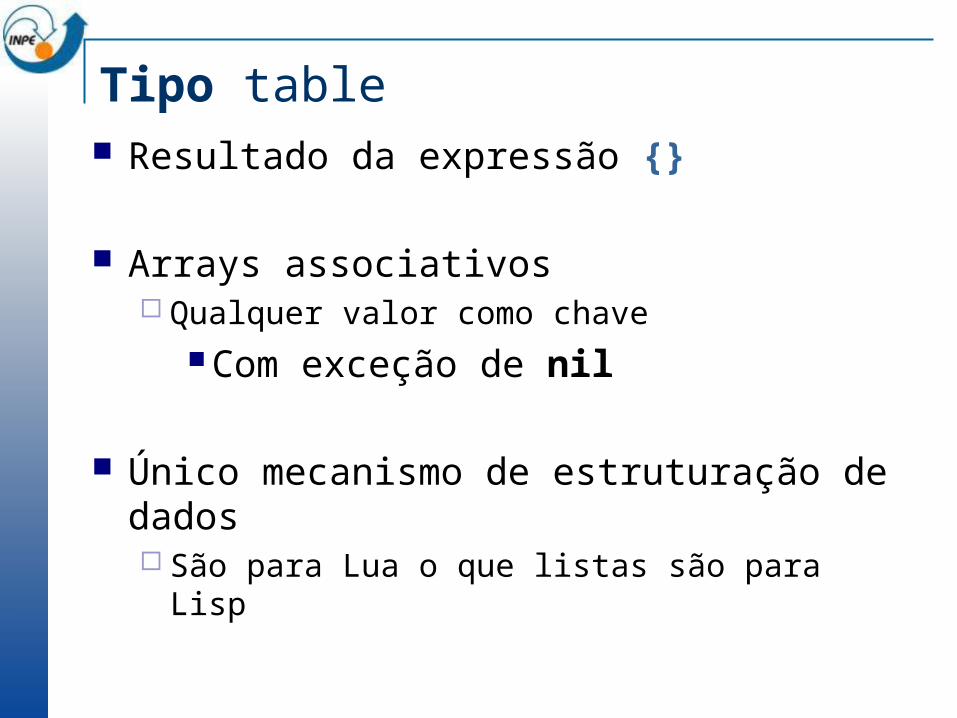
Tipo table Resultado da expressão {}
Arrays associativos Qualquer valor como chave
Com exceção de nil
Único mecanismo de estruturação de dados São para Lua o que listas são para Lisp
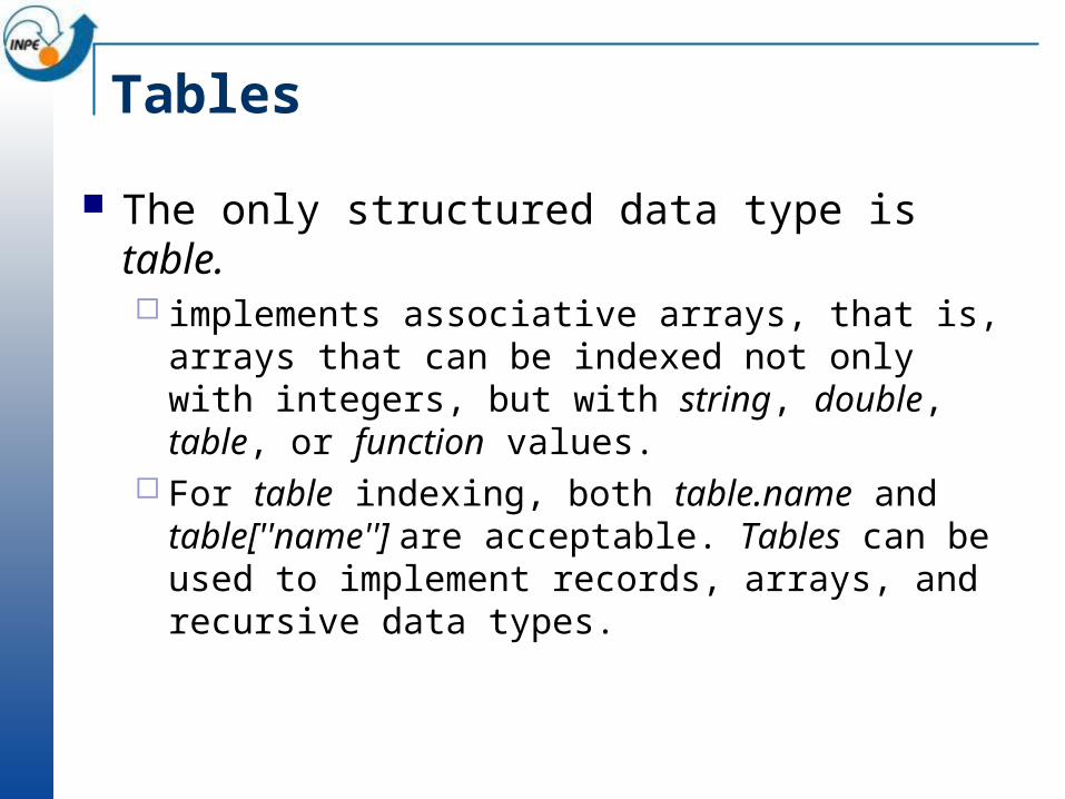
Tables
The only structured data type is table. implements associative arrays, that is, arrays that can be
indexed not only with integers, but with string, double, table, or function values.
For table indexing, both table.name and table[''name''] are acceptable. Tables can be used to implement records, arrays, and recursive data types.
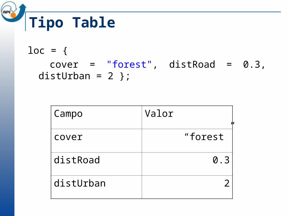
Tipo Table
loc = { cover = "forest", distRoad = 0.3, distUrban =
2 };
Campo Valor
cover “forest”
distRoad 0.3
distUrban 2
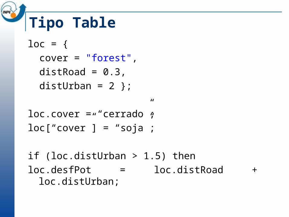
Tipo Table loc = { cover = "forest", distRoad = 0.3, distUrban = 2 };
loc.cover = “cerrado”;loc[“cover”] = “soja”;
if (loc.distUrban > 1.5) thenloc.desfPot = loc.distRoad + loc.distUrban;
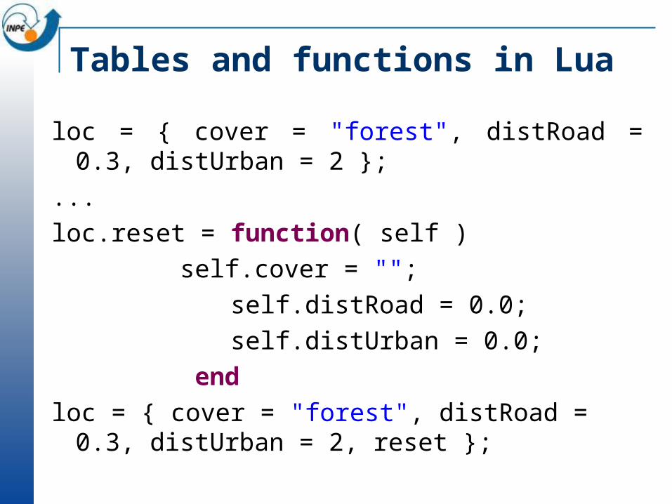
Tables and functions in Lua
loc = { cover = "forest", distRoad = 0.3, distUrban = 2 };
...loc.reset = function( self )
self.cover = ""; self.distRoad = 0.0; self.distUrban = 0.0;
end loc = { cover = "forest", distRoad = 0.3,
distUrban = 2, reset };
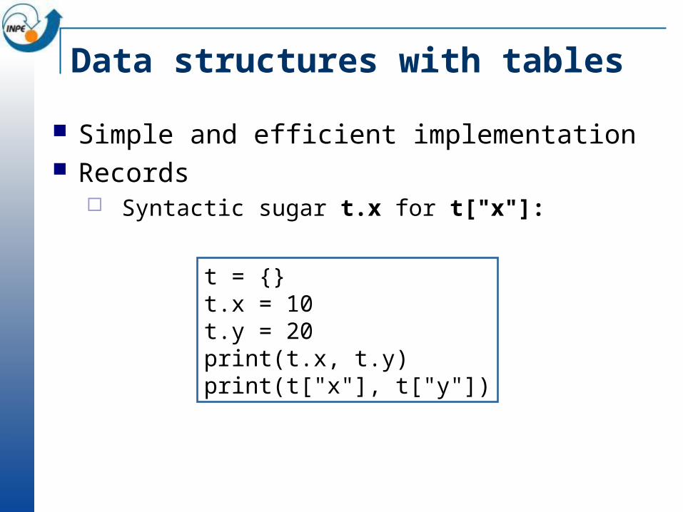
Data structures with tables
Simple and efficient implementation Records
Syntactic sugar t.x for t["x"]:
t = {}t.x = 10t.y = 20print(t.x, t.y)print(t["x"], t["y"])
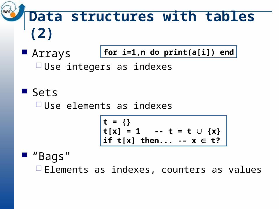
Data structures with tables (2)
Arrays Use integers as indexes
Sets Use elements as indexes
“Bags" Elements as indexes, counters as values
for i=1,n do print(a[i]) end
t = {}t[x] = 1 -- t = t {x}if t[x] then... -- x t?
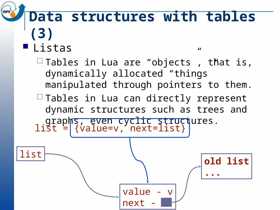
Data structures with tables (3) Listas
Tables in Lua are “objects”, that is, dynamically allocated “things” manipulated through pointers to them.
Tables in Lua can directly represent dynamic structures such as trees and graphs, even cyclic structures.
list
value - vnext -
old list...
list = {value=v, next=list}
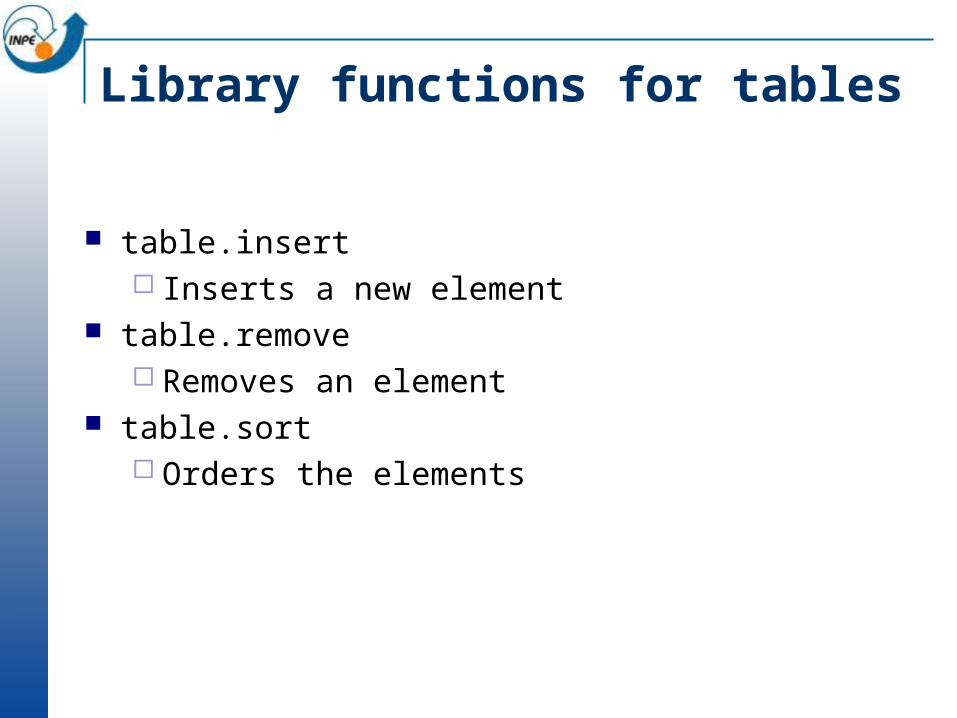
Library functions for tables
table.insert Inserts a new element
table.remove Removes an element
table.sort Orders the elements
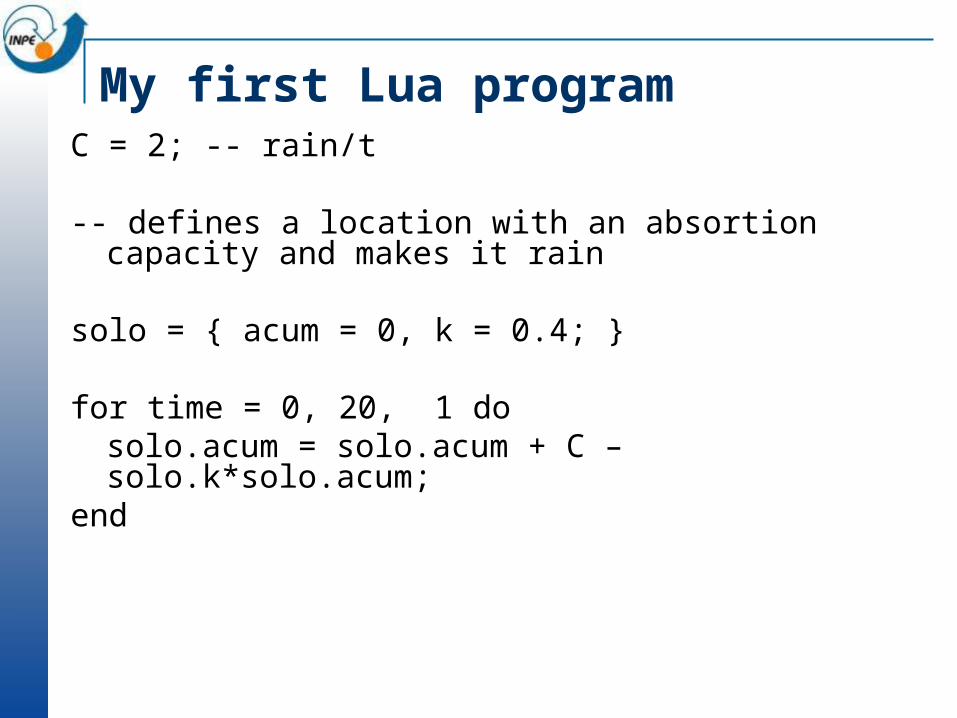
My first Lua programC = 2; -- rain/t
-- defines a location with an absortion capacity and makes it rain
solo = { acum = 0, k = 0.4; }
for time = 0, 20, 1 dosolo.acum = solo.acum + C – solo.k*solo.acum;
end
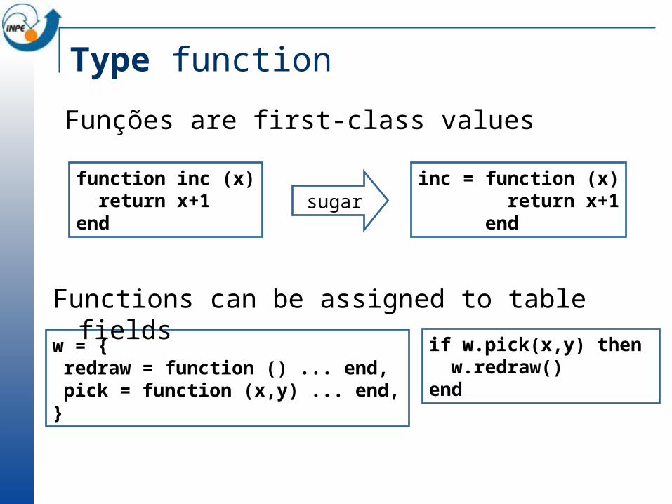
Type function
Funções are first-class values
function inc (x) return x+1end
inc = function (x) return x+1 end
sugar
w = { redraw = function () ... end, pick = function (x,y) ... end,}
if w.pick(x,y) then w.redraw()end
Functions can be assigned to table fields
Type function (2)
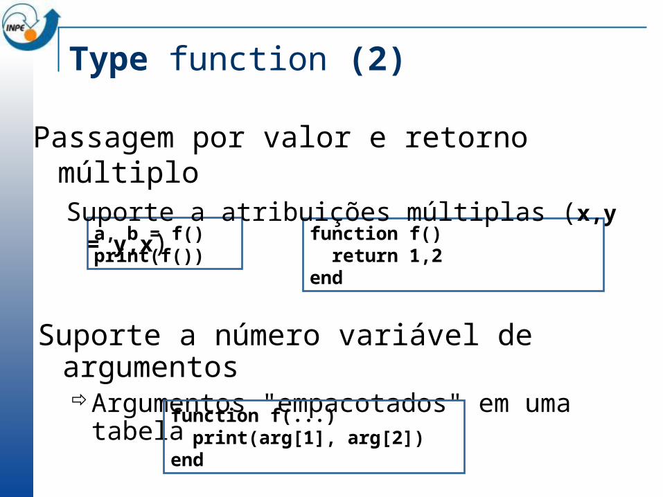
function f() return 1,2end
a, b = f()print(f())
Passagem por valor e retorno múltiploSuporte a atribuições múltiplas (x,y = y,x)
Suporte a número variável de argumentosArgumentos "empacotados" em uma tabela
function f(...) print(arg[1], arg[2])end
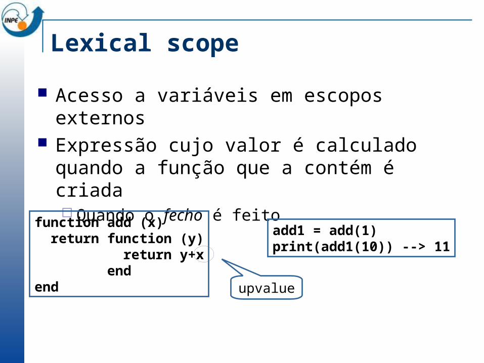
Lexical scope
Acesso a variáveis em escopos externos Expressão cujo valor é calculado quando a função
que a contém é criada Quando o fecho é feito
function add (x) return function (y) return y+x endend
add1 = add(1)print(add1(10)) --> 11
upvalue
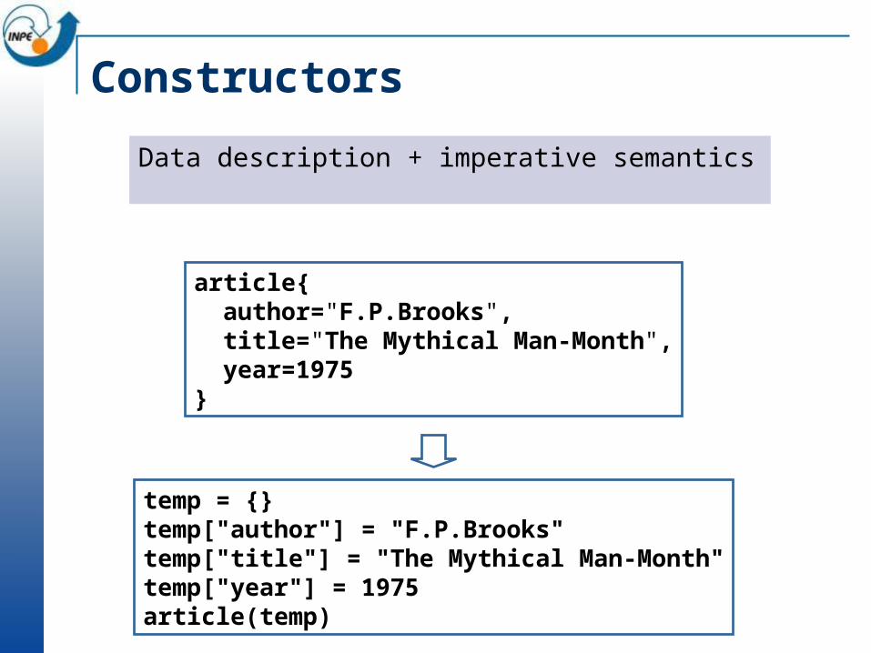
Constructors
Data description + imperative semantics
article{ author="F.P.Brooks", title="The Mythical Man-Month", year=1975}
temp = {}temp["author"] = "F.P.Brooks"temp["title"] = "The Mythical Man-Month"temp["year"] = 1975article(temp)
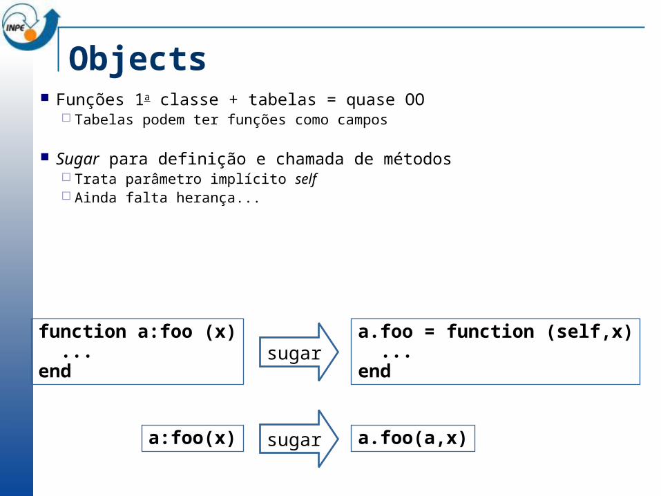
Objects Funções 1a classe + tabelas = quase OO
Tabelas podem ter funções como campos
Sugar para definição e chamada de métodos Trata parâmetro implícito self Ainda falta herança...
a.foo(a,x)a:foo(x)
a.foo = function (self,x) ...end
function a:foo (x) ...end
sugar
sugar

Exemplo: tipo Point-- Metatable de Pointlocal Point_metatable = { __add = function (p1,p2) return Point(p1.x+p2.x,p1.y+p2.y,p1.z+p2.z} end}-- Construtorfunction Point (self) self.x = tonumber(self.x) or 0.0 self.y = tonumber(self.y) or 0.0 self.z = tonumber(self.z) or 0.0 setmetatable(self,Point_metatable) return selfend-----------------------------------------------local p = Point{x=3.0,y=1.3,z=3.2}local q = Point{x=4.2,y=1.0}local r = p+q -- {7.2, 2.3, 3.2}
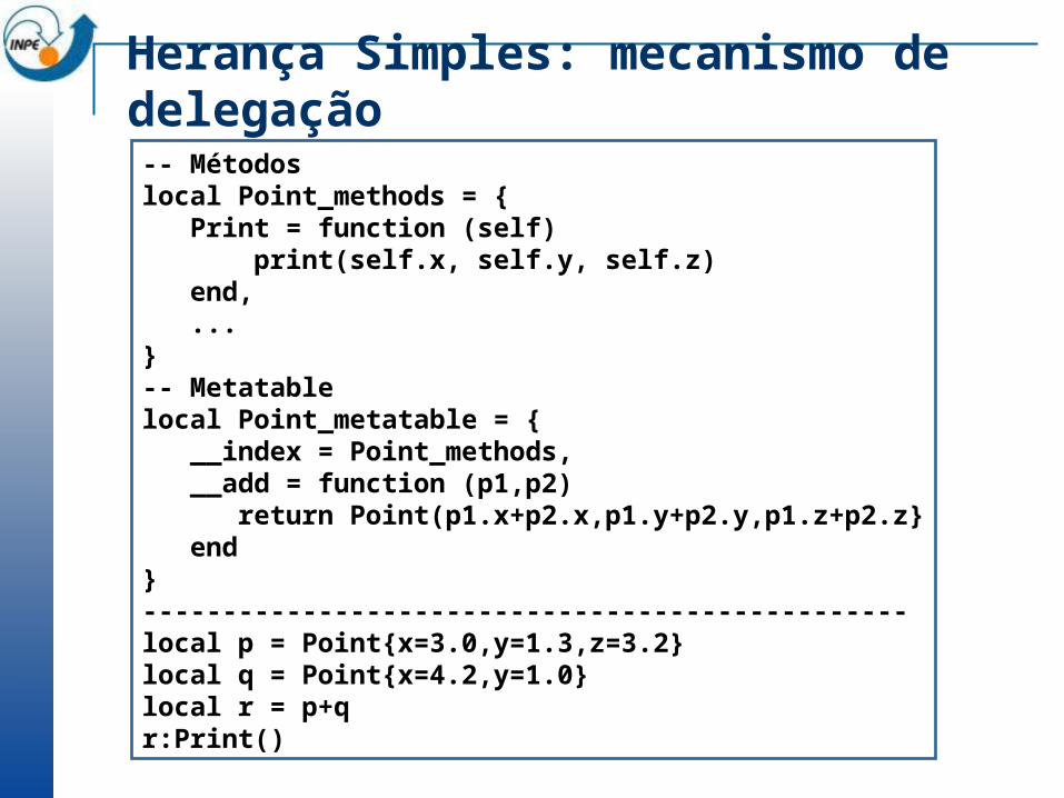
-- Métodoslocal Point_methods = { Print = function (self) print(self.x, self.y, self.z) end, ...}-- Metatablelocal Point_metatable = { __index = Point_methods, __add = function (p1,p2) return Point(p1.x+p2.x,p1.y+p2.y,p1.z+p2.z} end}------------------------------------------------local p = Point{x=3.0,y=1.3,z=3.2}local q = Point{x=4.2,y=1.0}local r = p+qr:Print()
Herança Simples: mecanismo de delegação
Bibliotecas padrão Basic String Table Math IO OS Debug Coroutine
Basic
Oferecem funções básicas print type setmetatable pairs
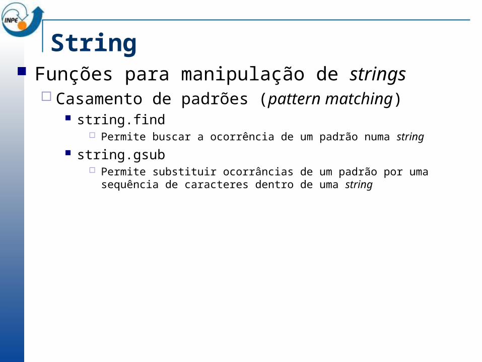
String Funções para manipulação de strings
Casamento de padrões (pattern matching) string.find
Permite buscar a ocorrência de um padrão numa string string.gsub
Permite substituir ocorrâncias de um padrão por uma sequência de caracteres dentro de uma string
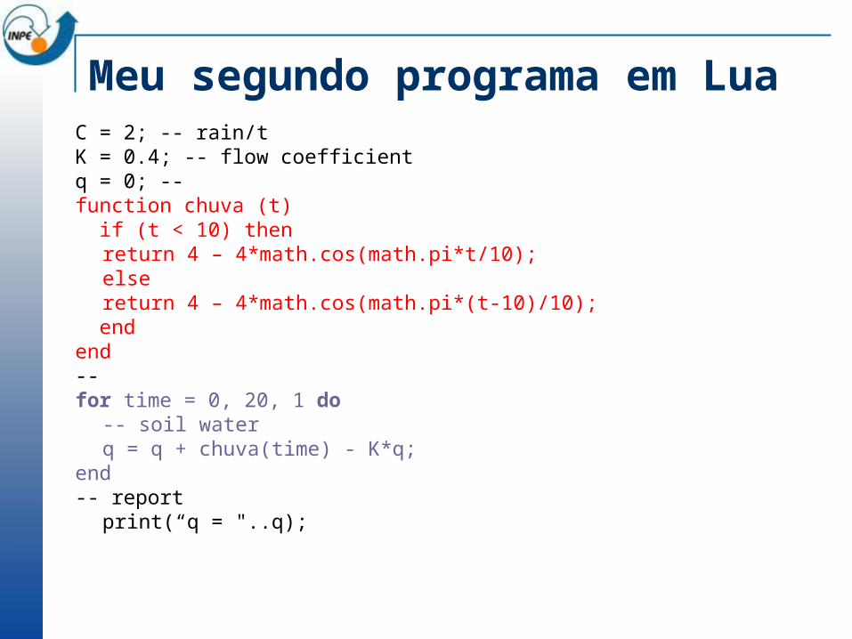
Meu segundo programa em Lua C = 2; -- rain/tK = 0.4; -- flow coefficientq = 0; --function chuva (t) if (t < 10) then
return 4 – 4*math.cos(math.pi*t/10);else
return 4 – 4*math.cos(math.pi*(t-10)/10); endend--for time = 0, 20, 1 do
-- soil waterq = q + chuva(time) - K*q;
end-- report
print(“q = "..q);
Defining a model in TerraME Part 1: The cell space
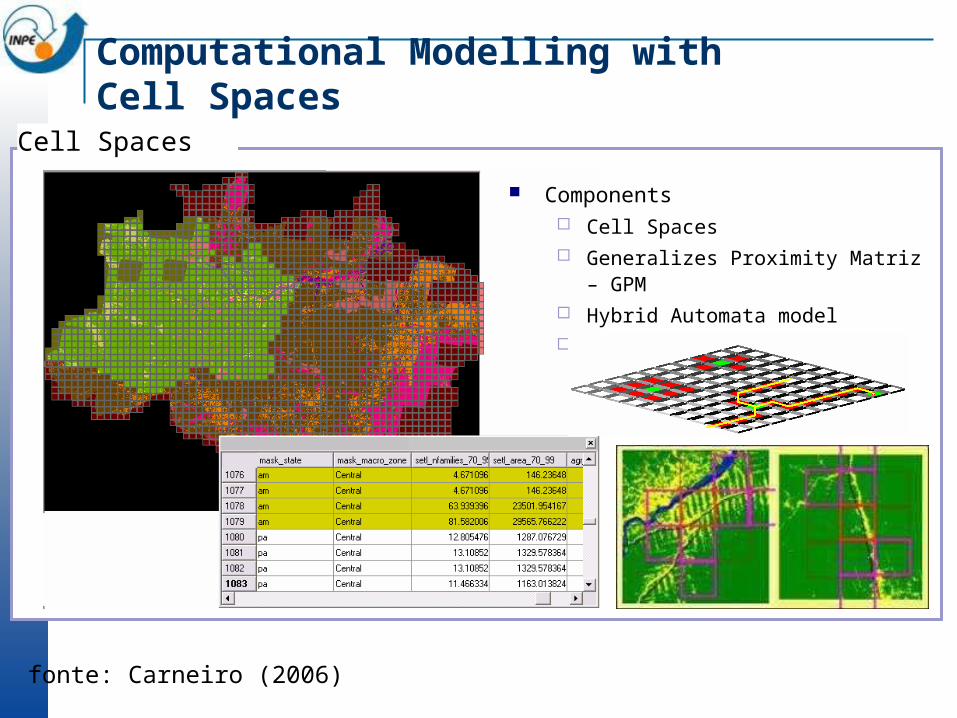
Computational Modelling with Cell Spaces
Cell Spaces
Components Cell Spaces Generalizes Proximity Matriz – GPM Hybrid Automata model Nested enviroment
fonte: Carneiro (2006)
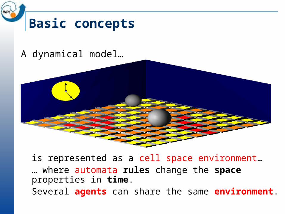
Basic concepts
is represented as a cell space environment…… where automata rules change the space properties in time.Several agents can share the same environment.
A dynamical model…
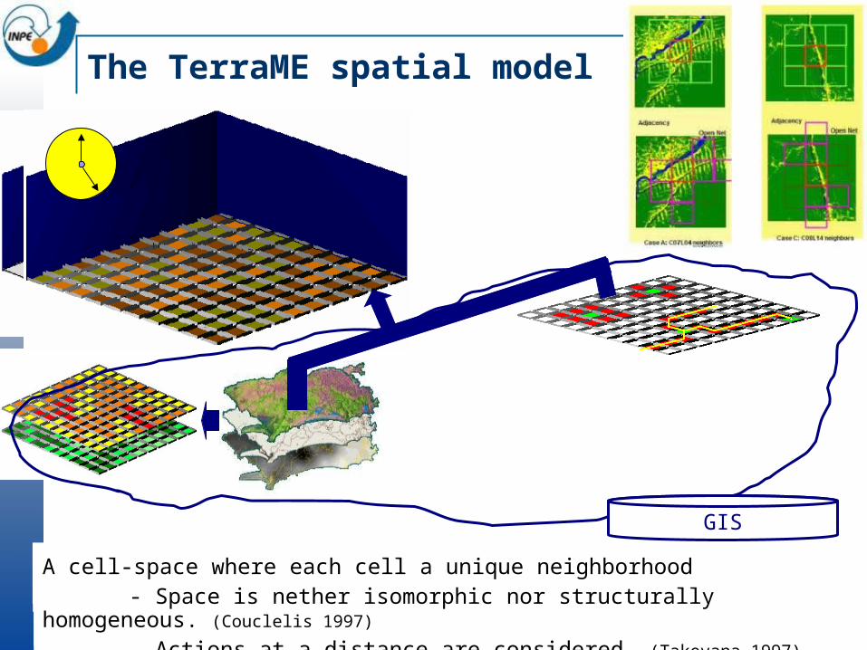
The TerraME spatial model
The space local properties, constraints, and connectivity can be modeled by:
- a set of geographic data: each cell has various attributes
GIS
- a spatial structure: a lattice of cellsA cell-space where each cell a unique neighborhood
- Space is nether isomorphic nor structurally homogeneous. (Couclelis 1997)
- Actions at a distance are considered. (Takeyana 1997), (O’Sullivan 1999)

TerraME extensions to Lua
To build spatial dynamic models, TerraME includes new value types in LUA using the constructor mechanism.
These values are: CellularSpace, Cell, Neighbourhood
Cellular Space
A CellularSpace is a multivalued set of Cells.
It consists of a geographical area of interest, divided into a regular grid.
Each cell in the grid has one or more attributes.
CellularSpaces are stored and retrieved from a TerraLib database, so the modeller should specify the properties of the CellularSpace
Constructors in Lua
LUA has a powerful syntactical tool, called constructor.
When the modeller writes name{…}, the LUA interpreter replaces it by name({… }), passing the table {…} as a parameter to the function name( ).
This function typically initializes, checks properties values and adds auxiliary data structure or methods.
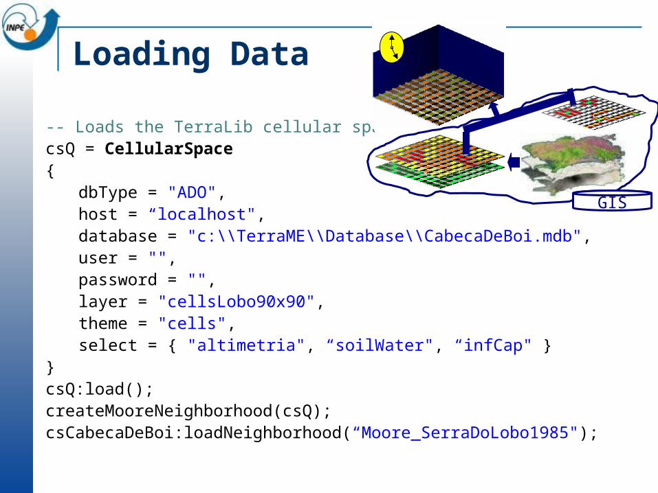
Loading Data
-- Loads the TerraLib cellular spacecsQ = CellularSpace{
dbType = "ADO",host = “localhost",database = "c:\\TerraME\\Database\\CabecaDeBoi.mdb",user = "",password = "",layer = "cellsLobo90x90",theme = "cells",select = { "altimetria", “soilWater", “infCap" }
}csQ:load();createMooreNeighborhood(csQ);csCabecaDeBoi:loadNeighborhood(“Moore_SerraDoLobo1985");
GIS
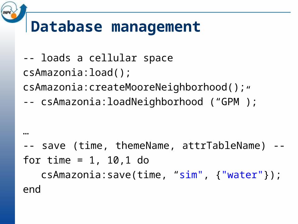
Database management
-- loads a cellular spacecsAmazonia:load();csAmazonia:createMooreNeighborhood();-- csAmazonia:loadNeighborhood (“GPM”);
…-- save (time, themeName, attrTableName) -- for time = 1, 10,1 do csAmazonia:save(time, “sim", {"water"});end
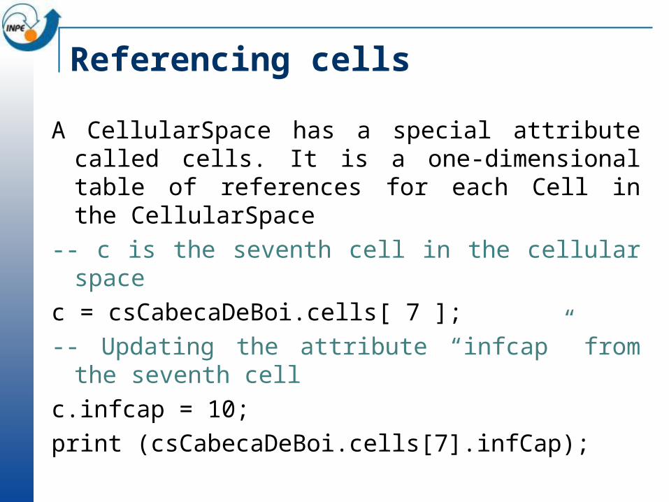
Referencing cells
A CellularSpace has a special attribute called cells. It is a one-dimensional table of references for each Cell in the CellularSpace
-- c is the seventh cell in the cellular spacec = csCabecaDeBoi.cells[ 7 ];-- Updating the attribute “infcap” from the
seventh cellc.infcap = 10;print (csCabecaDeBoi.cells[7].infCap);
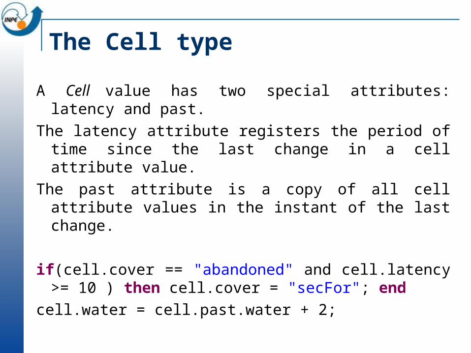
The Cell type
A Cell value has two special attributes: latency and past. The latency attribute registers the period of time since the
last change in a cell attribute value.The past attribute is a copy of all cell attribute values in
the instant of the last change.
if(cell.cover == "abandoned" and cell.latency >= 10 ) then cell.cover = "secFor"; end
cell.water = cell.past.water + 2;
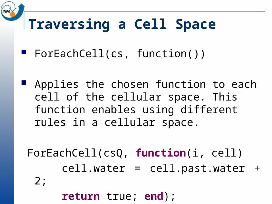
Traversing a Cell Space
ForEachCell(cs, function())
Applies the chosen function to each cell of the cellular space. This function enables using different rules in a cellular space.
ForEachCell(csQ, function(i, cell) cell.water = cell.past.water + 2; return true; end);
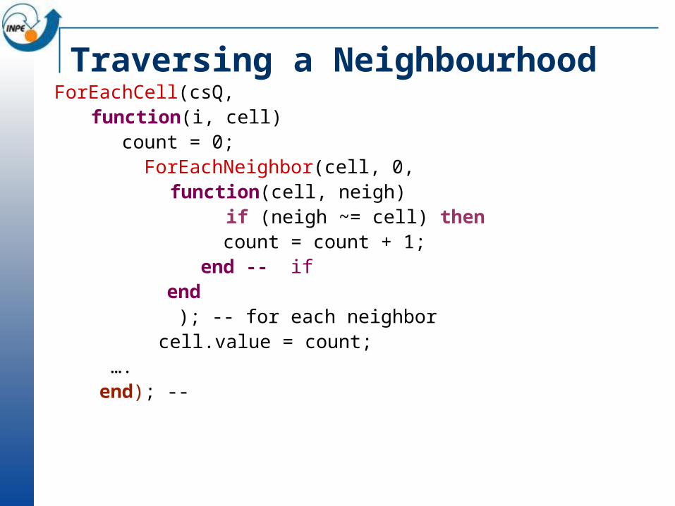
Traversing a NeighbourhoodForEachCell(csQ,
function(i, cell) count = 0; ForEachNeighbor(cell, 0,
function(cell, neigh) if (neigh ~= cell) then
count = count + 1; end -- if end ); -- for each neighbor
cell.value = count; …. end); --
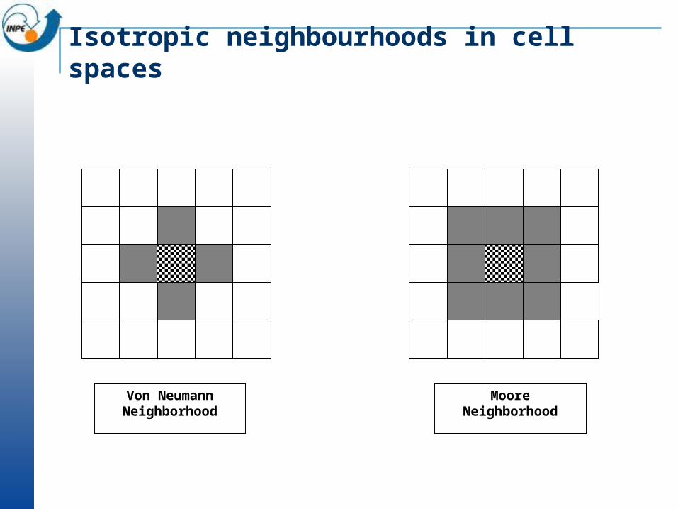
Von Neumann Neighborhood
Moore Neighborhood
Isotropic neighbourhoods in cell spaces

Generalized Proximity Matrix (GPM)
In a cell-space, each cell has a different neighbourhood
Defined by a NxN matrix
44434241
34333231
24232221
14131211
wwww
wwww
wwww
wwww
W

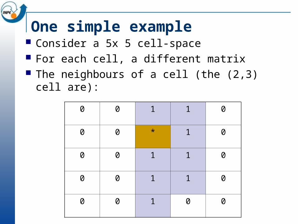
One simple example Consider a 5x 5 cell-space For each cell, a different matrix The neighbours of a cell (the (2,3) cell are):
0 0 1 1 0
0 0 * 1 0
0 0 1 1 0
0 0 1 1 0
0 0 1 0 0

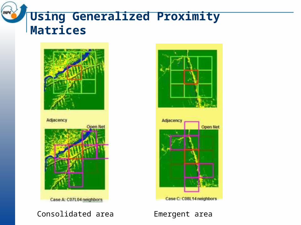
Using Generalized Proximity Matrices
Consolidated area Emergent area
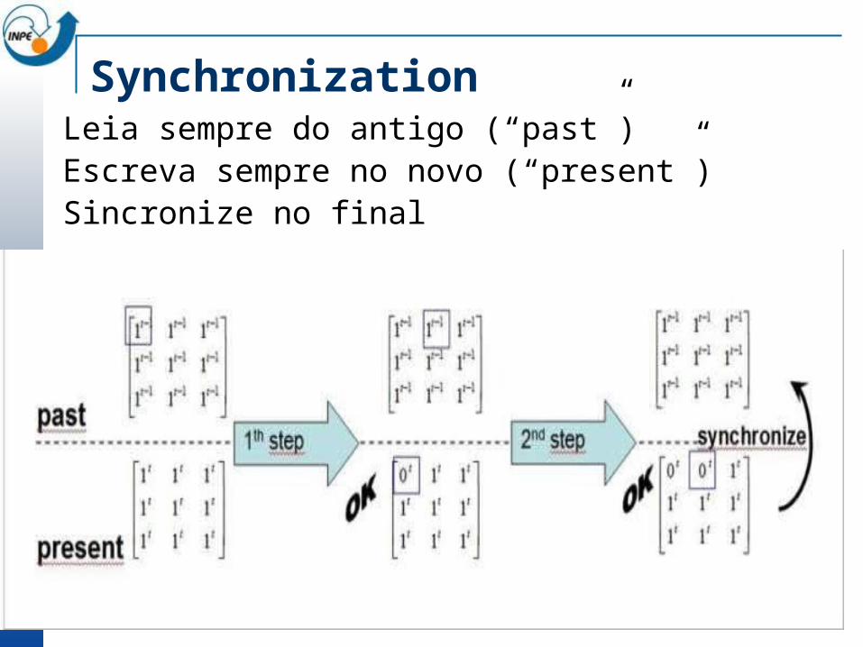
SynchronizationLeia sempre do antigo (“past”)Escreva sempre no novo (“present”)Sincronize no final
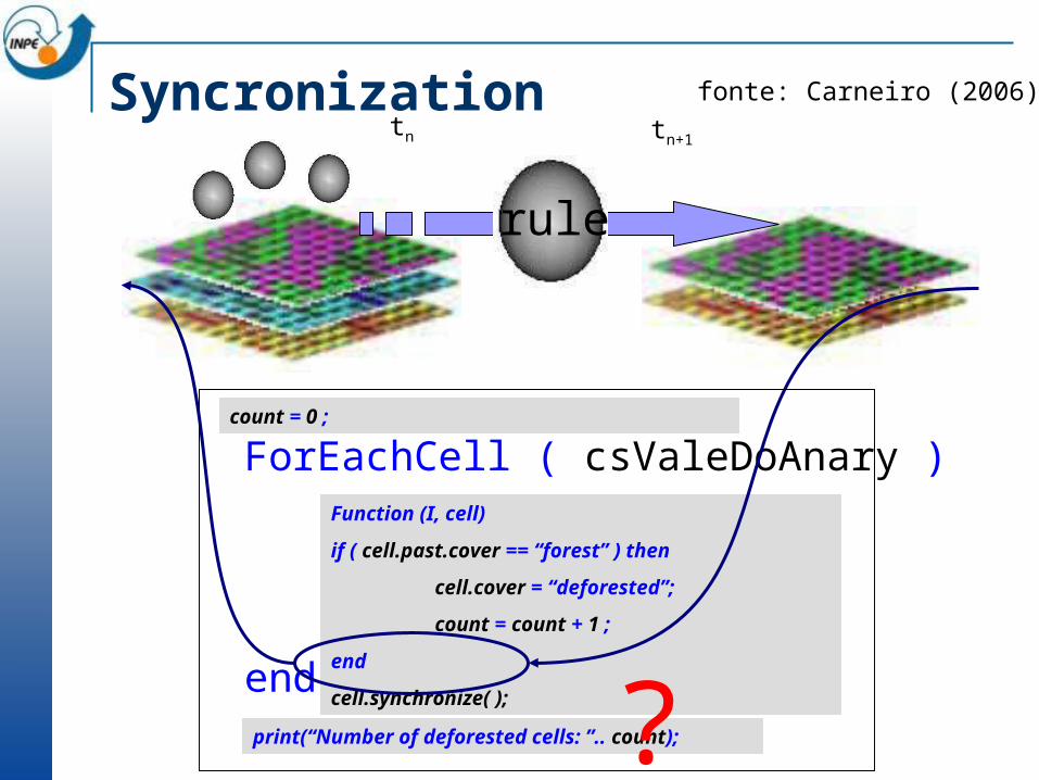
ForEachCell ( csValeDoAnary )
end
count = 0 ;
print(“Number of deforested cells: ”.. count);
Function (I, cell)
if ( cell.past.cover == “forest” ) then
cell.cover = “deforested”;
count = count + 1 ;
end
cell.synchronize( );
Syncronizationtn tn+1
rule
?
fonte: Carneiro (2006)
TerraME basics: some simple examples
An Example: The Majority Model for Segregation Start with a CA with “white” and “black” cells (random)
The new cell state is the state of the majority of the cell’s Moore neighbours, or the cell’s previous state if the neighbours are equally divided between “white” and “black” White cells change to black if there are five or more black
neighbours Black cells change to white if there are five or more black
neighbours What is the result after 50 iterations? How long will it take for a stable state to occur?
The Modified Majority Model for Segregation
Include random individual variation Some individuals are more susceptible to their neighbours
than others In general, white cells with five neighbours change to black,
but: Some “white” cells change to black if there are only four “black”
neighbours Some “white” cells change to black only if there are six “black”
neighbours Variation of individual difference
What happens in this case after 50 iterations and 500 iterations?

Key property of cellular spaces: potential
POTENTIAL
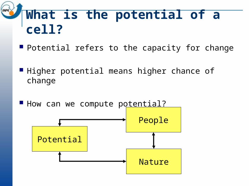
What is the potential of a cell?
Potential refers to the capacity for change
Higher potential means higher chance of change
How can we compute potential?
Potential
People
Nature
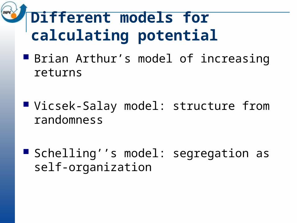
Different models for calculating potential
Brian Arthur’s model of increasing returns
Vicsek-Salay model: structure from randomness
Schelling’’s model: segregation as self-organization
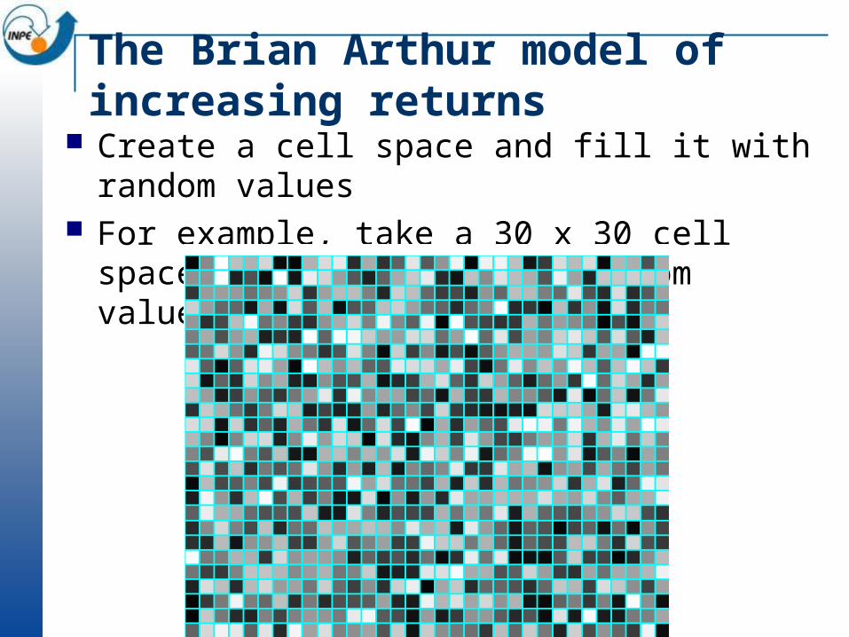
The Brian Arthur model of increasing returns
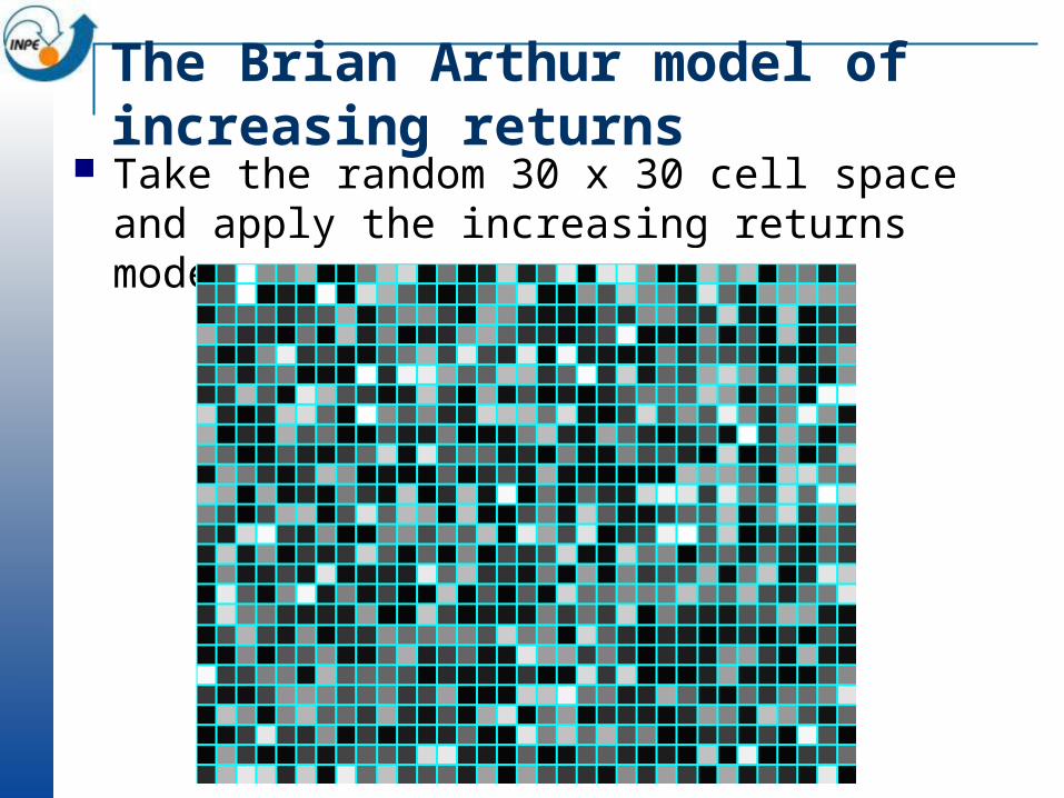
Create a cell space and fill it with random values For example, take a 30 x 30 cell space and populate
with random values (1..1000)
The Brian Arthur model of increasing returns
Think of this cellular space as the starting point for a population
What happens if the rich get richer?
This model is called “increasing returns” This effect is well-known in the software industry Customer may become dependent on proprietary data formats High switching costs might prevent the change to another
product Examples: QWERTY keyboard, and Microsoft Windows
Arthur, B. (1994). “Increasing Returns and Path Dependence in the Economy”. Ann Arbor, MI: The University of Michigan Press.
The Brian Arthur model of increasing returns
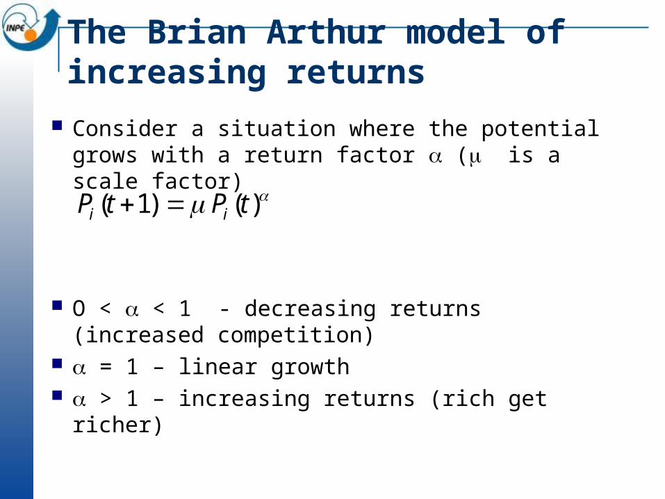
Consider a situation where the potential grows with a return factor ( is a scale factor)
O < < 1 - decreasing returns (increased competition)
= 1 – linear growth > 1 – increasing returns (rich get richer)
)()1( tPtP ii
The Brian Arthur model of increasing returns
Take the random 30 x 30 cell space and apply the increasing returns model = 2 – What happens?
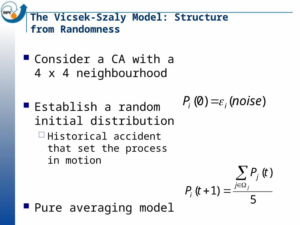
The Vicsek-Szaly Model: Structure from Randomness
Consider a CA with a 4 x 4 neighbourhood
Establish a random initial distribution Historical accident that
set the process in motion
Pure averaging model
)()0( noiseP ii
5
)(
)1(
jjj
i
tP
tP
TerraME: defining a model
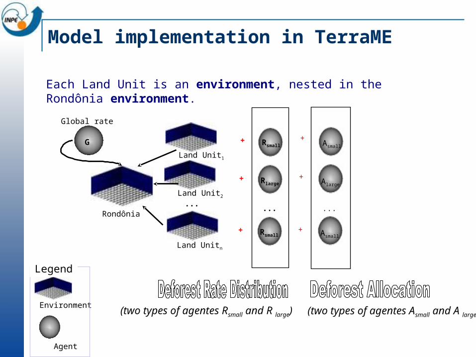
Model implementation in TerraME
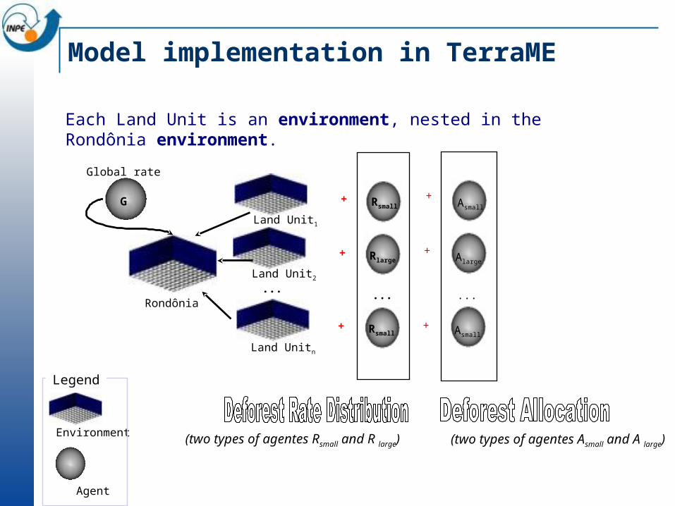
Land Unitn
Land Unit2
Land Unit1
...Rondônia
G
Global rate
...
+
+
+
Rsmall
Rlarge
Rsmall
(two types of agentes Rsmall and R large)
+
+
+
Asmall
Alarge
Asmall
...
(two types of agentes Asmall and A large)
Each Land Unit is an environment, nested in the Rondônia environment.
Environment
Agent
Legend

TerraME rules of behaviour
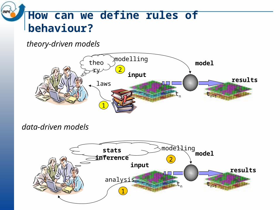
How can we define rules of behaviour?
stats inference model
tn tn+1
inputresults
analysis
1
2
modelling
theory
model
tn tn+1
inputresults
2
modelling
1
laws
theory-driven models
data-driven models
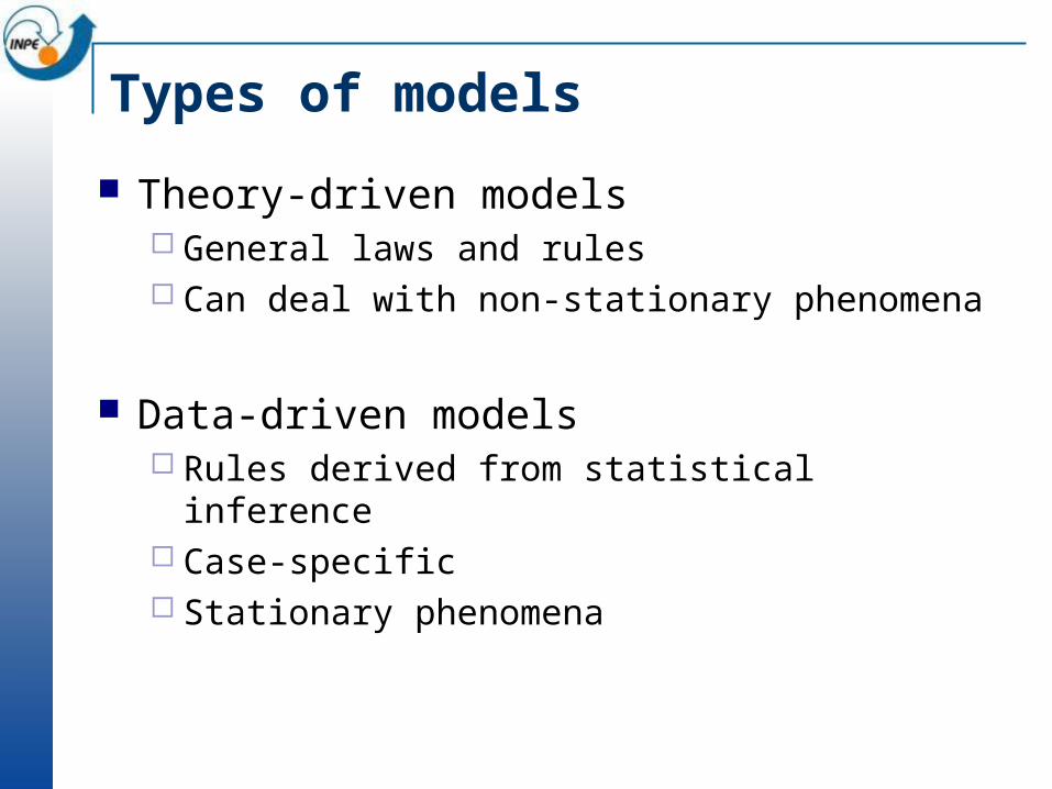
Types of models
Theory-driven models General laws and rules Can deal with non-stationary phenomena
Data-driven models Rules derived from statistical inference Case-specific Stationary phenomena
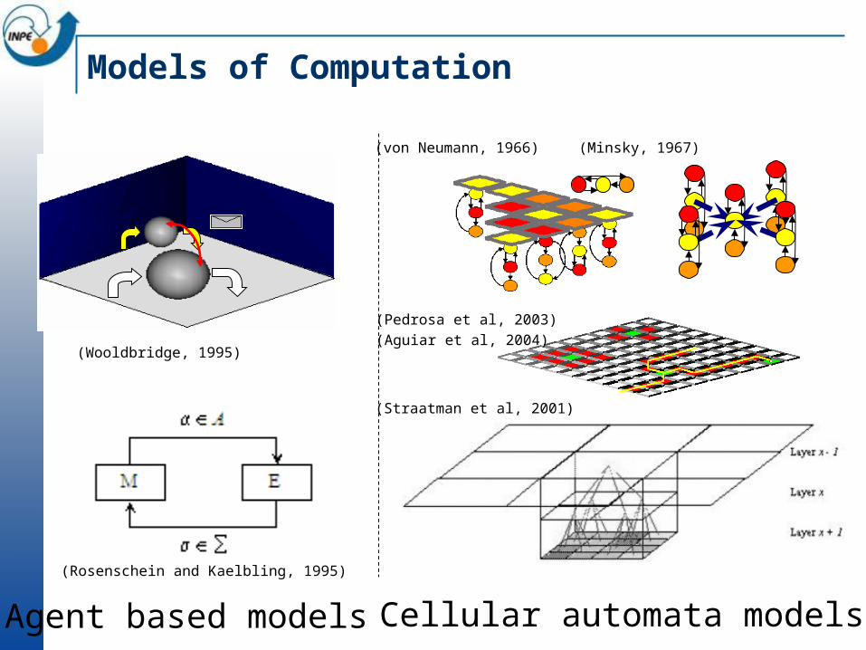
Models of Computation
Agent based models Cellular automata models
(Rosenschein and Kaelbling, 1995)
(Wooldbridge, 1995)
(von Neumann, 1966) (Minsky, 1967)
(Aguiar et al, 2004)
(Pedrosa et al, 2003)
(Straatman et al, 2001)
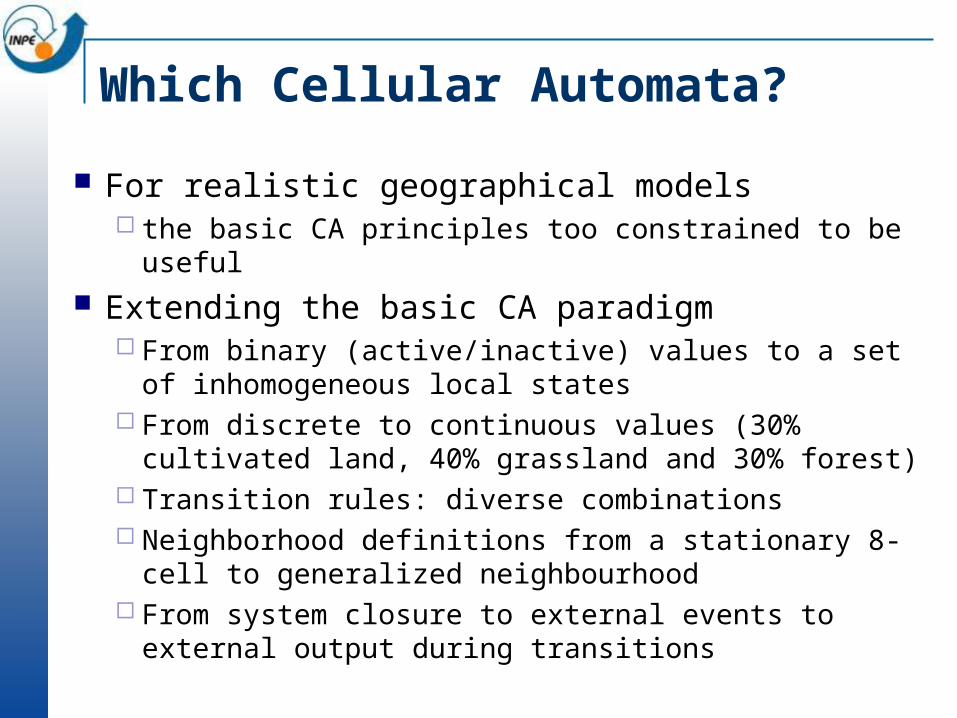
Which Cellular Automata?
For realistic geographical models the basic CA principles too constrained to be useful
Extending the basic CA paradigm From binary (active/inactive) values to a set of
inhomogeneous local states From discrete to continuous values (30% cultivated land,
40% grassland and 30% forest) Transition rules: diverse combinations Neighborhood definitions from a stationary 8-cell to
generalized neighbourhood From system closure to external events to external output
during transitions
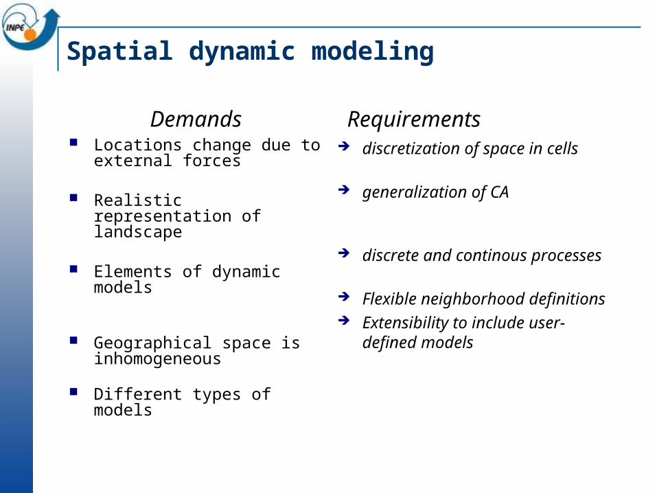
Spatial dynamic modeling
Locations change due to external forces
Realistic representation of landscape
Elements of dynamic models
Geographical space is inhomogeneous
Different types of models
discretization of space in cells
generalization of CA
discrete and continous processes
Flexible neighborhood definitions
Extensibility to include user-defined models
Demands Requirements

Hybrid Automata
Formalism developed by Tom Henzinger (UC Berkeley) Applied to embedded systems, robotics, process control,
and biological systems Hybrid automaton
Combines discrete transition graphs with continous dynamical systems
Infinite-state transition system
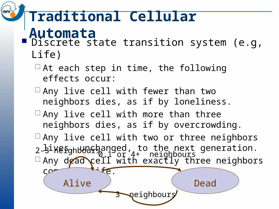
Traditional Cellular Automata Discrete state transition system (e.g, Life)
At each step in time, the following effects occur: Any live cell with fewer than two neighbors dies, as if by
loneliness. Any live cell with more than three neighbors dies, as if by
overcrowding. Any live cell with two or three neighbors lives, unchanged,
to the next generation. Any dead cell with exactly three neighbors comes to life.
Alive Dead
0,1 or 4+ neighbours
3 neighbours
2-3 neighbours
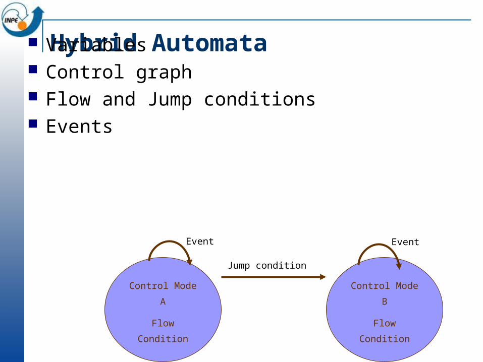
Hybrid Automata Variables Control graph Flow and Jump conditions Events
Control Mode A
Flow Condition
Control Mode B
Flow Condition
Event
Jump condition
Event

Modelo Hidrológico Simples
A water balance Automata
DRYsoilwater=soilwater+pre-evap
WETSurplus=soilwater-infilcp
Soilwater=infilcp
input soilwater>=infilcp
input
Surplus>0
TRANSPORTINGMOVE(LDD, surplus, infilcp)
discharge
Control Mode
Flow Condition Jump Condition Event Transition
DRY Solwat=solwat+pre-evap Solwat>=infcap WET
WET Surplus=soilwater-infilcap Surplus>0 discharge TRANSP
TRANSP MOVE(LDD,surplus, infilcap) Surplus>0 input DRY
input
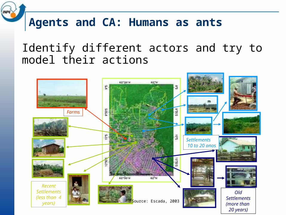
Agents and CA: Humans as ants
Old Settlements(more than 20 years)
Recent Settlements(less than 4
years)
Farms
Settlements 10 to 20 anos
Source: Escada, 2003
Identify different actors and try to model their actions
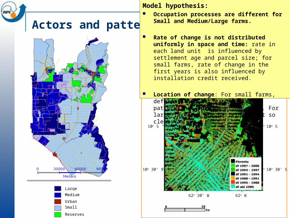
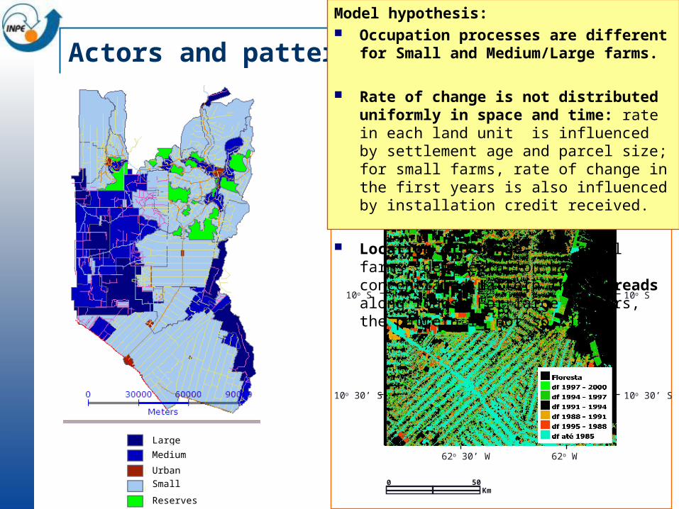
Actors and patterns9o S
10o S
9o 30’ S
10o 30’ S
9o S
9o 30’ S
10o S
10o 30’ S
0 50Km
62o 30’ W 62o W
62o 30’ W 62o W
Model hypothesis: Occupation processes are different for Small and
Medium/Large farms.
Rate of change is not distributed uniformly in space and time: rate in each land unit is influenced by settlement age and parcel size; for small farms, rate of change in the first years is also influenced by installation credit received.
Location of change: For small farms, deforestation has a concentrated pattern that spreads along roads. For large farmers, the pattern is not so clear.
Large farms
Medium farms
Urban areas
Small farms
Reserves
Model overview
Global study
area rate
in time
Deforestation Rate Distribution from 1985 to 2000 - Land Units Level:
Large/Medium Rate Distribution sub-model Small Farms Distribution sub-model
Allocation of changes - Cellular space level:
Large/Medium allocation sub-model Small allocation sub-model
2.500 m (large and
medium)
500 m (small)Large farms
Medium farms
Urban areas
Small farms
Reserves
Land unit 1 rate t
Land unit 2 rate t
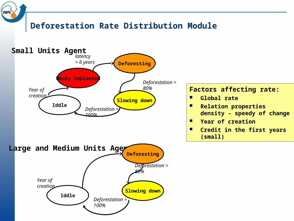
Deforestation Rate Distribution Module
Newly implanted
Deforesting
Slowing down
latency > 6 years
Deforestation > 80%
Small Units Agent
Factors affecting rate: Global rate Relation properties density -
speedy of change Year of creation Credit in the first years (small)
Iddle
Year of creation
Deforestation = 100%
Large and Medium Units AgentDeforesting
Slowing downIddle
Year of creation
Deforestation = 100%
Deforestation > 80%
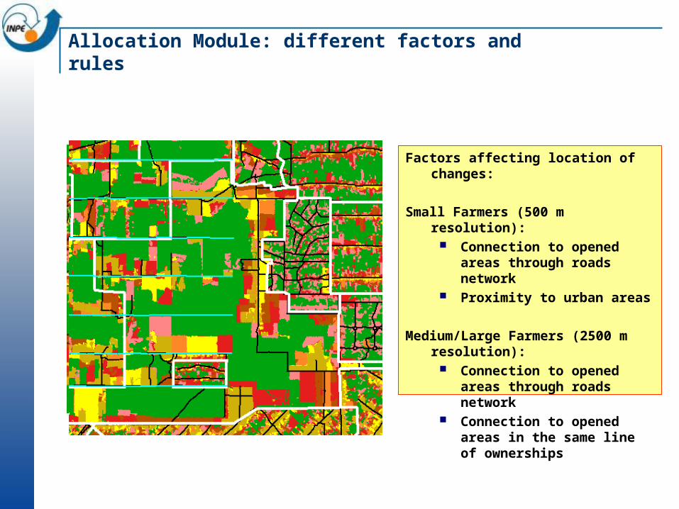
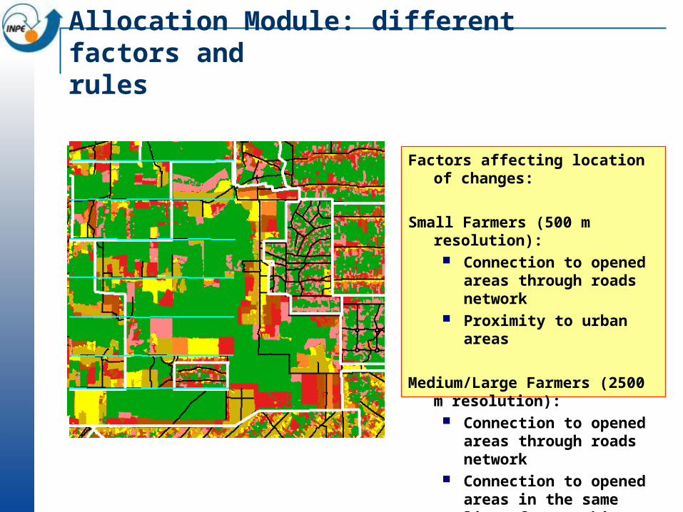
Allocation Module: different factors andrules
Factors affecting location of changes:
Small Farmers (500 m resolution): Connection to opened areas
through roads network Proximity to urban areas
Medium/Large Farmers (2500 m resolution):
Connection to opened areas through roads network
Connection to opened areas in the same line of ownerships
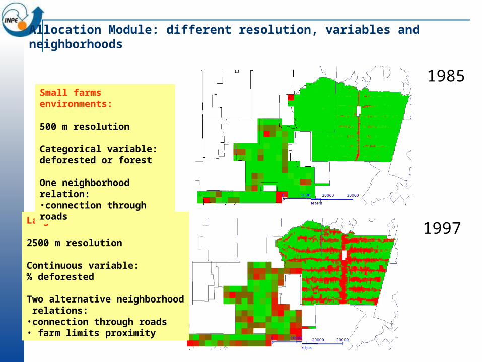
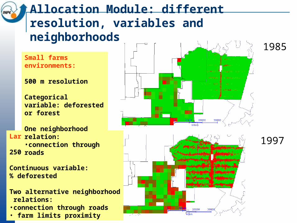
Allocation Module: different resolution, variables and neighborhoods
1985
1997 1997Large farm environments:
2500 m resolution
Continuous variable:% deforested
Two alternative neighborhood relations:•connection through roads• farm limits proximity
Small farms environments:
500 m resolution
Categorical variable: deforested or forest
One neighborhood relation: •connection through roads
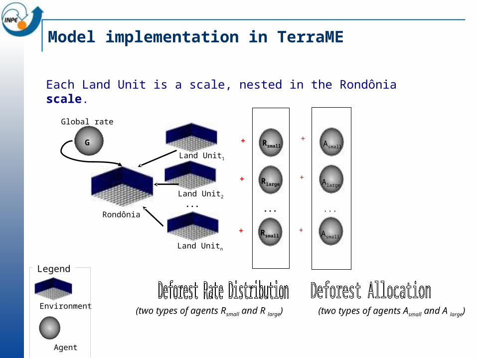
Model implementation in TerraME
Land Unitn
Land Unit2
Land Unit1
...Rondônia
G
Global rate
...
+
+
+
Rsmall
Rlarge
Rsmall
(two types of agents Rsmall and R large)
+
+
+
Asmall
Alarge
Asmall
...
(two types of agents Asmall and A large)
Each Land Unit is a scale, nested in the Rondônia scale.
Environment
Agent
Legend
Defining a model – part 3: TerraME temporal model
Asynchronous ProcessesMultiple Temporal Resolutions
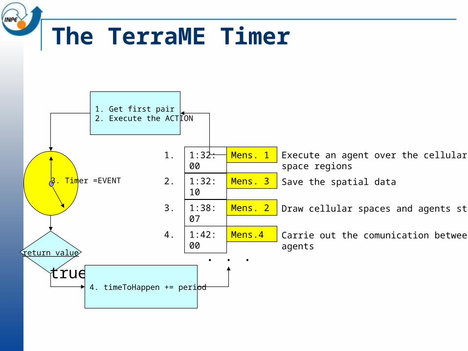
The TerraME Timer
1:32:00 Mens. 11.
1:32:10 Mens. 32.
1:38:07 Mens. 23.
1:42:00 Mens.44.
Execute an agent over the cellular space regions
Save the spatial data
Draw cellular spaces and agents states
Carrie out the comunication between agents
. . .return value
true
1. Get first pair 2. Execute the ACTION
3. Timer =EVENT
4. timeToHappen += period
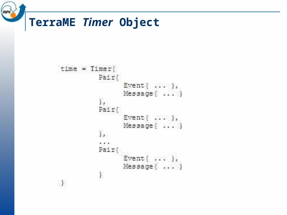
TerraME Timer Object
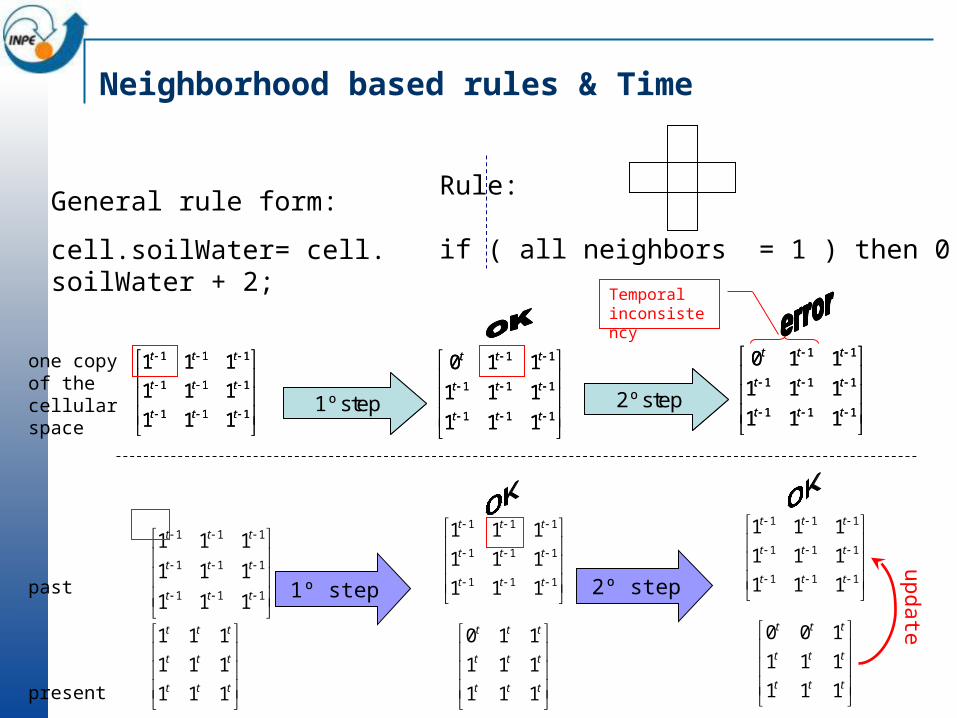
Neighborhood based rules & Time
Rule:
if ( all neighbors = 1 ) then 0
General rule form:
cell.soilWater= cell. soilWater + 2;
111
111
111
111
111
111
ttt
ttt
ttt
111
111
11
111
111
110
ttt
ttt
ttt
1º step
111
111
11
111
111
110
ttt
ttt
ttt
2º step
111
111
111
111
111
111
ttt
ttt
ttt
111
111
11
111
111
110
ttt
ttt
ttt
1º step
111
111
11
111
111
110
ttt
ttt
ttt
2º step
ttt
ttt
ttt
111
111
111
111
111
111
111
111
111
ttt
ttt
ttt
1º step
ttt
ttt
ttt
111
111
110
111
111
111
111
111
111
ttt
ttt
ttt
2º step
ttt
ttt
ttt
111
111
100
111
111
111
111
111
111
ttt
ttt
ttt
one copy of thecellular space
past
present
update
Temporal inconsistency
for i, cell ipairs( csValeDoAnary ) do
end
count = 0 ;
print(“Number of deforested cells: ”.. count);
if ( cell.past.cover == “forest” ) then
cell.cover = “deforested”;
count = count + 1 ;
end
cell.synchronize( );
Runtime Rule Activitytn tn+1
rule
?

TerraME Synchronization Schemes
Processes Might Be
Sequential in Time Parallel in Time
Sequential in Space execute(globalAutomaton1);synchronize( );execute(globalAutomaton2);synchronize( );
execute(globalAutomaton1);execute(globalAutomaton2);synchronize( );
Parallel in Space execute(localAutomaton1);synchronize( );execute(localAutomaton2);synchronize( );
execute(localAutomaton1);execute(localAutomaton2);synchronize( );

What is a Cell-Space?
Raster spatial data structure where each cell can handle one or more types of attribute.
Cell spaces were used in some of the very early GIS implementations and have been since discarded in most GIS implementations in favor of one-attribute raster data structures.
Cell spaces allow easier integrated modelling in a GIS environment

Cell Spaces
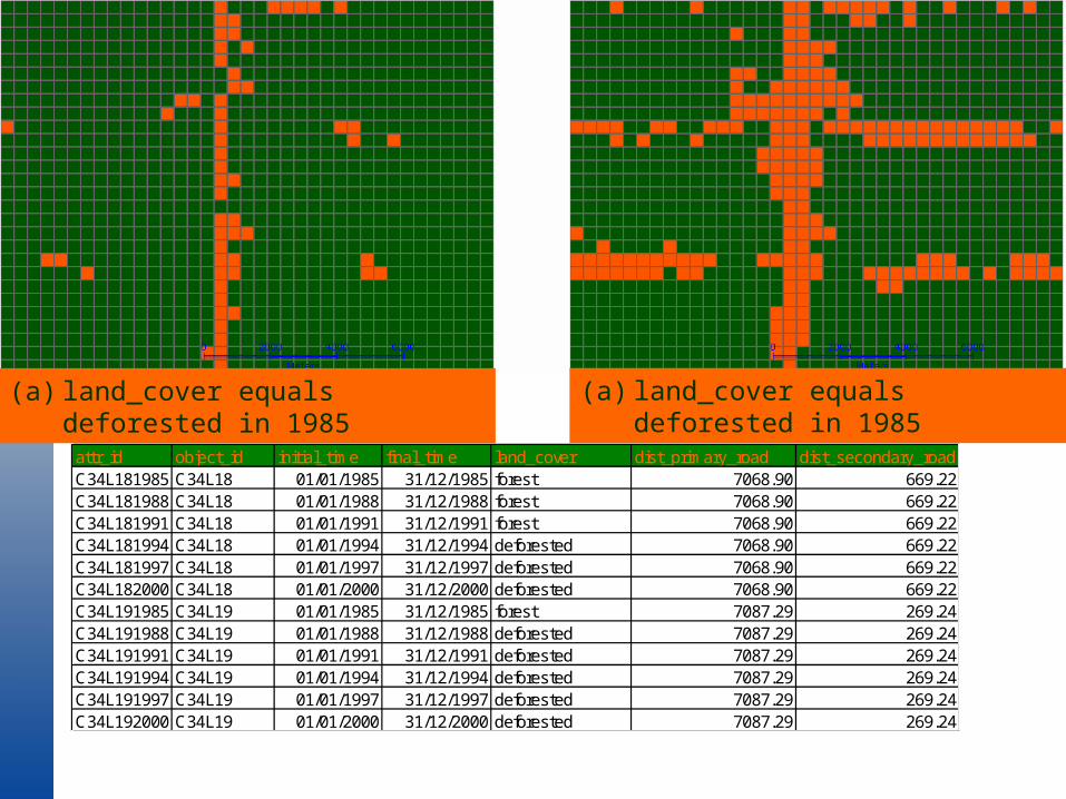
(a) land_cover equals deforested in 1985 (a) land_cover equals deforested in 1985
attr_id object_id initial_time final_time land_cover dist_primary_road dist_secondary_roadC34L181985-01-0100:00:001985-12-3123:59:59C34L18 01/01/1985 31/12/1985 forest 7068.90 669.22C34L181988-01-0100:00:001988-12-3123:59:59C34L18 01/01/1988 31/12/1988 forest 7068.90 669.22C34L181991-01-0100:00:001991-12-3123:59:59C34L18 01/01/1991 31/12/1991 forest 7068.90 669.22C34L181994-01-0100:00:001994-12-3123:59:59C34L18 01/01/1994 31/12/1994 deforested 7068.90 669.22C34L181997-01-0100:00:001997-12-3123:59:59C34L18 01/01/1997 31/12/1997 deforested 7068.90 669.22C34L182000-01-0100:00:002000-12-3123:59:59C34L18 01/01/2000 31/12/2000 deforested 7068.90 669.22C34L191985-01-0100:00:001985-12-3123:59:59C34L19 01/01/1985 31/12/1985 forest 7087.29 269.24C34L191988-01-0100:00:001988-12-3123:59:59C34L19 01/01/1988 31/12/1988 deforested 7087.29 269.24C34L191991-01-0100:00:001991-12-3123:59:59C34L19 01/01/1991 31/12/1991 deforested 7087.29 269.24C34L191994-01-0100:00:001994-12-3123:59:59C34L19 01/01/1994 31/12/1994 deforested 7087.29 269.24C34L191997-01-0100:00:001997-12-3123:59:59C34L19 01/01/1997 31/12/1997 deforested 7087.29 269.24C34L192000-01-0100:00:002000-12-3123:59:59C34L19 01/01/2000 31/12/2000 deforested 7087.29 269.24
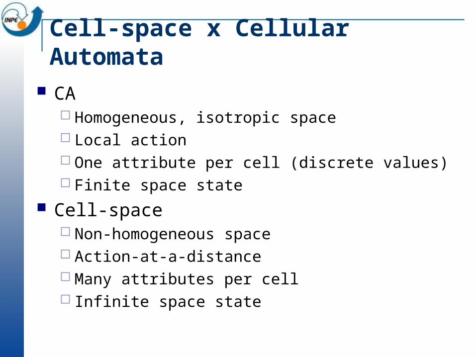
Cell-space x Cellular Automata
CA Homogeneous, isotropic space Local action One attribute per cell (discrete values) Finite space state
Cell-space Non-homogeneous space Action-at-a-distance Many attributes per cell Infinite space state
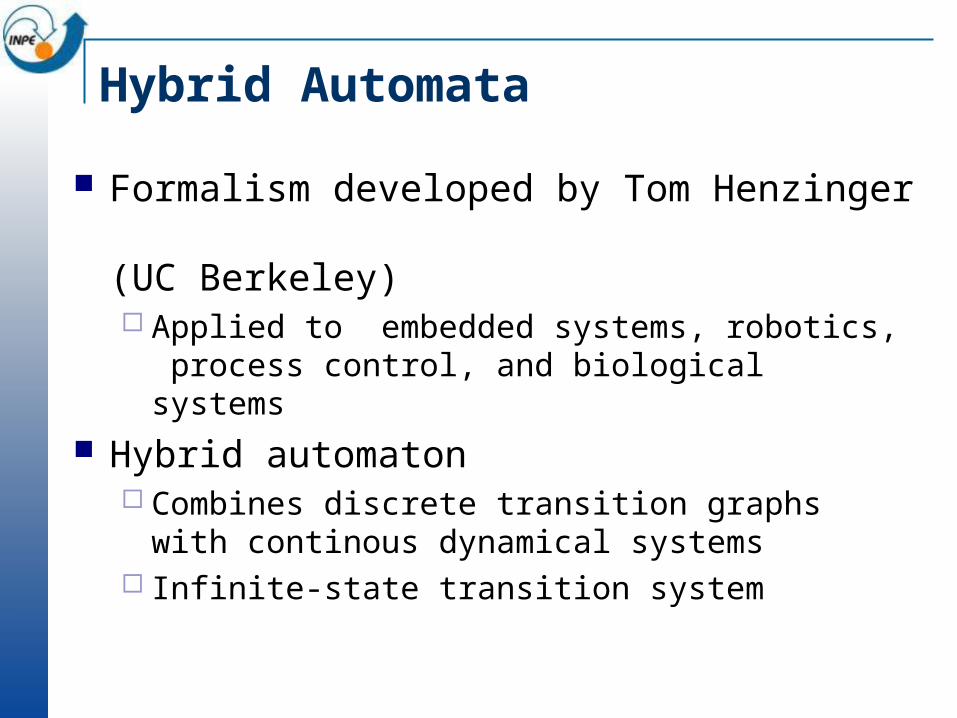
Hybrid Automata
Formalism developed by Tom Henzinger (UC Berkeley) Applied to embedded systems, robotics, process control,
and biological systems Hybrid automaton
Combines discrete transition graphs with continous dynamical systems
Infinite-state transition system
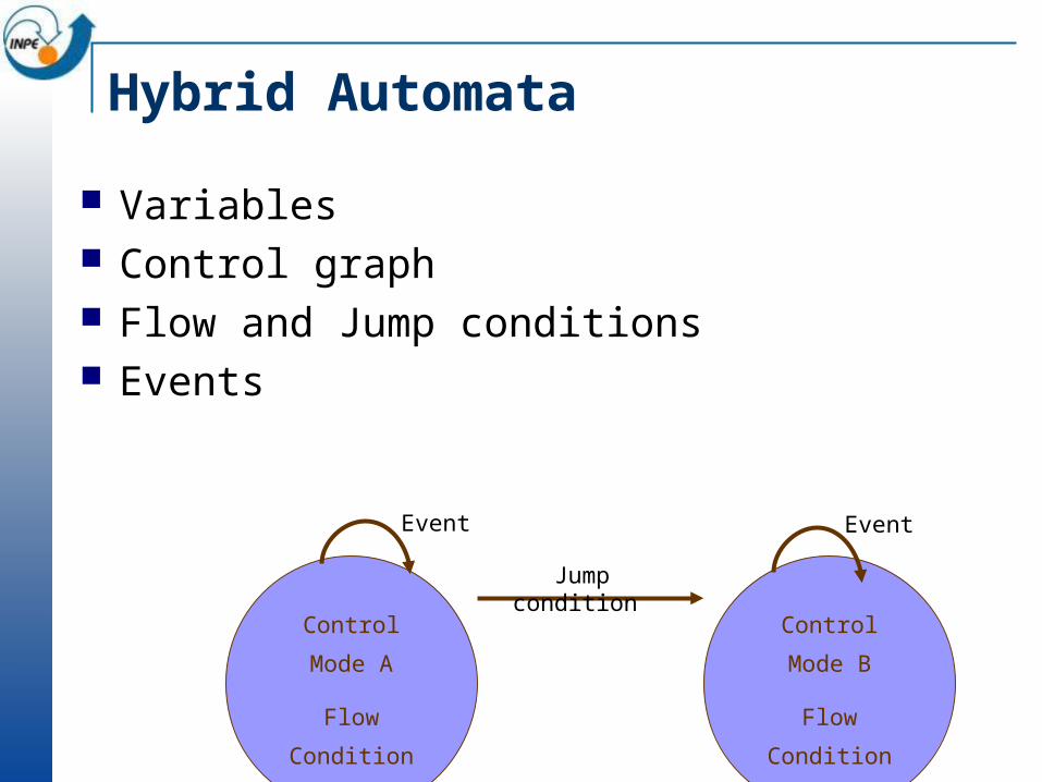
Hybrid Automata
Variables Control graph Flow and Jump conditions Events
Control Mode
A
Flow
Condition
Control Mode
B
Flow
Condition
Event
Jump condition
Event
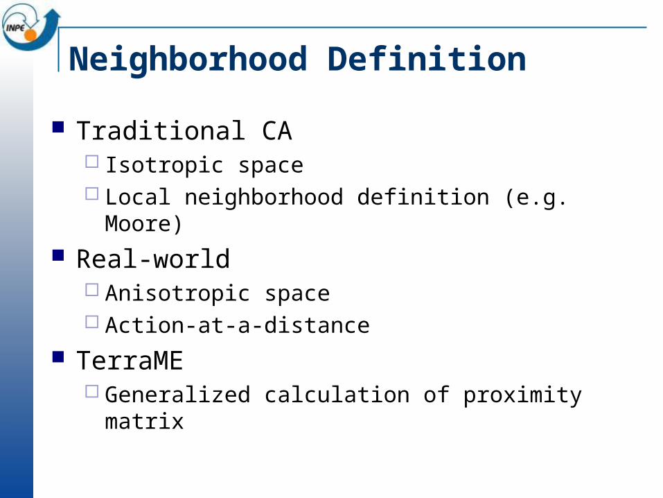
Neighborhood Definition
Traditional CA Isotropic space Local neighborhood definition (e.g. Moore)
Real-world Anisotropic space Action-at-a-distance
TerraME Generalized calculation of proximity matrix

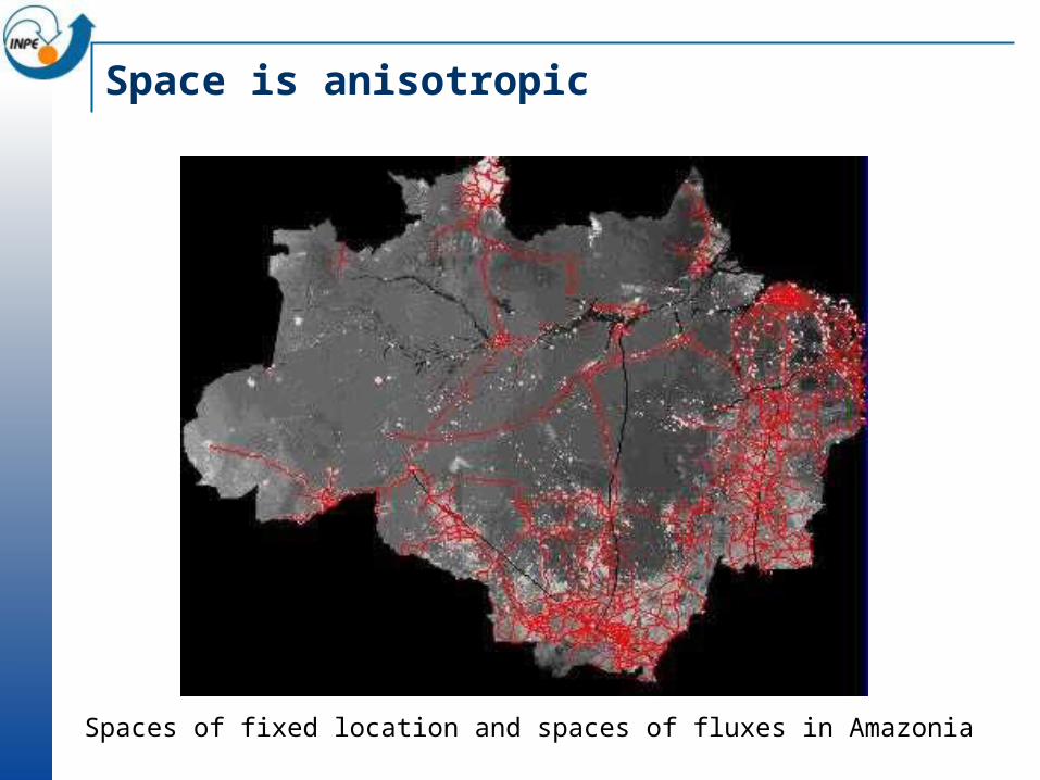
Space is Anisotropic
Spaces of fixed location and spaces of fluxes in Amazonia
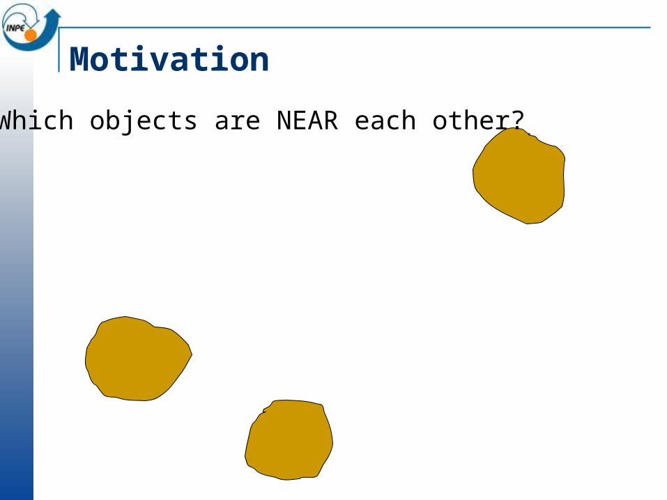
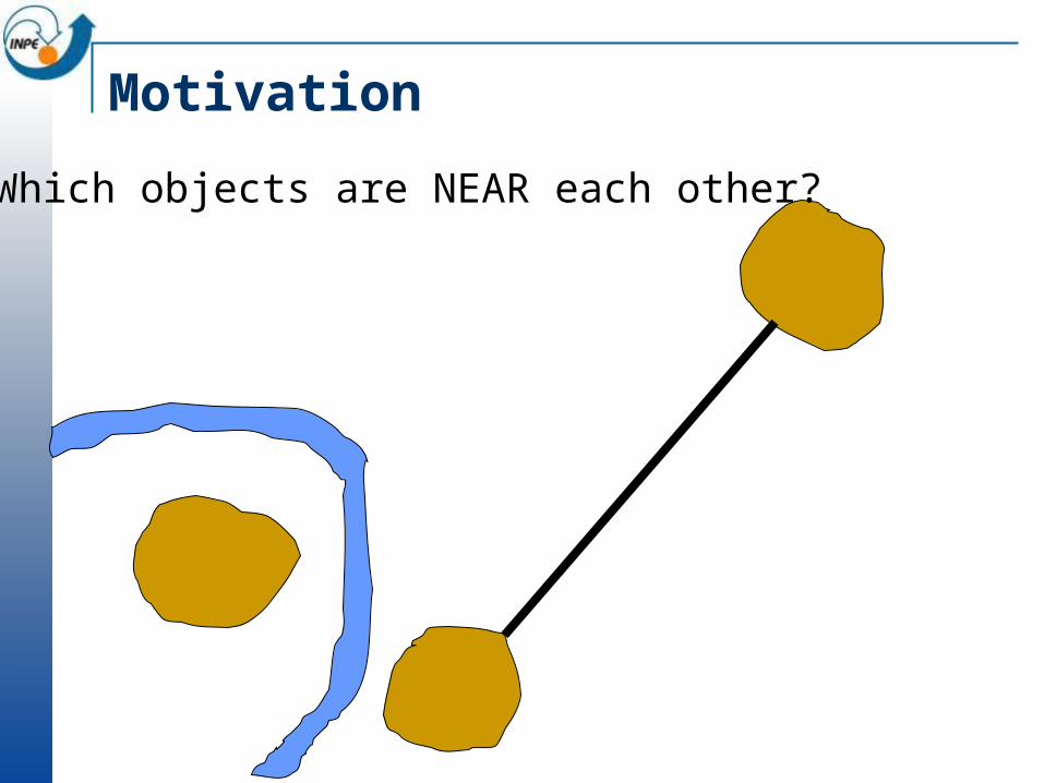
Motivation
Which objects are NEAR each other?
Motivation
Which objects are NEAR each other?

Using Generalized Proximity Matrices
Consolidated area Emergent area

Computational Modelling with Cell Spaces
Cell Spaces
Components Cell Spaces Generalizes Proximity Matriz – GPM Hybrid Automata model Nested enviroment
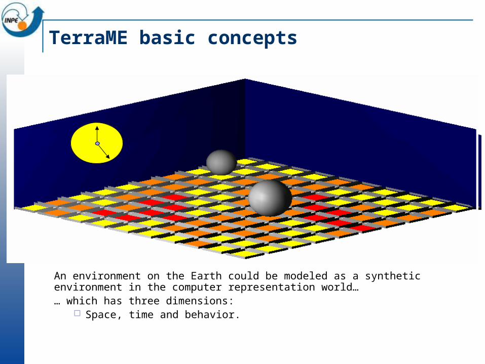
TerraME basic concepts
An environment on the Earth could be modeled as a synthetic environment in the computer representation world…… which has three dimensions:
Space, time and behavior.
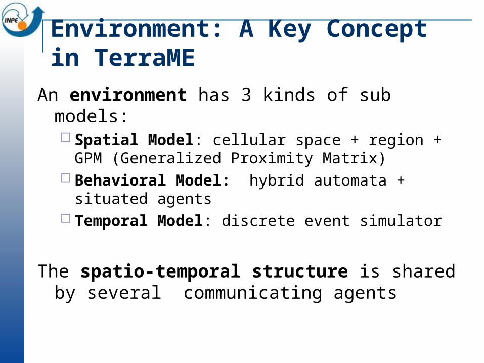
Environment: A Key Concept in TerraME
An environment has 3 kinds of sub models: Spatial Model: cellular space + region + GPM (Generalized
Proximity Matrix) Behavioral Model: hybrid automata + situated agents Temporal Model: discrete event simulator
The spatio-temporal structure is shared by several communicating agents
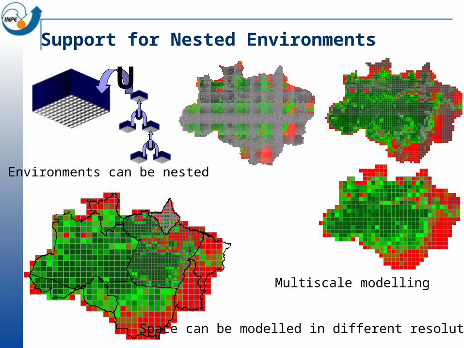
Support for Nested Environments
UU
U
Environments can be nested
Space can be modelled in different resolutions
Multiscale modelling

Agents: Local Global
Behavioural Model
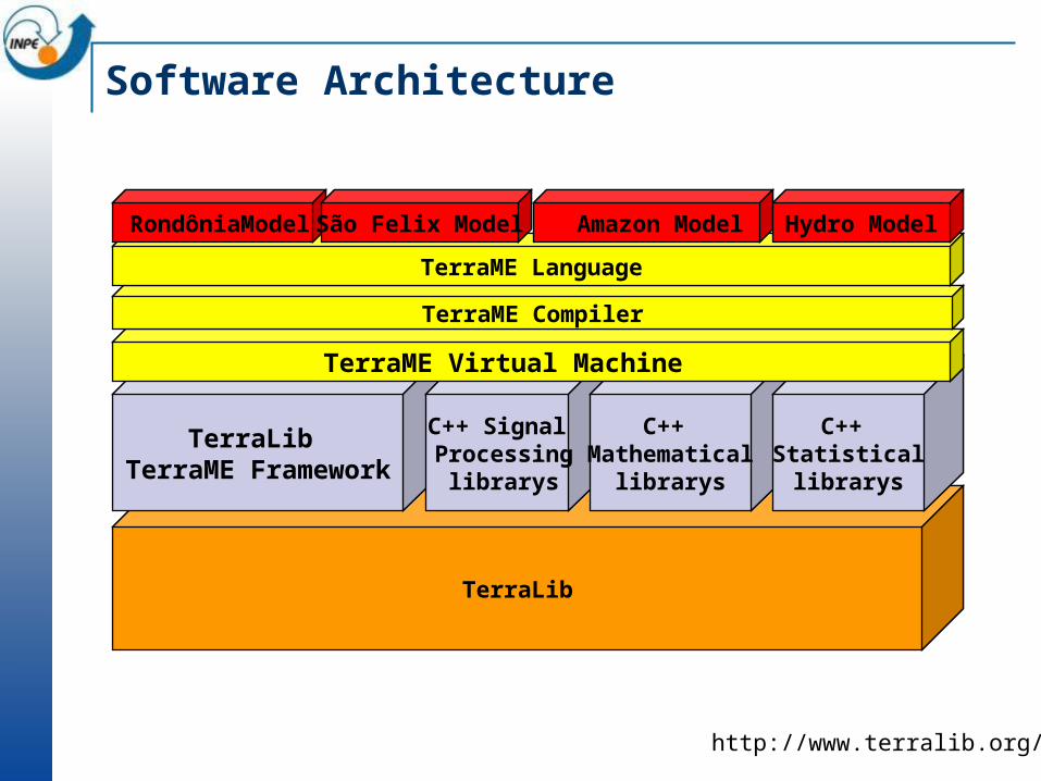
Software Architecture
TerraLib
TerraLib TerraME Framework
C++ Signal Processing
librarys
C++ Mathematical
librarys
C++ Statisticallibrarys
TerraME Virtual Machine
TerraME Compiler
TerraME Language
RondôniaModel São Felix Model Amazon Model Hydro Model
http://www.terralib.org/
Deforestation
Forest
Non-forest
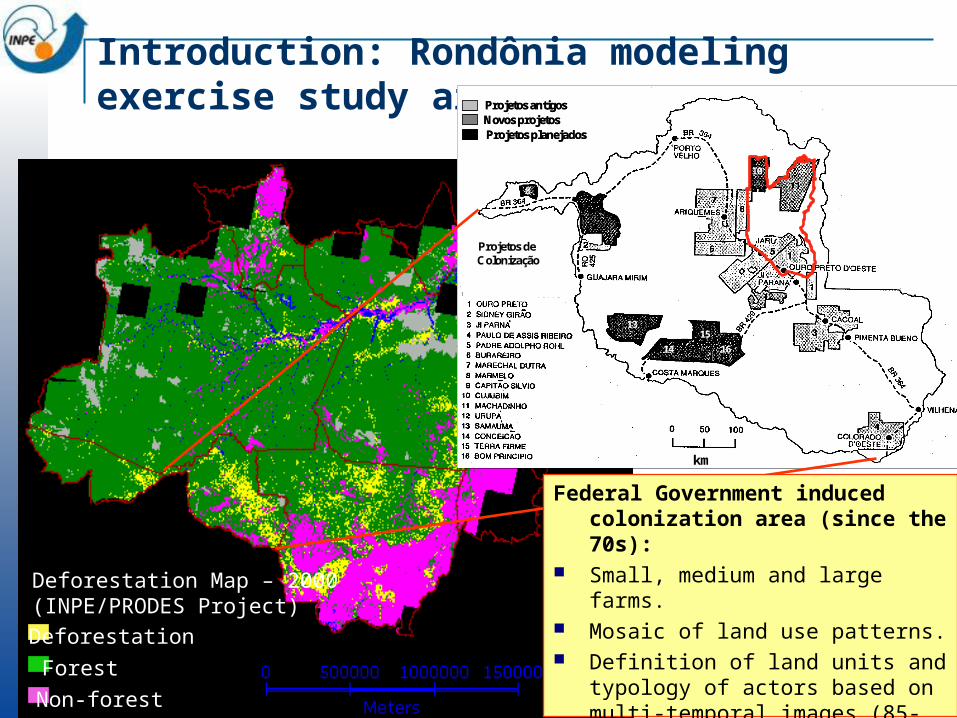
Deforestation Map – 2000 (INPE/PRODES Project)
Introduction: Rondônia modeling exercise study area
km
Projetos de Colonização
10
8
15
1614
13
Projetos antigosNovos projetosProjetos planejados
km
Projetos de Colonização
10
8
15
1614
13
Projetos antigosNovos projetosProjetos planejados
Projetos antigosNovos projetosProjetos planejados
Federal Government induced colonization area (since the 70s):
Small, medium and large farms. Mosaic of land use patterns. Definition of land units and typology
of actors based on multi-temporal images (85-00) and colonization projects information (Escada, 2003).
Intersects 10 municipalities (~100x200 km).
Actors and patterns9o S
10o S
9o 30’ S
10o 30’ S
9o S
9o 30’ S
10o S
10o 30’ S
0 50Km
62o 30’ W 62o W
62o 30’ W 62o W
Model hypothesis: Occupation processes are different for
Small and Medium/Large farms.
Rate of change is not distributed uniformly in space and time: rate in each land unit is influenced by settlement age and parcel size; for small farms, rate of change in the first years is also influenced by installation credit received.
Location of change: For small farms, deforestation has a concentrated pattern that spreads along roads. For large farmers, the pattern is not so clear.
Large farms
Medium farms
Urban areas
Small farms
Reserves

Model overview
Global study
area rate
in time
Deforestation Rate Distribution from 1985 to 2000 - Land Units Level:
Large/Medium Rate Distribution sub-model
Small Farms Distribution sub-model
Allocation of changes - Cellular space level:
Large/Medium allocation sub-model
Small allocation sub-model
2.500 m (large and
medium)
500 m (small)Large farms
Medium farms
Urban areas
Small farms
Reserves
Land unit 1 rate t
Land unit 2 rate t
Model implementation in TerraME
Land Unitn
Land Unit2
Land Unit1
...Rondônia
G
Global rate
...
+
+
+
Rsmall
Rlarge
Rsmall
(two types of agentes Rsmall and R large)
+
+
+
Asmall
Alarge
Asmall
...
(two types of agentes Asmall and A large)
Each Land Unit is an environment, nested in the Rondônia environment.
Environment
Agent
Legend
Deforestation Rate Distribution Module
Newly implanted
Deforesting
Slowing down
latency > 6 years
Deforestation > 80%
Small Units Agent
Factors affecting rate: Global rate Relation properties density -
speedy of change Year of creation Credit in the first years
(small)
Iddle
Year of creation
Deforestation = 100%
Large and Medium Units AgentDeforesting
Slowing downIddle
Year of creation
Deforestation = 100%
Deforestation > 80%
Allocation Module: different factors andrules
Factors affecting location of changes:
Small Farmers (500 m resolution): Connection to opened
areas through roads network
Proximity to urban areas
Medium/Large Farmers (2500 m resolution):
Connection to opened areas through roads network
Connection to opened areas in the same line of ownerships
Allocation Module: different resolution, variables and neighborhoods
1985
1997 1997Large farm environments:
2500 m resolution
Continuous variable:% deforested
Two alternative neighborhood relations:•connection through roads• farm limits proximity
Small farms environments:
500 m resolution
Categorical variable: deforested or forest
One neighborhood relation: •connection through roads

1985 1988 1991
1994 1997
Simulation Results
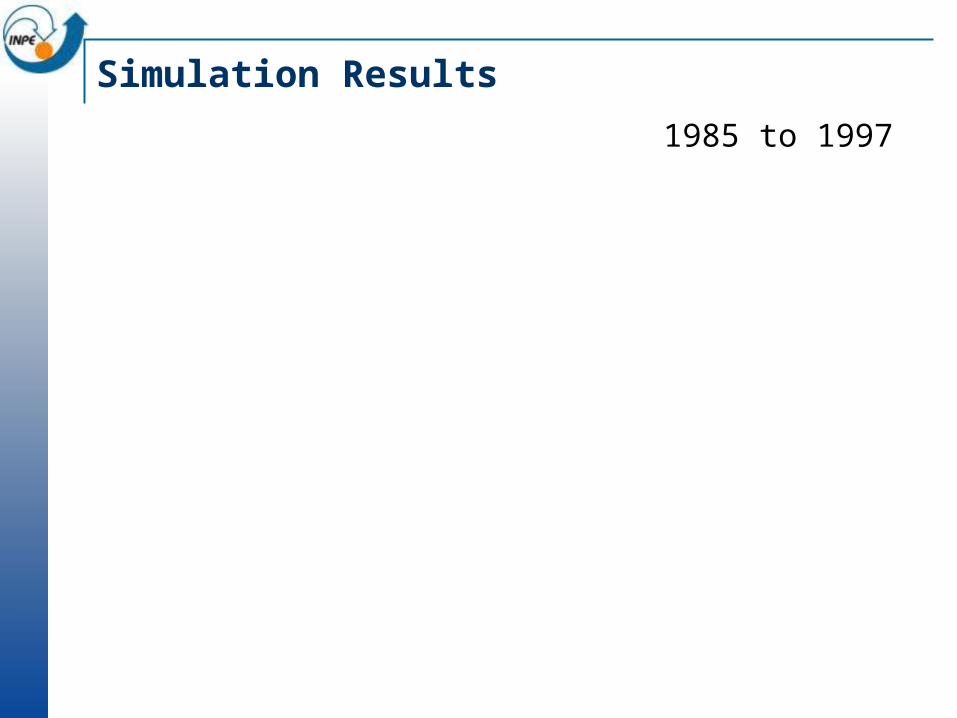
Simulation Results
1985 to 1997
Contributions TerraME models many aspects of spatial and temporal
Rondônia study area complexity combining: Multiple scales Multiple actors and behaviors Multiple time events and assynchronous processes Alternative neighborhood relationships Continuous and discrete behavior
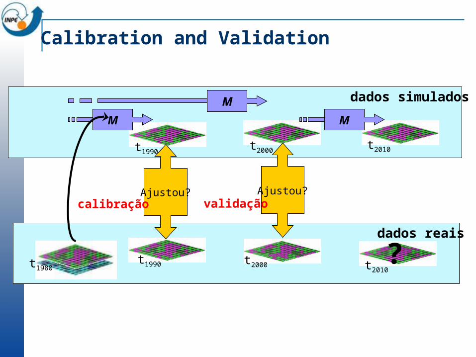
Calibration and Validation
M
t1980
t1990
M
t1990 t2000
t2000
dados reais
dados simulados
M
t2010
Ajustou?Ajustou?calibração validação
t2010?
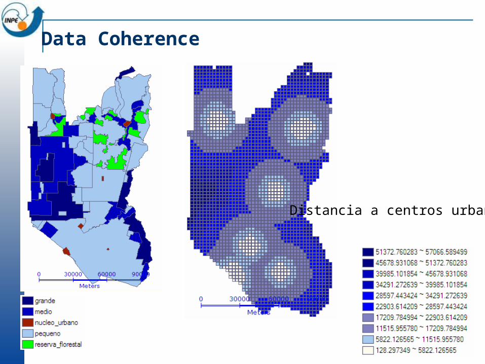
Data Coherence
Distancia a centros urbanos
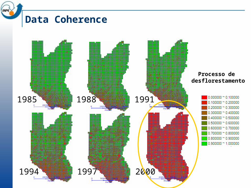
Data Coherence
1985 1988 1991
1994 1997 2000
Processo de desflorestamento
Conclusions
Computational modelling on cellular spaces is an emerging trend in land use modelling
Realistic assumptions are built in TerraME We have tried to avoid the five orders of ignorance
TerraME is an evolving project We hope to learn more as we do further experiments

Spatial Dynamical Modeling with TerraME
Tiago Garcia de Senna CarneiroAntônio Miguel Vieira MonteiroGilberto Câmara
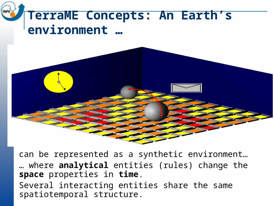
TerraME Concepts: An Earth’s environment …
can be represented as a synthetic environment…… where analytical entities (rules) change the space properties in time.Several interacting entities share the same spatiotemporal structure.
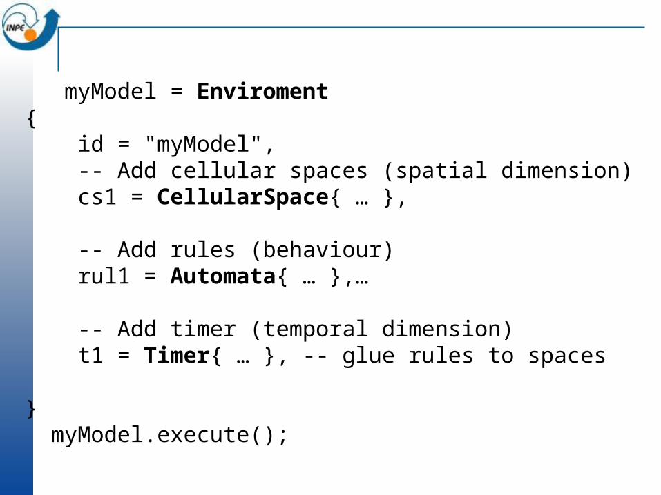
myModel = Enviroment{ id = "myModel", -- Add cellular spaces (spatial dimension) cs1 = CellularSpace{ … },
-- Add rules (behaviour) rul1 = Automata{ … },… -- Add timer (temporal dimension) t1 = Timer{ … }, -- glue rules to spaces
} myModel.execute();
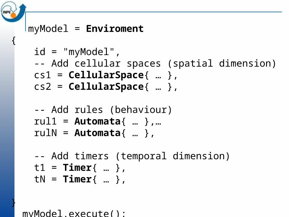
myModel = Enviroment{ id = "myModel", -- Add cellular spaces (spatial dimension) cs1 = CellularSpace{ … }, cs2 = CellularSpace{ … },
-- Add rules (behaviour) rul1 = Automata{ … },… rulN = Automata{ … }, -- Add timers (temporal dimension) t1 = Timer{ … }, tN = Timer{ … },
} myModel.execute();

myModel = Enviroment{ id = "myModel", -- Add cellular spaces (spatial dimension) cs1 = CellularSpace{ … },
-- Add rules to this CA (behaviour) rul1 = Automata{ … },… -- Add timers to this CA (temporal dimension) t1 = Timer{ … },
-- Add CA to this CA (nested-CAs) model1 = Environment{ … } … model2 = Environment{ … }, } myModel.execute();

Simulation of Physical Processes
- rain drainage in a terrain -
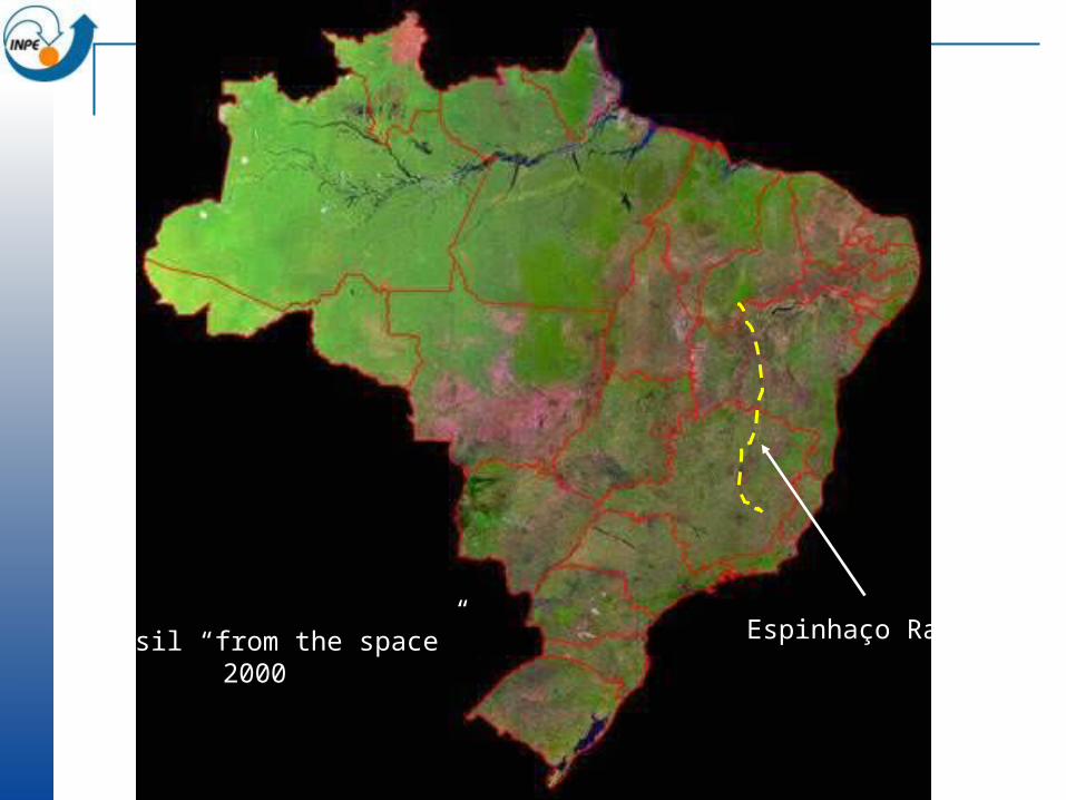
O Brasil “from the space”2000
Espinhaço Range
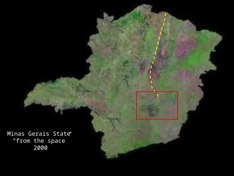
Minas Gerais State “from the space”
2000
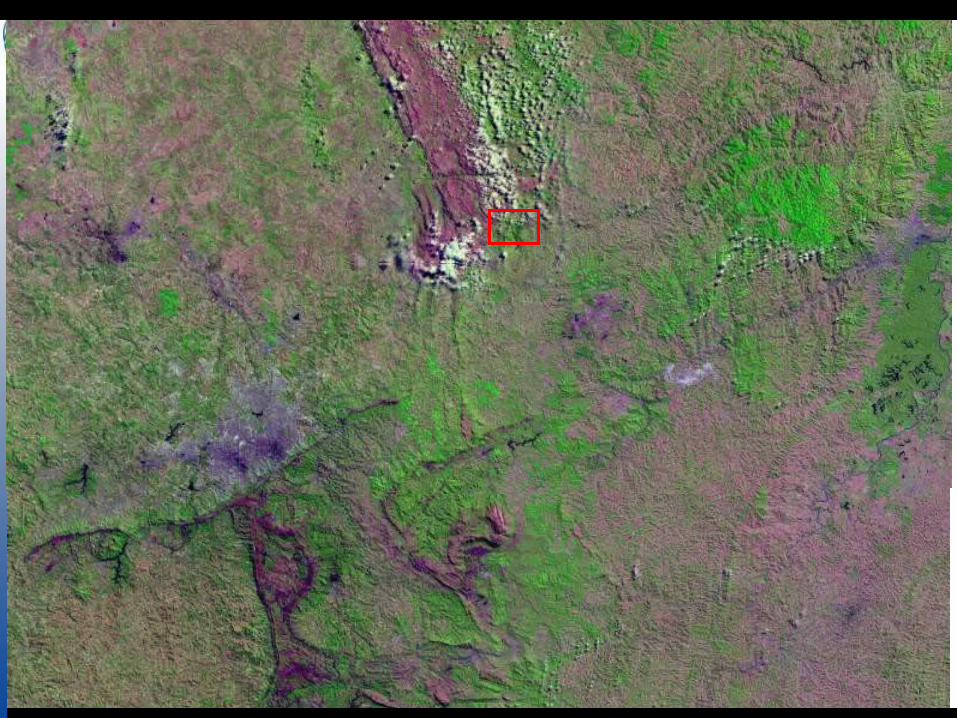

Point of View
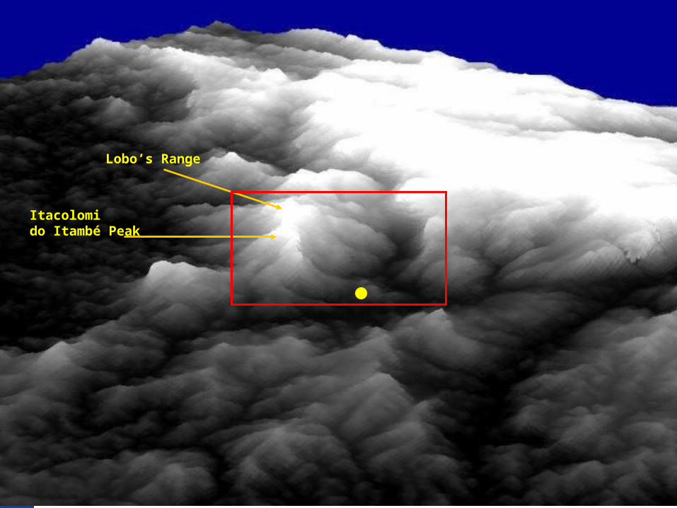
Itacolomido Itambé Peak
Lobo’s Range
Itacolomido Itambé Peak
Lobo’s Range
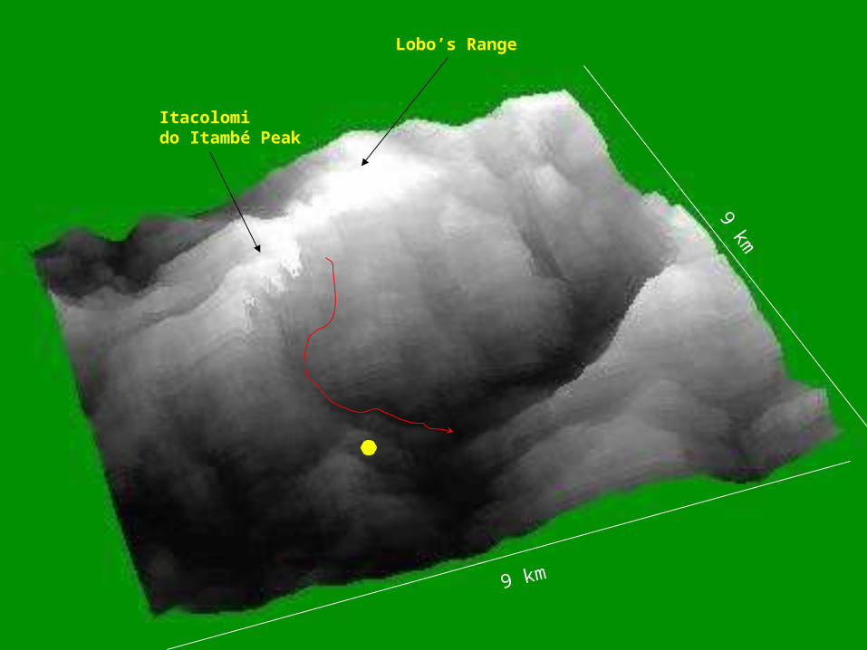
9 km
9 km
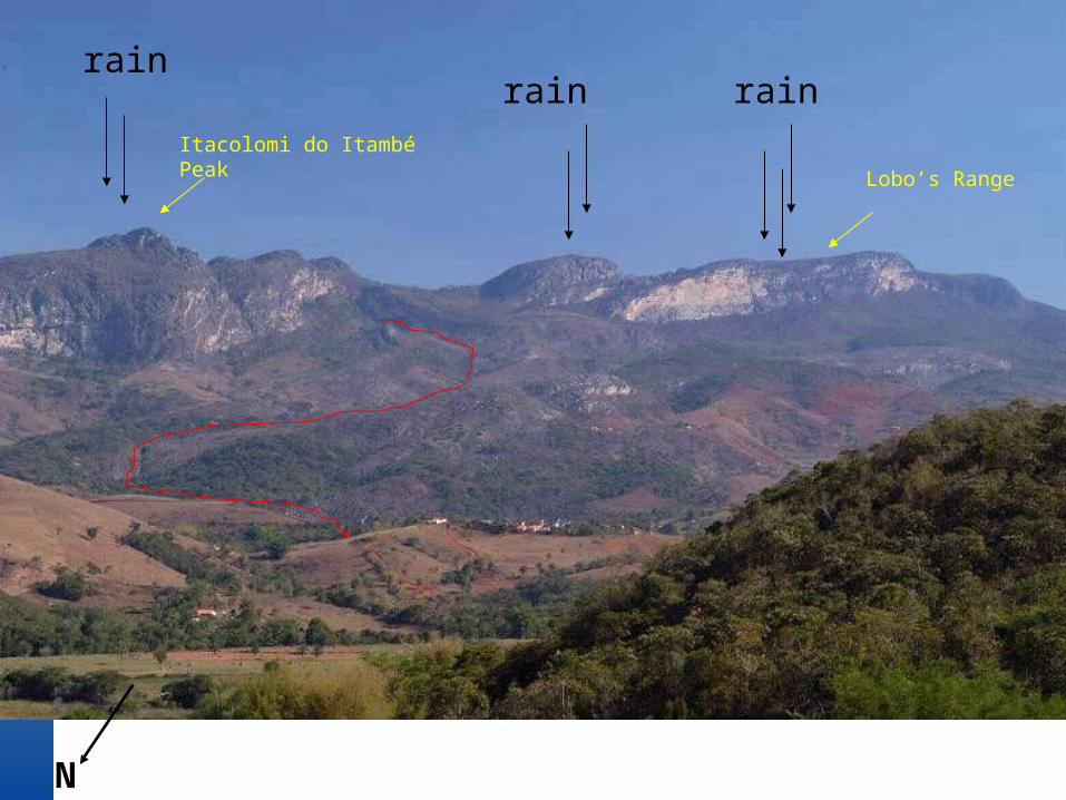
rainrain rain
N
Itacolomi do ItambéPeak Lobo’s Range
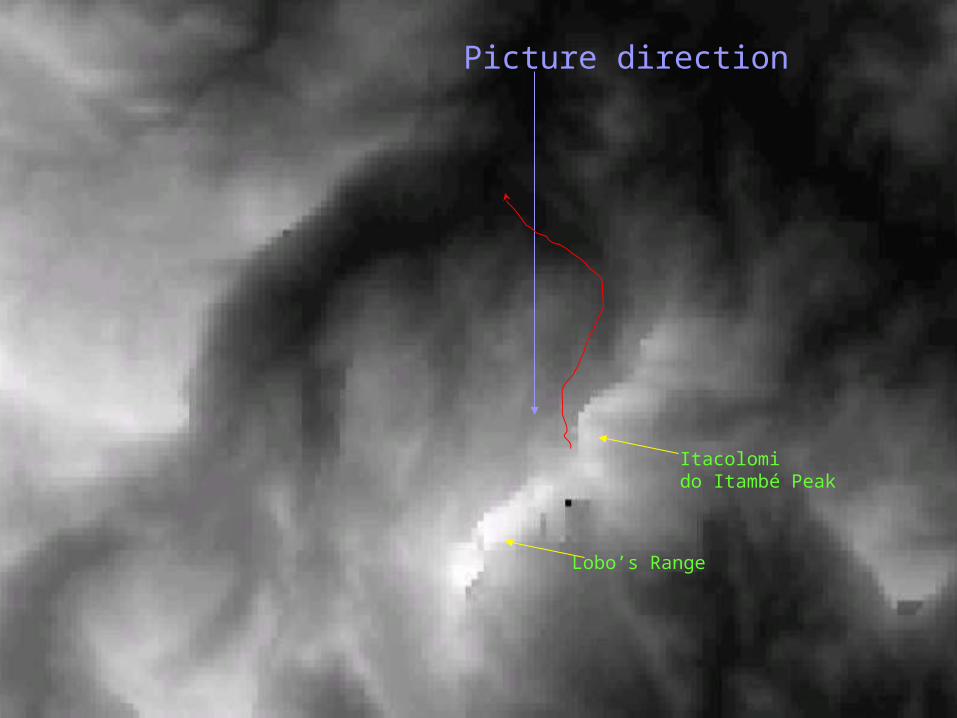
Picture direction
Itacolomido Itambé Peak
Lobo’s Range
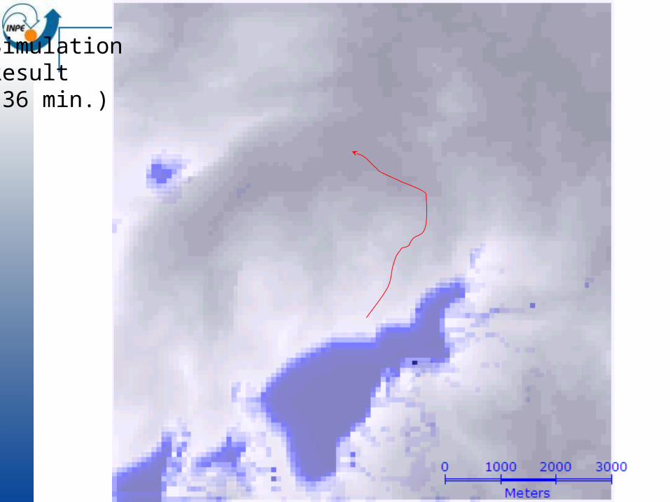
SimulationResult(36 min.)
TerraME Advanced: Non- isotropic spaces

Von Neumann Neighborhood
Moore Neighborhood
Isotropic neighbourhoods in cell spaces

Neighborhood Definition
Traditional CA Isotropic space Local neighborhood definition (e.g. Moore)
Real-world Anisotropic space Action-at-a-distance
TerraME Generalized calculation of proximity matrix
Space is anisotropic
Spaces of fixed location and spaces of fluxes in Amazonia

Motivation
Which objects are NEAR each other?

Motivation
Which objects are NEAR each other?
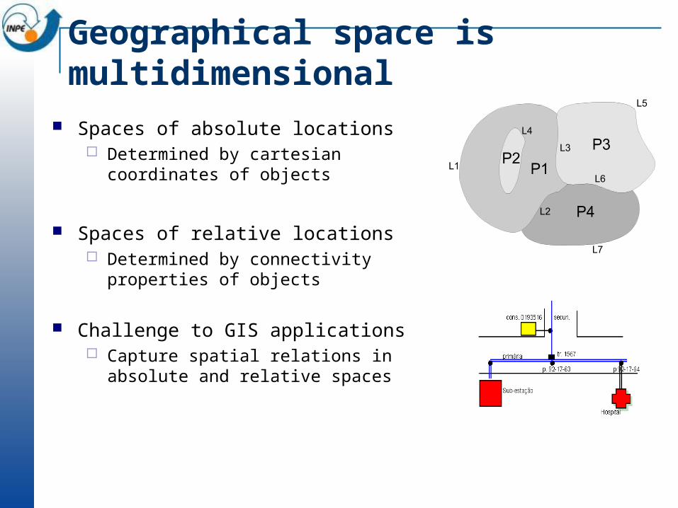
Geographical space is multidimensional
Spaces of absolute locations Determined by cartesian coordinates of
objects
Spaces of relative locations Determined by connectivity properties
of objects
Challenge to GIS applications Capture spatial relations in absolute
and relative spaces
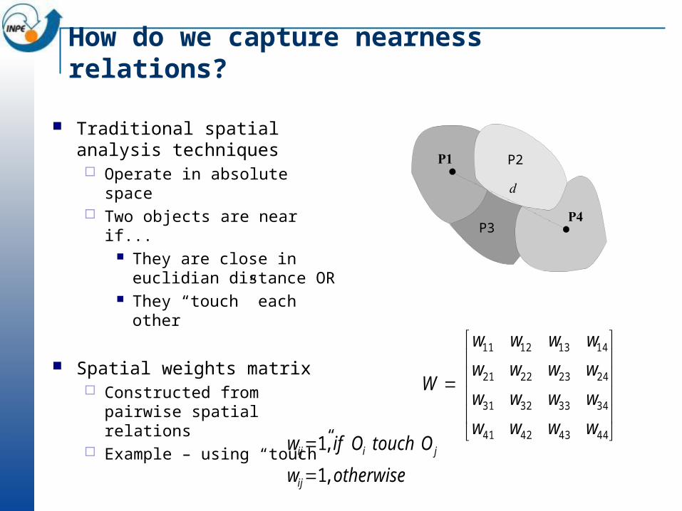
How do we capture nearness relations?
Traditional spatial analysis techniques Operate in absolute space Two objects are near if...
They are close in euclidian distance OR
They “touch” each other
Spatial weights matrix Constructed from pairwise
spatial relations Example – using “touch”
44434241
34333231
24232221
14131211
wwww
wwww
wwww
wwww
W
P2
P3
otherwisew
OtouchOifw
ij
jiij
,1
,1
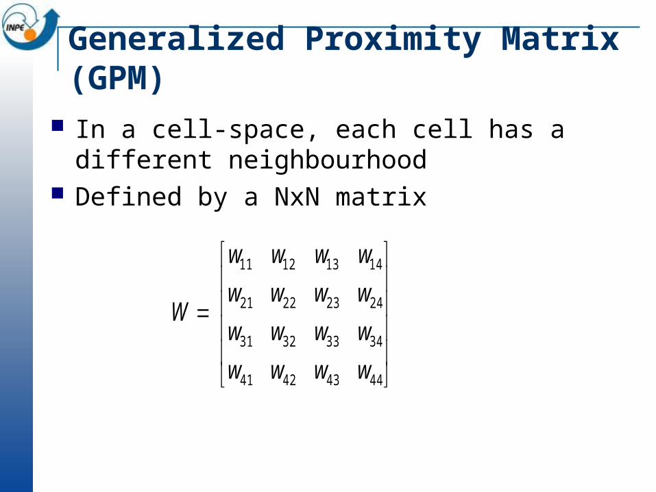
Generalized Proximity Matrix (GPM)
In a cell-space, each cell has a different neighbourhood
Defined by a NxN matrix
44434241
34333231
24232221
14131211
wwww
wwww
wwww
wwww
W
One simple example Consider a 5x 5 cell-space For each cell, a different matrix The neighbours of a cell (the (2,3) cell are):
0 0 1 1 0
0 0 * 1 0
0 0 1 1 0
0 0 1 1 0
0 0 1 0 0
Using Generalized Proximity Matrices
Consolidated area Emergent area

TerraME
O que é TerraME? Quais os requisitos? Quais as principais características? Arquitetura e componentes Onde obter?
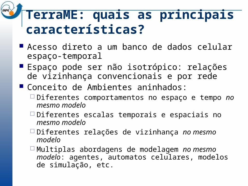
TerraME: quais as principais características?
Acesso direto a um banco de dados celular espaço-temporal
Espaço pode ser não isotrópico: relações de vizinhança convencionais e por rede
Conceito de Ambientes aninhados: Diferentes comportamentos no espaço e tempo no mesmo
modelo Diferentes escalas temporais e espaciais no mesmo
modelo Diferentes relações de vizinhança no mesmo modelo Multiplas abordagens de modelagem no mesmo modelo:
agentes, automatos celulares, modelos de simulação, etc.
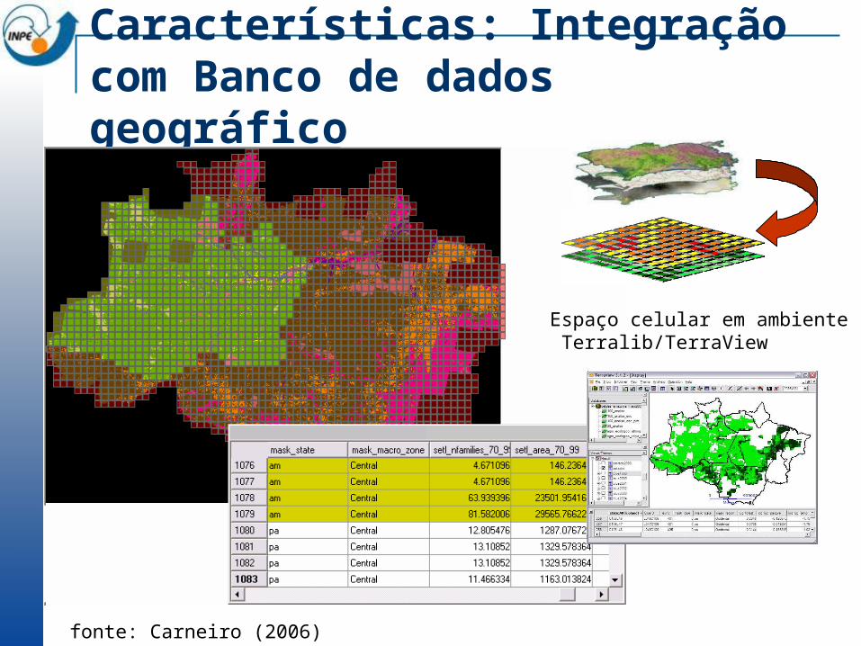
Características: Integração com Banco de dados geográfico
fonte: Carneiro (2006)
Espaço celular em ambiente Terralib/TerraView
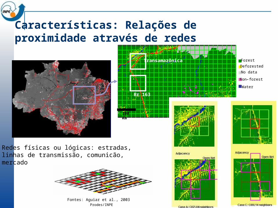
Características: Relações de proximidade através de redes
Forest
Deforested
No data
Non-forest-
Water
Roads
100 km
Transamazônica
Br 163-
São Felix do Xingu
Prodes/INPE
Fontes: Aguiar et al., 2003
Redes físicas ou lógicas: estradas,linhas de transmissão, comunicão,mercado

Um ambiente tem três sub-modelos Espacial: espaço celular, relações de proximidade Comportamental: modelos celulares, autômatos, agentes situados,etc. Temporal:
Características: Conceito de Ambiente em TerraME
Cellular space
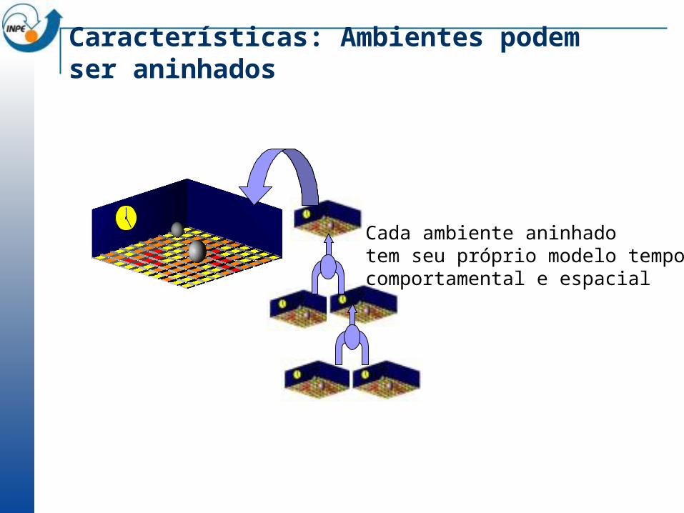
Características: Ambientes podem ser aninhados
Prodes/INPE 2000-2001
Cada ambiente aninhado tem seu próprio modelo temporal, comportamental e espacial
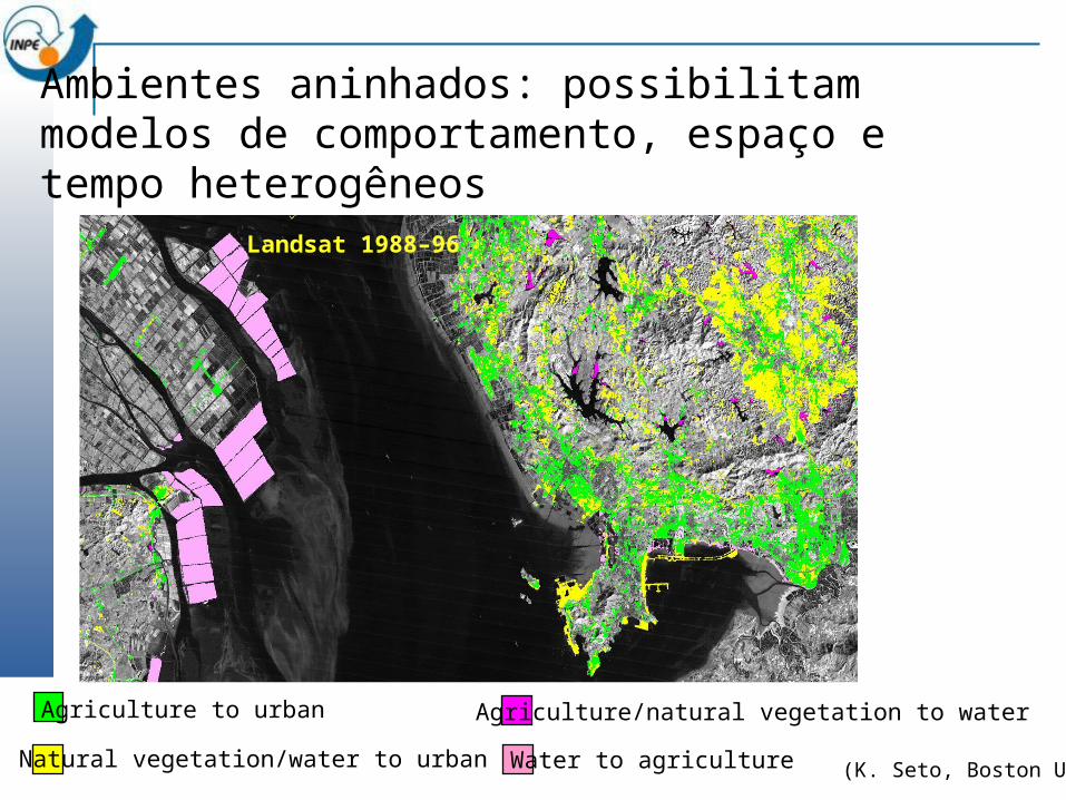
Agriculture to urban
Natural vegetation/water to urban
Agriculture/natural vegetation to water
Water to agriculture
Landsat 1988–96
(K. Seto, Boston U.)
Ambientes aninhados: possibilitam modelos de comportamento, espaço e tempo heterogêneos
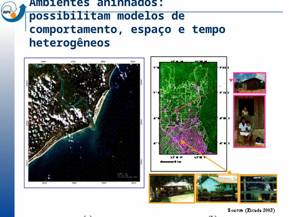
Ambientes aninhados: possibilitam modelos de comportamento, espaço e tempo heterogêneos
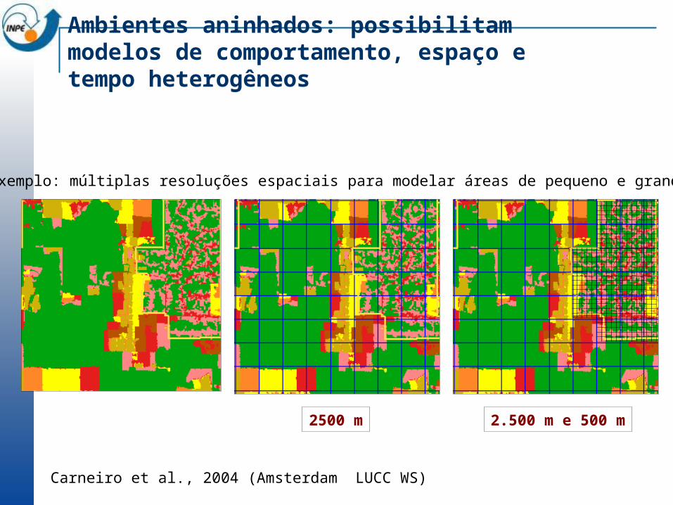
2500 m 2.500 m e 500 m
Exemplo: múltiplas resoluções espaciais para modelar áreas de pequeno e grandes
Ambientes aninhados: possibilitam modelos de comportamento, espaço e tempo heterogêneos
Carneiro et al., 2004 (Amsterdam LUCC WS)
1985
1997 1997Large farm environments:
2500 m resolution
Continuous variable:% deforested
Two alternative neighborhood relations:•connection through roads• farm limits proximity
Small farms environments:
500 m resolution
Categorical variable: deforested or forest
One neighborhood relation: •connection through roads
Exemplo de modelo de alocação de desflorestamento em Rondônia:resoluções diferentes, variáveis, fatores e relações de vizinhança
Carneiro et al., 2004 (Amsterdam LUCC WS)
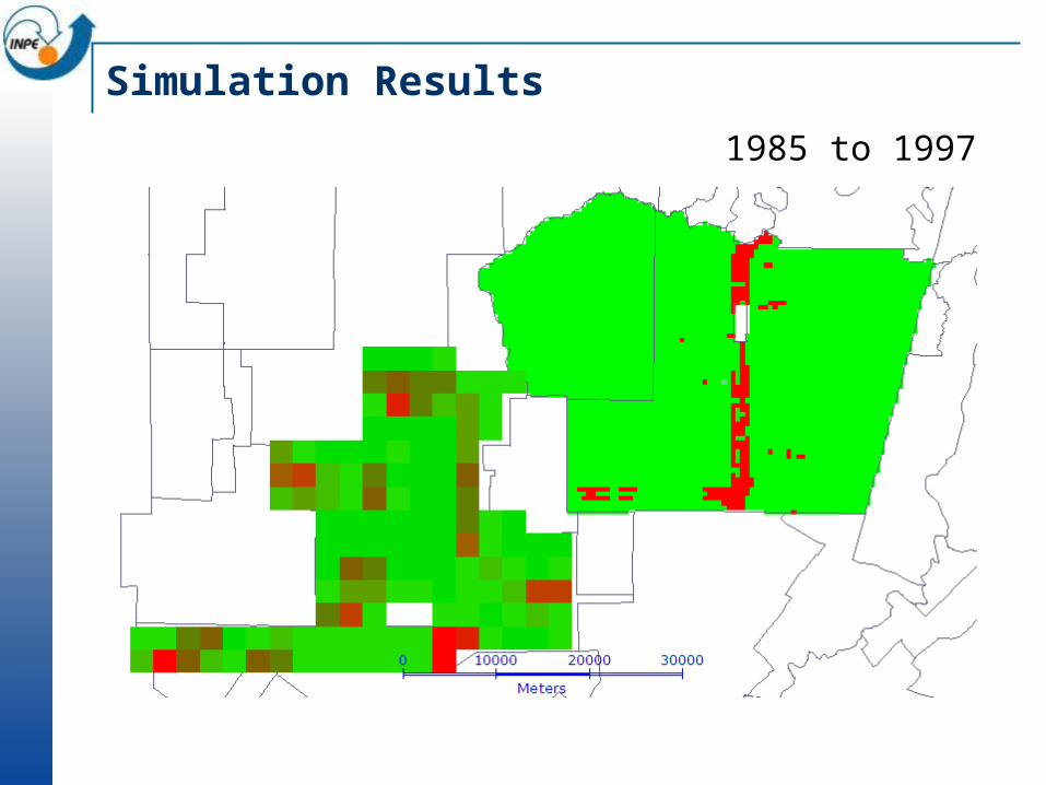
Simulation Results
1985 to 1997
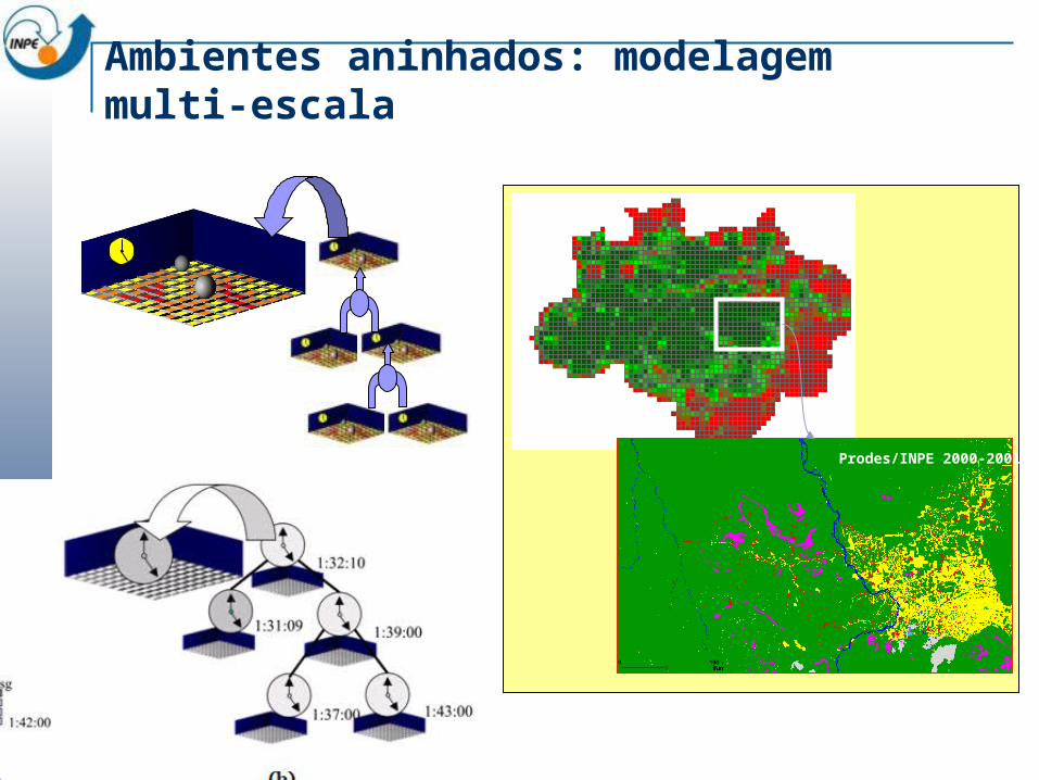
Ambientes aninhados: modelagem multi-escala
Prodes/INPE 2000-2001
TerraME
O que é TerraME? Quais os requisitos? Quais as principais características? Arquitetura e componentes Onde obter?
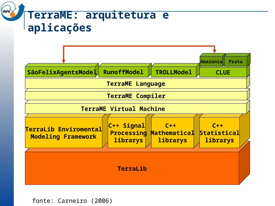
TerraLib
TerraLib EnviromentalModeling Framework
C++ Signal Processing
librarys
C++ Mathematical
librarys
C++ Statisticallibrarys
TerraME Virtual Machine
TerraME: arquitetura e aplicações
TerraME Compiler
TerraME Language
SãoFelixAgentsModel RunoffModel TROLLModel CLUE
fonte: Carneiro (2006)
Amazonia Prata
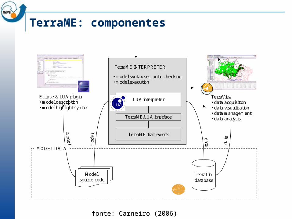
TerraME: componentes
Eclipse & LUA plugin• model description• model highlight syntax
TerraView• data acquisition• data visualization• data management• data analysis
TerraLibdatabase
da
ta
Model source code
MODEL DATA
mod
el
• model syntax semantic checking• model execution
TerraME INTERPRETER
LUA interpreter
TerraME framework
TerraME/LUA interface
model d
ata
fonte: Carneiro (2006)