Paul Wisheropp, P.E. CFM Cardno ENTRIX Erosion Control in Mountain Recreation Areas.


2-GatesFish Protection Demonstration ProjectDraft Biological Assessment

A P R I L 2 0 0 9

B I O L O G I C A L A S S E S S M E N T
2-Gate Fish ProtectionDemonstration Project
D R A F T
A P R I L 2 0 0 9
Prepared for
Department of Water Resources1416 9th StreetSacramento, CA 95814
U.S. Bureau of Reclamation2800 Cottage Way, MP-152
Sacramento CA 95825
Table of ContentsS E C T I O N 1 Introduction..........................................................................1-1
1.1 ESA Requirements........................................................................................1-11.1.1 Delta Smelt Biological Opinion.......................................................1-21.1.2 State Listed Species.........................................................................1-5
1.2 Background...................................................................................................1-51.3 Contents and Organization of the Biological Assessment............................1-6
S E C T I O N 2 Project Purpose and Description.......................................2-1
2.1 Purpose of and Need for the Proposed Project.............................................2-12.1.1 Purpose of the Project......................................................................2-12.1.2 Need for the Project.........................................................................2-1
2.2 Project Objectives.........................................................................................2-12.3 Project Location and Action Area.................................................................2-22.4 Project Description........................................................................................2-2
2.4.1 Overview..........................................................................................2-22.4.2 2-Gates Concept...............................................................................2-32.4.3 Project Construction......................................................................2-122.4.4 Project Schedule............................................................................2-152.4.5 Project Maintenance, Facilities Removal and Site Restoration.....2-15
2.5 Project Operations.......................................................................................2-162.5.1 Factors Considered in Project Operations.....................................2-172.5.2 Operations and Monitoring with Adult Behavioral and
Larvae/Juvenile Delta Smelt Models.............................................2-182.5.3 Monitoring and Real-time Operations...........................................2-21
2.6 Protective Measures for Listed Species......................................................2-312.6.1 Avoidance of Sensitive Resources.................................................2-312.6.2 Potential Adverse Effects on Listed Aquatic Species....................2-312.6.3 Erosion, Sediment Control, and Spill Prevention Measures..........2-312.6.4 Turbidity Criteria...........................................................................2-32
2.7 Mitigation Measures Incorporated as Part of the Project............................2-33
S E C T I O N 3 Status of Species.................................................................3-1
3.1 Aquatic Species.............................................................................................3-13.1.1 Delta Smelt......................................................................................3-13.1.2 Chinook Salmon and Steelhead.....................................................3-153.1.3 Southern Distinct Population Segment of North American Green
Sturgeon.........................................................................................3-463.1.4 Longfin Smelt................................................................................3-57
3.2 Terrestrial Species.......................................................................................3-653.2.1 Giant Garter Snake.........................................................................3-653.2.2 Vernal Pool Fairy Shrimp..............................................................3-673.2.3 Vernal Pool Tadpole Shrimp.........................................................3-733.2.4 Conservancy Fairy Shrimp............................................................3-76
3.3 State Threatened Species and Species of Special Concern.........................3-78
document.doc i
BIOLOGICAL ASSESSMENT DRAFT2-GATE FISH PROTECTION DEMONSTRATION PROJECT APRIL 2009
3.3.1 Swainson’s Hawk..........................................................................3-783.3.2 California Black Rail.....................................................................3-803.3.3 Tricolored Blackbird......................................................................3-803.3.4 Loggerhead Shrike.........................................................................3-813.3.5 Burrowing Owls.............................................................................3-813.3.6 Western Pond Turtle......................................................................3-81
S E C T I O N 4 Environmental Baseline......................................................4-1
4.1 Regulatory Baseline......................................................................................4-14.1.1 Decision 1641..................................................................................4-14.1.2 USFWS Biological Opinion on Coordinated Operations of the CVP
and SWP..........................................................................................4-14.1.3 NMFS Biological Opinion on Coordinated Operations of the CVP
and SWP..........................................................................................4-24.2 Environmental Baseline................................................................................4-2
4.2.1 Factors Affecting the Species and Critical Habitat in the Action Area4-2
S E C T I O N 5 Effects of the Action............................................................5-1
5.1 Overview.......................................................................................................5-15.2 Approach to the OPERATIONS Assessment...............................................5-1
5.2.1 Model Development........................................................................5-25.3 Construction Effects on Aquatic Species....................................................5-13
5.3.1 Direct Injury and Mortality............................................................5-145.3.2 Noise and Disturbance...................................................................5-155.3.3 Turbidity and Resuspension of Sediments.....................................5-165.3.4 Altered Physical Habitat................................................................5-17
5.4 Operations Effects on Aquatic Species.......................................................5-175.4.1 Potential Effects to Delta Smelt.....................................................5-185.4.2 Effects to Chinook Salmon and Steelhead.....................................5-225.4.3 Potential Effects on Southern DPS Green Sturgeon......................5-255.4.4 Potential Effects to Longfin Smelt.................................................5-26
5.5 Effects of Monitoring on Aquatic Species..................................................5-275.6 Effects on Terrestrial Species.....................................................................5-27
S E C T I O N 6 Cumulative Effects..............................................................6-1
6.1 Overview.......................................................................................................6-16.2 Non-Federal Water Diversions.....................................................................6-16.3 State and Local Levee Maintenance Activities.............................................6-16.4 Stormwater and Irrigation Discharges..........................................................6-26.5 Point and Non-Point Source Pollution..........................................................6-26.6 Oil and Gas Product Discharges...................................................................6-26.7 Invasive Species............................................................................................6-26.8 Climate Change.............................................................................................6-2
S E C T I O N 7 Summary and Conclusion..................................................7-1
7.1 Overview.......................................................................................................7-17.2 Summary of Species Status and Environmental Baseline............................7-17.3 Summary of Effects of the 2-Gates Project..................................................7-1
7.3.1 Aquatic Species................................................................................7-1
ii document.doc

TABLE OF CONTENTS
7.3.2 Effects on Designated Critical Habitat for Aquatic Species............7-37.3.3 Terrestrial Species............................................................................7-47.3.4 Effects on Designated Critical Habitat of Terrestrial Species.........7-4
7.4 Summary of Cumulative Effects...................................................................7-47.5 Conclusion....................................................................................................7-4
S E C T I O N 8 Essential Fish Habitat.........................................................8-1
8.1 Essential Fish Habitat Background...............................................................8-18.2 Description of the Proposed Action..............................................................8-18.3 Identification of Essential Fish Habitat.........................................................8-1
8.3.1 Pacific Coast Groundfish Fishery Management Plan......................8-28.3.2 Coastal Pelagic Species Fishery Management Plan........................8-28.3.3 Pacific Salmon Fishery Management Plan......................................8-2
8.4 Life History, Distribution, and Habitat Requirements..................................8-28.4.1 Starry Flounder................................................................................8-28.4.2 Northern Anchovy...........................................................................8-38.4.3 Pacific Salmon.................................................................................8-3
8.5 Effects of the Proposed Action.....................................................................8-38.5.1 Starry Flounder................................................................................8-38.5.2 Northern Anchovy...........................................................................8-48.5.3 Pacific Salmon.................................................................................8-4
8.6 Cumulative Effects........................................................................................8-48.7 Proposed Conservation Measures.................................................................8-58.8 Conclusion....................................................................................................8-5
S E C T I O N 9 References............................................................................9-1
AppendicesAppendix A Consultation LetterAppendix B Operations PlanAppendix C Monitoring PlanAppendix D RMA Hydrodynamics and Delta Smelt Models Draft ReportAppendix E Hydrodynamic Analysis of 2-Gate Fish Protection PlanAppendix F 90% Design Plans for Old River SiteAppendix G 90% Design Plans for Connection Slough SiteAppendix H Flooding Issues & Near Field HydrodynamicsAppendix I Mokelumne Salmonid Monitoring Plan
document.doc iii

BIOLOGICAL ASSESSMENT DRAFT2-GATE FISH PROTECTION DEMONSTRATION PROJECT APRIL 2009
TablesTable 1-1 OCAP Biological Opinion Reasonable and Prudent Alternative Components................1-3Table 2-1 2-Gates Project Construction Timing and Duration.......................................................2-15Table 2-2 Existing and New Monitoring Stations and Parameters Supporting Operations of the 2-
Gates Project...................................................................................................................2-25Table 3-1 The Temporal Occurrence of Delta Smelt Life Stages.....................................................3-9Table 3-2 The Temporal Occurrence of Adult and Juvenile Sacramento River winter-run Chinook
Salmon in the Sacramento River....................................................................................3-23Table 3-3 The Temporal Occurrence of Adult and Juvenile Central Valley spring-run Chinook
Salmon in the Sacramento River....................................................................................3-24Table 3-4 The temporal occurrence of adult and juvenile Central Valley steelhead in the Central
Valley..............................................................................................................................3-26Table 3-5 Winter-Run Chinook Salmon Population Estimates from RBDD Counts (1986 to 2001)
and Carcass Counts (2001 to 2007) and Corresponding Cohort Replacement Rates and Juvenile Production Estimates (JPE) for the Years Since 1986.....................................3-28
Table 3-6 Central Valley spring-run Chinook Salmon Population Estimates from CDFG GrandTab Data (May 2008) with Corresponding Cohort Replacement Rates and JPE’s for the Years 1986 to 2007...................................................................................................................3-31
Table 3-7 Temporal Occurrence of Salmonids and Sturgeon within the Delta..............................3-45Table 3-8 The Temporal Occurrence of Southern DPS of North American Green Sturgeon Life
Stages..............................................................................................................................3-49Table 3-9 Periodicity Table for Longfin Smelt in the Delta...........................................................3-58Table 5-1 Particle Insertion Locations and Resulting Change in Percent Particle Entrainment
Compared to Historic Conditions. Red values indicate increased entrainment, blue values decreased entrainment at the pumping facilities. Blue values generally define the region of control...........................................................................................................................5-4
Table 5-2 Entrainment Results for Release Point #809....................................................................5-6Table 5-3 Entrainment Results for Release Point #902....................................................................5-7Table 5-4. % Change in Entrainment from Release Point #919.................................................................5-8Table 5-5. % Change in Entrainment from Release Point #906.................................................................5-9Table 5-6 Conditions modeled to simulate change in potential entrainment with both gates operated
closed on flood-tide and open on ebb-tide, and with only the Old River gate operated.. 5-9Table 5-7 Simulated change in potential entrainment with only the Old River gate operated tidally
and with both Gates operated tidally..............................................................................5-10Table 5-8 2-Gates Construction Timing and Duration and Likely Occurrence of Aquatic Species
and Critical Habitat at Construction Sites......................................................................5-14
iv document.doc

TABLE OF CONTENTS
FiguresFigure 2-1 2-Gates Project, Regional Location..................................................................................2-5Figure 2-2 2-Gates Project, Project Vicinity with Construction Access............................................2-6Figure 2-3 Aquatic and Terrestrial Action Areas for Biological Assessment....................................2-7Figure 2-4 Old River Site Plan View.................................................................................................2-8Figure 2-5 Connection Slough Site Plan View..................................................................................2-9Figure 2-6 Old River Slough Site Conceptual View Showing Gates Closed and Open..................2-10Figure 2-7 Locations of Existing DWR, Reclamation, and USGS Monitoring Stations in the Delta
and Stations Added for the Project.................................................................................2-24Figure 2-8 IEP Interior Delta Monitoring Stations for Fisheries Surveys.......................................2-27Figure 2-9 Acoustic Monitoring Stations Used in Previous Studies and Monitoring Stations Added
for the Project.................................................................................................................2-28Figure 2-10 Old River Gate Area showing location of continuously recording hydrophone array,
monitoring areas for boat-based DIDSON imaging and electrofishing sites.................2-29Figure 2-11 Connection Slough Gate Area showing location of continuously recording hydrophone
stations, areas for boat-based DIDSON imaging and electrofishing sites......................2-30Figure 3-1 Action Area and Designated Critical Habitat for Delta Smelt.........................................3-3Figure 3-2 Fall Midwater Trawl (FMWT) Abundance Indices for Delta Smelt, 1967 – 2008..........3-4Figure 3-3 Summer Townet Survey (TNS) Abundance Indices for Delta Smelt, 1969-2008 (x = no
data collected)...................................................................................................................3-4Figure 3-4 20-mm Trawl Survey Abundance Indices for Delta Smelt, 1995 – 2008........................3-5Figure 3-5 Delta Smelt Combined Salvage at South Delta Fish Facilities for 1997 – 2005............3-10Figure 3-6 Adult Delta Smelt Salvage (December – March) by WY and by Hydrological Variables
and Turbidity..................................................................................................................3-11Figure 3-7 Action Area and Designated Critical Habitat for Sacramento River winter-run Chinook
Salmon............................................................................................................................3-18Figure 3-8 Action Area and Designated Critical Habitat for Central Valley spring-run Chinook
Salmon............................................................................................................................3-19Figure 3-9 Action Area and Designated Critical Habitat Central Valley steelhead.........................3-20Figure 3-10 Sacramento Valley winter-run Chinook Salmon Evolutionarily Significant Unit.........3-22Figure 3-11 Central Valley spring-run Chinook Salmon Evolutionarily Significant Unit................3-25Figure 3-12 Central Valley steelhead Evolutionarily Significant Unit..............................................3-27Figure 3-13 Estimated Sacramento River winter-run Chinook Salmon Run Size.............................3-28Figure 3-14 Estimated Central Valley spring-run Chinook Salmon Run Size...................................3-30Figure 3-15 Estimated Natural Central Valley steelhead Escapement in the Upper Sacramento River
Based on RBDD Counts. Note: Steelhead escapement surveys at RBDD ended in 1993 (from McEwan and Jackson 1996 in NOAA 2008a).....................................................3-32
Figure 3-16 Designated Critical Habitat for Southern DPS North American Green Sturgeon..........3-47Figure 3-17 Longfin Smelt Annual Relative Abundance...................................................................3-59Figure 3-18 California Natural Diversity Database records of GGS in the Project Vicinity.............3-69Figure 3-19 Critical Habitat of Vernal Pool Invertebrates Near the Action Area..............................3-70Figure 3-20 CNDDB Records of Vernal Pool Fairy Shrimp in the Project Vicinity.........................3-71Figure 3-21 CNDDB Records of Vernal Pool Tadpole Shrimp in the Project Vicinity....................3-74Figure 3-22 California Natural Diversity Database Records of Conservancy Fairy Shrimp in the
Project Vicinity...............................................................................................................3-79Figure 5-1 Location of DSM2 particle tracking simulation insertion points.....................................5-3Figure 5-2 20 mm Smelt Survey, Particle Release Points and Region of Control.............................5-5Figure 5-3 Generalized modeled regions of the Delta. The region of control includes SJR at Old
River, Middle River, Victoria, Old River, Frank’s Tract and Sjr at False River..............5-6Figure 5-4. 20 mm Smelt Survey, Particle Release Points and 2-Gate/QWEST Operations.....................5-8
document.doc v
BIOLOGICAL ASSESSMENT DRAFT2-GATE FISH PROTECTION DEMONSTRATION PROJECT APRIL 2009
Figure 5-5 Cumulative simulated entrainment of particles representing adult delta smelt recovered at the CVP and SWP facilities, December 2003 through March 2004, with alternative OMR flow limits ......................................................................................................................5-11
Figure 5-6 Cumulative simulated entrainment of particles representing adult delta smelt recovered at the CVP and SWP facilities, December 2003 through March 2004, with -3000 cfs OMR flows during RPA1 and -1250 cfs during RPA2 For the 2-gate case, exports were reduced briefly near the end of January to maintain positive QWEST at San Andreas Landing.5-12
Figure 5-7 Comparison of 2-Gate cumulative simulated entrainment of particles representing larval/juvenile delta smelt recovered at the CVP and SWP facilities from all regions of the Delta (not adjusted for hatching rate or mortality)...................................................5-13
Figure 5-8. Adult Delta Smelt Particle Distributions for historical conditions (HIST), OCAP operations (OCAP-LB), and 2-Gates scenario (2GATE_LB-OPNCLS1). The difference between OCAP and OCAP with 2-GATE is the comparison of lower left with upper right figures.............................................................................................................................5-20
Figure 5-9. Entrainment effects of the 2-Gates project on juvenile delta smelt from the Grantline Canal insertion location comparing 2004 historic and simulated 2004 entrainment using the OCAP BO upper and lower bound OMR flow rates. See Appendix E for further details..............................................................................................................................5-23
Abbreviations & AcronymsAFRP Anadromous Fish Restoration ProgramAFSP Anadromous Fish Screen ProgramBA Biological AssessmentBDCP Bay Delta Conservation PlanBDPAC Bay Delta Public Advisory CommitteeBO biological opinionCBDA California Bay-Delta AuthorityCCWD Contra Costa Water DistrictCESA California Endangered Species ActCFR Code of Federal RegulationsCFS conservancy fairy shrimpCNDDB California Natural Diversity DatabaseCorps U.S. Army Corps of EngineersCVI Central Valley Chinook salmon ocean harvest indexCVP Central Valley ProjectCVP Central Valley PumpsCVPIA Central Valley Project Improvement ActdB decibelsDCC Delta Cross ChannelDelta Sacramento-San Joaquin DeltaDelta Sacramento-San Joaquin River DeltaDelta San Joaquin DeltaDFG Department of Fish and GameDOI Department of the InteriorDPSs distinct population segments
vi document.doc

TABLE OF CONTENTS
DSM2 Delta Simulation Model IIDWR Department of Water ResourcesEFH essential fish habitatERP Ecosystem Restoration ProgramESA Endangered Species ActEWA Environmental Water AccountEWP Environmental Water ProgramFMPs fishery management plansFMWT Fall Midwater Trawl SurveyFRFH Feather River Fish HatcheryGGS Giant Garter SnakeGGS Giant Garter SnakeHORB Head of Old River BarrierIEP Interagency Ecological ProgramJPE Juvenile Production EstimatesLSNFH Livingston Stone National Fish HatcheryLSZ low salinity zoneLWD large woody debrismm millimetersNMFS National Marine Fisheries ServiceNPS non-point sourceOMR Old and Middle RiversPAHs polycyclic aromatic hydrocarbonsPCE Primary Constituent ElementsPFMC Pacific Fishery Management CouncilPOD Pelagic Organism DeclineProject 2-Gates ProjectPTM particle tracking modelRBDD Red Bluff Diversion DamRM river mileRMA Resource Management AssociatesRPA Reasonable and Prudent AlternativeSDTB South Delta Temporary BarriersSEL sound exposure levelSKT Spring Kodiak TrawlSMSCG Suisun Marsh Salinity Control GatesSRA shaded riverine aquaticSWP State Water ProjectSWP State Water PumpSWRCB State Water Resources Control BoardTBI The Bay InstituteTNS Townet Survey
document.doc vii

BIOLOGICAL ASSESSMENT DRAFT2-GATE FISH PROTECTION DEMONSTRATION PROJECT APRIL 2009
USFWS U.S. Fish and Wildlife ServiceVAMP Vernalis Adaptive Management PlanVPFS vernal pool fairy shrimpVPTS vernal pool tadpole shrimpWAP Water Acquisition ProgramYOY young-of-the-year
viii document.doc

S E C T I O N 1
IntroductionThis Biological Assessment (BA) evaluates the effects of implementing the 2-Gates Project (Project) in compliance with the federal Endangered Species Act (ESA). The 2-Gates Project will install and operate removable gates in two key channels in the central Delta (Old River and Connection Slough) in order to control flows and thereby help reduce entrainment of delta smelt (Hypomesus transpacificus) at the State Water Project (SWP) and Central Valley Project (CVP) export facilities without adversely affecting Sacramento River winter-run Chinook salmon (Oncorhynchus tshawaytscha), Central Valley spring-run Chinook salmon (O. tshawaytscha), Central Valley Steelhead (O. mykiss), North American green sturgeon (Acipenser medirostris)and longfin smelt (Spirinchus thaleichthys) In addition to federally or State listed threatened or endangered aquatic species, this BA addresses the anticipated effects of the Project on the following terrestrial species: giant garter snake (Thamnophis gigas), vernal pool fairy shrimp (Branchinecta lynchi), conservancy fairy shrimp (B. conservatio), vernal pool tadpole shrimp (Lepidurus packardi), Swainson’s hawk (Buteo swainsoni), and California black rail (Laterallus jamaicensis coturniculus). This BA also includes several State listed species of concern (see Section 3.3). .The Project would be located in the Sacramento-San Joaquin River Delta (Delta), which is a vital diversion point to provide drinking water for over 23 million Californians and supports more than 1.3 million acres of irrigated agricultural lands.
The purpose of this BA is to review the 2-Gates Project in sufficient detail to determine to what extent it may affect any of the threatened, endangered, proposed, or sensitive species and designated or proposed critical habitats found in the Action Area. In addition, the following information is provided to comply with statutory requirements to use the best scientific and commercial information available when assessing the risks posed to listed and/or proposed species and designated and/or proposed critical habitat by federal actions. This BA is prepared in accordance with legal requirements set forth under regulations implementing ESA Section 7 (50 CFR 402; 16 United States Code 1536 (c)).
1.1 ESA REQUIREMENTSFederal Agencies have an obligation to ensure that any discretionary action they authorize, fund, or carry out is not likely to jeopardize the continued existence of any endangered or threatened species or destroy or adversely modify its critical habitat unless that activity is exempt pursuant to the Federal ESA 16 United States Code §(a)(2); 50 Code of Federal Regulations (CFR) § 402.03. Under Section 7(a)(2), a discretionary agency action jeopardizes the continued existence of a species if it “reasonably would be expected, directly or indirectly, to reduce appreciably the survival and recovery of a listed species in the wild by reducing the reproduction, numbers, or distribution of the species” 50 CFR 402.02.
Through this consultation, the U.S. Bureau of Reclamation (Reclamation) will comply with its obligations under ESA, namely, to: (1) avoid any discretionary action that is likely to jeopardize continued existence of listed species or adversely affect designated critical habitat; (2) take listed species only as permitted by the relevant Service; (3) and use Reclamation’s authorities to conserve listed species. Under this BA, Reclamation is proposing actions to benefit species under its existing authorities and consistency with its 7(a)(1) obligation to conserve and protect listed species. Section 7(a)(1) alone does not give Reclamation additional authority to undertake any particular action, regardless of its potential benefit for endangered species. The Project operations will be coordinated with SWP and CVP operations and as such, are consulted on as part of the proposed action described in this BA.
document.doc 1
BIOLOGICAL ASSESSMENT DRAFT2-GATE FISH PROTECTION DEMONSTRATION PROJECT APRIL 2009
1.1.1 Delta Smelt Biological Opinion In response to a lawsuit brought against the U.S. Department of the Interior (DOI) on the 2005 Delta Smelt BO, Judge Oliver Wanger issued a summary judgment on May 25, 2007, that invalidated the 2005 BO and ordered a new opinion to be developed by September 15, 2008. On December 14, 2007, the judge issued an interim order to direct actions at the export pumps to adjust reverse flows in Old and Middle Rivers (OMR) to protect delta smelt. The interim order would remain in effect until a new BO was completed. On August 29, 2008, Judge Wanger issued an extension to complete the opinion to December 15, 2008.
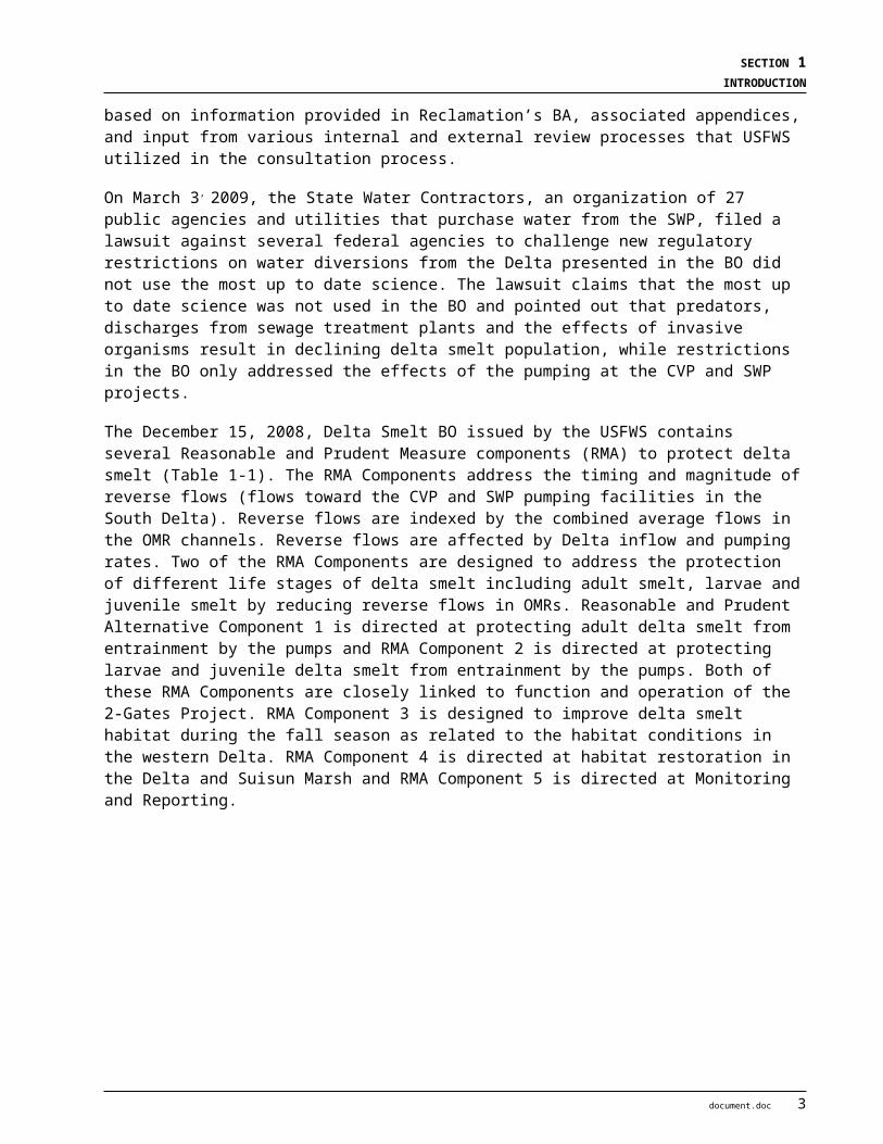
On December 15, 2008, the U.S. Fish and Wildlife Service (USFWS) issued a final biological opinion (BO) in response to Reclamation’s May 16, 2008 request for formal consultation regarding the continued long term operations of the CVP in coordination with the SWP. Reclamation was the lead agency and the California Department of Water Resources (DWR) was the co-applicant for this consultation. A revised BA analyzing the continued long term coordinated operations of the CVP and SWP was provided to the USFWS on August 20, 2008. The December 15, 2008 BO is based on information provided in Reclamation’s BA, associated appendices, and input from various internal and external review processes that USFWS utilized in the consultation process.
On March 3, 2009, the State Water Contractors, an organization of 27 public agencies and utilities that purchase water from the SWP, filed a lawsuit against several federal agencies to challenge new regulatory restrictions on water diversions from the Delta presented in the BO did not use the most up to date science. The lawsuit claims that the most up to date science was not used in the BO and pointed out that predators, discharges from sewage treatment plants and the effects of invasive organisms result in declining delta smelt population, while restrictions in the BO only addressed the effects of the pumping at the CVP and SWP projects.
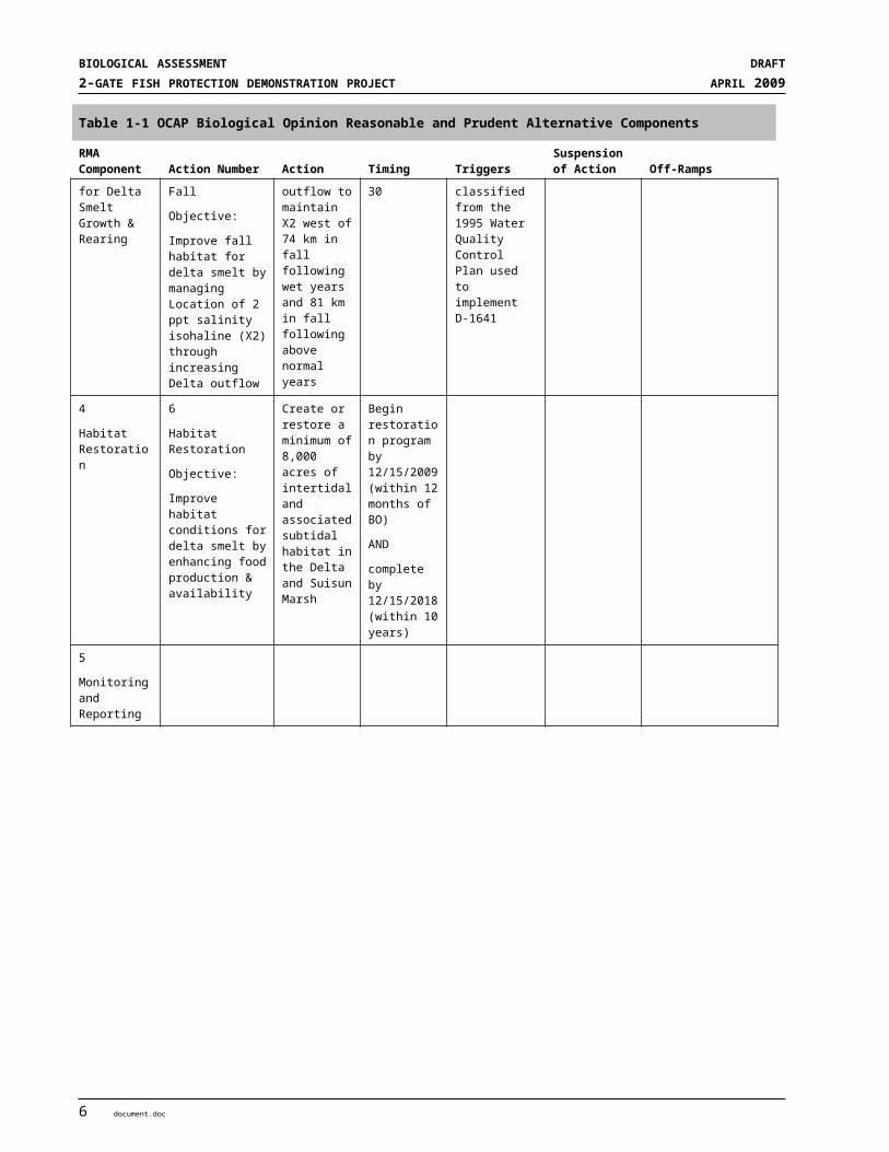
The December 15, 2008, Delta Smelt BO issued by the USFWS contains several Reasonable and Prudent Measure components (RMA) to protect delta smelt (Table 1-1). The RMA Components address the timing and magnitude of reverse flows (flows toward the CVP and SWP pumping facilities in the South Delta). Reverse flows are indexed by the combined average flows in the OMR channels. Reverse flows are affected by Delta inflow and pumping rates. Two of the RMA Components are designed to address the protection of different life stages of delta smelt including adult smelt, larvae and juvenile smelt by reducing reverse flows in OMRs. Reasonable and Prudent Alternative Component 1 is directed at protecting adult delta smelt from entrainment by the pumps and RMA Component 2 is directed at protecting larvae and juvenile delta smelt from entrainment by the pumps. Both of these RMA Components are closely linked to function and operation of the 2-Gates Project. RMA Component 3 is designed to improve delta smelt habitat during the fall season as related to the habitat conditions in the western Delta. RMA Component 4 is directed at habitat restoration in the Delta and Suisun Marsh and RMA Component 5 is directed at Monitoring and Reporting.
2 document.doc

SECTION 1INTRODUCTION
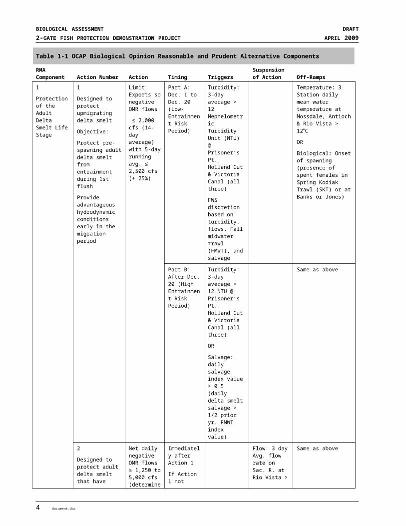
Table 1-1 OCAP Biological Opinion Reasonable and Prudent Alternative Components
RMA Component Action Number Action Timing Triggers
Suspension of Action Off-Ramps
1
Protection of the Adult Delta Smelt Life Stage
1
Designed to protect upmigrating delta smelt
Objective:
Protect pre-spawning adult delta smelt from entrainment during 1st flush
Provide advantageous hydrodynamic conditions early in the migration period
Limit Exports so negative OMR flows
≤ 2,000 cfs (14-day average) with 5-day running avg. ≤ 2,500 cfs (+ 25%)
Part A: Dec. 1 to Dec. 20 (Low-Entrainment Risk Period)
Turbidity: 3-day average > 12 Nephelometric Turbidity Unit (NTU) @ Prisoner’s Pt., Holland Cut & Victoria Canal (all three)
FWS discretion based on turbidity, flows, Fall midwater trawl (FMWT), and salvage
Temperature: 3 Station daily mean water temperature at Mossdale, Antioch & Rio Vista > 12oC
OR
Biological: Onset of spawning (presence of spent females in Spring Kodiak Trawl (SKT) or at Banks or Jones)
Part B: After Dec. 20 (High Entrainment Risk Period)
Turbidity: 3-day average > 12 NTU @ Prisoner’s Pt., Holland Cut & Victoria Canal (all three)
OR
Salvage: daily salvage index value > 0.5 (daily delta smelt salvage > 1/2 prior yr. FMWT index value)
Same as above
2
Designed to protect adult delta smelt that have migrated upstream and are residing in the Delta prior to spawning
Objective:
Same as action 1 above
Net daily negative OMR flows ≥ 1,250 to 5,000 cfs (determined by Smelt Working Group (SWG))
Immediately after Action 1
If Action 1 not implemented, SWG will determine start date
Flow: 3 day Avg. flow rate on Sac. R. at Rio Vista > 9,000 cfs
AND
on San Joaquin R. at Vernalis > 10,000 cfs
Same as above
document.doc 3
BIOLOGICAL ASSESSMENT DRAFT2-GATE FISH PROTECTION DEMONSTRATION PROJECT APRIL 2009
Table 1-1 OCAP Biological Opinion Reasonable and Prudent Alternative Components
RMA Component Action Number Action Timing Triggers
Suspension of Action Off-Ramps
2
Protection of Larval & Juvenile Delta Smelt
3
Entrainment protection of larval smelt
Objective:
Minimize the number of larval delta smelt entrained at the CVP/SWP facilities
Net daily negative OMR flows
≥ -1,250 to -5,000 cfs based on a 14-day running avg. with 5-day running avg. + 25% of required OMR
Initiate action when triggers met
Temperature: 3 Station daily mean water temperature at Mossdale, Antioch & Rio Vista > 12oC
OR
Biological: Onset of spawning (presence of spent females in SKT or at Banks or Jones
Temporal: June 30
OR
Temperature: daily average of 25oC for 3 consecutive days @ Clifton Court Forebay
5
Temporary Spring Head of Old River Barrier (HORB) & Temporary Barrier Project (TBP)
Objective:
Minimize entrainment of larval & juvenile delta smelt at the CVP/SWP facilities
Do not install HORB if delta smelt is a concern. Operate TBP as described in project description
If HORB installed (no smelt concerns) tie open TBP flap gates
Spring (varies depending on conditions)
When PTM results show entrainment levels of delta smelt increase
> 1% at station 815 as a result of installation of HORB
If Action 3 ends or May 15, whichever comes first
3
Improve Habitat for Delta Smelt Growth & Rearing
4
Estuarine Habitat During Fall
Objective:
Improve fall habitat for delta smelt by managing Location of 2 ppt salinity isohaline (X2) through increasing Delta outflow
Provide sufficient Delta outflow to maintain X2 west of 74 km in fall following wet years and 81 km in fall following above normal years
September 1 to November 30
Wet & above normal water years classified from the 1995 Water Quality Control Plan used to implement D-1641
4
Habitat Restoration
6
Habitat Restoration
Objective:
Improve habitat conditions for delta smelt by enhancing food production & availability
Create or restore a minimum of 8,000 acres of intertidal and associated subtidal habitat in the Delta and Suisun Marsh
Begin restoration program by 12/15/2009 (within 12 months of BO)
AND
complete by 12/15/2018 (within 10 years)
5
Monitoring and Reporting
4 document.doc

SECTION 1INTRODUCTION
1.1.2 State Listed Species On February 20, 2008, the California Fish and Game Commission issued an emergency regulation pursuant to the Fish and Game Code Section 2084 authorizing take of longfin smelt by the SWP and also imposing restrictions on the SWP under certain conditions for the purpose of protecting longfin smelt as noted in the California Code of Regulations, Title 14, § 749.3. Issuance of the emergency regulation followed a decision by the Commission to designate the longfin smelt as a candidate for listing under the California ESA. The emergency regulation requires DWR to modify operations of the SWP to meet prescribed flow ranges in OMRs that are designed to protect delta smelt. On March 4, 2009, the Commission listed the longfin smelt as threatened and changed the State listing status of delta smelt from threatened to endangered.
1.2 BACKGROUNDThrough the CVP and SWP, Reclamation and DWR have collectively built water storage and conveyance facilities in the Central Valley in order to deliver water supplies to water rights holders as well as CVP and SWP water contractors throughout California. A substantial amount of the water exported from the Delta is conveyed by SWP and CVP facilities.
Both Reclamation’s and DWR’s water rights are conditioned by the California State Water Resources Control Board (SWRCB) to protect the beneficial uses1 of water within each respective project and jointly for the protection of beneficial uses in the Sacramento Valley and the Sacramento-San Joaquin Delta Estuary. The Coordinated Operations Agreement was signed in 1986 and defines the project facilities and their water supplies, sets forth procedures for coordination of operations, identifies formulas for sharing joint responsibilities for meeting Delta standards, as the standards existed in the SWRCB Water Rights Decision 1485, and other legal uses of water, identifies how unstored flow will be shared, sets up a framework for exchange of water and services between the two projects, and provides for periodic review of the Agreement. Additional water management restrictions are included in the SWRCB Water Rights Decision 1641 and in other permits, decisions, and biological opinions.
The SWP is operated to provide flood control and water supply for agricultural, municipal, industrial, recreational, and environmental purposes. The DWR has SWRCB permits and licenses to appropriate and divert (or redivert) water for the SWP. Water is stored in Oroville Reservoir, on the Feather River, and released to three Upper Feather River area contractors, two contractors served by the North Bay Aqueduct, and the State’s Harvey O. Banks Pumping Plant in the south Delta, near Tracy, California, after which it is delivered to the remaining 24 contractors in the SWP service areas south of the Delta. In addition, the Banks Pumping Plant pumps water from other sources entering the Delta (i.e., the Sacramento River, San Joaquin River, and Mokelumne River). The current operations of SWP reservoirs, pumping plants, and aqueducts vary throughout the year based on changing hydrologic and environmental factors, as well as regulations and agreements governing the operation of the Project.
The CVP is operated by Reclamation and includes several large storage reservoirs, associated hydroelectric plants, and pumping plants, including the C. W. “Bill” Jones Pumping Plant in the south Delta near Tracy. The CVP’s major storage facilities are Shasta, Trinity, Whiskytown, Folsom, New Melones, and Millerton. The upstream reservoirs release water to provide water for the Delta, of which a portion is exported through the Jones Pumping Plant for storage in San Luis Reservoir and its associated O’Neal Forebay, in the western San Joaquin Valley, or delivered down the Delta Mendota Canal to water contractors south of the Delta. Both
1 A water quality control plan must establish beneficial uses. (Wat. Code § 13050(j)) Beneficial uses serve as a basis for establishing water quality objectives. The beneficial uses to be protected were established in the 1978 Delta Plan and the 1991 Bay-Delta Plan and no subsequent requests were made to change the beneficial uses so these uses are carried over into the current plan. The beneficial uses protected by this plan are: Municipal and Domestic Supply; Industrial Service Supply; Industrial Process Supply; Agricultural Supply; Ground Water Recharge; Navigation; Water Contact and Non-Contact Water Recreation; Shellfish Harvesting; Commercial and Sportfishing; Warm Freshwater Habitat; Cold Freshwater Habitat; Migration of Aquatic Organisms; Spawning, Reproduction, and/or Early Development; Estuarine Habitat; Wildlife Habitat; and Rare, Threatened, or Endangered Species.
document.doc 5
BIOLOGICAL ASSESSMENT DRAFT2-GATE FISH PROTECTION DEMONSTRATION PROJECT APRIL 2009
the CVP and the SWP use the San Luis Reservoir, O'Neill Forebay, and more than 100 miles of the California Aqueduct and its related pumping and generating facilities to store and convey water to contractors south of the Delta.
Many factors individually or in combination influence the movement of delta smelt into the south Delta toward the State and federal water export pumps. This movement can be influenced by Delta inflow, tidal flows, pumping at the CVP and SWP south Delta facilities, channel geometry and connections of Franks Tract, Old River and Middle River, along with salinity, temperature and turbidity gradients. The southward movement of water, influenced significantly by pumping at the CVP and SWP water export facilities, makes these sensitive fish more vulnerable to entrainment and increases the risk to the long term survival of the species. Delta smelt is currently a federally listed threatened species, although, the USFWS is considering a petition to change its status to endangered. The California Department of Fish and Game changed the status of delta smelt to endangered on March 4, 2009.
1.3 CONTENTS AND ORGANIZATION OF THE BIOLOGICAL ASSESSMENTTogether, Reclamation and DWR have the responsibility for the scope, content, and adequacy of this BA. The species addressed in the following sections were evaluated in accordance with the federal ESA guidelines. This BA follows a structure similar to a BO and includes appendices which provide more details on the models used to evaluate the effects as well as an operations plan that incorporates RMAs from the December 15, 2008, Delta Smelt BO. The appendices also include a monitoring plan developed to evaluate the effects of the Project on delta smelt and the other listed species.
This BA is organized as follows:
Section 1. Introduces the Project and the purpose of the BA.
Section 2. Describes the purpose and need for the Project, its objectives, project description including the location and Action Area, construction details and schedule, operations and monitoring, protective measures for listed species, and mitigation measures incorporated as part of the Project.
Section 3. Describes the covered species status in the ESU, the region and in the Action Area.
Section 4. Provides an environmental baseline identifying the environmental and regulatory setting.
Section 5. Effects Analysis - Describes the approach to the analysis, what models were used, and how models were used to evaluate the operation of the Project and describes methods used to make the effects determinations for each species.
Section 6. Cumulative Effects Section - Lists other non-federal projects that may affect listed species in the Action Area.
Section 7. Summary and Conclusion Section - Discusses the overall effects of cumulative effects and project actions.
Section 8. Essential Fish Habitat - Provides an analysis of Essential Fish Habitat affected by the Project
Section 9. References – Provides detailed references cited in this document.
Appendices. Provides supporting materials for the BA including the operations plan, monitoring plan, models used in the analysis, modeling results, and designs for the sites.
6 document.doc
S E C T I O N 2
Project Purpose and Description
2.1 PURPOSE OF AND NEED FOR THE PROPOSED PROJECT
2.1.1 Purpose of the Project The 2-Gates Project is intended to provide temporary, cost-effective, immediate protection to delta smelt and other sensitive aquatic species from entrainment in State Water Project (SWP) and Central Valley Project (CVP) facilities. It also is designed and planned to have the flexibility to be operated to test alternative water management and fish protection strategies. The environmental monitoring component is designed to provide the environmental and habitat information predictive of delta smelt distribution, upon which to base timely gate operational decisions and to acquire related information on aquatic ecosystem health.
The 2-Gates Project could be used to support future decision-making regarding the installation of more permanent operable gates for the protection of aquatic resources in the Delta. Should such a permanent project be implemented in the future, it would be subject to separate environmental review and permitting that would evaluate pertinent information collected from operation of the 2-Gates Project. The 2-Gates Project has independent utility and is not dependent upon the implementation of a longer-term plan, including the BDCP. It provides no long-term commitments to permitting or constructing a permanent gate structures in Old River and Connection Slough. The 2-Gates Project is removable if required once the demonstration phase ends
2.1.2 Need for the Project In light of the current environmental conditions in the Delta, the population declines in estuarine and anadromous fish in the Sacramento-San Joaquin River watershed, and the needs of water users dependent on the waters native to the watershed, the water agencies that rely on the CVP and SWP are proposing ways to meet the water needs of their customers while seeking ways to provide additional benefits to the environment and species using the Delta. In addition to the water resource management controls described in SWRCB Water Right Decisions 1485 and 1641 (D-1485 and D-1641), the published U.S. Fish and Wildlife Service (USFWS) OCAP Biological Opinion restricts CVP and SWP pumping from December through June and in the fall in an attempt to minimize entrainment of delta smelt from the central Delta (USFWS 2008a). Depending on the level of pumping allowed, water supply impacts can be severe. .
2.2 PROJECT OBJECTIVESThe 2-Gates Project objectives are as follows:
Achieve equivalent or reduced entrainment of delta smelt compared to OCAP BO RPA restrictions while providing SWP and CVP water supply benefits.
Collect and evaluate data needed to determine whether it would be beneficial to install permanent operable gates to achieve project purposes over a longer time period.
document.doc 1

BIOLOGICAL ASSESSMENT DRAFT2-GATE FISH PROTECTION DEMONSTRATION PROJECT APRIL 2009
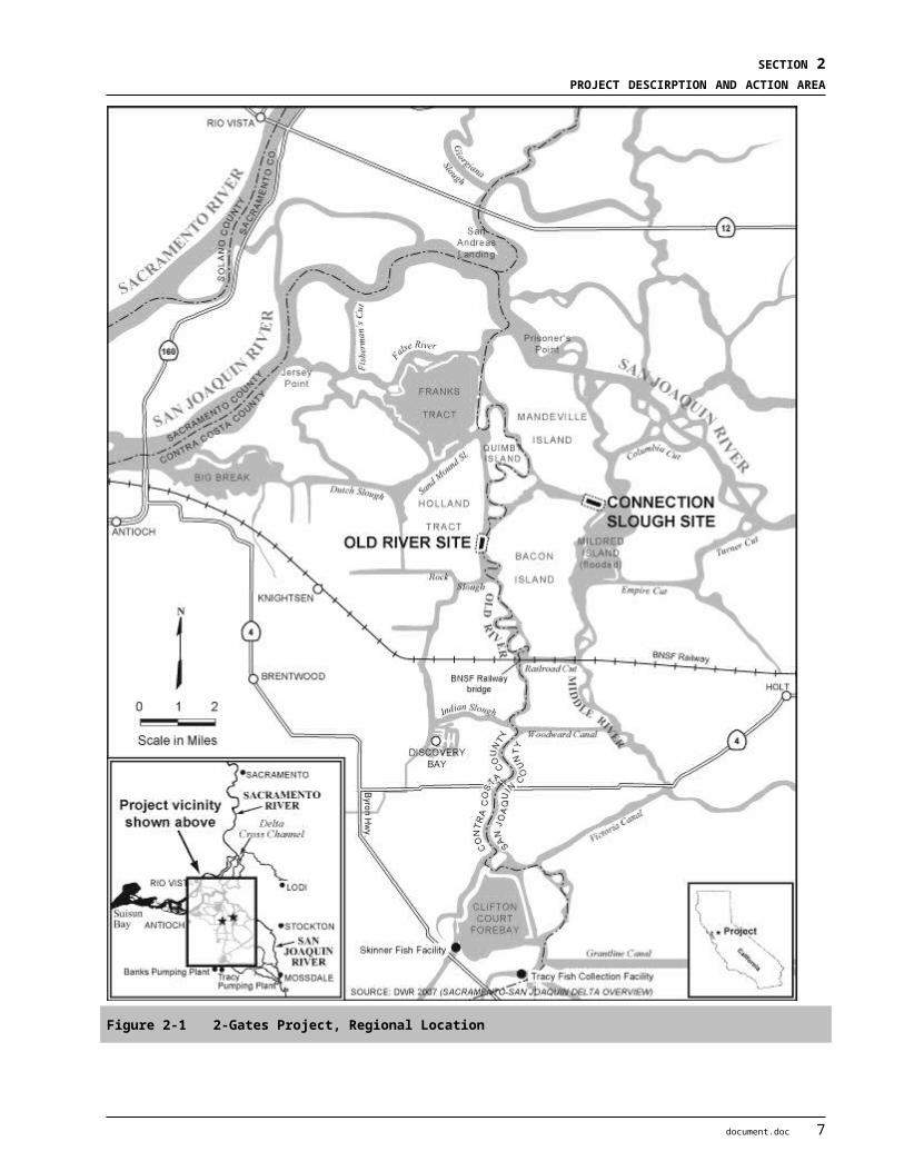
2.3 PROJECT LOCATION AND ACTION AREAThe Old River and Connection Slough sites are located in the central Delta, approximately 13 and 16 miles northwest of Stockton, and 4.8 and 6.8 miles north and northwest of Discovery Bay, respectively. The nearest developed areas are located in the City of Oakley, about 2.4 miles west of the Old River site. The regional location is shown in Figure 2-1, and a more detailed view of the area surrounding the Project sites is shown in Figure 2-2. The Contra Costa County-San Joaquin County boundary is formed by the Old River; therefore, Project construction at this site will occur in both counties. The Connection Slough site is located entirely in San Joaquin County. As shown on Figure 2-2, the Old River site is located on Old River between Holland Tract and Bacon Island, about 3 miles south of Franks Tract and about 1 mile north of the confluence of Old River and Rock Slough. The Connection Slough site is located about 3.5 miles southeast of Franks Tract between Mandeville Island and Bacon Island and between Middle River and Little Mandeville Island.
The Action Area for the 2-Gates Project is described separately for aquatic species and terrestrial species because of the different nature of the impacts to the Delta channels compared to the physical sites supporting the gate structure and construction activities. For aquatic species the Action Area includes the in-channel sites where construction will take place, as well as an extensive area of the central and south Delta where changes would occur to channel flows (direction, magnitude, and/or duration) as a result of gate installation and operation. The Action Area of the Delta for the 2-Gates Project includes the San Joaquin River channel between Dutch Slough and Turner Cut and all interconnected tidal channels from this section of the San Joaquin River to the south Delta State and Federal pumping plants, including Old and Middle Rivers, Turner Cut, Columbia Cut, Empire Cut, Mildred Island, Rock Slough, Franks Tract, Sand Mound Slough, Indian Slough, Railroad Cut, and Woodward and Victoria Canals. Not included in the Action Area is Middle River upstream of Victoria Canal or Old River and the Grantline Canal upstream of Clifton Court (Figure 2-3).
For terrestrial species the Action Area is defined as the Project sites needed for construction, laydown, storage and dredge spoil disposal and associated access routes between existing public roadways and these sites on Holland Tract, Bacon and Mandeville Islands and the levee sections adjacent to Old River and Connection Slough that will support the gate structures and operations (Figure 2-3).
2.4 PROJECT DESCRIPTION
2.4.1 Overview The 2-Gates Project is a temporary and cost-effective project that is intended to immediately improve Delta water management activities for the benefit of delta smelt and other listed species. The Project increases the certainty of critical water supplies from the Delta and includes a monitoring component that would allow the effectiveness of the gate system to be evaluated.
The 2-Gates Project provides a means of controlling the combined flows in Old and Middle Rivers (OMR) in order to help reduce the entrainment of fish from the western and central Delta at the export facilities. This will be accomplished by the installation of temporary “butterfly gates” in Old River and Connection Slough and operation of those gates when turbidity and salinity conditions are expected to support upstream movement of delta smelt. Changes to the movement of water and the timing of water movement were evaluated using the “Delta Simulation Model II” (DSM2)2 its associated modules and post processing applications. Overall, the results from the DSM2-related models indicate that under certain hydrologic conditions (including all normally expected OMR flows) when sensitive fish are located north and west of the 2 DSM2 models calculate stages, flows, velocities in channel segments in the Delta and is the basis for many post processed models that
calculate water quality parameters and the movement of individual particles. Detailed descriptions of this model are available at http://baydeltaoffice.water.ca.gov/modeling/deltamodeling/models/dsm2/dsm2.cfm.
2 document.doc
SECTION 2PROJECT DESCIRPTION AND ACTION AREA
2-Gates Project facilities, the gates would be effective at reducing entrainment of delta smelt, plankton, and other weak swimming fish from the western and central Delta by the export facilities in the southern Delta (model results are included in Appendices C, D, E, and F). Preliminary results from the newly developed adult delta smelt behavioral model applications further indicate that distribution and density of adult delta smelt can be modified to reduce the potential entrainment at the CVP and SWP facilities with the pumping restrictions from the OCAP BO (USFWS 2008) and the Project. Keeping adult delta smelt away from the south Delta reduces potential entrainment of larval and juvenile smelt. Gate operations also enhance the ability to reduce this entrainment. This would enhance delta smelt populations in the western and central Delta while allowing for the export of water to meet critical water needs.
Monitoring data will be used to verify the model information which indicates that operable gates in Old River and Connection Slough near Franks Tract can be used to provide additional protection from entrainment for delta smelt without adversely affecting Chinook salmon, steelhead, green sturgeon, and longfin smelt or designated Critical Habitat. The Project further will be monitored to verify that operable gates can improve water quality and allow for altered flow rates and pumping levels while reducing the movement of delta smelt from the lower San Joaquin River to the south Delta. The Project will make real-time adjustments to operations to reduce delta smelt entrainment while minimizing and avoiding impacts on listed anadromous species and longfin smelt. It also provides the ability to adjust operations based on changing conditions in the Delta, including changes associated with CVP and SWP operations.
2.4.2 2-Gates Concept The Project involves the installation and operation of gate structures mounted on commercially available cargo barges. Barges are fitted with top-mounted butterfly gates and keyed into sheetpile dikes. Pre-installed sheet pile abutment panels will be attached to the ends of the barges. The converted barges will be floated to the sites and ballasted to the prepared sites on the river bottom. Prior to the installation of the barge-mounted gate system, the channel bottom will be dredged to remove unstable peat material, and a gravel sub-base foundation will be installed. The barges will be cleaned prior to their placement in the channels, and residual oils, lubricants, and other contaminants will be removed. At each site a combination of sheet piles and/or rock will be used to secure the barge in place, and sheet pile dikes will be used to connect the structure to the adjacent levees.
A plan view of the design at both the Old River and Connection Slough sites is shown on Figures 2-4 and Figure 2-5 respectively. A conceptual view of the Old River operational gate system showing gates opened and closed is shown in Figure 2-6. For detailed project design plan views, cross-sections, and layouts see Appendices F and G for the Old River and Connection Slough Sites, respectively.
The gates will be installed at two sites: one in Old River and one in Connection Slough. At Old River, which is approximately 800 feet wide at the Project site, about 300 feet of sheet pile dike will be placed at both ends of the approximately 200-foot long grounded barge, extending to the adjacent levees. At Connection Slough, which is approximately 400 feet wide at the Project site, about 100 feet of sheet piles will be placed at both ends of the approximately 180 foot long grounded barge to anchor it to the river banks. The sheet pile wall will extend into the levees on both sides of the channel. At each end of each sheet pile wall a 50 foot perpendicular sheet pile dike will be installed into levees for approximately 25 feet on either side of the wall. Gate barges will be constructed offsite and floated to their respective project sites and sunk to a prepared foundation. Barges will be locked in place with large rock (lock rock).
Installation of the 2-Gates Project facilities would occur in the summer and fall of 2009 during the window for in-channel activities (which ends November 30th. From 2010 through 2014, the barge-gate system and sheet pile dikes would remain in place from late 2009 through 2014.Gate structures would be removed in July 2014. Barges and rock would be removed down to the bed elevation, sheet pile walls, king piles and boat
document.doc 3

BIOLOGICAL ASSESSMENT DRAFT2-GATE FISH PROTECTION DEMONSTRATION PROJECT APRIL 2009
ramps would also be removed along with any structure and ramps on the levees. Site restoration would then occur.
Under normal water conditions, the gates will not be submerged completely because the gate frames rise above the gates and will be visible under all tide stages. All in-channel structures will be designed to withstand over-topping during major flood events. The gates will be open during flood events and thus will accommodate 100-year flood flows with an approximately 0.1-foot change in flood stage elevation compared to the no-action condition. The gates are designed to operate up to a 3-foot maximum surface water differential elevation on either side of the gates, however because of velocity transients will only be operated up to a differential of 1.5 feet. When open, the Old River gates will provide a 75-foot wide navigation opening to accommodate commercial and large private vessel traffic typical for these locations and the Connection Slough gate will provide a 60-foot opening. Both gates will include boat ramps to provide passage for smaller recreational boats (a maximum of 24 feet and 10,000 pounds) when the gates are closed. It is anticipated that the gates will be open a large percentage of the time, which will limit the need to use the boat ramps.
2.4.2.1 Gate DesignAt each site, two approximately 85-foot long butterfly gates will be mounted on a steel barge and ballasted into place on a prepared bed in the channel. The barge will be further held by rock fill placed along each side of the barge to provide additional resistance to lateral forces from tidal flows.
The double butterfly gate design consists of gates that are supported on a center pivot to allow vessels to pass through the gates when open. The 75-foot navigation opening is consistent with the navigation opening provided at the BNSF Railway Bridge, which is just south of the Old River site, for traffic on this river reach. The gate top elevation will be +8 feet, and the pipe frame supporting the gates will be at +12 feet. The top of the sheet pile dikes will be +6.6 feet and the top of the levees are set at 10.5 feet. The gate sill (barge deck) elevation will be at -13 feet. An operator house will be constructed on the gate barges and will be manned by the gate operator, who will open and close the gates in response to fish protection criteria as well as to accommodate passage of commercial vessels and large recreational boats. The operator will coordinate the operations necessary for passage of small recreational boats using the levee boat ramps when the gates are not otherwise open or open for approved large vessel traffic.
2.4.2.2 Gate StructuresThe barge supporting the gates are expected to be approximately 200 feet long and 50 feet wide at the Old River Site and 180 feet by 50 feet at the Connection Slough Site, but their size may be changed as design/value engineering of the structure progresses, and actual available barges are identified and procured. The gate barge will be approximately 12 feet high and designed with abutments to join the sheet pile dike at both ends. Barges will be sunk onto a prepared foundation at each gate location. The foundation will be prepared by dredging approximately 20 feet of peat beneath the foot print of the barge and refilling it with crushed rock.
4 document.doc

SECTION 2PROJECT DESCIRPTION AND ACTION AREA
Figure 2-1 2-Gates Project, Regional Location
document.doc 5
BIOLOGICAL ASSESSMENT DRAFT2-GATE FISH PROTECTION DEMONSTRATION PROJECT APRIL 2009
Figure 2-2 2-Gates Project, Project Vicinity with Construction Access
6 document.doc

SECTION 2PROJECT DESCIRPTION AND ACTION AREA
Figure 2-3 Aquatic and Terrestrial Action Areas for Biological Assessment
document.doc 7

BIOLOGICAL ASSESSMENT DRAFT2-GATE FISH PROTECTION DEMONSTRATION PROJECT APRIL 2009
Figure 2-4 Old River Site Plan View
8 document.doc

SECTION 2PROJECT DESCIRPTION AND ACTION AREA
Figure 2-5 Connection Slough Site Plan View
document.doc 9

BIOLOGICAL ASSESSMENT DRAFT2-GATE FISH PROTECTION DEMONSTRATION PROJECT APRIL 2009
Figure 2-6 Old River Slough Site Conceptual View Showing Gates Closed and Open
10 document.doc

SECTION 2PROJECT DESCIRPTION AND ACTION AREA
2.4.2.3 Sheet Pile WallA sheet pile wall will be placed between the gate structure and the levee. No excavation of the peat is needed between the gate and the levee for sheet pile wall placement. Preliminary analysis has been performed to check the required depth of embedment and estimate the strength criteria for the sheet piles acting as the dam between the gate structure and the levee. Based on this analysis, sheet piles in lengths of 60 to 70 feet will be required to be driven approximately 30 feet into the underlying sand layer. To complete the sheet pile wall, the sheet piles will be supported by 36-inch diameter king piles, set on approximately 20-foot centers at both locations.
The sheet pile wall will tie into the levee and will require removal of a strip of existing levee slope protection material. At the gate barge end, a special end piece fabrication will be required to facilitate barge placement tolerances. The sheet pile wall can be constructed without displacing existing river bed peat material, thus minimizing the risk of seepage through the existing levees and the need for constructing cut-off walls within the existing levees.
2.4.2.4 Boat RampsBoat ramps (and associated small boat trailers and trucks) are provided to facilitate portage of small boats around the closed gates. Two pile-supported boat ramps will straddle the sheet pile walls at each of the two sites. The ramps will be elevated with piles and grated plates for launching and retrieving boats by the gate operator. Boarding floats will be provided alongside the ramps to facilitate staging of the boat launch and retrieval operation. The width of the levee will be increased to provide sufficient maneuvering space to accommodate launching and retrieving boats.
2.4.2.5 Mechanical and Electrical ComponentsThe barge design will incorporate the piping and valves necessary for ballasting and de-ballasting operations, thus allowing the barge to be removed if necessary. The pumps, compressors, and generators for this operation will be provided on a separate construction support barge. Once the barge is submerged, the construction support barge will be removed until it is needed to lift the barge out of the water.
The electrical system will be powered by electric power from Pacific Gas & Electric (PG&E), using the nearby power line at each site, or pending the PG&E interconnection; a skid-mounted diesel generator located on an upland area next to the existing levee will be used. The generator skid will be a self contained system with generator, diesel engine, starter batteries, fuel tank, etc. Should the system need to run continuously for an extended period of time, an additional fuel tank skid with fuel pump could be required.
Cabling will transmit the electrical power from the PG&E pole or the generator to the operator house. The operator will use levers on the control console to open and close the gates. The operator house will include outlets, fluorescent lights, and a wall-mounted heating, ventilating, and air-conditioning unit. The operator will control three sets of flood lights, allowing the eastern and western gates and boat ramp to be illuminated. Channel marker lights will be U.S. Coast Guard (USCG) approved.
Power for construction operations during the installation of the facilities will be from stand alone generators at each Project site. Temporary power for construction is anticipated only for land based welding or small winches or hoists to position barrier sheet elements. Most if not all welding and sheet pile placement is anticipated to be from a waterside barge.
document.doc 11
BIOLOGICAL ASSESSMENT DRAFT2-GATE FISH PROTECTION DEMONSTRATION PROJECT APRIL 2009
2.4.2.6 Navigation MarkersSignage will comply with navigation requirements established by the U.S. Aids to Navigation System and the California Waterway Marker system as appropriate. A boat safety exclusion zone will be established to keep small boats clear of the closed gates in case gates begin to open, both to avoid gate swing and potential rapid changes in water velocity. A safety exclusion zone should also keep small boats clear of the upstream side of the barrier during floods when the barrier is spilling and boats could be swept over the barrier. Channel markers also will be installed to indicate that the center opening (between the gate pivot posts) is the only navigable opening in the structure, and the side openings are not to be used.
2.4.2.7 Fender SystemA fender system will provide protection to the gate structure resulting from potential vessel impact. The fenders will consist of six steel mono-pile dolphins constructed at each site. Three fenders will be placed at the sides of the navigation channel on the upstream and on the downstream approaches to the gates approximately 40 feet from the face of the barge. Vessel and recreational boating traffic intending to pass through the gates would enter the channel aligned with the gate opening and would not change direction until it has passed through the gate structure.
2.4.3 Project Construction Construction of the gate structures includes installation of sheet pile dikes, dredging of the barge foundations, sealing the foundation from seepage, and refilling them with crushed rock. Following these steps, the sequence of events entails sinking the barges to the foundations, keying them into the sheet pile walls, and adding rock at each end of the barge, and on the sides of the barge to the lock the barge in place. Boat ramps will be constructed at each site and the existing levees will be widened to accommodate activities at the boat ramps. The prefabricated gate barge structures will be fabricated offsite and will be towed to the designated locations at Old River and Connection Slough.
The sheet pile wall sections to complete the barrier will then be installed, and the center pivot butterfly gates made operational. The Project will mostly be built from the water using barges and other vessels within the river channels. Materials will be brought to the site by barges. Some construction also will take place from the levees. For example, boat ramps will be constructed on one adjacent levee at each gate site. The boat ramps will intersect with the existing levee roads and will require a widening of the levee area to facilitate movement of the boats up one ramp and down the other. The boat ramps will be supported by piles and will be tied into the levee road.
The proposed design includes rock fill for the barge foundation and large rock for tie-in to the sheet pile dike. The preliminary geotechnical assessment concludes that the peat should be excavated from beneath the barge-gate foundation to increase the stability of the structure. A total of about 12,500 cubic yards of material will be dredged from Old River and Connection Slough.
2.4.3.1 Dredging and Rock PlacementBased on the geotechnical investigation, the weak peat material will be removed for the gate barge foundation by a barge-mounted clamshell dredge. Foundation preparation for the gate barge consists of dredging peat material estimated at 5,500 cubic yards for Connection Slough and 7,000 cubic yards for Old River from the bed of Old River and Connection Slough to the top of the underlying compact sand layer (believed to be at about elevation -32’ at both sites). Seepage mats will be used where the peat layer is removed to control possible increased seepage through the channel bed to the adjacent islands.
12 document.doc

SECTION 2PROJECT DESCIRPTION AND ACTION AREA
Dredged material will be disposed of locally on Bacon Island near the junction of Middle River and Connection Slough (Figure 2-2). Dredge material from the Connection Slough site can be sidecast over the levee. Material from Old River would need to be placed on a barge, moved to the disposal area then off loaded over the levee at the Bacon Island site. The disposal area will be surrounded by a low berm in order to contain any runoff. Disposal of the 12,500 cubic yards of material will require about 2.5 to 3 acres. A roughly 240-foot long by 65-foot wide support mat will be needed for the gate barge. The support mat or foundation will be roughly 5 feet thick. The foundation will contain two elements the bottom layer is constructed of impermeable material to serve as a seepage barrier and will be topped with a layer of crushed rock to an elevation of -25 feet, which will be graded flat for bedding the gate barge. It is anticipated that dredging and rock placement will require five weeks in September-October 2009.
While not anticipated to be required, removal of the peat material from the barge foundation area may require additional sheet pile installation near the outside ends of the excavated areas closest to and parallel with the levees. It is currently anticipated that the additional sheet piles will be installed as a precaution to mitigate any potential seepage. These can be eliminated during construction should peat excavation not result in seepage.
2.4.3.2 Sheet Pile WallsA sheet pile wall will be constructed at each site. Sheet piles in lengths of 60 to 70 feet will be required to be driven through the peat and approximately 30 feet into the underlying sand layer. The sheet piles will be supported by 36-inch diameter king piles, set on approximately 20-foot centers across the channel at both locations. Sheet piles and king piles will be installed using vibration driving techniques.
The sheet pile dike will tie into the levee and will require removal of vegetation and riprap along a 75 foot length of levee on each side of each site. At each levee end of the sheet pile wall, a 50 foot long length of sheet piles will be perpendicular to and tied into the sheet pile wall and will run parallel the levee.
2.4.3.3 Gate Barge Construction and InstallationAssembly and fabrication of the gate structures, and electrical and mechanical installation will be carried out in Rio Vista by the contractor. Prior to gate barge arrival at the site, sheet pile installation, dredging work and seepage barrier mat and bedding rock placement will have been completed. Guide piles may be installed to help position the barge during the ballasting / grounding procedure, but these piles will be removed once the barge is in place.
The gate barge for the Connection Slough Site will be delivered first according to the contractor’s schedule and will be ballasted into place. Fendering dolphins will then be installed, and rock fill work will begin. The same sequence will then be repeated for the Old River site. The estimated installation time for the barges is estimated to take two weeks.
2.4.3.4 LeveesThe levees will be bolstered on either side of the gates for a distance of approximately 50 feet using sheet piles and rock consistent with the agreement of Reclamation District 2025 associated with Holland Tract, Reclamation District 2028 associated with Bacon Island and Reclamation District 2027 associated with Mandeville Island.
document.doc 13
BIOLOGICAL ASSESSMENT DRAFT2-GATE FISH PROTECTION DEMONSTRATION PROJECT APRIL 2009
2.4.3.5 Laydown and Construction Support AreasAreas on Bacon Island and Holland Tract adjacent to the Old River gate site (measuring approximately 600 feet by 100 feet) have been identified for laydown and construction. Both locations will require clearing, grubbing, and grading per the contactor’s recommendations. Similarly, on Connection Slough, an area on Bacon Island and Mandeville Island adjacent to the Project location (measuring approximately 600 feet by 140 feet) has been identified for laydown and construction.
These areas will include the pile-supported boat ramp estimated to be 80 feet by 40 feet and a 50-foot by 50-foot utility yard. The adjacent construction sites also may be used for storage of materials removed when the gate is deconstructed, pending reuse of the material for gate re-installation.
An area of approximately 12 acres on Holland Tract is available for storage of materials such as rock if significant rock needs to be removed and stored beyond the adjacent construction area prior to reinstallation. It is quite possible the Project would not require a rock storage laydown area since much of the gate is being constructed of sheet piles and the barge foundations will remain in place.
Land areas will be needed for construction of the gate structures, tie-in of the sheet pile walls to sheet piles in the levees, boat ramps, creation of abutments to bolster the levees at the gate locations, and for any other land-side facilities such as parking for construction personnel and operations staff, and generators. Laydown areas will need to include initial staging of rock or sheet pile, as well as vehicles or equipment. Finally, approximately 3 acres of land will be needed for disposal of dredged material. The general geographic areas in which rights are expected to be needed for construction and laydown are shown in Figure 2-2. The offsite rock storage area on Holland Tract and spoil disposal area on the Bacon Island side of Connection Slough as required by Reclamation District 2028 are illustrated in Figures 2-2 and 2-3 and in Appendix F, Sheet C-21 and Appendix G Sheet C-81.
2.4.3.6 AccessMost of the construction (e.g., dredging, placement of rock, and driving sheet pile) will be done from barges. However, it may be necessary to deploy earthmoving equipment on the islands to install levee buttresses. Figure 2-2 shows the access routes that will be needed from public roads to the Project locations. Movement of earthmoving equipment during construction is expected to be limited to the construction/laydown areas shown above. Truck access to the dredged material disposal site will be within the Connection Slough and Old River work areas.
Connection Slough and Old River Project Sites are navigable from the San Joaquin River. The Old River Site is accessible by land from Holland Tract and Bacon Island. The west Old River levee is on Holland Tract and is accessible by road by proceeding through the town of Knightsen and crossing Delta Road Bridge on Delta Road. The Old River project site is then accessed via a private road. The east side Old River Site is accessible via the private West Bacon Island Road approximately 10 miles from State Route (SR) 4 on Bacon Island Road. Part of West Bacon Island Road is an unpaved. The Connection Slough Site can be accessed by Bacon Island Road. The Mandeville Island side of the Connection Slough Site is accessed via a bridge crossing Connection Slough (Figure 2-2).
Any degradation to levee roads, private or maintenance roads and other access roads that result from land based construction equipment use would be restored to pre-construction conditions. For example, it may be necessary to grade and apply gravel to the Holland Tract access road. It may be necessary to grade and gravel the unpaved part of West Bacon Island Road. It may be necessary to pave small sections on the Bacon Island Road between SR 4 and Connection Slough to ensure safe passage of land-based construction equipment.
14 document.doc

SECTION 2PROJECT DESCIRPTION AND ACTION AREA
2.4.3.7 Vessel Passage during ConstructionDuring construction, the contractor will maintain vessel access as needed. Notices of construction will be posted at local marinas and in the Local Notice to Mariners. Navigational markers will be used to prevent boaters from entering the construction area, and speed limits will be posted. Safe vessel passage procedures will be coordinated with the USCG and California Department of Boating and Waterways.
2.4.4 Project Schedule Construction work at the Old River and Connection slough sites can be completed in about seven weeks. It will be scheduled to occur in late summer to fall of 2009 in order to minimize impacts to sensitive aquatic and terrestrial resources as well as to avoid peak recreational use periods (Table 2-1). Site preparation prior to the placement of the barges will require about one month. This includes dredging the foundation areas of the barges, sealing the dredged area from seepage, placing rock in the dredged area, and the installation of sheet pile walls. Placement of the barges will occur at the end of the site preparation period and would require approximately about two weeks to install each barge. Sheet pile installation will most likely be conducted during daylight hours only; dredging would be conducted 24 hours per day, as would rock placement and gate barge installation. Additional construction site details are presented in Appendices F and G.
The Project facilities will be operational immediately upon the completion of construction and will be operational beginning in December 2009. Gates would be operated between December and June from 2009 to 2014. Gate structures including sheet pile walls will remain in place with gates in an open position from July through November of each year. Gate structures will be removed in July 2014.
Table 2-1 2-Gates Project Construction Timing and Duration
Construction Activity Construction Timing Construction DurationConstruction of sheet pile wall, dredging, installation of barge foundation rock September/October 2009 Five weeks
Installation of barge with gates and anchor rock November 2009 Two weeks
Removal of barge with gates, barge anchor rock at both sites, and sheet pile walls, boat ramps and structures to the initial channel bed elevation
July 2014 Four weeks
2.4.5 Project Maintenance, Facilities Removal and Site Restoration
2.4.5.1 MaintenanceProject facilities would require limited maintenance to insure operations and would include:
Infrequent fueling and lubrication of emergency generators,
Repair of coatings (e.g. painting) necessary to maintain equipment function, and
Equipment repair essential to maintain Project function.
On-site maintenance would occur on a regular basis through qualified contracting services retained as part of the operational protocols of the Project. Annual maintenance activities would be scheduled to occur during the summer-fall non-operations period.
2.4.5.2 RemovalAt the completion of the five-year demonstration period the barges and all associated facilities would be deballasted and removed from the Project sites. Rock fill would be removed down to the initial channel bed elevation. The rock removed would be removed from the area on barges or transported by trucks to the off-
document.doc 15

BIOLOGICAL ASSESSMENT DRAFT2-GATE FISH PROTECTION DEMONSTRATION PROJECT APRIL 2009
site rock storage area shown in Figure 2-2. All other structures and materials including the boat launching structures will be removed.
2.4.5.3 RestorationLocations adversely affected by the Project would be restored and this includes:
Construction laydown areas,
Land-based utility yards, and
Pile-supported boat ramps.
Restoration activities will be facilitated by siting access routes, laydown areas and structures to avoid sensitive areas (e.g. wetlands) and by limiting the duration of the use of land-based areas. The construction laydown areas will be used only during the associated land-based construction period. The adversely affected areas would be restored to meet local land use and resource agency requirements as soon as it was no longer needed. The pile-supported boat ramps will be removed as soon as they are no longer necessary, and the area below these decks will be restored to meet local land use and resource agency permit conditions.
A restoration plan will be developed, as required by applicable regulatory agencies, and will be completed prior to the onset of construction. The restoration plan will identify areas that will be restored and restoration methods. Seed mixes, schedules, success criteria, and success monitoring for restoration of wetlands, streams, and drainages would be identified. The restoration plan will be included in the contract specifications.
2.5 PROJECT OPERATIONSBased on extensive hydrodynamic and delta smelt behavioral modeling, the 2-Gates Project is designed to be effective at controlling delta smelt entrainment at the south Delta export facilities for a region of the central Delta largely bounded by the San Joaquin River between Dutch Slough and Old River. The concept was developed and refined using extensive hydrodynamic and delta smelt behavioral modeling. The circulation pattern developed by 2-Gates Project operation modeling within this region balances flows in Old and Middle Rivers (OMR flows) by controlling flows into these channels through gate structures in Old River and Connection Slough near Franks Tract. Although these actions are currently the subject of a court challenge, water management actions at the CVP and SWP facilities that are limited by the OCAP BO restrictions provide hydrodynamic conditions to reduce movement of delta smelt from the central Delta into the south Delta. The 2-Gates Project operation complements the OCAP RPA components 1 and 2 to further limit the establishment of water quality conditions in the south Delta used by delta smelt and reduce the entrainment of delta smelt. The Project facilities enhance the isolation of delta smelt from water management operations at the CVP and SWP pumps by balancing negative flows in Old and Middle Rivers.
The coordination of the Project operations and the OMR flow RPA actions develop a balanced flow in the OMR channels that results in limiting movement of delta smelt in these channels toward the pumps. These balanced flow conditions would also largely benefit other pelagic fish as well as outmigrating juvenile salmon and steelhead. Modeling results indicate that the effectiveness of the 2-Gates Project operation is dependent on the distribution of delta smelt, estimated relative abundance, and water quality conditions.
Due to the need for immediate feedback, it is important to incorporate a real-time decision framework that evaluates the best course of action for particular delta smelt distributions, hydrodynamic conditions, and water quality. The 2-Gates Project is designed to work in concert with other operational measures that seek to manage flows on the mainstem San Joaquin River and other channels in the Delta during critical periods in order to maintain the general distribution of adult delta smelt generally within the region of influence of the
16 document.doc
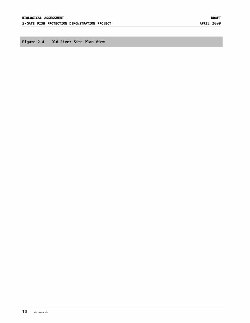
SECTION 2PROJECT DESCIRPTION AND ACTION AREA
Project in the western and central Delta. Control of the adult delta smelt during upstream movement immediately prior to spawning may also control the distribution of larval and juvenile delta smelt.
The control of water movement from the western and central Delta into Old and Middle Rivers, when water quality conditions are expected to support upstream movement of delta smelt, is critical to the avoidance and minimization of entrainment of delta smelt (and other pelagic species) by the export facilities. These water quality conditions (decreased salinity and increased turbidity) are positively correlated with the onset of winter storm and runoff events on the Sacramento and San Joaquin rivers. The operation of the 2-Gates system would reduce or eliminate direct upstream water flow from False River, Old River, and Franks Tract (either by tidal action or from operation of the export facilities) from the western and central Delta. The Project will be operated in consultation with the Smelt Working Group (SWG) and the Water Operations Management Team (WOMT) in a manner that considers salmon movement and that would accommodate the needs of commercial and recreational boaters.
Detailed operational parameters and actions are described in more detail below. Gate operations would occur when smelt distributions are located north and west of the “region of control” of the Project facilities as determined by the Department of Fish and Game (DFG) Spring Kodiak Trawl and 20 mm surveys. More information regarding the key monitoring parameters is provided in Section 2.6 and Appendix C. The principal testing and evaluations are intended to better inform Project operational decisions and future water management operations with regard to the Project:
Can provide better protection to delta smelt when used in conjunction and coordination with protection provided by the OCAP BO operations,
Can maintain the distribution of pre-spawning adult delta smelt generally within the region of influence of the gates. where gate operations, in conjunction with OCAP BO flow restrictions, has been shown to be effective in reducing larvae/juvenile delta smelt entrainment by eliminating the influence of the net reverse flow in Old River near the San Joaquin River, and
Can achieve, under certain hydrologic conditions, reduced export curtailments from that prescribed under OCAP BO operations alone.
2.5.1 Factors Considered in Project Operations
2.5.1.1 Hydrodynamics and Water Quality Factors Affecting Smelt EntrainmentHistorical entrainment of delta smelt at the export facilities has primarily occurred during the period of December through June. The science related to delta smelt movement, behavior, and entrainment is continuing to improve, but the presence of certain water quality conditions in the south Delta and net flow reversals in Old and Middle rivers can be important factors leading to delta smelt entrainment. Adult delta smelt pre-spawning distribution is believed to be strongly related to specific ranges of salinity and turbidity. The recently released OCAP BO (USFWS 2008) identifies supports the linkages between turbidity and delta smelt occurrence. These water quality conditions (electrical conductivity less than 400 µmhos/cm and turbidity greater than 12 nephelometric turbidity units [NTU]) occurs in different parts of the Delta depending on naturally occurring hydrologic conditions and operation of the SWP and CVP facilities. These water quality conditions are sought by pre-spawning delta smelt. Delta smelt seeking these conditions are thought to move into the central Delta by surfing the tides and can remain in these areas of suitable water quality as they are moved about by the tides. However, under certain hydrologic and operating conditions, the water quality conditions can be substantially moved into the central and south Delta due to reversal of flows on the lower San Joaquin River. Actual mechanisms supporting the pre-spawning movement of delta smelt to inland areas are unverified. Under the current configuration of the south Delta, high exports during these times cause net flow reversals of Old and Middle rivers, drawing water with the water quality conditions identified above into
document.doc 17

BIOLOGICAL ASSESSMENT DRAFT2-GATE FISH PROTECTION DEMONSTRATION PROJECT APRIL 2009
the south Delta. These conditions can lead to entrainment of pre-spawning adult delta smelt. In addition, the assumption is that adult delta smelt spawning distribution in the south Delta would likely result in increased risk of entrainment for larval and juvenile delta smelt due to the proximity of the export facilities.
2.5.1.2 Potential Measures for Controlling Delta Smelt EntrainmentSince the current hypotheses describing the mechanisms for delta smelt entrainment relate to either the movement of the water quality conditions into the central and south Delta or the direct transport of the early life stages from this region to the export facilities, management strategies to reduce the risk of delta smelt entrainment should seek to control associated adverse hydrodynamic conditions. The influence of 2-Gates operations in conjunction and coordination with OCAP BO restrictions have been assessed in the modeling analyses that follow.
2.5.2 Operations and Monitoring with Adult Behavioral and Larvae/Juvenile Delta Smelt Models
2.5.2.1 Modeling Process
THEORETICAL BASIS OF RMA MODEL. Resource Management Associates (RMA) has developed and refined models of the Sacramento-San Joaquin Delta system (Delta model) utilizing the RMA finite element models for surface waters (see Appendix D). The RMA models are a generalized hydrodynamic model that is used to compute two-dimensional depth-averaged velocity and water surface elevation (RMA2) and another model (RMA11) is a generalized two-dimensional depth-averaged water quality model that computes a temporal and spatial description of water quality parameters. RMA11 uses stage and velocity results from RMA2. The Delta model extends from Martinez to the confluence of the American and Sacramento Rivers and to Vernalis on the San Joaquin River. Daily average flows in the model are applied for the Sacramento River, Yolo Bypass, San Joaquin River, Cosumnes River, Mokelumne River, and miscellaneous eastside flows which include Calaveras River and other minor flows. The model interpolates between the daily average flows at noon each day. Delta Islands Consumptive Use (DICU) values address channel depletions, infiltration, evaporation, and precipitation, as well as Delta island agricultural use. DICU values are applied on a monthly average basis and were derived from monthly DSM2 input values. Delta exports applied in the model include SWP, CVP, Contra Costa exports at Rock Slough and Old River intakes, and North Bay Aqueduct intake at Barker Slough. Dayflow and IEP database data are used to set daily average export flows for the CVP, North Bay Aqueduct and Contra Costa’s exports. Historical simulations were run for the period between December and July for 1999-2000, 2002-2003, 2003-2004 and 2007-2008 to evaluate how conditions change in the Delta under historical conditions, historical conditions operated under the OCAP RPAs and operated under OCAP RPAs with the Project.
REAL-TIME FORECAST MODELING. Effective real-time forecasting requires knowing initial water quality and flow conditions, acquiring and interpreting delta smelt survey and salvage data, operations forecasts, and timely agency interaction. Forecasts would utilize the most recent field observations of delta smelt distribution and density; and forecasted estimates of inflow, inflow water quality, and operations. For each forecast period, several simulations may be performed using alternative estimates of future conditions. An initial set of forecast simulations would be performed using best estimates of future operations provided by Reclamation and DWR system operators. Upon review of delta smelt distribution and entrainment estimates by the SWG, a second set of forecast simulations may be performed with revised future operations with the objective of identifying operations that reduce expected delta smelt entrainment.
18 document.doc

SECTION 2PROJECT DESCIRPTION AND ACTION AREA
In real-time, an initial set of forecast simulations will be performed using best estimates of future operations provided by Reclamation and DWR system operators. Upon review of delta smelt distribution and entrainment estimates by the SWG, a second set of forecast simulations may be performed with revised future operations with the objective of identifying operations that reduce expected delta smelt entrainment.
2-Gates Operations in Conjunction with OCAP BO Flow Management 2-Gates operations would be conducted in conjunction and coordination with the OCAP BO Old and Middle River RPAs. Flow, salinity, turbidity, and particle forecasting simulations would be performed to forecast timing of the Old River and Connection Slough gate operations consistent with the RPAs. OMR flows restrictions would be achieved primarily through export curtailments.
Since the 2-Gates Project is being proposed as a temporary solution aimed at reducing delta smelt entrainment, it is useful to describe an operating plan that is sufficiently flexible to adapt to real-time monitoring and predictive hydrodynamic, water quality, and delta smelt behavior modeling. DSM2 modeling results have shown that the operational effects of various measures of entrainment are strongly influenced by the initial distribution of delta smelt and relatively short duration adverse hydrodynamic conditions in winter and spring. The following operating measures are described as examples of different operations under changing field conditions.
2.5.2.2 Operation—December through FebruaryThe 2-Gates Project operations are designed to be operated in conjunction with and in coordination with OMR flows prescribed through the U.S. Fish and Wildlife Service’s OCAP Biological Opinion (Biological Opinion). Project operations would take place in consultation with the SWG and the WOMT. The 2-Gate Project operations, in conjunction with OMR restrictions, would be guided by the following two actions:
Old River and Connection Slough Gates would be operated when triggering turbidity concentrations ≥ 12 NTU begin to appear at the region of influence of the 2-Gates, defined here as San Joaquin River at Jersey Point. Hydrodynamic modeling results indicate that the gates would be operated about an hour per day in a closed position, combined with flow balancing to manage the turbidity plume and adult delta smelt distributions, generally within the region of influence of 2-Gates. In this region, behavioral modeling has shown that 2-Gates, in conjunction with OMR flow restrictions is effective in maintaining the turbid conditions linked to pre-spawning movement of delta smelt generally within the region of influence of the gates, thereby reducing the entrainment of delta smelt at the CVP and SWP pumps. These early actions also control the initial distribution of larval and juvenile delta smelt in locations that reduce the probability of entrainment at the CVP and SWP export pumps.
Preemptive management of the turbidity plume and attracted adult delta smelt distributions would be accomplished using 2-Gates operations in conjunction with OMR flow restrictions. The restriction of OMR negative flow rates would be triggered when turbidity ≥ 12 NTU is exceeded at San Joaquin River at Prisoners Point, about a day after 2-Gates operations would be triggered at Jersey Point. These operations would actively manage the turbidity plume further downstream and several days earlier than specified in the OCAP BO RPA (OMR 3-station turbidity trigger). Alternatively, OMR restrictions in conjunction with 2-Gates operations would be tested in conjunction with OMR flows initiated upon the OMR 3-station turbidity trigger. Flexibility would be retained in field demonstrations to test both turbidity triggering options. n addition to OMR restrictions, operational flexibility would be retained in isolated cases to test effects of moderately increased San Joaquin River flow measured by QWEST3 @ San Andreas ≥ 0 cfs. Hydrodynamic modeling indicates that this action would be effective in restricting smelt passage and reducing entrainment in conjunction with the 2-Gates. These operations would be taken until the 3-station daily mean water
3 QWEST, in this case, is the net average daily flow in the San Joaquin River at San Andreas Landing
document.doc 19

BIOLOGICAL ASSESSMENT DRAFT2-GATE FISH PROTECTION DEMONSTRATION PROJECT APRIL 2009
temperatures at Mossdale, Antioch and Rio Vista ≥ 12ºC, signaling a transition from adult to larvae/juvenile delta smelt management actions.
2.5.2.3 Operation—March through JuneGate operations and flow control measures during the adult delta smelt life stage, are expected to maintain the turbidity plume and adult distributions generally in region of influence of the 2-Gates Project. With adult distributions generally in this region, 2-Gate operations in conjunction with OMR restrictions for larvae/juvenile delta smelt have been shown to be effective in significantly reducing entrainment. The 2-Gates operations for larvae/juvenile smelt would take place from March through June except during the Vernalis Adaptive Management Plan (VAMP) period (April 16 – May 15), and the Memorial Day weekend when gates would remain open. These operations would limit entrainment and manage the distribution of larvae/juvenile delta smelt through monitoring of delta smelt densities, spawning areas, and biweekly predictive modeling. 2-Gates operations and OMR restrictions would be governed by the following two actions:
Based on the real-time monitoring of hydrodynamic conditions, 2-Gates operations and OMR restrictions for larvae/juvenile delta smelt would be imposed, in consultation with the SWG and the WOMT, when the 3-station daily mean water temperatures at Mossdale, Antioch and Rio Vista ≥ 12ºC signaling a transition from adult to larvae/juvenile delta smelt management actions.
2-Gate operations and OMR restrictions would take place, consistent with boundary conditions of OMR discretionary operations, until June 30 or until the daily average temperature reaches 25ºC for 3 consecutive days at Clifton Court Forebay.
2.5.2.4 Daily Gate Operations Cycles
Adult Delta Smelt (December through February)To protect migrating and pre-spawning adult delta smelt from December through February, both gates would be operated about an hour per day in the closed position to manage the movement of adult delta smelt habitat (turbidity plume) through the balancing of daily flows generally within the region of influence of the gates.
Larvae/Juvenile Delta Smelt (March through June)To provide added protection to larvae/juvenile delta smelt from March through June, the predominate mode of gate operations would be with the Old River gate closed about 10 hours per day on flood-tide and open on ebb-tides (including slack-tides), during which the Connection Slough gate would be open about 4 hours per day on slack-tides. The gates would remain open during the VAMP period (April 16 – May 15), and on Memorial Day weekend for recreational purposes. However, to retain flexibility during field demonstrations, one or both gates could be operated in the flood-ebb mode, during VAMP if fish migration monitoring allows.
July through November The gates would not be operated from July through November, and would remain in a fully open position.
2.5.2.5 Gate Operation Protocols for Commercial and Recreational Boat Traffic Open-gate periods consistent with 2-Gates operations will be published weekly, posted weekly on the Project Website and posted at local marinas. These periods will also be published through the U.S. Coast Guard Notice to Mariners for commercial and recreational boat traffic.
20 document.doc
SECTION 2PROJECT DESCIRPTION AND ACTION AREA
December – February. The gate opening schedule for commercial and large recreational vessel passage during adult delta smelt gate operations allows both gates in an open position about 23 hours per day, excepting gate closures on one or the other of the high tides.
March – June. The gate opening schedule for commercial and large recreational vessel passage during larvae/juvenile delta smelt gate operations allows gates in an open position about 14 hours per day during ebb-tide (including slack-tides) conditions on Old River, and about 4 hours a day on Connection Slough during slack-tide conditions. Gates would be in an open position on the Memorial Day weekend.
Construction Stage Vessel Passage: During construction, the contractor will maintain vessel access as needed. Notices of construction would be posted at local marinas and in the U.S. Coast Guard Notice to Mariners. Navigational markers would be used to prevent boaters from entering the construction area, and speed limits would be posted. Safe vessel passage procedures would be coordinated with the USCG and California Department of Boating and Waterways.
Small recreational vessels would b allowed to pass through the gates along with the commercial and large recreational vessels. Small recreational vessel would also be allowed to portage around the 2-Gates facilities via the use of the boat ramps and small boat trailer facilities provided. As described above, two pile-supported boat ramps would straddle the sheet pile walls at each of the two sites. Ramps would accommodate recreational vessels up to 24-feet in length, and would include a vehicle and trailer to assist in boat portage.
2.5.3 Monitoring and Real-time Operations The modeling results indicate that the effectiveness of the Project operations, or other measures, is strongly dependent on the distribution of smelt and the hydrodynamic conditions of the modeling period. In order to optimize the operation of the Project to reduce entrainment at the pumps, a region of influence has been established for which the Project is most effective. RMA modeling has suggested that entrainment is minimized when turbidity and salinity conditions conducive to adult smelt movement are kept north of SR 4.
Models used historical data with and without OCAP RPA flow restrictions and Project operations to compare entrainment (salvage). Because the models used historical conditions to develop operational scenarios for the Project, real-time monitoring will be essential in determining the success of the operations for water flow, water quality and biological effects. Real time monitoring will also be necessary to determine triggering conditions such as when smelt appear within the study area or when turbidity and temperature triggers or off ramps are met. Monitoring will include water quality, channel velocities, and smelt distribution. This monitoring, combined with rapid reporting and decision protocols, will allow the Project to be operated for fish protection.
The 2-Gates Project would work in concert with other operational measures that reduce flows toward the pumps, providing potential benefits to both delta smelt as well as San Joaquin River and Mokelumne River salmonids. While other operational measures are not a part of the environmental documentation for the 2-Gates Project, a real-time dual hydrodynamic approach for protecting against delta smelt and salmonids entrainment would likely be the most appropriate strategy. The strategy could focus on (1) targeted increases to flow rates near San Andreas to protect against rapid reversals on the San Joaquin River, and (2) the 2-Gates for protection against entrainment within the Old River-Franks Tract-Big Break-False River region. These two actions need to work in concert for effective protection of delta smelt and salmonids and could effectively integrate within flow control measures described in the OCAP BO (USFWS 2008). An objective of these two actions would be to ensure no net increased entrainment of Mokelumne River salmonids under 2-Gates Project demonstration operations. Related studies of such combined actions are addressed in Appendix D.
document.doc 21

BIOLOGICAL ASSESSMENT DRAFT2-GATE FISH PROTECTION DEMONSTRATION PROJECT APRIL 2009
2.5.3.1 Environmental Monitoring and Control ActionsThe Project will utilize the existing DWR, U.S. Geological Survey (USGS), and Reclamation monitoring stations and real-time monitoring network (see http://www.delta.dfg.ca.gov/baydelta/monitoring/) and will supplement existing designated monitoring sites with additional monitoring equipment and constituent measurement capabilities. New monitoring stations will be installed in close proximity to the gates and equipped to provide capabilities equivalent to that provided at the existing stations. The above agencies will continue to monitor existing stations under the Project. At new station locations, monitoring will be conducted by the USGS or DWR.
The objectives are to (1) detect when triggers are reached for operating the Project gates, and (2) to evaluate performance of the gate operations. Further, by continually monitoring salinity, turbidity, temperature, dissolved oxygen, and chlorophyll-a in selected regions of the Delta, the monitoring program provides important information to assess habitat conditions in real-time, during both operation and non-operation of the gates.
The monitoring for the Project will be approached as adaptable as warranted by conditions and concerns. Additional monitoring sites or attributes will be added to establish pre-project conditions or to evaluate operations.
The monitoring program will also provide information about potential effects on listed fish. This information will address water quality, potential interference with fish passage at the gate sites and the potential predator populations. Water quality and fish monitoring will be in place to detect triggers for closing or opening the two gates and for avoiding adverse effects on fish, as explained below.
Existing Monitoring Stations
HYDRODYNAMICS Flow conditions in the Sacramento and San Joaquin Delta are monitored at 19 existing sites from the Sacramento River at Freeport and the San Joaquin River at Mossdale to Collinsville (see Table 2-2 and Figure 2-7). The stations are maintained by DWR, USGS, and Reclamation. Five new sites will be added including one on the San Joaquin River at Oulton Point, and sites at either side of each gate (see Figure 2-7).
ELECTRICAL CONDUCTIVITY EC in the Sacramento and San Joaquin Delta is monitored at 15 existing sites from the Sacramento River at Freeport and the San Joaquin River at Mossdale to Collinsville (see Table 2-2 and Figure 2-7). The stations are maintained by DWR, USGS, and Reclamation. EC will be added to the existing Victoria Canal site and to five new sites as noted in the Hydrodynamics paragraph above.
TURBIDITY Turbidity in the Sacramento and San Joaquin Delta is monitored at four existing sites from the Sacramento River at Freeport and Hood and at Jersey Point and Prisoner’s Point on the San Joaquin River (see Table 2-2 and Figure 2-7). The stations are maintained by DWR, USGS, and Reclamation. Turbidity will be added to eleven existing stations and to the five new sites as noted in the Hydrodynamics paragraph above (see Table 2-2).
WATER TEMPERATURE Water temperature in the Sacramento and San Joaquin Delta is monitored at five existing sites in the Central Delta (see Table 2-2 and Figure 2-7). The stations are maintained by USGS and Reclamation. Water
22 document.doc

SECTION 2PROJECT DESCIRPTION AND ACTION AREA
temperature will be added to eight existing stations and to the five new sites as noted in the Hydrodynamics paragraph above (see Table 2-2).
DISSOLVED OXYGEN Dissolved Oxygen in the Sacramento and San Joaquin Delta is monitored at one existing site in the Victoria Canal (see Table 2-2 and Figure 2-7). This station is maintained by USGS. Dissolved Oxygen will be added to twelve existing stations and to the five new sites as noted in the Hydrodynamics paragraph above (see Table 2-2).
CHLOROPHYLL-A Chlorophyll-a in the Sacramento and San Joaquin Delta is monitored at one existing site at the San Joaquin River at Mossdale (see Table 2-2and Figure 2-7). This station is maintained by DWR. Chlorophyll-a will be added to twelve existing stations and to the five new sites as noted in the Hydrodynamics paragraph above (see Table 2-2).
document.doc 23
BIOLOGICAL ASSESSMENT DRAFT2-GATE FISH PROTECTION DEMONSTRATION PROJECT APRIL 2009
Figure 2-7 Locations of Existing DWR, Reclamation, and USGS Monitoring Stations in the Delta and Stations Added for the Project
24 document.doc
SECTION 2PROJECT DESCIRPTION AND ACTION AREA
Table 2-2 Existing and New Monitoring Stations and Parameters Supporting Operations of the 2-Gates Project
Owner Parameter Measured
USBR
DWR
USGS
Flow
Elec
trica
l Co
nduc
tivity
Turb
idity
Wat
er T
emp
Diss
olve
d Ox
ygen
Chlo
roph
yll -
a
Locations of Existing Monitoring Stations
Sacramento River at Freeport (FPT) ● E E
Sacramento River at Hood (HOO) ● ● E E E
Delta Cross Channel (DCC) ● E E
Georgiana Slough (GEO) ● E
Sacramento River at Rio Vista (RIO) ● E E
Sacramento River at Collinsville (COL) ● ● E E N N N N
San Joaquin River at Mossdale (MOS) ● E E N N N E
San Joaquin River at Prisoners Point (PRI) ● ● E E E E N N
San Joaquin River at Jersey Point (JPT) ● ● E E E N N N
Mokelumne River at Andrus Island (MOK) ● E
Middle River at Columbia Cut (MRC) ● E E N N N N
Middle River at Bacon Island (MID) ● ● E E N N N N
Old River at Franks Tract (OSJ) ● E E N E N N
Old River at Quimby Island (ORQ) ● E E N E N N
Old River at Bacon Island (OLD) ● ● E E N N N N
False River (FAL) ● E E N E N N
Holland Cut (HOL) ● E E N E N N
Victoria Canal (VIC) ● E N N N E N
Clifton Court Gates (CCG) ● E E N N N N
Locations of New Monitoring Stations
San Joaquin River at Oulton Point (OUL) N N N N N
N of Old River Gate (ORN) N N N N N
S of Old River Gate (ORS) N N N N N
W of Connection Slough Gate (CSW) N N N N N
E of Connection Slough Gate (CSE) N N N N N
Note: “E” refers to existing monitoring activity; “N” refers to new monitoring activity added for 2-Gates Project.
document.doc 25

BIOLOGICAL ASSESSMENT DRAFT2-GATE FISH PROTECTION DEMONSTRATION PROJECT APRIL 2009
FISH MONITORING
DELTA SMELT AND LONGFIN SMELTDFG monitors the distribution and abundance of adult delta smelt using the Spring Kodiak Trawl (SKT). Stations 809, 812, 815, 901, and 902 are in close proximity to the gates (see Figure 2-8). Presence of adult delta smelt at these stations would indicate higher risk of potential entrainment. DFG’s existing program monitors smelt monthly, beginning in February or March depending on conditions. The 2-Gates Project will require sampling twice a week beginning in December.
The distribution of larval and juvenile smelt is monitored by the DFG’s 20 mm survey using the same stations as the SKT on a monthly basis. The 2-Gates Project will require sampling twice a month beginning in March.
SALMON AND STEELHEADCoordinated studies of acoustically tagged salmon and steelhead occurred on the Sacramento, Mokelumne and San Joaquin rivers in 2008-2009. These studies collectively released thousands of acoustically tagged fish that were individually tracked by remote recording stations installed throughout the Delta (see Figure 2-9). Some of these fish traveled to the vicinity of the gates and on to the fish salvage facilities. If similar studies are anticipated during 2-Gates Project operations, the plan will support additional acoustic tagging and remote recording sites on either side of each gate to better evaluate how salmon and steelhead move passed the gate structures and into and through the central and south Delta.
Fish Passage and Predation
SONIC CAMERAS (DIDSON CAMERAS) Sonic cameras (DIDSON cameras) will be used to evaluate fish populations in the vicinity of the gates and in other similar habitats in Old River and Connection Slough. Cameras will be boat mounted and pre-set to detect target species in designated depth ranges. The boat mounted DIDSON camera will be operated at established monitoring points used to repetitively monitor conditions on both sides of each gate (see Figures 2-10 and 2-11). Monitoring sites will include near-gate sites and sites in other locations in the channel without a gate structure. The boat mounted DIDSON camera will also be used to investigate changes in fish distribution during gate openings and closings. DIDSON cameras will be used to monitor:
Predator fish in the vicinity of the gate structures compared to predators in other similar habitats.
Whether sturgeon or other migratory fish are detected passing the gate when open or closed, or if they persist in the gate area when the gates are closed.
26 document.doc

SECTION 2PROJECT DESCIRPTION AND ACTION AREA
Figure 2-8 IEP Interior Delta Monitoring Stations for Fisheries Surveys
document.doc 27

BIOLOGICAL ASSESSMENT DRAFT2-GATE FISH PROTECTION DEMONSTRATION PROJECT APRIL 2009
Figure 2-9 Acoustic Monitoring Stations Used in Previous Studies and Monitoring Stations Added for the Project
28 document.doc
SECTION 2PROJECT DESCIRPTION AND ACTION AREA
Figure 2-10 Old River Gate Area showing location of continuously recording hydrophone array, monitoring areas for boat-based DIDSON imaging and electrofishing sites.
document.doc 29

BIOLOGICAL ASSESSMENT DRAFT2-GATE FISH PROTECTION DEMONSTRATION PROJECT APRIL 2009
Figure 2-11 Connection Slough Gate Area showing location of continuously recording hydrophone stations, areas for boat-based DIDSON imaging and electrofishing sites.
30 document.doc

SECTION 2PROJECT DESCIRPTION AND ACTION AREA
ELECTROFISHING Boat mounted electrofishers will be used to evaluate fish populations in areas near the gates and compared to fish populations in similar habitats with no gate structures. Electrofishing will occur along established transects tracking catch and effort.
Data Acquisition and AnalysisMuch of the monitoring that will be used in support of the 2-Gates Project is ongoing as part of established monitoring programs. Data will be downloaded from the Internet and used to evaluate operations.
Daily salvage will continue to be monitored at the Skinner and Tracy Fish Facilities and this data will be needed to evaluate the effects of the gates.
2.6 PROTECTIVE MEASURES FOR LISTED SPECIESThis section describes the features of the Project that have been incorporated into the design and construction approaches to protect listed species and habitats.
2.6.1 Avoidance of Sensitive Resources Qualified biologists and archaeologists have been working closely with the Project engineers to design the Project in the least environmentally damaging manner. Sensitive biological resources have been identified and avoided to the extent feasible. Avoidance measures also will be used in the field during construction as a result of preconstruction surveys or at the direction of permitting documents or additional consultations. If required, the construction will be coordinated through a specialist familiar with the species involved. The locations of all sensitive biological (and cultural) resources and the methods to avoid them will be included in the construction drawings.
2.6.2 Potential Adverse Effects on Listed Aquatic Species Project construction and operations have been designed to reduce or eliminate potential adverse effects to aquatic species. Further, the Project contains augmentations to existing monitoring programs to inform day-to-day operations of project facilities and further reduce adverse effects to resident and anadromous species. Adverse effects on listed aquatic species have been identified in this BA and measures to minimize or avoid those effects are included in this BA. The Project is subject to the permitting requirements of the USFWS, National Marine Fisheries Service (NMFS), and DFG, and these agencies may impose additional measures for any issues not addressed in this BA. The Project applicants will comply with the RPAs or other actions required by these regulatory agencies.
2.6.3 Erosion, Sediment Control, and Spill Prevention Measures Installation of the gates may result in sediment being disrupted to create increased turbidity within the areas where dredging will occur. Areas along the levees that are cleared prior to construction or where materials will be stored may disturb soil and vegetation and expose sites to possible erosion. Best Management Practices (BMPs) will be undertaken in accordance with the California Code of Regulations. Spill prevention measures detailed in the Storm Water Pollution Prevention Plan (SWPPP), as required under the National Pollutant Discharge Elimination System permit mandated by the Central Valley Regional Water Quality Control Board, will be developed to prevent or minimize soil erosion and protect against storm water runoff (for more information on the contents of a SWPPP see Section 2.5.4 below). In addition, the contractor will be required to make special provisions to prevent contamination, related to fuel or oil spills from construction
document.doc 31

BIOLOGICAL ASSESSMENT DRAFT2-GATE FISH PROTECTION DEMONSTRATION PROJECT APRIL 2009
vehicles, and to designate specific areas for vehicle fueling, oil changing, and washout of concrete trucks with controls to eliminate runoff.
The following standard erosion and sediment control measures and practices will be used during and after construction to ensure that impacts from soil erosion and sedimentation are less than significant:
Minimize site disturbance
Perform initial cleanup
Compact subsurface backfill material
Leave topsoil in roughened condition
Construct water bars
Perform seeding and mulching
Install erosion control blankets
Install silt fencing and straw bale dikes
Conduct daily inspections and periodic maintenance of erosion and sediment control measures
These measures are routinely implemented in the construction industry and have been proven successful for similar projects.
The following measures have been incorporated into the Project design and operations plan in order to minimize impacts on water quality and aquatic species from in-channel construction:
The dikes on either side of the barge that supports the operable gates will be constructed of sheet piles instead of rock. This will minimize impacts by:
Minimizing the footprint of the Project
Minimizing the amount of dredging that is necessary along the bottom of Connection Slough and Old River, thus reducing the amount of soft bottom habitat loss, turbidity caused by dredging, dredged material, and the dredge disposal area required.
Minimizing the amount of turbidity resulting from in-water construction activities by reducing the footprint area of dikes connecting the gate structure to adjoining levees and reducing in-channel excavation only to that directly under the gate structure.
Reducing predation because sheet piles provide less habitat structure for predator fish in the vicinity of the gates.
2.6.4 Turbidity Criteria For the construction phase (late summer to early winter 2009) and the removal in 2014, the following turbidity control performance measures would be implemented, subject to the approval of the applicable resource agencies (USFWS, NMFS, and DFG). The primary turbidity control method would be the cessation of activities (e.g.; dredging) contributing to the increase in local turbidity.
The Project contractor will minimize turbidity increases in surface waters to the extent practicable by conducting all in-water activities in a manner that minimizes turbidity through the implementation of approved BMPs and complying with the requirements of the RWQCB Water Quality Certification. The water quality criteria for turbidity in the Delta are as follows:
Where natural turbidity is between 0 and 5 NTUs, increases would not exceed 1 NTU.
32 document.doc

SECTION 2PROJECT DESCIRPTION AND ACTION AREA
Where natural turbidity is between 5 and 50 NTUs, increases would not exceed 20 percent. Where natural turbidity is between 50 and 100 NTUs, increase would not exceed 10 NTU.
Where natural turbidity is greater than 100 NTUs, increases would not exceed 10 percent. These limits would be eased during in-water working periods to allow a turbidity increase of 15 NTU over background turbidity as measured in surface waters 300 feet downstream from the working area.
In determining compliance with above criteria, appropriate averaging periods may be applied, provided that beneficial uses would be protected. Turbidity will be monitored by taking grab samples for analysis of NTU levels twice per day during the work period.
2.7 MITIGATION MEASURES INCORPORATED AS PART OF THE PROJECTThe following mitigation measures have been identified as part of the environmental impact analysis conducted in the associated Mitigated Negative Declaration/ Environmental Assessment (MND/EA) and will be implemented as part of the Project. All of the mitigation measures noted in the MND/EA have been identified below to fully disclose all details of the Project but many are not relevant to aquatic resources. At both sites land adjacent to the levees is lower then the water surface in the channels therefore, disturbance to these areas are not likely to affect fishery resource through the process of erosion. Seasonal wetland affects are evaluated in the Terrestrial portion of this BA. The mitigation measures that are relevant to aquatic species are Mitigation Measure BIO-8 and Mitigation Measures REC-1 and REC-2.
Mitigation Measure BIO-1: Avoidance, minimization, and mitigation measures for giant garter snake will include the following: Conduct preconstruction surveys for GGS, and if present, implement the following following measures to minimize potential impacts on giant garter snake:
(a) All land-based site disturbance, including construction in 2009 and removal in 2014 shall be conducted during the active season for GGS, between May 1 and September 30 when the snakes are active and the risk of direct mortality is lessened. Before any ground-disturbing construction activities begin, the Project proponent will retain a qualified biologist in possession of a recovery permit for GGS to conduct focused surveys to determine the presence or absence of this species on the Project site. At a minimum a visual preconstruction survey will be conducted not more than 24 hours before the start of construction in any portion of the Project site slated for ground-disturbing activities. There is a potential that trapping surveys would be effective in some areas of the Project site and may be implemented upon approval of this method by CDFG and USFWS. Surveys must be conducted every year in which Project construction activities or land-based disturbance occurs.
Construction related activities in the channel/water shall also be monitored by a qualified biologist due to the highly aquatic nature of the GGS during its active season.
(b) Not less than 48 hours prior to the start of any construction activities, including the removal of the structures in 2014, the permitted biologist will monitor installation of exclusionary fencing with one-way exits suitable for GGS around the terrestrial portion of the area subject to site disturbance. Habitat features suitable for GGS within the perimeter of the fence would be removed under the direct supervision of the permitted biologist, and any snakes detected would be relocated to a USFWS and DFG-approved location. The USFWS and DFG will be notified within 24 hours of any GGS (living or dead) observed during Project construction. The exclusionary fencing will be maintained throughout the duration of the Project, or will be reinstalled annually or when deemed necessary by the Project sponsor, the USFWS and DFG. If the fence is reinstalled annually, it should be installed during the active period for GGS, between May 1 and September 30, and will contain one-way exits so snakes within the fenced
document.doc 33

BIOLOGICAL ASSESSMENT DRAFT2-GATE FISH PROTECTION DEMONSTRATION PROJECT APRIL 2009
area would be able to escape but not reenter. All aquatic construction activities shall also be monitored by a qualified biologist.
(c) Before construction and prior to removal, a worker environmental training awareness program will be conducted by a qualified biologist. The training will include instruction regarding species identification, natural history, habitat, and protection needs. If the species is observed at the construction site at any time during construction or operations, work will cease immediately within 150 feet of the area until the animal can be moved to a safe location consistent with DFG and USFWS regulations, and USFWS and DFG, will be contacted immediately.
(d) A monitoring report of all activities associated with surveys and mitigation for this species will be submitted to DFG and USFWS no later than one month after land-based construction is completed.
(e) At the end of the 2-Gates Project, terrestrial and wetland habitat disturbed during construction and operation of the gates shall be restored to pre-Project conditions. Restoration work may include replanting with plant species removed the Project site.
Mitigation Measure BIO-2: Preconstruction surveys for western pond turtle will be conducted, and if they are present, the following protection measures will be implemented:
(a) Not more than 48 hours prior to the start of site disturbance, a qualified biologist will conduct focused ocular surveys for western pond turtles to determine the presence or absence of this species on the Project site. After the preconstruction surveys, silt fencing, buried not less than 6 inches at the base, will be installed around the perimeter of the laydown area, and the removal of vegetation within the laydown areas that is required for Project construction will be conducted under the direct supervision of the qualified biologist. If juvenile or adult turtles are found aestivating or hibernating on the Project site, the individuals will be moved out of the construction area and relocated as near as possible in suitable habitat outside the area of construction. If a nest is found in the construction area, DFG will be notified immediately to determine appropriate measures to protect or relocate the nest. Surveys must be conducted every year in which land-based construction activities occur.
(b) A letter report documenting survey methods and findings will be submitted to DFG following the completion of the preconstruction survey.
(c) Before land-based construction, a worker environmental training awareness program will be conducted by a qualified biologist. The training will include instruction regarding species identification, natural history, habitat, and protection needs. If the species is observed at the construction site at any time during construction, construction work will cease within 50 feet of the area until the animal can be moved to a safe location.
Mitigation Measure BIO-3: Preconstruction surveys for burrowing owls will be conducted, and if they are present, the following protection measures will be implemented:
(a) Surveys consistent with the California Burrowing Owl Survey Protocol (California Burrowing Owl Consortium 1997) will be conducted in all areas where construction-related site disturbance may occur and within a 500-foot buffer of land-based disturbance. A survey to determine if suitable burrows (larger than 3.5 inches diameter) are present in all areas of ground disturbance will be conducted. If no burrows suitable for burrowing owls are present in areas of ground disturbance then no other activities are necessary to avoid effects to individuals.
(b) If suitable burrows are present in the Project area then all areas of ground disturbance (including access roads) should be surveyed for occupancy by burrowing owls within 30 days
34 document.doc

SECTION 2PROJECT DESCIRPTION AND ACTION AREA
of initial ground disturbance. The California Burrowing Owl Survey Protocol (CBOC 1997) calls for up to four surveys on four separate days to determine burrowing owl presence or absence.
(c) No disturbance should occur within 250 feet of occupied burrows during the breeding season (February 1 through August 31). If burrowing owls are present within 160 feet of construction during the non-breeding season (September 1 through January 31), a site-specific impact avoidance plan will be prepared by a qualified biologist and submitted to DFG and Project sponsor for approval. The Plan will describe passive relocation procedures and maintenance of one-way doors during site disturbance, and habitat restoration after the Project is completed. Passive relocation procedures will include the installation of one-way doors in burrow entrances by a qualified biologist. One-way doors should be left in place not less than 48 hours to ensure that owls have left the burrow prior to excavation of the burrow by the qualified biologist.
(d) If construction activities result in the loss of occupied habitat, mitigation consistent with DFG Staff Report on Burrowing Owl Mitigation Guidelines (1995) will be provided by permanently protecting not less than 6.5 acres of suitable habitat per pair or unpaired resident owl at a location acceptable to DFG. Long-term management and monitoring of protected habitat acceptable to DFG will be provided.
(e) Before land-based site disturbance, a worker environmental training awareness program will be conducted by a qualified biologist. The training will include instruction regarding species identification, natural history, habitat, and protection needs. If the species is observed at the construction site at any time during construction, construction work will cease within 160 feet of the area until the animal can be moved to a safe location consistent with DFG regulations.
A monitoring report of all activities associated with surveys and mitigation for this species will be submitted to DFG and Project sponsor within one month after construction is completed. If owls are observed in the study area, monitoring reports will be submitted to DFG and the Project sponsor before any action is taken. CNDDB reports will be submitted within one month of each observation with a copy to the local DFG biologist and the Project sponsor.
Mitigation Measure BIO-4: Preconstruction surveys for nesting birds will be conducted, nesting habitat will be reduced prior to construction, and avoidance or mitigation measures will be implemented if nesting birds are present.
(a) If site disturbance commences between February 15 and August 15, a pre-construction survey for nesting birds will be conducted by a qualified wildlife biologist. If nests of either migratory birds or birds of prey are detected on or adjacent to the site, a no-disturbance buffer in which no new site disturbance is permitted will be fenced with orange construction fencing or equivalent, and the buffer will be observed until August 15, or the qualified biologist determines that the young are foraging independently or the nest has failed. The size of the no-disturbance buffer will be determined by a qualified wildlife biologist, and will take in to account local site features and pre-existing sources of potential disturbance. If more than 15 days elapses between the survey and site disturbance, the survey will be repeated.
Mitigation Measure BIO-5: Preconstruction surveys for rare plants will be conducted, and avoidance or mitigation measures will be implemented if rare plants are present.
(a) Rare plant surveys, timed to coincide with the flowering period of target species (spring and summer) will be conducted to determine if any special-status plant species are present within the study area. A summer survey has already been conducted on the Project area on Holland Tract and Bacon Island.
document.doc 35

BIOLOGICAL ASSESSMENT DRAFT2-GATE FISH PROTECTION DEMONSTRATION PROJECT APRIL 2009
(b) If rare plants are present within the development area of the Project, the feasibility of avoidance will be evaluated. Avoidance would include the installation of orange construction fencing around the plants prior to site disturbance. The summer-blooming rare plants observed within the study area would be afforded protection by this measure.
(c) If a survey timed to coincide with the flowering period for brown fox sedge cannot be performed due to a lack of access to the site, it will be assumed to be present. Prior to construction, a thorough search for plants sharing the vegetative characteristics of brown fox sedge will be made and if present, assumed to be the sensitive species. Individual plants found will be subject to the measures described in (d), below.
(d) If avoidance is not feasible, a mitigation plan, approved by DFG, will be developed and implemented, using the steps in the following order: (1) number and area of rare plants affected by the Project will be measured and documented; (2) a conservation easement of occupied habitat for the affected plant species in an area nearby the Project site will be established; and/or (3) a mitigation population near the Project site will be established (one possible site is the Wildlands Inc. marsh restoration area located on Holland Tract or the in-channel islands protected as sanctuaries by the Delta Wetlands Project); and/or (4) affected plant(s) will be transplanted to a suitable nearby area.
Mitigation Measure BIO-6: A Clean Water Act Section 404 Permit, Section 401 Water Quality Certification, and Streambed Alteration Agreement will be secured, and all permit conditions will be implemented.
(a) Authorization for the discharge of fill to waters of the U.S. will be secured from Corps through the CWA Section 404 permitting process before any fill is placed in jurisdictional waters of the United States, including wetlands. Mitigation for the discharge of fill to wetland habitats, if required by the Corps, RWQCB, or DFG will be secured through the purchase of wetland mitigation credit at an approved wetland mitigation bank or through the approval and implementation of a wetland mitigation and monitoring plan. Any mitigation required by Corps, as well as USFWS and DFG, will take into consideration the following benefits provided by the Project:
(i) Reduced take of the delta smelt and other listed species at the State Water Project and Central Valley Project pumps by restricting entrainment of fish from the western Delta toward the export pumps.
(ii) Continuation of water supply to agricultural and urban users throughout the state of California.
(b) Water Quality Certification pursuant to Section 401 of the CWA will be required as a condition of issuance of the Section 404 permit. Before construction in any areas containing wetland features, the Project Proponent will obtain water quality certification for the Project. Any measures required as part of the issuance of the water quality certification will be implemented.
(c) Report of waste discharge pursuant to California Water Code Section 13050 will be required for those waters of the state determined to be nonjurisdictional under Sections 404 and 401 of the Clean Water Act. Any measures required as part of the issuance of the report of waste discharge will be implemented.
(d) Orange construction fencing will be installed around the perimeter of wetlands and other waters in proximity to construction activities to prevent accidental disturbance during construction.
36 document.doc
SECTION 2PROJECT DESCIRPTION AND ACTION AREA
(e) The Project Proponent will implement all mitigation requirements determined through the process of obtaining the above permits.
Mitigation Measure CR-1: CA SJO 214H will be shown on contractor specifications with the direction that Project activities are to be kept as far away from the site as possible. Additionally, protective fencing will be installed as follows: (1) at the south end of the lay down area; (2) along the east shoulder of the levee road; (3) approximately 100 feet south of the site; and (4) along the western edge of the corn field east of the site. The site also will be monitored periodically (e.g., every week) during construction by the general contractor and its supervisory staff to ensure that the protective measures are effective and that no damage has been sustained to the camp structures.
Mitigation Measure CR-2: The Mandeville Island Portion of the Connection Slough site will be surveyed by a qualified archaeologist prior to the onset of construction. The purpose of this study will be to (1) determine if cultural resources are present in or near the Project area and (2) better define the relationship between the Project boundaries and the Mandeville School complex.
Mitigation Measure CR-3: The Mandeville Island School site will be shown on contractor specifications with the direction that Project activities are to be kept as far away from the site as possible. Additionally, protective fencing will be installed at locations identified by the archaeologist. The site also will be monitored periodically (e.g., every week) during construction by the general contractor and its supervisory staff to ensure that the protective measures are effective and that no damage has been sustained to the camp structures.
Mitigation Measure CR-4: Due to the presence of archaeologically sensitive Piper series soils immediately adjacent to the Holland Tract storage site, all ground-moving activities and the operation of heavy equipment will be restricted to the 12-acre site to prevent incidental damage to possible archaeological resources.
Mitigation Measure CR-5: Before initiating construction or ground-disturbing activities associated with the Project, all construction personnel will be alerted to the possibility of uncovering buried cultural resources. The general contractor and its supervisory staff will be responsible for monitoring the construction for disturbance of cultural resources. If any cultural resources, such as structural features, unusual amounts of bone or shell, artifacts, human remains, or architectural remains, are encountered during any development activities, work will be suspended and DWR and Reclamation will be immediately notified. DWR and Reclamation will retain a qualified archaeologist who will conduct a field investigation of the specific site and recommend reasonable mitigation deemed necessary to protect or recover any cultural resource concluded by the archaeologist to represent historical resources or unique archaeological resources. DWR and Reclamation will be responsible for approval of the recommended mitigation if it is determined to be feasible. DWR and Reclamation will implement the approved mitigation before the resumption of construction activities at the construction site. After DWR and Reclamation are notified, work may proceed on other portions of the Project sites while mitigation of impacts on archaeological resources is implemented.
Mitigation Measure CR-6: In the event that the archaeological survey of the Mandeville Island site identifies archaeological resources, the area shall be fenced and the site will be avoided.
Mitigation Measure CR-7: In accordance with the California Health and Safety Code, if human remains are uncovered during construction at the Project site, the construction contractors will immediately suspend work within 50 feet of the remains, and the Contra Costa County Coroner will be immediately notified. If the remains are determined by the County Coroner to be Native American, the Native American Heritage Commission (NAHC) will be notified within 24 hours of making that determination (Health and Safety Code Section 7050[c]), and the guidelines of the NAHC shall be adhered to in the treatment and disposition of the remains. The NAHC will then assign a Most Likely Descendent (MLD) to serve as the main point of Native American contact and consultation. Following the coroner’s findings, the MLD and the archaeologist will determine the ultimate treatment and disposition of the remains and
document.doc 37
BIOLOGICAL ASSESSMENT DRAFT2-GATE FISH PROTECTION DEMONSTRATION PROJECT APRIL 2009
take appropriate steps to ensure that additional human interments are not disturbed. DWR and Reclamation will be required to implement any feasible, timely formulated mitigation deemed necessary for the protection of the burial remains. Construction work in the vicinity of the burials will not resume until the mitigation is completed.
Mitigation Measure REC-1: DWR and/or Reclamation will keep the Sector Waterways Management Division (USCG Station Yerba Buena Island) informed about the Project, so that relevant information regarding the gates, methods of vessel passage, expected closure schedule, and duration of barrier installation and removal activities is included in the Local Notice to Mariners as appropriate. The USCG also will update navigation charts as appropriate.
Mitigation Measure REC-2: An interpretative program will be implemented to inform boaters of the purpose of the Project, expected duration of installation/removal activities and gate closures, and operational characteristics of the gates. The program will include notices in local newspapers and boater publications as appropriate; notices also will be posted at local marinas and boat launches.
Mitigation Measure TRANS-1: DWR/Reclamation will coordinate with the Contra Costa and San Joaquin County Sheriff and Fire Departments to notify them of the construction schedule and identify alternative access methods if needed.
38 document.doc

S E C T I O N 3
Status of Species
3.1 AQUATIC SPECIES
3.1.1 Delta Smelt
3.1.1.1 Listing Status and Designated Critical HabitatThe USFWS listed the delta smelt as threatened under the federal ESA on March 5, 1993, based upon its dramatically-reduced abundance, threats to its habitat, and the inadequacy of regulatory mechanisms then in effect (58 FR 12854). In 2004, a 5-year status review reaffirmed the need to retain the delta smelt as a threatened species (USFWS 2004). In February 2007, the USFWS and the California Fish and Game Commission were jointly petitioned to list the species as endangered under ESA and California Endangered Species Act (CESA), respectively (Center for Biological Diversity et al. 2006 and 2007). This re-listing was requested because of a substantial step decline in the abundance of this species beginning in 2002 from an already depressed population status, with no recovery in subsequent years, in spite of favorable hydrologic conditions. The Service is currently considering information to determine if the listing status of delta smelt should be upgraded from threatened to endangered. On March 4, 2009, the State of California listed the delta smelt as a state endangered species.
The USFWS designated critical habitat on December 19, 1994 (59 FR 65256). Critical habitat encompasses essentially all waters of the legal Delta extending downstream to western Suisun Marsh and Suisun Bay (USFWS 1994). The Action Area is entirely within designated critical habitat (Figure 3-1).
3.1.1.2 Life HistoryDelta smelt (Hypomesus transpacificus) are slender-bodied fish, about 2 to 3 inches long, in the Osmeridae family (smelts). The species is endemic to the Sacramento-San Joaquin Delta. Delta smelt are euryhaline fish that typically rear in shallow (<10 feet), open waters of the estuary (Moyle 2002). They are mostly found within the salinity range of 2-7 ppt (parts per thousand) and have been collected from estuarine waters up to 14 ppt (Moyle 2002, USFWS 2007a). The species generally lives about one year, although a small proportion of the population may live to spawn in its second year (Moyle 2002, Bennett 2005).
Beginning in September and October delta smelt slowly but actively migrate from the X2 region of the estuary to upper Delta spawning areas. The upstream migration of delta smelt seems to be triggered or cued by abrupt changes in flow and turbidity associated with the first flush of winter precipitation (Grimaldo et al., accepted manuscript cited in USFWS 2008) but can also occur after very high flood flows have receded. Grimaldo et al. (accepted manuscript) noted salvage often occurred when total inflows exceeded over 25,000 cfs or when turbidity was elevated above 12 NTU (CCF station).
Spawning has been reported as occurring primarily from late February through June (Moyle 2002, Bennett 2005), with a peak in April and May. Delta smelt spawn widely throughout the Delta, but their specific spawning distribution varies from year to year depending on flow conditions. Spawning cannot be easily observed and specific spawning locations are unknown, although the relative importance of spawning areas can be inferred from the catch of larval delta smelt in 20mm townets. The majority of spawning activity
document.doc 1

BIOLOGICAL ASSESSMENT DRAFT2-GATE FISH PROTECTION DEMONSTRATION PROJECT APRIL 2009
occurs in the northern (Sacramento River) side of the delta in the vicinity of Cache Slough and Liberty Island. A minority of adults spawn in the south delta in the vicinity of Franks Tract and the lower San Joaquin River.
Eggs are demersal and adhere to the substrate or plants over which they are spawned. They hatch after 9 to 14 days. Fish absorb their yolk sac and develop jaws over the next 4 to 5 days, then begin to feed on small planktonic organisms. Once this stage of their life begins, they are expected to drift with the predominant currents, perhaps exercising some control through vertical migrations in the water column (Bennett 2005). They become post-larvae about a month later, and juveniles about one month after that (Bennett 2005).
Delta smelt live together in loose aggregations, but they are not strongly schooling (Moyle 2002). They feed on zooplankton throughout their lives, mainly copepods, cladocerans, amphipods and some larval fish (Moyle et al. 1992, Bennett 2005). Primary productivity and the resulting zooplankton biomass are important factors determining growth and survival in the summer and fall (Kimmerer 2008).
3.1.1.3 DistributionThe delta smelt is endemic to the Sacramento-San Joaquin Delta, including Suisun Bay, but is generally most abundant in the western Delta and eastern Suisun Bay (Honker Bay) (Moyle et al. 1992). Distribution varies seasonally with freshwater outflow. Generally, the species inhabits areas of the San Francisco Estuary upstream of the 2-ppt isohaline (X2). This biologically productive area meets specific requirements for freshwater inflow, salinity, water temperature, and shallow open water habitat.
Delta smelt spawn widely throughout the Delta, but their specific spawning distribution varies from year to year depending on flow conditions. The majority of spawning activity occurs in the northern (Sacramento River) side of the delta in the vicinity of Cache Slough and Liberty Island, with some spawning in the vicinity of Franks Tract and the lower San Joaquin River. In wetter years spawning occurs in Napa River, Suisun Bay and Suisun Marsh (Sweetnam 1991, Wang 1991, Hobbs et al. 2006).
3.1.1.4 AbundancePopulation trends of delta smelt were assessed based on data from three sampling programs:
Fall midwater trawl (FMWT) conducted in most years since 1962 between September and December to sample late juveniles and adults (Figure 3-2). An abundance index derived from the FMWT is the primary measure for tracking changes in the delta smelt population (Moyle et al. 1992, Sweetnam 1999).
Summer Townet Survey (TNS) conducted each spring since 1959 (except for 1966 to 1968) to assess the population and distribution of juvenile delta smelt (Figure 3-3). The FMWT combined with subsequent Summer TNS give an index of reproductive success over the spring spawning period.
20 mm survey conducted each spring since 1995 to assess the distribution of late larval stage delta smelt (Figure 3-4).
2 document.doc

SECTION 3STATUS OF SPECIES
Figure 3-1 Action Area and Designated Critical Habitat for Delta Smelt
document.doc 3
BIOLOGICAL ASSESSMENT DRAFT2-GATE FISH PROTECTION DEMONSTRATION PROJECT APRIL 2009
Delta Smelt - Fall Midwater Trawl I ndex
0200400600800
10001200140016001800
YEAR 19
6919
7219
7519
7819
8119
8419
8719
9019
9319
9619
9920
0220
05
Source: CDFG Bay Delta Region, http://www.delta.dfg.ca.gov/data/mwt/charts.asp
Figure 3-2 Fall Midwater Trawl (FMWT) Abundance Indices for Delta Smelt, 1967 – 2008
Delta Smelt Summer Townet Survey Index
0
10
20
30
40
50
60
70
1959
1961
1963
1965
1967
1969
1971
1973
1975
1977
1979
1981
1983
1985
1987
1989
1991
1993
1995
1997
1999
2001
2003
2005
Year
x x x
Source: CDFG Bay Delta Region, http://www.delta.dfg.ca.gov/data/townet/indices.asp?species=3
Figure 3-3 Summer Townet Survey (TNS) Abundance Indices for Delta Smelt, 1969-2008 (x = no data collected)
4 document.doc
SECTION 3STATUS OF SPECIES
Delta Smelt - 20-mm Trawl Survey
05
101520
2530354045
1995
1996
1997
1998
1999
2000
2001
2002
2003
2004
2005
2006
2007
2008
Year
20-m
m T
raw
l Ind
ex
Source: CDFG Bay Delta Region, ftp://ftp.delta.dfg.ca.gov/Delta%20Smelt/
Figure 3-4 20-mm Trawl Survey Abundance Indices for Delta Smelt, 1995 – 2008
The population of delta smelt has declined substantially since the late 1970s. Since 2000, their populations have been at or near historic low values. The FMWT derived indices have ranged from a high of 1,653 in 1970 to a low of 27 in 2005 (Figure 3-2). For comparison, TNS-derived indices have ranged from a high of 62.5 in 1978 to a low of 0.3 in 2005 (Figure 3-3). Although the peak high and low values have occurred in different year, the TNS and FMWT indices show a similar pattern of delta smelt relative abundance; higher prior to the mid-1980s and very low in the past seven years. From 1969-1981, the mean delta smelt TNS and FMWT indices were 22.5 and 894, respectively. Both indices suggest the delta smelt population declined abruptly in the early 1980s (Moyle et al. 1992). From 1982-1992, the mean delta smelt TNS and FMWT indices dropped to 3.2 and 272 respectively. The population rebounded somewhat in the mid-1990s (Sweetnam 1999); the mean TNS and FMWT indices were 7.1 and 529, respectively, during the 1993-2002 period. However, delta smelt numbers have trended precipitously downward since about 2000. The total number of delta smelt collected in the 20-mm survey also shows a substantial decrease since 2001 (Figure 3-4). Currently, the delta smelt population indices (FMWT and TNS) are two orders of magnitude smaller that historical highs (USFWS 2008).
The diminished abundance of delta smelt coincides with historic low populations of other pelagic species including longfin smelt, threadfin shad, and young-of-year striped bass. The simultaneous declines of these species have been termed the Pelagic Organism Decline (POD) (IEP 2005, Sommer 2007, Sommer et al. 2007). A number of factors have been hypothesized to contribute to the decline of these species including pollutants, introduced species, and water operations. The relative importance of these factors in these declines is a topic of extensive research (Sommer 2007, Baxter et al. 2008).
3.1.1.5 Population Viability Summary
AbundanceSince 2004, FMWT indices of pre-spawning adult abundance have reached the lowest levels on record. A decline in abundance noted since 2001 is concurrent with the POD and appears to indicate acceleration in a previously observed long-term decline in delta smelt abundance. As delta smelt are endemic to the San Francisco Estuary, the FMWT indices document a decline in species as a whole.
document.doc 5

BIOLOGICAL ASSESSMENT DRAFT2-GATE FISH PROTECTION DEMONSTRATION PROJECT APRIL 2009
ProductivityRecent trends in the 20mm Survey and the TNS indices, which measure juvenile abundance after the spawning season, parallel the declining trends in the FMWT index suggesting that reproductive success is not compensating for low adult abundance and may be decreasing over time. Several possible reasons have been identified for this observed decline in reproductive success, including an increase in the entrainment of robust early-spawning adults, a decrease in the proportion of robust spawning adults that live to spawn in their second year, changes in summer food supply, and degradation in fall habitat conditions (Baxter et al. 2008).
Spatial StructureDelta smelt spawning occurs mostly in the north delta with the highest concentration occurring in the lower Sacramento River and in the vicinity of Liberty Island and Cache Slough. A minority of the population spawns in the central Delta in the vicinity of Franks Tract, the lower San Joaquin River, and the lower Mokelumne River. All larvae, juveniles, and surviving adults return to the summertime range in Suisun Bay and the western Delta to utilize habitat in the low salinity zone. The population is therefore largely contiguous. No genetic differences have been identified between the population spawning in the north Delta and those spawning in the central Delta (Bennett 2005).
DiversityBennett (2005) calls for further genetic studies on delta smelt to monitor population viability and determine effective population size. The Center for Biological Diversity et al. (2006) points out that the FMWT index has been less than 100 for over two years and therefore the population has fallen below a critical criterion previously cited by USFWS (2004) at which loss of genetic integrity may lead to increased extinction risk.
3.1.1.6 Critical Habitat Summary and Primary Constituent ElementsThe USFWS designated critical habitat for delta smelt in 1994 (USFWS 1994, 59 FR 65256). The geographic area includes areas and all water and all submerged lands below ordinary high water and the entire water column bounded by and contained in Suisun Bay (including the contiguous Grizzly and Honker Bays); the length of Goodyear, Suisun, Cutoff, First Mallard (Spring Branch), and Montezuma Sloughs; and the existing contiguous waters contained within the Delta.
The USFWS identified several primary constituent elements (PCEs) required to maintain delta smelt habitat for spawning, larval and juvenile transport, rearing, and adult migration (USFWS 1994 and 2008). Elements of these PCEs include the following (USFWS 2008):
PCE #1 Physical Habitat – structural components of habitat. For this pelagic fish, the only known important structural component is spawning substrate and possibly depth variation.
PCE #2 Water – appropriate water quality conditions of temperature, turbidity, and food availability. High entrainment risk or contaminant exposure can degrade this primary constituent element.
PCE #3 River flow – transport flow to facilitate spawning migrations and transport of offspring to low-salinity rearing habitats. River flow interacts with salinity by influencing the extent and location of the highly-productive low salinity zone, where delta smelt rear.
PCE #4 Salinity – low salinity zone (LSZ) nursery habitat, at 0.5-6.0 psu (parts per thousand salinity, Kimmerer 2004). The 2 psu isohaline (X2) is located within the LSZ and is an indicator of the low salinity zone, which varies seasonally. In general, delta smelt habitat quality and surface area are greater when X2 is located in Suisun Bay.
6 document.doc
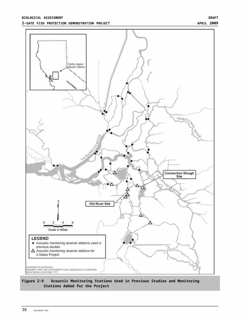
SECTION 3STATUS OF SPECIES
At the time of the 1994 designation, the best available science held that the delta smelt population was responding to variation in spring X2 (USFWS 2008). The scientific understanding has improved over the intervening 14 years. The current understanding of the USFWS is that OMR (combined flow in OMRs) must be considered to manage entrainment. The distribution, function and attributes of each PCE for each life stage are summarized below from the critical habitat designation (USFWS 2004) and the 2008 OCAP BO (USFWS 2008):
Spawning HabitatDelta smelt adults seek shallow, fresh, or slightly brackish backwater sloughs and edge-waters for spawning. Specific areas identified as important delta smelt spawning habitat include Barker, Lindsey, Cache, Prospect, Georgiana, Beaver, Hog, and Sycamore Sloughs; the Sacramento River in the Delta; and tributaries of northern Suisun Bay.
Spawning delta smelt require all four PCEs, but spawners and embryos are the only life stages of delta smelt that are known to require specific structural components of habitat (PCE # 1). Spawning delta smelt require sandy or small gravel substrates for egg deposition. Migrating, staging, and spawning delta smelt also require low-salinity and freshwater habitats, turbidity, and water temperatures less than 20ºC (68ºF) (Bennett 2005) (PCE #2 and #4).
Spawning occurs primarily late February through early June, peaking in April through mid-may (Moyle 2002). Historically, delta smelt ranged as far up the San Joaquin River as Mossdale, indicating that areas of the lower San Joaquin and its tributaries support conditions appropriate for spawning. Little data exists on delta smelt spawning activity in the lower San Joaquin region. Larval and young juvenile delta smelt collected at South Delta stations in DFG’s 20-mm Survey, indicate that appropriate spawning conditions exist there. However, the few delta smelt that are collected in the lower San Joaquin region is a likely indicator that changes in flow patterns entrain spawning adults and newly-hatched larvae into water diversions (Moyle et al. 1992).
Once the eggs have hatched, larval distribution depends on both the spawning locality (PCE#1 and PCE#2) and Delta hydrodynamics for transport (PCE#3). Larval distribution is further affected by salinity and temperature (attributes of PCE#4 and #3). Tidal action and other factors may cause substantial mixing of water with variable salinity and temperature among regions of the Delta (Monson et al. 2007), which in some cases might result in rapid dispersal of larvae away from spawning sites.
Successful feeding depends on a high density of food organisms and turbidity (PCE #2). Turbidity elicits a first feeding response and enhances the ability of delta smelt larvae to see prey in the water (Baskerville-Bridges et al. 2004). Their diet is comprised of small planktonic crustaceans that inhabit the estuary’s turbid, low-salinity, open-water habitats (attribute of PCE#2).
Larval and Juvenile TransportAs designated in 1994 (USFWS 1994), the specific geographic area important for larval transport is confined to waters contained within the legal boundary of the Delta, Suisun Bay, and Montezuma Slough and its tributaries. The specific season for successful larval transport varies from year to year, depending on when peak spawning occurs and on the water-year type. To ensure larval transport, the Sacramento and San Joaquin Rivers and their tributary channels must be protected from physical disturbance (e.g., sand and gravel mining, diking, dredging, and levee or bank protection and maintenance) and flow disruption (e.g., water diversions that result in entrainment and in-channel barriers or tidal gates). Adequate riverflow is necessary to transport larvae to shallow, productive rearing habitat in Suisun Bay and to prevent interception of larval transport by water diversions in the Delta. To ensure that suitable rearing habitat is available in Suisun Bay, the 2 ppt isohaline must be located westward from the Sacramento-San Joaquin River confluence during the period
document.doc 7
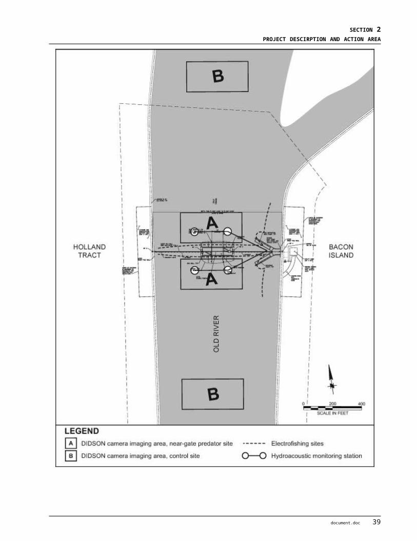
BIOLOGICAL ASSESSMENT DRAFT2-GATE FISH PROTECTION DEMONSTRATION PROJECT APRIL 2009
when larvae or juveniles are being transported, according to the historical salinity conditions which vary according to water- year type. Reverse flows interfere with transport by maintaining larvae upstream in deep-channel regions of low productivity and exposing them to entrainment.
Delta smelt larvae require PCEs # 2-4 (USFWS 2008). The distribution of delta smelt larvae follows that of the spawners; larvae emerge near where they are spawned. Thus, they are distributed more widely during high outflow periods. Delta smelt larvae mainly inhabit tidal freshwater at temperatures between 10ºC-20ºC (Bennett 2005). The center of distribution for delta smelt larvae < 20 mm is usually 5-20 km upstream of X2, but larvae move closer to X2 as the spring progresses into summer (Dege and Brown 2004). The primary influences the water projects have on larval delta smelt critical habitat are that they influence water quality, the extent of the LSZ, and larval transport via capture of runoff in reservoirs and subsequent manipulation of Delta inflows and exports that affect OMR flows
Rearing HabitatThe 1994 critical habitat designation identified an area extending eastward from Carquinez Strait, including Suisun Bay, Grizzly Bay, Honker Bay, Montezuma Slough and its tributary sloughs, up the Sacramento River to its confluence with Three Mile Slough, and south along the San Joaquin River including Big Break as the specific geographic area critical to the maintenance of suitable rearing habitat. Maintenance of the 2 ppt isohaline, and suitable water quality (low concentrations of pollutants) within the estuary is necessary to provide delta smelt larvae and juveniles a shallow, protective, food-rich environment in which to mature to adulthood. This placement of the 2 ppt isohaline also serves to protect larval, juvenile, and adult delta smelt from entrainment in the State and Federal water projects. Protection of rearing habitat conditions may be required from the beginning of February through the summer.
The USFWS (2008) focused on the specific PCEs required by rearing juveniles, mainly water quality and salinity (PCEs # 2 and # 4. Juvenile delta smelt are most abundant in the LSZ, specifically at the upstream edge of the LSZ where salinity is < 3 psu, water transparency is low (Secchi disk depth < 0.5 m), and water temperatures are cool (< 24ºC) (Feyrer et al. 2007, Nobriga et al. 2008). Many juvenile delta smelt rear now near the Sacramento-San Joaquin river confluence, a change in historic distribution. Currently, young delta smelt rear throughout the Delta into June or the first week of July, but thereafter, distribution shifts to the Sacramento-San Joaquin river confluence where water temperatures are cooler and water transparencies are lower (Feyrer et al. 2007, Nobriga et al. 2008). The 2008 OCAP BO (USFWS 2008) discusses the change in distribution in further detail.
Adult MigrationAdult delta smelt must be provided unrestricted access to suitable spawning habitat in a period that may extend from December to July. Adequate flow and suitable water quality may need to be maintained to attract migrating adults in the Sacramento and San Joaquin River channels and their associated tributaries, including Cache and Montezuma Sloughs and their tributaries. These areas also should be protected from physical disturbance and flow disruption during migratory periods (USFWS 1994).
Successful delta smelt adult migration habitat is characterized by conditions that attract migrating adult delta smelt (PCE #2, #3, and #4) and that help them migrate to spawning habitats (PCE #3). Delta smelt are weakly anadromous and move from the LSZ into freshwater to spawn, beginning in late fall or early winter and likely extending at least though May. Although the physiological trigger for the movement of delta smelt up the Estuary is unknown, movement is associated with pulses of freshwater inflow, which are cool, less saline and turbid (attributes of PCE #2 and #4 for adult migration). As they migrate, delta smelt increase their vulnerability to entrainment if they move closer to the CVP and SWP export pumps (Grimaldo et al. accepted manuscript in USFWS 2008). Analyses indicate that delta smelt in the central and south Delta become less vulnerable to entrainment when reverse flows in the Delta are minimized. Inflows in early winter must be of
8 document.doc
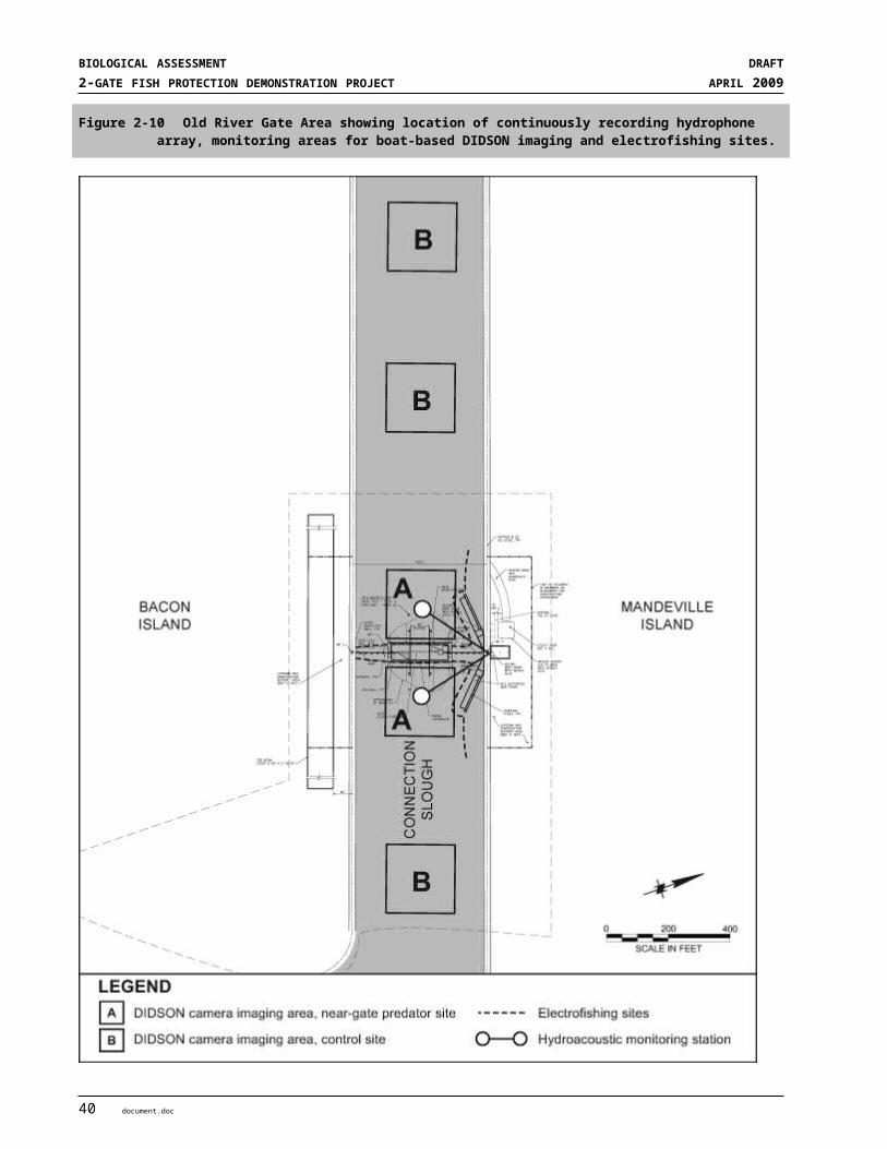
SECTION 3STATUS OF SPECIES
sufficient magnitude to provide the cool, fresh and highly turbid conditions needed to attract migrating adults and of sufficient duration to allow connectivity with the Sacramento and San Joaquin river channels and their associated tributaries, including Cache and Montezuma sloughs and their tributaries (attributes of PCE #2 for adult migration). These areas are vulnerable to physical disturbance and flow disruption during migratory periods.
3.1.1.7 Factors Affecting Delta Smelt and designated Critical HabitatMany factors come together to directly and indirectly affect delta smelt and their habitat. The most important factors limiting delta smelt populations are altered delta hydrodynamics, loss to entrainment at the state and federal water projects, food web alteration by alien species, and poor water quality.
Water Movement and ConveyanceThe direct and indirect effects of Delta water exports pose obvious threats to delta smelt and are the primary impetus behind this project. Entrainment directly affects adult, juvenile, and larval smelt at the SWP and CVP water export facilities. Delta smelt entrained by the export facilities are often assumed to suffer 100 percent mortality, as even those adults that are salvaged generally may die from handling stress (Kimmerer 2008).
The entrainment of adult delta smelt at the SWP and CVP export facilities occurs mainly during their upstream spawning migration between December and April (Table 3-1, Figure 3-5) (USFWS 2008). The risk of entrainment depends on level of exports and the location of spawning adults relative to facilities, which varies among years (Figure 3-6) (Grimaldo et al. accepted manuscript cited in USFWS 2008). In some years a large proportion of the adult population migrates to the central and south Delta, placing both spawners and their progeny in relatively close proximity to the export pumps and increasing entrainment risk. In other years, the bulk of adults migrate to the north Delta, reducing entrainment risk. In very wet periods, some spawning occurs west of the Delta.
Table 3-1 The Temporal Occurrence of Delta Smelt Life Stages
Jan Feb Mar Apr May Jun Jul Aug Sep Oct Nov DecAdult MigrationDelta
Spawning/IncubationDelta
Larval Development and Juvenile Movement to west of Chipps IslandDelta
Larval and Early Juvenile RearingDelta
Estuarine Rearing Juveniles and AdultsWestern Delta, Suisun Bay
Salvage
Source: Fisheries Technical Working Group (ENTRIX 2008)
document.doc 9

BIOLOGICAL ASSESSMENT DRAFT2-GATE FISH PROTECTION DEMONSTRATION PROJECT APRIL 2009
Source: Kimmerer 2008Image plot showing numbers of fish by length and day, according to log scale at right. Larger fish are adults, and small ones are larvae and juveniles, roughly separated by the vertical line. Larvae smaller than 20 mm are generally not counted. Very few fish were caught between July and mid-December.
Figure 3-5 Delta Smelt Combined Salvage at South Delta Fish Facilities for 1997 – 2005
10 document.doc
SECTION 3STATUS OF SPECIES
Source: USFWS 2008
Figure 3-6 Adult Delta Smelt Salvage (December – March) by WY and by Hydrological Variables and Turbidity
document.doc 11

BIOLOGICAL ASSESSMENT DRAFT2-GATE FISH PROTECTION DEMONSTRATION PROJECT APRIL 2009
UC Davis researchers propose that increased winter exports, and the accompanying OMR reverse flows, are entraining increased numbers of early spawning delta smelt (Baxter et al. 2008). The early spawners tend to be the largest individuals which produce more and stronger offspring. Increased entrainment of these early spawners can reduce population in concert with other factors (Bennett 2005, Brown and Kimmerer 2002).
Delta smelt larvae and juveniles are vulnerable to entrainment, particularly in years when spawning occurs in the Central and South Delta. Salvage has historically been greatest in drier years when a high proportion of young fish rear in the Delta (Moyle et al. 1992, Reclamation and DWR 1994, Sommer 1997). Delta smelt are not detected in the salvage until they are juveniles (at least 20 mm in length). Most salvage of juveniles occurs from April to July, with a peak May-June (Figure 3-5) (Kimmerer 2008, Grimaldo et al. accepted manuscript cited in USFWS 2008). In order to minimize entrainment of undetected larvae, export reductions have focused on the time period when larval smelt are thought to be in the South Delta (based on adult distributions). In 2007 and 2008, CVP and SWP implemented actions to reduce entrainment at the pumps, including maintaining higher outgoing flows in OMRs; delta smelt salvage was considerably decreased in those two years (USFWS 2008).
The indirect effects of water exports are due to altered hydrodynamics in the Delta. High exports and low San Joaquin River flows lead to reverse flows, poor habitat conditions, and degraded water quality in the south Delta. Exports combined with dam operations ultimately influence delta outflow and the position of the low salinity zone (X2). Sommer (2007) suggested that recent change in fall delta smelt habitat quality (salinity and turbidity) may be in part due to changes in fall water export/import ratios and Delta Cross channel operations.
Flood Control and Levee ConstructionThere is no evidence that levees and other flood control infrastructure directly impact delta smelt populations. The construction, maintenance, or failure of levees may have indirect effects on delta smelt by influencing delta hydrodynamics.
Land Use ActivitiesIntensive agricultural and urban development in the delta affects delta smelt indirectly by impacting water quality in the delta and reducing freshwater inflow through many small diversions. See ‘Water Quality’ and ‘Water Movement and Conveyance’ sections.
Water QualityContaminants, eutrophication, and algal blooms can alter ecosystem functions and productivity, but the magnitude and effects within the Delta are poorly understood (USFWS 2008). Pollutants from agricultural and urban sources may harm delta smelt directly, reduce zooplankton abundance, or both. Recent testing has noted invertebrate toxicity in the waters of the northern Delta and western Suisun Bay. Three water quality concerns are currently being investigated to determine their role in the Pelagic Organism Decline (Baxter et al. 2008, Sommer 2007, Sommer et al. 2007):
Pyrethroid pesticides in agricultural runoff are known to be very toxic to fish and other aquatic organisms. The recent decline in pelagic fishes in the San Francisco Estuary has roughly coincided with increasing agricultural use of pyrethroid pesticides.
12 document.doc

SECTION 3STATUS OF SPECIES
A blue-green alga known as Microcystis aeruginosa, has formed large summertime blooms in the Delta in recent years in the core habitat of delta smelt. This cyanobacterium produces a substance highly toxic to fish, invertebrates, and other animals. The toxin may cause physiological damage to delta smelt when they co-occur, or reduce the abundance of their primary food resources through toxicity to aquatic invertebrates (Reclamation 2008).
Ammonia released from sewage treatment plants in increasing quantities in recent years may inhibit primary productivity in some areas, be directly toxic to delta smelt, and encourage blooms of microcystis (Meyer et al. 2009).
Fish bioassays conducted as part of the POD studies indicated that larval delta smelt are highly sensitive to ammonia, low turbidity, and low salinity (Baxter et al. 2008, Reclamation 2008). Turbidity is an important attribute of delta smelt critical habitat, involved in attracting adult migration and facilitating foraging. There has been a Delta-wide increase in water transparency in recent years, linked to the invasion of non-native submerged aquatic vegetation which traps sediment (discussed below under Non-Native Invasive Species). Reduced turbidity may have also intensified predation pressures on delta smelt (USFWS 2008).
Hatchery OperationsCurrent captive breeding programs for delta smelt are for scientific purposes only and do not release fish into the wild. These programs therefore have no effect on wild delta smelt populations.
Over-utilization (commercial and sport)There is no lawful commercial or recreational fishery for delta smelt. The most significant form of utilization for this species is scientific collecting by the Interagency Ecological Program through several monitoring programs. The IEP has determined these monitoring programs have a net beneficial effect on the delta smelt population through improved management.
Disease and PredationPredation is presumed to have an important impact on delta smelt survival; however, it has proven difficult to quantify. There is little evidence that disease and predation threaten the survival of the species (USFWS 2004). Many introduced predators are known to eat delta smelt, the most important of these being striped bass and largemouth bass. Striped bass have experienced declining annual abundance concurrent with the recent Pelagic Organism Decline. Conversely, largemouth bass are believed to be increasing in numbers (Baxter et al. 2008). Decreased flows and restricted tidal influence in the south and central delta have combined to create warm, clear water conditions ideal for the growth of non-native Brazilian waterweed (Egeria densa), which provides favorable cover and hunting conditions for largemouth bass.
Non-native Invasive SpeciesMany non-native invasive species affect delta smelt both directly and indirectly through predation, food web alteration, and effects on physical habitat. Primary productivity, and likewise zooplankton biomass, in the western delta has declined since the introduction of the overbite clam (Corbula amurensis) in the 1980s, possibly limiting food availability for the delta smelt and other pelagic species (Baxter et al. 2008). As zooplankton production is an important factor limiting summer and fall survival in the western Delta and Suisun Bay (Kimmerer 2008), the overbite clam has indirectly limited the delta smelt population in the decades since its introduction. Furthermore the composition of the zooplankton community, mostly composed of introduced species, has changed in recent years having potentially significant, but as yet unproven, effects on food availability for delta smelt.
document.doc 13

BIOLOGICAL ASSESSMENT DRAFT2-GATE FISH PROTECTION DEMONSTRATION PROJECT APRIL 2009
The physical habitat of the interior Delta has been altered over the last two decades by invading submerged aquatic vegetation, principally Egeria densa (Baxter et al. 2008, USFWS 2008). This plant has altered fish community dynamics by increasing habitat for centrarchid fishes (Nobriga et al. 2005, Brown and Michniuk 2007), reducing habitat for native fishes (Brown 2003), and altering the food web. Non-native submerged aquatic vegetation can affect delta smelt directly by degrading and reducing unvegetated spawning habitat, and indirectly by decreasing turbidity (vegetation traps suspended sediment) which is an important attribute of juvenile and adult habitat (Feyrer et al. 2007, Nobriga et al. 2008).
Environmental Variation and Climate ChangeThere is currently no quantitative analysis of how ongoing climate change is currently affecting delta smelt (USFWS 2008). However, climate change has the potential to significantly shift habitat available to delta smelt upstream as Delta water temperatures and sea levels both rise. Altered precipitation patterns could also cause shifts in the timing of flows and water temperatures, which could lead to a change in timing of migration of adults and juvenile delta smelt (USFWS 2008).
Ecosystem RestorationEcosystem restoration projects currently underway within the Delta may prove to be beneficial to delta smelt (Bennett 2005). The highest density of delta smelt spawning and larval production occurs in the vicinity of Cache Slough and Liberty Island. This area provides abundant shallow water spawning habitat and is heavily influenced by flows from the Yolo Bypass which provide an important source of carbon and planktonic food to fish in the north delta. Similar habitat restoration is imminent adjacent to Suisun Marsh (i.e., at the confluence of Montezuma Slough and the Sacramento River) as part of the Montezuma Wetlands project, which is intended to provide for commercial disposal of material dredged from San Francisco Bay in conjunction with tidal wetland restoration. These areas are the focus of state and federal restoration programs to enhance the function of floodplain and tidal freshwater ecosystems.
A major restoration program is the CALFED Bay–Delta Program (CALFED), currently implemented through the California Bay-Delta Authority (CBDA). CALFED was formed in 1995 with the central tenets of environmental restoration and stable water supplies. Two CBDA programs in particular were created to improve conditions for fish in the Central Valley: (1) the Ecosystem Restoration Program (ERP) and its Environmental Water Program, and (2) the Environmental Water Account (EWA) managed under the Water Supply and Reliability Program (CALFED 2000). Restoration initiatives expected to benefit delta smelt include restoration of shallow-water tidal and marsh habitats within the Delta, screening diversions, and adjusting water export operations. Achievement of other goals of the ERP, such as reducing the negative impacts of invasive species and improving water quality (CALFED 2000), are also expected to benefit delta smelt by reducing competitors or improving food web dynamics and the copepods that are a key food resource.
A review of CALFED’s performance in Years 1 through 8 concluded that the greatest investments and outcomes of the ERP and Watershed Programs have been in areas upstream from the Delta, outside the range of delta smelt (CALFED Bay Delta Public Advisory Committee [BDPAC] 2007). Efforts have been less successful in the Delta where native species, including the delta smelt, continue to decline. Research indicates some of the management actions taken to protect salmon may be in conflict with actions to protect delta smelt. Funding and research efforts have been refocused to resolve the declining populations of important Delta species.
Habitat restoration initiatives sponsored and funded primarily by the CBDA-ERP have resulted in plans to restore ecological function to 9,543 acres of shallow-water tidal and marsh habitats within the Delta. Restoration of these areas primarily involves flooding lands previously used for agriculture, thereby creating additional shallow water spawning and rearing habitat for delta smelt. This assumption, however, has
14 document.doc
SECTION 3STATUS OF SPECIES
undergone revision with new science (Brown 2003). The benefits of restoring shallow water habitat may be offset by nonnative species that dominate these habitats, such as fishes that prey on delta smelt and invasive aquatic plants that alter water quality (reduced turbidity) and habitat structure (Bennett 2005, Brown 2003).
The CBDA’s EWA was established to alleviate the uncertainty of water use, as well as to provide benefits to delta smelt and other fishes of special concern. Environmental water is acquired and “banked” and used for fish protection, primarily by reducing water exports at critical times when delta smelt “take” at the major facilities is elevated. For delta smelt, however, it is unclear whether reducing water exports at the critical times has benefitted the delta smelt population (Bennett 2005). The CALFED BDPAC (2007) concluded that the EWA has not been successful at reversing the decline of important Delta species including delta smelt.
Another restoration approach seeks to improve fish screening and salvaging procedures at the export facilities. The CALFED Program Record of Decision called for substantial investments in fish screens in the south Delta (CALFED 2000). However, there is little scientific evidence that these measures benefit the population (Bennett 2005). Delta smelt are extremely fragile and many do not survive handling. Moreover, it is currently unclear if losses to the water projects are a major impact on their abundance (Bennett 2005). In 2005, an agency and stakeholder group recommended and the state and federal agencies concurred, that the CALFED Program not proceed with significant investments in new fish screens at the Delta pumping facilities, rather that additional research be accomplished and other actions taken that were thought to provide greater benefits to fish populations (CALFED BDPAC 2007). Similarly, there has been a consistent effort to install fish screens on the numerous small agricultural diversions in the Delta. Again, however, the benefits of fish screening have never been established for delta smelt, and the added structural complexity to these diversions may provide habitat harboring predatory fishes (Bennett 2005). What little is known indicates their effect is small (Nobriga and others 2004) and localized, with little effect at the population level.
3.1.1.8 Status of the Species within the Action AreaAll life stages of delta smelt occur in the Action Area of the 2-Gates Project and the Action Area encompasses much of the designated critical habitat (Figure 3-1). The Action Area includes areas considered important for larval transport. The Action Area is east and south of the area considered most important for rearing. However, if rearing delta smelt are found within the Action Area, protection of rearing habitat conditions may be required from the beginning of February through the summer. Areas important for delta smelt spawning habitat generally occur outside of the Action Area. The status of delta smelt rangewide and in the Action Area is currently declining and abundance levels are the lowest ever recorded (USFWS 2008).
3.1.2 Chinook Salmon and Steelhead
3.1.2.1 Listing Status and Designated Critical HabitatNMFS has recently completed an updated status review of 16 salmon ESUs that included the Sacramento River winter-run Chinook salmon (“winter-run Chinook”) and Central Valley spring-run Chinook salmon (“spring-run Chinook”), and concluded that the species’ status should remain as previously listed (June 28, 2005, 70 FR 37160). In addition, NMFS published a final listing determination for 10 steelhead distinct population segments (DPSs), and concluded that Central Valley steelhead (“CV steelhead”) will remain listed as threatened (January 5, 2006, 71 FR 834).
The following federally listed anadromous species ESUs or DPSs and designated critical habitats occur in the Action Area and may be affected by the action:
document.doc 15

BIOLOGICAL ASSESSMENT DRAFT2-GATE FISH PROTECTION DEMONSTRATION PROJECT APRIL 2009
Sacramento River winter-run Chinook SalmonWinter-run Chinook salmon (Oncorhynchus tshawytscha) were originally listed as threatened in August 1989 under emergency provisions of the ESA, and formally listed as threatened in November 1990 (55 FR 46515). The ESU consists of only one population that is confined to the upper Sacramento River. The Livingston Stone National Fish Hatchery population has been included in the listed winter-run Chinook population as of June 28, 2005 (70 FR 37160). The ESU was reclassified as endangered on January 4, 1994 (59 FR 440), due to increased variability of run sizes, expected weak returns as a result of two small year classes in 1991 and 1993, and a 99 percent decline between 1966 and 1991. NMFS reaffirmed the listing as endangered on June 28, 2005 (70 FR 37160) and included the Livingston Stone National Fish Hatchery population in this listed ESU.
NMFS designated critical habitat on June 16, 1993 (58 FR 33212). Critical habitat is delineated as the Sacramento River from Keswick Dam at river mile (RM) 302 to Chipps Island (RM 0) at the westward margin of the Sacramento-San Joaquin Delta (Delta), including Kimball Island, Winter Island, and Brown’s Island; all waters from Chipps Island westward to the Carquinez Bridge, including Honker Bay, Grizzly Bay, Suisun Bay, and the Carquinez Strait; all waters of San Pablo Bay westward of the Carquinez Bridge, and all waters of San Francisco Bay north of the San Francisco-Oakland Bay Bridge. The northwest region of the Action Area overlaps designated critical habitat, namely the migration corridor on the Sacramento River along the North Delta (Figure 3-7).
Central Valley spring-run Chinook SalmonCentral Valley spring-run Chinook salmon (Oncorhynchus tshawytscha) were listed as threatened on September 16, 1999 (64 FR 50394). NMFS released a five-year status review in June 2004, and proposed that this species remain listed as threatened (69 FR 33102). Although spring-run Chinook productivity trends were positive at the time, the ESU continued to face risks from: (1) a limited number of remaining populations (three, down from an estimated 17 historical populations); (2) a limited geographic distribution; and (3) potential hybridization with Feather River Fish Hatchery (FRFH) spring-run Chinook salmon, which are genetically divergent from populations in Mill, Deer, and Butte Creeks. The NMFS final decision on June 28, 2005 retained this species as threatened (70 FR 37160). The ESU currently consists of spring-run Chinook salmon occurring in the Sacramento River basin, including the FRFH spring-run Chinook salmon population.
Critical habitat for Central Valley spring-run Chinook salmon was designated on September 2, 2005 (70 FR 52488). Spring-run critical habitat includes the stream channels within numerous streams throughout the Central Valley, including the Sacramento, Feather and Yuba Rivers, and Deer, Mill, Battle, Antelope, and Clear Creeks in the Sacramento River basin. Critical habitat is also designated within the Sacramento-San Joaquin Delta and the San Francisco-San Pablo-Suisun Bay complex. The Action Area does not overlap designated critical habitat (Figure 3-8).
Central Valley steelheadCentral Valley steelhead (Oncorhynchus mykiss) are listed as threatened (January 5, 2006, 71 FR 834). The CV steelhead DPS consists of naturally spawned anadromous populations of O. mykiss below natural and manmade impassable barriers in the Sacramento and San Joaquin Rivers and their tributaries. Excluded are steelhead from San Francisco and San Pablo Bays and their tributaries, as well as two artificial propagation programs: the Coleman NFH, and FRFH steelhead hatchery programs.
NMFS designated critical habitat on September 2, 2005 (70 FR 52488). CV steelhead critical habitat encompasses 2,308 miles of stream habitat in the Central Valley including the Sacramento River and tributaries and the San Joaquin River and tributaries upstream to the Merced River. An additional 254 square miles of estuary habitat in the San Francisco-San Pablo-Suisun Bay complex is also designated critical
16 document.doc

SECTION 3STATUS OF SPECIES
habitat. The Action Area contains portions of the designated critical habitat, namely the channel reaches within the Sacramento-San Joaquin Delta (Figure 3-9).
3.1.2.2 Life HistoryChinook salmon and steelhead are anadromous salmonids of the genus Oncorhynchus. This section provides an overview of key life history attributes (reviewed by Myers et al. 1998, Moyle 2002, NMFS 2008a).
Sacramento River winter-run Chinook and Central Valley spring-run Chinook SalmonChinook salmon are the largest member of Oncorhynchus. Runs are designated on the basis of adult migration timing. However, distinct runs also differ in the degree of maturation at the time of river entry, thermal regime and flow characteristics of their spawning site, and the actual time of spawning (Myers et al. 1998). Both spring-run and winter-run Chinook tend to enter freshwater as immature fish, migrate far upriver, and delay spawning for weeks or months. For comparison, fall-run Chinook enter freshwater at an advanced stage of maturity, move rapidly to their spawning areas on the mainstem or lower tributaries of the rivers, and spawn within a few days or weeks of freshwater entry. Adequate instream flows and cool water temperatures are more critical for the survival of winter-run and spring-run Chinook salmon due to over-summering by adults and/or juveniles.
This section presents life history attributes common to winter-run and spring-run Chinook salmon (reviewed by Myers et al. 1998, Moyle 2002). Run-specific differences in the spatial and temporal distribution of various life stages are discussed in Section 3.1.2.3 “Distribution”. Chinook salmon typically mature between 2 and 6 years of age (Myers et al. 1998). Freshwater entry of migrating adults and spawning timing are generally thought to be related to local water temperature and flow regimes. Adults migrate to spawning habitat in streams well upstream of the Delta. Adults spawn in clean, loose gravel in swift, relatively shallow riffles or along the margins of deeper runs.
Upon emergence, fry swim or are displaced downstream. As juvenile Chinook salmon grow, they move into deeper water with higher current velocities, but still seek shelter and velocity refugia to minimize energy expenditures. Catches of juvenile salmon in the Sacramento River near West Sacramento by the USFWS (1997) exhibited larger juvenile captures in the main channel and smaller sized fry along the margins. When the channel of the river is greater than 9 to 10 feet in depth, juvenile salmon tend to inhabit the surface waters.
As Chinook salmon begin the smoltification stage, they prefer to rear further downstream where ambient salinity is up to 1.5 to 2.5 parts per thousand. Within the Delta, juveniles forage in shallow areas with protective cover, such as tidally-influenced sandy beaches and vegetated zones. Cladocerans, copepods, amphipods, and diptera larvae, as well as small arachnids and ants, are common prey items (Kjelson et al. 1982, Sommer et al. 2001).
Within the estuarine habitat, juvenile Chinook salmon movements are dictated by the tidal cycles, following the rising tide into shallow water habitats from the deeper main channels, and returning to the main channels as the tide recedes. Kjelson et al. (1982) reported that juvenile Chinook salmon demonstrated a diel migration pattern, orienting themselves to nearshore cover and structure during the day, but moving into more open, offshore waters at night. During the night, juveniles were distributed randomly in the water column, but during the day would school up into the upper 3 meters of the water column. Juvenile Chinook salmon were found to spend about 40 days migrating through the Sacramento-San Joaquin Delta to the mouth of San Francisco Bay.
document.doc 17

BIOLOGICAL ASSESSMENT DRAFT2-GATE FISH PROTECTION DEMONSTRATION PROJECT APRIL 2009
Figure 3-7 Action Area and Designated Critical Habitat for Sacramento River winter-run Chinook Salmon
18 document.doc
SECTION 3STATUS OF SPECIES
Figure 3-8 Action Area and Designated Critical Habitat for Central Valley spring-run Chinook Salmon
document.doc 19
BIOLOGICAL ASSESSMENT DRAFT2-GATE FISH PROTECTION DEMONSTRATION PROJECT APRIL 2009
Figure 3-9 Action Area and Designated Critical Habitat Central Valley steelhead
20 document.doc
SECTION 3STATUS OF SPECIES
Central Valley steelheadSteelhead can be divided into two life history types, winter (ocean-maturing) and summer (stream-maturing), based on their state of sexual maturity at the time of river entry and the duration of their spawning migration. Only winter steelhead are currently found in Central Valley rivers and streams (McEwan and Jackson 1996). Ocean-maturing steelhead enter freshwater with well-developed gonads and spawn shortly after river entry. A brief description of general life history follows, although variations in period of habitat use can occur. Further details are provided in Busbey et al. (1996), McEwan and Jackson (1996), Moyle (2002), Reclamation (2008) and NMFS (2008a).
CV steelhead generally leave the ocean from August through April and migrate through the estuary to spawning habitat in streams. Spawning takes place from December through April, with peaks from January through March (McEwan and Jackson 1996, Busby et al. 1996). Unlike Pacific salmon, steelhead are iteroparous, or capable of spawning more than once before death (Busby et al. 1996). Steelhead spend the first year or two of life in cool, clear, fast-flowing permanent streams and rivers with ample riffles, cover, and invertebrate prey (Moyle 2002). Juvenile steelhead emigrate from natal streams volitionally or during fall through spring freshets. Sacramento River juveniles migrate downstream most of the year, predominantly in spring (Hallock et al. 1961).
Rearing and ocean-emigrating juvenile steelhead use the lower reaches of the Sacramento River and the Delta including tidal marsh areas, non-tidal freshwater marshes, and other shallow water areas. CV steelhead migrate to the ocean after spending one to three years in freshwater (McEwan and Jackson 1996). They remain in the ocean for one to four years growing before returning to their natal streams to spawn.
3.1.2.3 Distribution
Sacramento River winter-run Chinook SalmonHistorically, the distribution of winter-run Chinook spawning and rearing was limited primarily to the upper Sacramento River and its tributaries, the Pit and McCloud Rivers (Myers et al. 1998). These spring-fed streams provided cold water through the summer to support spawning, egg incubation, and rearing (Slater 1963, Yoshiyama et al. 1998). Construction of Shasta Dam in 1943 and Keswick Dam in 1950 blocked access to all these waters, except Battle Creek (Moyle et al. 1989, NMFS 1997, Myers et al. 1998). An estimated 299 miles of spawning and rearing habitat upstream of Keswick Dam has been lost (Yoshiyama et al. 2001). As a result, the winter-run Chinook population has been displaced to a single population currently spawning and rearing in the mainstem Sacramento River between Keswick Dam (RM 302) and the Red Bluff Diversion Dam (RBDD) (RM 243). This population is entirely dependent on regulated cold water releases from Shasta and Keswick Dams and is vulnerable to a prolonged drought (Good et al. 2005). Small numbers of winter-run Chinook salmon have also been reported on the Calaveras River in the San Joaquin River system (Myers et al. 1998) although none have been reported there since 1984 (source: DFG GrandTab data 2008). The range of the Sacramento River winter-run Chinook salmon ESU is shown in Figure 3-10.
Adult winter-run Chinook enter the San Francisco Bay from November through June and migrate past the RBDD from mid-December through early August (Hallock and Fisher 1985, NMFS 1997) (Table 3-2). The majority of the run passes the RBDD from January through May, with the peak occurring in mid-March (Hallock and Fisher 1985). The timing of migration may vary somewhat due to changes in river flow, dam operations, and water year type (Yoshiyama et al. 1998, Moyle 2002). Spawning occurs primarily from mid-April to mid-August, with the peak activity occurring in May and June in the Sacramento River reach between Keswick Dam and RBDD (Vogel and Marine 1991).
document.doc 21
BIOLOGICAL ASSESSMENT DRAFT2-GATE FISH PROTECTION DEMONSTRATION PROJECT APRIL 2009
Source: NMFS 200X
Figure 3-10 Sacramento Valley winter-run Chinook Salmon Evolutionarily Significant Unit
22 document.doc

SECTION 3STATUS OF SPECIES
Table 3-2 The Temporal Occurrence of Adult and Juvenile Sacramento River winter-run Chinook Salmon in the Sacramento River.
Adult Location Jan Feb Mar Apr May Jun Jul Aug Sep Oct Nov DecSac River basin1
Sac River2
Delta3 X X X X X X X X X X X X X X X X
Juvenile Location Jan Feb Mar Apr May Jun Jul Aug Sep Oct Nov Dec
Sac River @ Red Bluff4
Sac River @ Red Bluff2
Sac River @ Knights L.5
Lower Sac River(seine)6
West Sac River(trawl)6
Delta3 X X X X X X X X X X X X X X X X X X X X
Salvage3 X X X X X X X X X X
RelativeAbundance =High =Medium =Low X =Present
Data Sources:1 Yoshiyama et al. 1998 & and Moyle 2002; 2 Meyers et al. 1998, 3 ENTRIX 2008, 4 Martin et al. 2001, 5 Snider and Titus 2000, 6 USFWS 2001Source: NMFS 2008a, ENTRIX 2008
Winter-run Chinook fry emerge from the gravel in late June through October. Juveniles rear in the upper Sacramento River and may begin to emigrate past RBDD as early as mid–July, typically peaking in September, and may continue through March in dry years (Vogel and Marine 1991, NMFS 1997). Juvenile winter-run Chinook occur in the Delta primarily from November through early May, based on trawl surveys in the Sacramento River at West Sacramento (RM 57) (USFWS 2001). The timing of emigration may vary somewhat due to changes in river flows, dam operations, and water year type. Winter-run Chinook salmon juveniles remain in the Delta until they reach a fork length of approximately 118 millimeters (mm) and are 5-10 months of age, and then emigrate to the ocean from November through May (Fisher 1994, Myers et al. 1998).
Central Valley spring-run SalmonHistorically, spring-run Chinook salmon was the dominant run in the Sacramento and San Joaquin River Basins (Clark 1929, Myers et al. 1998) and once considered among the largest runs on the Pacific Coast (Yoshiyama et al. 1998). Spring-run Chinook salmon historically migrated upstream as far as they could in the larger tributaries to the Sacramento and San Joaquin Rivers, where they held for several months in deep cold pools (Moyle 2002). Their run timing was suited to gain access to the upper river reaches (up to 1,500 m elevation) prior to the onset of high water temperatures and low flows that inhibit access to these areas during the fall (Myers et al. 1998). Historic runs were reported in the McCloud River, Pit River, Little Sacramento River, Feather River (including above Oroville Dam), Yuba River (including above Englebright Dam), and American River (including above Folsom Dam) in the Sacramento River Basin (Moyle 2002) and on the San Joaquin River (above Friant Dam), and in the tributaries of the Merced, Tuolumne, Stanislaus and Mokelumne rivers in the San Joaquin Basin (NMFS 2004, Yoshiyama et al. 1998).
Construction of Friant Dam on the San Joaquin River, Shasta Dam on the upper Sacramento River, and other low elevation dams on tributary streams extirpated spring-run Chinook from these watersheds. Currently,
document.doc 23
BIOLOGICAL ASSESSMENT DRAFT2-GATE FISH PROTECTION DEMONSTRATION PROJECT APRIL 2009
naturally spawning populations are restricted to accessible reaches of the Sacramento River, Antelope Creek, Battle Creek, Beegum Creek, Big Chico Creek, Butte Creek, Clear Creek, Deer Creek, Mill Creek, the Feather River and the Yuba River (DFG 1998) (Figure 3-11).
Adult spring-run Chinook leave the ocean to begin their upstream migration in late January and early February (DFG 1998) and enter the Sacramento River system between March and September, primarily peaking in May and June (Table 3-3; Yoshiyama et al. 1998, Moyle 2002). Adults enter native tributaries from the Sacramento River primarily between mid April and mid June (Lindley et al. 2007). Fry emerge from the gravel between November and March (Moyle 2002).
Table 3-3 The Temporal Occurrence of Adult and Juvenile Central Valley spring-run Chinook Salmon in the Sacramento River.
Adult Location Jan Feb Mar Apr May Jun Jul Aug Sep Oct Nov DecSac River basin1
Sac River2
Mill Creek3
Deer Creek3
Butte Creek3
Delta4
Juvenile Location Jan Feb Mar Apr May Jun Jul Aug Sep Oct Nov DecSac River Tribs5
Upper Butte Creek6
Mill, Deer, & Butte Creeks3
Sac River @RBDD2
Sac River @ Knights Landing7
Delta4 X X X X X X X X X X X X X X X XSalvage4 X X X X X X X XRelative Abundance
=High =Medium =Low X = Present4
Data Sources:1Yoshimama et al. 1998 and Moyle 2002; 2Meyers et al. 1998; 3Lindley et al. 2006; 4 ENTRIX 2008; 5DFG 1998; 6McReynolds et al. 2005, Ward et al. 2002, 2003; 7Snider and Titus 2000
Source: NMFS 2008a, ENTRIX 2008
The emigration timing of spring-run Chinook appears highly variable (DFG 1998). Some fish may begin emigrating as young-of-the-year (YOY) soon after emergence from the gravel, whereas others over summer and emigrate as yearlings with the onset of intense fall storms (DFG 1998). A shorter period of rearing may be a response to altered flow regimes (caused by dams and diversions) and required use of lower elevation sections of streams (Yoshiyama et al. 1998, Moyle 2002). The emigration period extends from November to early May, with up to 69 percent of the YOY fish outmigrating through the lower Sacramento River and Delta during this period (DFG 1998). Peak movement of juveniles in the Sacramento River at Knights Landing occurs in December, and again in March and April. However, juveniles also are observed between November and the end of May (Snider and Titus 2000).
24 document.doc

SECTION 3STATUS OF SPECIES
Source: NMFS 200X
Figure 3-11 Central Valley spring-run Chinook Salmon Evolutionarily Significant Unit
document.doc 25
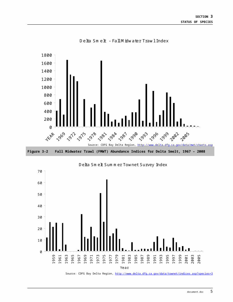
BIOLOGICAL ASSESSMENT DRAFT2-GATE FISH PROTECTION DEMONSTRATION PROJECT APRIL 2009
Central Valley steelheadCV steelhead populations are found in the Sacramento River and its tributaries, including the Feather, Yuba, and American Rivers, and many small tributaries, such as Antelope, Mill, Deer and Butte creeks, west side tributaries (including Clear, Cottonwood, Stoney, Thomes, Cache and Putah creeks and Suisun Bay tributaries of Alamo and Ulatis Creeks. The Cosumnes and Mokelumne Rivers also support steelhead, and they have also been documented in the Stanislaus River (Cramer 2000) on the San Joaquin System. Steelhead have also sporadically been collected from the Calaveras River. Figure 3-12 shows the range of the CV steelhead ESU.
The temporal distribution of different life stages in the Central Valley is shown in Table 3-4. Adults are present in the Delta (lower Sacramento River at Fremont Weir and the San Joaquin River) between July and March, with a peak in March and April. Juveniles are present in the Delta from October to July, with a peak in March to May. Adults leave the ocean August through April (Busby et al. 1996), and spawn December through April, with peaks January though March, (Hallock et al. 1961, McEwan and Jackson 1996). Juvenile steelhead emigrate episodically from natal streams during fall, winter, and spring high flows (NMFS 2008a). Juveniles migrate downstream during most months of the year, but the peak period of emigration occurs in the spring (March to May), with a much smaller peak in the fall (Hallock et al. 1961, Nobriga and Cadrett 2001).
Table 3-4 The temporal occurrence of adult and juvenile Central Valley steelhead in the Central Valley.
Jan Feb Mar Apr May Jun Jul Aug Sep Oct Nov DecAdult Location
Sac River 1, 2
Sac R. @ Red Bluff 2,3
Mill, Deer Creeks 4
Sac River @Fremont Weir 6
San Joaquin R 7
Juvenile LocationSac River 1,3
Sac River @Knights Landing 3,8
Sac River @Knights Landing 9
Sac River @ Hood 10
Chipps Island (wild) 11
Delta 12 X X X X X X X X X X
San Joaquin R @ Mossdale 8
Mokelumne R @ Woodbridge Dam 13
Stan. R @ Caswell 14
Salvage 12 X X X X X X X X X XRelativeAbundance
=High =Medium =Low X = Present12
Data Sources: 1 Hallock et al. 1961; 2USFWS unpubl. Data; 3McEwan 2001; 4DFG 1995; 5Hallock et al. 1957; 6Bailey 1954; 7DFG Steelhead Report Card Data; 8DFG unpubl. Data; 9Snider and Titus 2000; 10Schaffter 1980 & 1997; 11Nobriga and Cadrett 2001; 12 ENTRIX 2008; 13 Jones and Stokes Associates, Inc. 2002; 14S.P. Cramer and Associates, Inc. 2000 & 2001.
26 document.doc
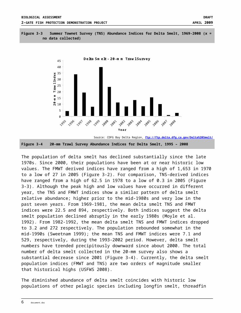
SECTION 3STATUS OF SPECIES
Source: NMFS 200X
Figure 3-12 Central Valley steelhead Evolutionarily Significant Unit
document.doc 27
BIOLOGICAL ASSESSMENT DRAFT2-GATE FISH PROTECTION DEMONSTRATION PROJECT APRIL 2009
3.1.2.4 Abundance
Sacramento River winter-run Chinook SalmonFollowing construction of Shasta Dam, population estimates of winter-run Chinook salmon ranged from 117,808 in 1969 to a low of 186 in 1994 (DFG 2002c). Adult escapement since 1970 is illustrated in Figure 3-13 (see also Table 3-5). Population estimates over the last decade generally show an increase trend in population size to 17,205 in 2006, the highest since the 1994 listing. However, the 2007 escapement estimate of 2,488 fish shows a significant decline relative to previous years (DFG GrandTab, 2008).
TOTAL RUN - Sacramento River Winter-run Chinook salmon
0
10,000
20,000
30,000
40,000
50,000
60,000
1970
1971
1972
1973
1974
1975
1976
1977
1978
1979
1980
1981
1982
1983
1984
1985
1986
1987
1988
1989
1990
1991
1992
1993
1994
1995
1996
1997
1998
1999
2000
2001
2002
2003
2004
[200
5]
[200
6][2
007]
Source: DFG GrandTab database March 2008
Figure 3-13 Estimated Sacramento River winter-run Chinook Salmon Run Size
Table 3-5 Winter-Run Chinook Salmon Population Estimates from RBDD Counts (1986 to 2001) and Carcass Counts (2001 to 2007) and Corresponding Cohort Replacement Rates and Juvenile Production Estimates (JPE) for the Years Since 1986
Year
In-RiverPopulation Estimate
5-Year MovingAverage of
Population EstimateCohort
Replacement Rate
5-Year MovingAverage of
Cohort Replacement RateNMFS Calculated
Juvenile Production Estimate (JPE)a
1986 2,566
1987 2,165
1988 2,857
1989 649 0.25
1990 411 1,730 0.19
1991 177 1,252 0.06 40,025
1992 1,203 1,060 1.85 272,032
1993 378 564 0.92 0.66 85,476
28 document.doc

SECTION 3STATUS OF SPECIES
Table 3-5 Winter-Run Chinook Salmon Population Estimates from RBDD Counts (1986 to 2001) and Carcass Counts (2001 to 2007) and Corresponding Cohort Replacement Rates and Juvenile Production Estimates (JPE) for the Years Since 1986
Year
In-RiverPopulation Estimate
5-Year MovingAverage of
Population EstimateCohort
Replacement Rate
5-Year MovingAverage of
Cohort Replacement RateNMFS Calculated
Juvenile Production Estimate (JPE)a
1994 144 463 0.81 0.77 32,5621995 1,166 613 0.97 0.92 263,6651996 1,012 780 2.68 1.45 228,8421997 836 707 5.82 2.24 189,0431998 2,903 1,212 2.49 2.55 656,4501999 3,264 1,836 3.23 3.04 738,0822000 1,263 1,856 1.51 3.14 285,6002001 8,120 3,277 2.80 3.17 1,836,1602002 7,360 4,582 2.26 2.46 1,664,3032003 8,133 5,628 6.44 3.25 1,839,1002004 7,784 6,532 0.96 2.79 1,760,1812005 15,730 9,425 2.14 2.92 3,556,9952006 17,205 11,242 2.12 2.78 3,890,5352007 2,488 10,268 0.32 2.39 562,607
Median 2,326 1,783 1.85 2.55 562,607Average 3,992 3,501 1.99 2.30 1,053,039Gmeanb 1,907 2,074 1.22 2.06 479,040
aJPE estimates were derived from NMFS calculations utilizing RBDD winter-run counts through 2001, and carcass counts thereafter for deriving adult escapement numbers. bGmean is the geometric mean of the data in that column.Source: CDFG 2004 and 2007 in NMFS 2008a
Ocean conditions may be a factor in recent declines (NMFS 2008a). The ocean life history traits and habitat requirements of winter-run Chinook and fall-run Chinook salmon are similar. The USFWS (2008) proposed that the unusually poor ocean conditions that are suspected to have contributed to the drastic decline in returning fall-run Chinook salmon populations coast-wide in 2007 (Varanasi and Bartoo 2008) have likely contributed to the observed decrease in winter-run Chinook escapement estimates for 2007. Preliminary escapement estimates for 2008 range from 2,600 to 2,950 (mean 2,775) winter-run Chinook in the Sacramento River. Although numbers appear to be slightly up from 2007, they are still low relative to the six years between 2001 and 2006, indicating that the conditions which have contributed to the general decline of Chinook salmon Pacific coast-wide have not significantly changed.
Since 1991, NMFS (2008a) has estimated juvenile production of winter-run Chinook using the Juvenile Production Estimate (JPE) method (Gaines and Poytress 2004). The median and average JPE between 1991 and 2007 has been estimated at 562,607 and 1,053,039, respectively (Table 3-4). Production increased steadily between 2000 (285,600) to 2006 (3,890,535), but declined significantly in 2007 (562,607).
Central Valley spring-run Chinook SalmonThe Sacramento-San Joaquin River Basin once supported a spring-run Chinook salmon run as large as 600,000 fish between the late 1880’s and 1940’s (DFG 1998). Since 1969, the abundance of spring-run Chinook (including Feather River Hatchery fish) has fluctuated broadly from a low of 3,044 in 1992 to a high of 31,471 in 1998 (Figure 3-14). The average (mean) and median population estimates for spring-run Chinook within the entire Sacramento-San Joaquin River system since 1969 are 13,328 and 11,430 fish, respectively.
In river (natural spawning) population estimates have generally followed the same trends. Between 1986 and 2007, in-river population estimates for spring-run Chinook salmon have ranged from a low of 1,403 fish in 1993 to a high of 24,725 fish in 1998 (see Table 3-6). Sacramento River tributary populations in Mill, Deer,
document.doc 29

BIOLOGICAL ASSESSMENT DRAFT2-GATE FISH PROTECTION DEMONSTRATION PROJECT APRIL 2009
and Butte Creeks are probably the best trend indicators because these streams contain the primary independent populations within the ESU. Generally, these streams had positive escapement trends between 1991 and 2005 dropping off in the last three years (from 14,014 fish in 2005 to an estimated 6,507 fish in 2007 (DFG GrandTab 2008). These trends are similar to the system wide in-river trends reported by DFG. Preliminary estimates for 2008 (4,381 fish in Deer, Mill and Butte Creeks) are generally lower than for 2007. Escapement numbers are dominated by Butte Creek returns, which have averaged over 7,000 fish between 1995 and 2007. During this same period, adult returns on Mill Creek have averaged 778 fish, and 1,463 fish on Deer Creek. Although recent trends are positive, annual abundance estimates fluctuate widely and remain well below historic levels (1960’s to 1990).
TOTAL RUN - Central Valley spring-run Chinook Salmon
0
5,000
10,000
15,000
20,000
25,000
30,000
35,000
1969
1970
1971
1972
1973
1974
1975
1976
1977
1978
1979
1980
1981
1982
1983
1984
1985
1986
1987
1988
1989
1990
1991
1992
1993
1994
1995
1996
1997
1998
1999
2000
2001
2002
2003
2004
[200
5][2
006]
[200
7]
Source: DFG GrandTab database March 2008Note: Years in [ ] are still considered preliminary
Figure 3-14 Estimated Central Valley spring-run Chinook Salmon Run Size
30 document.doc
SECTION 3STATUS OF SPECIES
Table 3-6 Central Valley spring-run Chinook Salmon Population Estimates from CDFG GrandTab Data (May 2008) with Corresponding Cohort Replacement Rates and JPE’s for the Years 1986 to 2007
YearIn-River
Population Estimate
5-Year MovingAverage of
Population EstimateCohort
Replacement Rate
5-Year MovingAverage of
Cohort Replacement Rate
NMFS CalculatedJuvenile Production
Estimate (JPE)a
1986 24,263 4,396,9981987 12,675 2,296,9931988 12,100 2,192,7901989 7,085 0.29 1,283,9601990 5,790 12,383 0.46 1,049,2771991 1,624 7,855 0.13 294,3051992 1,547 5,629 0.22 280,3511993 1,403 3,490 0.24 0.27 254,2551994 2,546 2,582 1.57 0.52 461,3921995 9,824 3,389 6.35 1.70 1,780,3281996 2,701 3,604 1.93 2.06 489,4821997 1,433 3,581 0.56 2.13 259,6921998 24,725 8,246 2.52 2.58 4,480,7221999 6,366 9,010 2.36 2.74 1,106,1812000 5,587 8,162 3.90 2.25 1,010,6772001 13,563 10,335 0.55 1.98 2,457,9192002 13,220 12,692 2.08 2.28 2,395,7592003 8,908 9,529 1.59 2.10 161,4322004 9,774 10,210 0.72 1.77 1,771,2672005 14,346 11,962 1.09 1.21 2,599,8162006 8,700 10,990 0.98 1.29 1,576,6342007 7,300 9,806 0.75 1.02 1,322,923
Median 8,000 8,628 0.98 1.98 1,106,181Average 8,885 7,970 1.49 1.73 1,335,479Gmeanb 6,452 7,109 0.93 1.50 1,051,034
aNMFS calculated the spring-run JPE using returning adult escapement numbers to the Sacramento River basin prior to the opening of the RBDD for spring-run Migration, and then escapement to Mill, Deer, and Butte Creeks for the remaining period, and assuming a female to male ratio of 6:4 and pre-spawning mortality of 25 percent. NMFS utilized the female fecundity values in Fisher (1994) for spring-run Chinook salmon (4,900 eggs/female). The remaining survival estimates used the winter-run values for calculating the JPE. bGmean is the geometric mean of the data in that column.Source: CDFG 2007 in NMFS 2008a
Central Valley steelheadVery limited information makes it difficult to estimate historic CV steelhead run sizes, but they may have approached 1 to 2 million adults annually (McEwan 2001). By the early 1960s the steelhead run size had declined to about 40,000 adults (McEwan 2001).
Over the past 30 years, the naturally-spawned steelhead populations in the upper Sacramento River have declined substantially from an estimated average of 20,540 adult steelhead through the 1960s down to an average of approximately 2,000 through the early 1990s, with an estimated total annual run size for the entire Sacramento-San Joaquin system, based on RBDD counts, to be no more than 10,000 adults (Figure 3-15) (McEwan and Jackson 1996, McEwan 2001). Steelhead escapement surveys at RBDD ended in 1993 due to changes in dam operations (NMFS 2008a). Although currently there is a complete lack of monitoring, what data exist indicate the population continues to decline (Good et al. 2005).
One challenge in assessing the success of steelhead spawning in the upper Sacramento River is the difficulty in distinguishing steelhead from the resident rainbow trout population that has developed as a result of managing for cold water all summer.
document.doc 31
BIOLOGICAL ASSESSMENT DRAFT2-GATE FISH PROTECTION DEMONSTRATION PROJECT APRIL 2009
Figure 3-15 Estimated Natural Central Valley steelhead Escapement in the Upper Sacramento River Based on RBDD Counts. Note: Steelhead escapement surveys at RBDD ended in 1993 (from McEwan and Jackson 1996 in NOAA 2008a).
3.1.2.5 Population Viability SummaryMcElhany et al. (2000) defined a population’s components of abundance, productivity, spatial structure, and diversity as the basis of determining population and ESU viability for salmonids. NMFS (2008) also summarized results of viability modeling.
Sacramento River winter-run Chinook Salmon
ABUNDANCE Redd and carcass surveys, and fish counts, suggest that the abundance of winter-run Chinook has been increasing over the past decade. The exception is the depressed abundance estimate observed in 2007 which is suspected to represent a cycle of poor ocean productivity coast wide recently. Population growth is estimated to be positive in the short-term with a trend at 0.26; however, the long-term trend is negative, averaging -0.14. Recent winter-run Chinook abundance represents only 3 percent of the maximum post-1967, 5-year geometric mean, and is not yet well established (Good et al. 2005).
32 document.doc

SECTION 3STATUS OF SPECIES
PRODUCTIVITY ESU productivity has generally been positive over the short term, and adult escapement and juvenile production have been increasing annually (Good et al. 2005) with the recent exception of the 2007 estimates. As mentioned above, poor ocean conditions coast wide are suspected of being the cause for poor adult returns, which in turn has resulted in decreased juvenile production. The long-term outlook for the ESU remains negative, however, as it consists of only one population that is subject to possible impacts from environmental and artificial conditions.
SPATIAL STRUCTURE The greatest risk factor for winter-run Chinook salmon lies with their spatial structure (Good et al. 2005). The remnant population cannot access historical winter-run habitat and must be artificially maintained in the mainstem Sacramento River by a regulated, finite cold water supply from Shasta Dam. Winter-run Chinook require cold water temperatures in summer that simulate their upper basin habitat, and they are more likely to be exposed to the impacts of drought in a lower basin environment. Battle Creek remains the most feasible opportunity for the ESU to expand its spatial structure, which currently is limited to the upper 25-mile reach of the mainstem Sacramento River below Keswick Dam.
DIVERSITY The second highest risk factor for winter-run Chinook has been the detrimental effects on its diversity. The present winter-run population has resulted from the introgression of several stocks that occurred when Shasta Dam blocked access to the upper watershed. A second genetic bottleneck occurred with the construction of Keswick Dam; there may have been several others within the recent past (Good et al. 2005).
VIABILITY MODELING Modeling has been used to assess the viability and risk of extinction of winter-run Chinook (NMFS 2008a). As reviewed by Good et al. (2005), Botsford and Brittnacker (1998) used an age-structured density-independent model of spawning escapement and concluded that the species was certain to fall below the quasi-extinction threshold of three consecutive spawning runs with fewer than 50 females). Lindley et al. (2003) used a Bayesian model based on spawning escapement that allowed for density dependence and a change in population growth rate in response to conservation measures. They found a biologically significant expected quasi-extinction probability of 28 percent.
Central Valley spring-run Chinook Salmon
ABUNDANCE Spring-run Chinook have experienced a trend of increasing abundance in some natural populations, most dramatically in the Butte Creek population (Good et al. 2005). There has been more opportunistic utilization of migration-dependent streams overall. The FRFH spring-run Chinook stock has been included in the ESU based on its genetic linkage to the natural population and the potential development of a conservation strategy for the hatchery program.
PRODUCTIVITY The 5-year geometric mean for the Butte, Deer, and Mill Creek spring-run Chinook populations range from 491 to 4,513 fish (Good et al. 2005), indicating increasing productivity for this period. Since 2005 the trend has declined (Table 3-5).
document.doc 33

BIOLOGICAL ASSESSMENT DRAFT2-GATE FISH PROTECTION DEMONSTRATION PROJECT APRIL 2009
SPATIAL STRUCTURE Spring-run Chinook presence has been reported more frequently in several upper Central Valley creeks, but the sustainability of these runs is unknown. Butte Creek spring-run cohorts have recently utilized all available habitat in the creek; the population cannot expand further and it is unknown if individuals have opportunistically migrated to other systems. The spatial structure of the spring-run ESU has been reduced with the extirpation of all San Joaquin River basin spring-run populations.
DIVERSITY The Central Valley spring-run Chinook ESU is comprised of two genetic complexes. Analysis of natural and hatchery spring-run Chinook stocks in the Central Valley indicates that the southern Cascades spring-run population complex (Mill, Deer, and Butte creeks) retains genetic integrity. The genetic integrity of the Sierra Nevada spring-run population complex has been somewhat compromised. Feather River spring-run Chinook have introgressed with the fall-run Chinook population, and it appears that the Yuba River population may have been impacted by FRFH fish straying into the Yuba River. Additionally, the diversity of the spring-run Chinook ESU has been further reduced with the loss of the San Joaquin River basin spring-run populations.
Lindley et al. (2007) indicated that the spring-run population of Chinook salmon in the Central Valley had a low risk of extinction in Butte and Deer Creek, according to their PVA model and the other population viability criteria (i.e., population size, population decline, catastrophic events, and hatchery influence). The Mill Creek population of spring-run Chinook salmon is at moderate extinction risk according to the PVA model, but appears to satisfy the other viability criteria for low-risk status. However, like the winter-run Chinook population, the spring-run Chinook population fails to meet the “representation and redundancy rule” since there is only one demonstrably viable population out of the three diversity groups that historically contained them. The spring-run Chinook population is only represented by the group that currently occurs in rivers and streams in the northern Sierra Nevada. Most historic populations have been extirpated. Over the long term, these remaining populations are considered to be vulnerable to catastrophic events, such as eruptions from Mount Lassen, forest fires, and drought.
In summary, the spring-run Chinook ESU remains at a moderate to high risk of extinction because it is spatially confined to relatively few remaining streams, continues to display broad fluctuations in abundance, and a large proportion of the population (i.e., in Butte Creek) faces the risk of high mortality rates.
Central Valley steelhead
ABUNDANCE Productivity for steelhead is dependent on freshwater survival and oversummering habitat which has been reduced by 95 percent from historic conditions. Estimates based on juvenile production indicate that the wild population may number in the average of 3,628 female spawners (Busby et al. 1996). All indications are that natural CV steelhead have continued to decrease in abundance and in the proportion of natural fish over the past 25 years (Good et al. 2005); the long-term trend remains negative. There has been little steelhead population monitoring despite 100 percent marking of hatchery steelhead since 1998. Hatchery production and returns are dominant over natural fish and include significant numbers of non-DPS-origin Eel River steelhead stock.
PRODUCTIVITY An estimated 100,000 to 300,000 natural juvenile steelhead are estimated to leave the Central Valley annually, based on rough calculations from sporadic catches in trawl gear (Good et al. 2005). Concurrently, one million in-DPS hatchery steelhead smolts and another half million out-of-DPS hatchery steelhead smolts are released annually in the Central Valley. The estimated ratio of nonclipped to clipped steelhead has
34 document.doc

SECTION 3STATUS OF SPECIES
decreased from 0.3 percent to less than 0.1 percent, with a net decrease to one-third of wild female spawners from 1998 to 2000 (Good et al. 2005).
SPATIAL STRUCTURE Steelhead appear to be well-distributed where found within the Central Valley (Good et al. 2005). Recent efforts have begun to document distribution. Since 2000, steelhead have been confirmed in the Stanislaus and Calaveras rivers. There appears to be fragmentation in the spatial structure because of reduction in the major populations of the Central Valley (i.e. the Sacramento River, Feather River, and American River) that provided a source for the numerous smaller tributary and intermittent stream populations like Dry Creek, Auburn Ravine, Yuba River, Deer Creek, Mill Creek, and Antelope Creek. Tributary populations can likely never achieve the size and variability of the core populations in the long-term generally due to the size and available resources of the tributaries.
DIVERSITY Analysis of natural and hatchery steelhead stocks in the Central Valley reveal genetic structure remaining in the DPS (Nielsen et al. 2003). There appears to be a great amount of gene flow among upper Sacramento River basin stocks, due to the post-dam, lower basin distribution of steelhead and management of stocks. Recent reductions in natural population sizes have created genetic bottlenecks in several CV steelhead stocks (Good et al. 2005; Nielsen et al. 2003). The out-of-basin steelhead stocks of the Nimbus and Mokelumne River hatcheries are not included in the CV steelhead DPS.
3.1.2.6 Critical Habitat and Primary Constituent Elements (PCE’s)The Action Area includes designated critical habitat for CV steelhead, namely the channel system within the Delta. There is no designated critical habitat for winter- and spring-run Chinook within the Action Area. Following are the habitat types used as PCE’s for spring-run Chinook and CV steelhead as well as the physical habitat elements for winter-run Chinook.
Spawning HabitatFreshwater spawning sites are those with water quantity and quality conditions and substrate supporting spawning, incubation, and larval development. Current spawning habitat occurs outside the Action Area, mostly in areas directly downstream of dams. Spawning habitat for winter-run Chinook is restricted to the mainstem Sacramento River, primarily in the 59-mile reach between the RBDD and Keswick Dam. Spring-run Chinook spawn within the Sacramento River Basin on the mainstem Sacramento River, the Feather River, and Mill, Deer, Antelope, and Butte Creeks, and recently on Clear Creek. CV steelhead spawn in reaches below dams which contain suitable conditions for spawning and incubation.
Freshwater Rearing HabitatRearing Chinook salmon and steelhead juveniles require adequate space, cover, and food, in addition to cool water temperatures. Suitable rearing habitat includes areas with instream and overhead cover in the form of undercut banks, downed trees, side channels, and large, overhanging tree branches. Both spawning areas and migratory corridors comprise rearing habitat for juvenile salmonids, which feed and grow before and during their outmigration. Non-natal, intermittent tributaries also may be used for juvenile rearing. Rearing habitat quality is strongly affected by habitat complexity, food supply, and the presence of fish predators. Some of these more complex and productive habitats with floodplain connectivity are still found in the system (e.g., the Yolo Bypass, the lower Cosumnes River, Sacramento River reaches with set-back levees [i.e., primarily located upstream of the City of Colusa]). The channeled, leveed, and riprapped river reaches and sloughs common in the lower Sacramento and San Joaquin Rivers and the Delta system, however, typically have low
document.doc 35
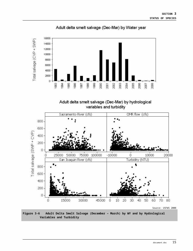
BIOLOGICAL ASSESSMENT DRAFT2-GATE FISH PROTECTION DEMONSTRATION PROJECT APRIL 2009
habitat complexity, low abundance of food organisms, and offer little protection from predation by fish and birds. Freshwater rearing habitat has a high conservation value as the juvenile life stages of salmonids are dependant on the function of this habitat for successful survival and recruitment. Thus, although much of the rearing habitat is in poor condition, it is important to the species.
Freshwater Migration CorridorsIdeal freshwater migration corridors for adults and juveniles are free of obstruction and contain natural cover such as submerged and overhanging large wood, aquatic vegetation, large rocks and boulders, side channels, and undercut banks. Migratory corridors are downstream of the spawning areas and include the Sacramento River and its tributaries downstream of Keswick Dam as well as the Delta. These corridors allow the upstream passage of adults, and the downstream emigration of juveniles. Migratory habitat condition is strongly affected by the presence of barriers, which can include dams, unscreened or poorly- screened diversions, and degraded water quality. For adults, upstream passage through the Delta and the lower Sacramento River does not appear to be a problem, but problems exist on many tributary streams. For juveniles, unscreened or inadequately screened water diversions throughout their migration corridors along with a scarcity of complex in-river cover have degraded this PCE. However, since the primary migration corridors are used by numerous populations and are essential for connecting early rearing habitat with the ocean, even the degraded reaches are considered to have a high conservation value to the species. Thus, although much of the migration corridor is in poor condition, it is important to the species.
Estuarine AreasEstuarine areas are another PCE, including both nearshore and off shore habitats, free of obstruction with water quality, salinity conditions, and food resources that support growth and maturation as well as juvenile and adult salmonid physiological transitions between fresh and salt water. Natural cover such as submerged and overhanging large wood, aquatic vegetation, side channels, and deep water areas are suitable for juvenile and adult salmonids. The remaining estuarine habitat for these species is severely degraded by altered hydrologic regimes, poor water quality, reductions in habitat complexity, and competition for food and space with exotic species. Regardless of the condition, the remaining estuarine areas are of high conservation value because they function as predator avoidance and as a transition corridor to the ocean environment. Nearshore marine features are essential to conservation because, without them, juvenile and adult salmonids cannot successfully transition between natal streams and offshore marine areas.
Winter-run and spring-run Chinook and CV steelhead use the Delta, Suisun Bay, San Pablo Bay and San Francisco Bay as migratory corridors through which they move from the ocean to freshwater as adults and from freshwater to the ocean as juveniles. Most movement by adults occurs in deeper channels, while juveniles are more likely to use the shallow habitats, including tidal flats, for feeding and predator refuge.
Ocean HabitatsAlthough ocean habitats are not part of the critical habitat listings for winter-run and spring-run Chinook and CV steelhead, biologically productive coastal waters are an important habitat component.
3.1.2.7 Factors Affecting Chinook salmon and Steelhead and designated Critical HabitatIn summary, the construction of high dams for hydropower, flood control, and water supply resulted in the loss of vast amounts of upstream habitat (i.e., approximately 80 percent, or a minimum linear estimate of over 1,000 stream miles), and often resulted in precipitous declines in affected salmonid populations. The reduced populations that remain below Central Valley dams are forced to spawn in lower elevation tailwater habitats of mainstem rivers and tributaries that were previously not used for this purpose. This habitat is entirely dependent on managing reservoir releases to maintain cool water temperatures suitable for spawning, and/or
36 document.doc
SECTION 3STATUS OF SPECIES
rearing of salmonids. All salmonid species considered in this BA have been adversely affected by the production and release of hatchery fish.
Land-use activities associated with agriculture, urban development, resource extraction (logging, mining) and recreation have significantly altered fish habitat quantity and quality through alteration of streambank and channel morphology, alteration of ambient water temperatures; degradation of water quality, elimination of spawning and rearing habitat, habitat fragmentation, elimination of large woody debris, removal of riparian vegetation, and other effects. Human-induced habitat changes, such as alteration of natural flow regimes; installation of bank revetment; and instream structures (e.g., diversion facilities, piers) often provide conditions that both disorient juvenile salmonids and attract predators. Additional stressors include harvest, ocean productivity, and drought conditions. In contrast, various ecosystem restoration activities have contributed to improved conditions for listed salmonids (e.g., habitat enhancement, screening water diversion structures, improved instream flows downstream of some dams).
The following sections are an overview of the factors affecting winter-run and spring-run Chinook and CV steelhead. Further details are provided in various NMFS reports (Busby et al. 1996; Myers et al., 1998; NMFS 1996, 1998 and 2008; Good et al. 2005).
Fish Movement & Habitat BlockageHabitat loss due to blockage is likely the most important threat to winter-run and spring-run Chinook salmon and CV steelhead. Hydropower, flood control, and water supply dams of the CVP, SWP, and other municipal and private entities have permanently blocked or hindered salmonid access to historical spawning and rearing grounds. Populations of these anadromous salmonids are now confined to lower elevation reaches of Central Valley rivers and streams which were historically only used for migration. Population abundances have declined in these streams due to decreased quantity and quality of spawning and rearing habitat. Higher temperatures at these lower elevation reaches during late-summer and fall are also a major stressor to adult and juvenile salmonids.
Blockages can also occur within the Delta. The Suisun Marsh Salinity Control Gates (SMSCG), installed in 1988 on Montezuma Slough to decrease the salinity levels of managed wetlands in Suisun Marsh, have delayed or blocked passage of adult Chinook salmon migrating upstream, but passage has improved since the 2001-2002 season when the boat lock remained open (NMFS 2008a). Migrating adult and juvenile steelhead may experience blockage or delays at the SMSCG, the Delta Cross Channel, and at temporary agricultural barriers in the south Delta (NMFS 2008a). Migration delays may reduce fecundity and increase susceptibility to disease and poaching for adults, and increase predation risk for juveniles.
Water Development and Conveyance (Hydrodynamics and Entrainment)The diversion and storage of natural flows by dams and diversion structures on Central Valley waterways have depleted streamflows and altered the natural flow cycles that cue migration by juvenile and adult salmonids. As much as 60 percent of the natural historical inflow to Central Valley watersheds and the Delta have been diverted for human uses. Depleted flows have contributed to higher temperatures, lower DO levels, and decreased recruitment of gravel and large woody debris (LWD). More uniform flows year round have resulted in diminished natural channel formation, altered sediment quality and bedload movement, altered foodweb processes, and slower regeneration of riparian vegetation. Runoff storage in these large reservoirs has altered the normal hydrograph. Rather than peak flows following winter rain events (Sacramento River) or spring snow melt (San Joaquin River), the current hydrology has truncated peaks with a prolonged period of elevated flows (compared to historical levels) continuing into the summer dry season.
Water withdrawals for agricultural and municipal purposes have reduced river flows and increased temperatures during the critical summer months. Direct relationships exist between water temperature, water
document.doc 37
BIOLOGICAL ASSESSMENT DRAFT2-GATE FISH PROTECTION DEMONSTRATION PROJECT APRIL 2009
flow, and juvenile salmonid survival (Brandes and McLain 2001). Elevated water temperatures in the Sacramento River have limited the survival of young salmon. Juvenile fall-run Chinook salmon survival in the Sacramento River is also directly related with June streamflow and June and July Delta outflow (Dettman et al. 1987).
Water diversions for irrigated agriculture, municipal and industrial use, and managed wetlands are found along the Sacramento River, San Joaquin River, and their tributaries. Many of these diversions are unscreened. Depending on the size, location, and season of operation, these unscreened diversions entrain and kill many life stages of aquatic species, including juvenile salmonids.
Outmigrant juvenile salmonids in the Delta have been exposed to adverse environmental conditions created by water export operations at the CVP and SWP facilities (NMFS 2008a). Specifically, juvenile salmonid survival has been reduced by the following: (1) water diversion from the mainstem Sacramento River into the Central Delta via the Delta Cross Channel; (2) upstream or reverse flows of water in the lower San Joaquin River and southern Delta waterways; (3) entrainment at the CVP/SWP export facilities and associated problems at Clifton Court Forebay; and (4) increased exposure at facilities to introduced, non-native predatory fish (NMFS 2008a).
Flood Control and Levee ConstructionThe development of the water conveyance system in the Delta has resulted in the construction of more than 1,100 miles of channels and diversions to increase channel elevations and flow capacity of the channels (Mount 1995).
Levee development and bank stabilization structures may affect the quality of rearing and migration habitat along the river. Juvenile steelhead prefer natural stream banks with ample cover from riparian vegetation and undercut banks (Moyle 2002), as opposed to riprapped, leveed, or channelized waterways. Many Delta islands have been fortified to minimize flooding, but these efforts have reduced historic floodplain, marsh, and shallow water habitats that juvenile salmonids depend on for rearing. Many levees use angular rock (riprap) to armor the bank from erosive forces. Channelization, removal of streamside vegetation and large woody debris, and riprapping alter river hydraulics and cover along the bank and cause long-term damage to nearshore habitat for juvenile salmonids (Busby et al. 1996, Myers et al. 1997, USFWS 2000, Schmetterling et al. 2001).
Land Use ActivitiesLand use activities such as historic and ongoing agricultural practices and urban development continue to have large impacts on salmonid habitat in the Central Valley watershed. Increased sedimentation from agricultural and urban practices within the Central Valley is a primary cause of habitat degradation (NMFS 1996). Land use activities associated with road construction, urban development, logging, mining, agriculture, and recreation have significantly altered fish habitat quantity and quality through the alteration of streambank and channel morphology; alteration of ambient water temperatures; degradation of water quality; elimination of spawning and rearing habitat; fragmentation of available habitats; elimination of downstream recruitment of LWD; and removal of riparian vegetation, resulting in increased streambank erosion (Meehan 1991). Urban stormwater and agricultural runoff may be contaminated with herbicides and pesticides, petroleum products, sediment, and other contaminants (Myers et al. 1998, NMFS 1996 and 1998).
Since the 1850s, wetlands reclamation for urban and agricultural development has caused significant loss of tidal marsh habitat in the Delta. By the time the last island was reclaimed in 1934, 441,000 acres of nearly 500,000 acres of federal swamplands had been reclaimed in the Delta (PPIC 2007). Only about five percent of the original marsh remains in the estuary, with the larger remnants in Suisun Marsh.
38 document.doc
SECTION 3STATUS OF SPECIES
Dredging of river channels for shipping and levee construction has significantly impaired the natural hydrology and function of the river systems in the Central Valley. The creation of levees and deep shipping channels reduced seasonal inundation of floodplains, which provided necessary habitat for rearing and foraging juvenile native fish, including salmon and steelhead. Levee maintenance has reduced riparian vegetation, LWD inputs, and productive intertidal mudflats.
Urban stormwater and agricultural runoff may be contaminated with pesticides, oil, grease, heavy metals, polycyclic aromatic hydrocarbons (PAHs), and other organics and nutrients (California Regional Water Quality Control Board-Central Valley Region [Regional Board] 1998). These can potentially destroy aquatic life necessary for salmonid survival (NMFS 1996). Point source and non-point source (NPS) pollution occurs at almost every point that urbanization activity influences the watershed. Impervious man-made surfaces reduce water infiltration and increase runoff, thus creating greater flood hazard (NMFS 1996). Juvenile salmonids are exposed to increased water temperatures from municipal, industrial, and agricultural discharges.
Past mining activities removed spawning gravels from streams, channelized streams, and leached toxic effluents into streams. Many of these effects persist today. Present day mining practices such as sand and gravel mining, suction dredging, and placer mining are typically less intrusive than historic operations (hydraulic mining), but adverse impacts to salmonid habitat still occur.
Water QualityThe water quality of the Delta has been negatively impacted over the last 150 years. Increased water temperatures, decreased DO levels, and increased turbidity and contaminant loads have degraded the quality of the aquatic habitat for the rearing and migration of salmonids. The Central Valley Regional Quality Control Board, in its 1998 Clean Water Act §303(d) list characterized the Delta as an impaired waterbody having elevated levels of a variety of pesticides, EC, mercury, low DO, and organic enrichment (Regional Board 1998, 2001). Water degradation or contamination can lead to either acute toxicity, resulting in death when concentrations are sufficiently elevated, or more typically, when concentrations are lower, to chronic or sublethal effects that reduce health and survival over an extended period of time.
In the aquatic environment, many anthropogenic chemicals and waste materials including toxic organic and inorganic chemicals eventually accumulate in sediment (e.g., Alpers et al. 2008). Direct exposure to contaminated sediments may cause deleterious effects to listed salmonids or the threatened green sturgeon. This may occur if a fish swims through a plume of the resuspended sediments or rests on contaminated substrate and absorbs the toxic compounds through dermal contact, ingestion, or uptake across the gills. Elevated contaminant levels may be found in localized “hot spots” where discharge occurs or where river currents deposit sediment loads. However, the more likely route of exposure to salmonids or sturgeon is through the food chain, when the fish feed on organisms that are contaminated with toxic compounds (Alpers et al. 2008). Prey species become contaminated either by feeding on the detritus associated with the sediments or dwelling in the sediment itself. Therefore, the degree of exposure to salmonids depends on their trophic level and the amount of contaminated forage base they consume. Response of salmonids to contaminated sediments is similar to water borne exposures.
Hatchery OperationsFive hatcheries currently produce Chinook salmon in the Central Valley. Releasing large numbers of hatchery fish can pose a threat to wild Chinook salmon stocks through genetic impacts, competition for food and other resources between hatchery and wild fish, predation of hatchery fish on wild fish, and increased fishing pressure on wild stocks as a result of hatchery production (Waples 1991). The genetic impacts of artificial propagation programs in the Central Valley primarily are caused by straying of hatchery fish and the subsequent interbreeding of hatchery fish with wild fish. Hatchery practices as well as spatial and temporal
document.doc 39

BIOLOGICAL ASSESSMENT DRAFT2-GATE FISH PROTECTION DEMONSTRATION PROJECT APRIL 2009
overlaps of habitat use and spawning activity between spring- and fall-run Chinook salmon have led to the hybridization and homogenization of some subpopulations (DFG 1998).
For Central Valley steelhead, two artificial propagation programs (Coleman National Fish Hatchery and the Feather River Fish Hatchery) may present additional threats to the natural steelhead population. These include mortality of natural steelhead in fisheries targeting hatchery-origin steelhead, competition, predation by hatchery-origin fish on younger natural fish, genetic introgression by hatchery-origin fish that spawn naturally and interbreed with local natural populations, disease transmission, and fish passage impediments from hatchery facilities (NMFS 2008a).
Over Utilization (Commercial and Sport)
OCEAN COMMERCIAL AND SPORT HARVEST – CHINOOK SALMON Extensive ocean recreational and commercial troll fisheries for Chinook salmon exist along the Northern and Central California coast. The ocean harvest rates of Sacramento River winter- and spring-run Chinook salmon are thought to be a function of the Central Valley Chinook salmon ocean harvest index (CVI), which is defined as the ratio of ocean catch south of Point Arena, California, to the sum of this catch and the escapement of Chinook salmon to Central Valley streams and hatcheries (Good et al. 2005). CWT returns indicate that Sacramento River salmon congregate off the California coast between Point Arena and Morro Bay.
From 1970 to 1995, the CVI ranged between 0.50 and a record high of 0.79 (1990). In 1996 and 1997, NMFS issued a BO which concluded that incidental ocean harvest represented a significant source of mortality to the endangered population, even though ocean harvest was not a key factor leading to the decline of the population. As a result, measures were developed and implemented by the Pacific Fisheries Management Council, NMFS, and CDFG to reduce ocean harvest by approximately 50 percent. In 2001 the CVI dropped to 0.27, as a result of reduced harvest, record spawning escapement of fall-run Chinook salmon in 2001 (approximately 540,000 fish) and concurrent increases in other Chinook salmon runs in the Central Valley (Good et al. 2005).
INLAND SPORT HARVEST – CHINOOK SALMON Since 1987, the Fish and Game Commission has adopted increasingly stringent regulations to reduce and virtually eliminate the in-river sport fishery for winter-run Chinook. These closures have virtually eliminated impacts on winter-run Chinook caused by recreational angling in freshwater. In 1992, the California Fish and Game Commission adopted gear restrictions and regulations to reduce the potential for injury and mortality.
In-river recreational fisheries historically have taken spring-run Chinook throughout the species’ range. During the summer, holding adults are easily targeted by anglers when they congregate in large pools or at fish ladders. The significance of poaching on the adult population is unknown. Specific regulations have been implemented to protect spring-run Chinook in important spawning creeks. The current regulations, including those developed for winter-run Chinook provide some level of protection for spring-run fish (DFG 1998).
CENTRAL VALLEY STEELHEAD OVERUTILIZATION FOR COMMERCIAL, RECREATIONAL, SCIENTIFIC, OR EDUCATIONAL PURPOSES Overutilization for commercial, recreational, scientific or educational purposes does not appear to have a significant impact on CV steelhead populations, but warrants continued assessment. Steelhead have been, and continue to be, an important recreational fishery throughout their range. Although there are no commercial fisheries for steelhead in the ocean, inland steelhead fisheries include tribal and recreational fisheries. In the Central Valley, recreational fishing for hatchery-origin steelhead is popular, but is restricted to only visibly marked fish of surplus hatchery-origin, which reduces the likelihood of catching naturally-spawned wild fish.
40 document.doc
SECTION 3STATUS OF SPECIES
The impact of these fisheries is unknown, however, because the sizes of Central Valley steelhead populations are unknown (Good et al. 2005).
Scientific and educational projects permitted under sections 4(d) and 10(a)(1)(A) of the ESA stipulate specific conditions to minimize take of Central Valley salmonid individuals during permitted activities. There are currently eleven active permits in the Central Valley that may affect steelhead. These permitted studies provide information that is useful to the management and conservation of the DPS.
Disease and PredationSalmonids are exposed to numerous bacterial, protozoan, viral, and parasitic organisms in spawning and rearing areas, hatcheries, migratory routes, and the marine environment (NMFS 1996, Myers et al. 1998). Very little current or historical information exists to quantify changes in infection levels and mortality rates attributable to these diseases; however, studies have shown that wild fish tend to be less susceptible to pathogens than are hatchery-reared fish. Nevertheless, wild salmonids may contract diseases that are spread through the water column (i.e., waterborne pathogens) as well as through interbreeding with infected hatchery fish.
Accelerated predation of juveniles may also be a factor in the decline. Human-induced habitat changes such as alteration of natural flow regimes and installation of bank revetment and structures often provide conditions that both disorient juvenile salmonids and attract predators (Decato 1978, Vogel et al. 1988, Garcia 1989). The risk from predatory fish can be increased due to turbulent conditions near structures, prolonged travel time due to flow alteration and reduction, and predators awaiting at salvage release sites (Edwards et al. 1996, Tillman et al. 1996, NMFS 1997, Orsi 1967, Pickard et al. 1982). High rates of predation are known to occur at diversion facilities on the mainstem Sacramento River (e.g., RBDD) and the South Delta (e.g. Clifton Court Forebay) and along rock revetment (CDFG 1998). The rates and effects of predation on the population, however, are difficult to determine. Fish-eating birds and mammals can also contribute to the loss of migrating juvenile salmonids (NMFS 2008a), although the level of this effect has not been measured.
Non-native Invasive SpeciesAs currently seen in the San Francisco estuary, non-native invasive species can alter the natural food webs that existed prior to their introduction (Sommer 2007, Baxter et al. 2008). Perhaps the most significant example is illustrated by the Asiatic freshwater clams Corbicula fluminea and Potamocorbula amurensis. The arrival of these clams in the estuary disrupted the normal benthic community structure and depressed phytoplankton levels in the estuary due to the highly efficient filter feeding of the introduced clams (Cohen and Moyle 2004). The decline in phytoplankton reduces zooplankton that feed upon them, and hence reduces the forage base available to salmonids in the Delta.
Attempts to control non-native invasive species, such as chemical treatments to control the invasive water hyacinth and Egeria densa, may also adversely impact salmonid health through chemical effects and decreased in DO from decaying vegetation (NMFS 2008a).
Ocean Survival and Environmental Variation and Climate ChangeNatural changes in the freshwater and marine environments play a major role in salmonid abundance (NMFS 2008a, Lindley et al. 2009). Lindley et al. (2009) examined the recent variation in Sacramento River chinook escapement and suggested that variations in salmon productivity over broad geographic areas may be due regional environmental variation, such as widespread drought or floods affecting hydrologic conditions (e.g., river flow and temperature), or regional variation in ocean conditions (e.g., temperature, upwelling, prey and predator abundance). Variations in ocean climate have been increasingly recognized as an important cause of variability in the landings, abundance, and productivity of salmon (reviewed in Lindley et al. 2009).
document.doc 41
BIOLOGICAL ASSESSMENT DRAFT2-GATE FISH PROTECTION DEMONSTRATION PROJECT APRIL 2009
The Pacific Ocean has many modes of variation in sea surface temperature, mixed layer depth, and the strength and position of winds and currents, including the El Niño-Southern Oscillation, the Pacific Decadal Oscillation and the Northern Oscillation. The broad variation in physical conditions creates corresponding variation in the pelagic food webs upon which juvenile salmon depend, which in turn creates similar variation in the population dynamics of salmon across the north Pacific.
The different Central Valley stocks appear to respond differently to recent environmental variation, especially ocean conditions (Lindley et al. 2009). Almost all fall-run Chinook populations have rapidly declined from peak abundances around 2002. In contrast, late-fall, winter and naturally-spawning spring-run Chinook populations have been increasing in abundance over the past decade, although escapement in 2007 was down in some of them and the growth of these populations through the 1990s and 2000s has to some extent been driven by habitat restoration efforts. One factor may be hatchery practices that reduce demographic variation. The other factor may be the different life history tactics of the other salmon runs. Spring-run Chinook juveniles enter the ocean at a broader range of ages (with a portion of some populations migrating as yearlings) than fall Chinook, due to their use of higher elevations and colder waters. Winter-run Chinook spawn in summer, and the juveniles enter the ocean at a larger size than fall Chinook, due to their earlier emergence and longer period of freshwater residency. If ocean conditions at the time of ocean entry are critical to the survival of juvenile salmon, then populations from different runs should respond differently to changing ocean conditions because they enter the ocean at different times and at different sizes (Lindley et al. 2009).
Ecosystem Restoration
CALIFORNIA BAY-DELTA AUTHORITY Two programs included under CBDA were created to improve conditions for fish, including listed salmonids, in the Central Valley: (1) the ERP and its Environmental Water Program, and (2) the EWA managed under the Water Supply and Reliability Program (CALFED 2000). Restoration actions implemented by the ERP include the installation of fish screens, modification of barriers to improve fish passage, habitat acquisition, and instream habitat restoration. The majority of these actions address key factors affecting listed salmonids and emphasis has been placed in tributary drainages with high potential for spring-run Chinook production. Additional ongoing actions include new efforts to enhance fisheries monitoring and directly support salmonid production through hatchery releases. Recent habitat restoration initiatives sponsored and funded primarily by the CBDA-ERP have resulted in plans to restore ecological function to 9,543 acres of shallow-water tidal and marsh habitats within the Delta. Restoration of these areas primarily involves flooding lands previously used for agriculture, thereby creating additional rearing habitat for juvenile salmonids. Similar habitat restoration is imminent adjacent to Suisun Marsh (i.e., at the confluence of Montezuma Slough and the Sacramento River) as part of the Montezuma Wetlands project, which is intended to provide for commercial disposal of material dredged from San Francisco Bay in conjunction with tidal wetland restoration.
A review of CALFED’s performance in Years 1 through 8 concluded that the greatest investments and results of the ERP and Watershed Programs have been in areas upstream from the Delta (CALFED BDPAC 2007). Significant investments made there in fish screens, temperature control, fish passage improvements and upstream habitats have resulted in an improved outlook for salmon throughout the Central Valley. Unfortunately, efforts have been less successful at acquiring and protecting important lands in the Delta along its tributary rivers and streams (CALFED BDPAC 2007)
The CBDA has two water acquisition programs: the Environmental Water Program (EWP) and the EWA. The EWP is a subprogram of the ERP designed to support ERP projects through enhancement of instream flows, principally for the benefit of listed salmonids, in anadromous reaches of priority streams controlled by dams. As of 2007, however, little progress has been made on purchasing water rights for fish in important spawning tributaries (CALFED BDPAC 2007).
42 document.doc
SECTION 3STATUS OF SPECIES
The EWA is designed to provide water at critical times to meet ESA requirements and incidental take limits without water supply impacts to other users, particularly South of Delta water users. In early 2001, the EWA released 290 thousand acre feet of water from San Luis Reservoir at key times to offset reductions in South Delta pumping implemented to protect winter-run Chinook salmon, delta smelt, and splittail. However, the benefit derived by this action to winter-run Chinook salmon in terms of number of fish saved was very small. The EWA has been very successful at eliminating conflict between protection of Delta fish and export water supply. From 1995 through 2006, no conflicts between fish and water supply occurred that resulted in uncompensated water supply reductions. It is uncertain whether EWA actions are having any favorable impact on Delta species in a system that continues to rely on through-Delta conveyance. Actions taken to protect anadromous species have had a positive influence on the species, but actions outside the Delta have been far more effective in improving populations than the EWA actions in the Delta.
Currently, the EWA program is authorized through 2010 and is scheduled to be reduced in its scope. Future EWA operations will be considered to have limited assets and will primarily be used only during CVP and SWP pumping reductions in April and May as a result of the Vernalis Adaptive Management Program (VAMP) experiments. In this case, EWA assets will be used to offset “uncompensated losses” to CVP and SWP water contractors for fisheries related actions. The primary source of EWA assets through 2015 will come from the 60,000 acre-feet of water transferred to the State under the Yuba Accord.
CENTRAL VALLEY PROJECT IMPROVEMENT ACT The Central Valley Project Improvement Act (CVPIA), implemented in 1992, requires that fish and wildlife get equal consideration with other demands for water allocations derived from the CVP. From this act arose several programs that have benefited listed salmonids: the Anadromous Fish Restoration Program (AFRP), the Anadromous Fish Screen Program (AFSP), and the Water Acquisition Program (WAP). The AFRP is engaged in monitoring, education, and restoration projects geared toward recovery of all anadromous fish species residing in the Central Valley. Restoration projects funded through the AFRP include fish passage, fish screening, riparian easement and land acquisition, development of watershed planning groups, instream and riparian habitat improvement, and gravel replenishment. The AFSP combines Federal funding with State and private funds to prioritize and construct fish screens on major water diversions mainly in the upper Sacramento River. The goal of the WAP is to acquire water supplies to meet the habitat restoration and enhancement goals of the CVPIA and to improve the Department of the Interior’s ability to meet regulatory water quality requirements. Water has been used successfully to improve fish habitat for spring-run Chinook salmon by maintaining or increasing instream flows in Butte and Mill Creeks and the San Joaquin River at critical times.
IRON MOUNTAIN MINE REMEDIATION Environmental Protection Agency's Iron Mountain Mine remediation involves the removal of toxic metals in acidic mine drainage from the Spring Creek Watershed. Contaminant loading into the Sacramento River from Iron Mountain Mine has shown measurable reductions since the early 1990s (see Reclamation 2004 Appendix J). Decreasing the heavy metal contaminants that enter the Sacramento River should increase the survival of salmonid eggs and juveniles. However, during periods of heavy rainfall upstream of the Iron Mountain Mine, Reclamation substantially increases Sacramento River flows in order to dilute heavy metal contaminants being spilled from the Spring Creek debris dam. This rapid change in flows can cause juvenile salmonids to become stranded or isolated in side channels below Keswick Dam.
SWP DELTA PUMPING PLANT FISH PROTECTION AGREEMENT (FOUR-PUMPS AGREEMENT) The 1986 ‘Four Pumps Agreement’ between the DWR and DFG was established to offset direct losses of Chinook salmon, steelhead and striped bass caused by the diversion of water at the SWP’s Harvey O. Banks Delta Pumping Plant (DWR and DFG 1986). Since 1986 approximately $59 million has been approved for over 40 fish mitigation projects. About $44 million of the approved funds have been expended to date and the
document.doc 43
BIOLOGICAL ASSESSMENT DRAFT2-GATE FISH PROTECTION DEMONSTRATION PROJECT APRIL 2009
remaining approved funds are allocated for new or longer term projects (DWR 2008). Four Pumps projects that benefit spring-run Chinook salmon include water exchange programs on Mill and Deer Creeks to provide salmon passage flows; enhanced law enforcement; fish screens and ladders on Butte Creek; and screening of diversions in Suisun Marsh and San Joaquin tributaries. Passage projects, migration flows, and enhanced enforcement for spring-run Chinook continue to be priority projects, as do natural production projects for steelhead.
3.1.2.8 Status of the Species within the Action AreaThe Sacramento-San Joaquin Delta serves as the gateway through which all listed anadromous species in the Central Valley must pass through on their way to spawning grounds as adults or retuning to the ocean as juveniles or post-spawn adults (for steelhead). The temporal and spatial occurrence of each of the runs of salmonids is intrinsic to their natural history and the exposure to the action can be anticipated based on their timing and location (Table 3-7) (NMFS 2008a).
Sacramento River winter-run Chinook SalmonThe main adult winter-run migration route is the mainstem Sacramento River, which skirts the northwest portion of the Delta. The Action Area does not overlap designated critical habitat for winter-run Chinook (Figure 3-7). However, there is the potential for a small number of adults to “stray” into the San Joaquin River side of the Delta while on their upstream migration, particularly early in the migratory season (November and December) (NMFS 2008a). Juvenile winter-run emigrants are susceptible to being “carried” into the Central and South Delta by the flow splits through the DCC (when open), Georgiana Slough, Three Mile Slough, and Broad Slough and subsequently being entrained by the effects of pumping at the CVP and SWP once entering the Central Delta. Juvenile winter-run are present in the waterways of the west, north , central, and south Delta waterways leading to the CVP and SWP pumping facilities including OMRs.
Central Valley spring-run Chinook SalmonSpring-run Chinook occur in the Action Area, as evidenced by salvage at the south Delta pumps. However, the Action Area does not include designated critical habitat for spring-run Chinook (Figure 3-8). Adult spring-run enter the San Francisco Bay Estuary from the ocean in January to late February. They move through the Delta prior to entering the Sacramento River system. Spring-run show two distinct juvenile emigration patterns. Fish may either emigrate to the Delta and ocean during their first year of life as YOY, typically in the following spring after hatching, or hold over in their natal streams and emigrate the following fall as yearlings. Typically, yearlings enter the Delta as early as November and December and continue to enter the Delta through at least March. They are larger and less numerous than the YOY smolts that enter the Delta from January through June. The peak of YOY spring-run presence in the Delta is during the month of April, as indicated by the recoveries of spring-run size fish in the CVP and SWP salvage operations and the Chipps Island trawls. Frequently, it is difficult to distinguish the YOY spring-run outmigration from that of the fall-run due to the similarity in their spawning and emergence times. The overlap of these two runs makes for an extended pulse of Chinook salmon smolts through the Delta each spring, frequently lasting into June.
44 document.doc

SECTION 3STATUS OF SPECIES
Table 3-7 Temporal Occurrence of Salmonids and Sturgeon within the Delta
Source: NMFS 2008a
Central Valley steelheadThe Action Area overlaps a portion of the designated critical habitat for CV steelhead (Figure 3-9). Adult steelhead have the potential to be found within the Delta during any month of the year. Typically, adults begin to enter the Delta during mid to late summer, and enter the Sacramento River system from July to early September. Post-spawning adults (kelts) are typically seen later in the spring following spawning. Steelhead entering the San Joaquin River basin are believed to enter the system in late October through December (NMFS 2008a).
Juvenile steelhead are recovered in the USFWS Chipps Island trawls from October through July. There appears to be a difference in the emigration timing between wild and hatchery-reared steelhead smolts. Adipose fin-clipped hatchery fish are typically recovered at Chipps Island from January through March, with the peak in February and March. This time period corresponds to the schedule of hatchery releases of steelhead smolts from the different Central Valley hatcheries (Nobriga and Cadrett 2001, Reclamation 2008). The timing of wild steelhead (unclipped) emigration is more spread out, with peaks in February and March, based on salvage records at the CVP and SWP fish collection facilities. Individual unclipped fish first begin to be collected in fall and early winter, and may extend through early summer (June and July). Wild fish that are collected at the CVP and SWP facilities late in the season may be from the San Joaquin River system, based
document.doc 45

BIOLOGICAL ASSESSMENT DRAFT2-GATE FISH PROTECTION DEMONSTRATION PROJECT APRIL 2009
on the proximity of the basin to the pumps and the timing of the spring pulse flows in the tributaries (April-May). The size of emigrating steelhead smolts typically ranges from 200 to 250 mm in length, with wild fish tending to be at the upper end of this range (Reclamation 2008, Nobriga and Cadrett 2001).
3.1.3 Southern Distinct Population Segment of North American Green Sturgeon
3.1.3.1 Listing Status and Designated Critical Habitat The Southern DPS of North American green sturgeon was listed as threatened on April 7, 2006 (71 FR 17757) and consists of coastal and Central Valley populations south of the Eel River in California. The Southern DPS presently contains only a single known population that spawns and rears in the Sacramento River system, including the Sacramento, Feather and Yuba Rivers, Sacramento-San Joaquin Delta and Suisun, San Pablo and San Francisco Bays.
Critical habitat for the Southern DPS was proposed on September 8, 2008 (NMFS 2008b; 73 FR 52084). Proposed critical habitat includes freshwater riverine habitats (stream channel defined by the ordinary high water line), bay and estuarine habitat (lateral extent of the mean higher high water line), and coastal marine habitat (to the 110 m [361 foot] depth contour). Proposed critical habitat for the Southern DPS is found within the Action Area, specifically within the Sacramento-San Joaquin Delta (Figure 3-16).
3.1.3.2 Life HistoryNorth American green sturgeon (green sturgeon) are among the largest of the bony fish (Moyle 2002). Green sturgeon are an anadromous, slow-growing, late-maturing and long-lived species (Nakamoto et al. 1995, Farr et al. 2002). Maximum age is likely 60-70 years or more (Moyle 2002). Little is known about the life history of green sturgeon because of its low abundance, low sportfishing value, and limited spawning distribution, but spawning and larval ecology are assumed to be similar to that of white sturgeon (Moyle 2002; Beamsderfer and Webb 2002).
Green sturgeon are mostly marine fish. Adults and subadults enter the San Francisco Estuary during the spring and remain until autumn (Kelly et al. 2007). Recent telemetry studies of fish captured in San Pablo Bay found that movements were not related to salinity, current, or temperature, leading Kelly et al. (2007) to surmise that movements are related to resource availability. Green sturgeon were most often found at depths greater than 5 meters with low or no current during summer and autumn months, presumably conserving energy (Erickson et al. 2002). Adults may utilize a variety of freshwater and brackish water habitats for up to nine months of the year.
Southern DPS green sturgeon currently spawn well upstream of the Action Area in the Sacramento River above Hamilton City and perhaps as far upstream as Keswick Dam (DFG 2002 in Adams et al. 2002). Spawning occurs in the upper river, particularly around the RBDD (Brown 2007). Spawning in the San Joaquin River system has not been recorded, but it is likely that sturgeon historically utilized this basin. Spawning occurs in deep pools in large, turbulent river mainstreams from March to July, with a peak in mid-April to mid-June (Moyle et al. 1992).
46 document.doc

SECTION 3STATUS OF SPECIES
Figure 3-16 Designated Critical Habitat for Southern DPS North American Green Sturgeon
document.doc 47

BIOLOGICAL ASSESSMENT DRAFT2-GATE FISH PROTECTION DEMONSTRATION PROJECT APRIL 2009
Green sturgeon larvae disperse downstream from Sacramento River spawning areas soon after hatching and rear as juveniles and subadults for several years throughout the Sacramento-San Joaquin Delta before migrating into the ocean (Beamesderfer et al. 2007). Little is known about larval rearing habitat requirements (NMFS 2008a). In the Klamath River, juvenile green sturgeon are reported to grow rapidly to 300 mm in one year and to over 600 mm within 2-3 years (Nakomoto et al. 1995).
Green sturgeon feed on benthic invertebrates including shrimp, mollusks and amphipods, and occasionally small fish (Moyle et al. 1992). The non-native overbite clam (Potamocorbula amurensis) has also been found in green sturgeon (Adams et al. 2002).
Green sturgeon in a telemetry study ranged widely from San Pablo Bay through the San Francisco Estuary, from warm, shallow brackish areas in Suisun Bay to the colder, deeper, oceanic region near the Golden Gate (Kelly et al. 2007). In general, they remained in shallow regions of the bay swimming over bottom depths less than 10m. Movements were either nondirectional and closely associated with the bottom (presumably foraging), or directional continuous swimming in the upper 20 percent of the water column. Nocturnal behavior has been observed in captive-reared larval and juvenile green sturgeon (9–10 months old). This may be an adaptation for avoiding predation during dispersal migration and first-year wintering in riverine habitat (Adams et al. 2002, Kynard et al. 2005).
Juveniles rear in fresh and estuarine waters for about 1 to 4 years (Nakamoto et al. 1995, NMFS 2008a). Juveniles seem to outmigrate in the summer and fall before the end of their second year (Moyle 2002). They disperse widely in the ocean after their outmigration from freshwater and before their return spawning migration (Moyle et al. 1992b).
Green sturgeon spend most of their lives in the ocean and their distribution and activities in the marine environment are poorly understood (Moyle et al. 1992b, Beamesderfer et al. 2007). Green sturgeon migrate considerable distances northward along the Pacific Coast and into other estuaries, particularly the Columbia (Adams et al. 2002). Columbia River green sturgeon are a mixture of fish from the Sacramento, Klamath, and Rogue Rivers (Israel et al. 200X).
Adults reach sexual maturity only after many years of growth: 9-13 years for males and 13-27 years for females (Nakomoto et al. 1995, Van Eenennaam et al. 2006). Spawning periodicity is once every 2-4 years (Erickson and Webb 2007).
3.1.3.3 DistributionGreen sturgeon are the most widely distributed and most marine-oriented of the sturgeon family Ascipenseridae (Moyle 2002). They range offshore along the Pacific Coast from Ensenada Mexico to the Bering Sea and in rivers from British Columbia to the Sacramento River (Moyle 2002). In North America, spawning populations are currently found in only three river systems, the Sacramento and Klamath Rivers in California and the Rogue River in southern Oregon. Two species of sturgeon are sympatric in California, green sturgeon and white sturgeon (A. transmontanus), which is more abundant and subject to sportfishing.
Two green sturgeon DPSs, Northern and Southern, were identified based on evidence of spawning site fidelity (indicating multiple DPS tendencies), and on the preliminary genetic evidence that indicates differences at least between the Klamath River and San Pablo Bay samples (Adams et al. 2002). The Northern DPS includes all green sturgeon populations starting with the Eel River (northern California) and extending northward. The Southern DPS includes all green sturgeon populations south of the Eel River, with the only known spawning population being in the Sacramento River. The distribution of the two DPSs outside of natal waters generally overlap with each other, including aggregations in the Columbia River estuary and Washington estuaries in late summer (reviewed in NMFS 2008b).
48 document.doc
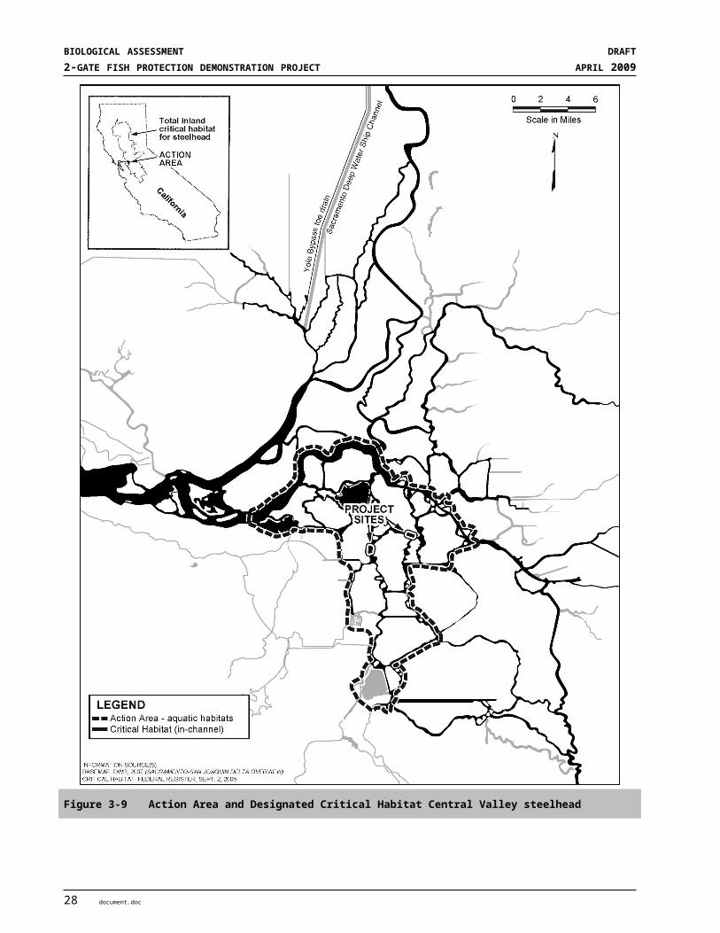
SECTION 3STATUS OF SPECIES
When not in the ocean, green sturgeon occupy freshwater and estuarine habitat in the Sacramento River (upstream to Keswick Dam), lower Feather River, lower Yuba River, the Sacramento-San Joaquin Delta, and the Suisun, San Pablo and San Francisco Bays. Table 3-8 illustrates the temporal distribution of Southern DPS green sturgeon.
Adults migrate in spring to spawning grounds in the Sacramento River and outmigrate in early summer to the ocean (NMFS 2008a). Green sturgeon have not been documented spawning or rearing in the San Joaquin River or its tributaries, although no directed sturgeon studies have ever been undertaken in the San Joaquin River (DFG 2002, Adams et al. 2002, Beamesderfer et al. 2007). Observations of green sturgeon juveniles or unidentified sturgeon larvae in the San Joaquin River have been limited to the Delta, where they could easily, and most likely, have originated from the Sacramento River (Beamesderfer et al. 2004 in NMFS 2008b).
Table 3-8 The Temporal Occurrence of Southern DPS of North American Green Sturgeon Life Stages
Jan Feb Mar Apr May Jun Jul Aug Sep Oct Nov DecAdult Immigration, Holding and Spawning (>13 yrs for females, >9 yrs for males)Upper Sac River1, 2, 3
SF Bay Estuary4,
8
Larval / Post-Larval Rearing (<10 mos)RBDD, Sac River5
GCID, Sac River5
Juvenile Rearing (>10 mos and <3 yrs)Sac-SJ Delta6
Sac-SJ Delta5
Suisun Bay5
Subadult and Adult Coastal Migrant (3-13 yrs for females, 3-9 yrs for males)Pacific Coast3,7
Salvage 6,9
RelativeAbundance
=High =Medium =Low
Sources: 1 USFWS (2002); 2 Moyle et al. (1992), 3 Adams et al. (2002) and NMFS (2005), 4 Kelley et al. (2006), 5 DFG (2002), 6 Interagency Ecological Program Relational Database, fall midwater trawl green sturgeon captures from 1969 to 2003, 7 Nakamoto et al. (1995), 8 Heublein et al. (2006), 9 Fish Facility salvage operations (not a useful criteria for analysis due to very low numbers, ENTRIX 2008)
Source: USBR 2008, NMFS 2008a, ENTRIX 2008
Green sturgeon juveniles, subadults and adults are widely distributed in the Delta and estuary areas including San Pablo Bay (Beamesderfer et al. 2007). Subadults and non-breeding adults inhabit the Delta and bays during summer months, most likely for feeding and growth (Kelly et al. 2007, Moser and Lindley 2007). Juvenile green sturgeon have been salvaged at the SWP and CVP fish facilities in the South Delta, and captured in trawling studies by the CDFG during all months of the year (CDFG 2002). The majority of these fish were 200-500 mm (estimated 2–3 years old) (Nakamoto et al. 1995). The lack of a significant proportion of juveniles smaller than approximately 200 mm (~7.9 inches) in Delta captures indicates juvenile Green sturgeon likely hold in the mainstem Sacramento River, as suggested in Klamath River studies by Kynard et al. (2005).
3.1.3.4 AbundanceReliable population estimates are not available for any green sturgeon population (Beamesderfer et al. 2007). Population abundance and the limitations in estimates are discussed in the NMFS status reviews (Adams et al.
document.doc 49
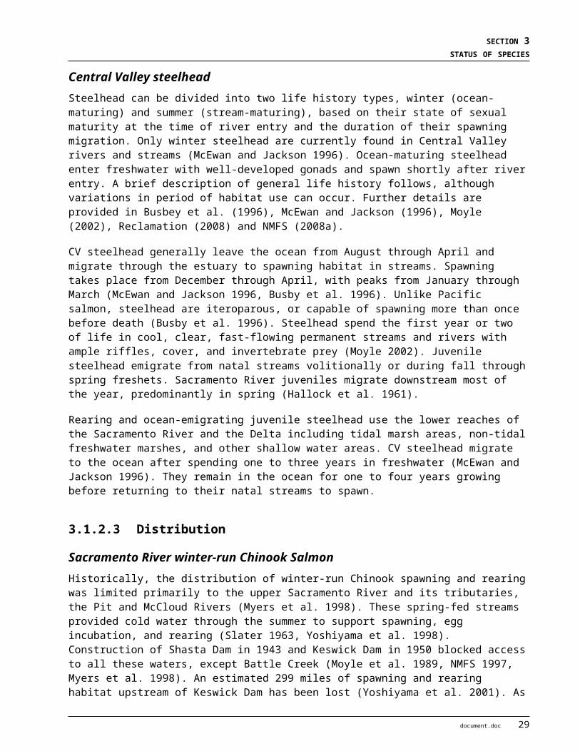
BIOLOGICAL ASSESSMENT DRAFT2-GATE FISH PROTECTION DEMONSTRATION PROJECT APRIL 2009
2002 and 2007, NMFS 2005 and 2008b). Green sturgeon have always been uncommon within the Delta (Moyle 2002). What limited information exists comes mainly from incidental captures of green sturgeon during the CDFG’s white sturgeon monitoring program in San Pablo Bay (CDFG 2002). These estimates, however, are confounded by small sample sizes, intermittent reporting, fishery-dependent data from sportfishing, subsamples representing only a portion of the population, and potential confusion with white sturgeon (Adams et al. 2002, NMFS 2005, Beamesderfer et al. 2007). The most notable biases are the assumptions of equal capture probabilities to the gear and similar seasonal distributions (green sturgeon concentrate in estuaries only during summer and fall, while white sturgeon may remain year round) (Adams et al. 2002 and 2007). Generally, green sturgeon catches are much lower than those for white sturgeon, precluding attempts to infer green sturgeon abundance from white sturgeon mark-recapture studies (Reclamation 2008).
The only abundance trend information available for the Southern DPS of green sturgeon comes from salvage data at the state and federal water export facilities (CDFG 2002, Adams et al. 2002). Green sturgeon taken at the facilities are usually juveniles (28–38 cm length), although an adult over 2 m TL was taken in the spring of 2003 at the USBR’s Tracy Fish Collection Facility (Wang 2006 in NMFS 2008b). At the State of California’s John E. Skinner Fish Facility, the average number of green sturgeon taken annually was 732 prior to 1986, but only 47 between 1986 and 2001 (Adams et al. 2002, 70 FR 17386). For the federal facility the average number was 889 prior to 1986, but only 32 between 1986 and 2001 (70 FR 17386). Estimates from salvage data do have their limitations, however (Adams et al. 2002, 71 FR 17757). Nevertheless, in light of the increased exports, particularly during the previous 10 years, it is clear that Southern DPS abundance is dropping.
Catches of sub-adult and adult North American green sturgeon by the IEP between 1996 and 2004 ranged from 1 to 212 green sturgeon per year (212 occurred in 2001); however, these captures were primarily located in San Pablo Bay, which is known to consist of a mixture of Northern and Southern DPS North American green sturgeon, and the portion represented by Southern DPS green sturgeon is unknown (NMFS 2008b).
3.1.3.5 Population Viability Summary for Green Sturgeon
AbundanceCurrently, no reliable data on population size exists and data on population trends is lacking. Fishery data collected at Federal and State pumping facilities in the Delta indicate a decreasing trend in abundance between 1968 and 2006 (70 FR 17386).
ProductivityThere is insufficient information to evaluate the productivity of green sturgeon. However, as indicated above, there appears to be a declining trend in abundance, which indicates low to negative productivity.
Spatial StructureThe Southern DPS of North American Green Sturgeon only includes a single population in the Sacramento River. Although some individuals have been observed in the Feather and Yuba Rivers, it is not yet known if these fish comprise separate populations. Therefore, the apparent presence of only one reproducing population puts the DPS at risk.
50 document.doc

SECTION 3STATUS OF SPECIES
DiversityGreen sturgeon genetic analyses shows strong differentiation between northern and southern populations, and therefore, the species was divided into Northern and Southern DPSs. However, the genetic diversity of the Southern DPS is not well understood.
3.1.3.6 Critical Habitat and Primary Constituent Elements Critical habitat for the Southern DPS of North American Green sturgeon was proposed in 2008 (73 FR 52084) and generally has physical and biological features or PCEs similar to those described for listed salmonids. NMFS’s Critical Habitat Recovery Team defined the geographical area occupied to range from the California/Mexico border north to the Bering Sea, Alaska. Within the geographical area, 39 occupied specific areas and seven presently unoccupied areas were delineated within freshwater rivers, coastal bays and estuaries, and coastal marine waters. The Action Area occurs in the freshwater riverine system. The PCE’s for the three habitat classes are briefly described below, with further details in the 2008 Draft Biological Report (NMFS 2008b).
Freshwater Riverine SystemsThe life stages that use freshwater habitats include adult migration, holding and spawning; egg incubation; larval development and growth; and juvenile rearing and downstream migration. Specific PCE’s for freshwater riverine systems include:
Abundant food resources for larvae, juveniles, subadult and adult life stages, principally benthic invertebrates and small fish;
Adequate substrate such as cobbles suitable for spawning, incubation and larval development;
Sufficient water flow for egg incubation, larval development, passage and trigger flows for migrating adults);
Good water quality such as temperature below 17 degrees (°) C for eggs and below 20°C for juveniles, salinity below 3 ppt for eggs and larvae and below 10 ppt for juveniles, and free of contaminants;
An unobstructed migratory corridor through the Delta and lower Sacramento River for adults migrating to upstream spawning areas and downstream migrating juveniles;
Deep pools for holding adults and subadults; and
Sediments free from elevated levels of contaminants such as selenium, PAHs, organochlorine pesticides.
Estuarine AreasGreen sturgeon life stages that utilize estuarine areas include migrating adults, foraging subadults and rearing juveniles. Specific PCEs include:
Abundant food resources for juvenile, subadult and adult life stages consisting primarily of benthic invertebrates and fish;
Sufficient water flow to allow adults to orient to incoming flow and migrate upstream to spawning grounds in the Sacramento River;
Good water quality such as water temperature below 24°C, salinity between 10 ppt (brackish) and 33 ppt (salt water), minimum dissolved oxygen levels of 6.54 mg O2/l, and waters with acceptably low levels of contaminants (e.g. pesticides, organichlorines, elevated levels of heavy metals);
document.doc 51
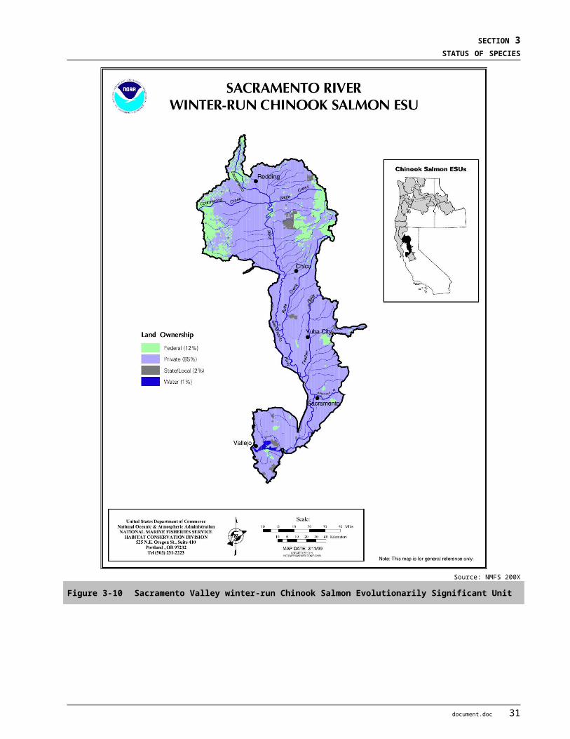
BIOLOGICAL ASSESSMENT DRAFT2-GATE FISH PROTECTION DEMONSTRATION PROJECT APRIL 2009
An unobstructed migratory corridor into and through the estuary for adults migrating to spawning areas in the Sacramento River and for subadults and adults oversummering in bays and estuaries;
A diversity of depths for shelter, foraging and migration; and
Sediments free from elevated levels of contaminants such as selenium, PAHs, organochlorine pesticides.
Estuarine areas free of obstruction with water quality, water quantity, and salinity conditions supporting juvenile and adult physiological transitions between fresh and salt water are included as a PCE. Natural cover such as submerged and overhanging large wood, aquatic vegetation, and side channels, are suitable for foraging juveniles and adults. The remaining estuarine habitat for these species is severely degraded by altered hydrologic regimes, poor water quality, reductions in habitat complexity, and competition for food and space with exotic species. Regardless of the condition, the remaining estuarine areas are of high conservation value because they function as a transition corridor to the ocean environment.
North American green sturgeon use the Delta, San Pablo Bay and San Francisco Bay as a migratory corridor as they move from the ocean to freshwater as adults and from freshwater to the ocean as juveniles. Most movement by adults occurs in deeper channels, while juveniles are more likely to use the shallow habitats, including tidal flats, for feeding and predator refuge.
Coastal Marine AreasGreen sturgeon life stages that utilize coastal marine areas include adults and subadults. Specific PCEs include:
Unobstructed migratory corridors within marine and between estuarine and marine habitats;
Good water quality with adequate dissolved oxygen and acceptably low levels of contaminants (e.g. pesticides, organochlorines, elevated levels of heavy metals); and
Abundant food resources for subadults and adults, which include benthic invertebrates and fish.
3.1.3.7 Factors Affecting Green Sturgeon and proposed Critical Habitat
SummaryThe principal risk factors for the Southern DPS of North American green sturgeon include loss of spawning habitat, harvest of adults, and entrainment of fertilized eggs, juveniles and subadults (Adams et al. 2007). Other threats to the Southern DPS include vulnerability due to concentrated spawning within the Sacramento River, a smaller overall population size compared to the Northern DPS, the lack of population data to inform fishery managers, increased summer stream temperatures that can limit larval growth or survival, and the influence of toxic material and exotic species (Adams et al. 2002 and 2007). The Southern DPS is more vulnerable to catastrophic events than the Northern DPS because the population is smaller and spawning appears to be concentrated in the upper Sacramento River above RBDD. Toxins, invasive species, and water project operations, all identified as threats to the Southern DPS of green sturgeon, may be acting in concert or individually to lower pelagic productivity in the Delta (71 FR 17757).
Many of the factors responsible for the current status of green sturgeon in the Central Valley are similar to those described above for winter-run and spring-run Chinook salmon and steelhead (Section 3.1.2.7). Further details are provided in recent BOs prepared by NMFS (2008a, c).
52 document.doc
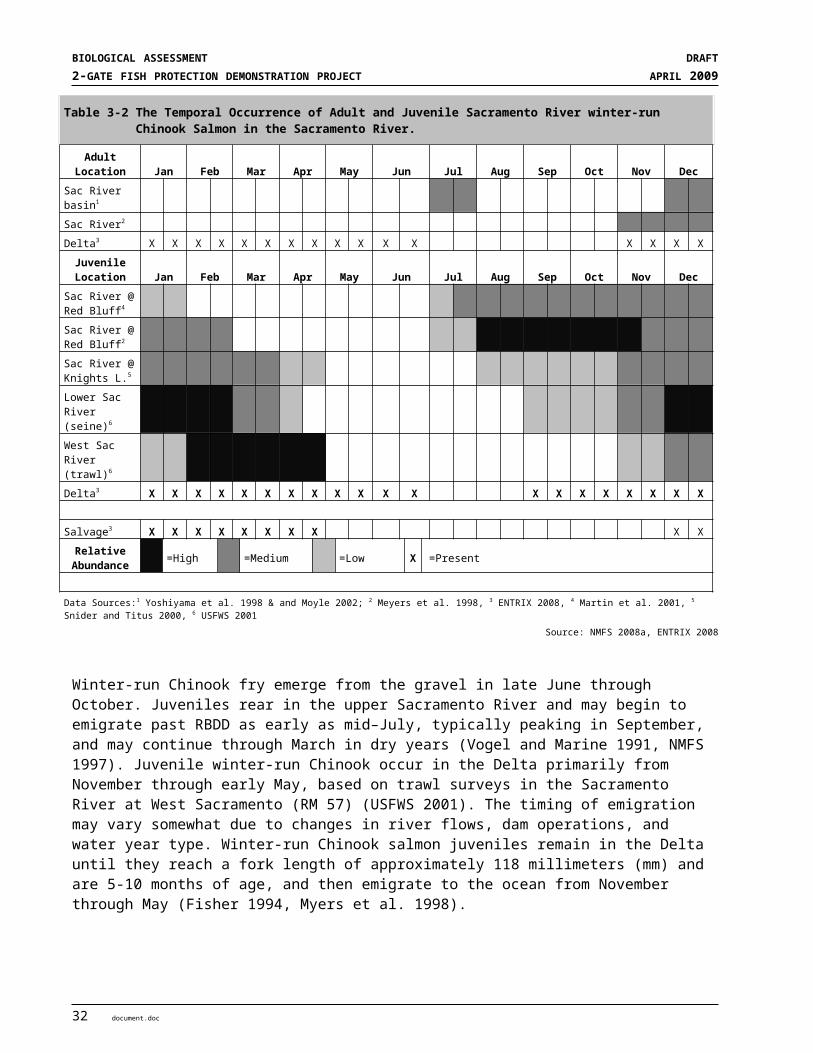
SECTION 3STATUS OF SPECIES
Fish Movement and Habitat BlockageAs with the listed salmonids in the Central Valley, the principal factor for decline of the Southern DPS is the reduction of the spawning area to a limited area of the Sacramento River (71 FR 17757). Hydropower, flood control, and water supply dams of the CVP, SWP, and other municipal and private entities have permanently blocked or hindered access to historical spawning and rearing grounds by a variety of anadromous fish. Keswick Dam provides an impassible barrier blocking green sturgeon access to what were likely historic spawning grounds upstream (USFWS 1995a). Furthermore, the RBDD blocks access to much spawning habitat below Keswick Dam. Changes in project operations since 1986 have increased green sturgeon access to spawning grounds above the RBDD (Adams et al. 2002). A substantial amount of habitat in the Feather River above Oroville Dam has also been lost (NMFS 2005).
Potential adult migration barriers to green sturgeon include the RBDD, the Sacramento Deep Water Ship Channel locks, the Fremont Weir at the head of the Yolo Bypass, the Sutter Bypass, the Delta Cross Channel Gates on the Sacramento River, and Shanghai Bench and Sunset Pumps on the Feather River. Most of these barriers are located outside the Action Area.
Water Development and ConveyanceConstruction of dams and associated impoundments have altered temperature and hydrologic regimes downstream and has simplified instream habitats in freshwater riverine habitat, which is believed to have substantially decreased spawning success (71 FR 17757). Temperature control efforts to benefit winter-run Chinook may have provided some benefit to green sturgeon in the Sacramento River below Keswick Dam.
Juvenile entrainment is considered a threat imposed by water diversions, but the degree to which it is affecting the continued existence of the Southern DPS remains uncertain (71 FR 17757). The threat of screened and unscreened water diversions in the Sacramento River and Delta is largely unknown as juvenile sturgeon are often not identified and current CDFG and NMFS screen criteria do not address sturgeon. Based on the temporal occurrence of juvenile green sturgeon and the high density of water diversion structures along rearing and migration routes, NMFS (2005) found the potential threat of these diversions to be serious and in need of study.
Southern DPS green sturgeon also face entrainment in pumps associated with the CVP and SWP. Substantial numbers of juveniles have been killed in pumping operations at state and federal water export facilities in the south Delta (DFG 2002, Adams et al. 2007). The average number of fish taken annually at the SWP pumping facility was higher in the period prior to 1986 (732) than from 1986 to the present (47) (DFG 2002). At the CVP pumping facilities, the average annual number prior to 1986 was 889; while the average number was 32 after 1986. However, these estimates should be viewed cautiously because they were expanded from brief sampling periods and very few captured sturgeon, and thus may be exaggerated (Adams et al. 2007).
Flood Control and Levee ConstructionThe effects of flood control and levee construction on green sturgeon are similar to those described above for salmonids. (Section 3.1.2.7.3)
Land Use ActivitiesThe effects of land use activities on green sturgeon are similar to those described above for salmonids. (Section 3.1.2.7.4)
document.doc 53

BIOLOGICAL ASSESSMENT DRAFT2-GATE FISH PROTECTION DEMONSTRATION PROJECT APRIL 2009
Water QualityAs described above for salmonids (Section 3.1.2.7.5), the water quality of the Delta and its tributaries has been negatively impacted over the last 150 years. Increased water temperatures, decreased DO levels, and changes in turbidity and increased contaminant loads have degraded the quality of the aquatic habitat for many species including green sturgeon. The upper levels of summer temperatures in the Sacramento River approach growth-limiting and lethal limits for larval green sturgeon (Adams et al. 2002). Temperature control efforts to protect winter-run Chinook have probably been beneficial to green sturgeon in the upper Sacramento River. The Regional Water Quality Control Board characterized the Delta as an impaired waterbody for a variety of issues (such as pesticides, herbicides, mercury, low DO, and organic enrichment) (Regional Board 1998, 2001). Anthropogenic manipulations of the aquatic habitat, such as dredging, bank stabilization, and waste water discharges have also degraded the quality of the Central Valley’s waterways for green sturgeon. Toxins, invasive species, and water project operations, all identified as threats to the Southern DPS of North American green sturgeon, may be acting in concert or individually to lower pelagic productivity in the Delta (71 FR 17757).
The potential effect of toxic contaminants on green sturgeon has not be directly studied, but their long life span, late age of maturity, and benthic feeding habits make sturgeon vulnerable to chronic and acute effects of bioaccumulation (COSEWIC 2004). Many contaminants eventually accumulate in sediment, where green sturgeon can be exposed through direct contact with substrate, swimming through resuspended sediments, or more likely through ingestion of contaminated benthic organisms and subsequent bioaccumulation (e.g., Alpers et al. 2008). Selenium studies in the San Francisco Bay and Delta found elevated levels of selenium in white sturgeon, much higher than in non-benthic fishes and approaching levels which may have acute or chronic effects (e.g., Urquhart et al. 1991). While green sturgeon spend more time in the marine environment than white sturgeon and, therefore, may have less exposure, NMFS concluded that green sturgeon face some risk from contaminants when they inhabit estuaries and freshwater (71 FR 17757).
Contamination of the Sacramento River increased substantially in the mid–1970s when application of rice pesticides increased (USFWS 1995b). Estimated toxic concentrations for the Sacramento River between 1970 and 1988 may have deleteriously affected the larvae of another anadromous species (e.g., striped bass) that occupy similar habitat as green sturgeon larvae (Bailey 1994). Studies of the recent POD in the Delta indicate that toxins may be at least partially responsible.
Hatchery OperationsHatchery operations have not been identified as a potential threat for green sturgeon. White sturgeon are cultivated in hatcheries for commercial aquaculture and for conservation, such as the Kootenay River sturgeon conservation hatchery on the upper Columbia River. There is a possibility of disease transfer from hatchery-raised sturgeon and wild sturgeon; however, there is no evidence that this has ever occurred (COSEWIC 2004). Although aquaculture methods have been developed for green sturgeon, there are currently no hatchery operations for the Southern DPS (J. Van Eenennaam, pers. comm. 2008).
Over-UtilizationGreen sturgeon are not a specifically targeted fish species during existing commercial and sport fishery harvest activities and is now almost entirely bycatch in three fisheries: white sturgeon commercial and sport fisheries, Klamath Tribal salmon gill-net fisheries, and coastal groundfish trawl fisheries (Adams et al. 2002 and 2007).
54 document.doc
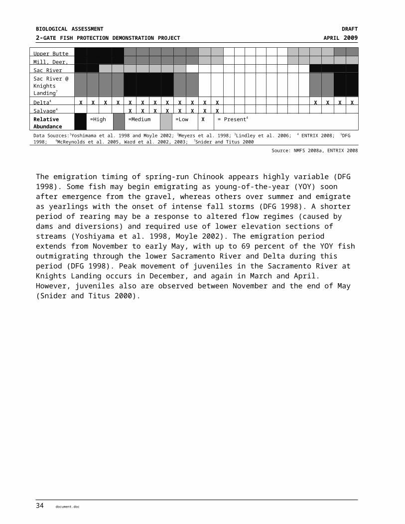
SECTION 3STATUS OF SPECIES
OCEAN AND COMMERCIAL HARVEST Commercial harvest of white sturgeon results in the incidental bycatch of green sturgeon, primarily along the Oregon and Washington coasts and within their coastal estuaries (Adams et al. 2002, NMFS 2008c). A high proportion of green sturgeon present in the Columbia River, Willapa Bay, and Grays Harbor may be Southern DPS North American green sturgeon (DFG 2002 in Adams et al. 2002, Moser and Lindley 2007). The total average annual harvest of green sturgeon declined from 6,466 in 1985-1989 to 1,218 fish in 1999-2001, mostly taken in the Columbia River (51 percent) and Washington coastal fisheries (28 percent) (Adams et al. 2002). Overall captures appeared to be dropping, although this could be related to changing fishing regulations. Oregon and Washington have recently prohibited the retention of green sturgeon for commercial and recreational fisheries.
INLAND SPORT HARVEST Green sturgeon are caught incidentally by sport fisherman targeting white sturgeon (NMFS 2008c). In California, small numbers of green sturgeon are incidentally caught, primarily in San Pablo Bay (Adams et al. 2007). Sportfishing in the Columbia River, Willapa Bay, and Grays Harbor captured from 22 to 553 fish per year between 1985 and 2001. It appears sportfishing captures are declining; however, it is not known if this is a result of abundance, changed fishing regulations, or other factors. In March 2007, the California Fish and Game Commission adopted new regulations that made the landing or possession of green sturgeon illegal. These regulations reduced the slot limit of white sturgeon from 72 inches to 66 inches, and limited the retention of white sturgeon to one fish per day with a total of 3 fish retained per year.
Fishing gear mortality presents an additional risk to the long-lived sturgeon species such as green sturgeon (Boreman 1997). Although sturgeon are relatively hardy and generally survive being hooked, their long life makes them vulnerable to repeated hooking encounters, which may lead to an overall significant hooking mortality rate over their lifetime. Illegal harvest of sturgeon occurs in the Sacramento River and Delta. These operations frequently target white sturgeon, especially for the lucrative caviar market, but green sturgeon may be incidentally taken as well.
Disease and PredationInsufficient information exists to determine whether disease has played an important role in the decline of the Southern DPS (71 FR 17757) of green sturgeon. There is a possibility of disease transfer from hatchery-raised sturgeon and wild sturgeon; however, there is no evidence that this has ever occurred (COSEWIC 2004).
Predation of juveniles by non-native fish such as striped bass has also been identified as a concern, although NMFS was not able to estimate mortality rates imposed on the Southern DPS of green sturgeon. NMFS maintains that the predation risk imposed by striped bass on the Southern DPS likely exists although its importance is uncertain (71 FR 17757).
Non-native Invasive SpeciesNon-native species are an ongoing problem in the Sacramento-San Joaquin River and Delta systems through continued introductions and modification of habitat (DFG 2002). The greatest concerns are about shifts in the relative abundance and types of food items (NMFS 2005). Change in the community composition of zooplankton and benthic invertebrates have been postulated as one factor in the overall pelagic organism decline experienced in the Delta since 2000 (Baxter et al. 2008). For example, the native opossum shrimp Neomysis mercedis was a common prey item for juveniles in the 1960’s (Radtke 1966); this native mysid has been largely replaced in the Delta by the introduced mysid Acanthomysis bowmani. The non-native overbite clam, Potamocorbula amurensis, was introduced in 1988 and now dominates the benthic community in Suisun and San Pablo Bays. This clam has become the most common food of white sturgeon (Urquhart et al. 1991) and was found in the only green sturgeon stomach examined so far (in 2001) (DFG 2002 in Adams et
document.doc 55
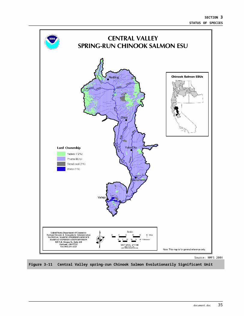
BIOLOGICAL ASSESSMENT DRAFT2-GATE FISH PROTECTION DEMONSTRATION PROJECT APRIL 2009
al. 2007). One risk involves the replacement of relatively uncontaminated food items with those that may be contaminated (70 FR 17386). The overbite clam is known to bioaccumulate selenium, a toxic metal (Urquhart et al. 1991).
As discussed earlier for salmonids (Section 3.1.2.7.8), predation of juveniles by non-native fish such as striped bass has also been identified as a potential risk, but has not been quantified (71 FR 17757).
Ocean SurvivalGreen sturgeon spend most of their lives in coastal marine habitat, and therefore could be vulnerable to conditions in the ocean. However, NMFS has not indicated this as a significant potential risk (71 FR 17757).
Environmental Variation and Climate ChangeClimate change is expected to result in altered and more variable precipitation and hydrological patterns in California. While population sizes are unknown for the Southern DPS, it is clearly much smaller than the Northern DPS and therefore is much more susceptible to catastrophic events (NMFS 2005). Spawning in the Southern DPS appears to be concentrated in the Sacramento River above the RBDD. Catastrophic events have occurred on the Sacramento River, such as the large-scale Cantara herbicide spill which killed all fish in a 10-mile stretch of the Sacramento River upstream from Shasta Dam, and the 1977–1978 drought that caused year-class failure of winter-run Chinook (NMFS 2005). Changes in ocean conditions, such as the El Nino climatic events, could also affect feeding and survival of green sturgeon, which spend most of their lives in the ocean.
Ecosystem RestorationActions to address limiting factors for Southern DPS green sturgeon are proposed or are being carried out by the CBDA, CVPIA, and DFG such as: (1) improving flow conditions in Central Valley rivers and streams; (2) installing additional fish screens and improving fish passage; and (3) implementing stricter fishing regulations. Other restoration efforts that could benefit green sturgeon include Iron Mountain Mine Remediation efforts to improve water quality in the upper Sacramento River and providing fish passage at barriers such as Daguerre Point Dam on the Yuba River or the Fremont Weir in the Yolo Bypass. While these are important contributions, NMFS concluded in 1996 that these efforts alone do not substantially reduce risks to the Southern DPS and that further protections afforded under the ESA were necessary (71 FR 17757).
3.1.3.8 Status of the Species within the Action AreaAdult green sturgeons enter the San Francisco Bay estuary in early winter (January/February) before initiating their upstream spawning migration into the Delta. Adults move through the Delta from February through April, arriving in the upper Sacramento River between April and June (Heublein 2006, Kelley et al. 2007). Following their initial spawning run upriver, adults may hold for a few weeks to months in the upper river or immediately migrate back down river to the Delta.
Adults and sub-adults may also reside for extended periods in the western Delta as well as in Suisun and San Pablo Bays. Sub-adults are believed to reside year round in these estuaries prior to moving offshore as adults. Juveniles are believed to use the Delta for rearing for the first 1 to 3 years of their life before moving out to the ocean. Juveniles are recovered at the SWP and CVP fish collection facilities year round (NMFS 2008b).
56 document.doc

SECTION 3STATUS OF SPECIES
3.1.4 Longfin Smelt
3.1.4.1 Listing Status and Designated Critical HabitatLongfin smelt (Spirinchus thaleichthys) is not currently listed under the Federal ESA, but is listed as a threatened species under the CESA. Available scientific information and monitoring data indicate that the abundance of longfin smelt in all major California estuaries where the species has been found historically has declined severely in the past two decades. In response to these declines, the Bay Institute, the Center for Biological Diversity and the Natural Resources Defense Council petitioned the USFWS in August 2007 to list the population of longfin smelt in the San Francisco Bay-Delta Estuary as endangered under the ESA (The Bay Institute [TBI] et al. 2007a). These groups also submitted a formal request to the California Fish and Game Commission to list longfin smelt in California on an emergency basis as an endangered species under CESA (The Bay Institute et al. 2007b). During spring of 2008, the CDFG sought stakeholder input to the process of drafting a Section 2084 regulation to protect longfin smelt. On November 14, 2008 the Fish and Game Commission adopted emergency regulations, to be in effect for 90 days, governing conditions under which Delta water diversions and exports can continue, with limitations depending on longfin smelt distribution and take at water export facilities. On March 4, 2009, the Commission found that listing longfin smelt as threatened under CESA was warranted, and initiated the state regulatory process to establish the listing (DFG 2009).
There is no designated critical habitat because the species is not currently listed under the Federal ESA. However, suitable spawning and rearing habitat for longfin smelt occurs throughout the San Francisco Estuary, including in the Action Area, as described in Section 3.1.4.2.
3.1.4.2 Life HistoryThe species is pelagic and anadromous. Longfin smelt are euryhaline, capable of living in freshwater but spending the majority of their lives in brackish and marine environments. Longfin smelt are one of seven osmerid fish species occupying habitats in California estuaries and coastal waters (Moyle 2002). Presently, the largest and southern-most self-sustaining longfin smelt population on the Pacific Coast occurs in the San Francisco Estuary (Moyle 2002). In the San Francisco Estuary, longfin smelt adults are generally 90-110 mm SL at maturity, but some individuals may grow up to 140 mm SL (Baxter 1999, Moyle 2002).
Longfin smelt predominantly have a 2-year life cycle. Most longfin smelt reach maturity at Age 2, with most individuals dying shortly after spawning. A few smelt, mostly females, live a third year, but it is not certain if they spawn again. Peak spawning occurs between February and April (Reclamation 2008), within a temperature range of 7 to 14.5°C (The Bay Institute et al. 2007a). Longfin smelt eggs are adhesive and are probably released over a firm substrate (Moyle 2002). Just after hatching, longfin smelt larvae move quickly into the upper part of the water column, and are swept downstream into more brackish areas of the estuary (Moyle 2002). Recently hatched longfin smelt larvae are buoyant and occur in the upper portion of the water column usually from January through April. Rearing habitat for longfin smelt is typically open water, away from shorelines and vegetated inshore regions. Most juveniles occur within a salinity range of 15 to 30 ppt (Baxter 1999), and are not commonly found where water temperatures are above 20°C (Moyle 2002).Young juvenile longfin smelt feed primarily on copepods, while older juveniles and adult longfin smelt feed principally on opossum shrimp, Neomysis mercedis and the introduced mysid, Acanthomysis bowmani when available (Hobbs et al. 2006, DFG 2009).
document.doc 57
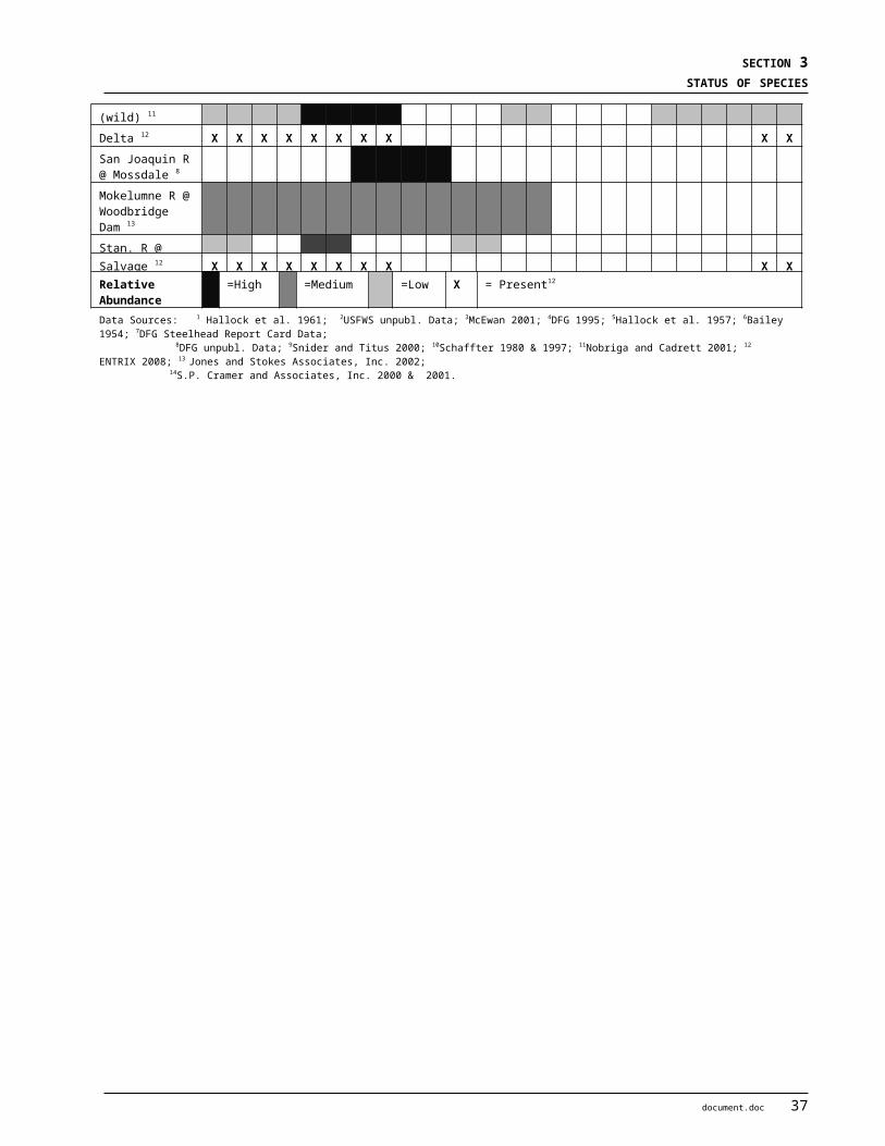
BIOLOGICAL ASSESSMENT DRAFT2-GATE FISH PROTECTION DEMONSTRATION PROJECT APRIL 2009
3.1.4.3 DistributionScattered populations occur along the Northeast Pacific coast from Alaska to the San Francisco estuary (Moyle 2002). Longfin smelt populations in California have historically been documented in the San Francisco Estuary, Humboldt Bay, the Eel River Estuary, and the Klamath River Estuary. Currently, the largest spawning population occurs in the San Francisco Estuary, while other California populations appear to be small and possibly not self-sustaining (Reclamation 2008, The Bay Institute et al. 2007a).
Longfin smelt use the entire the San Francisco Estuary, from the freshwater Delta and Suisun Marsh downstream to brackish South San Francisco Bay and in coastal marine waters depending on the time of year and life stage (Table 3-9) (Baxter 1999, Moyle 2002, Rosenfield and Baxter 2007). In wet years they can occur in the Gulf of the Farallones, just outside of the Golden Gate (Moyle 2002). The center of their distribution gradually moves down the estuary in the summer. Adult longfin smelt tend to aggregate in Suisun Bay and the western Delta in late fall, and then spawn in freshwater areas immediately upstream during winter and early spring. Based on data from the FMWT, Winter MWT, and SKT surveys conducted by DFG, only a very small fraction of the sub-adult and adult longfin smelt appear in the southeast Delta in OMRs. Adults and larvae were found furthest upstream in years of lower river flow CDFG 2009). The exact spawning areas are unknown for longfin smelt, but the general spawning region is considered to be between the confluence of the Sacramento and San Joaquin Rivers up to Rio Vista on the Sacramento River and Medford Island on the San Joaquin River (Moyle 2002). Spawning probably also occurs in the eastern portion of Suisun Bay and in the larger sloughs of Suisun Marsh in some years (The Bay Institute et al. 2007a).
Table 3-9 Periodicity Table for Longfin Smelt in the Delta
From spawning grounds in the upper estuary, longfin smelt move downstream through a combination of passive transport and migration (Baxter 1999, Dege and Brown 2004, Rosenfield and Baxter 2007). Longfin smelt larvae are swept downstream shortly after hatching (Moyle 2002). When high outflows correspond with the presence of larval longfin smelt, the larvae are transported mainly to Suisun and San Pablo Bays, whereas in years with lower outflows they are transported to the western Delta and Suisun Bay (Moyle 2002). Larvae are frequently caught upstream of the Sacramento-San Joaquin River confluence in the Delta around Sherman Island (Baxter 1999, Dege and Brown 2004). The geographic distribution of larval longfin smelt is closely associated with the location of the estuary’s 2-ppt isohaline (X2), with the center of the distribution being seaward of X2 (Reclamation 2008). Juveniles migrate further downstream to Suisun Bay and more brackish habitats for growth and rearing (Moyle 2002). Further details on age-specific distribution are provided in DFG (2009).
3.1.4.4 AbundanceAll available scientific information and monitoring data indicate that the abundance of longfin smelt in California has declined severely in the past two decades (The Bay Institute 2007a, DFG 2009). The longfin smelt, one of the species associated with the POD, has experienced a sharp population decline starting in 2000
58 document.doc

SECTION 3STATUS OF SPECIES
(Figure 3-17). Population indices have declined further since 2000, with record or near-record-low abundance indices based on FMWT abundance indices for 2002-2006.
Historically, the longfin smelt population in the San Francisco Estuary has shown wide fluctuations in annual Age-class 1 and Age-class 2 abundance, with abundance in any given year depending on the number of spawners and on river outflow during spawning and larval periods during the Age-class natal year (Moyle 2002). Recently, longfin smelt abundance has remained low even in years with relatively moderate hydrology, which typically supports at least modest fish production (Moyle 2002, Baxter et al. 2008).
Persistent low levels of longfin smelt abundance may have, at least in part, been the result of the introduction and establishment of the overbite clam Corbula amurensis in the estuary. The 1987 invasion of this filter-feeding clam has diminished the availability of the longfin smelt’s primary food resources (i.e., copepods) through heavy grazing on phytoplankton (Rosenfield and Baxter 2007). Although dramatic declines were observed after introduction of Corbula, there was little change in the slope of the relationship between freshwater outflow and abundance. Some aspects of the longfin smelt decline may not be explained by changes in food availability caused by the introduction of the overbite clam or outflow conditions. Notably, since 2000 longfin smelt abundance levels have been consistently lower than the post-1987 outflow-abundance relationship would predict (Figure 3-17). Also, catches of pre-spawning adult longfin smelt in Suisun Marsh dropped consistently after inception of the Suisun Marsh Survey, and this decline predates the onset of the 1987-1994 drought and the introduction of Corbula. It is possible that recent environmental changes have altered the Marsh’s carrying capacity for longfin smelt (Rosenfield and Baxter 2007). The recent decline in longfin smelt abundance corresponds with that observed for other pelagic fishes in the Delta, and is as dramatic, if not more so, than that observed for other species (Moyle 2002).
Source: DFGA) Fall Midwater Trawl Survey September-December, 1967-2005B) Bay Study Survey otter trawl, May-October 1980-2005C) Bay Study Survey midwater trawl, May-October 1980-2005.
Figure 3-17 Longfin Smelt Annual Relative Abundance
document.doc 59
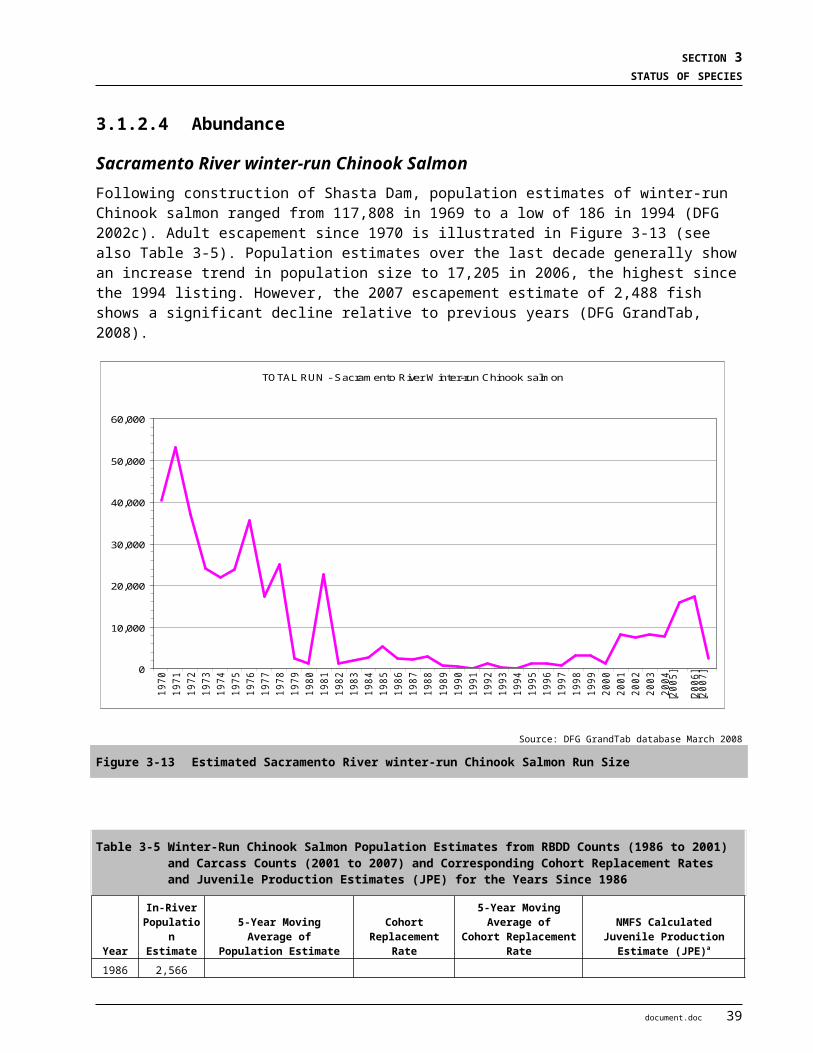
BIOLOGICAL ASSESSMENT DRAFT2-GATE FISH PROTECTION DEMONSTRATION PROJECT APRIL 2009
3.1.4.5 Population Viability Summary
AbundanceLongfin smelt populations have declined throughout California. The population found in the San Francisco Estuary is the largest longfin smelt population in California, and has experienced substantial declines over the past 20 years, with persistent record low abundance levels since 2002 (The Bay Institute 2007a). Small populations have also been historically documented in California in Humboldt Bay, the Eel River Estuary, and the Klamath River Estuary, but fish have not been found in these areas in recent years. In fact, the Humboldt Bay and Klamath River populations may now be extirpated (The Bay Institute 2007a). Outside of California, longfin smelt are found in bays from Coos Bay, Oregon to Prince William Sound, Alaska (Moyle 2002). Relatively large populations still appear to exist in portions of the northernmost area of its range (i.e., Oregon, Washington and Alaska (ADFG 2006).
As summarized in the recent status review (DFG 2009), longfin smelt abundance within the San Francisco Estuary is influenced by outflow during the egg and larva periods (Sommer et al. 2007).
ProductivityHistorically, longfin smelt year-class strength has been positively correlated with freshwater outflow in the San Francisco Estuary (The Bay Institute 2007a). In recent years, the magnitude of this response has declined for both Age-class 1 and Age-class 2 smelt, but the slope of the relationships has remained similar (Reclamation 2008, Rosenfield and Baxter 2007). The decline in Age-class 2 smelt has been greater than that for Age-class 1, suggesting a reduction in survival between age-classes (Rosenfield and Baxter 2007). Data from the Suisun Marsh survey indicates that the abundance of spawning age adult longfin smelt has declined since 1990 (Rosenfield and Baxter 2007). Dramatic declines have also been observed during this period for larval and juvenile longfin smelt (Reclamation 2008). These declines in productivity are likely associated with multiple factors, including reduced freshwater outflow and declining food availability caused by introduction of the overbite clam.
SPATIAL STRUCTURE Longfin smelt live in relatively small, reproductively isolated populations, which cannot be supplemented by immigration from adjacent populations. This aspect of their natural history, combined with current levels of anthropogenic disturbance to their spawning and rearing habitats in California, make longfin smelt particularly vulnerable to extirpation. Evaluation of physical characteristics, genetic data, and ecological attributes of the population of longfin smelt in the San Francisco Estuary longfin indicates that this population is reproductively isolated from the other populations located in California and those located further north (The Bay Institute 2007a).
Within the San Francisco Estuary the recent declines in abundance do not appear to be attributable to a constriction in overall distribution (Rosenfield and Baxter 2007). Unlike delta smelt, however, longfin smelt are found throughout San Pablo, San Francisco and South San Francisco bays as well as Suisun Bay and the western Delta.
DiversityThe longfin smelt population living in the San Francisco Estuary was once considered to be a separate species from those found further north. In 1963, it was discovered that meristic differences observed between the San Francisco Estuary population and those further north occurred along a north-south gradient, and the populations were merged into a single species, Spirinchus thaleichthys (The Bay Institute 2007a). In 1995 genetic data confirmed that the San Francisco Estuary population is the same species as that from Lake Washington in Washington State. It was also found, however, that the gene pool of the San Francisco Estuary
60 document.doc

SECTION 3STATUS OF SPECIES
population is significantly different and isolated from the Washington population, warranting protection as an isolated, genetically-distinct entity (Stanley 1995). Moyle et al. (1995) has also recommended that longfin smelt in the San Francisco Estuary be recognized and protected as an ESU, due to its apparent reproductive isolation from other populations, and because it represents an important component of the evolutionary history of the species.
3.1.4.6 Critical Habitat and Primary Constituent ElementsCritical habitat has not been proposed or defined for the longfin smelt because it is not currently a listed species under the ESA.
3.1.4.7 Factors Affecting Longfin SmeltThe major factors believed to be responsible for recent declines in the abundance of the longfin smelt, and other pelagic species in the San Francisco Estuary, include the direct and indirect effects of Delta water operations, food web alteration by invasive species, and poor water quality (Reclamation 2008). Other factors that make longfin smelt vulnerable include cumulative and possibly synergistic effects of its low abundance, distance between local populations, reduced reproductive potential, and reduced carrying capacity of its habitat (DFG 2009). The POD studies (Baxter et al. 2008) used a conceptual model to categorize the many factors affecting the abundance of four pelagic fishes including longfin smelt: (1) previous abundance; (2) habitat (spawning and open water); (3) top-down factors such as entrainment in diversions, predation, fishery bycatch, and collections; and (4) bottom-up factors such as food availability and impacts from non-native overbite clam (reviewed in DFG 2009).
Fish Movement & Habitat BlockageMigration barriers do not significantly affect longfin smelt in the San Francisco Estuary, as all life stages occur downstream of major dams.
Water Development and Conveyance (Hydrodynamics and Entrainment)Longfin smelt adults and larvae are vulnerable to entrainment by water diversions, such as SWP and CVP export facilities, power plants, and agricultural diversions. The risk of entrainment by the SWP and CVP facilities is greatest in winter, when adults migrate upstream to freshwater spawning areas, particularly in dry years when adult distribution shifts further upstream to the southeast Delta (Sommer et al. 2007, DFG 2009). By mid-summer, entrainment is no longer a major stressor because most of the population is downstream of the zone affected by exports (Baxter et al. 2008). The magnitude of the impact of entrainment on the Bay-Delta longfin smelt population is not known at this time. Also unknown is the impact of entrainment relative to other stressors. In their 2009 species status review DFG (2009) estimated that from 1993 through 2008 a total of approximately 1.6 million juvenile and 12,000 adult longfin smelt were entrained at the CVP and SWP intakes in the southern Delta. Although loss (mortality) rates for entrained longfin smelt have not been studied directly, based on studies of other species DFG estimated that more than 95 percent and 80 percent of longfin smelt entrained at the SWP and CVP, respectively, were lost. These losses probably represent a small fraction of the total population, especially in wet years when the population has a more downstream distribution.
The indirect effects of water exports occur in the form of changed hydrodynamics in the Delta. Because longfin smelt are particularly sensitive to physio-chemical water quality characteristics (e.g., salinity, prey availability), their abundance is closely associated with spring outflow conditions. The FMWT index for longfin smelt typically increases in years when outflows are high and X2 is pushed seaward, indicating that the extent and quality of longfin smelt habitat increases when freshwater flows are high (Reclamation 2008).
document.doc 61

BIOLOGICAL ASSESSMENT DRAFT2-GATE FISH PROTECTION DEMONSTRATION PROJECT APRIL 2009
Flood Control and Levee ConstructionThere is no evidence that levees and other flood control infrastructure directly impact longfin smelt in the San Francisco Estuary. This is not unexpected given that longfin smelt are largely a pelagic species. The construction, maintenance, or failure of levees may have indirect effects on longfin smelt by influencing Delta hydrodynamics.
Land Use ActivitiesIntensive agricultural and urban development in the Delta affects longfin smelt through the impairment of water quality and reductions in freshwater river flow due to water diversions (see “Water Development and Conveyance” and “Water Quality” sections).
Water QualityThe quality and quantity of spawning and rearing habitat available to fish living in the San Francisco Estuary has declined dramatically due to increased water temperatures, turbidity, and contaminant loads, and decreased DO. Although longfin smelt are well-adapted to living in turbid areas, they are likely vulnerable to changes in temperature, low DO levels, and exposure to contaminants from urban, agricultural and industrial sources. As described earlier for delta smelt (Section 3.1.1.7.4), contaminants, eutrophication, and algal blooms can alter ecosystem functions and productivity, although the magnitude and effects within the Delta are poorly understood (USFWS 2008). Pollutants from agricultural and urban sources may harm delta smelt directly, reduce zooplankton abundance, or both. Recent testing has noted invertebrate toxicity in the waters of the northern Delta and western Suisun Bay. The POD studies have focused on three factors: pyrethroid pesticides, the blue-green alga Microcystis, and ammonia (Baxter et al. 2008, Sommer 2007). Limited data exists, however, regarding the population level impacts and relative importance of poor water quality for longfin smelt.
POD investigators have initiated several recent studies to determine the role of contaminants in the observed declines of Delta fish species. Fish bioassays indicated that larval delta smelt (Hypomesus transpacificus) are highly sensitive to ammonia, low turbidity, and low salinity (Reclamation 2008). Due to the similarity in life history strategy and habitat used by delta smelt and longfin smelt, longfin smelt may be sensitive to similar water quality characteristics.
Hatchery OperationsThere are currently no captive breeding programs for longfin smelt. Thus, hatchery operations are not believed to pose a major threat to longfin smelt in the San Francisco Estuary.
Over Utilization (Commercial and Sport)Longfin smelt are a small component of the “whitebait” fishery in the South San Francisco Bay but they have no sport fishery value. Adults sometimes occur as bycatch in commercial trawling for bait shrimp in the brackish parts of the lower San Francisco Estuary (e.g., San Pablo Bay) (DFG 2009). Commercial fishers are required to return most trawl-caught fish to the water. CDFG (Hieb 2009) estimated 15,539 (adult) longfin smelt were caught as bycatch in 1989-90. The most significant utilization of longfin smelt is scientific collecting by the IEP through several monitoring programs. The IEP studies during 1987 to 2008 annually collected from 461 to 85,742 adults, and 343 to 72,824 larval longfin smelt. Current levels of harvest are not believed to be a major factor in the declines in abundance of longfin smelt in the San Francisco Estuary.
62 document.doc

SECTION 3STATUS OF SPECIES
Disease and PredationRecent POD investigations have not revealed any histopathological abnormalities associated with disease in longfin smelt. These studies also found no evidence of viral infections or high parasite loads (Reclamation 2008). Limited information exists regarding the impact of predation on longfin smelt populations. The introduction of striped bass is not believed to have contributed to declines in the abundance of longfin smelt (Moyle 2002). The introduction of inland silversides, however, may have played a role in these declines. This conclusion is based on the following: (1) the invasion of the estuary by inland silversides coincided with declines of longfin smelt, (2) inland silversides concentrate in shallow waters where smelt spawn, and (3) inland silversides are known to be effective predators on larval fishes (Moyle 2002).
Non-native Invasive SpeciesMultiple introduced species affect longfin smelt both directly and indirectly through predation, food web alteration, and effects on physical habitat, as discussed earlier for other fish species (Section 3.1.1.7.8). In particular, the invasion of overbite clam C. amurensis in the 1980’s has been implicated in the decline of primary productivity and zooplankton biomass in the western delta, possibly limiting food availability for pelagic species such as longfin smelt (Baxter et al. 2008).
Furthermore the composition of the zooplankton community has shifted, such that it is mostly composed of introduced species, thereby having potentially significant effects on food availability for longfin smelt. For example, the invasive cyclopoid copepod Limnoithona tetrospina likely competes with native copepod species for food resources, and is now the most abundant copepod in the low-salinity zone of the Estuary. It is believed that Limnoithona is an inferior prey item for longfin smelt, and that its high abundance could result in reduced energy reserves and overall condition of pelagic fish species in the Delta (Reclamation 2008). Consistent with the hypothesis of food limitation, Rosenfield and Baxter (2007) have documented reduced age-class 1 productivity and a disproportionate reduction in age-class 2 recruitment. Moreover, poor growth and condition of longfin smelt has been documented in certain regions of Suisun Bay (Hobbs et al. 2006).
Ocean SurvivalLittle is known about the extent and effects of the marine migration of San Francisco estuary longfin smelt. Because most longfin smelt apparently complete their life cycle primarily within the Estuary, ocean survival is unlikely to be a critical factor in their population decline.
Environmental Variation and Climate ChangeClimate change has the potential to exacerbate existing threats by significantly impacting Delta hydrodynamics and habitat quality for longfin smelt in future decades (DFG 2009). This is due to changed precipitation patterns, increased flood frequency and water temperatures, and sea level rise. The increased likelihood of winter floods may alter flows from historical conditions under which Delta fish species have evolved, thereby interfering with reproduction (Reclamation 2008). An increased frequency of flooding could also dislodge eggs and sweep adults, eggs, and larvae far downstream to unsuitable rearing habitat (Moyle 2002). Sea level rise will likely increase seawater intrusion, altering the position of X2, an important predictor of longfin smelt abundance (Reclamation 2008). Finally, increased water temperature caused by warming could reduce the availability of suitable spawning habitat in upstream reaches of the Delta. Increasing water temperature is a particular concern for the San Francisco Estuary population, because the estuary is at the southernmost end of the species range.
document.doc 63
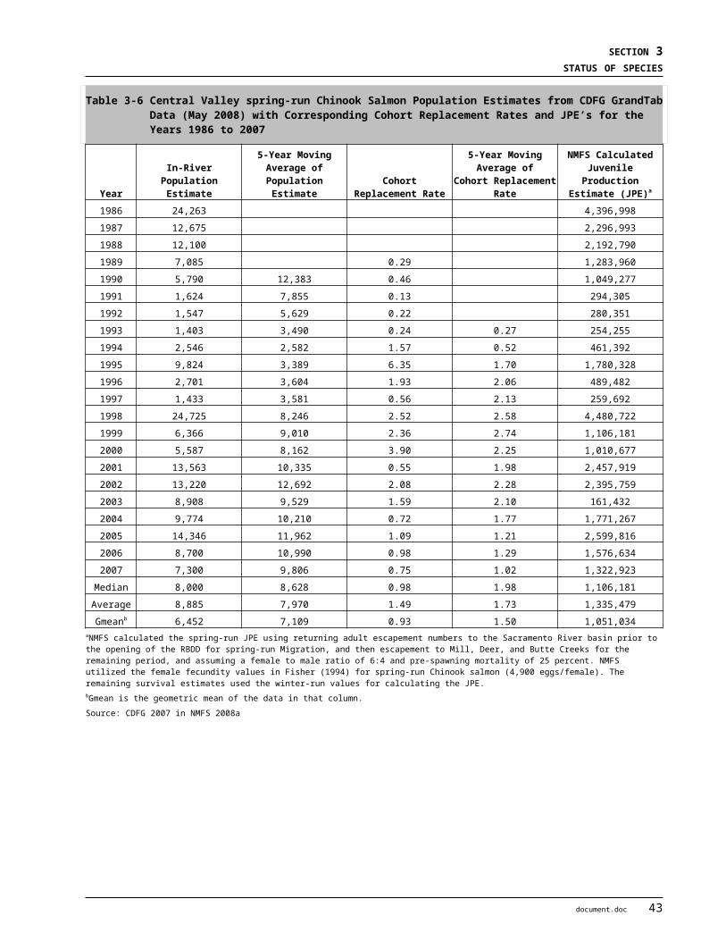
BIOLOGICAL ASSESSMENT DRAFT2-GATE FISH PROTECTION DEMONSTRATION PROJECT APRIL 2009
Ecosystem Restoration
CALIFORNIA BAY-DELTA AUTHORITY Two programs included under CBDA, the ERP and the EWA, were created to improve conditions for fish, including longfin smelt, in the Central Valley (CALFED 2000). Installation of fish screens is one of the key components of the ERP, and should reduce entrainment of longfin smelt in diversion pumps in areas of the Delta where longfin smelt are found. Achievement of other goals of the ERP, such as reducing the negative impacts of invasive species and improving water quality (CALFED 2000), would also benefit longfin smelt in the San Francisco Estuary by reducing competitors or improving food web dynamics and the copepods that are a key food resource for longfin smelt. Habitat restoration initiatives sponsored and funded primarily by the CBDA-ERP Program have resulted in plans to restore ecological function to 9,543 acres of shallow-water tidal and marsh habitats within the Delta. Restoration of these areas primarily involves flooding lands previously used for agriculture, thereby creating additional shallow water spawning and rearing habitat for longfin smelt.
The EWA is designed to provide water at critical times to meet ESA requirements and incidental take limits without water supply impacts to other users, particularly South Delta water users. In early 2001, the EWA released 290 thousand acre feet of water from San Luis Reservoir at key times to offset reductions in South Delta pumping implemented to protect winter-run Chinook salmon, delta smelt, and splittail. This action may have had positive implications for longfin smelt by reducing entrainment and increasing freshwater outflow. Recent reviews, however, provide no indication that the EWA has been effective in reducing entrainment loss of listed species at the SWP and CVP diversion facilities (The Bay Institute 2007a). The CALFED BDPAC (2007) concluded that the EWA has not been successful at reversing the decline of important Delta species. Currently, the EWA program is authorized through 2010 and is scheduled to be reduced in its scope. Future EWA operations will be considered to have limited assets and will primarily be used only during CVP and SWP pumping reductions in April and May as a result of the VAMP experiments.
The ERP’s Environmental Water Program (EWP) does not benefit longfin smelt because it is designed to enhance instream flows in reaches of priority streams controlled by dams, outside the range of longfin smelt.
CENTRAL VALLEY PROJECT IMPROVEMENT ACT The CVPIA, implemented in 1992, requires that fish and wildlife get equal consideration with other demands for water allocations derived from the CVP. Small, short-duration water export reductions at the CVP export facility (usually timed to protect migrating juvenile salmonids) associated with the CVPIA provide some benefit to longfin smelt. However, most of the habitat restoration and protective actions specified by the program (e.g., gravel restoration, stream flow enhancement, installation of fish screens and ladders) have been implemented outside the geographic range of longfin smelt and therefore do not benefit or protect this species (The Bay Institute 2007a).
SWP DELTA PUMPING PLANT FISH PROTECTION AGREEMENT (FOUR-PUMPS AGREEMENT) The Four Pumps Agreement Program (DWR and DFG 1986) has approved $59 million for over 40 fish mitigation projects, and by December 2007 had expended $44 million for a variety of projects in the Sacramento and San Joaquin river basins and in the Bay-Delta area, such as salmon habitat enhancement projects, water exchange projects for salmon passage flows, fish screens and ladders, guidance barriers, enhanced law enforcement, and stocking of salmon, steelhead and striped bass (DWR 2008). Most projects have focused on salmon and steelhead, particularly spring-run Chinook, and were implemented outside the range of longfin smelt. One component of the Four Pumps projects that could benefit longfin smelt is the screening of diversions in Suisun Marsh (DWR and DFG 1986).
64 document.doc
SECTION 3STATUS OF SPECIES
3.1.4.8 Status of Species in the Action AreaSurvey data indicates that the population of longfin smelt in the San Francisco Estuary has declined substantially since the 1980s (DFG 2009). Longfin smelt occur in the Action Area in winter as spawning adults and in winter and spring as larvae moving to downstream rearing habitat.
3.2 TERRESTRIAL SPECIES
3.2.1 Giant Garter Snake
3.2.1.1 Listing Status and Designated Critical HabitatOn October 20, 1993, the giant garter snake (Thamnophis gigas, GGS) was listed as threatened by the USFWS due to habitat loss from urbanization, flooding, and agricultural activities, as well as contaminants and introduced predators (58 FR 54053). Previous to that ruling, it was listed as threatened by the California Fish and Game Commission. No critical habitat has been designated for GGS.
3.2.1.2 Life HistoryThe GGS is a large (37 to 65 inches total length) aquatic snake that is never found far from water. The dorsal coloration is highly variable—brown to olive with a cream, yellow, or orange dorsal stripe and two light-colored lateral stripes (USFWS 1999 and 2005a). Some individuals have a checkered pattern of black spots between the dorsal and lateral stripes or completely lack any dorsal stripes at all.
The GGS inhabits both agricultural wetlands and natural waterways including irrigation canals, drainage ditches, rice lands, marshes, sloughs, ponds, small lakes, low gradient streams, and riparian corridors (USFWS 1999). This species is closely tied to water and seems to require freshwater aquatic habitat during the spring and summer months, and estivation habitat (small mammal burrows or rock piles) in the dry uplands during the fall and winter months (Brode 1988 in USFWS 1999). Juvenile and adult GGS appear to be most active when air temperatures reach 90°F; however, they can be observed during any month of the season when the sun is out and air temperatures are over 70°F (Hansen and Brode 1980 and Brode 1988 in USFWS 1999).
The species is relatively inactive during the winter, typically over wintering in burrows and crevices near active season foraging habitat. Individuals have been noted using burrows as far as 164 feet from marsh edges during the active season, and retreating as far as 820 feet from the edge of wetland habitats while over wintering, presumably to reach hibernacula above the annual high water mark (USFWS 1999). After emerging from over wintering sites, adult GGS breed during the spring (March to May) and 10 – 46 young (average 8.1 inches total length) are born alive during the months of late July through early September (Hansen and Hansen 1990 in USFWS 1999). Giant garter snakes feed on a wide variety of fishes and amphibians, including both native and introduced fishes and Pacific tree frogs (Pseudacris regilla) and introduced bullfrogs (Rana catesbeiana). They seem to take prey items that are most abundant. Young snakes grow rapidly and reach maturity within about 3-5 years (USFWS 1999).
GGS are typically found in fresh water marshes and wetland areas. They can also be found in modified habitats like agricultural canals and ditches often associated with rice farming and flooding. The process of rice farming fairly closely coincides with the biological needs of the GGS. During the summer, GGS use flooded rice fields as long as sufficient prey is present. During the late summer, rice fields provide important nursery areas for newborn GGS. In the later summer and fall as the rice fields are drained, prey items become concentrated in remaining water bodies and GGS often gorge themselves on this food supply before going into hibernation (USFWS 1999).
document.doc 65

BIOLOGICAL ASSESSMENT DRAFT2-GATE FISH PROTECTION DEMONSTRATION PROJECT APRIL 2009
3.2.1.3 Distribution and AbundanceThe GGS is endemic to California’s Central Valley, the lowland area between the Sierra Nevada and Coast Ranges (Hansen and Brode 1980 in USFWS 1999). Historically, GGS were widespread throughout the lowlands of the Central Valley (except for a midway historic gap) from the vicinity of Chico in Butte County south to Buena Vista Lake in Kern County (Stebbins 2003). Today, the species has disappeared from approximately 98 percent of its historic range and is largely confined to the rice growing regions of the Sacramento and San Joaquin Valleys (USFWS 1999). There are 13 separate populations of GGS in 11 counties including Butte, Colusa, Glenn, Fresno, Merced, Sacramento, San Joaquin, Solano, Stanislaus, Sutter and Yolo (USFWS 1999). The population was reported as not declining further in the five-year review for GGS (USFWS 2006). Although Contra Costa County is not specifically mentioned, it is only because surveys have not been done in the Project region, which is contiguous with the populations in San Joaquin and Sacramento Counties and with no barriers to dispersal or colonization.
3.2.1.4 Critical Habitat and Primary Constituent Elements The GGS has four main habitat requirements as outlined by the draft recovery plan: (1) adequate water during active season to support prey species such as blackfish (Orthodox microlepidotus), Pacific tree frog, carp (Cyprinus carpio), mosquito fish (Gambusia affinis) and bullfrogs; (2) emergent wetland vegetation (i.e., cattails Typha spp. and bulrushes Scirpus spp.) for foraging habitat and cover from predators; (3) upland habitat with grassy banks and openings in vegetation for basking; and (4) higher elevation upland habitats for cover and refuge (i.e., burrows and crevices) from flood waters during winter (USFWS 1999).
The GGS is active from early spring (April – May) through mid-fall (October – November), although patterns vary with weather (Brode 1988 in USFWS 1999). During the winter season they are inactive and rarely emerge from wintering burrows. When active they usually remain near wetland habitat, although they can move up to 0.8 km in a day (USFWS 1999). The GGS breeds primarily in March – May, although some mating takes place in September. They are viviparous and the young are born late July to early September. Litter size ranges from 10 – 46, with an average of 23. Males reach sexual maturity at three years and females at five years of age (USFWS 1999).
3.2.1.5 Factors Affecting Giant Garter Snake The destruction of floodplain habitats and areas of cattail and bulrush-dominated habitats for agricultural conversion, flood control activities, and land development have greatly reduced the population size for this species (USFWS 1999). Other factors for decline include interrupted or intermittent water flows within floodplain areas, poor water quality, and contaminants such as selenium and pesticides (USFWS 1999), and predation by introduced species such as large mouth bass and bullfrogs (USGS 2004).
3.2.1.6 Status of Species within the Action AreaThe GGS is listed as a threatened species at the state and federal level. Recovery priorities, objectives and criteria, and further conservation efforts have been outlined in a draft recovery plan by USFWS (USFWS 1999). Some threats to GGS populations include habitat loss and adverse habitat alteration. They may also be negatively affected by selenium pollution, livestock grazing, hunting, introduction of predatory fish and bullfrogs, and victim to road kills and parasites (USFWS 1999 and 2005a).
The Project site is located within the historic and current range for GGS (USFWS 1999). The nearest recent observations of GGS recorded in the California Natural Diversity Database (CNDDB) (DFG 2008) are a 2002 record of an adult snake captured on the levee on the southwest corner of Webb Tract approximately five miles northwest of the Project area, and a 1996 record of a shed skin recovered from the southwest edge of
66 document.doc
SECTION 3STATUS OF SPECIES
Medford Island, approximately 1.5 miles northeast of the Project area (Figure 3-18). Two other CNDDB observations of GGS individuals both located approximately 8.5 miles from the Project area include a 1998 observation of an adult snake on a levee south of Brannan State Recreation Area, and another in the San Joaquin River at the north end of the Antioch Bridge. Multiple GGS observations were documented during the 1970s and 1980s from the area near Coldani Marsh, located 0.8 mile west of the intersection of Thornton Road and State Highway 12 approximately nine miles from the Project area. These include three GGS sightings at Coldani Marsh proper, one at nearby White Slough, and one on Shin Kee Tract, 1.5 miles south of State Highway 12.
The CNDDB contains two records of GGS within a five-mile radius of the Project location. Two additional sightings are within eight miles of the Project location, and there are multiple sightings within nine miles at Coldani Marsh. This likely represents the largest population of GGS in the vicinity of the Project site. The sightings were reported in the 1970s and 1980s, but are presumed extant.
The distance between these localities and the Project site are within dispersal distances for GGS. They have been known to move up to eight kilometers (5 miles) within a few days in search of appropriate habitat (Wylie et al. 1997 in USFWS 1999). The Old River and other large waterways in the Delta may facilitate long distance movements by sweeping individuals in currents to new locations.
Given the proximity of the Project to known GGS sightings and suitable habitat at both the Old River and Connection Slough sites, its presence should be assumed in the Project area.
3.2.2 Vernal Pool Fairy Shrimp
3.2.2.1 Listing Status and Designated Critical HabitatVernal pool fairy shrimp (Branchinecta lynchi, VPFS) was listed as federally threatened on September 19, 1994 (59 FR 48153). The Final Recovery Plan for Vernal Pool Ecosystems was released December 15, 2005 (USFWS 2005b). In 2007, the USFWS published a 5-year status review recommending that the species remain listed as endangered (USFWS 2007a).
Critical habitat was designated for several vernal pools species on August 6, 2003 (FS 68:46683) and revised August 11, 2005 (FR 70:46923). These include VPFS, vernal pool tadpole shrimp (VPTS), and Conservancy fairy shrimp (CFS). For the listed shrimps treated here, there are five critical habitat units within 30 miles of the Action Area, but no critical habitat within the Action Area. There are four VPFS: two locations in Contra Costa County, approximately 9 miles to the southwest; one in San Joaquin County, 30 miles to the east; and another 24 miles to the northwest in Solano County. For CFS as well as VPTS, there is a critical habitat unit 24 miles to the northwest. Additionally, there is a critical habitat unit for VPTS located 33 miles to the northeast in Sacramento County (Figure 3-19).
3.2.2.2 Life HistoryVPFS is a small crustacean in the class Branchiopoda and order Anostraca. It ranges from 0.75-1 inch in length, and is distinguished from other vernal pool crustaceans by the female’s tapered, pear-shaped brood pouch, and the male’s antennae size and shape.
VPFS are present in seasonally inundated basins from December to early May, and can survive in water temperatures below 75°F. They are filter and suspension feeders, with a diet consisting of algae, bacteria, and ciliates. They may also scrape detritus from substrates within the vernal pool habitat. Eggs are laid by adult females every winter, and they may lie dormant as long as 10 years in the cyst soil bank (CDPR undated).
document.doc 67

BIOLOGICAL ASSESSMENT DRAFT2-GATE FISH PROTECTION DEMONSTRATION PROJECT APRIL 2009
3.2.2.3 Distribution and Abundance The historical distribution of VPFS is not known, but distribution of VPFS has been assumed to be the historical extent of vernal pool habitat in California throughout the Central Valley and southern coastal regions, numbering in the millions of acres (USFWS 2005b).
VPFS are found in vernal pool habitats throughout the Central Valley and in the Coast Ranges. There are multiple populations of VPFS in 28 counties, including Shasta, Tehama, Butte, Glenn, Yuba, Yolo, Placer, Sacramento, Solano, San Joaquin, Modesto, Napa, Contra Costa, Merced, Madera, Fresno, San Benito, Tulare, Kings, Monterey, San Louis Obispo, Santa Barbara, Ventura, and Riverside (USFWS 2005b). Although they are reported in this wide distribution, they are not abundant in any of these locations (Eng et al. 1990, USFWS 2007a). VPFS have rarely been collected from the same pools as other shrimp species, suggesting competitive exclusion (Eng et al 1990, Helm 1998). VPFS have been detected in vernal pool habitats in numerous locations, in the region surrounding the Project area (Figure 3-20).
3.2.2.4 Population Viability SummaryVPFS populations have declined over a wide range along with their dependent habitats. Because vernal pool species are absolutely dependent on these unique habitats, their decline is closely tied to the destruction of vernal pools. It is expected that this species will decline commensurate with the loss, degradation, and fragmentation of its habitat.
3.2.2.5 Critical Habitat and Primary Constituent ElementsVPFS, like all vernal pool shrimp, are highly specialized to the vernal pool habitats they occupy (USFWS 2005b). VPFS are active when their vernal pool habitats contain water. Adaptations for survival within the ephemeral pools include a very short (as short as 18 days) period to maturity, with completion of a life cycle within 9 weeks, depending on water temperature (Helm 1998). VPFS can live up to 147 days and populations can have several hatchings in a single pool in a single season (Helm 1998). VPFS deposit specialized eggs, called cysts, that go dormant and survive the dry period between rainy seasons, and which are triggered into activity when pools fill and water temperatures drop below 10°C. Water movement among pools and swales disperses the VPFS and their cysts (embryonic eggs) (USFWS 2005b). Cysts can survive desiccation and digestion, and waterfowl and other migratory birds are important dispersal agents (USFWS 2005b).
68 document.doc

SECTION 3STATUS OF SPECIES
Figure 3-18 California Natural Diversity Database records of GGS in the Project Vicinity
document.doc 69
BIOLOGICAL ASSESSMENT DRAFT2-GATE FISH PROTECTION DEMONSTRATION PROJECT APRIL 2009
Figure 3-19 Critical Habitat of Vernal Pool Invertebrates Near the Action Area
70 document.doc
SECTION 3STATUS OF SPECIES
Figure 3-20 CNDDB Records of Vernal Pool Fairy Shrimp in the Project Vicinity
document.doc 71
BIOLOGICAL ASSESSMENT DRAFT2-GATE FISH PROTECTION DEMONSTRATION PROJECT APRIL 2009
VPFS occur only in seasonally inundated habitats, such as vernal pools, and have never been found in riverine, marine or other permanent water sources (USFWS 2005b). They can occur within a wide variety of pool types, including clear sandstone rock pools to turbid alkali valley grassland pools (Eng et al. 1990, Helm 1998). Vernal pool habitats fill with rainwater and some snowmelt runoff, which results in low nutrient levels and daily fluctuations in pH, dissolved oxygen, and carbon dioxide (Keeley and Zedler 1998). VPFS have been found in the same pool habitats as VPTS and Conservancy fairy shrimp (USFWS 2005b).Though they have been found in large pools, the majority of records are from smaller pools less than 0.05 acre in area (USFWS 2005b). Most habitats that support VPFS occur in hydrologically connected complexes of interconnected swales, basins, and drainages.
3.2.2.6 Factors Affecting Vernal Pool Fairy ShrimpThe major cause for the decline of this species is habitat loss due to land conversion from ephemeral wetland to other uses, mainly agriculture and urban or suburban development (Belk 1998). Other reasons for decline include habitat fragmentation, degradation by changes in natural hydrology, introduction of invasive species, contamination, poor grazing practices, infrastructure, recreation, erosion, and climatic and environmental change (USFWS 2005b). In northern California, 92 occurrences of VPFS are threatened by development, and an additional 27 are threatened by agricultural conversion (USFWS 2005b).
Current and projected threats to vernal pool habitats include land conversion due to human population pressure, conversion to cropland, and widespread urbanization. Limiting factors for recovery include the continued conversion of habitats to human uses, and continued anthropogenic causes of degradation and contamination (USFWS 2005b).
3.2.2.7 Status of the Species within the Action AreaVPFS are not known to occur within the Action Area for large branchiopods. In the San Joaquin Valley Region, most land is privately held, and VPFS are threatened by direct habitat loss due to fragmentation or conversion to agriculture or urban uses (USFWS 2005b). Prior to the conduct of wet-season surveys, the 0.5-acre seasonal wetland on Bacon Island at Connection Slough was considered to provide suitable habitat for the federally threatened VPFS and the federally endangered VPTS and CFS. Historically, the Project site did not contain VPFS habitat, but the levees have isolated the area from the prolonged periods of flooding that occurred historically, and a 0.5-acre seasonal wetland is now present within the Bacon Island project area. Waterfowl may use the wetland and the migration of these waterfowl could provide a vector for the introduction of these species into the seasonal wetland.
Dry- and wet-season sampling for federally listed large branchiopods, including VPFS, VPTS, and CFS, consistent with USFWS’ Interim Survey Guidelines to Permittees for Recovery Permits under Section 10(a)(1)(A) of the Endangered Species Act for the Listed Vernal Pool Branchiopods (1996) were conducted in the 0.5-acre wetland on Bacon Island south of Connection Slough in October 2008 (dry season) and November and December 2008, and January, February and March 2009 (wet season) (Helm Biological February 2009 and April 2009). No VPFS were detected during the surveys, and since the wetland never ponded water during any of the wet-season site visits, the wetland basin was determined to be unsuitable for federally listed large branchiopods. The wet- and dry-season reports are enclosed in Appendix J.
72 document.doc

SECTION 3STATUS OF SPECIES
3.2.3 Vernal Pool Tadpole Shrimp
3.2.3.1 Listing Status and Designated Critical HabitatVernal pool tadpole shrimp (Lepidurus packardi, VPTS) was listed as federally Endangered on September 19, 1994 (59 FR 48153). Critical habitat for this species was originally designated on August 6, 2003 (FR 68:46683) and revised August 11, 2003 (FR 70:46923). Species by unit designations were published February 10, 2006 (FR 71:7117) (Figure 3-21).
3.2.3.2 Life HistoryVPTS is a small crustacean in the class Branchiopoda and order Notostraca. It is distinguished from other vernal pool crustaceans by a large shell-like carapace and two long appendages at the end of the last abdominal segment. They reach 2 inches in length (USFWS 2005b).
VPTS have been observed in seasonal wetlands from December until they dry, and have greater temperature tolerances than other fairy shrimps. They are predators, feeding on other invertebrates and amphibian eggs, as well as organic debris. They climb over objects and plow into bottom sediments. Sexually mature adults have been observed in pools three to four weeks after pools have filled. Eggs are laid by adult females every winter, and they may lie dormant as long as 10 years in the cyst soil bank (USFWS 2005b).
3.2.3.3 Distribution and AbundanceThe historical distribution of VPTS is not known (USFWS 2005b). VPTS appear to be endemic to the Central Valley and probably were extant in the approximated 4 million acres of vernal pool habitat that once dotted the Central Valley, before agricultural conversion (USFWS 2005b).
VPTS are found in vernal pool habitats throughout the Central Valley and in the San Francisco Bay area (Rogers 2001). They are uncommon even where vernal pool habitat occur (USFWS 2005b). VPTS have been recorded in Shasta, Tehama, Butte, Glenn, Yuba, Sutter, Yolo, Placer, Sacramento, Solano, San Joaquin, Modesto, Contra Costa, Alameda, Merced, Fresno, Tulare, and Kings Counties (USFWS 2005b). The highest concentrations of observations have been in Solano and Sacramento Counties. VPTS have been detected in vernal pool habitats in numerous locations in the vicinity, mostly north the Project area (Figure 3-20).
3.2.3.4 Population Viability SummaryVPTS populations have declined over a wide range along with their dependent habitats. Because vernal pool species are absolutely dependent on these unique habitats, their decline is closely tied to the destruction of vernal pools. It is expected that this species will decline commensurate with the loss, degradation, and fragmentation of its habitat.
document.doc 73
BIOLOGICAL ASSESSMENT DRAFT2-GATE FISH PROTECTION DEMONSTRATION PROJECT APRIL 2009
Figure 3-21 CNDDB Records of Vernal Pool Tadpole Shrimp in the Project Vicinity
74 document.doc
SECTION 3STATUS OF SPECIES
3.2.3.5 Critical Habitat and Primary Constituent ElementsVPTS, like many other large branchiopods, are highly specialized to the vernal pool habitats they occupy. Vernal pool habitats fill with rainwater and some snowmelt runoff, which results in low nutrient levels and daily fluctuations in pH, dissolved oxygen, and carbon dioxide (Keeley and Zedler 1998). Adaptations for survival within the ephemeral pools include a short lifecycle (25 days-4 weeks to mature, longer than other large branchiopods) and high fecundity (VPTS can hatch more than one generation in a season, if pool conditions persist) (Ahl 1991, Helm 1998). Variation in water temperature may drive the variation in time to maturity. VPTS molt their carapace several times during their lifecycle. VPTS deposit specialized eggs, called cysts, that survive the dry period between rainy seasons, and which hatch when pools fill and water temperatures are between 10-15°C (Ahl 1991).
Specific vernal pool habitat characteristics associated with this species have not yet been determined. VPTS occur in a wide variety of ephemeral pools, with variations in size (a pool size range from 6.5 feet to 88 acres), temperature (range of 50-84°F), and pH (ranging from 6.2-8.5) (USFWS 2005b), though tolerances of this species to fluctuations in habitat conditions have not yet been established. VPTS have been found in vernal pools, clay flats, alkaline pools, ephemeral stock tanks, roadside ditches, and road ruts (Helm 1998, Rogers 2001). Typically they are found in pools deeper than 12 cm, and have been reported in small, clear pools and in turbid alkaline pools to large lakes (USFWS 2007b).
VPTS are active when their vernal pool habitats contain water. They are transported from pool to pool through overland water flow, or on the feet and/or feces of waterfowl and other migratory bird species (USFWS 2005b). Reproduction by this and other large branchiopods is generally accomplished by the deposit of cysts which go dormant and survive through the hot summer months.
3.2.3.6 Factors Affecting Vernal Pool Tadpole ShrimpThe major cause for the decline of this species is habitat loss due to land conversion from ephemeral wetland to other uses, mainly agriculture and urban or suburban development (Belk 1998). Other reasons for decline include habitat fragmentation, degradation by changes in natural hydrology, introduction of invasive species, contamination, poor grazing practices, infrastructure, recreation, erosion, and climatic and environmental change (USFWS 2005b).
Current and projected threats to vernal pool habitats include land conversion due to human population pressure, conversion to cropland, and widespread urbanization. Limiting factors for recovery include the continued conversion of habitats to human uses, and continued anthropogenic causes of degradation and contamination (USFWS 2005b).
3.2.3.7 Status of the Species within the Action AreaVPTS are not known to occur within the Action Area. In the San Joaquin Valley Region, most land is privately held, and VPTS are threatened by direct habitat loss due to fragmentation or conversion to agriculture or urban uses (USFWS 2005b). Prior to the conduct of wet-season surveys, the 0.5-acre seasonal wetland on Bacon Island at Connection Slough was considered to provide suitable habitat for VPTS as well as VPFS and Conservancy fairy shrimp. Historically, the Project site did not contain VPFS, VPTS, or Conservancy fairy shrimp habitat, but the levees have isolated the area from the prolonged periods of flooding that occurred historically, and a 0.5-acre seasonal wetland is now present within the Project area. Waterfowl may use the wetland and the migration of these waterfowl could provide a vector for the introduction of these species into the wetland.
Dry- and wet-season sampling for federally listed large branchiopods, including VPFS, VPTS, and CFS, consistent with USFWS’ Interim Survey Guidelines to Permittees for Recovery Permits under Section 10(a)
document.doc 75

BIOLOGICAL ASSESSMENT DRAFT2-GATE FISH PROTECTION DEMONSTRATION PROJECT APRIL 2009
(1)(A) of the Endangered Species Act for the Listed Vernal Pool Branchiopods (1996) were conducted in the 0.5-acre wetland on Bacon Island south of Connection Slough in October 2008 (dry season) and November and December 2008, and January, February and March 2009 (wet season) (Helm Biological February 2009 and April 2009). No VPTS were detected during the surveys, and since the wetland never ponded water during any of the wet-season site visits, the wetland basin was determined to be unsuitable for federally listed large branchiopods. The wet- and dry-season reports are enclosed in Appendix J.
3.2.4 Conservancy Fairy Shrimp
3.2.4.1 Listing status and Designated Critical HabitatThe Conservancy fairy shrimp (Branchinecta conservatio, CFS) was listed as federally Endangered on September 19, 1994 (59 FR 48153). As with the other vernal pool invertebrates, critical habitat for this species was designated on August 6, 2003 (FR 68:46683) and revised August 11, 2003 (FR 70:46923). Species by unit designations were published February 10, 2006 (FR 71:7117) (Figure 3-18).
3.2.4.2 Life HistoryCFS is a small crustacean in the class Branchiopoda and order Anostraca. The species has no carapaces, compound eyes, and segmented bodies with 11 pairs of swimming legs. Adult shrimp range in length between 0.6 to 1.1 inches. (Eng et al. 1990). The female brood pouch is cylindrical and usually ends under the fourth body segment. The male CFS has distinctive antennae ends. The second pair of antennae in adult females is cylindrical and elongate (Eng et al. 1990).
This species is most often observed from November to early April. CFS diet consists of algae, bacteria, protozoa, rotifers, and organic detritus (Pennak 1989). Females lay their eggs within the brood sac, which either drops to the bottom of the vernal pool, or sinks with the dead body of the female (Federal Register 1994). The egg cysts survive heat, cold, and prolonged dry periods, and the cyst bank in the soil may contain multiple generations from different years (Donald 1983). Cyst dispersal may occur either during flood events to hydrologically connected vernal pools, or waterfowl and shorebirds, which ingest CFS and transport the cysts via feces or on their body (USFWS 1999).
CFS, like some other large branchiopods are highly specialized to the vernal pool habitats they occupy. Adaptations for survival within the ephemeral pools include a short lifecycle, with an average of 46 days to mature. They live for as long as 154 days, with an average of 123 days (Helm 1998). Variation in water temperature may drive the variation in time to maturity. CFS produce one large cohort of offspring in a season (USFWS 2005b). CFS deposit specialized eggs, called cysts, which survive the dry period between rainy seasons. The eggs are either dropped to the bottom or remain attached until the female dies and sinks (Pennak 1989).
CFS are only known to occur in seasonally inundated habitats, and have never been observed in rivers or marine waters (USFWS 2005b). Vernal pool habitats fill with rainwater and some snowmelt runoff, which results in low nutrient levels and daily fluctuations in pH, dissolved oxygen, and carbon dioxide (Keeley and Zedler 1998). CFS have been observed in large, turbid and cool pools with low conductivity, low total dissolved solids, and low alkalinity (Eng et al. 1990). The majority of records occur in playa pools, which are vernal pools that typically remain inundated for longer periods, are larger in size, and are rarer than other vernal pools (USFWS 2007c).
76 document.doc

SECTION 3STATUS OF SPECIES
3.2.4.3 Distribution and AbundanceThis historical distribution of CFS is not known, but it is likely to have occupied once more extensive suitable vernal pool habitats throughout the Central Valley and southern coastal regions of California (USFWS 2005b).
The 14 currently known localities containing CFS are restricted to the Central Valley, with one population in southern California. A total of eight populations are distributed statewide (USFWS 2007c). These occur in fragmented habitat patches located in Tehama, Butte, Yolo, Solano, Colusa, Stanislaus, Merced, and Ventura Counties (USFWS 2005b). The nearest reported sightings of CFS to the Project site are 23 miles to the northwest in the Jepson Prairie (CNDDB 2008), see Figure 3-22.
3.2.4.4 Population Viability SummaryCFS populations have declined over a wide range along with their dependent habitats. Because vernal pool species are absolutely dependent on these unique habitats, their decline is closely tied to the destruction of vernal pools. It is expected that this species will decline commensurate with the loss, degradation and fragmentation of its habitat.
3.2.4.5 Factors Affecting Conservancy Fairy ShrimpThe major cause for the decline of this species is habitat loss due to land conversion from ephemeral wetland to other uses, mainly agriculture and urban or suburban development (Belk 1998). Other reasons for decline include habitat fragmentation, degradation by changes in natural hydrology, introduction of invasive species, contamination, poor grazing practices, infrastructure, recreation, erosion, and climatic and environmental change (USFWS 2005b). Specific threats to this species in recorded locations include inappropriate grazing, conversion to cropland or development, altered hydrology, and introductions of non-native predatory fishes, crayfish and bullfrogs (CNDDB 2008).
Current and projected threats to vernal pool habitats include land conversion due to human population pressure, conversion to cropland, and widespread urbanization. Limiting factors for recovery include the continued conversion of habitats to human uses, and continued anthropogenic causes of degradation and contamination (USFWS 2005b).
3.2.4.6 Status of the Species within the Action AreaCFS are not known to occur within the Action Area for large branchiopods. The Jepson Prairie population is protected on a preserve, but other populations outside the preserve are threatened by development (USFWS 2005b).
Prior to the conduct of wet-season surveys, the 0.5-acre seasonal wetland on Bacon Island at Connection Slough was considered to provide suitable habitat for CFS. Historically, the Project site did not contain CFS habitat, but the levees have isolated the area from the prolonged periods of flooding that occurred historically, and a seasonal wetland is now present within the Project area. Waterfowl may use the wetland and the migration of these waterfowl could provide a vector for the introduction of these species into the wetland.
Dry- and wet-season sampling for federally listed large branchiopods, including VPFS, VPTS, and CFS, consistent with USFWS’ Interim Survey Guidelines to Permittees for Recovery Permits under Section 10(a)(1)(A) of the Endangered Species Act for the Listed Vernal Pool Branchiopods (1996) were conducted in the 0.5-acre wetland on Bacon Island south of Connection Slough in October 2008 (dry season) and November and December 2008, and January, February and March 2009 (wet season) (Helm Biological February 2009
document.doc 77

BIOLOGICAL ASSESSMENT DRAFT2-GATE FISH PROTECTION DEMONSTRATION PROJECT APRIL 2009
and April 2009). No CFS were detected, and since the wetland never ponded water during any of the wet season site visits, the wetland basin was determined to be unsuitable for federally listed large branchiopods. The wet- and dry-season reports are enclosed in Appendix J.
3.3 STATE THREATENED SPECIES AND SPECIES OF SPECIAL CONCERNState Threatened and Species of Special Concern which may be affected by the Project include:
Swainson’s Hawk (Buteo swainsoni) FSC, ST
Burrowing owl (Athene cunicularia) SSC
California black rail (Laterallus jamaicensis coturniculus) ST
Tricolored blackbird (Agelaius tricolor) SSC
Loggerhead shrike (Lanius ludovicianus) SSC
Western pond turtle (Actinemys marmorata) SSC
3.3.1 Swainson’s Hawk The Swainson’s hawk (Buteo swainsoni) is a medium-sized hawk with relatively long, pointed wings and a long, square tail. Adult females weigh 28 to 34 ounces and males 25 to 31 ounces. Swainson’s hawks inhabit a wide variety of open habitats, including shrublands and croplands. In California, they are mostly found in agricultural croplands within the Central Valley. Nesting habitats for this species is usually in riparian forest or in remnant riparian trees, while foraging habitat consists of open cropland areas or grasslands (Estep 1989, Woodbridge 1998).
Over 85 percent of Swainson’s hawk territories in the Central Valley are in riparian systems adjacent to suitable foraging habitats. Swainson’s hawks often nest peripherally to riparian systems of the valley. Suitable nest sites may be found in mature riparian forest, as well as lone trees or groves of oaks, other trees in agricultural fields, and mature roadside trees. Valley oak, Fremont cottonwood, walnut, and large willow with an average height of about 58 feet, and ranging from 41 to 82 feet, are the most commonly used nest trees in the Central Valley (Estep 1989).
Swainson’s hawks require large, open grasslands or suitable croplands with abundant prey in association with suitable nest trees. Suitable foraging areas include native grasslands or lightly grazed pastures, alfalfa and other hay crops, and certain grain and row croplands (Estep Environmental Consulting 2009). Unsuitable foraging habitat includes crops such as vineyards, orchards, certain row crops, rice, corn and cotton crops. The diet of the Swainson’s hawk is varied, with the California vole being the staple in the Central Valley. A variety of bird and insect species are also taken.
Swainson’s hawks are migratory. They breed in the western United States and Canada, and winter in Mexico and South America. Central Valley birds appear to winter in Mexico and Columbia and hawks from northeastern California have been satellite-transmitter tracked to Argentina.
78 document.doc

SECTION 3STATUS OF SPECIES
Figure 3-22 California Natural Diversity Database Records of Conservancy Fairy Shrimp in the Project Vicinity
document.doc 79

BIOLOGICAL ASSESSMENT DRAFT2-GATE FISH PROTECTION DEMONSTRATION PROJECT APRIL 2009
Swainson’s hawks were once found throughout lowland California and were absent only from the Sierra Nevada, north Coast Ranges, Klamath Mountains, and portions of the desert regions of the state. Today, Swainson’s hawks are restricted to portions of the Central Valley and Great Basin region where suitable nesting and foraging habitat is still available. Approximately 95 percent of the Swainson’s hawk population is in the Central Valley (Anderson et al. 2007), where populations are centered in Sacramento, San Joaquin, and Yolo counties. During historical times (ca. 1900), Swainson’s hawks may have maintained a population in excess of 17,000 pairs. Based on a study conducted in 1994, the statewide population was estimated to be approximately 800 pairs. A survey conducted in 2005 and 2006 estimated 1,948 pairs in the Central Valley (Anderson et al. 2007). The estimate for Sacramento and Solano Counties was 159 pairs in each county (Anderson et. al. 2007).
The loss of agricultural lands to various residential and commercial developments is a serious threat to Swainson’s hawks throughout California (Woodbridge 1998). Additional threats are habitat loss due to riverbank protection projects, conversion of agricultural crops that provide abundant foraging opportunities to crops such as vineyards and orchards which provide fewer foraging opportunities (Swolgaard et al. 2008), shooting, pesticide poisoning of prey animals and hawks on wintering grounds, competition from other raptors, and human disturbance at nest sites.
Within the Project area, a Swainson’s hawk was observed foraging on Bacon Island on September 8, 2008, and there is a documented nest tree 2.5 miles to the southwest on the Lower Jones Tract along Middle River (CNDDB 2008). Large trees suitable for nesting are present on Holland Tract and Bacon Island near the Project location. Large trees may be present on Mandeville Island, either within the Project area or within 250 feet of the Project area.
3.3.2 California Black Rail California black rails inhabit salt and freshwater marshes and tidal flat areas containing emergent vegetation of cattails and bulrushes. A study from the late 1980s reports that “Rails were much more commonly encountered in fully-tidal marshes than in marshes with restricted tidal flow, in marshes along large tributaries or along the bayshore than in smaller tributaries, and in marshes located at the mouths of sloughs and creeks. Prime black rail habitat is that thin ribbon of salt marsh vegetation that occurs between the high tideline (mean higher high water) and the upland shore, a gently sloping plain with very little elevational rise” (Evens 1999, 2000).
California black rails have been documented on the study area within Old River and in Connection Slough, as well as in Middle River (CNDDB 2008). The records indicate that the birds were observed on the in-channel islands near the study areas. Black rails use marsh and mudflat habitat, retreating to areas with dense cover when tides are high. The levee habitats on site provide only marginal cover in high tide situations.
3.3.3 Tricolored Blackbird Tricolored blackbirds are colonial nesters which utilize tall emergent vegetation in marshes and tidal areas, as well as copses of blackberries, all of which deter mammalian predators. They have been observed foraging in and near rice fields and livestock grazing areas (Hamilton 2004). The cattails and bulrushes along the levees and in the channel islands provide suitable nesting habitat for tricolored blackbird. Red-winged blackbird (Agelaius phoeniceus), a species with habitat requirements similar to the tricolored, was observed foraging on the site on September 8, 2008.
80 document.doc
SECTION 3STATUS OF SPECIES
3.3.4 Loggerhead Shrike Loggerhead shrikes are resident birds in California, observed in open habitats composed of scattered trees, shrubs, or man-made perches. This bird is often found in open cropland, with population concentration in the Central Valley foothills. Nests have been observed in densely foliaged shrubs and trees 0.4 to 15 m above ground (Granholm 1988-1990).
3.3.5 Burrowing Owls The burrowing owl is a semi-fossorial bird that inhabits flat grassland, prairie, savanna, desert and other open areas (Haug et al. 1993, Zarn 1974, Grinnell and Miller 1944). Burrowing owls often occur in human-altered and disturbed environments such as livestock grazing lands, margins of agricultural fields, airport infields (Barclay 2007), edges of athletic fields and golf courses, in irrigation canal banks, and vacant lots (Thomsen 1971, Zarn 1974). Burrowing owls rarely dig their own burrows in the western United States, but typically use burrows dug by fossorial mammals such as ground squirrels (Spermophilus spp.), badgers (Taxidea taxus), and prairie dogs (Cynomys spp.) (Zarn 1974).
Burrowing owls are primarily monogamous and commonly nest in loose colonies of 4 to 10 pairs (Zarn 1974). The nesting season in California generally runs from February through August with peak activity from mid-April to mid-July (California Burrowing Owl Consortium 1997, Zeiner et al. 1990, Thomsen 1971). Breeding tends to be earlier in central and southern parts of the state. Burrowing owls usually produce one clutch per year averaging seven to nine eggs which are laid in a slightly enlarged chamber of the nest burrow (Zarn 1974, Bent 1938). The female incubates the eggs for four weeks (Zarn 1974). The nestlings stay in the burrow for the first two weeks when they are brooded and fed by the female. Beginning about two weeks of age, the young owls begin venturing outside the nest burrow. As they mature they spend more time outside the burrow and they remain near the nest burrow for the next few weeks as they mature and begin to fly (Thomsen 1971).
There are no CNDDB records of burrowing owls in the Bouldin Island or Woodward Island topographic quads surrounding the Project area. No sign of owl use was observed on September 8, 2008, and the habitat area is small and disconnected from other areas known to host burrowing owl. Suitable habitat for burrowing owls is, however, present on Bacon Island at Connection Slough, as an abundance of ground squirrel burrows are present in the laydown and spoil disposal areas.
3.3.6 Western Pond Turtle The western pond turtle is associated with aquatic habitats, and occurs in streams, ponds, lakes, and permanent and ephemeral wetlands. Although pond turtles spend much of their lives in water, they require terrestrial habitats for nesting. They also often overwinter on land, disperse via overland routes, and may spend part of the warmest months in aestivation on land. Pond turtles are generally wary, but they may be seen basking on emergent or floating vegetation, logs, rocks, and occasionally mud or sand banks (Hays et al. 1999).
The western pond turtle has recently received some taxonomic study. Formerly this species was called Clemmys marmorata. The species phylogeny had been split into two subspecies, a northern (A. m. marmorata) and a southern (A. m. pallida). The characters used to distinguish the species were, however, ill-defined, and it has been argued that the subspecies distinction should be abandoned, and a new phylogeny should be applied, reuniting the species under A. marmorata while recognizing the existence of four distinct clades (Bury and Germano 2008, Spinks and Shaffer 2005). Regardless of the name applied to the species or subspecies, records for western pond turtle exist on the site and within the vicinity.
document.doc 81
BIOLOGICAL ASSESSMENT DRAFT2-GATE FISH PROTECTION DEMONSTRATION PROJECT APRIL 2009
This Page Intentionally Left Blank
82 document.doc

S E C T I O N 4
Environmental BaselineThe environmental baseline is an analysis of the effects of past and ongoing human and natural factors leading to the current status of the species within the Action Area. The environmental baseline “includes the past and present impacts of all Federal, State, or private actions and other human activities in the Action Area, the anticipated impacts of all proposed Federal projects in the Action Area that have already undergone formal or early Section 7 consultation, and the impact of State or private actions which are contemporaneous with the consultation in process” (50 CFR § 402.02). The following discussion addresses first the regulatory baseline established by the State of California and recent biological opinions by the USFWS and NMFS which establish constraints of CVP and SWP operations within the Delta, then the ongoing natural and anthropogenic factors leading to the current status of the species under consideration in the BA.
4.1 REGULATORY BASELINE
4.1.1 Decision 1641 The SWRCB imposes a myriad of water rights upon the operations of the CVP and State SWP in the Delta. With Water Rights Decision 1641, the SWRCB implements the objectives set forth in the SWRCB 1995 Bay-Delta Water Quality Control Plan and imposes flow and water quality objectives upon the Projects to assure protection of beneficial uses in the Delta. The SWRCB also grants conditional changes to points of diversion for the Projects within D-1641. The numerous flow and export restraints are designed to protect fisheries. These objectives include specific outflow requirements throughout the year, specific export restraints in the spring and export limit based on a percentage of estuary inflow through the year. The water quality objectives are designed to protect agricultural, municipal, and industrial users in and around the Delta, as well as fishery uses, and they vary through the year and wetness of the year.
4.1.2 USFWS Biological Opinion on Coordinated Operations of the CVP and SWP The December 15, 2008, biological opinion by the USFWS on the coordinated operations of the CVP and SWP (USFWS 2008) concluded that continued long term operations of the CVP and SWP, as proposed, were “likely to jeopardize” the continued existence of delta smelt without further flow conditions in the Delta for their protection and the protection of designated delta smelt critical habitat. In order to avoid jeopardizing the continued existence of delta smelt or the destruction or adverse modification of critical habitat, the USFWS developed a reasonable and prudent alternative (RPA) which consists of 5 components aimed at protecting delta smelt, improving and restoring habitat, and monitoring and reporting results. Two RPA components establish flow conditions on Old River and Middle River (OMR flows) to reduce the effects that reverse flows have on the entrainment of adults, larvae and juvenile life stages into the CVP and SWP pumping facilities in the South Delta.
RPA component 1 addresses high and low entrainment risk periods and actions to protect adult delta smelt under specific conditions during the winter adult migration period. The measures reduce entrainment risk by limiting OMR reverse flows.
RPA component 2 is implemented upon the completion of RPA component 1 or when Delta water temperatures reach 12ºC, a level that is associated with start of delta smelt spawning, or biological evidence is collected in trawl programs or at the fish facilities that adult smelt have started spawning. OMR flows are also
document.doc 1

BIOLOGICAL ASSESSMENT DRAFT2-GATE FISH PROTECTION DEMONSTRATION PROJECT APRIL 2009
limited under RPA component 2 depending on the location of the population relative to the proximity of the conveyance channels leading to the pumping facilities in the south Delta.
4.1.3 NMFS Biological Opinion on Coordinated Operations of the CVP and SWP Anadromous fish protections will be described in a forthcoming release of anew BO from NMFS regarding the continued long term coordinated operations of the CVP and SWP. A draft BO was released December 11, 2008 (NMFS 2008a) which concluded that continued long term operations of the CVP and SWP, as proposed, were “likely to jeopardize” the continued existence of Sacramento River winter run Chinook salmon, Central Valley spring run Chinook salmon, Central Valley steelhead, and the southern DPS of North American green sturgeon. They also concluded that continued CVP/SWP operations was “likely to destroy or adversely modify designated or proposed critical habitat of these species. However, a RPA was not included in the draft BO and is currently still under development. Based on the analysis in the BO, most of the protection measures are likely to focus on the management of coldwater pools in upstream reservoirs and on flows below the terminal dams.
4.2 ENVIRONMENTAL BASELINE
4.2.1 Factors Affecting the Species and Critical Habitat in the Action Area Water Exports from the Delta at the CVP and SWP Delta Pumping Facilities has long been recognized to have multiple effects on the ecosystem upon which species such as delta smelt depend (Stevens and Miller 1983, Arthur et al. 1996, Bennett and Moyle 1996, USFWS 2008). In general, water is conveyed to the Jones Pumping Plant for the CVP and the Banks Pumping Plant for the SWP via the Old River and Middle River (OMR) channels, often resulting in a net (over a tidal cycle or tidal cycles) flow south, through the Action Area, towards these facilities. When combined water export exceeds San Joaquin River inflows, the additional water is drawn from the Sacramento River through the Delta Cross Channel, Georgina Slough, and Three-Mile Slough. At high pumping rates, net San Joaquin River flow is toward Banks and Jones (Arthur et al. 1996). Combined flow in Old River and Middle River is measured as “OMR” flows while flow in the San Joaquin River at Jersey Island is calculated as “QWEST” (Dayflow at http://www.iep.ca.gov/dayflow/). Flow towards the pumps (in a southerly direction) is characterized as “negative” flow for both measurements. Additionally, OMR flow towards the pumps is increased seasonally by installation of the South Delta Temporary Barriers. In particular, the Head of Old River barrier reduces flow from the San Joaquin River downstream into Old River so more water is drafted from the San Joaquin River through Turner and Columbia cuts adding to OMR flows from the Central Delta.
4.2.1.1 Tracy Fish Collection Facilities and Skinner Fish FacilitiesDelta smelt, juvenile salmon, steelhead, and green sturgeon are all susceptible to entrainment at the CVP/SWP Delta Pumping facilities as they migrate through the Delta. Adult salmon, steelhead and sturgeon are not considered as susceptible because of their increased swimming ability allowing them to avoid entrainment.
The entrainment of adult delta smelt at CVP/SWP Pumping facilities occurs mainly during their upstream spawning migration between December and April. Entrainment risk depends on the location of the fish relative to the export facilities and the level of exports (Grimaldo et al. accepted manuscript). The spawning distribution of adult delta smelt varies widely among years. In some years a large proportion of the adult population migrates to the Central and South Delta, placing both spawners and their progeny in relatively close proximity to the export pumps and increasing entrainment risk. In other years, the bulk of adults migrate to the North Delta, reducing entrainment risk. In very wet periods, some spawning occurs west of the Delta.
2 document.doc

SECTION 4ENVIRONMENTAL BASELINE
The CVP and SWP water operations are thought to have a minor impact on delta smelt eggs because they remain attached to substrates or at least are strongly negatively buoyant due to attached sand grains (USFWS 2008). However, shortly after hatching, larvae become subject to flow-mediated transport, and are vulnerable to entrainment although they generally do not show up in salvage counts until they reach 20-25 mm in length. Most salvage of juvenile delta smelt occurs from April-July with a peak in May-June (Grimaldo et al. accepted manuscript, as referenced in USFWS 2008).
The export facilities are known to entrain all species of fish inhabiting the Delta (Brown et al. 1996) and are of particular concern in dry years, when the distribution of young striped bass, delta smelt, and longfin smelt shift upstream, closer to the diversions (Stevens et al. 1985; Sommer et al. 1997). The magnitude of entrainment effects caused by the Banks and Jones pumping plants is indicated by the approximately 110 million fish salvaged just downstream of the SWP’s Banks Pumping Plant, at the Skinner Fish Collection Facility and returned to the Delta over a 15-year period (Brown et al. 1996). This number greatly underestimates the actual number of fish entrained and does not include losses through the guidance louvers at either facility. For Banks in particular, it does not account for high rates of predation in the Clifton Court Forebay (Gingras 1997).
Delta smelt and other fish are not officially counted at the fish facilities unless they are 20 mm or greater in total length and transitioning to the juvenile stage. Juvenile delta smelt are vulnerable to entrainment and are counted in salvage operations once they reach 20-25 mm in length, but the fish facilities only capture a portion of the fish passing the louvers and screens until they surpass 30 mm in length (Kimmerer 2008). Most salvage of juvenile delta smelt occurs from April-July with a peak in May-June (Grimaldo et al. accepted manuscript). High winter entrainment has been suspected as a contributing cause of both the early 1980s (Moyle et al. 1992a) and the POD-era declines of delta smelt (Baxter et al. 2008).
Delta hydrodynamics can be indexed by tidally averaging net flows through OMR that integrate changes in inflow, exports, and barrier operations (Monsen et al. 2007, Peter Smith, USGS, unpublished data). Several analyses have revealed strong, non-linear inverse relationships between net OMR flow and winter salvage of delta smelt at the fish facilities (Reclamation 2008; Peter Smith, USGS, unpublished data; Grimaldo et al accepted manuscript; Kimmerer 2008). While the specific details of these relationships vary by species and life stage, net OMR flow generally works very well as a binary switch: negative OMR (net flow south or towards the pumping facilities) is associated with some degree of entrainment, while positive OMR (net flow north or away from the pumping facilities) is usually associated with no, or very low, entrainment. While the mechanism is unknown, OMR flows may interfere or compete with normal tidally driven flows that species would ride or follow into or out of the estuary. Particle tracking modeling (PTM) also shows that entrainment of particles and residence time is highly related to the absolute magnitude of negative OMR flows, and that the zone of influence of the pumps increases as OMR becomes more negative. The rapid increase in the extent of the zone of entrainment at high negative OMR likely accounts for the faster-than-linear increase in entrainment as OMR becomes more negative. Adult delta smelt do not behave as passive particles, but they still use tidal flows to seek suitable staging habitats prior to spawning. When the water being exported is suitable staging habitat, (when turbidity is > 12 NTU), delta smelt do not have a reason to avoid net southward transport toward the pumps so the OMR/entrainment relationship reinforces that tidally averaged net flow is an important determinant of the migratory outcome for delta smelt.
4.2.1.2 Contra Costa Water DistrictContra Costa Water District (CCWD) diverts water from the Delta for irrigation and municipal and industrial uses in central and eastern Contra Costa County, California (between the Delta and San Francisco Bay). CCWD’s system includes intake facilities in the Delta at Mallard Slough, Rock Slough, and Old River near SR 4. Water can be sent directly to treatment plants for use or to the Los Vaqueros Reservoir for storage. The total diversion by CCWD is approximately 127 TAF per year. Most CCWD diversions are made through facilities that are screened; the Old River (80 percent of CCWD diversions) and Mallard Slough (3 percent of
document.doc 3

BIOLOGICAL ASSESSMENT DRAFT2-GATE FISH PROTECTION DEMONSTRATION PROJECT APRIL 2009
CCWD diversions) facilities have fish screens to protect delta smelt. However, the fish screens on these facilities may not protect larval fish from becoming entrained. For that reason, in part, there are also no-fill and no diversion periods at the CCWD facilities. Before 1998, the Rock Slough Intake was CCWD’s primary diversion point. It has been used less since 1998 when Los Vaqueros Reservoir and the Old River Pumping Plant began operating and now only accounts for 17 percent of CCWD’s diversions. To date, the Rock Slough Intake is not screened. Reclamation is responsible for constructing a fish screen at this facility under the authority of the CVPIA. Reclamation has received an extension for construction of the screen until 2008 and is seeking a further extension until 2013. The diversion at the Rock Slough Intake headworks structure is currently sampled with a sieve net three times per week from January through June and twice per week from July through December. A plankton net is fished at the headworks structure twice per week during times when larval delta smelt could be present in the area (generally March through June). A sieve net is fished at Pumping Plant #1 two times per week from the time the first Sacramento River winter-run Chinook salmon is collected at the TFCF and SFF (generally January or February) through June. The numbers of delta smelt entrained by the facility since 1998 have been extremely low, with only a single fish observed in February 2005 (Reclamation 2008).
4.2.1.3 Delta Cross Channel (DCC)The Delta Cross Channel (DCC) is a component of the CVP and was built to convey water from the Sacramento River to the lower Mokleumne River to improve water quality conditions in the central Delta. When gates at the head of the DCC are open, water flows from the Sacramento River through the cross channel to channels of the lower Mokelumne and San Joaquin Rivers toward the Central Delta.
Standing operating procedures generally call for DCC gate closure when flow on the Sacramento River reaches 20,000 to 25,000 cfs. In addition, the gates are generally operated annually in accordance with SWRCB Decision 1641 as follows:
November 1 through January 31. Gates closed for a total of up to 45 days for fisheries protection as requested by the USFWS, NMFS, and DFG;
February 1 through May 20. Gates closed;
May 21 through June 15. Gates closed for a total of 14 days for fisheries protection as requested by USFWS, NMFS, and DFG;
June 16 through October 31. Gates generally open, with intermittent closures for hyrodynamic and fishery experiments as necessary.
When the gates are closed during key periods for salmonid protection more natural hydraulics are likely in the Delta, by keeping Sacramento River flows in the Sacramento River and in Georgiana Slough, which may provide flow cues for migrating fish. Previous PTM modeling done for the SWG has shown that having the DCC open or closed does not significantly affect flows in the Central Delta (Kimmerer and Nobriga 2008). There could be times, however, when the DCC closure affects delta smelt by generating flows that draw them into the South Delta.
4.2.1.4 South Delta Temporary Barriers (SDTB)The SDTB program was initiated by DWR in 1991 to ensure that south delta agricultural diverters did not experience adverse water level and circulation conditions as a result of SWP and CVP operations. The U.S. Army Corps of Engineers (Corps) issued a 404 permit to DWR for annual installation and operation of the SDTBs. The Corps permit was extended through 2007. Both the USFWS and NMFS have issued biological opinions on the SDTB program permits through 2007 and have included continued operations of the temporary barriers in their 2008 BO’s on the continued coordinated operation of the SWP and CVP
4 document.doc

SECTION 4ENVIRONMENTAL BASELINE
(USFWS 2008, NMFS 2008).It is planned that permanent operable gates will eventually be installed to replace the current temporary barriers. These permanent operable gates will be assessed under separate Section 7 consultations.
Installation and operation of the SDTBs does not change total Delta outflow or the location of X2 but does cause changes in the hydraulics of the southern and central Delta that affect fish. During the spring, installation of the Head of Old River Barrier (HORB) is designed to reduce the number of out-migrating salmon smolts coming down the San Joaquin River from entering Old River. During the fall, this barrier is designed to improve flow and DO conditions in the San Joaquin River for the immigration of adult fall-run Chinook salmon. The HORB is typically in place from April 15 to May 15 in the spring, and from early September to late November in the fall. Installation and operation of the barrier also depends on San Joaquin River flow conditions. When the HORB is in place, most water flow is effectively blocked from entering Old River. This, in turn, increases the flow to the west in Turner and Columbia cuts, two major Central Delta channels that flow toward the Banks and Jones pumping plants. In years when sizable numbers of delta smelt move into the central Delta, increases in negative OMR caused by installation of the SDTBs can increase their entrainment at the SWP and CVP pumps (USFWS 2008).
4.2.1.5 Vernalis Adaptive Management Plan (VAMP)The VAMP was initiated in 2000 as part of the SWRCB D-1641. VAMP schedules and maintains pulse flows in the San Joaquin River and reduced exports at the Banks and Jones pumping plants for a one month period, typically from April 15- May 15 (May 1-31 in 2005/06). Tagged salmon smolts released in the San Joaquin River are monitored as they move through the Delta in order to determine their fate. While VAMP-related studies attempt to limit CVP and SWP impacts to San Joaquin River juvenile salmonids, the associated reduction in exports reduces the upstream flows that occur in the South and Central Delta. This reduction limits the southward draw of water from the Central Delta, and thus reduces the Projects’ entrainment of Sacramento and Mokelumne river salmon and steelhead and delta smelt. unpublished analysis, reduced spring exports resulting from VAMP have selectively enhanced the survival of delta smelt larvae spawned in the Central Delta that emerge during VAMP by reducing their entrainment. Bennett’s Initial otolith studies by Bennett’s lab suggest that these spring-spawned fish dominate subsequent recruitment to adult life stages (USFWS 2008). By contrast, delta smelt spawned prior to and after the VAMP have been poorly-represented in the adult stock in recent years. The data suggests that the differential fate of early, middle and late cohorts affects sizes of delta smelt in fall because the later cohorts have a shorter growing season. These findings suggest that direct entrainment of larvae and juvenile delta smelt during the spring are relevant to population dynamics.
4.2.1.6 In-Delta DiversionsThere are 2,209 known agricultural diversions in the Delta (Herren and Kawasaki 2001). The vast majority of these diversions do not have fish screens to protect fish from entrainment. It has been recognized for many years that delta smelt are entrained in these diversions (Hallock and Van Woert 1959). Determining the effect of this entrainment has been limited because previous studies either (1) did not quantify the volumes of water diverted (Hallock and Van Woert 1959), or (2) did not sample at times when, or locations where, delta smelt were abundant (Spaar 1994, Cook and Buffaloe 1998). Delta smelt primarily occur in large open-water habitats, but early life stages move downstream through Delta channels where irrigation diversions are concentrated (Herren and Kawasaki 2001). At smaller spatial scales, delta smelt distribution can be influenced by tidal and diel cycles (Bennett et al. 2002), which also may influence vulnerability to shore-based diversions.
In the early 1980s, delta smelt were commonly entrained in the Roaring River diversion in Suisun Marsh (Pickard et al. 1982), suggesting that it and similar diversions can adversely affect delta smelt. However, delta
document.doc 5
BIOLOGICAL ASSESSMENT DRAFT2-GATE FISH PROTECTION DEMONSTRATION PROJECT APRIL 2009
smelt may not be especially vulnerable to many Delta agricultural diversions for several reasons. First, adult delta smelt move into the Delta to spawn during winter-early spring when agricultural diversion operations are at a minimum. Second, larval delta smelt only occur briefly in most of the Delta and not usually during the summer months when diversion demand is high. Third, Nobriga et al. (2004) examined delta smelt entrainment at an agricultural diversion in Horseshoe Bend during July 2000 and 2001, when much of the YOY population was rearing within one tidal excursion of the diversion. Delta smelt entrainment was an order of magnitude lower than density estimates from the DFG 20-mm Survey. Low entrainment was attributed to the offshore distribution of delta smelt, and the extremely small hydrodynamic influence of the diversion relative to the channel it was in. Because Delta agricultural diversions are typically close to shore and take small amounts of water relative to what is in the channels they draw water from, delta smelt vulnerability is generally thought to be low, despite their small size and their poor performance near simulated fish screens in laboratory settings (Swanson et al. 1998; White et al. 2007). The impact on fish populations of individual diversions is likely highly variable and depends upon size, location, and operations (Moyle and Israel 2005). Given that few studies have evaluated the effectiveness of screens in preventing losses of fish, much less declines in fish populations, further research is needed to examine the likely population level effects of delta smelt mortality attributed to agricultural diversions (Nobriga et al. 2004; Moyle and Israel 2005). Note however, that most of the irrigation diversions are in the Delta, so low flow conditions that compel delta smelt to rear in the Delta fundamentally mediate loss to these irrigation diversions. PTM evidence for this covariation of Delta hydrodynamics and cumulative loss to irrigation diversions was provided by Kimmerer and Nobriga (2008).
4.2.1.7 Invasive SpeciesInvasive species greatly impact the growth and survival of juvenile salmonids, and likely adult and juvenile delta and longfin smelt within the Delta, including the Action Area. Non-native predators such as striped bass (Morone saxatilis), largemouth bass (Micropterus salmoides), and other sunfish species (Lepomis and Pomoxis spp) present an additional risk to the survival of listed fish species migrating through, spawning, and/or rearing in the Delta that was not historically present prior to their introduction. These introduced species are often better suited to the changes that have occurred in the Delta habitat than are the native species. The presence of the Asian clam (Potamocorbula amurensis) has led to alterations in the levels of phyto- and zooplankton found in water column samples taken in the Delta. This species of clam efficiently filters out and feeds upon a significant number of these planktonic organisms, thus reducing the populations of potential forage species for listed fish species.
Likewise, introductions of invasive plant species such as the water hyacinth (Eichhornia crassipes) and Egeria densa have diminished access of listed fish species to critical habitat. Egeria densa forms thick “walls” along the margins of channels in the Delta. This growth prevents listed fish species from accessing their preferred shallow water habitat along the channel’s edge. In addition, the thick cover of Egeria provides excellent habitat for ambush predators, such as sunfish and bass, which can then prey on juvenile salmonids swimming along their margins. Water hyacinth creates dense floating mats that can impede river flows and alter the aquatic environment beneath the mats. DO levels beneath the mats often drop below sustainable levels for fish due to the increased amount of decaying vegetative matter produced from the overlying mat. Like Egeria, water hyacinth is often associated with the margins of the Delta waterways in its initial colonization, but can eventually cover the entire channel if conditions permit. This level of infestation can produce barriers to fish movement within the Delta. The introduction and spread of Egeria and water hyacinth have created the need for aquatic weed control programs that utilize herbicides targeting these species. Even in dilute concentrations, these compounds are thought to have indirect effects, such as reduced reproductive output or ability to avoid predators, on listed salmonids, and likely smelt, in the Action Area. However, increased regulation generally is expected to improve the water quality in the Delta.
6 document.doc
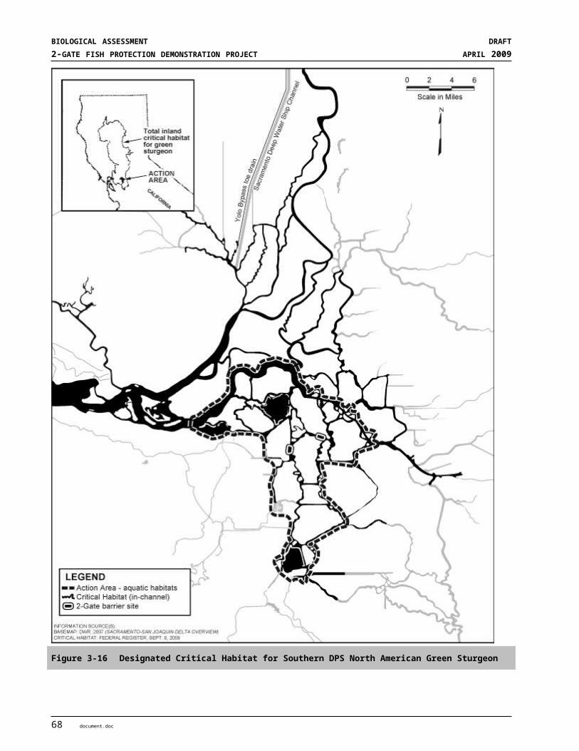
SECTION 4ENVIRONMENTAL BASELINE
4.2.1.8 Existing Monitoring ProgramsMost research and monitoring of fish populations in the Bay-Delta estuary is coordinated through the Interagency Ecological Program (IEP). The IEP is a cooperative effort, funded primarily by Reclamations and DWR and led by state and federal resource agencies with university and private partners. There are currently 16 fish monitoring programs that are implemented year-round across the entire Bay-Delta system (Honey et al. 2004). Figure 2-X illustrates existing monitoring stations that are sampled regularly in the Bay-Delta estuary under different programs and which capture delta smelt, longfin smelt, salmon, and other fish species. Sturgeon are rarely collected at these stations. The Fall Midwater Trawl Survey (FMWT) and the Summer Townet Survey (TNS) are the two longest running IEP fish monitoring programs that are used to index the abundance of delta smelt and other fish species. They work well because they were originally designed to target age-0 striped bass, which have similar habitat requirements to delta smelt. Two more recent programs, the 20-mm Survey and the Spring Kodiak Trawl (SKT) Survey, were designed specifically to sample delta smelt and are also commonly used to evaluate relative abundance and distribution.
Each of these four sampling programs mentioned above targets different life stages and encompasses the entire distribution of delta smelt for the given life stage and time of year. The efficiency of sampling gears used for delta smelt is unknown. However, they were all designed to target open-water pelagic fishes and data from these programs have been used extensively in prior studies of delta smelt abundance and distribution (e.g., Stevens and Miller 1983; Moyle et al. 1992a; Jassby et al. 1995; Dege and Brown 2004; Bennett 2005; Feyrer et al. 2007).
Data from the FMWT are used to calculate indices of relative abundance for delta smelt. The program has been conducted each year since 1967, except that no sampling was done in 1974 or 1979. Samples (10-minute tows) are collected at 116 sites each month from September to December throughout the Bay-Delta. Detailed descriptions of the sampling program are available from Stevens and Miller (1983) and Feyrer et al. (2007). The delta smelt recovery index includes distribution and abundance components and is calculated from a subset of the September and October FMWT sampling (http://www.delta.dfg.ca.gov/). The details on the calculation of the recovery index can be found in the Delta Native Fishes Recovery Plan (USFWS 1995b). Data from the TNS are used to calculate indices of abundance for young-of-year delta smelt during the summer. The TNS has been conducted annually since 1959 (Turner and Chadwick 1972). It involves sampling at up to 32 stations with three replicate tows to complete a survey. A minimum of two surveys is conducted each year. The delta smelt index is generated from the first two TNS surveys (Moyle et al. 1992a). The TNS sampling has had an average survey starting date of July 13, but surveys have been conducted as early as June 4 and as late as August 28 in some years (Nobriga et al. 2008). Data from the 20-mm survey are used to examine the abundance and distribution of young post-larval/early juvenile delta smelt during the spring (Dege and Brown 2004). The survey has been conducted each year since 1995, and involves the collection of three replicate samples at up to 48 sites; additional sites have been added in recent years. A complete set of samples from each site is termed a survey and 5-9 surveys are completed each year from approximately March though June. This survey also simultaneously samples zooplankton with a Clarke-Bumpus net during one of the three sampling tows at each site. Data from the SKT are used to monitor and provide information on the pre-spawning and spawning distributions of delta smelt. The survey also quantifies the reproductive maturity status of all adult delta smelt collected. SKT sampling has been done since 2002 at approximately 39 stations. Sampling at each station is completed five or more times per year from January to May. Supplemental surveys are often completed when additional information is requested by managers to assist with decisions relating to water project An additional source of information on delta smelt comes from salvage operations at the Banks and Jones pumping plant fish collection facilities. Both pumping facilities are screened with fish-behavioral louvers designed to salvage young Chinook salmon and striped bass before they enter the pumps (Brown et al. 1996).
In general, the salvage process consists of fish capture, handling, transport, and ultimately release at locations where they are presumed safe from further influence of the CVP and SWP delta pumps. However, unlike some species, it is commonly recognized that delta smelt often do not survive the salvage process. Data on the
document.doc 7
BIOLOGICAL ASSESSMENT DRAFT2-GATE FISH PROTECTION DEMONSTRATION PROJECT APRIL 2009
salvage of delta smelt is typically used to provide an index of entrainment into the diversion pumps, but not as an index of general population abundance. However, there are a number of caveats with these data including unknown sampling efficiency, unknown pre-screen mortality in Clifton Court Forebay, and no sampling of fish smaller than 20 mm (Kimmerer 2008). Fortunately, some of this information may become available in the future because of targeted studies on efficiency and pre-screen mortality being conducted by the IEP and Reclamation. Although monitoring at the Banks and Jones pumping plants is limited in geographic range compared to the other surveys, they sample substantially larger volumes of water, and therefore may have a greater likelihood to detect low densities of delta smelt larger than 20 mm. Delta smelt entrainment is presently estimated (or indexed) by extrapolating data from periodic samples of salvaged fish (≥ 20 mm). Fish are counted from a sub-sample of water from the facility holding tanks and numbers are extrapolated based on the volume of water diverted during collection of that sample to estimate the number of fish entrained into the Banks and Jones pumping plants. Intervals typically range from 1-24 hours depending on time of year, debris loads, etc.
4.2.1.9 Levee Construction, Maintenance and Bank ProtectionLevee construction, maintenance and bank protection activities have affected aquatic habitat availability and the processes that develop and maintain preferred habitat by reducing floodplain connectivity, changing riverbank substrate size, and decreasing riparian habitat and shaded riverine aquatic cover. Levee construction, maintenance and bank protection activities generally result in two levels of impacts to the environment: (1) site-level impacts which affect the basic physical habitat structure at individual bank protection sites; and (2) reach-level impacts which are the cumulative impacts to ecosystem functions and processes that accrue from multiple bank protection sites within a given river reach. Revetted embankments result in loss of sinuosity and braiding and reduce the amount of aquatic habitat. Impacts at the reach level result primarily from halting erosion and controlling riparian vegetation. Reach-level impacts which cause significant impacts to fish are reductions in new habitats of various kinds, changes to sediment and organic material storage and transport, reductions of lower food-chain production, and reduction in aquatic cover provided by root-wads and large woody debris within the river channel.
4.2.1.10 Research and Monitoring ProgramsResearch and monitoring programs within the Delta, including potentially the Action Area, are expected to continue into the future. These include DFG monitoring programs, DWR studies and sampling, IEP studies, and various fish sampling programs conducted by academics and private consulting firms. Both lethal and non-lethal take of various fish species, including listed species, is associated with these programs. If listed populations are reduced to very low abundance levels, incidental take associated with these monitoring can have an effect on the survival and recovery of listed species.
8 document.doc

S E C T I O N 5
Effects of the Action
5.1 OVERVIEWIn Section 2.2, “Project Description,” of this BA we provide an overview of the Action, its location, the gate concept, and planned construction, operations, and maintenance activities along with other actions incorporated to protect listed aquatic and terrestrial species within the Action Area (the area anticipated to experience direct or indirect effects of the project). Section 3.0, “Status of Species and Critical Habitat,” and Section 4.0, “Environmental Baseline” provide an overview of listed aquatic and terrestrial species and designated critical habitat under consideration, along with their current status and a description of the multitude of factors already affecting listed species populations both throughout their range and within the Action Area.
The following analysis focuses on those factors that are caused, either directly or indirectly, by the 2-Gates Project. After a brief description of the analytical approach used in this BA, this effects analysis is organized first according to project phase (construction, operations, or monitoring), and second according to species groups and critical habitat (aquatic species and their critical habitat, then terrestrial species and their critical habitat).
The following effects analysis is based on our current understanding of construction and operations effects of the project. Construction effects are evaluated relative to changes to existing habitats that are already in degraded conditions at the project sites – both areas contain rip-rapped levees along both banks. Riparian habitat consists of a bed of emergent vegetation primarily tules and cattails supporting limited to little shaded riparian aquatic habitat. Connection Slough is a constructed channel. Neither channel is regularly dredged to support navigation but may be irregularly dredged to maintain or repair levees. Both sites are influenced Delta inflow, tidal flows, in-Delta use and exports by CVP and SWP operations.
The effect of 2-Gate operations is based on extensive hydrodynamic and delta smelt behavioral modeling. Details of the RMA delta smelt behavioral models are Appendix E and were present in the Forward. Initial results from the modeling processes indicates a dramatic decrease in the entrainment risk to adult and juvenile delta smelt and other species when the 2-Gates Project is operated in a comprehensive manner with OCAP flow restrictions and QWEST flows at San Andreas. Collectively, deploying and operating the 2-Gates Project can result in increased protection for delta smelt while providing for reduced restrictions on water supplies.
5.2 APPROACH TO THE OPERATIONS ASSESSMENTThe development of the 2-Gates Project employed a process of model development and use, while applying progressively detailed model analyses from the site selection through final effects analyses phases (a description of this process is included in the Forward and more complete descriptions of the models and assumptions are included in Appendix E. This section generally describes this process to evaluate effects on biological resources and present results and essential findings to support the effects analysis. A list of the model development steps is provided in the Forward
It should be pointed out that the many modeling steps used differing operational assumptions and hydrology. This was a vailid process for transitioning from one level of study to another in an effort to refine and improve project operations. What became clear during this process was that the 2-Gates Project consistenly
document.doc 1
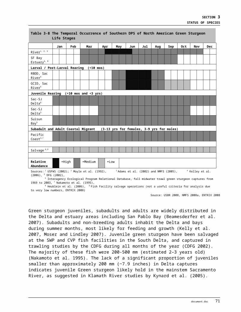
BIOLOGICAL ASSESSMENT DRAFT2-GATE FISH PROTECTION DEMONSTRATION PROJECT APRIL 2009
provided better protection to delta smelt adults and juveniles compared to only controlling reverse flows on Old and Middle Rivers (OMR). The modeling effort was an iterative process where results from previous models were used to refine operations and in order to develop simulations to reflect operations to conditons that reflect realtime conditons. Because of this iterative process, model results should not be directly compared between models.
5.2.1 Model Development Early in the analyses process, it was determined that complex delta smelt behavioral models would be useful to, with reasonable accuracy, predict distribution, abundance and fate of delta smelt under OCAP and 2-Gates operational conditions. Because the development of such a model would be time-consuming and its success could not be accurately predicted, a decision was made to initially use the One-Dimensional (1D) DSM2 model formulation for hydrodynamic, water quality and particle tracking to determine the most favorable location of gates, their region of control and their benefits under OCAP-modified flow conditions. While this effort was taking place, the RMA team developed an accurate behavioral model using a Two-Dimensional (2D) RMA formulation, as modified to characterize both the adult and larvae/juvenile delta smelt behavior. The 2D behavioral models were used to determine effects of the 2-Gates Project for environmental documentation purposes under OCAP-adjusted hydrodynamic conditions. Project operations criteria were improved based on the knowledge derived from the preceding evaluations. Therefore, the results from the initial simulation my not be precisely replicated with the Project operations. However, the Project operations incorporated the beneficial components of the initial simulations and overall Project performance improved through the development process. For example, early simulations assumed particle tracking would be a reasonable simulation of delta smelt behavior while the later simulations used more sophisticated delta smelt population distributions (from samples) and an enhanced simulation of adult delta smelt movement behavior.
One-Dimensional DSM2 AnalysesThis analyses of 2-Gates flow control measures to identify the region of control and the formation of a physical/hydraulic barrier for the control of delta smelt migration into the south Delta used the most recent historic DSM2 simulation software available from the Department of Water Resources (DWR). The initial Project formulation analyses used DSM2 to (1) evaluate hydrodynamics, fate and transport of neutrally buoyant particles for historic hydrology and for simulating the operating rules contained within the OCAP BO and with operations simulating the 2-Gates Project.
INITIAL SITE SCREENING STUDY USING DSM2 ANALYSES. Once the region of control was identified, then DSM2 PTM was used to evaluate 34 individual and combined gate location alternatives in the central and south Delta to determine the optimum locations and number of gates4. A 2-Gates Project on the Old River near Bacon Island and on Connection Slough provided optimum protection to delta smelt. DSM2 analyses determined that other individual or combined gate alternative locations provided less favorable fish protective benefits. Some locations were constrained by channel capacity or unfavorable geotechnical conditions. Other alternative locations studied, included: (1) two-gates on Old River at Quimby Island; (2) three-gates at Connection Slough, Railroad Cut, and Old River below Woodward; (3) four-gates on Connection Slough, Woodward and Railroad Cuts, and Old River below Woodward; (4) selective weir removal on Paradise Cut; (5) a weir on the San Joaquin River downstream of the head of Old River; and (6) Clifton Court Forebay gate tidal re-operations. Certain of these alternatives also included combined QWEST management. Water supply options were also evaluated at this step.
One-hundred and forty (140) PTM analyses were analyzed to determine the effectiveness of 2-Gates in controlling particle entrainment at south Delta export facilities5. Particle insertion locations used in these 4 Release date: 2Mar035 Release dates: 1Apr91, 1Mar 01, 2Mar03, 27Mar03, 1Feb05
2 document.doc
SECTION 5EFFECTS OF THE ACTION
analyses are shown on Figure 5-1. The Project facilities reduced particle entrainment at the pumps predominately for insertion points downstream of the gates on Franks Tract, Dutch Slough, False River, Fisherman’s Cut and Old River. Reduction in entrainment was also shown for insertions on Old River between Railroad Cut and the gate. Circulation patterns developed by the Old River gate operating open on flood-tide and closed on ebb-tide, while the Connection Slough Gate remained closed, consistently promoted seaward movement of particles in Old River and away from the pumps. These findings were used to define the region of control of the gates, largely bounded by the Old River, False River, Dutch Slough and Fisherman’s Cut. Table 5-1 shows the particle insertion locations, hydrologic periods of analyses and particle entrainment results for the cases modeled. The blue colored values define the region of the control of the gates operating under historical conditions. Operation of the 2-Gates facilities was also found to improve water quality conditions in the central and south Delta.
Figure 5-1 Location of DSM2 particle tracking simulation insertion points.
document.doc 3
BIOLOGICAL ASSESSMENT DRAFT2-GATE FISH PROTECTION DEMONSTRATION PROJECT APRIL 2009
Table 5-1 Particle Insertion Locations and Resulting Change in Percent Particle Entrainment Compared to Historic Conditions. Red values indicate increased entrainment, blue values decreased entrainment at the pumping facilities. Blue values generally define the region of control.
501513249Little Potato Slough28
19-2191910272Mokelumne River downstream of
Georgiana Confluence27
11217236258Mokelumne River downstream of
Cosumnes Confluence26
-871-91-83-7899Old River near Quimby Island25
-10-1-3-1461San Joaquin River downstream of Big
Break24
00000174Grant Line Canal23
-35931-714SJR south of Rough and Ready
Island22
0--840107Middle River at North of Mowry21
00000354Sacramento River at Collinsville20
0000-1351Sacramento River at Rio Vista19
00-102344Sacramento River at Ryde18
40231338Sacramento River at Hood17
30433330Sacramento River at Sacramento 16
20-1191712291Georgiana Slough15
151162616281North Fork Mokelumne14
10621249261South Fork Mokelumne13
60-214240Three-mile Slough12
000-11113Middle River at Victoria Canal11
-14-5-12-13-11226Frank's Tract West10
-58-3-53-47-51103Frank's Tract East9
-901-97-80-8492Old River at Bacon Island8
-20-1-1046San Joaquin River at Antioch7
18-16171442San Joaquin River at Twitchell Island6
28-5-3-432San Joaquin River at Rindge Pump5
-263-6-625San Joaquin River at Empire Tract4
19-4-13-721San Joaquin River at Stockton3
8391677San Joaquin River at Mossdale2
7481261San Joaquin River at Vernalis1
27-Mar-031-Feb-951-Mar-011-Apr-912-Mar-03
Change in % Entrainment at Export PumpsDSM2NodeLocationNo.
DSM2 ANALYSES FOR COMBINED 2-GATE AND QWEST STUDIES TO EVALUATE PHYSICAL/HYDRAULIC CONTROL. DSM2 PTM analyses were conducted to determine operations of the 2-Gates together with flow management on the San Joaquin River generated through OMR restrictions during critical periods. These operations generally maintained the distributions of particles within or north/west of the region of control of the gates, forming an effective hydraulic barrier to upstream smelt movement or migration into the south Delta.
4 document.doc

SECTION 5EFFECTS OF THE ACTION
Operations of the 2-Gate Project are shown to be consistent with the protective actions proposed by the U.S. Fish and Wildlife Service’s OCAP BO (USFWS 2008).
The outputs of DSM2 analyses of the 2-Gate Project provide insight into how to effectively operate the gates and potential benefits from flow rate modification. In these analyses, Three-hundred and twenty (320) PTM analyses were conducted at 20 mm smelt survey locations (Figure 5-2) using DSM2 to determine operational effects of combined 2-Gates and QWEST operations. The latter studies were performed in anticipation of potential operation in conjunction with the new OCAP BO and subsequent RMA delta smelt behavioral analyses6. The 2-Gates Project and modest QWEST operations were found to provide an hydraulic barrier to delta smelt movement into the south Delta, and were found effective in preventing particle entrainment within in the region of control of Project and QWEST controls (Tables 5-2 and 5-3; and Figures 5-2 and 5-3):
Delta Smelt Survey Locations modeled in DSM2 PTM20 mm survey points modeled in PTM20 mm survey release points in 2-Gate PTM showing reduced entrainment levels 2-Gate region of control where particle releases show consistent entrainment reduction at pumpsQwest @ San Andreas region of control resulting in consistent downstream entrainment reduction
20mm Survey Station Locations and PTM Release Points
Figure 5-2 20 mm Smelt Survey, Particle Release Points and Region of Control
6 Release dates: 9Jun99, 12Jun02, 15May02, 30May02, 21May03, 1May04, 16Dec03, 30Dec04
document.doc 5

BIOLOGICAL ASSESSMENT DRAFT2-GATE FISH PROTECTION DEMONSTRATION PROJECT APRIL 2009
SAC Ship Channel
Cache Slough and Liberty Island
Upper SAC
Upper Mokelumne
South Fork Mokelumne
Disappointment
SJR at Stockton
Upper SJR
Suisun Marsh
Napa
San Pablo Bay
Carquinez
Suisun
Honker Bay
SJR near confluence
Lower SAC
MidSAC
Grant line and OldVictoria
Middle
SJR at Old River
SJR at False River
Franks Tract
Old
Figure 5-3 Generalized modeled regions of the Delta. The region of control includes SJR at Old River, Middle River, Victoria, Old River, Frank’s Tract and Sjr at False River.
Table 5-2 Entrainment Results for Release Point #809
Survey Location/Release Point
% Entrainment from Release Location #809Feb-Jun Dec-Feb
9-Jun-99 12-Jun-02 15-May-02
30-May-02
21-May-03
12-May-04 16-Dec-03 30-Dec-
04
Historic 2 5 0 2 2 1 29 3
Historic + 2-Gates 0 2 0 1 1 0 25 1
Historic + 2-Gates+ QWEST > -1,000 cfs 1 1 0 1 0 0 9 5 0
Historic + 2-Gates+ QWEST > 0 cfs 1 0 0 0 0 0 6 5 0
5 0% entrainment observed in Historic + 2-Gates + QWEST >-1,000 cfs, when exports were curtailed to match San Joaquin River flow during the gate closure.
6 document.doc
SECTION 5EFFECTS OF THE ACTION
Table 5-3 Entrainment Results for Release Point #902
Survey Location/Release Point
% Entrainment from Release Location #902Feb-Jun Dec-Feb
9-Jun-99 12-Jun-02 15-May-02
30-May-02
21-May-03
12-May-04 16-Dec-03 30-Dec-
04
Historic 51 60 20 50 56 24 97 92
Historic + 2-Gates 1 2 0 1 6 1 11 4
Historic + 2-Gates+ QWEST > -1,000 cfs 1 1 1 0 2 1 4 5 3
Historic + 2-Gates+ QWEST > 0 cfs 1 0 1 0 2 1 4 5 3
5 0% entrainment observed in Historic + 2-Gates + QWEST >-1,000 cfs, when exports were curtailed to match San Joaquin River flow during the gate closure.
Further analyses were conducted to determine potential mitigating effects of combined 2-Gates and QWEST flow control measures, consistent with OCAP OMR restrictions, on Mokelumne River salmon. Tables 5-4 and 5-5 show examples of adding QWEST flows to 2-Gate Project operations to prevent substantial increases in particle entrainment or to reduce entrainment originating from the region of the confluence of the Mokelumne and San Joaquin rivers. The red symbols on Figure 5-4 depict 20mm survey location insertion sites that would otherwise be impacted without the application of such QWEST controls. Adding QWEST @ San Andreas > -1,000 cfs to 0 cfs to the 2-Gates Project operations was found to prevent increased entrainment or to reduce entrainment of particles from the Mokelumne and San Joaquin River regions in two-thirds of the model runs. Operations of the gates can also be changed (left open) with additional QWEST flow depending on severity of forecasted conditions.
document.doc 7

BIOLOGICAL ASSESSMENT DRAFT2-GATE FISH PROTECTION DEMONSTRATION PROJECT APRIL 2009
Delta Smelt Survey Locations modeled in DSM2 PTM20 mm survey points modeled in PTM
20 mm survey release points in 2-Gate PTM showing increased entrainment levels mitigated by Qwest flows
920
20mm Survey Station Locations and PTM Release Points
Figure 5-4. 20 mm Smelt Survey, Particle Release Points and 2-Gate/QWEST Operations
Table 5-4. % Change in Entrainment from Release Point #919
Survey Location/Release Point
% Change in Entrainment from Release Point #919
Feb-Jun Dec-Feb
9-Jun-99 12-Jun-02 15-May-02 30-May-02 21-May-03 12-May-04 16-Dec-03 30-Dec-04
Historic + 2-Gates +12 +16 +12 +24 +14 +12 -7 +9
Historic + 2-Gates+ QWEST > -1,000
cfs+9 +1 +7 +4 +4 +12 -21 5 +7
Historic + 2-Gates+ QWEST > 0 cfs +8 -10 +7 -8 0 +8 -26 5 +4
5 -74% change in entrainment observed in Historic + 2-Gates + QWEST>-1,000 cfs, when exports were curtailed to match San Joaquin River flow during the gate closure.
8 document.doc
SECTION 5EFFECTS OF THE ACTION
Table 5-5. % Change in Entrainment from Release Point #906
Survey Location/Release Point
% Change in Entrainment from Release Point #906
Feb-Jun Dec-Feb
9-Jun-99 12-Jun-02 15-May-02 30-May-02 21-May-03 12-May-04 16-Dec-03 30-Dec-04
Historic + 2-Gates +6 +4 +9 +17 +10 +7 -10 -2
Historic + 2-Gates+ QWEST > -1,000
cfs+2 -9 +8 0 +1 +4 -21 5 -3
Historic + 2-Gates+ QWEST > 0 cfs 0 -21 +6 -14 -1 +1 -26 5 -6
5 -86% change in entrainment observed in Historic + 2-Gates + QWEST >-1,000 cfs, when exports were curtailed to match San Joaquin River flow during the gate closure.
MODE OF GATE OPERATIONS CONSIDERED DURING LARVAE/JUVENILE STAGE. The DWR Potential Entrainment Index methodology, a model used to evaluate export levels and related entrainment, was used to test operational modes of the Project facilities during the March through June period when larvae/juvenile entrainment is of greatest concern. Using this methodology, differing 2-Gate operations and flow control measures were tested to reduce entrainment of simulated larval and juvenile delta smelt depending on the targeted distribution. Conditions were evaluated based on both gates closed, the Old River and Connection Slough Gates closed on flood-tide and open on ebb-tide and, and with only the Old River gate operated closed on flood-tide and open on ebb-tide. Table 5-6 describes the ranges of gates operation and other operational factors considered in these analyses.
Table 5-6 Conditions modeled to simulate change in potential entrainment with both gates operated closed on flood-tide and open on ebb-tide, and with only the Old River gate operated.
OMR Conditions Operation Alternatives Operating Criteria
OMR ≥ - 1,250 cfs Gates Closed OR Operating (flood-ebb)
OR & CS Operating (flood-
ebb)
Start gate operations when 3 station daily mean water temps ≥ 12 C
OCAP-adjusted QWEST @ San Andreas ≥ 0cfs
Gates open during VAMP
OMR ≥ - 5,000 cfs Gates Closed OR Operating (flood-ebb)
OR & CS Operating (flood-
ebb)
A comparison of either one or both gates operating closed on flood-tide and open on ebb-tide was evaluated and results are summarized in Table 5-7. Operation of both the Old River and Connection Slough closed on flood-tide and open on ebb-tide increases the number of events in which there was a simulated net reduction in potential entrainment. However, under certain conditions the tidal operation of the Old River gate alone proves significantly more effective, particularly when distributions fall within the western Delta and generally within region of control of the gates. Considering this evaluation, a gate operation mode with Old River gate closed on flood-tide and open on ebb-tide and Connection Slough gate closed during such operations was
document.doc 9
BIOLOGICAL ASSESSMENT DRAFT2-GATE FISH PROTECTION DEMONSTRATION PROJECT APRIL 2009
selected for evaluation in the RMA analyses. This operation was applied to distributions of larvae/juvenile generally falling within in the region of control of the gates. This would be consistent with the application of RPA Component 2. An operational protocol is being established to guide the most favorable protections to smelt for testing in the demonstration program. Flexibility would be applied during field demonstrations to operate one or both gates in the flood-ebb operational mode.
Table 5-7 Simulated change in potential entrainment with only the Old River gate operated tidally and with both Gates operated tidally
20 mm Survey
Change in Potential Entrainment
OR Gate Tidal Operation % Change
OR & CS Gate Tidal Operation % Change
09 June 1999, Survey 5 -50.4% -20.6%
15 May 2002, Survey 5 11.4% -4.5%
30 May 2002, Survey 6 3.4% -14.3%
12 June 2002, Survey 7 5.2% -7.6%
21 May 2003, Survey 5 -12.3% 11.9%
12 May 2004, Survey 4 -32.4% -26.2%
Two-Dimensional RMA-2 Analyses
SIMULATED REAL-TIME OPERATIONS WITH OCAP BO RESTRICTIONS USING ADULT AND LARVAE/JUVENILE SMELT BEHAVIORAL MODELS. Adult Delta Smelt. All prior simulations of near-term solutions had modeled adult delta smelt as neutrally-buoyant particles. While reasonably accurate for the larval/juvenile stage, researchers have observed behaviors associated with increased turbidity and decreased salinity in preparation to moving inland prior to spawning (Grimaldo et. al as cited in USFWS 2008). Smelt distribution patterns are related to salinity and turbidity conditions during the winter in preparation for spawning (USFWS 2008). Scientists have postulated that the adult smelt may be “surfing” the tides as a means of staying within the desired water quality conditions. A new modeling package was developed to impart tidal ‘surfing’ behaviors on the particles in the RMA11 model. Once the delta smelt behavior model reasonably reproduced delta smelt distribution patterns in the Delta and occurrence at the export facilities, additional simulations were done with simulated operable gates in the Old River and Connection Slough. Simulations employed Project operations and the modulation of exports during December through February. These simulations demonstrate that the turbidity distribution (and therefore the distribution of adult delta smelt) can be managed generally within the region of control of the Project. Within this region, Project operations and related flow control measures have been shown through the model to be effective in dramatically reducing the entrainment risk of adult delta smelt from the CVP and SWP pumping facilities.
Larvae/Juvenile Delta Smelt. To correlate observed and modeled distributions and abundance of larvae/juvenile delta smelt, the RMA11, RMA2 and RMA-PTRK models have evaluated the larval and juvenile delta smelt period, roughly from March through June, for differing hydrologic conditions. For each condition, hatching rates have been determined by “tuning” to match distributions established by the 20mm surveys and, if possible, observed salvage. The hatching period and mortality rates used in the simulations
10 document.doc
SECTION 5EFFECTS OF THE ACTION
have been specified based on published findings from credible researchers. Delta smelt density predictions were compared with 20mm survey observations and the predicted delta smelt salvage was compared with salvage observations at the Skinner Fish Facility and the Tracy Fish Facility including factors necessary to estimate pre-screen losses and salvage efficiency. The model evaluated the percent of larval/juvenile delta smelt population entrainment by the combined export facilities, the percent flushed from Delta, and the percent that remained within Delta.
Computer simulations of adult delta smelt distribution with habitat seeking behavior were performed for historic periods. Simulation points representing adult delta smelt were initially placed in regions of acceptable habitat at the start of the simulation period. Key constituent elements of adult delta smelt habitat were characterized by salinity (EC) and turbidity. Options were added to the model to influence sensitivity to habitat gradients, chance of incorrect directional choices, and resistance to tidal flow velocity. Behavioral characteristics were adjusted to attempt to replicate entrainment (salvage) at water export facilities. The 2-Gates Project operations were coupled with flow management measures of the OCAP BO.
Adult delta smelt distribution, including entrainment at the SWP and CVP facilities were determined through simulation using modified operations scenarios for the OCAP BO baseline and OCAP plus the 2-Gate Project using the RMA Adult Behavioral Model. Models were run for the December through February months for the 1999-2000, 2001-2002, 2003-2004 and 2007-2008 periods. See Appendix E for more details. Sample results are shown in Figures 5-5 and 5-6. A comparison of Figures 5-4 and 5-5 shows that in addition to the OCAP required OMR controls, the control of QWEST to be greater than or equal to zero cfs at San Andreas is effective in reducing modeled entrainment at the SWP and CVP facilities is nearly 0%. It is expected that proper application of such QWEST control through export modulation during the adult stage will be effective in managing turbidity distribution and hence, the distribution of adults generally within the region of control of the gates.
ADULT-2004-HISTADULT-2004-2GATE-2000ADULT-2004-2GATE-3000ADULT-2004-2GATE-4000ADULT-2004-2GATE-5000
14 28 11 25 8 22 7 21Dec2003 J an2004 Feb2004 Mar2004
Cum
ulat
ive
% o
f Tot
al P
artic
le R
elea
se
0
2
4
6
8
10
12
14
16
18
20CVP+SWP
Figure 5-5 Cumulative simulated entrainment of particles representing adult delta smelt recovered at the CVP and SWP facilities, December 2003 through March 2004, with alternative OMR flow limits .
document.doc 11
BIOLOGICAL ASSESSMENT DRAFT2-GATE FISH PROTECTION DEMONSTRATION PROJECT APRIL 2009
ADULT-2004-HISTADULT-2004-OCAP-LBADULT-2004-OCAP-3000-2GST-LBADULT-2004-2GATE-3000MOD-LB
14 28 11 25 8 22 7 21Dec2003 J an2004 Feb2004 Mar2004
Cum
ulat
ive
% o
f Tot
al P
artic
le R
elea
se
0
2
4
6
8
10
12
14
16
18
20CVP+SWP
Figure 5-6 Cumulative simulated entrainment of particles representing adult delta smelt recovered at the CVP and SWP facilities, December 2003 through March 2004, with -3000 cfs OMR flows during RPA1 and -1250 cfs during RPA2 For the 2-gate case, exports were reduced briefly near the end of January to maintain positive QWEST at San Andreas Landing.
These simulations were used in RMA Bay-Delta Model and RMA-PTRK for passive particle tracking with post processing analysis of hatching and mortality. Modified operations scenarios were simulated for revised export flows according to OCAP guidelines and OCAP plus 2-Gates operations to determine resulting larval and juvenile delta smelt distribution and entrainment. Simulations were conducted roughly from March through June for the 2002 and 2004 historic periods. Analyses to adjust simulation results for mortality/hatching are underway and will be reflected in the final simulation results. The hatching rates estimated for historic conditions will be applied without modification to the various operations scenarios, focusing on the effects after initial hatching.
The combined effects of the 2-Gates, OMR -5,000 cfs restrictions, and supplemental QWEST ≥ 0 cfs suggests resulting larvae/juvenile entrainment can be maintained near OCAP OMR -1,250 cfs entrainment levels. Figure 5-7 displays the forecast of reduced entrainment at the export facilities with the implementation of the Project. Each of the Project simulation displays less predicted entrainment than either of the simulations of OCAP BO restricted OMR flow regimes.
12 document.doc

SECTION 5EFFECTS OF THE ACTION
J UVEN-2004-HISTJ UVEN-2004-OCAP-LBJ UVEN-2004-OCAP-UBJ UVEN-2004-2GATE-OPT2-LBJ UVEN-2004-2GATE-OPT2-UB
22 7 21 4 18 2 16 30 13Feb2004 Mar2004 Apr2004 May2004
PER
CENT
ENT
RAIN
ED, A
LL R
EGIO
NS
0
10
20
30
4050
60
70
80
90100
Total Particle Entrainment at CVP+SWPPassive Particle Tracking without adjustment for Hatching Rate or Mortality
Figure 5-7 Comparison of 2-Gate cumulative simulated entrainment of particles representing larval/juvenile delta smelt recovered at the CVP and SWP facilities from all regions of the Delta (not adjusted for hatching rate or mortality).
5.3 CONSTRUCTION EFFECTS ON AQUATIC SPECIESConstruction activities include levee clearing of rip rap and vegetation at each shoreline at each site, dredging (clamshell dredge), dredge spoil disposal, sheet pile dike installation (vibration-driven), placement of rock in the channel and on levees, installation of the gate barge (the gate barge is the barge and the gate structure, control house and all wiring and electrical components that are pre-installed on the barge, then barge is then towed to the site and sunk to the prepared foundation), and removal and reinstallation of the gate barge and lock rock at the end of the first season and beginning of next season. Foundation preparation for the gate barge involves dredging peat material estimated at 5,500 cubic yards for Connection Slough and 7,000 cubic yards for Old River.
Exposure to construction effects depends on the spatial and seasonal occurrence of different species and life stages (Table 5-8). The period of in-water construction at the two sites is up to five weeks in September-October 2009 for construction (install sheet pile wall, dredge barge foundation, and place foundation rock), two weeks in November for barge gate installation, and two weeks in July for removal (gate barges and about 200 feet sheet pile walls on either side in the Old River Channel, no sheet pile wall will be removed from Connection Slough). All in-water work for the 2-Gates Project will be conducted within the in-water work windows already established by the fish agencies to limit project impacts to listed salmonids (winter-run and spring-run Chinook, CV steelhead) and delta smelt. Therefore, it is anticipated that the immediate effects of construction on listed fishes will be minimal, although some individuals may still be found within the Project work areas.
Species that could potentially occur near the sites during in-water construction in September-October include CV steelhead (early migrating adults and rearing juveniles) and green sturgeon (migrating adults, juveniles), with a low probability of winter-run Chinook (juveniles). Species that could potentially occur during gate
document.doc 13

BIOLOGICAL ASSESSMENT DRAFT2-GATE FISH PROTECTION DEMONSTRATION PROJECT APRIL 2009
barge installation in November include CV steelhead (migrating adults and juveniles), green sturgeon (juveniles), and longfin smelt (migrating or spawning adults), with a lower probability of occurrence for spring-run Chinook (juveniles) and CV steelhead (juveniles). Species that could potentially occur near the sites during gate removal in July include green sturgeon (adults and juveniles), with a low probability of CV steelhead (juveniles entering Delta). Adult winter-run and spring-run Chinook would not likely occur at the Project sites because they stay in the Sacramento River during their upstream migration. The two construction sites on Old River and Connection Slough are located within designated critical habitat for delta smelt, CV steelhead, and green sturgeon (proposed). However, the existing habitat quality of these leveed, riprapped Delta channels for rearing of delta smelt and juvenile salmonids is poor.
Table 5-8 2-Gates Construction Timing and Duration and Likely Occurrence of Aquatic Species and Critical Habitat at Construction Sites
Construction Activity Timing Duration Species Likely Occurring at Construction Sites Critical HabitatConstruction of sheet pile walls, dredging barge foundation, installation of barge rock base and
September- October 2009
Five weeks CV steelhead (adult, juvenile)
Green sturgeon (adult, juvenile)
Delta smelt
CV Steelhead
Green Sturgeon
Installation of barge with gates and anchor rock November 2009 Two weeks CV steelhead (adult, juvenile) -unlikely
Green sturgeon (juvenile)
Longfin smelt (adult) unlikely
Spring-run Chinook (juvenile possible but unlikely)
Removal of argegates from both sites and sheet pile dikes from Old River only
July 2010 Two weeks Green sturgeon (adult, juvenile)
The assessment examines several potential effects from construction activities:
Direct injury or mortality from dredging and placement of rock and the barge
Behavioral, physiological or physical habitat changes or impairment in response to:
Underwater noise and disturbance
Turbidity and resuspension of sediments and contaminants and resettling on benthic habitats
Alteration of benthic habitat by placement of rock and barge
5.3.1 Direct Injury and Mortality Construction activities include dredging, sheet pile wall installation, rock placement, gate barge installation, gate barge removal and gate barge reinstallation. The principal risk of direct injury and mortality to listed species would be from striking, collision or capture in the bucket dredge or crushing due to placement of rock or installation of the gate barge and sheet pile dikes (especially for bottom dwelling species such as green sturgeon). By using a bucket dredge and disposing of spoils on land, the Project will avoid other potential effects of dredging, such as fish entrainment by hydraulic dredging and burial of benthic organisms and habitat by disposed sediments (Reine et al. 1989, Nightingale and Simenstad 2001, Hoover et al. 2005).
5.3.2 Noise and Disturbance Noise associated with construction activities of the 2-Gates Project has the potential to adversely affect aquatic species. Transient noise from dredging, foundation preparation (i.e. rock placement), pile driving,
14 document.doc
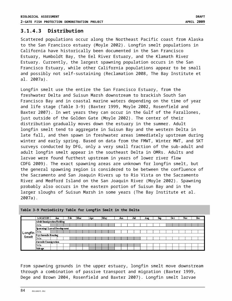
SECTION 5EFFECTS OF THE ACTION
surface machinery, and topside activities on the construction barge decks during installation of the gate structures on site may have adverse effects on fish in close proximity to the noise source. This effect is expected to be localized and temporary in nature. Furthermore, these activities will occur during periods when few listed species are likely present in the area (green sturgeon and CV steelhead).
High levels of underwater noise can adversely affect some fish species7. The effects of pile driving on fish have been assessed by NMFS and others (Hastings and Popper 2005, Popper et al. 2006, Carlson et al. 2007, NMFS 2008d,). Information is not currently available regarding transient underwater noise associated with dredging, rock placement, surface machinery and topside activities on the barge decks. However, it is not expected that these noise levels will reach the same levels as from pile driving. Fish impacts from exposure to pile driving activities were reviewed by Hastings and Popper (2005), and recommendations provided to protect fish from physical injury (Popper et al. 2006, Carlson et al. 2007). In 2008 NMFS, USFWS and DFG adopted interim criteria of a peak sound pressure level of 208 decibels (dB) referenced to 1 µpascal per second (re: 1µPa2-s) and a cumulative sound exposure level (SEL) of 187 dB re: 1µPa2-s (Fisheries Hydroacoustic Working Group 2008, ICF Jones & Stokes and Illingworth & Rodkin 2009). Although these criteria were specific to percussive pile driving, they have served as a general guideline for noise thresholds for the onset of physical injury in fish exposed to the impact sound associated with pile driving (NMFS 2008d).
Sheet and king pile driving is expected to generate the greatest levels of underwater noise. Rock placement is also expected to generate underwater noise. These activities may generate sharp transient noises from metal components (buckets, scoops, etc.) striking rock that will propagate into the water column. The noise will be transient, occurring over a five week period. The 2-Gates Project will use a vibratory hammer to install the sheet pile dikes and king piles (wall) between the gate structure and the levee at reach site (see appendix G and H for details).Vibratory hammers are generally much quieter than impact hammers and are routinely used on smaller piles (ICF Jones & Stokes and Illingworth & Rodkin 2009). Although peak sound levels can be substantially less than those produced by impact hammers, the total energy imparted can be comparable to impact driving because the vibratory hammer operates continuously and requires more time to install the pile (ICF Jones & Stokes and Illingworth & Rodkin 2009). Sound levels during vibratory pile driving were measured at the City of Stockton Downtown Marina (Power Engineering 2008). Peak sound pressure levels ranged from 184 to 202 dB re: 1µPa, while accumulated SEL’s ranged from 181 to 195 dB re: 1µPa2-sec, as measured at 10 meters from the pile and mid-water depth (approximately 2 to 3 meters below the water surface). The duration of pile driving ranged approximately 6-12 minutes, with periods of 11 - 71 minutes between pile driving (Power Engineering 2008). The peak sound pressure levels were below recommended levels, while the accumulated SEL’s slightly exceeded the recommended criteria by 8 dB re: 1µPa2·sec,. It is anticipated that pile driving associated with the 2-Gates Project would have similar results in terms of SEL and peak sound pressure levels. This combined with the relatively short duration expected to drive each king pile and sheet pile along with an anticipated period between pile driving, and the timing of work within established in-water work windows suggest that physical injury to fish is unlikely.
Anticipated responses of any fish within the work area would more likely be behavioral in nature (startle response, avoidance etc.), although these would diminish with distance from the construction sites. Hastings and Popper (2005) concluded that data are lacking on behavioral responses to pile driving, such as a startle response to noise or movement away from highly utilized habitats impacted by sound. Carlson et al. (2001 cited in NMFS 2008c) reported migrating juvenile salmon reacting with startle behavior in response to routine channel maintenance activities in the Columbia River. Some of the fish that did not immediately recover from
7 Three metrics are commonly used in evaluating hydroacoustic impacts on fish: peak sound pressure level (LPEAK), root mean square (RMS) sound pressure, and sound exposure level (SEL) (ICF Jones & Stokes and Illingworth & Rodkin 2009). SEL is defined as the constant sound level acting for one second, which has the same amount of acoustic energy as the original sound (Hastings and Popper 2005). Reference sound levels from pile driving normally are reported at a fixed distance of 10 meters. Underwater peak and RMS decibel levels are usually referenced to 1 micropascal (μPa), and the SEL is referenced to 1 micropascal squared per second (dB re: 1μPa2-s). (Hastings and Popper 2005).
document.doc 15
BIOLOGICAL ASSESSMENT DRAFT2-GATE FISH PROTECTION DEMONSTRATION PROJECT APRIL 2009
the disorientation of turbidity and noise from channel dredges and pile driving swam directly into the point of contact with predators.
5.3.3 Turbidity and Resuspension of Sediments The main impact from construction is likely to be resuspension of channel sediments during in-channel activities. Site preparation in September and October includes dredging, followed by pile driving and installation of the sheet pile dike and rock placement. In November, the barge with gate will be installed and lock rock placed.. Sediments resuspended during dredging operations pose a variety of water quality and ecological concerns (Nightingale and Simenstad 2001, Bridges et al. 2008). The turbidity plume in the immediate vicinity of a dredging operation could influence the behavior, growth or health of fish and other organisms. The change from background levels, the type of suspended sediment, its concentration and duration, and species and life stage of fish are all factors to consider in evaluating the effect of exposure (Newcombe and Jensen 1996). Some effects that could occur in the Delta include avoidance of a turbidity plume and altered foraging and predation dynamics.
Foundation preparation for the gate barge consists of dredging peat material estimated at 5,500 cubic yards for Connection Slough and 7,000 cubic yards for Old River. Dredging the peat sediment is expected to release a combination of organic and inorganic sediments into the water column, with associated potential reductions in dissolved oxygen. Barrier construction activities would increase localized turbidity at the two project sites that would extend downcurrent from the installation site due to tidal flow. Although this increase in turbidity may affect fish by inducing avoidance of the plume, temporarily disrupting feeding, or disrupting resting or movement behavior, green sturgeon and steelhead are strong swimmers capable of moving away from the area of disturbance.
These effects would be limited in scope, due to the relatively small construction area (approximately 1.5 acres) and limited duration of construction. Once in-water construction stops, water quality is expected to return to background levels within a few hours, depending on hydrodynamics and the amount and size of fines in the channel sediments. The potential for exposure is therefore limited to those fish that may be present during the construction season (green sturgeon and juvenile steelhead) and they would avoid adverse conditions.
In-water construction activities also have the potential to distribute sediment-borne contaminants, if present, into the water column and onto nearby substrate, where they could be taken up by benthic organisms. Resuspension of contaminated sediments could have adverse effects on fishes that encounter the sediment plume, even at low turbidity levels. These effects will be localized and temporary, although some effects could persist if the mobilized sediments are contaminated and enter the benthic food chain. Contaminant mobilization, contaminant leaching, bioaccumulation, and trophic transfer through the food web can occur during or as a result of the dredging (Bridges et al. 2008). Green sturgeon could be affected because they are benthic foragers and can bioaccumulate contaminants over their long lifespan. The potential for this effect is related to the degree of contaminants in the sediments to be dredged and the total area disturbed. It is not known whether contaminated sediments are present at the two construction sites.
Construction vessels could potentially release contaminants into the water column due to runoff of oil-based materials during operations. This could affect fish through impaired water quality and substrate quality. Surface contaminants would be addressed in a Spill and Pollution Prevention Plan, which will outline actions to reduce impacts from this activity and address responses to potential spills. The implementation of BMPs and other protection measures would mitigate the potential effects on fishes and their habitat.
16 document.doc

SECTION 5EFFECTS OF THE ACTION
5.3.4 Altered Physical Habitat Installation of the rock foundation and the barges would directly affect a total of about 65,000 square feet of channel bottom, approximately 30,000 square feet at Old River and approximately 35,000 square feet at Connection Slough. This action would replace approximately 1.5 acres of soft bottom habitat of peat and mud with rocky bottom habitat and two barges, which in turn will affect the benthic community structure. Species adapted to the soft peat and mud habitat will be replaced, in this particular area, with those more adapted to a firm surface. This alteration or reduction of the benthic community could potentially change the foraging habitat for green sturgeon. Pelagic feeders such as delta smelt and longfin smelt would not be affected by alteration of the channel physical habitat. The gate structures would attract predatory fish, thereby increasing predation risk for Delta smelt, longfin smelt and juvenile salmonids. Gate structure installation would alter near field channel hydraulics changing the channel from mostly laminar flow to locally turbulent flow conditions during a portion of the tidal stage down current of gate (Appendix E). This change would be most notable in Old River where a large volume of tidally driven water passes during each tidal cycle.
The Old River and Connection Slough sites are within the designated critical habitat for delta smelt, CV steelhead, and green sturgeon. Installation of the gates would affect certain PCE’s for these species. For delta smelt, this would affect the PCE for Physical Habitat including spawning substrate. The scale of any potential impact is discountable, however, given the relatively small footprint of the Project on the substrate. For CV steelhead juveniles, the quality of freshwater rearing habitat is affected by habitat complexity, food supply, and presence of fish predators. The baseline condition of freshwater rearing habitat within Delta channels, however, is already degraded, and installation of the Project would not exacerbate this degradation. For green sturgeon juveniles and adults, attributes of tidal freshwater habitat that would be altered are principally benthic foraging habitat. However, the overall amount of habitat altered is small relative to what is available in the Delta, so the action is not likely to adversely affect the prey base for green sturgeon or juvenile salmon populations. Migratory corridors for emigrating CV steelhead juveniles and for green sturgeon adults and juveniles would not be substantially blocked by the gate structures because the sloped lock rock along each side of the barges will assist sturgeon in moving across the gate structure and the gates will be open during most of the operational period. The gates would be closed up to an hour a day from December into late February or March, and then operated tidally (closed on flood and open on ebb tides) from then until mid-April. Gates would be open during the VAMP period (mid April to mid May), then operated tidally into June, but open on weekends and holidays to allow for vessel navigation.
Construction on the levees would disturb existing emergent or riparian vegetation and habitat resulting in reduced shoreline vegetation and any riparian function it may have in supporting juvenile Chinook that utilize the area. Reductions in functions may include loss of shading and stabilization of sediments and loss of insect prey items for juvenile Chinook (Toft et al. 2004). However, the existing riparian function is already degraded and very small in relation to what is available in the Delta. In conclusion, the Project construction would not have a significant effect on the physical habitat for the listed aquatic species.
5.4 OPERATIONS EFFECTS ON AQUATIC SPECIESThe gate structures and their operations will have several effects on listed aquatic species including changes to physical habitat, flow patterns, and predation. Changes to physical habitat conditions result from installation of rock, gate barges, sheet pile walls and boat ramps. Structures change physical habitat conditions in a channel cross section that was primarly composed of open water channel with a soft sediment bed and bordered with a shoreline of tule-fringed rip-rapped levees on either side. The otherwise open water habitat of the channel is occupied by vertical steel walls that extend from the bed to above the surface creating vertical walls with little habitat value. Water velocities are low near the wall and slow eddies may develop in the backwater areas between the gate and levee. The barges create a shallow shoaling area in the middle of the channel. Shoaling areas can create tidal rips during large tidal changes as velocities increase across the top of the barge, then decelerate upon again reaching deep water. The deck of the steel barge provides poor quality
document.doc 17
BIOLOGICAL ASSESSMENT DRAFT2-GATE FISH PROTECTION DEMONSTRATION PROJECT APRIL 2009
bottom habitat with limited complexity to support invertebrates. Piles and decks for the boat ramps create structure in the nearshore area and can also provide shade, but the use of the boat ramps would disturb fish using these areas. These areas may provide habitat for predators, both fish and birds. The interstices in the rocks used to lock the barge in place provide numerous underwater hiding spots along sloping faces on both sides and ends of the barge. This can provide habitat for crayfish, catfish or other aquatic cavity dwellers.
Gate installation and operation will attract predatory fish to the structure or favorable conditions created by the structures. The gate structures will change the flow field in close proximity to the barges. The constrained channel cross section will change the mostly laminar flow of these channels to areas of turbulent flow during large tidal changes when water accelerates from the high side of the structure through the gate to the low side. These velocity jets will create eddies and shear zones along their sides that predator fish can use to feed on smaller fish being swept along with the current. Predatory fish in the Delta (primarily striped bass, largemouth bass, sunfishes and catfish) are good at exploiting situations where food is abundant or where features exist that enhance feeding opportunities, such as crevices or turbulent flows. For example, large populations of striped bass occur inside Clifton Court Forebay and schools of striped bass are known to occur in the vicinity of the salvage release sites. The gate structure would provide permanent (sheet pile wall, barge, lock rock and boat ramp) structures that provide interstitial spaces, topographic features or currents that are used by predatory fish. Navigation requirements and operation of the boat ramps and gates on a 24/7 requirement means that safety lighting will be installed at the gates. Flood lights need to illuminate the gate, sheet pile walls and boat ramp. Lighting may attract fish into lighted areas. Night predators such herons, other birds and raccoons may also take the opportunity to use the light sources as a means of gathering food. Predators that are attracted to the gate result in the loss of individual delta smelt, salmon and CV steelhead, but the overall effect of the gate structures on predator populations in Old River and Connection Slough would not result in populations level effects to these listed species.
When the gates are closed, the channel ends next to the gate will function much like a dead end slough, and water quality condition may slightly degrade with lower dissolved oxygen, change in salinity and debris build up. These conditions would be transient and would dissipate upon gate opening.
The Project operations will affect hydrodynamics in the region of influence. The following analysis of operation effects is based on hydrodynamic and behavioral simulations conducted for these analyses. Project operations will minimize the entrainment of listed fish species, primarily delta smelt relative to baseline conditions, in the CVP and SWP south delta pumping facilities. Details of the hydrodynamic and behavioral simulations efforts used in these analyses were presented in Section 5.1 and are provided in more detail in Appendix D. Results from the modeling inidcate a decrease in the entrainment of adult delta smelt by the export facilities by controlling the distribution of water quality characteristics that are correlated with migration of pre-spawning adults into the central and south Delta. Results from the simulations also indicate a decrease in the entrainment of larval and juvenile delta smelt over OCAP required OMR by operation of the 2-Gates consistent with OCAP flows and management of QWEST in the San Joaquin River at San Andreas Landing.
5.4.1 Potential Effects to Delta Smelt The Project will benefit delta smelt by limiting pre-spawning adults from moving south of the gates, and thus limiting the distribution of adults, eggs, and larvae from reaching the south Delta. Fish entering the south Delta are highly vulnerable to entrainment at the pumping facilities, and subject to increased predation and poor habitat conditions. Reproductive success in the San Joaquin portion of the Delta is reduced because many adults and most larvae have been entrained and lost during transport to and from spawning sites to rearing areas (USFWS 2008). The adult delta smelt prevented from entering the south Delta would need to find other areas to spawn, but they and their progeny would be less vulnerable to entrainment, predation and poor habitat conditions.
18 document.doc

SECTION 5EFFECTS OF THE ACTION
The following sections discuss the Project effects in further detail by life history stages and critical habitat PCEs. During the December to June gate operation period, all life stages of delta smelt may be present in the vicinity of the Project facilities. Adults would predominate in December through February, and other life stages would increase in abundance from February through June. Most adults die after spawning, so their numbers would tend to decrease after the peak of spawning (usually by April or May). Juveniles would increase in abundance through June. Historically, salvage densities for delta smelt have been highest during May and June. In wet years spawning and migration tend to occur further west in the Delta than in dry years when delta smelt migrate further up the rivers to access freshwater spawning habitat. This pattern implies that direct and indirect effects and operations may be greater in dry years than in wet years.
5.4.1.1 Life History Stages
MIGRATING AND SPAWNING ADULTS (~DECEMBER THROUGH MARCH) Adult smelt begin moving inland from the western Delta when first flush flows increase turbidity (greater than or equal to 12 NTUs) and decrease salinity. When the higher turbidity in the west or central Delta bridges the gap through Old and Middle rivers, this links with the high turbidity waters in close proximity to the pumps. Once the turbidity bridge occurs, adult delta smelt tend to move more easily move into the south Delta. Recent estimates of annual entrainment have ranged from 10 to 60 percent of the delta smelt population (adults and progeny combined) per year from 2002 to 2006 (Kimmerer 2008). Since most adult entrainment occurs between mid-December and March, the gates will be operated during this period to modulate flows in Old and Middle Rivers and thus manage distribution of higher turbidity conditions that cue adult pre-spawning migration from extending into the south Delta. Operation of the project will reduce the risk of entrainment for adults.
The results from RMA’s delta smelt behavioral simulations indicate that installation and operation of the Project would manage water quality to keep adults north of the area to avoid becoming entrained by the pumping facilities. Figure 5-8 shows the simulated distribution of adult delta smelt for different operational scenarios. Under current operations (Figure 5-8, upper left frame), delta smelt are distributed throughout the south Delta as well as other channels. The OCAP restrictions (Figure 5-8, lower left frame) also show delta smelt dispersing into the south Delta channels but not as extensively as under historic conditions. Simulations of OCAP with 2-Gate reveal that delta smelt distribution extends only to about Woodward Canal (Figure 5-8, upper right frame). The Project would limit the distribution of adult delta smelt from extending further into Old and Middle Rivers toward the south Delta channels, thus reducing entrainment risk. Model runs indicate that operations of the 2-Gate with OCAP OMR flows and QWEST result in better reduction in entrainment than OCAP OMR flows alone (Figures 5-5 and 5-6).
document.doc 19

BIOLOGICAL ASSESSMENT DRAFT2-GATE FISH PROTECTION DEMONSTRATION PROJECT APRIL 2009
HIST
OCAP-LB
2GATE-LB-OPNCLS1
OCAP-LB-2GST
Figure 5-8. Adult Delta Smelt Particle Distributions for historical conditions (HIST), OCAP operations (OCAP-LB), and 2-Gates scenario (2GATE_LB-OPNCLS1). The difference between OCAP and OCAP with 2-GATE is the comparison of lower left with upper right figures.
LARVAL AND JUVENILE DELTA SMELT TRANSPORT (~MARCH THROUGH JUNE) Delta smelt spawning typically commences once Delta-wide average water temperatures reach 12 ºC, approximately February or March. Once this occurs, gates will be operated to protect larval and juvenile delta smelt from entrainment into the south Delta, as informed by 20-mm surveys of larval distribution. The Old River gate will be operated tidally: open on ebb tides and closed on flood tides. The Connection Slough gate will be closed, except when opened during slack tide (an hour per opening, four times per 25 hour tidal cycle) or for boat navigation on weekends. Gate operations will be coordinated with OCAP restrictions and QWEST. Gates will also be open continuously during the VAMP periods (mid-April to mid-May) and on weekends from Memorial Day through June.
The Project would enhance survival of larval and juvenile delta smelt. As discussed above, operations will affect the distribution of turbidity and salinity, which would result in redistribution of pre-spawning adult delta smelt in the inner Delta and consequently would change the distribution of larval and juvenile delta smelt. The gate structures and their operations will influence habitat conditions by affecting hydrodynamics in the region of influence. The Project will balance net flows in Old and Middle Rivers between the San Joaquin River and Woodward Cut, thus reducing entrainment risk at the SWP and CVP export facilities. The Project operations will also complement QWEST flows (maintained in the San Joaquin River at San Andreas Landing greater than zero), which assist downstream movement of larvae and juveniles to rearing habitat in the low salinity zone in Suisun Bay.
20 document.doc

SECTION 5EFFECTS OF THE ACTION
RMA’s behavioral simulation shows a net decrease in the entrainment of larval/juvenile delta smelt when the Project is operated and OMR flows are balanced. Figure 5-7 compares modeled entrainment rates at the SWP and CVP facilities under various scenarios (historic, upper and lower OCAP BO, and Project operations using the OCAP upper and lower bound OMR flow rates). The Project achieves a 10-12% reduction of cumulative entrainment compared to OCAP restrictions alone for the hydrologic conditions and Delta-wide smelt distribution that occurred in 2004.
Project operations would reduce the number of larval and juvenile fish being drawn into the south Delta. The gates will remain open during the VAMP period (mid-April to mid-May). During VAMP, San Joaquin River inflow is increased and exports are decreased. These conditions reduce the volume of water drafted up Middle and Old Rivers toward the pumps. Gate structures will constrain the cross section in Old River and Connection Slough, further limiting reverse flows in these channels south of the two gate structures.
The benefits of Project operations may be greater than the model results indicate. The current simulations are based on the existing distribution of larval smelt, as indicated by the historic 20-mm survey data. However, Project operations will change distribution of turbidity and salinity, which would result in redistribution of spawning adults and therefore changes in distribution of larvae and juveniles (i.e. fewer closer to the south Delta). The model, which works from existing 20-mm data, would need be adapted to reflect the new distribution of delta smelt.
JUVENILE REARING AND ADULT DEVELOPMENT (~JUNE THROUGH DECEMBER) Delta smelt move toward the western Delta and into Suisun Bay during later spring/early summer and are generally absent from the Delta during the warm summer months. They remain in the western Delta and Suisun Bay until early winter when they begin moving back inland. The Old River and Connection Slough Gates will not be operated from July into December when smelt are generally absent from the Delta. No adverse effects are anticipated during the juvenile rearing and adult development period.
5.4.1.2 Effects on Critical Habitat The Project will enhance overall designated critical habitat for delta smelt. The Primary Constituent Elements (PCEs) include physical habitat (PCE#1), water (PCE#2), river flow (PCE#3) and salinity (PCE#4) and are discussed here for all life history stages. Adequate flow (PCE#3) and suitable water conditions (PCE#2) may need to be maintained to attract migrating adults in the Sacramento and San Joaquin River channels and their tributaries. Use of south Delta habitat would be reduced by the Project operations. While the south Delta is encompassed within the designated critical habitat, the condition of several PCEs (#2 water and #3 flow) have been degraded by SWP/CVP operations that have altered river flows and increased entrainment risk (USFWS 2008). Under current conditions, a significant proportion of progeny produced in the south Delta are probably entrained at the pumping facilities. While this area may have historically been used for spawning, it is believed that the south Delta is not currently an important source for production of delta smelt. Shifting spawning activity away from the south Delta to other areas where the progeny are more likely to survive would reduce the negative effects and could benefit the species. Adult smelt would still be able to access the lower San Joaquin River and other areas of the central and northern Delta by migrating up the main stem of the San Joaquin River.
The Project has a minor effect on physical habitat (PCE#1) by the placement of the gate structures in Old River and Connection Slough. About 1.5 acres of habitat is changed by the dredging, barge placement, lock rock, sheet pile wall installation and boat ramps, but delta smelt are open water species and are not known to frequent shoreline areas or channel beds except during spawning. Most of the habitat changes to the physical habitat occur at the bed of the channel or along the shoreline so would have minimal effect on delta smelt. The 1.5 acres at the two project sites make up a very small percentage of the entire channel area used by Delta
document.doc 21

BIOLOGICAL ASSESSMENT DRAFT2-GATE FISH PROTECTION DEMONSTRATION PROJECT APRIL 2009
smelt. The change to the physical habitat PCE is inconsequential given the small footprint of the Project structures on physical habitat available in the Delta.
PCE #2 is water for all life stages of delta smelt. The condition of PCE #2 has been substantially reduced (USFWS 2008). The current Delta has little of its historic intertidal marsh lands and many of its historic sloughs and channels have been cut off or altered. The pattern and quantity of inflow and outflow has been highly altered by upstream storage and diversions from the Delta. The 2-Gates project would reduce the amount of water drafted through Old River from Franks Tract. Water not drafted from the western Delta would be drawn from Middle River, Turner and Columbia Cuts and Old River upstream of the pumps. This would potentially benefit larval and juvenile delta smelt in the western Delta by reducing their movement into south Delta channels and subsequent loss via export facilities.
In conclusion, the Project would have a net beneficial effect on designated critical habitat for delta smelt. Operations would enhance the condition of critical habitat by reducing entrainment risk in the south Delta (PCEs #2 and #3) and would not significantly degrade the condition of physical habitat (PCE #1).
5.4.2 Effects to Chinook Salmon and Steelhead
5.4.2.1 Potential Effects by Life History StagesWinter-run and spring-run Chinook and CV steelhead occur in the Delta during their adult and juvenile migratory life history stages. Some rearing may also occur in the Delta during juvenile emigration. Potential effects for the different salmon runs and CV steelhead depend on the timing and the river systems they use. Runs that have peak migratory or rearing life history stages in the Delta during the construction and operation periods of the 2-Gate Project would have a higher potential to be affected by the project. Winter-run and spring-run Chinook and CV steelhead runs that access the Sacramento River and tributaries are less affected by the project compared to fall-run Chinook or CV steelhead runs using the San Joaquin or Mokelumne River systems.
The Biological Characteristics, Status of the Species and Critical Habitat (as applicable) for Winter-run and spring-run Chinook and CV steelhead are presented in Section 3. This analysis presents the effects common to all salmonids, followed by a description of unique attributes for individual runs based on the species, run timing or home river system. There is more information available for Chinook salmon than CV steelhead, but CV steelhead are expected to have similar behavioral responses once differences in run timing and distribution are accounted for.
EMIGRATION OF JUVENILE SALMON AND STEELHEAD THROUGH THE DELTA Juvenile winter-run Chinook salmon generally occur in the Sacramento-San Joaquin Delta from December through April with a peak from February through April. Occurrence within the Delta may extend from October into June. The emigration period for spring-run Chinook salmon extends from November to early May. Juvenile spring-run Chinook salmon numbers are reported to peak in December and March and April in the lower Sacramento River and Sacramento-San Joaquin Delta. Historical Central Valley steelhead salvage data from the State Water Project and Central Valley Project provide salvage data indicate a high relative abundance of steelhead juveniles from February through May, moderate abundance in June and October – January, and minimal to no abundance from July – September. In summary most salmonid outmigration occurs during the winter and spring from October through May and perhaps into June.
Project operations from December through June would likely reduce entrainment of juvenile salmon and steelhead moving though the Delta. Limiting negative flows in Old and Middle River to keep delta smelt north or west of the gate would also provide improved flow or salinity cues for salmon and steelhead migrating toward the ocean.
22 document.doc
SECTION 5EFFECTS OF THE ACTION
Juvenile steelhead emigrating from the Mokelumne and San Joaquin Rivers take migration paths that would be different from Sacramento River fish. Mokelumne River steelhead would migrate along the same route used by Sacramento River steelhead or salmon that entered the central Delta via the DCC gates or Georgiana Slough. Operation of the 2-Gate Project includes an element to mitigate for entrainment of fish from those stations in the central Delta that are located around or upstream of the confluence of the Mokelumne River (Figure 5-3). By keeping QWEST at San Andreas Landing equal to or greater than zero, the 2-Gate Project would have minimal effect on steelhead from the Mokelumne River.
San Joaquin River steelhead could move through the Delta using several routes including moving into Old River downstream of Mossdale. Migration routes most likely take fish down the Grantline Canal before re-entering Old River near the intakes to the CVP and SWP. Figure 5-8 shows the difference in entrainment of neutrally buoyant particles to the CVP and SWP facilities from releases in the Grantline Canal for historic, OCAP and OCAP plus 2-Gate operations. Based on the lack of differences in entrainment rates among these different operational scenarios, the project would not adversely affect steelhead migration down Old River.
JUVEN-2004-HISTJUVEN-2004-OCAP-LB2JUVEN-2004-OCAP-UB2JUVEN-2004-2GATE-LB2OPT2JUVEN-2004-2GATE-UB2OPT2
22 7 21 4 18 2 16 30 13Feb2004 Mar2004 Apr2004 May2004 Jun2004
PERC
ENT
ENTR
AINE
D, G
RANT
LINE
AND
OLD
0
10
20
30
40
50
60
70
80
90
100
Total Particle Entrainment by Region at CVP+SWPPassive Particle Tracking without adjustment for Hatching Rate or Mortality
Figure 5-9. Entrainment effects of the 2-Gates project on juvenile delta smelt from the Grantline Canal insertion location comparing 2004 historic and simulated 2004 entrainment using the OCAP BO upper and lower bound OMR flow rates. See Appendix E for further details
MIGRATION OF ADULT SALMON AND STEELHEAD THROUGH THE DELTA Adult immigration of winter-run Sacramento River Chinook salmon through the Sacramento-San Joaquin Delta generally occurs from December through June with a peak in March., while the immigration of spring-run salmon occurs from March through September with a peak in May and June. Adult immigration of steelhead through the Sacramento-San Joaquin Delta generally occurs from September through May with the peak in December through February. Unlike other species of salmon, steelhead do not necessarily die after spawning and downstream moving post-spawn adult steelhead (kelts) move through the Delta from January through May.
Construction of the project will occur outside of the winter-run migration period and at the extreme end of the spring-run migration period, and beginning of the steelhead run. Because of the location in the central Delta, winter and spring-run adults are highly unlikely to pass the gate sites during the construction period. It is also unlikely that steelhead will pass the gates sites during the early period of their upstream migration, however
document.doc 23
BIOLOGICAL ASSESSMENT DRAFT2-GATE FISH PROTECTION DEMONSTRATION PROJECT APRIL 2009
adult steelhead may be making their way toward the Mokelumne or San Joaquin river systems and could pass the gate sites.
Project operations have been shown to control the distribution of delta smelt to keep them out of the south Delta. Therefore, operations would also reduce entrainment of juvenile salmon and steelhead into the pumping facilities by keeping them away from the south Delta. This would tend to reduce entrainment risk for juvenile salmon and steelhead that are passing through the central Delta, Evidence suggests that steelhead using the Old River route from the San Joaquin River would not show much increased risk of entrainment (See Figure 5-8). Effects on Mokelumne and San Joaquin River salmon would be variable depending on the timing of the outmigration into the central Delta. 2-Gate 0perations that combine OCAP flow restrictions and QWEST flows would improve conditions for outmigrating salmon and steelhead that pass through the Mokelumne River on their way to the ocean.
The Project would have limited effect on adult migrating salmonids since Sacramento River upstream migrating adults would not be expected to pass the project site on their way upstream. Downstream migration steelhead kelts could be exposed to Project operations, and could become disoriented in channels conveying water toward the pumping facilities as they seek a route to the ocean. However, Project operations should reduce strong negative flows from Old River and balance negative flows in Middle River, and therefore should reduce the risk of entrainment of kelts into the Middle and Old River channels.
5.4.2.2 Potential Effects on Salmon and Steelhead Designated Critical HabitatThe 2-Gates Project would affect designated critical habitat for CV steelhead in the Action Area (there is no designated critical habitat present for winter- or spring-run Chinook). CV steelhead designated critical habitat in the Delta region as a whole will not be adversely modified as a result of the 2-Gates Project. Part of the intrinsic values of the PCE’s listed for CV Steelhead critical habitat in the Delta is unobstructed passage of emigrating fish through the region, with conditions free of obstacles or risks (i.e. entrainment, predation) . This characteristic of the PCE’s will be modified locally within Old River and Connection Slough by construction and operation of the 2-Gates structures since passage there would be intermittently obstructed during tidal operations. Upstream passage for adults migrating through the Old River and Connection Slough channels to habitats on the San Joaquin River system may be partially obstructed during winter operations. Gates would be closed mostly during flood tide periods, but passage would occur during slack water and the ebb tide. Migrating adults would be able to pass the gates and proceed with their upstream migration. If gates are closed the fish may be delayed for up to 12 hours. Upstream passage for adult CV steelhead migrating through other interior Delta channels will not be adversely affected by the 2 Gates Project.
The effect of gate operations on flows that can affect downstream passage by juveniles would be negligible. As with adults, this PCE (unobstructed passage) would only be modified locally, within Old River and Connection Slough at the sites of the gate structures. Since the gates will be closed intermittently, mostly during the flood tide, dominate flow upstream of the gates in Middle River would be toward the pumps, whereas flows in Old River would be variable - north of Railroad Cut it would be slack during gate closure or ebb during gate opening, whereas south of railroad cut, negative flow would dominate the channel. Juveniles passing the intakes for the CVP and SWP presently face negative flows in these channels. Operation of the 2-Gates would enhance downstream migration conditions in Old River between Woodward Canal and Railroad Cut by reducing negative flow. Negative flows would be markedly improved in Old River north of railroad cut compared to existing conditions, or conditions with only the OCAP BO restrictions. Juveniles that encounter closed gates during the ebb tide cycle could be delayed for up to 12 hours and could be exposed to predation during that time. Downstream passage of juvenile CV steelhead migrating through other interior Delta channels will not be adversely affected by the 2 Gates Project.
The gate structures would affect the passage PCE by increasing predation risk, but this effect would localized and would not adversely affect overall critical habitat in the Delta. The gate structures would attract predatory
24 document.doc

SECTION 5EFFECTS OF THE ACTION
fish and the increased velocity of flows passing through the narrow gates may disorient individual CV steelhead in the immediate vicinity and provide shear zones and turbulent eddies during certain tidal stages that would attract predators. Predation risk would be a concern for juvenile steelhead but not for adults migrating through the sites of the gate structures. Although there would be local adverse modification of the critical habitat PCE of unobstructed passage for CV steelhead juveniles, designated critical habitat in other interior Delta channels will not be adversely modified as a result of the 2 Gates Project. Improved flows for adult and juvenile CV steelhead migration will occur in other interior Delta channels as a result of 2 Gates Project installation and operations. Therefore, the overall conservation value of these structures would be to improve critical habitat characteristics. Any adverse modification will be local to the gates structure sites and minor relative to the total critical habitat available within other Delta channels. The net effect would be neutral or beneficial. Outmigration success of juvenile CV steelhead approaching the gates from the north and east would be improved. In addition, gate operations will reduce entrainment of steelhead from the Sacramento and Mokelumne river systems at the CVP and SWP facilities.
Freshwater rearing habitat, another PCE of the Delta, is currently in poor condition, with leveed and rip-rapped channels that have low habitat complexity and low abundance of food organisms, and offer little protection from predation. Project operations would temporarily alter tidal inundation patterns that could affect tidal shallow water habitat, but this change is minimized by the periodic, not permanent, gate closure. Physical condition of freshwater rearing habitat would be affected in a local area near the gates, but the Project would not adversely affect freshwater rearing habitat in the Delta as a whole, The net effect of the Project on the function of CV steelhead critical habitat within the Delta would be neutral or slightly beneficial by reducing the risk of entrainment for the majority of the CV Steelhead population, which emigrates from the Sacramento River basin.
5.4.3 Potential Effects on Southern DPS Green Sturgeon
5.4.3.1 Potential Effects on Life History StagesGreen sturgeon adults and juveniles are in the Delta year-round and salvage indicate a low level of occurrence of juvenile sturgeon in all months. Juvenile sturgeon are much larger than delta smelt or salmonids. The majority of juvenile green sturgeon salvaged at the facilities and captured in trawling studies were 200-500 mm (DFG 2002 cited in NMFS 2008a), indicating they were 2 to 3 years of age (Nakamoto et al. 1995). Large sturgeon rarely show up at the salvage facilities because they are too big to fit through the trash racks.
Green sturgeon use the Delta as a migratory corridor as they move from the ocean to freshwater as adults and from freshwater to the ocean as juveniles. Most movement by adults occurs in deeper channels, while juveniles are more likely to use the shallow habitats for feeding and predator refuge (NMFS 2008b). Periodic closure of the gates could affect movements of juveniles and adults residing within the Delta, but the effect would be transitory. Telemetry has documented green sturgeon moving nondirectionally on the bottom presumably foraging, and swimming directionally closer to the surface (Kelly et al. 2007). Rock ramps on either side of the barges will also guide benthic sturgeon to move up and over the gates, which will be approximately 15 feet deep at the crest of the gates. Flow velocities through the gates would be greater when the gates are initially opened because the channel will be narrower than under baseline conditions. These flows are not expected to prevent sturgeon movements because even juveniles are relatively large and strong swimmers. Green sturgeon are tolerant of a wide range of environmental conditions experienced in the estuary (Kelly et al. 2007), so operational effects on water quality conditions are not expected to adversely affect this species.
document.doc 25

BIOLOGICAL ASSESSMENT DRAFT2-GATE FISH PROTECTION DEMONSTRATION PROJECT APRIL 2009
5.4.3.2 Potential Effects on Southern DPS Green Sturgeon Proposed Critical HabitatThe Action Area encompasses part of the proposed critical habitat for green sturgeon, namely freshwater riverine systems. Specific PCE’s within the Delta are food resources, principally benthic invertebrates and fish, migratory corridor through the Delta and lower Sacramento River for adults and juveniles, and uncontaminated sediments. As discussed earlier (Construction Effects Section 5.2.3.4), installation of the gate structures will alter a small area of soft benthic habitat, but the effect on food resources and sediment quality would be localized and would not impair the overall function of proposed critical habitat within the Delta. Project operations would not impair benthic habitat condition. Gate operations would not impede upstream migration of adults, because the two sites are not along the corridor from the ocean to spawning habitat in the upper Sacramento River. Periodic closure of the gates would have a transitory effect on movement corridors for juveniles and adults residing within the local structure sites within Old River and Connection Slough but would not affect passage through other interior Delta channels. The operations effects would not impair the condition of freshwater riverine habitat currently available in the Delta.
5.4.4 Potential Effects to Longfin Smelt
5.4.4.1 Potential Effects by Life History StageAll life stages of longfin smelt may be present in the action area during the proposed operational period (December – June), and would be exposed to the direct and indirect effects of Project operations during this time. Adults would predominate in December through February, but would continue to be present through April, eggs and larvae would become abundant in February through April, and juveniles could start to occur in February and would increase in abundance through June.
The intent of the proposed project is to reduce movement of longfin smelt toward the export pumps. This will be achieved by placing physical barriers, the two barriers, in important migration routes on Old River and Connection Slough. The Project would also reduce fish movement toward the export pumps by increasing downstream flows in the central Delta in the vicinity of Frank’s Tract. Operation of the Project may increase entrainment of longfin smelt that are located south and east of the region of control (in the vicinity of the Mokelumne, lower San Joaquin, and Middle Rivers
Project operations designed to significantly reduce entrainment of weak-swimming pelagic organisms from the west and central Delta would initiate in early December. These operations would reduce entrainment of longfin smelt in this region. Details of the hydrodynamic and biological computer simulations efforts used in these analyses are provided in Appendix E. Preliminary results from the optimization process indicate a significant decrease in the entrainment of delta smelt by the export pumps which would also be applicable to longfin smelt. Longfin smelt located north and west of this region would be unaffected by the Project. Longfin smelt located south of the Project facilities and along the mainstem of the San Joaquin River upstream from Prisoner’s Point during the Project operational period (December through June) may be subject to increased negative flows (upstream) and increased entrainment potential. However, as shown in Figure 5-3, the Project would have negligible effects on entrainment of fish in the south Delta.
Longfin smelt could be present in the vicinity of Old River and Connection Slough sites during the operations period. Project operations would prevent longfin smelt (i.e., spawners and offspring), from being entrained from the Frank’s Tract area into the conveyance channels of Old and Middle Rivers and transported directly to the CVP and SWP pumps. Based on particle entrainment, RMA simulations suggest that substantially fewer larval longfin smelt from Frank’s Tract will be entrained at the diversion facilities with implementation of the proposed project (Figure 5-1). This will provide a greater benefit to longfin smelt in dry years than in wet years, when they are generally more abundant in the area of influence of the project, and their population is likely to be relatively small.
26 document.doc

SECTION 5EFFECTS OF THE ACTION
These conclusions are all based on the assumption that longfin smelt behave similarly to neutrally buoyant particles. Although larvae generally move passively in the direction of river flow, they are fairly strong swimmers and can maintain their position in the mixing zone of the estuary by moving up and down in the water column (Moyle 2002). Thus, their position in the estuary will depend not only on flow magnitude and direction but also on the location of X2. Adult and juvenile longfin smelt, on the other hand, are unlikely to move passively with the direction of flow. Consequently, it is possible, that the particle tracking model may not provide an accurate estimation of changes in entrainment after implementation of the proposed project, especially for spawning adults and juveniles.
Potential Effects on Longfin smelt Designated Critical HabitatCritical habitat has not been proposed or defined for the longfin smelt therefore none will be affected.
5.5 EFFECTS OF MONITORING ON AQUATIC SPECIESTO BE ADDED: EFFECTS are Somewhat INCREASED level of TAKE when added to ongoing monitoring programs in Delta but not likely to affect considering the benefit of reducing entrainment. Would need to increased monitoring take and integrate with take provisions under both OCAPs for all IEP agencies.
5.6 EFFECTS ON TERRESTRIAL SPECIESPursuant to section 7(a)(2) of the ESA (16 U.S.C.§1536), Federal agencies are directed to ensure that their activities are not likely to jeopardize the continued existence of any listed species or result in the destruction or adverse modification of critical habitat. The action may adversely affect giant garter snake, as well as the state-listed species previously mentioned in Section 3.2, if they are found within the Action Area. Based on the results of the dry- and wet-season surveys, no vernal pool fairy shrimp, vernal pool tadpole shrimp, or Conservancy fairy shrimp were detected, and the habitat was determined to be unsuitable for these species. There are no interrelated or interdependent activities related to the action that would affect terrestrial species.
5.6.1.1 Giant Garter Snake (GGS)Habitat potentially suitable for Giant Garter Snake (GGS) is present at both gate locations and the Holland Tract Alternate Storage site. The Project site is within habitat designated for the recovery of the species (USFWS 1999), and GGS is assumed to be present. Construction of the Project has the potential to take individual snakes if they are present in the area subject to disturbance. GGS are active during the summer (season defined May 1 to September 30) and hibernate in upland burrows and refugia during the winter (season defined October 1 to April 30). Construction activities and site disturbance between May 1 and September 30 could result in the take of snakes during their active period, if present within the area subject to disturbance. Although unlikely, foraging, resting, or migrating GGS could be directly killed by vehicular traffic on the levee roads accessing the Project site, or by construction equipment within the Project site. Land-based disturbance would occur during initial construction in September (during the active season), and gate removal in 2014 would be conducted during the active period of GGS.
All site disturbance that has the potential to result in a take of GGS will be conducted during the active period for GGS between May 1 and September 30. Installation of the barge and gates during November would involve access along the roads, but would not impact GGS because there would be no earthmoving work that could disturb, expose or entomb GGS hibernating in upland refugia, and GGS would not be present above ground on roadways during this period.
document.doc 27

BIOLOGICAL ASSESSMENT DRAFT2-GATE FISH PROTECTION DEMONSTRATION PROJECT APRIL 2009
Project construction may result in a temporary loss of habitat for GGS as upland refugia and burrows suitable for hibernation may be crushed by earthmoving equipment, and debris piles that function as upland refugia are removed from within the laydown areas to accommodate construction activities. The removal of emergent and riparian vegetation along the banks of Old River and Connection Slough, as well as the removal of upland vegetation within the construction zone could expose GGS to predation. The loss of upland refugia and vegetative cover within the Project construction zone would be short-term impacts as burrowing mammals would likely recolonize areas disturbed during construction, and vegetative cover would be quickly reestablished following disturbance. Furthermore, the 2-Gates Project is short-term by design, as it is intended to serve as a pilot project to test the effectiveness of these seasonally operated gates on the aquatic species of concern. The effects of the Project on GGS would occur principally during construction activities and the removal of the gates in 2014.
Gate operations are not expected to impact giant garter snakes or significantly impede their movement. The gates would be opened and closed over a period of approximately 10 minutes. The snakes are highly mobile and would be able to move away from the gates during operation, and around the sheet piles on the levees when the gates are closed.
5.6.1.2 Vernal Pool Fairy Shrimp, Vernal Pool Tadpole Shrimp, Conservancy Fairy ShrimpAs discussed in Sections 3.2.2-3.2.4, no listed large branchiopods were detected during wet- and dry-season surveys. Since the wetland never ponded water during any of the wet season site visits, the wetland basin was determined to be unsuitable for federally-listed large branchiopods. The wet- and dry-season reports are enclosed in Appendix J. Therefore the Project will have no effect on these species.
5.6.1.3 Swainson’s HawkProject activities are not expected to require the removal of any trees so no direct effects to Swainson’s hawk nesting habitat are anticipated. The project does not propose the conversion of agricultural fields that may be used by Swainson’s hawk for foraging to other uses. Thus, project activities are not expected to affect foraging habitat. . Installation of the Project facilities will not affect nesting activities of Swainson’s hawk because construction would occur outside of the nesting season (mid-March to late July). Removal of the gates and boat ramps during the in-water work window (July 1 through November 30) in 2014 would take place toward the end of the nesting season when young birds are active and nest abandonment due to construction disturbance is extremely unlikely, or after the nesting season. The potential for construction activities to adversely affect the reproductive success of a nest decreases with the distance between the nest and construction disturbance. The potential for adverse effects is high if construction directly impacts active nest trees while the potential for adverse effects is substantially reduced if construction activities are greater than 200 yards from an active nest.
Therefore, the project would not adversely affect the nesting behavior of Swainson’s hawk.
5.6.1.4 California Black Rail, Tricolored Blackbird, and Loggerhead ShrikeLarge and small trees on the Holland Tract, Old River site and on Mandeville Island are present either in or near the Project sites. These trees may serve as potential nesting sites for a variety of raptors, and other migratory birds. The study area also provides foraging habitat for a wide range of species. Suitable nesting habitat is present in the riparian scrub and the planted trees. Wetland habitats along the margins of Old River and Connection Slough may provide suitable habitat for the California black rail and tricolored blackbird.
Construction activities would not adversely affect the nesting activities of black rail, tricolored blackbird, or loggerhead shrike because land-based disturbance and removal activities would occur September through
28 document.doc

SECTION 5EFFECTS OF THE ACTION
November, outside the nesting season. Gate removal in 2014 would require minimal land-based disturbance and would be conducted late in the nesting season or after the nesting season. The potential to disrupt nesting behavior of black rail and tricolored blackbird is also limited due to the small area of marsh habitat along the levees that would be disturbed by construction.
Gate operations would not adversely affect protected bird species. Nesting and foraging habitat would not be impacted by gate operations, since operations will not disturb those habitats, and birds nesting in proximity to the gates would presumably be habituated to ongoing operations since operations would begin prior to the nesting season for all species of concern. Gates would be open during flood events, producing less than a 0.1-foot change in flood stage elevations in a 100 year event, so the disturbance of low-lying nesting habitat is unlikely.
5.6.1.5 Burrowing OwlLand-based construction activities, including the installation and removal of sheet piles, pile-supported boat ramps, clearing, grading, the storage or movement of rock or other construction materials, or disposal of dredge spoils could result in a direct take of individuals, if burrowing owls are present in the disturbance area. Construction activities would not result in failure of a nest because all earth-moving work will occur outside the breeding season. Gate operations would not adversely affect burrowing owls since the operations would not require land-based earthwork.
5.6.1.6 Western Pond TurtleWestern pond turtle (and the subspecies, northwestern pond turtle) has been documented to occur in the canal west of the Old River site on Holland Tract, on the channel islands north of the Old River study area, and to the south, on Old River. Western or northwestern pond turtles could be crushed or injured by construction equipment or vehicular traffic, if present within the Action Area during construction. Gate operations would not adversely affect these organisms since operations would not alter their habitat or involve actions that could pose a direct or indirect threat to these mobile animals.
document.doc 29

BIOLOGICAL ASSESSMENT DRAFT2-GATE FISH PROTECTION DEMONSTRATION PROJECT APRIL 2009
This Page Intentionally Left Blank
30 document.doc
S E C T I O N 6
Cumulative Effects
6.1 OVERVIEWCumulative effects include the effects of future State, tribal, local, or private actions that are reasonably certain to occur in the action area considered in this BA. Future Federal actions that are unrelated to the Project are not considered in this section because they require separate consultation pursuant to Section 7 of the Endangered Species Act (ESA).
Non-Federal actions that are reasonably certain to occur in the Action Area include: (1) on-going non-Federal water diversions for irrigated agriculture and managed wetlands; (2) State and/or local levee maintenance activities; (3) stormwater and/or irrigation discharges; (4) point and non-point source pollution; (5) oil and gas produce discharges; (6) invasive species introductions; and, (7) climate change.
Planning efforts such as the Bay Delta Conservation Plan and the Governor’s Delta Vision process are anticipated to have both adverse and beneficial effects to listed species and designated critical as a result of planned actions. However, the effects are anticipated in the long-term and are not likely to occur within the 5-year time frame of the 2-Gates Project. In addition, these efforts are expected to have a federal nexus and will be the subject of future State and Federal ESA consultations.
6.2 NON-FEDERAL WATER DIVERSIONSThere are a number of unscreened non-Federal water diversions within the action area. Depending on the size, location, and period of operation, these unscreened diversions are believed to entrain various life stages of aquatic species, including listed salmonids and delta smelt. Although, the results of a study conducted by Nobriga et al. (2004) suggest that entrainment of very many delta smelt is not likely. In general, the littoral location and low-flow operational characteristics of these diversions are thought to reduce the risk of entraining delta smelt. Similar information is not currently available for salmonids.
6.3 STATE AND LOCAL LEVEE MAINTENANCE ACTIVITIESLevee maintenance activities by State and local entities within the action area are expected to continue and may……. The study areas on Bacon Island and Mandeville Island are actively farmed, and land surrounding the agricultural fields is regularly disked. Portions of Holland Tract are under cultivation; but in the study area, the fields are fallow. Adjacent fields on Holland Tract were utilized as rangeland for cattle at the time of the field visit. Maintenance dredging occurs in the agricultural ditches on all islands. The alternate storage site on Holland Tract was grazed by cattle at the time of the site visit.
Most of the land bordering the study areas is farmland, rangeland, and open space. There are several unused structures (old farmhouses) located on Bacon Island in the Old River location; a large barn is located on Holland Tract. There is a structure visible on aerial photography at Mandeville Island near the access bridge.
Levees have been constructed along both banks of Old River and Connection Slough. The roads on the Old River levees are private. The road on the Bacon Island side of Connection Slough is public, while the road on Mandeville Island is private. Periodic levee maintenance includes the control of vegetation and repairs of the riprap above the waterline.
document.doc 1
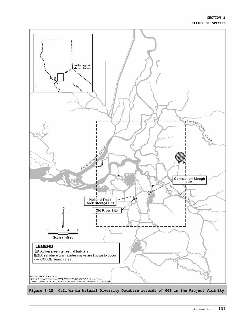
BIOLOGICAL ASSESSMENT DRAFT2-GATE FISH PROTECTION DEMONSTRATION PROJECT APRIL 2009
6.4 STORMWATER AND IRRIGATION DISCHARGESAdverse effects to designated critical habitat for delta smelt, Central Valley (CV) spring-run Chinook salmon and CV steelhead, and proposed critical habitat for the southern distinct population segments (DPSs) of North American Green Sturgeon may result from stormwater and/or irrigation discharges which change the balance of important habitat constituents (i.e. salinity, turbidity, water temperature, etc) within the action area.
6.5 POINT AND NON-POINT SOURCE POLLUTIONAdverse effects to designated critical habitat for delta smelt, CV spring-run Chinook salmon and CV steelhead, and proposed critical habitat for the southern DPSs of North American Green Sturgeon may result from stormwater and/or irrigation discharges which change the balance of important habitat constituents (i.e. salinity, turbidity, and water temperature, etc.) within the action area.
6.6 OIL AND GAS PRODUCT DISCHARGESThe introduction of contaminants from oil and gasoline product discharges as a result of on-going commercial and private shipping and boating within the action area is expected to continue. Implicated as potential stressors to aquatic species, these contaminants may adversely affect reproductive success and/or survival.
6.7 INVASIVE SPECIESInvasive species introductions are also expected to continue although it is difficult to predict the types of species introduced and the magnitude of the effects. Adverse effects from these introductions may include changes in water quality (i.e. turbidity), reductions in food supply, competition for space, and predation.
6.8 CLIMATE CHANGEGlobal warming and climate change is an issue that has become more prominent over the past decade and one that certainly warrants consideration in the long-run. It has been predicted that global warming will increase Central Valley ambient air temperatures by 2oC to 7oC by the end of this century. Such an increase is anticipated to have a profound effect on Central Valley run-off and local hydrology. Within the Delta, anticipated effects are expected to include changes in seasonal flow patterns and increased water levels (as a result of general sea level rise). While difficult to predict, it is anticipated that such events will affect the distribution, and possible even the abundance, of many aquatic species currently occupying the Delta seasonally or year round.
2 document.doc
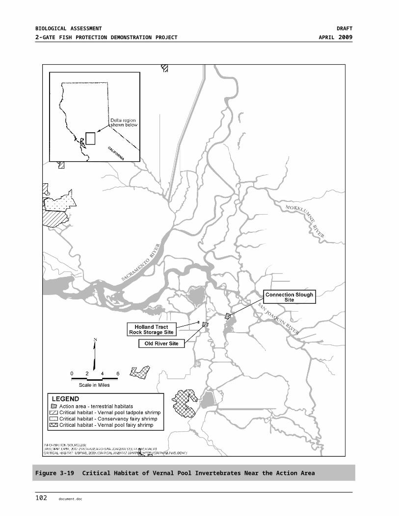
S E C T I O N 7
Summary and Conclusion
7.1 OVERVIEWThis section integrates current conditions described in the status of species and environmental baseline sections of this BA with anticipated effects of the 2-Gates Project and expected cumulative effects of future non-Federal actions. Its purpose is to develop a better understanding of the likely short-term and up to five year effects to listed species and designated critical habitat within the Action Area, which includes the region of influence (that area where gate operations can control hydrodynamic and water quality conditions in order to reduce delta smelt movement toward the south Delta) and other Delta channels where flows may be affected but not directly controlled. The geographic extent of the region of influence was determined by hydraulic modeling, as described in Section 2.3.
7.2 SUMMARY OF SPECIES STATUS AND ENVIRONMENTAL BASELINEAs described in the status of species and environmental baseline sections of this BA, past and present activities have caused significant habitat loss, fragmentation, and degradation within the Delta. In addition, past and present operations of the Central Valley Pumps (CVP) and State Water Pump (SWP) pumping facilities within the south Delta, along with other unscreened diversions, have resulted in significant entrainment and loss of Endangered Species Act (ESA) listed aquatic species.
The functionality of aquatic, riparian, and floodplain habitat within the Action Area have all been substantially degraded due to anthropogenic activities, such as alterations in Delta channel geometry, removal of riparian vegetation and shallow water habitat, construction of armored levees, changes in Delta hydrodynamics due to water export demands and water diversions, and the influx of contaminants from stormwater and agricultural discharges. Introduction and spread of non-native invasive species of plants and animals has significantly altered the habitat structure, community composition and food web dynamics in the Delta. Past and present effects described in the environmental baseline are expected to continue through the duration of the 5-year operation planned for the 2-Gates Project and into the future.
7.3 SUMMARY OF EFFECTS OF THE 2-GATES PROJECTThe proposed 2-Gates Project, along with the interrelated and interdependent activities associated with it are expected to affect aquatic and terrestrial species and the value of their habitat for the 5-years covering Project installation and operation. For aquatic species, these effects are anticipated to extend throughout the Action Area. For terrestrial species, these effects are expected to be more localized primarily occurring only within the actual physical foot print of the gates and associated structures (i.e. boat ramps, access roads, staging areas).
7.3.1 Aquatic Species Listed aquatic species that could be affected by the 2-Gates Project include delta smelt, winter-run Chinook, spring-run Chinook, Central Valley (CV) steelhead, Southern distict population segment (DPS) green sturgeon, and longfin smelt. The Project effects would result from in-channel installation (September-October
document.doc 1
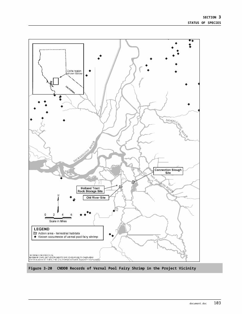
BIOLOGICAL ASSESSMENT DRAFT2-GATE FISH PROTECTION DEMONSTRATION PROJECT APRIL 2009
2009), operation of the gate structures (annually December through June, 2009-2014), and removal of the gates at the Project’s conclusion in July 2014.
In-water site preparation and gate installation (dredging, foundation prep, sheet pile installation, barge placement, etc.) is anticipated to occur during established in-water work windows to avoid adverse effects to listed species. Southern DPS green sturgeon and CV steelhead adults may be present in the Action Area and at the Project sites during installation. Construction effects include increased construction vessel activity with potential oil and gas contamination from spills; the installation of the sheet pile walls; dredging of peat sediments and installation of a rock base for the barge, and installation of the gate and placement of rock to lock in the barge. Construction activities would generate noise from construction vessels, sheet pile installation, dredging activity and rock placement that would disturb species in the immediate vicinity of the Project sites. Dredging would remove about 7,500 cubic yards of channel bed in Old River and 5,000 cubic yards of bed material in Connection Slough and replace that with a similar amount of rock. This activity would increase local turbidity during the dredging and would replace approximately 1.5 acres of soft bottom habitat with hard bottom substrate and the two barges. Green sturgeon are bottom-oriented fish and could be injured or killed by dredging, rock or barge placement, however, green sturgeon in the Delta are relatively large and would be able to quickly move away from any threat.
The gates will be operated to modulate flows in Old and Middle Rivers and thus manage distribution of higher turbidity conditions that cue adult pre-spawning migration from extending into the south Delta. Adult smelt begin moving inland from the western Delta when first flush flows increase turbidity (greater than or equal to 12 NTUs) and decrease salinity. During this period, typically December to February/March, gates will be operated to reduce movement of fresher, more turbid water in the central Delta from extending into the south Delta via Old and Middle Rivers. The Old River gate will be closed periodically depending on turbidity distributions. Typically, Old River gate closure of up to about an hour within a 25 hour tidal cycle will be sufficient to achieve desired conditions. The Connection Slough gate will generally be closed.
Delta smelt spawning typically commences once Delta-wide average water temperatures reach 12 ºC, approximately February or March. Once this occurs, gates will be operated to protect larval and juvenile delta smelt from entrainment into the south Delta, as informed by 20-mm surveys of larval distribution. The Old River gate will be operated tidally: open on ebb tides and closed on flood tides, both lasting approximately 5-7 hours each within a 25 hour tidal cycle. The Connection Slough gate will be closed during ebb and flood tides, may be opened on slack tides (approximately an hour), and will be opened to allow boat navigation on weekends and as needed. Gate operations will be coordinated with OCAP restrictions and QWEST. Gates will also be open continuously during the Vernalis Adaptive Management Program (VAMP) periods (mid-April to mid-May) and on weekends from Memorial Day through June. Gates will remain open from July into December.
The gate structures and their operations would affect habitat conditions by affecting hydrodynamics in the region of influence. The Project will balance net flows in Old and Middle Rivers between the San Joaquin River and Woodward Cut, but will increase reverse flows in Turner and Columbia cuts. These altered hydrodynamics may affect delta smelt, winter-run and spring-run Chinook, CV steelhead, green sturgeon and longfin smelt. All species of fish would be present in the Action Area during the operational period for adult delta smelt (December to February/March). All species except longfin smelt would be present during the operational period for larval delta smelt (March-June). Results of the modeling studies indicate that there would be a reduced risk of entrainment for delta smelt and other species within the Action Area during operations. This relative change would benefit delta smelt since upstream-moving pre-spawning adults would not move into the conveyance channels that lead to the pumping facilities. These changes would also benefit juvenile salmonids that are emigrating from the Sacramento River (winter-run and spring-run Chinook and CV steelhead) and would not increase the risk of entrainment to CV steelhead juveniles emigrating from the Mokelumne River. Project operations would not increase and may reduce entrainment risk for longfin smelt and juvenile green sturgeon.
2 document.doc
SECTION 7SUMMARY AND CONCLUSION
Gate operations will not change local water quality conditions in the vicinity of the gates beyond the range of natural variation experienced in the Delta. In Old River, changes in DO or turbidity are unlikely because of the short periods of gate closure. In Connection Slough, where the gate will be closed for long durations, there may be reduced DO levels in the slough west of the gate. However, these reductions are not likely to reach deleterious levels during the winter and early spring when Delta water temperatures are cool. Also, there will be some water exchange through the leaky gate structures.
Gate closure may affect migration corridors for salmon and steelhead juveniles emigrating from the San Joaquin River by impeding movement during flood tides or diverting individuals to other routes through the Delta. The consequence would be a delay in migration to the ocean, increased exposure to predators in the Delta, or unsuccessful migration. However, the negative effects on CV steelhead from the San Joaquin River would not be great because only some of the juveniles utilize the Old River route, gate closure occurs briefly during flood tides, downstream movement by juveniles tends to occur during ebb tides, and the gates will remain open during peak outmigration through the Delta (VAMP period). Gate closure may benefit juvenile Chinook and CV steelhead emigrating from the Sacramento River by reducing opportunities for diversion down Old River toward the south Delta and the export facilities.
The gate structures would attract predatory fish, such as striped bass, which exploit situations where food is abundant or where features exist that enhance feeding opportunities, such as turbulent flows. Species and life stages at potential risk include delta smelt (adult and juvenile), salmonids (juvenile), and longfin smelt (adult). This effect would be localized, however, and would not result in jeopardy for these species as a whole.
7.3.2 Effects on Designated Critical Habitat for Aquatic Species Critical Habitat in the Action Area has been designated for delta smelt and Central Valley steelhead, and proposed for Southern DPS Green sturgeon. The Action Area supports a variety of Primary Constituent Elements (PCEs) of Critical Habitat for each species. For delta smelt, these include physical habitat (suitable spawning substrate and depth), water (suitable water quality, low entrainment risk), flow (cues for spawning migrations and larval transport flows), and salinity (low salinity rearing habitat). For CV steelhead in the Delta, these include migration corridors for adults and juveniles that are free of barriers (unobstructed passage) and entrainment risk. For green sturgeon in the Delta, these include migration corridors for adults and juveniles, sediments free of contaminants, and rearing habitat for juveniles. Current conditions of aquatic habitat in the Delta overall are considered degraded.
The Project would adversely modify a small area proportion of critical habitat at the sites of the gates structures, and would have minor effect on critical habitat within the Action Area as a whole. Overall, the Project would improve critical habitat for delta smelt within the larger Delta region through control of important habitat constituents, turbidity and salinity. The Project is designed to improve conditions for delta smelt by reducing entrainment risk. Installation of the gates will disturb approximately 1.5 acres of soft-bottom channel habitat and replace it with rock substrate and two barges. This would affect a relatively small area compared to the habitat that is available in Old River and Connection Slough, so overall effects on critical habitat would be discountable. Delta smelt are pelagic fish and Central Valley steelhead are surface-oriented, so alteration of the channel bottom would not be considered an adverse effect on critical habitat. Green sturgeon are bottom-oriented, but the relatively small amount of habitat that is altered would not be considered to be an adverse modification of proposed critical habitat for foraging. Overall, the Project would improve critical habitat for delta smelt by reducing entrainment risk and would not substantially degrade the functionality of critical habitat for CV steelhead and green sturgeon within the Action Area.
document.doc 3

BIOLOGICAL ASSESSMENT DRAFT2-GATE FISH PROTECTION DEMONSTRATION PROJECT APRIL 2009
7.3.3 Terrestrial Species Special-status terrestrial species that could be affected by the Project include Giant Garter Snake (GGS), western pond turtle, Swainson’s hawk, burrowing owl, California black rail, tricolored blackbird, and loggerhead shrike. The effects would be due to construction activities, principally site disturbance during construction (September-October 2009), and to a lesser degree, gate installation (November 2009) and removal in 2014. Construction activities could affect GGS by trampling or crushing individuals if they are present within the terrestrial Action Area. . Burrowing owls and western pond turtles could be killed or injured during construction. Gate removal in 2014 would occur after nesting for sensitive bird species.Gate operations would not adversely affect GGS, Swainson’s hawk, California black rail, tricolored blackbird, loggerhead shrike or western pond turtle.
7.3.4 Effects on Designated Critical Habitat of Terrestrial Species The Project will not affect critical habitat for any terrestrial species, because none has been designated within the Action Area for the Project.
7.4 SUMMARY OF CUMULATIVE EFFECTSThe anticipated effects described in the cumulative effects section of this BA are expected to occur with or without the Project. Adverse affects resulting from non-Federal actions to both aquatic and terrestrial species are anticipated and may further diminish the functional value of critical habitat within the Action Area. Planning efforts such as the BDCP and the Governor’s Delta Vision process are anticipated to have both adverse and beneficial effects to listed species as a result of planned actions in the long-term but not likely within the 5-year time frame of the 2-Gates Project. In addition, these efforts are expected to have a federal nexus and will be the subject of future State and Federal ESA consultations.
7.5 CONCLUSIONIn conclusion, the 2-Gates Project, when combined with past and present effects and those anticipated as a result of future non-Federal actions within the Action Area, would benefit delta smelt. The Project would not jeopardize and may benefit other listed aquatic species. The Project would have minimal or no effect on special status terrestrial species within the Action Area, and would not jeopardize the existence of these species.
The presence and operations of the gates is intended to complement actions by fishery managers to protect threatened delta smelt. The intent is to operate the gates in concert with the protective requirements already established in the OCAP BOs from USFWS (USFWS 2008) and NMFS (NMFS 2004 and 2008a). These measures would affect hydrodynamic and water quality (turbidity and salinity) conditions, which would result in decreased entrainment of delta smelt at the CVP and SWP Delta export pumping facilities in the south Delta. The proposed installation and operation of the 2-Gates Project is not expected to appreciably reduce the functionality of the PCEs of designated critical habitat for delta smelt within the Delta as a whole. While there may be some adverse effects in the immediate vicinity of the gate structures themselves, these effects would be transitory and localized and would be more than offset by the benefits of reduced entrainment at the CVP and SWP pumping facilities. The result is an expected increase in the overall survival and recovery of delta smelt. Irreversible effects to delta smelt will be avoided by the short-term nature of the Project (5-years) and the ability to quickly remove the structures if deemed necessary.
Migrating adult and emigrating juvenile (smolt) life stages of Winter-run and spring-run Chinook salmon and CV steelhead could be affected by the Project during both installation and operation of the gate structures and associated components. Reduced reverse flows in both Connection Slough and Old River between the gate
4 document.doc

SECTION 7SUMMARY AND CONCLUSION
locations and areas to the north and west are generally expected to improve flow conditions for outmigrating juvenile salmonids and consequently reduce entrainment at the export facilities. Furthermore, since the 2-Gates Project will be operated in accordance with current OCAP Operating requirements (USFWS 2008, NMFS 2004), it is anticipated that no additional “take” of listed salmonids will occur at the CVP and SWP pumping facilities as a result of the Project. Therefore, the 2-Gates Project will not adversely affect listed salmonids.
Migration delays (adults and juveniles) would be negligible since gate operations would result in Old River gate closures on flood tides. Juveniles may experience increased predation at the gate structures, but these effects would be localized and would not jeopardize the species’ survival.
Green sturgeon are expected to be exposed to the effects of the 2-Gates Project during both construction and operations periods. However, because there are no reliable estimates of the number of individual green sturgeon occupying the Delta, and the Action Area, population level effects are unknown. Any green sturgeon individuals present in the area may experience temporary and localized disturbance and possibly injury from construction and installation activities. As with salmonids, gate closures would temporarily impede movement of any green sturgeon in the vicinity during flood tides. The 2-Gates Project will also be operated in accordance with current OCAP Operating requirements (USFWS 2008, NMFS 2004), so no additional “take” of listed green sturgeon will occur at the CVP and SWP pumping facilities as a result of the Project.
document.doc 5

BIOLOGICAL ASSESSMENT DRAFT2-GATE FISH PROTECTION DEMONSTRATION PROJECT APRIL 2009
This Page Intentionally Left Blank
6 document.doc
S E C T I O N 8
Essential Fish Habitat
8.1 ESSENTIAL FISH HABITAT BACKGROUNDSection 305(b)(2) of the Magnuson-Stevens Fishery Conservation and Management Act, as amended (United States Code. 180 et seq.), requires Federal action agencies which fund, permit, or carry out activities that may adversely effect designated essential fish habitat (EFH) for Federally managed fish species to consult with the National Marine Fisheries Service (NMFS) regarding the potential adverse effects of their actions on EFH. In addition, this act also provides that the NMFS “shall coordinate with and provide information to other Federal agencies to further the conservation and enhancement of essential fish habitat” (16 United States Code. §1855(b)(1)(D). The EFH regulations also require that Federal action agencies obligated to consult on EFH also provide NMFS with a written assessment of the effects of their action on EFH (50 Code of Federal Regulations §600.920).
The objective of this EFH assessment is to describe potential adverse effects to designated EFH for Federally managed fish species anticipated to occur within the proposed 2-Gates Action Area. It also describes proposed conservation measures designed to avoid, minimize, or otherwise offset potential adverse effects to designated EFH resulting from the 2-Gates Fish Protection Demonstration Project.
8.2 DESCRIPTION OF THE PROPOSED ACTIONThis EFH assessment is based on the description of the 2-Gates Project and the Action Area described previously in Section 2.3 Project Description and Section 2.5 Project Area and Action Area of this BA. For complete description of the proposed Project and the Action Area used in this EFH assessment see Sections 2.3 and 2.5, respectively.
8.3 IDENTIFICATION OF ESSENTIAL FISH HABITATThis section describes EFH designated by the Pacific Fishery Management Council (PFMC) within the Action Area for species managed under three different fishery management plans (FMPs). These FMPs are discussed in the following order: (1) the Pacific Groundfish FMP; (2) the Coastal Pelagic Species FMP; and, (3) the Pacific Salmon FMP. With regards to the Pacific salmon FMP, because previous sections of this BA provide habitat protection requirements for Sacramento River winter-run Chinook salmon and Central Valley spring-run Chinook salmon, this section pertains only to Central Valley fall and late-fall run Chinook salmon. Central Valley steelhead and Central California Coast steelhead are not managed by the PFMC and no EFH has been designated for these species.
EFH is defined as those waters and substrates necessary to fish for spawning, breeding, feeding, or growth to maturity. For the purposes of interpreting EFH, “waters” includes aquatic areas and their associated physical, chemical, and biological properties that are used by fish, and may include areas historically used by fish where appropriate; “substrate” includes sediment, hard bottom, structures underlying the waters, and associated biological communities; “necessary” means habitat required to support a sustainable fishery and a healthy ecosystem; and, “spawning, breeding, feeding, or growth to maturity” covers all habitat types used by a species throughout its life cycle. The Action Area considered for the proposed Project is within the region identified as EFH for starry flounder (Platichthys stellatus), in Amendment 11 of the Pacific Coast
document.doc 1
BIOLOGICAL ASSESSMENT DRAFT2-GATE FISH PROTECTION DEMONSTRATION PROJECT APRIL 2009
Groundfish FMP, for Northern Anchovy (Engraulis mordax) in the Coastal Pelagic Species FMP, and for Pacific salmon in Amendment 14 of the Pacific Salmon FMP.
8.3.1 Pacific Coast Groundfish Fishery Management Plan The Pacific Coast Groundfish FMP (PFMC 1998) has designated EFH for 83 species of groundfish, which taken together include all coastal waters, including to the upstream extent of saltwater intrusion in coastal rivers, along the Pacific coast. Starry flounder (Platichthys stellatus) is the most prevalent species managed under this FMP that is present within the described Action Area (see Section 2.3). Designated EFH for the Pacific groundfish FMP includes Suisun Bay, San Pablo Bay, and San Francisco Bay.
8.3.2 Coastal Pelagic Species Fishery Management Plan Northern Anchovy (Engraulis mordax) is the only species managed under this FMP that may occur within the Action Area. Designated EFH for the Coastal Pelagic Species FMP includes Suisun Bay, San Pablo Bay, and San Francisco Bay.
8.3.3 Pacific Salmon Fishery Management Plan The PFMC has identified and described EFH, Adverse Impacts, and Recommended Conservation Measures for salmon in Amendment 14 to the Pacific Coast Salmon FMP (PFMC 1999). Freshwater EFH for Pacific salmon in the California Central Valley includes waters currently or historically accessible to salmon within the Central Valley ecosystem as described in Myers et al. (1998), and includes the Sacramento River Basin hydrologic unit and the San Joaquin Delta (Delta) hydrologic unit (i.e., number 18040003). Sacramento River winter-run Chinook salmon (Oncorhynchus tshawytscha), Central Valley spring-run Chinook salmon (O. tshawytscha), and Central Valley fall-/late fall-run Chinook salmon (O. tshawytscha) are species managed under the Salmon Plan that occur in the proposed Action Area.
Factors limiting salmon populations in the Action Area include reduced instream flows due to water diversion and exports, loss of fish into unscreened diversions, predation by introduced species, and reduction in the quality and quantity of rearing habitat due to channelization, pollution, riprapping, etc. (Dettman et al. 1987; California Advisory Committee on Salmon and Steelhead Trout 1988, Kondolf et al. 1996a, 1996b). Factors affecting salmon populations in Suisun Bay include heavy industrialization within its watershed and discharge of wastewater effluents into the bay. Loss of vital wetland habitat along the fringes of the bay reduce rearing habitat and diminish the functional processes that wetlands provide for the bay ecosystem.
8.4 LIFE HISTORY, DISTRIBUTION, AND HABITAT REQUIREMENTS
8.4.1 Starry Flounder The starry flounder is a flatfish found throughout the eastern Pacific Ocean, from the Santa Ynez River in California to the Bering and Chukchi Seas in Alaska, and eastwards to Bathurst inlet in Arctic Canada. Adults are found in marine waters to a depth of 375 meters. Spawning takes place during the fall and winter months in marine to polyhaline waters. The adults spawn in shallow coastal waters near river mouths and sloughs, and the juveniles are found almost exclusively in estuaries. The juveniles often migrate up freshwater rivers, but are estuarine dependent. Eggs are broadcast spawned and the buoyant eggs drift with wind and tidal currents. Juveniles gradually settle to the bottom after undergoing metamorphosis from a pelagic larva to a demersal juvenile by the end of April. Juveniles feed mainly on small crustaceans, barnacle larvae, cladocerans, clams, and dipteran larvae. Juveniles are extremely dependent on the condition of the estuary for their health. Polluted estuaries and wetlands decrease the survival rate for juvenile starry flounder. Juvenile
2 document.doc

SECTION 8ESSENTIAL FISH HABITAT
starry flounder also have a tendency to accumulate many of the anthropogenic contaminants found in the environment.
8.4.2 Northern Anchovy Northern anchovy are pelagic schooling fish found in coastal waters of the eastern Pacific Ocean. A small, short lived species, northern anchovy seldom live beyond four years. Spawning occurs during every month of the year, peaking from January through April (Richardson 1981). Eggs are pelagic, found near the water surface, and require two to four days to hatch, depending on water temperatures. Juveniles range in size from 25 mm to 140 mm in length and mature at two to three years of age. Northern anchovy feed diurnally, selectively feeding on larger zooplankton, fish eggs, and fish larvae. One of the most abundant and productive fishes in the San Francisco Bay area, northern anchovy occur throughout the San Francisco Bay-San Pablo Bay-Suisun Bay complex. Although most common downstream of Carquinez Strait, separating San Pablo Bay from Suisun Bay, they are often found in surveys of the lower brackish water portions of the Sacramento and San Joaquin Rivers (PFMC 1998).
8.4.3 Pacific Salmon General life history information for Central Valley Chinook salmon is summarized below. Information on Sacramento River winter-run and Central Valley spring-run Chinook salmon life histories is summarized in Section 3.1 of this BA. Further detailed information on Chinook salmon ESUs is available in the NMFS status review of Chinook salmon from Washington, Idaho, Oregon, and California (Myers et al. 1998), and the NMFS proposed rule for listing several Chinook salmon ESUs (63 Federal Rule 11482).
Adult Central Valley fall-run Chinook salmon enter the Sacramento and San Joaquin Rivers from July through December and spawn from October through December. Adult Central Valley late fall-run Chinook salmon enter the Sacramento and San Joaquin Rivers from October to April and spawn from January to April (USFWS 1998). Chinook salmon spawning generally occurs in clean loose gravel in swift, relatively shallow riffles or along the edges of fast runs (NMFS 1997).
Egg incubation occurs from October through March (Reynolds et al. 1993). Shortly after emergence from their gravel nests, most Chinook salmon fry disperse downstream towards the Delta and into the San Francisco Bay and its estuarine waters (Kjelson et al. 1982). The remaining fry hide in the gravel or station in calm, shallow waters with bank cover such as tree roots, logs, and submerged or overhead vegetation. These juveniles feed and grow from January through mid-May, and emigrate to the Delta and estuary from mid-March through mid-June (Lister and Genoe 1970). As they grow, the juveniles associate with coarser substrates along the stream margin or farther from shore (Healey 1991). Along the emigration route, submerged and overhead cover in the form of rocks, aquatic and riparian vegetation, logs, and undercut banks provide habitat for food organisms, shade, and protect juveniles and smolts from predation. Chinook salmon smolts generally spend a short time in the Delta and estuary before entry into the ocean. Whether entering the Delta or estuary as fry or juveniles, Central Valley Chinook salmon depend on passage through the Delta for access to the ocean.
8.5 EFFECTS OF THE PROPOSED ACTION
8.5.1 Starry Flounder Starry flounder salvage does occur at the State and Federal export pumps on Old River south (upstream) of the Project sites. Therefore, starry flounder may be adversely affected by the proposed Project. Most salvage
document.doc 3
BIOLOGICAL ASSESSMENT DRAFT2-GATE FISH PROTECTION DEMONSTRATION PROJECT APRIL 2009
occurs in the months of May through July and is made up of young-of-the-year fish with the largest between 3 and 4 inches long (Lloyd Hess, pers. comm. as reported in Bureau of Reclamation 2008).
The general effects on the quality of EFH for starry flounder are expected to be similar to those described previously for green sturgeon due to their benthic life history. Benthic dwelling fish will have direct contact with sediment and may ingest contaminated sediment exposed during the construction phase of the proposed Project along with benthic invertebrates during their foraging activities. It is anticipated that starry flounder will spend more time as juveniles rearing in the Action Area than Chinook salmon smolts expected to pass through the area. Therefore, this fish species will have a greater duration of potential exposure to contaminants of concern during construction activities than juvenile Chinook salmon, leading to potentially greater levels of adverse effects to the individual organisms.
Essential Fish Habitat designated in the Groundfish FPM ends at the eastern boundary of Suisun Bay, 30 river miles (RM) downstream of the Project site. The proposed Project may adversely affect starry flounder habitat in the Delta by changing flow and water quality within the Action Area; however, it is unlikely that the Project will adversely affect designated EFH as far downstream as Suisun Bay.
Effects to starry flounder habitat are anticipated to be minor, as the majority of their habitat is some distance downstream of the Project site, in Suisun Bay, San Pablo Bay, San Francisco Bay, and the marine environment. In addition, no commercial fisheries for groundfish will be affected by localized effects of the Project.
8.5.2 Northern Anchovy Northern anchovy is primarily a marine and estuarine species and only occasionally occur within the Action Area. There are no records of northern anchovy salvage at the State and Federal export pumps on Old River south (downstream) of the Project sites. Therefore, no adverse effects to northern anchovy are expected within the Project area.
EFH designated in the Coastal Pelagic FMP ends at the eastern boundary of Suisun Bay, 30RM downstream of the Project site. Therefore, no adverse effects to Coastal Pelagic EFH are expected as a result of the Project.
8.5.3 Pacific Salmon The effects of the proposed action on Pacific salmon habitat are described at length in Section 5. Effects of the Action, and generally are expected to apply to Pacific salmon EFH as well.
8.6 CUMULATIVE EFFECTSPotential impacts of river modification due to the proposed 2-Gates Project include effects on flow, water quality, fish migration pattern, spawning habitat and species diversity within the Action Area. These interactions may have an influence on the abundance and distribution of prey or food items for benthic and pelagic fish species as well as predators of these species within the Action Area. Changes in flow patterns and water quality within the Action Area may affect habitat essential to benthic and pelagic fish species managed under FMPs; however, effects to designated EFH as a whole is expected to be less than significant. This is because either designated EFH does not occur within the Action Area of the Project (Ground Fish and Coastal Pelagic) or the effects are localized, affecting a relative small portion of designated EFH (Pacific salmon).
4 document.doc
SECTION 8ESSENTIAL FISH HABITAT
8.7 PROPOSED CONSERVATION MEASURESProposed conservation measures include recommendations that: (1) all intake or other Project structures such as the gates be designed to minimize entrainment or impingement of fish; (2) mitigation be provided for the net loss of habitat from placement of the gate structures and associated components (i.e. sheet pile, rip-rap, etc.); and, (3) the gates are to be operated in a way that allows migrating salmon to pass through the Project sites in both upstream and downstream directions.
8.8 CONCLUSIONBased on the best available information as described in this section it is believed that the Project may adversely affect designated EFH for Pacific salmon during initial construction and normal long-term operations and annual construction activities. Although there may be effects to Starry Flounder within the Action Area, this area is not designated EFH in the Groundfish FPM, therefore, no Groundfish EFH will be adversely effected by the Project. In addition, while Northern Anchovy may occasionally occur within the Action Area, this area is not designated EFH in the Coastal Pelagic FPM; therefore, no Coastal Pelagic EFH will be adversely affected by the Project.
document.doc 5

BIOLOGICAL ASSESSMENT DRAFT2-GATE FISH PROTECTION DEMONSTRATION PROJECT APRIL 2009
This Page Intentionally Left Blank
6 document.doc
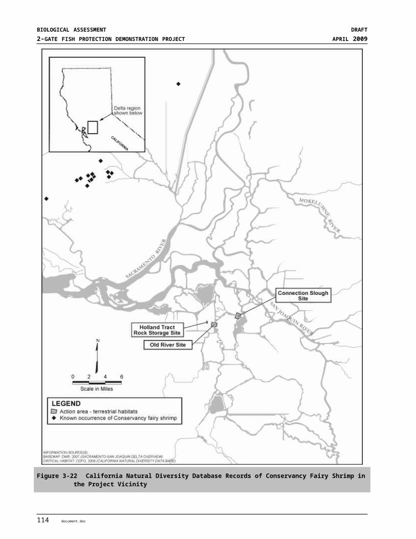
S E C T I O N 9
ReferencesAdams, P.B., C.B. Grimes, J.E. Hightower, S.T. Lindley, and M.L. Moser. 2002. Status review for North
American green sturgeon, Acipenser medirostris. National Marine Fisheries Service. 58 pages.
Adams, P.B., C. Grimes, J.E. Hightower, S.T. Lindley, M.L. Moser, M.J. Parsley. 2007. Population status of North American green sturgeon, Acipenser medirostris. Environmental Biology of Fishes. 79(3-4):339-356.
Ahl, JSB. 1991. Factors affecting contributions of the tadpole shrimp (Lepidurus packardi) to its oversummering egg reserves. Hydrobiologia 212:137-143
Alaska Department of Fish and Game. 2006. Species account for Longfin smelt. State Conservation Status, Element Ecology & Life History. May 5, 2006 edition. http://aknhp.uaa.alaska.edu/zoology/species_ADFG/ADFG_PDFs/Fishes/Longfin_smelt_final_ADFG_2006.pdf
Alpers C, Eagles-Smith C, Foe C, Klasing S, Marvin-DiPasquale M, Slotton D, and Winham-Myers L. 2008. Mercury conceptual model. Sacramento (CA): Delta Regional Ecosystem Restoration Implementation Plan. January 24, 2008.
Anderson, R.L., J.L. Dinsdale and R. Schlorff. 2007. California Swainson’s Hawk Inventory: 2005-2006. U.C. Davis Wildlife Health Center, Department of Fish and Game Resource Assessment Program. Final Report P0485902. May 31, 2007.
Arthur, J. F., M. D. Ball, and S. Y. Baughman. 1996. Summary of federal and State water project impacts in the San Francisco Bay-Delta estuary, California. Pages 445-495 in J. T. Hollibaugh (editor) San Francisco Bay: the ecosystem. AAAS, San Francisco, CA.
Bailey, E.D. 1954. Time pattern of 1953-54 migration of salmon and steelhead into the upper Sacramento River. California Department of Fish and Game, Unpublished report. 4 pages.
Barclay, J.H. 2007. Burrowing owl management at Mineta San Jose International Airport. Pages 146-154 in Proceedings of the California Burrowing Owl Symposium, November 2003. J.H. Barclay, K.W. Hunting, J.L. Lincer, J. Linthicum, and T.A. Roberts (Editors). Bird Populations Monographs No. 1. The Institute for Bird Populations and Albion Environmental, Inc. Point Reyes Station, CA.
Barclay, W.R. and A.W. Knight. 1984. Physico-chemical processes affecting production in a turbid vernal pool. Pages 126-142. IN S. Jain and P. Moyle, eds. Vernal pools and intermittent streams. Inst. Ecol. Pub. 28. Univ. Calif. Davis, California.
Baskerville-Bridges, B., J.C. Lindberg and S.I. Doroshov. 2004. The effect of light intensity, alga concentration, and prey density on the feeding behavior of delta smelt larvae. Pages 219-228 in F. Feyrer, L.R. Brown, R.L. Brown and J.J. Orsi, eds. Early life history of fishes in the San Francisco Estuary and watershed. Am. Fish. Soc. Symp. 39, Bethesda, MD, USA
document.doc 1

BIOLOGICAL ASSESSMENT DRAFT2-GATE FISH PROTECTION DEMONSTRATION PROJECT APRIL 2009
Baxter, R., R. Breuer, L. Brown, M. Chotkowski, F. Feyrer, M. Gingras, B. Herbold, A. Mueller-Solger, M. Nobriga, T. Sommer and K. Souza. 2008. Pelagic Organism Decline Progress Report: 2007 Synthesis of Results. January 15, 2008. 52 pp. http://www.science.calwater.ca.gov/pdf/workshops/POD/2007_IEP-POD_synthesis_report_031408.pdf
Baxter, R.D. 1999. Osmeridae. Pages 179-216 in J. Orsi, editor. Report on the 1980-1995 fish, shrimp and crab sampling in the San Francisco Estuary, Interagency Ecological Program for the Sacramento-San Joaquin Estuary.Technical Report.
Beamesderfer, R., M. Simpson, G. Kopp, J. Inman, A. Fuller, and D. Demko. 2004. Historical and current information on green sturgeon occurrence in the Sacramento and San Joaquin Rivers and tributaries. Prepared for the State Water Contractors by S.P. Cramer and Associates, Inc. Greasham, Oregon. 46 pages.
Beamesderfer, R.C.P. and M.A. H. Webb. 2002. Green Sturgeon Status Review Information. Prepared for State Water Contractors by S. P. Cramer & Associates, Inc. April 26, 2002. 46 pp.
Beamesderfer, R.M., M.L. Simpson, and G.J. Kopp. 2007. Use of life history information in a population model for Sacramento green sturgeon (Acipenser medirostris). Environmental Biology of Fishes. 79 (3-4): 315-337.
Belk, D. 1998. Global status and trends in ephemeral pool invertebrate conservation: implications for California fairy shrimp. Pages 147-150 in CW Witham, ET Bauder, D Belk, WR Ferren, Jr, and R Ornduff (eds). Ecology, Conservation and Management of Vernal Pool Ecosystems – Proceedings from a 1996 conference. California Native Plant Society, Sacramento, CA. 285 pp.
Bennett, W. A. 2005. Critical assessment of the delta smelt population in the San Francisco Estuary, California. San Francisco Estuary and Watershed Science. 3(2): Article 1. http://repositories.cdlib.org/jmie/sfews
Bent, A.C. 1938. Life Histories of North American Birds of Prey: Hawks, Falcons, Caracaras, Owls. Dover Publications, Inc., New York. 482 pp.
Boreman, J. 1997. Sensitivity of North American sturgeons and paddlefish to fishing mortality. Environmental Biology of Fishes. 48:399-405.
Botsford, L.W. and J.G. Brittnacher. 1998. Viability of Sacramento River winter-run Chinook salmon. Conservation Biology 12:65-79.
Brandes, P.L., and J.S. McLain. 2001. Juvenile Chinook salmon abundance, distribution, and survival in the Sacramento-San Joaquin Estuary. In: R.L. Brown, editor. Contributions to the biology of Central Valley salmonids. Volume 2. California Department of Fish and Game Fish Bulletin 179:39-136. http://repositories.cdlib.org/sio/lib/fb/179.
Brode, J. 1988. Natural history of the giant garter snake (Thamnophis couchii gigas). Pages 25-28 In: H. F. De Lisle, P. R. Brown, B. Kaufman, and B. McGurty (editors). Proceedings of the Conference On California Herpetology. Southwestern Herpetologists Society, Special Publication (4):1-143.
Brown, K. 2007. Evidence of spawning by green sturgeon, Acipenser medirostris, in the upper Sacramento River, California. Environmental Biology of Fishes. 79:297-303.
2 document.doc
SECTION 9REFERENCES
Brown, L.R. and D. Michniuk. 2007. Littoral fish assemblages of the alien-dominated Sacramento-San Joaquin Delta, California, 1980–1983 and 2001–2003. Estuaries and Coasts. Vol. 30(1): 186-200.
Brown, R. L. and W, Kimmerer 2002. Delta smelt and CALFED’s Environmental Water Account: a summary of the 2002 Delta Smelt Workshop. Prepared for the CalFed Science Program, October 2002.
Bury, RB, and DJ Germano. 2008. Actinemys marmorata (Baird and Girard 1852) - Western Pond Turtle, Pacific Pond Turtle. In AGJ Rhodin, PCH Pritchard, PP van Dijk, RA Samure, KA Buhlmann, and JB Iverson (eds.). Conservation Biology of Freshwater Turtles and Tortoises: A Compilation Project of the IUCN/SSC Tortoise and Freshwater Turtle Specialist Group. Pp. 1.1-1.9.
Busby, P.J., T.C. Wainwright, G.J. Bryant, L.J. Lierheimer, R.S. Waples, F.W. Waknitz, and I.V. Lagomarsino. 1996. Status Review of West Coast Steelhead from Washington, Idaho, Oregon, and California. NOAA Technical Memorandum NMFS-NWFSC-27. National Marine Fisheries Service. Northwest Fisheries Science Center Seattle, WA and Southwest Region Protected Species Management Division, Long Beach, CA. 261 pp.
California Bay-Delta Authority (CALFED). 2000. Ecosystem Restoration Plan, Volume II. Technical Appendix to draft EIS/EIR. July 2000.
CALFED Bay Delta Public Advisory Committee (BDPAC). 2007. CALFED Bay-Delta Program Program Performance Assessment. Executive Summary Final Draft as of August 20, 2007.
California Burrowing Owl Consortium. 1997. Burrowing owl survey protocol and mitigation guidelines. Appendix B, pp. 171-177 in Raptor Research Report No. 9. The Burrowing Owl, Its Biology, and Management, Including the Proceedings of the First International Burrowing Owl Symposium. J.L. Lincer and K. Steenhof, Eds.
California Department of Fish and Game (DFG). 1998. A status review of the spring run Chinook salmon (Oncorhyncus tshawytscha) in the Sacramento River drainage. Report to the Fish and Game Commission. Candidate species status report 98-1. June 1998. Sacramento, California.
California Department of Fish and Game (DFG). 2002. California Department of Fish and Game Comments to NMFS Regarding Green Sturgeon Listing. 129 p.
California Department of Fish and Game (DFG). 2008a. California Natural Diversity Database (CNDDB). Database query for the Jersey Island, Brentwood, Bouldin Island, Woodward Island, Terminous and Holt 7 ½ - minute quadrangles. September 2008.
California Department of Fish and Game (DFG). 2008b. Summaries of Central Valley Chinook salmon escapements. Draft 3-19-08 GRANDTAB data. Available at: http://www.calfish.org/IndependentDatasets/CDFGRedBluff/tabid/126/Default.aspx
California Department of Fish and Game (DFG). 2009. A Status Review of the Longfin Smelt (Spirinchus thaleichthys) in California. Report prepared by the Resources Agency, Department Of Fish And Game to the Fish and Game Commission. January 23, 2009.
California Department of Water Resources (DWR) and DFG 1986. Agreement between the Department of Water Resources and the Department of Fish and Game to offset direct fish losses in relation to the Harvey O. Banks Delta Pumping Plant. December 30, 1986. 12 pp. and appendices.
California Natural Diversity Database 2008. http://www.dfg.ca.gov/biogeodata/cnddb/
document.doc 3
BIOLOGICAL ASSESSMENT DRAFT2-GATE FISH PROTECTION DEMONSTRATION PROJECT APRIL 2009
California Regional Water Quality Control Board-Central Valley Region [Regional Board]. 1998. Water Quality Control Plan (Basin Plan) for the Sacramento River and San Joaquin River Basins, fourth edition. Available at: http://www.swrcb.ca.gov/rwqcb5/water_issues/basin_plans/
California Regional Water Quality Control Board-Central Valley Region [Regional Board]. 2001. Draft staff report on recommended changes to California’s Clean Water Act, section 303(d) list. Available at: http://www.swrcb.ca.gov/tmdl/docs/segments/region5/r5303d_staffreport.pdf
Carlson, T. M. Hastings and A.N. Popper. 2007. Update on Recommendations for Revised Interim Sound Exposure Criteria for Fish during Pile Driving Activities. Memorandum to California Department of Transportation and Washington Department of Transportation. December 21, 2007. 8 pp. http://www.dot.ca.gov/hq/env/bio/files/ct-arlington_memo_12-21-07.pdf
Center for Biological Diversity (CBD), Bay Institute and Natural Resources Defense Council. 2006. Emergency petition to list the delta smelt (Hypomesus transpacificus) as an endangered species under the Endangered Species Act. Submitted to the U.S. Fish and Wildlife Service. March 8, 2006.
Clark, G.H. 1929. Sacramento-San Joaquin salmon (Oncorhynchus tshawytscha) fishery of California. Fish Bulletin 17:1-73.
Cohen, A.N., and P.B. Moyle. 2004. Summary of data and analyses indicating that exotic species have impaired the beneficial uses of certain California waters: a report submitted to the State Water resources Control Board. June 14, 2004. 25pp.
COSEWIC 2004. COSEWIC Assessment and update status report on the green sturgeon Acipenser medirostris in Canada. Committee on the Status of Endangered Wildlife in Canada. Ottawa. vii + 31 pp. (www.sararegistry.gc.ca/status/status_e.cfm)
Cramer, S.P. 2000. Fisheries Newsletter, July 2000.
Decato, R.J. 1978. Evaluation of the Glenn-Colusa Irrigation District fish screen. California Department of Fish and Game, Anadromous Fisheries Branch Administrative Report No. 78-20.
Dege, M. and L. R. Brown. 2004. Effect of outflow on spring and summertime distribution and abundance of larval and juvenile fishes in the upper San Francisco Estuary. Pages 49-66 in Feyrer, F., L. R. Brown, R. L. Brown, and J. J. Orsi (eds.). Early life history of fishes in the San Francisco Estuary and watershed. American Fisheries Society Symposium 39.
Dettman, D.H., D.W. Kelley, and W.T. Mitchell. 1987. The influence of flow on Central Valley salmon. Prepared for the California Department of Water Resources. Prepared by D.W. Kelley and Associates, Newcastle, CA. Revised July 1987.
Driver, EA. 1981. Caloric values of pond invertebrates eaten by ducks. Freshwater Biology 11:579-581.
Edwards, G.W., K.A.F. Urquhart, and T.L. Tillman. 1996. Adult salmon migration monitoring, Suisun Marsh Salinity Control Gates, September-November 1994. Technical Report 50. Interagency Ecological Program for the San Francisco Bay/Delta Estuary, 27 pages.
Eng, L, D Belk, and CH Eriksen. 1990. Californian Anostraca: distribution, habitat, and status. Journal of Crustacean Biology 10:247-277.
4 document.doc
SECTION 9REFERENCES
ENTRIX. 2008a. Mitigated Negative Declaration (MND)/Environmental Assessment (EA) for the 2-Gate Fish Protection Demonstration Project.
ENTRIX 2008b. Delta Mendota Canal Recirculation Feasibility Study, Fisheries and Aquatic Ecosystems Technical Memorandum. Prepared by ENTRIX, Sacramento, CA for the Fisheries Technical Working Group (California Department of Fish and Game, National Marine Fisheries Service, U.S. Fish and Wildlife Service, California Department of Water Resources, Anadromous Fish Restoration Program, and U.S. Bureau of Reclamation). January 2008. 62 pp.
Erickson, D. L. and M. A. H. Webb. 2007. Spawning periodicity, spawning migration, and size at maturity of green sturgeon, Acipenser medirostris, in the Rogue River, Oregon. Environmental Biology of Fishes 79:255-268.
Erickson, D.L., J.A. North, J.E. Hightower, J. Weber, L. Lauck. 2002. Movement and habitat use of green sturgeon (Acipenser medirostris) in the Rogue River, Oregon, USA. Journal of Applied Ichthyology 18:565-569.
Estep, J.A. 1989. Biology, movements and habitat relationships of the Swainson’s Hawk in the Central Valley of California, 1986–87. California Department of Fish and Game, Nongame Bird and Mammal Sec. Rep., Sacramento, CA U.S.A.
Estep Environmental Consulting. 2009. The Influence of Vegetation Structure on Swainson’s Hawk Foraging Habitat Suitability in Yolo County. Prepared for Technology Associates International Corporation and Yolo Natural Heritage Program. February 2009. 43 pp.
Evens, J. 1999/2000. Mystery of the marsh: the California black rail. Tideline Vol 19 No. 4 1-3.
Farr, R. A., M. L. Hughes, and T. A. Rien. 2002. Green sturgeon population characteristics in Oregon. Annual Progress Report. Sport Fish Restoration Project F-178-R. 27 p.
Feyrer, F., M. Nobriga, and T. Sommer. 2007. Multi-decadal trends for three declining fish species: habitat patterns and mechanisms in the San Francisco Estuary, California, U.S.A. Canadian Journal of Fisheries and Aquatic Sciences 64:723-734
Fisheries Hydroacoustic Working Group. 2008. Agreement in Principal for Interim Criteria for Injury to Fish from Pile Driving Activities. Memorandum dated June 12, 2008. http://www.dot.ca.gov/hq/env/bio/files/fhwgcriteria_agree.pdf.
Gaines, P.D. and W. R. Poytress. 2004. Brood-year 2003 winter Chinook juvenile production indices with comparisons to adult escapement. Report of U.S. Fish and Wildlife Service to California Bay-Delta Authority, San Francisco, CA.
Gallagher, SP. 1996. Seasonal occurrence and habitat characteristics of some vernal pool Branchiopoda in northern California, USA. Journal of Crustacean Biology 16:323-329.
Good, T.P., R.S. Waples, and P. Adams (editors). 2005. Updated status of Federally listed ESU of West Coast salmon and steelhead. U.S. Department of Commerce, NOAA Technical Memo. NMFS-NWFSC-66, 598 p.
document.doc 5
BIOLOGICAL ASSESSMENT DRAFT2-GATE FISH PROTECTION DEMONSTRATION PROJECT APRIL 2009
Granholm, S, 1988-1990. Loggerhead Shrike (Lanius ludovicianus). California Wildlife Habitat Relationships System, California Department of Fish and Game, California Interagency Wildlife Task Group. Originally published in: Zeiner, DC, WF Laudenslayer, Jr, KE Mayer, and M White, eds. 1988-1990. California’s Wildlife. Vol. I-III. California Department of Fish and Game, Sacramento, California.
Grinnell, J. and A.H. Miller. 1944. The Distribution of the Birds of California. Cooper Ornithological Club. Berkeley. 615 pp.
Hallock, R.J., W.F. Van Woert, and L. Shapovalov. 1961. An evaluation of stocking hatchery reared steelhead rainbow (Salmo gairdnerii gairdnerii) in the Sacramento River system. California Department of Fish and Game Bulletin No. 114. 74 pp
Hallock, R.L. and F.W. Fisher 1985. Status of winter-run Chinook salmon, Oncorhynchus tshawytscha, in the Sacramento River. Unpublished Report. California Department of Fish and Game, Anadromous Fisheries Branch Office Report, January 25, 1985. http://repositories.cdlib.org/sio/lib/fb/114
Hamilton, WJ. 2004. Tricolored Blackbird (Agelaius tricolor). In: The Riparian Bird Conservation Plan: a strategy for reversing the decline of riparian-associated birds in California. California Partners in Flight. http://www.prbo.org/calpif/pdfs/riparian_v-2.pdf
Hansen, G. E. and J. M. Brode. 1980. Status of the giant garter snake Thamnophis couchii gigas (Fitch): Special Publication Report Number 80-5. Inland Fisheries Endangered Species Program: California Department of Fish and Game: 14 pp.
Hastings, M.C. and A.N. Popper. 2005. Effects of sound on fish. Prepared for Jones & Stokes. January 28, 2005.
Haug, E.A., B.A. Millsap, and M.S. Martell. 1993. Burrowing Owl (Speotyto cunicularia). In Birds of North America, No 61 (A. Poole and F. Gill, Eds.). Philadelphia: The Academy of Natural Sciences; Washington, D.C.: The American Ornithologists’ Union.
Hays, DW, KR McAllister, SA Richardson, and DW Stinson. 1999. Washington State Recovery Plan for the Western Pond Turtle. Washington Department of Fish and Wildlife. August. 76 pages.
Healey, M.C. 1980. Utilization of the Nanaimo River Estuary by juvenile Chinook salmon, Oncorhynchus tshawytscha. U.S. Fisheries Bulletin 77:653-668.
Healey, M.C. 1991. Life history of Chinook salmon (Oncorhynchus tshawytscha). In C. Groot and L. Margolis, editors. Pacific Salmon Life Histories, pp 396-445. University of British Columbia Press, Vancouver. 564 pages.
Helm Biological Consulting, LLC. 2009. Results of the 2008/2009 Wet-Season Sampling for Federally-Listed Large Branchiopods at the Connection Slough Area of the 2-Gates Project (April).
Helm Biological Consulting, LLC. 2009. Dry-Season Sampling for Federally-Listed Large Branchiopods at the Connection Slough Area of the 2-Gates Project. (February).
Helm, B. 1998. Biogeography of eight large Branchiopods endemic to California. Pages 124-139 in: CW Witham, ET Bauder, D Belk, WR Ferren, Jr, and R Ornduff (eds). Ecology, Conservation and Management of Vernal Pool Ecosystems – proceedings from a 1996 conference. California Native Plant Society, Sacramento, CA. 285 pp.
6 document.doc
SECTION 9REFERENCES
Hobbs, J. A., W. A. Bennett, and J. E. Burton. 2006. Assessing nursery habitat quality for native smelts (Osmeridae) in the low-salinity zone of the San Francisco estuary. Journal of Fish Biology. 69:907-922.
ICF Jones & Stokes and Illingworth and Rodkin, Inc. 2009. Technical guidance for assessment and mitigation of the hydroacoustic effects of pile driving on fish. Prepared for California Department of Transportation. February 2009. http://www.dot.ca.gov/hq/env/bio/files/Guidance_Manual_2_09.pdf
Interagency Ecological Program (IEP). 2005. Interagency Ecological Program Synthesis of 2005 work to evaluate the Pelagic Organism Decline (POD) in the upper San Francisco Estuary. 55 pp.
Israel, J.A. J.F. Cordes, M.A. Blumberg, and B. May. 2004. Geographic Patterns of Genetic Differentiation among Collections of Green Sturgeon North American Journal of Fisheries Management 24:922–931.
Israel, J. and B. May. 2007. Mixed Stock Analysis of Green Sturgeon from Washington State Coastal Aggregations. Final Report. January 29, 2007. 22 pp. http://genome-lab.ucdavis.edu/People/Israel/GSWDFW_finalreport2007.pdf
Keeley, J.E. and P.H. Zedler. 1998. Characterization and global distribution of vernal pools. Pages 1-14 in: CW Witham, ET Bauder, D Belk, WR Ferren, Jr, and R Ornduff (eds). Ecology, Conservation and Management of Vernal Pool Ecosystems – proceedings from a 1996 conference. California Native Plant Society, Sacramento, CA. 285 pp.
Kelley, J.T., A.P. Klimley, and C.E. Crocker. 2007. Movements of green sturgeon, Acipenser medirostris, in the San Francisco Bay Estuary, CA. Environmental Biology of Fishes 79:281-295
Kimmerer, W.J. 2008. Losses of Sacramento River Chinook salmon and delta smelt to entrainment in water diversions in the Sacramento-San Joaquin Delta. San Francisco Estuary and Watershed Science [online serial] 6 (2): Article 2. http://repositories.cdlib.org/jmie/sfews
King, J.L., M.A. Simovich and R.D. Brusca. 1996. Species richness, endemism and ecology of crustacean assemblages in northern California vernal pools. Hydrobiologia 328: 85-116.
Kjelson, M.A., P.F. Raquel, and F.W. Fisher. 1982. Life history of fall-run juvenile Chinook salmon, Oncorhynchus tshawytscha, in the Sacramento-San Joaquin estuary, California. Pages 393-411 in V.S. Kennedy, editor. Estuarine comparisons. Academic Press, New York, New York.
Kynard, B., E. Parker, and T. Parker. 2005. Behavior of early life intervals of Klamath River green sturgeon, Acipenser medirostris, with note on body color. Environmental Biology of Fishes 72:85-97.
Levy, D.A., and T.G. Northcote. 1981. The distribution and abundance of juvenile salmon in marsh habitats of the Fraser River Estuary. Westwater Research Centre, University of British Columbia, Technical Report no. 25. Vancouver, B.C., Canada.
Lindley, S.T., and M.S. Mohr. 2003. Modeling the effect of striped bass (Morone saxatillis) on the population viability of Sacramento River winter-run Chinook salmon (Oncorhynchus tshawytscha). Fisheries Bulletin 101:321-331.
document.doc 7

BIOLOGICAL ASSESSMENT DRAFT2-GATE FISH PROTECTION DEMONSTRATION PROJECT APRIL 2009
Lindley, S. T., R. Schick, A. Agrawal, M. Goslin, T. Pearson, E. Mora, J.J. Anderson, B. May, S. Greene, C. Hanson, A. Low, D. McEwan, R.B. MacFarlane, C. Swanson, and J. G. Williams. 2006. Historical population structure of Central Valley steelhead and its alteration by dams. San Francisco Estuary and Watershed Science. 4 (1): Article 3. http://repositories.cdlib.org/jmie/sfews/vol4/iss1/art3
Lindley, S. T., R. Schick, E. Mora, P.B. Adams, J.J. Anderson, S. Greene, C. Hanson, B. P. May, D. McEwan, R.B. MacFarlane, C. Swanson, and J. G. Williams. 2007. Framework for assessing viability of threatened and endangered Chinook salmon and steelhead in the Sacramento-San Joaquin basins. ESUs in California’s Central Valley basin. San Francisco Estuary and Watershed Science. Volume 5, Issue 1, Article 4.
Longhurst, AR. 1955. Evolution in the Notostraca. Evolution 9:84-86.
Martin, C.D., P.D. Gaines, and R.R. Johnson. 2001. Estimating the abundance of Sacramento River juvenile winter Chinook salmon with comparisons to adult escapement. Red Bluff Research Pumping Plant Report Series, Volume 5. U.S. Fish and Wildlife Service. Red Bluff, CA.
McElhany, P., M.H. Ruckelshaus, M.J. Ford, T.C. Wainwright, and E.P. Bjorkstedt. 2000. Viable salmonid populations (VSPs) and the recovery of evolutionary significant units. U.S. Department of Commerce, NOAA Tech. Memo. NMFS-NWFSC-42, 156 pages.
McEwan, D., and T. A. Jackson. 1996. Steelhead restoration and management plan for California. California Dep. Fish Game, 234 p. (Available from California Department of Fish and Game, Inland Fisheries Division, 1416 Ninth Street, Sacramento, CA 95814.)
McEwan, D.R. 2001. Central Valley steelhead. In: Brown RL, editor. Fish Bulletin 179. Contributions to the biology of Central Valley salmonids. Vol. 1. California Department of Fish and Game. pp 1–43. http://repositories.cdlib.org/sio/lib/fb/179
McReynolds, T.R., Garman, C.E., Ward, P.D., and M.C. Schommer. 2005. Butte and Big Chico Creeks spring-run Chinook salmon, Oncorhynchus tshawytscha life history investigation, 2003-2004. California Department of Fish and Game, Inland Fisheries Administrative Report No. 2005-1.
Meehan, W.R. and T.C. Bjornn. 1991. Salmonid distributions and life histories. In W.R. Meehan, editor. Influences of Forest and Rangeland Management on Salmonid Fishes and Their Habitats. American Fisheries Society Special Publication 19. American Fisheries Society. Bethesda, Maryland. 751 pages.
Meyer, J.S., P.J. Mulholland, H.W. Paerl, and A.K. Ward. 2009. A framework for research addressing the role of ammonia/ammonium in the Sacramento-San Joaquin Delta and the San Francisco Bay Estuary Ecosystem. Final. April 13, 2009. Submitted to CALFED Science Program. 15 pp. http://www.science.calwater.ca.gov/pdf/workshops/workshop_ammonia_research_framework_final_041609.pdf
Moser, M. and S. Lindley. 2007. Use of Washington estuaries by subadult and adult green sturgeon. Environmental Biology of Fishes 79:243-253.
Mount, J.F. 1995. California Rivers and Streams: The conflict between fluvial process and land use. University California Press, Berkeley.
Moyle, P. 2002. Inland Fishes of California, 2nd Ed. University of California Press. Berkeley, CA.
8 document.doc

SECTION 9REFERENCES
Moyle, P.B., B. Herbold, D.E. Stevens and L.W. Miller. 1992a. Life history and status of delta smelt in the Sacramento-San Joaquin Estuary, California. Transactions of the American Fisheries Society 77:67-77.
Moyle, P.B., J.E. Williams, and E.D. Wikramanayke. 1989. Fish species of special concern of California. Wildlife and Fisheries Biology Department, University of California, Davis, CA. Prepared for the California resources Agency, Department of Fish and Game, Rancho Cordova, CA.
Moyle, P.B., P.J. Foley, and R.M. Yoshiyama. 1992b. Status of green sturgeon, Acipenser medirostris, in California. Final report submitted to National Marine Fisheries Service, Terminal Island, CA by UC Davis Department of Wildlife and Fisheries Biology. 12 pages.
Myers, J. M., R. G. Kope, G. J. Bryant, D. Teel, L. J. Lierheimer, T. C. Wainwright, W. S. Grant, F. W. Waknitz, K. Neely, S. T. Lindley, and R. S. Waples. 1998. Status review of chinook salmon from Washington, Idaho, Oregon, and California. U.S. Dep. Commer., NOAA Tech. Memo. NMFS-NWFSC-35, 443 p.
Nakamoto, R. J., T.T. Kisanuki, and G.H. Goldsmith. 1995. Age and growth of Klamath River green sturgeon (Acipenser medirostris). U.S. Fish and Wildlife Service. Project # 93-FP-13. 20 pages.
National Marine Fisheries Service (NMFS). 1996. Factors for Decline: A Supplement to the Notice of Determination for West Coast Steelhead Under the Endangered Species Act. Protected Species Branch, National Marine Fisheries Service. Portland, Oregon. August 1996. 80 pp. http://www.nwr.noaa.gov/ESA-Salmon-Listings/Salmon-Populations/Reports-and-Publications/upload/stlhd-ffd.pdf
National Marine Fisheries Service (NMFS). 1997. Proposed Recovery Plan for the Sacramento River winter-run Chinook salmon. National Marine Fisheries Service, Southwest Region, Long Beach, CA. 217 pp.
National Marine Fisheries Service. 1998. Factors Contributing to the Decline of Chinook Salmon: An Addendum to the 1996 West Coast Steelhead Factors For Decline Report. Protected Resources Division, National Marine Fisheries Service. Portland, Oregon. June 1998. 70 pp. http://www.nwr.noaa.gov/ESA-Salmon-Listings/Salmon-Populations/Reports-and-Publications/upload/chnk-ffd.pdf
National Marine Fisheries Service (NMFS). 2003. Updated status of Federally listed ESUs of West Coast salmon and steelhead. West Coast Salmon Biological Review Team. NOAA Fisheries Northwest and Southwest Fisheries Science Centers. July 31, 2003.
National Marine Fisheries Service (NMFS). 2004. Endangered Species Act – Section 7 consultation. Biological Opinion for the Central Valley Project and State Water Project Operations, April 1, 2004 through March 31, 2006 for Central Valley spring-run Chinook salmon and Central Valley steelhead. Southwest Region, Long Beach, CA. Issued February 27, 2004. 47 pp
National Marine Fisheries Service (NMFS). 2005. Green sturgeon (Acipenser medirostris) status review update. Biological review team, Santa Cruz Laboratory, Southwest Fisheries Science Center. February 2005. 31 pages.
National Marine Fisheries Service (NMFS). 2008a. Draft Biological Opinion on the long-term Central Valley Project and State Water Project Operations Criteria and Plan. National Marine Fisheries Service, Southwest Region, Long Beach, CA. December 11, 2008. 436 pp.
document.doc 9

BIOLOGICAL ASSESSMENT DRAFT2-GATE FISH PROTECTION DEMONSTRATION PROJECT APRIL 2009
National Marine Fisheries Service (NMFS). 2008b. Proposed designation of critical habitat for the Southern Distinct Population Segment of North American Green Sturgeon: Draft Biological Report. National Marine Fisheries Service, Southwest Region, Long Beach, CA. September 2008. 90 pp.
National Marine Fisheries Service (NMFS). 2008c. South Delta Temporary Barriers Program Biological Opinion. May 5, 2008.
National Marine Fisheries Service (NMFS). 2008d. Stockton Deep Water Ship Channel Maintenance Dredging and Levee Stabilization. Biological Opinion. April 4, 2008.
Newcombe, C.P., and J.O.T. Jensen. 1996. Channel Suspended Sediment and Fisheries: A Synthesis for Quantitative Assessment of Risk and Impact. North American Journal of Fisheries Management, 16: 693-727.
Nielsen, J.L., S. Pavey, T. Wiacek, G.K. Sage, and I. Williams. 2003. Genetic analyses of Central Valley trout populations 1999 - 2003. Final Report. USGS Alaska Science Center. Final Technical Report submitted to California Department of Fish and Game, Sacramento, CA. and U.S. Fish and Wildlife Service, Red Bluff, CA. December 8, 2003.
Nightingale, B. and C.A. Simenstad. 2001. Dredging Activities: Marine Issues. University of Washington. Research Project T1803, Task 35 Overwater White paper.
Nobriga, M. and P. Cadrett. 2001. Differences among hatchery and wild steelhead: evidence from Delta fish monitoring programs. Interagency Ecological Program for the San Francisco Estuary Newsletter. 14:3:30-38. http://www.iep.ca.gov/report/newsletter/
Nobriga, M. L., F. Feyrer, R. D. Baxter, and M. Chotkowski. 2005. Fish community ecology in an altered river Delta: spatial patterns in species composition, life history strategies and biomass. Estuaries. 776-785.
Nobriga, M.L., T. Sommer, F. Feyrer, and K. Fleming. 2008. Long-term trends in summertime habitat suitability for delta smelt, Hypomesus transpacificus. San Francisco Estuary and Watershed Science. Vol. 6, Issue 1 (February), Article 1 http://repositories.cdlib.org/cgi/viewcontent.cgi?article=1109&context=jmie/sfews
Orsi, J. 1967. Predation study report, 1966-1967. California Department of Fish and Game
Pennak, RW. 1989. Freshwater invertebrates of the United States. Protozoa to Mollusca. Wiley and Sons, Inc. New York, New York.
Pickard, A., A. Grover, and F. Hall. 1982. An evaluation of predator composition at three locations on the Sacramento River. Interagency Ecological Study Program for the Sacramento-San Joaquin Estuary. Technical Report No. 2. 20 pages.
Platenkamp, GA. 1998. Patterns of vernal pool biodiversity at Beale Air Force Base. Pages 151-160 in: CW Witham, ET Bauder, D Belk, WR Ferren, Jr, and R Ornduff (eds). Ecology, Conservation and Management of Vernal Pool Ecosystems – proceedings from a 1996 conference. California Native Plant Society, Sacramento, CA. 285 pp.
Popper, A.N., T. J. Carlson, A.D. Hawkins, B.L. Southall, and R.L. Gentry. 2006. Interim Criteria for Injury of Fish Exposed to Pile Driving Operations: A White Paper. Dept. of Biology, University of Matyland. College Park, MD. May 15, 2006. 15 pages http://www.dot.ca.gov/hq/env/bio/files/piledrivinginterimcriteria_13may06.pdf
10 document.doc

SECTION 9REFERENCES
Power Engineering and City of Stockton. 2008. Final Monitoring Report: Stockton Downtown Marina Redevelopment Project, Appendix F:Underwater Sound Measurement. Prepared for Power Engineering Contractors and CIty of Stockton Redevelopment Dept. by ENTRIX Environmental Consulting, Inc. Sacramento, CA and Illingworth & Rodkin, Inc. Petaluma, CA. December 2008. 86 pages
Proctor, VW. 1964. Viability of crustacean eggs recovered from ducks. Ecology 45:656-658.
Quinn. T.P. 2005. The Behavior and ecology of Pacific salmon and trout. University of Washington Press. Seattle, WA
Radtke, L. D. 1966. Distribution of smelt, juvenile sturgeon, and starry flounder in the Sacramento-San Joaquin Delta with observations on food of sturgeon. In Turner, J. L. and D. W. Kelly (ed.) Ecological studies of the Sacramento-San Joaquin Estuary. Part II; California Department of Fish and Game, Fish Bulletin 136: 115-119.
Rogers, D.C. 2001. Revision of the Nearctic Lepidurus (Notostraca). J. Crustacean Biology. 214): 991-1006.
Rosenfield, J. A. and Baxter, R. D. 2007 Population Dynamics and Distribution Patterns of Longfin Smelt in the San Francisco Estuary. Transactions of the American Fisheries Society. 136 (6): 1577-1592.
Schmetterling, D.A., C.G. Clancy, and T.M. Brandt. 2001. Effects of riprap bank reinforcement on stream salmonids in the Western United States. Fisheries 26:8-13.
Schwing, F.B., R. Parrish, and R. Mendelssohn. Decadal-scale environmental variability in the coastal Northeastern Pacific. pp. 105-111. In: Emmett, R.L. and M.H. Schiewe (Eds.) 1997. Estuarine and ocean survival of Northeastern Pacific salmon: Proceedings of the workshop. U.S. Dep. Commerce., NOAA Tech. Memo. NMFS-NWFSC-29, 313 pp
Slater, D.W. 1963. Winter-run Chinook salmon in the Sacramento River, California, with notes on water temperature requirements at spawning. U.S. Fish and Wildlife Service, Special Science Report Fisheries 461:9.
Snider, B., and R.G. Titus. 2000. Timing, composition, and abundance of juvenile anadromous salmonid emigration in the Sacramento River near Knights Landing, October 1996-September 1997. California Department of Fish and Game, Habitat Conservation Division, Stream Evaluation Program Technical Report No. 00-04.
Sommer, T. 2007. The decline of pelagic fishes in the San Francisco Estuary: An update. Presented to the California State Water Resources Control Board March 22, 2007.
Sommer, T., C. Armor, R. Baxter, R. Breuer, L. Brown, M. Chotkowski, S. Culberson, F. Feyrer, M. Gingras, B. Herbold, W. Kimmerer, A. Mueller-Solger, M. Nobriga, and K. Souza. 2007. The collapse of pelagic fishes in the upper San Francisco Estuary. Fisheries 32:270-277.
Sommer, T.R., M.L. Nobriga, W.C. Harrel, W. Batham, and W.J. Kimmerer. 2001. Floodplain rearing of juvenile Chinook salmon: evidence of enhanced growth and survival. Canadian Journal of Fisheries and Aquatic Sciences 58:325-333.
Spinks P.Q. and H.B. Shaffer. 2005. Range-wide molecular analysis of the western pond turtle (Emys marmorata): cryptic variation, isolation by distance, and their conservation implications. Molecular Ecologyl 14: 2047-2064.
document.doc 11
BIOLOGICAL ASSESSMENT DRAFT2-GATE FISH PROTECTION DEMONSTRATION PROJECT APRIL 2009
Stebbins, R. C. 2003. A Field Guide to Western Reptiles and Amphibians. Boston, Houghton Mifflin Book Co.
Stevens, D.E. 1961. Food habits of striped bass, Roccus saxatilis (Walbaum) in the Rio Vista area of Sacramento River. Master’s Thesis. University of California. Berkeley, California
Stevens, D.E. and L.W. Miller. 1983. Effects of river flow on abundance of young Chinook salmon, American shad, longfin smelt, and delta smelt in the Sacramento-San Joaquin river system. North American Journal of Fisheries Management 3:425- 437.
Stillwater Sciences. 2006. Biological Assessment for five critical erosion sites, river miles: 26.9 left, 34.5 right, 72.2 right, 99.3 right, and 123.5 left. Sacramento River Bank Protection Project. May 12, 2006.
Sugnet and Associates. 1993. Preliminary compilation of documented distribution, fairy shrimp and tadpole shrimp proposed for listing. Sugnets and Associates Environmental Consultants, Roseville, California. 22 pp. + 3 maps.
Swanson, GA, M.I. Meyer, and J.R. Serie. 1974. Feeding ecology of breeding blue-winged teals. Journal of Wildlife Management 38(3): 396-407.
Sweetnam, D.A. 1999. Status of delta smelt in the Sacramento-San Joaquin Estuary.California Fish and Game 85:22-27.
Swolgaard, C.A., K.A. Reeves, D.A. Bell. 2008. Foraging by Swainson’s hawks in a vineyard-diminated landscape. Journal of Raptor Research 42(3):188-196.
The Bay Institute, Center for Biological Diversity & Natural Resources Defense Council. 2007a. Petition to List the San Francisco Bay-Delta Population of Longfin Smelt (Spirinchus thaleichthys) as Endangered under the Endangered Species Act. August 2007.
The Bay Institute, Center for Biological Diversity, and Natural Resources Defense Council. 2007b. Petition to the State of California Fish and Game Commission and supporting information for the listing of the longfin smelt (Spirinchus thaleichthys) as an endangered species under the California endangered species act.
Thomsen, L. 1971. Behavior and ecology of burrowing owls on the Oakland Municipal Airport. Condor 73:177-192.
Tillman, T.L., G.W. Edwards, and K.A.F. Urquhart. 1996. Adult salmon migration during the various operational phases of Suisun Marsh Salinity Control Gates in Montezuma Slough: August-October 1993. Agreement to California Department of Water Resources, Ecological Services Office by California Department of Fish and Game, Bay-Delta and Special Water Projects Division, 25 pages.
U.S. Bureau of Reclamation (Reclamation). 2004. Long-term Central Valley Project and State Water Project Operating Criteria and Plan: Biological Assessment for ESA section 7(a)(2) consultation. Mid-Pacific Region. Sacramento, CA.
U.S. Bureau of Reclamation (Reclamation). 2008. Biological Assessment on the Continued Long-term Operations of the Central Valley Project and the State Water Project. U.S. Bureau of Reclamation, Mid-Pacific Region, Sacramento, CA. August 2008
12 document.doc

SECTION 9REFERENCES
U.S. Bureau of Reclamation (Reclamation).and DWR. 1994.
U.S. Fish and Wildlife Service (USFWS) 1995b. Sacramento-San Joaquin Delta Native Fishes Recovery Plan. U.S. Fish and Wildlife Service, Portland, Oregon.
U.S. Fish and Wildlife Service (USFWS). 1995a. Working paper on restoration needs: habitat restoration actions to double natural production of anadromous fish in the Central Valley of California. Volume 2. May 9, 1995. Prepared for the U.S. Fish and Wildlife Service under the direction of the Anadromous Fish Restoration Program Core Group. Stockton, California. 293 p.
U.S. Fish and Wildlife Service (USFWS). 2001. Abundance and Survival of Juvenile Chinook Salmon in the Sacramento-San Joaquin Estuary: 1997 and 1998. Annual progress report Sacramento-San Joaquin Estuary.
U.S. Fish and Wildlife Service (USFWS). 1994. Endangered and Threatened Wildlife and Plants; Critical Habitat Determination for the Delta Smelt. Federal Register Vol. 59 No. 242. December 19, 1994. 65256-65277.
U.S. Fish and Wildlife Service (USFWS). 1998. Central Valley Project Improvement Act tributary production enhancement report. Draft report to Congress on the feasibility, cost, and desirability of implementing measures pursuant to subsections 3406(e)(3) and (e)(6) of the Central Valley Project Improvement Act. U.S. Fish and Wildlife Service, Central Valley Fish and Wildlife Restoration Program Office, Sacramento, California.
U.S. Fish and Wildlife Service (USFWS). 1999. Draft recovery plan for the giant garter snake (Thamnophis gigas). U.S. Fish and Wildlife Service, Portland, Oregon. 192 p.
U.S. Fish and Wildlife Service (USFWS). 2000. Impacts of riprapping to ecosystem functioning, Lower Sacramento River, California. Technical report prepared for the U.S. Army Corps of Engineers, Sacramento District. 39 pages.
U.S. Fish and Wildlife Service (USFWS). 2004. 5-Year Review of Status: Delta smelt. March 31, 2004. 50 pp.
U.S. Fish and Wildlife Service (USFWS). 2005a. Species account: giant garter snake (Thamnophis gigas). 2005, from http://www.fws.gov/sacramento/es/animal_spp_acct/giant_garter_snake.pdf
U.S. Fish and Wildlife Service (USFWS). 2005b. Recovery plan for vernal pool ecosystems of California and Southern Oregon. Prepared by Region 1 of the USFWS, Portland, Oregon. December 15. Available at: http://www.fws.gov/sacramento/es/recovery_plans/vp_recovery_plan_links.htm
U.S. Fish and Wildlife Service (USFWS). 2007a. Vernal Pool Fairy Shrimp (Branchinecta lynchi) 5-Year Review Summary and Evaluation . Sacramento Fish and Wildlife Office. September 2007. http://www.fws.gov/cno/es/images/Graphics/VPFS_5-yr%20review%20CNO%20FINAL%2027Sept07.pdf
U.S. Fish and Wildlife Service (USFWS). 2007b. Species Account: Vernal Pool Tadpole Shrimp, Lepidurus packardi. Sacramento Fish and Wildlife Office. October 15, 2007.
U.S. Fish and Wildlife Service (USFWS). 2007c. Conservancy Fairy Shrimp (Branchinecta conservatio) 5-Year Review: Summary and Evaluation. Sacramento Fish and Wildlife Office. September 2007.
document.doc 13

BIOLOGICAL ASSESSMENT DRAFT2-GATE FISH PROTECTION DEMONSTRATION PROJECT APRIL 2009
U.S. Fish and Wildlife Service (USFWS). 2008. Biological Opinion on the Coordinated Operations of the Central Valley Project (CVP) and State Water Project (SWP). Final. December 15, 2008.
U.S. Fish and Wildlife Service. (USFWS) 2007a. Species Account: Delta smelt Hypomesus transpacificus. Sacramento Fish and Wildlife Office. Last updated October 19, 2007. 2 pp. http://www.fws.gov/sacramento/es/animal_spp_acct/delta_smelt.pdf
U.S. Geological Survey (USGS). 2004. Bullfrogs are significant predators of giant garter snake young of the year. Publication Brief for Resource Managers. US Department of the Interior, Western Ecological Research Center. February 2004. http://www.werc.usgs.gov/pubbriefs/wyliepbfeb2004.pdf
Urquhart, K.A.F. , K. Regalado et al. 1991. Selenium verification study, 1988-1990 (report 91-2-WQWR). A report from the California Department of Fish and Game to the California State Water Resources Control Board: California State Water Resources Control Board, Sacramento, California, 94 pp. and appendices. http://www.waterboards.ca.gov/publications_forms/publications/general/docs/91-2-wq_1991.pdf
Van Eenennaam, J.P., J. Linares-Casenave, S.I. Doroshov, D.C. Hillemeier, T.E. Wilson, and A.A. Nova. 2006. Reproductive conditions of Klamath River green sturgeon. Transactions of the American Fisheries Society 135:151-163.
Varanasi, U. and N. Bartoo. 2008. Memorandum to D. Robert Lohn (NWR) and Rodney R. McInnis (SWR): Evaluating causes of low 2007 coho and Chinook salmon returns. 4 pp.
Vogel, D.A., and K.R. Marine. 1991. Guide to Upper Sacramento River Chinook salmon life history. Prepared for the U.S. Bureau of Reclamation, Central Valley Project.
Vogel, D.A., K.R. Marine, and J.G. Smith. 1988. Fish passage action program for Red Bluff Diversion Dam. Final report on fishery investigations. Report No. FR1/FAO-88-19. U.S. Fish and Wildlife Service, Northern Central Valley Fishery Resource Office. Red Bluff, CA.
Wang, J. C. S. 2006. Early life history comparison of the green sturgeon, Acipenser medirostris, and white sturgeon, Acipenser transmontanus, of the Sacramento-San Joaquin River Delta, California. U.S. Bureau of Reclamation, Tracy Fish Collection Facility, Tracy Technical Bulletin 2006-1, Byron, CA. 24 pp.
Waples, R.S. 1991. Pacific Salmon, Oncorhynchus spp., and the definition of “species” under the Endangered Species Act. Marine Fisheries Review 53:11-21.
Ward, P.D., McReynolds, T.R., and C.E. Garman. 2003. Butte and Big Chico Creeks spring-run Chinook salmon, Oncorhynchus tshawytscha life history investigation, 2001-2002. California Department of Fish and Game, Inland Fisheries Administrative Report.
Woodbridge, B. 1998. Swainson's Hawk (Buteo swainsoni). In: The Riparian Bird Conservation Plan: A strategy for reversing the decline of riparian-associated birds in California. California Partners in Flight. http://www.prbo.org/calpif/htmldocs/species/riparian/swainsons_hawk.htm
Wylie, G. D., M. Cassaza, and J. K. Daugherty. 1997. 1996 Progress report for the giant garter snake study. Preliminary report, U.S. Geological Survey, Biological Resources Division.
Wylie, G.D. and M. L. Casazza. 2002. Investigations of Giant Garter Snakes in the Natomas Basin: 2001 Field Season. USGS-BRD, Western Ecological Research Center Dixon Field Station.
14 document.doc

SECTION 9REFERENCES
Yoshiyama, R.M., E.R. Gerstung, F.W. Fisher, and P.B. Moyle. 2001. Historical and present distribution of Chinook salmon in the Central Valley drainage of California. In: Brown, R.L. editor. Contributions to the biology of Central Valey salmonids. Volume I. California Department of Fish and Game. Fish Bulletin 179:71-177. http://repositories.cdlib.org/sio/lib/fb/179
Yoshiyama, R.M., F.W. Fisher, and P.B. Moyle. 1998. Historical abundance and decline of Chinook salmon in the Central Valley Region of California. North American Journal of Fisheries Management 18:487-521.
Zarn, M. 1974. Burrowing owl (Speotyto cunicularia hypugaea). Habitat management series for unique or endangered species, Report. No.11, T-N-250, Bureau of Land Management, Denver. 25 pp.
Zeiner, D.C., W.F. Laudenslayer, Jr., K.E. Mayer, and M. White, eds. 1990. California’s Wildlife. Vol. II: Birds. Calif. Dept. of Fish and Game. Sacramento. 732 pp.
Personal CommunicationsVan Eenennaam, J. UC Davis, Davis, CA. 2008. Personal communication on November 21, 2008.
document.doc 15

BIOLOGICAL ASSESSMENT DRAFT2-GATE FISH PROTECTION DEMONSTRATION PROJECT APRIL 2009
This Page Intentionally Left Blank
16 document.doc