Enterprise GIS Implementation Presentation€¦ · · 2013-10-11Madison County Council of...
16
Madison County Council of Governments (MCCOG) Enterprise GIS Implementation The road to accurate & complete information Purdue Road School March 11 th , 2009
Transcript of Enterprise GIS Implementation Presentation€¦ · · 2013-10-11Madison County Council of...

Madison County Council of
Governments (MCCOG)
Enterprise GIS
Implementation
The road to accurate &
complete information
Purdue Road School
March 11th, 2009

Where did we start?
• Desktop only
• Single staff member
• Limited amounts of Data
1997
Inception
of GIS at
MCCOG
MCCOG Enterprise GIS 3/10/09
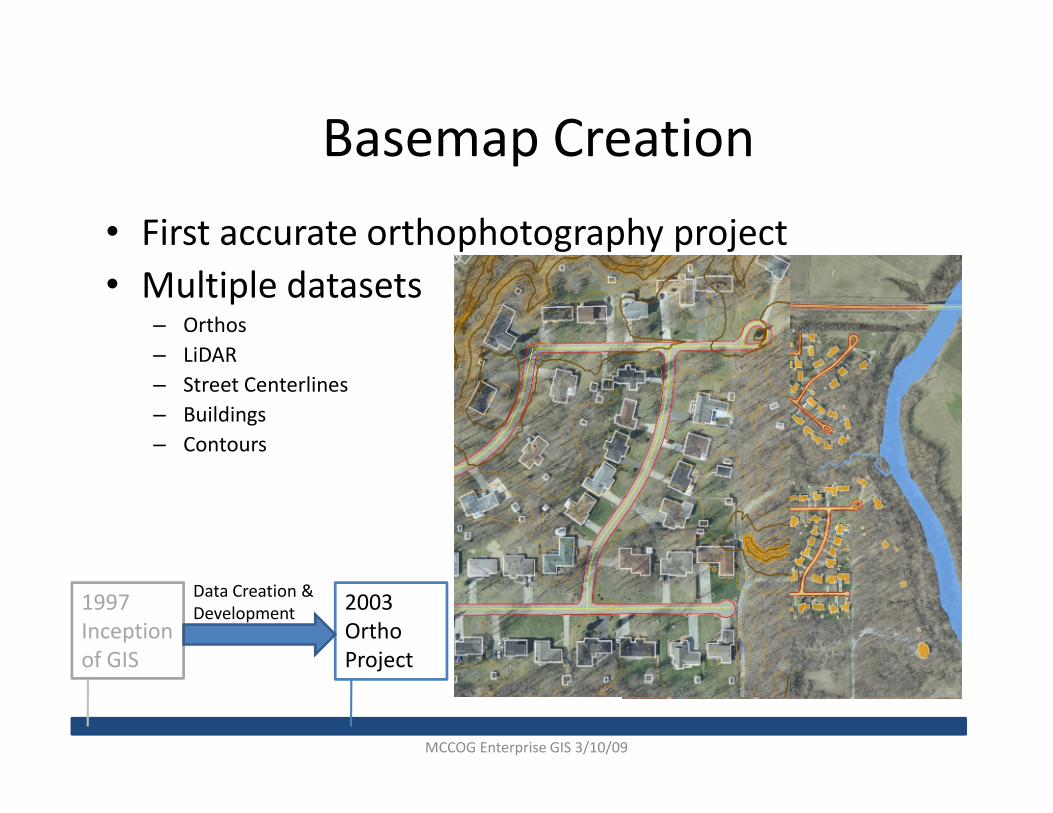
Basemap Creation
• First accurate orthophotography project
• Multiple datasets– Orthos
– LiDAR
– Street Centerlines
– Buildings– Buildings
– Contours
1997
Inception
of GIS
2003
Ortho
Project
Data Creation &
Development
MCCOG Enterprise GIS 3/10/09
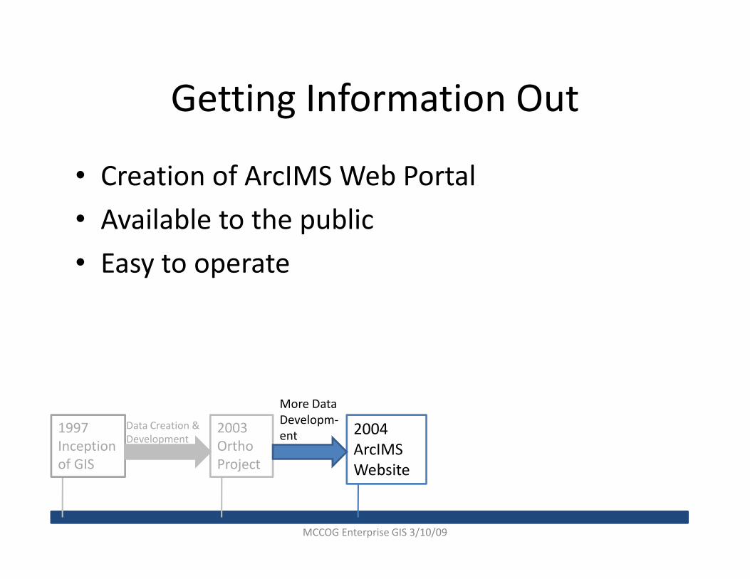
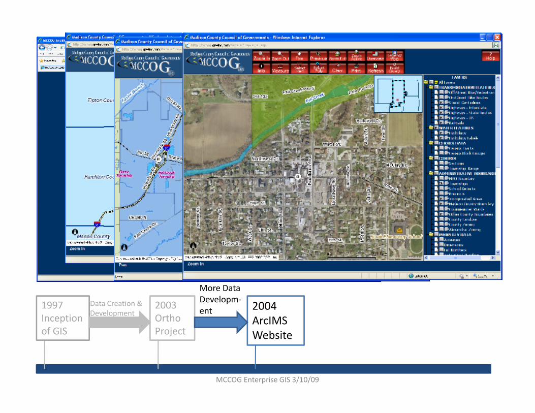
Getting Information Out
• Creation of ArcIMS Web Portal
• Available to the public
• Easy to operate
1997
Inception
of GIS
2003
Ortho
Project
Data Creation &
Development2004
ArcIMS
Website
More Data
Developm-
ent
MCCOG Enterprise GIS 3/10/09
1997
Inception
of GIS
2003
Ortho
Project
Data Creation &
Development2004
ArcIMS
Website
More Data
Developm-
ent
MCCOG Enterprise GIS 3/10/09
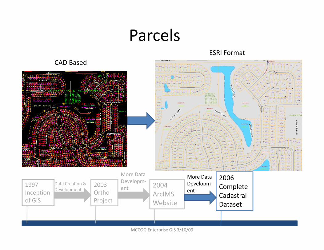
Parcels
CAD Based
ESRI Format
1997
Inception
of GIS
2003
Ortho
Project
Data Creation &
Development2004
ArcIMS
Website
More Data
Developm-
ent
2006
Complete
Cadastral
Dataset
More Data
Developm-
ent
MCCOG Enterprise GIS 3/10/09

Who are the Stakeholders?
• Policy Committee– Sheriff
– Commissioners
– City GIS Coordinators
– Surveyor
– Planning Director
– Assessor
• Technical Committee– COG GIS Coordinator
– Addressing/Zoning Technician
– Sheriff’s GIS Tech
– Assessor GIS Tech
– Anderson GIS Coordinators– Assessor
– IT Director
– COG Executive Director
– COG GIS Coordinator
– EMA Director
1997
Inception
of GIS
2003
Ortho
Project
Data Creation &
Development2004
ArcIMS
Website
More Data
Developm-
ent
2006
Complete
Cadastral
Dataset
More Data
Developm-
ent
Creation of GIS
Policy & Tech
Committees
Decision Made
to Create an
Enterprise GIS
– Anderson GIS Coordinators
– Pendleton GIS Tech
MCCOG Enterprise GIS 3/10/09

Madison County GIS Mission
• Serve the interest of the public in terms of access to all types of spatial information in Madison County.
• Provide guidance and support to all Madison County agencies and municipalities.
• Prioritize the needs of spatial technologies in individual offices.
• Progress the agencies within Madison County by the utilization of spatial technologies in their daily work flow.
• Progress the agencies within Madison County by the utilization of spatial technologies in their daily work flow.
• Maintain familiarity with the most current advancements in GIS technology.
• Establish and maintain a standard for GIS and mapping for Madison County.
1997
Inception
of GIS
2003
Ortho
Project
Data Creation &
Development2004
ArcIMS
Website
More Data
Developm-
ent
2006
Complete
Cadastral
Dataset
More Data
Developm-
ent
Creation of GIS
Policy & Tech
Committees
Decision Made
to Create an
Enterprise GIS
MCCOG Enterprise GIS 3/10/09
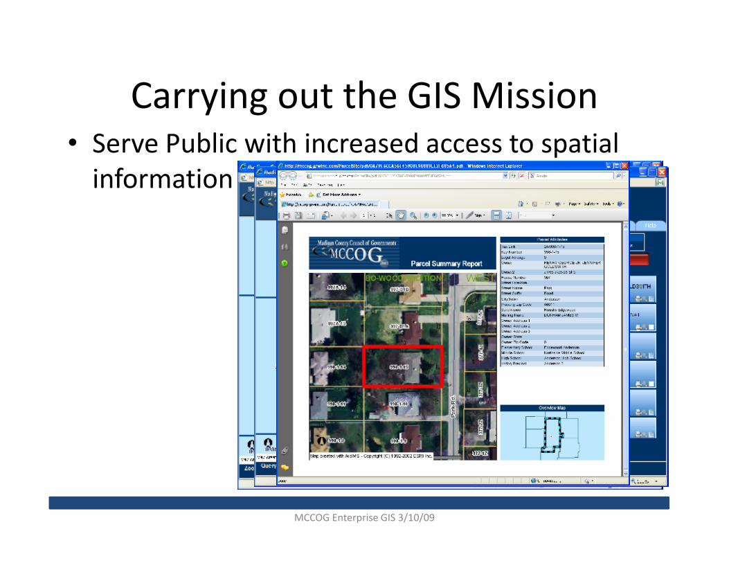
Carrying out the GIS Mission• Serve Public with increased access to spatial
information
MCCOG Enterprise GIS 3/10/09

Sharing the Information
•SDE Technology allows
you to share GIS
information while
maintaining user level
security.
MCCOG Enterprise GIS 3/10/09

Sharing the Information
• Need for a cost
effective way of
sharing GIS
internally.
• Ability to use
ESRI data
formats.
MCCOG Enterprise GIS 3/10/09

Sharing the Information
-Versioned
-User Level Permissions
-Database Authenticated
-GeoData Service Enabled
MADISON
SDE Geodatabase
MCCOG & Madison County
Madison County
Sheriff Dept. City of AndersonAnderson Police Dept.
MCCOG Enterprise GIS 3/10/09

IndianaMap
IFI Public
Access Point
Assessor File
Upload &
Verification
System
Co
un
ty
Da
ta
Sta
te
Da
taFe
de
ral
Da
ta
FME
Translator to
IndianaMap
Schema
SDE-
Raw
State
State Data
Center
IBRC
IndianaMap Integration & Distribution
Collaborators
•United States Geological Survey (USGS)
•State GIS Center of Excellence (CoE)
•Indiana Department of Transportation (INDOT)
•Department of Local Government Finance (DLGF)
•Indiana Geological Survey (IGS)
•State Data Center, State Library
•Indiana Business Research Center (IBRC)
•IndianaView Consortium
•University Information Technology Services, Indiana University
•Coalition of Universities for Spatial Information Sciences (CUSIS)
•Indiana Department of Homeland Security (DHS)Fed
era
l
Image
Library
State
Work
Areas
State
SDE
Library
State
Direct
Connect
Users
State
Apps
IDHS
Apps
Direct
Connect
Users
Public
Download
Indiana
Map
Viewer
WMS
Services
Indiana
Map
Cache
State
Library
Replication
IGSUITS
SDE
Ortho
Imagery
•Indiana Department of Homeland Security (DHS)
•Indiana Geographic Information Council (IGIC)
•Geographic Information Office (GIO), Indiana Office of Technology
c I
nd
ian
a O
ffic
e o
f G
eo
gra
ph
ic I
nfo
rma
tio
n
Slide Courtesy of Indiana Geographic Information Counsel

IndianaMap
IFI Public
Access Point
Assessor File
Upload &
Verification
System
Co
un
ty
Da
ta
Sta
te
Da
taFe
de
ral
Da
ta
FME
Translator to
IndianaMap
Schema
SDE-
Raw
State
State Data
Center
IBRC
IndianaMap Integration & Distribution
Collaborators
•United States Geological Survey (USGS)
•State GIS Center of Excellence (CoE)
•Indiana Department of Transportation (INDOT)
•Department of Local Government Finance (DLGF)
•Indiana Geological Survey (IGS)
•State Data Center, State Library
•Indiana Business Research Center (IBRC)
•IndianaView Consortium
•University Information Technology Services, Indiana University
•Coalition of Universities for Spatial Information Sciences (CUSIS)
•Indiana Department of Homeland Security (DHS)Fed
era
l
Image
Library
State
Work
Areas
State
SDE
Library
State
Direct
Connect
Users
State
Apps
IDHS
Apps
Direct
Connect
Users
Public
Download
Indiana
Map
Viewer
WMS
Services
Indiana
Map
Cache
State
Library
Replication
IGSUITS
SDE
Ortho
Imagery
•Indiana Department of Homeland Security (DHS)
•Indiana Geographic Information Council (IGIC)
•Geographic Information Office (GIO), Indiana Office of Technology
c I
nd
ian
a O
ffic
e o
f G
eo
gra
ph
ic I
nfo
rma
tio
n
Slide Courtesy of Indiana Geographic Information Counsel

Where Next?
• Increase accuracy
• Increase data availability
• Define and Develop Mapping Standards
– MPA wide– MPA wide
– Regional
• “Real Time” Data
• Mobile Deployment
MCCOG Enterprise GIS 3/10/09

MCCOG Enterprise GIS
Implementation
Trent Pell
MCCOG GIS COORDINATOR
Purdue Road School
March 11th, 2009