Enhancing the Safety of Visually Impaired Travelers in … · 2015-01-16 · The Robotics Institute...
31
1 Enhancing the Safety of Visually Impaired Travelers in and around Transit Stations Alekhya Jonnalagedda, Lucy Pei, Suryansh Saxena, Ming Wu, Byung-Cheol Min, Ermine Teves, Aaron Steinfeld, M. Bernardine Dias CMU-RI-TR-14-28 The Robotics Institute Carnegie Mellon University Pittsburgh, Pennsylvania 15213 December 2014 Copyright © 2014 by TechBridgeWorld. All rights reserved. Preparation of this report was supported by the US Department of Transportation University Transportation Center Program, Google, Inc., Boeing, Carnegie Mellon University’s Berkman Faculty Development Fund, the National Science Foundation under NSF-NRI Award Number 1317989, and the National Institute on Disability and Rehabilitation Research under the RERC- APT (grant number H133E080019). Any opinions, findings, and conclusions or recommendations expressed in this material are those of the author and do not necessarily reflect the views of the sponsors.
Transcript of Enhancing the Safety of Visually Impaired Travelers in … · 2015-01-16 · The Robotics Institute...
1
Enhancing the Safety of Visually Impaired Travelers
in and around Transit Stations
Alekhya Jonnalagedda, Lucy Pei, Suryansh Saxena, Ming Wu,
Byung-Cheol Min, Ermine Teves, Aaron Steinfeld, M. Bernardine Dias
CMU-RI-TR-14-28
The Robotics Institute
Carnegie Mellon University
Pittsburgh, Pennsylvania 15213
December 2014
Copyright © 2014 by TechBridgeWorld. All rights reserved.
Preparation of this report was supported by the US Department of Transportation University
Transportation Center Program, Google, Inc., Boeing, Carnegie Mellon University’s Berkman
Faculty Development Fund, the National Science Foundation under NSF-NRI Award Number
1317989, and the National Institute on Disability and Rehabilitation Research under the RERC-
APT (grant number H133E080019). Any opinions, findings, and conclusions or
recommendations expressed in this material are those of the author and do not necessarily reflect
the views of the sponsors.
2
Abstract Safety is a primary concern for the visually impaired when navigating unfamiliar urban environments.
Since most environments are constructed to be easily navigated by sighted people, visually impaired
people have to often seek help and use secondary clues to navigate many urban environments safely. As
a result, daily activities such as using transit systems remain challenging tasks for people with visual
impairments even though the use of transit systems is often a key factor for participation in
employment, and educational, social, and cultural opportunities. Visually impaired adults have several
challenges when navigating unfamiliar environments. First, they must pre-plan their navigation routes
as much as possible and need to build a mental map of the new environment they will be navigating.
Next, they need to figure out how to navigate between locations of interest from a known environment.
They also need to be informed of dynamic changes to the unfamiliar environment which may impact
their safe navigation. Furthermore, they need to be able to “record” their navigation experience for
future trips and also potentially share this information with others who might find it useful. Finally, if
they get into any unsafe or difficult situation while navigating the unfamiliar environment, they need to
have a reliable means of getting help. We have been exploring specific needs and constraints
encountered by this user population when using transit stations. Based on our findings, we created a
set of design guidelines for useful technology targeting this user population and prototyped an
accessible smartphone tool that has significant potential to enhance the safety of these travelers. This
tool allows travelers to annotate their paths and choose/invite trusted sources to enhance the relevant
information that can enhance the safety and efficacy of their travel.
Acknowledgments Many individuals and organizations supported the work presented in this report. Partner involvement
has been essential for this work and we were fortunate to collaborate with several groups who have
supported various aspects of this project. Colleagues from the Blind and Vision Rehabilitation Services of
Pittsburgh (BVRSP) and Western Pennsylvania School for Blind Children (WPSBC) have provided
guidance on this work and have encouraged their networks to participate in our needs assessment and
testing. Dr. George J. Zimmerman from the Vision Studies Program at the University of Pittsburgh
provided invaluable insight into the field of Orientation and Mobility which also significantly impacted
this work. We also thank collaborators Dr. Hassan Karimi and Dr. Jonathan Pearlman from the University
of Pittsburgh for their contributions. The authors also thank the many members of the research team
who assisted with different aspects of the reported work.
3
Table of Contents Abstract ............................................................................................................................................... 2
Acknowledgments ............................................................................................................................... 2
Introduction ........................................................................................................................................ 7
Background ..................................................................................................................................... 8
Related Work ...................................................................................................................................... 9
Existing Technology for Navigation in Transit Stations for Sighted Users ...................................... 9
Existing Technology formNavigation for Visually Impaired Users .................................................. 9
Existing Technology for Visually Impaired Travelers using Transit Systems ................................ 11
Technology for Familiarization of Transit Systems .................................................................. 11
Localization and Navigation Technology for Transit Systems .................................................. 13
Support for Navigation Technology in Transit Systems ........................................................... 14
Needs Assessment: Phase I ............................................................................................................... 14
Methodology ................................................................................................................................ 15
Participants............................................................................................................................... 15
Data Collection ......................................................................................................................... 15
Limitations .................................................................................................................................... 15
Data Analysis................................................................................................................................. 16
Current General Use of Transit Systems .................................................................................. 16
Familiarization with Transit Systems ........................................................................................ 18
Observation Analysis ................................................................................................................ 20
Other Stakeholders .................................................................................................................. 21
Needs Assessment: Phase II .............................................................................................................. 22
Participants............................................................................................................................... 22
Data Collection ......................................................................................................................... 22
Data Analysis ............................................................................................................................ 23
Guidelines and Prototype ................................................................................................................. 24
Design Guidelines ......................................................................................................................... 25
Prototype ...................................................................................................................................... 26
Conclusion ......................................................................................................................................... 28
References ........................................................................................................................................ 30

4
5
List of Figures
Figure 1. Needs assessment and iterative user testing with B/VI people .................................................... 7
Figure 2. Train Station Navigation Assistance User Mapping ..................................................................... 12
Figure 3. Transit System Usage Among Participants .................................................................................. 16
Figure 4. Familiarization Techniques Used by Participants ........................................................................ 19
Figure 5. Challenges mentioned by Sighted Stakeholders .......................................................................... 22
Figure 6. Ability to accomplish urban navigation tasks .............................................................................. 23
Figure 7. System architecture ..................................................................................................................... 26
Figure 8. Screenshots of early prototype .................................................................................................... 27
List of Tables
Table 1. Challenges faced in Familiarization and Navigation, by Cause ..................................................... 17
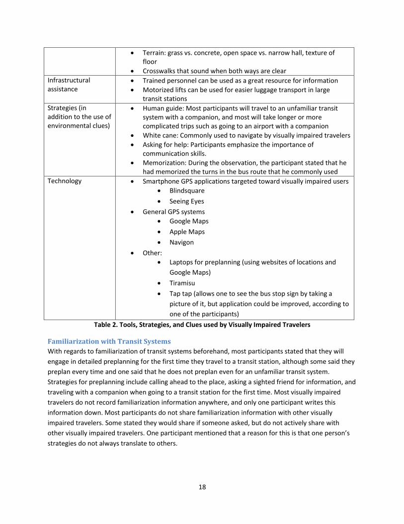
Table 2. Tools, Strategies, and Clues used by Visually Impaired Travelers ................................................. 18
Table 3. Proposed solutions from participants ........................................................................................... 20
Table 4. Outdoor navigation technology use and recommendations ........................................................ 24

6
7
Introduction Safety is a primary concern for the visually impaired when navigating unfamiliar urban environments.
The recent White House Technology Showcase celebrating 20 years of the Americans with Disabilities
Act (ADA) highlighted the need for using technology to enable Americans with disabilities to participate
fully, both in their personal and professional lives. A critical component of this envisioned independence
for people with disabilities is their ability to navigate urban environments. For people with visual
impairments urban navigation can be sufficiently daunting that they avoid unfamiliar environments if
possible. Since most environments are constructed to be easily navigated by sighted people, people with
disabilities have to often seek help and use secondary clues to navigate many urban environments
safely. Day-to-day activities such as using transit systems remain challenging tasks for people with visual
impairments even though the use of transit systems is often a key factor for participation in
employment, educational, social, and cultural opportunities. This work explores the specific challenges
encountered by visually impaired travelers when navigating in and around transit stations, and examines
several technology options for enhancing safety for this population during their use of transit stations.
Assistive technology plays a key role in the independence and safety of people with disabilities. For blind
and visually impaired (B/VI) people, appropriately designed and well implemented assistive technology
can additionally make a significant difference in education, social acceptance, and productivity. We have
been working with B/VI communities around the world on a variety of assistive technology projects for
almost a decade, with a more recent focus on technology tools for wayfinding and navigation. Because
visual impairments can vary widely, the corresponding needs and preferences for tools and interfaces
can also vary accordingly. Our approach also recognizes the current limitations of technology and the
capabilities of the B/VI travelers by designing assistive mechanisms that value input from humans, and
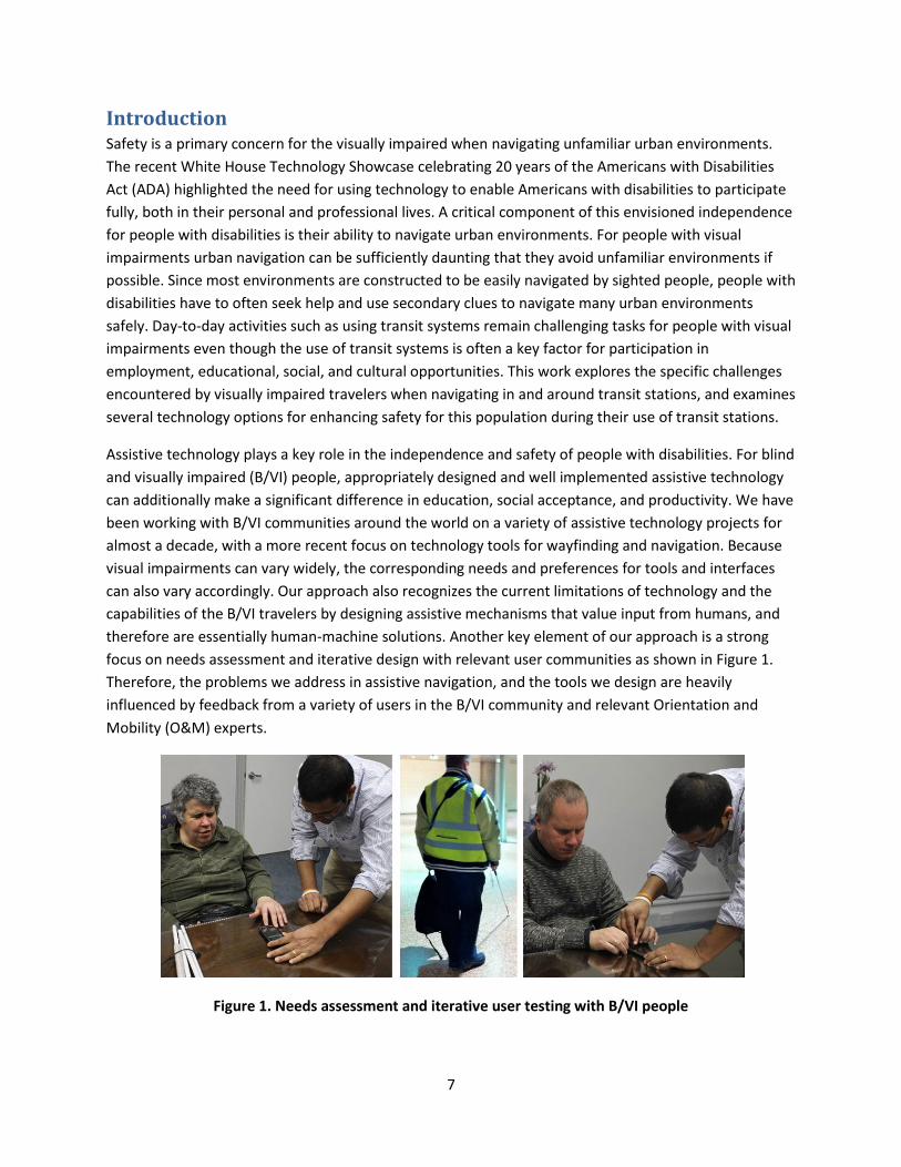
therefore are essentially human-machine solutions. Another key element of our approach is a strong
focus on needs assessment and iterative design with relevant user communities as shown in Figure 1.
Therefore, the problems we address in assistive navigation, and the tools we design are heavily
influenced by feedback from a variety of users in the B/VI community and relevant Orientation and
Mobility (O&M) experts.
Figure 1. Needs assessment and iterative user testing with B/VI people
8
Findings from our needs assessment revealed several concerns of B/VI travelers. Visually impaired adults
have several challenges when navigating unfamiliar environments. First, they must pre-plan their
navigation routes as much as possible and need to build a mental map of the new environment they will
be navigating. Next, they need to figure out how to navigate to and from the location(s) of interest from
a known environment. They also need to be informed of dynamic changes to the unfamiliar
environment which may impact their safe navigation. Furthermore, they need to be able to “record”
their navigation experience for future trips and also potentially share this information with others who
might find it useful. Finally, if they get into any unsafe or difficult situation while navigating the
unfamiliar environment, they need to have a reliable means of getting help.
Background Visually impaired individuals generally employ a variety of non-technology strategies to help them
navigate in their daily lives. One source of knowledge is orientation and mobility (O&M) experts, who
provide visually impaired individuals with the strategies and techniques they need to navigate more
independently. The American Foundation for the Blind breaks down the definition of O&M in the
following manner: “Orientation refers to the ability to know where you are and where you want to go;
Mobility refers to the ability to move safely, efficiently, and effectively from one place to another,” [1].
O&M experts teach visually impaired travelers techniques to use their senses to navigate without vision.
Visually impaired travelers learn to use landmarks to orient themselves by taking note of a certain smell,
sound, or texture that consistently appear in a certain location [2]. Visually impaired users can then use
these landmarks to create a mental map of the environment, which can then help them determine the
safest and most efficient path to their destination. Additionally, visually impaired individuals are taught
to use tools to help them navigate more safely and efficiently. Currently, the most widely adopted tools
are white canes and dog guides [3].
Canes are primarily used to detect and avoid obstacles in the path of travel [4]. When using a cane, the
user holds the cane centered in front of the body, and moves the cane using the wrist in an arc that is
about one inch wider than the body. The tip of the cane should be at the opposite side of the forward
foot, and the cane can either slide across the ground or touch the ground at either end of the arc. After
training and practice, canes can be very effective in providing navigational assistance to visually
impaired travelers.
Another tool that visually impaired people often employ in general navigation is dog guides, the Seeing
Eye being the oldest existing dog guide school in the world ([3], [5]). Dog guides undergo a minimum of
four months of training with experienced instructors and another month of training with their visually
impaired owners. Users receive continued support from The Seeing Eye after they adopt a dog through
the organization in case they run into problems. However, the breeding, training, and care required of
maintaining a dog guide makes this navigation strategy more difficult to sustain. The availability of well-
trained dogs is also limited. The Seeing Eye, for example, only operates in the United States and Canada.
9
Related Work With this understanding of how visually impaired people navigate in their daily lives, we then reviewed
three interrelated areas of the literature to construct a more comprehensive framework for
understanding the current state of navigation assistance for visually impaired travelers. These areas are:
existing technology for sighted travelers using transit systems, existing technology for visually impaired
travelers in general indoor and outdoor navigation, and existing technology for visually impaired
travelers using transit systems.
Existing Technology for Navigation in Transit Stations for Sighted Users Currently, there exists a broad range of approaches in implementing navigation assistance for sighted
travelers in transit stations, though mobile application is by far the most widely adopted model. In fact,
having a user-centered mobile application detailing real-time flight information, gate locations, and
point-to-point navigation (route planning from designated starting point to destination) around airport
terminals is now an industry standard for major transit hubs such as Doha International Airport and
London Heathrow Airport [6]. For more distributed networks like metropolitan transit systems, which
include bus stops and train stations spanning large radiuses, Google Maps and similar navigation
services have become the cornerstone for enabling indoor and outdoor facility navigation and
accessibility, specifically in serving the functions of localization and point-to-point navigation. Though it
was just in recent years that Google Maps, Bing Maps, and the Apple mobile location interface have
expanded to include building layouts and point-to-point navigation indoors, their applications have
already been widespread [7]. Google in particular, has partnered with Hartsfield-Jackson Atlanta
International Airport, Chicago O’Hare, San Francisco International Airport, Boston Transit, and the JR and
Tokyu Corporation (which operates major railway lines in Japan) to provide real-time point-to-point
navigation for sighted users in select transit stations [8].
Aside from interactive maps and point-to-point navigation assistance, there are also mobile applications
which focus on real-time transport location tracking. They complement transit system mapping
navigation aids previously discussed in that they address the transit user’s need for short, predictable
waits for transport vehicles such as trains and buses [9]. Notable projects in this space include Tiramisu,
a crowd-sourced transit tracking system which generates real-time arrival time predictions for buses in
the Pittsburgh (Pennsylvania, USA) area based on commuter GPS input [10].
The sheer volume of technological tools that exist to meet the need of navigation assistance for sighted
travelers suggest the importance of independent, safe, and efficient navigation for the user group. In the
next two sections, we explored the array of navigation tools available to visually impaired travelers, who
value safe and efficient navigation just as much, if not more, than sighted travelers.
Existing Technology formNavigation for Visually Impaired Users Dias and Ravishankar [3] provide a useful organization of technical tools based on its purpose and phase
in the travel process, as well as based on the medium of its implementation. The two phases include
familiarization and localization and navigation. Below we detailed some existing technological solutions
that attempt to address needs in each of the two phases.
10
Phase 1: Familiarization
Familiarization is often defined as the understanding and/or spatial memory of the layout and structure
of an area. Familiarization of a new location occurs before the traveler has been to that location for the
first time. The technology in this area primarily focuses on allowing users to build a mental map
(cognitive map) so that exploration and orientation in the location will be easier and safer.
Narrative Maps: “Directions” and ClickAndGo Wayfinding Maps are two forms of narrative maps (verbal
or text-based descriptions of an area) that function both indoors and outdoors ([11], [12]). “Directions”
is a smartphone application that allows visually impaired users to receive instructions from a sighted
user. ClickAndGo Wayfinding Maps is a website that uses pre-recorded instructions from landmark to
landmark that can be downloaded as audio or braille text. ClickAndGo sets out to professional O&M
consultation to visually impaired travelers, though the limited number of locations available in the
database could make the tool less useful to the end users.
Virtual Exploration: Virtual exploration consists of using sensory feedback to help visually impaired
travelers familiarize themselves within the context of an environment. This has been accomplished
through spatial audio systems such as the Audio-based Environments Simulator, where objects in the
virtual environment correspond with a certain sound as well as spoken words [13]. Spatial audio systems
can be augmented with a force-feedback joystick (vibration-enabled) for a multisensory experience, for
which researchers concluded that users were able to develop a better perception of space and location
of objects in the environment [14]. If applied to transit systems and stations, virtual exploration devices
as such have the potential to help visually impaired travelers familiarize themselves with the layout of
the building or with the layout of the overall transportation network.
Phase 2: Localization and Navigation
The next phase described in Dias and Ravishankar’s review consists of localization and navigation. These
tools help the visually impaired traveler determine where he or she is at a given moment and help
provide directions to safely guide the traveler to his or her destination. Tools in this space include
enhancements to traditional mobility aids, outdoor smartphone GPS systems, use of landmarks and
dead-reckoning on smartphones, as well as non-smartphone enabled solutions.
Enhancements to Traditional Mobility Aids: Solutions such as the affordable Sensible Blind Cane
incorporates an ultrasonic sensor module used to detect obstacles in an effort to enhance the
commonly adopted mobility aid [15]. Similarly, the MobiFree Cane, Sunglasses and Echo, are a set of
wearables and mobility aids that help detect obstacles and notify the user through audio blips or
vibrotactile interfaces [16]. Other systems like the SonicGuide uses enhanced sunglasses and ultrasonic
waves to convey spatial information to the user [17]. Relating to dog guides, another traditional mobility
aid, robots such as eyeDog have been marketed as more affordable options [18].
Smartphone Navigation Apps: There have been attempts to create smartphone applications using
occasional GPS, landmark inputs, and dead-reckoning tools. Navatar is an example of a smartphone
11
application that uses the built-in features of a smartphone such as the accelerometer to perform dead-
reckoning in between user-inputted landmarks [19].
Non-smartphone Solutions: Drishti is an example of an integrated indoor and outdoor navigation tool
that is not smartphone based. Rather, it is a portable computer that uses ultrasonic sensors and a stereo
camera to guide visually impaired users through environments. Though innovative, Drishti does face a
great challenge in widespread implementation and scalability since the underlying ultrasound
positioning system requires infrastructure changes in the implementation site [20].
Other non-smartphone solutions include the PERCEPT glove and kiosk, which uses Radio Frequency
Identification (RFID) to guide users indoors. The PERCEPT glove and kiosk design, much like the RFID
based navigation system proposed by S. Chumkamon et al., would rely on the RFID technology to collect
location information from the environment, and utilizing a routing server, calculate the shortest route
from the user’s current position to the destination. To implement this proposal, RFID tags would have to
be planted along a footpath within the building, which are then read and processed by the RFID reader
embedded in the cane antenna [21]. Though the underlying RFID technology is very mature and cost-
effective, the need for infrastructure changes does limit the scalability of the proposal.
Wifi-fingerprinting has also been explored as a way to localize the user based on strength of Wifi signal
in a particular spot. Applications in this space include the Wayfinding Electronic Bracelet, a wearable
that uses an ultrasonic transceiver [22] as well as a portable SLAM (Simultaneous Localization And
Mapping) device [23]. Research in this space has not been as widespread as wireless networking
technology distribution varies greatly by countries, cities, and even neighborhoods, and associated
proposals might be considered niche applications versus universal implementation/adoption.
Many of the general navigation technologies discussed above can be extended or adapted into usage in
indoor transit systems. However, it is still useful to see what technologies with the specific goal of
assisting the visually impaired in navigating transit systems have already been developed. As such, we
reviewed existing technology designed specifically for transit systems in the following section.
Existing Technology for Visually Impaired Travelers using Transit Systems Research in the area of navigation technology for visually impaired travelers in transit systems is not
extensive. In meeting this limitation, we highlighted and analyzed (more extensively than in previous
sections) key work in this space in order to better understand what has been done and why specific
design choices were made.
Technology for Familiarization of Transit Systems
Currently, existing navigation technology for visually impaired travelers in transit systems primarily
fulfills the purpose of familiarization in such spaces ([24], [25]). Notable work includes the Train Station
Navigation Assistant [24], a smartphone application designed to provide visually impaired travelers with
a holistic comprehension of train stations1. The motivation behind this application is that without an
understanding of the overall structure of a given train station, a visually impaired traveler can enter a
1 The accompanying study did not include details about the type of train station that was studied.

12
potentially dangerous situation once he/she becomes disoriented or strays from the original intended
path.
In designing the Train Station Navigation Assistant, developers followed best practices for conveying
information to visually impaired users: “Overview first, details-on-demand.” The information hierarchy is
organized in the following levels:
Figure 2. Train Station Navigation Assistance User Mapping
The user interface was designed iteratively based on feedback from potential end-users who are visually
impaired. Output used text-to-speech technology to convey information in an audio format that was
convenient for users to understand. As for input, the user utilizes one-handed swipe gestures to ensure
that one hand is available for another navigation/mobility tool such as a white cane. The swipe gestures
are simple and follow convention: swipe right for more detailed information, and left for less detail.
Swiping up and down allows the user to scroll through options at each level, and this gesture
corresponds to the up-and-down orientation of floors. The final feature of the interface is an auditory
tone that lowers in pitch as the user goes down the information hierarchy (towards more detailed
information), allowing the user to “localize” in both the physical and virtual environment. Learnability
for this system appears to be quite high, as experimental users were able to explore more complicated
train stations once developers demonstrated its use and application in a relatively easy to navigate
environment.
Although this system seems promising, extensive testing has not yet been done on the Train Station
Navigation Assistant, according to interviews with visually impaired travelers and O&M experts. Indeed,
a challenge with this system is scalability since a great deal of information must be collected on the
station, its structure, and points of interest. Crowdsourcing has been investigated as a way to address
the issue of information collection, scalability, and implementation feasibility.
Another familiarization tool for transit stations is the AudioMetro [25], a software suite for desktop
users. This tool was designed to help simulate and plan trips on the Metro network in Santiago, Chile.
The software first utilizes background information on the user to tailor the application experience and
Overview: Choose Floor
Upon Arriving at Floor X: Choose Platform
Upon Arriving at Platform Y: Choose Lines/Points of Interest (ie. restrooms, elevators, coffee shops, information kiosks)
13
interface. Upon inputting the start and end location, the user is then able to control a simulation,
exploring and making decisions about the route to take in a virtual metro trip. The software also
includes options for guided directions, points of interest and nearby streets, and basic concepts about
metros.
AudioMetro’s feedback system consisted of audio output for visually impaired users complementary
with a graphic interface for a sighted facilitator or companion. Landmarks and clues that would be
encountered during the trip were represented as different sounds. These sounds corresponded to
auditory clues that would actually be heard during the appropriate stages of metro travel.
AudioMetro was shown to be effective by the researchers, who conducted pre- and post-tests on users,
observing their trips through the metro system. Using Lego blocks to construct their conception of the
metro station, visually impaired users demonstrated that the AudioMetro system is also effective in
helping to create a mental map of spaces like transit stations.
Despite the promise demonstrated by Train Station Navigation Assistant and AudioMetro, one should
note that there is still a lack of scalable, reliable, and accurate systems for familiarization of transit
systems in general for visually impaired travelers. There are also no tools that integrate familiarization
between different types of transit (i.e. transfers involving bus systems and metro). Finally, there is a lack
of tools that assist in familiarization with vehicles in transit systems, such as the layout of an airplane or
train car.
Localization and Navigation Technology for Transit Systems
Most of the localization and navigation technologies discussed in the previous section can be and have
been applied to transit systems. Tagging with infrared and other radio frequency waves can be
implemented in transit stations. The Wifi fingerprint of the transit station could be gathered, or an
image database could be provided to facilitate use of camera-based localization devices. GPS
technology, however, is limited in its expansion to indoor transit systems, especially those that operate
underground due to the little or no GPS signal in those spaces.
Previous suggestions aside, it is important to note that localization and navigation technology has been
developed specifically for transit systems. AudioTransantiago, for example, is a mobile phone
application developed to allow for effective navigation and localization on a bus, with the additional
benefit of becoming familiar with the overall layout of the city. The application allows for multiple
routes to be planned ahead of time, and the user selects one route as the best one for a particular
situation. During the bus ride, verbal audio output from the user’s smartphone allows the user to
anticipate stops and be informed about the streets that are near each stop. This allows the user to
familiarize him or herself with the layout of the city while staying oriented over the course of the bus
ride.
The interface for this application includes high color contrast graphic user interface for low-vision users,
and audio text-to-speech with tactile buttons for blind users.
14
Some problems associated with this approach include heavy traffic, which causes buses to run off
schedule. Changes in routes or detours can be dangerous if they are not reported accurately and
efficiently, and this is an important gap.
A system related to localization has already been implemented in taxi systems in several cities, including
New York City and Boston ([26], [10]). The taxis in these cities feature screens in the backseat that
generally play commercials and allow for credit-card payment. For visually impaired travelers, the screen
can be activated into an audio system with the swipe of a special card. The audio system updates the
traveler on the status of the meter, eliminating the need for total trust in the fare declared by the driver
at the end. The system also assists in the payment process, allowing visually impaired users to pay
independently using credit card.
A challenge faced by this system is the distribution of the activation cards to visually impaired travelers.
Many are distributed through visually impaired rehabilitation centers, but visually impaired travelers
who are not affiliated may not have access to information about the system or may not have access to a
card. The system also lacks an orientation aspect, since it does not announce the street or avenue that is
being passed by the taxi, which could be useful information for the visually impaired traveler.
Overall, there is a lack of reliable and scalable localization and navigation technology that will work in
underground locations. The investment associated with implementing current systems that work
underground prevents widespread implementation, and a lack of reliable ways to update information
after the initial gathering of data also provides a challenge.
Support for Navigation Technology in Transit Systems
In the course of exploring technological solutions in the space of navigation assistance for visually
impaired travelers, we noticed one common theme: the need to gather and maintain updated,
extensive information on a location is the most persistent challenge facing most, if not all the previously
discussed technical solutions in scalability and wide-scale adoption. Crowdsourcing, in conjunction with
the use of Google Street View for the purpose of identifying bus stops, has been shown to be successful
in collecting information virtually [27]. There have also been movements in coordinating crowdsourcing
efforts, as exemplified by the tool Bus Stop CSI, which was designed to make the crowdsourcing more
structured and efficient. Further improvements in this space could include verification of a bus stop
through another street view provider and expanded list of important landmarks to be noted.
Needs Assessment: Phase I Having surveyed the relevant literature, in order to learn more about the strategies and challenges faced
by visually impaired travelers, we conducted needs assessment with a variety of stakeholders. The
methodology of our needs assessment is discussed next, along with some of its limitations. We then
present our analysis of the data.
15
Methodology To ensure that the design guidelines and recommendations we propose are consistent with and
effectively address the challenges faced by visually impaired travelers in using transit systems, we
conducted a needs assessment study with various stakeholders, including visually impaired travelers,
O&M experts, transit station managers, as well as sighted expert travelers.
Participants
Currently, our study is limited to stakeholders residing in the greater Pittsburgh area in Pennsylvania,
USA. Participants were recruited from relevant community organizations, and the study was designed
and executed in compliance with Carnegie Mellon University’s Institutional Review Board (IRB) protocols
(IRB number HS14-400). A total of 14 participants were involved in the study, all recruited through
partner networks. Nine were blind or visually impaired travelers, two were O&M experts, one was an
expert traveler and two were transit system managers/employees.
Data Collection
This needs assessment study was conducted through three main channels: online survey, phone
interview, and observation. All survey and interview data collected in the course of this study have been
anonymized to protect the identity and confidentiality of the participants. Eight phone interviews were
conducted with visually impaired travelers and one phone interview was conducted with an expert
sighted traveler, who uses busses weekly and uses trains and airplanes several times a year. One survey
was conducted with a visually impaired traveler and two surveys were conducted with O&M experts.
We also conducted one survey and one phone interview with two different public transit managers. One
observation was conducted with a blind participant who was also interviewed.
Limitations Given time constraints on the completion of the needs assessment, further research could broaden the
generalizability of our findings. There was a small sample size, since we only had nine visually impaired
participants, two O&M experts, one expert traveler, and two transit system managers/employees. Of
the nine visually impaired participants, six were blind, and three were low-vision. Having more diversity
among visual impairments would be useful. Another limitation of the study is that all of the participants
were from the Pittsburgh area. Studies in different cities would increase the generalizability of our
findings. Furthermore, we do not know how many participants lived in the city itself versus the
surrounding suburbs, and this could also be a potential limitation.
Several factors also create limitations with regards to technology usage. We recommend gathering
information on income range of the participants, which could impact a participant’s tendency to use
technology. The age of the participants could also affect the likeliness to be tech savvy. Since most of
our participants were in their sixties, the findings regarding technology usage may be skewed, and
further studies with more diverse age ranges of participants would be useful.
Further studies could incorporate research on the public policy and legal side of the issue of accessibility
in public transit, since this would be helpful in creating sustainable and ubiquitous change.
16
Despite these limitations, the data found is a useful starting point for generating recommendations and
design guidelines. Further research can be done to alleviate the limitations and confirm the
generalizability of our findings.
Data Analysis In this section, we provide a summary of the data collected. First, we present data about current use of
transit systems in general, followed by data specific to the familiarization process. Finally, we present
data specific to the navigation process.
Current General Use of Transit Systems
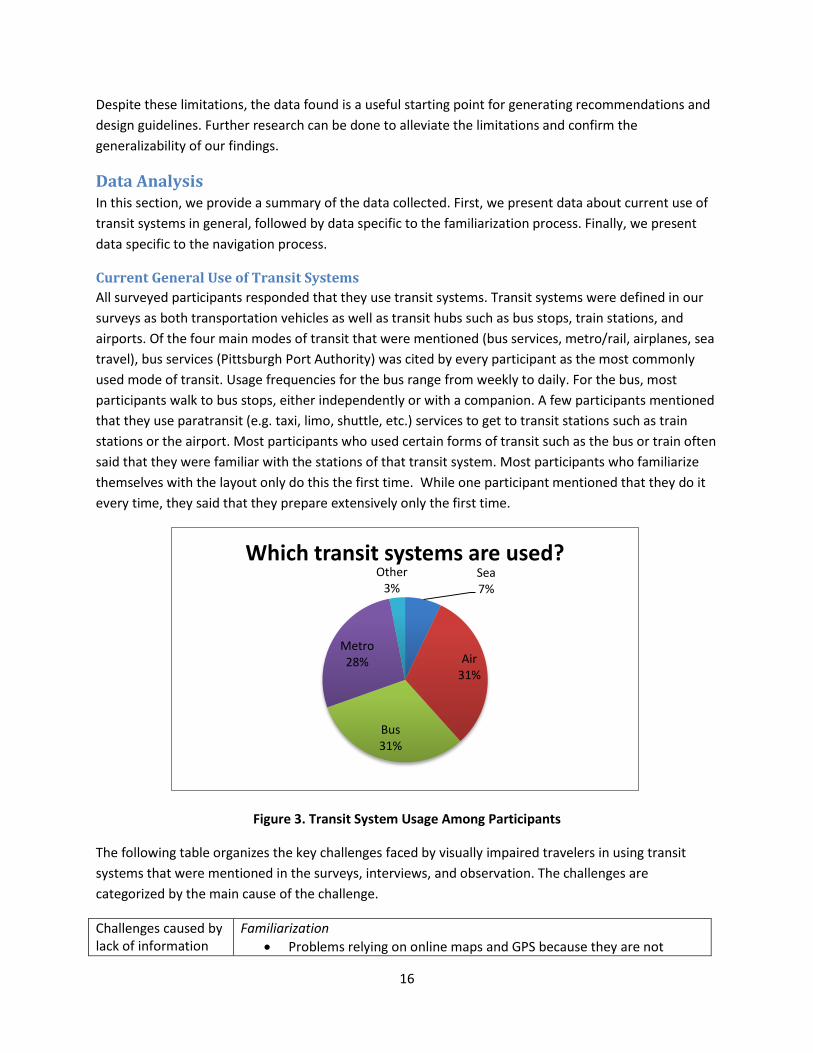
All surveyed participants responded that they use transit systems. Transit systems were defined in our
surveys as both transportation vehicles as well as transit hubs such as bus stops, train stations, and
airports. Of the four main modes of transit that were mentioned (bus services, metro/rail, airplanes, sea
travel), bus services (Pittsburgh Port Authority) was cited by every participant as the most commonly
used mode of transit. Usage frequencies for the bus range from weekly to daily. For the bus, most
participants walk to bus stops, either independently or with a companion. A few participants mentioned
that they use paratransit (e.g. taxi, limo, shuttle, etc.) services to get to transit stations such as train
stations or the airport. Most participants who used certain forms of transit such as the bus or train often
said that they were familiar with the stations of that transit system. Most participants who familiarize
themselves with the layout only do this the first time. While one participant mentioned that they do it
every time, they said that they prepare extensively only the first time.
Figure 3. Transit System Usage Among Participants
The following table organizes the key challenges faced by visually impaired travelers in using transit
systems that were mentioned in the surveys, interviews, and observation. The challenges are
categorized by the main cause of the challenge.
Challenges caused by lack of information
Familiarization
Problems relying on online maps and GPS because they are not
Sea 7%
Air 31%
Bus 31%
Metro 28%
Other 3%
Which transit systems are used?
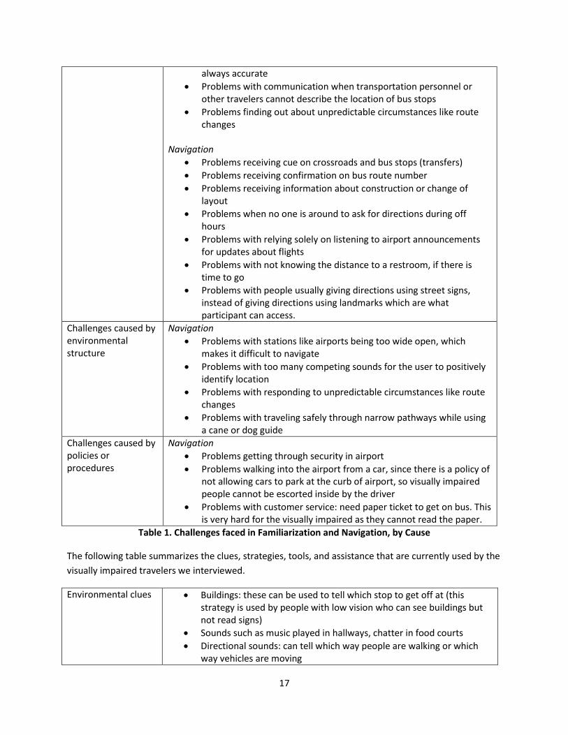
17
always accurate
Problems with communication when transportation personnel or other travelers cannot describe the location of bus stops
Problems finding out about unpredictable circumstances like route changes
Navigation
Problems receiving cue on crossroads and bus stops (transfers)
Problems receiving confirmation on bus route number
Problems receiving information about construction or change of layout
Problems when no one is around to ask for directions during off hours
Problems with relying solely on listening to airport announcements for updates about flights
Problems with not knowing the distance to a restroom, if there is time to go
Problems with people usually giving directions using street signs, instead of giving directions using landmarks which are what participant can access.
Challenges caused by environmental structure
Navigation
Problems with stations like airports being too wide open, which makes it difficult to navigate
Problems with too many competing sounds for the user to positively identify location
Problems with responding to unpredictable circumstances like route changes
Problems with traveling safely through narrow pathways while using a cane or dog guide
Challenges caused by policies or procedures
Navigation
Problems getting through security in airport
Problems walking into the airport from a car, since there is a policy of not allowing cars to park at the curb of airport, so visually impaired people cannot be escorted inside by the driver
Problems with customer service: need paper ticket to get on bus. This is very hard for the visually impaired as they cannot read the paper.
Table 1. Challenges faced in Familiarization and Navigation, by Cause
The following table summarizes the clues, strategies, tools, and assistance that are currently used by the
visually impaired travelers we interviewed.
Environmental clues Buildings: these can be used to tell which stop to get off at (this strategy is used by people with low vision who can see buildings but not read signs)
Sounds such as music played in hallways, chatter in food courts
Directional sounds: can tell which way people are walking or which way vehicles are moving
18
Terrain: grass vs. concrete, open space vs. narrow hall, texture of floor
Crosswalks that sound when both ways are clear
Infrastructural assistance
Trained personnel can be used as a great resource for information
Motorized lifts can be used for easier luggage transport in large transit stations
Strategies (in addition to the use of environmental clues)
Human guide: Most participants will travel to an unfamiliar transit system with a companion, and most will take longer or more complicated trips such as going to an airport with a companion
White cane: Commonly used to navigate by visually impaired travelers
Asking for help: Participants emphasize the importance of communication skills.
Memorization: During the observation, the participant stated that he had memorized the turns in the bus route that he commonly used
Technology Smartphone GPS applications targeted toward visually impaired users
Blindsquare
Seeing Eyes
General GPS systems
Google Maps
Apple Maps
Navigon
Other:
Laptops for preplanning (using websites of locations and
Google Maps)
Tiramisu
Tap tap (allows one to see the bus stop sign by taking a
picture of it, but application could be improved, according to
one of the participants)
Table 2. Tools, Strategies, and Clues used by Visually Impaired Travelers
Familiarization with Transit Systems
With regards to familiarization of transit systems beforehand, most participants stated that they will
engage in detailed preplanning for the first time they travel to a transit station, although some said they
preplan every time and one said that he does not preplan even for an unfamiliar transit system.
Strategies for preplanning include calling ahead to the place, asking a sighted friend for information, and
traveling with a companion when going to a transit station for the first time. Most visually impaired
travelers do not record familiarization information anywhere, and only one participant writes this
information down. Most participants do not share familiarization information with other visually
impaired travelers. Some stated they would share if someone asked, but do not actively share with
other visually impaired travelers. One participant mentioned that a reason for this is that one person’s
strategies do not always translate to others.

19
Figure 4. Familiarization Techniques Used by Participants
Some visually impaired travelers will not do much familiarization if only going to a transit station or
system once or twice. On the other hand, most visually impaired travelers who will be going to a transit
station consistently will schedule a formal on-site familiarization of the location with an O&M expert.
After hearing about the challenges as well as the strategies that visually impaired participants used, we
asked them to suggest some solutions that might improve their experience using transit systems. We
also asked other stakeholders what solutions they might suggest to improve the experience of visually
impaired travelers using transit systems. Below is a table presenting the solutions that were suggested
by all of our participants, organized by solution type.
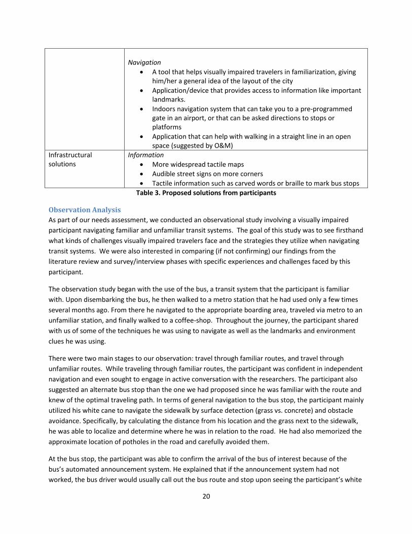
Training solutions Information and Navigation
Staff in transit systems should have more training, since there were mixed responses about experiences asking transit staff for help (ACCESS employee states that Pittsburgh Port Authority bus drivers receive training on interacting with VI travelers)
Bus should stop at curb and announce route and direction
Visually impaired children should be familiarized with how to use transit by O&M experts (according to O&M expert)
Technological solutions Information
Accessible websites, schedules written in HTML
GPS with detour information and braille output
Device for reading signs in airport
Device that will tell you when you pass gate A, gate B, etc.
Application that announces bus stops and locations of bus stops
Use smartphone 10%
Ask Sighted Travelers before
40% Do not
famalirize 20%
Call transit personnel ahead
of time 10%
Mobility Instructors
10%
Online Maps 10%
Familiarizing techniques used
20
Navigation
A tool that helps visually impaired travelers in familiarization, giving him/her a general idea of the layout of the city
Application/device that provides access to information like important landmarks.
Indoors navigation system that can take you to a pre-programmed gate in an airport, or that can be asked directions to stops or platforms
Application that can help with walking in a straight line in an open space (suggested by O&M)
Infrastructural solutions
Information
More widespread tactile maps
Audible street signs on more corners
Tactile information such as carved words or braille to mark bus stops
Table 3. Proposed solutions from participants
Observation Analysis
As part of our needs assessment, we conducted an observational study involving a visually impaired
participant navigating familiar and unfamiliar transit systems. The goal of this study was to see firsthand
what kinds of challenges visually impaired travelers face and the strategies they utilize when navigating
transit systems. We were also interested in comparing (if not confirming) our findings from the
literature review and survey/interview phases with specific experiences and challenges faced by this
participant.
The observation study began with the use of the bus, a transit system that the participant is familiar
with. Upon disembarking the bus, he then walked to a metro station that he had used only a few times
several months ago. From there he navigated to the appropriate boarding area, traveled via metro to an
unfamiliar station, and finally walked to a coffee-shop. Throughout the journey, the participant shared
with us of some of the techniques he was using to navigate as well as the landmarks and environment
clues he was using.
There were two main stages to our observation: travel through familiar routes, and travel through
unfamiliar routes. While traveling through familiar routes, the participant was confident in independent
navigation and even sought to engage in active conversation with the researchers. The participant also
suggested an alternate bus stop than the one we had proposed since he was familiar with the route and
knew of the optimal traveling path. In terms of general navigation to the bus stop, the participant mainly
utilized his white cane to navigate the sidewalk by surface detection (grass vs. concrete) and obstacle
avoidance. Specifically, by calculating the distance from his location and the grass next to the sidewalk,
he was able to localize and determine where he was in relation to the road. He had also memorized the
approximate location of potholes in the road and carefully avoided them.
At the bus stop, the participant was able to confirm the arrival of the bus of interest because of the
bus’s automated announcement system. He explained that if the announcement system had not
worked, the bus driver would usually call out the bus route and stop upon seeing the participant’s white

21
cane. During the bus ride, the participant was able to stay oriented while multitasking (engaging in
conversation and interpreting bus stop announcements).
Through the stretch of unfamiliar areas (which began once the participant disembarked the bus), the
participant asked one of the researchers to serve as a sighted guide since he had never traveled this
route before. He mentioned that usually he would ask someone in the nearby vicinity to assist him in
reaching his destination instead. One challenge we noticed was that once the participant got to the train
tracks, he did not know where to wait for the train. Without external feedback on the specifics of
boarding area, the participant waited in a place that was far away from where the train would stop.
Another challenge was that during periods of light traffic (e.g. noon), the participant would have trouble
navigating large, open spaces like metro stations because he usually relies on sound clues such as foot
traffic to know the general flow of people and accordingly gather information on important landmarks
(e.g. exits). In situations where there are little environmental clues and feedback, a technique that the
participant used most often was asking others for assistance.
Other Stakeholders
As a whole, our findings based on the visually impaired participants’ responses from the needs
assessment study are consistent with the responses from other stakeholders. One participant from the
expert traveler group, for example, identified some perceived challenges faced by visually impaired
travelers in navigating transit systems, including having too many competing auditory clues and safety
concerns due to the architecture and traffic flow of the transit station. Another stakeholder, a transit
station manager who interacts with visually impaired travelers daily, point to similar challenges faced by
visually impaired travelers: lack of location signaling due to inconsistency in fixed route stop calling,
inaccessible bus stops and path of travel barriers, limited information on navigation directions or
descriptions of the transit station, and general navigational challenges in large, open spaces such as
airports. The two O&M expert participants shared similar insights, explaining that “wide open areas are
difficult for travelers who are totally blind to maintain a straight line of travel (reducing veer). Also, busy
underground transit stations may have many other pedestrians which impede the travel of the
individual.”
The perceived challenges mentioned by the various stakeholders involve several dimensions, mainly the
architectural design of transit stations (large open spaces difficult to traverse for visually impaired
travelers) and accessible information on key landmarks as well as real-time routes changes, construction
work, or related transit information. In this aspect, study participants also offered some potential
solutions to the previously mentioned perceived challenges, as summarized below:
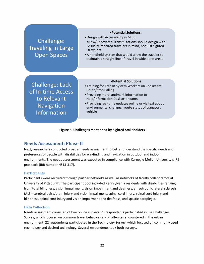
22
Figure 5. Challenges mentioned by Sighted Stakeholders
Needs Assessment: Phase II Next, researchers conducted broader needs assessment to better understand the specific needs and
preferences of people with disabilities for wayfinding and navigation in outdoor and indoor
environments. The needs assessment was executed in compliance with Carnegie Mellon University’s IRB
protocols (IRB number HS13-317).
Participants
Participants were recruited through partner networks as well as networks of faculty collaborators at
University of Pittsburgh. The participant pool included Pennsylvania residents with disabilities ranging
from total blindness, vision impairment, vision impairment and deafness, amyotrophic lateral sclerosis
(ALS), cerebral palsy/brain injury and vision impairment, spinal cord injury, spinal cord injury and
blindness, spinal cord injury and vision impairment and deafness, and spastic paraplegia.
Data Collection
Needs assessment consisted of two online surveys. 23 respondents participated in the Challenges
Survey, which focused on common travel behaviors and challenges encountered in the urban
environment. 22 respondents participated in the Technology Survey, which focused on commonly used
technology and desired technology. Several respondents took both surveys.
•Potential Solutions:
•Design with Accessibility in Mind
•New/Renovated Transit Stations should design with visually impaired travelers in mind, not just sighted travelers
•A handheld system that would allow the traveler to maintain a straight line of travel in wide open areas
Challenge: Traveling in Large
Open Spaces
•Potential Solutions
•Training for Transit System Workers on Consistent Route/Stop Calling
•Providing more landmark information to Help/Information Desk attendants
•Providing real-time updates online or via text about environmental changes, route status of transport vehicle
Challenge: Lack of In-time Access
to Relevant Navigation
Information
23
Data Analysis
To get around, the majority of participants are transported by a friend (24%), walk (22%), and take the
bus (20%). Other commonly used transportation options include para-transit (14%), personal vehicle
(11%), and taxi (9%).
Challenges faced when navigating outdoor environments varied for mobility impaired travelers and
visually impaired travelers. Mobility impaired travelers found outdoor sidewalks to be challenging.
Visually impaired travelers found crossings, parks, and busy intersections to be difficult. Both categories
of travelers found the absence of sidewalks and unfamiliarity of their surroundings to be challenging in
outdoor environments.
Indoor challenges for mobility impaired travelers include transitional environments and indoor
carpeting. A challenge for visually impaired travelers in indoor environments includes using public
facilities. Both categories of travelers found loud environments and unfamiliarity of their surroundings
to be challenging in indoor environments.
Challenges faced when navigating unfamiliar environments varied between both categories of travelers.
For visually impaired travelers, getting to the destination from the transit stop is a challenge in
unfamiliar environments. For mobility impaired travelers, getting to the transit stop to home is a
challenge in unfamiliar environments. Notable challenges for both categories include getting accessible
route before travel and emergency situations.
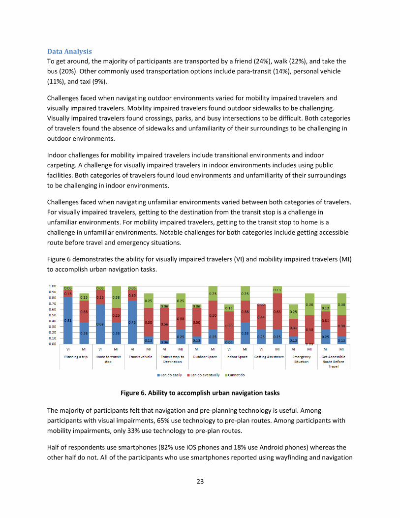
Figure 6 demonstrates the ability for visually impaired travelers (VI) and mobility impaired travelers (MI)
to accomplish urban navigation tasks.
Figure 6. Ability to accomplish urban navigation tasks
The majority of participants felt that navigation and pre-planning technology is useful. Among
participants with visual impairments, 65% use technology to pre-plan routes. Among participants with
mobility impairments, only 33% use technology to pre-plan routes.
Half of respondents use smartphones (82% use iOS phones and 18% use Android phones) whereas the
other half do not. All of the participants who use smartphones reported using wayfinding and navigation
24
technologies on their phone, whereas none of the participants who use mobile phones reported using
wayfinding and navigation technologies on their phone.
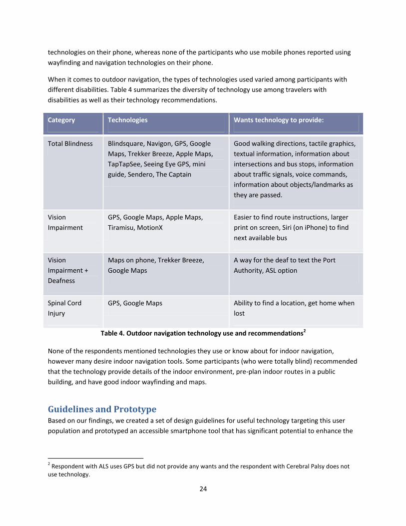
When it comes to outdoor navigation, the types of technologies used varied among participants with
different disabilities. Table 4 summarizes the diversity of technology use among travelers with
disabilities as well as their technology recommendations.
Category Technologies Wants technology to provide:
Total Blindness Blindsquare, Navigon, GPS, Google
Maps, Trekker Breeze, Apple Maps,
TapTapSee, Seeing Eye GPS, mini
guide, Sendero, The Captain
Good walking directions, tactile graphics,
textual information, information about
intersections and bus stops, information
about traffic signals, voice commands,
information about objects/landmarks as
they are passed.
Vision
Impairment
GPS, Google Maps, Apple Maps,
Tiramisu, MotionX
Easier to find route instructions, larger
print on screen, Siri (on iPhone) to find
next available bus
Vision
Impairment +
Deafness
Maps on phone, Trekker Breeze,
Google Maps
A way for the deaf to text the Port
Authority, ASL option
Spinal Cord
Injury
GPS, Google Maps Ability to find a location, get home when
lost
Table 4. Outdoor navigation technology use and recommendations2
None of the respondents mentioned technologies they use or know about for indoor navigation,
however many desire indoor navigation tools. Some participants (who were totally blind) recommended
that the technology provide details of the indoor environment, pre-plan indoor routes in a public
building, and have good indoor wayfinding and maps.
Guidelines and Prototype Based on our findings, we created a set of design guidelines for useful technology targeting this user
population and prototyped an accessible smartphone tool that has significant potential to enhance the
2 Respondent with ALS uses GPS but did not provide any wants and the respondent with Cerebral Palsy does not
use technology.
25
safety of these travelers. This tool allows travelers to annotate their paths and choose/invite trusted
sources to enhance the relevant information that can enhance the safety and efficacy of their travel.
Design Guidelines The following set of ten design guidelines will be informative to other researchers working in the area of
assistive navigation technology for B/VI users.
1. Include users in the design process: The most important guideline for effective work in this area
is to include B/VI users and O&M specialists in an iterative design and testing process. Testing
conducted with blindfolded sighted users does not yield the same result.
2. Keep the user in the loop: It is important to appreciate the orientation and mobility training of
the B/VI users. Navigation assistance tools that keep the B/VI user in the loop and incorporate
their input effectively will produce more robust and useful guidance.
3. Pay attention to affordability: Employment and purchasing power can be low among the B/VI
community so assistive tools must be affordable in order to be useful.
4. Reliability is extremely important: Because the failure of these tools could jeopardize the safety
of B/VI users, the tools must operate reliably to gain the trust of the users. Reliability can be
addressed practically by predictable behavior in all scenarios, and graceful degradation in
difficult environments. If users can predict failure conditions and how the tool will respond to
these conditions, users can detect these situations and be prepared to overcome these
limitations of the technology.
5. Build practical tools: It is important to ensure that B/VI users will be able to learn to use the
technology in a reasonable timeframe, and that the usage scenario of the tool is practical. For
example, practical considerations such as theft of expensive technology or the inability of a user
to carry and use many/heavy/poorly shaped devices must be taken into account when designing
these tools.
6. Do not overwhelm the user: Because the B/VI users must pay attention to their surroundings
and keep track of a variety of things when navigating, it is important to design assistive tools
that do not overwhelm or monopolize the attention of the user. Interfaces should be as simple
as possible and allow for customization since the user will often need to multitask, and will want
different levels of assistance from the assistive device depending on the specific scenario.
7. Environmental considerations are important: In areas with high levels of competing sound, B/VI
users often prefer less information from assistive tools so that they can focus on other inputs
from the surroundings. In contrast, when navigating through a large empty space, the user may
want much more detailed instructions. Furthermore, when a tool provides information that is
read aloud, it is important to consider privacy issues and whether this output is generating
distracting levels of background noise.
8. Expect and adapt to dynamics: Effective assistive tools will provide mechanisms for recognizing
changes in the environment and adapt to those changes in a timely manner that is beneficial to
the B/VI user. Distinctions should be made between temporary changes and permanent
infrastructural changes for optimal performance.

26
9. Make the most of existing resources: Understanding how B/VI users navigate without
technology, and employing universal design principals to harness resources useful to sighted
people can contribute significantly to the success of assistive tools for the B/VI community.
10. Understand the bigger picture: Understanding procedures, policies, and laws relevant to
accessibility can significantly contribute to successful design decisions for assistive tools.
Prototype Our findings indicated a need for a tool that allows visually impaired travelers to annotate routes with
their own notes of useful information, and to easily obtain and use relevant information from trusted
sources. These trusted sources can fall in the category of authorities, individuals in the area who have
been vetted or have a reputation for providing trustworthy information of relevance, and personal
contacts (both sighted and B/VI) who the user trusts to provide useful and accurate information. The
information needed and the level of detail/nature of the descriptions needed can be very different for
people with different levels of visual impairment and/or familiarity of the environment. In order to
further investigate the idea of this tool, we developed an Android smartphone prototype of the
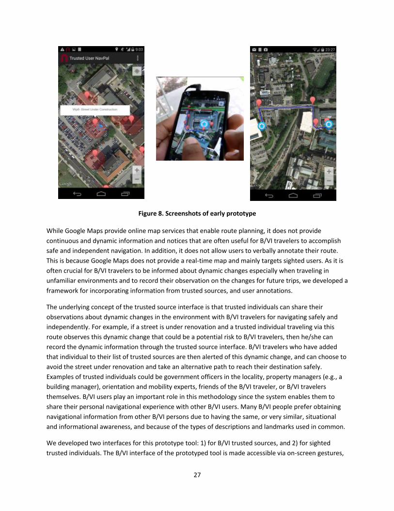
proposed tool. Figure 7 shows the system architecture and Figure 8 shows some screenshots of the early
prototype.
Figure 7. System architecture
Google Maps Server
Trusted Source Interface
For Sighted and VI Users
Local Server
Internet
Trusted Users
Visually Impaired (VI)
User
Text-to-Speech APIGesture Recognition
Interface
Haptic Interface
Voice Recognition
Interface
Direction API
Geocoding API
NavPal Outdoor App
Breadcrumb Interface Trusted Source Interface
27
Figure 8. Screenshots of early prototype
While Google Maps provide online map services that enable route planning, it does not provide
continuous and dynamic information and notices that are often useful for B/VI travelers to accomplish
safe and independent navigation. In addition, it does not allow users to verbally annotate their route.
This is because Google Maps does not provide a real-time map and mainly targets sighted users. As it is
often crucial for B/VI travelers to be informed about dynamic changes especially when traveling in
unfamiliar environments and to record their observation on the changes for future trips, we developed a
framework for incorporating information from trusted sources, and user annotations.
The underlying concept of the trusted source interface is that trusted individuals can share their
observations about dynamic changes in the environment with B/VI travelers for navigating safely and
independently. For example, if a street is under renovation and a trusted individual traveling via this
route observes this dynamic change that could be a potential risk to B/VI travelers, then he/she can
record the dynamic information through the trusted source interface. B/VI travelers who have added
that individual to their list of trusted sources are then alerted of this dynamic change, and can choose to
avoid the street under renovation and take an alternative path to reach their destination safely.
Examples of trusted individuals could be government officers in the locality, property managers (e.g., a
building manager), orientation and mobility experts, friends of the B/VI traveler, or B/VI travelers
themselves. B/VI users play an important role in this methodology since the system enables them to
share their personal navigational experience with other B/VI users. Many B/VI people prefer obtaining
navigational information from other B/VI persons due to having the same, or very similar, situational
and informational awareness, and because of the types of descriptions and landmarks used in common.
We developed two interfaces for this prototype tool: 1) for B/VI trusted sources, and 2) for sighted
trusted individuals. The B/VI interface of the prototyped tool is made accessible via on-screen gestures,
28
voice commands, and audio output. Locations of interest to the user can be stored as phone contacts
and effective routes between destinations (and from the current location) can be calculated via Google
Maps. While navigating with this tool, the user is given audible navigational instructions at waypoint
intervals, e.g., "Head north for 20 meters and then turn left." In addition, the street name and user’s
direction of travel are announced at intersections. The nearby points of interest are also automatically
announced to the user for better localization and orientation. If the user deviates from the desired path
at a given setting, e.g., 10 meters, the app informs the user to stop and re-routes a new path to the
destination.
Since on-screen gestures are a commonly used input modality for B/VI users when interacting with a
touchscreen smartphone, we adopted these gestures as part of our accessible interface. We first
conducted a small usability study with a few B/VI users from our partner networks to determine which
gestures are more effective for our tool. We also evaluated accessibility and ease of operation of our
smartphone tool through this small usability study.
For the annotation component, a B/VI user can verbally record his or her navigational experience and
refer to it for future trips using our “breadcrumb” interface which allows a user to record messages tied
to specific locations on a route that will automatically be played when they encounter those waypoints
in the future. Message examples include any potential hazards, a waypoint name, and orientation
information for future trips.
For sighted trusted users, we developed an additional app where they can simply tap the map on the
screen and annotate any observed dynamic changes. Trusted users can specify attributes for the data
such as 1) characterization of traversability of the waypoint, 2) the proximity of this waypoint to a key
landmark, and 3) an estimated lifetime for this data to exist. The users can define a fixed lifetime in
hours and minutes or can leave it as an unknown lifetime.
Trusted sources data, either from B/VI users themselves or sighted users, are then directly sent to the
local server for storing. The data will be retrieved by the NavPal app depending on the trusted sources
selected by B/VI users. The trusted user interface allows B/VI users to designate trusted sources for
navigation aids from their contact list. This feature is vital because it enables B/VI travelers to prioritize
trusted users and sources and also prevents retrieval of excessive and unhelpful information. This list is
stored in the user’s Android internal memory and can be edited through the setting option of this
interface. Finally, B/VI users can be informed of dynamic changes by retrieving the user-designated
trusted sources.
This initial prototype was tested with four B/VI users during the reporting period. User feedback
confirmed the significance of its potential impact in improving safety for B/VI travelers.
Conclusion In this work, we explored the challenges encountered by visually impaired travelers when navigating in
and around transit stations, and examined several technology options for enhancing safety for this
population during their use of transit stations. Findings from needs assessments and a literature review
29
have resulted in a set of design guidelines for useful technology targeting this user population. These
guidelines advise researchers and developers to: include users in the design process, keep the user in
the loop, pay attention to affordability, keep reliability in mind, build practical tools, not overwhelm the
users, keep environmental considerations in mind, make the most of existing resources, and understand
the bigger picture. Findings have also led to an early prototype of an accessible smartphone tool that
allows travelers to annotate their paths and choose/invite trusted sources to enhance the relevant
information that can improve the safety and efficacy of their travel. User feedback confirmed the
significance of the tool’s potential impact in improving safety for blind and visually impaired travelers.
Future work will further develop this prototype, conduct user tests and iterative enhancements, and
deploy the tool with relevant users.
30
References [1] D. Saurburger, “Introduction to Orientation and Mobility,” Vision Aware, 2013 -
http://www.visionaware.org/section.aspx?FolderID=8&SectionID=115&TopicID=515
[2] D. Saurburger, “Indoor Movement and Orientation with Vision Impairment,” Vision Aware, 2013. -
http://www.visionaware.org/section.aspx?FolderID=8&SectionID=115&TopicID=515&DocumentID=
5800
[3] M. B. Dias, S. Ravishankar, “Indoor Navigation Aids for Blind and Visually Impaired People,” in Indoor
Wayfinding and Navigation, 2015, ch 2.
[4] D. Saurburger, “How Do I Learn to Use a Cane?” Vision Aware, 2013. -
http://www.visionaware.org/section.aspx?FolderID=8&SectionID=115&TopicID=515&DocumentID=
5808
[5] “The Seeing Eye” - http://www.seeingeye.org/aboutUs/?M_ID=508
[6] “Qatar : DOHA INTERNATIONAL AIRPORT introduces new mobile application & website,” MENA
Report, Jan. 2014.
[7] “Google: Go indoors with Google Maps 6.0 for Android,” Official Google Mobile Blog, Nov. 2011.
[8] Google, “Go Inside with Indoor Maps.” Google, March 2014.
[9] H. Iseki, B. D. Taylor, "Style versus Service? An Analysis of User Perceptions of Transit Stops and
Stations," Journal of Public Transportation, vol. 13, no. 3, pp. 23-48, 2010.
[10] J. Zimmerman, A. Tomasic, C. Garrod, D. Yoo, C. Hiruncharoenvate, R. Aziz, N. R. Thiruvengadam, Y.
Huang, and A. Steinfeld, “Field Trial of Tiramisu: Crowd-sourcing Bus Arrival Times to Spur Co-
design,” in Proceedings of the SIGCHI Conference on Human Factors in Computing Systems, New
York, NY, USA, 2011, pp. 1677–1686.
[11] E. Sheepy, S. Salenikovich, ‘Technological Support for Mobility and Orientation Training:
Development of a Smartphone Navigation Aid.” Proceedings of the World Conference on E-learning
in Corporate, Government, Healthcare, and Higher Education, pp. 975-980. 2013
[12] “ClickandGo Wayfinding Maps” -http://www.clickandgomaps.com/
[13] J. Sanchez et al, “Navigation for the Blind through Audio-Based Virtual Environments” CHI ’10
Extended Abstracts on Human Factors in Computing Systems New York, 3409-3414, 2010.
[14] O. Lahav, D. Mioduser, “Haptic feedback supporting for cognitive mapping of unknown spaces by
people who are blind”, International Journal of Human-Computer Studies, vol. 66, Issue 2, pp. 23-
35, 2008.
[15] “Sensible Blind Canes: Electronically-Enhanced Mobility Aids for the Blind”. Center for Innovation
and Development {i4d}, Vellore, Tamil Nadu - http://i4d.mit.edu/sensible-blind-canes/. (Last
accessed Jan. 31, 2014).
[16] Sérgio I. Lopes, José M.N. Vieira, Óscar F.F. Lopes, Pedro R.M. Rosa, Nuno A.S. Dias. 2012.
“MobiFree: A Set of Electronic Mobility Aids for the Blind”. In proceedings of the 4th International
Conference on Software Development for Enhancing Accessibility and Fighting Info-exclusion (DSAI).
Volume 14: Pages 10-19. ISSN 1877-0509. http://dx.doi.org/10.1016/j.procs.2012.10.002.
31
[17] Leslie Kay. 2000. “Ultrasonic Eyeglasses for the Blind”. In the proceedings of ASA/NOISE-CON 2000
Meeting, Newport Beach, CA.
[18] Georgios Galatas, Christopher McMurrough, Gian Luca Mariottini, and Fillia Makedon. 2011.
“eyeDog: an assistive-guide robot for the visually impaired”. In Proceedings of the 4th International
Conference on PErvasive Technologies Related to Assistive Environments (PETRA '11). ACM, New
York, NY, USA, Article 58 , 8 pages. DOI=10.1145/2141622.2141691
http://doi.acm.org/10.1145/2141622.2141691
[19] Indoor Navigation and Wayfinding – Book Chapters of the SIGCHI Conference on Human Factors in
Computing Systems (CHI '12). ACM, New York, NY, USA: 425-432. DOI=10.1145/2207676.2207735
http://doi.acm.org/10.1145/2207676.2207735
[20] L. Ran,S. Helal, S. Moore, "Drishti: an integrated indoor/outdoor blind navigation system and
service," Pervasive Computing and Communications, 2004. PerCom 2004. Proceedings of the Second
IEEE Annual Conference on , vol., no., pp.23,30, 14-17 March 2004
[21] S. Chumkamon, P. Tuvaphanthaphiphat, and P. Keeratiwintakorn, “A blind navigation system using
RFID for indoor environments,” in 5th International Conference on Electrical
Engineering/Electronics, Computer, Telecommunications and Information Technology, 2008. ECTI-
CON 2008, 2008, vol. 2, pp. 765–768.
[22] Shripad Bhatlawande, Manjunatha Mahadevappa and Jayanta Mukhopadhyay. 2013. “Way-finding
Electronic Bracelet for Visually Impaired People”. In the proceedings of IEEE Point-of-Care
Healthcare Technologies (PHT): 260-263.
[23] E.B. Kaiser, M. Lawo,. 2012. "Wearable Navigation System for the Visually Impaired and Blind
People". IEEE/ACIS 11th International Conference on Computer and Information Science (ICIS): 230-
233. doi: 10.1109/ICIS.2012.118.
[24] M. Guentert, “Improving public transit accessibility for blind riders: a train station navigation
assistant,” in The proceedings of the 13th international ACM SIGACCESS conference on Computers
and accessibility (ASSETS '11). ACM, New York, NY, 2011.
[25] J. Sánchez, M. Sáenz, “Metro navigation for the blind,” in Computers & Education, vol. 55 no. 3, pp.
970-981, 2010.
[26] C. Quinn, “A Ride in a Cab that’s Optimized for the Blind,” Creative Mobile Technologies, July 2,
2012, -http://www.creativemobiletech.com/post7212.shtml
[27] Lecture Notes in Computer Science, vol. 8011, pp 661-670, 2013.