
Enhancing storm surge forecasting capabilities for the North Indian Ocean eSurge workshop, Venice,...
44
Enhancing storm surge forecasting capabilities for the North Indian Ocean eSurge workshop, Venice, 19 Nov 2013 Kevin Horsburgh
-
Upload
nevaeh-hipsley -
Category
Documents
-
view
213 -
download
0
Transcript of Enhancing storm surge forecasting capabilities for the North Indian Ocean eSurge workshop, Venice,...
Enhancing storm surge forecasting capabilities for the North Indian Ocean
Enhancing storm surge forecasting capabilities for the North Indian Ocean
eSurge workshop, Venice, 19 Nov 2013
Kevin Horsburgh
eSurge workshop, Venice, 19 Nov 2013
Kevin Horsburgh
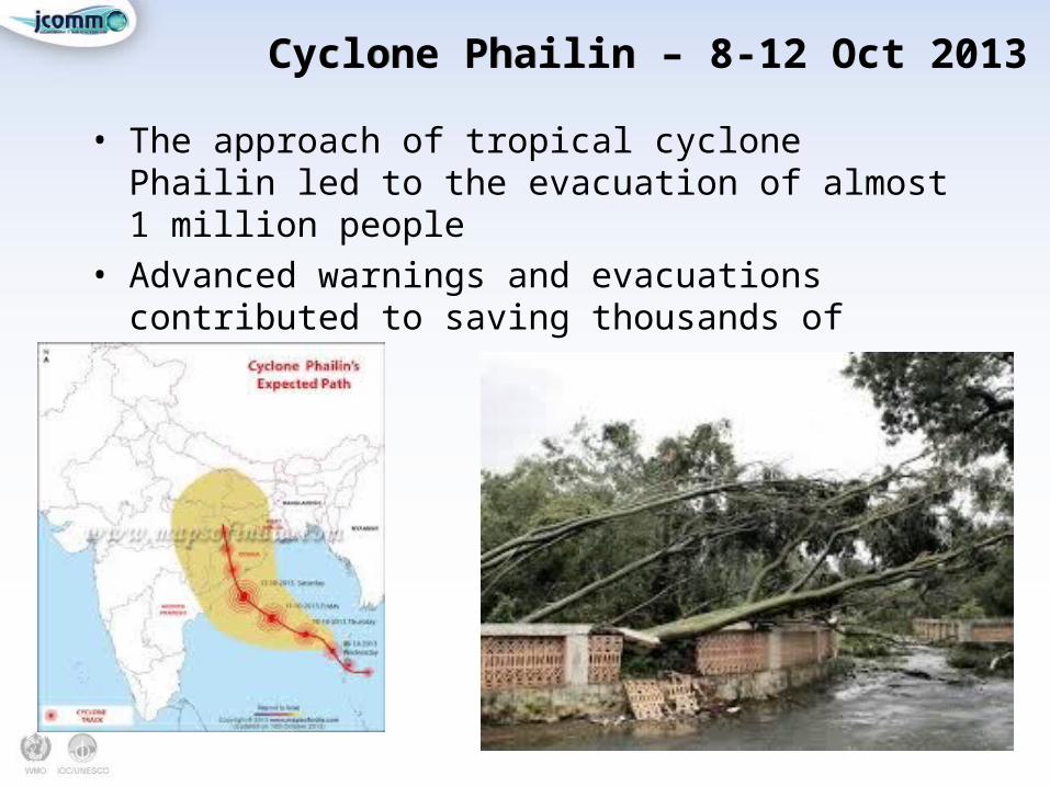
Cyclone Phailin – 8-12 Oct 2013Cyclone Phailin – 8-12 Oct 2013
• The approach of tropical cyclone Phailin led to the evacuation of almost 1 million people
• Advanced warnings and evacuations contributed to saving thousands of lives.
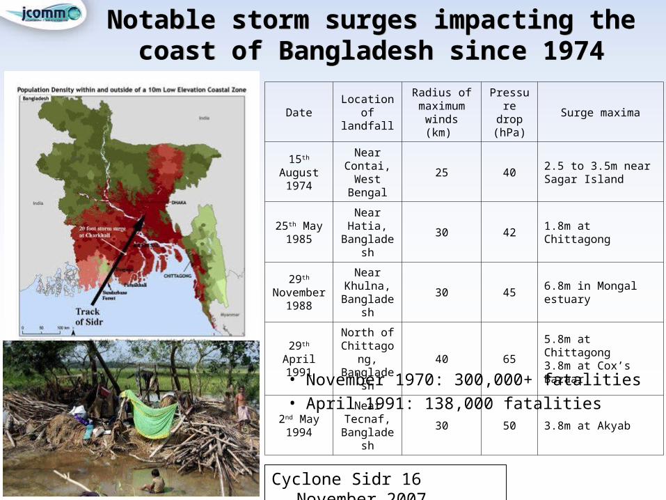
Notable storm surges impacting the coast of Bangladesh since 1974
Notable storm surges impacting the coast of Bangladesh since 1974
• November 1970: 300,000+ fatalities• April 1991: 138,000 fatalities
Cyclone Sidr 16 November 2007
DateLocation of
landfall
Radius of maximum
winds (km)
Pressure drop (hPa)
Surge maxima
15th August 1974
Near Contai, West
Bengal
25 402.5 to 3.5m near Sagar Island
25th May 1985
Near Hatia, Bangladesh
30 42 1.8m at Chittagong
29th November
1988
Near Khulna,
Bangladesh30 45 6.8m in Mongal estuary
29th April 1991
North of Chittagong, Bangladesh
40 655.8m at Chittagong 3.8m at Cox’s Bazaar.
2nd May 1994
Near Tecnaf,
Bangladesh30 50 3.8m at Akyab
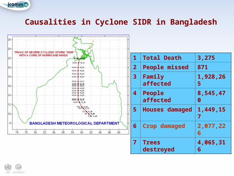
Causalities in Cyclone SIDR in Bangladesh
1 Total Death 3,275
2 People missed 871
3 Family affected 1,928,265
4 People affected 8,545,470
5 Houses damaged 1,449,157
6 Crop damaged 2,077,226
7 Trees destroyed 4,065,316
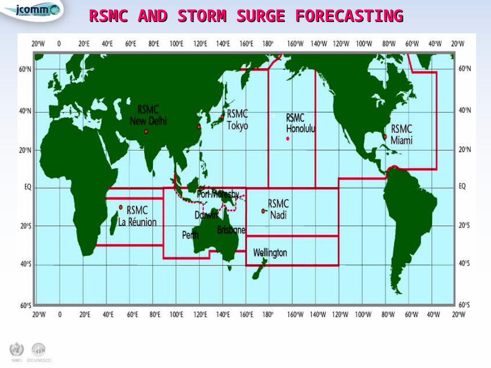
RSMC AND STORM SURGE FORECASTINGRSMC AND STORM SURGE FORECASTING
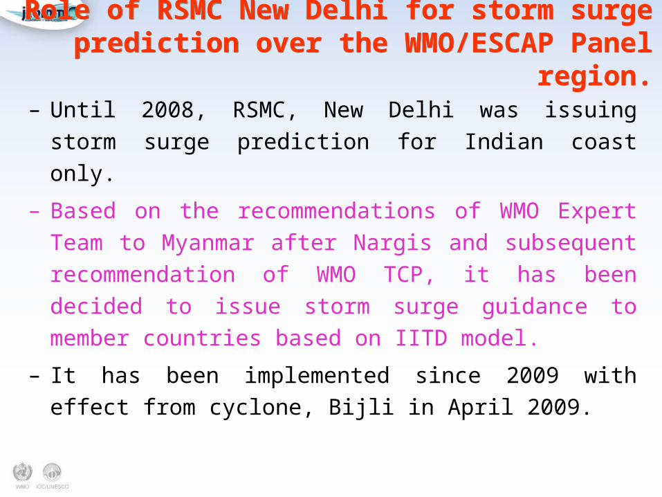
Role of RSMC New Delhi for storm surge prediction over the WMO/ESCAP Panel region.
Role of RSMC New Delhi for storm surge prediction over the WMO/ESCAP Panel region.
– Until 2008, RSMC, New Delhi was issuing storm surge
prediction for Indian coast only.
– Based on the recommendations of WMO Expert Team to
Myanmar after Nargis and subsequent recommendation of
WMO TCP, it has been decided to issue storm surge
guidance to member countries based on IITD model.
– It has been implemented since 2009 with effect from
cyclone, Bijli in April 2009.
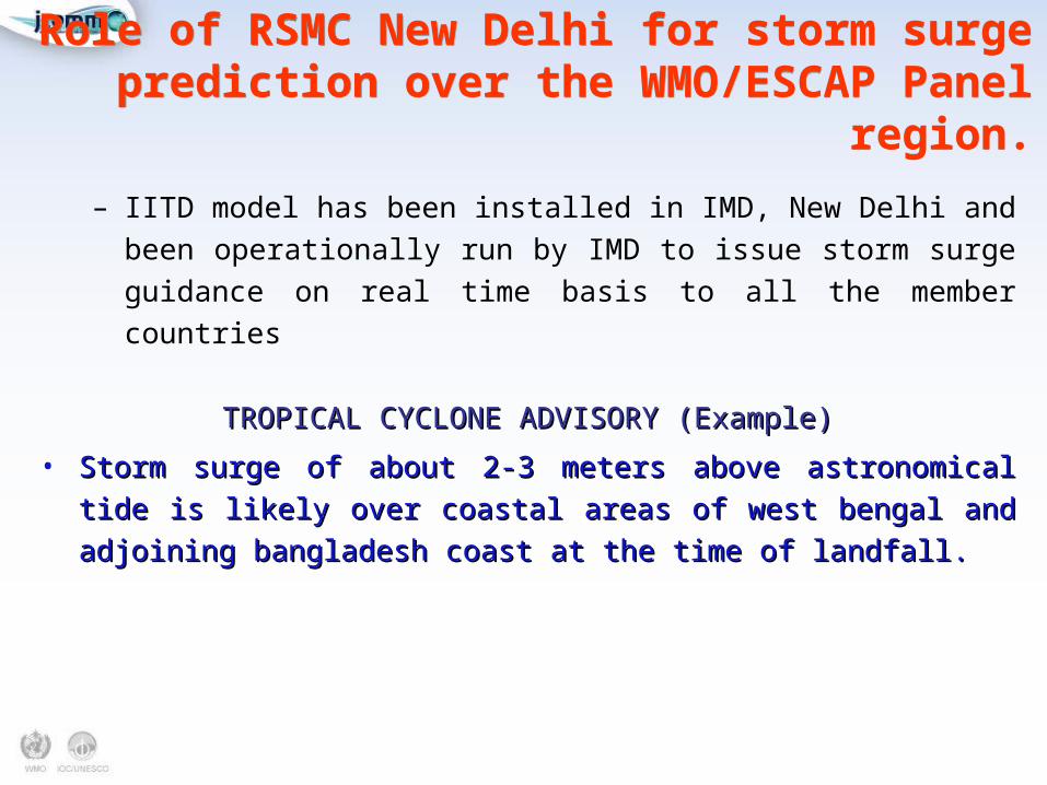
– IITD model has been installed in IMD, New Delhi and been
operationally run by IMD to issue storm surge guidance on real time
basis to all the member countries
TROPICAL CYCLONE ADVISORY (Example)TROPICAL CYCLONE ADVISORY (Example)
• Storm surge of about 2-3 meters above astronomical tide is likely over Storm surge of about 2-3 meters above astronomical tide is likely over
coastal areas of west bengal and adjoining bangladesh coast at the time coastal areas of west bengal and adjoining bangladesh coast at the time
of landfall.of landfall.
Role of RSMC New Delhi for storm surge prediction over the WMO/ESCAP Panel region.
Role of RSMC New Delhi for storm surge prediction over the WMO/ESCAP Panel region.
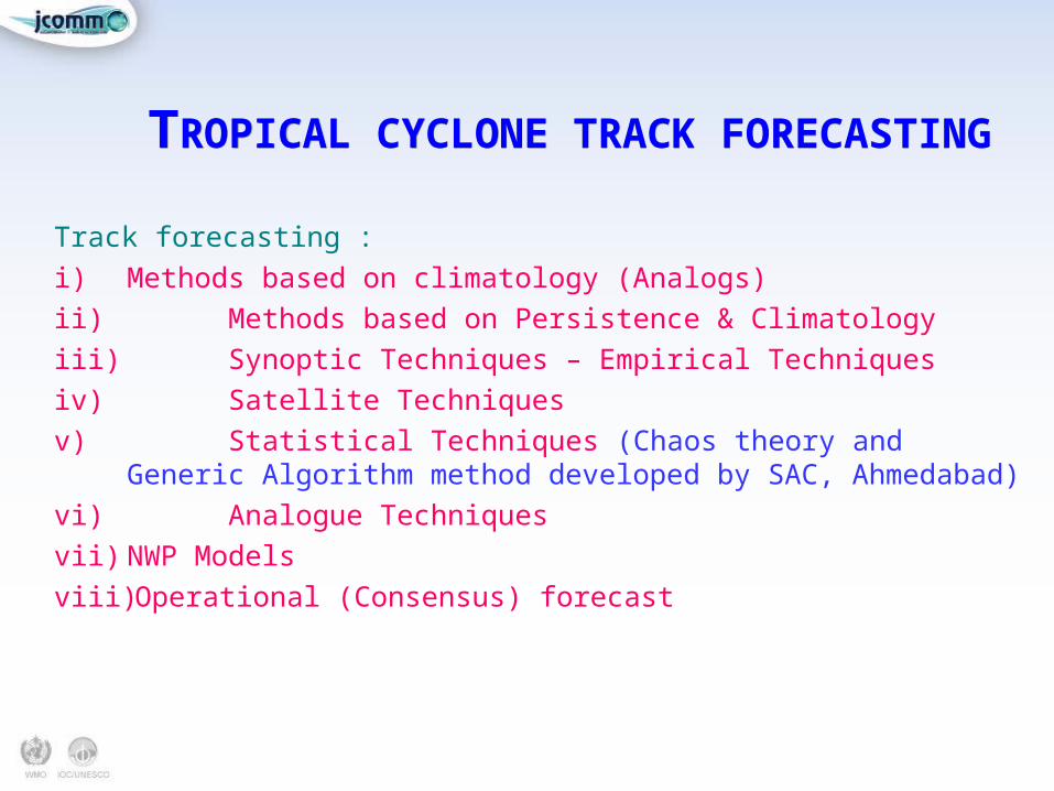
TROPICAL CYCLONE TRACK FORECASTINGTROPICAL CYCLONE TRACK FORECASTING
Track forecasting :
i) Methods based on climatology (Analogs)
ii) Methods based on Persistence & Climatology
iii) Synoptic Techniques – Empirical Techniques
iv) Satellite Techniques
v) Statistical Techniques (Chaos theory and Generic Algorithm method developed by SAC, Ahmedabad)
vi) Analogue Techniques
vii) NWP Models
viii) Operational (Consensus) forecast
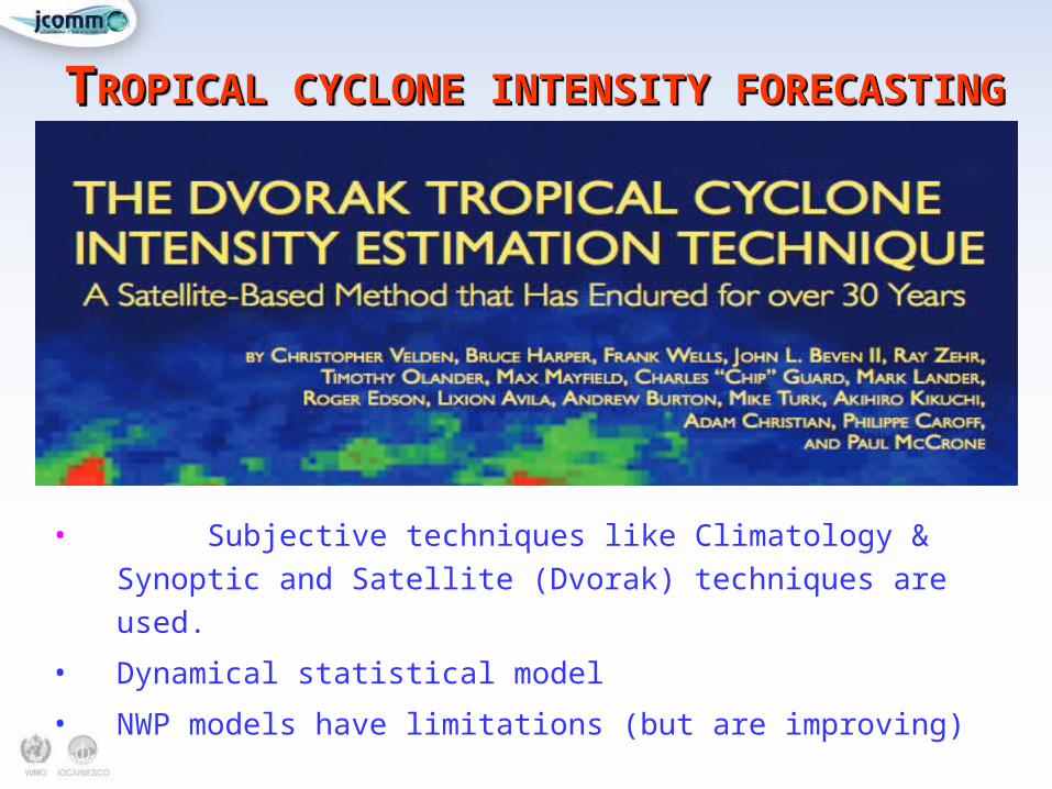
TTROPICAL CYCLONE INTENSITY FORECASTINGROPICAL CYCLONE INTENSITY FORECASTINGTTROPICAL CYCLONE INTENSITY FORECASTINGROPICAL CYCLONE INTENSITY FORECASTING
• Subjective techniques like Climatology & Synoptic
and Satellite (Dvorak) techniques are used.
• Dynamical statistical model
• NWP models have limitations (but are improving)
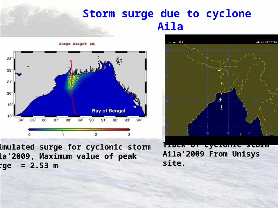
Simulated surge for cyclonic storm Aila’2009, Maximum value of peak surge = 2.53 m
Track of cyclonic storm Aila’2009 From Unisys site.
Storm surge due to cyclone Aila
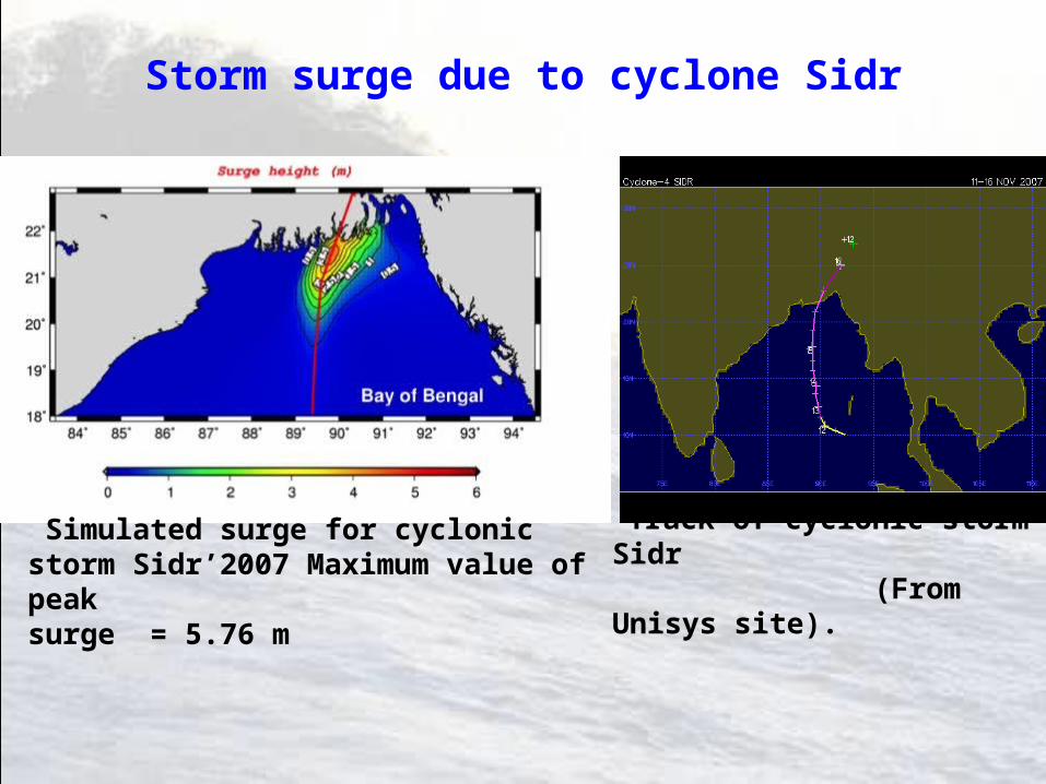
Simulated surge for cyclonic storm Sidr’2007 Maximum value of peak surge = 5.76 m
Track of cyclonic storm Sidr (From Unisys site).
Storm surge due to cyclone Sidr
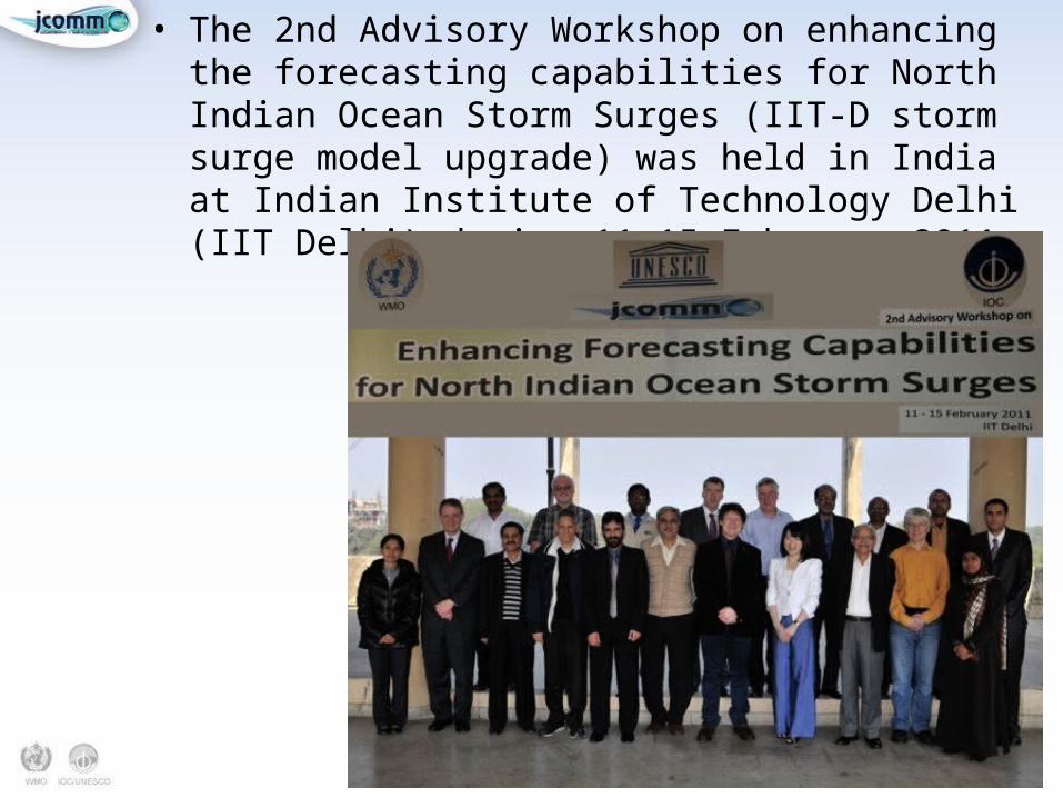
• The 2nd Advisory Workshop on enhancing the forecasting capabilities for North Indian Ocean Storm Surges (IIT-D storm surge model upgrade) was held in India at Indian Institute of Technology Delhi (IIT Delhi) during 11-15 February 2011.
• Reviewed current status/performance of operational storm surge forecasting model (IIT-D Model) in the North Indian Ocean (NIO) region, the mid-term plan on up-gradation of IIT-D storm surge model; and provided necessary scientific and technical advice.
• The IIT-Delhi working group demonstrated the enhanced model’s performance in hindcast/operational mode, the combined effect of the interaction of storm surge with tides and wind waves on sea level
• The workshop provided a forum for discussion on the regional development and applications of the upgraded IIT-D model, which would improve SS predictability in the NIO region
• The workshop also decided on the future course of action in view of collaborating and linking with related international programmes and projects, such as the JCOMM-CHy Coastal Inundation Forecast Demonstration Project (CIFDP) and the eSurge project funded by the European Space Agency (ESA). Linkages with other regional projects/programmes was also deliberated and finalized
Highlights and recommendationsHighlights and recommendations
• It was recommended that the tidal forcing at the open boundary should be provided as a time-dependent series of ocean tide constituents, so that the TWLE as a result of tide surge interaction may be operationalized in the region. In doing so, the Scientific Advisory Committee (SAC) advised that methodology for operation be worked out to eventually incorporate the effects of wave coupling
• The importance of collaborative efforts to complete the in-situ observational network in the NIO region by all countries was emphasized, and suggestions were made that the countries continue to extend the buoy and tide gauge networks for the area of interest. The workshop reemphasized its earlier recommendations to develop ensemble methods for track prediction.
Highlights and recommendationsHighlights and recommendations
• The development of CIFDP, jointly by the Joint WMO-IOC Technical Commission for Oceanography (JCOMM) and Marine Meteorology and the WMO Commission for Hydrology (CHy), was well noted and welcomed, particularly in view of the TWLE as final deliverable of a forecasting system. The participating experts welcomed the decision of the CIFDP to select the Bay of Bengal as the priority region for the project. It was advised that there should be a close linkage between this project (and following activities in the region) and CIFDP
Highlights and recommendationsHighlights and recommendations
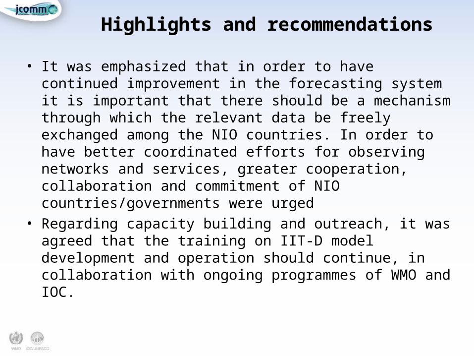
• It was emphasized that in order to have continued improvement in the forecasting system it is important that there should be a mechanism through which the relevant data be freely exchanged among the NIO countries. In order to have better coordinated efforts for observing networks and services, greater cooperation, collaboration and commitment of NIO countries/governments were urged
• Regarding capacity building and outreach, it was agreed that the training on IIT-D model development and operation should continue, in collaboration with ongoing programmes of WMO and IOC.
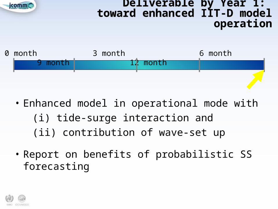
Deliverable by Year 1: toward enhanced IIT-D model operation
Deliverable by Year 1: toward enhanced IIT-D model operation
• Enhanced model in operational mode with
(i) tide-surge interaction and
(ii) contribution of wave-set up
• Report on benefits of probabilistic SS forecasting
0 month 3 month 6 month 9 month 12 month
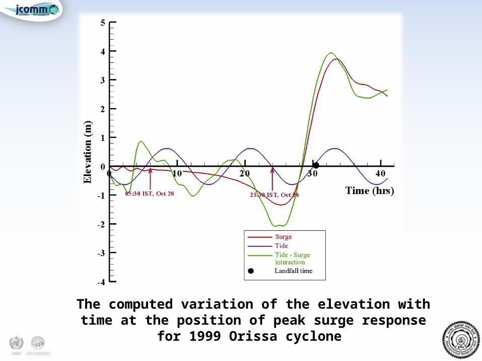
The computed variation of the elevation with time at the position of peak surge response for 1999 Orissa cyclone
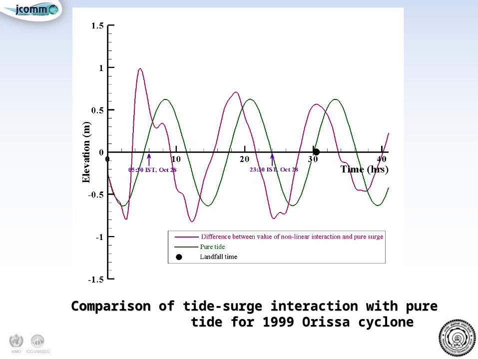
Comparison of tide-surge interaction with pure tide for 1999 Orissa cyclone
Comparison of tide-surge interaction with pure tide for 1999 Orissa cyclone
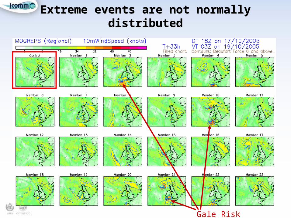
Extreme events are not normally distributed
Extreme events are not normally distributed
Gale Risk
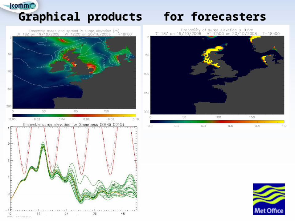
Graphical products for forecastersGraphical products for forecasters
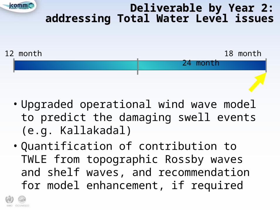
Deliverable by Year 2:addressing Total Water Level issues
Deliverable by Year 2:addressing Total Water Level issues
12 month 18 month 24 month
• Upgraded operational wind wave model to predict the damaging swell events (e.g. Kallakadal)
• Quantification of contribution to TWLE from topographic Rossby waves and shelf waves, and recommendation for model enhancement, if required
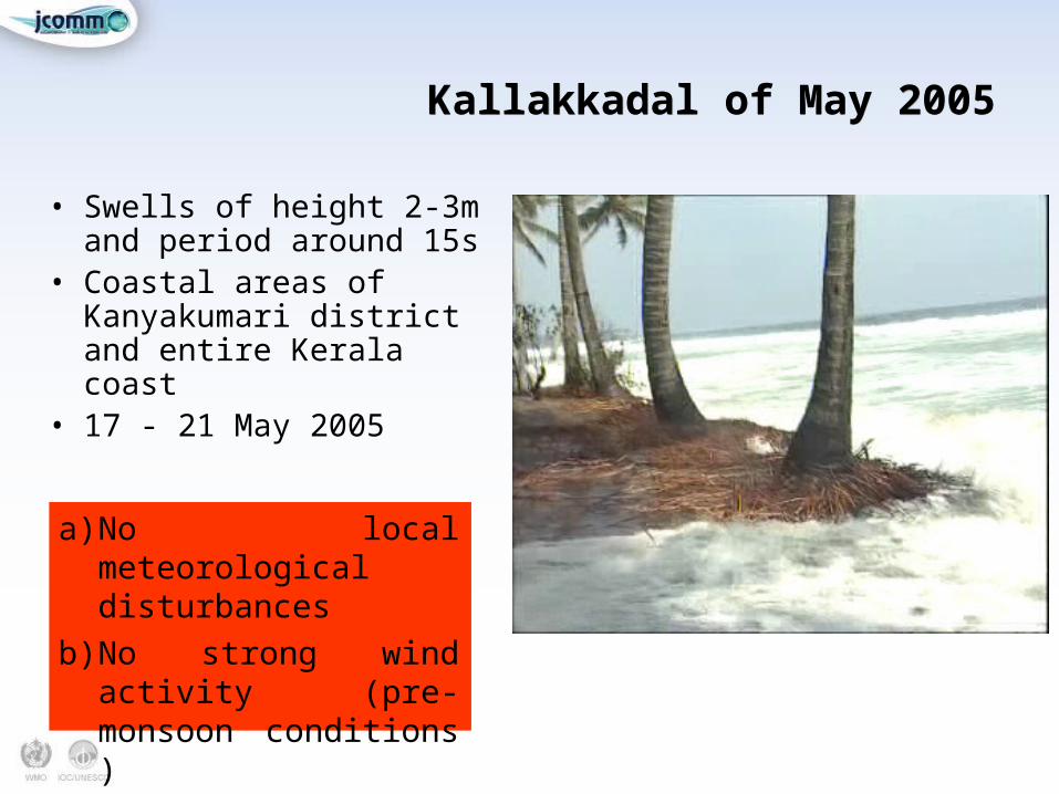
Kallakkadal of May 2005Kallakkadal of May 2005
• Swells of height 2-3m and period around 15s
• Coastal areas of Kanyakumari district and entire Kerala coast
• 17 - 21 May 2005
a) No local meteorological disturbances
b) No strong wind activity (pre-monsoon conditions )
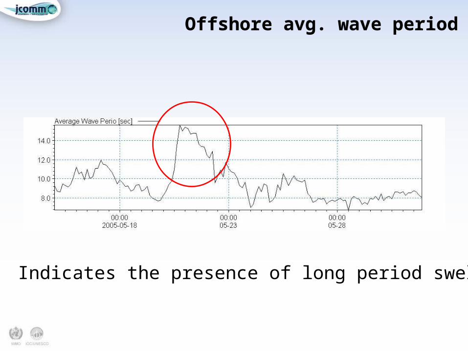
Offshore avg. wave periodOffshore avg. wave period
Indicates the presence of long period swells
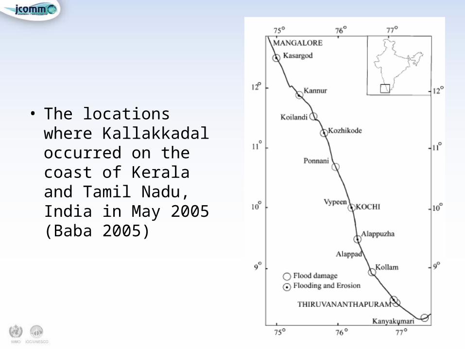
• The locations where Kallakkadal occurred on the coast of Kerala and Tamil Nadu, India in May 2005 (Baba 2005)
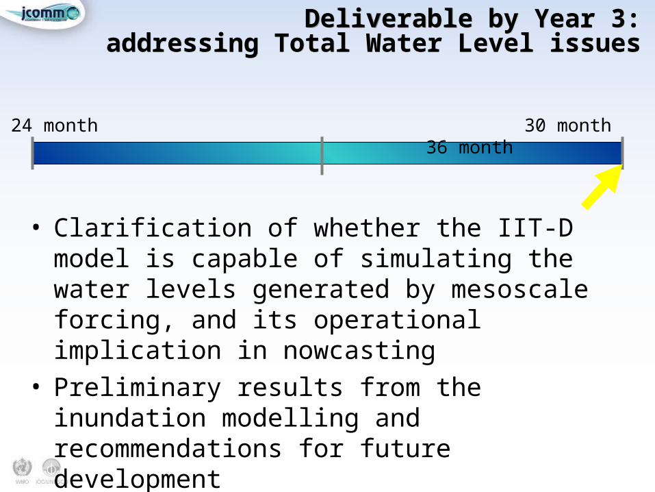
Deliverable by Year 3:addressing Total Water Level issues
Deliverable by Year 3:addressing Total Water Level issues
24 month 30 month 36 month
• Clarification of whether the IIT-D model is capable of simulating the water levels generated by mesoscale forcing, and its operational implication in nowcasting
• Preliminary results from the inundation modelling and recommendations for future development
ProgressProgress
• Many of the recommendations have been acted on. The key delivery partners held a “National Workshop on Storm Surge and Coastal Inundation Modeling over North Indian Ocean” on 11th February, 2013 at IMD, New Delhi
• Delegates included representatives from IIT- Delhi, National Centre for Medium Range Weather Forecasting (NCMRWF), Indian National Centre for Ocean Information Services (INCOIS), Integrated Coastal and Marine Area Management (ICMAM), Indian Air Force (IAF), Indian Navy, The Energy and Resources Institute (TERI), National Institute of Ocean Technology (NIOT) and IMD.
Outcome of the national workshopOutcome of the national workshop
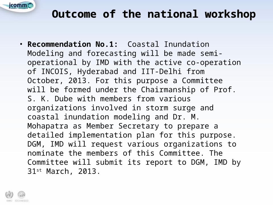
• Recommendation No.1: Coastal Inundation Modeling and forecasting will be made semi-operational by IMD with the active co-operation of INCOIS, Hyderabad and IIT-Delhi from October, 2013. For this purpose a Committee will be formed under the Chairmanship of Prof. S. K. Dube with members from various organizations involved in storm surge and coastal inundation modeling and Dr. M. Mohapatra as Member Secretary to prepare a detailed implementation plan for this purpose. DGM, IMD will request various organizations to nominate the members of this Committee. The Committee will submit its report to DGM, IMD by 31st March, 2013.
Outcome of the national workshopOutcome of the national workshop
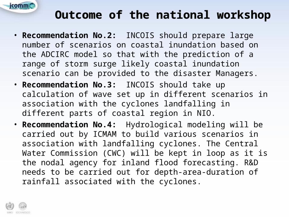
• Recommendation No.2: INCOIS should prepare large number of scenarios on coastal inundation based on the ADCIRC model so that with the prediction of a range of storm surge likely coastal inundation scenario can be provided to the disaster Managers.
• Recommendation No.3: INCOIS should take up calculation of wave set up in different scenarios in association with the cyclones landfalling in different parts of coastal region in NIO.
• Recommendation No.4: Hydrological modeling will be carried out by ICMAM to build various scenarios in association with landfalling cyclones. The Central Water Commission (CWC) will be kept in loop as it is the nodal agency for inland flood forecasting. R&D needs to be carried out for depth-area-duration of rainfall associated with the cyclones.
Outcome of the national workshopOutcome of the national workshop
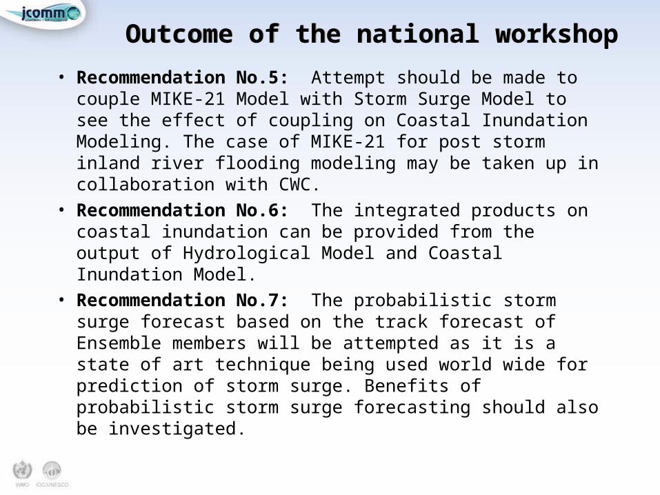
• Recommendation No.5: Attempt should be made to couple MIKE-21 Model with Storm Surge Model to see the effect of coupling on Coastal Inundation Modeling. The case of MIKE-21 for post storm inland river flooding modeling may be taken up in collaboration with CWC.
• Recommendation No.6: The integrated products on coastal inundation can be provided from the output of Hydrological Model and Coastal Inundation Model.
• Recommendation No.7: The probabilistic storm surge forecast based on the track forecast of Ensemble members will be attempted as it is a state of art technique being used world wide for prediction of storm surge. Benefits of probabilistic storm surge forecasting should also be investigated.
Outcome of the national workshopOutcome of the national workshop
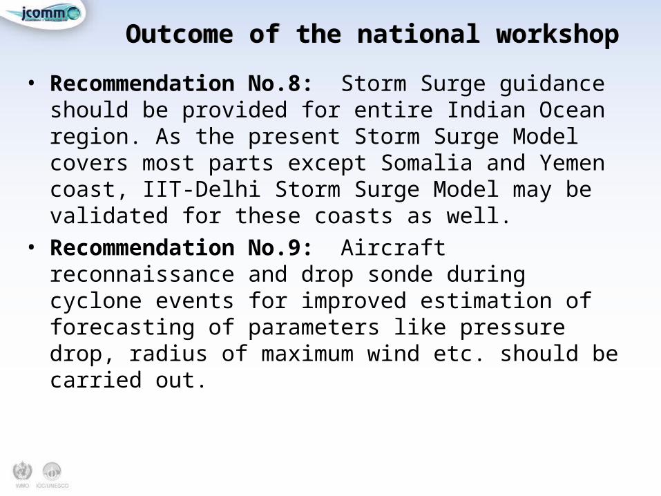
• Recommendation No.8: Storm Surge guidance should be provided for entire Indian Ocean region. As the present Storm Surge Model covers most parts except Somalia and Yemen coast, IIT-Delhi Storm Surge Model may be validated for these coasts as well.
• Recommendation No.9: Aircraft reconnaissance and drop sonde during cyclone events for improved estimation of forecasting of parameters like pressure drop, radius of maximum wind etc. should be carried out.
Outcome of the national workshopOutcome of the national workshop
• Recommendation No.10: For improvement in monitoring and forecasting of Meteorological inputs required for storm surge and coastal inundation modeling, IMD should take necessary steps for upgradation of coastal observational network (surface and upper air), DWR , use of various satellites like OSCAT-II, INSAT, Meghatropiques etc. for collection of ocean surface winds, SST, waves, sea surface height anomaly etc. NIOT should augment the buoy network (moored, drifting) which are very crucial for collecting observations for monitoring air pressure, wind waves and SST in the data sparse regions of North Indian Ocean.
Outcome of the national workshopOutcome of the national workshop
• Recommendation No.11: The surge-soft software should be applied to prepare the real time wind field and pressure field in association with the cyclone, based on the observations from satellite (OSCAT), RADAR, buoy, ships and coastal observations etc.
• Recommendation No.12: To improve the meteorological forecast, necessary steps should be taken for assimilation of remote sensing (Satellite and RADAR) and in-situ (coastal observations, buoy and ships) data.
• Recommendation No.15: Bathymetry with 100m horizontal resolution and 0.25m vertical depth with updates preferably every 5 years may be used based on a uniform source (say CARTOSAT). More frequent updates (say 3 years) in the river delta region such as Mahanadi, Hooghly, Krishna etc. should be planned for developing higher resolution models.
Outcome of the national workshopOutcome of the national workshop
• Recommendation No.19: For validation of coastal inundation forecasting, the satellite pictures before and after the storm may be collected by National Remote Sensing Centre (NRSC) which can provide supplementary information in addition to the ground observations through post storm survey.
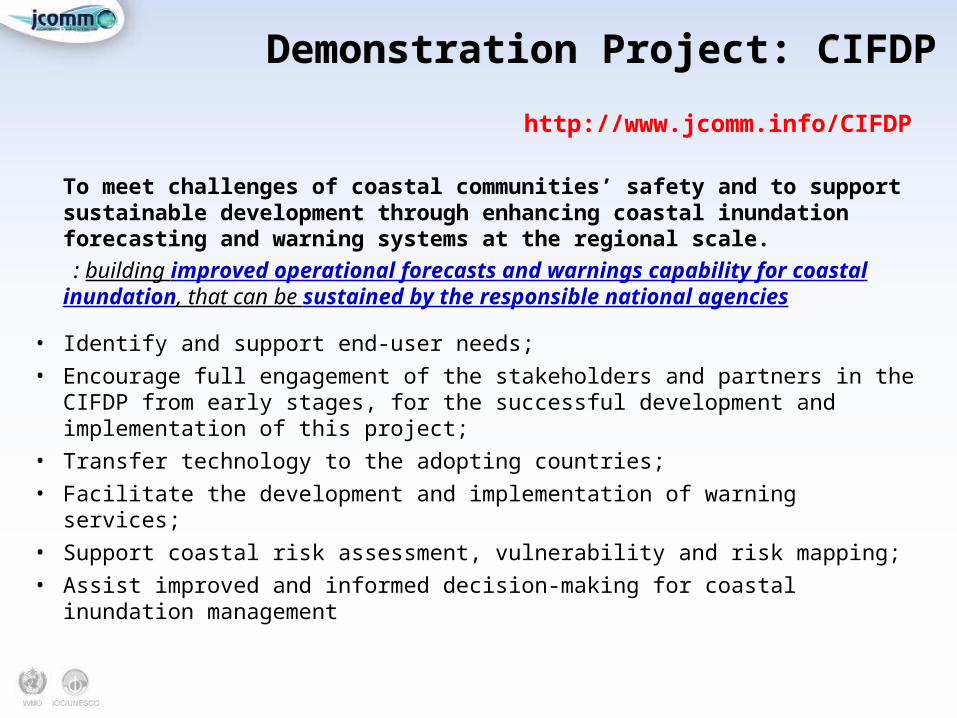
Demonstration Project: CIFDPDemonstration Project: CIFDP
To meet challenges of coastal communities’ safety and to support sustainable development through enhancing coastal inundation forecasting and warning systems at the regional scale.
: building improved operational forecasts and warnings capability for coastal inundation, that can be sustained by the responsible national agencies
• Identify and support end-user needs;• Encourage full engagement of the stakeholders and partners in the CIFDP from
early stages, for the successful development and implementation of this project;• Transfer technology to the adopting countries; • Facilitate the development and implementation of warning services;• Support coastal risk assessment, vulnerability and risk mapping;• Assist improved and informed decision-making for coastal inundation
management
http://www.jcomm.info/CIFDP
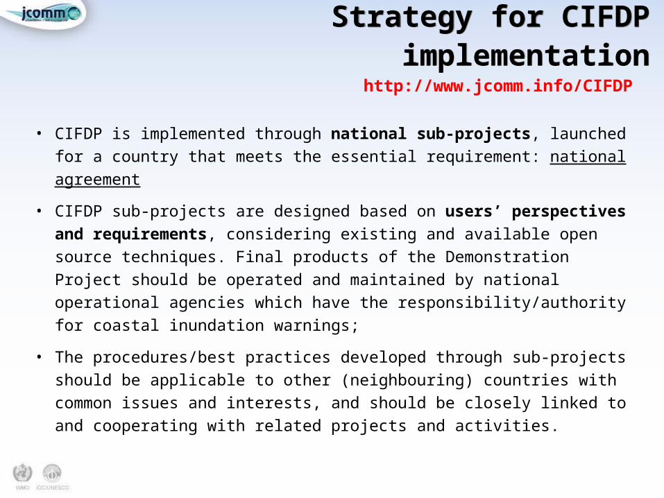
Strategy for CIFDP implementationStrategy for CIFDP implementation
• CIFDP is implemented through national sub-projects, launched for a country that meets the essential requirement: national agreement
• CIFDP sub-projects are designed based on users’ perspectives and requirements, considering existing and available open source techniques. Final products of the Demonstration Project should be operated and maintained by national operational agencies which have the responsibility/authority for coastal inundation warnings;
• The procedures/best practices developed through sub-projects should be applicable to other (neighbouring) countries with common issues and interests, and should be closely linked to and cooperating with related projects and activities.
http://www.jcomm.info/CIFDP
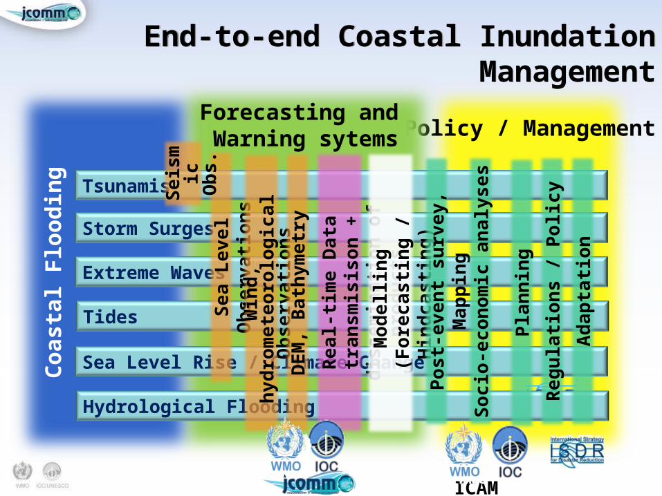
End-to-end Coastal Inundation ManagementEnd-to-end Coastal Inundation Management
Policy / ManagementForecasting and Warning sytems
Coas
tal F
lood
ing
Sea Level Rise / Climate Change
Tsunamis
Storm Surges
Extreme Waves
ICAM
Tides
Hydrological Flooding
Sea
Lev
el O
bse
rvat
ion
s
Sei
smi
c O
bs.
Win
d, h
ydro
met
eoro
logi
cal
Ob
serv
atio
ns
Rea
l-ti
me
Dat
a tr
ansm
isis
on +
d
isse
min
atio
n o
f p
rod
uct
s
Mod
ellin
g (F
orec
asti
ng
/ Hin
dca
stin
g)
DEM
, Bat
hym
etry
Pos
t-ev
ent
surv
ey, M
app
ing
Soc
io-e
con
omic
an
alys
es
Pla
nn
ing
Reg
ula
tion
s / P
olic
y
Ad
apta
tion
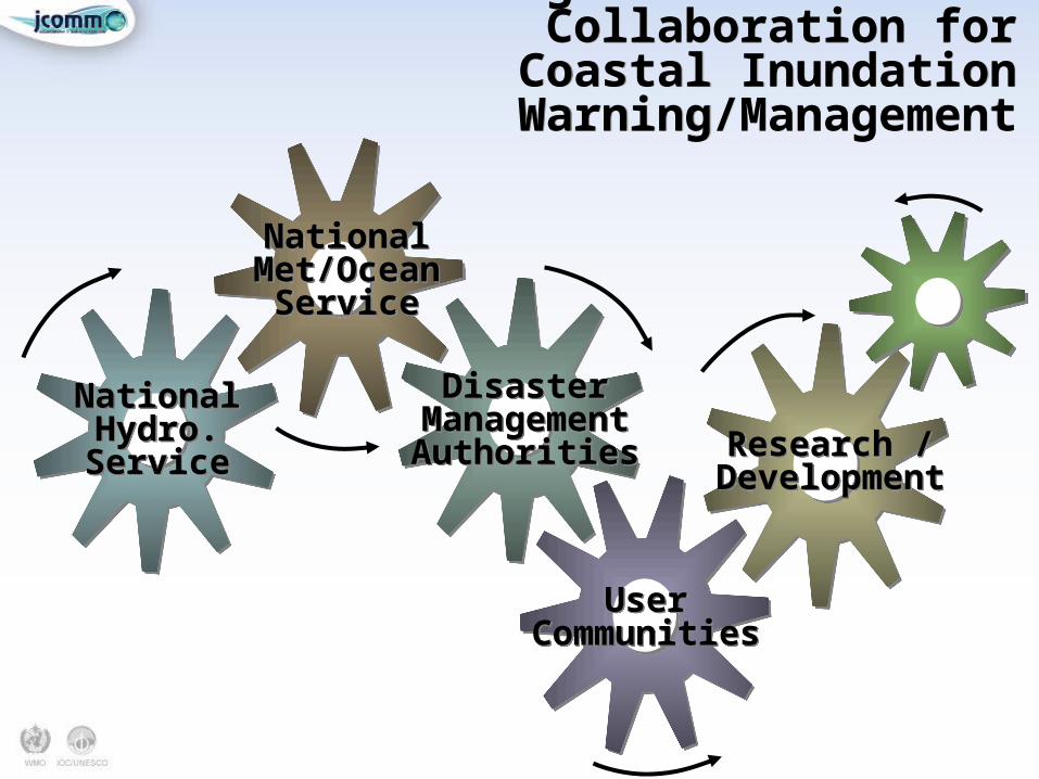
A Challenge: Institutional Collaboration for Coastal Inundation
Warning/Management
A Challenge: Institutional Collaboration for Coastal Inundation
Warning/Management
NationalHydro.Service
NationalHydro.Service
NationalMet/Ocean
Service
NationalMet/Ocean
Service
DisasterManagement
Authorities
DisasterManagement
Authorities
UserCommunities
UserCommunities
Research /Development
Research /Development
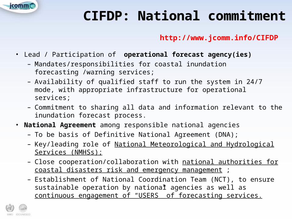
CIFDP: National commitmentCIFDP: National commitment
• Lead / Participation of operational forecast agency(ies)– Mandates/responsibilities for coastal inundation forecasting /warning services;– Availability of qualified staff to run the system in 24/7 mode, with appropriate
infrastructure for operational services;– Commitment to sharing all data and information relevant to the inundation
forecast process.• National Agreement among responsible national agencies
– To be basis of Definitive National Agreement (DNA);– Key/leading role of National Meteorological and Hydrological Services
(NMHSs);– Close cooperation/collaboration with national authorities for coastal disasters
risk and emergency management ;– Establishment of National Coordination Team (NCT), to ensure sustainable
operation by national agencies as well as continuous engagement of “USERS” of forecasting services.
http://www.jcomm.info/CIFDP

CIFDP ImplementationCIFDP Implementation
Natural Disaster Hotspots: A Global Risk Analysis. World Bank, 2005
http://www.jcomm.info/CIFDP
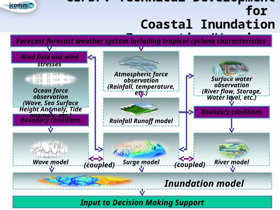
CIFDP: Technical Development for Coastal Inundation
Forecasting/Warning
CIFDP: Technical Development for Coastal Inundation
Forecasting/Warning Forecast forecast weather system including tropical cyclone characteristics
Wind field and wind stresses
Atmospheric force observation
(Rainfall, temperature, etc.)
Rainfall Runoff model
Wave model
River model
Surge model
Surface water observation(River flow, Storage,
Water level, etc.)
Boundary conditionsBoundary conditions
Ocean force observation(Wave, Sea Surface Height Anomaly, Tide anomaly,
etc.)
Inundation model
Input to Decision Making Support
(coupled) (coupled)
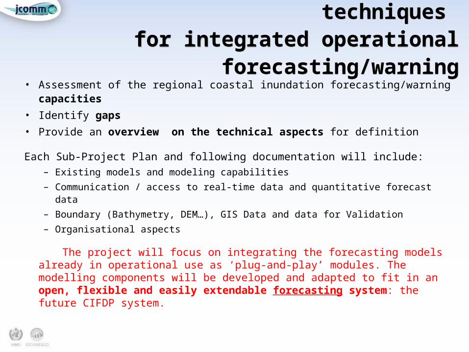
CIFDP: Applying available techniques for integrated operational
forecasting/warning
CIFDP: Applying available techniques for integrated operational
forecasting/warning• Assessment of the regional coastal inundation forecasting/warning capacities • Identify gaps • Provide an overview on the technical aspects for definition
Each Sub-Project Plan and following documentation will include:– Existing models and modeling capabilities– Communication / access to real-time data and quantitative forecast data– Boundary (Bathymetry, DEM…), GIS Data and data for Validation– Organisational aspects
The project will focus on integrating the forecasting models already in operational use as ‘plug-and-play’ modules. The modelling components will be developed and adapted to fit in an open, flexible and easily extendable forecasting system: the future CIFDP system.
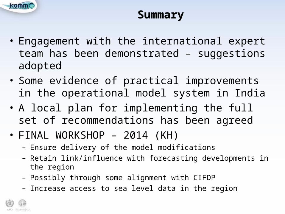
SummarySummary
• Engagement with the international expert team has been demonstrated – suggestions adopted
• Some evidence of practical improvements in the operational model system in India
• A local plan for implementing the full set of recommendations has been agreed
• FINAL WORKSHOP – 2014 (KH)– Ensure delivery of the model modifications
– Retain link/influence with forecasting developments in the region
– Possibly through some alignment with CIFDP
– Increase access to sea level data in the region


![English | 5211 · ACD[2.1E][DR] SYLLABUS Break-Up/Scheme of Studies Textbook: New Oxford Modern English - 5 Author: Nicholas Horsburgh/ Clair Horsburgh Publisher: Oxford University](https://static.fdocuments.us/doc/165x107/5fbcdc2eb84fd343031b7da7/english-acd21edr-syllabus-break-upscheme-of-studies-textbook-new-oxford.jpg)