ENHANCEMENT OF FLOOD HAZARD MAPS FOR NATIONAL … · enhancement of flood hazard maps for national...
14
ENHANCEMENT OF FLOOD HAZARD MAPS FOR NATIONAL FLOOD FORECASTING AND WARNING SYSTEM UNDER PROGRAM RAMALAN & AMARAN BANJIR (PRAB) BENGKEL KONSULTATIF PELAN SAINS, TEKNOLOGI, DAN INOVASI BAGI PENGURANGAN RISIKO BENCANA, DRR (STI4DDR) 24 JULAI 2017 KELAB GOLF DANAU, UKM BANGI, SELANGOR by; Ir. NORIZAN ABDUL AZIZ PUSAT RAMALAN DAN AMARAN BANJIR NEGARA BAHAGIAN PENGURUSAN SUMBER AIR DAN HIDROLOGI JABATAN PENGAIRAN DAN SALIRAN MALAYSIA
Transcript of ENHANCEMENT OF FLOOD HAZARD MAPS FOR NATIONAL … · enhancement of flood hazard maps for national...
ENHANCEMENT OF FLOOD HAZARD MAPS FOR
NATIONAL FLOOD FORECASTING AND
WARNING SYSTEM UNDER PROGRAM
RAMALAN & AMARAN BANJIR (PRAB)
BENGKEL KONSULTATIF PELAN SAINS, TEKNOLOGI, DAN INOVASI BAGI PENGURANGAN RISIKO BENCANA, DRR
(STI4DDR)
24 JULAI 2017
KELAB GOLF DANAU, UKM BANGI, SELANGOR
by;
Ir. NORIZAN ABDUL AZIZ
PUSAT RAMALAN DAN AMARAN BANJIR NEGARA
BAHAGIAN PENGURUSAN SUMBER AIR DAN HIDROLOGI
JABATAN PENGAIRAN DAN SALIRAN MALAYSIA

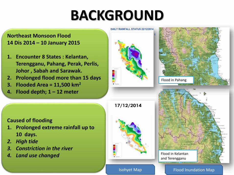
BACKGROUND
4
CORAK HUJAN – ISOHYET
14/12/2014 15/12/2014 16/12/2014 17/12/2014
18/12/2014 19/12/2014 20/12/2014 21/12/2014
Flood in Pahang
Flood in Kelantan and Terengganu
Northeast Monsoon Flood 14 Dis 2014 – 10 January 2015
1. Encounter 8 States : Kelantan, Terengganu, Pahang, Perak, Perlis, Johor , Sabah and Sarawak.
2. Prolonged flood more than 15 days3. Flooded Area = 11,500 km2
4. Flood depth; 1 – 12 meter
Caused of flooding1. Prolonged extreme rainfall up to
10 days.2. High tide3. Constriction in the river4. Land use changed
Isohyet Map Flood Inundation Map

6
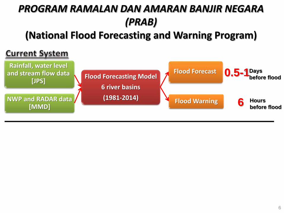
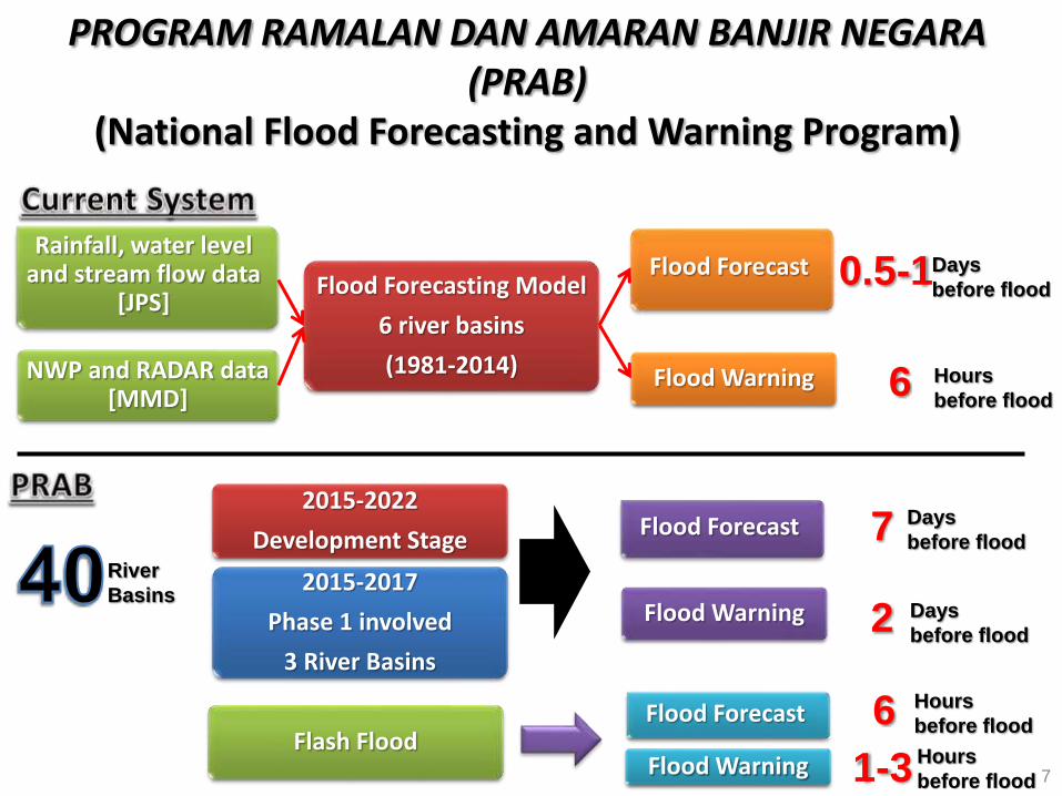
PROGRAM RAMALAN DAN AMARAN BANJIR NEGARA (PRAB)
(National Flood Forecasting and Warning Program)
Rainfall, water level and stream flow data
[JPS]
NWP and RADAR data [MMD]
Flood Forecasting Model
6 river basins
(1981-2014)
Flood Forecast
Flood Warning
0.5-1Days
before flood
6 Hours
before flood
7
PROGRAM RAMALAN DAN AMARAN BANJIR NEGARA (PRAB)
(National Flood Forecasting and Warning Program)
Rainfall, water level and stream flow data
[JPS]
NWP and RADAR data [MMD]
Flood Forecasting Model
6 river basins
(1981-2014)
Flood Forecast
Flood Warning
0.5-1Days
before flood
6 Hours
before flood
2015-2022
Development StageFlood Forecast
Flood Warning
7 Days
before flood
2 Days
before flood
River
Basins2015-2017
Phase 1 involved
3 River Basins
Flash FloodFlood Forecast
Flood Warning
6 Hours
before flood
1-3 Hours
before flood
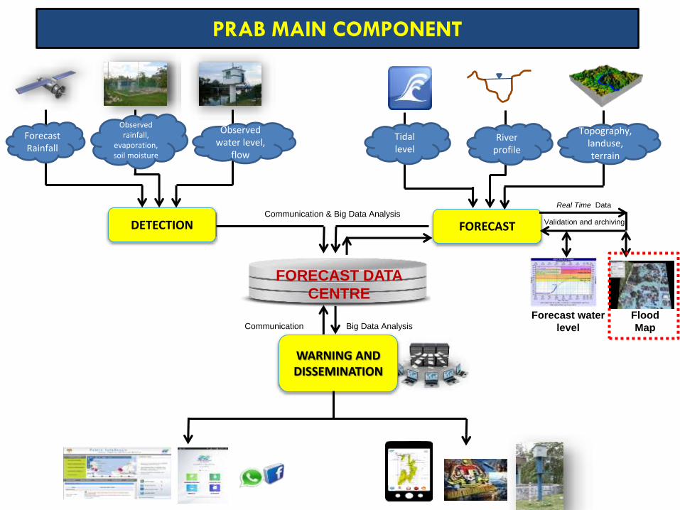
Forecast Rainfall
Observed rainfall,
evaporation, soil moisture
Observed water level,
flow
DETECTION
Flood
Map
Forecast water
level
Real Time Data
Topography, landuse, terrain
River profile
FORECAST Validation and archiving
Tidal level
WARNING AND DISSEMINATION
Communication Big Data Analysis
FORECAST DATA
CENTRE
Communication & Big Data Analysis
PRAB MAIN COMPONENT
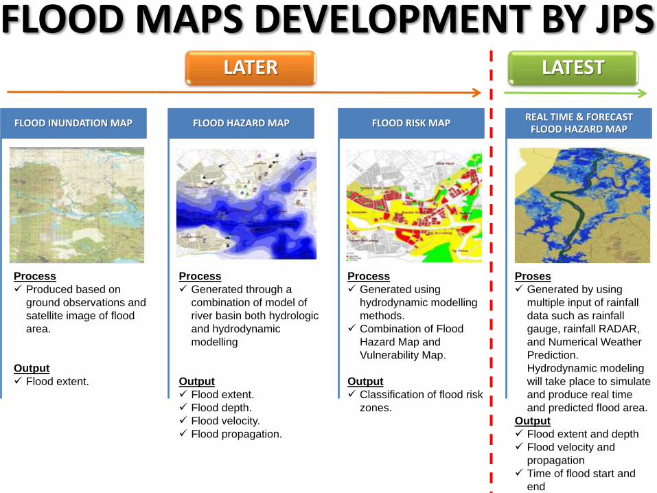
FLOOD MAPS DEVELOPMENT BY JPS
FLOOD INUNDATION MAP FLOOD HAZARD MAP FLOOD RISK MAPREAL TIME & FORECAST
FLOOD HAZARD MAP
Process
Produced based on
ground observations and
satellite image of flood
area.
Output
Flood extent.
Process
Generated through a
combination of model of
river basin both hydrologic
and hydrodynamic
modelling
Output
Flood extent.
Flood depth.
Flood velocity.
Flood propagation.
Process
Generated using
hydrodynamic modelling
methods.
Combination of Flood
Hazard Map and
Vulnerability Map.
Output
Classification of flood risk
zones.
Proses
Generated by using
multiple input of rainfall
data such as rainfall
gauge, rainfall RADAR,
and Numerical Weather
Prediction.
Hydrodynamic modeling
will take place to simulate
and produce real time
and predicted flood area.
Output
Flood extent and depth
Flood velocity and
propagation
Time of flood start and
end
LATER LATEST
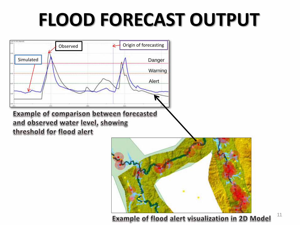
11
Danger
Warning
Alert
Origin of forecastingObserved
Simulated
FLOOD FORECAST OUTPUT
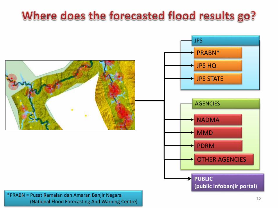
PRABN*
JPS HQ
JPS STATE
NADMA
JPS
AGENCIES
12
MMD
*PRABN = Pusat Ramalan dan Amaran Banjir Negara(National Flood Forecasting And Warning Centre)
PDRM
OTHER AGENCIES
PUBLIC (public infobanjir portal)
• The overall PRAB program aim to reduce the impact of floodhazard and provide enhancement disaster risk reductionthrough a forecast system which able to forecast monsoonflood 7 days earlier based on weather forecast data from theDepartment of Meteorology, Malaysia
• PRAB utilized science and technology application in floodforecasting to enable advance flood hazard warning toagencies and public.
• Real time flood hazard map will able provide advantages inidentification of priority area for evacuation and logisticmanagement.
13
CONCLUSION