
Engineers Australia response to the Review of … · of Environmental Factors for Newcastle Light...
19
Engineers Australia response to the Review of Environmental Factors for Newcastle Light Rail NSW Government Transport for NSW May 2016 Contact: Helen Link General Manager, Newcastle Division Engineers Australia [email protected] 02 4911 7318
Transcript of Engineers Australia response to the Review of … · of Environmental Factors for Newcastle Light...

Engineers Australia response to the Review of Environmental Factors for Newcastle
Light Rail NSW Government
Transport for NSW
May 2016
Contact: Helen Link General Manager, Newcastle Division Engineers Australia [email protected] 02 4911 7318


Engineers Australia 1
REF Submission for Light Rail in Newcastle
Executive Summary
Engineers Australia met with the Minister’s office in November 2015 to express our professional interest
in and concerns about the delivery of the Newcastle Light Rail project (the NLR) and the broader long
term transport planning for the Greater Newcastle area.
After reviewing the REF for the proposal we would like to discuss with you our significant concerns about
the risks that we see with the proposal as it currently stands. These risks are both time and cost driven
but also have implications for safety, efficiency and effectiveness of the NLR and the wider transport
system.
From our review of the REF we have concluded that the Proposal does not satisfy the key transport and
urban design objectives for which it has been planned, the Newcastle Urban Transformation and
Transport Program (NUTTP), that it fails to deliver an integrated transport system and that alternatives
are available which can meet these objectives and this integration.
Newcastle at present has very low public transport usage. This NLR project must be a strong positive
agent to reverse that and bring higher public transport usage for travel to and within the city centre. It
must also build stronger public transport usage within the inner and middle suburbs and to major travel
generators; the University campuses, the two main hospitals and the several major sporting arenas and
shopping centres.
Engineers Australia concludes that there are significant flaws in this proposal which will reduce public
transport usage and will inhibit growth of the CBD. The present proposal fails the objectives in significant
ways.
Construction issues:
Constructing the NLR outside the existing rail corridor in Hunter Street places significant time
and costs risks on the project because of unknown factors including underground services,
archaeology and mine issues.
Road (traffic) issues:
King Street east of Union Street, Honeysuckle Drive and Wharf Road will become congested
and adversely affect the very urban vibrancy and amenity the NUTTP is aiming to achieve.
Poor levels of service at key intersections within and around the area of modelling.
Hunter Street will be segregated by the NLR track, creating another divider across the CBD at
least as severe as the present Hunter Street and the previous rail track.
Road safety particularly for pedestrians and cyclists in Hunter Street, King Street and
Honeysuckle Drive.
Emergency services access along Hunter Street.
Loss of up to 350 on street parking spaces, loading zones and disabled parking.
Rail issues:
The single NLR track across Stewart Avenue will become a Tram and vehicle congestion point
resulting in delays to both NLR operations and will also add to delays and congestion on the
main inner city north-south road.
The REF does not address the issue of passenger demand analysis nor does it explain how
passengers will interchange from other modes (heavy rail, bus, taxi, bicycle etc) to the NLR.
Interchange delays caused by the forced need to transfer modes.
Lack of justification for segregated or mixed running in different sections of Hunter Street.
Planning issues
Lack of integrated landuse multi-modal transport network modelling, essential for significant
structural changes.
Engineers Australia 2
REF Submission for Light Rail in Newcastle
Lack of consideration for future network extensions; the long term viability of this project will
be at serious risk without future extensions.
Traffic shedding implications for the urban design of King Street & Hunter Street in the
Civic/Cultural Precinct (amenity, pedestrian and cycling safety, streetscape etc.).
Engineers Australia recommends that relatively straightforward changes to the proposal can make great
improvements in its effectiveness, and can turn around a negative flawed scheme to one which will go
towards meeting its objectives.
The NLR track should remain in the old rail corridor from Worth Place to beyond Darby Street and
potentially as far as the proposed Crown Street NLR stop. This would significantly reduce the
potential time and cost risks to the project.
The NLR track across Stewart Avenue should be double track into the rail terminus station which
should also consider dual platforms for the NLR as part of the extension plans for the system.
A strategic planning project using a land use / multi-modal transport model should be
commissioned urgently to study and plan all future road, bus and light rail services for the whole
city. This must consider land use, private and public transport (Train, NLR and bus) and freight
using integrated land use multi-modal transport network models.
Extensions to the NLR system must be planned urgently to ensure they can be accommodated through the new Train terminus station.
The final design should show how the project improves the transport system and, ultimately, the city
overall, including better travel times, less congestion and improved service levels. It should show how
the system integrates with other transport modes (Train, bus, ferry, cycles, pedestrian and road
vehicles). The key for all of this to function safely and effectively will be the integration of this project into
the broader transport system especially the Wickham and Store interchange. Transparent and open
planning for this needs to happen now.
The funds that have been allocated to this project provide an opportunity for very significant transport
improvements and urban revitalisation to Newcastle and the Hunter Region. There are risks with the
project, as outlined in these comments, and failure to apply rigorous and appropriate processes to
assessment and modification of the proposal will result in insufficient benefits from the investment and
possible failure of the project.
Engineers Australia looks forward to the opportunity to discuss our recommendations for improving this
project with the Minister for Transport.

Engineers Australia 3
REF Submission for Light Rail in Newcastle
Table of Contents
Introduction 4
Risks to the Project 5
Route Infrastructure Issues 5
Services 5
Infrastructure - Route Excavation 6
Conclusion on Construction Matters 6
Travel Analysis and NLR Passenger Facility 7
Impacts of Disruptions to NLR Schedules 8
Traffic Modeling and Traffic Analysis 8
Traffic modeling 8
Future traffic demand growth 10
Multi Modal Modeling 12
Provision for Cyclists 12
Issues not answered by the REF 12
Objectives of the NUTTP 13
Urban Design 14
Provision for Cyclists 14
Socio-economic impact 14
Conclusions 16
Questions and matters not addressed 16

Engineers Australia 4
REF Submission for Light Rail in Newcastle
Introduction
Engineers Australia (EA) is the peak body for the engineering profession in Australia. With over 105,000
members across Australia, it represents all disciplines and branches of engineering. Engineers Australia
is constituted by Royal Charter to advance the science and practice of engineering for the benefit of the
community.
Engineers Australia has examined the REF for the Proposed Newcastle Light Rail (NLR) and has
concluded that the Proposal does not satisfy the key transport and urban design objectives for which it
has been planned (the NTUPP), that it fails to deliver an integrated transport system and that
alternatives are available which can meet these objectives and this integration.
EA has come to this conclusion after a rigorous examination of the REF documents by a group
comprising professional engineers, urban design architects and transport economists all of whom have
many years of relevant experience and strong knowledge of the urban issues facing the City of
Newcastle.
There are major failures with the proposal detailed in this response and summarised below:
1. Very high risk to cost budget and timeline to bring to operation
2. Flawed travel analysis failing to recognise large travel delays to all existing bus and Train
passengers expected to use the NLR
3. Disruption to NLR scheduling resulting from incidents at Wickham Terminus, Worth Place and in
Scott Street
4. Flawed and inadequate traffic analysis not recognising severe traffic congestion around
Newcastle CBD
5. Loss of amenity in the significant main public places at Civic: the Cultural Precinct around and
south of Town Hall, the Legal/University precinct, and the Museum Precinct at Civic
6. Loss of an urban street spirit in Hunter Street from the traffic and NLR arrangements which will
encourage higher speeds and greater impacts on the pedestrian/shopping environment
7. Failure to allow for improved cycle access and in fact a reduction in cycle accessibility
8. Loss of parking and servicing spaces close to the commercial premises being accessed.
The principal findings we make directly related to this NLR REF are:
1. The Light Rail should remain within the rail corridor for the maximum length possible and at
minimum from Wickham to the proposed Crown Street stop.
2. Double tracks should be built across Stewart Avenue into the rail terminus area.
3. Future extensions of the Light Rail network west from Wickham must be planned immediately to
detailed concept to include space within the rail terminus area for future track extensions and
adequate Light Rail passenger areas.
4. The future Wickham transport interchange be planned now using all necessary land to provide for
safe, efficient and attractive transfer areas for passengers using all modes of travel (rail, light rail,
bus, coach, taxi) now and into the future.
The following is a list (not necessarily complete) of items that have not been fully addressed in the REF:
Project Benefit/Cost Analysis
Key Intersection deficiencies recognised and required upgrades planned and scheduled
Identification and Costing of Enabling Works
Detailed Traffic Model Assumptions and Outputs
Traffic Modelling Sensitivity Analysis
Bicycle Plan

Engineers Australia 5
REF Submission for Light Rail in Newcastle
The New City Centre Bus Plan
On-Street Parking Plan
Off-Street Parking Plan
Bus / Tram interchange arrangements at Wickham
Train / Tram interchange arrangements at Wickham
Regional Light Rail Plan extending to areas such as Charlestown, Rankin Park and Wallsend
Special Event People Movement Plan
Public Transport Incentives to increase patronage
Rail and Tram Fair Structure
Risks to the Project
Route Infrastructure Issues
Services
The installation of the light rail infrastructure including the track structure, will require the relocation and
or replacement of an unknown number of existing services. These will include gas, water, electricity,
sewer and stormwater, copper and possibly fibre-optic communications. These services belong to both
private and government organisations. They are the enabling works.
The location of services currently in the light rail route will impose a cost to the project if they have to be
relocated, replaced or enhanced. The location and identification of services (conduits in the act) in both
the street running section and the rail corridor section is required before a business case can be
established. The services include above rail level, below rail level and longitudinal services.
The routes as shown with the general arrangement cross sections in the REF do not show any services
or longitudinal conduits which are required for light rail operation (communications, power, etc). In many
light rail projects these will have extra capacity installed so they can be of substantial dimensions.
These new light rail conduits can come into conflict with existing underground services.
The REF does not indicate what is the time and cost, and what is the risk probability to the project
budget and time line for service relocations (“conduits”).
The Transport Administration Act 1988 SECT104U Pertaining to Light Rail says in part, ‘’that the TfNSW
may serve a written notice that an alteration is required to be made in the position of a conduit owned by
the person to facilitate the development of a light rail system.....notice must specify the work and must
include an undertaking by the owner or operator of the light rail to pay the reasonable cost of carrying
out the work”.
The Asset Standards Authority is compiling the light rail standards to be used in NSW. These standards
have not been released to date. Australian standard AS4799 (Installation Of Underground Utility
Services And Pipelines Within Railway Boundaries) may apply to this project. This standard for railway
tracks sets a distance of 1600mm below rail level for conduits etc. This would seem for a light rail
project a debateable number and it is thought that a risk based approach may be allowed by TfNSW
under some circumstances. The current rules applied to the Sydney light rail in George Street would be
a good guide but are not discussed within the REF.
The REF in section 15.10 Services and Utilities mentions the issue of service location but does not
indicate in the REF any risk to the project on this issue. The unknown here is the extent and what else
may be found when excavation is done.

Engineers Australia 6
REF Submission for Light Rail in Newcastle
The investigations for services management on other Light Rail Project in Australia has been examined.
There is reference from the Capital Metro (Canberra) project of a detailed service (utilities) location and
inspection regime (Appendix 2) and indicates a risk based approach may be applicable for some of the
services (Capital Metro tender documents). The Capital Metro Document, Construction and Utilities,
states:
‘‘… Capital Metro has undertaken an unprecedented level of investigations to establish the exact
location of buried utilities along the 12 kilometre route. Working with utility owners, Capital Metro
has conducted 1,312 pothole investigations, 432 hydraulic investigations and excavated
29 trenches along the alignment’’. There has not been such detailed investigation for Newcastle
NLR and risks of increase in construction time and cost are therefore high.
The Sydney Light Rail EIS Volume 1 Ch 5 states: “Transport for NSW has consulted with the major utility
providers during development of the conceptual design for the CSELR. Desktop investigations have
been undertaken including dial-before-you dig enquiries (for sections 5.2.11 and 10.8, Volume 1A of the
EIS). Field investigations to locate utilities are currently in progress to inform the detailed design.”
“Interface agreements would be negotiated with utility providers in relation to protection, relocation, or
upgrade of assets due to construction of the CSELR. Once finalised, these agreements would be
incorporated into the design and delivery of the CSELR proposal. Securing active cooperation from all
affected utility providers would help ensure relocation and/or protection of utilities can be designed,
agreed and constructed in an efficient manner, and ongoing maintenance and access arrangements can
be agreed for the construction and operation phases. These agreements would also clarify responsibility
for affected assets.”
Infrastructure - Route Excavation
The REF Section 7 Main Construction works details the expected excavation and possible fill. ”At this
stage of the design process, it is estimated that about 18,500 cubic metres of material would be
excavated during construction..”
The extent of service investigation requiring excavation (potholes, trenching etc) and then relocation
excavations for this work is not referenced in the REF. There is likely to be impacts of service relocation
on other environmental aspects of the REF including heritage, aboriginal and non aboriginal. The
installation of Light Rail Service conduits is likely to require much more excavation than suggested.
The REF section 7.2.2 Main Construction Works should reflect these issues: Construction Risks,
Services, who bears risk? Aboriginal and Colonial heritage are also at risk?.
Conclusion on Construction Matters
There is a high risk to the project budget and to project completion to the timeline as shown is section 7.
The extent of the service issue is unknown. The current acts and regulations are in place for enabling
works to be undertaken at TfNSW direction and there appears some scope for a risk based approach to
some of the enabling works.
The construction method outlined does not allow for excavation for services or installation of light rail
services.
The business case will require funding for the search and investigation of services in and around the
light rail path. The enabling works can then be costed for the business case.
The project timeline as shown in the REF Section 7 Construction of the Proposal will have to reflect the
enabling works schedule and emphasis should be put on a detailed service search and investigation so
as to minimise the risk to the project.
Engineers Australia 7
REF Submission for Light Rail in Newcastle
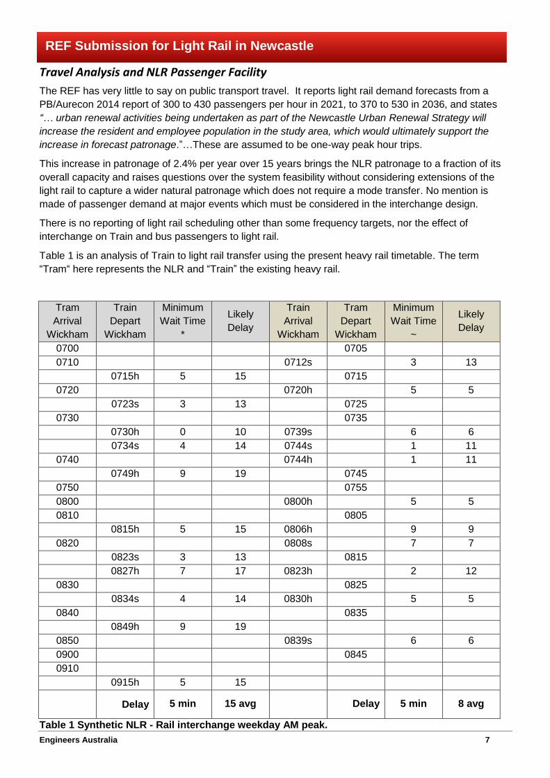
Travel Analysis and NLR Passenger Facility
The REF has very little to say on public transport travel. It reports light rail demand forecasts from a
PB/Aurecon 2014 report of 300 to 430 passengers per hour in 2021, to 370 to 530 in 2036, and states
“… urban renewal activities being undertaken as part of the Newcastle Urban Renewal Strategy will
increase the resident and employee population in the study area, which would ultimately support the
increase in forecast patronage.”…These are assumed to be one-way peak hour trips.
This increase in patronage of 2.4% per year over 15 years brings the NLR patronage to a fraction of its
overall capacity and raises questions over the system feasibility without considering extensions of the
light rail to capture a wider natural patronage which does not require a mode transfer. No mention is
made of passenger demand at major events which must be considered in the interchange design.
There is no reporting of light rail scheduling other than some frequency targets, nor the effect of
interchange on Train and bus passengers to light rail.
Table 1 is an analysis of Train to light rail transfer using the present heavy rail timetable. The term
“Tram“ here represents the NLR and “Train” the existing heavy rail.
Tram
Arrival
Wickham
Train
Depart
Wickham
Minimum
Wait Time
*
Likely
Delay
Train
Arrival
Wickham
Tram
Depart
Wickham
Minimum
Wait Time
~
Likely
Delay
0700
0705
0710
0712s
3 13
0715h 5 15
0715
0720
0720h
5 5
0723s 3 13
0725
0730
0735
0730h 0 10 0739s
6 6
0734s 4 14 0744s
1 11
0740
0744h
1 11
0749h 9 19
0745
0750
0755
0800
0800h
5 5
0810
0805
0815h 5 15 0806h
9 9
0820
0808s
7 7
0823s 3 13
0815
0827h 7 17 0823h
2 12
0830
0825
0834s 4 14 0830h
5 5
0840
0835
0849h 9 19
0850
0839s
6 6
0900
0845
0910
0915h 5 15
Delay 5 min 15 avg
Delay 5 min 8 avg
Table 1 Synthetic NLR - Rail interchange weekday AM peak.

Engineers Australia 8
REF Submission for Light Rail in Newcastle
Notes:
Train arrival and departure times were taken from the timetable at Hamilton plus or minus 2
minutes (h = Hunter line, s Sydney line).
The Tram is based on 10 minute intervals at peak time as given in the REF.
A significant number of passengers leaving the CBD will catch the earlier Tram to ensure that they
don't miss the Train. Average delay for passengers leaving the CBD could extend to 15 minutes.
Based on Surveys carried out at Hamilton Station passengers will require at least 4 minutes to
transfer from the Train to the Tram.
If the Tram runs to schedule it will be necessary for some passengers to wait for the next Tram.
Therefore average delay experienced by passengers transferring to the Tram is likely to be 8
minutes.
The main conclusions drawn from this are:
1. Delay for passengers out of the CBD (Tram to Train) is likely to be 15 minutes, and into the CBD
(Train to Tram) is likely to be 8 minutes, with minimum wait times of 5 minutes.
2. Stewart Avenue will be crossed every five minutes by a Tram, with consequential stopping of road
traffic. This frequency is necessary to maintain a 10 minute service headway and is enforced by
the single track access to Wickham Termimus station.
3. At times of unusual demand and into the long future with strong passenger growth, the crossing of
Stewart Avenue will become more frequent, with consequential impacts on road traffic.
An analysis of bus-NLR transfers needs to be included but cannot be quantified until a strategy and plan
for future bus routings and schedules is prepared. This should have been part of the REF as it is
intrinsic to the proposal.
Impacts of Disruptions to NLR Schedules
Light rail operations can be disrupted in several ways which are not addressed in the REF. These
include NLR vehicle breakdown on the track, road vehicle breakdown on the track through sections of
mixed running and passenger delays at the Wickham Terminus such as accident. The REF makes no
comment on how these may be ameliorated.
Clearly a major improvement will be achieved by placing the NLR tarck within the rail corridor for the
maximum distance, and by laying double tracks across Stewart Avenue into the terminus.
Traffic Modeling and Traffic Analysis
Traffic modeling
The area modeled is shown in Figure 8.1 of the REF reproduced below. This is the area that will be
directly affected by the proposed Light Rail service especially with the changes proposed for Hunter
Street. It has then been assumed that any reassignment of traffic flows will also occur within this
envelope. This is an erroneous assumption because the Newcastle road netwoork has complexity and
journeys are highly responsive to changes in conditions.
It is understood that detailed surveys were carried out on each of the major roads feeding into and out of
this cordon and it is assumed that this data was used to establish external to external and external to
internal trip patterns.
The REF acknowledges that the model was used to re-assign trips within this cordon. For example trips
were transferred from Hunter Street to King Street and Honeysuckle Drive. However, there is no
mention of any reassignment of trips outside the cordon. It is considered that the proposed restrictions
to traffic flow in Hunter Street to make way for the Light Rail service will result in significant changes to

Engineers Australia 9
REF Submission for Light Rail in Newcastle
the travel patterns to and from the CBD beyond the cordon area being modeled. These changes are
likely to see increased traffic flows on alternative routes serving the CBD including Union Street, Darby
Street, Watt Street and Scenic Drive. Failure to consider these broader network issues significantly
compromises the analysis carried out.
The only substantial output model data reported in the REF is the predicted link volumes on 30 road
sections within the study cordon. There will be changes, possibly highly significant on the road network
across the whole urban area.
The only consideration of north-south matters is through some SIDRA modelling. It is incomplete, and it
shows failures at key junctions with north south routes – Stewart Avenue and Union Street definitely with
LoS ‘F’ in 2028. Even the two dimensional aspects (i.e. transfer of traffic from Hunter to King and to
Honeysuckle/Wharf) are incomplete in their analysis and presentation. Traffic data on Honeysuckle East
and Wharf Road are missing completely.

Engineers Australia 10
REF Submission for Light Rail in Newcastle
Table 2 below provides an extract from Appendix C showing the predicted 2018 and 2028 traffic flows
without the proposal. This table shows that the predicted 2018 PM traffic flows are identical to the 2015
PM flows. It is not reasonable that these 2018 figures are correct because of the significance of these
roads serving the CBD.
These predicted traffic flows show that the REF assumes there will be less than 1% annual growth over
the next 12 years on both of these roads within the CBD. Recent independent surveys suggest that
2016 counts already exceed the predicted 2028 flows.
The conclusion from the above two paragraphs is that the REF underestimates road traffic into and
through the proposal study area, the service corridor for the NLR. Conclusions drawn in the REF on the
impacts of road traffic are therefore considered to be questionable and underestimate the traffic
interference to NLR operations.
2015 2015 2015 2018 2018 2018 2028 2028 2028
AM PM Daily AM PM Daily AM PM Daily
Stewart Ave
between Throsby
St & Honeysuckle
Drive Nb 1,500 1,620 19,001 1,500 1,620 18,997 1,531 1,667 19,472
Sb 1,659 1,598 17,389 1,700 1,598 17,607 1,708 1,631 17,829
Hunter St between
Wood St &
Stewart Ave Wb 365 482 4,659 372 482 4,698 388 542 5,114
Eb 795 635 7,863 828 635 8,047 915 645 8,579
Table 2: Predicted 2018 and 2028 Traffic Flows with out the Proposal for two key Links.
Future traffic demand growth
Section 4.3 of the REF summarises the sources of data used to forecast future traffic demand. It
appears that the data obtained from each of these sources had not been critically reviewed.
For example the REF states that … “BTS prepared the land use forecasts through the STM / PTPM
models and created the sub-area car travel demand matrices for the Newcastle city centre. This model
includes the change in mode share and patronage as a result of the proposal.” The REF does not state
what these predicted mode share and patronage changes are nor does it give any justification for the
changes.
The REF goes on to acknowledge that … “The growth attributed to the city centre was provided by
UrbanGrowth NSW.” Again these predictions are not documented nor justified.
Accordingly it appears that the modelling completed for the assessment of the proposal is based on
inputs and assumptions that have been prepared in isolation.
When modeling the future demand on the transport network for such a major infrastructure change as
this NLR proposal, sensitivty testing of the assumptions used in the model is required to provide
confidence in the model predictions. No sensitivity testing is reported and presumably none was done.

Engineers Australia 11
REF Submission for Light Rail in Newcastle
The forecast traffic demand reported in Table 4.7 of the REF shows that the modeling of the AM peak
period is based on very low growth in traffic demand to the CBD. Table 3 below provides further
assessment of the data from Table 4-7 of the REF.
Year
AM Peak Hr
8:00 – 9:00
Predicted
Demand
AM
Increased
Demand
AM
%
change
PM Peak Hr
5:00 – 6:00
Predicted
Demand
PM
Increased
Demand
PM
%
change
2015 17990 18960
460 0.85% 560 0.98%
2018 18450 19520
1360 0.74% 1260 0.65%
2028 19810 20780
1820 0.78% 1820 0.74%
Table 3: Predicted 2018 and 2028 Traffic Demand within the Study Area.
Note: PM peak future traffic demands were synthesised by transposing the growth of car demands in the
AM peak period and superimposing into the existing PM peak period matrices.
The note under Table 4-7 in the REF confirms that the network has been tested only for the AM Peak.
The PM Peak is simply a synthesized version of the AM Peak. This is an inadequate technique for the
assessment of such a major structural change to the network
These numbers show that the modeled forecast traffic demand within the study area will be less than 1%
linear over the next 12 years in both morning and evening peak periods. These are very low growth
forecasts for an area which is planned to have a large growth in residential accommodation and jobs and
with assoociated increases in commercial and retail activity. Even with these low predicted growth
factors the model predicts that several of the key intersection will fail or be at capacity in 2028.
The performance of other important intersections such as Workshop Way/Merewether Street and Darby
Street/Queen Street are not reported.
The REF only presents overall intersection LOS as a measure of intersection performance. Average
Delays and Queue Lengths are also important parameters for assessing intersection performance not
just for the intersection but for individual approaches.
These queues and delays also need to be fed back into the micro-simulation model to properly consider
the performance of the network and in particular the impact on Bus and Tram services.
In summary there are three road corridors serving the CBD; Honeysuckle Drive / Workshop Way / Wharf
Road, Hunter Street and King Street and all three interact. Traffic changes on one will impact on the
others. Earlier studies (the Honeysuckle Transport studies etc.) considered all three corridors with 10
lanes in total west of Union Street. The conclusions then were that this could be reduced to 8 lanes and
still have enough capacity, a conclusion which led to the development of Workshop Way as a means of
reducing the capacity through the Honeysuckle precinct. It also acknowledged the capacity constraint in
King Street at City Hall/Civic Park to meet precinct amenity objectives.
The above required that Hunter Street remains as a key road corridor and retained its 4 lane capacity.

Engineers Australia 12
REF Submission for Light Rail in Newcastle
The fact that the REF road modeling does not allow review of this interaction is one of the key
shortcomings in the work.
Multi Modal Modeling
The REF does not refer to the use of any multi modal transport modeling tools to assess the
performance of the proposed facilities. If they were used they do not report any of the outputs of this
modeling.
Full network modelling with true network comparisons in terms of VKT, VHT would demonstrate
technically the traffic impacts of the proposal. Such reporting based on scientific modelling is a minimum
requirement for such a significant and costly proposal as the Newcastle NLR.
Section 4.3 of the REF includes the following statement “This model includes the change in mode share
and patronage as a result of the proposal.”
The REF fails to provide any evidence that a major shift to public transport will be achieved. The
predicted increased travel times and the likely removal of the Fare Free Zone cannot be seen as
incentives. The only strategy likely to increase public transport patronage is the proposed removal of on-
street parking spaces.
The REF clearly identifies that there will be a new City Centre Bus Plan with buses continuing to run
down Hunter Street. However major stops at Civic, Market Street and Watt Street will be removed. The
capacity of this Bus Plan to service the requirements of existing and projected passenger numbers is not
reported.
The modelling tools used are inadequate and don’t address some of the key network issues associated
with travel to and from the CBD. The Paramics Model is not a land use model and it is dependant on
adjustments that have to be coded in by the Modeller. This process of adjustment is contrived and
results in a model which is of limited value as a tool to predict future travel patterns, and is thus unable to
estimate changes which will occur following the land use and transport system changes as substantial
as those proposed for Newcastle.
Provision for Cyclists
Cycle travel is formally accepted as part of the road transport system and is supported by State and
Newcastle City policies to enable cycling to take a greater share of the trasnport task and is implicit
within the NUTTP.
The REF lists roads on which cycle paths and lanes are available, and some cycle/pedestrian crossing
places. It makes no comment on how cycle travel will be impacted by the proposal and its traffic
arrangements.
There is no bicycle plan within the REF which will encourage cycle travel and the motor traffic proposal
will make cycling more hazardous, reducing cycle use and possibly increasing cycle incidents (injury and
death).
In this aspect the REF demonstrates that the proposal fails the objectives of the NUTTP.
Issues not answered by the REF
1. Are the population and employment predictions used to derive future traffic demand valid? There
is no statement of nor any justification for these very significant assumptions in the REF.
2. Section 4.3 includes the statement “The growth attributed to the urban renewal projects in the city
centre was provided by UrbanGrowth NSW. The proposed urban development is likely to be
primarily residential that would not attract high private vehicle growth.” This statement includes no
quantification and no risk analysis to test alternative futures.

Engineers Australia 13
REF Submission for Light Rail in Newcastle
3. How will approvals for the proposed residential developments within the CBD be managed if on-
site parking is not provided? This is a significant assumption and needs to be addressed in the
REF.
4. What is the overall efficiency of the road network? It is standard requirement that this be reported
in any traffic study but no reference is made in the REF.
5. There is no parking plan and an ambiguous Bus Plan.
6. The exceptionally low growth in traffic demand included in the model.
7. Recent traffic surveys at Hunter St and Stewart Ave show higher traffic flows than the model
predicts for 2028.
8. The REF states that UrbanGrowth land use predictions are mainly for residential units which will
have low private car use yet the LEP is for an additional 10,000 work places.
9. The reporting of network performance is selective with only 11 key intersections reported. Other
key intersections such as Parry St/Stewart Ave, Darby St/Queen St and Merewether St/Workshop
Way were excluded.
The REF states, in part … “Traffic modelling indicated that most intersections would perform
satisfactorily in the year of opening. A 10 year future traffic scenario was also modelled, with the results
showing that traffic conditions in 2028 would be mostly influenced by other developments and
associated traffic generation, and not the proposal. With the proposal operational, the road network
would generally operate at a satisfactory level, with only two intersections experiencing potential issues
– the intersections of King Street/Union Street and Honeysuckle Drive/Hannell Street in the PM peak
period. The intersection of Honeysuckle Drive and Hannell Street currently performs at a similar level of
service without light rail due to issues currently experienced at this intersection.”
This review does not accept this claim and has demonstrated that the road network providing access
into the CBD will suffer high congestion resulting in re-distribution of trips to other destinations over time.
This review indicates that the objectives of the NTTUP will be severely compromised by the proposed
light rail and road traffic arrangemnts in this REF.
Objectives of the NUTTP
The objectives of the NUTTP listed in section 1.1. are, in part:
The NUTTP is an integrated development and transport plan that comprises a number of urban redevelopment /
renewal projects supported by a transport program of works. The transport program seeks to revitalise Newcastle
by improving pedestrian and vehicle connectivity within the CBD and by promoting public transport usage and
accessibility. The key public transport components of the NUTTP are:
Truncating and removing the existing Newcastle heavy rail branch line from Newcastle to Wickham.
Constructing the new transport interchange west of Stewart Avenue at Wickham to facilitate the movement
of people between transport modes including heavy rail, light rail, buses and taxis.
Delivery of a new light rail system from Wickham to Newcastle.
Investigating the potential to extend the light rail network in Newcastle.
The transport components of the NUTTP are an important part of the wider renewal of the Newcastle city centre.
The transport projects aim to reconnect the Newcastle CBD to its waterfront and make it easier to move around the
city centre. The transport projects will drive the economic growth and renewal of Newcastle as part of an integrated
land use and transport strategy.
These objectives are stated in full because the analysis of travel and traffic carried out by Engineers
Australia has demonstrated that they are not met by the proposal.

Engineers Australia 14
REF Submission for Light Rail in Newcastle
Urban Design
Loss of urban street amenity
Newcastle is set on a peninsula with three main traffic service arteries. Hunter Street and King Street run
the full length of the city and Honeysuckle Drive along part of the length of the city. Other major roads
such as Stewart Avenue, Union Street and Darby Street also have significant roles in providing access
to the City. If the light rail is to run down Hunter Street rather than the rail corridor there will be a
shedding of traffic, not only, into King Street but also Honeysuckle Drive and other major access roads
with their own problems of congestion.
The loss of car parking and the change to traffic flow will result in reduced traffic calming, bringing with it
increased traffic speed, increased vehicle impact on footpaths and difficulties for emergency vehicles to
gain access in the case of an accident, especially mid block.
Hunter Street is a long transport corridor which will be radically changed by the NLR proposal between
Worth Place and Scott Street. It will carry one lane of through traffic in each direction, two NLR lanes,
no specific provision for cyclists and no kerbside parking or commercial servicing. Concentration of
vehicle traffic into one lane adjacent to the kerb will create a traffic route, inimical to pedestrians on the
footpath and to shop and business activity along the frontage. It will not be a “people street” any more
than it is now.
The resulting transport corridor with this proposal will create a psychological barrier across the CBD no
more penetrable than the existing street. It will inhibit pedestrian crossing and concentrate it at
designated crossing points. Though this is a safety advantage for pedestrians, of itself it does not add to
north-south connectivity any more than just putting the crossings in with present kerbside uses in place.
The proposal will impose clearway conditions in King Street between Auckland Street and Darby Street.
This is the principle cultural and civic square of the city, and will be bisected by a new main traffic route.
There will be considerable loss of amenty resulting from this traffic change.
Loss of Servicing and Parking Amenity
Loss of parking and commercial servicing described in the REF will reduce amenity to parts of the CBD.
This is contrary to the stated objectives and is a significant negative of the proposal.
Provision for Cyclists
The REF lists roads on which cycle paths and lanes are available, and some cycle/pedestrian crossing
places. It makes no comment on how cycle travel will be impacted by the proposal and its traffic
arrangements.
There is no bicycle plan which will encourage cycle travel and the motor traffic proposal will make cycling
more hazardous, reducing cycle use and possibly increasing cycle incidents (injury and death).
In this aspect the REF demonstartes that the proposal fails the objectives of the NUTTP.
Socio-economic impact
The socio-economic impact study (Technical Appendix 5) applies no recognised transport methodology.
It is neither a cost-benefit study, nor a business case. At best it is a list of impacts with brief and casual
notes. In the absence of either a cost-benefit study or a business case, the expenditure of public money
on light rail has not yet been justified.
The baseline for comparison is not specified. Because the starting point is the Newcastle Urban
Renewal Strategy 2012 and the government’s total program expenditure of $510 million, the baseline
Engineers Australia 15
REF Submission for Light Rail in Newcastle
should be the service level for heavy rail prior to truncation. Nowhere is this mentioned. Implicitly the
baseline is the status quo but using buses from Wickham instead of Hamilton.
‘Potential impacts’ are listed in Table 5.3 with positive or negative impact rates as ‘minor’ or ‘moderate’.
Nothing is quantified and nothing is weighted.
From a user viewpoint the REF says little about the crucial issues of extra travel time and extra fares. On
p.18 of TA5 is a statement that light rail between Wickham and Newcastle Station will take about 3
minutes longer than the present rail shuttle bus. This is not explained but presumably is because the
light rail will have more stops.
Transit time of 12 minutes plus 8 to 15 minutes waiting time (into CBD and out of CBD respectively at
AM peak – Table 1) adds up to 20 to 27 minutes (REF 4.2.4) additional journey time. This differential of
16 to 23 extra minutes for rail passengers (as compared with the former 4-minute rail journey) is not a
positive impact as stated by the REF (p.27), even if light rail is more reliable and more comfortable. This
statement is clearly wrong. This crucial point is left to the end of the section ‘Access and connectivity’
and not mentioned at the outset under ‘Changes to travel times’.
The cost of travel time in the Hunter is not zero. A simple calculation can be done: the adult rail fare from
Maitland or Fassifern to Newcastle Station is $3.37. Costing the extra journey time (16 to 23 minutes) at
$10/hour equates to $2.67 to $3.83 or an effective fare increase of 80% to 110%.
The true situation is even worse because rail passengers transferring to the light rail will pay an extra
$2.10 fare because of abolition of the fare-free zone (TA5, 4.2.4). Thus the effective fare at $10/hour for
travel time will be $8.10 to $9.26 (a 267% increase or more than doubling), that is almost triple what the
through rail fare would have been.
These are massive increases in effective public transport fares.
There is also an issue of frequency. With a 5-minute transfer time, rail buses are presently in principle
matched with Train arrivals and departures from Hamilton. If a regular 10-minute frequency is
maintained, the implication is that it will fail to synchronise with the majority of arrivals and departures. If
so, some connections will be shorter, some longer. This does not suggest greater reliability and, if so, is
another negative, not a positive impact.
The introduction of light rail will involve reduction in bus services along Hunter Street from 30 to 4
(according to the REF, TA5). TA 4.2.3 suggests that the location of the new bus terminals is yet to be
fixed so the impact is difficult to estimate. Nevertheless, it may be deduced that the majority of bus users
to downtown Newcastle will also have either to transfer to the Tram or walk a greater distance. Since
Trams will run only every 10 minutes (15 at weekend), this will impose waiting time, on average 5
minutes (7.5 at weekends) for each bus passenger across 26 services. This is a large negative impact
that needs to be included as a cost in the analysis. The elasticity effect will be an accelerated reduction
in bus patronage.
These findings are underlined by the change in travel speeds. The Train covered the 2.7 km from
Wickham to Newcastle in 4 minutes, thus an average speed of 40 kmph. Tram will take 12 minutes, thus
averaging only 13.5 kmph. But if the minimum 5 minute transfer time is also factored in for rail
passengers, the average speed drops to just 9.5 kmph, barely double a good walking speed of 5 kmph.
This will be an incentive for many more rail passengers to walk rather than wait for the Tram and may be
a health benefit but it is not in any way a transport improvement. Notwithstanding the potential
advantages of light rail, they will not be realised by the slow, infrequent and short-distance running
proposed for downtown Newcastle.

Engineers Australia 16
REF Submission for Light Rail in Newcastle
Conclusions
The weak presentation of benefits and costs of the Newcastle Light Rail and the failure to weight and
quantify them, the disregard for some traffic impacts and the lack of comment on real integrated
transport planning and system development demonstrate that the REF is significantly flawed.
A well-designed and well integrated system can incorporate light rail. Light rail does offer scope for a
new spine to the Hunter public transport system with scope to run on existing alignments through to
Calvary Mater Hospital, Callaghan university campus, Wallsend and also along the Inner City Bypass
route to Jesmond John Hunter Hospital and possibly Charlestown.
This REF is an opportunity for applying international best practice. The funds originally allocated to
planning public transport for Newcastle as the start of public transport re-vitalisation can still be applied
to a comprehensive planning strategy and should be applied to this purpose before committing to further
infrastructure.
Questions and matters not addressed
What is the predicted shift to Public Transport and can it realistically be achieved?
What are the consequences if the shift to public transport is not achieved?
Where is the Integrated Public Transport Plan that is essential to planning such a significant change and
was promised when NLR scheme was announced?
Engineers Australia welcome the opportunity to discuss the suggested changes to the Proposal with the
NSW Minister for Transport.


