Enabling Canadian Innovation - Geospatial World Forum 2020 · 2014-05-21 · Blueprint 2020...
14
Enabling Canadian I nnovation: Creating “geoSMART solutions” from satellite to mobile May 7, 2014 Prashant Shukle, Director General Canada Centre for Mapping and Earth Observation Canada Centre for Mapping and Earth Observation
Transcript of Enabling Canadian Innovation - Geospatial World Forum 2020 · 2014-05-21 · Blueprint 2020...

Enabling Canadian I nnovation: Creating “geoSMART solutions” from satellite to mobile
May 7, 2014
Prashant Shukle, Director GeneralCanada Centre for Mapping and Earth ObservationCanada Centre for Mapping and Earth Observation

2
Geography and natural resources are important to Canada …important to Canada …

3
“Data is Canada’s new natural resource…”“Data is Canada’s new natural resource…”- Treasury Board President, Tony Clement, July 2012
Canada’s Open Government Action Plan 2.0 recognizes that the G8 Open Data Charter Plan 2.0 recognizes that the greatest value of data is found in its liberation and use. Elements:
G8 Open Data Charter Principles: • Open Data by Default• Quality and Quantity• Useable by All
liberation and use. Elements: Open Data - Open Dialogue - Open Information Open Government License
• Useable by All• Releasing Data for
Improved Governance• Releasing Data for Open Government License
Next Generation Open Data Portal (data.gc.ca) Pan-Canadian Open Data Strategy
• Releasing Data for Innovation
Pan-Canadian Open Data Strategy (planned)
"… the possibilities for using this data are as infinite as our imaginations.”
4
infinite as our imaginations.” - Tony Clement, June 2013

The Canadian Government is Transforming - its all about working smarter…
4
all about working smarter…
Blueprint 2020 Blueprint 2020 Public Service VisionBlueprint 2020“the best people working together with citizens, making smart use of new technologies and achieving the best possible outcomes with efficient,
Blueprint 2020 Public Service Vision• Open and networked, engaging
citizens• Whole-of-Government approach to
service• Modern workplace and smart use possible outcomes with efficient,
interconnected and nimble processes, structures and systems.”
• Modern workplace and smart use of technology
• High performing workforce
Policies & Standards
Government-wide Policies, Standards and Directives
Shared Services Canada
Policies & Standards• Policy on Information Management• Standard on Geospatial Data• Metadata Standard• Directive on Recordkeeping
Shared Services CanadaFor a “leaner, more efficient government and better value for taxpayers”
Shared Services• Data Centre Consolidation• E-mail, Telecommunications and
Workplace Technology Devices TransformationTransformation

…in a dynamic and challenging context.
5
…in a dynamic and challenging context.
Rapid pace of technological change Budget constraints within the Government of CanadaBudget constraints within the Government of CanadaRust-out of critical geospatial infrastructure No single source view of Canada’s authoritative geospatial dataBarriers to sharing and integration of data – technology, standards, licensingIncreasing demand for geospatial data – any time on any platform Increasing demand for geospatial data – any time on any platform
The growing need for geospatial…94% of respondents in a survey of federal departments reported increasing demand 94% of respondents in a survey of federal departments reported increasing demand for and use of geospatially-related data to meet business requirements.
Source: FCGEO Survey, May 2012

geoSMART solution: Creation of the Canada Centre for Mapping and Earth
6
Creation of the Canada Centre for Mapping and Earth Observation…
Merger of Natural Resources Canada’s Canada Centre Merger of Natural Resources Canada’s Canada Centre for Remote Sensing (CCRS) and Mapping Information Branch (MIB) on June 21, 2013. Rationale:
Convergence of technologies in mapping and remote Convergence of technologies in mapping and remote sensing
Integration of EO and geo translates into more robust applications and analyses for government and business applications and analyses for government and business solutions
Greater efficiencies through streamlining of parallel Greater efficiencies through streamlining of parallel imagery and GIS/GPS data value chains

… extracting more value, and finding efficiencies across the Authoritative –
7
efficiencies across the Authoritative –Accurate – Accessible (AAA) Geospatial Value Chain
Data Integration,
Access, Dissemination and Visualization
Use / Business Integration
Transformation, Management and Archiving
Data Integration, Modeling and Analysis
Data Creation / Acquisition
Conceptualization / Planning, R&DPlanning, R&D

8
geoSMART solution: Federal Committee on Geomatics and Earth ObservationObservationBuilding a Government of Canada, enterprise-wide solution – the Federal Geospatial Platform…
Comprehensive collection and Comprehensive collection and sharing of authoritative data
Common web-based environment enabling data
Authoritative Integrated Accessible
Northern land claim
environment enabling data integration, analysis, and visualization to support informed decision-making
Infrastructure
Caribou areas
Resource development
informed decision-making
Shared governance and management of geospatial assets and tools that are built
Caribou areas
CensusPopulation
Base map
assets and tools that are built once and reused many times
Underpinned by operational standards and policies
FGP: Data Repository, Catalogue, Web ServicesFGP: Data Repository, Catalogue, Web Services
Authoritativeness Interoperability Standards / Policies
Population
standards and policiesAuthoritativeness Interoperability Standards / Policies
…to support Government of Canada priorities.

Today, using geospatial data to support decision-making can take weeks to months…The FGP will reduce time and effort…
9
NRCanECDFO
ResearchData Owners
FindData Contact
AggregateData
AlignSpatial Layers
AnalyzeInformation Develop Map ReportContact
DepartmentsDownloadRaw Data
NRCan
AAFC
1 - 2 - 3 - 4 - 5 - 6 - 7 - 8 - 91 - 2 - 3 - 4 - 5 - 6 - 7 - 8 - 9Tomorrow, the FGP will streamline this process down to hours…
Find Data Analyse Data Report broader access to geospatial information, Find DataOnline
Analyse DataOnline
Report broader access to geospatial information, searching once and finding everythingfaster integration for report generationassured quality of authoritative data
1 - 2 - 3…moving us towards a modern, tech-enabled organization that manages its
assured quality of authoritative dataincreased access to all through a single window
…moving us towards a modern, tech-enabled organization that manages its data assets more effectively and leverages our significant investments to date

geoSMART solution: I nvestment in world class satellite ground station
10
I nvestment in world class satellite ground station facilities 3 satellite stations; 4 antennas -strategically located to provide strategically located to provide full coverage of Canada’s landmass
Inuvik Satellite Station Facility is being established in collaboration with stakeholders:collaboration with stakeholders:
EO data for public goodcommercial opportunities – open for businessfor businesslocal economic benefits and capacity building

geoSMART solution:Moving science into operations for public service
11
NRCan’s Emergency Geomatic Services:
Moving science into operations for public service
Geomatic Services: Near-real time flood mapping in support of emergency in support of emergency response to seasonal flooding in Canada
Red River Valley, Manitoba, 2013
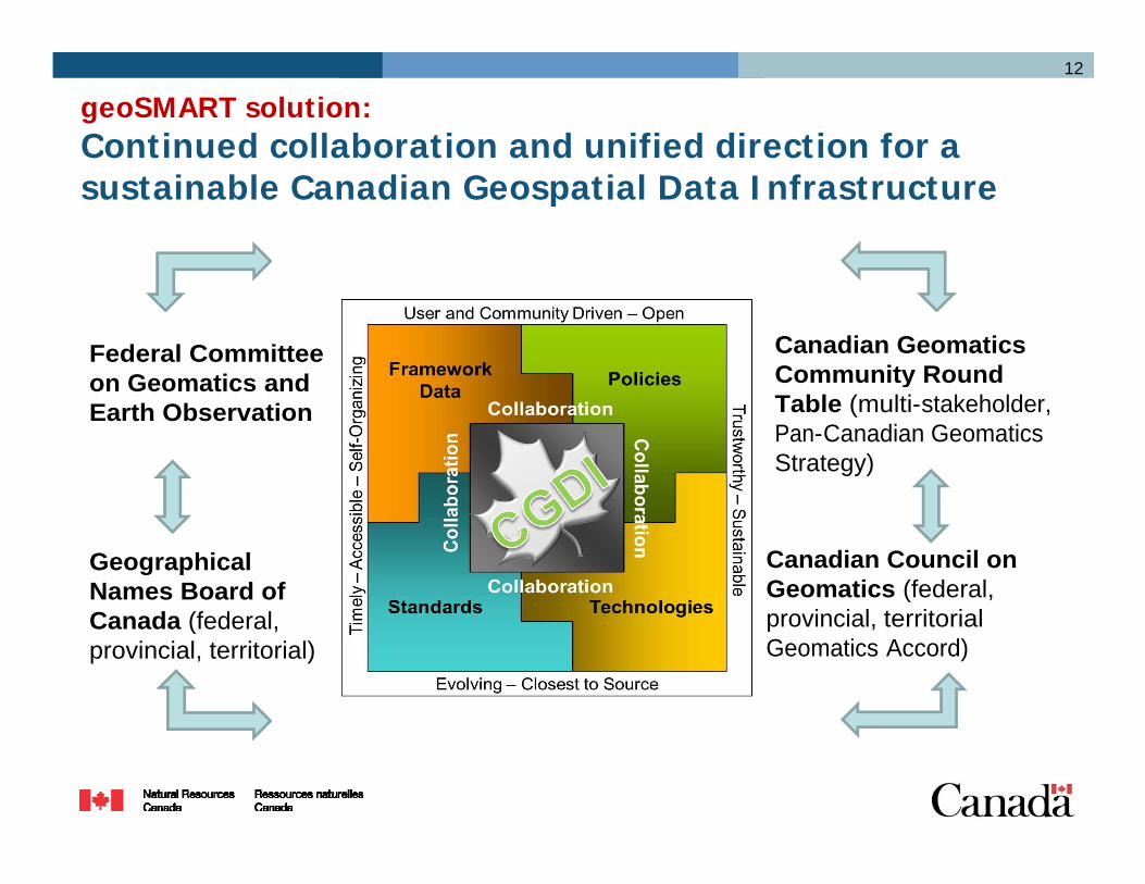
geoSMART solution: Continued collaboration and unified direction for a
12
Continued collaboration and unified direction for a sustainable Canadian Geospatial Data I nfrastructure
Canadian GeomaticsCommunity Round
Federal Committee on Geomatics and Community Round
Table (multi-stakeholder, Pan-Canadian GeomaticsStrategy)
on Geomatics and Earth Observation
Canadian Council on Geomatics (federal, provincial, territorial
Geographical Names Board of Canada (federal, provincial, territorial
Geomatics Accord)Canada (federal, provincial, territorial)

Now that’s geoSMART:
1313
Now that’s geoSMART: Open Dialogue for Open Data
Working collaboratively within the Government of Canada, Working collaboratively within the Government of Canada, and with other levels of government, the private sector, academia, and associations to achieve:
Horizontal integration of Earth observations and geomatics
Vertical integration of data sources to device (satellite to mobile)mobile)
Efficiencies (build/buy once – use many times)
State-of-the-art and sustainable geo-infrastructureState-of-the-art and sustainable geo-infrastructure
Open, “AAA” data for innovation and public good

14
For more information…
Government of Canada - Open Government http://data.gc.caNRCan Earth Sciences Sector NRCan Earth Sciences Sector https://www.nrcan.gc.ca/earth-sciences/Canada’s Country Report to the UNRCCA http://unstats.un.org/unsd/geoinfo/RCC/unrcca10.htmlhttp://unstats.un.org/unsd/geoinfo/RCC/unrcca10.htmlPan-Canadian Geomatics Strategy http://cgcrt.ca
Brian Gray, Assistant Deputy Minister, Earth Sciences Brian Gray, Assistant Deputy Minister, Earth Sciences Sector, [email protected] Shukle, Director General, Canada Centre for Mapping and Earth Observation [email protected]@NRCan-RNCan.gc.ca