Emery County Off-Highway Vehicle (OHV) Travel Map
2
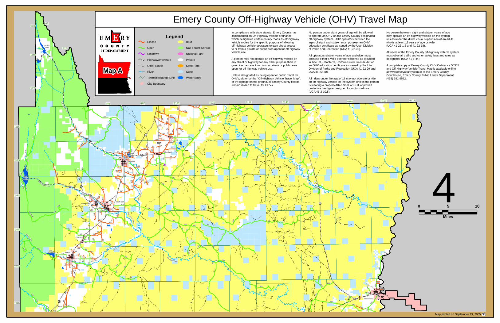
401 206 803 115 320 302 215 705 416 405 328 1118 114 125 335 120 1115 410 421 1029 605 708 129 337 404 603 1030 701 1110 801 802 506 322 1001 602 105 706 209 1130 212 110 409 301 SR 124 403 608 101 324 128 722 511 126 304 216 330 426 1051 125 611 1032 306 422 412 402 806 211 310 707 201 510 119 407 702 108 719 333 603 316 808 612 720 406 118 418 127 124 312 204 414 1 102 507 107 1111 308 1009 205 425 1042 415 508 1031 413 606 109 208 427 420 419 318 717 122 221 609 503 709 424 315 514 219 327 305 339 515 704 516 214 1006 319 329 512 716 213 614 1119 718 116 307 1004 417 309 313 1002 217 326 117 504 104 338 113 712 325 202 220 103 317 112 1135 121 428 723 502 111 1116 715 615 201 1010 401 611 114 125 708 332 101 332 407 426 806 705 115 316 201 201 301 209 214 1007 219 1029 115 1007 608 110 208 705 303 216 302 1110 604 127 219 303 307 318 316 311 312 302 106 101 105 120 102 110 110 110 114 215 215 206 218 334 206 206 314 311 322 337 328 337 330 327 328 332 325 401 401 401 405 405 407 401 332 320 332 332 Joes Valley Reservoir 1118 1115 Electric Lake Huntington Lake 412 416 401 423 421 401 421 422 605 605 602 603 602 426 1130 Millsite Reservoir 701 717 716 612 611 705 705 709 710 711 705 708 802 802 801 1030 1030 1003 1001 Moore Ferron Clawson Orangeville Castle Dale Huntington Cleveland Elmo Green River 713 331 323 610 207 1117 607 222 T13S T14S T15S T16S T17S T18S T19S T20S T21S R6E R7E R8E R9E R10E R11E R12E R13E R14E R15E R16E R17E R a ng e C r e e k P r ice R i v er S a n R a f ael R i ver H u n t i n g t on Cre e k Co t to n w o od C r ee k H u n t ing to n C r e e k Cott on w o od C r eek F e r ro n Cr ee k F e rr on Cr ee k 155 10 155 6 § ¨ ¦ 70 10 29 57 31 4 0 5 10 Miles Map printed on September 19, 2005 Map A Emery County Off-Highway Vehicle (OHV) Travel Map In compliance with state statute, Emery County has implemented an Off-Highway Vehicle ordinance which designates certain county roads as off-highway vehicle routes for the specific purpose of allowing off-highway vehicle operators to gain direct access to or from a private or public area open for off-highway vehicle use. A person may not operate an off-highway vehicle on any street or highway for any other purpose than to gain direct access to or from a private or public area open for off-highway vehicle use. Unless designated as being open for public travel for OHVs, either by the "Off-Highway Vehicle Travel Map", or by signage on the ground, all Emery County Roads remain closed to travel for OHVs. No person under eight years of age will be allowed to operate an OHV on the Emery County designated off-highway system. OHV operators between the ages of eight and sixteen must possess an OHV education certificate as issued by the Utah Division of Parks and Recreation (UCA 41-22-30). All operators sixteen years of age and older must possess either a valid operator's license as provided in Title 53, Chapter 3, Uniform Driver License Act or an OHV education certificate as issued by the Utah Division of Parks and Recreation (UCA 41-22-29 and UCA 41-22-30). All riders under the age of 18 may not operate or ride an off-highway vehicle on the system unless the person is wearing a properly-fitted Snell or DOT approved protective headgear designed for motorized use (UCA 41-2-10.8). No person between eight and sixteen years of age may operate an off-highway vehicle on the system unless under the direct visual supervision of an adult who is at least 18 years of age or older (UCA 41-22-1.5 and 41-22-18). All users of the Emery County off-highway vehicle system must obey all traffic and other safety laws and rules as designated (UCA 41-6-44). A complete copy of Emery County OHV Ordinance 50305 and Off-Highway Vehicle Travel Map is available online at www.emerycounty.com or at the Emery County Courthouse, Emery County Public Lands Department, (435) 381-5552. Legend Closed Open Unknown Highway/Interstate Other Route River Township/Range Line City Boundary BLM Natl Forest Service National Park Private State Park State Water Body
Transcript of Emery County Off-Highway Vehicle (OHV) Travel Map
401
206
803
115
320
302
215
1007
705
416
405
328
1118
114
125
335
120
1115
410
421
1029
605
708
129
337
404
603
1030
701
1110
801
802
506
322
1001
602
105
706
209
1130
212
110
409
301
SR 124
403
608
101
324
128
722
511
126
304
216
330
426
1051
125
611
1032
306
422
412
402
806
211
310
707
201
510
119
407
702
108
719
333
603
316
808
612
720
406
118
418
127
124
312
204
414
1050
102
507
107
1111
308
1009
205
425
1042
415
508
1031
413
606
109
208
427
420
419
318
717
122
221
609
503
709
424
315
514
219
327
305
339
515
704
516
214
1006
319
329
512
716
213
614
1119
718
116
307
1004
417
309
313
1002
217
326
117
504
104
338
113
712
325
202
220
103
317
112
1135
121
428
723
502
111
1116
715
615
201
1010
401
611
114
125
708
332
101
332407
426
806
705
115
316
201
201
301
209
214
1007
219
1029
115
1007
608
110
208
705
303
216
302
1110
604
127
219
303
307
318
316
311
312
302
106
101
105
120
102
110
110
110
114
215
215206
218334
206
206
314
311
322
337
328
337
330
327 328 332
325
401
401
401
405405
407
401 332
320332
332
JoesValley
Reservoir
11181115
ElectricLake
HuntingtonLake
412
416
401
423421
401
421
422
605 605
602603
602
426
1130
MillsiteReservoir
701
717716
612
611
705
705
709
710 711 705
708
802
802801
10301030
1003 10
01
Moore
Ferron
Clawson
OrangevilleCastle Dale
Huntington
Cleveland
Elmo
Green River
713
331323
610
207
1117
607
222
T13S
T14S
T15S
T16S
T17S
T18S
T19S
T20S
T21S
R6E
R7E
R8E R9E R10E R11E R12E R13E R14E R15E R16E R17E
Range Creek
Price River
San Ra fael River
Huntington Creek
Cottonwood Creek
Hu nt ington Creek
Cottonwo od Creek
Ferron Creek
Ferron Creek
155
10
155
6
§̈¦7010
29 57
31
40 5 10
Miles
Map printed on September 19, 2005
Map A
Emery County Off-Highway Vehicle (OHV) Travel MapIn compliance with state statute, Emery County hasimplemented an Off-Highway Vehicle ordinancewhich designates certain county roads as off-highwayvehicle routes for the specific purpose of allowingoff-highway vehicle operators to gain direct accessto or from a private or public area open for off-highwayvehicle use.A person may not operate an off-highway vehicle onany street or highway for any other purpose than togain direct access to or from a private or public areaopen for off-highway vehicle use.Unless designated as being open for public travel forOHVs, either by the "Off-Highway Vehicle Travel Map",or by signage on the ground, all Emery County Roadsremain closed to travel for OHVs.
No person under eight years of age will be allowedto operate an OHV on the Emery County designatedoff-highway system. OHV operators between theages of eight and sixteen must possess an OHVeducation certificate as issued by the Utah Divisionof Parks and Recreation (UCA 41-22-30).All operators sixteen years of age and older mustpossess either a valid operator's license as providedin Title 53, Chapter 3, Uniform Driver License Act oran OHV education certificate as issued by the UtahDivision of Parks and Recreation (UCA 41-22-29 andUCA 41-22-30).All riders under the age of 18 may not operate or ridean off-highway vehicle on the system unless the personis wearing a properly-fitted Snell or DOT approvedprotective headgear designed for motorized use(UCA 41-2-10.8).
No person between eight and sixteen years of agemay operate an off-highway vehicle on the systemunless under the direct visual supervision of an adultwho is at least 18 years of age or older(UCA 41-22-1.5 and 41-22-18).All users of the Emery County off-highway vehicle systemmust obey all traffic and other safety laws and rules asdesignated (UCA 41-6-44).A complete copy of Emery County OHV Ordinance 50305and Off-Highway Vehicle Travel Map is available onlineat www.emerycounty.com or at the Emery CountyCourthouse, Emery County Public Lands Department,(435) 381-5552.
LegendClosedOpenUnknownHighway/InterstateOther RouteRiverTownship/Range LineCity Boundary
BLMNatl Forest ServiceNational ParkPrivateState ParkStateWater Body

401
1010
1011
803
33210
12
920
320
1013
923
927
912
1007
705
925
1046
416
405
1028
1118335
1045
1019
410
421
1029
605
708
404
1014
603
1030
701
1016
926
801
802
921
1044
1001
1047
602
1043
706
1130
409
1049
403
608
915
916
929
722
511
426
611
1032
911
1024
42290
6
402
336
806
907
908
707
510
1033
804
903
1015
407
1025
805
702
919
719
341
603
1023
1026
909
808
612
720
406
340
418
913
910
414
1050
901
1009
924
425
1042
415
1031
902
413
606
1027
427
420
419
922
717
609
1017
709
424
1048
1200
905
1020
327
515
704
1006
928
512
716
614
1119
718
1021
1004
1002
504
904
712
1135
428
723
715
615
1010
401
920
611
926
708
920
332407
920
426
1019
806
332
705
911
1012
916
924
1200
1029
1007
1029
1007
1012
608
1010
920
705
912
604
206
401
401
401
405405
407
401 332
320332
332
332
11181115
401
423421
401
421
422
605 605
602603
602
426
1130
MillsiteReservoir
701
717716
612
611
705
705
709
710 711 705
70880
2
802801
803
803
910
907
914
909
912912
920
920
923
332
340
332
336
332
10121012
1012
1012
1018
1013
1010
1010100
8
1010
1011
1045 1044
1046
1011
1010
1010 1025
1010
1028
1007
10301030
1003 10
01
GoblinValleyStatePark
Capitol ReefNational Park
Emery
Moore
Ferron
Clawson
OrangevilleCastle Dale
Green River
918917
930
713
610
607
T19S
T20S
T21S
San Ra fael River
Huntington Creek
Cottonwood Creek
Ferron Creek
Ferron Creek
6
§̈¦70
24
§̈¦70
§̈¦70
10
T22S
T23S
T24S
T25S
T26S
R6E R7E R8E R9E R10E R11E R12E R13E R14E R15E R16E R17E
40 5 10
Miles
Map printed on September 19, 2005
Map AMap B
Emery County Off-Highway Vehicle (OHV) Travel MapIn compliance with state statute, Emery County hasimplemented an Off-Highway Vehicle ordinancewhich designates certain county roads as off-highwayvehicle routes for the specific purpose of allowingoff-highway vehicle operators to gain direct accessto or from a private or public area open for off-highwayvehicle use.A person may not operate an off-highway vehicle onany street or highway for any other purpose than togain direct access to or from a private or public areaopen for off-highway vehicle use.Unless designated as being open for public travel forOHVs, either by the "Off-Highway Vehicle Travel Map",or by signage on the ground, all Emery County Roadsremain closed to travel for OHVs.
No person under eight years of age will be allowedto operate an OHV on the Emery County designatedoff-highway system. OHV operators between theages of eight and sixteen must possess an OHVeducation certificate as issued by the Utah Divisionof Parks and Recreation (UCA 41-22-30).All operators sixteen years of age and older mustpossess either a valid operator's license as providedin Title 53, Chapter 3, Uniform Driver License Act oran OHV education certificate as issued by the UtahDivision of Parks and Recreation (UCA 41-22-29 andUCA 41-22-30).All riders under the age of 18 may not operate or ridean off-highway vehicle on the system unless the personis wearing a properly-fitted Snell or DOT approvedprotective headgear designed for motorized use(UCA 41-2-10.8).
No person between eight and sixteen years of agemay operate an off-highway vehicle on the systemunless under the direct visual supervision of an adultwho is at least 18 years of age or older(UCA 41-22-1.5 and 41-22-18).All users of the Emery County off-highway vehicle systemmust obey all traffic and other safety laws and rules asdesignated (UCA 41-6-44).A complete copy of Emery County OHV Ordinance 50305and Off-Highway Vehicle Travel Map is available onlineat www.emerycounty.com or at the Emery CountyCourthouse, Emery County Public Lands Department,(435) 381-5552.
LegendClosedOpenUnknownHighway/InterstateOther RouteRiverTownship/Range LineCity Boundary
BLMNatl Forest ServiceNational ParkPrivateState ParkStateWater Body