elm creek€¦ · A regular meeting of the Elm Creek Watershed Management Commission will be held...
27
CHAMPLIN - CORCORAN - DAYTON - MAPLE GROVE - MEDINA - PLYMOUTH - ROGERS elm creek Watershed Management Commission ADMINISTRATIVE OFFICE 3235 Fernbrook Lane Plymouth, MN 55447 PH: 763.553.1144 FAX: 763.553.9326 email: [email protected] www.elmcreekwatershed.org TECHNICAL OFFICE Hennepin County Dept. of Environment & Energy 701 Fourth Ave S Suite 700 Minneapolis, MN 55415-1600 PH: 612.348-7338 • FAX: 612.348.8532 Email: [email protected] December 6, 2017 Representatives Elm Creek Watershed Management Commission Hennepin County, MN The meeting packets for these meetings may be found on the Commission’s website: http://elmcreekwatershed.org/pages/Meetings/ Dear Representatives: A regular meeting of the Elm Creek Watershed Management Commission will be held on Wednesday, December 13, 2017, at 11:30 a.m. in the Mayor’s Conference Room at Maple Grove City Hall, 12800 Arbor Lakes Parkway, Maple Grove, MN. The Technical Advisory Committee (TAC) will meet at 10:00 a.m., prior to the regular meeting, to discuss the following: 1) updating the hydrologic and hydraulic models of Elm Creek, 2) proposed changes to the Elm Creek Rules, 3) the Commission’s role as WCA LGU, and 4) addition of projects to the CIP. Please email Beverly at [email protected] to confirm whether you or your Alternate will be attending the TAC and the regular meetings. Thank you. Regards, Judie A. Anderson Administrator JAA:tim Encls: Meeting Packet cc: Alternates Joel Jamnik TRPD HCEE Diane Spector Clerks BWSR Met Council Official Newspaper MPCA DNR Z:\Elm Creek\Meetings\Meetings 2017\12 Notice_reg and TAC meetings.doc Item 1
Transcript of elm creek€¦ · A regular meeting of the Elm Creek Watershed Management Commission will be held...

CHAMPLIN - CORCORAN - DAYTON - MAPLE GROVE - MEDINA - PLYMOUTH - ROGERS
elm creek Watershed Management Commission
ADMINISTRATIVE OFFICE 3235 Fernbrook Lane Plymouth, MN 55447 PH: 763.553.1144 FAX: 763.553.9326 email: [email protected] www.elmcreekwatershed.org
TECHNICAL OFFICE Hennepin County
Dept. of Environment & Energy 701 Fourth Ave S Suite 700
Minneapolis, MN 55415-1600 PH: 612.348-7338 • FAX: 612.348.8532
Email: [email protected]
December 6, 2017
Representatives Elm Creek Watershed Management Commission Hennepin County, MN
The meeting packets for these meetings may be found on the Commission’s website: http://elmcreekwatershed.org/pages/Meetings/
Dear Representatives:
A regular meeting of the Elm Creek Watershed Management Commission will be held on Wednesday, December 13, 2017, at 11:30 a.m. in the Mayor’s Conference Room at Maple Grove City Hall, 12800 Arbor Lakes Parkway, Maple Grove, MN.
The Technical Advisory Committee (TAC) will meet at 10:00 a.m., prior to the regular meeting, to discuss the following: 1) updating the hydrologic and hydraulic models of Elm Creek, 2) proposed changes to the Elm Creek Rules, 3) the Commission’s role as WCA LGU, and 4) addition of projects to the CIP. Please email Beverly at [email protected] to confirm whether you or your Alternate will be attending the TAC and the regular meetings.
Thank you.
Regards,
Judie A. Anderson Administrator JAA:tim Encls: Meeting Packet
cc: Alternates Joel Jamnik TRPD
HCEE Diane Spector Clerks
BWSR Met Council Official Newspaper
MPCA DNR
Z:\Elm Creek\Meetings\Meetings 2017\12 Notice_reg and TAC meetings.doc
Item 1

A = Action item E = Enclosure provided I = Informational update available at meeting RPFI ‐ removed pending further information R = Will be removed RP= Information will be provided in revised meeting packet….. D = Project is denied AR awaiting recordation *in meeting packet
**available at meeting CHAMPLIN - CORCORAN - DAYTON - MAPLE GROVE - MEDINA - PLYMOUTH - ROGERS
elm creek Watershed Management Commission ADMINISTRATIVE OFFICE 3235 Fernbrook Lane Plymouth, MN 55447 PH: 763.553.1144 • FAX: 763.553.9326 Email: [email protected] www.elmcreekwatershed.org
TECHNICAL OFFICE Hennepin County
Dept. of Environment and Energy 701 Fourth Ave S Suite 700
Minneapolis, MN 55415-1600 PH: 612.348-7338 • FAX: 612.348.8532
Email: [email protected]
AGENDA
December 13, 2017 1. Call Regular Meeting to Order. a. Approve Agenda.* 2. Consent Agenda. a. Minutes last Meeting.* b. Treasurer’s Report and Claims.** 3. Open Forum. 4. Action Items.
a. Project Reviews – see Staff Report.* 5. TAC Update.*** a. Letter from City of Corcoran.* b. CIP, Medina.* 6. New Business. 7. Grant Opportunities and Updates. a. Fish Lake Internal Phosphorus Loading Control. (See Staff Report.) b. Rush Creek Headwaters Subwatershed Assessment. 8. Education. a. Education and Outreach Update.* b. FLARA Water Quality Grant.** 9. Elm Creek Watershed‐wide TMDL. 10. Watershed Management Plan. 11. Communications. 12. Project Reviews – also see Staff Report.* 13. Other Business. 14. Adjourn. ***Additional items will be available prior to the TAC meeting.
Z:\Elm Creek\Meetings\Meetings 2017\12 agenda.docx
Item 1a

A = Action item E = Enclosure provided I = Informational update available at meeting RPFI ‐ removed pending further information R = Will be removed RP= Information will be provided in revised meeting packet….. D = Project is denied AR awaiting recordation *in meeting packet
**available at meeting CHAMPLIN - CORCORAN - DAYTON - MAPLE GROVE - MEDINA - PLYMOUTH - ROGERS
Project Reviews. (See Staff Report.*)
a. 2013‐046 Woods of Medina, Medina.
b. 2014‐015 Rogers Drive Extension, Rogers.
c. 2015‐004 Kinghorn Outlet A, Rogers.
d. AR 2015‐030 Kiddiegarten Child Care Center, Maple Grove.
e. 2016‐002 The Markets at Rush Creek, Maple Grove.
f. 2016‐004 Park Storage Place, Corcoran.
g. 2016‐005W Ravinia Wetland Bank Plan, Corcoran.
h. AR 2016‐026 Faithbrook Church, Dayton.
i. 2016‐040 Kinghorn 4th Addition, Rogers.
j. 2016‐047 Hy‐Vee Maple Grove #1 (Hy‐Vee Maple Grove North).
k. AR 2016‐052 The Woods at Rush Creek, Maple Grove.
l. 2017‐002 RDO Site Plan, Dayton.
m. 2017‐013W 20417 Larkin Road, Wetland Violations, Corcoran.
n. AR 2017‐014 Laurel Creek, Rogers.
o. AR 2017‐016 Territorial Woods, Maple Grove.
p. AR 2017‐017 Mary Queen of Peace Catholic Church, Rogers.
q AR 2017‐019 Medina Senior Living Community, Medina.
r. AR 2017‐021 Hindu Society of MN Staff Housing, Maple Grove.
s. R 2017‐022 CSAH 81 / CSAH101 & 13 Intersection Improvements, Rogers
t. R 2017‐027W Mill Pond Restoration, Champlin.
u. 2017‐028W Fehn Meadows Wetland Bank, Corcoran.
v. AR 2017‐029 Brayburn Trails, Dayton.
w. 2017‐030 Brindle Path, Medina.
x. 2017‐031 Bass Lake Crossing, Corcoran.
y. AR 2017‐034 Plymouth Memory Care, Plymouth.
z 2017‐035 Weston Woods PUD, Medina.
aa. 2017‐036 Enclave at Elm Creek, Plymouth.
ab. AR 2017‐037 Corcoran L‐80 Lift Station MCES Project 808520, Corcoran.
ac. 2017‐038 Bass Lake Estates, Corcoran.
ad. 2017‐039 Rush Creek Apartments, Maple Grove.
af. 2017‐040 Capitol Beverage, Rogers.
ag. 2017‐044 Reserve at Medina 2nd Addition, Medina.
ah. 2017‐045 Fish Lake Estates, Maple Grove.
ai. 2017‐046W Wessell Property Wetland Delineation, Corcoran.
aj. 2017‐047W Newman Property Wetland Delineation, Corcoran.
ak. 2017‐048W Ebert Parcel Wetland Delineation, Corcoran/
al. 2017‐049W Rolling Hills Wetland Delineation, Corcoran.
am. E 2017‐050W Ernie Mayer Wetland/floodplain violation, Corcoran.
an. 2017‐051 Mallard South 2nd Addition, Rogers.
ao.
ap.
aq.
ar.
au.
Item 1a

CHAMPLIN - CORCORAN - DAYTON - MAPLE GROVE - MEDINA - PLYMOUTH - ROGERS
RULE D ‐ STORMWATER MANAGEMENT RULE E ‐ EROSION AND SEDIMENT CONTROL RULE F – FLOODPLAIN ALTERATION RULE G ‐ WETLAND ALTERATION RULE H – BRIDGE AND CULVERT CROSSINGS RULE I – BUFFERS
elm creek Watershed Management Commission ADMINISTRATIVE OFFICE 3235 Fernbrook Lane Plymouth, MN 55447 PH: 763.553.1144 • FAX: 763.553.9326 Email: [email protected] www.elmcreekwatershed.org
TECHNICAL OFFICE Hennepin County
Dept. of Environment and Energy 701 Fourth Ave S Suite 700
Minneapolis, MN 55415-1600 PH: 612.348-7338 • FAX: 612.348.8532
Email: [email protected]
Regular Meeting Minutes November 8, 2017
I. A regular meeting of the Elm Creek Watershed Management Commission was called to order at 11:40 a.m., Wednesday, November 8, 2017, in the Mayor’s Conference Room, Maple Grove City Hall, 12800 Arbor Lakes Parkway, Maple Grove, MN, by Chairman Doug Baines.
Present were: Gerry Butcher, Champlin; Sharon Meister, Corcoran; Doug Baines, Dayton; Joe Trainor, Maple Grove; Elizabeth Weir, Medina; Fred Moore, Plymouth; Kevin Jullie, Rogers; James Kujawa and Jason Swenson, Hennepin County Dept. of Environment and Energy (HCEE); Jeff Weiss, Barr Engineering; and Judie Anderson, JASS.
Also present: Todd Tuominen, Champlin; Kevin Mattson, Corcoran; Mark Lahtinen, Maple Grove; and Catherine Cesnik and Ben Scharenbroich, Plymouth.
A. The revised agenda* was approved unanimously.
B. The minutes* of the September 13, 2017 regular meeting were approved unanimously.
C. The November Treasurer’s Report and Claims* totaling $67,427.25 were approved unanimously.
II. Open Forum.
III. Action Items.
A. Affirm the actions of the Executive Committee as they pertain to approval of the following:
1. October 2017 Treasurer’s Report and Claims.*
2. Project Review 2017‐022 CSAH 81/CSAH 101 and 13 Intersection Improvements, Rogers.*
3. Project Review 2017‐036 Enclave at Elm Creek, Plymouth.*
4. Project Review 2017‐037 L‐80 Lift Station, Corcoran.*
The actions cited above were approved unanimously.
B. Project Review 2017‐031 Bass Lake Crossing, Corcoran.* This is two parcels, 48.5 total acres, located north of the intersection of CR 10 and Larkin Road. M/I Homes is proposing to develop the two parcels into 97 single‐family residential homes. As proposed, the project will require 0.3303‐acre of jurisdictional wetland fill within five separate wetland locations. The review will be for compliance with Commission rules D, G, and I. A notice for the wetland replacement plan was sent on August 1, requesting comments by August 31. A TEP met on August 25 and determined the wetland replacement plans meet the intent of the Commission and MN Wetland Conservation Act (WCA) requirements and recommended approval. In their findings dated November 1, 2017, Staff recommends approval contingent upon: 1) the wetland replacement credit purchase being completed or an escrow of $75,000 cash or letter of credit being received and 2) the buffer monumentation meeting Commission requirements. Staff’s recommendations were approved unanimously.
Item 2a

elm creek Watershed Management Commission Regular Meeting Minutes – November 8, 2017 Page 2
CHAMPLIN - CORCORAN - DAYTON - MAPLE GROVE - MEDINA - PLYMOUTH - ROGERS
C. Project Review 2017‐044 Reserve at Medina 2nd Addition, Medina.* This is an erosion control review of the plans for the final build‐out of this addition of the Reserve at Medina project originally approved under project #2013‐002. This addition is located southeast of Hackamore Road and Pinto Drive (CR116), immediately east of the First Addition, and will allow for the construction of 46 new single‐family homes. The plans are in conformance with the previously approved project and require small modifications to allow Staff to complete its adminsitrative review. In their findings dated November 1, 2017, Staff recommends approval with the following minor revisions: 1) A final plan, dated and signed by a Professional Engineer licensed in Minnesota, must be submitted to the Commission and the City of Medina; 2) A narrative, discussing whether these plans are covered by a previous or a new NPDES Construction Stormwater Permit, should be included on the plan sheets, including what, if any, modifications are required to comply with current MPCA standards, if applicable; 3) the SWPPP must include a map identifying the receiving waters from the site (Elm Creek is located downstream within one mile of the project, so the special provisions in the NPDES permit will apply to this project); and 4) the plans should include an actual Statement of Estimated Quantities (SEQ) to comply with NPDES permit requirements. Staff’s recommendations were approved unanimously.
IV. New Business.
V. Grant Opportunities and Updates.
A. Internal Phosphorus Loading Control in Fish Lake project.
Mobilization for the alum treatment began the morning of September 18, 2017. Two 7000‐gallon capacity temporary chemical storage tanks were placed on‐site to store liquid aluminum sulfate. The alum was delivered to the site in 5,000 gallon tanker trucks to transfer alum to the temporary lakeshore chemical storage tanks. The storage tanks allowed for the continuous transfer of alum to the treatment barge at a rate that exceeds the delivered supply from the tanker trucks.
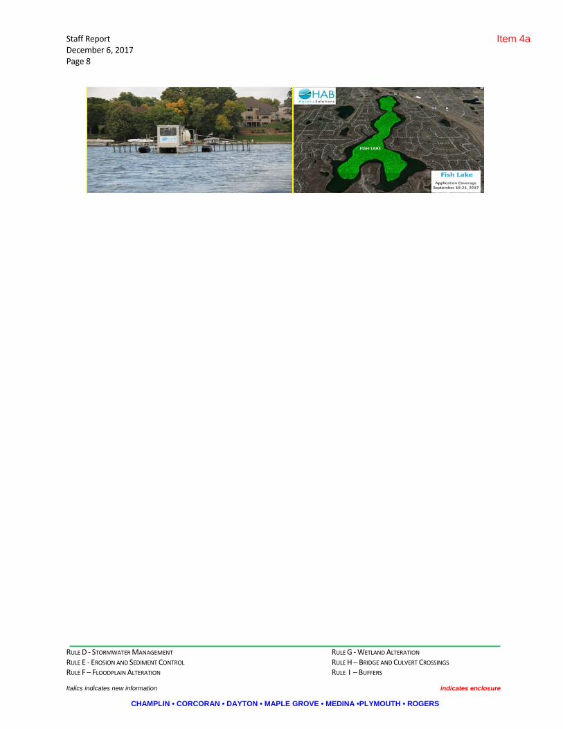
The treatment barge started applying alum to Fish Lake at 1:00 p.m. on September 18. The treatment barge had a computer with GPS technology that had pre‐programmed bathymetry data to assist with the route of the application. The computer also controlled the pumping rate of the alum based on boat speed and water depth to ensure the effective dose of alum applied to the lake. The treatment barge has the ability to apply 20,000+ gallons of alum per day. Alum was applied to 120 acres of Fish Lake at depths greater than 20 feet. The target dose of alum was 95,000 gallons for the entire treatment. A total of 95,349 gallons of alum (22 alum trucks) was applied to Fish Lake. The treatment was completed by 1:00 p.m. on September 21. (Some pictures of the event are included in the November Staff Report.*)
HAB Aquatic Solutions set up a website (http://fishlakealum.com) for the Fish Lake Alum Treatment, providing daily updates of the project and an opportunity for folks to submit their questions about the project.
The Fish Lake Area Residents Association (Dave Haas) set up a media event on September 20. Baines attended the media event representing the Elm Creek Commission. There were approximately 10 to 15 homeowners in attendance. There were also presentations by HAB Aquatic Solutions and Three Rivers Park District about the project followed by a boat tour in order to observe the alum application. The CCX news media video is available at the following link: https://www.youtube.com/watch?v=Mt1gYo5lGtw
B. Rush Creek Headwaters Subwatershed Assessment project. Minutes* of the Rush Creek SWA TAC meeting, which preceded this meeting, are available under separate cover and on the Commission website.
The hydro‐conditioned Digital Elevation Model (DEM) for the Study Area has been finalized and has been used to develop a much more accurate stream network and drainage subcatchments. The Study Area has been broken down into six Management Units: Lake Henry, Lake Jubert, Lower Rush Creek, Upper Rush Creek, South Tributary, and Tilton’s. Map books have been assembled for the Study Area and each of the Management Units, including the following figures:
Item 2a

elm creek Watershed Management Commission Regular Meeting Minutes – November 8, 2017 Page 3
CHAMPLIN - CORCORAN - DAYTON - MAPLE GROVE - MEDINA - PLYMOUTH - ROGERS
a. Location, including lakes, streams, and ditches b. Land Use c. Land Cover d. Soil properties e. Feedlots and animal locations f. Potential tile‐drained areas g. ACPF raw model results h. Known flooding and stream erosion areas i. Coarse‐grained Revised Universal Soil Loss Equation (RUSLE) sedimentation loading rate by
catchment
At today’s TAC meeting they presented the following: a. Discussion of priority strategies and areas by Management Unit b. Review of model findings c. Continued discussion regarding public participation and input process, and identification of key
landowners
The City of Corcoran has scheduled an Open House for December 7, 2017 and will send an invitation to all property owners in the Study Area. An informational flyer* has been created to promote the event.
VI. Education.
A. The Lake Effect: Protecting Water through Innovative Collaboration.* https://freshwater.org/ moos‐family‐lecture‐series/
B. The next WMWA meeting is scheduled for 8:30 a.m., Tuesday, December 5, 2017, at Plymouth City Hall. Commissioners are encouraged to attend.
VII. Communications.
VIII. Other Business.
A. The following projects are discussed in the November Staff Report.* ("W" denotes wetland project.)
1. 2013‐046 Woods of Medina, Medina. 2. 2014‐015 Rogers Drive Extension, Rogers. 3. 2015‐004 Kinghorn Outlet A, Rogers. 4. 2015‐006 Veit Building and Parking Lot Addition, Rogers. 5. 2015‐030 Kiddiegarten Child Care Center, Maple Grove. 6. 2016‐002 The Markets at Rush Creek, Maple Grove. 7. 2016‐004 Park Place Storage Site Plans, Corcoran. 8. 2016‐005W Ravinia Wetland Bank, Corcoran. 9. 2016‐018 Cambridge Park, Maple Grove. 10. 2016‐022 AutoZone, Maple Grove. 11. 2016‐026 Faithbrook Church, Dayton. 12. 2016‐040 Kinghorn 4th Addition, Rogers. 13. 2016‐047 Hy‐Vee Maple Grove #1, Maple Grove. 14. 2016‐052 The Woods at Rush Creek, Maple Grove.
15. 2017‐002 RDO Site Plan, Dayton. 16. 2017‐004W Cartway Trail, Champlin. 17. 2017‐013W 20417 Larkin Road, Corcoran. 18. 2017‐014 Laurel Creek, Rogers. 19. 2017‐016 Territorial Woods, Maple Grove. 20. 2017‐017 Mary Queen of Peace Catholic Church, Rogers 21. 2017‐019 Medina Senior Living Community, Medina. 22. 2017‐021 Hindu Society of MN Staff Housing, Maple Grove. 23. 2018‐022 CSAH81 and CSAH101 and 13 Intersection Improvements, Rogers.*
Item 2a
elm creek Watershed Management Commission Regular Meeting Minutes – November 8, 2017 Page 4
CHAMPLIN - CORCORAN - DAYTON - MAPLE GROVE - MEDINA - PLYMOUTH - ROGERS
24. 2017‐023 Midwest Steel Supply, Rogers. 25. 2017‐024 Lil Explorers Daycare, Rogers. 26. 2017‐027W Mill Pond Restoration, Champlin. 27. 2017‐028W Fehn Meadows Wetland Bank, Corcoran. 28. 2017‐029 Brayburn Trails, Dayton. 29. 2017‐030 Brindle Path, Medina. 30. 2017‐031 Bass Lake Crossing, Corcoran.* 31. 2017‐034 Plymouth Memory Care, Plymouth. 32. 2017‐035 Weston Woods of Medina PUD. 33. 2017‐036 Enclave at Elm Creek, Plymouth.* 34. 2017‐037 L‐80 Lift Station MCES, Corcoran.* 35. 2017‐038 Bass Lake Estates, Corcoran. 36. 2017‐039 Rush Creek Apartments, Maple Grove. 37. 2017‐040 Capitol Beverage, Rogers. 38. 2017‐041W Maghrak Wetland Delineation, Corcoran. 39. 2017‐042 Cavanaugh Concept Plan, Medina. 40. 2017‐043W Kissner WCA Exemption, Corcoran. 41. 2017‐044 Reserve at Medina 2nd Addition, Medina.* 42. 2017‐045 Fish Lake Estates, Maple Grove. 43. 2017‐046W Wessell Wetland Delineation, Corcoran. 44. 2017‐047W Newman Wetland Delineation, Corcoran.
B. Adjournment. There being no further business, the meeting was adjourned.
Respectfully submitted,
Judie A. Anderson, Recording Secretary JAA:tim Z:\Elm Creek\Meetings\Meetings 2017\11 Regular Meeting Minutes.docx
Item 2a

RULE D ‐ STORMWATER MANAGEMENT RULE G ‐ WETLAND ALTERATION RULE E ‐ EROSION AND SEDIMENT CONTROL RULE H – BRIDGE AND CULVERT CROSSINGS RULE F – FLOODPLAIN ALTERATION RULE I – BUFFERS Italics indicates new information indicates enclosure
CHAMPLIN • CORCORAN • DAYTON • MAPLE GROVE • MEDINA •PLYMOUTH • ROGERS
elm creek Watershed Management Commission
ADMINISTRATIVE OFFICE 3235 Fernbrook Lane Plymouth, MN 55447 PH: 763.553.1144 FAX: 763.553.9326 email: [email protected] www.elmcreekwatershed.org
TECHNICAL OFFICE Hennepin County
Environment and Energy Dept 701 Fourth Ave S Suite 700
Minneapolis, MN 55415-1600 PH: 612.348-7338 • FAX: 612.348.8532
Email: [email protected]
STAFF REPORT December 6, 2017
2013‐046 Woods of Medina. Medina. This is two parcels totaling 9.5 acres located east of CR 116 and south of Hackamore Road. The site is proposed to be developed into 16 single‐family residential lots. On January 13, 2015, the Commission approved this project with two conditions. Although this project has not been constructed, it is still active with the City of Medina and remains approved by the Commission until it becomes inactive with the City.
2014‐015 Rogers Drive Extension, Rogers. This project involves improvements along Rogers Drive from Vevea Lane to Brockton Lane. The project is located east of I‐94, south of the Cabela development. The total project area is 8.0 acres; proposed impervious surfaces total 5.6 acres. Site plans received July 1, 2014 meet the requirements of the Commission with the exception of the nutrient control. Due to limited options to treat the nutrient loads on the east 1.7 acre portion of Rogers Drive, the Commission approved the site plan contingent upon the City deferring 4.6 lbs. of phosphorus for treatment in future ponding opportunities as the easterly corridor of Rogers Drive develops. 2.3 lbs. will be accounted for in the Kinghorn Spec. Building site plan with 2.3 lbs. still outstanding. This item will remain on the report until the total deferral is accounted for.
2015‐004 Kinghorn Outlot A, Rogers. This is a 31 acre site located between the Clam and Fed Ex sites in Rogers on the west side of Brockton Road and I‐94. The proposed site will have two warehouse buildings, 275,000 and 26,000 SF in size, with associated parking and loading facilities. The Commission standards require review of stormwater management, grading and erosion controls and buffers. In June 2015 the Commission approved this project with three conditions. Revisions have yet to meet the Commission’s approval conditions. This project was extended by the City of Rogers earlier this year. It will remain active on the Staff Report.
2016‐002 The Markets at Rush Creek, Maple Grove. This is a proposal to develop 40 acres of a 123‐acre planned unit development located in the southwest quadrant of the intersection of CSAH 101 and CSAH 10. County Ditch 16 (Maple Creek) runs along the south property line on this project. The 40‐acre project area includes a Hy‐Vee grocery store (16.8 acres), a Hy‐Vee gas station (2.5 acres) and 11 outlots (18.76 acres). Right‐of‐way accounts for 2.3 acres. The remaining acreage (83 acres) consists of 5 outlots and right‐of‐way. The additional outlot areas are not part of the stormwater review for this project but will be reviewed for compliance with the Commission’s buffer and floodplain requirements. In May 2016 the Commission granted Staff authority to administratively approve the project and report any updates. This project has been placed on hold by Hy‐Vee. As long as it remains active with the City, the Commission’s approval with conditions remains in place. A temporary pipe to drain excess water on the west side of CSAH 101 will be installed by the City of Maple Grove through this site. The permanent pipe was installed under CSAH 101 at the time the road was constructed in 2007, but it was bulk headed on both ends of the ROW. This is being completed because a new development in the northwest corner of this intersection is being considered by the City. (See project 2017‐039.)
2016‐004 Park Place Storage Site Plans, Corcoran. The applicant is developing a 22‐acre site in the southwest portion of the city into a multi‐unit storage facility with associated access roads, utilities, and stormwater features. This is an addition to the existing storage facility located west of the proposed project. New wetland permit revisions were approved by the Commission at their July 2016 meeting. New site plan information was received and approved by the Commission in October 2016. All approval contingencies have been met with the exception of wetland banking withdrawals for 0.24 acres from bank account #15560. Staff gave the applicant 45 days (until November 17, 2017) to secure the additional 0.24 acre
Item 4a

RULE D ‐ STORMWATER MANAGEMENT RULE G ‐ WETLAND ALTERATION RULE E ‐ EROSION AND SEDIMENT CONTROL RULE H – BRIDGE AND CULVERT CROSSINGS RULE F – FLOODPLAIN ALTERATION RULE I – BUFFERS Italics indicates new information indicates enclosure
CHAMPLIN • CORCORAN • DAYTON • MAPLE GROVE • MEDINA •PLYMOUTH • ROGERS
Staff Report December 6, 2017 Page 2
credits. If this does not occur, the Commission will pursue utilizing the wetland replacement plan escrow it holds for this project to purchase the credits necessary. The applicant has requested some additional time to secure these credits due to a specific bank site expected to be certified by BWSR in the next 60 days. Staff approved the request.
2016‐005W Ravinia Wetland Replacement Plan, Corcoran. In February 2016, Lennar Corporation submitted a Wetland Banking Concept Plan for Phase II of the Ravinia Development. This plan was withdrawn in favor of an onsite wetland replacement plan. At their December 2016 meeting the Commission approved Staff’s findings and recommendations dated January 10, 2017. Final wetland impacts will be 1.22 acres. Wetland credits created on site will be 4.01 acres. Excess credits of 0.11 acres are proposed to be used on Lennar’s Laurel Creek development in Rogers (2017‐014). All contingency items that were part of Commission’s approval have been met. Construction on the site began last spring. Barr Engineering was contacted by the Commission to provide monitoring to ensure the replacement meets the performance standards of the approved plans.
2016‐040 Kinghorn 4th Addition, Rogers. This is a 13.7‐acre parcel located in the northwest corner of the intersection of Brockton Lane and Rogers Drive. An industrial warehouse with 8.8 acres of new impervious area is proposed for the site. The plan includes the use of a NURP pond and a biofiltration basin to meet Commission requirements for rates, water quality and abstraction. The adjacent site is likely to be developed in the near future and some of the stormwater features were oversized to accommodate future development. In November 2016 the Commission approved the project with the following conditions: 1) approval of only this phase; future phases will need additional review and approval; 2) final modifications to the hydrologic modeling; 3) additional details are provided for a proposed water re‐use system; 4) an O&M Plan for the pond and biofiltration basin is completed and recorded on the final plat; 5) modification of the storm sewer system to maximize the area draining to the NURP pond; and 6) receipt and review of wetland‐related documentation if wetlands are present. Condition #1 required no action, so has been met. Condition #2 has been met for the current design; however, any future modifications to the design will require additional review. Conditions #3‐6 remain outstanding and are expected to be addressed during final design. 2016‐047 Hy‐Vee North Maple Grove. The applicant is proposing to disturb 13 acres of a 20.4‐acre site located at the northeast corner of Maple Grove Parkway and 99th Avenue for the purpose of constructing a grocery store, fuel station, convenience store and parking facilities. Staff sent preliminary review comments and requested revisions on December 14. In their findings dated January 10, 2017, Staff recommended approval of this project subject to 1) receipt, approval, and recordation of an Operations and Maintenance Plan for the pond and the iron‐enhanced filtration system, 2) revisions for items relating to buffer requirements and erosion and sediment control as enumerated in the findings, and 3) receipt of a signed and dated final plan set. The Commission approved Staff’s recommendations at their January 11, 2017 meeting with the additional requirement that the Commission receive and comment on a WCA impact notice. No new information has been received to date.
2017‐002 RDO Dayton Site Plan. This is a commercial development proposal on a 25.6± acre plot located between I94 and Holly Lane. The project will develop the south 16 acres, to create about 7.6 acres of impervious cover. This project was approved with conditions by the Commission at their March 8, 2017 meeting. The City approved the PUD in May. The applicant has decided not to begin construction until spring 2018 and requested an extension to December 31, 2017, for the project’s approval conditions set by the Commission at their March meeting.
2017‐013W 20417 Larkin Road, Corcoran. Staff was contacted by the DNR Conservation Officer about an unauthorized excavation in a Public Waters Inventory stream and ditching from the stream into a WCA wetland within the subject property. Staff and the DNR staff inspected the site on April 26, 2017, and confirmed the violation. The CO issued Resource Protection Notices for PWI and WCA violations to the property owner and the renter who performed the excavation. Staff also informed the city administrator. A Restoration Order was issued to the property owner by the DNR. The deadline for submittal of a replacement plan, exemption or no‐loss application is July 15, 2017, or the site must be restored per the RO by that date. The landowner requested an extension to the deadline. It was granted to comply with the same deadline issued by the DNR for their RO, September 30, 2017.
Item 4a

RULE D ‐ STORMWATER MANAGEMENT RULE G ‐ WETLAND ALTERATION RULE E ‐ EROSION AND SEDIMENT CONTROL RULE H – BRIDGE AND CULVERT CROSSINGS RULE F – FLOODPLAIN ALTERATION RULE I – BUFFERS Italics indicates new information indicates enclosure
CHAMPLIN • CORCORAN • DAYTON • MAPLE GROVE • MEDINA •PLYMOUTH • ROGERS
Staff Report December 6, 2017 Page 3
Staff inspected the site October 25th and determined the following: 1. Recommend extending this restoration order two additional weeks so the landowner can complete the removal of spoil piles placed in the wetland areas. The extension is recommended to give the landowner time to complete this task without damaging the crops. (soybeans had just been harvested on the date of the TEP) 2. Any additional extension to this restoration order must be done in writing and approved by the LGU and CO prior to November 8, 2017. 3. The ditch between the DNR watercourse and the LGU wetland has been re‐filled adequately to restore the original water elevations in the ditch and the LGU jurisdictional wetland south of it. 4. All other conditions of the original restoration order must be adhered to, including reseeding any disturbed areas outside of cropland and placement of all spoil materials outside of any wetland areas. 5. An inspection will be conducted by the LGU after November 8, 2017 to determine if all the conditions of the restoration order were met.
Follow‐up inspection on November 22 found all items to be in complaince with the exception of the seeding. This item will be removed from the report.
2017‐022 CSAH 81/101/13 Intersection Reconstruction, Rogers. An application was submitted by the City of Rogers for the reconstruction of the CSAH 81 and CSAH 101&13 intersection. The project will add driving and turning lanes to improve traffic flow and safety. The project will increase the impervious area at the intersection from 7.1 acres to 9.5 acres. At the July 12, 23017 meeting, the Commission approved the project with the following conditions: 1) review and administrative approval of the model revisions to more accurately depict the project immediately after construction; and 2) review and approval of the model results and design of a planned pond to be constructed to the south in association with the Justen Circle extension project. The engineer for the project has provided modeling and design summary and all conditions of approval have been met. This item was approved by the Executive Committee of the Commission in October 2017 and will be removed from the report.
2017‐027W Mill Pond Restoration, , Champlin. This application proposes to restore the aquatic and riparian habitat of the Upper and Lower Mill Ponds (DNR Pulbic Waters Basin No. 061P) to improve water quality, enhance shoreland andaquatic habitat, develop a sustainable fishery, and provide public access to the lake. No Wetland Conservation Act jurisdictional impacts are occurring from this project. The drawdown of the Mill Pond began in September 2017 and construction will begin in December 2017, with completion by October 2018. The Commission reviewed and approved this project for complaince to its wetland, floodplain, E&SC and buffer criteria at their August meeting contingent upon 1) DNR issuance of a permit and compliance of said permit 2) Compliance with Army Corps of Engineers regulations.3) Staff approval of the final operation and maintenance plan on the forebay area at the upstream end of the Upper Mill Pond. 4) Staff approval of the contractor SWPPP design and 5) receipt of final plans signed and dated by an engineer. No new information has been received. All contingent items have been satisfied. This item will be removed from the report.
2017‐028W Fehn Meadows Wetland Bank, Corcoran. The owner of this 63‐acre parcel would like to pursue a potential wetland banking project during development. This site is located south of CR 117 between Trail Haven and Cain Roads. An initial wetland bank scoping document was provided to the Commission as LGU for the City of Corcoran. This will be reviewed with BWSR to determine if the site is a good candidate for the BWSR Wetland Banking Program. If BWSR and the LGU believe it is, the next phase of the process will be a Concept Banking Plan Application. The final phase would be the final Wetland Banking Plan. A TEP was held on‐site on July 6, 2017. Findings were provided to the applicant and BWSR. This item will remain on the report as a placeholder until an application is received.
2017‐030 Brindle Path, Medina. This is a 40‐acre site proposed for 68 single family lots. It is located just north of the Polaris Headquarters. Staff provided preliminary comments to the City. This item will remain on the report as a placeholder until an application is received.
Item 4a

RULE D ‐ STORMWATER MANAGEMENT RULE G ‐ WETLAND ALTERATION RULE E ‐ EROSION AND SEDIMENT CONTROL RULE H – BRIDGE AND CULVERT CROSSINGS RULE F – FLOODPLAIN ALTERATION RULE I – BUFFERS Italics indicates new information indicates enclosure
CHAMPLIN • CORCORAN • DAYTON • MAPLE GROVE • MEDINA •PLYMOUTH • ROGERS
Staff Report December 6, 2017 Page 4
2017‐031 Bass Lake Crossing, Corcoran. This is two parcels, 48.5 total acres, located north of the intersection of CR 10 and Larkin Road. M/I Homes is proposing to develop the two parcels into 97 single‐family residential homes. As proposed, the project will require 0.3303‐acre of jurisdictional wetland fill within 5 separate wetland locations. The review will be for complaince with the Commission rules D, G, and I. A notice for the wetland replacement plan was sent on August 1 requesting comments by August 31. A TEP met on August 25 and determined the WCA replacement plans meet the intent of the Commission and MN WCA requirements and recommended approval. Updated findings, if available, will be provided to the Commission for a decision at the October meeting. Per the applicant’s request of October 4, 2017, the project review deadline per MN Statute 15.99 was extended to November 8, 2017. The Commission approved this project per Staff recommendations at their November meeting. All the contingent recommendations have been met with the exception of the gravel access roads to the ponds in the buffer areas.
2017‐035 Weston Woods, Medina. This is an 80 acre townhome development located northeast of Chippewa Road and Mohawk Drive. Staff will provide preliminary comments to the City and this item will remain on the report as a placeholder until plans are received.
2017‐036 Enclave at Elm Creek, Plymouth. This is a 73‐acre parcel located on CSAH 101 and Prairie Creek Road, about 3/4 miles north of TH 55. The property will be developed into 111 residential lots and a new school site. Stormwater, grading and erosion control plans were submitted for the residential portion of the property. Only stormwater management plans for the future school site were submitted for review. The residential portion of this development looks good. But, a large component of the stormwater managment (2.1 lbs/year of phosphorus removals and 46,452 CF of abstraction) for this 73‐acre area is dependent on construction of the school site on the south 1/3 portion of the property. The school site grading and stormwater management system was provided as a concept only. Staff is working with the City of Plymouth to provide assurance to the Commission that the limiting stormwater components will be handled by the City if the school site is not constructed to meet Commission standards. If available, a recommendation for a decision will be provided to the Commission at their October meeting. An alternative to meet the Commission’s requirements has been proposed, but not prefereed by the applicant. The applicant and city agreed to an escrow submittal in lieu of meeting the City and Commission’s stormwater management requirements at this time. The escrow will be held until the applicant meets said requirements or the school site is developed. This item was approved by the Executive Committee of the Commission in October 2017. It will remain on the report until the stormwater management requirements are met by the school district or applicant.
2017‐038 Bass Lake Estates, Corcoran. This is a proposed residential development consisting of 55 single family lots and one commercial lot on a 40‐acre site. The project is located west of the intersection of Bass Lake Road (CR 10) and County Road 101. 55 villa‐style homes are proposed for the residential portion of the site and a storage facility is proposed for the commercial portion of the site. The Commission will review this site for conformance to rulex D, E, F, and I. There are several large items remaining for the applicant to address before Staff will make a recommendation, including the submital of abstraction calculations and water quality calculations. Revised plans and calculations were submitted on November 27, 2017 and, If available, Staff’s findings and recommendations will be provided to the Commision at their meeting.
2017‐039 Rush Creek Apartments, Maple Grove. This project is located in the southwest quadrant of the intersection of Bass Lake Road (CSAH 10) and Troy Lane (CSAH 101). The project area is 8.2 acres in size and includes two phases of construction. Phase I is 236 apartment units on 6.0 acres located on Lot 1, Block 1, Southwest Crossroads 2nd Addition. Phase II is a future 76‐unit apartment building located on 2.2 acres in Outlot C of this development. The Commission will review this project for conformance to rules D, E and I. Fndings with no recommendations dated November 15, 2017, have been provided to the applicant and city. No new information has been received since that date.
2017‐040 Capitol Beverage, Rogers. This is a 76,700 SF expansion to an existing building. Stormwater management for this expansion (fully developed condition) was approved by the Commission under project 2004‐005 (Thorpe Distribution). The City of Rogers requested, and staff has agreed to the use of the existing stormwater management for this expansion. This was based on prior city approvals for this site with the expectation of the project being staged as
Item 4a

RULE D ‐ STORMWATER MANAGEMENT RULE G ‐ WETLAND ALTERATION RULE E ‐ EROSION AND SEDIMENT CONTROL RULE H – BRIDGE AND CULVERT CROSSINGS RULE F – FLOODPLAIN ALTERATION RULE I – BUFFERS Italics indicates new information indicates enclosure
CHAMPLIN • CORCORAN • DAYTON • MAPLE GROVE • MEDINA •PLYMOUTH • ROGERS
Staff Report December 6, 2017 Page 5
was and is being proposed. As of this update, the erosion and sediment control plans do not meet the Commission’s requirements.
2017‐044 Reserve at Medina 2nd Addition, Medina. An erosion control review of the plans for the final buildout of this addition of the Reserve at Medina project originally approved under permit #2013‐002. This addition is located southeast of Hackamore Road and Pinto Drive (CR116), immediately east of the First Addition, and will allow for the construction of 46 new single‐family homes. The plans are in conformance with the previously approved project, and require small modifications to allow Staff to complete its adminsitrative review.
2017‐045 Fish Lake Estates, Maple Grove. This is a small subdivision located at the intersection of the Weaver Lake Road entrance ramp to east bound I94 and Fish Lake Road East. The application is considered incomplete at this time because the Commission has not received authorization from the City of Maple Grove to proceed with its review. The City has concerns with the lot layout, wetland impacts and stormwater mangement.
2017‐046W Wessell Property Wetland Delineation, Corcoran. This is a wetland delineation received for the Commission’s review and decision for a 155‐acre site located in the NW quadrant of Hackamore Road and CSAH 116. The WCA application notice has been issued. The application is considered incomplete at this time. Staff met with the delineator on the site and walked the wetland boundries. Staff requested additional historic aerial photo reviews and the complete report prior to a final decision. Both have yet to be received.
2017‐047W Newman Property Wetland Delineation, Corcoran. This is a 113‐acre site located just north of Mama G’s on CSAH 116. The application has been noticed. Staff walked the area with the wetland delineator and found the boundaries to be accurate per WCA and Commission requirements. A notice of an approved decision will be issued by Staff. This item will be removed from the report.
2017‐048W Ebert Parcel Wetland Delineation, Corcoran. This application is not considered complete. It was submitted without a final delineation report. The applicant requested the LGU look at the site prior to freeze up. Once a final report is received Staff will notice the delineation and move forward with the application.
2017‐049 Rolling Hills Road Wetland Delineation, Corcoran. This application is not considered complete. It was submitted without the final delineation report. The applicant requested the LGU look at the site prior to freeze up. Once a final report is received Staff will notice the delineation and move forward with the application.
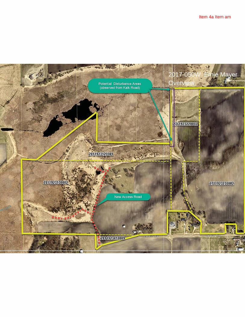
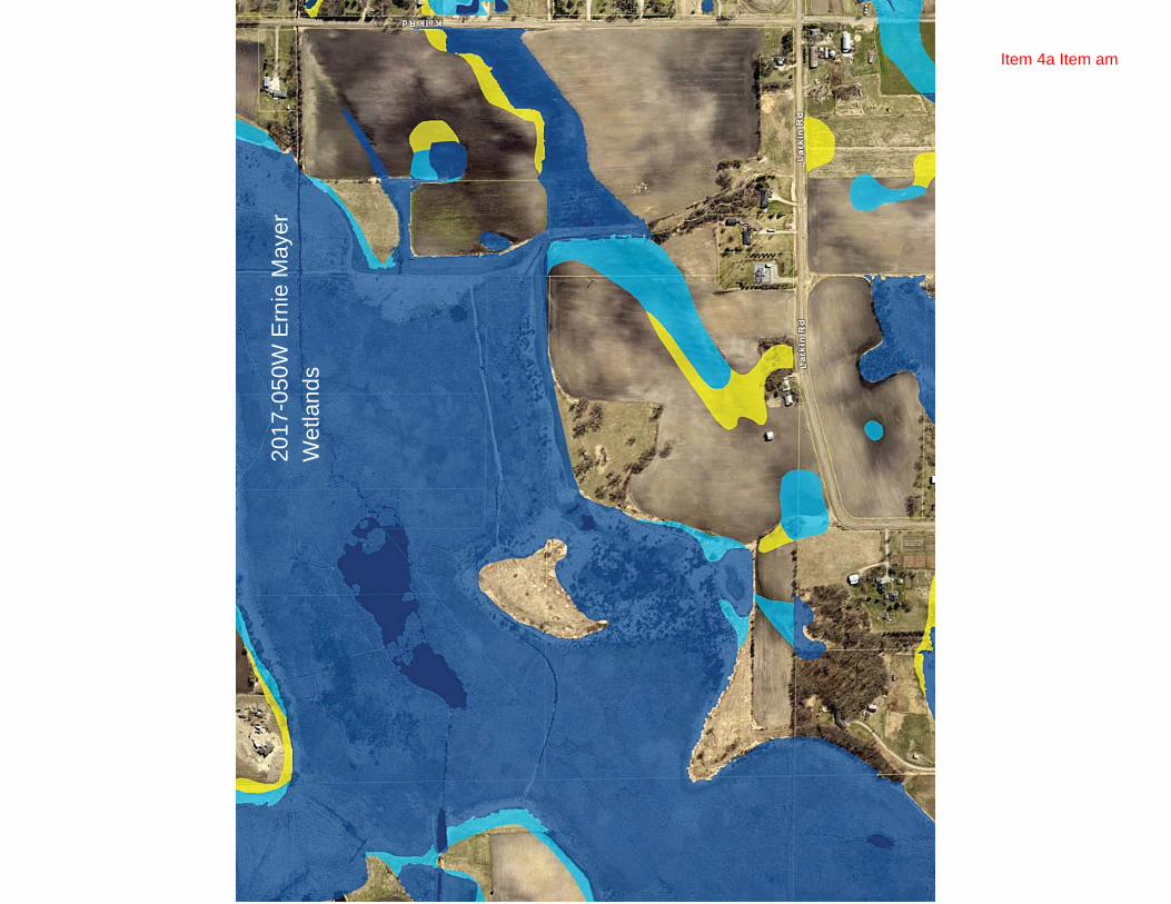
2017‐050 Ernie Mayer Wetland/floodplain violation, Corcoran. It came to the Commission’s attention that a potential wetland violation occurred on the following properties in Corcoran 1) 2811923410009, 2) 2811923130002, 3) 2711923220002 4) 2711923230002. Alll parcels appear to be operated by Ernie Mayer.
An initial site inspection appears to confirm the wetland violation. An access road was constructed from Larkin Road into these parcels. The road appears to be constructed in MN Wetland Conservation Act jurisdictional wetlands. In addition, this work was done in the Rush Creek floodplain.
A Technical Evaluation Panel (TEP) will meet on December 11 to visit the site and advise the Local Government Unit (ECWMC) as to the extent of the violation (if any) and the development of a restoration order for any violation that has occurred on these site. An update will be provided to the Commission at their meeting.
2017‐051 Mallard South 2nd Addition, Rogers. This is a 1.5 acre parcel proposed to be replatted for a 9‐unit townhome development. It was originally approved as 12 townhome units in 2001. Because of the change in platting, the site will have to conform to the Commission’s 3rd Generation Stormwater Management Plan. Site plans were received too late for Staff to provide their review and recommendations in this report. If available, staffs findings and recommendations will be provided to the Commision at their meeting.
Item 4a
RULE D ‐ STORMWATER MANAGEMENT RULE G ‐ WETLAND ALTERATION RULE E ‐ EROSION AND SEDIMENT CONTROL RULE H – BRIDGE AND CULVERT CROSSINGS RULE F – FLOODPLAIN ALTERATION RULE I – BUFFERS Italics indicates new information indicates enclosure
CHAMPLIN • CORCORAN • DAYTON • MAPLE GROVE • MEDINA •PLYMOUTH • ROGERS
Staff Report December 6, 2017 Page 6
FINAL RECORDINGS ARE DUE ON THE FOLLOWING PROJECTS: 2015‐030 Kiddiegarten Child Care Center, Maple Grove. This project was approved by the Commission at their December 9, 2015 meeting. If the City of Maple Grove does not take over the operation and maintenance of the underground system and the sump catch basins, an O&M agreement for the underground trench/pond system must be approved by the Commission and the City and recorded with the title.
2016‐026 Faithbrook Church, Dayton. Approved August 10, 2016, with the stipulation that an approved O&M plan be recorded with the property within 90 days following final plat approval. Per his August 31, 2017 email, Jason Quisberg has indicated that construction is significantly complete, although some vegetation establishment remains. The City still has an escrow in place which will be held until the maintenance agreement is finalized and recorded.
2016‐052 The Woods at Rush Creek, Maple Grove. At their March 2017 meeting, the Commission approved Staff’s findings and recommendations dated February 15, 2017. Outstanding items are the biofiltration pond, O & M plans, and recording.
2017‐014 Laurel Creek, Rogers. At their June 14, 2017 meeting the Commission approved Staff findings dated June 13, 2017, in which they recommended approval of this project with four conditions. All contingency items have been provided with the exception of the O&M agreement which is being negotiated by the City as to whether the City or the HOA will be responsible for the operation and maintenance of the stormwater management facility. In his August 31, 2017 email, Andrew Simmons responded that the O&M agreement is still being negotiated. 2017‐016 Territorial Woods, Maple Grove. This is a 21 acre site located at 13763 and 14033 Territorial Road. The development is proposing to construct a 98‐unit apartment building and 69 townhome units. Staff review is for compliance to the Commission’s rules D, E and I. This item was approved at the September 2017 Commission meeting contingent upon receipt of an O & M agreement meeting the Commission’s rules. The agreement was approved by the City and is in the process of being recorded.
2017‐017 Mary Queen of Peace Catholic Church, Rogers. At their June 14, 2017 meeting the Commission granted Staff approval authority pending satisfactory compliance with Staff’s findings dated June 16, 2017. All items from the findings have been completed with the exception of the operation and maintenance agreements for the stormwater facilities. In his August 31, 2017 email, Andrew Simmons responded that he has the O&M agreement in hand, just awaiting recordation.
2017‐019 Medina Senior Community, Medina. This item was approved at the Commission’s September 2017 meeting subject to conditions. All of the conditions have been met with the submission of revised plans, with the exception of the final recordings of the O&M agreements and easements.
2017‐021 Hindu Society of MN, Maple Grove. At their June 14, 2017 meeting, the Commission approved this project per Staff’s recommendations. All the recommendations have been met with the exception of the O&M plan agreements.
2017‐029 Brayburn Trails, Dayton. At their August 2017 meeting the Commission approved Staff’s findings dated August 2, 2017 with five conditions. All of the conditions have been met with the submission of revised plans, with the exception of the final recordings of the O&M agreements and easements.
2017‐034 Plymouth Memory Care, Plymouth. This project is a new Senior Living Facility located on a 4.7 acre parcel located northwest of CR 101 and Medina Road. The project will replace one single family home located on the site. Stormwater, grading and erosion control plans were submitted for review. This project was approved by the Commission at its September 2017 meeting subjec to the receipt of an O&M agreement acceptable to the Commission.
2017‐037 Corcoran L‐80 Lift Station, Corcoran. Staff recommended the Commission approve this project contingent upon the project meeting the Commission wetland buffer requirements. This item was approved by the Executive Committee of the Commission in October 2017. Revised plans meet the Commission’s buffer requirements with the exception of the final easment recordings.
Item 4a

RULE D ‐ STORMWATER MANAGEMENT RULE G ‐ WETLAND ALTERATION RULE E ‐ EROSION AND SEDIMENT CONTROL RULE H – BRIDGE AND CULVERT CROSSINGS RULE F – FLOODPLAIN ALTERATION RULE I – BUFFERS Italics indicates new information indicates enclosure
CHAMPLIN • CORCORAN • DAYTON • MAPLE GROVE • MEDINA •PLYMOUTH • ROGERS
Staff Report December 6, 2017 Page 7
FISH LAKE INTERNAL LOAD PROJECT.
1. Mobilization for the Alum treatment began the morning of September 18, 2017. Two 7000‐gallon capacity temporary chemical storage tanks were placed on‐site to store liquid aluminum sulfate. The alum was delivered to the site in 5,000 gallon tanker trucks to transfer alum to the temporary lakeshore chemical storage tanks. The storage tanks allowed for the continuous transfer of alum to the treatment barge at a rate that exceeds the delivered supply from the tanker trucks.
2. The treatment barge started applying alum to Fish Lake at 1:00 PM on September 18. The treatment barge had a computer with GPS technology that had pre‐programmed bathymetry data to assist with the route of the application. The computer also controlled the pumping rate of the alum based on boat speed and water depth to ensure the effective dose of alum applied to the lake.
3. The treatment barge has the ability to apply 20,000+ gallons of alum per day. Alum was applied to 120 acres of Fish Lake at depths greater than 20 feet. The target dose of alum was 95,000 gallons for the entire treatment. A total of 95,349 gallons of alum (22 alum trucks) was applied to Fish Lake. The treatment was completed by 1:00 PM on September 21.
4. HAB Aquatic Solutions set up a website for the Fish Lake Alum Treatment (http://fishlakealum.com). The website gave daily updates of the project, and provided an opportunity for anyone to submit questions that they may have had about the project.
5. The Fish Lake Area Residents Association (Dave Haas) set up a media event on September 20. Doug Baines attended the media event as representation for the Elm Creek Watershed Commission. There were approximately 10 to 15 home owners in attendance. There were also presentations by HAB Aquatic Solutions and Three Rivers Park District about the project followed by a boat tour in order to observe the alum application. The CCX news media video is available at the following link: https://www.youtube.com/watch?v=Mt1gYo5lGtw
Daily Application Log for Fish Lake, MN Alum Application ‐ 2017
Date LakeHours of Application
Approx. Alum Applied (gal)
Approx. Acres Covered
Alum Truck Deliveries Notes
9/18/2017 Fish 12:35 ‐ 20:25 19,800 50.2 6 First day of application9/19/2017 Fish 6:55 ‐ 21:00 30,668 77.8 79/20/2017 Fish 7:40 ‐ 21:35 29,385 74.3 79/21/2017 Fish 7:35 ‐ 13:05 15,496 39.1 2 Application completed
Total 95,349 241.4 22
Item 4a
RULE D ‐ STORMWATER MANAGEMENT RULE G ‐ WETLAND ALTERATION RULE E ‐ EROSION AND SEDIMENT CONTROL RULE H – BRIDGE AND CULVERT CROSSINGS RULE F – FLOODPLAIN ALTERATION RULE I – BUFFERS Italics indicates new information indicates enclosure
CHAMPLIN • CORCORAN • DAYTON • MAPLE GROVE • MEDINA •PLYMOUTH • ROGERS
Staff Report December 6, 2017 Page 8
Item 4a
2017-050W Ernie MayerOverview
Item 4a Item am

2017
-050
WE
rnie
May
erFl
oodp
lain
Item 4a Item am
2017
-050
WE
rnie
May
erW
etla
nds
Item 4a Item am

Item 5a

Item 5a

Technical Advisory Committee Meeting
October 27, 2017, 9-11AM, Maple Grove City Hall
Take Away Notes
1) Discussion on Pros and Cons of increasing filtration basin sizing to 2.2” when used to meet the ECWMC abstraction standards.
a. Maintenance i. Less chance of filter plugging, meaning less maintenance needed over the same
period of time. ii. Essentially provides a more conservative design – can still function with ½ the
assumed discharge rate and function correctly iii. Concern that doubling the size of filtration basins could double the cost to
replace/repair filter media when it is needed. There was discussion that the increase in size may result in a longer service life before this type of maintenance is needed. Unknown whether these offset each other.
iv. Forebay sizing – does not need to double, both ECWMC staff and City staff confident that existing forebay sizing requirements are adequate.
b. Nutrient and TSS reductions i. Low increases in pollutant reductions by doubling sizes. Per MIDS modeling,
highest increase was about 1-4% additional reduction in TP and 4-9% reduction in TSS, with all other scenarios less than this. The removal table is included at the end of this memo
1. Makes sense based on the fact at 1.1 inch sizing, we are at the large inflection point in the rainfall curve – essentially we are maximizing the benefits for the basin size based on the # of rainfall events below and above 1.1” sizing – ie: that is a large part of why that criteria was adopted by MIDS.
ii. Modeling does NOT show that these features will meet the removals provided by true abstraction.
c. Concern about increased Land usage by stormwater practices because of increased sizing requirements
i. Facility sizes will essentially double ii. Discussion about how this works with Met Council requirements for higher
density requirements for MUSA areas. d. Key point: The motivation for the proposed change is for development to use true
abstraction vs filtration i. The thought is that less land being used for stormwater mgmt. for true
abstraction (ie: infiltration where possible, irrigation, increased buffers, soil amendements) will free up more developable land (ie: rather than default to filtration, as seems to be happening, actually consider other approaches).
Item 5a

2) Provide sizing examples for 1.1” vs 2.2” for filtration ponds. a. Modeled as biofiltration basins in MIDS.
i. Selected as this is the only sizing that takes into account the size of the basins – the sand filter option only removes a fixed percentage assuming it is sized per the MPCA manual.
ii. Size of basins shown in tables below. 3) Little or no discussion on other abstraction increases proposed – increases in credits for
additional buffers soil amendment areas, preservation areas. (50% to 75% credits), 4) There were questions on actual phosphorous removals for the various abstractions. Indicated
staff would still keep track of estimates of TP/TSS removals for TMDL purposes. 5) Extensive discussion was held on irrigation requirements
a. Minimum sizing (does the system have capacity to irrigate when its actually dry out) b. Monitoring / reporting c. Troubleshooting issues d. Well augmentation e. Removal rates (TP) f. Pathogens / MDH discussion on requirements for irrigation water g. General support for ECWMC staff to look for additional details like pumps, install details,
etc…
For filtration systems ECWMC will start to require the following standard be met.
1) Underdrains must be constructed with Schedule 40 or SDR smooth wall PVC pipe (or a similar pipe and corresponding ‘n’ value)
2) Minimum 3” #57 (3/4-1”) stone around the pipe 3) Minimum 2” chocking stone (1/2” minus) 4) Minimum 0.5% pipe slope 5) One underdrain for every 1000 sq. ft. of surface area. 6) Include at least 2 observation /cleanouts for each underdrain, one at the upstream end and one
at the downstream end. Cleanouts should be at least 4 inches diameter vertical non-perforated schedule 40 PVC pipe, and extend to the surface. Cap cleanouts with a watertight removable cap.
7) For underdrains that daylight on grade, include a marking stake and animal guard 8) Avoid filter fabric. (Pipe socks may be needed for underdrains imbedded in sand. If pipe socks
are used, then use circular knit fabric) 9) Use solid sections of non-perforated PVC piping and watertight joints wherever the underdrain
system passes below berms, down steep slopes, makes a connection to a drainage structure, or daylights on grade.
10) Filter basin sequencing must be very specific as it relates to your site. The basin sequencing must ensuring the basin is constructed or reconstructed after the site has permanent stabilization established or the plan must state how it will be protected during the interim (perimeter silt fence alone is not adequate)
Item 5a

Scenario Surface Size (acres)
TSS Removal (%)
Change from 1.1” (%)
TP Removal (%)
Change from 1.1” (%)
Residential 1.1”
0.35 66 61
Residential 2.2”
0.69 70 4 65 4
Commercial 1.1”
0.64 62 66
Commercial 2.2”
1.26 71 9 67 1
Item 5a

EXHIBIT A
Elm Creek Watershed Management Commission Capital Improvement Project Submittal
(This submittal will be rated on its completeness and adherence to the goals of the Commission. A second page may be used to provide complete responses.)
City City of Medina Contact Name Steve Scherer, Public Works Director; Dusty Finke, City Planner Telephone 763-473-8842; 763-473-8846 Email [email protected]; [email protected] Address 2052 County Road 24; Medina, MN 55340
Project Name Hickory Drive Stormwater Improvement
1. Is project in Member’s CIP? ( X ) yes ( ) no Proposed CIP Year = 2019 2. Has a feasibility study or engineering report (circle one) been done for this project? ( ) yes ( X ) no Amount Total Estimated Project Cost $ 225,000 Estimated Commission Share (up to 25%, not to exceed $250,000) $ 56,250 Other Funding Sources (name them) – City will seek additional grant or clean water funding;
City stormwater utility and assessments for remainder $168,750 $ 3. What is the scope of the project? Install stormwater pond for 8.3 acre drainage area (50%
impervious). Stabilize approximately 300 linear feet of gully erosion. Install approximately 700 feet of curb and 600 feet of storm sewer to capture and direct stormwater to improvements.
4. What is the purpose of the project? What water resource(s) will be impacted by the project? The purpose of the project is to reduce nutrient loading to Elm Creek, which is adjacent to the project area. Drainage to Elm Creek is currently not treated.
5. What is the anticipated improvement that would result from the project? (Include size of area treated and projected nutrient reduction.) Jim Kujawa has estimated the phosphorus removal would be approximately 26.6 lbs/year. This removal is estimated to consist of an estimated 16 lbs/year for the pond plus 10.6 lbs/year phosphorus reduction for the gully/erosion improvements.
6. How does the project contribute to achieving the goals and programs of the Commission? The proposed project will reduce nutrient loading to Elm Creek, reduce runoff rate to Elm Creek, address implementation of the Elm Creek Watershed TMDL, and reduce erosion of the gully draining to Elm Creek.
0/10 7. Does the project result from a regulatory mandate? ( ) yes ( X ) no How? The stormwater improvement is not triggered by a permit requirement, but is consistent with TMDL implementation.
0/10/20 8. Does the project address one or more TMDL requirements? ( X ) yes ( ) no Which? Elm Creek Watershed TMDL
0/10/20 9. Does the project have an educational component? ( X ) yes ( ) no Describe. Information related to the benefits of the project will be included in newsletters and public meetings related to the project. The anticipated location of the pond does not lend itself well to educational signage, but the City will search for options.
0/10 10. Do all the LGUs responsible for sharing in the cost of the project agree to go forward with this project? ( X ) yes ( ) no Identify the LGUs. City of Medina
10/20 11. Is the project in all the LGUs’ CIPs? ( X ) yes ( ) no
1-34 (For TAC use)
12. Does project improve water quality? (0-10)
13. Prevent or correct erosion? (0-10)
14. Prevent flooding? (0-5)
15. Promote groundwater recharge? (0-3)
16. Protect and enhance fish and wildlife habitat? (0-3) 17. Improve or create water recreation facilities? (0-3)
TOTAL (poss 114) Adopted April 11, 2012
Z:\ELM CREEK\MANAGEMENT PLAN\EXHIBIT A_APRIL 2012F.DOC
Item 5b

Technical Memo
Wenck Associates, Inc. | 7500 Olson Memorial Highway | Suite 300 | Plymouth, MN 55427
Toll Free 800-472-2232 Main 763-252-6800 Email [email protected] Web wenck.com
To: Shingle Creek/West Mississippi WMC Commissioners From: Diane Spector Date: December 8, 2017 Subject: Education and Outreach Update WMWA A reminder that WMWA has switched over its email distribution system for the WaterLinks e‐newsletter from Hennepin County to MailChimp. If you wish to keep getting it (or to newly subscribe), go to westmetrowateralliance.org/contact.html and sign up. Basset Creek and the city of Plymouth both recently hosted salt applicator workshops, mostly attended by city staff and only a few private applicators. WMWA is currently discussing options for assisting property owners with rain gardens and native plant conversions. Two options being considered are 1) funding two hours of on site technical assistance for owners who take the Metro Blooms Landscaping workshop; and/or 2) providing reimbursement for the cost of purchasing native plants, up to a certain amount, say $100. These ideas are still under development. WMWA is also planning to continue facilitating native plant sales by linking up native growers with community events such as festivals and farmer’s markets. WMWA would pay any booth fees charged by the event sponsor and advertise the event and the grower would be free to sell plants. Outreach Ed and Diane met with Patience Caso (HCEE) and two Master Water Steward students (Josh Bindewald, Sarah Guse) who live in Robbinsdale and are interested in learning more about the watersheds and how they can help foster citizen engagement. masterwaterstewards.org/ Website/Social Media After last month’s flurry of inquires submitted via the website, I downloaded all the inquiries received via the website since the site was rebooted last year. They are attached. I have minimized contact information and names in this printed list. The website Google Analytics for November 2017 are attached, as are the Facebook insights for the last 28 days for both Shingle Creek and WMWA. As a reminder, Reach is the number of times a post was viewed in a Facebook feed, Engagement is an action‐ a click, comment, share, or reaction. The Shingle Creek post with the most reach and engagement highlighted Olson Middle School students.
Item 8a

2
Shingle Creek FB Metrics Last 28 days: 103 total Likes, 363 Reaches, 74 Engagements.
Item 8a

3
West Metro Water Alliance (WMWA) Metrics Last 28 days: 118 total Likes, 143 Reaches, 112 Engagements
Item 8a