EGYPT - United States Agency for International …pdf.usaid.gov/pdf_docs/PNADG846.pdfTraversing A...
68
Technical Report No. 9 June 16, 2005 Prepared by: Noel Taylor In cooperation with: Registration Team (Task 2) This publication was produced for review by the United States for International Development. It was prepared by consultants and/or subcontractors in collaboration with Chemonics International Inc. Cadastral Survey and Mapping Issues Report EGYPT Contractor: Chemonics International Inc. Contract No: 263-C-00-05-00003-00
Transcript of EGYPT - United States Agency for International …pdf.usaid.gov/pdf_docs/PNADG846.pdfTraversing A...

Technical Report No. 9 June 16, 2005
Prepared by: Noel Taylor
In cooperation with: Registration Team (Task 2)
This publication was produced for review by the United States for International Development. It was prepared by consultants and/or subcontractors in collaboration with Chemonics International Inc.
Cadastral Survey and
Mapping Issues Report
EGYPT
Contractor: Chemonics International Inc. Contract No: 263-C-00-05-00003-00

DATA PAGE Activity Title and Number: Egypt Financial Services (EFS) Project
Contract No. 263-C-00-05-00003-00 Prepared for: EFS CTO: Gregg Wiitala DCTO: Ingi Lotfi
Economic Growth Division Office of Financial and Information Technology USAID/Egypt
Task: Task 2: Improve Operation of Urban Registration
System in the Ministry of Justice KRA: KRA 2.2: Automation Design Phase of Business
Applications of Pilot System for Registration Activities: 2.2.6: Embed a Property Locator System within the
Design Application.
Author: Noel Taylor International Land Systems Date: June 16, 2005 List of Key Words Contained in Report: Egyptian Survey Authority Cadastral ESA Business Processes for Property Registration Current Status of Cadastral Surveying The author’s views expressed in this publication do not necessarily reflect the views of the United States Agency for International Development or the United States Government.

Egypt Financial Services Project
Cadastral Survey and Mapping Issues Report Technical Report No. 9
Table of Contents
ACRONYMS I
TERMINOLOGY & DEFINITIONS II
EXECUTIVE SUMMARY V
INTRODUCTION 1
1. EGYPTIAN GENERAL SURVEY AUTHORITY 1
1.1 ESA Organizational Structure – Central Level 1
1.2 ESA Staffing Resources – Greater Cairo 2
1.3 ESA Technical Capacity 5
1.4 Cadastral Mapping Infrastructure & Data 7 1.4.1 Geodetic & Cadastral Mapping Network Control 7 1.4.2 Base Mapping 9 1.4.3 Current State of Cadastral Data 9
2. LEGISLATION, REGULATIONS & TECHNICAL INSTRUCTIONS FOR CADASTRAL ACTIVITIES 13
2.1 Law #114:1946 on Regulating Real Estate Registration 13
2.2 Law #142:1964 on In Rem Registry & Supporting Regulations 14
2.3 ESA Fees for Property Registration Activities 16
2.4 ESA Technical Instructions 16 2.4.1 EDO Instructions 16 2.4.2 City Survey Instructions 17 2.4.3 Next Steps - Cadastral Survey Technical Instructions 18
3. CURRENT STATUS OF CADASTRAL SURVEYING & MAPPING IN URBAN AREAS 27

Egypt Financial Services Project
Cadastral Survey and Mapping Issues Report Technical Report No. 9
3.1 ESA District Office (EDO) 29 3.1.1 Customer Service 29 3.1.2 Cadastral Surveys 30
3.2 ESA Provincial Office (EPO) 31 3.2.1 Customer Service 33 3.2.2 Cadastral Surveys 33
3.3 ESA Business Processes for Property Registration 36
4. TECHNICAL CAPACITY OF PRIVATE SECTOR 38
4.1 Education & Training in Surveying 38
4.2 Next Steps – Private Sector Capacity Building & Training 39
ANNEX 1 – ESA HIGH ACCURACY REFERENCE NETWORK STATION DIAGRAM 41
ANNEX 2 - SPECIFICATIONS FOR CADASTRAL SURVEY EQUIPMENT 42
ANNEX 3 – SAMPLE GEODETIC CONTROL POINT DESCRIPTION 43
ANNEX 4 – ESA CIRCULAR ON FEES 44
ANNEX 5 – EDO INSTRUCTIONS 52
ANNEX 6 – ECIM PROPOSED CADASTRAL NUMBERING SCHEME FOR EGYPT 58

Egypt Financial Services Project
Cadastral Survey and Mapping Issues Technical Report No. 9 i
ACRONYMS CAPMAS Central Agency for Public Mobilization & Statistics
CIF Cadastral Information Form
ECSM Egyptian Committee of Survey & Mapping
ECIM Egypt Cadastral Information Management (Project)
EDO ESA District Office
EFS Egypt Financial Services (Project)
EPO ESA Provincial Office
ESA Egyptian General Survey Authority
GOE Government of Egypt
GPS Global Positioning System
ID Identification
MoJ Ministry of Justice
MSAD Ministry of State for Administrative Development
REPD Real Estate Publicity Department
RETD Real Estate Taxation Department
RO Registration Office
USAID United States Agency for International Development
WB World Bank

Egypt Financial Services Project
Cadastral Survey and Mapping Issues Technical Report No. 9 ii
TERMINOLOGY & DEFINITIONS In an effort to develop a list of consistent terms and definitions for use in Egypt by EFS Task 2, the list below incorporates and builds on terminology relevant to cadastral systems that was included in the trip reports of Rabley and Gaynor. In cases where possible the Arabic term is also included. Over time it is proposed that all terms on the list have both English and Arabic terms listed along with their descriptions. Some of the forms described in this section are also referred within other sections of this report. Examples of these forms have been collected by Task 2. The forms kept by Task 2 now also include hand written translation of key sections. File size and scanned image quality kept copies of these documents from being included in this report.
Term Definition / Description
Adjudication A judicial decision or formal judgment by a court or tribunal. Systematic adjudication is generally carried out during the introduction of a system of title registration to investigate and identify and adjudicate all rights, responsibilities and interests connected with individual real property objects. These are then registered against the object in the title register.
Aerial Survey A survey of an area made by taking sequential photographs from an aircraft; plans are then drawn from the aerial photographs.
Benchmark A permanent reference mark or point established for use by surveyors in measuring differences in elevation.
Boundary The line which separates property in one ownership from its neighbor(s); it is therefore the limit in all directions to which the ownership extends.
Cadastral Form (Sahiyfa akariya)
Used in the Sigueal el-ainee system as the form on which ownership information is recorded. Every parcel has its Cadastral Form. The Cadastral Form is akin to what is called a registration card or registration sheet in other countries. It is the document referred to in Article 58 of Law 142 of 1964 (the Sigueal el-ainee Law). That Law also refers to the Cadastral Form as a title deed (sanad al mulkkaya). The original of the Cadastral Form is kept in the central registration office. A copy of the Cadastral Form is provided only to the original parcel owner. Subsequent owners receive Certificates (Shaheda) pursuant to Article 59 of Law 142 of 1964.
Cadastral Information Form (CIF) (kashf tahadeed)
The form generated by the ESA district office (EDO) describing the property that is the subject of a transaction. The EDO must provide the CIF to the local registration office (RO) before the RO

Egypt Financial Services Project
Cadastral Survey and Mapping Issues Technical Report No. 9 iii
will proceed with registering a transaction.
Cadastral Index Map The purposes of a cadastral index map is not to show each individual property with high spatial accuracy but rather to show properties in their correct spatial relationships to each other. Historically, cadastral index maps were often built up from surveys of individual parcels, a bottom-up approach. The bottom-up approach requires generalization of the individual parcel maps to get an overview map in which all parcels fit smoothly. In modern times, with the availability of computerized maps, aerial and satellite photography, and other top-down views, cadastral index maps are often prepared independently in parallel with the surveys of individual parcels.
Cadastral Plan (Location Plan)
A plan which, for clarity of interpretation, is of a large scale (e.g. 1:1,250 or 1:2,500) to show the position of a specific property in relation to its surroundings.
Cadastral Survey A survey carried out for the determination, identification, and re-establishment of adjustment of the boundaries of a property on a plan.
Certificate of Authenticity (Shaheda)
The certificate issued pursuant to Article 61 of the Sigueal el-ainee Law to confirm the authenticity of a copy of the Cadastral Form or Certificate issued under Article 59.
Certificate of Title A statement of opinion on the status of the title to a parcel of real property based on an examination of specified public records.
Deed A document, being written evidence of a legal transaction, which has been signed, sealed and delivered to testify to the agreement of the parties concerned.
Easement A right to use the land of another for a specific purpose, such as for a right-of-way or utilities; an incorporeal interest in land.
Encroachment Unauthorized extension of the boundaries of a piece of land over adjoining land, via occupation, which belongs to another.
Mutation Form The document generated by the EDO when a parcel is created. It contains spatial information regarding the real property object as well as ownership information that is updated each time there is a transaction. The spatial information is generated through results of cadastral surveys performed by EDO or EPO surveyors.
Plan 1) A drawing to scale of the layout and construction of a part of a building, whether existing or proposed, in horizontal section e.g. of a particular floor or set of rooms, and showing details such as windows, doors and permanent partitions.

Egypt Financial Services Project
Cadastral Survey and Mapping Issues Technical Report No. 9 iv
2) A drawing of a relatively small area of land, usually drawn to a large scale and including details of boundaries, buildings, structures, service and other man-made features of a relatively permanent nature in addition to physical features. 3) A set of proposals for the performance of a task or undertaking in a controlled manner or in a series of predefined steps according to certain principles or rules. In the case of the future development of an area, it would probably embrace maps and written statements.
Registered Contract (ad el baiya el nehaie)
A final contract, sometimes referred to as a deed, registered under the Sigueal el-shaksi system. The original is printed on oversized green paper and is kept in the central registration office. A blue copy on laminated legal size paper is provided to the owner.
Sigueal el-ainee Registry of real property (all rights, responsibilities and interests are registered against real property objects).
Sigueal el-shaksi Personal registry (meaning registration of real property objects against the name of a person).
Site Plan A drawing of an area of land, on a horizontal plane, showing the boundaries and physical extent of the land included in a particular parcel. It may also show existing buildings or the proposed layout of a development.
Subdivision A tract of land divided by the owner, known as the sub divider, into blocks, building lots, and streets according to regulations.
Survey A process of investigation into some subject involving measurement and/or assessment, e.g. building survey; land survey; land use survey; pedestrian survey.
Traversing A method of land surveying by measuring angles with a theodolite or total station, from each station to other stations, measuring the distance between stations and plotting the results. The stations are generally used as local geodetic control points for land surveys.

Egypt Financial Services Project
Cadastral Survey and Mapping Issues Technical Report No. 9 v
EXECUTIVE SUMMARY Purpose. The purpose of this report to present the results of a six week consultancy that concentrated on initial analysis and information gathering on technical aspects related to cadastral surveying and mapping of the urban property registration system in Egypt. The report also presents recommendations for improvements to various aspects of the cadastral surveying and mapping components of the system based on this preliminary analysis. Overview. The report includes an introduction plus sections on the Egyptian General Survey Authority in terms of organization structure, human resources, technical capacity, and geodetic and cadastral mapping infrastructure. Legislation, regulations and ESA technical instructions related to property registration were reviewed and next steps for improvement provided. Further analysis of actual cadastral survey and mapping business processes was conducted in light of the business process mapping that has been performed under EFS Task 2. The status of private sector capacity for increased involvement in cadastral activities is examined along with the education and training situation related to surveying. Most analyses are accompanied with interwoven recommendations for areas of improvement, or followed by separate ‘next step’ sections. Relevant documents such as technical instructions have been referenced and attached as annexes. Egyptian General Survey Authority (ESA). ESA has long been connected with property registration in Egypt. It has enjoyed a basic monopoly on the provision of cadastral survey and mapping services and products. Reorganized four years ago into an economic authority ESA is now under pressure to maintain the level of service it had traditionally provided through government funding, while generating enough self funding revenue. It is over resourced in terms of staff but is unable to reduce staff numbers being a government agency. The technical and organizational capacity of the Authority would struggle under a large scale program of systematic property formalization or title registration in urban settings. There are numerous areas where EFS can provide assistance to ESA in improving technical capacity, modernization of offices, improving records management and archiving and organizational restructuring. Early indications are that ESA understands it has problems is open to improving its operations that support property registration. Legislation, Regulations & Technical Instructions. EFS had legal analyses being carried out in parallel with this technical review. Separate reports will be submitted by the two legal consultants with the comprehensive recommendations for improvements to legislation and regulations. There are numerous provisions of the major legislation and regulations related to technical issues that, in most cases, do not need to be included in such documents. There are two sets of ESA issued technical instructions pertinent to cadastral surveying in urban areas. City Survey Instructions were developed in 1945 and have not been updated since that time. EDO instructions act as operational guidelines for handling applications and requests submitted by Ministry of Justice Registration Offices (ROs). Neither set of instructions would be suitable for use by EFS or the expectant World Bank project in terms of providing adequate and reasonable technical standards for modern cadastral surveying and mapping to support property registration.

Egypt Financial Services Project
Cadastral Survey and Mapping Issues Technical Report No. 9 vi
This is an area where EFS can lend valuable assistance in developing guidelines for both cadastral fieldwork and ESA office operations. Two key areas that must be closely examined during development of the technical instructions is the policy on boundary demarcation and delineation, and the development of a modern property locator (cadastral numbering) system. Current State of Cadastral Surveying & Mapping in Urban Areas. This section places emphasis on analyzing what is actually happening on the ground in terms of cadastral activities. ESA District (EDO) and Provincial (EPO) Offices have vastly different technical capacities and roles to play in the property registration process. Customer service at both levels is almost non-existent and certainly not conducive towards encouraging wider involvement in the formal property registration system. ESA has indicated willingness to trial a new institutional arrangement whereby the role of the EDO would be significantly reduced and EPOs would assume greater responsibility for conducting field activities, improving interaction with customers, and providing data to ROs. The business processes followed by ESA offices during the registration process clearly add to the complexity of the system and frustration that applicants would experience while conducting transactions. Testing the new EDO-EPO institutional arrangement will provide the perfect avenue for also testing reengineered business processes for ESA operations. One of the simpler changes to process suggested is that applicants have cadastral survey activities conducted prior to lodgment of their application. EFS could provide much needed assistance to ESA in these areas by purchasing additional modern surveying instruments and IT infrastructure, provide comprehensive training to staff on new processes, improve records management and archiving systems, and refurbish offices. Private Sector Capacity, Education & Training. Cadastral surveying and mapping in Egypt has been strictly the domain of ESA since it was established over 100 years ago. To this end there are no private companies currently performing cadastral activities. ESA has no experience or system in place for certifying and contracting private companies or carrying out quality control of their activities and work product. There are a number of private and para-statal companies that have the equipment and human resources to do such activity but they have not received the cadastre specific technical training afforded ESA employees when they join the authority. There are numerous universities offering degrees relevant to surveying but none include the cadastre in their curriculum. EFS could provide assistance in introducing a system of ESA certification for private companies to carry out cadastral activities as well as quality control for contracted activities. In the immediate term private companies should receive short targeted training to enable them to carry out building and apartment unit cadastral surveys. In the short to medium term EFS could assist in the establishment of a private surveyors’ association as one component of a strategy to increase private sector involvement in property registration. In the longer term EFS could work with ESA to introduce cadastral concepts into universities and other technical institutes.

Egypt Financial Services Project
Cadastral Survey and Mapping Issues Technical Report No. 9 1
INTRODUCTION This report is the result of a six week consultancy undertaken as part of the USAID-funded Egypt Financial Services (EFS) Project. Overarching goals of EFS are to establish a modern property registration system, wholesale mortgage finance systems, deepen the capital market’s regulatory work, and establish a credit bureau. Task 2 of the project is charged with “Improving Operations of Urban Real Property Registration Systems”. The key objective of Task 2 is to develop a pilot registration system in two urban areas in collaboration with the Ministry of Justice (MoJ), Ministry of State for Administrative Development (MSAD) and the Egyptian General Survey Authority (ESA). The purpose of the consultancy was to conduct an analysis of the current cadastral survey and mapping operations and institutions supporting real property registration within urban areas of Greater Cairo. The consultancy was to also identify some of the negative factors connected with these operations and institutions that are contributing to a less than ideal system of urban real property registration in Egypt, and provide initial recommendations that could assist EFS, USAID and key Egyptian stakeholders in addressing these issues.
1. EGYPTIAN GENERAL SURVEY AUTHORITY The science, or art, of what is now often termed ‘surveying’ can be traced back to the period of Pharaonic rule in Egypt. The Pharaonic term for surveyors was “harpedonaptae”, or rope stretchers. The most commonly used instrument for measuring distances during this period were ropes that had been specially treated to hold their length. Structures such as the pyramids stand testament to the success with which ancient Egyptian surveyors were able to ply their trade. Nowadays the responsibility for government sponsored surveying and mapping falls to the Egyptian General Survey Authority (ESA). ESA was established in 1898 to implement a program of surveying and mapping. The name “Egyptian General Survey Authority” was adopted in 1971. ESA was placed under the Ministry of Irrigation in 1975, which is now the Ministry Water Resources & Irrigation. Presidential decree #239 of 1978, later amended by decree #298 of 1984, defines ESA’s role in the area of surveying and mapping. The decree effectively presents ESA with the first right of refusal for the provision of mapping information and conduct of surveys when such data is required by governmental agencies, local governmental units and public sector companies. Further discussion related to current legislation in the context of property registration and ESA is presented in Section 7. This discussion will focus on technical issues only. In-depth legal analysis has been carried out by two Task 2 Real Property Legal Advisers.
1.1 ESA Organizational Structure – Central Level ESA has well in excess of 10,000 staff spread across Egypt in offices at the District, Provincial and Central level. ESA is divided into various administrative levels that are responsible for managing implementation of ESA activities on a day-to-day basis. An overview of ESA’s general organizational structure is presented in Figure 1. Further details
Egypt Financial Services Project
Cadastral Survey and Mapping Issues Technical Report No. 9 2
on key divisions within this structure, which play a role in real property registration, are presented below.
Governorate Survey Affairs Central Department This department is a key division within ESA in the context of real property registration. It sits above the General Department for Cadastral Mapping (GDCM). GDCM is responsible for out carrying cadastral surveys of all properties within Egypt, whether it is for deeds or title registration. The conduct of these surveys is primarily performed by ESA Provincial Offices and ESA District Offices. Also sitting within the Governorate Survey Affairs Central Department are five ‘Regional’ divisions. The five Regions are Upper Egypt, Middle, Middle Delta, Western Delta and Eastern Delta. These divisions in turn sit above Governorate level (EPO) offices according to geographic location.
Information Systems General Department
The Department performs scanning and digitizing of some existing cadastral maps and scanning of parcel mutation forms. However, it currently serves more as a digital archiving department. ESA does have plans for a restructure of the Department that would see it play a greater role in centralizing storage and delivery of digital cadastral and topographic maps and data.
Land Registration Central Department
The Department only performs work connected with title registration. Title Registration Offices within EPOs report progress and statistics directly to the Department.
Mapping Affairs Central Department
Sitting below this Department is the Department for Geodesy, Triangulation and Control, which is responsible for establishing, managing and maintaining all geodetic infrastructure for Egypt’s horizontal and vertical control networks. It is responsible for providing geodetic control point information for the conduct of cadastral surveys and mapping. Under the Mapping Affairs Central Department also sits the Department for Topographic Maps and Photogrammetry, which is responsible for production of topographic maps and processing of aerial photography into map products. Each division within the Department has its own cartographic section.
Training General Department Responsible for providing all training to ESA on cadastral topics and methodologies, and the delivery of training on new technology such as modern survey instrumentation, information technology, etc. This department is very well equipped with IT, training curricula and classrooms that have, in part, been provided through donor funded projects assisting ESA over the last decade.
1.2 ESA Staffing Resources – Greater Cairo As mentioned earlier, ESA has in excess of 10,000 staff spread across Egypt. ESA staff are generally classified according to four generic designations; Engineer, Technician, Administration, Supporting Staff. It has been extremely difficult to gain accurate and detailed

Egypt Financial Services Project
Cadastral Survey and Mapping Issues Technical Report No. 9 3
information related to numbers of staff within Greater Cairo, let alone position descriptions. The only information that was passed on by ESA is presented below. It took nearly two weeks to get these figures after a request of staffing breakdown for Greater Cairo according to position titles.
Total No Department 691 Head Office 81 Cadastre Mapping Department 155 Cairo Governorate 146 Kalyoubia Governorate 151 Giza Governorate 143 Beni Swief Governorate
Table 1 : Number of Technicians The consultant will continue to seek a more detailed breakdown of staffing, as staffing numbers are a key issue that must be examined when analyzing and recommending improvements to organizational structures and institutional business processes. One of the major constraints that ESA faces is the fact that it is still a GOE agency, despite its designation as an economic authority, and is therefore unable to undertake major staffing reductions. The inability to reduce staff numbers may impinge on the ability of EFS to achieve genuine improvements in the operations of the property registration system. This is discussed further under the commentary on the current institutional settings for property registration.

Egypt Financial Services Project Cadastral Survey & Mapping Report
Cadastral Survey and Mapping Issues Report Technical Report No. 10 Page 4
Figure 1: Current ESA Organization Structure - Head Office

Egypt Financial Services Project
5 Cadastral Survey and Mapping Issues Report Technical Report No. 9
1.3 ESA Technical Capacity As previously mentioned, there is an abundance of human resources within ESA for a large scale program, but the technical capacity of the Authority for the most effective and efficient implementation of a large scale program is less suitable. Although there are Engineers and Technicians on staff, EPOs do not have adequate modern surveying equipment (i.e. GPS and total stations) to carry out mass cadastral survey and mapping activities. The Cairo EPO only has two total stations, one Topcon and one Nikkon. This is not an adequate number of total stations to cover the 16 districts that fall under the EPO’s jurisdiction, especially under any large scale systematic program. There are no GPS units within the EPO. The Cairo EPO does not have adequate computers and software to support any major recommendations for improved business processes that are likely to come from EFS Task 2 built around digitalization. EDOs do not have computers at all. Anecdotal evidence suggests that very few staff of either office could be classified as proficient enough in computer use to support immediate take up of computerized processes. It had been earlier recommended that cadastral data collection under Task 2 rely heavily on aerial photography and GPS. Based on the review of ESA’s technical capacity it is clear that the use of aerial photography is considerably less likely to happen than was originally envisioned. Although such an approach would most probably produce the greatest efficiencies for large scale activities there is little buy in from the side of ESA at this point in time. Despite having a dedicated unit for the processing of aerial photography and creation of map products, ESA has not yet tested the appropriateness of orthophotos for cadastral maps in urban areas. ESA requires high levels of absolute spatial accuracy and does not view aerial surveys by themselves as an adequate tool for cadastral mapping. It was indicated1 that maps created through aerial surveys would only serve as a starting point and should be updated with extensive fieldwork using total stations to get higher absolute accuracy. Technical Advisors under Task 2 will continue to try and overcome these obstacles but will not be delayed in developing alternative data collection methodologies in the mean time. ESA Head Office has a number of total stations and GPS units that could be mobilized to support large scale activities in one area. However, these resources would be stretched beyond their means under a systematic program. The same could be said about digitalization of data and processes. As demonstrated through the Nasr City digital maps activity (see Section 6.4.3), Head Office is capable of producing a one off ‘snap shot’ but sustainability disappears when the data is handed over to the EPOs, unless they are adequately trained and involved in the process.
1 Discussion with Eng, Atef, Head of ESA Mapping Affairs Central Department (April 19)

Egypt Financial Services Project
6 Cadastral Survey and Mapping Issues Report Technical Report No. 9
The table below (Table 2) is an inventory of equipment available within Greater Cairo, including the Head Office Geodetic Department. As with data on staff numbers this information took some time for ESA to collect and provide. The amount of equipment is grossly inadequate to support a large scale program as well as maintain normal operations of Head Office Geodetic Department activities across Egypt.
Equipment Number of Units GPS - Leica - Ashtec
16 12
Total Stations - Topcon - Nikon - Sokia
5 3 8
Plotters (A0 ) 6 Scanner (A0 : A3) 3 Digitizers 6
Table 2: ESA Equipment within Greater Cairo With regards to IT systems, ESA is currently receiving assistance from the Finnish funded “Egyptian Cadastral Information Management Project”. It commenced in 2002 and was recently extended for a further 18 months. The ECIM project has primarily worked in rural areas where title registration has been ongoing. The project purpose has been the improvement/development of cadastral information systems linked to land registration and taxation. The project has developed a cadastral application based around existing ESA business processes connected with transactions in the title registration system. The application was scheduled for installation of the final version at the end of April 2005. The ECIM project is expected to work in urban areas and has expressed a strong desire to implement its system in the EFS model RO locations. With regards to ECIM, it is recommended that cooperation or integration with this project be put on hold pending further clarification of ECIM planned activities and system capabilities. The possibility of further development and refinement of the application developed by ECIM should be clarified. It should be noted that the information system developed by ECIM is based on the premise that the system in place is title registration. Additionally, the ECIM application merely computerizes the existing business processes of ESA without adoption of any streamlined procedures. The replacement ECIM Team Leader himself questioned the reasons for not streamlining the process before computerizing them. The system developed is capable of handle several transactions of the title registration process but it does not support the initial formalization, adjudication and registration phase. It is proposed that the consultant conduct further analysis of the ECIM system during his next short term input.

Egypt Financial Services Project
7 Cadastral Survey and Mapping Issues Report Technical Report No. 9
1.4 Cadastral Mapping Infrastructure & Data
1.4.1 Geodetic & Cadastral Mapping Network Control Egypt has at least two different geodetic coordinate systems, the 1907 system and the 1995 system. Based on the Helmert 1906 Projection, the 1907 network was initially established to support cadastral mapping. It is the most widely used network in the country. The New Egyptian Datum (NED) 1995 is based on the WGS-84 ellipsoid and consists of approximately 30 High Accuracy Reference Network (HARN) stations (1:10,000,000), and subsequent lower order points spread across Egypt. Annex 1 is a diagram showing HARN station locations throughout Egypt. USAID provided assistance to ESA for establishing NED-95 through the mid 1990’s project implemented by Geonex Ltd. Transformation parameters between the two systems have been calculated. NED-95 is not currently used by ESA2 as it would be too costly to adopt the new system and convert all existing maps. As previously mentioned, the Department for Geodesy, Triangulation and Control is responsible for management and updating of the control networks. It is this department which is also tasked with providing surveyors at the EPO level with point location diagrams and coordinate descriptions to enable the connection of cadastral surveys with the geodetic network. Anecdotal evidence3 suggests that this often does not happen; resulting in cadastral surveys carried out in local or free coordinate systems and later fitted to existing mapsheets. The density of the existing geodetic network within Greater Cairo is not currently adequate to support a large scale surveying and mapping program. This also contributes to cadastral surveys not being linked to the geodetic network, or extra time being required to conduct traverse surveys to densify control points for cadastral mapping.
1.4.1.1 Next Steps – Geodetic & Cadastral Mapping Infrastructure The improvement of geodetic infrastructure is an area where the EFS Project can provide immediate assistance to ESA that will have both long and short term benefits. Enhancing the technical capacity for cadastral data collection at the field level is also critical for implementation of a large scale systematic program. It is recommended that EFS purchase a set of three GPS receivers that can be used for densification of the geodetic network in EFS work areas. Although an urban setting, adopting medium static observations (≥1.5hrs), differential GPS and post processing of results will provide acceptable accuracy levels for network densification.
2 Discussion with Eng, Atef, Head of ESA Mapping Affairs Central Department (April 19) 3 Discussions with surveyors at Cairo EPO (March 21)

Egypt Financial Services Project
8 Cadastral Survey and Mapping Issues Report Technical Report No. 9
To support systematic cadastral mapping it is recommended that EFS assist ESA in establishing a Continuously Operating Reference System (CORS) that enables real time kinematic (RTK) GPS surveys. A network of four permanently fixed GPS reference stations would be separated by 40km baselines, encompassing an area of approximately 1600km2. The network would be scalable, so more GPS stations could be established through the proposed World Bank financing to cover additional areas of Greater Cairo. EFS assistance would also include rover units, but existing ESA instruments and units owned by the private sector may also be able to act as additional rover units for high speed survey and mapping. To ensure as high a level of usability as possible, it is recommended that the network be established in the region to the east of central Cairo. This would essentially give coverage to Nasr City and the new communities within it. The housing typology of this area would suit the use of RTK GPS not only for a large scale program but also in supporting the ongoing real estate development that will occur in these areas. For example, a development company could hire a private survey company to use GPS in setting out its new developments and then submit a development plan to ESA with real world coordinates, in digital form if necessary. This would remove the need to send ESA surveyors to the field and prepare another copy of the development plan after the set out has already been done. By making the submission of such development plans to ROs/ESA mandatory the registration of strata property objects would also be greatly improved. Any equipment procured under EFS should be assigned to the EPO in the interim to ensure EFS activities are adequately supported. Technical specifications for the GPS equipment recommended for procurement is attached as Annex 2. It is also recommended that EFS strongly encourage the adoption of the NED-95 as the basis for cadastral surveying and mapping under any large scale program, including EFS supported activities. This seems more than appropriate given that USAID previously provided assistance in the establishment of this system. A copy of control points coordinates and descriptions of their physical location (See Annex 3 for a sample from Victoria, Australia) should also be kept at EPOs, with the Department for Geodesy, Triangulation and Control retaining overall responsibility for system maintenance and upgrade. With the likelihood of increased private sector participation in cadastral surveying and mapping activities, ESA should lift its secrecy constraints on providing more detailed information for its geodetic control systems. Collection of basic information for the purposes of this report took longer than originally anticipated. With several papers on Egyptian geodetic networks presented at the recent conference for the International Federation of Surveyors (FIG) it is clear that strict control of such information is not really warranted. In fact, retaining strict control over access to the information is likely to result in the information becoming less relevant, especially to the private sector. This will have a detrimental effect on ESA in the longer term as it struggles to retain its identity as the principal supplier of spatial information in Egypt. Given ESA’s eminent role in Egypt’s

Egypt Financial Services Project
9 Cadastral Survey and Mapping Issues Report Technical Report No. 9
progression toward the establishment of a National Spatial Data Infrastructure, wider access to, and adoption of, a common geodetic framework should be a key priority of the Authority. The sample permanent mark sketch plan example from Australia (Annex 3) was printed off a government website open to public access so that private surveyors can search and print off information for geodetic control points across the entire state. This is a user pays system that could be replicated in Egypt over a relatively short period of time. Such a system would provide both open access to geodetic information as well as another revenue stream for ESA.
1.4.2 Base Mapping Given ESA’s long existence it is no surprise that ESA possesses a variety of mapping products that could serve as ideal base mapping material for a large scale program. Some of the key sources of base map data include:
• High resolution IKONOS satellite imagery; • Recently created digital maps for selected areas of Greater Cairo (Nasr City); • 1:10,000 scale topographic maps; • 1:5,000 scale topographic map sheets; • 1:1,000 scale cadastral map sheets; • 1:500 scale cadastral map sheets;
The role of each data source will vary according to the level of relevant cadastral information that can be extracted. For example, IKONOS imagery will be a valuable planning (block mapping), management and monitoring tool, while 1:500 maps will act as a primary source of cadastral data at the parcel level. The applicability of these data sources will need to be assessed on a case by case basis due to the variable condition of cadastral data within ESA offices. This is discussed in further detail below.
1.4.3 Current State of Cadastral Data Unfortunately the existing paper based cadastral data in the EPO and EDOs visited is in extremely poor condition, in terms of both products and how they are stored and archived. ESA Head Office is carrying out a program of digitalizing cadastral maps for a large portion of Nasr City but this is being carried out without EPO or EDO involvement. And the geodetic infrastructure is not suitable for a large scale program. EPOs maintain a series of traditional paper based map sheets (60cm x 40cm) as cadastral index maps at 1:500 or 1:1000 scale. It is not uncommon for these map sheets to date back to the early 1900’s. As would be expected, many of these map sheets are in a state of extreme disrepair. They are torn, frayed or faded to the point where data is either completely missing or totally illegible. Figure 2 shows two cadastral mapsheets created in the 1930’s which are still used to support property registration. Unfortunately it is difficult to make out the pencil markings that represent new parcels being created or changes to the boundaries of old parcels.

Egypt Financial Services Project
10 Cadastral Survey and Mapping Issues Report Technical Report No. 9
Figure 2: Old Cadastral Mapsheets (still in use)
Modern day transactions (i.e. subdivision, amalgamation and new parcels) are still entered on these sheets, primarily in pencil but sometimes in colored pen. EPOs also store field notes and calculations from survey teams and archive copies of transaction deeds that are forwarded by the REPD.
Figure 3: Mapsheet storage at EPO Figure 4: Deeds archive at EPO
The storage and archiving of these mapsheets (Figure 3) and other documents are not ideal. They are often left uncovered in offices that have no visible means of protection from fire or the elements. In some cases documents are left stacked in hallways or other areas, unprotected from public access. In the case of deeds documents, the Cairo EPO has two archive rooms, one of which is rarely opened (Figure 4), which contains over 6 millions documents dating back to the 1920s. Both rooms are in need of upgrade and repair, and destruction of deeds if the originals are kept by Central Notarization offices. The principal documents stored by EDOs are the most important of all documents maintained by ESA, the mutation forms. Again, many of these mutation forms are very old because they were initially created when individual land parcels were created. Although usually stored in
Egypt Financial Services Project
11 Cadastral Survey and Mapping Issues Report Technical Report No. 9
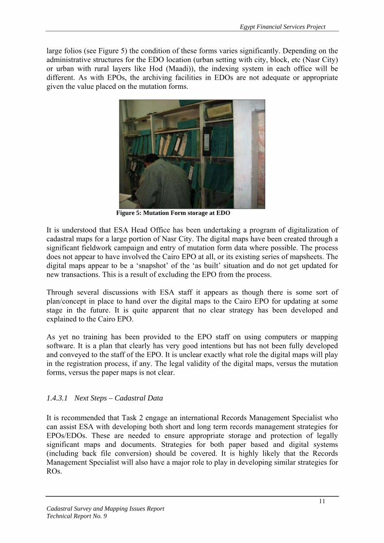
large folios (see Figure 5) the condition of these forms varies significantly. Depending on the administrative structures for the EDO location (urban setting with city, block, etc (Nasr City) or urban with rural layers like Hod (Maadi)), the indexing system in each office will be different. As with EPOs, the archiving facilities in EDOs are not adequate or appropriate given the value placed on the mutation forms.
Figure 5: Mutation Form storage at EDO
It is understood that ESA Head Office has been undertaking a program of digitalization of cadastral maps for a large portion of Nasr City. The digital maps have been created through a significant fieldwork campaign and entry of mutation form data where possible. The process does not appear to have involved the Cairo EPO at all, or its existing series of mapsheets. The digital maps appear to be a ‘snapshot’ of the ‘as built’ situation and do not get updated for new transactions. This is a result of excluding the EPO from the process. Through several discussions with ESA staff it appears as though there is some sort of plan/concept in place to hand over the digital maps to the Cairo EPO for updating at some stage in the future. It is quite apparent that no clear strategy has been developed and explained to the Cairo EPO. As yet no training has been provided to the EPO staff on using computers or mapping software. It is a plan that clearly has very good intentions but has not been fully developed and conveyed to the staff of the EPO. It is unclear exactly what role the digital maps will play in the registration process, if any. The legal validity of the digital maps, versus the mutation forms, versus the paper maps is not clear.
1.4.3.1 Next Steps – Cadastral Data It is recommended that Task 2 engage an international Records Management Specialist who can assist ESA with developing both short and long term records management strategies for EPOs/EDOs. These are needed to ensure appropriate storage and protection of legally significant maps and documents. Strategies for both paper based and digital systems (including back file conversion) should be covered. It is highly likely that the Records Management Specialist will also have a major role to play in developing similar strategies for ROs.

Egypt Financial Services Project
12 Cadastral Survey and Mapping Issues Report Technical Report No. 9
It is likely that a program of scanning and indexing of maps and other documents will be one activity that is recommended. This is also an area where Task 2 could consider providing assistance to ESA in the model RO locations. Storage and indexing can also be greatly improved through simple interventions such as minor archives room refurbishment, extra storage shelves and cupboards, and assistance in binding documents where necessary. The value of the digitalization of some of the Nasr City maps should not be underestimated, though further analysis is needed as to their role in the property registration system. The use of these maps could be interlinked to the institutional reforms proposed later in this document. If this is to happen though, it is even more crucial that adequate training is provided to EPO staff as soon as possible, and a comprehensive strategy on the pilot system developed. It is recommended that further analysis of these digital maps be carried out against relevant mutation forms and existing hard copy maps in the EPO.

Egypt Financial Services Project
13 Cadastral Survey and Mapping Issues Report Technical Report No. 9
2. LEGISLATION, REGULATIONS & TECHNICAL INSTRUCTIONS FOR CADASTRAL ACTIVITIES
Cadastral surveying and mapping activities that support real property registration are primarily governed through legislation by law #114 of 1946 on Regulating Real Estate Registration and supporting regulations, and law # 142 of 1964 on In Rem Registry and supporting executive regulations on Sigueal El-Ainee (Ministry of Justice decree #825, 1975). Technical instructions for these activities, with regards to urban settings, are ESA instructions for EDOs issued in 1997, and ESA Department of Cadastral Survey and Registration – Instructions for City Survey (1945). There is a separate ESA directive, Circular #222:2005, issued by the Central Department for Regional Survey Affairs that regulates the calculation and collection of fees for survey activities connected with real property registration. At the time of writing this report an extensive analysis of the legislative and regulatory environment underpinning real property registration is being conducted in parallel with the review of cadastral survey and mapping components. The analysis and recommendations below will be restricted to mainly technical aspects of the laws and regulations. The EFS Task 2 Inception Report will bring the results of the legal and technical reviews and recommendations together in one coherent document.
2.1 Law #114:1946 on Regulating Real Estate Registration Until the introduction of this law, ESA was primarily responsible for both legal and technical components of real property registration. The enactment of this law resulted in the establishment of ROs under the Real Estate Publicity Department of the Ministry of Justice. The REPD was assigned responsibility for the legal component of real property registration, which came through registration of documents (deeds) affecting and effecting real property transactions. The second sentence of Article 4 stipulated that, “All documents, registrations, and indexes in the former offices and in the land survey department are to be transferred to these offices”. ESA has remained responsible for delivery of cadastral surveying and mapping activities connected with real property registration under this law. The workflow procedures and business processes actually adopted by EDOs and EPOs for property registration were mapped by EFS Task 2. Analysis of these and initial recommendations on streamlined processes is provided under Section 8.3.
Egypt Financial Services Project
14 Cadastral Survey and Mapping Issues Report Technical Report No. 9
2.2 Law #142:1964 on In Rem Registry & Supporting Regulations Please note that two similar, yet different, translations of the law were reviewed. One translation was provided to the EFS Project through the Egyptian Cadastral Information Management (ECIM) Project. It was originally obtained from the Middle East Library. The second translation was provided by the EFS Project itself. Only the EFS Project translation of the supporting executive regulations was reviewed. This law is commonly referred to as the “law on title registration”, which underpins “Sigueal El-Ainee”. It should be noted that there are various opinions on the meaning of Sigueal El-Ainee, with some taking the view that it means “title registration” and others claiming a meaning of “systematic adjudication”. A third, seemingly more appropriate, translation of the term which was conveyed to the consultant in March 2005 was “registration of objects”. Article 1 of the law does however provide a definition of the “In Rem Registry” that fits more closely with the concept of title registration. The law itself does not implicitly state that ESA plays a role in carrying out activities governed by it. It is however implied under Chapter 2 – Regularization of Property Rights through references to the “Authority”, or “Department”. This chapter also makes reference to the cadastre, surveying and placement of boundary marks so it could be reasonably assumed that ESA is the agency referred to. The key concept that comes from this chapter is that ESA is responsible for performing the survey and mapping activities, while also performing the initial duties connected with regularization/formalization and adjudication. The results of these activities are included into Form 1, which forms the basis for the initial title register. There are no key technical aspects listed in the law, except some unnecessary provisions such as requiring the listing of names of neighboring landowners, and placing landmarks along all boundaries while also recording natural boundaries. Features logged during cadastral surveys are further discussed under the review of the ESA instructions on city surveys. The key principles governing the formalization/regularization process are outlined further in the supporting executive regulations (MoJ decree #825:1975). It is understood that despite the enactment of the law in 1964, title registration did not actually commence until this MoJ decree was issued. According to Article 11 ESA is involved from the very beginning of the process, with its opinion, along with that of the REPD, being sought by MoJ as to where Sigueal El-Ainee should be implemented. It is Chapter 3: Preparation of maps and forms and determination of real estate, however, which principally defines ESA’s role in initial registration. The chapter is broken into separate sections for agricultural and urban settings. Since there is a mandate for EFS to focus on working within urban areas of Greater Cairo, only certain articles of Section 2: Urban Areas have been commented on.

Egypt Financial Services Project
15 Cadastral Survey and Mapping Issues Report Technical Report No. 9
At this point it is important to note that the law and regulations in their current form do not have a definition for real property objects that explicitly encompasses the concept of separate private ownership of individual apartments within a multi-unit building. This is a major constraint to the introduction of title registration in urban settings. This issue is currently under detailed review by the Task 2 Legal Specialist on Strata Law. His findings will be included into a separate analytical report and key points will also be included into the Task 2 Inception Report. Article 66 provides a simple description of the breakdown of geographic sections and blocks within a city, and what they may comprise of. The last sentence however, states “Public outlets within a geographic section are considered to be an independent real estate building unit”. If taken literally this in effect means that all public means of access (roads, lanes, paths, etc) are taken as one unit. Further clarification is needed as the exact meaning of the sentence. Article 68 clarifies that survey, adjudication and registration activities supporting title registration are only to be applied to those areas covered by the decision issued by the Minister of Justice. It then states that areas of a city outside the declared regions should have sections and blocks mapped, but not individual building units. It is recommended that such a provision is not required as it could result in a large unnecessary mapping exercise for ESA if only a small section of a city is declared. Under a systematic program this work would eventually be carried out anyway. Article 69 outlines the information and materials that should be provided to ESA staff, or other government or private sector agents, as background data. It calls for the provision of information on boundaries of police zones and Sheakkas. Given that ROs have their own administrative zones there should be no need to map the boundaries of additional administrative structures. The article also mentions licenses issued by ESA to permit surveyors to carry out the work. Such licenses are not mentioned in any other reviewed regulations or instructions, so while a good idea, they should not be included in the regulations if they do not exist at this time. Articles 70-72 simply provide a definition of types of sketches that should be created by surveyors. These sketches are created as part of the overall process and their inclusion into such regulations is not warranted if ESA technical instructions are referenced within the regulations and kept up-to-date. In general, the remaining articles of Chapter 2 of the regulations, except Articles 80-81, are overly detailed provisions that cover mainly technical issues in a disjointed manner. Issues such as cartographic norms, parcel numbering, etc should be covered by ESA technical instructions rather than these regulations. The regulations should define what products/outputs are required of the technical process (e.g. Article 81 – surveying book) and reference relevant ESA instructions for further detail on implementation in the field. Additional relevant articles of these instructions related to ESA, and other technical issues, will be discussed later in the context of related property registration system methodologies and outputs.
Egypt Financial Services Project
16 Cadastral Survey and Mapping Issues Report Technical Report No. 9
2.3 ESA Fees for Property Registration Activities Examination of the fee structure developed by ESA for property registration was outside the scope of this consultancy so only minor investigations were performed on this issue. It has been repeatedly stated that ESA fees are prohibitive and discourage people from registering their property. There has been a considerable increase in ESA fees since it was converted to an economic authority, but this is to be expected if the Authority is to generate revenue. With regards to cadastral surveys performed for initial title registration it is understood that ESA is meant to collect approximately L.E. 4-7 per land parcel. This money is supposed to be paid to ESA by REPD from the fees it collects as part of the initial registration. It is understood that this does not happen in practice and it is one of main reasons behind the bad relationship between the two organizations. It is the consultant’s opinion that is perfectly reasonable that ESA receive payment for activities it provides connected with initial title registration, especially if it is no longer receiving direct GOE funding for this initiative. It is recommended that further analysis of the fee structure for ESA activities for subsequent transactions be reviewed in the near future by Task 2. This review should also take into consideration the likelihood of increased private sector involvement in the cadastral surveying activities and how that may affect ESA services and responsibilities. The English translation of the current ESA circulation for calculation of fees is attached as Annex 4
2.4 ESA Technical Instructions
2.4.1 EDO Instructions The ESA instructions issued in 1997 (see Annex 5) act as an operational guide for EDOs in detailing the activities required on receipt of real property transaction applications through ROs. In general the document is a detailed commentary that provides step by step instruction on most of the procedures that are currently followed by EDOs. Although more comprehensible than the City Survey Instructions discussed below there are numerous provisions that do raise questions as to their legal foundation and/or necessity. There is no distinction between activities deeds and title systems and this has resulted in provisions that, in some cases, conflict with existing legislation. Provision 28 calls for the creation of mutation forms for all individual units and common areas within an apartment building when the first transaction of a unit within the building is being registered. The detailed engineering design building is to be kept within EDOs in case there are applications for further transactions in that apartment building. Firstly, as was previously raised, the title registration system does not currently permit transactions on individual apartment units in its current form. Secondly, adhering to this

Egypt Financial Services Project
17 Cadastral Survey and Mapping Issues Report Technical Report No. 9
provision would require that surveyors gain entry to each individual unit to perform the internal cadastral survey of all units. There appears to be no legal basis for this and the work is likely to have been carried out in vain given the very low numbers of individual units that are officially registered. These instructions also contribute to the perceived policing role that the registration system plays. Under Provision 41 the conditions that must be met before amalgamation of two real property objects can occur, actually place constraints on the likelihood of amalgamations taking place. Plots to be merged must be adjacent and lie within one basin (administrative region)4. Plots to be merged must be owned by one person5. If plots are to be merged, none of the plots should have easement or physical rights6. The legal foundation for these provisions should be referenced within the instructions if such foundations exist. “It is not allowed to take data from original maps for inspection unless there is an urgent need. Inspections should be done at site and upon guidance from parties concerned. Then, survey is done with maps in the engineering office to check the integrity of inspection”7. Currently inspections are mandatory for all transactions, unless an inspection has been performed within the last 12 months, whether the geometry of the real property object has changed or not. The issue of inspections is a contentious one as they are an avenue of revenue for ESA and also contribute to the policing role adopted by ESA and REPD. However, inspections not only add unnecessary cost to the registration process, but also complexity and time. It is recommended that unless the transaction results in a change to a real property object’s geometry, through subdivision or amalgamation, there is no need for an inspection or survey. This applies to those subsequent transaction cases where a mutation form already exists. Unless there is a change in the real property object geometry there is little, if any, need for ESA involvement in terms of field activities. After up-to-date cadastral index maps have been created, and adjudication carried out in title registration areas, the role of ESA in the registration process could effectively be limited to one of maintaining updated spatial cadastral information for provision to ROs and monitoring cadastral survey products submitted by private sector companies.
2.4.2 City Survey Instructions The Department of Cadastral Survey and Registration – Instructions for City Survey (translation available within Task 2) were developed in 1945. These instructions have not been updated since 1945, although it is understood that ESA currently has a consultant revising them. These instructions also don’t distinguish between activities carried out under the title registration and deeds registration systems. This corresponds with other anecdotal evidence that suggests there is in fact no noticeable distinction between ESA activities for 4 Provision 41.a 5 Provision 41.b 6 Provision 41.c 7 Provision 42

Egypt Financial Services Project
18 Cadastral Survey and Mapping Issues Report Technical Report No. 9
either system, apart from the initial formalization and adjudication activities under Sigueal el-ainee. It must be remembered that these instructions were developed at a stage when ESA was responsible for virtually all aspects of the real property registration system. The result is a set of instructions that are detailed to the highest degree possible, including down to setting the minimum average daily field and office work outputs for staff. It would be surprising, and worrying, if these instructions were actually followed precisely. It is however likely that a considerable proportion of these instructions are followed. The instructions, in their current form, present overly detailed and unrealistic provisions for the efficient conduct of urban cadastral surveys, especially on a large scale. It is recommended that the EFS Project work with ESA to create a set of separate set of simplified urban cadastral survey instructions for areas covered by the Project.
2.4.3 Next Steps - Cadastral Survey Technical Instructions The level of detail for cadastral survey information is often a contentious issue amongst stakeholders of the real property registration process. It is generally the case that surveyors and survey authorities will support or promote the collection of extraneous amounts of data, whereas lawyers look to collect less data. The challenge lies in balancing the views and wishes of all stakeholders and ensuring that cadastral surveys collect an adequate amount of spatial and other related data, so that an individual real property object can be unambiguously described and identified. The property registration system that the cadastral data is supporting also plays a role in the level of detail of information collected. Under a deeds registration system, including parcel based variations, the real property object acts as an object that transaction documents (deeds) are indexed against. In many cases an accurate spatial description (size and location) does not exist. It is the responsibility of those conducting transactions on real property objects to investigate the contents of the deeds to identify what interests, conflicting or enduring, potentially may exist for the property unit. There is no requirement for the spatial identification of the various interests that may exist, for example, easements for utility companies. It is only the property unit itself that requires identification Under a title registration system the real property object is registered, as are all rights, responsibilities and interests connected with that real property object. In transferring from a deeds registration system to a title registration system all rights, responsibilities and interests that exist must be investigated, identified and adjudicated before the real property object can be registered in the title register. There are likely to be spatial components to many of these rights and interests, which should also be identified. Examples include public and private rights of way, easements for underground utilities, etc. Therefore, cadastral data collection for the purposes of supporting

Egypt Financial Services Project
19 Cadastral Survey and Mapping Issues Report Technical Report No. 9
title registration systems will in many cases be more time consuming, complex and expensive than for a deeds registration system. ESA technical instructions do not make a genuine distinction between data collection for either system. As they currently stand the specifications require the collection of more detailed information than is genuinely required for either system in the current environment within Egypt. Based on a review of the technical instructions and discussions with ESA staff, including surveyors, it is apparent that what is currently termed as a cadastral survey could in many cases be defined as a topographic survey. Although the cadastral surveying has been long in existence within Egypt it is recommended that the following basic concepts should be used as core guiding principles underpinning the cadastral surveying and mapping system in Egypt:
1. Cadastral surveying data (maps, plans, coordinates) constitute evidence to support the definition, validation or re–establishment of a real estate object boundary.
2. All available evidence will be evaluated in support of the validation or re–
establishment of a real estate object boundary. Evidence may include physical indications, verbal testimony, surveying and mapping records and data, etc.
3. In general, all available legitimate boundary evidence will be considered (weighed)
when validating or re–establishing a boundary. The principle of the preponderance of evidence will prevail.
However, it should be emphasized that accurate (reliable) cadastral surveying information constitutes very strong evidence, and therefore contributes significantly to the security of title. In light of the concepts listed above it is recommended that ESA, in collaboration with REPD, and assisted by EFS where appropriate, identify the minimum cadastral data needed from the survey and mapping side to unambiguously identify real property objects. This should also be carried out in the context of deeds and title registration systems, as well as large scale cadastral data collection campaigns, and conducting subsequent transactions within both systems. Once these cadastral data requirements have been agreed on it is recommended that a new set of technical fieldwork instructions for the conduct of cadastral surveys be developed by ESA for use by its technical staff and private survey contractors. Given the likelihood of the deeds system remaining in operation in urban settings for some time to come it is advisable that clear separations exist between instructions relevant to deeds and title systems. The manual/instructions should clearly define the outputs (or products) that are required in terms of cadastral information and how, and/or where, that data should be collected. An appropriate title for such a manual could be “Cadastral Survey Procedures Manual”.

Egypt Financial Services Project
20 Cadastral Survey and Mapping Issues Report Technical Report No. 9
Since EFS Task 2 will be testing streamlined business process for ESA and REPD operations within the property registration it is recommended that a separate operations manual be developed for staff of the EDO and EPO in relation to office procedures. As with the cadastral survey procedures manual, the EDO/EPO operational manual would need to flexible enough to easily adapt to new processes or legislation. It must handle not only procedures and processes for initial property registration (deeds and title systems) but also the steps followed for subsequent transactions connected with each system. The instructions should cover numerous technical issues such as accuracy requirements, cartographic symbology, fieldwork documentation, plan/map product standards etc. Two important areas that need further discussion and analysis before inclusion into the technical instructions are the demarcation and delineation of boundaries, and cadastral numbering (or real property object identifiers). They are discussed in further detail below.
2.4.3.1 Real Property Boundary Demarcation & Delineation ESA instructions call for the placement of a variety of steel rods, including a 50cm variety, nails, and paint as boundary markers dependent on the physical characteristics of the property being demarcated. The instructions also set down extremely detailed instructions on measuring and apportioning of boundaries where shared walls are in existence or where ‘extra’ land outside the areas specified in deeds should be apportioned, dependant on various scenarios. On the international stage boundaries have usually been divided into two types: ‘fixed’ and ‘general. ’ In a fixed boundary system, the boundary is an invisible straight line between two terminal points, which are physically demarcated with a monument (artificial or natural). In a general boundary system, the boundary line is demarcated by a fence, wall, ditch, hedge or some other physical feature. No monuments are required and the boundary is usually treated like any other topographic map feature. From a legal viewpoint general boundaries leave the exact position of the boundary within the topographic features undetermined, however, it is anticipated the main body of the real property object can be readily defined and identified. Until relatively recently these two boundary systems were regarded as distinct, but they are now being viewed as two options within a single system (a combined approach). Many registration acts now incorporate both types of boundaries as an acceptable means of defining the legal limits of property rights. Examples of the three types of systems are shown in the figure below. This is an appropriate approach for the existing deeds registration in Cairo where both types of boundary are already in existence. The advantage of a combined or integrated approach is that it makes the accuracy requirements more flexible, a criterion which is important in an environment of widely varying real estate object types and values such as found in Cairo.

Egypt Financial Services Project
21 Cadastral Survey and Mapping Issues Report Technical Report No. 9
Figure 6: Boundary Systems
One important consideration that must be taken into account if a large scale program of initial title registration is implemented within Greater Cairo is the system of boundary identification adopted. Under large scale programs the process of adjudication that comes with negotiating boundary locations between adjoining owners for a fixed boundary approach can be time consuming and expensive. This is especially pertinent if demarcations also involve the placement of markers such as steel rods. It is worth noting that GOE does not guarantee the location of boundaries, or size of real property objects, under either deeds or title registration systems, so there appears to be little need for a large scale program to adopt a fixed boundaries approach for the introduction of title registration.

Egypt Financial Services Project
22 Cadastral Survey and Mapping Issues Report Technical Report No. 9
It is recommended that ESA, and private survey companies where relevant, carry out “as built” cadastral surveys that rely more on the location of existing features such as fences, walls, etc. for the delineation of real property objects. Introducing a systematic boundary adjudication process has the potentially to significantly increase the number of boundary disputes amongst owners and cause delays in registration of many real property objects.
If, and when, GOE moves towards provision of a state guarantee for title registration it may wish to consider the introduction of a fixed boundary system, which could ultimately be paid for by landowners at the time of transaction. Under this scenario the landowner could be provided with a range of different boundary markers to choose from.
2.4.3.2 Real Property Object Identifiers (Cadastral Numbering) ESA has adopted an approach to numbering of real property objects that, although appearing to have some method, is likely to result in ad hoc, ambiguous numbering of individual real property objects. In short, if RETD and Municipality numbers are provided to ESA surveyors then they are provisionally adopted, using the Municipality number as a numerator and RETD number as the denominator. In the event that RETD and Municipality numbers are not provided the surveyor is to follow ESA guidelines on numbering which are supposed to mirror those of the Municipality. Under this approach individual real property objects are sequentially numbered according to streets. This requires that each street has its own serial number. The EPOs also generate their own numbering scheme that is applied to units once the fieldwork material is submitted to the office. The current system is inadequate for uniquely identifying individual real property objects. One building examined on a map sheet for Nasr City had three different municipality numbers because it bordered three different streets. RETD and ESA numbers were not included on the map. ESA does recognize deficiencies within the existing system and is open to suggestions for improved methods of property identification. The ECIM Project has developed a cadastral numbering scheme for adoption in rural areas where initial title registration is implemented. The resultant 12-digit identifier is constructed through numbering of various hierarchical layers according to administrative boundaries. The administrative levels currently referenced in the identifier are Province, District, Village, Hod and Parcel. ESA has been examining the formulation and adoption of a similar structure for identification of real property objects with urban areas so that there might be some consistency for urban and rural areas. See Annex 6 for a scanned diagram showing some of ECIM’s initial ideas on how the numbering scheme may be constructed for all areas of Egypt. One of the significant shortfalls of the ECIM numbering system is its inability to deal with the scenario of shifting and splitting, or creation of new administrative boundaries. ECIM Project staff have admitted that this was not considered when designing the computerized

Egypt Financial Services Project
23 Cadastral Survey and Mapping Issues Report Technical Report No. 9
system. Such a scenario is highly likely in urban areas, especially those areas such as new communities like New Cairo, where development is occurring at a rapid pace. By reviewing the diagram in Annex 6 the potential complexity of the system proposed becomes quite clear. Development of appropriate property locator systems is one the most important challenges facing governments around the world. These systems support not only property registration but other key government services such as emergency services, postal services, census data collection, etc. It is understood that the Ministry of State for Administrative Development (MSAD) has formed a committee tasked with identifying the most appropriate property identification system for Egypt. Although this is a positive step, the committee is yet to meet and there has been no indication as to when it might begin its task. ESA is one of the agencies represented on this committee, as are RETD, REPD, municipalities, and several other key agencies. Drawing on previous analysis and findings in this area, it is recommended that “the parcel identification system should be legally defined and recognized as the official reference to all data for each parcel. It is desirable for all jurisdictions in a state or province to use the same primary system of parcel identification. Because agencies have different needs, various secondary identifiers may also be used to index parcel data; however, all of the secondary identifiers must be cross indexed to the legally recognized, unique parcel identifier, allowing multiple uses of the data”8. The American Bar Association also identified a now widely accepted set of six desirable criteria9 that should be evaluated when considering property identification systems. They are:
Simplicity A property unit identifier should be easy to understand, easy to use and reasonably permanent. This will ensure that a new system can be readily adopted by its users, is easy to use and maintain under normal operations, and can be expected to remain in place for a reasonable period of time.
Uniqueness
An identifier should be assigned to only one real property object and one real property object should be assigned only one identifier to ensure a one-to-one relationship between identifiers and real property objects. This contributes to the system’s simplicity by avoiding misidentification of property unit related data and contributes to its longevity.
Accuracy
Accuracy is pertinent only for those systems that contain some spatial component within the identifier. For example, a system using the coordinates of a property unit centroid in the identifier for a real property object in Cairo could be accurate to the nearest 1m in terms of absolute accuracy.
8 National Research Council, 1983, Procedures and Standards for a Multipurpose Cadastre, Washington, DC, USA, National Academy Press, p.63 9 Moyer et al, 1973, Land Parcel Identifiers for Information Systems, American Bar Foundation, Chicago, Il, USA, pp. 600

Egypt Financial Services Project
24 Cadastral Survey and Mapping Issues Report Technical Report No. 9
Flexibility Any system introduced should be flexible enough to be compatible with various systems already in place and have the ability to be adapted to future advances in technology such as GIS.
Economy
The costs of real property identifications should be assessed with regards to the initial cost of establishing the system, and ongoing costs for maintaining and updating the system chosen.
Accessibility
The parcel identification system should be readily accessible to the various users of property related data, such as the REPD, RETD and Municipalities in the case of Egypt. This is an important consideration for whichever agency is chosen for establishing, maintaining and updating in Egypt. Given ESA’s existing role in providing maps and some ownership data to REPD and RETD, it is recommended that ESA be tasked with this responsibility, and that of disseminating up-to-date data to other agencies.
It is recommended that the committee formed by MSAD first evaluate the appropriateness a predominantly location based numeric identifier as the primary real property object identifier, as opposed to a system based on administrative boundaries, map based numbering, or other non-location based systems. The mass scale property registration activities planned for Greater Cairo present a unique opportunity to design an appropriate property locator system for implementation in urban areas prior to implementation of field activity. This should be a priority issue that is addressed by MSAD and other agencies as soon as possible. One option for such a location based system, the centroid of the land parcel would have an absolute location based identifier that consists of, yet to be decided, components of its Easting (x) and Northing (y) coordinate values. These only need to be rounded to the nearest meter.

Egypt Financial Services Project
25 Cadastral Survey and Mapping Issues Report Technical Report No. 9
Table 3: Proposed Cadastral Numbering Scheme Where additional individual real property objects, exist such as buildings or apartments, they could be represented through a suffix to the location based parcel identifier. It is recommended that a building suffix (2 digits) sit between land parcel and apartment unit numbers to accommodate scenarios where more than one building may sit on the land parcel. Apartment unit suffixes should not need more than 3 digits to accommodate larger apartment developments as well as commercial buildings. Since the system proposed consists of coordinates it is again recommended that the NED-95 be adopted as the norm for cadastral surveying and mapping, at least within Greater Cairo to begin with. Such a numbering system would meet simplicity criteria given its link with the coordinate based location of property units. This location based approach also ensures uniqueness if adequate levels of accuracy are achieved during the initial data capture phase, which is more likely than not.
1. Land parcel identifier
2. Land parcel with building
3. Land parcel with building & unit
•
Land parcel identifier would consist of x,y coordinates for parcel centroid. Real property unit ID: xxxxxyyyyy
Identifier would consist of land parcel ID and building identifier. Real property unit ID: xxxxxyyyyy-01
Identifier would consist of land parcel ID, building ID and apartment unit identifier. Real property unit ID: xxxxxyyyyy-01-001
•
•

Egypt Financial Services Project
26 Cadastral Survey and Mapping Issues Report Technical Report No. 9
One would also assume that the cost of introduction and maintenance of such a system would not be prohibitive, especially given that much of the required data for its introduction would be collected during the large scale mapping activities anyway. And although identifiers with large numbers of digits (>10) may face difficulties fitting on hard copy index maps, the prevalence of modern ICTs in managing registration and cadastre systems would virtually nullify this constraint. The diagram below gives an overview of how the numbering scheme may appear, firstly for a land parcel, then a land parcel with a building, ending with numbering of an individual apartment/commercial unit. The purpose of the figure is to provide an overview only. Exact protocols on how to number individual units within multi-floor buildings, etc would have to be defined as an integral component of the numbering system’s overall design. The EFS project is currently carrying out some initial data acquisition activities that aim to collect as much background and administrative data as possible. This data will include collation of information on the different real property numbering schemes that are used by various agencies such ESA, RETD, Municipalities and the Central Agency for Public Mobilization & Statistics (CAPMAS). The adoption of a new, more structured and coherent, property locator scheme would in no way preclude these agencies using their existing numbering schemes as secondary identifiers if they chose the keep them. This is an additional issue that the MSAD committee should review. It is recommended that EFS offer technical assistance to the MSAD committee where deemed appropriate, especially since the development of the property locator system is one the Key Result Areas under the Task 2 work plan.
Egypt Financial Services Project
27 Cadastral Survey and Mapping Issues Report Technical Report No. 9
3. CURRENT STATUS OF CADASTRAL SURVEYING & MAPPING IN URBAN AREAS
The following section takes a closer look at what the actual process is that is currently followed in the field when it comes to cadastral surveying and mapping. To date, detailed analysis has only been carried out in Greater Cairo offices where deeds registration is the only system in operation. MSAD is currently conducting a pilot introduction of title registration in the Dokki area but it is understood that ESA was not initially involved in preparing cadastral materials. EFS has not yet reviewed any of the work connected with the pilot. Analysis of the on-the-ground approach adopted for title registration system is ongoing and will be reported on a later stage. Initial investigations and anecdotal evidence however, suggests that there is little difference, apart from the initial registration step, between processes of the two systems. The information discussed in this section has been compiled through a combination of document review, meetings and discussions with ESA representatives, and collaboration with the Task 2 local Cadastral Systems Adviser and international Business Process Specialist. Several business process diagrams for EDO and EPO operations have been included in, or attached to, this report for discussion. A complete set of detailed business processes for the entire property registration system (deeds) will be submitted as a separate Task 2 report. To gain an appreciation of ESA’s involvement in real property transactions the workflow diagram (see Figure 7) provides a generalized overview of a generic transaction within the deeds system. Even this simple overview begins to identify complexities and anomalies within the existing processes. Take for example the case where a new mutation form is created for a land parcel by the EPO. The mutation form and its data are checked for errors by the EDO, even though the field and office work is carried out using equipment that staff of the EDO do not have access to (i.e. total stations and computers). On the other hand, if a new mutation form is created for an apartment it is checked by the EPO.

Egypt Financial Services Project
28 Cadastral Survey and Mapping Issues Report Technical Report No. 9
Figure 7: Business process overview of generic deeds based transaction.

Egypt Financial Services Project
29 Cadastral Survey and Mapping Issues Report Technical Report No. 9
3.1 ESA District Office (EDO) The EDO is the initial point of contact, in terms of cadastral operations, for individuals or organizations wishing to conduct real property transactions. The consultant, accompanied by the local cadastral systems specialist, conducted two site visits to Nasr City and Maadi EDOs during March-April 2005. There are 30 EDOs within Greater Cairo. Cairo EPO sits above 16 EDOs, Giza has 9 EDOs, and Kalyubia 5 EDOs. Each MoJ district Registration Office (RO), except two within Greater Cairo, is associated with an individual EDO. EFS has collected location and contact information for each EDO and EPO that will be linked a map showing boundaries for each office in the coming weeks. The principal roles and responsibilities of EDOs within Greater Cairo include:
Receipt of applications from ROs; Calculation of ESA fees; Checking whether real property object geometry has changed through field inspection; Creation of initial land parcel mutation forms (only if nearby land parcel has mutation
form); Creation and updating of apartment unit and apartment building common area mutation
forms; Preparation of Cadastral Identification Form (CIF); Checking EPO outputs connected with creating initial land parcel mutation forms;
A typical EDO may consist of approximately 10 staff. The Head of the EDO will in most cases be an Engineer and there will be 2-3 technical staff to perform surveys. The remaining staff will fill various “Clerk” positions related to application receipt, cost calculation, research, archiving, etc. The following observations and recommendations have been made with respect to EDO operations.
3.1.1 Customer Service The concept of customer service does not exist in its truest sense within EDOs. This lack of service is just one of many factors that could be contributing to too few transactions taking place within the formal environment. For example, one of the key pieces of information that must be submitted to the Maadi RO and EDO with any transaction request is the Hod number for the area that the parcel is located in. If the incorrect Hod number is submitted the EDO will reject the application and forward back to the RO informing them that the correct Hod number must be submitted. The applicant is only informed of this when they visit the RO to check on the status of the application. A new application must be submitted with the correct Hod number. The discovery of an incorrect Hod number also might not occur until EDO staff visit the field, at which point the

Egypt Financial Services Project
30 Cadastral Survey and Mapping Issues Report Technical Report No. 9
transaction is essentially cancelled and the applicant forced to re-submit the application with the correct Hod number. The EDO does not provide Hod numbers to applicants, until the field visit stage, so they must use other means to find this information. The EDO assumes that the Hod number is widely known and part of the reason Hod numbers are not provided is to try and stop fraudulent transactions. It should be highlighted that the Maadi EDO was not able to show a map of its area of jurisdiction, which should include delineation and numbering of Hods. If an EDO is unable to easily and readily identify areas under its jurisdiction, such as Hods, it is nonsensical to expect applicants to gain easy access to this information using their own means. As was pointed out to the EDO staff, the lack of a correct Hod number is not a major impediment to conducting a fraudulent transaction as the correct number will eventually be identified later in the transaction process and conveyed to the applicant. The lack of the correct Hod numbers prior to the lodgment of applications however, is a major impediment to individuals and organizations wishing to conduct formal transactions in good faith, without having to re-lodge application forms. It is strongly recommended that EDOs be instructed to provide applicants with Hod numbers and any other relevant location information as required for the submission of complete and correct application forms. In many cases this will require the upgrading of map products within EDOs themselves so that such information can be provided efficiently.
3.1.2 Cadastral Surveys In the context of EDO operations, the term cadastral survey relates to field surveys of land parcels, apartment units and common areas of apartment buildings. EDOs are not equipped with modern survey equipment such as total stations, GPS or computers. Cadastral surveys are performed using cloth measuring tapes or steel measuring bands in some cases. Most land parcel surveys are conducted by EPOs using total stations and connection to the geodetic network is made if possible. EDOs then survey the location of buildings on land parcels through offset surveys. Ground floor common areas are surveyed prior to individual apartments and are assigned their own mutation form. The figure above (Figure 8) portrays a chain of mutation forms, starting with the land parcel form on the right, common areas in the middle and individual apartment on the left. Cloth tapes are the most common form of measurement tool.

Egypt Financial Services Project
31 Cadastral Survey and Mapping Issues Report Technical Report No. 9
Figure 8: Chain of mutation forms for apartment unit. On occasions where a new land parcel mutation needs to be created the EDO may choose to carry out the field work if a nearby land parcel already has a mutation form. Cloth tapes are usually used and connections to nearby parcels are made. There is no direct connection to the geodetic network. One example reviewed in Nasr City EDO involved a cloth tape based connection with a parcel that was five parcels away on a seemingly curved street. The cloth tapes used are usually quite old and certainly aren’t calibrated to any great extent. This example destroys the ESA rhetoric regarding high accuracy surveys being required. It also demonstrates that not all land parcels are necessarily connected to the geodetic network. Rather than being a negative, this is a positive discovery that could pave the way for relaxed accuracy requirements from ESA. EDOs operational instructions also dictate that, as part of their field activities, EDOs must perform investigations of real property objects for all transactions unless there has been a previous inspection within the last 12 months. As will be discussed later in this section, it is recommended that EFS assist ESA with testing a new institutional arrangement whereby EDOs carry out no fieldwork. Under this arrangement all cadastral surveys will be conducted out of the EPO.
3.2 ESA Provincial Office (EPO) There are three EPOs within Greater Cairo, Cairo Governorate EPO, Giza Governorate EPO and Kalyubia Governorate EPO. The primary tasks and responsibilities of EPOs include:
Creation of initial mutation forms for land parcels, including cadastral surveys; Creation of mutation forms for apartments when these need to be created en masse; Reviewing and amending EDO calculated fees if required; Receipt of payments connected with ESA activities during registration process;

Egypt Financial Services Project
32 Cadastral Survey and Mapping Issues Report Technical Report No. 9
Reviewing outputs of ESA District Offices (EDOs), primarily mutation forms and Cadastral Identification Forms (CIF), which are created or updated during the registration process;
Calculating property unit areas and assigning unit numbers for inclusion into mutation forms;
Implementing land expropriation projects; Receiving notifications from Finance and Administration Central Department of updates
to administrative boundaries; Certifying deed information onto existing parcel plans; Archiving copies of deeds for all transactions, which are sent by the Ministry of Justice
(MoJ) Real Estate Publicity Department (REPD); Providing technical opinions and expertise in court proceedings;
A typical staffing and organizational structure for an EPO within Greater Cairo is presented below in Figure 9. The four key departments involved in property registration within EPOs are Muraja’a (Review), Hesab wa Isqat (Calculation & Drawing), Taghyeerat (Changes), and Traverse. The following observations and recommendations can be made with regards to EPO operations.
Figure 9: Organizational structure for Cairo EPO.
Egypt Financial Services Project
33 Cadastral Survey and Mapping Issues Report Technical Report No. 9
3.2.1 Customer Service Despite fees being calculated at the EDO, all official payments for ESA activities in the registration process must be made at the EPO. The process can be frustrating for an applicant wishing to conduct a transaction because the fees payable may change. Fees must be paid, based on the EDO calculations, at the EPO prior to the conduct of any fieldwork whether by EDO or EPO technical staff. The end result of the fieldwork is the Cadastral Information Form (CIF) that is prepared by the EDO and checked by the EPO. If the EPO finds errors then the applicant may be liable for additional fees if they were incorrectly calculated at the EDO. The applicant is only informed when they return to the RO to continue their transaction. During this consultancy it was indicated on several occasions that applicants were bearing additional costs connected with ESA activities, falling outside the official charges. Items such as transport and meals at restaurants/cafes are costs that applicants are expected to cover for ESA field staff carrying out inspections and cadastral surveys. This applies to both EDO and EPO staff. The consultant did not check the veracity of these statements, but such practice is possibly quite common throughout Egypt. The “customer service area” for payment at the EPO is best described as a hole in the wall type operation. Applicants stand outside and pay a cashier through steel bars. There is no waiting area and very little protection from the elements. On one occasion the consultant saw five applicants all trying to pay at once and there appeared to be no concept of first in first served. In terms of EPO technical operations there appears to be nothing to stop applicants/customers from entering some work areas of technical staff. There also appear to be some individuals (facilitators for applicants) who are able to move quite freely through the offices. It is recommended that a dedicated customer service area be established inside the EPOs. Applicants should be able to pay for services as well as check at what stage their application is within ESA. The installation of a telephone to assist in this regard would also be most helpful. Non ESA staff should not be permitted inside areas other than the customer service area unless otherwise authorized. To increase stakeholder awareness of the system, including their rights and responsibilities, it is strongly recommended that information leaflets and posters also be a key feature of a customer service area. One of the most useful leaflets would simply be a list of what documents must be submitted for the various types of transactions. Standard forms for applications should also be developed. Similar materials will need to also be developed for ROs.
3.2.2 Cadastral Surveys EPOs are only slightly more well equipped than EDOs to perform cadastral surveys. They at least have total stations and access to computers. The two total stations in Cairo EPO have

Egypt Financial Services Project
34 Cadastral Survey and Mapping Issues Report Technical Report No. 9
not been calibrated since they were purchased almost 10 years ago. One of the models is a Nikon but the Nikon dealer has now left Cairo so there is no longer any dealer technical support for the instruments. There are only two technicians in the EPO that use the total stations to service 16 EDOs. As expected, the senior technician indicated that more field staff and equipment are needed to keep up with the work that is ongoing. To supplement the RTK GPS surveying methodology, it is recommended that EFS purchase additional total stations to support the survey and mapping activities performed within its model RO jurisdictions. These will allow rapid and accurate cadastral surveys in areas where RTK GPS is not able to operate. The additional instruments should be assigned to the EPO and adequate training should also be provided. Local dealer support should be a key feature examined in documents submitted by tendering suppliers Based on the recommendation that EPOs assume responsibility for ESA field survey activities, it is recommended that EFS also purchase laser distance measurement devices. These small hand held devices are far more accurate and time efficient than cloth tapes and only require one person to perform internal measurements. Specifications for the recommended equipment procurement is attached as Annex 2. In addition to performing cadastral surveys to support mutation form creation for new land parcels (see Figure 10 for standard workflow) the EPOs also create apartment unit mutation forms for multi-unit developments. When land parcels in subdivisions are to be registered the EPO must re-survey the parcels even though development company surveyors have laid out the parcels based on the plan. The Head of the Cairo EPO indicated that the level of discrepancies between the subdivision plan and what they find in the field is less than 5%. This clearly demonstrates that non-ESA surveyors are quite capable of performing cadastre related surveys. Fieldwork and office processing of EPO cadastral survey activities also suffer from major inefficiencies moving between digital and manual environments and methodologies. For example, the steps below indicate a typical data flow for cadastral survey data.
Field observations with electronic total station are manually logged by Surveyor. Manual calculations are performed and results entered into computer for drafting in
AutoCAD. AutoCAD software prints to tracing sheet and resulting cadastral plan manually
transferred to hard copy mapsheet. This sort of issue could be adequately addressed by ensuring that total stations are fitted with data cards, point codes are used in field measurements, surveyors are involved in computer processing of field results, and moving away from the hardcopy mapsheets that were developed in the 1920s to a modern digital index map that can be plotted on standard paper. It will be extremely important under EFS Task 2 assistance to ESA that considerable effort is made in ensuring such inefficiencies are removed from ESA business processes. Initial recommendations in this area are provided below. To ensure that the improved processes are

Egypt Financial Services Project
35 Cadastral Survey and Mapping Issues Report Technical Report No. 9
institutionalized it will be crucial that they are documented in an ESA operations manual backed up by intensive training courses.
Figure 10: Standard EPO workflow for land parcel mutation form creation.
Egypt Financial Services Project
36 Cadastral Survey and Mapping Issues Report Technical Report No. 9
3.3 ESA Business Processes for Property Registration There are numerous inefficiencies in ESA’s business processes supporting the property registration system. The amount of time spent by Task 2 staff in mapping the processes of the entire registration supports also highlights the complexities that are faced by applicants wishing to conduct transactions in the system. One of the major obstacles sitting above the ESA component of the system is the institutional arrangement that is currently in place for EDO-EPO operations. The splitting of tasks and responsibilities has resulted in a disjointed data flow (see example in Figure 10), conflicting responsibilities and unnecessary inefficiencies. For a transaction such as the creation of the initial parcel mutation form (Figure 10) an applicant is likely to be required to visit the EDO-EPO on no less than five occasions. Add this to the numerous visits connected with the ROs and Notarization Offices and an applicant could conceivably be required to visit ESA and MoJ offices more than 10 times throughout the process of a transaction. This in itself would be discouraging applicants from using the formal property registration system. One of simpler changes to the overall registration process would be to have applicants conduct any survey related activities prior to submitting their application. All survey related material would be submitted with the application. If there has been no change to the geometry of the real property object there is no need for ESA involvement other than to provide the cadastral information (currently on mutation forms) to the RO. This requires no applicant interaction with ESA at all. Preliminary discussions have already been held with the ESA Chairman with regards to significantly reducing the role of the EDO and consolidating ESA’s registration activities into EPOs. This could effectively reduce the number of EDO staff to one, or possibly two. Under this model EDO operations could conceivably be housed within the ROs rather than being conducted from a separate location. The model is based on the premise that the EDO officer would act more as an information source and have access to digital information stored in the EPO. There would be a significant increase in direct contact and data sharing between the EPO and RO, something which currently does not happen. EPO staff would be responsible for all field and office activities, and client interaction. Suggestions for improved client interaction were outlined earlier. The increase in field activities will require additional EPO technical staff competent in the use of total stations and GPS for cadastral surveys. It is recommended that appropriately skilled technical staff from the EDOs be given intensive training on using modern survey equipment. This will offset the impact of reduced EDO field activities on ESA staff numbers. The staff should be housed at the EPO. Other EDO technical staff could be assigned the laser distance measurement devices to conduct internal measurement surveys under the large scale systematic program.

Egypt Financial Services Project
37 Cadastral Survey and Mapping Issues Report Technical Report No. 9
Consolidation of ESA staff responsibilities will also go a long way towards improving efficiency of the overall system. For example, examine the steps and staff required for fees calculation on Figure 10 (W1.12.11 - W1.12.17). These are carried out after 10-13 previous steps involving several staff at the EDO. Another nonsensical example is the conduct of the field survey (W.12.19 – W1.12.24). The applicant must visit the EPO and set a time for a field survey appointment, which is likely to be several days later. On the day of the survey the applicant is required to be present at the EPO again to travel to the property object in question with the field team. This initial field visit is to simply mark the corners of the object and prepare a field sketch based on tape measurements. The applicant must then make another appointment with the field team (Traverse Department) and again visit the EPO to take the team to property object. A full cadastral survey is then conducted. As mentioned earlier, it is likely that the applicant will be expected to pay for transport and meals for ESA staff on both occasions. That aside, there is no reason that all fieldwork could be conducted with one visit by 2-3 field staff. Another area for drastic improvement would be connected with the processing of field data, and preparation of the cadastral plan and mutation form (W1.12.25 – W1.12.30). This currently involves six different staff when it could conceivably be carried out 1-2. Such a consolidation could be adopted under the existing paper based system or through the introduction of computerized process. Consolidation of responsibilities would also lead to the removal of extra forms, such as the Distance/Area Form, from the process. The consultant has not yet seen the final version of all business process diagrams for transactions within the deeds system and has not seen any diagrams connected with the title registration system. It is proposed that the consultant would review these documents in collaboration with the Task 2 Business Process Reengineering Specialist and local Cadastral Systems Adviser during his next short term input. During this input more structured recommendations for improved ESA business processes would be compiled.

Egypt Financial Services Project
38 Cadastral Survey and Mapping Issues Report Technical Report No. 9
4. TECHNICAL CAPACITY OF PRIVATE SECTOR There are no private companies dedicated to cadastral surveying and mapping activities despite several companies having the resources to provide such services. This is due to ESA control of all cadastral survey activities. There are also numerous para-statal companies connected to government agencies and universities with modern survey equipment and IT that could potentially perform cadastral survey and mapping. Some of the more well known companies in Cairo are listed below. Many gas and petroleum companies have their own survey divisions but it is unlikely that they would be interested in cadastral surveying. Some other government bodies such as the Cairo and Giza Data Utility Centers may be interested.
• Ragwa Company • Cairo Engineering Company (Gamal Ibrahim) • Arab Contractors • Nabil Abdel- Bar Company • Global Company (Dr. Shawky al Ghazaly) • Zone Engineering Company • Helwan Company for surveying • Technoscient
The Governorate Data Utility Centers mentioned above should be reviewed more closely by Task 2 as they have extensive GIS maps of utilities within their governorates. They have their own survey teams equipped with GPS and total stations. One of the centers has created their own real property layer for their utility maps. When asked why ESA maps weren’t used they responded that ESA maps were out of date and only exist in hard copy. They have effectively conducted as built surveys of building mass and maintain up-to-date data on the location of all utilities. Preliminary discussions with ESA have indicated that ESA is willing to have private sector companies conducting cadastral surveys of buildings and units as part of a systematic program, as long as ESA remains responsible for land parcel surveys for the large scale programs. Private survey companies would be required to submit their fieldwork and office data to ESA for checking and approval. It should be noted that quality control of private survey companies is not something that ESA has previously performed.
4.1 Education & Training in Surveying One of the major constraints connected with private sector cadastral surveying is the fact that surveyors in Egypt only receive training on cadastral survey concepts, methodologies and requirements when they commence employment with ESA. Universities and technical institutions do not currently have cadastral surveying as part of their curricula.
Egypt Financial Services Project
39 Cadastral Survey and Mapping Issues Report Technical Report No. 9
The list of institutes below is where the majority of survey graduates come from. Most universities offer a 5 year degree, Bachelor of Civil Engineering, which has technical components of surveying also covered. Only one institute, Cairo University, offers a Bachelor of Survey Engineering degree. There are approximately 100 graduates of this course per year, and no less than 5000 engineering graduates.
• Surveying Lab at Cairo University • Surveying Centre at Ain Shams University • Alexandria University • Shobra Faculty of Engineering • Zagazig University • Assuit University • Port Said, Canal University
Approximately 1200-1500 graduates enter the survey engineering industry every year. It should be noted that they graduate with a technical background only. They do not receive training in cadastral surveying concepts, methodologies, etc. Once employed with ESA graduates undertake an additional six months training on these topics. There is also currently a donor funded training project being implemented within ESA. The Dutch funded “Training Programs for the Development of Managers and Supervisors for the National Cadastre at the Egyptian General Survey Authority” (TMS/ESA) has run since 1999 and will cease at the end of June 2005. The TMS/ESA Project has focused on capacity building across ESA at all levels. As of the end of March 2005 the project had delivered training in some form or another to 1300 ESA employees. Training has included study tours, postgraduate study programs, and numerous training courses both in Egypt and the Netherlands. ESA is planning to maintain the training programs once the project is completed, and it is likely that the Project will purchase additional computers and software for the ESA training centre prior to close out. Chairman Nasr has agreed to provide a list of materials related to the training courses delivered.
4.2 Next Steps – Private Sector Capacity Building & Training The willingness of ESA to allow private sector involvement in large scale activities should be supported as much as possible by EFS. This is likely to significantly increase the role of the private sector in property registration and possibly even help address the oversupply of staff within ESA, as one would expect staff to see inviting opportunities outside the Authority. EFS support should be directed towards assisting ESA establish quality standards for the private sector as well as itself. Expertise will also have to be developed in the area of monitoring and managing private contractors, especially in implementing mass scale activities. It is likely that ESA will initially insist on a high degree of quality checking but this will become more relaxed once ESA is confident in the work that is being produced. This is standard practice as national mapping authorities move gradually away from total control of the system to increased private sector involvement.

Egypt Financial Services Project
40 Cadastral Survey and Mapping Issues Report Technical Report No. 9
To assist in increasing the technical capacity of private companies it is recommended that EFS focus support on the provision of training on cadastral survey concepts and requirements to private companies. The training programs will need to take into consideration the quality standards set by ESA for such activities. In parallel with the training programs it is recommended that EFS assist ESA in moving towards a system of certification for private survey companies. This will build a cadre of appropriately trained and experienced companies that could eventually be the principal suppliers of surveying and mapping services for property registration. In the longer term, EFS should assist ESA in establishing cadastral surveying as a core component of the technical curricula delivered through universities and other training institutes. This will reduce the need for ESA to devote its own resources to training staff while increasing the pool of graduates who have been educated in cadastral surveying. In the immediate term, it is recommended that Task 2 engage a specialist in the areas of quality control and professional standards for cadastral surveying. This adviser would assist ESA in establishing quality assurance and quality control protocols and standards, designing training programs for private survey companies, introducing a professional standards certification system, and increasing the teaching of cadastral surveying at universities and other institutions. Given that ESA would like to continue with the training programs developed and delivered through the Dutch project, it is recommended that EFS provide support where possible to assist in achieving this. Specifically, it is recommended that EFS focus its support on modules connected with IT and survey training relevant to activities planned for a revised EPO-EDO organizational structure. Finally, it is recommended that EFS conduct further investigation into the possibility of establishing a professional surveyor’s association, which would draw membership from government and the private sector. Although the Egyptian Committee for Survey & Mapping (ECSM) already exists, this committee is composed entirely of public sector surveyors. The Head of ECSM indicated that a totally non-governmental professional body would be well received by surveyors across Egypt. USAID assisted the establishment of a similar association through its Land Titling and Registration Project in Armenia. The establishment of the association saw an increase in involvement of private survey companies in the systematic land titling program. Through support of the USAID project the association also became registered with the International Federation of Surveyors (FIG). The consultant is able to assist in this area if deemed warranted by project management.

Egypt Financial Services Project
Cadastral Survey and Mapping Issues Report Technical Report No. 10 41
ANNEX 1 – ESA HIGH ACCURACY REFERENCE NETWORK STATION DIAGRAM
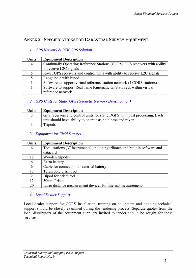
Egypt Financial Services Project
Cadastral Survey and Mapping Issues Report Technical Report No. 9 42
ANNEX 2 - SPECIFICATIONS FOR CADASTRAL SURVEY EQUIPMENT
1. GPS Network & RTK GPS Solution
Units Equipment Description 4 Continually Operating Reference Stations (CORS) GPS receivers with ability
to receive L2C signals 5 Rover GPS receivers and control units with ability to receive L2C signals 5 Range pole with bipod 1 Software to support virtual reference station network (4 CORS stations) 1 Software to support Real Time Kinematic GPS surveys within virtual
reference network
2. GPS Units for Static GPS (Geodetic Network Densification)
Units Equipment Description 3 GPS receivers and control units for static DGPS with post processing. Each
unit should have ability to operate as both base and rover 3 Tripods
3. Equipment for Field Surveys
Units Equipment Description
6 Total stations (3” instruments), including tribrach and built in software and datacard
12 Wooden tripods 6 Extra battery 6 Cable for connection to external battery 12 Telescopic prism rod 2 Bipod for prism rod 12 50mm Prism 20 Laser distance measurement devices for internal measurements
4. Local Dealer Support
Local dealer support for CORS installation, training on equipment and ongoing technical support should be closely examined during the tendering process. Separate quotes from the local distributors of the equipment suppliers invited to tender should be sought for these services.

Egypt Financial Services Project
Cadastral Survey and Mapping Issues Report Technical Report No. 9 43
ANNEX 3 – SAMPLE GEODETIC CONTROL POINT DESCRIPTION

Egypt Financial Services Project
Cadastral Survey and Mapping Issues Report Technical Report No. 9 44
ANNEX 4 – ESA CIRCULAR ON FEES Egyptian Survey Authority Central Department for Regional Survey Affairs
Circular No. 222 of 2005
Subject: Regulating collection of the cost of works in the survey directorates and affiliate offices Dear ….., As of today, all previous circulars regulating collection of the cost of works shall be annulled, with abiding by ISA products price lists:
• Physical inspection: cost of works shall be collected at LE. 190,00/parcel. • Descriptive inspection: cost of works shall be collected at LE. 120,00/parcel. • Office review: cost of works shall be collected at LE. 60,00/parcel.
General Provisions
1. The cost of works shall be estimated according to the data on the number of parcels, buildings and sections … etc. on the application presented to the survey office, the issues and review office or other directorate offices. If upon physical inspection it is found out that there are elements not indicated in the application or insufficiently indicated, the costs shall be re-estimated as per the number of parcels indicated in the cadastral information form or the final service, either issues or boundary separation. The concerned person shall be requested to pay the remaining costs prior to enjoying the requested service.
2. If the concerned person is informed in-writing of the cost of works, does not pay within a month, and the costs circular is amended thereafter, then the new circular shall govern and computation shall depend thereon.
3. All real estate publicity applications shall be physically inspected for the prompt changes in properties. Physical inspection costs shall be collected at LE. 190. As for receiving applications in amendment of current ones within the legal period and applications in extension of others that already have cadastral information form and sent to the real estate district office (all its survey procedures are completed), then cost of works shall be collected at LE. 60/parcel for the parcels inspected before the lapse of three months and at LE. 120/parcel for the parcels that enjoyed inspection for a lapse exceeding three months (descriptive inspection).
4. If the concerned person suspends completion of procedures and requests reimbursement of the cost of works, the computation shall take place according to the following phases:
Physical or descriptive inspection applications: A. Costs of the office review phase at 25% from the total costs. B. Costs of the field inspection phase at 50% from the total costs.

Egypt Financial Services Project
Cadastral Survey and Mapping Issues Report Technical Report No. 9 45
C. Costs of the change form approval and issuance of the cadastral information form phase at 25% from the total costs.
The office inspection costs are divided into two phases:
A. The office research phase, at 50% from the total costs. B. Review and issuance of the cadastral information form phase, at 50% from the total
costs. If the concerned person suspends completion of procedures and requests reimbursement of the cost of works, the cost of the completed phases shall be deducted and the above percentage shall be computed at LE. 60 minimum. Costs shall be refunded to the concerned persons by the accounting unit after verifying suspension of the application and that the cost of works is paid. The amount shall only be disbursed to the concerned person after checking his ID.
5. Objections at site or inability to inspect (closed apartment, …. etc.) A. First objection to the inspection and re-inspection (second inspection) takes place
after collecting LE. 50,00. B. Second objection to the inspection and re-inspection (third inspection); additional
costs shall be collected other than the costs of the original application at 40% of the previously collected costs for parcels physically inspected (real estate publicity applications). As for the issues and review (separating boundaries, issues), 40% of the total costs.
C. Application cost of works shall be settled unless the interference (conflict) is eliminated before the lapse of the legal period (application write-off).
D. Costs of the issues and review works shall be settled after one year from the date of such interference pursuant to the completed phases of work.
6. In cases where a grievance is received from the real estate district office to the
engineering office, the transaction type shall be changed from procedure applications to applications for transfer of ownership and additional costs shall be collected at LE. 60/parcel previously physically inspected. If the case is reversed; the transaction type is changed from applications for transfer of ownership to procedure applications, no additional costs shall be collected and the previously collected amounts shall be sufficed with.
The following should be abided by regarding the computation of the cost of works inside the boundaries:
1. Cost of works shall be collected for every parcel included in the cadastral statement form. Costs shall be computed as per the number of parcels multiplied by the cost of physical inspection (LE. 190), provided that the dimension of any parcel does not exceed 20 feddans. If the dimension exceeds this, the costs shall be computed as per the following brackets:
A. More than 20 feddans up to 100 feddans: LE. 40/extra feddan and its fractions. B. More than 100 feddans up to 200 feddans: LE. 20/extra feddan and its fractions. C. More than 200 feddans: LE. 10/extra feddan and its fractions.

Egypt Financial Services Project
Cadastral Survey and Mapping Issues Report Technical Report No. 9 46
Example: A transaction taking place for 250 feddans, the cost of works shall be computed as follows: LE. 190 (first 20 feddans) + 80 feddan x LE. 40 = LE. 3200 + 100 feddan x LE. 20 = LE. 2000 + 50 feddan x LE 10 = LE. 500. Total costs = LE. 5890.
2. As for the shared ownership inside the boundaries of a part of the total dimension of the parcel (shared ownership base), the cost of works shall be computed for the transacted part only and not the whole dimension (shared ownership base).
3. As for the applications for the heritage publicity and sale, a cadastral statement form should be issued including two schedules (A) Heritage Schedule, (B) Sale Schedule:
A. Cost of works shall be collected as per the number of parcels indicated in schedule (A) Heritage, multiplied by the physical inspection rate (LE. 190).
B. If the transacted parcels on the Sale Schedule (B) are the same parcels indicated in the Heritage Schedule (A), no additional costs shall be collected other than the amounts already collected on the Heritage Schedule (A).
C. If the transaction on the Sale Schedule (B) is relevant to part of the parcels indicated on Schedule (A) Heritage (retail), a physical inspection cost shall be collected at LE. 190/ parcel, in addition to the collected amounts on the Heritage Schedule (A).
Example: In case of a transaction on part of two parcels out of five heritage parcels indicated on Schedule (A) Heritage, the cost of works shall be computed as follows: number parcel rate ( 7 x LE. 190 = LE. 1330)
D. Generally, all applications which their cadastral statement forms include more than one schedule, no cost of works shall be collected for the repeated parcels on any of these schedules.
4. As for the official lists received with the application or after issuing the cadastral statement form from the real estate publicity district to be compared with the cadastral statement form. In this case, cost of works shall be collected at LE. 60/building, other than costs of the original application.
5. As for the lawsuit petition, it is non-applicable as per the regulating instructions, since it does not include ownership review and under the responsibility of the concerned person. It is used as reference in the procedures applications related to registering the rulings during the initial phase of the application research. It shall also be compared with the physical inspection as per the guidance. In this case, if the transaction is for registering a ruling, cost of works shall be collected in addition to the actual application costs at LE. 120.
• The following should be abided by in respect of the cost of works computation for the
applications outside the boundaries:

Egypt Financial Services Project
Cadastral Survey and Mapping Issues Report Technical Report No. 9 47
- Procedures of the applications outside the boundaries shall be carried out by the engineering office if the transaction has a map drafted by the review office at the directorate and has an inspection report. Cost of works shall be computed per parcel. Such applications shall be subject to the same terms of the applications inside the boundaries.
- All applications outside the boundaries that have no drafted maps and no inspection report shall be transferred to the review office at the directorate, either small or large areas. Cost of works shall be computed for drafting maps and processing the application as per the transaction dimension (taking into consideration that the feddan is a unit and its fraction (half feddan and more) is a separate unit.
Computation shall be as follows:
A. Transaction dimension is less than a feddan up to ten feddans: cost of works shall be collected as per the number of units multiplied by the physical inspection rate (LE. 190 physical inspection) per unit.
Example: Cost of works for a transaction with a dimension of …………outside the boundaries that requires a map to be drafted, an inspection report and procedures to be processed shall be computed as follows: 9 units x LE. 190 = LE. 1710
B. What exceeds 10 feddans, the cost of works shall be collected at LE. 40 for physical inspection/extra feddan and its fractions.
Example: Cost of works for a transaction with a dimension of 150 feddans outside the boundaries, which requires a map to be drafted, an inspection report and procedures to be processed shall be computed as follows: (10 x LE 190 = LE. 1900 for the first 10 feddans) + (140 feddans x LE. 40 = LE. 5600). Total cost of this application = LE. 7500.
C. The following should be abided by regarding the shared ownership outside the boundaries that requires a map to be drafted, an inspection report and procedures to be processed for several applications filed and each of them constitutes a part of the total dimension (shared ownership base) and for the first time (cooperative sections and shared ownership transactions … etc.):
Cost of works shall be computed for every application separately for every transacted part only, but not the total dimension (shared ownership base). In case of filing applications related to the above transactions for the second time, the cost of works shall be computed according to the cost of works inside the boundaries.

Egypt Financial Services Project
Cadastral Survey and Mapping Issues Report Technical Report No. 9 48
D. The calculation and write-off costs shall be added to the above costs for the applications outside the boundaries that require a map to be drafted as per ISA product price list.
• As for the land division projects (non-constructed land requires division)
1. If an application is filed for the first time for dividing several large dimension parcels (approved division application), a change form shall be prepared for every parcel within the division, as well as public utilities forms (streets, gardens, … etc.). The cost of works shall be computed as per the number of parcels within the division and the public utilities, multiplied by the physical inspection rate (LE. 190 physical inspection).
2. In case of filing applications for amending or extending the previous application related to the division project after collecting the cost of works for the first time, cost of works shall be collected at 50% of the total costs of the previous application.
• As for collecting cost of works for buildings or establishments on the transaction land Whereas this entails a level of effort different from the effort exerted in the normal application, as costs shall be collected for every transacted parcel, so every building or establishment constructed on the transaction land shall be measured as if it is a separate transaction. Costs thereof shall be collected according to the following:
1. A building constructed on an agricultural land inside the boundaries (inside the transaction land); cost of works shall be collected in the amount of LE. 190/building in addition to the land cost of works.
2. A building constructed on a land outside the boundaries (reconstruction land transaction); cost of works shall be collected in the amount of LE. 190/building in addition to the land cost of works.
3. Amendment and extension applications shall be subject to paragraph no. 3 under the general provisions.
• As for collecting cost of works for buildings on unconstructed lands:
1. Cost of works shall be collected for a building constructed on the total dimension of a land inside the boundaries in the amount of LE. 190 land inclusive.
2. Cost of works shall be collected in the amount of LE. 190 in case of a building constructed on part of a land inside the boundaries, added to the building cost of works (LE. 190).
3. Cost of works shall be collected for the land and buildings thereon at the total of LE. 400 in case of a building transaction in the new urban cities, constructed on the total dimension.
4. Cost of works shall be collected at LE. 400 in addition to LE. 400 for the building in case of a building transaction in the new urban cities, constructed on part of the land.
5. Amendment and extension applications shall be subject to paragraph no. 3 under the general provisions.
• As for collecting cost of works under the multi-storey system (apartments and others):

Egypt Financial Services Project
Cadastral Survey and Mapping Issues Report Technical Report No. 9 49
1. In case of the multi-storey system transaction (apartments and others) inside the boundaries, the amount of LE. 190 shall be collected/apartment, including the easement rights. If the first transaction on the land takes place through the apartment application, its share in the land cost of works shall be added (LE. 190 divided by the number of apartments)
Example: Apartment application Apartment 190 + apartment share in the land 190 ÷ number of apartments. Amendment and extension applications shall be subject to paragraph 3 under the general provisions.
2. In case of multi-storey transactions (apartments or others) in the new cities, the following should be abided by:
A. Cost of works shall be collected in the amount of LE. 190/apartment, inclusive of easement rights in addition to the apartment share in the land at LE. 400, divided by the number of apartments.
B. Amendment and extension applications shall be subject to paragraph 3 under the general provisions.
• As for collecting cost of works for borders separation:
1. Cost of works for borders separation according to the quotation of the actual cost of works for the office and field works at a minimum of LE. 850/border in every parcel.
2. In case of losing the basins demarcation and inability to link by the normal methods, re-demarcation shall be carried out via survey instruments, projecting it and collecting additional costs against re-demarcation and projection pursuant to ISA product list.
3. Renewing demarcation of longitude projects for expropriation at site shall cost LE. 3000/longitude Km.
• As for collecting cost of works for application of heritage legitimacy certification and
registered contracts: Whereas the application works entail strenuous effort either in the engineering office, directorate, regional office or the central department for survey affairs that require the committee to be present at site, if necessary, therefore:
A. Registered and dated contracts that were used in the modern survey works shall be referred to as a legitimate document but may not be applied.
B. When the engineering office receives the heritage legitimate certification or a registered contract to be applied, the amount of LE. 300 shall be collected from the concerned person as an advance payment for reviewing the certification or contract as per the available survey maps and references. Actual costs quotation shall be prepared for all finalized application phases regarding this certification or contract. The application result shall not be delivered to the real estate publicity district office unless the remaining costs are paid.

Egypt Financial Services Project
Cadastral Survey and Mapping Issues Report Technical Report No. 9 50
C. Heritage legitimacy certification or the registered contracts may not be applied if not received from a real estate district office and sent from the concerned persons with the purpose of applying or projecting on survey maps.
General Provisions The digital works at the Authority are increasing and mainly depend on the survey reference books maintained by the Authority. Therefore, the following was resolved by the Authority Chairman with the objective of preserving such references:
1. The engineering offices shall prepare a special book for recording the review carried out by experts from the Ministry of Justice and the Real Estate Publicity reviewers, indicating the date of review, reviewer's name, applications numbers (current applications with paid costs) and the types of references to be reviewed upon an approved letter by the Real Estate Publicity Commissioner and the engineering office Head. After completion, the reviewer shall sign on the book. The review process should be carried out in the engineering Head's office. As for the engineering archiving room for the change forms and survey reference book, it shall be restricted for the usage of the engineering staff only.
2. Dates for inspection by the directorate staff or committees comprising other agencies shall be determined no later than 10:00 am. In case the agents from other agencies shall not comply, a letter shall have to be issued for such agencies.
3. Monthly operations report shall be reviewed by the Directorate Chief since several errors were previously detected in the reports. Operations obstacles shall be presented by-hand to the Directorate Chief and the Regional Head on a monthly basis. The Directorate Chief shall handle following up solutions of the obstacles in the Authority.
4. Price lists approval competence: Directorate Chief = up to LE. 5000 Regional Head = more than LE. 5000 and up to LE. 20,000 Regional Offices Commissioner = more than LE. 20,000 and up to LE. 200,000 Amounts exceeding the above shall be approved by ISA Chairman.
5. Any delayed operations shall be the responsibility of the manager, unless the
obstacles are presented by-hand and an official paper that indicates the problem is presented and the follow-up is ongoing with the officials.
6. Date for physical inspection shall be determined immediately after paying the cost of works and signature of the concerned person is secured. If he is not present, no other date shall be determined unless he/she pays LE. 50 in addition of the previously collected costs.
7. The concerned person has the right to put off the physical inspection date three days ahead. If otherwise, LE. 50 shall be collected in addition to the previously collected costs against determining another date.
8. If an application is filed by the concerned person for allocating a site on a survey map (guiding site) to file it with other agencies to obtain approvals, a quotation shall be drafted including the cost of works and physical inspection, to be paid prior to carrying out any works. All preservations shall be indicated at the top of the map and underlined with red, such as:

Egypt Financial Services Project
Cadastral Survey and Mapping Issues Report Technical Report No. 9 51
A. The said site is allocated upon the filed application from (concerned person's name) and under his guidance.
B. This map shall be presented to (agency name) for (indicate the reason) and may not be used except for the purpose upon which it is requested or for the interest of any other concerned person.
C. Allocation shall be made on the map without reviewing the ownership and upon a request by the concerned person without claiming against ISA either currently or in the future.
D. Any scratching or addition to the allocation or notes on the map shall be deemed null and void.
The Directorate shall add any other preservation it believes to secure the survey works and to indicate ISA disclaimer either currently or in the future. All survey works required from the directorates with no circulars issued in respect of organizing the requested work shall be presented to the Central Department for Survey Affairs in the regional offices by virtue of an inclusive technical memorandum with the purpose of obtaining an approval on the requested work. Context of the above circular should be abided by precisely and if otherwise, the violator shall be subject to legal question as well as obliging him to pay the uncollected cost differences.

Egypt Financial Services Project
Cadastral Survey and Mapping Issues Report Technical Report No. 9 52
ANNEX 5 – EDO INSTRUCTIONS
Egyptian Survey Authority Central Department for Survey Affairs in Regions
A Guide for Engineering Offices in Survey Directorates
Issued in 1997
Steps to be Followed Once Real Estate Publicity Applications Arrive at the Engineering
Office
1- Once the application is sent from the real estate publicity district office to the engineering office, which most probably is located in the same building, the competent offices receive copies of the applications and attachments (if available) after verifying the serial numbers of the applications and that no number is missed. If a serial number is missed, the issue is submitted to the office chief to contact the district office to find out the reason.
2- The competent clerk registers the applications in the book according to the data included, the serial numbers given to them by the real estate publicity district office, in addition to attachments if available.
3- Applications are submitted to the office chief who reviews them, examines documents if available, and checks the veracity of registration procedures. The journal is closed by drawing a red line at the bottom of the received applications. The chief signs them to prove closure.
4- Copies of the applications and attachments, if available, are delivered to the technical researcher to examine all applications and check the completion of data in each application in order to finalize engineering procedures. Such data are:
a- (governorate - markaz – village – basin name and number – plot number –area of transaction – literal description of borders subject of the application i.e. agricultural lands).
b- Governorate – city – section of transaction – shyakha – street – building number – area of transaction – literal description of borders and lengths subject of the application that is related to real estates and lands in cities and bandars ).
5- If lack of adequate data is shown during the initial examination of the applications and it became impossible to recognize the spot of transaction when all researches in survey references in the office are done, the technical researcher has to submit these applications to the office chief to review the initial research. If the office chief is assured that it was impossible to recognize the spot of transaction, he returns the applications to the real estate publicity district office in order to inform the person concerned of lack of data and to come to the engineering office to give information about their transactions and to complete data.
6- The complete applications are reviewed by the technical researcher in conjunction with the engineering review in the office. The researcher records the research remarks on the application copy with a red pen (the remark indicates that a change form was previously filled out for the plot subject of the application and that the transaction on the application includes the full area of the plot or part of it is commonly or individually owned.

Egypt Financial Services Project
Cadastral Survey and Mapping Issues Report Technical Report No. 9 53
7- The borders of the plot required to be transacted on index maps in the office and the survey references should be reviewed. It is necessary to verify that land transactions are not overlapping with the government lands, waqfs, or agricultural reform. If an overlap occurs with one of the mentioned agencies, the real estate publicity should be notified to inform, in turn, the agencies of encroachment upon their properties on the application no. (….), the names of the contracting parties and the person who signed the application in order to preserve the State money from usurpation and set a suitable date that does not exceed fifteen days to inform the engineering office of receiving a reply from the owning agency. If the reply has not been arrived within the specified timeline, the application procedures are to be proceeded, provided that the cadastral statement list is to be signed with a red pen to indicate encroachment upon the State property.
8- If it is shown that the application encroached upon the public utilities, the application shall be suspended and the REP shall be notified. It is not permissible to carry out transactions on the public utilities with any type of disposal and the cadastral statement list is not allowed to be issued as well.
9- When the technical research is completed, all applications are delivered to the engineering office chief to distribute them for inspection on the same day.
10- The person concerned is notified to be present in the engineering office within three days as of the date of submitting the application in order to set a date for inspection on the application copy.
11- Change forms are filled out for applications where one can be guided to the site of transaction and include complete common ownership plots and areas which have not been transacted before, descriptive inspection is done and sent to the survey directorate for matching with the original maps (1/1000), reviewing and approving the area. The forms are sent back to the engineering office for issuing the cadastral statement list within ten days as of the date of receiving the application by the engineering office.
12- Applications where the transactions take place for entire plots or commonly owned plots with approved change forms become effective and a cadastral statement list is issued without descriptive inspection or review by the directorate (if a descriptive inspection was done within a year prior to this application) within three days as of the date of receiving the application.
13- Applications exclusively deal with entire plots or common ownership ones with approved change forms and for which the last inspection has been done a year ago, a descriptive inspection shall be carried out and sent to the directorate for matching with original maps (1/1000) and reviewing the area, then they are sent back to the engineering office to finalize procedures, issue cadastral statement list and send it to the district office within a week as of the date of receiving the application by the engineering office.
14- If the transaction is exclusively concerned with an allocated part of a bigger area, the following needs to be done:
a- According to the set date known by the person concerned in accordance with his declaration, the inspector goes to the transaction spot in the presence of the person concerned and the seller (as for the satisfactory sale applications) and inspection is done at site in accordance with guidance, agreement by both parties and in accordance with the process cycle in the office.
b- A change form is opened with the dimensions specified at site. Both of the seller and the purchaser sign it. It is sent to the directorate to be offset on the original maps 1/1000, a change number is given to it, the area resulted from inspection is approved

Egypt Financial Services Project
Cadastral Survey and Mapping Issues Report Technical Report No. 9 54
and then returned to the engineering office to finalize the rest of procedures, issue cadastral statement list, and send it to the real estate publicity district office within fifteen days as of the date of receiving the application by the engineering office.
15- As for the procedures applications (lawsuits), procedures are to be followed as mentioned above and it is sufficient for the applicant to attend (the application is to his interest) without the need for the presence of the seller (against whom the application is issued) and the person for whom the application is issued in favor signs the change form.
16- As for the rulings applications, inspection should be carried out at site in the presence of whom the ruling is in favor, using an approved copy of the ruling and the petition upon which the ruling is based. Procedures are pursued in accordance with the prior clause. The person whom the ruling is passed in favor shall sign the change form.
17- As for the applications where the person concerned demands "maintaining a known area indicated on the application", an inspection is carried out upon guidance. The inspector has to record the border needs to be moved in order to complete the required area upon a request by the person concerned. It is sent to the directorate to finalize the rest of procedures. The Area Identification Office, after allocations are done, determines the dimensions upon which the border movement shall take place in order to complete the required surface. The change form shall not be approved until the border is moved at site in order to complete the area. The form is returned to the directorate to verify and approve the required area and is sent to the engineering office to finalize procedures, issue the cadastral statement list and send it to the district office within twenty one days.
18- If "the two contracting parties did not attend" (persons concerned) to accompany the inspector during the inspection and guide him to the transaction spot, the application shall be suspended and the Real Estate Publicity Department shall be notified on the day following that of inspection.
19- In case of "physical encroachment" by any person whether seller, purchaser, one of the neighbors or any person who has no capacity, an encroachment report shall be conducted and signed by the encroachers and the concerned parties. If the encroachers refuse to sign, it is sufficient to have the parties concerned sign, the application shall be suspended and the Real Estate Publicity Department shall be notified on the day following the inspection of the encroachment. No other inspection shall take place unless a grievance by the person concerned is filed to eliminate the encroachment.
20- As for cases of "physical encroachments of the procedures applications" (lawsuits), an encroachment report is issued and signed by the encroacher and the person concerned. Procedures are halted and the Real Estate Publicity Department is notified on the day following that of inspection. In this case, the person concerned has the right to submit a sketch upon his responsibility showing dimensions, area and a description of borders in accordance with the request received. The sketch is attached to the data change form and sent to the directorate for approval. It is offset on the original maps and the area is approved on the change form upon the responsibility of the person concerned. Then, it is sent to the engineering office to complete the rest of procedures, issue the cadastral statement list while using the red pen to mention that "data included in the cadastral statement list is upon the responsibility of the person concerned and the survey authority has no liability".
21- As for applications in respect of "rulings need to be publicized" and that established an encroachment at site, an encroachment report shall be conducted, the application shall be suspended and the REPD shall be notified. The person, for whom the ruling is passed in favor, may obtain an approved copy of the encroachment report to submit to

Egypt Financial Services Project
Cadastral Survey and Mapping Issues Report Technical Report No. 9 55
the police to use it for inspection in execution of the ruling passed in his favor in case the ruling is issued with a footnote indicating execution by-force or by virtue of a permit by the public prosecution.
22- If the application submitted is a lawsuit, and inspection was subsequently done for it, then a petition is submitted to change the type of transaction from a lawsuit to sale, inspection should be repeated at site in the presence of the seller who signs the change form, indicating guidance by both parties.
23- If an encroachment takes place after inspection is done at site in cases of (sale – lawsuit) a report shall be conducted to indicate that "encroachment happened after inspection" while establishing the name of the person who did the encroachment, reasons for encroachment and the signature of the encroacher on the report. Application procedures are continued till a cadastral statement list is issued and the content of the report are indicated on the cadastral statement list in red and a copy of the report is sent with the cadastral statement list to the REPD.
24- It is necessary to record the numbers and years of applications that were suspended for the above reasons on index maps existing at the office and on the change forms and the application logbook in order to maintain precedence and prevent issuance of further cadastral statement lists without a notation indicating the precedence of applications.
25- Applications of buildings submitted and later on it is proved that they are encroaching upon public utilities (the street on which the building is overlooking), the cadastral statement list should be issued in two parts "a & b", (a) the area of transaction without encroachment and description of borders, (b) the area of encroachment with description of borders. A signature is made to refer that this area encroaches on the street (public utilities) and can not be used for transaction while writing a note on the cadastral statement list to indicate that the areas "a & b" are the components of the building number (…) and there are no separators between them and that the REPD may take the necessary action.
26- Cadastre borders can not be re-measured if that was previously done for the purposes of modern survey works or prior applications during the inspection of the new application, but the new borders are only measured if the need may arise.
27- If the submitted documents are applied, the following have to be done: a- Documents previously applied during the work of modern survey will count and may
not be re-applied. b- Documents that were not applied during the modern survey process and were
recorded in the book of names of appropriation without a document are to be applied. c- Documents and contracts with fixed dates that are not submitted by their parties
during the settlement of modern survey books, no procedures are taken regarding their application and the parties are requested to file local complaints through real estate taxation offices if the title registration is not applied on the village subject of transaction.
d- If the title registration system is applied on the village subject of transaction, it is not permissible to apply the local complaint system, however they are submitted to the judicial committees, and in case five years have passed since the application of the system, it is referred to the civil court.
28- If a publicity application is submitted for a transaction on an apartment in a building, the following are to be pursued:
a- The application should have complete data of the whole building, its number, street or slum name, the building borders, areas, the organization number and data of the flat or

Egypt Financial Services Project
Cadastral Survey and Mapping Issues Report Technical Report No. 9 56
the floor (flat no. – floor – area in m2 – borders) and what is related to the flat in the common parts of the building (entrance – corridor – shaft – staircase - …).
b- The person concerned submits an engineering design that can be obtained from the competent district, but if this is not possible, the person concerned should submit an approved design from an accredited engineer for the flat or floor.
c- It should be observed when the first application for transaction of flat or floor that a detailed engineering design approved from an accredited engineer is attached. The design should include all floors and flats and must be kept in the office for reference in case of later applications.
d- The engineering office inspects the building using the engineering design submitted. A comprehensive change form is opened including data of buildings and common parts (basement – entrance – staircase …) and each part is symbolized by serial alphabetical character provided that symbols and border description should be explained at the side of the form. For example, the symbol (a) refers to shaft, the symbol (b) refers to corridor, etc. The form should also include the number of plot on which the building is established, its borders, length, and a general description of the building, number of floors and flats in the building, and then a separate change form is opened for each part.
29- If the building was previously transacted but for systems other than flats, and a change form was previously opened for it, dimensions mentioned in this form should be matched with dimensions contained in the comprehensive open form that was opened for the flat system. It should be observed that all newly opened forms for the flat system must be signed and it is necessary to refer to the original form of the building to identify earlier transactions concluded for this building.
30- Land and common parts shares are executed by the owners by virtue of an affidavit signed by them on the comprehensive change form, provided it should be referred to in later transactions.
31- The total area of buildings in the ground floor in addition to total area of common parts should be equal to the original area of the building.
32- If the flat under transaction has projections such as balconies, they are calculated as an area separate from the original area of the flat. The original flat area + the towers area is the area transacted for the flat.
33- If a flat in the building was previously subject to transaction and was registered, then the flat owner offers buying the rest of the whole building, in this case a cadastral statement list is issued for the whole building. The cadastral statement list should include a notation to indicate that a flat in the building was previously registered in favor of the purchaser and the flat system will not be applied.
34- If the transaction will be on the rest without the land or vice versa, the cadastral statement list should be executed for transaction and include that the transaction is for buildings without land or for land without buildings as per the case or the required transaction.
35- If the transaction takes place in a village where the modern survey is not done and the vendor and purchaser came to the survey office to guide them to the transaction location, guidance is made on maps by them, an inspection report is conducted, its data is filled out and it is signed by the seller and purchaser to prove their guidance. If plots are overlapping, an inspection at site shall be done in the presence of the contracting parties.
36- If the person concerned is unable to mention the plot number, basin name and number, and was recorded on the application according to the result of the inspection at site, a date is set for inspection, parties concerned are informed to be present during

Egypt Financial Services Project
Cadastral Survey and Mapping Issues Report Technical Report No. 9 57
inspection and the remaining procedures are to be followed either for satisfactory applications or lawsuits whether in villages of old or modern surveys.
37- During inspection in cities, if buildings are built on part of land, the whole estate should be measured as well as the building and spaces. It is recorded in the cadastral statement list that the building area is "…" with description of buildings, number of floors, number of stores if available and the type of construction (red bricks, concrete or adobe bricks, etc.).
38- The organization lines should be observed for transaction of estates in cities. The organization engineer has to sign to prove his participation in determining the organization line.
39- When the cadastral statement lists are issued, the number of previous outstanding applications should be mentioned in order to maintain precedence.
40- As for satisfactory applications lying within the boundaries and it is indicated that the transaction is on part of the plot, the parties concerned are required to submit a division project approved by a competent agency. As for lawsuits applications, the cadastral statement list is signed to indicate that the transaction is subject to the division law. It is necessary to record in the cadastral statement list that the transaction is within the boundaries and also if it is inside or outside improvement areas.
41- If plots are to be merged, the following conditions of merge should be observed: a- Plots required to be merged should be adjacent and lie within one basin. b- To be owned by one person. c- None of the plots have easement or physical rights. 42- It is not allowed to take data from original maps for inspection unless there is an
urgent need. Inspections should be done at site and upon guidance from parties concerned. Then, survey is done with maps in the engineering office to check the integrity of inspection.
43- In all cases from the moment the request arrives the engineering office till the execution of the cadastral statement list, the office chief is fully responsible for the work integrity and timing whether during the measuring process at site or in-office procedures. This is to prevent returning the applications by the directorate for completion. Abiding by specified timelines is important to finalize the application and review the supporting documents. If execution is not possible in the engineering office after documents being submitted to the competent supervising managers, they are sent to the directorate for execution by a committee formed by the engineer, who is the directorate Head. If it is not possible for the committee to implement application, a report is written detailing reasons for that and the REPD is notified. It is responsible for the completion of change forms, form (300 survey), the applications logbook and performing regular review. Managers should observe this while supervising the office operations.
Central Dept. Head Chairman For Survey Affairs in the Regions of Egyptian Authority of Survey Eng. Ismail Ali Mahmoud Eng. M. Mossad Ibrahim

Egypt Financial Services Project
Cadastral Survey and Mapping Issues Report Technical Report No. 9 58
ANNEX 6 – ECIM PROPOSED CADASTRAL NUMBERING SCHEME FOR EGYPT