Eggborough CCGT (Generating Station) Order – Access ... · PDF fileD D D D D D D D D D D...
5
1 2 3 4 [ 1:10,000 Date: Drawn by: Version: Checked: Doc Ref.: Document Reference 4.5 Scale: 17/05/2017 CA CW 1.0 Reproduced from Ordnance Survey digital map data © Crown opyright 2016. All rights reserved. Licence number 100023397. © Crown copyright material is reproduced with the permission of Land Registry under delegated authority from the Controller of HMSO. This material was last updated in June 2016 and may not be copied, distributed, sold or published without the formal permission of Land Registry. Only an official copy of a title plan or register obtained from the Land Registry may be used for legal or other official purposes. May contain public sector information licensed under the Open Government Licence v3.0. Eggborough CCGT (Generating Station) Order Access & Rights of Way Plans Key Plan at A1 Projection: British National Grid 0 200 400 600 800 Metres Regulation 5(2)(k) Infrastructure Planning (Applications: Prescribed Forms and Procedure) Regulations 2009 Map Extent Contains OS data © Crown Copyright and database right 2017 Land required for, or affected by, the authorised development (the Order limits) Sheet Number
Transcript of Eggborough CCGT (Generating Station) Order – Access ... · PDF fileD D D D D D D D D D D...

1
2
3
4
[ 1:10,000
Date: Drawn by:
Ve rsion: Ch e ck e d :
Doc R e f.: Docum e nt R e fe re nce 4.5
Scale:17/05/2017 CA
CW1.0
R e prod uce d from Ord nance Surv e y d igital m ap d ata © Crown opyrigh t 2016. All righ ts re se rv e d . Lice nce num be r 100023397.© Crown copyrigh t m ate rial is re prod uce d with th e pe rm ission of Land R e gistry und e r d e le gate d auth ority from th e Controlle r of HMSO. Th is m ate rial was last upd ate d in June 2016 and m ay not be copie d ,distribute d , sold or publish e d with out th e form al pe rm ission of Land R e gistry. Only an official copy of a title plan or re giste r obtaine d from th e Land R e gistry m ay be use d for le gal or oth e r official purpose s.May contain public sector inform ation lice nse d und e r th e Ope n Gov e rnm e nt Lice nce v 3.0.
Eggbo ro ugh CCGT (GeneratingStatio n) Order –
Access & Rights o f Way Plans Key Plan
at A1Proje ction: British National Grid
0 200 400 600 800Me tre s
R e gulation 5(2)(k) – Infrastructure Planning (Applications: Pre scribe d Form s and Proce d ure ) R e gulations 2009
Map Extent
Contains OS data © Crown Copyrigh t anddatabase righ t 2017
Land re quire d for, or affecte d by, th e auth orise d d e v e lopm e nt (th e Ord e r lim its)
Sh e e t Num be r
D
D
D
D
D
D
D
D
DD
D
FP 35.27/6/1
WB
CR
7.6m
El Sub Sta
SL
7.6m
HAZE
LOL
D LA
NE
Gantry
SLs
L Twr
Drain
SL
11.9m
Drain
SL
13.7m
13.4m
Tank
SL
MP .75
CR
Def
Eggborough
Pipe
Reservoir
Conveyor
13.7m
Pond
Stone
DefSD
Def
1.22m RH
31
Stone
Drain
A 19
Und
RH
Def
Reservoir
Spoil Heap
RHWard Bdy
9.4m
ElectricityPoles
A 645
ETL
MP 2DrainL Twr
Tower
Tank
Works
Conveyors
MP .25
Track
SL
TravellingCrane
Conveyor
SL
Conveyor
Conveyor
LightingTower
TankChy
Conveyors
LevelCrossing
Ppg Sta
North PointBusinessPark
126
5
14
7
6
25
PostsPosts
15 TRANM
ORE L
ANE
9
238
WEELAND ROAD
16
Works
1119
7a
Track
19
1
15
4
5b
SL
WB
MP .75
Drain
TRAN
MORE
LANE
MP 1
SD
FB
Gantry
SLs
FB
Tranmore Farm
LevelCrossing
MP .5SL WBSL
Tank
Tank
Level
Tank
Trave
lling
Crane
Conv
eyor
Tanks
Hopper
Conveyor
Conveyor
LightingTower
Conveyor
FB
Gantry
Gantry
Eggborough
Car Park
Gantry
ETL
11.3m
Golf Course
Drain
A 19
12.2m
ETL
Car Park
GP
Pond Gantry
Gantry
Gantry
SL
Gantry
Def
Golf Course
Gantry
Chy
FS
Pond
Ramp
Tanks
TravellingCrane
Power Station
Track
Drain
Drain
SL
TankMP .5
TRANMORE LANE
MP .25
Path (um)
SL
WBWB
LC
Wind Gauge
Drain
SLs L Twr
Conv
eyor
Conveyor
Conveyors
FB
AB
C
DE
FG
[ 1:2,500
Date: Drawn by:
Rev: Ch ec ked:
Doc u m ent Reference 4.5
Scale:18/05/2017 CA
CWAA
Reprodu ced from Ordnance Su rvey digital m ap data © Crown opyrigh t 2016. All righ ts reserved. Licence nu m b er 100023397.© Crown copyrigh t m aterial is reprodu ced with th e perm ission of Land Registry u nder delegated au th ority from th e Controller of HMSO. Th is m aterial was last u pdated in Ju ne 2016 and m ay not be c opied,distrib u ted, sold or pu b lish ed with ou t th e form al perm ission of Land Registry. Only an offic ial c opy of a title plan or register ob tained from th e Land Registry m ay be u sed for legal or oth er offic ial pu rposes.May contain pu b lic sector inform ation licensed u nder th e Open Governm ent Licence v3.0.
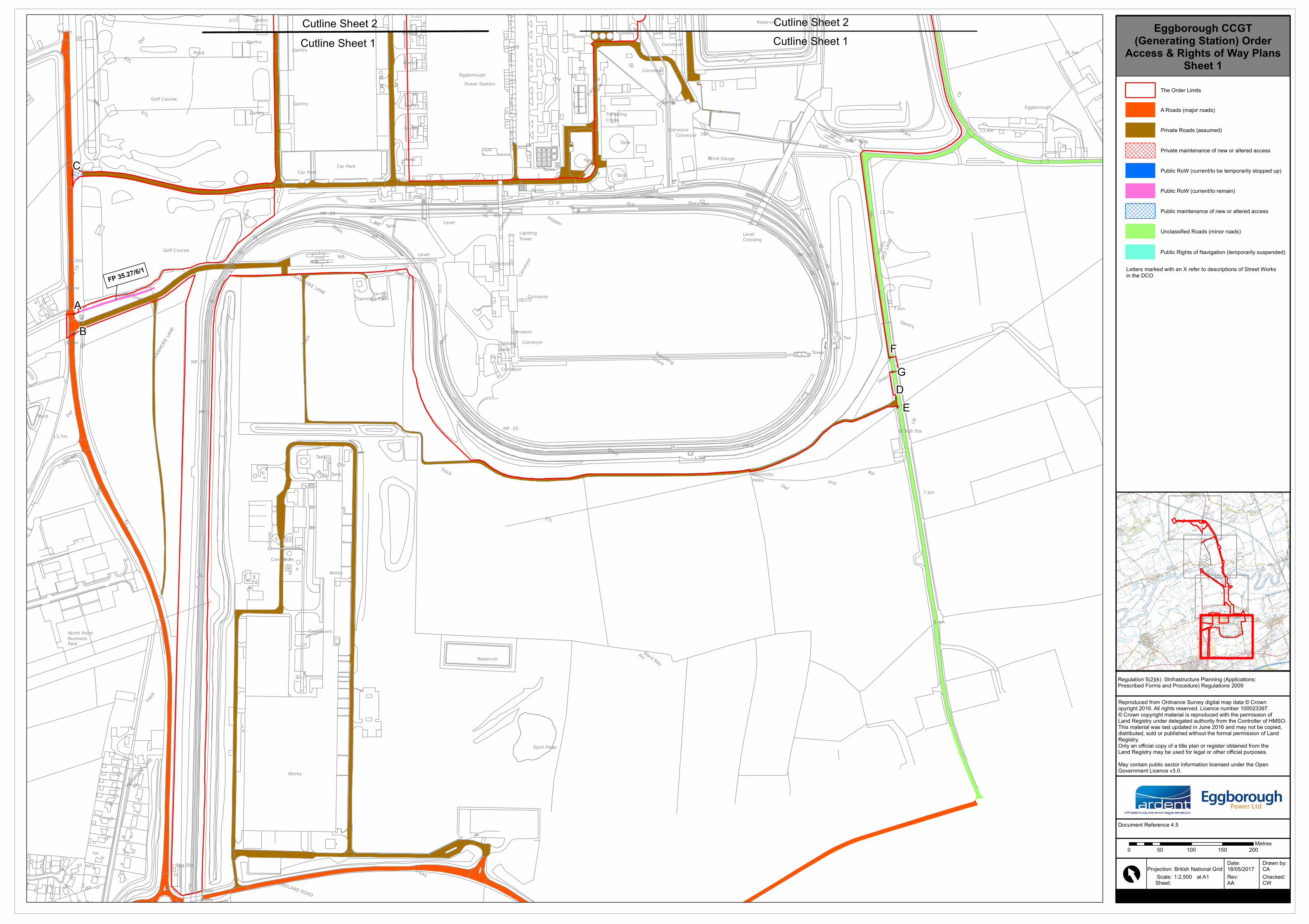
Eggborough CCGT(Generating Station) Order
Access & Rights of Way PlansSheet 1
at A1P rojection: British National Grid
Sh eet:
Regu lation 5(2)(k) – Infrastru c tu re P lanning (Applications:P resc rib ed Form s and P rocedu re) Regu lations 2009
Cu tline Sh eet 1Cu tline Sh eet 2
Th e Order Lim its
A Roads (m ajor roads)
P rivate Roads (assu m ed)
P rivate m aintenance of new or altered ac cess
P u b lic RoW (c u rrent/to be tem porarily stopped u p)
P u b lic RoW (c u rrent/to rem ain)
P u b lic m aintenance of new or altered ac cess
Unc lassified Roads (m inor roads)
P u b lic Righ ts of Navigation (tem porarily su spended)
0 50 100 150 200Metres
Letters m arked with an X refer to desc riptions of Street Worksin th e DCO
Cu tline Sh eet 1Cu tline Sh eet 2

D
D
D
D
D
D
DD
D
D
DD
D
WB
24
SL
ETL
5Gallows
1
17
WAND LANE
5
4
10.7mThe B
unga
lows
6
El SubSta 10
1
11.9m
Drain
13.7m
13.4m
Tank
SLCR
Def
Eggborough
Pipe
Drain
Track
Boynton Reach
ETL
Mean High
Water
High
Mean
Sluice
Water
MLWMud
CCLW
River
Ward Bdy
Tank
WB
ETL
Drain
Works7.9m
Track
Tanks
Reservoir
Conveyor
8.2m
INGS LANE
Drain
WAND LANE
PondDrain
Drain
Drain
CRWa
rd Bd
y
Drain
Tanks
8.5m
Ppg Sta
Sludge Tanks
Drain
Drain
Track
Track
SL
LevelCrossing
Def
EggboroughIngs
Def
WB
Tank
Gantry
Ppg Sta
Sluice
FB
El Sub StaWater Ppg Sta
Sluice
Gantry
Ppg Sta
FB
Tanks
SLs
FB
MP .5SL WBSL
Tank
Tank
Level
Tank
Trave
lling
Crane
Conv
eyor
Tanks
Hopper
Conveyor
Conveyor
LightingTower
Conveyor
FB
Sluice
FBWater
TravellingCraneTank
SluiceFB SluiceWater
FB
FB
FB
Water
FB
Water
FB
Wate
r
TanksTanks
Gantry
Gantry
Eggborough
Car Park
Gantry
Golf Course
Drain
ETL
Car Park
Pond Gantry
Gantry
Gantry
SL
Gantry
Def
Play Area
Club
Posts
Golf Course
Gantry
Chy
FS
Pond
Ramp
Tanks
TravellingCrane
Power Station
Drain
Drain
SL
TankMP .5
MP .25
Tank
CoolingTowers
FB
Drain
8.2m
FB Sluice
WAND LANEDrain
8.2mETL
Water
El Sub Sta
Track
Bowling
Wind Gauge
SLs L Twr
FB
HI J
K
L
M N
AJ
[ 1:2,500
Date: Drawn by:
Rev: Ch ecked:
Doc u m ent Reference 4.5
Scale:18/05/2017 CA
CWAA
Reprodu ced from Ordnance Su rvey digital m ap data © Crown opyrigh t 2016. All righ ts reserved. Licence nu m b er 100023397.© Crown c opyrigh t m aterial is reprodu ced with th e perm ission of Land Registry u nder delegated au th ority from th e Controller of HMSO. Th is m aterial was last u pdated in Ju ne 2016 and m ay not be copied,distrib u ted, sold or pu b lish ed with ou t th e form al perm ission of Land Registry. Only an offic ial copy of a title plan or register ob tained from th e Land Registry m ay be u sed for legal or oth er offic ial pu rposes.May contain pu b lic sector inform ation licensed u nder th e Open Governm ent Licence v3.0.
Eggborough CCGT(Generating Station) Order
Access & Rights of Way PlansSheet 2
at A1P rojec tion: British National Grid
Sh eet:
Regu lation 5(2)(k) – Infrastru c tu re P lanning (Applications:P resc rib ed Form s and P rocedu re) Regu lations 2009
Cu tline Sh eet 3Cu tline Sh eet 2
Cu tline Sh eet 2Cu tline Sh eet 1
The Order Lim its
A Roads (m ajor roads)
P rivate Roads (assu m ed)
P rivate m aintenance of new or altered ac cess
P u b lic RoW (c u rrent/to be tem porarily stopped u p)
P u b lic RoW (c u rrent/to rem ain)
P u b lic m aintenance of new or altered ac cess
Unc lassified Roads (m inor roads)
P u b lic Righ ts of Navigation (tem porarily su spended)
Letters m arked with an X refer to desc riptions of Street Worksin th e DCO
Cu tline Sh eet 2Cu tline Sh eet 1
FP 35.27/1/1
0 50 100 150 200Metres

D
D
D
D
D
D
D
D
D
D
D
D
D
D
D
D
D
D
FP 35.21/5/1
Drain
A 19
ETL
Drain
NTL
MLW
Ward BdySluicesWeirNTL
SM
Old Lock
Drain
FB
Lock
Track
Def
Mud
Track
Mud
Haddlesey Dam
Track7.6m
Drain
Drain
2
Path (
um)
Track
6.1m
Hall Garths
Pond
5.8m
HaddleseyManor
Ward Bdy
Millfie
ld Co
ttage
Chapel HaddleseyPrimary School
HouseTheOld
Cottage
Rectory
7.6m
Pond
7.9m
Cotta
ges
5
Drain
Cotta
ge
NARR
OW LA
NE
Shelt
er
Cros
sroad
s
1
7.0m
10.7mWater Intakes
North
Bank
Hous
e
The
Kestr
elsHo
use
AshleaFern Cottage
Bridg
e View
A 19
ROAD
Drain
Track
Cherrydene
CR
UndUn
d
Def
Ppg Sta
Pond
HaddleseyBridge
Village Hall
River Aire
6.4m
6
1
Aire
Sewage
Masts(Telecommunication)
1
Cotta
ges
Burng
ate Co
ttage
32 1
9
Track
MP
House
LB
Millst
ones
Ivy H
o
Croft H
ouse
Haddlesey
Chap
el Lod
ge
Octob
er
6
House
TheStudio
Malain
Cotta
ge
1
Brymu
ta
MP
Chapel
The JugInn
IvyCo
ttage
End
78
Drain
The
MS
A 19
Longle
y Cha
se
Gree
n Crof
t
7.0m
7.0m
7.0mPaddock
House
Byland Cottage
Wild
4
Drain
Drain
Orch
ard
Beech
Tree
House
Mano
rFar
mHouse
6.4m
ChurchLodge
Drain
Track
St John
House
Drain
Lodge Farm
GVC
FOX
LANE
Drain
FARMCOURT
6.4m
Drain
Oakdene
Drain
Croft Farm
7.0m
Drain
3
Track
Drain
2
Drain
Track
Drain
Drain
PumpingStation
River AireOP
Q
RS
T
UV
W
X
YZAK
AA
[ 1:2,500
Date : Drawn b y:
Re v: Che cke d :
Docum e nt Re fe re nce 4.5
Scale :18/05/2017 CA
CWAA
Re p rod uce d from Ord nance Surve y d igital m ap d ata © Crown op yright 2016. All rights re se rve d . Lice nce num b e r 100023397.© Crown cop yright m ate rial is re p rod uce d with the p e rm ission of Land Re gistry und e r d e le gate d authority from the Controlle r of HMSO. This m ate rial was last up d ate d in June 2016 and m ay not b e cop ie d ,d istrib ute d , sold or p ub lishe d without the form al p e rm ission of Land Re gistry. Only an official cop y of a title p lan or re giste r ob taine d from the Land Re gistry m ay b e use d for le gal or othe r official p urp ose s.May contain p ub lic se ctor inform ation lice nse d und e r the Op e n Gove rnm e nt Lice nce v3.0.
Eggborough CCGT(Generating Station) Order
Access & Rights of Way PlansSheet 3
at A1P roje ction: British National Grid
She e t:
Re gulation 5(2)(k) – Infrastructure P lanning (Ap p lications:P re scrib e d Form s and P roce d ure ) Re gulations 2009
Cutline She e t 3Cutline She e t 4
Cutline She e t 3
Cutline She e t 2
The Ord e r Lim its
A Road s (m ajor road s)
P rivate Road s (assum e d )
P rivate m ainte nance of ne w or alte re d acce ss
P ub lic RoW (curre nt/to b e te m p orarily stop p e d up )
P ub lic RoW (curre nt/to re m ain)
P ub lic m ainte nance of ne w or alte re d acce ss
Unclassifie d Road s (m inor road s)
P ub lic Rights of Navigation (te m p orarily susp e nd e d )
Le tte rs m arke d with an X re fe r to d e scrip tions of Stre e t Worksin the DCO
FP 35.21/5/1
0 50 100 150 200Me tre s
D
D
D
D
D
D
D
D
DD
D
D
D
D
D
Drain
Track
Track
Drain
Drain
Drain
6.4m
Drain
Drain SD
MP .75
Drain
A 19
Drain
Drain
ETL
Drain
Drain
WHITING'SLANE
Drain
Drain
Track
BurnLodgeFarm
Drain
ED & Ward Bdy
7.6m
Track
SL
Drain
Drain
Blossom Hill
Drain
Drain
Pond
Drain
Drain
Drain
WEST LANE
Drain
6.4m
Def
Drain
A 19
Drain
Track
Drain
SL
MP 172
MP .25
DrainDrain
MP 172
Drain
View House
Pond
WEST LANE
Top House11.6m
8.2m
ViewlandsEdge
WhitingsLodge
Track
6.1m
Drain
Drain
Drain
BRIC
KKI
LNLA
NE
6.1m
Croftlands
WHITING'SLANE
WHITING'S LANE
Whitings
Drain
MP .25Drain
SL
Track
Drain
SDED &Ward Bdy
A 19
DrainTrack
Drain
AB
AC
AD
AE
AFAGAH
AI
ALAM
[ 1:2,500
Date: Drawn by:
Rev: Ch ec ked:
Doc u m ent Reference 4.5
Scale:18/05/2017 CA
CWAA
Reprodu ced from Ordnance Su rvey digital m ap data © Crown opyrigh t 2016. All righ ts reserved. Licence nu m b er 100023397.© Crown copyrigh t m aterial is reprodu ced with th e perm ission of Land Registry u nder delegated au th ority from th e Controller of HMSO. Th is m aterial was last u pdated in Ju ne 2016 and m ay not be c opied,distrib u ted, sold or pu b lish ed with ou t th e form al perm ission of Land Registry. Only an offic ial c opy of a title plan or register ob tained from th e Land Registry m ay be u sed for legal or oth er offic ial pu rposes.May contain pu b lic sector inform ation licensed u nder th e Open Governm ent Licence v3.0.
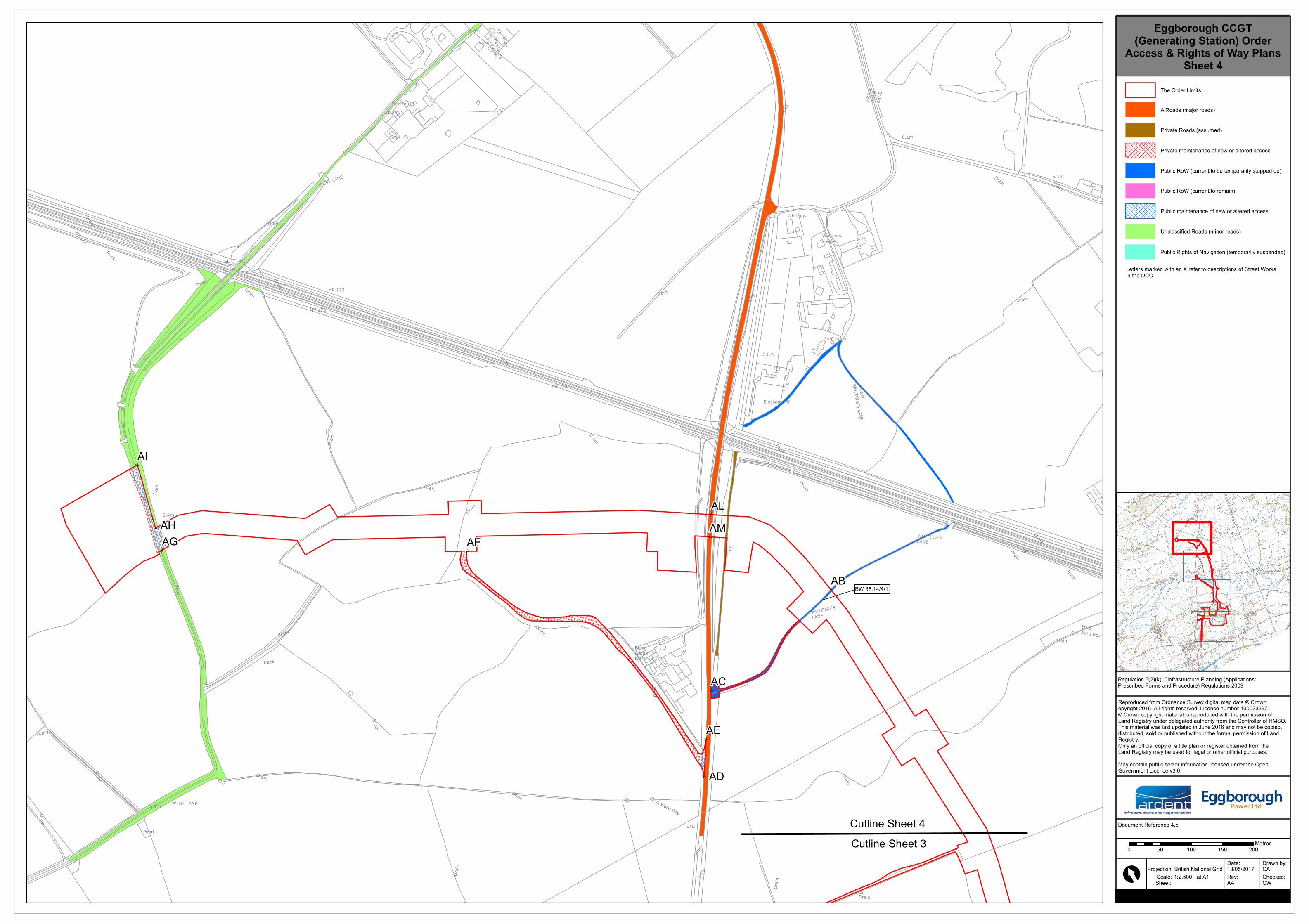
Eggborough CCGT(Generating Station) Order
Access & Rights of Way PlansSheet 4
at A1P rojection: British National Grid
Sh eet:
Regu lation 5(2)(k) – Infrastru c tu re P lanning (Applications:P resc rib ed Form s and P rocedu re) Regu lations 2009
Cu tline Sh eet 3Cu tline Sh eet 4
Th e Order Lim its
A Roads (m ajor roads)
P rivate Roads (assu m ed)
P rivate m aintenance of new or altered ac cess
P u b lic RoW (c u rrent/to be tem porarily stopped u p)
P u b lic RoW (c u rrent/to rem ain)
P u b lic m aintenance of new or altered ac cess
Unc lassified Roads (m inor roads)
P u b lic Righ ts of Navigation (tem porarily su spended)
Letters m arked with an X refer to desc riptions of Street Worksin th e DCO
BW 35.14/4/1
0 50 100 150 200Metres