E&G – Quaternary Science Journal - Sediment Input into the Heidelberg Basin as determined from ...
15
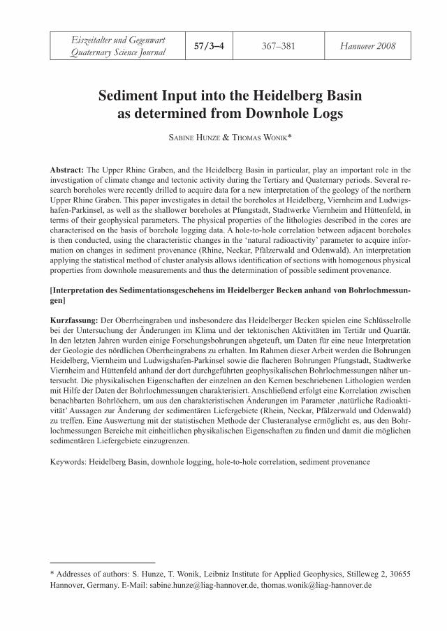
Sediment Input into the Heidelberg Basin as determined from Downhole Logs SABINE HUNZE & THOMAS WONIK* Abstract: The Upper Rhine Graben, and the Heidelberg Basin in particular, play an important role in the investigation of climate change and tectonic activity during the Tertiary and Quaternary periods. Several re- search boreholes were recently drilled to acquire data for a new interpretation of the geology of the northern Upper Rhine Graben. This paper investigates in detail the boreholes at Heidelberg, Viernheim and Ludwigs- hafen-Parkinsel, as well as the shallower boreholes at Pfungstadt, Stadtwerke Viernheim and Hüttenfeld, in terms of their geophysical parameters. The physical properties of the lithologies described in the cores are characterised on the basis of borehole logging data. A hole-to-hole correlation between adjacent boreholes is then conducted, using the characteristic changes in the ‘natural radioactivity’ parameter to acquire infor- mation on changes in sediment provenance (Rhine, Neckar, Pfälzerwald and Odenwald). An interpretation applying the statistical method of cluster analysis allows identification of sections with homogenous physical properties from downhole measurements and thus the determination of possible sediment provenance. [Interpretation des Sedimentationsgeschehens im Heidelberger Becken anhand von Bohrlochmessun- gen] Kurzfassung: Der Oberrheingraben und insbesondere das Heidelberger Becken spielen eine Schlüsselrolle bei der Untersuchung der Änderungen im Klima und der tektonischen Aktivitäten im Tertiär und Quartär. In den letzten Jahren wurden einige Forschungsbohrungen abgeteuft, um Daten für eine neue Interpretation der Geologie des nördlichen Oberrheingrabens zu erhalten. Im Rahmen dieser Arbeit werden die Bohrungen Heidelberg, Viernheim und Ludwigshafen-Parkinsel sowie die flacheren Bohrungen Pfungstadt, Stadtwerke Viernheim and Hüttenfeld anhand der dort durchgeführten geophysikalischen Bohrlochmessungen näher un- tersucht. Die physikalischen Eigenschaften der einzelnen an den Kernen beschriebenen Lithologien werden mit Hilfe der Daten der Bohrlochmessungen charakterisiert. Anschließend erfolgt eine Korrelation zwischen benachbarten Bohrlöchern, um aus den charakteristischen Änderungen im Parameter ‚natürliche Radioakti- vität’ Aussagen zur Änderung der sedimentären Liefergebiete (Rhein, Neckar, Pfälzerwald und Odenwald) zu treffen. Eine Auswertung mit der statistischen Methode der Clusteranalyse ermöglicht es, aus den Bohr- lochmessungen Bereiche mit einheitlichen physikalischen Eigenschaften zu finden und damit die möglichen sedimentären Liefergebiete einzugrenzen. Keywords: Heidelberg Basin, downhole logging, hole-to-hole correlation, sediment provenance * Addresses of authors: S. Hunze, T. Wonik, Leibniz Institute for Applied Geophysics, Stilleweg 2, 30655 Hannover, Germany. E-Mail: [email protected], [email protected] Eiszeitalter und Gegenwart Quaternary Science Journal 57/3–4 367–381 Hannover 2008
-
Upload
geozon-science-media -
Category
Documents
-
view
214 -
download
0
description
Der Oberrheingraben und insbesondere das Heidelberger Becken spielen eine Schlüsselrolle bei der Untersuchung der Änderungen im Klima und der tektonischen Aktivitäten im Tertiär und Quartär. In den letzten Jahren wurden einige Forschungsbohrungen abgeteuft, um Daten für eine neue Interpretation der Geologie des nördlichen Oberrheingrabens zu erhalten. Im Rahmen dieser Arbeit werden die Bohrungen Heidelberg, Viernheim und Ludwigshafen-Parkinsel sowie die flacheren Bohrungen Pfungstadt, Stadtwerke Viernheim and Hüttenfeld anhand der dort durchgeführten geophysikalischen Bohrlochmessungen näher untersucht. Die physikalischen Eigenschaften der einzelnen an den Kernen beschriebenen Lithologien werden mit Hilfe der Daten der Bohrlochmessungen charakterisiert. Anschließend erfolgt eine Korrelation zwischen benachbarten Bohrlöchern, um aus den charakteristischen Änderungen im Parameter‚ natürliche Radioaktivität Aussagen zur Änderung der sedimentären Liefergebiete (Rhein, Neckar, Pfälzerwa...
Transcript of E&G – Quaternary Science Journal - Sediment Input into the Heidelberg Basin as determined from ...
Sediment Input into the Heidelberg Basin
as determined from Downhole Logs
SABINE HUNZE & THOMAS WONIK*
Abstract: The Upper Rhine Graben, and the Heidelberg Basin in particular, play an important role in the investigation of climate change and tectonic activity during the Tertiary and Quaternary periods. Several re-search boreholes were recently drilled to acquire data for a new interpretation of the geology of the northern Upper Rhine Graben. This paper investigates in detail the boreholes at Heidelberg, Viernheim and Ludwigs-hafen-Parkinsel, as well as the shallower boreholes at Pfungstadt, Stadtwerke Viernheim and Hüttenfeld, in terms of their geophysical parameters. The physical properties of the lithologies described in the cores are characterised on the basis of borehole logging data. A hole-to-hole correlation between adjacent boreholes is then conducted, using the characteristic changes in the ‘natural radioactivity’ parameter to acquire infor-mation on changes in sediment provenance (Rhine, Neckar, Pfälzerwald and Odenwald). An interpretation applying the statistical method of cluster analysis allows identifi cation of sections with homogenous physical properties from downhole measurements and thus the determination of possible sediment provenance.
[Interpretation des Sedimentationsgeschehens im Heidelberger Becken anhand von Bohrlochmessun-
gen]
Kurzfassung: Der Oberrheingraben und insbesondere das Heidelberger Becken spielen eine Schlüsselrolle bei der Untersuchung der Änderungen im Klima und der tektonischen Aktivitäten im Tertiär und Quartär. In den letzten Jahren wurden einige Forschungsbohrungen abgeteuft, um Daten für eine neue Interpretation der Geologie des nördlichen Oberrheingrabens zu erhalten. Im Rahmen dieser Arbeit werden die Bohrungen Heidelberg, Viernheim und Ludwigshafen-Parkinsel sowie die fl acheren Bohrungen Pfungstadt, Stadtwerke Viernheim and Hüttenfeld anhand der dort durchgeführten geophysikalischen Bohrlochmessungen näher un-tersucht. Die physikalischen Eigenschaften der einzelnen an den Kernen beschriebenen Lithologien werden mit Hilfe der Daten der Bohrlochmessungen charakterisiert. Anschließend erfolgt eine Korrelation zwischen benachbarten Bohrlöchern, um aus den charakteristischen Änderungen im Parameter ‚natürliche Radioakti-vität’ Aussagen zur Änderung der sedimentären Liefergebiete (Rhein, Neckar, Pfälzerwald und Odenwald) zu treffen. Eine Auswertung mit der statistischen Methode der Clusteranalyse ermöglicht es, aus den Bohr-lochmessungen Bereiche mit einheitlichen physikalischen Eigenschaften zu fi nden und damit die möglichen sedimentären Liefergebiete einzugrenzen.
Keywords: Heidelberg Basin, downhole logging, hole-to-hole correlation, sediment provenance
* Addresses of authors: S. Hunze, T. Wonik, Leibniz Institute for Applied Geophysics, Stilleweg 2, 30655
Hannover, Germany. E-Mail: [email protected], [email protected]
Eiszeitalter und Gegenwart
Quaternary Science Journal57/3–4 367–381 Hannover 2008
1 Introduction
1.1 Geology
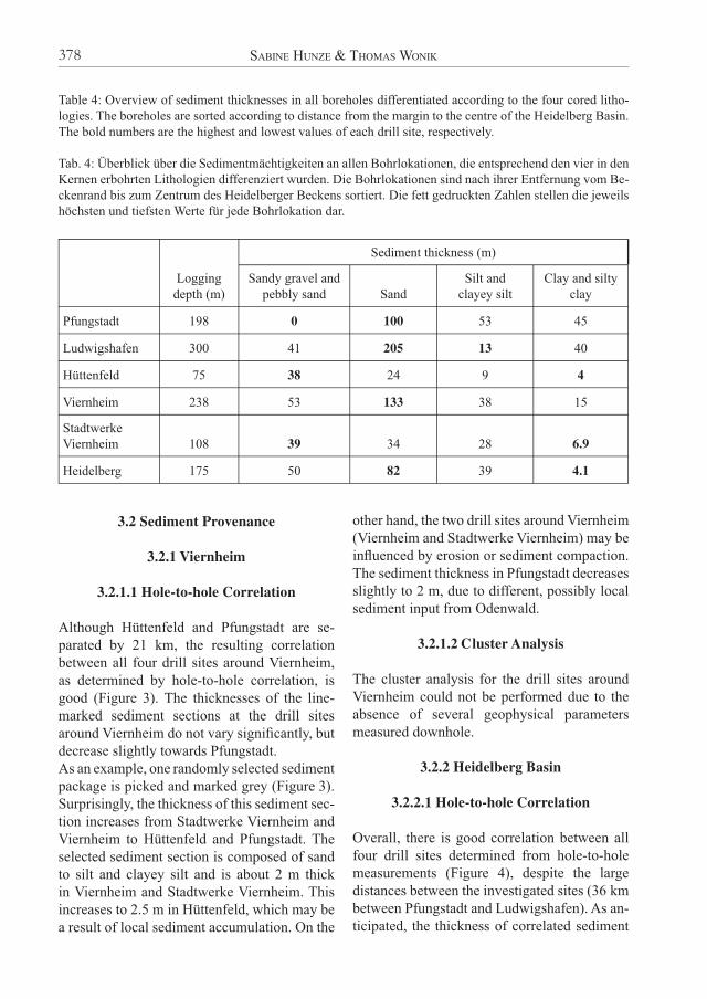
One of Europe’s largest river systems, the River Rhine, provides a unique geoscientifi c data set with the potential of bridging the gap between glaciated alpine areas and the inland ice-sheet advances of Northern Europe (WESTERHOFF 2008). The Upper Rhine Graben extends ap-proximately 300 km from Basel (Switzerland) to Frankfurt (Germany) and is 35-45 km wide on average. This graben is a north-northeast-trending rift of Tertiary age (ELLWANGER et al. 2005). As a subsidence structure it forms an element of the Oligocene and Neogene rif-ting of the Upper Rhine Graben, representing 40 Ma of active graben tectonics (BEHRMANN et al. 2003). The Oberrhein (Upper Rhine) Valley, as a graben structure, forms part of the rifting system that began to develop during the mid-Tertiary (PREUSSER 2008). During the Quaternary, the subsiding part of the northern Upper Rhine Graben acted as a distal and fi nal accommodation space for coarser alpine mate-rial (ELLWANGER et al. 2005).Rhine sediments have recorded changes in both climate and tectonic activity (PREUSSER, 2008). During the Pliocene-Quaternary, the major sub-sidence centre shifted towards the eastern part of the graben (Heidelberg Basin), with a zone of maximum subsidence located in the central-eastern part of the basin, around the city of Heidelberg (ELLWANGER et al. 2005). The Plio-cene-Quaternary infi ll of the Heidelberg Basin was mainly deposited by the River Rhine. The most distal signals of alpine climate dynamics associated with the major events of alpine glaciation can still be identifi ed as sediment bodies within the Pleistocene succession. They are embedded in relatively fi ne alpine material and coarser local material. Coarser layers are also present, which are related to sediment input from the River Neckar (ELLWANGER et al. 2005). Towards the north, the character of the graben sediments change as a result of sorting processes during fl uvial transport and admixture with local material derived from
the graben margins. In the northern part of the Upper Rhine Graben the graben sediments are generally fi ner grained, better sorted and mixed with local sediment input from the graben mar-gins (HAGEDORN & BOENIGK 2008).
1.2 Boreholes
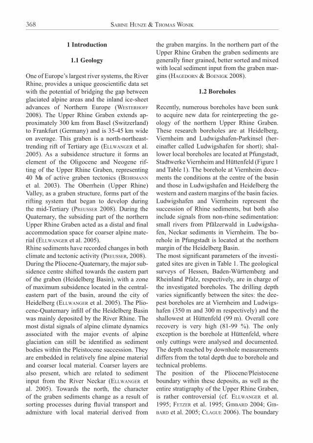
Recently, numerous boreholes have been sunk to acquire new data for reinterpreting the ge-ology of the northern Upper Rhine Graben. These research boreholes are at Heidelberg, Viernheim and Ludwigshafen-Parkinsel (her-einafter called Ludwigshafen for short); shal-lower local boreholes are located at Pfungstadt, Stadtwerke Viernheim and Hüttenfeld (Figure 1 and Table 1). The borehole at Viernheim docu-ments the conditions at the centre of the basin and those in Ludwigshafen and Heidelberg the western and eastern margins of the basin facies. Ludwigshafen and Viernheim represent the succession of Rhine sediments, but both also include signals from non-rhine sedimentation: small rivers from Pfälzerwald in Ludwigsha-fen, Neckar sediments in Viernheim. The bo-rehole in Pfungstadt is located at the northern margin of the Heidelberg Basin. The most signifi cant parameters of the investi-gated sites are given in Table 1. The geological surveys of Hessen, Baden-Württemberg and Rheinland Pfalz, respectively, are in charge of the investigated boreholes. The drilling depth varies signifi cantly between the sites: the dee-pest boreholes are at Viernheim and Ludwigs-hafen (350 m and 300 m respectively) and the shallowest at Hüttenfeld (99 m). Overall core recovery is very high (81-99 %). The only exception is the borehole at Hüttenfeld, where only cuttings were analysed and documented. The depth reached by downhole measurements differs from the total depth due to borehole and technical problems.The position of the Pliocene/Pleistocene boundary within these deposits, as well as the entire stratigraphy of the Upper Rhine Graben, is rather controversial (cf. ELLWANGER et al. 1995; FETZER et al. 1995; GIBBARD 2004; GIB-BARD et al. 2005; CLAGUE 2006). The boundary
SABINE HUNZE & THOMAS WONIK368
Fig
. 1:
Loc
atio
n of
dri
ll s
ites
in
the
Hei
delb
erg
Bas
in.
The
mai
n ge
olog
ical
are
as (
Upp
er R
hine
Gra
ben,
Ode
nwal
d, P
fälz
erw
ald)
and
the
mai
n ri
vers
(R
hine
an
d N
ecka
r) a
re m
arke
d (a
fter
HO
SE
LM
AN
N 2
008)
. The
sm
all r
ecta
ngle
(le
ft)
com
pris
es th
e se
dim
ent t
hick
ness
es o
f Q
uate
rnar
y ag
e in
the
nort
hern
Upp
er R
hine
G
rabe
n (a
fter
BA
RT
Z 1
974)
.
Abb
. 1:
Lag
e de
r B
ohrl
okat
ione
n im
Hei
delb
erge
r B
ecke
n (r
echt
s). D
ie w
icht
igst
en g
eolo
gisc
hen
Geb
iete
(O
berr
hein
grab
en, O
denw
ald,
Pfä
lzer
wal
d) u
nd d
ie
wic
htig
sten
Flü
sse
(Rhe
in u
nd N
ecka
r) s
ind
mar
kier
t (na
ch H
OS
EL
MA
NN
200
8). D
as R
echt
eck
(lin
ks)
enth
ält e
ine
Dar
stel
lung
der
Sed
imen
tmäc
htig
keit
im Q
uar-
tär
im n
ördl
iche
n O
berr
hein
grab
en (
nach
BA
RT
Z 1
974)
.
Sediment input into the Heidelberg Basin as determined from Downhole Logs 369
between Pliocene and Quaternary strata has been defi ned by the fi rst occurrence of alpine input into the graben as indicated by the car-bonate content within the sediments, as well as by the changing distribution of heavy minerals. The Pliocene sediments in the graben zone are predominantly fi ne-grained. Sandy clays alter-nate with fi ne to medium sands and some peat layers. Gravel layers occur only sporadically (HAGEDORN & BOENIGK 2008).
2 Methods
2.1 Downhole Logging
In the majority of boreholes downhole logging was conducted by the Leibniz Institute for Ap-plied Geophysics (LIAG), Hannover; an excep-tion is Hüttenfeld, where downhole logging was performed by the Geological Survey of Hessen (HLUG). The number of measured geophysical parameters at each site differs signifi cantly: the most complete borehole measurement data sets were obtained at the Heidelberg and Viernheim sites, but Pfungstadt comprises a slightly re-duced number of downhole measurements. At
Table 1: Basic parameters of the investigated boreholes.
Tab. 1: Grundlegende Parameter der untersuchten Bohrungen.
Pfungstadt Hüttenfeld Viernheim Stadtwerke Viernheim
Heidelberg Ludwigs-hafen
Responsible operating institution
Geological Survey (HLUG)Hessen
Geological Survey (HLUG)Hessen
Geological Survey (HLUG)Hessen
Geological Survey (HLUG)Hessen
Geological Survey (LGRB)Baden-Württemberg
Geological Survey (LGB-RLP) Rheinland- Pfalz
Drilling depth 200 m 99 m 350 m 110 m 180 m 300 m
Core recovery 98 % Drill cuttings
97 % 99 % 81 % 99 %
Basis of Quaternary
At 132 m Not recovered
At 225 m Not recovered
Not recovered At 177 m
Downhole logging
To 180 m To 75 m, only GR
To 238 m To 108 m, only GR
To 180 m To 300 m, only GR
the Ludwigshafen, Stadtwerke Viernheim and Hüttenfeld sites only gamma ray logs (GR) were run.The downhole logging in Heidelberg, Viern-heim and Pfungstadt was conducted in seve-ral sections because of problems within these less lithifi ed sediments during drilling. This means that up to fi ve logging campaigns were necessary to complete downhole logging. The borehole diameter generally decreases in stages (e.g. from 244 mm to 200 mm to 150 mm) with increasing depth. The steps coincide with each logging campaign.The downhole measurements can be differenti-ated into radioactive methods (density, neutron porosity, spectral gamma ray including gamma ray, potassium, thorium and uranium); acoustic methods (sonic velocity and acoustic borehole televiewer); electrical methods (dual laterolog resistivity, dipmeter); magnetic methods (mag-netic susceptibility); and other methods (bore-hole diameter, temperature and salt content of the drilling mud). Only those logs yielding information on the physical properties of the sediments, in particu-lar on their grain size, were utilised for further
SABINE HUNZE & THOMAS WONIK370
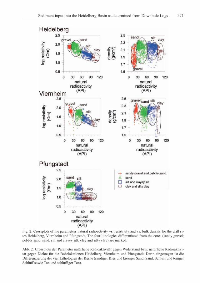
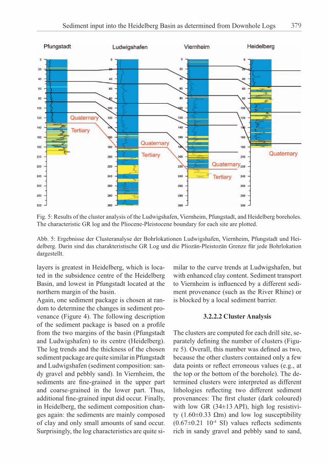
Fig. 2: Crossplots of the parameters natural radioactivity vs. resistivity and vs. bulk density for the drill si-tes Heidelberg, Viernheim and Pfungstadt. The four lithologies differentiated from the cores (sandy gravel; pebbly sand; sand, silt and clayey silt; clay and silty clay) are marked.
Abb. 2: Crossplots der Parameter natürliche Radioaktivität gegen Widerstand bzw. natürliche Radioaktivi-tät gegen Dichte für die Bohrlokationen Heidelberg, Viernheim und Pfungstadt. Darin eingetragen ist die Differenzierung der vier Lithologien der Kerne (sandiger Kies und kiesiger Sand, Sand, Schluff und toniger Schluff sowie Ton und schluffi ger Ton).
Sediment input into the Heidelberg Basin as determined from Downhole Logs 371
interpretation. These logs are GR, density, neutron porosity, resistivity, susceptibility, and caliper (borehole diameter). The caliper refl ects the actual borehole diameter during logging as compared to the drilling diameter. Any sections with high differences in borehole diameter must be interpreted with caution. The neutron porosity log measures only relative porosity values; no absolute porosity values can be gi-ven. Therefore, the unit a.u. is used below.
2.2 Physical Properties
The main objective of analysing physical pro-perties is to characterise each lithology by its specifi c physical properties. For better compa-rison the mean value and the standard deviation for each lithology has been calculated (Table 2 and Appendix). The log data sets were correc-ted prior to interpretation; this includes deleting erroneous and negative values. Those sections preferably with homogeneous lithology as determined by core descriptions (HOSELMANN 2008; WEIDENFELLER & KNIPPING 2008) are then selected and corrected using crossplots. Cross-plotting logs is usually done to quantify lithology and empirical relationships often be-come evident (RIDER, 1996). Finally, the physi-cal properties of each lithology are calculated from the most prominent downhole logs, which are GR, density, porosity, resistivity (far) and susceptibility.
2.3 Hole-to-hole Correlation
Changes in sediment thickness, and therefore in sediment input, can be quantifi ed by hole-to-hole correlation. This method comprises the synoptical comparison and connection of similar characteristic peaks and downhole log trends from adjacent sites. The correlation was performed using several logs (such as GR, susceptibility, porosity, density and resistivi-ty), but most logs, except the GR log, were not measured at all sites and/or data variation is high. The correlation was therefore carried out on the GR log (Figures 3, 4 and 5), because of its low data scatter and characteristic log
trends. RIDER (1996) pointed out that the GR log is used for correlation, because the ‘charac-ter’ of the gamma ray log is repeatable, is not affected by compaction with depth, and gives some indication of lithology.
2.4 Cluster Analysis
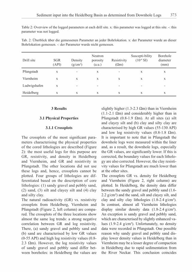
The lithologies and resultant possible sediment provenances were determined using the statisti-cal method of cluster analysis (Ward method of complete hierarchical linkage, Figure 5). The WINSTAT Statistic for Windows (Version 3.1) software application was employed for this purpose. Cluster analysis is a multivariate statistical technique, which assesses the similarities bet-ween units based on the occurrence or absence of specifi c components within them. This ana-lysis creates homogeneous (members are simi-lar to one another) groups of variables, the clus-ters. The elements in a cluster have relatively small distances from each other and relatively larger distances from elements outside a cluster (DAVIS 1986; BACKHAUS et al. 1996). Cluster analysis differentiates groups characterised by their physical properties. The number of clus-ters is determined using a tree-like structure, the dendrogram, which visualises the similarity of clusters (MOLINE et al. 1992, FRICKE & SCHÖN 1999). The dendrogram is cut horizontally at any level to create groups, which are compared to core data, and the most appropriate grouping level is chosen (RIDER 1996). The cluster analysis is performed for four lo-cations simultaneously, allowing a comparison of the resulting clusters between the drill sites. The maximum number of parameters used for calculating the clusters in Heidelberg and Viernheim is six (Table 2). However, the num-ber of logging parameters is reduced at the two other locations: in Pfungstadt four parameters were measured and in Ludwigshafen only one. Cluster analysis was not performed for the Hüt-tenfeld and Stadtwerke Viernheim boreholes, because of an insuffi cient number of measured geophysical parameters.
SABINE HUNZE & THOMAS WONIK372
3 Results
3.1 Physical Properties
3.1.1 Crossplots
The crossplots of the most signifi cant para-meters characterising the physical properties of the cored lithologies are described (Figure 2): the most useful logs for this purpose are GR, resistivity, and density in Heidelberg and Viernheim, and GR and resistivity in Pfungstadt. The other locations did not use these logs and, hence, crossplots cannot be plotted. Four groups of lithologies are dif-ferentiated based on the description of core lithologies: (1) sandy gravel and pebbly sand, (2) sand, (3) silt and clayey silt and (4) clay and silty clay. The natural radioactivity (GR) vs. resistivity crossplots from Heidelberg, Viernheim and Pfungstadt (Figure 2, left column) are compa-red. The crossplots of the three locations show almost the same log trends: a strong negative correlation between GR and log resistivity. There, (a) sandy gravel and pebbly sand and (b) sand are characterised by low GR values (0-55 API) and high log resistivity values (0.8-2.3 Ωm). However, the log resistivity values of sandy gravel and pebbly sand differ bet-ween boreholes: in Heidelberg the values are
Table 2: Overview of the logged parameters at each drill site. x: this parameter was logged at this site. -: this parameter was not logged.
Tab. 2: Überblick über die gemessenen Parameter an jeder Bohrlokation. x: der Parameter wurde an dieser Bohrlokation gemessen. -: der Parameter wurde nicht gemessen.
Drill site SGR(API)
Density(g/cm³)
Neutronporosity
(a.u.)Resistivity
(Ωm)
Suscepti-bility(10-4 SI)
Borehole diameter
(mm)
Pfungstadt x - x - x x
Viernheim x x x x x x
Ludwigshafen x - - - - -
Heidelberg x x x x x x
slightly higher (1.3-2.3 Ωm) than in Viernheim (1.1-2.1 Ωm) and considerably higher than in Pfungstadt (0.8-1.9 Ωm). At all sites (a) silt and clayey silt and (b) clay and silty clay are characterised by high GR values (55-130 API) and low log resistivity values (0.8-1.8 Ωm). It is important to note that in Pfungstadt the downhole logs were measured within the liner and, as a result, the downhole logs, especially the GR values, are signifi cantly lower. If this is corrected, the boundary values for each litholo-gy are also corrected. However, the clay resisti-vity values for Pfungstadt are much lower than at the other sites.The crossplots GR vs. density for Heidelberg and Viernheim (Figure 2, right column) are plotted. In Heidelberg, the density data differ between the sandy gravel and pebbly sand (1.6-2.2 g/cm³) and the sand, silt and clayey silt, and clay and silty clay lithologies (1.8-2.4 g/cm³). In contrast, almost all Viernheim lithologies display similar density data (1.8-2.4 g/cm³). An exception is sandy gravel and pebbly sand, which are characterised by slightly enhanced va-lues (1.9-2.4 g/cm³). Unfortunately, no density data were recorded in Pfungstadt. One possible reason why sandy gravel and pebbly sand dis-play lower density values in Heidelberg than in Viernheim may be a lesser degree of compaction in Heidelberg due to rapid sedimentation from the River Neckar. This conclusion coincides
Sediment input into the Heidelberg Basin as determined from Downhole Logs 373
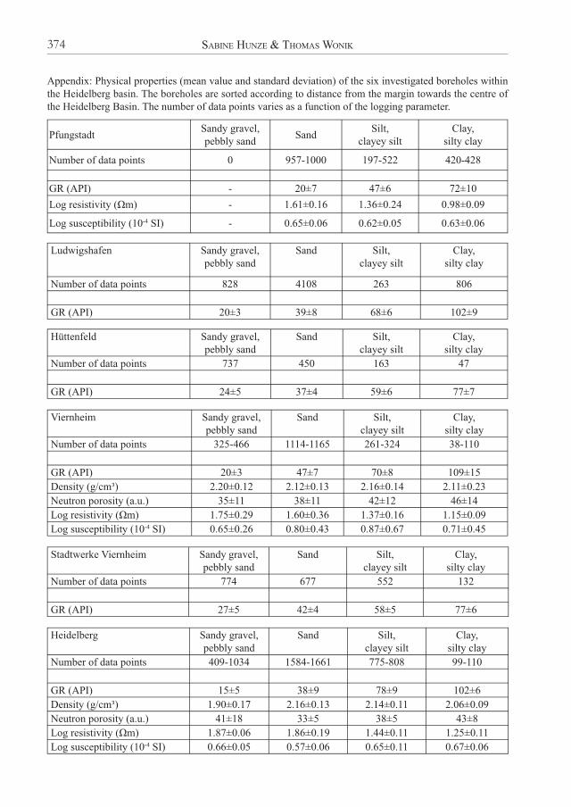
Appendix: Physical properties (mean value and standard deviation) of the six investigated boreholes within the Heidelberg basin. The boreholes are sorted according to distance from the margin towards the centre of the Heidelberg Basin. The number of data points varies as a function of the logging parameter.
PfungstadtSandy gravel, pebbly sand
SandSilt,
clayey siltClay,
silty clay
Number of data points 0 957-1000 197-522 420-428
GR (API) - 20±7 47±6 72±10
Log resistivity (Ωm) - 1.61±0.16 1.36±0.24 0.98±0.09
Log susceptibility (10-4 SI) - 0.65±0.06 0.62±0.05 0.63±0.06
Ludwigshafen Sandy gravel, pebbly sand
Sand Silt, clayey silt
Clay, silty clay
Number of data points 828 4108 263 806
GR (API) 20±3 39±8 68±6 102±9
Hüttenfeld Sandy gravel, pebbly sand
Sand Silt, clayey silt
Clay, silty clay
Number of data points 737 450 163 47
GR (API) 24±5 37±4 59±6 77±7
Viernheim Sandy gravel, pebbly sand
Sand Silt, clayey silt
Clay, silty clay
Number of data points 325-466 1114-1165 261-324 38-110
GR (API) 20±3 47±7 70±8 109±15
Density (g/cm³) 2.20±0.12 2.12±0.13 2.16±0.14 2.11±0.23
Neutron porosity (a.u.) 35±11 38±11 42±12 46±14
Log resistivity (Ωm) 1.75±0.29 1.60±0.36 1.37±0.16 1.15±0.09
Log susceptibility (10-4 SI) 0.65±0.26 0.80±0.43 0.87±0.67 0.71±0.45
Stadtwerke Viernheim Sandy gravel, pebbly sand
Sand Silt, clayey silt
Clay, silty clay
Number of data points 774 677 552 132
GR (API) 27±5 42±4 58±5 77±6
Heidelberg Sandy gravel, pebbly sand
Sand Silt, clayey silt
Clay, silty clay
Number of data points 409-1034 1584-1661 775-808 99-110
GR (API) 15±5 38±9 78±9 102±6
Density (g/cm³) 1.90±0.17 2.16±0.13 2.14±0.11 2.06±0.09
Neutron porosity (a.u.) 41±18 33±5 38±5 43±8
Log resistivity (Ωm) 1.87±0.06 1.86±0.19 1.44±0.11 1.25±0.11
Log susceptibility (10-4 SI) 0.66±0.05 0.57±0.06 0.65±0.11 0.67±0.06
SABINE HUNZE & THOMAS WONIK374
with the highest sediment thickness at the basin centre. Another reason may be the mineralogy of the sediments at the different drill sites.Comparing the results of both crossplots shows that the GR vs. resistivity crossplot implies that the fi ne-grained sediments are characterised by low resistivity values, which suggests high conductivity possibly caused by high water content, salinity and/or porosity. In the GR vs. density crossplot the coarser-grained sediments
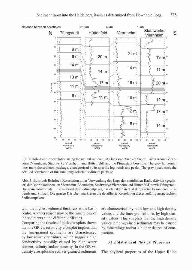
Fig. 3: Hole-to-hole correlation using the natural radioactivity log (smoothed) of the drill sites around Viern-heim (Viernheim, Stadtwerke Viernheim and Hüttenfeld) and the Pfungstadt borehole. The grey horizontal lines mark the sediment package, characterised by its specifi c log trends and peaks. The grey boxes mark the detailed correlation of this randomly selected sediment package.
Abb. 3: Bohrloch-Bohrloch Korrelation unter Verwendung des Logs der natürlichen Radioaktivität (geglät-tet) der Bohrlokationen um Viernheim (Viernheim, Stadtwerke Viernheim und Hüttenfeld) sowie Pfungstadt. Die graue horizontale Linie markiert das Sedimentpaket, das charakterisiert ist durch seine besonderen Log-trends und Spitzen. Die grauen Kästchen markieren die detaillierte Korrelation dieser zufällig ausgesuchten Sedimentpakete.
are characterised by both low and high density values and the fi ner-grained ones by high den-sity values. This suggests that the high density values in fi ne-grained sediments may be caused by mineralogy and/or a higher degree of com-paction.
3.1.2 Statistics of Physical Properties
The physical properties of the Upper Rhine
Sediment input into the Heidelberg Basin as determined from Downhole Logs 375

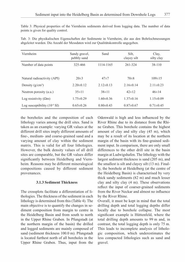
Graben were computed to determine both their characteristics and their changes according to location within the Heidelberg Basin (see Ap-pendix). The physical properties are described using Viernheim as an example (Table 3). Prin-cipally, natural radioactivity refl ects the grain size: the higher the natural radioactivity values, the higher the clay content of the sediment. The density and log resistivity values decrease and the neutron porosity values increase with incre-asing clay content (from sandy gravel to clay). Again, this may imply a decreasing degree of
compaction from the coarser-grained to the fi ner-grained sediments. The log susceptibi-lity values vary with grain size, because this parameter mainly refl ects an overall change in sediment input.A number of important trends are observed by comparing the physical properties of all lithologies within the Heidelberg Basin (see Appendix). Overall, it must be kept in mind that the lithologies were defi ned for each site separately. This leads to more or less signifi cant differences in GR values between
Fig. 4: Hole-to-hole correlation using the GR log from the drill sites within the Heidelberg Basin (Pfungstadt, Ludwigshafen, Viernheim, and Heidelberg). The lowermost blue horizontal lines mark the Pliocene-Pleisto-cene boundary as described in the cores. The red horizontal lines mark the sediment package, characterised by specifi c log trends (marked with vertical line) and peaks. The green lines mark the characteristic log trends. The grey boxes mark the detailed correlation of one randomly selected sediment package.
Abb. 4: Bohrloch-Bohrloch Korrelation unter Verwendung des GR Logs der Bohrlokationen im Heidelberger Becken (Pfungstadt, Ludwigshafen, Viernheim und Heidelberg). Die unterste blaue, horizontale Linie mar-kiert die Pliozän-Pleistozän Grenze wie sie in den Kernen beschrieben wurde. Die anderen roten, horizon-talen Linien markieren jeweils das Sedimentpaket, das charakterisiert ist durch seine besonderen Logtrends (markiert mit vertikaler Linie) und Spitzen. Die grünen Linien markieren die charakteristischen Logtrends. Die grauen Kästchen markieren die detaillierte Korrelation dieser zufällig ausgesuchten Sedimentpakete.
SABINE HUNZE & THOMAS WONIK376
the boreholes and the composition of each lithology varies among the drill sites. Sand is taken as an example: varying GR values at the different drill sites imply different amounts of fi ne-, medium- and coarse-grained sand and a varying amount of clay within the sediment matrix. This is valid for all four lithologies. However, the bulk density values of all drill sites are comparable, but the GR values differ signifi cantly between Heidelberg and Viern-heim. Reasons may be different mineralogical compositions caused by different sediment provenances.
3.1.3 Sediment Thickness
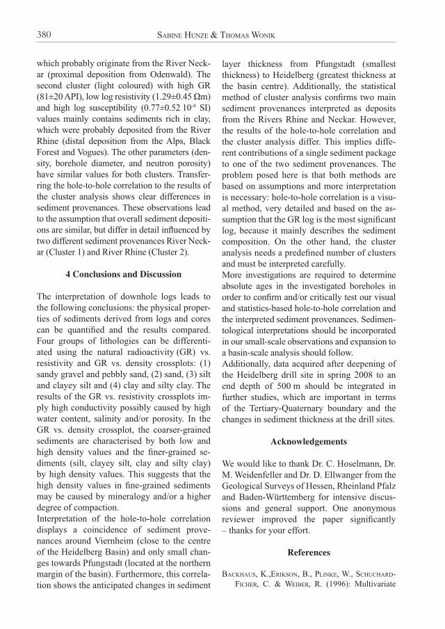
The crossplots facilitate a differentiation of li-thologies. The thickness of the sediment in each lithology is determined from this (Table 4). The main objective is to quantify the changes in se-diment composition from margin to centre in the Heidelberg Basin and from south to north in the Upper Rhine Graben. In Pfungstadt (at the northern margin of the basin) the drilled and logged sediments are mainly composed of sand (sediment thickness 100.0 m). Pfungstadt is located furthest north of all boreholes in the Upper Rhine Graben. Thus, input from the
Odenwald is high and less infl uenced by the River Rhine due to its distance from the Rhi-ne Graben. This borehole contains the highest amount of clay and silty clay (45 m), which may be a result of its location at the northern margin of the basin with its fi ne-grained sedi-ment input. In comparison, there are only small differences to the other drill site in the basin margin at Ludwigshafen. The lithology with the largest sediment thickness is sand (205 m), and the smallest is silt and clayey silt (13 m). Final-ly, the borehole at Heidelberg (at the centre of the Heidelberg Basin) is characterised by very thick sandy sediments (82 m) and much lesser clay and silty clay (4 m). These observations refl ect the input of coarser-grained sediments from the River Neckar and almost no infl uence by the River Rhine. Overall, it must be kept in mind that the total drilling depth and total logging depths differ locally due to borehole collapse. The most signifi cant example is Hüttenfeld, where the total drilling depth amounts to 99 m and, in contrast, the total logging depth is only 75 m. This leads to incomplete analysis of litholo-gic composition, which underestimates the less compacted lithologies such as sand and gravel.
Table 3: Physical properties of the Viernheim sediments derived from logging data. The number of data points is given for quality control.
Tab. 3: Die physikalischen Eigenschaften der Sedimente in Viernheim, die aus den Bohrlochmessungen abgeleitet wurden. Die Anzahl der Messdaten wird zur Qualitätskontrolle angegeben.
Viernheim Sandy gravel, pebbly sand
Sand Silt, clayey silt
Clay, silty clay
Number of data points 325-466 1114-1165 261-324 38-110
Natural radioactivity (API) 20±3 47±7 70±8 109±15
Density (g/cm³) 2.20±0.12 2.12±0.13 2.16±0.14 2.11±0.23
Neutron porosity (a.u.) 35±11 38±11 42±12 46±14
Log resistivity (Ωm) 1.75±0.29 1.60±0.36 1.37±0.16 1.15±0.09
Log susceptibility (10-4 SI) 0.65±0.26 0.80±0.43 0.87±0.67 0.71±0.45
Sediment input into the Heidelberg Basin as determined from Downhole Logs 377
3.2 Sediment Provenance
3.2.1 Viernheim
3.2.1.1 Hole-to-hole Correlation
Although Hüttenfeld and Pfungstadt are se-parated by 21 km, the resulting correlation between all four drill sites around Viernheim, as determined by hole-to-hole correlation, is good (Figure 3). The thicknesses of the line-marked sediment sections at the drill sites around Viernheim do not vary signifi cantly, but decrease slightly towards Pfungstadt. As an example, one randomly selected sediment package is picked and marked grey (Figure 3). Surprisingly, the thickness of this sediment sec-tion increases from Stadtwerke Viernheim and Viernheim to Hüttenfeld and Pfungstadt. The selected sediment section is composed of sand to silt and clayey silt and is about 2 m thick in Viernheim and Stadtwerke Viernheim. This increases to 2.5 m in Hüttenfeld, which may be a result of local sediment accumulation. On the
other hand, the two drill sites around Viernheim (Viernheim and Stadtwerke Viernheim) may be infl uenced by erosion or sediment compaction. The sediment thickness in Pfungstadt decreases slightly to 2 m, due to different, possibly local sediment input from Odenwald.
3.2.1.2 Cluster Analysis
The cluster analysis for the drill sites around Viernheim could not be performed due to the absence of several geophysical parameters measured downhole.
3.2.2 Heidelberg Basin
3.2.2.1 Hole-to-hole Correlation
Overall, there is good correlation between all four drill sites determined from hole-to-hole measurements (Figure 4), despite the large distances between the investigated sites (36 km between Pfungstadt and Ludwigshafen). As an-ticipated, the thickness of correlated sediment
Table 4: Overview of sediment thicknesses in all boreholes differentiated according to the four cored litho-logies. The boreholes are sorted according to distance from the margin to the centre of the Heidelberg Basin. The bold numbers are the highest and lowest values of each drill site, respectively.
Tab. 4: Überblick über die Sedimentmächtigkeiten an allen Bohrlokationen, die entsprechend den vier in den Kernen erbohrten Lithologien differenziert wurden. Die Bohrlokationen sind nach ihrer Entfernung vom Be-ckenrand bis zum Zentrum des Heidelberger Beckens sortiert. Die fett gedruckten Zahlen stellen die jeweils höchsten und tiefsten Werte für jede Bohrlokation dar.
Logging depth (m)
Sediment thickness (m)
Sandy gravel and pebbly sand Sand
Silt andclayey silt
Clay and silty clay
Pfungstadt 198 0 100 53 45
Ludwigshafen 300 41 205 13 40
Hüttenfeld 75 38 24 9 4
Viernheim 238 53 133 38 15
Stadtwerke Viernheim 108 39 34 28 6.9
Heidelberg 175 50 82 39 4.1
SABINE HUNZE & THOMAS WONIK378
layers is greatest in Heidelberg, which is loca-ted in the subsidence centre of the Heidelberg Basin, and lowest in Pfungstadt located at the northern margin of the basin.Again, one sediment package is chosen at ran-dom to determine the changes in sediment pro-venance (Figure 4). The following description of the sediment package is based on a profi le from the two margins of the basin (Pfungstadt and Ludwigshafen) to its centre (Heidelberg). The log trends and the thickness of the chosen sediment package are quite similar in Pfungstadt and Ludwigshafen (sediment composition: san-dy gravel and pebbly sand). In Viernheim, the sediments are fi ne-grained in the upper part and coarse-grained in the lower part. Thus, additional fi ne-grained input did occur. Finally, in Heidelberg, the sediment composition chan-ges again: the sediments are mainly composed of clay and only small amounts of sand occur. Surprisingly, the log characteristics are quite si-
milar to the curve trends at Ludwigshafen, but with enhanced clay content. Sediment transport to Viernheim is infl uenced by a different sedi-ment provenance (such as the River Rhine) or is blocked by a local sediment barrier.
3.2.2.2 Cluster Analysis
The clusters are computed for each drill site, se-parately defi ning the number of clusters (Figu-re 5). Overall, this number was defi ned as two, because the other clusters contained only a few data points or refl ect erroneous values (e.g., at the top or the bottom of the borehole). The de-termined clusters were interpreted as different lithologies refl ecting two different sediment provenances: The fi rst cluster (dark coloured) with low GR (34±13 API), high log resistivi-ty (1.60±0.33 Ωm) and low log susceptibility (0.67±0.21 10-4 SI) values refl ects sediments rich in sandy gravel and pebbly sand to sand,
Fig. 5: Results of the cluster analysis of the Ludwigshafen, Viernheim, Pfungstadt, and Heidelberg boreholes. The characteristic GR log and the Pliocene-Pleistocene boundary for each site are plotted.
Abb. 5: Ergebnisse der Clusteranalyse der Bohrlokationen Ludwigshafen, Viernheim, Pfungstadt und Hei-delberg. Darin sind das charakteristische GR Log und die Pliozän-Pleistozän Grenze für jede Bohrlokation dargestellt.
Sediment input into the Heidelberg Basin as determined from Downhole Logs 379
which probably originate from the River Neck-ar (proximal deposition from Odenwald). The second cluster (light coloured) with high GR (81±20 API), low log resistivity (1.29±0.45 Ωm) and high log susceptibility (0.77±0.52 10-4 SI) values mainly contains sediments rich in clay, which were probably deposited from the River Rhine (distal deposition from the Alps, Black Forest and Vogues). The other parameters (den-sity, borehole diameter, and neutron porosity) have similar values for both clusters. Transfer-ring the hole-to-hole correlation to the results of the cluster analysis shows clear differences in sediment provenances. These observations lead to the assumption that overall sediment depositi-ons are similar, but differ in detail infl uenced by two different sediment provenances River Neck-ar (Cluster 1) and River Rhine (Cluster 2).
4 Conclusions and Discussion
The interpretation of downhole logs leads to the following conclusions: the physical proper-ties of sediments derived from logs and cores can be quantifi ed and the results compared. Four groups of lithologies can be differenti-ated using the natural radioactivity (GR) vs. resistivity and GR vs. density crossplots: (1) sandy gravel and pebbly sand, (2) sand, (3) silt and clayey silt and (4) clay and silty clay. The results of the GR vs. resistivity crossplots im-ply high conductivity possibly caused by high water content, salinity and/or porosity. In the GR vs. density crossplot, the coarser-grained sediments are characterised by both low and high density values and the fi ner-grained se-diments (silt, clayey silt, clay and silty clay) by high density values. This suggests that the high density values in fi ne-grained sediments may be caused by mineralogy and/or a higher degree of compaction.Interpretation of the hole-to-hole correlation displays a coincidence of sediment prove-nances around Viernheim (close to the centre of the Heidelberg Basin) and only small chan-ges towards Pfungstadt (located at the northern margin of the basin). Furthermore, this correla-tion shows the anticipated changes in sediment
layer thickness from Pfungstadt (smallest thickness) to Heidelberg (greatest thickness at the basin centre). Additionally, the statistical method of cluster analysis confi rms two main sediment provenances interpreted as deposits from the Rivers Rhine and Neckar. However, the results of the hole-to-hole correlation and the cluster analysis differ. This implies diffe-rent contributions of a single sediment package to one of the two sediment provenances. The problem posed here is that both methods are based on assumptions and more interpretation is necessary: hole-to-hole correlation is a visu-al method, very detailed and based on the as-sumption that the GR log is the most signifi cant log, because it mainly describes the sediment composition. On the other hand, the cluster analysis needs a predefi ned number of clusters and must be interpreted carefully. More investigations are required to determine absolute ages in the investigated boreholes in order to confi rm and/or critically test our visual and statistics-based hole-to-hole correlation and the interpreted sediment provenances. Sedimen-tological interpretations should be incorporated in our small-scale observations and expansion to a basin-scale analysis should follow.Additionally, data acquired after deepening of the Heidelberg drill site in spring 2008 to an end depth of 500 m should be integrated in further studies, which are important in terms of the Tertiary-Quaternary boundary and the changes in sediment thickness at the drill sites.
Acknowledgements
We would like to thank Dr. C. Hoselmann, Dr. M. Weidenfeller and Dr. D. Ellwanger from the Geological Surveys of Hessen, Rheinland Pfalz and Baden-Württemberg for intensive discus-sions and general support. One anonymous reviewer improved the paper signifi cantly – thanks for your effort.
References
BACKHAUS, K.,ERIKSON, B., PLINKE, W., SCHUCHARD-FICHER, C. & WEIBER, R. (1996): Multivariate
SABINE HUNZE & THOMAS WONIK380
Analysemethoden: Eine anwendungsorientierte Einführung. – 591 p.; Berlin (Springer).
BARTZ, J. (1974): Die Mächtigkeit des Quartärs im Oberrheingraben. – In: ILLIES, J. H. & FUCHS, K. (eds.): Approaches to Taphrogenesis. – Inter-Union Commission on Geodynamics Scientifi c Report, 8: 78-87; Stuttgart (Schweizerbart).
BEHRMANN, J. H., HERMANN, O., HORSTMANN, M., TANNER, D. C. & BERTRAND, G. (2003): Anatomy and kinematics of oblique continental rifting revealed: A three-dimensional case study of the southeast Upper Rhine Graben (Germany). – AAPG Bulletin, 87 (7): 1105-1121.
CLAGUE, J. (2006): Open letter to INQUA Executive Committee. – Quaternary International, 154/155: 158-159.
DAVIS, J. C. (1986): Statistics and Data Analysis in Geology. – 646 p.; New York (Wiley).
ELLWANGER, D., BIBUS, E., BLUDAU, W., KÖSEL, M. & MERKT, J. (1995): Baden-Württemberg. – In: BENDA, L. (ed.): Das Quartär Deutschlands: 255-295; Stuttgart (Bornträger).
ELLWANGER, D., GABRIEL, G., HOSELMANN, C., LÄMMERMANN-BARTHEL, J. & WEIDENFELLER, M. (2005): The Heidelberg Drilling Project (Upper Rhine Graben, Germany). – Quaternaire, 16 (3): 191-199.
FETZER, K. D., LARRES, K., SABEL, K.-J., SPIES, E.-D. & WEIDENFELLER, M. (1995): Hessen, Rhein-land-Pfalz, Saarland. – In: BENDA, L. (ed.): Das Quartär Deutschlands, 220-254; Stuttgart (Bornträger).
FRICKE, S. & SCHÖN, J. (1999): Praktische Bohrloch-geophysik. – 254 p.; Stuttgart (Enke).
GIBBARD, P.L. (2004): Quaternary … now you see it, now you don’t. – Quaternary International, 129: 89-91.
GIBBARD, P.L., SMITH, A.G., ZALASIEWICZ, J.A., BAR-RY, T.L., CANTRILL, D., COE, A. L., COPE, J.C.W., GALE, A.S., GREGORY, F.J., POWELL, J.H., RAWSON, P.F., STONE, P. & WATERS, C.N. (2005): What sta-tus for the Quaternary? – Boreas, 34: 1-6.
HAGEDORN, E.-M. & BOENIGK, W. (2008): The Pli-ocene and Quaternary sedimentary and fl uvial history in the Upper Rhine Graben based on heavy mineral analyses. – Netherlands Journal of Geosciences – Geologie en Mijnbouw, 87 (1): 21-32.
HOSELMANN, C. (2008): The Pliocene and Pleisto-cene fl uvial evolution in the northern Upper Rhine Graben based on results of the research borehole at Viernheim (Hessen, Germany). – Eiszeitalter & Gegenwart (Quaternary Science Journal), 57/3-4: 286-315.
MOLINE, G.R., BAHR, J.M., DRZEWIECKI, P.A. & SHEPARD, L.D. (1992): Identification and cha-racterisation of pressure seals through the use of wireline logs: a multivariate statistical approach. – Log Analyst, 33 (4): 362-372.
PREUSSER, F. (2008): Characterization and evolution of the River Rhine system. – Netherlands Jour-nal of Geosciences – Geologie en Mijnbouw, 87 (1): 7-19.
RIDER, M. (1996): The Geological Interpretation of Well Logs. – 256 p.; Caithness (Whittles Pub-lishing).
WEIDENFELLER, M. & KNIPPING, M. (2008): Correla-tion of Pleistocene sediments from boreholes in the Ludwigshafen area, western Heidelberg Basin – Eiszeitalter & Gegenwart (Quaternary Science Journal), 57/3-4: 270-285.
WESTERHOFF, W.E. (2008): The Rhine – a major fl uvial record. – Netherlands Journal of Geosci-
ences – Geologie en Mijnbouw, 87 (1): 3-5.
Sediment input into the Heidelberg Basin as determined from Downhole Logs 381