E&G – Quaternary Science Journal - Long sequence of Quaternary Rocks in the Heidelberg Basin De...
22
Abstract: A description and classification of the successions of the new scientific core drillings at Heidelberg is presented. Since 2002 drilling and research activities were ongoing in the Heidelberg Basin (HDB), as a mid-continental sedimentary archive within the Upper Rhine Graben (URG), Germany. The HDB is sup- posed to host one of the longest continuous successions of Quaternary sediments in Europe, due to continu- ous subsidence of the basin and sediment input from various sources. The HDB is about half-way between the Alpine source area of the Rhine and the North Sea. Here the Quaternary input is least affected by discon- tinuities due to climate events as alpine glacier meltdown events or periods of low sea level. Reversely, the low influence of climate leads to a larger tectonic control. The sedimentary succession of more than 500 m is considered as primarily controlled by tectonics, but with incorporated climate signals. For classification purposes, sediment provenance, lithofacies-associations, and the ratio of accommodation space and sediment input are used. Some biostratigraphic markers are also available. We suggest a sedimentary scenario where the overall fluvial environment is twice interrupted by lacustrine intervals. The accommodation space varies too: in one period it expands even beyond the eastern boundary fault of the HDB. [Mächtige Abfolge quartärer Sedimente im Depozentrum des Heidelberger Beckens] Kurzfassung: Die neue Forschungs-Kernbohrung aus Heidelberg wird beschrieben und gegliedert. Die For- schungs- und Bohraktivitäten im Heidelberger Becken (HDB) begannen im Jahr 2002; sie erschließen ein kontinentales Sedimentarchiv im Oberrheingraben (URG). Im HDB wird eine der längsten Sedimentabfol- gen quartärer Sedimente in Europa erwartet, dank kontinuierlicher Subsidenz des Beckens in Verbindung mit kontinuierlichem Input von Sedimenten unterschiedlicher Herkunft. Das HDB befindet sich auf halber Stre- cke zwischen dem alpinen Einzugsgebiet des Rheins und seiner Mündung in die Nordsee. Eine kontinuier- liche Sedimentation ist hier eher möglich als am Alpenrand mit seinen Schmelzwasser-Erosionsereignissen oder an der Küste mit ihren Meeresspiegelschwankungen. Dieser eher geringe Einfluss des Klimas hat zur Folge, dass die Tektonik eine umso größere Rolle bei der Steuerung der Sedimentation spielt. Die über 500 m mächtige quartäre Abfolge ist daher in erster Linie durch Tektonik kontrolliert, wobei Klimasignale ebenfalls Long sequence of Quaternary Rocks in the Heidelberg Basin Depocentre DIETRICH ELLWANGER, GERALD GABRIEL, THEO SIMON, ULRIKE WIELANDT-SCHUSTER, REINHARD O. GREILING, EVA-MARIE HAGEDORN, JÜRGEN HAHNE & JÜRGEN HEINZ *) *Addresses of authors: D. Ellwanger, Regierungspräsidium Freiburg, Abteilung 9 (Landesamt für Geolo- gie, Rohstoffe und Bergbau), Albertstraße 5, 79104 Freiburg i. Br., Germany. E-Mail: dietrich.ellwanger@ rpf.bwl.de; G. Gabriel, Leibniz Institute for Applied Geophysics, Stilleweg 2, 30655 Hannover, Germany. E-Mail: [email protected]; T. Simon, Regierungspräsidium Freiburg, Abteilung 9 (Lan- desamt für Geologie, Rohstoffe und Bergbau), Albertstraße 5, 79104 Freiburg i. Br., Germany. E-Mail: [email protected]; U. Wielandt-Schuster, Regierungspräsidium Freiburg, Abteilung 9 (Landesamt für Geologie, Rohstoffe und Bergbau), Albertstraße 5, 79104 Freiburg i. Br., Germany. E-Mail: ulrike.wielandt- [email protected]; R. Greiling, Geologisches Institut - Strukturgeologie und Tektonophysik, Universität Karlsruhe (TH), Hertzstr. 16, 76187 Karlsruhe, Germany. E-Mail: [email protected], E.-M. Hagedorn, Leineweberstr. 9, 51381 Leverkusen, Germany. E-Mail: [email protected]; J. Hahne, Tiefental 3, 37586 Dassel; Germany. E-Mail: [email protected]; J. Heinz, Hydroisotop GmbH, Karl-Friedrich-Str. 19, 79312 Emmendingen; Germany. E-Mail: [email protected] Eiszeitalter und Gegenwart Quaternary Science Journal 57/3–4 316–337 Hannover 2008
-
Upload
geozon-science-media -
Category
Documents
-
view
219 -
download
4
description
Die neue Forschungs-Kernbohrung aus Heidelberg wird beschrieben und gegliedert. Die Forschungs- und Bohraktivitäten im Heidelberger Becken (HDB) begannen im Jahr 2002; sie erschließen ein kontinentales Sedimentarchiv im Oberrheingraben (URG). Im HDB wird eine der längsten Sedimentabfolgen quartärer Sedimente in Europa erwartet, dank kontinuierlicher Subsidenz des Beckens in Verbindung mit kontinuierlichem Input von Sedimenten unterschiedlicher Herkunft. Das HDB befindet sich auf halber Strecke zwischen dem alpinen Einzugsgebiet des Rheins und seiner Mündung in die Nordsee. Eine kontinuierliche Sedimentation ist hier eher möglich als am Alpenrand mit seinen Schmelzwasser-Erosionsereignissen oder an der Küste mit ihren Meeresspiegelschwankungen. Dieser eher geringe Einfluss des Klimas hat zur Folge, dass die Tektonik eine umso größere Rolle bei der Steuerung der Sedimentation spielt. Die über 500 m mächtige quartäre Abfolge ist daher in erster Linie durch Tektonik kontrolliert, wobei...
Transcript of E&G – Quaternary Science Journal - Long sequence of Quaternary Rocks in the Heidelberg Basin De...
Abstract: A description and classifi cation of the successions of the new scientifi c core drillings at Heidelberg is presented. Since 2002 drilling and research activities were ongoing in the Heidelberg Basin (HDB), as a mid-continental sedimentary archive within the Upper Rhine Graben (URG), Germany. The HDB is sup-posed to host one of the longest continuous successions of Quaternary sediments in Europe, due to continu-ous subsidence of the basin and sediment input from various sources. The HDB is about half-way between the Alpine source area of the Rhine and the North Sea. Here the Quaternary input is least affected by discon-tinuities due to climate events as alpine glacier meltdown events or periods of low sea level. Reversely, the low infl uence of climate leads to a larger tectonic control. The sedimentary succession of more than 500 m is considered as primarily controlled by tectonics, but with incorporated climate signals. For classifi cation purposes, sediment provenance, lithofacies-associations, and the ratio of accommodation space and sediment input are used. Some biostratigraphic markers are also available. We suggest a sedimentary scenario where the overall fl uvial environment is twice interrupted by lacustrine intervals. The accommodation space varies
too: in one period it expands even beyond the eastern boundary fault of the HDB.
[Mächtige Abfolge quartärer Sedimente im Depozentrum des Heidelberger Beckens]
Kurzfassung: Die neue Forschungs-Kernbohrung aus Heidelberg wird beschrieben und gegliedert. Die For-schungs- und Bohraktivitäten im Heidelberger Becken (HDB) begannen im Jahr 2002; sie erschließen ein kontinentales Sedimentarchiv im Oberrheingraben (URG). Im HDB wird eine der längsten Sedimentabfol-gen quartärer Sedimente in Europa erwartet, dank kontinuierlicher Subsidenz des Beckens in Verbindung mit kontinuierlichem Input von Sedimenten unterschiedlicher Herkunft. Das HDB befi ndet sich auf halber Stre-cke zwischen dem alpinen Einzugsgebiet des Rheins und seiner Mündung in die Nordsee. Eine kontinuier-liche Sedimentation ist hier eher möglich als am Alpenrand mit seinen Schmelzwasser-Erosionsereignissen oder an der Küste mit ihren Meeresspiegelschwankungen. Dieser eher geringe Einfl uss des Klimas hat zur Folge, dass die Tektonik eine umso größere Rolle bei der Steuerung der Sedimentation spielt. Die über 500 m mächtige quartäre Abfolge ist daher in erster Linie durch Tektonik kontrolliert, wobei Klimasignale ebenfalls
Long sequence of Quaternary Rocks in the
Heidelberg Basin Depocentre
DIETRICH ELLWANGER, GERALD GABRIEL, THEO SIMON, ULRIKE WIELANDT-SCHUSTER, REINHARD O. GREILING, EVA-MARIE HAGEDORN, JÜRGEN HAHNE & JÜRGEN HEINZ *)
*Addresses of authors: D. Ellwanger, Regierungspräsidium Freiburg, Abteilung 9 (Landesamt für Geolo-gie, Rohstoffe und Bergbau), Albertstraße 5, 79104 Freiburg i. Br., Germany. E-Mail: [email protected]; G. Gabriel, Leibniz Institute for Applied Geophysics, Stilleweg 2, 30655 Hannover, Germany. E-Mail: [email protected]; T. Simon, Regierungspräsidium Freiburg, Abteilung 9 (Lan-desamt für Geologie, Rohstoffe und Bergbau), Albertstraße 5, 79104 Freiburg i. Br., Germany. E-Mail: [email protected]; U. Wielandt-Schuster, Regierungspräsidium Freiburg, Abteilung 9 (Landesamt für Geologie, Rohstoffe und Bergbau), Albertstraße 5, 79104 Freiburg i. Br., Germany. E-Mail: [email protected]; R. Greiling, Geologisches Institut - Strukturgeologie und Tektonophysik, Universität Karlsruhe (TH), Hertzstr. 16, 76187 Karlsruhe, Germany. E-Mail: [email protected], E.-M. Hagedorn, Leineweberstr. 9, 51381 Leverkusen, Germany. E-Mail: [email protected]; J. Hahne, Tiefental 3, 37586 Dassel; Germany. E-Mail: [email protected]; J. Heinz, Hydroisotop GmbH, Karl-Friedrich-Str. 19, 79312 Emmendingen; Germany. E-Mail: [email protected]
Eiszeitalter und Gegenwart
Quaternary Science Journal57/3–4 316–337 Hannover 2008

erkannt werden können. Die hier vorgestellte Gliederung der Abfolge beruht auf Provenienz, Lithofazies und wechselnden Verhältnissen von Akkomodationsraum und Sedimentinput (a/s-ratio). Dazu kommen biostratigraphische Zeitmarken. Im skizzierten Sedimentations-Szenario dominieren fl uviale Verhältnisse; dazwischen zwei lakustrine Abschnitte. Letztere sind verknüpft mit zunehmendem Akkomodationsraum, der in mindestens einer Zeitscheibe über die Grabenrandstörung hinweg sich bis in die Täler des Odenwalds erstreckt.
Keywords: Upper Rhine Graben, Heidelberg Basin, research borehole, lithofacies, sediment provenance,
sequence stratigraphy, lithostratigraphy, biostratigraphy, differential uplift, subsidence.
1 Introduction
This paper summarises fi rst results and impres-sions of the newly cored research borehole at Heidelberg. It is located at the depocentre of the „Heidelberg Basin“ (HDB), close to the eastern margin of the northern Upper Rhine Graben (URG). The probably largest and most complete Quaternary sediment succession along the Rhine has been exhibited, amounting to > 500 m. It proved to be a fairly continuous continental archive of the Quaternary in super-position and quite good resolution.The sediments are strongly infl uenced by the input of the river Neckar, a major tributary of the Rhine which has its outlet into the URG within Heidelberg. Two other boreholes repre-senting other parts of the HDB are the borehole of Viernheim in the geographic centre of the basin (HOSELMANN 2008), and the borehole of Ludwigshafen at the western margin (WEIDEN-FELLER & KÄRCHER 2008, ROLF, HAMBACH & WEIDENFELLER 2008; Fig. 1). Their sediments are both dominated by input of the Rhine.All three boreholes are part of a multidisci-plinary research project (The Heidelberg Basin Drilling Project; ELLWANGER et al. 2005, 2007, GABRIEL et al. 2008). Its aims will be to identify the interaction of climate and tectonics as con-trolling mechanisms of sedimentation, describe properties and 3D architecture of the infi ll, and contribute to the correlation of alpine and north European Quaternary stratigraphy. This paper only contributes to the basics of this research, as is it primarily focused on the Heidelberg borehole.
2 Regional geological context
The northern URG contains a more or less con-tinuous succession of Oligocene, Neogene and Quaternary sediments, which accumulated due to ongoing subsidence since Oligocene time (DÈZES, SCHMID & ZIEGLER 2004, DURINGER 1988, GIDEON, LOPES CARDOZO & BEHRMANN 2006, ROTSTEIN et al. 2006, SCHUMACHER 2002, ZIEGLER 1992). In the Quaternary, the subsid-ence increased towards the east, which led to a halfgraben architecture with a maximum sediment thickness at the eastern margin of the URG, i.e. the Heidelberg deep (Heidelberger Loch, location of the Heidelberg borehole, BARTZ 1974). The western part of the Graben is slightly uplifted. As a result, the HDB low-lands are bordered in the east by the Odenwald highlands and the Kraichgau depression. West of the HDB, there is a widespread foothill landscape within the URG (PETERS 2007), and the Pfälzerwald highlands at the western URG shoulder (Fig. 1). The subsidence of the HDB is balanced by sediment input throughout the Quaternary. The primary sediment sources are the fl u-vial systems of Rhine and Neckar. The deposits mainly refl ect this fl uvial environment, but also include intervals dominated by local coarse debris input from the nearby highlands, and also some lacustrine intervals. The HDB suc-cession is, therefore, not only an archive of the Quaternary stratigraphic evolution, but also of the varying sedimentary dynamics.
Long sequence of Quaternary Rocks in the Heidelberg Basin Depocentre 317

Fig. 1: Location of the UniNord boreholes in Heidelberg and other boreholes. The Eastern Boundary Fault (EBF) of the Upper Rhine Graben (URG) separates the lowland plains of the Upper Rhine from the adjacent highlands. The Heidelberg Basin (HDB) covers approximately the area between the present River Rhine and the EBF, extending some 10 – 15 km north and south of Heidelberg. The highlands east of the EBF are two-parted, the Odenwald anticline (highlands) in the north, and the Kraichgau syncline (lowlands) in the south. The Neckar valley is incised into the southern Odenwald highlands, as is the buried early Neckar valley at Mauer.
Abb. 1: Lokation der UniNord Bohrungen in Heidelberg und anderer Bohrungen. Die „östliche Hauptver-werfung“ (EBF) des Oberrheingrabens (URG) trennt die Oberrheinebene von den angrenzenden Mittelgebir-gen. Das Heidelberger Becken (HDB) erstreckt sich zwischen dem heutigen Rheinlauf und der EBF, sowie, ausgehend von Heidelberg, jeweils 10 – 15 km nach Norden und Süden. Die Mittelgebirge östlich der EBF sind zweigeteilt, im Norden die Odenwald-Antikline (als Mittelgebirge) und im Süden die Kraichgau-Syn-kline (als Tiefl and). Das Neckartal ist in den südlichen Odenwald eingeschnitten, wie auch das verlassene Neckartal bei Mauer mit seiner Talverschüttung.
DIETRICH ELLWANGER ET AL.318

3 Definitions and methods
3.1 Definition of „Quaternary“ in the
Upper Rhine Graben (URG)
Some popular stratigraphic schemes of the URG are diffi cult for stratigraphers to apply, as chronostratigraphic terms are used to describe lithostratigraphic units (Table 1 in GABRIEL et al. 2008). In this routine, „Quaternary“ and „Pliocene“ are defi ned by their sediment prov-enance (e.g. BARTZ 1982, HGK Rhein-Neckar 1999). I.e. „Pleistocene“ Rhine sediments enclose material of alpine origin, „Pliocene“ sediments don’t. This refers to a major event in the history of the alpine Rhine, when its course changed from „circumalpine“ towards the North Sea (VILLINGER 1998). In the URG, this provenance transition is usual-ly a very distinct and widely recognized bound-ary. The alpine origin of the sediments above is easely detectable by carbonate content and identifi cation of pebbles of alpine origin. It can further be proved by heavy mineral analysis (BOENIGK 1987, HAGEDORN 2004). According to the few yet available chronostratigraphic mark-ers, the boundary is considered diachronic. The markers come from the non-alpine sediments below. They are located close to the present river Rhine and 30 km apart: In Sessenheim (25 km north of Strasbourg) the transition is identifi ed still within the uppermost Neogene (BOENIGK 1987), in Marlen (5 km south of Strasbourg) at least post-Tiglian (BROST & ELL-WANGER 1991, ELLWANGER 2003) or even post-Bavelian (BLUDAU 1998). In the far downriver Lower Rhine area, the provenance transition has been frequently detected as heavy mineral signal within the Pliocene Reuver Clay (BOE-NIGK 1970, 1987, BOENIGK & FRECHEN 2006, KEMNA 2008, KEMNA & WESTERHOFF 2007, WESTERHOFF 2004, 2008). In this paper we use the lithostratigraphic scheme outlined below (chapter 3.3), which has been created some years ago to avoid con-fusion. We also use chronostratigraphic terms, but only when referring to chronostratigraphy and only based on chronostratigraphic data.
3.2 Sediment evaluation
In Applied Geology, the Quaternary sediment succession of the URG is up to now described as an alternation of units of coarse and fi ne-grained sediments (Kieslager, Zwischenho-rizonte, BARTZ 1982). These units are widely used in e.g. in hydrogeology, serving as aquifer resp. aquitard units. Most data in archives fi t in this routine. In this paper we describe the succession as lithofacies resp. lithofacies associations and identify genetic units (FIEBIG 1999). We attempt to give a fi rst interpretation of sedimentary cycles of various orders, stacking patterns and sedimentary control in different environments. Dealing with borehole cores of often quite coarse grained sediments, this is based primar-ily on fi rst analysis of grain sizes, stratifi cation, petrography, heavy minerals, carbonate con-tent, pollen, molluscs, ichnofossils etc. Studies on stratifi cation and textures are limited due to weak consolidation of the material. We distinguish gravel, sand and fi nes (silt and clay) according to DIN 4022 and lithofacies terms according to MIALL (1985, 1996). The succession is related to trends of the relative base level and the sediment input (a/s-ratio). They again depend on what is considered to ultimately control the sedimentary system: tectonic uplift and subsidence, compaction, but also effects of climate as intensifi ed mechanical erosion. The base level concept as applied here goes back to basic studies of CROSS et al. (1993) and of CROSS & LESSENGER (1998). They combine WALTHER’s law with sediment volume parti-tioning. This leads to a simplifi ed way to regard sedimentary cycles as a function of accommo-dation space vs. sediment supply (a/s-ratio). In particular the grain size variations and changes in the recorded environment are interpreted, e.g. sequences with dominant pedogenesis represent very low input and high accommo-dation space, i.e. high a/s-ratio; in contrast to sequences with dominant sand preservation in the fl uvial system where the fi nes are reworked, i.e. low a/s-ratio. The changes of increase and
Long sequence of Quaternary Rocks in the Heidelberg Basin Depocentre 319

decrease of the a/s-ratio are then used to iden-tify the sequence stratigraphic frame which can be used for correlation.
3.3 Lithostratigraphy
The sedimentary succession is put in the frame of several lithostratigraphic units which were lately defi ned as formations and sub-forma-tions (Fm, Sfm, SYMBOLSCHLÜSSEL GEOLOGIE BADEN-WÜRTTEMBERG 2007). They avoid the former mix-up with chronostratigraphy but, at the same time, try to continue to use major observations formerly registered. Primarily this concerns two observations: in the lower part of the succession the provenance change related to the alpine Rhine; and in the upper part (only northern URG) a specifi c boundary, revealing a wide-spread, externally controlled and abrupt change of lithofacies: • Mannheim-Formation (upper unit), series
of two or three sand cycles, low preserva-tion potential of fi nes; topmost unit with increased ratio of local sand and gravel;
• Boundary: abrupt fi ne-coarse transition • Kurpfalz-Formation (middle unit), series
with basal coarse-fi ne-cycles of Rhenish provenance, followed by a sand-dominated section, and fi nally a widely recognized subunit of fi nes on top;
• Boundary: change of provenance;• Iffezheim-Formation (lower unit), series of
sand-to-mud cycles of local origin, usually including strongly weathered sediments.
The above patterns refl ect the lithofacies of the central HDB. They are modifi ed by local input, in this case of the Neckar close to Heidelberg. Please note that in the frame set up by these defi nitions,• Provenance plays no part with regard to the
upper boundary (Kurpfalz-Formation vs. Mannheim-Formation);
• Lithofacies plays no part with regard to the lower boundary (Iffezheim-Formation vs. Kurpfalz-Formation); and
• Chronostratigraphy plays no part with re-gard to both boundaries.
4 The Heidelberg Cores – Description and
basic classifications
(Litho- and Biostratigraphy)
4.1 Some general remarks
The Heidelberg research boreholes are the deep-est in the project, representing the depocentre on the eastern margin of the HDB. They are located just north of the Campus of Heidelberg Univer-sity, still close to the mouth of the River Neckar in downtown Heidelberg, and situated on the al-luvial fan of the Neckar. For technical reasons, a fi rst borehole was cored to 190 m, a second borehole from 184 to 500 m (UniNord 1+2). The two sites are only 300 m apart and are easily cor-related (Fig. 2). Their combined depth of 500 m exhibits Quaternary sediments down to ~ 500 m which is more than originally predicted (before drilling the chronostratigraphic Plio- Pleistocene transition was expected around 400 m, i.e. we intended to recover 400 m cores of Quaternary sediments, plus 100 m of Pliocene sediments). We present a condensed lithostratigraphic de-scription and classifi cation of the sediments, including some remarks on• sediment provenance, derived from pebble
and heavy minerals analysis; • the sedimentary environment; • the few already available biostratigraphic
markers, derived from pollen analysis, that are used to set up a chronostratigraphic frame;
• and depositional trends.Following the conventional technique of core documentation, the major units are in order from top to bottom; but subunits in upward di-rection. A detailed description including further data will be published later in a special volume of LGRB Informationen (Regierungspräsidium Freiburg, www.rp-freiburg.de). The sediment succession is provisionally sub-divided in three large units according to the above lithostratigraphic terms. At UniNord they were identifi ed as follows: • Mannheim-Formation from 56 to 0 m; as
a series dominated by coarse gravels, with layers of diamicton and fi nes, including a well preserved fossil soil;
DIETRICH ELLWANGER ET AL.320
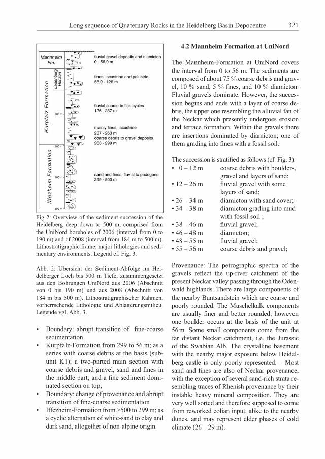
• Boundary: abrupt transition of fi ne-coarse sedimentation
• Kurpfalz-Formation from 299 to 56 m; as a series with coarse debris at the basis (sub-unit K1); a two-parted main section with coarse debris and gravel, sand and fi nes in the middle part; and a fi ne sediment domi-nated section on top;
• Boundary: change of provenance and abrupt transition of fi ne-coarse sedimentation
• Iffezheim-Formation from >500 to 299 m; as a cyclic alternation of white-sand to clay and dark sand, altogether of non-alpine origin.
4.2 Mannheim Formation at UniNord
The Mannheim-Formation at UniNord covers the interval from 0 to 56 m. The sediments are composed of about 75 % coarse debris and grav-el, 10 % sand, 5 % fi nes, and 10 % diamicton. Fluvial gravels dominate. However, the succes-sion begins and ends with a layer of coarse de-bris, the upper one resembling the alluvial fan of the Neckar which presently undergoes erosion and terrace formation. Within the gravels there are insertions dominated by diamicton; one of them grading into fi nes with a fossil soil.
The succession is stratifi ed as follows (cf. Fig. 3):• 0 – 12 m coarse debris with boulders,
gravel and layers of sand;• 12 – 26 m fl uvial gravel with some layers of sand;• 26 – 34 m diamicton with sand cover;• 34 – 38 m diamicton grading into mud
with fossil soil ;• 38 – 46 m fl uvial gravel;• 46 – 48 m diamicton;• 48 – 55 m fl uvial gravel;• 55 – 56 m coarse debris and gravel;
Provenance: The petrographic spectra of the gravels refl ect the up-river catchment of the present Neckar valley passing through the Oden-wald highlands. There are large components of the nearby Buntsandstein which are coarse and poorly rounded. The Muschelkalk components are usually fi ner and better rounded; however, one boulder occurs at the basis of the unit at 56 m. Some small components come from the far distant Neckar catchment, i.e. the Jurassic of the Swabian Alb. The crystalline basement with the nearby major exposure below Heidel-berg castle is only poorly represented. – Most sand and fi nes are also of Neckar provenance, with the exception of several sand-rich strata re-sembling traces of Rhenish provenance by their instable heavy mineral composition. They are very well sorted and therefore supposed to come from reworked eolian input, alike to the nearby dunes, and may represent elder phases of cold climate (26 – 29 m).
Fig 2: Overview of the sediment succession of the Heidelberg deep down to 500 m, comprised from the UniNord boreholes of 2006 (interval from 0 to 190 m) and of 2008 (interval from 184 m to 500 m). Lithostratigraphic frame, major lithologies and sedi-mentary environments. Legend cf. Fig. 3.
Abb. 2: Übersicht der Sediment-Abfolge im Hei-delberger Loch bis 500 m Tiefe, zusammengesetzt aus den Bohrungen UniNord aus 2006 (Abschnitt von 0 bis 190 m) und aus 2008 (Abschnitt von 184 m bis 500 m). Lithostratigraphischer Rahmen, vorherrschende Lithologie und Ablagerungsmilieu. Legende vgl. Abb. 3.
Long sequence of Quaternary Rocks in the Heidelberg Basin Depocentre 321

Fig. 3: The sediment succession of the Mannheim-Formation in the Heidelberg UniNord research borehole (location Fig. 1). Centre: Stratigraphic succession as Lithofacies log (schematic), genetic units; Left: Lithostratigraphic inter-pretation; Right: Sequence stratigraphic trends (increasing and decreasing a/s-ratio).The succession is dominated by coarse debris fl ows and proximal fl uvial gravels, but also includes insertions of matrix-rich diamicton and fi ne sediments. – Further details on the stratigraphic succession, provenance, chronostratigraphic markers and sedimentary environment see text.
Abb. 3: Die Sedimentfolge der Mannheim-Formation aus der Forschungsbohrung Heidelberg UniNord (Lokation Abb. 1):Mitte: Stratigraphische Abfolge als schematisches Lithfazieslog, genetische Einheiten; Links: Lithostratigra-phische Interpretation; Rechts: Sequenzstratigraphische Trends (zu- und abnehmendes a/s-Verhältnis).Die Abfolge wird beherrscht von groben Debris-Flows und proximalen Flussschottern; sie enthält auch Einschaltungen von Matrix-reichen Diamikten und Feinsedimenten. – Weitere Angaben zur Schichtenfolge, Provenienz, chronostratigraphischen Marken und Ablagerungsmilieu im Text.
DIETRICH ELLWANGER ET AL.322

Sedimentation: The depocentre of the HDB cor-responds with the alluvial fan of the Neckar. The genetic units in intervals with coarse debris and fl uvial gravels match well with this proximal setting (Fig. 3). One major interval with diamic-ton, fi nes and pedogenesis, occurs all over the depocentre (HGK 1999). As a result, the Mannheim-Fm shows an overall coarse – fi ne – coarse trend, going along with a fi rst increas-ing then decreasing a/s-ratio. Any further inter-pretation needs a chronostratigraphic frame.
Chronostratigraphy: No chronostratigraphic markers are yet available. As the underlying unit (Ladenburg-Subformation) is supposed to date from the Cromerian, post-Cromerian ages are expected. The fossil soil at 34 m is quite well preserved, dividing the succession into an upper and a lower part. Their interpretation remains open (last and penultimate glaciation, effects of loading and compaction).
Summary and interpretation: The major part of the Mannheim-Formation at the Heidel-berg UniNord borehole is built up by coarse sediments representing the proximal lithofacies of the Neckar alluvial fan. This is an input-controlled system which strongly depends on sediment supply from the nearby Odenwald highlands. As preservation in superposition is discontinuous, due to lateral shifting within the fan, the subsidence of the basin plays only a minor part.
4.3 Kurpfalz Formation at UniNord
The Kurpfalz-Formation at UniNord covers the interval from 299 to 56 m, i.e. its thick-ness amounts to 243 m. It is composed of 35 % debris and gravel, 20 % sand, and 45 % fi nes. There is a continuous background supply and preservation of fi ne sediments (lacustrine, fl uvial overbanks), interrupted by three major intervals with coarse debris and gravel input (fl uvial bedload, mass fl ow). Accordingly it is subdivided into lithostratigraphic subunits. The uppermost subunit (interval 56 to 126 m, Ladenburg-Subformation) is dominated by
fi ne sediments. The subunit from 126 to 237 m (subunit K3) subsumes two pulses of coarse input (intervals 126 – 168 m and 189 to 206 m), but throughout with layers of fi nes and sand. The next subunit from 237 to 263 m is again wholly dominated by fi ne sediments (K2). Some genetic units grade into dark fi nes (organic), others into clay with evidence of pedogenesis and ichnofossils. The lowermost subunit (263 – 299 m, K1) is dominated by massive coarse debris (263 – 288 m) which represents the termination of a coarsening-up trend that begins with red sands below the For-mation boundary at 316 m. The defi nition of the lower boundary of the Kurpfalz-Formation is, as indicated above, not a matter of the local cycle architecture but of provenance. The low-ermost signal of instable „alpine“ heavy miner-als has been identifi ed at 292 m; we suggest the Formation-basis at 299 m.
The sediment succession of the Kurpfalz-For-mation is stratifi ed as follows (Fig. 4):
Ladenburg-Subformation from 56–126 m = 70 m (20 % gravel, 10 % sand, 70 % fi nes)• 56 – 67 m graded sand to fi nes and fossil peat, fl uvial, some sand from eolian input
and fl uvially reworked;• 67 – 74 m massive fi nes, lacustrine;• 74 – 80 m graded sand to fi nes;• 80 – 83 m silt and clay, ichnofossils,
fossil soil, fl uvial environment;• 83 – 89 m massive fi nes, lacustrine;• 89 – 92 m gravely sands, ?diamicton;• 92 – 101 m gravel, some sand from eolian input and fl uvially
reworked, ?diamicton (no or poor cores);• 101 – 103 m fi nes and sand, gravely,
?diamicton (poor cores);• 103 – 109 m coarse debris, gravel, sand,
?diamicton (poor cores); • 109 – 126 m massive fi nes, at the basis
with coarse components, lacustrine;
Long sequence of Quaternary Rocks in the Heidelberg Basin Depocentre 323
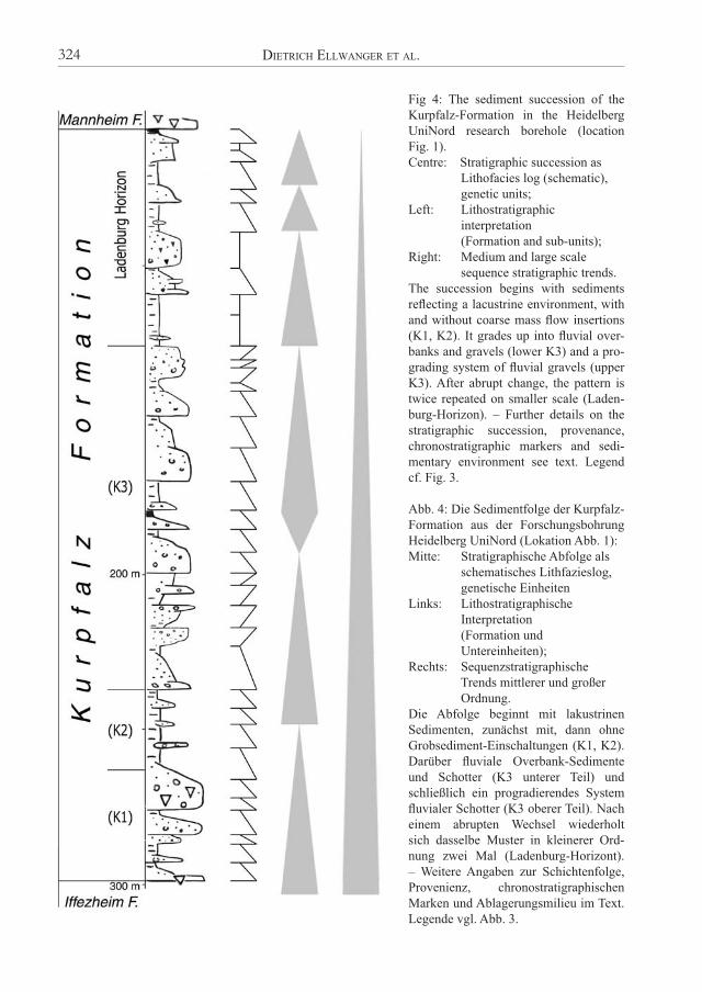
Fig 4: The sediment succession of the Kurpfalz-Formation in the Heidelberg UniNord research borehole (location Fig. 1). Centre: Stratigraphic succession as Lithofacies log (schematic), genetic units;Left: Lithostratigraphic interpretation (Formation and sub-units);Right: Medium and large scale sequence stratigraphic trends.The succession begins with sediments refl ecting a lacustrine environment, with and without coarse mass fl ow insertions (K1, K2). It grades up into fl uvial over-banks and gravels (lower K3) and a pro-grading system of fl uvial gravels (upper K3). After abrupt change, the pattern is twice repeated on smaller scale (Laden-burg-Horizon). – Further details on the stratigraphic succession, provenance, chronostratigraphic markers and sedi-mentary environment see text. Legend cf. Fig. 3.
Abb. 4: Die Sedimentfolge der Kurpfalz-Formation aus der Forschungsbohrung Heidelberg UniNord (Lokation Abb. 1):Mitte: Stratigraphische Abfolge als schematisches Lithfazieslog, genetische EinheitenLinks: Lithostratigraphische Interpretation (Formation und Untereinheiten);Rechts: Sequenzstratigraphische Trends mittlerer und großer Ordnung.Die Abfolge beginnt mit lakustrinen Sedimenten, zunächst mit, dann ohne Grobsediment-Einschaltungen (K1, K2). Darüber fl uviale Overbank-Sedimente und Schotter (K3 unterer Teil) und schließlich ein progradierendes System fl uvialer Schotter (K3 oberer Teil). Nach einem abrupten Wechsel wiederholt sich dasselbe Muster in kleinerer Ord-nung zwei Mal (Ladenburg-Horizont). – Weitere Angaben zur Schichtenfolge, Provenienz, chronostratigraphischen Marken und Ablagerungsmilieu im Text. Legende vgl. Abb. 3.
DIETRICH ELLWANGER ET AL.324
Section (K3) from 126 – 237 m = 111 m(35 % gravel, 30 % sand, 35 % fi nes)• 126 – 138 m sand, gravel, debris (no or
poor cores recovered);• 138 – 152 m sand and gravel with some
fi nes (no or poor cores recovered);• 152 – 168 m sand and gravel (no or poor
cores recovered), basis of subunit K3b;
• 168 – 179 m massive fi nes upon insertion of sandy gravel;
• 179 – 185 m cycle of gravel-sand-fi nes-peat;• 185 – 206 m basal debris, gravel, red sand and fi nes, K3a;• 206 – 211 m gravely sand and fi nes;• 211 – 215 m sand;• 215 – 217 m fi nes, fossil soil;• 217 – 222 m gravel, debris;• 222 – 227 m fi nes, fossil soil;• 227 – 234 m grey and red sand;• 234 – 237 m coarse debris grading into dark fi nes (organic);
Section (K2) from 237 – 263 m = 26 m(10 % gravel, 15 % sand, 75 % fi nes)• 237 – 263 m fi nes, sandy to muddy, with
few insertions of sand (254 – 257), gravel (247 – 248) and debris (258 – 259), fossil soils;
Section (K1) from 263 – 299 m = 36 m(60 % gravel and debris, 10 % sand, 30 % fi nes) • 263 – 287 m debris of coarse gravels and
some boulders, few layers of sand and fi nes;
• 287 – 297 m fi nes, silt and clay with ichnofossils, sand layers;• 297 – 299 m debris of coarse gravels and some boulders.
Provenance: The sediment input in the Kur-pfalz-Formation of the UniNord succession is classifi ed in sediments of Rhine origin (i.e. comprising a signal of the alpine source area),
of Neckar origin, and of very local origin. They may be subdivided in: (a) fi nes and sand of the Rhine (proven by in-
stable heavy mineral ratio > 50 %); (b) local or Neckar fi nes and sand (instable
heavy mineral ratio < 50 %);(c) gravel of the Neckar (pebbles of Buntsand-
stein, Muschelkalk and Jurassic); and (d) coarse debris and gravel of the nearby
Odenwald (mainly Buntsandstein, some crystalline and Muschelkalk).
The sediments of the Ladenburg-Subforma-tion belong primarily to the „fi nes and sands of Neckar or local origin“. There are exceptions at the top of two lacustrine intervals, where minor sand pulses of Rhine origin are identifi ed by their instable heavy mineral content. Presently we interpret this to be fl uvially reworked eolian input. – The Ladenburg-deposits of UniNord are contemporaneous with similar deposits all over the HDB which are usually of Rhine origin. They also correlate with the upstream buried valley infi ll at the discovery site of the Homo
heidelbergensis located near to the village of Mauer, some 15 km southeast of UniNord (LÖSCHER 1996). From this it follows that the sediment of this subunit covered the whole HDB, and extended beyond the Eastern Bound-ary Fault (EBF) of the URG. I.e. the nearby Neckar valley within the Odenwald highlands is also, as a drowned valley, part of the basin. The subunits K1 and the lower part of K3 show strong evidence of periodical fl uvial input from the alpine Rhine, with continuous input from the Neckar upheld. In K1, the arrival of the Rhine and the preservation of fi nes even when alternating with coarse local sediments indicate a strongly increasing a/s-ratio. In K2, only sand on fi nes of non-Rhine origin are yet identifi ed. The K3 succession begins with an alternation of local and Rhine input. Then the local input is gradually replaced by supply from the Neckar, and still further up the input from the Rhine ter-minates. From 190 m upwards only sediments of Neckar provenance are left. The three intervals of coarse debris and gravel (subunits K1 and K3) refer to expanding ero-sion into the Odenwald, probably due to uplift.
Long sequence of Quaternary Rocks in the Heidelberg Basin Depocentre 325
There is always an overall dominance of coarse Buntsandstein, but the ratio of the supplemen-tary components varies (Muschelkalk, crystal-line). The fi rst coarse pulse (299 – 297 m, basis of K1) contains much local crystalline (Heidel-berg Granite). The main pulse (287 – 263 m) is mainly Buntsandstein, but with an upward increasing ratio of Muschelkalk; i.e. the sedi-ment source is fi rst „downtown Heidelberg“, then expanding towards the Muschelkalk scarp. – Two coarse intervals of fl uvial gravels follow (206 – 189 m and 168 – 126 m, subunit K3). Within the latter a fi rst small then increasing ratio of Jurassic is present, and there are some layers where the Muschelkalk components dominate. This is also characteristic regarding some correlative gravely insertions in the suc-cession of the Viernheim sister drilling (inter-val 180 to 80 m, HOSELMANN 2008).
Sedimentation: The overall fl uvial evolution of the UniNord succession is interrupted in the Kurpfalz-Formation by intervals of lacustrine conditions and by intervals of strong supply of mass fl ows. Our interpretation as a lacustrine environment is based upon the abrupt occur-ance of coarse-grained debris fl ows within the fi ne-grained background sedimentation. In some parts of the succession, even matrix sup-ported mass fl ow deposits including boulders and cobbles occur (high density mass fl ows). The abrupt alternation of mass fl ow- and back-ground-sedimentation is a clear indication for lacustrine deposition in a lake system with a minimal water depth of several meters. The fi rst lacustrine interval is at the basis of the Formation where mass fl ow deposits of coarse debris are embedded in fi nes, with almost no transition (subunit K1). It carries on in subunit K2 with few coarse layers in the fi nes. Eventu-ally the lacustrine sedimentation terminates, fi rst indicated by fossil soils in the fi nes (transi-tion of subunits K2 to K3), then by cycles of fl uvial gravels to fi nes (subunit K3). The lower gravel seems to represent a local event; the up-per refl ects a long and overall coarsening-up series of a prograding fl uvial system. – The transition to follow, from fl uvial gravels to
the fi nes of the Ladenburg-Subformation, is again very abrupt. The fi nes are massive; again with insertions of mass fl ow deposits (here the components are well rounded i.e. reworked from the gravels). This again represents a la-custrine environment. Towards the top of these fi nes, the environment migrates back towards fl uvial, fi rst visible in traces of plant roots and ichnofossils, still within the fi nes, then by re-establishing the prograding fl uvial system (lacustrine-to-fl uvial cycle from 126 to 89 m = 37 m). In the upper part of the Ladenburg-Subformation, two more lacustrine to fl uvial transitions are identifi ed (89 – 74 m = 15 m; and 74 – 56 m = 18 m). They range from mas-sive fi nes up to graded sands, i.e. they comprise no gravely sediments. Further up, the lacustrine to fl uvial cyclicity is drowned by the input of the Mannheim-Formation. The Kurpfalz-Formation shows an overall de-creasing a/s-ratio throughout the succession, with various symmetrical and asymmetrical cycles of lower order (Fig. 4). The maximum accommodation space is given in the fi rst la-custrine cycle (K1, K2), which hosts not only coarse local debris but also alpine sands of the Rhine. The alpine infl uence is then pushed back by prograding coarse-grained fl uvial Neckar deposits (K3).
Chronostratigraphy: Some biostratigraphic markers based on pollen analysis are already available. They are preliminarily interpreted. � At 57 – 70 m and at 82 – 85 m, „coniferous
forest“: Interpretation: cool to cold „inter-stadial“ climate.
� At 81 – 82 m and at 87 m, „typical middle Pleistocene pollen spectra“ but no Fagus and no early Pleistocene species. Interpre-tation: Cromerian.
� At 162 – 163 m, pollen spectra with Pinus, Picea and Tsuga, no Carya, no Eucommia. Interpretation: Bavelian (per se uncertain, but in the succession quite likely).
� At 180 – 208 m, pollen spectra with Tsuga and Pterocarya. Interpretation: Waalian (certain, HAHNE, ELLWANGER & STRITZKE 2008).
DIETRICH ELLWANGER ET AL.326

� At 212 – 249 m „coniferous forest“: Inter-pretation: rather cold climate, may match with the Eburon cold period.
The Cromerian age of the Ladenburg-Sub-formation was fi rst published by ENGESSER & MÜNZING (1991); also the „Maurer Sande“ are of Cromerian age (LÖSCHER 1996).
Summary and interpretation of the Kurpfalz-Formation: The succession of the Kurpfalz-For-mation at UniNord, within its upper „sequence“-boundary and its lower „provenance“-boundary, comprises one overall large scale cycle, from a basal lacustrine environment up to a large and input controlled subunit of prograding fl uvial gravels. The fi nes to follow are, although in parts lacustrine and related to a fi nal pulse of subsid-ence, only of local importance. We suggest this has to do with the pattern of Rhine sediments through time in the HDB. This is confi rmed by the sister boreholes of the Heidelberg project at Ludwigshafen and Viernheim, where, as it seems, the Rhine signal comes, in each case, at a different chronostratigraphic level. • In Heidelberg, the overall depocentre of
the HDB, the Rhine signal begins at 299 m (Eburonian) and ends at 190 m (Waalian);
• In Ludwigshafen at the western margin of the HDB, the Rhine signal begins at 177 m close to the Pliocene-Pleistocene transition (WEIDENFELLER & KÄRCHER 2008 and WEI-DENFELLER & KNIPPING 2008), then comes to a standstill (increase of local sediments with only stable heavy minerals) at 137 – 127 m and 109 – 97 m (Waalian);
• In Viernheim at the geographic centre of the HDB, the Rhine signal begins at 220 m (HOSELMANN 2008, KNIPPING 2002, 2008). As discussed above we suggest correlating a subunit of prograding gravels from Hei-delberg (Bavelian) with the 80 – 180 m in-terval at Viernheim. This leaves 40 m with little evidence of any greater hiatus. From all this we suggest the provenance change to happen in the Waalian.
The above may be interpreted as „alpine“ Rhine sediments migrating in three steps through what later became the HDB: This story
begins in Ludwigshafen close to the Pliocene-Pleistocene transition; then it continues in Hei-delberg in the Eburonian; and fi nally comes to Viernheim in the Waalian. The subunit of prograding gravels (K3, Bave-lian) appears to be the fi rst unit covering the HDB in its present extent as a whole, as do the above units of the Ladenburg-Subforma-tion and the Mannheim-Formation. Below the gravels (K3) there is a patchwork of local units which are diffi cult to correlate. Here the units including alpine Rhine sediments may be of small extend. Their west-to-east migra-tion (from Ludwigshafen to Heidelberg) seems to be subsidence-controlled, as a result of the Halfgraben architecture. Their return back west to Viernheim is related to Neckar input. The upper units covering the entire HDB are related to input pulses of Rhine and Neckar which in-clude potentially increased sediment volumes during the Pleistocene glaciations. All sediments below the „alpine“ Rhine, re-gardless of their chronostratigraphic position, are not part of the Kurpfalz-Formation. They belong, to the Iffezheim-Formation.
4.4. Iffezheim Formation at UniNord
The Iffezheim-Formation at UniNord covers the interval from >500 to 299 m, i.e. >202 m. It is a cyclic alternation of fl uvial deposits with an average composition of 55 % sand, and 45 % fi nes. The succession is subdivided in several lithostratigraphic subunits, according to litho-facies variations. They are dominated by sand at 316 to 382 m (I5); by fi ne sediments at 382 to 411 m (I4); again by sand at 411 to 452 m (I3); fi ne sediments at 452 to 467 (I2); and fi nally by sand at 467 to >500 m (I1). The uppermost subunit at 299 to 316 m (I6) resembles the tran-sition to the lacustrine environment and to the onset of coarse local debris of subunit (K1). The main fl uvial lithofacies are:• Grey, coarse to medium-grained sands.
They contain only few gravely compo-nents, the small pebbles being well rounded and often with weathering halos. Quite fre-quently there are other coarse components,
Long sequence of Quaternary Rocks in the Heidelberg Basin Depocentre 327
as pieces of wood of various size (in the cores with diameters up to 25 cm), but also reworked pieces of fi ne sediment, rang-ing from small rounded pieces up to large strata. Their original stratifi cation may be preserved, including organic-rich laminae or even peat. They were probably in a fro-zen state during transport.
• White, fi ne to medium-grained sands, usu-ally very well sorted. They either alternate with the grey sand lithofacies, or grade into green silt with sandy laminations, and fi -nally into the silt and clay cycles.
• Clay-rich overbank fi nes, forming sequences of green and sandy silt grading into clay-rich silt up to almost pure clay, usually speckled with brownish (wet) and reddish (dry) colours resembling pedogenesis. Colours are intense, apart from the transition to the Kurpfalz-For-mation where they become dark and gloomy. The sequences are rich in ichnofossils, in some layers also in authigenic grains (authi-genic siderite, Dr. Martin, Freiburg). Some are fractured due to diagenetic compaction.
The sediment succession of the Iffezheim-For-mation is stratifi ed as follows (cf. Fig. 5):
Section (I6) from 299 to 316 m = 17 m(55 % sand and 45 % fi nes)• 299 – 305 m dark fi nes, sandy silt to clay;• 305 – 316 m massive dark grey sand and
graded dark red sand;
Section (I5) from 316 – 382 m = 66 m(65 % sand and 35 % fi nes)• 316 – 323 m fi nes (sandy silt to clay with
organic-rich top);• 323 – 329 m brightly coloured fi nes (sandy silt to clay);• 329 – 340 m alternation of • grey sand with reworked
wood and fi nes, and of • white sand with kaolin; • 340 – 342 m brightly coloured silt and
clay, ichnofossils;• 342 – 351 m grey sand with reworked
wood and fi nes;
• 351 – 382 m grey sand with reworked wood and fi nes;
Section (I4) from 382 – 411 m = 29 m(10 % sand and 90 % fi nes)• 382 – 399 m fi nes, green silt to coloured
clay with ichnofossils and brown and red fossil soils;• 399 – 402 m white sand and grey silt; • 402 – 411 m brightly coloured fi nes,
green silt to coloured clay with ichnofossils and brown and red fossil soils;
Section (I3) from 411 – 451 m = 40 m(70 % sand and 30 % fi nes)• 411 – 421 m grey sand with reworked
wood and fi nes, grading into white sand;• 421 – 425 m white sand grading into silt
and clay with ichnofossils;• 425 – 440 m alternation of • grey sand with reworked
wood and fi nes, and of • white sand with kaolin
matrix;• 440 – 443 m brightly coloured silt and
clay with ichnofossils;• 443 – 451 m alternation of • grey sand with reworked
wood and fi nes, and of • white sand with kaolin
matrix (445 – 447); • fi nes, laminated with
white sand (443 – 445);
Section (I2) from 451 – 467 m = 16 m(almost 100 % fi nes)• 451 – 467 m brightly coloured fi nes,
green silt to coloured clay with ichnofossils and brown and red fossil soils;
Section (I1) from 467 – 500 m = 33 m(80 % sand and 20 % fi nes)• 467 – >500 m grey sand with reworked wood and fi nes;
DIETRICH ELLWANGER ET AL.328

Fig. 5: The sediment succession of the Iffezheim-Formation in the Heidelberg UniNord research bore-hole (location Fig. 1). Centre: Stratigraphic succession as Lithofacies log (schematic), genetic units;Left: Lithostratigraphic interpretation (Formation and sub-units);Right: Sequence stratigraphic trends (increasing and decreasing a/s-ratio).The succession (I1 - I5) is composed of alternating fl uvial bedload sands and overbank silt and clay. The sands contain large pieces of reworked overbank fi nes, the silt and clays are frequently altered by ich-nofossils and pedogenesis. The uppermost unit (I6) includes proximal local sand insertions refl ecting the beginning of local mass fl ow as in unit K1. – Further details on the stratigraphic succession, provenance, chronostratigraphic markers and sedimentary envi-ronment see text. Legend cf. Fig. 3.
Abb. 5: Die Sedimentfolge der Iffezheim-Formation aus der Forschungsbohrung Heidelberg UniNord (Lokation Abb. 1):Mitte: Stratigraphische Abfolge als schematisches Lithfazieslog, genetische EinheitenLinks: Lithostratigraphische Interpretation (Formation und Untereinheiten);Rechts: Sequenzstratigraphische Trends (zu- und abnehmendes a/s-Verhältnis).Die Abfolge (I1 - I5) besteht aus fl uvialen Sanden (bedload) und schluffi g-tonigen Overbank-Schich-ten. In den Sanden sind große Feinsedimentstücke aufgearbeitet, während die Overbanks durch Spuren-fossilien und Bodenbildung verändert sind. In der obersten Einheit (I6) sind proximale Lokalsande eingeschaltet, die zu den Massfl ows der darüber folgenden Einheit K1 überleiten. – Weitere Angaben zur Schichtenfolge, Provenienz, chronostratigra-phischen Marken und Ablagerungsmilieu im Text. Legende vgl. Abb. 3.
Long sequence of Quaternary Rocks in the Heidelberg Basin Depocentre 329
Provenance: The „local“ i.e. non-alpine origin of the sediments determines their allocation to the Iffezheim-Formation. This is primarily based on heavy mineral analysis. Many of the few coarser components are of Buntsandstein origin, as are several layers of red sands. – The provenance of the other sediments remains uncertain. The well sorted white sands are probably far transported, but this may be an inherited feature if they are reworked from nearby Neogene sands. The grey sands are related to various sources, including crystalline and Buntsandstein (Odenwald? Black Forest?). They seem confi ned to a fl uvial system close to the eastern margin of the URG. The source of the silt and clay is again undetermined, prob-ably nearby Neogene.
Sedimentation: By alternation of the grey sand lithofacies and the silt-to-clay lithofacies, sev-eral genetic units are stacked to symmetrical cycles of increasing and decreasing a/s-ratios. Within the fi nes, the turning points often co-incide with intensive pedogenesis i.e. almost no input; within the sands they coincide with sections where large pieces of reworked fi nes indicate a/s minima. These bedload-dominated units represent the greater part of the succes-sion. The preserved cycles are in the 10 to 50 m order. – The minima of accommodation space are likely to be related with increasing sediment supply, maybe due increased sediment volumes as a result of colder climate (some of the re-worked fi nes are still stratifi ed, they may have been frozen when redeposited). As opposed to this the sediment input is generally much reduced in silt-clay sections, with ichnofos-sils and traces of more or less reworked fossil soils. Preservation is primarily related to local subsidence of the depocentre, but differentiated uplift within and at the northern margin of the URG may also be involved.
Chronostratigraphy: Some biostratigraphic markers based on pollen analysis are already available. They are preliminarily interpreted. � At 312 m, „open coniferous forest with
herbs“. Interpretation: cool to cold climate
(per se indifferent, but in the succession most likely Eburonian).
� At 316 m, „Pinus-dominated coniferous forest“. Interpretation: cool to cold climate, could match with the Eburon cold period.
� At 358 – 359 m, reworked strata. They host a pollen spectrum with > 30 % „tertiary taxa“ immediately overlying a typical „early Pleistocene pollen spectra“ with Fagus but no Tsuga. Interpretation: reworked Reuverian (Reuverian A) over-lying reworked late Tiglian. Deposition age: late Tiglian to early Eburon.
� At 417 – 500 m (lowest sample at 499.94 m): several typical „early Pleistocene pol-len spectra“ with Fagus and tertiary taxa
increasing downward, no Tsuga. Interpre-tation: Tiglian (certain) in stratigraphic superposition.
� At 481 m: „Pinus-dominated coniferous forest“. Interpretation: cooler climatic pe-riod within the Tiglian (possibly Tiglian B, sensu ZAGWIJN 1963).
� There are no hints for in-situ sediments from the Pretiglian or Reuverian period. The reworked sample at 358 m illustrates the pollen spectra to be expected from in-situ Reuverian.
Summary and interpretation of the cored part of the Iffezheim-Formation: According to the defi -nition outlined above, the succession is not in-fl uenced by instable heavy minerals of the alpine Rhine. The above pollen markers show that the succession terminates well above the base of the Quaternary, i.e. in a time slice when the course of the alpine Rhine was already bound within the URG (in the western HDB proved by WEI-DENFELLER & KNIPPING 2008). At the same time, maximum sedimentation rates occur on the east-ern side at Heidelberg UniNord. All this requires a two-partition of the HDB, with a western basin hosting the alpine Rhine, and an eastern basin with maximum sedimentation rates. The transition between the basins is suggested to be represented by the Viernheim drilling where the Rhine sediments arrived latest.
DIETRICH ELLWANGER ET AL.330

4.5 Below 500 m
As the cored UniNord boreholes end at 500 m still within the Tiglian, the lower part of the Tiglian, the Pretiglian, and the transition into the uppermost Neogene unit i.e. the Reuverian remain uncored. In order to estimate compac-tion and tectonic subsidence rates, serving as accomodation space of the cored units, some basic informations on the deeper subsurface are introduced here. They rely on three avail-able data sets: (a) the sediment log of the „Ra-dium Sol“ borehole in downtown Heidelberg, approx. 1 km south of the UniNord location; (b) the „vertical seismic profi ling“ (VSP) log which was recorded by the Leibniz Institute for Applied Geophysics in the UniNord 1 borehole; and (c) the sediment log of the geothermal fl ush borehole from Weinheim, approx. 14 km north of UniNord.(a) The Radium Sol drilling was fi nished in the
early 1920ies (SALOMON 1927, BARTZ 1951, FEZER 1998). Its overall cyclicality follows a coarse-fi ne-coarse pattern, with
• 0 ~ 350 m coarse and fi ne grained sediments; • 350 ~ 700 m only fi ne grained
sediments; • 700 ~ 1000 m coarse and fi ne grained sediments.(b) The VSP log was recorded as part of the
geophysical downhole logging program (data recorded down to 181 m, velocity information to 160 m). It is plotted as cor-ridor stack down to 1000 m (BUNESS, pers. comm.). We do not interpret individual re-fl ections but evaluate their frequency. There are many strong refl ections in the upper part and again several though weaker refl ections in the lower part, but almost none in a middle interval from 350 down to 700 m. This is unlikely in a succession of alternat-ing coarse and fi ne sediments. We conclude fi ne sediment dominance down to 770 m.
(c) Also at Weinheim where two boreholes were fl ushed down to ~ 1000 m, a long in-terval of fi ne sediment domination has been detected down to 700 m.
We conclude that, at UniNord, the high ratio of fi ne sediment will continue or even increase in the interval 500 to 700 m, estimated 50 % of fi nes or more. It will then again decrease in the 700 to 1000 m interval where coarse and fi ne sediments alternate. Assuming constant sedimentation rates as derived below, the tran-sition from the Neogene Reuverian unit to the Pleistocene Pre-Tiglian stage is now predicted close to or below 600 m.
5 The Heidelberg Boreholes – Synopsis,
Conclusions, Outlook
5.1 Sedimentation rates, Accommodation
Space and Subsidence
The patterns of Lithostratigraphy and Chro-nostratigraphy are compared in Table 1. Ba-sically the lithostratigraphic boundaries are controlled by tectonics whereas Chronostrati-graphy refers to climate. They are identical where the lithostratigraphy is based on the local lithofacies patterns, i.e. the boundaries of the Ladenburg-Sfm and the Mannheim-Fm. Table 1 also includes „absolute“ ages (STD 2002, OGG, OGG & GRADSTEIN 2008). They serve as a geochronologic frame to estimate average sedimentation rates for the units (Tab. 2, Fig. 6). They are, as yet, uncorrected, but may be used to calculate the non-tectonic i.e. compaction part of the subsidence.
5.2 Input and uplift
The local aspect: The relatively rapid increase of sediment thickness during Eburonian time is associated with coarse, clastic deposits. Clastic fragments are derived from Triassic sedimen-tary rocks and the Heidelberg granite and as-sociated crystalline rocks of the Variscan base-ment. This sediment composition is interpreted to refl ect the synchronous uplift of the adjacent rift shoulder and the initiation or reactivation of faults in the Heidelberg town area, which trend both subparallel with and at a high angle to the major, eastern rift bounding fault. Activities at these faults led to the exposition of the crystal-
Long sequence of Quaternary Rocks in the Heidelberg Basin Depocentre 331

Lithostratigraphy Chronostratigraphy
Formation Sub-formation Interval
thickness
original Interval
thickness
Pollen
Neckar fan 12 m
fluvial gravel
Diamicton and
fines,
fossil soil
Mannheim-Fm
0 – 56 m
fluvial gravel,
diamicton
44 m 56 m
Holocene;
Würm/Weichsel;
Riss/Saale;
Hoßkirch/Elster
Ladenburg-
Sfm (mass
flow, fluvial,
lacustrine)
70 m 70 m Cromerian
44 m Pinus, Picea
Tsuga
Bavelian
126 – 170 m
40 m Tsuga,
Pterocarya
Waalian
170 – 210 m
(K3) two
fluvial pulses
126 – 237 m
111 m
Coniferous forest
210 – 250 m
(K2) lacustrine
237 – 263 m 26 m
Kurpfalz-Fm
56 – 299 m
(K1) mass
flow, fluvial,
lacustrine,
263 – 299 m
36 m No pollen
(I6) lacustrine
fines and Sand
299 – 316 m
17 m Open forest at 312
m
130 m
Coniferous forest
at 316 m
Eburonian
210 – 340 m
(I5) fluvial
sand
316 – 382 m
66 m
(I4) fluvial
overbank
382 – 411 m
29 m
(I3) fluvial
sand
411 – 451 m
40 m
(I2) fluvial
overbank
451 – 467 m
16 m
Iffezheim-Fm
299 – 500 m
(I1) fluvial
sand
467 – 500 m
33 m
160 m early Pleistocene
pollen spectra
with Fagus and
Tertiary taxa
increasing
downward
sand and fines ? estimated
20 m
Tiglian
340 – >500 m
sand and fines ? estimated
80 m Praetiglian
Not drilled:
Iffezheim-Fm 500 > 700 m
mainly fines ? estimated> 100 m
Reuverian
Table 1: Lithostratigraphy and Chronostratigraphy of the sediment succession of the borehole Heidelberg UniNord. The lithostratigraphic boundaries are controlled by tectonics (cf. Tab. 2); the chronostratigraphic stages refer to the alpine and north European glaciations and to the pollen-based biostratigraphy of NW-Eu-rope. Sediment thicknesses are uncorrected.
Tab. 1: Lithostratigraphie und Chronostratigraphie der Sedimentfolge aus der Bohrung Heidelberg UniNord. Die lithostratigraphischen Grenzen sind tektonisch gesteuert (vgl. Tab. 2); die chronostratigraphischen Stufen beziehen sich auf die alpinen und nordeuropäischen Vergletscherungen und auf die pollenanalytisch begründete Biostratigraphie NW-Europas. Sedimentmächtigkeiten sind nicht korrigiert.
DIETRICH ELLWANGER ET AL.332

line rocks, fragments of which are now found in the basin sequence. The subsequent period is characterized by thin sediments and may be related to a peneplanation observed at the rift shoulder. The ultimate stage, represented by the Mannheim Formation, with a more rapid increase in sediment thickness is lasting until the present and associated with renewed uplift of the rift shoulders. This uplift is accompanied by a dissection of the peneplain surface, caused by the reactivation of pre-existing faults.The regional aspect: The fi rst onset of alpine sedimentation in the HDB, as identifi ed in the Ludwigshafen succession (WEIDENFELLER & KNIPPING 2008) reflects the redirection of the al-
pine Rhine into the URG, prior to the Pliocene-Pleistocene transition at ~ 2.6 Ma (e.g. HOSEL-MANN 2008). The redirection happens in the Mulhouse area where the fi rst signal of alpine heavy minerals in the URG fi ll goes along with an abrupt coarsening of the lithofacies of alpine and local sediment. This composition has been interpreted as to refl ect the starting uplift of parts of the southern Black Forest (ELLWANGER 2003), probably related to the latest folding in front of the Jura mountains (GIAMBONI et al. 2004). Two subsequent uplift markers are identifi ed in the UniNord succession. They are related to the coarse input at the basal Kurpfalz-Formation (Eburonian, ~ 1.7 Ma) and to the coarse input
Long sequence of Quaternary Rocks in the Heidelberg Basin Depocentre 333
Sedimentation rates
(uncorrected) Chrono-
stratigraphy
Sediment
Thickness
Amount of fine
sedimentsDuration
Meter/ka mm/a
Suggested
major control of
Subsidence
Würm, Riss,
Hosskirch56 m < 5 m 450 ka 56 / 450 0.1 Non-tectonic
Cromerian 70 m 40 m 350 ka 70 / 350 0.2 Tectonic
Bavelian 44 m 5 m 600 ka 44 / 600 < 0.1 Non-tectonic
Waalian 40 m 15 m 200 ka 40 / 200 0.2 non-tectonic
Eburonian 130 m 70 m 200 ka 130 / 200 0.7 Tectonic
Tiglian160 m
(180 m) 60 m 600 ka 180 / 600 0.3 non-tectonic
Table 2: Average sedimentation rates of the chronostratigraphic units, according to uncorrected thickness and age data of Table 1. Cf. Fig. 6. Control of the subsidence: We suggest tectonic control only if the sedimentary environment relies on tectonic subsidence. This is, presently, only the case in the lacustrine intervals covering small areas in the Heidelberg deep (Eburonian, Cromerian). In all other cases we suggest that considerable parts of the accomodation space come up from compaction of underlying fi ne sediments. This will be considered in future studies, including correction of the sedimentation rates. - The discussion of the potential tectonic control of the input remains unaffected.
Tab. 2: Durchschnittliche Sedimentationsraten für die chronostratigraphischen Einheiten, unter Verwendung der unkorrigierten Sedimentmächtigkeiten und Altersdaten aus Tab. 1. Vgl. Abb. 6. Steuerung der Subsidenz: Wir diskutieren eine tektonische Steuerung nur dann, wenn das Ablagerungsmilieu nicht anders hergeleitet werden kann. Das ist bisher nur in den lakustrinen Abschnitten der Fall, die nur klein-räumlich im Heidelberger Loch nachgewiesen sind (Eburon, Cromer). Ansonsten gehen wir derzeit davon aus, dass ein erheblicher Teil des Akkomodationsraums auch durch Kompaktion der Feinsedimente aus dem Liegenden herzuleiten ist. Bei der weiteren Bearbeitung sind die Sedimentationsraten entsprechend nach oben zu korrigieren. - Die potentielle tektonische Steuerung des Inputs bleibt unberührt.
at the basal Mannheim-Formation (post-Cro-merian, ~ 0.5 Ma). Both refl ect uplift periods of the Odenwald. The post-Cromerian uplift is contemporaneous with the main uplift of the Rhenish Massif (cf. various studies of the lower main terrace e.g. HOSELMANN 1994).All this leads to a scenario of Quaternary uplift = input events in cycles of ~1 Ma, proceeding from south to north: � ~0.5 Ma Rhenish Massif plus Odenwald (?plus Black Forest);� ~1.7 Ma Odenwald (?plus Black Forest); � ~2.6 Ma southern Black Forest.Each uplift event potentially provides sediment supply which will more easily be activated if
the mechanical erosion is facilitated by climate changes (e.g. VANDENBERGHE 1993, 1995, BUSS-CHERS 2007). In case of the middle input event the Tiglian to Eburonian transition is proved to occur well below the coarse input is recorded. This supports the above scenario. The other events lack of chronostratigraphic data.
5.3 Outlook
The descriptions, basic data and correlative patterns presented here are all focused upon the specifi c situation of the Heidelberg deep i.e. the cores of the borehole of the UniNord location in Heidelberg. In the interpretative steps to fol-low, the controlling parameters of sedimenta-tion will have to be more thoroughly identifi ed,
DIETRICH ELLWANGER ET AL.334
Fig. 6: Net accumulation of the sedimentary sequence through time of the Heidelberg UniNord borehole, using thickness and age data of Table 2.
Abb. 6: Sedimentmächtigkeiten der Bohrung Heidelberg UniNord gegen stratigraphische Zeitskala, unter Verwendung unkorrigierter Mächtigkeiten und Alter aus Tab. 2.
e.g. are increasing a/s-ratios due to tectonic subsidence or to compaction within the basin, or due to uplift around the basin. This can only be accomplished if the entire HDB is regarded. Additional boreholes (e.g. HAIMBERGER, HOPPE & SCHÄFER 2005, WIRSING et al. 2007, HOSEL-MANN 2008, HUNZE & WONIK 2008, SIMON 2008, WEIDENFELLER & KNIPPING 2008) as well as seismic and logging data (BUNESS, GABRIEL & ELLWANGER 2008) will have to be included
Acknowledgement
The Heidelberg drilling project was greatly supported from many people and institutions. In fi rst place the actual and former heads of the involved institutions, Prof. Dr. U. Yaramanci, Prof. Dr. H.-J. Kümpel, Prof. Dr. R. Watzel, Ltd. Bergdirektor V. Dennert and Prof. Dr. B. Stribrny. Dr. E. Würzner, Lord Major of the city of Heidelberg, arranged contacts, whenever necessary. The involved members of staff of the Stadtverwaltung Heidelberg, the Universitäts-bauamt Heidelberg and the Amt für Vermögen und Bau Baden-Württemberg, Mannheim gave logistic support, provided the pieces of land for the Heidelberg boreholes and friendly helped whenever they could. All this support is grate-fully acknowledged. Scientifi c discussions with colleagues helped signifi cantly to become more familiar with several topics related to this pro-ject. Thanks to Dr. H. Buness, Dr. W. Engesser, Prof. Dr. M. Frechen, Dr. F. Fromm, Dr. C. Hoselmann, Dr. M. Martin, H. Meyer, Dr. Ch. Rolf, R. Thienel, Dr. M. Weidenfeller, Dr. T. Wonik and K. Worm. We very much thank Prof. Dr. Fiebig and an anonymous colleague for their reviews and additional valuable comments.
References
BARTZ, J. (1951): Revision des Bohr-Profils der Hei-delberger Radium-Sol-Therme. – Jahresberichte und Mitteilungen des Oberrheinischen Geolo-gischen Vereins, 33: 101-125.
BARTZ, J. (1974): Die Mächtigkeit des Quartärs im Oberrheingraben. – In: ILLIES, J.H. & FUCHS, K. (eds.): Approaches to Taphrogenesis: 78 – 87.
BARTZ, J. (1982): Quartär und Jungtertiär II im Ober-rheingraben im Großraum Karlsruhe. – Geolo-gisches Jahrbuch, A 63: 2-237.
BLUDAU, W. (1998): Altpleistozäne Warmzeiten im Alpenvorland und im Oberrdheingraben - Ein Beitrag der Palynologie zum „Uhlenberg-Prob-lem“. – Geologica Bavarica, 99: 119-133.
BOENIGK, W. (1970): Zur Kenntnis des Altquartärs bei Brüggen. – Sonderveröffentlichungen Ge-ologisches Institut Universität Köln, 17: 141 p.
BOENIGK, W. (1987): Petrographische Untersuchun-gen jungtertiärer und quartärer Sedimente am linken Oberrhein. – Jahresberichte und Mit-teilungen des Oberrheinischen Geologischen Vereins, N.F., 69: 357-394.
BOENIGK, W. & FRECHEN, M. (2006): The Pliocene and Quaternary Fluvial Archives of the Rhine System. – Quaternary Science Reviews, 25: 550-574.
BROST, E. & ELLWANGER, D. (1991), mit Beiträgen von W. Bludau & C. Rolf: Einige Ergebnisse neuerer geoelektrischer und stratigraphischer Untersuchungen im Gebiet zwischen Kaiserstuhl und Kehl. – Geologisches Jahrbuch, E 48: 71-81.
BUNESS, H., GABRIEL, G. & ELLWANGER, D. (2008): The Heidelberg Basin drilling project: Geophysi-cal pre-site surveys. – Quaternary Science Journal (Eiszeitalter und Gegenwart), 57/3-4: 338-366.
BUSSCHERS, F. (2007): Unravelling the Rhine; re-sponse of a fl uvial system to climate change, sea-level oscillation and glaciation. – PhD thesis Vrije Universiteit Amsterdam. Geology of the Netherlands 1: 1-183.
CROSS, T.A., BAKER, M.R., CHAPIN, M.A., CLARK, M.S., GARDNER, M.H., HANSON, M.S., LESS-ENGER, M.A., LITTLE, L.D., MCDONOUGH, K.J., SONNEFELD, M.D., VALASEK, D.W., WILLIAMS, M.R. & WRITTER, D.N. (1993): Application of high-resolution sequence stratigraphy to reser-voir analysis. – In: ESCHARD, R. & DOLIGEZ, B. (eds.): Subsurface Reservoir Characterization from Outcrop Observations. – Technip: 11-33.
CROSS, T.A. & LESSENGER, M.A. (1998): Sediment Volume Partitioning: Rationale for Strati-graphic Model Evaluation and High-Resolution Stratigraphic Correlation. – In: SANDVIK, K.O., GRADSTEIN, F. & MILTON, N. (eds.): Predictive high resolution sequence stratigraphy. – Nor-wegian Petroleum Society Special Publication: 171-196.
DEUTSCHE STRATIGRAPHISCHE KOMMISSION (2002): Stratigraphische Tabelle von Deutschland 2002 (STD 2002).
Long sequence of Quaternary Rocks in the Heidelberg Basin Depocentre 335

DÈZES, P., SCHMID, S.M. & ZIEGLER, P.A. (2004): Evo-lution of the European Cenozoic Rift System: interaction of the alpine and Pyrenean orogens with their foreland lithosphere. – Tectonophys-ics, 389/1-2: 1-33.
DURINGER, P. (1988) : Les conglomérats des bordures du rift cénozoïque rhénan. Dynamique sédi-mentaire et contrôle climatique. – Thèse d’Etat, Université de Strasbourg, 278 p.
ELLWANGER, D., FIEBIG, M., GABRIEL, G., HOSELMANN, C. & WEIDENFELLER, M. (2007): Scientifi c Deep Drilling - The Heidelberg Basin Project. – Geo-physical Research Abstracts, European Geosci-ences Union, 9: 09460-09460.
ELLWANGER, D., GABRIEL, G., HOSELMANN, C., LÄM-MERMANN-BARTHEL, J. & WEIDENFELLER, M. (2005) : The Heidelberg Drilling Project (Upper Rhine Graben, Germany). – Quaternaire, 16/3: 191-199.
ELLWANGER, D. (2003), unter Mitarbeit von Neeb, I. & Lämmermann-Barthel, J.: Eine landschafts-übergreifende Lockergesteinsgliederung vom Alpenrand zum Oberrhein. – In: SCHIRMER, W. (ed.): Landschaftsgeschichte im europäischen Rheinland. – GeoArchaeoRhein, 4: 81-124.
ENGESSER, W. & MÜNZING, K. (1991): Mollusken-faunen aus Bohrungen im Raum Philippsburg-Mannheim und ihre Bedeutung für die Quartär-stratigraphie des Oberrheingrabens. – Jahresheft Geologisches Landesamt Baden-Württemberg, 33: 97-117.
FEZER, F. (1998): Mittel- und Jungpleistozän im „Heidelberger Loch“, Bohrprofi l Entensee von 285 m bis 6 m Teufe. – Jahresbericht und Mit-teilungen des Oberrheinischen Geologischen Vereines, Neue Folge, 80: 297-360.
FIEBIG, M. (1999): Zur geologischen Aufnahme von quartären Lockergesteinen. – Zeitschrift für geo-logische Wissenschaften, 27/1/2: 135-152.
GABRIEL, G., ELLWANGER, D., HOSELMANN, C. & WEIDENFELLER, M. (2008): The Heidelberg Basin Drilling Project. – Quaternary Science Journal (Eiszeitalter und Gegenwart), 57/3-4: 253-269.
GIAMBONI, M., WETZEL, A., NIVIÈRE, B. & SCHUM-ACHER, M. (2004): Plio-Pleistocene folding in the southern Rhinegraben recorded by the evolution of the drainage network (Sundgau area; north-western Switzerland and France). – Eclogae Geologicae Helvetiae, 97/1: 17-31.
GIDEON, G.O., LOPES CARDOZO, G. & BEHRMANN, J.H. (2006): Kinematic analysis of the Upper Rhine Graben boundary fault system. – Journal of Structural Geology 28/6: 1028-1039.
HAGEDORN, E.-M. (2004): Sedimentpetrographie und Lithofazies der Jungtertiären und Quartären Sedimente im Oberrheingebiet. – PhD thesis, Mathematisch-Naturwissenschaftliche Fakultät, Universität zu Köln: 248 p.
HAHNE, J., ELLWANGER, D. & STRITZKE, R. (2008): Evidence for a Waalian thermomer pollen record from the research borehole Heidelberg UniNord, Upper Rhine Graben, Baden-Württemberg. – Quaternary Science Journal (Eiszeitalter und Gegenwart), 57/3-4:403-410.
HAIMBERGER, R., HOPPE, A. & SCHÄFER, A. (2005): High-resolution seismic survey on the Rhine River in the northern Upper Rhine Graben. – International Journal of Earth Sciences ⁄ Geo-logische Rundschau, 94: 657-668.
HOSELMANN, C. (1994): Stratigraphie des Haupt-terrassenbereichs am unteren Mittelrhein. – Geologisches Institut der Universität zu Köln, Sonderveröffentlichungen, 96: 235 p.
HOSELMANN, C. (2008): The Pliocene and Pleistocene fl uvial evolution in the northern Upper Rhine Graben based on results of the research borehole at Viernheim (Hessen, Germany). – Quaternary Science Journal (Eiszeitalter und Gegenwart), 57/3-4: 286-315.
HUNZE, S. & WONIK, T. (2008): Sediment Input into the Heidelberg Basin as determined from Downhole Logs. – Quaternary Science Journal (Eiszeitalter und Gegenwart), 57/3-4: 367-381.
HYDROGEOLOGISCHE KARTIERUNG UND GRUNDWASSER-BEWIRTSCHAFTUNG RHEIN-NECKAR-RAUM (HGK), FORTSCHREIBUNG 1983-1998 (1999). – Ministe-rium für Umwelt und Verkehr Baden-Württem-berg, Hessisches Ministerium für Umwelt, Landwirtschaft und Forsten, Ministerium für Umwelt und Forsten Rheinland-Pfalz: 1 - 155.
KEMNA, H. (2008): A revised Stratigraphy for the Pliocene and Lower Pleistocene deposits of the lower Rhine embayment. – Netherlands Journal of Geosciences – Geologie en Mijnbouw, 87/1: 91-105.
KEMNA, H. & WESTERHOFF, W. (2007): Remarks on the palynology-based chronostratigraphical subdivision of pliocene terrestrial deposits in NW-Europe. – Quaternary International, 164-165: 184-196.
KNIPPING, M. (2002): Pollenanalytische Untersuc-hungen am Profi l ‚Schifferstadt BK 30c GM‘. – Arbeitsbericht Geologisches Landesamt Rhe-inland-Pfalz, Mainz: 11 p.
KNIPPING, M. (2008): Early and Middle Pleistocene pollen assemblages of deep core drillings in
DIETRICH ELLWANGER ET AL.336
the northern Upper Rhine Graben, Germany. – Netherlands Journal of Geosciences – Geolo-gie en Mijnbouw, 87/1: 51-65.
LÖSCHER, M. (1996): Die Schotterablagerungen in der alten Neckarschleife von Mauer. – In: BEIN-HAUER, K., KRAATZ, R. & WAGNER, G.A. (eds.): Homo erectus heidelbergensis von Mauer: Kol-loquium I, Neue Funde und Forschungen zur Frühen Menschheitsgeschichte Eurasiens mit einem Ausblick auf Afrika: 17-27.
MIALL, A.D. (1985): Architectural-element analyses: a new method of facies analyses applied to fl uvial deposits. – Earth Science Reviews, 22: 261-308.
MIALL, A.D. (1996): The Geology of Fluvial De-posits. Sedimentary Facies, Basin Analysis and Petroleum Geology. – 582 p.; Berlin(Springer).
OGG, J., OGG, G. & GRADSTEIN, F. (2008): The Con-cise Geologic Time Scale. – 184 p.; Cambridge et al. (Cambridge University Press).
PETERS, G. (2007): Active tectonics in the Upper Rhine Graben - Integration of paleoseismology, geomorphology, and geomechanical modelling. – PhD thesis, Vrije Universiteit Amsterdam: 270 p.
ROLF, C., HAMBACH, U. & WEIDENFELLER, M. (2008): Rock and palaeomagnetic evidence for the Plio-/ Pleistocene palaeoclimatic change recorded in Upper Rhine Graben sediments (Bohrung Ludwigshafen-Parkinsel). – Netherlands Journal of Geosciences – Geologie en Mijnbouw, 87/1: 41-50.
ROTSTEIN, Y., EDEL, J.-B., GABRIEL, G., BOULANGER, D., SCHAMING, M. & MUNSCHY, M. (2006): In-sight into the structure of the Upper Rhine Gra-ben and its basement from a new compilation of Bouguer Gravity. – Tectonophysics, 425: 55-70.
SALOMON, W. (1927): Die Erbohrung der Heidelberg-er Radium-Sol-Therme und ihre geologischen Verhältnisse. – Abhandlungen Heidelberger Akademie der Wissenschaften, 14: 1 – 105.
SCHUMACHER, M.E. (2002): Upper Rhine Gra-ben: Role of preexisting structures during rift evolution. – Tectonics, 21/1: doi:10.1029/2001TC900022.
SIMON, T. (2008): Die Bohrung Frankenbach. – Naturf. Hefte 14, Naturkundemuseum Heil-bronn /Neckar.
SYMBOLSCHLÜSSEL GEOLOGIE BADEN-WÜRTTEMBERG (2007): Verzeichnis Geologischer Einheiten - Aktualisierte Ausgabe März 2007. – Internet-Publ.: http://www.lgrb.uni-freiburg.de; Freiburg
i. Br. (Reg.-Präs. Freiburg - L.-Amt Geol. Rohst. Bergb.).
VANDENBERGHE, J. (1993): Changing fluvial pro-cesses under changing periglacial conditions. – Zeitschrift für Geomorphologie N. F., Suppl., 88: 17-28.
VANDENBERGHE, J. (1995): Time scales, climate and river development. – Quaternary Science Re-views, 14: 631-638.
VILLINGER, E. (1998): Zur Flußgeschichte von Rhein und Donau in Südwestdeutschland. – Jahresbe-richte und Mitteilungen des Oberrheinischen Geologischen Vereines, Neue Folge 80: 361 – 398.
WEIDENFELLER, M. & KÄRCHER, T. (2008): Tectonic infl uence on fl uvial preservation: Aspects of the architecture of Middle and Late Pleistocene sediments in the northern Upper Rhine Graben, Germany. – Netherlands Journal of Geosciences – Geologie en Mijnbouw, 87/1: 33-40.
WEIDENFELLER, M. & KNIPPING, M. (2008): Correla-tion of Pleistocene sediments from boreholes in the Ludwigshafen area, western Heidelberg Ba-sin. – Quaternary Science Journal (Eiszeitalter und Gegenwart), 57/3-4: 270-285.
WESTERHOFF, W. (2004): Upper Pliocene and lower Pleistocene Rhine-Meuse deposits in the Tegelen-Reuver type area. – In: KEMNA, H. (ed.): DEUQUA-meeting 2004, Nijmegen Excursion guide: 79-130.
WESTERHOFF, W. (2008): Stratigraphy and sedimen-tary evolution. The lower Rhine Meuse system during the Late Pliocene and Early Pleistocene (southern North Sea Basin). – PhD thesis Vrije Universiteit Amsterdam. Geology of the Neth-erlands 1: 1-168.
WIRSING, G., LUZ, A., ENGESSER, W. & KOCH, A. (2007,) unter Mitarbeit von Elsass, P. & Per-rin, J.: Hochaufl ösende Refl exionsseismik auf dem Rhein und dem Rheinseitenkanal zwischen Mannheim und Rheinfelden. – Fachbericht 1/07, Regierungspräsidium Freiburg, Landesamt für Geologie, Rohstoffe und Bergbau: 60 p.
ZAGWIJN, W.H. (1963): Pleistocene stratigraphy in the Netherlands, based on changes in vegetation and climate. – Verhand. van het konink. Nederl. Geol. Mijnb. Gen. Geol. Serie, 21-2: 173-197
ZIEGLER, P. (1992): European Cenozoic rift system. – In: ZIEGLER, P.A. (Ed.): Geodynamics of Rifting, Volume I. Case History Studies on Rifts: Europe and Asia. – Tectonophysics, 208: 91-111.
Long sequence of Quaternary Rocks in the Heidelberg Basin Depocentre 337