Argo Technologies Argo TC Inputs by S. Riser (UW) DBCP #22, Technical Workshop La Jolla, California.
Mode of operation and achievements of the DBCP
(January 2012)
Table of contents:
1. DBCP mode of operation..........................................................................................................................21.1. A forum of people:..................................................................................................................................21.2. Operating Principles...............................................................................................................................21.3. Information Exchange............................................................................................................................31.4. Strong body for negotiating with telecommunication providers and buoy manufacturers:.........41.5. Technical expertise................................................................................................................................41.6. Coordination............................................................................................................................................41.7. Regional Action Groups.........................................................................................................................51.8. Capacity Building....................................................................................................................................61.9. Pilot Projects...........................................................................................................................................7
2. Achievements..............................................................................................................................................72.1. More buoys deployed.............................................................................................................................72.2. Quality of buoy data is recognised as good.....................................................................................102.3. Argos GTS sub-system.......................................................................................................................102.4. Quality Control guidelines...................................................................................................................112.5. Standardization.....................................................................................................................................122.6. Collection of metadata.........................................................................................................................122.7. DBCP Implementation strategy..........................................................................................................132.8. Capacity Building initiatives................................................................................................................152.9. Pilot Projects supported.......................................................................................................................152.10. Cooperation with Tsunami warning systems...............................................................................182.11. Vandalism..........................................................................................................................................192.12. Safety.................................................................................................................................................192.13. Buoy Evaluation and technical developments.............................................................................202.14. Impact studies...................................................................................................................................212.15. Actual cooperation between meteorologists and oceanographers..........................................212.16. Action groups established through Panel support and/or action:.............................................222.17. Existing programs who joined as DBCP action groups:.............................................................222.18. Technical document series initiated..............................................................................................222.19. Web site – http://www.jcommops.org/dbcp..................................................................................242.20. Web news..........................................................................................................................................252.21. Integration..........................................................................................................................................25

1. DBCP mode of operation
1.1. A forum of people:
The DBCP is a forum of people interested in the data buoy technology. The DBCP meets yearly, normally in October, switching between WMO and IOC Secretariat headquarters, Northern Hemisphere and Southern Hemisphere venues. A technical and scientific workshop is held in conjunction with each Panel session. This is an excellent opportunity to discuss technical issues related to data buoys in the light of applications of buoy data. Participants in the meeting and/or workshop include representatives of meteorological agencies, oceanographic institutes, scientists, data telecommunication providers, and manufacturers. Contacts, exchange of information, assistance is facilitated during the intersessional period because people know each other and because the DBCP is served by a Technical Coordinator, and works through Task Teams. An Executive Board oversees the activities of the Panel during the intersessional periods.
DBCP Chair and vice-Chairs have regional responsibilities, i.e. Europe, Asia, Southern Hemisphere, and North America. In 2011, the following individuals were elected and appointed by the Panel:
Elected:
o Chairman (and North America): Mr Al Wallace, MSC, Canadao Vice-chair, Asia: Dr R. Venkatesan, NIOT, Indiao Vice-chair, Europe: Mr Jean Rolland, Météo Franceo Vice-Chair, Southern Hemisphere: Mr Johan Stander, SAWS, South Africa
Appointed:
o Technical Coordinator: Ms Kelly Stroker
1.2. Operating Principles
At the twenty-third DBCP Session (Jeju, Republic of Korea, 15-19 October 2007), the Panel reviewed and restructured its modus operandi so that its activities become more effective. The Panel agreed with its operating principles, established an Executive Board (essentially to conduct the DBCP business during intersessional periods), and proposed to establish Task Teams to deal with (i) data management, (ii) quality management, (iii) technological developments, (iv) capacity building, and (v) moored buoys.
The Operating Principles provide details on the following:
Rules governing DBCP membership, DBCP Terms of Reference (ToR) Key DBCP personnel, the Executive Board (including ToR and membership), and
Technical Coordinator (including ToR) Task Teams (including ToR and membership) Action Groups (including definition) Implementation Strategy DBCP workplan Funding (including budget lines, ToR of the Trust Fund) Organization and conduct of the DBCP Sessions Information exchange and reporting

Routine tasks of the Technical Coordinator Review of the management structure and Operating Principles DBCP Data Policy
Since 2007, the Operating Principles have been updated at yearly Sessions and attached to the Session final reports.
At the twenty-fourth DBCP Session (Cape Town, South Africa, 13-16 October 2008), the Panel formally established the Task Teams and decided to merge the Task Team on Quality Management with the Task Team on Drifter Technology Developments.
There are currently four DBCP Task Teams:
Task Team on Data Management (TT-DM)Task Team on Capacity Building (TT-CB)Task Team on Moored Buoys (TT-MB)Task Team on Instrument Best Practices and Drifter Technology Development (TT-IBP)
Their Terms of Reference and membership are documented in the DBCP Operating Principles.
1.3. Information Exchange
Information exchange is realised primarily through the DBCP session and workshop but also through the following media:
DBCP web site (http://www.jcommops.org/dbcp)
Web News(http://wo.jcommops.org/cgi-bin/WebObjects/JCOMMOPS.woa/wa/news?prog=DBCP)
Mailing lists:
o [email protected] : National Focal Points for Buoy Programmeso [email protected] : General mailing list for DBCP members (general information).o [email protected] : Buoy operators (technical issues).o [email protected] : Mailing list dedicated to reporting of buoy data systematic
errors.o [email protected] : DBCP Task Team on Instrument Best Practices and Drifter
Technology Developmento [email protected] : DBCP drifter Iridium Pilot Projecto [email protected] : International Arctic Buoy Programme
DBCP Publication series: Series now includes 43 publications dealing with subjects such as Argos system, GTS sub-system, buoy technology and applications, SVPB evaluation, SVPB construction manual, DBCP annual reports, quality control procedures, instrument practices.
Technical Coordinator who acts as a focal point between buoy operators, meteorological or oceanographic centres, Service Argos, etc... For example he/she can provide users with information on buoy technology, and data telecommunication systems that he can easily obtain from relevant experts.

Brochure: general information regarding the DBCP and its activities is given in a glossy brochure.
1.4. Strong body for negotiating with telecommunication providers and buoy manufacturers:
The DBCP is a strong body for negotiating with satellite data telecommunication providers (e.g. Argos) and buoy manufacturers. For example, the DBCP collects requirements from all buoy operators and negotiates with Service Argos inclusion of those into the Argos development programme. A flexible and efficient Argos GTS sub-system was developed by Service Argos according to technical specifications written by the DBCP. This could not have been requested by a national agency alone. This also facilitates standardisation (see paragraph 2.5).
1.5. Technical expertise
The DBCP comprises experts, or can rely upon expertise, in fields such as:
Buoy and sensor technology, including deployment (e.g. by air) Data telecommunication and location (e.g. DBCP is presently evaluating various
systems) Data processing and data management Data quality control Data assimilation and Numerical Weather Prediction (NCEP, ECMWF..) Oceanographic research (e.g. GDP)…
The DBCP Task Teams also play an important role, and provide appropriate expertise to conduct and coordinate efficiently the DBCP activities (see item 1.2).
1.6. Coordination
The DBCP employs a full-time Technical Coordinator using funds provided voluntarily by panel Member countries. The first Technical Coordinator, Mr. David Meldrum, was hired in June 1987 and was based at CLS, Service Argos in Toulouse. The second Technical Coordinator, Mr. Etienne Charpentier, was hired in June 1989 and was based in Service Argos, Inc. in Largo, USA until June 1993, when the position was moved to Toulouse. The third Technical Coordinator, Ms Hester Viola, was hired in July 2006, and was based in Toulouse. The fourth Technical Coordinator, Ms Kelly Stroker was recruited in August 2011, and is based in Toulouse.
The DBCP Technical Coordinator:
Acts as a focal point. The Technical Coordinator knows with whom the expertise lies, and can be contacted to identify experts in the field of data buoys and their applications.
Identifies new partners and convinces them to share data. The TC has access to Argos files and can identify new buoy operators. Buoy operators which do not participate in the DBCP may be interested to join in or can be convinced to share their data in real-time through GTS distribution.
Makes proposals and recommendations. Since the TC is constantly in contact with key players in the buoy community, e.g. buoy operators, buoy data users, Service Argos, he is in a good position to make proposals and recommendations regarding Quality Control of buoy data, data processing, GTS issues (e.g. code forms, GTS bulletin headers), potential cooperation between buoy operators.
Helps to fix technical problems. Since the TC uses office spaces at Service Argos part of the time, it is easier to fix technical problems related to the system or to GTS distribution of the data. On other technical issues, since he is aware of the most common problems that occur, he can suggest usual solutions and call for expertise within the DBCP community.
Acts as a catalyst among different players to speed up certain processes (e.g. cooperation between meteorologists and oceanographers regarding evaluation and deployment of SVPB drifters).
Informs the buoy community of the status of buoy programmes. This is now done primarily through the DBCP web server and through reporting mechanisms to DBCP Action Groups and by the Technical Coordinator to the DBCP itself.
1.7. Regional Action Groups
Action Groups focus deployment of buoys in a particular ocean area (e.g. International South Atlantic Buoy Programme) or for a particular application (e.g. Global Drifter Programme). This permits to satisfy national interests but also to integrate buoy programmes in a regional and then global perspective. Deployment opportunities are more easily managed at the regional level and coordination is made easier.
Regional (or global) Action Groups are independent self-funded bodies that maintain an observational buoy programme in support of the WMO World Weather Watch (WWW), the WMO-IOC-ICSU World Climate Research Programme (WCRP), the WMO-IOC-UNEP-ICSU Global Climate Observing System (GCOS), and the IOC-WMO-UNEP-ICSU Global Ocean Observing System (GOOS). They agree to exchange good quality basic meteorological and/or oceanographic data in real time over the Global Telecommunication System (GTS). They also agree on exchange of information on data buoy activities and development and transfer of appropriate technology. They submit annual reports to the DBCP. Regional Action Groups usually engage their own coordinators, who work closely with the Technical Coordinator of the DBCP.
They receive support from the DBCP through DBCP officers, DBCP TC, WMO and IOC secretariats. DBCP is normally represented at the AG meetings, and AG are represented at DBCP meetings.
Present DBCP Action Groups are:
E-SURFMAR: EUCOS Surface Marine Programme (focus on the North Atlantic, http://surfmar.meteo.fr/wikisurf/index.php/Main_Page). E-SURFMAR took over from the European Group on Ocean Stations (EGOS) in January 2005.
IABP: International Arctic Buoy Programme (http://iabp.apl.washington.edu/) IPAB: WCRP-SCAR International Programme for Antarctic Buoys (http://www.ipab.aq/) ISABP: International South Atlantic Buoy Programme
(http://www.dbcp.noaa.gov/dbcp/isabp/) IBPIO: International Buoy Programme for the Indian Ocean
(http://www.meteo.shom.fr/ibpio/)
NPDBAP: DBCP-PICES North Pacific Data Buoy Advisory Panel (http://npdbap.noaa.gov/).
GDP: Global Drifter Programme (http://www.aoml.noaa.gov/phod/dac/gdp.html, was SVP, Surface Velocity Programme)
TIP: Tropical moored buoy Implementation Panel (TAO: http://www.pmel.noaa.gov/tao/, TRITON: http://www.jamstec.go.jp/jamstec/TRITON/, PIRATA: http://www.pmel.noaa.gov/pirata/)
OceanSITES: OCEAN Sustained Interdisciplinary Time series Environment observation System (http://www.oceansites.org)
The International Tsunameter Partnership (ITP)
For deployments of buoys in the Southern Ocean, the DBCP integrated a Southern Ocean Buoy Programme (SOBP) in its implementation strategy tentatively maintaining an array of some 300 drifting buoys south of 50S. There was no need to establish a SOBP Action Group because most of the deployments in the region are made through other DBCP Action Groups (e.g. ISABP, IBPIO, IPAB, GDP). SOBP implementation issues are therefore discussed at DBCP sessions.
1.8. Capacity Building
The Panel now considers that it is critical to develop its capacity building activities further, as the technology and global coordination for operational activities are now considered to be sufficiently mature. Experience has shown that Capacity Building initiatives such as organizing training workshops in developing countries, while primarily benefiting to them, could also be used as an effective mechanism to encourage the active involvement of these countries in the observing programme operations and maintenance (e.g. ship time, buoy deployments).
The Panel is involved in the following capacity building activities, and is devoting some resources to that end:
Production of technical publications and training materials on the buoy technology and related data management procedures;
Organization of scientific and technical workshops on a yearly basis together with DBCP Sessions;

Organization of in region Capacity Building workshops following the PANGEA1 concept (those are currently focusing on the Western Indian Ocean region) to promote the implementation of buoy networks regionally, and provide information on data use to developing countries;
Organization of specific technology workshops as the need arises; Drifter donation to developing countries.
See paragraph 2.8 for information on specific capacity building initiatives supported by the Panel.
1.9. Pilot Projects
Pilot Projects are effective tools for evaluating new technology, developing technology, and for enhancing international cooperation. The Panel agrees in principle to devote some of its resources to support specific Pilot Projects. See paragraph 2.9 for information on DBCP sponsored Pilot Projects.
2. Achievements
2.1. More buoys deployed
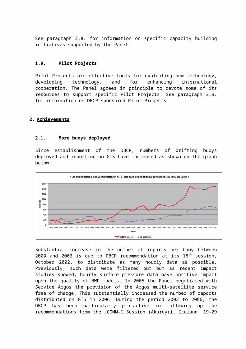
Since establishment of the DBCP, numbers of drifting buoys deployed and reporting on GTS have increased as shown on the graph below:
Number of drifting buoys reporting on GTS, and number of observations per buoy (source ISDM)
0
200
400
600
800
1000
1200
1400
1600
1979 1980 1981 1982 1983 1984 1985 1986 1987 1988 1989 1990 1991 1992 1993 1994 1995 1996 1997 1998 1999 2000 2001 2002 2003 2004 2005 2006 2007 2008 2009 2010 2011
Year
Num
ber
Drifting Buoys Obs per buoy
Substantial increase in the number of reports per buoy between 2000 and 2003 is due to DBCP recommendation at its 18th session, October 2002, to distribute as many hourly data as possible. Previously, such data were filtered out but as recent impact studies showed, hourly surface pressure data have positive impact upon the quality of NWP models. In 2005 the Panel negotiated with Service Argos the provision of the Argos multi-satellite service free of charge. This substantially increased the number of reports distributed on GTS in 2006. During the period 2002 to 2006, the DBCP has been particularly pro-active in following up the recommendations from the JCOMM-I Session (Akureyri, Iceland, 19-29 June 2001) and reach the target of 1250 units operational in the world oceans. This was effectively realized during the JCOMM-II Session (Halifax, Canada, 19-27 September 2005) on 18 September 2005 with the deployment of “drifter 1250” (see picture below).
1 PANGEA: Partnership for New GEOSS Applications – http://www.jcomm.info/pangea-concept

Picture: Dr Peter Niiler and Mr Mike Johnson deploying “drifter 1250” from Tall Ship Silva off the coasts of Halifax, 18 September 2005
1537 hours
Status of the Global Drifter Array as of January 2012. Direct access to latest map: http://www.jcommops.org/dbcp/network/status.html
Status of the Global Tropical Moored Buoy Array as of January 2012. Direct access to latest map: http://www.pmel.noaa.gov/tao/global/global.html

2.2. Quality of buoy data is recognised as good
Thanks to improvements in data assimilation as well as improvements in the numerical weather prediction models themselves, and to a lesser extent to the DBCP quality control guidelines, observed buoy data now agree very well with the models. Buoy technology has not changed dramatically in the last 15 years. In fact, when the SVPB2 was designed and before it was tested at sea in the early 1990s, concerns were expressed regarding expected quality of pressure data from those buoys (e.g. buoy submerged, new cheaper barometer used). Facts showed that both FGGE3 type buoys (the standard at the time) as well as the new SVPBs produced reliable pressure observations, while the SVPBs were substantially more cost effective and provide excellent water following characteristics in contrary to FGGE type buoys. What the buoy community knew, however, was a difficult message to pass through the Numerical Weather Prediction (NWP) community. Improvement of NWP techniques permitted to demonstrate that the buoy data quality was indeed very good.
For example, standard deviation of observed pressure data from buoys minus first guess pressure field of ECMWF model was in the order of 2.5 hPa in 1990. In 2000, it dropped to about 1.2 hPa, and 0.8 hPa in 2006. As a result, modellers are now confident in the quality of buoy data, including air pressure (0.7 hPa SD), wind speed (1.6 m/s SD), wind direction, and SST (0.6C SD).
2.3. Argos GTS sub-system
Before 1993, when a buoy operator wanted his buoy data to be distributed on the GTS, he had to follow very strict standards as far as Argos message format was concerned. Sensors has to be placed in a certain order, the set of available types of calibration curves was limited, it was not possible to distribute the back-hour data on the GTS, and only very limited quality control checks were done. Besides, if a buoy reported on the GTS, the buoy operator could not recover the raw data since the GTS required to process the data in geophysical units and the standard Argos data processing system was used for that purpose.
There were in fact a number of buoy operators who agreed to distribute their buoy data on the GTS, but for whom this was not possible for technical reasons.
The DBCP therefore decided to ask Service Argos to develop a separate flexible system dedicated to GTS distribution of Argos platforms. The Technical Coordinator wrote the specifications, development work was evaluated and sub-contracted. DBCP agreed to pay for a part of the development costs ($90K). The rest was included within the Argos development programme and reimbursed through the Argos Joint Tariff Agreement. The project was developed in 2 phases. Phase 1 started in July 1991, and was implemented in February 1993. Phase 2 started in October 1992, and was implemented in September 1993.
The GTS sub-system has been closely monitored by the Technical Coordinator and improvements proposed over the years. Specifications of the present system include among other things:
No interference with Argos users' needs (e.g. he can get the raw data) Recognising almost any kind of Argos message formats Wide range of calibration curves (tables, polynoms, formulae, specific algorithms)
2 SVPB: Surface Velocity Programme (SVP, now replaced by the Global Drifter Programme – GDP) Barometer Drifter3 FGGE: First GARP Global Experiment (GARP: Global Atmospheric Research Programme).

Processing timers and time of observation Automatic quality control checks (gross errors, dedicated sensor limits, sensor
blockage, checksum) Geo-magnetic variation model (for wind direction sensors) Reduction of pressure to sea level (for remote stations in altitude) Data encoded according to WMO regulations (BUOY, SYNOP, SHIP, BATHY,
TESAC, and BUFR) Processing GPS data and interpolation between locations Compression for identical Argos messages and identical sensor observations Automatic remote technical file access (via email) Processing of profile data (e.g. XBTs, Argo profiling floats) Delayed mode distribution (i.e. waiting to collect all necessary information during a
given period before actually distributing a report on GTS; this is particularly useful for sub-surface profiling floats which may transmit the data of one single profile through many satellite passes)
BUFR table driven code was implemented in early July 2003. BUFR compression was developed in 2004. BUFR is more flexible than traditional alphanumerical code forms, and therefore permits GTS distribution of variables that cannot be distributed in BUOY format (BUOY is now frozen), e.g.
a. Data collection and/or location systemb. Platform transmitter IDc. Platform battery voltage (used to be coded as housekeeping parameter)d. Transmitter battery voltagee. Receiver battery voltagef. Submergence (used to be coded as housekeeping parameter)g. Drogue status (now drogue depth independent from drogue status)h. Ice thickness (for ice-buoys)i. Temperature of barometerj. Height of instrument (pressure, temp., humidity, wind, precip.)k. Wind gustl. Precipitationsm. Global radiation
Argo automatic real-time quality control tests were implemented in October 2003
Salinity computation for TAO equatorial moorings (from conductivity, temperature, and depth) was implemented in November 2004.
In 2007, CLS, Service Argos implemented new sensor data processing system, largely inspired from the existing Argos GTS sub-system, and compatible with DBCP requirements (based on guidance from the Panel).
2.4. Quality Control guidelines
In 1992, the DBCP established so called "Quality Control Guidelines" as a way to rationalise and speed up the buoy status change process for those buoys reporting on the GTS (e.g. remove a buoy from GTS, recalibrate a sensor). There was also a recognition that the Meteorological and Oceanographic centres, and especially those running global models were in the best position to undertake deferred-time quality control procedures and comment upon the quality of buoy data. The scheme was later formally included by CBS as part of the World Weather Watch.
The scheme is based on an Internet mailing list ([email protected]) which is used by all actors involved in the process. The mailing list is operated by the JCOMM in situ Observations Programme Support Centre (JCOMMOPS). Particularly, when felt necessary, and according to quality control procedures they undertake on their own, Principal Meteorological or Oceanographic Centres (PMOC) responsible for buoy data Quality Control can make status change proposals by means of the mailing list. The subject line of status change proposals is standardised in order to facilitate automatic data processing of the messages.
For each buoy programme, only one person is responsible for asking Service Argos or Local User Terminals (LUT) to effectively implement status changes. This person is designated by the programme Principal Investigator or operator and is called Principal GTS Coordinator (PGC).
The Technical Coordinator of the DBCP, acting as a focal point between these centres and the owners of the buoys, forwards the proposals to them. Some of the proposals are automatically forwarded to the PGC in case the latter has an email address.
In addition, monthly buoy monitoring statistics produced by PMOCs are available on the mailing list.
In 2003, a dedicated web page (http://wo.jcommops.org/cgi-bin/WebObjects/QCRelay) was implemented to allow PMOCs to directly report on systematic errors via the web. The web page remains complementary to the mailing list.
2.5. Standardization
Instrumentation: Standardization of instrumentation has always been an important issue within the DBCP. As a result, strong cooperation was put in place between meteorologists and oceanographers deploying drifting buoys and common designs are now being used (SVP, SVPB, SVPBW). See paragraph 2.15 for details.
Data telecommunication formats: The DBCP defined sets of recommended data telecommunication formats for the transmission of the raw data through the Argos system (http://www.jcommops.org/dbcp/data/sharing.html). This facilitates implementation of technical files at Service Argos upon deployment of buoys. It also permits new partners in the programme to quickly set up buoy programmes.
Quality Control and information: Simple automatic quality control checks had been implemented within the Argos GTS sub-system (see DBCP publication No. 2). A guide on Guide to buoy data quality control tests to perform in real-time by a GTS data processing centre has been published as DBCP Technical Document No. 37. In addition, Sea Surface Salinity Quality Control processes for potential use on Data Buoy observations have been documented in DBCP Publication No. 42. Deferred-time Quality Control is the responsibility of data users and NWP centres. However, a standardized quality information feed-back mechanism was put in place by the DBCP (see 2.4) and permits relay of quality information from data users back to buoy operators. References and links to DBCP Technical Publications are provided in paragraph 2.18.
2.6. Collection of metadata

A synthesis of DBCP members’ comments regarding the metadata issue was submitted to the JCOMM Sub-group on Marine Climatology in January 2000 (see http://www.jcommops.org/dbcp/metadata.html). The sub-group met in early 2000 and took the DBCP recommendations into account. At its first session in Akureyri, Iceland, 19-29 June 2001, JCOMM recommended that the format agreed upon by its sub-group on Marine Climatology be used as the global format for the assembly, exchange and archival of metadata from all types of ODAS, including, in particular, drifting and moored buoys and fixed platforms.
To assist in preparing the compilation of the final catalogue, DBCP members and the Action Groups had to compile their own metadata catalogues, with a view to submitting them when required in a format as close as possible to the one that was proposed by JCOMM (see Recommendation 1 – JCOMM-I). On the other hand, for drifting buoys, the panel, at its 16th session in Victoria, October 2000, noted that a good way to collect most of the metadata was to ask buoy manufacturers to fill out a standardized sheet each time a new drifting buoy was being delivered. Calibration procedures for buoys should be adequately documented and archived. Panel members are urged to provide the JCOMM Expert Team on Marine Climatology with related calibration information as well.
In 2002 and 2003, a metadata relational model was defined by EGOS in cooperation with the DBCP. Specifications were written for a web based global buoy deployment notification scheme to facilitate collection of metadata. Notification is planned in two steps, i.e. (i) by buoy manufacturers upon buoy purchase, and (ii) by buoy operators upon buoy deployment. Buoy manufacturers are indeed in the best position to provide the metadata so most of the metadata will be collected through step 1. In 2004, EGOS funded JCOMMOPS to realize the web application that collects the metadata. Application was made operational in January 2005.
In 2010, the DBCP made efforts to simplify the format in which moored buoy metadata should be made available by buoy operators.
Regarding inclusion of metadata in GTS reports, the CBS and its Implementation Coordination Team on Data Representation and Codes accepted as ultimate modification of the BUOY code inclusion of certain metadata (e.g. anemometer height, buoy type, drogue type) in the BUOY code. This was implemented on 8 November 2001. As of July 2003, GTS distribution of buoy data in BUFR format also permits more metadata to be included in the real-time data-flow (e.g. name of data collection system, platform transmitter ID, drogue status, height of other instruments than anemometer such as barometer, thermometer).
2.7. DBCP Implementation strategy
The DBCP was established in 1985, jointly by the WMO and IOC, as a means of enhancing cooperation, coordination and information exchange among the operators and users of drifting buoys, meteorological and oceanographic, research and operational, with a view to improving both the quantity and quality of buoy data available on the Global Telecommunications System of WMO in support of major programme requirements of the two Organisations. In 1992 its terms of reference were widened and its name changed from Drifting Buoy Co-operation Panel to Data Buoy Co-operation Panel, to reflect its work in coordinating all forms of ocean buoy deployments, and particularly moored buoys in the high seas. In 2011, the Panel agreed to change again its Terms of Reference to also coordinate activities concerning rigs and platforms reporting surface marine meteorological and oceanographic data.

During the 25 years of its existence, the panel has had great success in achieving its initial objectives. At the same time, this period has also seen advances in both buoy and communications technology, as well as greatly enhanced and expanded requirements for buoy data, in particular in support of global climate studies. Major global experiments such as TOGA4 and WOCE5 have clearly demonstrated the value of buoy data for this purpose, and at the same time established and refined the buoy networks needed to fulfil the scientific requirements. One of the major challenges now facing the panel and buoy operators is to convert the buoy networks established for these experiments into long-term operational programmes.
In recognition of these new developments and expanded requirements, and in the context also of the implementation plans and requirements of the GOOS and GCOS, the panel agreed in 1997 on the need for a DBCP Implementation Strategy, which would provide an overall framework for the panel’s work, and at the same time enable it and its members to react appropriately to future developments. A draft strategy document was prepared for the panel by Mr David Meldrum, reviewed and revised at the panel session in 1998, and has been published in the DBCP Technical Document series (No. 15). The strategy document is also available through the DBCP web server (http://www.jcommops.org/doc/DBCP/DBCP_Impl_Strategy.pdf).
In the period 2003 to 2005, DBCP implementation strategy was revised in conjunction with JCOMM Observations Programme Area (OPA) phase-in in implementation plan. As a consequence, size of operational drifter array increased substantially from about 700 operational buoys to about 1250. Only about 330 drifting buoys reported air pressure in August 2006. The new JCOMM OPA strategic workplan calls for installing barometers on all of the 1250 drifting buoys by 2009.
In 2006, the Panel the panel supported the requirement for additional high-quality wave measurements in under-sampled areas of the world oceans in the area of Maritime Safety Services, and agreed to add wave measurements to the DBCP Implementation Strategy. It therefore invited buoy operators and Panel Members to increase wave measurements, particularly from open ocean areas, in the Southern Ocean, and the tropics. The Panel invited its Evaluation Group to address wave measurement technology issues, and recommended that the JCOMM Observations Coordination Group addresses the broader issues.
In 2007, ssubstantial additions were made to the strategy to include new initiatives for the Panel such as pilot projects, task teams, user workshops, training courses and other outreach activities.
In 2008, the Panel made clear references to the WMO and IOC strategic planning in its implementation strategy.
In 2010, Consideration of the outcome of OceanOBS’09, the third JCOMM Session (JCOMM-III), and the 2010 update of the GCOS Implementation Plan was made, and the requirements for the developing GFCS added.
In 2011, the Panel considered the outcome and guidance of the WMO 16th Congress and the IOC 26th Assembly to update its implementation strategy.
2.8. Capacity Building initiatives
See paragraph 1.8 for background information on DBCP Capacity Building activities.
4 TOGA: Tropical Ocean Global Atmosphere programme5 WOCE: World Ocean Circulation Experiment

2.8.1. Technical publications
The DBCP has produced a number of technical publications useful for Member Countries to develop their national activities. Useful DBCP technical publications include publications No. 2 (Argos GTS sub-system reference guide), No. 3 (Argos guide), No. 4 (SVPB drifter design), No. 8 (moored buoys), and No. 15 (implementation strategy), No. 37 (real time quality control), No. 41 (vandalism on data buoys), and 42 (quality control of salinity data). See paragraph 2.18 for details.
2.8.2. Scientific and technical workshops
The Panel has been organizing scientific and technical workshops on a yearly basis since 1995, and has been producing their proceedings. See paragraph 2.18 for the list of such publications.
2.8.3. Technology workshops
The DBCP has long recognized the need to engage closely with the users of buoy data to identify current and upcoming issues. A DBCP data users and technology workshop was organized UK from 27 to 28 March 2006. A number of participants from developing countries have been invited and funded to attend the workshop. The most important goals for the workshop were to re-examine the basic principles behind data buoy observations, to think laterally, and to explore new avenues that might be important for the next decade. One aim was to optimize buoy design, deployment strategies and data management to maximize the usefulness of buoy data, both in terms of their impact on model forecasts and their value for money. Alongside this aim was the need to develop and validate new generations of sensors and observing platforms to address future requirements in terms of spatial and temporal measurement densities, improving the impact of buoy data, smart in situ data selection, communications options, data processing and overall value for money.
2.8.4. Training workshops
A “training course on buoy and fixed-platform data management” was organized in June 2007, at the IODE Project Office, Oostende, Belgium, in close cooperation with the Ocean Data and Information Network for Africa (ODINAFRICA). Training materials have been developed to that end. The primary goal for the workshop was to provide training to buoy operators and researchers in African nations on application and management of the data from in situ oceanographic and marine meteorological observations.
2.9. Pilot Projects supported
See paragraph 1.9 for background information on Pilot Projects.
2.9.1. META-T Pilot Project
Following discussions with the DBCP and the Ship Observations Team (SOT), the Water Temperature metadata Pilot Project (META-T PP) was established by the JCOMM/OCG workshop, Reading, United Kingdom, 28-29 March 2006. The pilot project was aiming at providing an international standardization framework for collecting SST and water temperature profile instrumental metadata from a number of marine observational systems, including drifting and moored buoys, observing ships, sea level stations, sub-surface profiling floats, ocean reference stations, and ODAS.
The Pilot Project was targeting a number of applications including (i) Numerical Weather

Prediction (NWP), (ii) SST analysis and GODAE High Resolution SST Pilot Project (GHRSST), (iii) data assimilation and ocean field analysis, (iv) ocean modelling, (v) ocean modelling validation, (vi) climate forecast, (vii) seasonal to decadal climate variability, (viii) satellite calibration, (ix) satellite validation, (x) operational activities (e.g. weather forecasters, disaster response), (xi) quality assurance activities serving above applications, and (xii) diagnostic by platform operators.
The National Marine Data & Information Service (NMDIS, China) offered to host a metadata server for the Pilot Project. The National Data Buoy Center (NDBC, NOAA) also expressed its interest to participate in this pilot project by hosting a mirror server, and is investigating feasibility.
The Water Temperature Metadata Pilot Project (Meta-T) ended in 2011. Despite slow progress some very useful lessons have been derived from the Pilot Project, e.g.:
(i.) The concept of a single point of access to all JCOMM metadata that operates independently from the platform data management process is not sustainable, especially in a low funding environment.
(ii.) Organizing the metadata development effort around a geophysical variable, temperature in this case, was less effective than organizing around platforms.
(iii.) JCOMM is organized into panels that have common platforms and data processing systems. Exploiting this organizational infrastructure will likely be more effective, at least initially, than creating a separate metadata service that aims to integrate across panel activities and is developed independently. On the other hand, such cross-panel metadata services (e.g. the ODAS Metadata Service operated by China) may also still end up having important downstream integrating and permanent archive roles.
(iv.) Data content and data representation standards are enabling technologies that can serve to integrate the platform-focused activities of the panels.
(v.) A key strategy recommended by Meta-T is to include as much metadata as is practically available at the time of GTS encoding in the BUFR templates. Therefore, of primary importance to the overall management and distribution of data and metadata, is the design of BUFR templates.
(vi.) Exploring web based technologies, including web-services that provide deeper functionality than the GTS can currently deliver. A network of servers which adhere to industry standards for data exchange and representation will be easier to develop and likely more effective than a single metadata-only service that deals with metadata separately from the operational dataflow of the ocean observing platform.
2.9.2. DBCP Iridium drifter Pilot Project
At its twenty-sixth session, La Jolla, USA, 16-20 October 2006, the DBCP agreed to actively pursue technology evaluation initiatives. A proposal to establish an Iridium Pilot Project was presented to the session and agreed upon. The Pilot Project ran for a period of two years as of November 2006. In the first instance, the goal of the Pilot Project was to evaluate and demonstrate the operational use of Iridium satellite data telecommunication technology for the real-time collection of drifter data in support of the WWW, GOOS, and GCOS applications, and the WMO Natural Disaster Prevention and Mitigation Programme. In addition, the Pilot Project aimed to evaluate whether this can be realized in

a cost effective way, on a global basis, and under various ocean conditions. Deployment of drifters in data sparse areas of interest to developing countries was also targeted.
The Pilot Project has evaluated the feasibility of Iridium technology for real-time telecommunication of drifter data, relating to:
1) Operating a global observing system (over 50 units have been deployed worldwide);2) Network reliability and survivability;3) Data throughput in terms of quantity and timeliness;4) Data management, especially data formatting and insertion on the GTS;5) Operational shipment and deployment, including rapid response options (e.g. ahead
of tropical cyclones);6) Cooperation with developing countries in terms of drifter deployment and Iridium
technology transfer;7) Collaboration with manufacturers to promote free availability of Iridium modems and
drifters8) Demonstrating overall cost effectiveness (manufacturing, transmission, data
processing, life-time);
The Pilot Project has been successful, and a number of countries have now started deploying Iridium drifters operationally.
2.9.3. Argos-3 Pilot Project
Drawing on substantial financial support from CLS, the Pilot Project for the evaluation of Argos-3 technology was initiated at the twenty-fourth Session of the DBCP (Cape Town, South Africa, 13-16 October 2008) with the plan to deploy 50 drifters equipped with Argos 2-way PMTs. The Panel agreed to make additional funding available to the project so that all drifters might be equipped with barometers.
2.9.4. Pilot Project on Wave measurement Evaluation and Test from moored buoys (PP-WET)
Based on the recommendations arising from the JCOMM Workshop on Wave Measurements from Buoys (New York City, New York, USA, 2-3 October 2008), the Panel agreed at its twenty-fourth Session to establish a Pilot Project on Wave measurement Evaluation and Test from moored buoys (PP-WET) for a period of three years, and to allocate adequate finances in 2009 and succeeding years so that the project might get under way as soon as possible. The project is a joint cooperation between the DBCP and the JCOMM Expert Team on Wind Waves and Storm Surges (ETWS). It has initiated the inter-comparisons of different in situ wave observing networks from moored buoys. This Project, while being implemented by the participating countries/programmes such as USA, Canada, and E-SURFMAR, has collaborated with the DBCP Task Teams and other related programmes in developing the metadata list for wave data collection. The results would contribute to JCOMM standards and best practice, as well as to the relevant WIGOS exercise.
2.9.5. Pilot Project for Wave Measurement from Drifters (PP-WMD)
At its twenty-fifth Session (Paris, France, 28 September – 1 October 2009), the Panel established a Pilot Project for Wave Measurement from Drifters (PP-WMD) with the aims of reporting inexpensive deep ocean 2D wave spectra in support of satellite and model cal/val activities. This pilot project is complementing the PP-WET. At its twenty-seventh Session (Geneva, Switzerland, 26-30 September 2011), the Panel decided that (i) PP-WMD chair and membership should be reviewed, and possible incorporation within PP-

WET should be considered by the DBCP EB; (ii) the GPS sensor developed by the Scripps Institution of Oceanography for wave measurements should be deployed within the PP-WET evaluation and inter-comparison exercise; and (iii) early consideration should be given to a protocol for characterizing the performance of the sensor when incorporated within a SVP drifter hull.
2.9.6. Pilot Project for the measurement of High Resolution Sea Surface Temperature (HRSST)
At the twenty-fifth DBCP Session (Paris, France, 28 September – 1 October 2009), the Panel endorsed a new Pilot Project for the measurement of High Resolution Sea Surface Temperature (HRSST) from drifters, with the objective of addressing the requirements expressed by the Group for High Resolution SST (GHRSST) and better integrate in situ and satellite SST data. Within this Project, a number of drifters equipped with HRSST sensors (+/- 0.05C accuracy), GPS and Iridium communications are to be deployed in the test region, and the Pilot Project Team to evaluate the impact of in situ HRSST on the quality of satellite SST retrievals.
2.9.7. Evaluation of the impact of Sea Level Pressure from drifters on NWP
At its twenty-seventh Session (Geneva, Switzerland, 26-30 September 2011), the Panel agreed to initiate a two-year pilot project with objectives to (i) quantify the impact of Sea Level Atmospheric Pressure (SLP) data from the existing SVPB6 network on Numerical Weather Prediction (NWP); and (ii) provide a scientific/operational rationale for designing the temporal and spatial resolution, as well as the optimal geographical distribution of the SVPB array, taking into account all sources of data (e.g. moorings, ships).
2.10.Cooperation with Tsunami warning systems
Following the 26 December 2004 Tsunami, the DBCP has been increasingly cooperating with the Intergovernmental Coordination Group for the Pacific Tsunami Warning System (ICG/PTWS) and the new Intergovernmental Coordination Group for the Indian Ocean Tsunami Warning and Mitigation System (ICG/IOTWS). The Panel agreed that a number of components in the JCOMM structure, particularly the Observations and Services Programme Areas, could contribute in the development of a tsunami warning system as part of a more comprehensive marine multi-hazard warning system. It again noted that synergies could be created with SOT and DBCP in the deployment and use of multi-purpose deep ocean moorings for marine hazard detection. It also emphasized the potential contribution of the Panel to this initiative through JCOMMOPS, in the ocean platform deployments and maintenance.
In 2006, the Panel also noted that Tsunami warning systems are looking for better integration at the international level in terms of instrument standards, data exchange formats and quality control procedures, development of communal acceptance processes for “core” stations on which many countries might depend, formulation of collective web-based tools to assist network progress and tracking during the system’s development and for subsequent operational status accounting, and development of an international data archive for high resolution data sets.
In 2008, at its twenty-fourth Session (Cape Town, South Africa, 13-16 October 2008), the Panel noting the recommendations from the sixtieth WMO Executive Council (EC-LX), and recognising the immediate and longer-term synergies between the DBCP and the
6: Surface Velocity Programme (SVP) Barometer drifter

work of the International Tsunameter Partnership (ITP), the Panel agreed to extend an invitation to the ITP to become an Action Group of the DBCP. The members of the ITP recognised the value in the association with the DBCP, and the capacity for the action agendas of both parties to be advanced by a more direct association. Accordingly, the ITP expressed its wish to become an Action Group of the DBCP.
2.11.Vandalism.
DBCP is cooperating with relevant international organizations such as IHO to address the vandalism issue. For example, IHO agreed to promulgate navigational warning messages on the presence of data buoys in the seas and the necessity of their safety for assistance to mariners, in particular during bad weather times. Such messages are based upon information provided by the DBCP (see documents on the DBCP web site which are available for DBCP members to use as needed at http://www.jcommops.org/dbcp/vandalism.html and http://www.jcommops.org/dbcp/vandalism.pdf).
The issue was also discussed at the first meeting of JCOMM, Akureyri, Iceland, 19-29 June 2001. JCOMM recommended Member States (i) to contact their respective Hydrographic Services to reinforce the message in the "Hydrogram" and to ensure that it is reissued as often as possible; (ii) to develop, if possible, tamper proof designs for buoy systems; (iii) to design a warning system in the event any data buoys were intentionally damaged; and (iv) to take legal steps nationally to limit acts of vandalism within their territorial seas and Exclusive Economic Zones.
In 2010, at its twenty-sixth Session (Oban, UK, 27-30 September 2010), the Panel noted the recommendations made by both the WMO and IOC Executive Councils in this regard, and agreed to finalize a report on the issue for submission to the WMO sixteenth Congress in 2011. The Panel established a small working group to provide continuity of attention to this important issue, and to provide a focal point for follow-up action by the Panel. The working group is also a channel for further information requests, following the release of the vandalism report.
In 2011, at its twenty-seventh Session (Geneva, Switzerland, 26-30 September 2011), the Panel noted the recommendations made by both the WMO Congress and IOC Assembly in this regard, and thanked Mr Ken Jarrott (Australia) for finalizing the report on Vandalism (DBCP TD No. 41). The small working group established at the previous Session will continue to follow up the recommendations from the report as well as from the DBCP. Hardware improvements include special fasteners, buoys with cones, better transmitters and fish dispersion devices. The Panel recognized that there were essentially three items on which to focus: hardware improvements, education and regulations.
2.12.Safety.
Following explosion in august 2001 of a moored data buoy during maintenance onboard a ship in the Bay of Bengal which resulted in the death of a crew member, the Indian National Institute for Ocean Technology (NIOT) who operated the buoy constituted an expert committee to examine the incident. The committee included distinguished scientists in mechanical and electrical engineering, battery development and manufacture, forensic science and pressure vessels. This committee had concluded that the explosion was due to the emission of hydrogen and oxygen from overcharged batteries, ignited by an electrical spark. The recommendations of the expert committee were then placed before the Data Buoy Cooperation Panel and the issue was discussed further with the buoy

operator represented by Dr. K. Premkumar, Panel Members, and manufacturers at its 17th session in Perth, 22-26 October 2001. Finally, the DBCP made specific recommendations which can be found at http://www.jcommops.org/dbcp/safety.html.
In 2006, the Panel noted with concerns the risk of accidents or injuries when drifter deployments from ships were not made properly. In particular, the paper tape that is present on some drogues should not be removed prior deployment as the drifter and its drogue might then behave as a kite. The Panel recommended the production of a short video for creating awareness and explaining deployment procedures in detail.
2.13.Buoy Evaluation and technical developments.
Before 1992, oceanographers only deployed so called standard SVP Lagrangian drifters in order to measure primarily sea surface currents. The only geophysical sensor installed on the drifters was for Sea Surface Temperature. At the same time, they encouraged meteorologists to install large drogues on their FGGE type buoys in order to increase their drag area ratio and therefore increase their water following characteristics (reduce slip due to wind stress, vertical current shear, surface gravity wave effect). However, installing a drogue on a FGGE type meteorological buoy does not transform it into a real Lagrangian drifter. Only small spherical hulls with large drogue attached and drag area ratio > 40 are considered as Lagrangian. In practice, only a very small number of drogues had been attached to meteorological buoys, and only to slow them down and keep them longer in a given ocean area rather than to increase their water following characteristics. Cooperation between the two communities in the buoy business was in fact very small.
WOCE funded the development of a Lagrangian drifter equipped with a barometer. Because of the drogue and designed buoyancy, a Lagrangian drifter is regularly submerged by the waves. Measuring atmospheric pressure in those conditions was therefore a challenge. Developments were conducted at Scripps Institution of Oceanography by Peter Niiler and Andy Sybrandy. The DBCP felt that this was a good opportunity to make the two buoy communities (on the meteorological and on the oceanographic side) cooperate to a larger extent and pushed its members to purchase prototypes and test them. This was a success, agencies from five countries accepted to buy and test the drifter. 25 prototypes were initially deployed and evaluation was done in cooperation between the two communities. Two evaluation workshops were organised, in May 1993 and May 1995, respectively in La Jolla at SIO, and New Orleans. Design modifications were proposed. This was the real start of an excellent cooperation between oceanographers and meteorologists within the DBCP.
In May 1999, the Panel established a DBCP sub-group on SVPB/Minimet evaluation to evaluate the so called SVPBW or Minimet, a new technology to measure wind speed using WOTAN (wind observation through ambient noise).
At its 17th session in Perth, October 2001, the panel agreed that the sub-group had proved successful and had led to significant improvements in the quality of the data produced by these instruments. At the same time, the panel agreed that there was a need (i) to evaluate other types of buoys or instruments (e.g. moorings, thermistor strings) but also (ii) to routinely discuss other technical issues such as DBCP recommended Argos message formats, or to define specific DBCP criteria regarding life-times, early failures, ocean areas, etc. The Panel therefore decided to extend the terms of references of the group to become a more general DBCP evaluation group.
The group then evolved into a DBCP Task Team on Instrument Best Practices and Drifter Technology Developments (TT-IBP). The Task Team primarily works via email

([email protected] mailing list), meets annually in conjunction with DBCP Sessions, and reports to the DBCP at panel sessions.
Examples of other technical developments undertaken through the DBCP:
Storm buoy concept (resolutions adjusted with actual weather conditions) Smart buoy concept (extending buoy life-time by using a transmission strategy that
saves battery power while still providing observational data that meet user requirements).
Satellite data collection using Iridium (permits to transmit higher resolution data, and to be more cost effective)
Satellite data collection (and downlink capability) using Argos-3 (permits to transmit higher resolution data, and to play with the storm buoy, and smart buoy concepts)
High Resolution SST sensors (to address in situ / satellite integration requirements, e.g. GHRSST)
Wave Measurements from drifters using GPS (cost effective for global wave observations)
2.14. Impact studies.
DBCP is maintaining information regarding impact of buoy data upon Numerical Weather Prediction. Details can be found at: http://www.jcommops.org/dbcp/impact.html
2.15.Actual cooperation between meteorologists and oceanographers
After the first SVPB evaluation phase (evaluation is considered as an ongoing process), meteorologists began to purchase SVPBs for their own purposes to replace the FGGE type buoys. This is the case for example for the South African Weather Bureau, Météo France, the Australian Bureau of Meteorology, and the United Kingdom Meteorological Office.
SVPB meets both communities needs:
For meteorologists, it is equipped with a barometer and a SST sensor and reports onto the GTS. It is drogued and therefore stays longer in a given area. It is cheaper than regular FGGE type buoys measuring the same variables.
For oceanographers, it is an excellent Lagrangian drifter which has been calibrated for that purpose. Surface velocity correction due to wind stress can even be applied thanks to a formula. Because the drifter is equipped with a barometer, and reporting on GTS, one can expect to obtain better wind fields from the meteorological agencies for making this correction.
Since standard SVP drifters continue to be deployed by oceanographers, meteorological agencies can use this potential and pay to upgrade SVPs to SVPBs for only the cost of a barometer. Météo France is presently upgrading 10 drifters a year for deployments in the Indian Ocean. This is an excellent example where resources are shared.
2.16.Action groups established through Panel support and/or action:
The Panel took steps to support, initiate and create the following Action Groups:

IABP: International Arctic Buoy Programme (1991) ISABP: International South Atlantic Buoy Programme (1994) IBPIO: International Buoy Programme for the Indian Ocean (1996) NPDBAP: DBCP-PICES North Pacific Data Buoy Advisory Panel (2002)
Within DBCP implementation strategy:
SOBP: The Southern Ocean Buoy Programme is not a DBCP Action Group as it involves work from many of the other Action Groups. It is directly included as part of the DBCP implementation strategy and coordinated at the DBCP level (e.g. at Panel sessions).
2.17.Existing programs who joined as DBCP action groups:
The following Action Groups decided to join the DBCP after they had been created:
EGOS: European Group on Ocean Stations (joined in 1987). EUCOS Surface Marine Programme (E-SURFMAR) took over from EGOS in January 2005 and become Action Group of the DBCP.
IPAB: International Programme for Antarctic Buoys (joined in 1994) GDP: Global Drifter Program (joined in 1996) TIP: Tropical moored buoy Implementation Panel (joined in 1998) OceanSITES: OCEAN Sustained Interdisciplinary Time series Environment
observation System (joined in 2005) ITP: International Tsunameter Partnership (joined in 2008)
2.18.Technical document series initiated
The DBCP document series, which was initiated in 1995, now contains the following publications:
No. Title Issued
43 Presentations at the DBCP Scientific and Technical Workshop, Geneva, Switzerland, 26 September 2011 - CD ROM (ftp)
2011
42 Sea Surface Salinity Quality Control processes for potential use on Data Buoy observations - Web only (ftp)
2011
41 Ocean Data Buoy Vandalism - Incidence, Impact and Responses - Web only (ftp) 2011
40 Annual report for 2010 - CD ROM (ftp) 2011
39 Presentations at the DBCP Scientific and Technical Workshop, Oban, United Kingdom, 27 September 2010 - CD-ROM (ftp)
2011
38 Annual report for 2009 - CD ROM (ftp) 2010
37 Guide to buoy data quality control tests to perform in real-time by a GTS data processing centre - Web only (ftp)
2011
36 Presentations at the DBCP Scientific and Technical Workshop, Paris, France, 28 September 2009 - CD ROM (ftp)
2010
35 Annual report for 2008 - CD ROM (ftp) 2009

34 Presentations made at the DBCP scientific and technical workshop, Cape Town, Republic of South Africa, 13 October 2008 - CD ROM (ftp)
2009
33 Annual Report for 2007 - CD ROM (ftp) 2008
32 Presentations at the DBCP Scientific and Technical Workshop, Jeju, Republic of Korea, 15-16 October 2007 - CD ROM (ftp)
2008
31 Annual Report for 2006 (.pdf) - CD ROM (ftp) 2007
30 Technological Developments and Applications of Data Buoys for Tsunami Monitoring Systems, Hurricane and Storm Surge Prediction, Presentations at the DBCP Technical Workshop, La Jolla, 16-17 October 2006- CD-ROM (ftp)
2007
29 JCOMM TR No. 37. Application of collected data, Presentations at the DBCP Technical Workshop, Buenos Aires, Argentina, 17-18 October 2005 - e-version only (ftp)
2006
28 JCOMM TR No. 35. Application of collected data, Presentations at the DBCP Technical Workshop, Chennai, India, 18-19 October 2004 - e-version only (ftp)
2006
27 Annual Report for 2005 - CD-ROM (.doc) (.pdf) 2006
26 Annual Report for 2004 - CD-ROM (.doc) ( .pdf), Annex II pp. 2-20 (.doc) 2005
25 Annual Report for 2003 (.pdf) - CD-ROM (.doc) (.pdf) 2004
24 Research, Applications, and Developments Involving Data Buoys - Presentations at the DBCP Technical Workshop (Angra dos Reis, Rio de Janeiro, Brazil, October 2004) - CD-ROM (ftp)
2004
23 Annual Report for 2002 (.pdf) - CD-ROM (.doc) (.pdf) 2003
22 Research, Applications, and Developments Involving Data Buoys - Presentations at the DBCP Technical Workshop (Trois Ilets, Martinique, October 2002) - CD-ROM (zip)
2003
21 Developments in Buoy Technology, Communications, Science and Data Applications - Presentations at the DBCP Technical Workshop (Perth, Australia, October 2001) - CD-ROM (ftp)
2002
20 Annual Report for 2001 (.doc)Annexes 1 (.doc), 2 (.pdf), 3 (.pdf), 4 (.pdf), 5 (.pdf), 6 (.pdf), 7 (.pdf), 8 (.pdf), 9 (.pdf), 10 (.doc) (.pdf), 11 (.doc) (.pdf)
2002
19 Developments in Buoy Technology, Communications and Data Applications - Presentations at the DBCP Scientific and Technical Workshop (zip)
2001
18 Annual Report for 2000 ( pdf), Annex 3, RNODC/DB report ( pdf), Annex 3,
DB SOC report ( pdf)
2001
17 Developments in Moored and Drifting Buoy Design, Programmes, Sensors, and Communications – Presentations at the DBCP Technical Workshop
2000
16 Annual Report for 1999 2000
15 Global Drifting Buoy Observations - A DBCP Implementation Strategy (9th edition) 2010
14 Variety in Buoy Technology and Data Applications 1999
13 Annual Report for 1998 1999
12 Developments in Buoy Technology and Data Applications 1998

11 Annual Report for 1997 1998
10 Developments in Buoy and Communications Technologies 1997
9 Annual Report for 1996 1997
8 Guide to Moored Buoys and Other Ocean Data Acquisition Systems 1997
7 Developments in Buoy Technology and Enabling Methods – Technical Presentations Made at the Eleventh Session of the DBCP
1996
6 Annual Report for 1995 1996
5 Surface Velocity Programme - Joint Workshop on SVP Barometer Drifter Evaluation
1996
4 WOCE Surface Velocity Programme Barometer Drifter Construction Manual -
Revision 2.2 ( pdf)
2009
3 Guide to Data Collection and Location Services using Service Argos - Revision 1 (
pdf)
2011
2 Reference Guide to the GTS Sub-system of the Argos Processing System -
Revision 1.6 ( pdf)
2005
1 Annual Report for 1994 1995
2.19.Web site – http://www.jcommops.org/dbcp
A dedicated DBCP web site was established at NOAA/NOS as early as February 1995. Since then it has regularly evolved, was ultimately moved to JCOMMOPS, and now contains a substantial amount of information, e.g.:
General Information Overview
o About the DBCP Aims People Mission
o Backgroundo Action Groups and Linkso Task Teams o Pilot Project Information
Platformso Search JCOMMOPS Databaseo Platform Type Descriptions
Drifting Buoys Moored Buoys Ice Buoys Wave Buoys OceanSITES
o Manufacturer Information Links to manufacturer contacts
Instrument Standards and Best Practices

o Best Practice Documents Deployment Techniques Sensors and Calibration Information Manufacturer Information Packaging Techniques Satellite Telecommunication’s Message Formats Quality Control (real-time and delay-mode) GTS Dissemination Metadata Archiving Data Buoy Recovery Anti-Vandalism
Telecommunication Systemso Links and information about Argo, Iridium, othero Information on telecom delays
Deployment Information and Opportunities Network Status and Maps
o Monthly maps and Google Earth files Data Access Instructions and Formats
o How to get Data onto the GTSo How is Data Used
Communityo All community contact information
National Focal points Manufacturers DBCP Executive Board
o DBCP related meetingso Photoso Definitionso External Links to related information
2.20.Web news
In May 1999, the DBCP opened an Internet technical forum as a means of debating on technical issues, answering technical questions, and exchanging information among buoy operators or actors. In 2004, the forum was replaced by a DBCP News section with the JCOMMOPS web site. DBCP news are available at:http://wo.jcommops.org/cgi-bin/WebObjects/JCOMMOPS.woa/wa/news?prog=DBCP
2.21. Integration
The DBCP now reports to the Joint WMO-IOC Technical Commission for Oceanography and Marine Meteorology (JCOMM). It is following requirements expressed by the WWW, GOOS, and GCOS and is working in an integrated way in the context of the JCOMM Observations Programme Area (OPA), as well as responding to requirements for the WMO Integrated Global Observing Systems (WIGOS), the WMO Information System (WIS), and the Global Framework for Climate Services (GFCS). It is particularly playing particular attention to instrument standards, quality management, and free and
unrestricted buoy data exchange. Real-time distribution of the data is essentially assured through the GTS. Delayed mode distribution and archival is essentially assured through the Responsible National Oceanographic Data Centre for Drifting Buoys (RNODC/DB, operated by Canada), and the Specialized Oceanographic Centre for Drifting Buoys (SOC/DB operated by France). In particular, buoy data sets are made discoverable using ISO 19115 standard through the WMO Information System (WIS), and the IOC Ocean Data Portal (ODP).
The DBCP is building on potential synergies and cooperating with other Panels dealing with other types of in situ observing systems such as the Ship Of Opportunity Programme Implementation Panel (SOOPIP), the Argo sub-surface profiling float programme, the Voluntary Observing Ships Programme (VOS), and the Automated Shipboard Aerological Programme Implementation Panel (ASAPP).
The DBCP is particularly supporting financially (jointly with SOT, Argo, and OceanSITEs) the operations of the JCOMM in situ Observations Programme Support Centre (JCOMMOPS, http://www.jcommops.org/) in Toulouse. JCOMMOPS includes the DBCP, SOT, and Argo International Coordination Facilities. JCOMMOPS particularly provides information on deployment opportunities for drifting buoys and floats, as well as status information regarding drifting and moored buoy programmes, XBT programmes (SOOP), and sub-surface profiling float programmes (Argo).
_______________