Edithvale and Bonbeach Level Crossing Removal Projects · III Executive Summary The Victorian...
104
I Edithvale and Bonbeach Level Crossing Removal Projects Aboriginal Cultural Heritage Impact Assessment Client: Level Crossing Removal Authority Date of Completion: 23 February 2018
Transcript of Edithvale and Bonbeach Level Crossing Removal Projects · III Executive Summary The Victorian...
I
Edithvale and Bonbeach Level Crossing Removal Projects
Aboriginal Cultural Heritage Impact Assessment
Client: Level Crossing Removal Authority
Date of Completion: 23 February 2018

II
Revision History Revision Revision
Date Details
Rev. A 06-Jun-17 Revision A
Quality InformationDocument Edithvale and Bonbeach Level Crossing Removal Projects - Aboriginal Cultural
Heritage Impact Assessment
Date 23 February 2018

III
Executive Summary The Victorian Government is removing 50 of Melbourne’s most dangerous and congested level crossings. The Edithvale Road, Edithvale and Station Street/Bondi Road, Bonbeach level crossing removal projects were referred to the Minister for Planning who decided an Environment Effects Statement (EES) was required.
This report addresses the Scoping Requirements of the EES in relation to potential impacts to Aboriginal cultural heritage resulting from construction activity as a result of removing the level crossings.
Aboriginal cultural heritage context This report assesses the impacts posed to known and previously unregistered Aboriginal cultural heritage during the construction of the projects.
Archaeological evidence within the Melbourne metropolitan region suggests an extensive history of human occupation dating at least over 31,000 years before present.
The purpose of this report is to present the results of the assessment of Aboriginal cultural heritage impacts associated with the projects and define Environmental Performance Requirements necessary to meet Aboriginal cultural heritage objectives.
Method The existing conditions assessment was used to establish the study area and provide a baseline assessment of the Aboriginal cultural heritage within it. The existing conditions surrounding the Edithvale project area and the Bonbeach project area were assessed by reviewing the project boundary’s geographic and environmental context, an assessment of the historical environment and various heritage databases.
The risk and impact assessment process has been iterative and informed the development of the project design and the Environmental Performance Requirements, which define the environmental outcomes the project must achieve.
Existing conditions
Key findings – Edithvale No registered Aboriginal cultural heritage places are located in the Edithvale project area. Two registered Aboriginal cultural heritage places, both Low Density Artefact Distributions are situated in the geographic region defined for the Edithvale project area.
Key findings – Bonbeach There are no registered Aboriginal cultural heritage places located in the Bonbeach project area or in the geographic region defined for the Bonbeach project area.
Impact assessment The potential impacts from the project include disturbance of previously registered or previously unregistered Aboriginal cultural heritage places resulting in a loss of heritage value. An approved Cultural Heritage Management Plan (CHMP) would provide a process to manage any proposed harm to any Aboriginal cultural heritage encountered during the preparation of the CHMP or during works to construct the project. Adopting the controls of a CHMP would maintain the risk from the project to Aboriginal heritage at a negligible rating.
Environmental Performance Requirements
The following Environmental Performance Requirements are recommended for the Edithvale and Bonbeach level crossing removal projects:
EPR ID Environmental Performance Requirement Stage
EPR_AH1
Comply with and implement any Cultural Heritage Management Plan approved under the Aboriginal Heritage Act 2006 that applies to the projects.
Construction

IV
Contents
Revision History .......................................................................................................................... II
Executive Summary .....................................................................................................................III
ABBREVIATIONS/GLOSSARY ...................................................................................................... VII
1. INTRODUCTION ........................................................................................................................ 1
1.1 Purpose and background to the EES ............................................................................................. 1 1.2 Project description ........................................................................................................................ 1
1.2.1 Edithvale project area ............................................................................................................ 3 1.2.2 Bonbeach project area ........................................................................................................... 5 1.2.3 Ancillary components ............................................................................................................. 7 1.2.4 Construction ........................................................................................................................... 7 1.2.5 Operations and maintenance ................................................................................................. 7 1.2.6 Works excluded from the EES .............................................................................................. 8
1.3 Project areas .................................................................................................................................. 8 1.3.1 Edithvale project area ............................................................................................................ 8 1.3.2 Bonbeach project area ........................................................................................................... 8 1.3.3 Temporary laydown areas ...................................................................................................... 8
2. SCOPING REQUIREMENTS ......................................................................................................... 9
3. LEGISLATION AND POLICY ....................................................................................................... 10
4. METHOD ................................................................................................................................ 12
4.1 Existing conditions assessment ...................................................................................................14 4.1.1 Study area .............................................................................................................................14 4.1.2 Establish existing conditions ................................................................................................15
4.2 Risk assessment method .............................................................................................................17 4.3 Impact assessment method ........................................................................................................18 4.4 Environmental Performance Requirements ................................................................................18
4.4.1 Initial EPRs ............................................................................................................................18 4.4.2 Confirm or update EPRs .......................................................................................................18 4.4.3 Final EPRs ..............................................................................................................................18
4.5 Linkages to other technical reports .............................................................................................18 5. EXISTING CONDITIONS ............................................................................................................ 20
5.1 A review of landforms or geomorphology ..................................................................................20 5.2 Historical environment ................................................................................................................21 5.3 Heritage register searches ...........................................................................................................28
5.3.1 Edithvale project area ..........................................................................................................36 5.3.2 Bonbeach project area .........................................................................................................36
5.4 Review of historical and ethnohistorical accounts of Aboriginal occupation in the region........40 5.4.1 Social organisation ...............................................................................................................40 5.4.2 Lifestyle, environment and resources ..................................................................................41 5.4.3 Post-contact history .............................................................................................................43
5.5 Review of reports about Aboriginal cultural heritage .................................................................45 5.5.1 Regional studies ...................................................................................................................45 5.5.2 Localised studies ...................................................................................................................47
5.6 Land use history ..........................................................................................................................56 5.6.1 Edithvale project area ..........................................................................................................57 5.6.2 Bonbeach project area .........................................................................................................58
5.7 CHMP 15158 summary ................................................................................................................59

V
5.7.1 Introduction ..........................................................................................................................59 5.7.2 Previously Registered Aboriginal Cultural Heritage Places ..................................................59 5.7.3 Aims ......................................................................................................................................59 5.7.4 Method of Assessment .........................................................................................................59 5.7.5 Obstacles ..............................................................................................................................61 5.7.6 Participants Involved in the Standard Assessment ..............................................................61 5.7.7 Oral Information ...................................................................................................................61 5.7.8 Results ..................................................................................................................................62 5.7.9 Preliminary archaeological potential rating .........................................................................73 5.7.10 Conclusions .........................................................................................................................76
6. RISK ASSESSMENT .................................................................................................................. 77
6.1 Construction ................................................................................................................................77 7. IMPACT ASSESSMENT ............................................................................................................. 78
7.1 Construction ................................................................................................................................78 7.1.1 Edithvale project area ..........................................................................................................78 7.1.2 Bonbeach project area .........................................................................................................78 7.1.3 Typical CHMP management measures .................................................................................78
8. ENVIRONMENTAL PERFORMANCE REQUIREMENTS ................................................................. 80
9. CONCLUSIONS ........................................................................................................................ 81
9.1 Existing conditions ...................................................................................................................81 9.2 Impact assessment ..................................................................................................................81 9.3 Residual risk .............................................................................................................................81
10. REFERENCES ......................................................................................................................... 82
11. APPENDICES ......................................................................................................................... 88
11.1 Legislation and Policy ................................................................................................................88 11.1.1 Commonwealth Government .............................................................................................88 11.1.2 State Government ..............................................................................................................89
11.2 Risk Assessment Tables .............................................................................................................92 11.3 Original activity area for CHMP 14493 from Bentleigh and Frankston .....................................95
FIGURES FIGURE 1: EDITHVALE AND BONBEACH PROJECT AREAS ........................................................................................ 2 FIGURE 2: EDITHVALE PROJECT AREA ..................................................................................................................... 4 FIGURE 3: BONBEACH PROJECT AREA ..................................................................................................................... 6 FIGURE 4: OVERVIEW OF IMPACT AND RISK ASSESSMENT PROCESS ................................................................... 13 FIGURE 5: GEOMORPHOLOGICAL UNITS WITHIN THE EDITHVALE AND BONBEACH LEVEL CROSSING REMOVAL
PROJECT AREAS ............................................................................................................................................ 24 FIGURE 6: GEOLOGICAL UNITS WITHIN THE EDITHVALE AND BONBEACH LEVEL CROSSING REMOVAL PROJECT
AREAS ........................................................................................................................................................... 25 FIGURE 7: 1866 SURVEY MAP OF PORT PHILLIP BAY COASTLINE BETWEEN MORDIALLOC AND KANANOOK
CREEKS (SOURCE: BIRD 1993: FIGURE 112) .................................................................................................. 26 FIGURE 8: MODELLED 1750 ECOLOGICAL VEGETATION CLASSES (EVCS) WITHIN EDITHVALE AND BONBEACH
LEVEL CROSSING REMOVAL PROJECT AREAS ............................................................................................... 27 FIGURE 9: PREVIOUSLY REGISTERED ABORIGINAL CULTURAL HERITAGE AND AREAS OF CULTURAL HERITAGE
SENSITIVITY IN PROXIMITY TO THE EDITHVALE AND BONBEACH LEVEL CROSSING REMOVAL PROJECT .... 37 FIGURE 10: PREVIOUSLY REGISTERED ABORIGINAL CULTURAL HERITAGE AND AREAS OF CULTURAL HERITAGE
SENSITIVITY IN PROXIMITY TO THE EDITHVALE LEVEL CROSSING REMOVAL PROJECT ............................... 38 FIGURE 11: PREVIOUSLY REGISTERED ABORIGINAL CULTURAL HERITAGE AND AREAS OF CULTURAL HERITAGE
SENSITIVITY IN PROXIMITY TO THE BONBEACH LEVEL CROSSING REMOVAL PROJECT ............................... 39

VI
FIGURE 12: THE ACTIVITY AREA SHOWING AREAS SUBJECT TO PEDESTRIAN AND VEHICULAR SURVEY ............. 72 FIGURE 13: RESULTS OF THE STANDARD ASSESSMENT INVESTIGATION AREAS AND ARCHAEOLOGICAL
POTENTIAL RATINGS (APR) ........................................................................................................................... 75 FIGURE 14: ORIGINAL ACTIVITY AREA FOR THE FRANKSTON RAILWAY LINE – LEVEL CROSSING REMOVAL
PROJECT CHMP 14493, BETWEEN BENTLEIGH AND FRANKSTON ................................................................ 95 TABLES TABLE 1: PRIMARY LEGISLATION AND ASSOCIATED INFORMATION .................................................................... 10 TABLE 2: ARCHAEOLOGICAL SENSITIVITY/DISTURBANCE RATINGS ...................................................................... 17 TABLE 3: CLIMATE DATA FOR THE WIDER AREA ................................................................................................... 22 TABLE 4: REGISTERED ABORIGINAL CULTURAL HERITAGE PLACES AND HISTORICAL PLACES LOCATED WITHIN
THE GEOGRAPHIC REGION DEFINED IN CHMP 15158 (EDITHVALE PROJECT AREA) .................................... 30 TABLE 5: REGISTERED ABORIGINAL CULTURAL HERITAGE PLACES AND HISTORICAL PLACES LOCATED WITHIN
THE WIDER GEOGRAPHIC REGION DEFINED IN CHMP 14493 ...................................................................... 31 TABLE 6: ABORIGINAL HISTORICAL REFERENCES LOCATED WITHIN THE WIDER GEOGRAPHIC REGION DEFINED
IN CHMP 14493 ............................................................................................................................................ 35 TABLE 7: PREVIOUS STUDIES WITHIN THE GEOGRAPHIC REGION DEFINED BY CHMP 14493 IN WHICH NO
ABORIGINAL CULTURAL HERITAGE PLACES WERE IDENTIFIED (HIGHLIGHTED STUDIES ARE LOCATED WITHIN ONE KILOMETRE OF THE PROJECT AREAS) ..................................................................................... 53
TABLE 8: PARTICIPANTS INVOLVED IN THE STANDARD ASSESSMENT .................................................................. 61 TABLE 9: PEDESTRIAN SURVEY AREAS .................................................................................................................. 62 TABLE 10: SURVEY AREA 1 (SA1) ........................................................................................................................... 63 TABLE 11: SURVEY AREA 2 (SA2) ........................................................................................................................... 64 TABLE 12: SURVEY AREA 3 (SA3) ........................................................................................................................... 65 TABLE 13: SURVEY AREA 4 (SA4) ........................................................................................................................... 66 TABLE 14: SURVEY AREA 5 (SA5) ........................................................................................................................... 67 TABLE 15: SURVEY AREA 6 (SA6) ........................................................................................................................... 68 TABLE 16: SURVEY AREA 7 (SA7) ........................................................................................................................... 69 TABLE 17: SURVEY AREA 8 (SA8) ........................................................................................................................... 70 TABLE 18: SURVEY AREA 9 (SA9) ........................................................................................................................... 71 TABLE 19: ARCHAEOLOGICAL SENSITIVITY / DISTURBANCE RATINGS .................................................................. 73 TABLE 20: APR SCALE ............................................................................................................................................ 74 TABLE 21: ARCHAEOLOGICAL POTENTIAL RATINGS OF THE ACTIVITY AREA ........................................................ 74 TABLE 22:ABORIGINAL CULTURAL HERITAGE RISKS ............................................................................................. 77 TABLE 23: ENVIRONMENTAL PERFORMANCE REQUIREMENTS FOR ABORIGINAL CULTURAL HERITAGE FOR THE
EDITHVALE AND BONBEACH PROJECT AREAS .............................................................................................. 80 TABLE 24: GUIDE TO QUANTIFICATION OF LIKELIHOOD ....................................................................................... 92 TABLE 25: CONSEQUENCE TABLE USED FOR ABORIGINAL CULTURAL HERITAGE RISK ASSESSMENT .................. 93 TABLE 26: ABORIGINAL CULTURAL HERITAGE RISKS............................................................................................. 94

VII
ABBREVIATIONS/GLOSSARY Abbreviation Technical definition
AAG Activity Advisory Groups
ALA Andrew Long and Associates Pty Ltd
APR Archaeological Potential Rating
BLCAC Bunurong Land Council Aboriginal Corporation
BP Before present (years before 1950)
BWF Boon Wurrung Foundation
CHMP Cultural Heritage Management Plan
CHMP ID Cultural Heritage Management Plan identifier as nominated by the Notice of Intent
CHP Cultural Heritage Permit
CSR Combined Services Route
E East
EPBC Act Environment Protection and Biodiversity Conservation Act 1999
EPR Environmental Performance Requirement
HA Heritage Advisor
IA Investigation area
ICOMOS Australia International Council on Monuments and Sites
IU Investigation unit
LDAD Low-density artefact distribution
N North
NE North-east
NW North-west
OSL Optically Stimulated Luminescence
RAP Registered Aboriginal Party
S South
SA Salvage area
SE South-east
STP Shovel test pit
SW South-west
VAHR Victorian Aboriginal Heritage Register
W West
WTLCCHC Wurundjeri Tribe Land and Compensation Cultural Heritage Council Inc.
Glossary Technical definition
Activity area The area or areas to be used or developed for an activity
Site type Category of Aboriginal cultural heritage place held on the VAHR


1
1 1. INTRODUCTION
1.1 Purpose and background to the EES
The Victorian Government is removing 50 of Melbourne’s most dangerous and congested level crossings, including the level crossings at Edithvale Road, Edithvale (Edithvale) and Station Street/Bondi Road, Bonbeach (Bonbeach).
The level crossing removal projects have three core objectives. To provide:
improved productivity from more reliable and efficient transport networks
better connected, liveable and thriving communities
safer communities.
The Edithvale and Bonbeach level crossing removal projects were referred to the Minister for Planning on 9 March 2017. On 5 April 2017, the Minister issued a decision determining that an Environment Effects Statement (EES) is required for the projects due to the potential for a range of significant environmental effects.
This report provides an Aboriginal cultural heritage impact assessment for the Edithvale Road, Edithvale (Edithvale) and the Stations Street/Bondi Road, Bonbeach (Bonbeach) level crossing removal projects.
Operations activities were not assessed as impacts on Aboriginal cultural heritage places and associated heritage values are confined to the design and construction phases.
1.2 Project description
The Edithvale and Bonbeach project areas are illustrated in Figure 1 and described in more detail in the sections below.

2
Figure 1: Edithvale and Bonbeach project areas

3
1.2.1 Edithvale project area The Level Crossing Removal Authority proposes to remove the level crossing by lowering the Frankston railway line into a trench under Edithvale Road while maintaining Edithvale Road at the current road level. The trench would be located between Lochiel Avenue and Berry Avenue. It would be up to 1,300 metres in length and 14 metres wide at its narrowest point, widening to up to 24 metres (including pile widths) at the new Edithvale station platforms.
The rail track would be approximately eight metres below ground level, and sit above the trench base slab and infrastructure to collect and divert rain water from the trench. The maximum depth of the excavation would be 15 metres. Pile depths would be a maximum of 24 metres at the deepest point of the trench.
Barriers, fencing and screening would be erected along the trench at road level to prevent unauthorised access by vehicles or people. Decking above the rail trench would provide for the new station building, car parking and a new substation required to ensure sufficient power is available for passenger services on the Frankston railway line. New pedestrian bridges would be constructed to retain pedestrian access across the railway line. A new station is to be constructed with lift, ramp and stair access to the below-ground train platforms.

4
Figure 2: Edithvale project area

5
1.2.2 Bonbeach project area LXRA proposes to remove the level crossing by lowering the Frankston railway line into a trench under Bondi Road while maintaining Bondi Road at the current road level. The trench would be located between Golden Avenue and The Glade. It would be up to 1,200 metres in length and 14 metres wide at its narrowest point, widening to up to 24 metres (including pile widths) at the new Bonbeach station platforms.
The rail track would be approximately eight metres below ground level, and sit above the trench base slab and infrastructure to collect and divert rain water from the trench. The maximum depth of the excavation would be 15 metres. Pile depths would be a maximum of 24 metres at the deepest point of the trench.
Barriers, fencing and screening would be erected along the trench at road level to prevent access by vehicles or people. Decking above the rail trench would provide for the new station building and car parking. New pedestrian bridges would be constructed to retain pedestrian access across the railway line. A new station building would be constructed with lift, ramp and stair access to the below-ground train platforms.

6
Figure 3: Bonbeach project area

7
1.2.3 Ancillary components Ancillary components of the projects include those related to (but necessary for) construction associated with the projects, such as temporary site barriers and buildings, laydown areas, access track, road diversions, removal of disused rail infrastructure (such as culverts and poles) and relocation and upgrade of utilities and non-rail carparking.
The scope and extent of these ancillary components will be subject to detailed design and the final construction methodology.
1.2.4 Construction The key construction activities for the Edithvale and Bonbeach level crossing removal projects include:
site establishment including:
o clearing of vegetation and ground levelling
o establishment of site fencing, staff facilities and temporary construction areas
protection and/or relocation of utility services
excavation for piling, foundations and the rail trench
on site waste management including removal, management and appropriate disposal of excavated soil, rock, stormwater and groundwater
transport of spoil, excavated material and groundwater offsite
demolition of existing stations and removal of existing rail and road infrastructure
construction of bridge/deck structures to support Edithvale Road and Station Street/Bondi Road where they cross the rail line
construction of base slab and waterproofing, including stormwater tanks
construction of new station infrastructure including platforms and buildings
construction of pedestrian overpasses and decking over the rail trench
installation and commissioning of new rail infrastructure including ballast, overhead line equipment and rail.
In preparation for the main rail occupation, the existing Edithvale and Bonbeach stations would be closed approximately four weeks in advance. Both projects would be constructed concurrently under the same rail closure which is anticipated to take six weeks.
During the closure of the rail corridor, construction activities would occur 24 hours per day, seven days per week. Additional periodic road closures and lane closures would be required and access along adjacent streets could be restricted. Additional weekend rail shutdowns would likely be required prior to and after the main rail occupation. Construction is expected to be completed within an 18 month period.
1.2.5 Operations and maintenance
Following the construction of the Edithvale and Bonbeach level crossing removal projects, the key operation and maintenance phase activities would include:
operation – monitoring, controlling and operation of the asset in accordance with the rail and road network requirements

8
maintenance – routine inspection and monitoring of the condition of the asset, planned routine maintenance and refurbishment work, and unplanned intervention and repair of the asset.
Operation and maintenance activities would be consistent with existing practices and subject to the evolving operational demands of the road and rail networks.
1.2.6 Works excluded from the EES The following works have been specifically excluded from the EES and therefore these works could commence before the conclusion of the EES despite being within the project area:
• preparatory works to facilitate the commencement of the project, specifically:
o relocation of utilities
o renewal and maintenance
• Combined Services Route (CSR) works
• signalling work
• any works relating to the Carrum or Patterson River Bridge project due to overlap of project areas, including the closure of the Mascot Avenue level crossing in Bonbeach (note: works related to Carrum or Patterson River bridge are not expected to have any cumulative impacts, and are subject to a separate approvals process).
1.3 Project areas
1.3.1 Edithvale project area The Edithvale Road, Edithvale level crossing project investigation area (Edithvale project area) extends from Lincoln Parade, Aspendale to Chelsea Road, Chelsea. It includes the rail corridor and all of Station Street and Nepean Highway to the east and west of the rail corridor, and small sections of adjacent road reserves. Refer to Figure 2.
1.3.2 Bonbeach project area The Station Street/Bondi Road, Bonbeach level crossing removal project area (Bonbeach project area) extends from Chelsea Road, Chelsea to Patterson River, Bonbeach. It includes the rail corridor and all of Station Street and Nepean Highway located to the east and west of the rail corridor, and small sections of adjacent road reserves. Refer to Figure 3.
1.3.3 Temporary laydown areas Specific construction laydown areas have not been identified at this time. Temporary laydown areas would be used for site offices, storing materials, plant and equipment, parking for construction works and construction traffic standby.
9
2 2. SCOPING REQUIREMENTS
In order to meet statutory requirements, protect environmental values and sustain stakeholder confidence, the EES would include an Environmental Management Framework (EMF). The EMF would provide a transparent framework with clear accountabilities for managing and monitoring environmental effects and hazards associated with the construction and operational phases of the projects.
Section 3.5 of the Scoping Requirements (issued September 2017), states ‘Environmental Performance Requirements (EPRs) should be clearly described in the EMF’. The proposed objectives, indicators and monitoring requirements to be described that are relevant to this study are:
• Aboriginal cultural heritage.

10
3 3. LEGISLATION AND POLICY
Table 1 summarises the relevant primary legislation that applies to the Edithvale and Bonbeach level crossing removal projects as well as the implications and required approvals. Detailed descriptions of all relevant legislation are contained in Appendix 11.1 of this report.
Table 1: Primary legislation and associated information
Legislation/policy Key policies/strategies Implications for this project Approvals required
Commonwealth
Native Title Act 1993
EPBC Act
National Heritage List etc
To provide recognition and protection of native title for Aboriginal and Torres Strait Islanders
Details provisions for the protection of Aboriginal and non-Aboriginal cultural heritage places with national heritage value
Lists places of outstanding heritage significance to Australia
Determining whether native title exists and compensation for acts affecting native title
The Commonwealth Minister for Environment and Energy determined that the project is a ‘controlled action’ under the Environment Protection and Biodiversity Conservation Act 1999 (EPBC Act), due to the potential cumulative impact on the Ramsar listed Edithvale-Seaford Wetlands, listed threatened species and migratory species.
Requires that approval be obtained before any action takes place that could have a significant impact on the national heritage values of a listed place
No
N/a
N/a
State
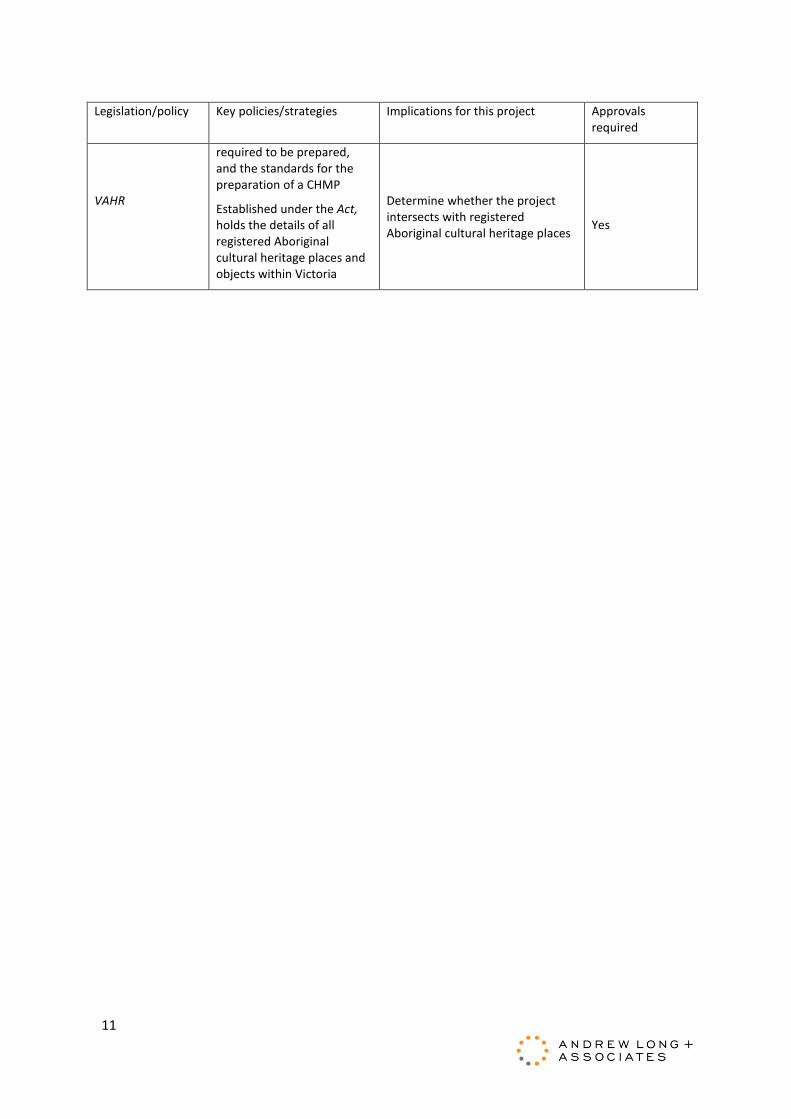
Aboriginal Heritage Act and Regulations
The Act provides for the protection and management of Victoria’s Aboriginal heritage with processes linked to the Victorian planning system. The Regulations set out the circumstances in which a Cultural Heritage Management Plan (CHMP) is
A CHMP is required if an Environment Effects Statement is required (Part 4 Div 2 s49)
Yes
11
Legislation/policy Key policies/strategies Implications for this project Approvals required
VAHR
required to be prepared, and the standards for the preparation of a CHMP
Established under the Act, holds the details of all registered Aboriginal cultural heritage places and objects within Victoria
Determine whether the project intersects with registered Aboriginal cultural heritage places
Yes

12
4 4. METHOD
This section describes the method that was used to assess the potential impacts of the Edithvale and Bonbeach level crossing removal projects.
A systematic risk based approach was applied to understand the existing environment, potential impacts of the projects and how to avoid, minimise or manage the risk.
The iterative nature of the assessment is illustrated in Figure 4.

13
Figure 4: Overview of impact and risk assessment process

14
4.1 Existing conditions assessment
The existing conditions assessment was used to establish the study area and provide a baseline assessment of the Aboriginal cultural heritage within it.
4.1.1 Study area The Edithvale and Bonbeach project areas and the activity area for the CHMP (ID 15158) is founded on the design provided on the 20 September 2017 (Figure 1).
In accordance with the requirements of s. 54 of the Act, on 17 July 2017 a formal Notice of Intent to Prepare a CHMP (NOI) was submitted to the Secretary, Department of Premier and Cabinet. Aboriginal Victoria responded to the NOI on 17 July 2017 by issuing CHMP Number 15158.
For consistency with the CHMP, the activity area is considered within the project boundary as the study area for the impact assessment report. The activity area must encompass all proposed activities to be considered by the CHMP. These activities must be presented in the activity description section of the CHMP to ensure compliance.
Further, the project boundary is consistent with the geographic region, as presented in the CHMP. The geographic region provides a context for the activity area in order to gain a better understanding of the possible resources available to pre-contact Aboriginal people and European settlers which may have influenced past human activity. This information also assists in determining the degree to which environmental and/or human processes have impacted on Aboriginal cultural heritage places.
The geographic region has been defined as an irregular buffer of the activity area. This irregular buffer, approximately one kilometre, neatly captures the dominant geological and vegetation classes historically relevant to the activity area, and which includes a number of previously registered Aboriginal cultural heritage places associated with a variety of substrates in the vicinity of the activity area.
Where appropriate, reference will also be made to the wider geographic region, previously defined for the original activity area for the Frankston Railway Line – Level Crossing Removal Project CHMP 14493, between Bentleigh and Frankston (approximately 27 kilometres long by two kilometres wide), to provide a broader context for the Edithvale and Bonbeach project areas in instances where limited relevant records are available regarding previous studies or the likely nature of local Aboriginal cultural heritage places (Figure 14)1.
1 Note that on 17 July 2017 a formal request to change the activity area for CHMP 14493 was provided to the Secretary, Department of Premier and Cabinet to consider works associated with the Southern Program - Initial Works Package CHMP.

15
4.1.2 Establish existing conditions The existing conditions surrounding the Edithvale project area and the Bonbeach project area were assessed by reviewing the project boundary’s geographic and environmental context, an assessment of the historical environment and various heritage databases.
4.1.2.1 A review of the landforms or geomorphology The geographic and environmental context of the project boundary provides an understanding of the possible resources available to Aboriginal people prior to European contact. In addition, this information also assists in determining the degree to which environmental, such as natural erosion of landforms and/or human processes, such as land clearance and cultivation have impacted on Aboriginal cultural heritage places.
4.1.2.2 Historical environment The environmental context within the project boundary and the possible resources available to Aboriginal people prior to European contact provides an understanding of what parts may have served as a focus for Aboriginal use or occupation. A review of environmental datasets was used to provide an insight into the environment utilised by hunter-gather groups within the region.
4.1.2.3 Heritage register search A review of the relevant registers is necessary to identify known heritage and characterise heritage site types and locations likely to be present within the project boundary.
The methods used to undertake this assessment included, but were not limited to, examination of the following registers:
• Victorian Aboriginal Heritage Register (Aboriginal Victoria)
• Victorian Aboriginal Heritage Register Supplementary Lists – Aboriginal Historic Places and Action File (Aboriginal Victoria)
• National Heritage List (Australia)
• A search was undertaken of the Australian National Heritage List and the VAHR, accessed through the Aboriginal Cultural Heritage Register & Information System on 5 June 2017.
4.1.2.4 A review of historical and ethnohistorical accounts A review of available ethnohistorical and historical information relating to Aboriginal people in the region assists in formulating a model of Aboriginal subsistence and occupation patterns in the project boundary.
In conjunction with an analysis of the documented archaeological record of the region, the ethnohistorical information assists in the interpretation of archaeological sites in the wider area and in predicting the potential locations of various archaeological site types within the project boundary.
4.1.2.5 Review of reports about Aboriginal cultural heritage – regional studies Previous studies in the Melbourne area assist in characterising the general pattern of archaeological site distribution across a broad regional environment.

16
4.1.2.6 Review of reports about Aboriginal cultural heritage – local studies A series of local studies have been reviewed to assist with understanding the level of previous archaeological investigation within the project boundary and to characterise the likely archaeological and cultural heritage values of the different project areas.
4.1.2.7 Land use history Land use activities have the potential to significantly affect the preservation and condition of surface and subsurface archaeological deposits. A review of the land use history provided an overview of the key periods of European activity within the project boundary and the impacts of these developments had on ground surfaces.
The historical heritage impact assessment (EES Technical Report N Historic Heritage) was also used to inform the review of land use history within the project boundary.
4.1.2.8 Site survey A standard assessment as part of CHMP 15158 was undertaken on 4 September 2017.
As the results of the CHMP 15158 desktop assessment show that it is reasonably possible that Aboriginal heritage is present in the activity area, the standard assessment was undertaken in accordance with Regulation 59.
A complex assessment will be prepared in accordance with Regulation 61, if the results of the desktop or standard assessment show that Aboriginal heritage is present, or is likely to be present in the activity area, and it is not possible to define the extent, nature and significance of the heritage.
Detailed information in relation to the outcomes of these assessments will be available in the CHMP.
A summary of the results of the standard assessment is presented in Section 5.7.8 to 5.7.10.
4.1.2.9 Preliminary archaeological potential rating The preliminary archaeological potential rating (APR) indicates the relative likelihood of archaeological deposits occurring within the project boundary, examining both the intensity of Aboriginal use of the landscape and the probability that any evidence is likely to have survived past and current land uses.
The APR is based on a combination of the archaeological sensitivity rating (from low to high) and the disturbance rating (from high to none), with the ratings values sequence reversed, as shown in Table 2.
Historical aerial images assist in determining the past extent of construction activities and the level of ground disturbance. Disturbance ratings also considered the results of the desktop assessment and the site inspection undertaken during the standard assessment for the CHMP 14493, currently being prepared for LXRA that includes the Combined Services Route on the Frankston line between Bentleigh and Frankston, level crossing removals for Carrum and Seaford, Patterson River Bridge works and additional train stabling at Kananook.
The disturbance rating is particularly useful when considering the likelihood of in situ archaeological deposits being present. It is important to note archaeological sites, especially stone artefact sites, can survive a variety of impacts from prior land use activities with only their structure and condition affected rather than the artefact content.

17
Table 2: Archaeological sensitivity/disturbance ratings
Archaeological sensitivity Rating Disturbance
Low 1 High
Low-moderate 2 Moderate-high
Moderate 3 Moderate
Moderate-high 4 Low
High 5 None
The resulting values of the archaeological sensitivity and disturbance ratings are multiplied to achieve an overall preliminary APR for within the project boundary.
4.1.2.10 Disturbance mapping The information sources used to develop disturbance mapping included the following EES specialist studies:
• EES Technical Report C Acid Sulfate Soils and Contamination
• EES Technical Report F Land Use
• EES Technical Report N Historic Heritage
Relevant mapped data from these specialist studies were used to create the disturbance map.
4.2 Risk assessment method
A risk-based approach is integral to the EES as required by Section 3 of the Scoping Requirements for the EES.
The risk management approach adopted for the Edithvale and Bonbeach EES is consistent with AS/NZS ISO 31000:2009 Risk Management Process and involves the following steps:
establishment of the context of the risk assessment – this identifies the boundaries of the projects including the project definition, the duration of construction and operation, the design and environmental controls that would be in place (initial Environmental Performance Requirements (EPRs) – refer to section 6), and the location of the projects
risk identification – identification of risk pathways by specialists in each relevant discipline area
risk analysis – assessment of risk for each risk pathway, whereby risk is a combination of:
o the likelihood of an event and its associated consequences occurring
o the magnitude of potential consequences of the event.
risk evaluation – review key risks posed by the projects to focus effort in terms of impact assessment and mitigation.
risk treatment – identification of additional management and mitigation where required to reduce risk levels where possible.
An initial risk assessment was undertaken to assess potential risks to the environment arising from the implementation of the projects. Where risks were minor or above, further mitigation was explored. Risks were re-assessed to determine the residual risk based on further mitigation.
A more detailed description of each step in the risk assessment process is provided in EES Attachment II Environmental Risk Report.

18
This technical report describes the risks associated with the projects on Aboriginal cultural heritage.
4.3 Impact assessment method
The study has assessed the impact to Aboriginal cultural heritage during construction of the projects on the assets and values to be managed and protected.
The impacts may potentially occur to previously unregistered and registered Aboriginal cultural heritage places during ground disturbing works associated with the projects.
The preparation of a standard and complex assessment as part of a CHMP for the activity area, including a program of subsurface investigation, will be undertaken in order to identify the nature, extent and significance of Aboriginal cultural heritage in accordance with Regulation 60 (1b) of the Aboriginal Heritage Act (2006). Further, an approved CHMP will provide a process to manage any harm to Aboriginal cultural heritage by construction activities.
4.4 Environmental Performance Requirements
The environmental outcomes that must be achieved during design, construction and operation of the projects are referred to throughout the EES as Environmental Performance Requirements (EPRs). EPRs must be achieved regardless of the construction methodology or design solutions adopted. Measures identified in this EES to avoid or minimise environmental impacts have formed part of the recommended EPRs for the projects.
The development of a final set of EPRs for the project has been iterative.
4.4.1 Initial EPRs Environmental performance requirements were identified to inform the assessment of initial risk ratings (where appropriate). These initial EPRs were based on compliance with legislation and standard requirements that are typically incorporated into the delivery of construction contracts for rail projects.
4.4.2 Confirm or update EPRs The risk assessment either confirmed that these EPRs were adequate or identified the need for further refinement.
EPRs were updated or new EPRs were developed for any initial risk that could not be appropriately managed by standard requirements. The risk and impact assessment processes confirmed the effectiveness of new or updated EPRs to determine the residual risk rating.
4.4.3 Final EPRs The EPRs recommended for the projects are outlined in Section 8 of this report and are included in the EES Environmental Management Framework.
The EPRs are applicable to the final design, construction approach and operation and provide certainty regarding the environmental performance of the projects.
4.5 Linkages to other technical reports
This report relies on, or informs the following technical assessments:
• EES Technical Report C Acid Sulfate Soils and Contamination
• EES Technical Report F Land Use

19
• EES Technical Report N Historic Heritage

20
5 5. EXISTING CONDITIONS
It is important to understand the geographic and environmental context of the project areas to gain a better understanding of the possible resources available to Aboriginal people and European settlers which may have influenced past human activity. This information also assists in determining the degree to which environmental (e.g. natural erosion of landforms) and/or human processes (e.g. land clearance, cultivation) have impacted on Aboriginal cultural heritage places.
For the purposes of this report, the geographic region has been defined as an approximate one kilometre radial buffer centred on the Edithvale and Bonbeach project areas and, where relevant, bounded along its western margin by the high-water mark of Port Phillip Bay. This region neatly captures the dominant topographic features and underlying geological substrates relevant to the Edithvale and Bonbeach project areas, as well as several Aboriginal cultural heritage places and historically relevant vegetation classes. It is deemed sufficient to adequately capture information relating to relevant landforms, geology and soils, fauna and flora, and past evidence for Aboriginal occupation relating to the project areas, including all relevant Aboriginal cultural heritage place types.
Where appropriate, reference will also be made to the wider geographic region, previously defined for the original activity area for the Frankston Railway Line – Level Crossing Removal Project CHMP 14493, between Bentleigh and Frankston (approximately 27 kilometres long by two kilometres wide), to provide a broader context for the Edithvale and Bonbeach project areas in instances where limited relevant records are available regarding previous studies or the likely nature of local Aboriginal cultural heritage places.
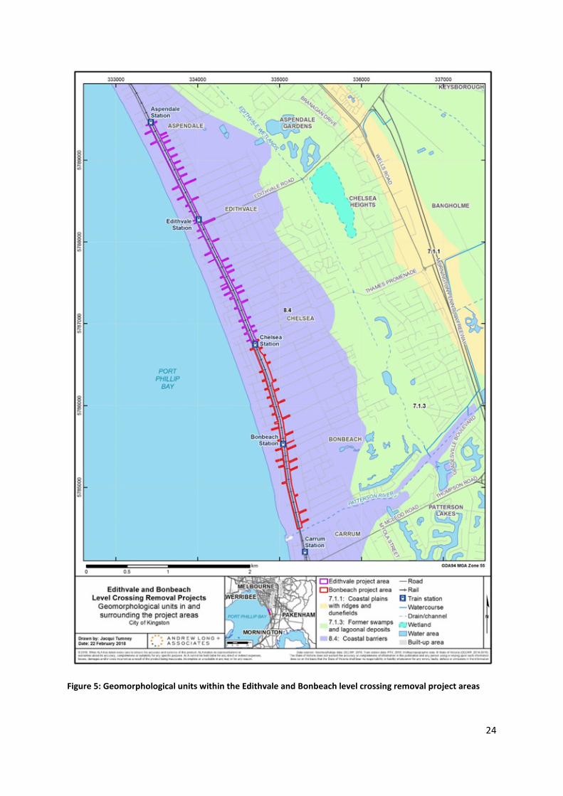
5.1 A review of landforms or geomorphology
The geographic region is situated within the Eastern Plains and Coast geomorphological units as defined within Victoria’s Geomorphological Framework. More precisely, the project areas sit within sub-unit 8.4 (coastal barriers within the Coast unit) and sub-unit 7.1.3 (former swamps and lagoonal deposits).
Unless otherwise referenced, the following landform, geological and geomorphological descriptions are derived from online resources developed by the Victorian Government, including GeoVic 3 and Victorian Resources Online. The geomorphology of the geographic region is presented in Figure 5, and the geology in Figure 6.
The coastal barrier between Mordialloc and Frankston compromises a quartzose sand beach (Bird 1993: 160), which forms the seaward margin of an outer barrier system that was backed by Carrum Swamp. Carrum Swamp drained either to the north into Mordialloc Creek or south into Kananook Creek, which flows along a swale between outer barrier foredunes southwards for several kilometres before opening to the shore at Frankston (Bird 1993: 160). The area originally comprised an outer sandy barrier dating to the Holocene and segments of an inner sandy barrier dating to the Pleistocene, separated and backed by extensive swamps that were eventually drained and reclaimed by cutting an artificial channel (the Patterson River) in 1879 (Bird 1993: 166; see Figure 7).

21
Former swamps and lagoonal deposits on the Eastern Plains which form the eastern margin of the geographic region are the result of swamp deposits from streams and rivers, including:
• Dandenong and Eumemmerring creeks, that flowed into the former Carrum swamp
• Cardinia Creek and the Bunyip River that flowed across the alluvial plains south of Pakenham into the former Koo-Wee-Rup Swamp (includes the Dalmore Swamp)
• The Bass and Lang Lang Rivers which flowed into their respective alluvial plains and swamps.
The geological substrates underlying the geographic region include the following deposits:
• Unnamed coastal dune deposits (Qdl1): comprising sand, silt and clay deposited as poorly consolidated coastal dunes and beaches during the Holocene (11,700 years ago to the present).
• Unnamed coastal lagoon deposits (Qg): comprising silts and clays deposited in lagoon environments during the Holocene 11,700 years ago to the present).
The project areas directly overlie the unnamed dune deposits forming the outer coastal barrier and the western margins of the coastal lagoon deposits.
Soils within the project areas are likely to be pale grey sands overlying silts and clays.
5.2 Historical environment
The climate of Australia has altered and fluctuated since the time of earliest human occupation during the Pleistocene period, around 40,000-60,000 years ago. The Pleistocene period is conventionally dated from two million to 10,000 years ago (Mulvaney and Kamminga 1999: 103; Aguirre and Pasini 1985; Lourens 2008: 239). During the Pleistocene, lower sea levels were present across Australia, and the southern coastline extended southwards, connecting Tasmania to the Australian mainland (Cosgrove 1999: 362). During the Late Pleistocene to Early Holocene (the Holocene period generally dates from around 10,000 years ago to the present day (Mulvaney and Kamminga 1999: 103)) sea levels began to rise in response to post-glacial marine transgression resulting from the melting of Late Pleistocene ice sheets (Lambeck and Nakada 1990: 143). This rise in sea levels separated Tasmania from the mainland, and reduced the Australian coastline. Victorian sea levels stabilised and reached modern levels before around 6000 years Before Present (BP) (Lambeck and Nakada 1990: 149).
During the period of Aboriginal occupation of the Melbourne region, the climatic conditions varied greatly in regards to temperature and rainfall levels. During the Last Glacial Maximum of the Pleistocene period (21,000-15,000 years BP), temperatures were approximately 6-10 degrees lower than today (Mulvaney & Kamminga 1999: 116). During the late Pleistocene period, there was less rainfall and less precipitation throughout the continent, reducing the woodland forest areas of southern Australia and resulting in a predominance of grasslands. Within this time, there is evidence for dry/shallow lakes with conditions likely to have been too dry to support swamp or open-water environments (Bowler 1981: 436-437; Aitken and Kershaw 1993: 76). The inland of Australia was characterised by arid and dry conditions and it is likely that Aboriginal people during this period would have experienced severe drought. Within southern Victoria these climatic conditions generally discouraged tree growth, although some trees survived in particularly sheltered and watered areas (Mulvaney & Kamminga 1999: 116).
In the late Pleistocene to early Holocene (around 12,000-9,000 BP), warmer temperatures and increased precipitation resulted in the expansion of woodland and forest areas dominated by Eucalypts (Aitken and Kershaw 1993: 67). At this time, the Tadpole Swamp (now located within the Cranbourne botanic gardens) was formed, possibly supported directly by precipitation or, as is more

22
likely, a rise in the regional water table caused by wetter conditions (Aitken and Kershaw 1993: 76). At Tadpole Swamp, pollen and charcoal sample analysis of sediment cores indicate that permanent wet conditions in the Cranbourne area were in existence after 8,500BP. The highest moisture levels occurred between 7,000 and 5,000 years ago as evidenced by the expansion of wet sclerophyll taxon Pomaderris in the understorey (Aitken and Kershaw 1993: 77).
Similar peaks in Pomaderris also occurred in data from the Gippsland Lakes and with the period of highest lake levels in the volcanic crater lakes from the Western Plains (Aitken and Kershaw 1993: 77; Kershaw et al. 2004: 154).
The analysis from Cranbourne also displays the fluctuating environmental conditions of the Holocene, with data indicating that after 5,000 years ago, vegetation in the Cranbourne area became more diverse with an increased representation of understorey vegetation relating to Eucalyptus (Aitken and Kershaw 1993: 78). Aitken and Kershaw suggest that it is likely that the eucalypt canopy became more open with an understorey mosaic of heath, bracken and grassland, possibly due to climatic variability with lower rainfall experienced in the Late Holocene, and also the possible result of increased burning indicated by relatively high levels of charcoal (Aitken and Kershaw 1993: 78). Palaeoecological studies of the Gippsland Lakes also indicate that lower levels of moisture were available during the late Holocene, with fluctuating fresh water conditions experienced at Lake Wellington (Reid 1989: 48). Data from crater lakes in south western Victoria also show a decline in water levels during the mid-Holocene, with a more substantive decline after approximately 5,000 years, and water levels oscillating perhaps as a result of fluctuating temperatures until the later Holocene from around 1.8-1.3 thousand years ago (Wilkins et al 2013: 8, 10). Aitken and Kershaw’s investigations at Cranbourne also highlight vegetation changes during the period of European occupation, with analysis from Tiger Snake Swamp within the Cranbourne botanic gardens revealing the addition of exotic vegetation including pines, docks and sorrels, plantains and asters/daisies, and an increase in shrub understories of woodland vegetation or the replacement of woodlands by scrubland and heath vegetation (Aitken and Kershaw 1993: 78). This general increase in grasses is partially a response to vegetation clearance activities, with bracken and Casuarina showing a marked decline.
The climate of the geographic region is generally described as temperate with dry, warm to hot summers and cool, wet winters (LCC 1991: 57). Considerable topographic variation across the Melbourne region makes the climate within the area generally quite variable. Summer drought conditions over most of the area not only create an environment particularly susceptible to fire, but inhibit plant growth for up to three months. Winter temperatures retard plant growth in all areas, and frost commonly occurs in some.
Climate statistics for relevant weather stations are presented in Table 3.
Table 3: Climate data for the wider area
Weather Station
Mean Max Temperature (oC) Mean Min Temperature (oC) Average Annual Rainfall (mm) High Low High Low
Moorabbin Airport
26.1 (February) 13.7 (July) 14.4 (February) 6.2 (July) 709
Frankston 24.9 (February) 12.8 (July) 16.0 (February) 8.0 (July) 710
The project areas are situated entirely within the Gippsland Plain Bioregion2 which is characterised by lowland alluvial and coastal plains formed from erodible Tertiary sediments and Quaternary alluvial
2 http://mapshare2.dse.vic.gov.au/MapShare2EXT/imf.jsp?site=bim – accessed 31 August 2016

23
deposits (VEAC 2010: 73). The terrain is flat to gently undulating and vegetated by Swamp Scrub and open forests with a grassy and herbaceous ground layer. The bioregion is generally below 200 metres in altitude, with coastal areas of sandy beaches, shallow inlets and extensive mudflats and mangroves. The Gippsland Plain contains a large number of freshwater wetlands and saline estuaries and lagoons.
Descriptions of the likely vegetation classes that would have been dominant in the area prior to 1750 have been derived from modelling developed by the Department of Environment, Land, Water & Planning (DELWP)3 (Figure 8).
The wider geographic region defined for CHMP 14493 includes a diverse range of Ecological Vegetation Classes (EVCs) that are characteristic of the Gippsland Plain bioregion. These include:
• Lower Slopes or Hills Woodlands
• Herb-rich Woodlands
• Heathy Woodlands
• Coastal Scrubs Grasslands and Woodlands
• Riparian Scrubs or Swampy Scrubs and Woodlands
• Wetlands
According to current modelling, the project areas would have been situated within EVC Group 1: Coastal Scrubs Grasslands and Woodlands; specifically, EVC 2 Coast Banksia Woodland. This EVC is restricted to coastal localities on secondary or tertiary dunes behind Coastal Dune Scrub. It is usually dominated by a woodland overstorey of Coast Banksia (Banksia integrifolia) to 15 metre tall over a medium shrub layer. The understorey consists of a number of herbs and sedges, including scramblers. Common tree and shrub species would have included Coast Banksia (Banksia integrifolia), and understory grasses and herbs would have included Austral Bracken (Pteridium esculentum).
Other vegetation types local to the project areas would have included:
• EVC Group 15: Herb-rich Woodlands (specifically, EVC 418 Damp Sands Herb-rich Woodland/Heathy Woodland Complex)
• EVC Group 18: Wetlands (specifically, EVC 125 Plains Grassy Wetlands).
3 http://www.depi.vic.gov.au/environment-and-wildlife/biodiversity/evc-benchmarks#gipp – accessed 30 June 2016
24
Figure 5: Geomorphological units within the Edithvale and Bonbeach level crossing removal project areas

25
Figure 6: Geological units within the Edithvale and Bonbeach level crossing removal project areas

26
Figure 7: 1866 survey map of Port Phillip Bay coastline between Mordialloc and Kananook creeks (source: Bird 1993: Figure 112)
Carrum Swamp
Inner sandy barrier
Outer sandy barrier

27
Figure 8: Modelled 1750 Ecological Vegetation Classes (EVCs) within Edithvale and Bonbeach level crossing removal project areas

28
5.3 Heritage register searches
A search of the Victorian Aboriginal Heritage Register (VAHR) covering the full extent of the original activity area and geographic region defined for CHMP 14493 was conducted on 24 August 2016. Note that an updated VAHR search was undertaken on the 31 August 2017 for the Edithvale and Bonbeach project areas, as defined by the geographic region for CHMP 15158. The results of the VAHR searches are presented in Table 4, Table 5 and Table 6.
There are no registered Aboriginal cultural heritage places within one kilometre of the Bonbeach project area. A total of two registered Aboriginal cultural heritage places (Table 4) are located within a one kilometre radius of the Edithvale project areas. These include:
• two low density artefact distributions (LDADs)
In terms of the coordinates recorded for these places, none fall within the Edithvale or Bonbeach project areas. The two Aboriginal cultural heritage places are located on flat low-lying land east of the project area. There are also cluster of Aboriginal cultural heritage places located at the edge of a sand ridge, associated with a former shoreline at Chelsea Heights approximately 1.5 kilometres east of the Edithvale project area. Although this represents a discrete landform, not intersected by the Edithvale project area, it is of interest that Pleistocene dates were recorded at this location (Kennedy et al. 2012).
A total of 51 registered Aboriginal cultural heritage places (Table 5) are located within a one kilometre radius of the wider activity area defined for CHMP 14493. These include:
• 13 artefact scatters
• one artefact scatter associated with a shell midden
• 18 low density artefact distributions (LDADs)
• seven shell middens
• six scarred trees
• two privately owned artefact collections
• five historical places (one in association with a registered shell midden)
In terms of the coordinates recorded for these places, none fall within the wider CHMP 14493 activity area or the Edithvale or Bonbeach project areas. However, at least one historical place (VAHR 7921-1446 Mordialloc Aboriginal Reserve) intersects with the CHMP 14493 activity area, and it is likely that the place extent inferred for a shell midden (VAHR 7921-0669 Mordialloc Shell Midden 1) also intersects the CHMP 14493 activity area. Neither of these places have the potential to intersect with either the Edithvale or Bonbeach project areas.
The following points emerge from a review of these 51 registered Aboriginal cultural heritage places:
• Most places are clustered at three locations:
o within or near Cheltenham Golf Course and the Cheltenham Pioneer Cemetery
o within one kilometre of Mordialloc Creek where it debouches into Port Phillip Bay
o within 2.5 kilometres of Frankston
• This distribution probably reflects the recent history of cultural heritage investigations and an earlier pattern of post-contact Aboriginal occupation across the geographic region, rather than accurately representing a pre-contact pattern of Aboriginal occupation across the region.

29
• Registered places are located on coastal dunes, inland dunes and plains, and along the margins of the former Carrum Swamp, i.e. they are found on all major landforms characterising the CHMP geographic region.
• Places containing stone artefacts (artefact scatters and LDADs) are the most commonly occurring Aboriginal cultural heritage place within the CHMP geographic region. They occur on all major landforms across the region.
• Thirty artefact scatters/LDADs have data recorded on the number of stone artefacts present within each place. Of these, 28 (93 percent) contain 10 or less artefacts (including 11 (37 percent) isolated artefacts), and on this basis, should all be considered LDADs according to the terminology currently recommended by Aboriginal Victoria. Most these places were identified as subsurface deposits during CHMP complex assessments.
• Two (seven percent) artefact scatters contain more than ten artefacts: VAHR 7921-1613, comprising 13 artefacts situated in disturbed contexts on the sandy plain adjacent to Carrum Swamp; and VAHR 7922-0956, comprising at least 18 artefacts situated on an inland dune in Cheltenham.
• Silcrete and quartz appear to be equally dominant raw materials across the geographic region. Quartzite and chert appear sporadically in the regional assemblage.
• Stone artefact types found across the geographic region include flakes, angular fragments, blades, scrapers and cores. Formal tools include bondi points, thumbnail scrapers, and geometric microliths.
• Scars have been identified on Red Gums, Manna or Swamp Gum, Banksia and several unidentified tree species. The cultural status of two of these sites (VAHR 7921-0297 and 7921-0298) is uncertain.
• Shell middens are generally found near the coastline or inland estuaries such as Mordialloc Creek. The coastal middens mostly contain a mix of rocky and sandy shore species, while the estuarine middens mostly contain either cockles (Anadara) or oysters (Ostrea).
The five registered Aboriginal historical places listed in Table 5 (VAHR 7921-0669, 7921-1446, 7922-0958, 7922-0959 and 7922-0960) and the six historical references listed in Table 6 have all been identified based on historical references and/or physical associations with archaeological sites. None of these historical references spatially overlap with the Edithvale or Bonbeach project areas.

30 Tabl
e 4:
Reg
iste
red
Abor
igin
al c
ultu
ral h
erita
ge p
lace
s and
his
toric
al p
lace
s loc
ated
with
in th
e ge
ogra
phic
regi
on d
efin
ed in
CHM
P 15
158
(Edi
thva
le p
roje
ct a
rea)
VAHR
Pl
ace
Nam
e Pl
ace
Type
Su
rfac
e /
Subs
urfa
ce
Dept
h (m
m)
No.
Ar
tefa
cts
Raw
M
ater
ials
Co
nten
ts
Land
form
79
21-1
520
LDA
D LD
AD
Subs
urfa
ce
290-
300
1 S
1 ba
cked
bla
de
Inla
nd sw
amp
7921
-153
0 LD
AD
LDAD
Su
bsur
face
20
0-25
0 3
S 2
flake
s, 1
bla
de
Inla
nd p
lain

31
Tabl
e 5:
Reg
iste
red
Abor
igin
al c
ultu
ral h
erita
ge p
lace
s and
his
toric
al p
lace
s loc
ated
with
in th
e w
ider
geo
grap
hic
regi
on d
efin
ed in
CHM
P 14
493
VAHR
Pl
ace
Nam
e Pl
ace
Type
Su
rfac
e /
Subs
urfa
ce
Dept
h (m
m)
No.
Ar
tefa
cts
Raw
M
ater
ials
Co
nten
ts
Land
form
79
21-0
187
EEL
RACE
RD
1 Ar
tefa
ct
scat
ter
Surf
ace
Q, C
O
chre
(rar
e) a
nd fl
aked
ston
e ar
tefa
cts
Sand
ridg
e ad
jace
nt to
swam
p
7921
-024
2 SE
AFO
RD 1
Sh
ell m
idde
n Su
rfac
e
Rock
y sh
ore
spec
ies (
Subn
inel
la,
Myt
ilus)
Co
asta
l dun
e slo
pe
7921
-024
3 M
cIN
DOE
PARA
DE 1
Sh
ell m
idde
n Su
rfac
e
Rock
y sh
ore
spec
ies (
Subn
inel
la,
Cella
na M
ytilu
s)
Coas
tal b
luff
7921
-029
4 KA
NAN
OO
K CR
EEK
1 Sc
arre
d tr
ee
Surf
ace
U
nide
ntifi
ed sp
ecie
s; a
t lea
st 1
scar
Co
asta
l pla
in a
djac
ent t
o Ka
nano
ok C
reek
79
21-0
295
KAN
ANO
OK
CREE
K 2
Scar
red
tree
M
anna
or S
wam
p Gu
m; 5
scar
s;
unce
rtai
n ID
Co
asta
l pla
in a
djac
ent t
o Ka
nano
ok C
reek
79
21-0
296
SEAF
ORD
2
Shel
l mid
den
Surf
ace
Ro
cky
shor
e (M
ytilu
s) a
nd sa
ndy
shor
e/es
tuar
ine
(Ost
rea)
spec
ies
Coas
tal d
une
slope
7921
-029
7 DE
NBI
GH R
D 1
Scar
red
tree
U
nide
ntifi
ed e
ucal
ypt;
6 sc
ars;
un
cert
ain
ID
Coas
tal p
lain
7921
-029
8 DE
NBI
GH R
D 2
Scar
red
tree
Ba
nksia
; 2 sc
ars;
unc
erta
in ID
Co
asta
l pla
in
7921
-034
5 SE
AFO
RD M
IDDE
N
Shel
l mid
den
Surf
ace
Sa
ndy
shor
e/es
tuar
ine
spec
ies
(Ost
rea,
Mod
iolu
s); e
rodi
ng
Sand
ridg
e ad
jace
nt to
Ka
nano
ok C
reek
79
21-0
346
SEAF
ORD
AXE
S O
bjec
t co
llect
ion
Subs
urfa
ce
2
G 2
grou
nd e
dge
axes
Sa
nd ri
dge
adja
cent
to
Kana
nook
Cre
ek
7921
-066
9 M
ORD
IALL
OC
CREE
K M
IDDE
N 1
Sh
ell
mid
den;
Ab
orig
inal
hi
stor
ical
pl
ace
Surf
ace
Ro
cky
shor
e sp
ecie
s (M
ytilu
s,
Aust
roch
ochl
ea);
high
ly d
istur
bed
cont
ext
Coas
tal s
ands
heet
adj
acen
t to
Mor
dial
loc
Cree
k
7921
-087
7 M
ORD
IALL
OC
CREE
K M
IDDE
N 2
Sh
ell m
idde
n Su
rfac
e
Mai
nly
estu
arin
e sp
ecie
s (An
adar
a an
d O
stre
a)) w
ith ro
cky
shor
e (A
balo
ne, S
cutu
s) a
nd sa
ndy
shor
e (D
onax
); di
stur
bed
cont
ext
Mor
dial
loc
Cree
k ba
nk
7921
-087
8 M
ORD
IALL
OC
CREE
K M
IDDE
N 3
Sh
ell m
idde
n Su
rfac
e
Estu
arin
e sp
ecie
s (An
adar
a); h
ighl
y di
stur
bed
cont
ext
Leve
e ad
jace
nt to
Mor
dial
loc
Cree
k 79
21-0
879
MO
RDIA
LLO
C CR
EEK
SCAR
RED
TREE
Sc
arre
d tr
ee
Rive
r Red
Gum
; 4 sc
ars;
axe
mar
ks
Leve
e ad
jace
nt to
Mor
dial
loc
Cree
k 79
21-0
911
1
Arte
fact
sc
atte
r Su
bsur
face
40
0-50
0 3
S 1
brok
en fl
ake,
1 b
roke
n bl
ade,
1
angu
lar f
ragm
ent
Inla
nd sa
nd sh
eet

32
VAHR
Pl
ace
Nam
e Pl
ace
Type
Su
rfac
e /
Subs
urfa
ce
Dept
h (m
m)
No.
Ar
tefa
cts
Raw
M
ater
ials
Co
nten
ts
Land
form
79
21-0
912
2
Arte
fact
sc
atte
r Su
bsur
face
98
0 1
Q
1 un
reto
uche
d fla
ke
Inla
nd sa
nd sh
eet
7921
-107
7
Arte
fact
sc
atte
r Su
bsur
face
2 Q
, Qz
2 fla
kes;
dist
urbe
d In
land
dun
e
7921
-134
7 A
S1
Arte
fact
sc
atte
r Su
bsur
face
70
0-80
0 2
S 1
brok
en b
lade
, 1 th
umbn
ail s
crap
er
Coas
tal d
une
7921
-136
6 Du
ncan
Ave
nue
1 Ar
tefa
ct
scat
ter
Subs
urfa
ce
100
3 S,
Q
2 fla
ke fr
agm
ents
, 1 fl
aked
pie
ce;
foun
d in
impo
rted
fill
Coas
tal d
une
7921
-137
7 M
cMah
ons R
d,
Fran
ksto
n 2
Arte
fact
sc
atte
r Su
bsur
face
45
0-70
0 5
Q, Q
z, B
4
brok
en b
lade
s, 2
ang
ular
fr
agm
ents
In
land
pla
in
7921
-137
8 M
cMah
ons R
d,
Fran
ksto
n IA
1 Ar
tefa
ct
scat
ter
Subs
urfa
ce
650-
700
1 Q
1
angu
lar f
ragm
ent
Inla
nd P
lain
7921
-139
4 De
nbig
h St
reet
IA1
Arte
fact
sc
atte
r Su
bsur
face
1,
320
1 FG
S 1
flake
Co
asta
l dun
e
7921
-143
3
Arte
fact
sc
atte
r Su
bsur
face
1,
000
1 Q
1
was
te fl
ake
Inla
nd sw
amp
7921
-143
4
Arte
fact
sc
atte
r Su
bsur
face
35
0 1
Q
1 w
aste
flak
e In
land
swam
p
7921
-144
0
LDAD
Su
bsur
face
10
0 1
1
angu
lar f
ragm
ent
7921
-144
4 M
ordi
allo
c Be
ach
1 IA
LD
AD
Subs
urfa
ce
800-
1,00
0 2
Q
1 fla
ke, 1
ang
ular
frag
men
t
7921
-144
6 M
ordi
allo
c Ab
orig
inal
Res
erve
Ab
orig
inal
Hi
stor
ical
Pl
ace
7921
-150
1 Ko
rrig
o 1
LDAD
Su
bsur
face
35
0-40
0 1
Q
1 an
gula
r fra
gmen
t; hi
ghly
dist
urbe
d co
ntex
t Cr
est o
f a ri
se
7921
-150
5 Ko
rrig
o 2
Arte
fact
sc
atte
r/Sh
ell
mid
den
Subs
urfa
ce
300-
450
650-
800
950-
1,20
0
Mix
of r
ocky
shor
e (M
ytilu
s, T
urbo
, Ce
llana
) and
sand
y sh
ore/
estu
arin
e (O
stre
a); u
nwor
ked
burn
t sto
ne
Coas
tal d
une
7921
-152
0 L
DAD
LDAD
Su
bsur
face
29
0-30
0 1
S 1
back
ed b
lade
In
land
swam
p

33
VAHR
Pl
ace
Nam
e Pl
ace
Type
Su
rfac
e /
Subs
urfa
ce
Dept
h (m
m)
No.
Ar
tefa
cts
Raw
M
ater
ials
Co
nten
ts
Land
form
79
21-1
530
LD
AD
LDAD
Su
bsur
face
20
0-25
0 3
S 2
flake
s, 1
bla
de
Inla
nd p
lain
7921
-158
1 Ce
cil S
tree
t Fr
anks
ton
LDAD
Su
bsur
face
1,
020
1 Q
1
flake
Lo
w re
lief p
late
au
7921
-158
8 Br
agge
LDA
D LD
AD
Subs
urfa
ce
200-
400
3 Q
2
flake
s, 1
cor
e Co
asta
l dun
e
7921
-159
5 Di
ngle
Ave
nue
LDAD
1 LD
AD
Subs
urfa
ce
700-
900
3 Q
, S
2 fla
kes,
1 a
ngul
ar fr
agm
ent
Inla
nd d
une
(Cra
nbou
rne
Sand
s)
7921
-160
5 Be
ar S
tree
t M
ordi
allo
c LD
AD 1
LD
AD
Subs
urfa
ce
500-
650
1m-
1.2m
6 Q
, S
5 an
gula
r fra
gmen
ts (Q
), 1
back
ed
mic
rolit
h (S
) In
land
dun
e ne
ar C
arru
m
Swam
p
7921
-160
9 L
DAD1
LD
AD
Subs
urfa
ce
200/
700
4 Q
, Qz,
S, C
3
flake
d pi
eces
, 1 c
ore
(C)
Coas
tal d
une
7921
-161
0 L
DAD1
LD
AD
Subs
urfa
ce
600
1 S
1 fla
ked
piec
e In
land
swam
p
7921
-161
2 Du
ncan
Ave
nue
LDAD
LD
AD
Subs
urfa
ce
400
3 S,
Qz,
C
2 fla
kes,
1 c
ore
(C)
Sand
y pl
ain
adja
cent
to C
arru
m
Swam
p 79
21-1
613
Dunc
an A
venu
e AS
Ar
tefa
ct
scat
ter
Subs
urfa
ce
0-40
0 13
S,
Qz
10 fl
akes
, 1 a
ngul
ar fr
agm
ent,
1 fla
t ed
ge sc
rape
r, 1u
nifc
ial p
oint
(Qz)
Sa
ndy
plai
n ad
jace
nt to
Car
rum
Sw
amp
7921
-161
9 L
DAD1
LD
AD
Subs
urfa
ce
100-
700
5 S,
Q
2 fla
kes,
3 a
ngul
ar fr
agm
ents
7921
-162
0 M
erew
eath
er
Aven
ue L
DAD1
LD
AD
Subs
urfa
ce
750
1 S
1 fla
ke
7921
-162
1 L
DAD
LDAD
Su
bsur
face
60
0-70
0 4
Qz
2, fl
akes
, 1 d
ebita
ge, 1
bla
de fl
ake
7921
-162
2
LDAD
LD
AD
Subs
urfa
ce
400-
690
2 S,
Q
1 ge
omet
ric m
icro
lith
(S),
1 an
gula
r fr
agm
ent (
Q)
Sand
y pl
ain
adja
cent
to C
arru
m
Swam
p 79
22-0
956
Ar
tefa
ct
scat
ter
Surf
ace
18
+ S,
Q
1 en
d sc
rape
r, 1
mic
robl
ade,
1
geom
etric
mic
rolit
h, 1
m
ultid
irect
iona
l cor
e
Inla
nd d
une
7922
-095
7
Scar
red
tree
U
nide
ntifi
ed sp
ecie
s, 1
scar
In
land
dun
e
7922
-095
8
Abor
igin
al
hist
oric
al
3 w
ells/
wat
erho
les r
efer
ence
d on
18
72 p
arish
pla
n; e
xact
loca
tion

34
VAHR
Pl
ace
Nam
e Pl
ace
Type
Su
rfac
e /
Subs
urfa
ce
Dept
h (m
m)
No.
Ar
tefa
cts
Raw
M
ater
ials
Co
nten
ts
Land
form
pl
ace
unce
rtai
n
7922
-095
9 TI
GER'
S GR
AVE
Abor
igin
al
hist
oric
al
plac
e
Grav
e of
a n
amed
Abo
rigin
al
pers
on; c
oord
inat
e po
ssib
ly
inco
rrec
t
7922
-096
0 EL
IZA'
S (T
OO
-LU
M)
GRAV
E Ab
orig
inal
hi
stor
ical
pl
ace
Grav
e of
a n
amed
Abo
rigin
al
pers
on; c
oord
inat
e po
ssib
ly
inco
rrec
t
7922
-135
3 He
llier
Col
lect
ion
Obj
ect
colle
ctio
n
Pr
ivat
e co
llect
ion
cont
aini
ng g
roun
d st
one
and
flake
d st
one
arte
fact
s;
hist
ory
sugg
est n
ot c
olle
cted
in
geog
raph
ic re
gion
7922
-140
6 L
DAD
LDAD
Su
bsur
face
16
0-70
0 5
C, Q
z 2
flake
s, 3
ang
ular
frag
men
ts
7922
-140
8 L
DAD
COLL
ECTI
ON
LD
AD
Rebu
ried
loca
tion
of 7
922-
1406

35
Tabl
e 6:
Abo
rigin
al h
isto
rical
refe
renc
es lo
cate
d w
ithin
the
wid
er g
eogr
aphi
c re
gion
def
ined
in C
HMP
1449
3
Hist
oric
al
Refe
renc
e Id
Hi
stor
ical
Ref
eren
ce N
ame
Hist
oric
al R
efer
ence
Ass
ocia
tion
Perio
d of
As
soci
atio
n
4.5-
3 Ca
rrum
Sw
amp
12.1
Pre
-con
tact
food
reso
urce
s/ar
eas w
here
peo
ple
cont
inue
d to
pro
cure
food
5.4-
89
Mor
dial
loc
(J.Ra
ndel
l),
Hono
rary
Co
rres
pond
ent
Depo
t 5.
4 Pr
oper
ties/
loca
tions
of
Hono
rary
Cor
resp
onde
nts
to t
he B
oard
for
the
Pro
tect
ion
of
Abor
igin
es
1872
-187
6
5.4-
90
Mor
dial
loc
(G.H
.War
ren)
, Ho
nora
ry C
orre
spon
dent
De
pot
5.4
Prop
ertie
s/lo
catio
ns o
f Ho
nora
ry C
orre
spon
dent
s to
the
Boa
rd f
or t
he P
rote
ctio
n of
Ab
orig
ines
18
62-1
866
7.1-
12
7.
1 La
nd R
eser
ved
for G
ener
al A
borig
inal
Pop
ulat
ion
Use
18
41-1
878
9.2-
10
Mor
dial
loc
Buria
l Gro
und
9.2
Loca
tion
of b
uria
l gro
unds
out
side
form
al c
emet
erie
s
9.3-
29
Lam
e To
mm
y's G
rave
9.
3 Lo
catio
n of
bur
ials
with
in c
emet
erie
s

36
5.3.1 Edithvale project area Two registered Aboriginal cultural heritage places, comprising two LDADs are situated in the geographic region defined for the Edithvale project area (Figure 9 and Figure 10). None are located within the Edithvale project area.
5.3.2 Bonbeach project area There are no registered Aboriginal cultural heritage places situated in the geographic region defined for the Bonbeach project area or in the Bonbeach project area (Figure 9 and Figure 11).

37
Figure 9: Previously registered Aboriginal cultural heritage and areas of cultural heritage sensitivity in proximity to the Edithvale and Bonbeach Level Crossing Removal Project

38
Figure 10: Previously registered Aboriginal cultural heritage and areas of cultural heritage sensitivity in proximity to the Edithvale Level Crossing Removal Project

39
Figure 11: Previously registered Aboriginal cultural heritage and areas of cultural heritage sensitivity in proximity to the Bonbeach Level Crossing Removal Project

40
5.4 Review of historical and ethnohistorical accounts of Aboriginal occupation in the region
In this section the available ethnohistorical and historical information relating to Aboriginal people in the region is briefly reviewed. This information will assist in formulating a model of Aboriginal subsistence and occupation patterns across the region. In conjunction with an analysis of the documented archaeological record of the region, the ethno-historical information also assists in the interpretation of archaeological sites in the wider area, and in predicting the potential location of archaeological site types within the project areas.
Aboriginal peoples’ occupation of the geographic region likely extends over thousands of years. This occupation would have taken the form of temporary camps used on a seasonal basis, making use of diverse resources in the area. The landscape was undoubtedly well known to generations of people and it is probable that associations extended to spiritual attachments.
There are several problems concerned with correctly identifying and describing 19th century Aboriginal groups within the geographic region. This is largely a result of discrepancies in early European accounts and the difficulties early settlers had in understanding Aboriginal languages and social systems. Furthermore, the devastating effects on Aboriginal people of European presence, e.g. the loss of traditional lands and resources, spread of disease, social breakdown and removal of groups and individuals to reserves and mission stations compounded the difficulties associated with accurately recounting an early ethnohistory of the Aboriginal people of the Melbourne region (Barwick 1984: 13).
5.4.1 Social organisation At the time of European colonisation, central and north eastern Victoria was occupied by a collection of peoples known as the Kulin, who shared certain cultural, social and language characteristics (Barwick 1998: 13, 28). The Kulin were in turn divided by distinctive language variations and organisational attributes, resulting in the definition of individual groups by contemporary observers as ‘tribes’. Today they are more consistently defined by ethnohistorians as groups linked by commonalities of language, or ‘language groups’. In contemporary Aboriginal society in the Melbourne region, the terms ‘tribe’, ‘people’ or ‘nation’ are more commonly used by Aboriginal people to demonstrate a traditional identity or allegiance, beyond the strictly academic term ‘language group’.
Each tribe consisted of independent groups of closely related kin, or ‘clans’, who were spiritually linked to designated areas of land through their association with topographic features connected to mythic beings or deities. Clan lands were inalienable, and clan members had religious responsibilities, such as conducting rituals, to ensure ‘the perpetuation of species associated with the particular mythic beings associated with that territory’ (Berndt 1982:4). Unfortunately, there is no available information at this level of study regarding mythic associations with landscape features associated with the project areas.
Traditionally, reconstructions of tribal boundaries have been based on language groups documented in the ethnographic and ethnohistorical literature. It is important to note, however, that these reconstructions do not necessarily reflect the spatial distribution of Aboriginal peoples prior to European settlement and instead provide an approximate guide to Aboriginal tribal boundaries during the contact period. During the early phase of European exploration, the few observations made of Aboriginal groups were generally limited to distant sightings of Aboriginal people and their fires (Sullivan 1981: 13). At the time of European contact, clans from two language groups, the Bun wurrung and the Woi wurrung (spelling according to Clark 1990: 364, although numerous variants exist) are believed to have occupied land in the geographic region.
41
The territories of two Bun wurrung Aboriginal clans probably extended into the project areas:
• The Mayune balug clan – meaning ‘Mayune people’ (i.e. people associated with the locality of Mayune). This Bun wurrung clan was associated with Carrum Swamp, the upper Mornington Peninsula and the head of Western Port Bay (Clark 1990: 366-7).
• The Ngaruk willam – meaning ‘stone dwellers’, a Bun wurrung clan who identified with the coastal littoral of Port Phillip Bay from Brighton in the north, and extending down the western Mornington peninsula to Mt Martha (Clark 1990: 365). This group was also known as the Karrun, as they appear to have custodianship over the Carrum Swamp area. Their main focus of activity, however, appears to have been the coastline and the lower reaches of Mordialloc Creek (Hibbins 1984: 10-12).
The Woi wurrung and Bun wurrung regularly met for social, ceremonial and trade purposes, which also included Kulin groups from elsewhere in Victoria, particularly after the establishment of Melbourne as a European settlement. William Thomas noted in 1840 that:
By what I can learn, long ere the settlement was formed the spot where Melbourne now stands and the flats on which we are now camped [on the south bank of the Yarra] was the regular rendezvous for the tribes known as Warorangs, Boonurongs, Barrabools, Nilunguons, Gouldburns twice a year or as often as circumstances and emergences required to settle their grievances, revenge deaths…(Thomas in Presland 1994: 35).
It is likely that the settlement of Melbourne acted as a focal point for these gatherings from the 1830s onwards, and previously they may have been held at more diverse locations throughout Kulin territory.
Intertribal relationships varied throughout the region. While the Bun wurrung were closely affiliated with Woi wurrung, they had a long-standing dispute with the Kurnai in Gippsland, with many references to periodic raids carried out by both groups. In 1840 a Bun wurrung group arrived at Yallock station (adjacent to Koo-Wee-Rup swamp) on their way to carry out a reprisal raid in Gippsland. The women, children and old men of the group remained at the station ‘hunting and fishing’ until the raiding party returned five weeks later (Gunson 1968: 6).
5.4.2 Lifestyle, environment and resources Bun wurrung groups followed a semi-sedentary hunter-gatherer lifestyle. Resource rich watercourses and swamps, containing a diversity of fish, shellfish, birds and other plant or animal foods formed a particular focus for regular Aboriginal occupation. William Thomas observed clans in the wider Westernport district living a hunter-gatherer lifestyle, moving within their lands to make use of seasonal plant and animal resources, trading opportunities and to meet ritual and kinship obligations. Thomas noted that during the winter months Bun wurrung clans moved between Port Phillip and Western Port Bays whilst during the summer they moved to hinterland areas (Gunson 1968: 10).
William Thomas, the Assistant Protector of Aborigines for Westernport, recorded most of the limited documented information regarding the lifestyle of the Woi wurrung peoples occupying the area around Port Phillip Bay and Westernport Bay. Other settlers and travellers such as Daniel Bunce (1856) and George Haydon (1846) have also contributed to a broader picture of Aboriginal life across the region in the decade following European settlement. In general, they observed clans living a hunter-gatherer lifestyle, moving within their lands to make use of seasonal plant and animal resources (e.g. Thomas noted that coastal clans used to travel by canoe to French Island in the centre of Westernport Bay to obtain eggs), trading opportunities and to meet ritual and kinship obligations.
A typical mobile Aboriginal encampment in the region was described by William Thomas, while travelling between Port Phillip Bay and Westernport in 1854:
42
…all are employed; the children in getting gum, knocking down birds etc; the women in digging up roots, killing bandicoots, getting grubs etc; the men in hunting kangaroos, etc, scaling trees for opossums etc. They mostly are at the encampment about an hour before sundown – the women first, who get fire and water, etc. by the time their spouses arrive… . In warm weather, while on tramp, they seldom make a miam – they use merely a few boughs to keep off the wind, in wet weather a few sheets of bark make a comfortable house. In one half hour I have seen a neat village begun and finished (Thomas in Gaughwin and Sullivan 1984: 93-4).
Aboriginal groups tended to remain small for their day to day activities and while travelling, only coming together in large groups for particular ceremonies or to exploit abundant seasonal food resources. Early settlers noted that the river valleys were often used as travelling routes by Aboriginal people. E.S. Parker, an Assistant Protector of Aboriginal People, called these areas “their ordinary place of resort” where Aboriginal groups would utilise their most abundant sources of food (Parker in Cannon 1982: 693).
The effective exploitation of resource diversity within a group’s territory was integral to their success as hunter-gatherer communities. Hibbins (1984: 11) has noted that the coastal Ngaruk willam moved between three distinct environmental domains throughout the year, thus reducing their vulnerability to severe ecological fluctuations such as drought.
The permanent section of Carrum Swamp (located west of the project areas) formed the primary food source, providing the most reliable and diverse range of resources throughout the year, but especially in spring when birds, eggs, fish, yabbies and edible plants were readily available, in particular myrnong and swamp rushes (Hibbins 1984: 11).
The surrounding morass would dry out or swell according to rainfall and through-flow from the surrounding uplands channelled along Dandenong Creek and Eumemmerring Creek, thus expanding the range and availability of swamp resources on a seasonal basis. In this wider swamp basin, the land surrounding the major creek inlets would probably have formed other foci for semi-permanent or recurrent activity, partly through the occurrence of accessible elevated ground and the welling of floodwater into ephemeral swamps and waterholes.
During the drier summer weather, people moved to the coast edge, to gather shellfish and mutton birds, or catch eels in the lower reaches of the larger creeks such as Mordialloc Creek, using wooden spears with bone tips and fish traps (Presland 1994: 75-6; Hibbins 1984: 12). In addition to the dwindling swamp resources, the increase of mosquitoes in stagnant pools may have added impetus to the coastal move (Hibbins 1984: 11).
The higher wooded ground and grassy plains surrounding the swamp were subject to more transient occupation in winter, when seasonal rains inhibited accessibility to the core swamp and regenerated smaller outlying water bodies. This broader area was useful for hunting kangaroo, as well as gathering smaller animals, fruits, roots and grubs. Huts or mia mias were rapidly erected during bad weather to form temporary settlements (Bunce 1856: 109), but these were swiftly abandoned when local resources were exhausted.
Prior to European settlement the geographic region would have contained a great number and variety of faunal species associated with the rivers, creeks and floodplains of the area. Some of the food resources that may have been utilised by Aboriginal people include wetland root crops such as Typha and Triglochin, dry land root crops such as Microseris lanceolata (murnong or yam-daisy), fresh water fish, eels and crustaceans, waterfowl and land mammals. With the demise of native habitat, the number and range of species that once existed has been greatly reduced, however, land mammal species once commonplace throughout the region would have included possum, native rats, bettong, wallaby, kangaroo and bandicoot. During the pre-European contact period the

43
waterways would have supported black swans, ducks, ibis, quail, fish and crustaceans (LCC 1991: 107).
A large variety of plants were not only valued for their potential food resources, but also for their medicinal uses and their suitability for the manufacture of implements. Ephemeral swamp plants such as bull rushes and sedges were also an important source of food, as well as fibre for woven bags and decorative items. Detailed lists of plant and animal species available within the Port Phillip area can be obtained from Presland (2010), Gott and Conran (1991) and Zola and Gott (1992). Most of the following economic species would have been found in the immediate vicinity of the project areas:
• Themeda triandra (Kangaroo Grass) – fishing nets, leaves and stem yielding fibre for string (Zola and Gott 1992: 58).
• Convolvulus erubescens (Pink Bindweed or Blushing Bindweed) – tough starchy roots were cooked and eaten (Gott and Conran 1991: 22).
• Triglochin spp (Water-ribbons) – bearing starch-sweet tubers that were cooked and eaten (Gott and Conran 1991: 9; Zola and Gott 1992: 12).
• Poa labillardierei (Common Tussock-grass) – the fibre from these tough grasses was used to make string for nets, and for bags, baskets and mats (Zola and Gott 1992: 58).
• Phragmites australis (Common Reed) – the tall straight flowering stems were used for spear-shafts, or cut into short lengths and used to make necklaces. The leaves were used to weave bags and baskets, and the non-starchy roots were also eaten (Gott and Conran 1991: 66; Zola and Gott 1992: 12).
• Pteridium esculentum (Bracken Fern or Austral Bracken) – young juicy stems were rubbed on to the skin to relieve stinging and itching from insect bites (Zola and Gott 1992: 56).
• Xanthorrhoea australis (Grass-tree) – soft bases and growing points of young leaves and succulent roots were eaten. The long flowering stalk produced nectar and also served as a butt-piece for spears. Pieces of flower stalk were also used to make fire sticks, and the leaves produce a hard, waterproof resin which was used to cement stone axe heads to wooden handles and spear tips to spears (Zola and Gott 1992: 59).
• Acacia melanoxylon (Blackwood) – the wood was used to manufacture spear-throwers, shields and clubs, while the bark was heated and infused with water to bathe rheumatic joints (Gott and Conran 1991: 50; Zola and Gott 1992: 53).
• Eucalyptus camaldulensis (River Red Gum): bark used to manufacture bark shelters, canoes and shields (Zola and Gott 1992: 14, 55).
5.4.3 Post-contact history After the establishment of Melbourne and the rapid dispersal of pastoralists around Port Phillip in search of quality grazing and water for stock, the Bun wurrung were swiftly excluded from traditional food resources and the more reliable water sources in the region. In particular, the yam daisy or myrnong, a staple food found in swamps, was rapidly destroyed by introduced grazing animals. Access to local woodlands, swamps and billabongs became difficult following the establishment of station homesteads at significant locations. In addition to the dislocation and social breakdown caused by this conflict, the limited resource diversity available to each group became critical, forcing the survivors increasingly to dependence on government and station supplied rations.
The development of Melbourne and its hinterland during the mid-19th century resulted in not only the rapid loss of traditional lands and resources, but also the spread of diseases including venereal
44
disease and alcoholism (Caldere & Goff 1991: 3), social breakdown and the removal of Aboriginal groups and individuals to reserves and mission stations. Following the loss of traditional resources, Aboriginal people increasingly camped in close proximity to the township of Melbourne where rations and, to an extent, social justice were available, particularly after George Robinson, the Government appointed Chief Protector of Aborigines arrived in Melbourne in 1839.
The close proximity of the mass of urban settlers to these Aboriginal groups inevitably caused problems for the Colonial administration, and consequently a Government Mission was set up in 1837 on an 895-acre site at South Yarra, close to an established camping area on the site of the Botanical Gardens. George Langhorne was responsible for its management. Rather than resolving Aboriginal grievances, the objective of the mission was to ‘civilise’ Aboriginal people, and those who decided to live at the mission were provided with rations in exchange for agricultural endeavours. Children were also provided with rations for attending school classes. Woi wurrung people were mainly associated with the mission, although a few Bun wurrung individuals and members of other language groups were noted as being affiliated to the mission in 1838 (Clark and Heydon 1998:27). The mission was short-lived, and alternative locations were sought away from the ‘influence’ of Melbourne.
Various reserves were subsequently established as refuges for Aboriginal people around Port Phillip and Westernport by Assistant Protector William Thomas during the period 1839-1843, in an attempt to move the remaining Aboriginal people further away from Melbourne. These included Arthurs Seat, Merri Creek, Mordialloc Creek and the Westernport Protectorate Station on Dandenong Creek at Nerre Nerre Warren (Clark and Heydon 1998:28; Barwick 1998:31). Thomas hoped that the stations would encourage Aboriginal people to take up an agricultural lifestyle, but he spent most of his time unsuccessfully trying to keep Aboriginal people out of Melbourne. One of the major problems was the way in which the Woi wurrung and Bun wurrung were frequently treated as the same group, leading to internal dissent and dissatisfaction. The Westernport Protectorate Station, for instance, was located on Woi wurrung land which was not acceptable to the Bun wurrung, who were treated like strangers.
It is difficult to measure the Port Phillip Aboriginal population in the 1830s and 1840s, however it is clear that disease, starvation, murder and forced removal rapidly continued the population slide begun by smallpox and other plagues that occurred in the 1820s (Butlin 1983). An 1839 census of Aboriginal people living in and around Melbourne by Assistant Protector E.S. Parker recorded 140 “Waverong” (Woi wurrung) people and only 12 “Boonmoorong” (Bun wurrung) people (Lakic & Wrench, 1994: 110-113). In 1847 an influenza epidemic further depleted their population. By 1866 most of the remaining Aboriginal people in the Port Phillip region, including Bun wurrung and Woi wurrung, were removed from their lands to Coranderrk Aboriginal Station near Healesville (Clark & Heydon, 1998).
Despite this official interference, a few Bun wurrung were able to live outside of Aboriginal Missions with some dignity into the 1870s. Thomas managed to secure 832 acres of land on Mordialloc Creek on the northern rim of Carrum Swamp in 1852 at a location where Aboriginal people had camped since the earliest European settlement in 1835. Thomas spent years trying to ‘defend the interests of the Bunurong’, who had strong attachments to the Mordialloc Reserve, by preventing its cancellation under pressure from settlers. Despite his efforts the Mordialloc Reserve was eventually revoked and sold in 1863, with most of the residents moved to Coranderrk Aboriginal Station. The remainder, by now quite elderly, continued to live in camps at Mordialloc and Cranbourne, where the last (Jimmy Dunbar) died in 1877 (Barwick 1998: 35, 52 and 66).

45
5.5 Review of reports about Aboriginal cultural heritage
In the past 25 years, the broader Melbourne region has been the subject of numerous cultural heritage assessments, commissioned by both public and private agencies involved in housing developments and various associated infrastructure projects including (for example) wastewater facilities, roads, schools and golf clubs. As a consequence, archaeologists working with Aboriginal community groups have achieved reasonably extensive survey coverage. However, while this has resulted in the documentation of many Aboriginal archaeological sites across metropolitan Melbourne, these archaeological assessments have mostly involved only fairly superficial examinations of the majority of geographic region. The currently known distribution of Aboriginal cultural heritage places across the geographic region needs to be considered in the context of these limitations.
Nonetheless, several archaeological investigations have been carried out within the geographic region which are relevant to CHMP 14493. This previous research consists of regional studies which assist in characterising the general pattern of archaeological site distribution across a broad region; and localised studies, generally undertaken for cultural resource management purposes, which may assist in developing an understanding of archaeological sensitivity and the extent and scope of prior investigation in a relatively limited area or environment.
The following review has been limited to investigations incorporating landforms similar to those contained within and immediately adjacent to the Edithvale and Bonbeach project areas.
5.5.1 Regional studies
The following studies have examined the archaeology of the geographic area defined for CHMP 14493 within a regional, rather than a localised context.
Mornington Peninsula Regional Study (Sullivan 1981)
An Aboriginal archaeological study of the Mornington Peninsula was undertaken by Sullivan (1981). Sullivan’s project area was divided into three zones: the northern hills and plains, the uplands, and the south-west peninsula. The northern hills and plains zone was sample surveyed by Sullivan with 290.9 hectares examined with effective survey coverage calculated at 2.3 percent of the entire zone (Sullivan 1981: 62- 3). While 328 Aboriginal sites had been registered to date on the Mornington Peninsula, of which 289 of these were identified during Sullivan’s survey, only 15 of these were situated within the northern hills and plains (Sullivan 1981: 57, 64). These Aboriginal cultural heritage places comprised 14 stone artefact scatters and one shell midden, with most sites located in association (less than 500 metres) with swamps and sources of water (Sullivan 1981: 71-73). On a regional basis Sullivan argued that the results of the survey indicated that Aboriginal people exploited shellfish and other resources on the Port Phillip Bay and south western peninsula coastal margin, potentially from base camps in the adjacent hinterland. In comparison the Westernport coastline was less intensively utilised, with sites instead concentrated around swamps in the hinterland. Sullivan (1981: 96) argued that the nature of sites on the Mornington Peninsula was consistent with the ethnohistorical data, which pointed to the regular movement of Aboriginal people between the south-west Peninsula (Bass Strait coastline) and large swamps in the Westernport plains.
The Melbourne Metropolitan Area (Presland 1983)
Presland undertook an archaeological study of the Melbourne Metropolitan area in 1983. Presland divided the project area into five landscape units consisting of Flat Plains, Undulating Plains, Low Hills, Hills and Coastal Margin.

46
The current geographic region is located in landscape unit 5 – Coastal Margin (Presland 1983: 49). The Coastal Margin Unit comprised 116 square kilometres, however, only 1.79 percent of the Coastal Margin unit was considered suitable for surveying (featuring more than 50 percent visibility). Although no pedestrian surveys were undertaken within the coastal unit one site was recorded on the shoreline of Port Phillip.
Presland argued that the results of the study reflected the general use by Aboriginal people of all landscape units present in the project area. He concluded that the limited survey coverage and lack of literature information on specific aspects of Aboriginal life did not allow for the definition of any clear patterns of subsistence behaviour and Aboriginal occupation (Presland 1983: 69-74).
Port Phillip Bay Coastline (Ellender and Weaver 1991)
An Aboriginal heritage study of the Port Phillip Bay foreshore was undertaken in 1989-91 (Ellender and Weaver 1991), though it should be noted that the report for this survey remains in draft form. The Port Phillip Bay project area was divided into three zones: the east coast, the west coast, and the west coast hinterland. The east coast zone encompassed the Frankston foreshore, and the results for this zone are discussed below.
The majority of the east coast, extending from the Yarra River to Frankston was surveyed by two people examining a 20 metre wide transect. Survey coverage varied between 75 and 100 percent with visibility ranging between 20-40 percent, although estuarine/creek landforms had poor surface visibility (ten percent). Ellender and Weaver located a total of 38 Aboriginal sites on the east coast, including 28 shell middens, six rock wells and four scarred trees. Site types appeared to have close associations with specific landforms. All of the scarred trees were located on estuarine/creek landforms such as creek banks and alluvial floodplains. The rock wells were all associated with rocky shorelines and while shell middens were located on both rocky and sandy shore coasts, 75 percent were associated with rocky shores.
Within the rocky shore coastline all middens were located, or had originally been located, on the top of cliffs and bluffs on the immediate foreshore. Some of these middens had slumped from their original location to the base of cliffs and bluffs to beach level. The sandy shore middens were located in fore dunes derived from eroded bluffs and within a low-lying sandy wetland area in the Seaford/Carrum area. The scarred trees were located in association with Kananook Creek and the former Carrum Swamp.
All shellfish species identified within the shell middens were locally available, with the majority of species associated with rocky shore environments. Several identified species were also associated with muddy and sandy environments. The most commonly represented shellfish species were Common Mussel Mytilus planulatus, Limpet Cellana tramoserica, and Turbo Subninella undulata.
Ellender and Weaver (1991) argued that the results of the survey supported a pattern of coastal exploitation involving basecamps situated further inland around watercourses, with Aboriginal use of the coast characterised by brief visits to specifically exploit shellfish resources. The establishment of rock wells at Half Moon Bay and Black Rock were thought to have enhanced the exploitation of shellfish resources at these locations. The absence of stone artefacts from the sites was difficult to interpret due to the previous collection of stone artefacts from sites in the region.
Ellender and Weaver (1991) proposed a site predictive model for the east coast of Port Phillip Bay that highlighted the likely presence of small, single layered shell middens generally associated with rocky shores. Common Mussel Mytilus planulatus was predicted to be the most common shellfish species found in the shell middens, although other shell species would also be present. Rock wells were also predicted to occur where fresh water and appropriate geological conditions occur (i.e. cliff

47
faces with rock platform at their base). Other site types such as scarred trees and artefact scatters were predicted to occur adjacent to waterbodies further inland.
Aboriginal Archaeological Sensitivities Study of the Waterways and Floodplains Greater Melbourne (du Cros and Rhodes 1998)
A study of Aboriginal archaeological sensitivities of the waterways and floodplains of greater Melbourne was undertaken by du Cros and Rhodes (1998). The study noted that the Port Phillip Bay coastline had been drastically altered through developmental processes for foreshore recreational activity. It was noted that some cultural material still remained regardless of these developments (du Cros and Rhodes 1998: 19). The Port Phillip Bay study also noted that scarred trees all occurred on creek or river terraces and that this was probably related to avoidance of these areas during farm clearance (du Cros and Rhodes 1998: 19).
5.5.2 Localised studies
The following report summaries focus on studies which have identified evidence for the presence of Aboriginal cultural heritage within the geographic region defined for CHMP 14493, with a particular focus on locations defined as area of cultural heritage significance under the provisions of the Aboriginal Heritage Act 2006 (Vic).
By way of overview, it is clear that post 1830s urban development throughout the geographic region has resulted in a significant amount of disturbance throughout the landscape, commonly to depths of about 400 millimetres. This has resulted in the loss of many sites throughout the region, as indicated by the large number of archaeological reports in which no Aboriginal cultural heritage places were identified as a result of archaeological survey and excavation (Table 7).
(Hyett 2005)
Hyett (2005) conducted an archaeological investigation of the . The pedestrian survey was hindered by poor ground surface visibility. No Aboriginal cultural heritage places were identified during the field survey. A program of subsurface testing was recommended before the commencement of any ground disturbing works.
Subsequently Hyett (2008) undertook a cultural heritage management plan for the . This assessment comprised a complex assessment involving the excavation of 22
shovel test probes. Two Aboriginal cultural heritage places were identified during the assessment. While these sites were determined to be of low significance, the CHMP recommended the salvage excavation of the sites prior to the commencement activities.
(Griffin and Nicolson 2006)
Griffin and Nicolson (2006) conducted a subsurface testing programme at . The testing programme utilised eight mechanical transects measuring a total of
405 metres and 45 shovel test pits. The test pits were excavated to a maximum depth of 1.3 metres. A total of two Aboriginal stone artefacts were recorded. One was a silcrete flake from a shovel test pit at a depth of 700 millimetres and the second was a quartz flake. The two artefacts were considered to be part of the same site, VAHR 7921-0743. The site was considered to be of low scientific significance. It was recommended that the developer seek a Consent to Disturb and undertake a monitoring program during construction works.
(Nicholson et al. 2008)
48
CHMP 10041 was prepared due to the planned works to . As a result of the standard assessment, three Aboriginal cultural heritage places
were identified. Those places include one scarred tree (VAHR 7921-0879) and two shell middens (VAHR 7921-0877 and 7921-0878). No excavation or complex assessment of the project area was undertaken as part of CHMP 10041
(Hyett 2008)
TerraCulture Heritage Consultants prepared CHMP 10192 with regard to the proposed works at the . Surface visibility across the property was poor,
hampering survey of the property. No Aboriginal cultural heritage places were identified following the standard assessment. During the complex assessment 22 shovel test probes were excavated, with eight of them showing evidence for disturbance. One shovel test probe was found to contain three silcrete artefacts, and a quartz artefact was recovered from another shovel test probe. The places are registered as VAHR 7921-0911 and 7921-0912 respectively.
, Four-Unit Development (Dugay-Grist et al. 2011)
CHMP 12243 was prepared by Grist Archaeology Heritage Management with regard to the proposed four-unit development at . The property is located approximately 690 metres to the east of Mordialloc Station in a suburban context. Poor surface visibility hampered the standard assessment and no cultural places were identified. During the complex assessment that followed two stone artefacts were recovered from a test pit and shovel test probe. These have been registered as VAHR 7921-1434 and 7921-1433. Dugay-Grist et al. (2011: iii) found that there was a general level of disturbance across the property to depths of 300 millimetres.
, Residential Development (Dugay-Grist and Maher 2011)
CHMP 11806 was prepared with regards to the proposed multi-unit development of . The property is located approximately 590 metres to the south of Mordialloc
Station, west of the Frankston rail line in a sand dune context. As the desktop assessment indicated that Aboriginal cultural heritage places might be located within the property a standard and complex assessment of the property was undertaken. Poor surface visibility hampered the surface survey and no cultural places were identified during the standard assessment. During the complex assessment, however, one cultural heritage place (VAHR 7921-1347), comprising of two silcrete flakes, was identified. Due to the high levels of ground disturbance across the property, Dugay-Grist and Maher (2011: iv) argue that the flakes were not in situ. Disturbance was found to depths of 300to 1100millimetres. The artefacts were recovered at depths of 700to 800 millimetres.
Proposed Multi-Residential Development, Cultural Heritage Management Plan (Hislop 2012)
Excavations at , were carried out by Hislop ahead of a multi-residential development (2012). The study area is located on the southern periphery of the former Carrum Swamp. The excavations comprised 18 machine test probes targeting a small rise within the project area, however the testing strategy was re-evaluated following evidence of disturbance across the rise.
The soil profile for the study area comprised upper layers of disturbance, to a depth of approximately 25 centimetres, underlain by deep sandy deposits to an excavated depth of 255 centimetres (Hislop 2012: 51).
Two previously unrecorded Aboriginal cultural heritage places were identified during the subsurface testing program. IA1 (7921-1378 [VAHR]), comprises one artefact identified at 65to 70 centimetre depth within fine grey sand deposits. 2

49
(VAHR 721-1377), comprises five stone artefacts located at 45 to 70 centimetre depth in a similar grey fine sand deposit (Hislop 2012: 65-67).
Residential Development (McAlister 2012)
CHMP 12315 was prepared by Heritage Insight in 2012 on behalf of Trinco Pty Ltd with regard to the residential development of . A desktop assessment of the region near the proposed works suggested that artefact scatters were the most likely Aboriginal cultural heritage place to be identified through archaeological research. Due to the likelihood of evidence of past Aboriginal land use being present in the project area, a standard and complex assessment were undertaken of the property prior to redevelopment. The standard assessment was hampered by poor surface visibility (less than one percent) and no Aboriginal cultural heritage places were identified (McAlister 2012: ii). Due to the poor visibility a complex assessment was undertaken in which one square metre test pit and 10 shovel test pits were excavated (McAlister 2012: ii). Although there was significant ground disturbance throughout the property, one Aboriginal cultural heritage place, comprised of an isolated mudstone flake, was identified (VAHR 7921-1440). The mudstone flake was recovered from a disturbed context and is not considered to be in situ (McAlister 2012: ii).
Proposed Residential Development at (Ward 2012)
CHMP 11904 was prepared by ACHM Pty Ltd on behalf of Fraser Gehric with regard to the residential development at . The property is located approximately 170 metres to the west of the Frankston rail line. As the desktop assessment indicated that Aboriginal cultural heritage places might be found on the property a standard and complex investigation was undertaken. Poor surface visibility hampered the standard assessment and no cultural places were identified during the survey. One cultural heritage place, VAHR 7921-1366, was identified during the complex assessment. Despite this, the sub-surface testing program found that there was widespread sub-surface disturbance across the property.
Development (Thomas and Compton 2013)
CHMP 12693 was prepared by Wandri Archaeology Cultural Heritage Management on behalf of Frankston City Council with regard to planned works to the
(Thomas and Compton 2013). A desktop assessment of the region indicated that the project area, which is located on the coast, would likely contain artefact scatters and shell middens. Due to the high probability of Aboriginal cultural heritage places existing within the property a complex assessment was undertaken in which one 0.5 x 0.5 metre test pit and 22 shovel test pits were excavated across the site. Excavations found that the southern extent of the property had been subject to extensive disturbance, while the northern extent was relatively undisturbed. One Aboriginal cultural heritage place (VAHR 7921-1501) was identified in the northern extent of the site. It is comprised of a low density artefact scatter and shell midden. The midden is located between depths of 330 millimetre and 800 millimetre. The CHMP recommended that the midden be retained and protected.
(Nichols 2014)
TerraCulture prepared CHMP 13118 with regard to the construction of a new facility at the . The property is located on the foreshore, approximately 360 metres
from Mordialloc Station. One Aboriginal cultural heritage place, VAHR 7921-1444, was already known to be within the project area prior to standard and complex assessment. No new places were identified during the standard assessment, with poor surface visibility hampering the survey. Following archaeological excavation at the property, one additional flake was found at VAHR 7921-

50
1444. No new cultural heritage places were identified. Disturbance varied throughout the property, with disturbance in some places found to depths of 400 millimetres, and with no evidence for disturbance at other locations.
, Residential Development (Mitchell 2014)
Alpha Archaeology Pty Ltd prepared CHMP 13201 with regard to the proposed residential development at . The property is located approximately 540 metres to the east of the Frankston railway line. Due to limited visibility and existing buildings on the property, a standard assessment was not undertaken. Nevertheless, a complex assessment was undertaken which included the excavation of a one square metre test pit and nine 0.4 x 0.4 metre shovel test pits. One Aboriginal cultural heritage place (VAHR 7921-1530) was found as a result. The place comprised of three silcrete flakes recovered from depths between 200 and 250 millimetres.
, Residential Subdivision (Matic 2014)
Pragmatic Cultural Heritage Services prepared CHMP 12961 on behalf of Susan & Des Roberts with regard to residential subdivision at . The property is located approximately one kilometre north-east of Chelsea Railway Station. No Aboriginal cultural heritage places were identified during the standard assessment. During the complex assessment which followed one Aboriginal cultural heritage place (VAHR 7921-1520) was identified. VAHR 7921-1520 comprises of a single silcrete backed blade that was found within a former dune landform. The site was widely disturbed up to depths of 300 millimetres, below which the sub-surface deposits appeared to be intact.
, Residential Development (Oataway, 2015)
Biosis prepared CHMP 13878 on behalf of Nik Konidaris with regard to the subdivision and residential development of . The property is located in the archaeologically sensitive Cranbourne-Frankston Sands formation. Desktop assessment of the region suggested that stone artefacts could be recovered from deep sandy deposits, despite disturbance commonly occurring up to 300-340 millimetres depth (Oataway 2015: iii). Poor ground visibility hampered survey of the property. As a consequence, a complex assessment of the property was undertaken. One Aboriginal cultural heritage place, comprising of one quartz artefact recovered from a depth of about 1m, was identified during the complex assessment. The place has been registered as VAHR 7921-1581. Disturbance was found to be limited to a depth of about 400 millimetres, with deposits at greater depths considered to be stratigraphically intact.
Seven Dwellings, (Burch 2016)
A CHMP was prepared for land situated on the edge of the former Carrum Swamp. An investigation of the property consisted of surface and subsurface components, although the surface survey was hampered by poor surface visibility due to grass cover and residential developments (Burch 2016: iii). No Aboriginal cultural heritage material was identified during the survey; however, one area of cultural heritage sensitivity was identified in the front yard.
A subsequent complex assessment phase comprised two test pits and six shovel test pits. One Aboriginal archaeological site was discovered during the complex assessment: Bragge LDAD (VAHR 7921-1588). The LDAD consists of three artefacts distributed across a 4.2m area and identified between 200 and 400 millimetres depth within very dark greyish brown compact dry silty sand (Burch 2016: 37).
, Residential Development (Jones 2016)

51
CHMP 13955 was prepared by Andrew Long and Associates on behalf of Elena Rinidis with regard to the residential development of . The property is located in archaeologically sensitive unnamed dune deposits (Qrm). A desktop assessment of the region suggested that archaeological sites would most likely be identified in elevated sand bodies with stone artefact scatters and low density artefact scatters being the likely place types to be identified within the property. No Aboriginal cultural heritage places were identified in the project area, with poor surface visibility (less than five percent) hampering survey efforts. During complex assessment of the property one artefact scatter comprising of three stone artefacts was identified. The place is registered as VAHR 7921-1595.
, Proposed 6 Lot Residential Subdivision (Barker and Young 2016)
Benchmark Heritage Management prepared CHMP 14108 on behalf of Godfrey Maranda with regard to the residential subdivision and development of . Baker and Young (2016: vi) determined that the most likely Aboriginal cultural heritage places to be found within the property are stone artefact scatters and low density artefact distributions. During complex assessment, one isolated silcrete flake was recovered from a depth of 600 millimetres (Barker and Young 2016: viii). The place was registered as VAHR 7921-1610. Several of the test pits excavated indicated that the stratigraphy of the project area had been subject to at least partial disturbance (Barker and Young 2016: viii).
, Proposed Multi-Storey Apartment Building (Barker and Young 2016)
In 2016 CHMP 14151 was prepared by Benchmark Heritage Management Pty Ltd on behalf of Peninsula Blue Development Pty Ltd with regard to the construction of a multi-storey apartment building at . A desktop assessment of the region suggested that Aboriginal cultural heritage places were likely to be located in elevated sand dune deposits above the Kananook Creek catchment, with stone artefact scatters and low density artefact distributions being the most likely places identified. Although no Aboriginal cultural heritage places were identified during a standard assessment of the property, one place, VAHR 7921-1609, was found during archaeological excavation. VAHR 7921-1609 is comprised of several stone artefacts, recovered from depths of 200 millimetres and 700 millimetres. Raw materials used were quartz, silcrete, chert and crystal quartz. It was clear from excavations that the property had been subject to significant disturbance, which resulted in an inconsistent stratigraphic profile across the property.
, Residential Development (Burch 2016)
In 2016 Jem Archaeology prepared CHMP 14180 on behalf of Alex Bernshteyn with regard to the residential development of . The property is located east of Kananook Creek and within the Koo Wee Rup Plain. It was Burch’s (2016: iii) assessment that the most likely sites to be found in the area would be comprised of low and high density stone artefact scatters.
As there was potential to identify Aboriginal cultural heritage places within the study area, a standard and complex assessment of the property was undertaken. Following the survey, in which no Aboriginal artefacts were identified, a total of two test pits and fifteen STPs were excavated (Burch 2016: iii). Two Aboriginal cultural heritage places were identified during the complex assessment, VAHR 7921-1612 and VAHR 7921-1613. VAHR 7921-1612 is a low density artefact distribution, and VAHR 7921-1613 is a high density artefact distribution. These sites were comprised of silcrete, quartzite and chert artefacts, with silcrete being the dominant raw material in both cases. The artefacts were recovered in depths of up to 40 centimetres.
, Residential Development (Matic and van der Walt 2016)

52
CHMP 14384 was prepared by Pragmatic Cultural Heritage Services with regard to the residential development planned at . The project area is located approximately 160 metres to the west of the rail line. A desktop assessment indicated that low density artefact distributions would be the most likely place found within the property (Matic and van der Walt 2016: iv). Although most of the property was found to be disturbed following a standard assessment, some areas had potential to retain intact sub-surface deposits with archaeological artefacts. Following a complex assessment, in which sub-surface testing was undertaken, one Aboriginal cultural heritage place (VAHR 7921-1622) was identified. VAHR 7921-1622 comprises of two stone artefacts that were found at depths of 400 and 500 millimetres in sandy deposits.
, Subdivision and Residential Development (Jones 2016)
CHMP 14253 was prepared by Andrew Long and Associates with regard to the residential subdivision and development of . As the desktop assessment concluded that it would be likely that Aboriginal cultural heritage places may be located within the proposed development, standard and complex assessments were undertaken. Surface visibility of less than five percent hampered the survey and no cultural heritage places were identified during the standard assessment. However, one Aboriginal cultural heritage place (VAHR 7921-1620) was identified during complex assessment. There was widespread disturbance across the property, with historic artefacts recovered to depths of up to 800 millimetres.
: Residential Subdivision (Kennedy et al. 2012) (CHMP 11958)
The report by Kennedy et al. (2012) examined previously undeveloped land measuring 4.7 hectares, in the vicinity of approximately 1.7 km south west of the activity area. Excavation identified a layer of coastal lagoon deposits to approximately 300 mm depth overlying light-coloured and stained sand deposits to 500 mm to 800 mm depth. Excavation was not possible beyond 800 mm to 900 mm depth due to influx of groundwater. Kennedy et al. (2012) recorded six Aboriginal places (VAHR), comprised of 16 stone artefacts located in the lower levels of excavations.
Optically Stimulated Luminescence dating (OSL) was obtained for three sand samples at 500 mm, 650 mm and 800 mm depth, being the levels bracketing most artefact finds. The results estimated a deposition age of 10ka ± one for the upper sample, 32ka ± four for the middle sample and 30ka ± three for the lower sample (Kennedy et al. 2012: 116). These results tally with modelling (Holdgate 2011) which strongly indicates that the Port Phillip Basin has been subject to drastic variations in inundation and dessication. This signifies that the area of the Carrum Swamp was for extended periods during the Pleistocene (2.5 million years ago to 11,500 years ago), a dry land location utilised by Aboriginal people.
The implications for this study are that Aboriginal artefactual material dating to the Pleistocene may be present in sandy deposits below the lagoon deposits of the Carrum Swamp.

53
Tabl
e 7:
Pre
viou
s st
udie
s w
ithin
the
geo
grap
hic
regi
on d
efin
ed b
y CH
MP
1449
3 in
whi
ch n
o Ab
orig
inal
cul
tura
l her
itage
pla
ces
wer
e id
entif
ied
(hig
hlig
hted
stu
dies
are
lo
cate
d w
ithin
one
kilo
met
re o
f the
pro
ject
are
as)
Repo
rt
No.
Ti
tle
Auth
or
Date
Fi
nds
Clos
est
stat
ion
4102
Ar
chae
olog
ical
mon
itorin
g of
a g
roun
dwat
er w
ell,
Seaf
ord
Fore
shor
e Re
serv
e, V
icto
ria: A
dden
dum
Rep
ort
M S
chilt
z 20
08
Dete
rmin
ed th
at sh
ell m
ater
ial s
ubje
ct to
site
mon
itorin
g w
orks
w
as n
ot c
ultu
ral.
No
finds
Se
afor
d
1103
6 Co
nstr
uctio
n of
new
Dw
ellin
gs a
t
C Tu
cker
20
09
Poor
surf
ace
visib
ility
. Hi
ghly
dist
urbe
d. N
o fin
ds
Kana
nook
1035
3 In
dust
rial S
ubdi
visio
n, S
eafo
rd
John
How
ell-M
eurs
20
08
Poor
surf
ace
visib
ility
. Hi
ghly
dist
urbe
d to
var
iabl
e de
pths
. N
o fin
ds
Kana
nook
1094
0 Re
siden
tial D
evel
opm
ent,
N
Dud
ley
2010
Po
or su
rfac
e vi
sibili
ty.
High
ly d
istur
bed.
No
finds
Ca
rrum
1176
2 : P
ropo
sed
Resid
entia
l De
velo
pmen
t As
hley
Mat
ic
2011
Po
or su
rfac
e vi
sibili
ty.
High
ly d
istur
bed.
No
finds
Se
afor
d
1183
7 : R
esid
entia
l Sub
divi
sion
Laur
inda
Dug
ay-
Grist
Re
nee
McA
liste
r
2011
Po
or su
rfac
e vi
sibili
ty.
High
ly d
istur
bed.
No
finds
Se
afor
d
1239
6 Ei
ght T
ownh
ouse
Dev
elop
men
t, Je
n Bu
rch
2012
Po
or su
rfac
e vi
sibili
ty.
Part
ially
dist
urbe
d. N
o fin
ds
Seaf
ord
1243
7 An
drea
Mur
phy
Andr
ew M
orris
20
13
Poor
surf
ace
visib
ility
1%
. Hi
ghly
dist
urbe
d. N
o fin
ds
Carr
um
1276
4 Pr
opos
ed R
esid
entia
l Dev
elop
men
t at
Jodi
e M
itche
ll Al
exan
der T
imm
s 20
13
Stan
dard
ass
essm
ent i
ndic
ated
land
scap
e hi
ghly
mod
ified
and
di
stur
bed.
No
com
plex
ass
essm
ent u
nder
take
n. N
o fin
ds.
Fran
ksto
n
1293
6 , R
esid
entia
l Sub
divi
sion
Ashl
ey M
atic
20
14
Poor
surf
ace
visib
ility
. Hi
ghly
dist
urbe
d. N
o fin
ds
Seaf
ord
1303
4 Fo
ur D
wel
lings
, Je
n Bu
rch
2014
Po
or su
rfac
e vi
sibili
ty.
No
finds
Fr
anks
ton
1336
6 Jo
hn S
teve
ns
2015
Po
or su
rfac
e vi
sibili
ty 1
0%.
High
ly d
istur
bed
to 5
00m
m.
No
finds
Le
awar
ra
1348
8 Pr
opos
ed T
ownh
ouse
Dev
elop
men
t:
Laur
inda
Dug
ay-
Grist
Al
ex C
owle
d Re
nee
McA
liste
r
2015
Po
or su
rfac
e vi
sibili
ty.
High
ly d
istur
bed.
No
finds
Se
afor
d

54
Repo
rt
No.
Ti
tle
Auth
or
Date
Fi
nds
Clos
est
stat
ion
1383
6 Pr
opos
ed 5
-Uni
t Dev
elop
men
t: La
urin
da D
ugay
Al
ex W
isnio
wie
cka
2015
Po
or su
rfac
e vi
sibili
ty.
High
ly d
istur
bed.
No
finds
Ca
rrum
1383
7 Pr
opos
ed 5
-Uni
t Dev
elop
men
t: La
urin
da D
ugay
Al
ex W
isnio
wie
cka
2015
Po
or su
rfac
e vi
sibili
ty.
High
ly d
istur
bed.
No
finds
Ca
rrum
1390
7 Pr
opos
ed D
evel
opm
ent a
t
Laur
en H
ardi
man
20
16
Poor
surf
ace
visib
ility
0%
. Hi
ghly
dist
urbe
d. N
o fin
ds
Fran
ksto
n
1392
9 : R
esid
entia
l Dev
elop
men
t As
hley
Mat
ic
2015
Po
or su
rfac
e vi
sibili
ty.
High
ly d
istur
bed.
No
finds
Ca
rrum
1396
9 Pr
opos
ed D
evel
opm
ent a
t
Jere
my
Hill
2015
N
o st
anda
rd a
sses
smen
t (lim
ited
visib
ility
). D
istur
bed
to 6
00m
m
Mor
dial
loc
1397
1
Keith
W P
atto
n Je
nny
Fidd
ian
2016
Po
or su
rfac
e vi
sibili
ty 0
%.
High
ly d
istur
bed.
No
finds
Fr
anks
ton
1397
2 Ho
usin
g Su
bdiv
ision
and
Con
stru
ctio
n of
Fou
r Dw
ellin
gs,
Sa
rah
Mye
rs
Dr S
arah
Mira
ms
Tom
Mal
lett
2016
N
o st
anda
rd a
sses
smen
t (lim
ited
visib
ility
). H
ighl
y di
stur
bed
to
600m
m.
No
finds
As
pend
ale
1400
2 La
urin
da D
ugay
Al
ex W
isnio
wie
cka
2016
Po
or su
rfac
e vi
sibili
ty.
Subs
urfa
ce d
istur
bed,
intr
oduc
ed sa
nds,
di
spla
ced
sand
s, u
tiliti
es.
No
finds
Le
awar
ra
1401
5
Laur
inda
Dug
ay
Alex
Wisn
iow
ieck
a 20
16
Poor
surf
ace
visib
ility
. Su
bsur
face
dist
urbe
d, in
trod
uced
sand
s,
mod
ern
rubb
ish, b
itum
en.
No
finds
Fr
anks
ton
1406
2 Re
siden
tial S
ubdi
visio
n
Anita
Bar
ker
2016
Po
or su
rfac
e vi
sibili
ty <
5%.
High
ly d
istur
bed
to 2
00m
m (U
tiliti
es to
>5
00m
m).
No
finds
Ch
else
a
1422
1 Su
bdiv
ision
of L
and
. An
drea
Mur
phy
To
m R
ymer
20
16
Poor
surf
ace
visib
ility
. Hi
ghly
dist
urbe
d. N
o fin
ds
Carr
um
1427
3 : R
esid
entia
l Dev
elop
men
t As
hley
Mat
ic
2016
Po
or su
rfac
e vi
sibili
ty <
1%.
High
ly d
istur
bed
to a
bout
400
mm
. N
o fin
ds
Edith
vale
1431
0 : P
ropo
sed
Reta
il /
Resid
entia
l Dev
elop
men
t: De
skto
p, S
tand
ard
and
Com
plex
Ass
essm
ents
Mat
thew
Bar
ker
2016
Po
or su
rfac
e vi
sibili
ty 5
-10%
. Hi
ghly
dist
urbe
d to
440
mm
. N
o fin
ds
Chel
sea
1434
1 H
ousin
g su
bdiv
ision
Ed
war
d Ea
st
2016
Su
rfac
e vi
sibili
ty <
1%
. Su
bsur
face
hig
hly
dist
urbe
d. N
o fin
ds
Fran
ksto
n
1435
2 : P
ropo
sed
14
Appa
rtm
ent D
evel
opm
ent:
Desk
top,
Sta
ndar
d an
d Co
mpl
ex A
sses
smen
ts
Mat
thew
Bar
ker
John
You
ng
2016
Po
or su
rfac
e vi
sibili
ty 1
-2%
. Hi
ghly
dist
urbe
d to
400
mm
. N
o fin
ds
Mor
dial
loc

55
Repo
rt
No.
Ti
tle
Auth
or
Date
Fi
nds
Clos
est
stat
ion
1436
8 P
ropo
sed
5 U
nit
Deve
lopm
ent:
Cultu
ral H
erita
ge M
anag
emen
t Pla
n De
skto
p, S
tand
ard
and
Com
plex
Ass
essm
ents
Mat
thew
Bar
ker
John
You
ng
2016
Po
or su
rfac
e vi
sibili
ty <
5%.
High
ly d
istur
bed
to 3
50m
m.
No
finds
Ca
rrum
1439
0 Pr
opos
ed C
onst
ruct
ion
of T
hree
Dw
ellin
gs:
Mic
hael
Lev
er
2016
Po
or su
rfac
e vi
sibili
ty.
Und
istur
bed
sand
y de
posit
s. N
o fin
ds
Edith
vale

56
5.6 Land use history
A detailed review of the land use history can be found in EES Technical Report N Historic Heritage, prepared by Lovell Chen for the project.
The first European activity recorded in Port Phillip Bay was associated with sealing. Sealing bases were well established on Bass Strait islands and along the coast of Van Diemen’s Land (Tasmania) by the early 1790s. As seal numbers were depleted in these areas attention shifted to the seal colonies along the Victorian coast which were exploited from the early 1800s to 1820s (Townrow 1997: 7-8, 15).
The first detailed survey of the Port Phillip region was conducted in 1802-03 when Acting Lieutenant John Murray, in the Lady Nelson, explored the Port Phillip coastline. Following Murray’s favourable report of the region, and in an attempt to prevent French settlement, Lieutenant Colonel David Collins arrived from England in 1803 to establish the first large scale colonisation of the area. Over four hundred people, comprised of convicts, troops and some free settlers, were landed at Sullivans Bay near Sorrento. However, the colony was unsuccessful mainly due to the lack of readily available fresh drinking water, and in 1804 the settlement was transferred to Van Diemen’s Land (Dingle 1984: 21). Another problem which beset the colony was the escape of convicts. The most famous, William Buckley, remained at large for 32 years living with the Wada wurrung people near Corio Bay (Morgan 1852: 63, 87).
Another unsuccessful British colony was later established at Corinella in Westernport in 1826 when it was mistakenly believed that the French were once again interested in establishing a colony in southern Australia. It too was abandoned a year later and the garrison returned to Sydney (Dingle 1984: 21). In 1834, Edward Henty sailed from Van Diemen’s Land with a consignment of sheep and squatted in the Portland region. Permanent settlement of the Port Phillip area occurred the following year after the then village of Melbourne was established in 1835 by John Batman acting on behalf of the Port Phillip Association (Dingle 1984:21). When news of the arrival of Batman’s party and the Port Phillip Association’s ‘treaty’ for land reached the escaped convict William Buckley, Buckley decided to make himself known and acted as interpreter between Aboriginal people and Europeans until 1837 (Morgan 1852: 87-94).
In 1836, a census of the European population of the settled district around Melbourne was estimated at 142 men and 35 women, with livestock numbers calculated at 26,500 sheep, 100 cattle and 57 horses (Dingle 1984: 21). The first government sale of Melbourne allotments took place in June 1837. However, many settlers squatted on land around Melbourne Town and the settled district prior to applying for a government licence (Curr 1883: 3).
The following description of the history of the Edithvale and Bonbeach project areas are derived from Matic (2016: 18-19).
The area between the Mordialloc and Kananook Creeks was identified as swampy land by the early European visitors to the area, and was inundated in places by ‘several feet’ of water even in the drier months (Bruton n.d.: 3); as such it was avoided by most, bar hunters and travellers making their way to the Mornington Peninsula (Brown-May and Swain 2005: 114). In 1861 the swamp was gazetted as the ‘Mordialloc Farmers Common’, however by the 1870s the area was opened to selectors. Many selectors chose to run cattle on their lands, and there was hope the rich soils would allow for the cultivation of crops; the reality, however, was that most were unable to improve or build on the land due to the regular flooding of the area (Brown-May and Swain 2005: 114).

57
In the 1870s the Lands Department developed a scheme to drain the swamp by constructing two main channels that would allow Dandenong Creek and Eumemmering Creek to join Mordialloc and Kananook Creeks, thus eliminating the accumulation of water in the swamp. This proved inadequate, and in 1878 the minister for Public Lands, J.B. Patterson, recommended a canal be cut directly into Port Phillip Bay; this was constructed in 1879 as ‘Patterson’s Cut’ (later Patterson River) and exits into the bay at Carrum (Brown-May and Swain 2005: 114).
This too did not completely alleviate the flooding, and further works were carried out in the 1890s and 1920s by the Carrum Trust; however, flooding continued to occur until the 1950s. In the 1960s yet more works were carried out to reduce the number of floods, including the construction of flood gates and pumps and the raising of outfall drain levels, which finally eliminated much of the flooding the area had been prone to (Brown-May and Swain 2005: 114).
The rail line from Caulfield to Mordialloc opened in December 1881 and extended to Frankston in August 1882. The Frankston line was electrified in three stages between March and August 1922.4
Installation of powered signalling on the line began in 1933 with the section from Caulfield to Glenhuntly, and the remainder of the line was converted in a number of stages from 1958 to 1986. Amplification of the line from Caulfield to Moorabbin to three tracks was announced in 1984, at a cost of $10 million to save ten minutes on travel times from Frankston. Work began in July that year and was due for completion by the end of 1985. However, it did not enter service until June 1986, with three track working commencing in July the same year.
The current bridge over the Patterson River was provided in 1974, replacing the previous trestle bridge.
More recently, the line has been upgraded as part of the Bayside Rail Project. The upgrade includes station refurbishments, track, signal and electrical upgrades.
The Frankston rail corridor has largely been cleared of native vegetation and has been subjected to a mix of agricultural, residential, industrial and rail uses since the 1830s. Due to the highly modified nature of the rail corridor, sections of the project areas will contain a high level of previous ground disturbance which will affect the likelihood of identifying intact Aboriginal cultural heritage material in these areas. Many of the areas adjacent to the rail corridor contain residential housing estates, and activities such as scraping and levelling have been undertaken across this land, further impacting the potential to locate intact Aboriginal cultural heritage.
The Frankston line has continued to be subject to ongoing maintenance upgrades. Ground disturbance associated with these maintenance activities tends not to be limited to the precise location of such excavations, but extends to the surrounds during mechanical extraction, dumping, and redeposition of soils. Given the extensive nature of development across the site it is likely that large sections of the rail corridor have been subjected to significant ground disturbance in relation to the construction of the Frankston line, associated parking and landscaped areas.
5.6.1 Edithvale project area Recent high-resolution aerial photography using Nearmap5 and Google Maps with street-view6 was assessed to determine the current status of ground surfaces within the Edithvale project area. The purpose of the assessment was to investigate the current land use within the project area and, based on the outcomes of the assessment, determine whether there is evidence for the presence of
4 http://vicsig.net/infrastructure/line/frankston - accessed 6 October 2016 5 https://au.nearmap.com – accessed 6 October 2016 6 https://www.google.com.au/maps - accessed March-April 2016
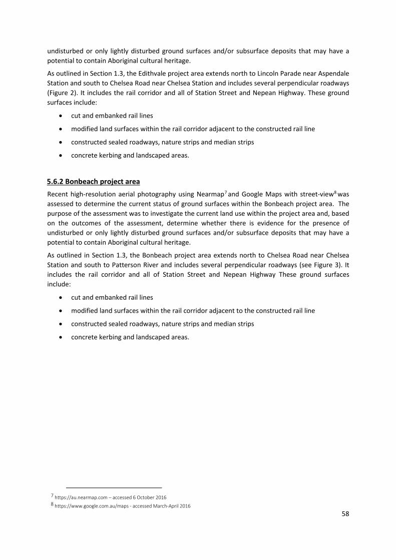
58
undisturbed or only lightly disturbed ground surfaces and/or subsurface deposits that may have a potential to contain Aboriginal cultural heritage.
As outlined in Section 1.3, the Edithvale project area extends north to Lincoln Parade near Aspendale Station and south to Chelsea Road near Chelsea Station and includes several perpendicular roadways (Figure 2). It includes the rail corridor and all of Station Street and Nepean Highway. These ground surfaces include:
• cut and embanked rail lines
• modified land surfaces within the rail corridor adjacent to the constructed rail line
• constructed sealed roadways, nature strips and median strips
• concrete kerbing and landscaped areas.
5.6.2 Bonbeach project area Recent high-resolution aerial photography using Nearmap7 and Google Maps with street-view8 was assessed to determine the current status of ground surfaces within the Bonbeach project area. The purpose of the assessment was to investigate the current land use within the project area and, based on the outcomes of the assessment, determine whether there is evidence for the presence of undisturbed or only lightly disturbed ground surfaces and/or subsurface deposits that may have a potential to contain Aboriginal cultural heritage.
As outlined in Section 1.3, the Bonbeach project area extends north to Chelsea Road near Chelsea Station and south to Patterson River and includes several perpendicular roadways (see Figure 3). It includes the rail corridor and all of Station Street and Nepean Highway These ground surfaces include:
• cut and embanked rail lines
• modified land surfaces within the rail corridor adjacent to the constructed rail line
• constructed sealed roadways, nature strips and median strips
• concrete kerbing and landscaped areas.
7 https://au.nearmap.com – accessed 6 October 2016 8 https://www.google.com.au/maps - accessed March-April 2016

59
5.7 CHMP 15158 summary
A cultural heritage management plan (CHMP 15158) is currently being prepared for LXRA that includes the Edithvale and Bonbeach project areas as well as the original CHMP (14493) that was being prepared for LXRA that included the Frankston line between Bentleigh and Frankston. Sections of the CHMP 14493 intersect with the Edithvale and Bonbeach project areas, and as such limited surveys have already been undertaken as part of the standard assessment for that CHMP.
The initial site survey included a cultural values assessment as well as a standard assessment for CHMP 15158 and was undertaken on the 4 September 2017 with the involvement of the relevant traditional owner groups. The standard assessment for CHMP 14493 was limited to VicTrack land on the Frankston line between Bentleigh and Frankston and was undertaken on the 26-27 September 2016 and 7-8 November 2016 with the involvement of the relevant traditional owner groups.
5.7.1 Introduction This section outlines the aims, methods, and results of a standard assessment (field survey) undertaken for the activity area, including descriptions of individual survey areas.
The standard assessment was conducted over a one-day period and was conducted in accordance with proper archaeological practice as set out in Regulation 59 of the Aboriginal Heritage Regulations 2007 (Vic).
5.7.2 Previously Registered Aboriginal Cultural Heritage Places There were no previously registered Aboriginal cultural heritage places within the activity area at the time of the standard assessment.
5.7.3 Aims The aims of the field survey were as follows:
• to undertake a general assessment of the archaeological sensitivity and level of ground disturbance and thereby determine the archaeological potential of the entire activity area
• to inspect a sample of the activity area through pedestrian survey and at these locations to examine areas with ground surface visibility for Aboriginal archaeological heritage within the activity area
• to characterise the remaining parts of the activity area through a vehicular survey • involve representatives of the RAP Applicant/Traditional Owner Groups and provide an
opportunity to discuss any broader cultural values of the activity area.
5.7.4 Method of Assessment The field survey was conducted over one day on 4 September 2017. Participants in the field survey are listed in Table 8.
The field survey methodology was dictated by the need to systematically examine the activity area and confirm the results of the desktop assessment. Given the large size and urban nature of the activity area, it was not possible or necessary to undertake a comprehensive pedestrian survey of the entire activity area. The field survey was thereby undertaken by both systematic pedestrian transects that were generally walked north to south across and by vehicular survey. Figure 12 details the parts of the activity area subject to pedestrian survey, the remaining parts of the activity area were subject to vehicular survey.
Aerial mapping of the activity area guided the systematic pedestrian surface survey, as did the use of a differential GPS (dGPS). The survey results for each investigation area were recorded on survey

60
recording forms which include information relating to landform, environment, details of any Aboriginal cultural heritage if identified, cultural sensitivity, and ground surface impacts. Each investigation area was documented and photographed accordingly.
A systematic pedestrian survey was undertaken across parts of activity area with each member of the field team spaced approximately two metres apart. This spacing enabled each individual to examine all surface exposures within the activity area in accordance with archaeological practice outlined in Burke and Smith (2004, 65-69).
Pedestrian spacing was sufficient to identify any areas of significant ground exposure. According to regulation 59 (3) of the Aboriginal Heritage Regulations 2007, which stipulates what a standard assessment must include, where pedestrian survey occurred, the field survey involved the examination for potential mature trees, caves, rock shelter or cave entrances within the activity area. There were occasional mature eucalyptus trees growing within the accessed part of the activity area and these were all inspected for cultural scarring, with no culturally scarred trees identified.
The average ground surface visibility of the activity area was generally less than one per cent at the time of the survey. There were very few areas containing patches of exposed soil within the activity area. The small portions of exposed areas, such as patches of eroded soil along fence lines or informal tracks provided some surface visibility and these areas were targeted.
5.7.4.1 Establishing investigation areas (IAs) using landforms As a component of the field survey and as a means of informing the conduct of any subsequent complex assessment, the activity area was divided into a single investigation areas numbered IA1 (Section 5.7.8 – Section 5.7.10; Figure 13).
The activity area was assessed as containing one major investigation area (IA); established on the basis of geology:
• IA1: coastal dune deposits
5.7.4.2 Establishing archaeological sensitivity As a component of the field survey and as a means of informing the conduct of the subsequent complex assessment, the activity area was assessed in terms of the overall archaeological sensitivity of the area. The initial archaeological sensitivity rating was based on the outcomes of the desktop assessment, and was subsequently modified as a result of observations made during the field survey.
Following this methodology each investigation area was assigned an archaeological sensitivity rating, reflecting the environmental and cultural value of a location, and a disturbance rating, reflecting the compound impact of past and present land uses.
Archaeological sensitivity ratings were based on a variety of factors including proximity to water, landform, geology, elevation, vegetation type, traditional owner viewpoints, and the presence or absence of identified cultural heritage. Previous archaeological work in this region has demonstrated that the majority of Aboriginal places identified within the geographic region were located on landforms that are associated with localised Aeolian sand bodies and other low rises, with an increased concentration in close proximity to water sources, including creeks and the coastal margin.
5.7.4.3 Establishing levels of ground disturbance Each investigation area was surveyed in relation to the level of disturbance observed. Disturbance ratings were scaled to reflect the compound impact of past and present land uses.
The disturbance ratings were based on factors such as the extent of likely landscape modification by activities such as the construction and maintenance of the rail corridor and associated rail reserve, as well as train stations, carparks, roads, utilities, pathways, water crossings, and vehicle access tracks.

61
Observed disturbance ratings for the current activity area were based on a range detailed below.
• 2: Moderate-high disturbance. Associated with highly disturbed landscapes including the existing rail corridor, heavily modified rail reserve, sealed pedestrian walkways, built-up train stations, sealed carparks, numerous sub-surface utilities, substantial cuttings and artificial embankments. Note: within the coastal dunes landform this is limited to a depth of 0-0.5 metres
• 4: Low disturbance. Associated with buried coastal dune deposits at depths of greater than 0.5 metres
5.7.4.4 Investigation units The investigation area within the activity area was further divided into smaller investigation units (IUs) based on the above listed disturbance ratings. The part of the activity area between the ground surface and a depth of 0.5 metres was assigned a moderate-high disturbance rating and is described as investigation area 1 - Unit A (or IA1A), whereas the part of the activity area below a depth of 0.5 metres was assigned a low disturbance rating are labelled investigation area 1 - Unit B (or IA1B). Each investigation unit that is present within the activity area is described in Section 5.7.8 and 5.7.9.
5.7.5 Obstacles The ground surface visibility of the activity area was typically very limited due to sealed surfaces (such as roadways) and dense ground cover of introduced grass and weed species and shrub vegetation. This ground cover obscured visibility across the majority of the activity area.
Due to the size of the activity area, it was not possible to conduct a pedestrian survey of the entire area. Further, the location of much of the activity area within road reserve limited pedestrian access.
5.7.6 Participants Involved in the Standard Assessment The participants in the standard assessment are listed in Table 8.
Table 8: Participants involved in the Standard Assessment
Participant Organization Position Date ALA Archaeologist and Heritage
Advisor 04-09-2017
ALA Archaeologist and Heritage Advisor
04-09-2017
AECOM-GHD JV Representative 04-09-2017 BLCAC Representative 04-09-2017 BWF Representative 04-09-2017
5.7.7 Oral Information As set out in Regulation 59 (2) of the Aboriginal Heritage Regulations 2007 (Vic), the standard assessment may include the collection and review of oral history relating to the activity area.
The BLCAC and BWF participated in the standard assessments of the CHMP (WTLCCHC were unable to provide a representative for the standard assessment). Consultation with BLCAC and BWF representatives during fieldwork included informal discussions regarding fieldwork methodologies, likely Aboriginal cultural heritage values associated with the activity area, and the results of the assessments. These discussions included issues relating to any potential oral history information known about the geographic region or non-archaeological values associated with the activity area.

62
Following the standard assessment, a further formal request to the BLCAC, BWF and WTLCCHC for any non-archaeological values that may be associated with the activity area will be provided by the Heritage Advisor (HA). Please note, no oral information has been collected to this point as part of the standard assessment.
The various Aboriginal community representatives informally consulted during fieldwork for the preparation of this CHMP are listed in Section 5.6.
5.7.8 Results The field survey was conducted on 4 September 2017. In accordance with regulation 59 (3) where pedestrian survey occurred, the field survey included the examination of all potential mature trees for signs of scarring. The field survey identified no caves, scarred trees, rock shelters or cave entrances within the activity area.
A key aim of the standard assessment was to establish the archaeological sensitivity rating and disturbance rating of the activity area. This was achieved through a targeted combination pedestrian and vehicular survey.
Pedestrian survey targeted eleven locations that were selected as they were representative samples of the broader activity area (Table 9 and Figure 12). The majority of the remainder of the activity area was subject to vehicular survey.
Table 9: Pedestrian survey areas
Pedestrian Survey Area Location 1 Edithvale Station 2 Mascot Avenue 3 Breeze Street 4 Bonbeach Station 5 Broadway 6 Chelsea Station 7 Berry Avenue 8 Lochiel Avenue 9 Aspendale Station
Where survey occurred, it was observed that the majority of the activity area had very poor ground surface visibility, with dense grass, modified native vegetation and an understorey of shrubs and introduced weed species and sealed road surfaces or structures present. Despite the poor ground surface visibility, it was clear that a significant level of prior ground disturbance has occurred across much of the activity area. As the activity area traverses highly urbanised land, this result was expected based on the results of the desktop assessment.
The activity area lies primarily within the rail corridor and road reserve, with some sections of parkland (see Section 2). Most of the activity area have undergone a variety of disturbances, mainly associated with developments in the rail corridor, roadway development and the construction of associated features such as embankments, cuttings and open drainage channels, the installation of utilities (e.g. water, gas, telecommunication and power).
As stated in Section 5.4, the activity area was contained a single broad landforms:
• IA1: coastal dune deposits
Table 10 to Table 18 detail the results of the pedestrian survey. Section 5.7.9 discusses the archaeological sensitivity and ground disturbance and the resulting investigation areas and archaeological potential of the activity area.
No Aboriginal cultural heritage was identified during the standard assessment.

63
Table 10: Survey Area 1 (SA1)
Pedestrian Survey Area 1 – Edithvale Station Survey Method Pedestrian Sampling Strategy Systematic and
opportunistic No. of Participants 5 Transect Width 2m Transect Spacing 2m Visibility Exposure(s) None % ground cover on exposure(s)
0
% surface visibility on exposure(s)
n/a
% ground cover off exposure(s)
100
% surface visibility off exposure(s)
0%
Average ground surface visibility of SA
0%
Environment Environmental Settings Inland Landform, Land systems, Elevations
Lowland
Slope Flat to very gently Inclined (0° - 1.5°)
Locality Landforms Flats, dune Water None present Disturbance Road construction,
station construction, rail and associated infrastructure, landscaping and utility installation
Previous + Current Land use Clearing, rail construction, road construction, utility construction, landscaping
Vegetation Vegetation Condition modified Vegetation Type modified Major Vegetation Types -- Aboriginal Place Identified No Type -- List -- Archaeology Sensitivity Rating
Moderate (3)
Disturbance Rating Variable: Moderate-high (2) 0-0.5m Low (4) 0.5m+
Archaeological Potential Rating (APR)
Variable: low-moderate to moderate depending on depth
Photograph 1: SA1 facing south east towards Edithvale Station_4Sept17
Photograph 2: Flat land to the south of Edithvale Station – intersection of Edithvale Road and Station Street. Note the typical ground surface visibility of SA1 at the time of the standard assessment_4Sept17
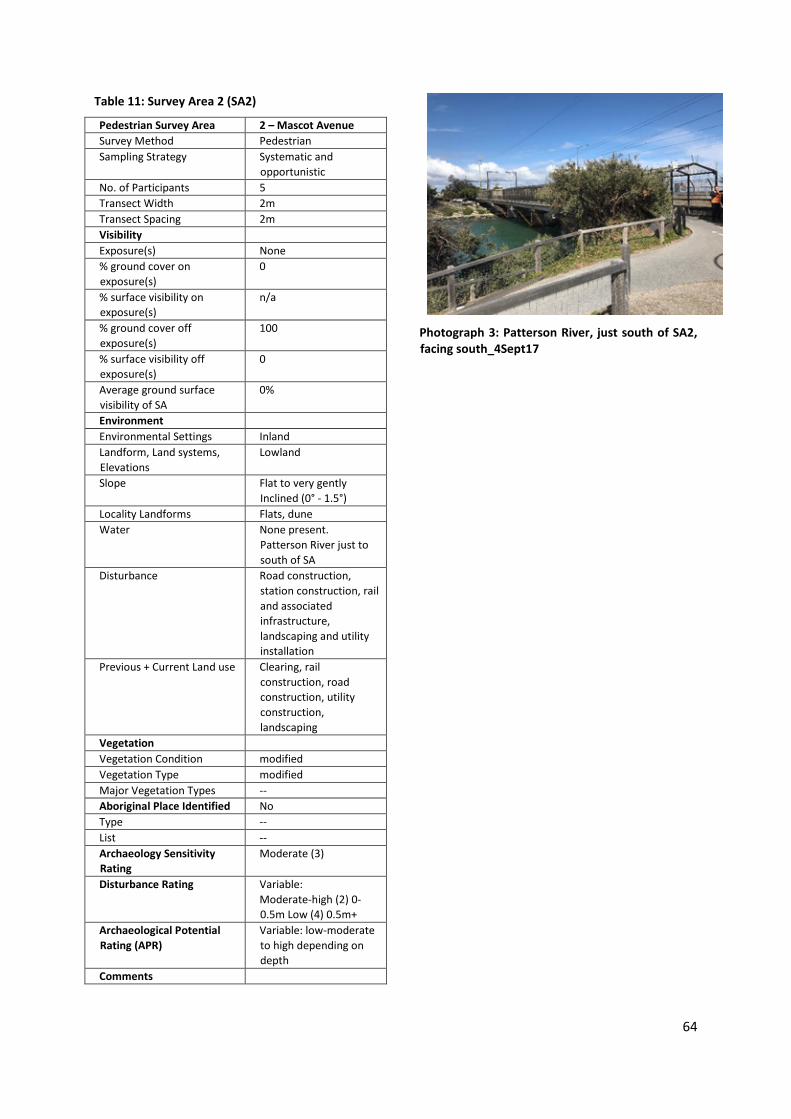
64
Table 11: Survey Area 2 (SA2)
Pedestrian Survey Area 2 – Mascot Avenue Survey Method Pedestrian Sampling Strategy Systematic and
opportunistic No. of Participants 5 Transect Width 2m Transect Spacing 2m Visibility Exposure(s) None % ground cover on exposure(s)
0
% surface visibility on exposure(s)
n/a
% ground cover off exposure(s)
100
% surface visibility off exposure(s)
0
Average ground surface visibility of SA
0%
Environment Environmental Settings Inland Landform, Land systems, Elevations
Lowland
Slope Flat to very gently Inclined (0° - 1.5°)
Locality Landforms Flats, dune Water None present.
Patterson River just to south of SA
Disturbance Road construction, station construction, rail and associated infrastructure, landscaping and utility installation
Previous + Current Land use Clearing, rail construction, road construction, utility construction, landscaping
Vegetation Vegetation Condition modified Vegetation Type modified Major Vegetation Types -- Aboriginal Place Identified No Type -- List -- Archaeology Sensitivity Rating
Moderate (3)
Disturbance Rating Variable: Moderate-high (2) 0-0.5m Low (4) 0.5m+
Archaeological Potential Rating (APR)
Variable: low-moderate to high depending on depth
Comments
Photograph 3: Patterson River, just south of SA2, facing south_4Sept17

65
Table 12: Survey Area 3 (SA3)
Pedestrian Survey Area 3 – Breeze Street Survey Method Pedestrian Sampling Strategy Systematic and
opportunistic No. of Participants 5 Transect Width 2m Transect Spacing 2m Visibility Exposure(s) None % ground cover on exposure(s)
0
% surface visibility on exposure(s)
n/a
% ground cover off exposure(s)
100
% surface visibility off exposure(s)
0
Average ground surface visibility of SA
0%
Environment Environmental Settings Inland Landform, Land systems, Elevations
Lowland
Slope Flat to very gently Inclined (0° - 1.5°)
Locality Landforms Flats, dune Water None present Disturbance Road construction,
station construction, rail and associated infrastructure, landscaping and utility installation
Previous + Current Land use Clearing, rail construction, road construction, utility construction, landscaping
Vegetation Vegetation Condition modified Vegetation Type modified Major Vegetation Types -- Aboriginal Place Identified No Type -- List -- Archaeology Sensitivity Rating
Moderate (3)
Disturbance Rating Variable: Moderate-high (2) 0-0.5m Low (4) 0.5m+
Archaeological Potential Rating (APR)
Variable: low-moderate to high depending on depth
Comments
Photograph 4: SA3, facing southeast_4Sept17
Photograph 5: Typical ground surface visibility of SA3 at the time of the standard assessment_4Sept17

66
Table 13: Survey Area 4 (SA4)
Pedestrian Survey Area 4 – Bonbeach Station Survey Method Pedestrian Sampling Strategy Systematic and
opportunistic No. of Participants 5 Transect Width 2m Transect Spacing 2m Visibility Exposure(s) None % ground cover on exposure(s)
0
% surface visibility on exposure(s)
n/a
% ground cover off exposure(s)
100
% surface visibility off exposure(s)
0
Average ground surface visibility of SA
0%
Environment Environmental Settings Inland Landform, Land systems, Elevations
Lowland
Slope Flat to very gently Inclined (0° - 1.5°)
Locality Landforms Flats, dune Water None present Disturbance Road construction,
station construction, rail and associated infrastructure, landscaping and utility installation
Previous + Current Land use Clearing, rail construction, road construction, utility construction, landscaping
Vegetation Vegetation Condition modified Vegetation Type modified Major Vegetation Types -- Aboriginal Place Identified No Type -- List -- Archaeology Sensitivity Rating
Moderate (3)
Disturbance Rating Variable: Moderate-high (2) 0-0.5m Low (4) 0.5m+
Archaeological Potential Rating (APR)
Variable: low-moderate to high depending on depth
Comments
Photograph 6: Bonbeach Station, facing north_4Sept17
Photograph 7: Surface visibility of SA4 at the time of the standard assessment_4Sept

67
Table 14: Survey Area 5 (SA5)
Pedestrian Survey Area 5 – BroadwaySurvey Method Pedestrian Sampling Strategy Systematic and
opportunistic No. of Participants 5 Transect Width 2m Transect Spacing 2m Visibility Exposure(s) None % ground cover on exposure(s)
1
% surface visibility on exposure(s)
100
% ground cover off exposure(s)
99
% surface visibility off exposure(s)
0
Average ground surface visibility of SA
1%
Environment Environmental Settings Inland Landform, Land systems, Elevations
Lowland
Slope Flat to very gently Inclined (0° - 1.5°)
Locality Landforms Flats, dune Water None present Disturbance Road construction,
station construction, rail and associated infrastructure, landscaping and utility installation
Previous + Current Land use Clearing, rail construction, road construction, utility construction, landscaping
Vegetation Vegetation Condition modified Vegetation Type modified Major Vegetation Types -- Aboriginal Place Identified No Type -- List -- Archaeology Sensitivity Rating
Moderate (3)
Disturbance Rating Variable: Moderate-high (2) 0-0.5m Low (4) 0.5m+
Archaeological Potential Rating (APR)
Variable: low-moderate to high depending on depth
Comments
Photograph 8: Sealed surfaces within SA5, facing south_04Sept17
Photograph 9: SA5, conditions within the rail corridor_4Sept17

68
Table 15: Survey Area 6 (SA6)
Pedestrian Survey Area 6 – Chelsea Station Survey Method Pedestrian Sampling Strategy Systematic and
opportunistic No. of Participants 5 Transect Width 2m Transect Spacing 2m Visibility Exposure(s) None % ground cover on exposure(s)
0
% surface visibility on exposure(s)
n/a
% ground cover off exposure(s)
100
% surface visibility off exposure(s)
0
Average ground surface visibility of SA
0%
Environment Environmental Settings Inland Landform, Land systems, Elevations
Lowland
Slope Flat to very gently Inclined (0° - 1.5°)
Locality Landforms Flats, dune Water None present Disturbance Road construction,
station construction, rail and associated infrastructure, landscaping and utility installation
Previous + Current Land use Clearing, rail construction, road construction, utility construction, landscaping
Vegetation Vegetation Condition modified Vegetation Type modified Major Vegetation Types -- Aboriginal Place Identified No Type -- List -- Archaeology Sensitivity Rating
Moderate (3)
Disturbance Rating Variable: Moderate-high (2) 0-0.5m Low (4) 0.5m+
Archaeological Potential Rating (APR)
Variable: low-moderate to high depending on depth
Comments
Photograph 10: SA6, facing south_4Sept17

69
Table 16: Survey Area 7 (SA7)
Pedestrian Survey Area 7 – Berry Avenue Survey Method Pedestrian Sampling Strategy Systematic and
opportunistic No. of Participants 5 Transect Width 2m Transect Spacing 2m Visibility Exposure(s) None % ground cover on exposure(s)
0
% surface visibility on exposure(s)
n/a
% ground cover off exposure(s)
100
% surface visibility off exposure(s)
0
Average ground surface visibility of SA
0%
Environment Environmental Settings Inland Landform, Land systems, Elevations
Lowland
Slope Flat to very gently Inclined (0° - 1.5°)
Locality Landforms Flats, dune Water None present Disturbance Road construction,
station construction, rail and associated infrastructure, landscaping and utility installation
Previous + Current Land use Clearing, rail construction, road construction, utility construction, landscaping
Vegetation Vegetation Condition modified Vegetation Type modified Major Vegetation Types -- Aboriginal Place Identified No Type -- List -- Archaeology Sensitivity Rating
Moderate (3)
Disturbance Rating Variable: Moderate-high (2) 0-0.5m Low (4) 0.5m+
Archaeological Potential Rating (APR)
Variable: low-moderate to high depending on depth
Comments
Photograph 11: The rail corridor within SA7, facing north_4Sept17

70
Table 17: Survey Area 8 (SA8)
Pedestrian Survey Area 8 – Lochiel Avenue Survey Method Pedestrian Sampling Strategy Systematic and
opportunistic No. of Participants 5 Transect Width 2m Transect Spacing 2m Visibility Exposure(s) None % ground cover on exposure(s)
0
% surface visibility on exposure(s)
n/a
% ground cover off exposure(s)
100
% surface visibility off exposure(s)
0
Average ground surface visibility of SA
0%
Environment Environmental Settings Inland Landform, Land systems, Elevations
Lowland
Slope Flat to very gently Inclined (0° - 1.5°)
Locality Landforms Flats, dune Water None present Disturbance Road construction,
station construction, rail and associated infrastructure, landscaping and utility installation
Previous + Current Land use Clearing, rail construction, road construction, utility construction, landscaping
Vegetation Vegetation Condition modified Vegetation Type modified Major Vegetation Types -- Aboriginal Place Identified No Type -- List -- Archaeology Sensitivity Rating
Moderate (3)
Disturbance Rating Variable: Moderate-high (2) 0-0.5m Low (4) 0.5m+
Archaeological Potential Rating (APR)
Variable: low-moderate to high depending on depth
Comments
Photograph 12: SA8, facing north_4Sept17
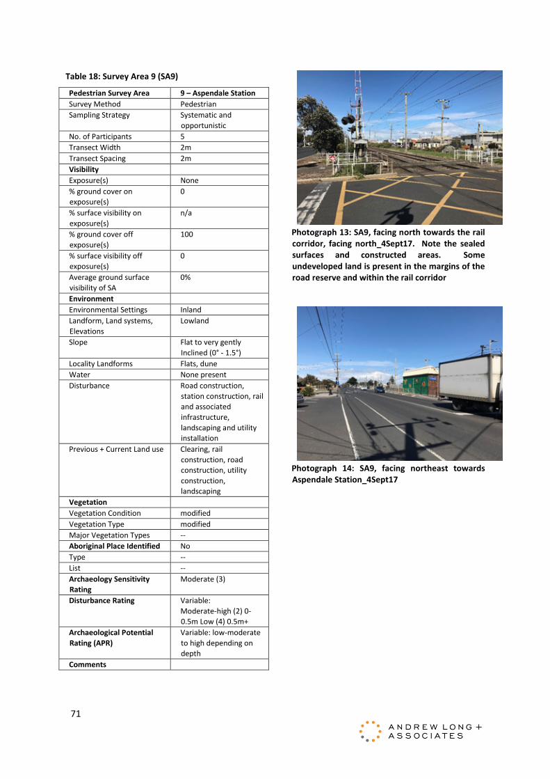
71
Table 18: Survey Area 9 (SA9)
Pedestrian Survey Area 9 – Aspendale Station Survey Method Pedestrian Sampling Strategy Systematic and
opportunistic No. of Participants 5 Transect Width 2m Transect Spacing 2m Visibility Exposure(s) None % ground cover on exposure(s)
0
% surface visibility on exposure(s)
n/a
% ground cover off exposure(s)
100
% surface visibility off exposure(s)
0
Average ground surface visibility of SA
0%
Environment Environmental Settings Inland Landform, Land systems, Elevations
Lowland
Slope Flat to very gently Inclined (0° - 1.5°)
Locality Landforms Flats, dune Water None present Disturbance Road construction,
station construction, rail and associated infrastructure, landscaping and utility installation
Previous + Current Land use Clearing, rail construction, road construction, utility construction, landscaping
Vegetation Vegetation Condition modified Vegetation Type modified Major Vegetation Types -- Aboriginal Place Identified No Type -- List -- Archaeology Sensitivity Rating
Moderate (3)
Disturbance Rating Variable: Moderate-high (2) 0-0.5m Low (4) 0.5m+
Archaeological Potential Rating (APR)
Variable: low-moderate to high depending on depth
Comments
Photograph 13: SA9, facing north towards the rail corridor, facing north_4Sept17. Note the sealed surfaces and constructed areas. Some undeveloped land is present in the margins of the road reserve and within the rail corridor
Photograph 14: SA9, facing northeast towards Aspendale Station_4Sept17

72
Figure 12: The activity area showing areas subject to pedestrian and vehicular survey

73
5.7.9 Preliminary archaeological potential rating As a component of the field survey and as a means of informing the conduct of the subsequent complex assessment, each investigation area was assessed in terms of the overall archaeological sensitivity and the overall disturbance of the area. The initial archaeological sensitivity rating was based on the outcomes of the desktop assessment, and was subsequently modified as a result of observations made during the field survey.
Following this methodology, each investigation area was assigned an archaeological sensitivity rating and a disturbance rating (Table 19). Archaeological sensitivity ratings range from low (1) to high (5) and are based on a variety of factors including proximity to water, landform, elevation and the presence or absence of Aboriginal cultural heritage. Disturbance ratings are also based on a range from high (1) to low (5).
The results of the background research for the activity area contributed to the information regarding archaeological sensitivity ratings for the investigation areas (Figure 13). Previous archaeological work in this region has demonstrated that the majority of Aboriginal places identified within the geographic region were generally located in association with localised Aeolian sand bodies and other low rises, with an increased concentration in close proximity to water sources, and the coastal margin. As a result, the archaeological sensitivity ratings for coastal dune deposits within the activity area have been uniformly assessed as moderate. Relatively fewer archaeological places have been identified on the coastal lagoon deposits and this investigation area has been assigned a low-moderate archaeological sensitivity rating.
Each investigation area was surveyed in relation to the level of disturbance observed (Section 5.4.3). Disturbance ratings reflected the compound impact of past and present land uses. The disturbance ratings assigned to sections of the activity area was based on factors such as the extent of landscape modification. Given the location of the activity area, disturbance is primarily derived from the construction and maintenance of the rail corridor and associated rail reserve, as well as train stations, roads, carparks, utilities, pathways, water crossings, and access tracks. As a result, the disturbance ratings for the activity area have been assessed as ranging from low to high.
The resulting values for each of these ratings are multiplied to achieve an overall Archaeological Potential Rating (Figure 13: , Table 20 and Table 21). The APR indicates the likelihood for archaeological deposits to occur within the activity area, given both the intensity of Aboriginal use of the landscape, and the probability that any evidence is likely to have survived past and current land uses. The resultant archaeological potential rating will be used to assist in informing the results of the desktop and standard assessment undertaken within the activity area.
Table 19: Archaeological Sensitivity / Disturbance Ratings
Archaeological sensitivity Rating Disturbance Low 1 High Low-moderate 2 Moderate-high Moderate 3 Moderate Moderate-high 4 Low High 5 None

74
Table 20: APR Scale
Low 0-5 Low-moderate 5.5-8.5 Moderate 9-12 Moderate-high 12.5-16 High 16.5-25
Table 21: Archaeological potential ratings of the activity area
Investigation Area
Investigation Unit
Previously registered Aboriginal Place
Archaeological Sensitivity Rating
Disturbance Rating
Archaeological Potential Rating (APR)
IA1 (Coastal dune deposits (Qdl1) 0-0.5m depth
A No 3 (moderate) 2 (moderate-high)
6 (low-moderate)
IA1 (Coastal dune deposits (Qdl1) 0.5m+ depth
B No 3 (moderate) 4 (low) 12 (moderate)

75
Figure 13: Results of the standard assessment investigation areas and Archaeological Potential Ratings (APR)

76
5.7.10 Conclusions The field survey was conducted over a one-day period on 4 September 2017. In general, the landscape was flat or gently-inclined, with steep slopes only encountered towards the north of Survey Area 3. The activity area is predominately characterised by the rail corridor and associated rail reserve and roads.
• Most of the ground surface within the activity area was obscured by ground cover or sealed surfaces, with ground surface visibility during the standard assessment, ranging from zero percent to one per cent.
• The activity area was assessed as containing one Investigation Area (IA) established on the basis of underlying geology. This area comprised coastal dune deposits (IA1).
• The IA was further divided into subunits (Investigation Units) demonstrating varied levels of disturbance (e.g. IA-1 Unit A and IA-1 Unit B). Observed impacts to the activity area included existing railway lines and infrastructure, train stations, carparks, and roadways.
• Archaeological potential ratings across the activity area were determined through a comparison of disturbance ratings and sensitivity ratings for each investigation area. The APRs ranged from low-moderate to moderate (see Section 5.9).
• The highest calculated APR was moderate and was associated with IA 1 Unit B. This investigation unit was defined as the part of the activity area located on coastal dune deposits at a depth of greater than 0.5 metres below the current ground surface.
• The desktop assessment found that there were no previously registered Aboriginal cultural heritage place within the activity area at the commencement of this CHMP. The nearest registered Aboriginal cultural heritage place to the activity area is 7921-1530, located approximately 400 metres away.
• No Aboriginal cultural heritage places were identified within the activity area by the completion of the standard assessment.
• In accordance with r. 59 (3) the field survey included the examination of all potential mature trees for signs of scarring. The field survey identified no caves, rock shelters or cave entrances within the activity area.
At the completion of the standard assessment, investigation areas IA1 Unit A was assigned a low-moderate APR. This overall rating was based on a moderate archaeological sensitivity rating associated with the coastal dune deposit and a moderate-high disturbance rating assigned to the upper 0.5 metres of soil deposits within the road reserve and rail corridor
IA1 Unit B was assigned a moderate APR – the highest rating within the current activity area. IA1 Unit B, spatially aligns with IA1 Unit A (namely the part of the activity area located on the coastal dune deposit) and includes likely less disturbed soil deposits at depths greater than 0.5 metres below the ground surface.
Based on the results of the standard assessment, it was therefore deemed necessary to undertake a complex assessment of these investigation areas in order to enable a proper investigation of the potential for sub-surface Aboriginal cultural heritage places to be present, and to identify the nature, extent and significance of any Aboriginal cultural heritage found during the assessment in accordance with Regulation 60 (1b) of the Aboriginal Heritage Act 2006 (Vic).

77
6 6. RISK ASSESSMENT
6.1 Construction
A risk assessment of project activities was performed in accordance with the methodology described in Section 4.2. Risks were assessed for the construction and design/operation phases (where relevant).
The Aboriginal cultural heritage risks during the construction phase of the projects are listed in Table 22. The likelihood and consequence ratings applied during the risk assessment process are provided in Appendix 11.2. There was no change in the initial risk and final risk levels for Aboriginal cultural heritage.
Table 22:Aboriginal cultural heritage risks
Risk ID Risk name Risk pathway Final EPR Residual Risk level
ACH1 Disturbance of known ACH
Disturbance of previously registered Aboriginal cultural heritage places resulting in loss of heritage value
EPR AH1 CHMP Negligible
ACH2 Disturbance of unknown common ACH
Disturbance of not previously registered common Aboriginal cultural heritage places resulting in loss of heritage value
EPR AH1 CHMP Negligible
ACH3 Disturbance of unknown rare ACH
Disturbance of not previously registered rare ACH places resulting in loss of heritage value.
EPR AH1 CHMP Negligible
For further details refer to the EES Attachment II Environmental Risk Assessment which includes the full risk register, with initial EPRs and the recommended EPRs assigned to each risk.

78
7 7. IMPACT ASSESSMENT
7.1 Construction
7.1.1 Edithvale project area The greatest risk to Aboriginal cultural heritage through the construction of the project relates to the potential impacts to previously unregistered Aboriginal cultural heritage places.
No registered Aboriginal cultural heritage places are located in the Edithvale project area. Two registered Aboriginal cultural heritage places, comprising two LDADs are situated in the geographic region defined for the Edithvale project area (Figure 10).
An approved CHMP would provide a process to manage any proposed harm to any Aboriginal cultural heritage encountered during the preparation of the CHMP (risk ACH1) or during works to construct the project (risk ACH2 and ACH3).
7.1.2 Bonbeach project area The greatest risk to Aboriginal cultural heritage through the construction of the project relates to the potential impacts to previously unregistered Aboriginal cultural heritage places.
No registered Aboriginal cultural heritage places are located in the Bonbeach project area. There are no registered Aboriginal cultural heritage places situated in the geographic region defined for the Bonbeach project area (Figure 11).
An approved CHMP would provide a process to manage any harm to any Aboriginal cultural heritage encountered during the preparation of the CHMP (risk ACH1) or during works to construct the project (risk ACH2 and ACH3).
7.1.3 Typical CHMP management measures Typical management of registered Aboriginal cultural heritage places or values as part of a CHMP (EPR_AH1) would include, but not be limited to:
• harm minimisation or harm avoidance measures • mitigation measure such as salvage excavation or salvage collection and associated analysis
and reporting • custody and management of Aboriginal cultural heritage recovered • repatriation of any collected Aboriginal cultural heritage.
Typical management of unregistered Aboriginal cultural heritage places or values as part of a CHMP (EPR_AH1) would include, but not be limited to:
• management of Aboriginal cultural heritage found during works through the contingency arrangements of the CHMP
• custody and management of Aboriginal cultural heritage recovered • management of the discovery of human remains • review and compliance with the CHMP.

79
Adopting the controls of a Cultural Heritage Management Plan (CHMP) (or other authorisation) approved under the Aboriginal Heritage Act 2006 and prepared in accordance with the Aboriginal Heritage Regulations 2007 (EPR_AH1), would maintain the risk from the project to Aboriginal heritage at a negligible rating.

80
8 8. ENVIRONMENTAL PERFORMANCE
REQUIREMENTS
The EPRs required for the projects to achieve acceptable environmental outcomes are summarised in Table 23 below. The EPRs are applicable to the final design and construction approach and provide certainty regarding the environmental performance of the projects. Table 23: Environmental Performance Requirements for Aboriginal cultural heritage for the Edithvale and Bonbeach project areas
EPR ID Environmental Performance Requirement Stage
EPR_AH1
Comply with and implement any Cultural Heritage Management Plan approved under the Aboriginal Heritage Act 2006 that applies to the projects.
Construction
81
9 9. CONCLUSIONS
An Aboriginal cultural heritage impact assessment has been undertaken for the Edithvale and Bonbeach level crossing removal projects to determine the impacts on Aboriginal cultural heritage as a result of the projects and to identify management and mitigation options in order to reduce potential risks of the projects.
9.1 Existing conditions No registered Aboriginal cultural heritage places are located in the Edithvale project area. Two registered Aboriginal cultural heritage places, comprising two LDADs are situated in the geographic region defined for the Edithvale project area
No registered Aboriginal cultural heritage places are located in the Bonbeach project area. There are no registered Aboriginal cultural heritage places situated in the geographic region defined for the Bonbeach project area.
9.2 Impact assessment The study has assessed the impact to Aboriginal cultural heritage during construction of the projects on the assets and values to be managed and protected.
The impacts may potentially occur to previously unregistered and registered Aboriginal cultural heritage places during ground disturbing works associated with the projects.
The preparation of a standard and complex assessment as part of a CHMP for the activity area, including a program of subsurface investigation, will be undertaken in order to identify the nature, extent and significance of Aboriginal cultural heritage in accordance with Regulation 60 (1b) of the Aboriginal Heritage Act (2006). Further, an approved CHMP will provide a process to manage any potential harm to Aboriginal cultural heritage by construction activities.
9.3 Residual risk Adopting the controls of a Cultural Heritage Management Plan (CHMP) (or other authorisation) approved under the Aboriginal Heritage Act 2006 and prepared in accordance with the Aboriginal Heritage Regulations 2007 (EPR_AH1), would maintain the risk from the project to Aboriginal heritage at a negligible rating.

82
10 10. REFERENCES
Aguirre, E. and G. Pasini. 1985. The Pliocene-Pleistocene Boundary, in Episodes, Vol. 8, No. 2, pp. 116-120.
Aitken, D. L. & Kershaw, P. 1993. Holocene vegetation and environmental history of Cranbourne
Barker, A. 2016, Residential Subdivision , CHMP 14062.
Barker, M. 2016, : Proposed Retail/Residential Development: Desktop, Standard and Complex Assessments, CHMP 14310, Benchmark Heritage Management Pty Ltd.
Barker, M. and Young, J. 2016, , Proposed Multi Storey Apartment Building: Desktop, Standard and Complex Assessments, CHMP 14151, Benchmark Heritage Management.
Barker, M. and Young, J. 2016, , Proposed 6 lot Residential Subdivision and Construction of 6 Townhouses, CHMP 14108, Benchmark Heritage Management Pty Ltd.
Barker, M. and Young. J. 2016, : Proposed 14 Apartment Development: Desktop, Standard and Complex Assessments, CHMP 14352, Benchmark Heritage Management Pty Ltd.
Barker, M. and Young, J. 2016, Proposed 5 Unit Development: Cultural Heritage Management Plan Desktop, Standard and Complex Assessments, CHMP 14368, Benchmark Heritage Management Pty Ltd.
Barker, M. and Young. J. 2016, , Proposed Multi Storey Apartment Building: Desktop Standard and Complex Assessments CHMP 14151, Benchmark Heritage Management Pty Ltd.
Barwick, D. 1984. Rebellion at Coranderrk. Aboriginal History Monograph 5, Aboriginal Affairs Victoria, Melbourne.
Barwick, D. 1998 Rebellion at Coranderrk. Aboriginal History Monograph 5, Melbourne, Aboriginal Affairs Victoria.
Berndt, R. 1982. ‘Traditional Concepts of Aboriginal Land’, in Berndt, R. (ed.) Aboriginal Sites, Rights and Resource Development. Academy of Social Sciences in Australia, Fifth Academy Symposium, 11th November 1981, Proceedings. University of Western Australia Press, Perth, 1-11.
Bird, E.C.F. 1993. The Coast of Victoria. Melbourne: Melbourne University Press.
Bowler, J.M. 1966. ‘Port Phillip Survey 1957-1963: the geology and geomorphology. Memoirs of the National Museum of Victoria Melbourne, no. 27.
Bowler, J.M. 1981. Australian salt lakes – a palaeohydrologic approach. Hydrobiologia 82: 431-444.
Brown-May, A. and Swain, S. (eds.) 2005 The Encyclopaedia of Melbourne, Cambridge University Press, Melbourne
Bruton, W. n.d. Local History: Carrum to Cheltenham, Standard Newspapers, Cheltenham

83
Bunce, D. 1856. Reminiscences of Twenty-three Years Wandering in the Australian Colonies. Journal of Australasia 1:16-21, 109-12.
Burch, J. 2012, Eight Townhouse Develeopment, , Victoria, CHMP 12396, Jem Archaeology.
Burch, J. 2014, Four Dwellings, , Victoria, CHMP 13034, Jem Archaeology.
Burch, J. 2016, Seven Dwellings, Victoria: Cultural Heritage Management Plan, Report no. 13938.
Burch, J 2016, Three Dwellings, , Victoria, CHMP 14180, Jem Archaeology.
Burke, H. and Smith, C. 2004. The Archaeologists Field Handbook. Allen & Unwin, Crows Nest.
Butlin, N. 1983. Our Original Aggression. Aboriginal Populations of Southeastern Australia 1788-1850. North Sydney: George Allen and Unwin.
Caldere, D.B. and D.J. Goff. 1991. Aboriginal reserves & missions in Victoria. Aboriginal Lands Group, Dept. of Conservation and Environment.
Cannon, M. 1991. Old Melbourne Town before the goldrush. Loch Haven Books, Main Ridge Victoria.
Clark, I. 1990. Aboriginal Languages and Clans: an Historical Atlas of Western and Central Victoria, 18001900. Monash Publications in Geography, no. 37.
Clark, I and Heydon, T. 1998. The Confluence of the Merri Creek and Yarra River: A History of the Western Port Aboriginal Protectorate and the Merri Creek Aboriginal School. Unpublished Report to Aboriginal Affairs Victoria.
Cosgrove, R. 1999. Forty-two degrees south: the archaeology of Late Pleistocene Tasmania. Journal of World Prehistory. Vol. 13 No. 4: 357-402.
Curr, E. 1883 [1965]. Recollections of Squatting in Victoria. Melbourne University Press, Carlton.
Dawson, J. 1881. Australian Aborigines; the Languages and Customs of several Tribes of Aborigines in the Western District of Victoria. George Robertson, Melbourne.
Dingle, T. 1984. The Victorians Settling. Wilke & Co. Ltd., Clayton.
Du Cros, Hilary. 1989. The Western Region: Melbourne Metropolitan Area. An Archaeological Survey. Victoria Archaeological Survey Occasional Report No. 27. Victoria Archaeological Survey, Albert Park.
Dugay, L. and Wisniowiecka, A. 2015, Proposed 5-Unit Development: , CHMP 13837, Dugay and Co. Archaeology Cultural Heritage Management.
Dugay, L. and Wisniowiecka, A. 2015, Proposed 5-Unit Development: , CHMP 13836, Dugay and Co. Archaeology Cultural Heritage Management.
Dugay, L. and Wisniowiecka, A. 2016, , CHMP 14015, Dugay & Co. Pty Ltd.
Dugay-Grist, L., Cowled, A. and Maher, M. 2011, : Four Unit Development, CHMP 12243, Grist Archaeology Heritage Management.
Dugay-Grist, L., Cowled, A. and McAlister, R. 2015, Proposed Townhouse Development . CHMP 13448, Grist Archaeology Heritage Management.
Dugay-Grist, L. and Maher, M. 2011, : Multi-Unit Development, CHMP 11806, Grist Archaeology Heritage Management.
84
Dugay-Grist, L. and McAlister, R. 2011, , Residential Subdivision, CHMP 11837, Grist Archaeology Heritage Management.
Duncan, J. 2001. Megafauna at Keilor and the timing of their extinction. Australian Archaeology 53, 16-22.
East, E. 2016, 13 Ebdale Street, Frankston, Housing Subdivision, Cultural Heritage Management Plan number: 14341, U.C.A. Pty Ltd.
Ellender, I and F. Weaver. 1994. An Archaeological Survey of Port Phillip Bay. Unpublished report for the Central Highlands Regional Assessment Archeological Survey.
Gott, B. and J. Conran. 1991. Victorian Koorie Plants. Hamilton: Aboriginal Keeping Place.
Griffin, D and Nicolson, O. 2006, Sub-surface Testing of , Victoria. Unpublished report to Frankston City Council.
Gunson, N. 1968. The Good Country, Cranbourne Shire. Melbourne: F.W. Cheshire.
Hardiman, L 2016, Proposed Development at , CHMP 13907, Alpha Archaeology Pty Ltd.
Hill, J. 2015, Proposed Development at , CHMP 13969, Alpha Archaeology Pty Ltd.
Hislop, K. 2012, Proposed Multi-Residential Development, Cultural Heritage Management Plan, Report no. 11923.
Howell-Meurs, J. 2008. Industrial Subdivision, Seaford CHMP. An unpublished report.
Hyett, J. 2005. An Archaeological Investigation: . Unpublished report to Robert Luxmoore.
Hyett, J. 2008, , CHMP 10192, TerraCulture Heritage Consultants Pty Ltd.
Jones, Z 2016, , Residential Development, CHMP 13955, Andrew Long and Associates Pty Ltd.
Jones, Z. 2016, Subdivision and Residential Development, CHMP 14253, Andrew Long and Associates Pty Ltd.
Kennedy, S., J. Wheeler and E. Foley. 2012. : Residential Subdivision. Cultural Heritage Management Plan 11958. Unpublished report prepared for Lynette Anne Clissold, Janice Victoria Rayne and Leonie Joy Kingston
Kershaw, A. P., J. Tibby, D. Penny, H. Yezdani, R. Walkley, E. Cook and R. Johnston. 2004. Latest Pleistocene and Holocene vegetation and environmental history of the Western Plains of Victoria, Australia. Proceedings of the Royal Society of Victoria Vol. 116, No. 1, pp. 139-161.
Lakic, M and Wrench, R. (eds.). 1994. Through Their Eyes: An Historical Record of Aboriginal People of Victoria as Documented by the Officials of the Port Phillip Protectorate 1839-1841. Museum of Victoria, Melbourne.
LCC. 1973. Report on the Melbourne Study Area. Land Conservation Council, Melbourne.
Lambeck, K. and M. Nakada. 1990. “Late Pleistocene and Holocene sea-level change along the Australia coast”, in Palaeogeography, Paleoclimatology, Paleoecology (Global and Planetary Change Section), 89, pp. 143-176.

85
LCC, 1991. Melbourne Area District 2 Review; Descriptive Report. Land Conservation Council.
Lever, M. 2016, Proposed Construction of Three Dwellings: , Vic, 3196, CHMP 14390, A. B. Heritage Consulting Pty Ltd.
Lourens, L.J. 2008. ‘On the Neogene-Quaternary Debate’ in Episodes, Vol. 31 no. 2, pp. 239-242.
Marshall, B. 1998, Frankston City Council: Aboriginal Cultural Heritage Assessment. Unpublished report to Frankston City Council.
Matic, A. 2011, : Proposed Residential Development, CHMP 11762, Terraculture Heritage Consultants.
Matic, A. 2014, : Residential Subdivision CHMP 12961, Pragmatic Cultural Heritage Services Pty Ltd.
Matic, A. 2014, : Residential Subdivision, CHMP 12936, Pragmatic Cultural Heritage Services Pty Ltd.
Matic, A. 2015, : Residential Development, CHMP 13929, Pragmatic Cultural Heritage Services Pty Ltd.
Matic, A., 2016, : Residential Development, CHMP 14273, Pragmatic Cultural Heritage Services.
Matic, A and van der Walt, A 2016, : Residential Development, CHMP 14384, Pragmatic Cultural Heirtage Services Pty Ltd.
McAlister, R 2012, Proposed Residential Development , Cultural Heritage Management Plan 12315, Heritage Insight Pty Ltd.
Mitchel, J. 2014, Proposed Residential Development at , CHMP 13201, Alpha Archaeology Pty Ltd.
Mitchell, J and Timms, A 2013, Proposed Residential Development at , Victoria, CHMP 12764, Alpha Archaeology.
Morgan, J. 1852 [1967]. The Life & Adventures of William Buckley. Griffin Press, Adelaide.
Mulvaney, J. and J. Kamminga. 1999. Prehistory of Australia. Allen & Unwin.
Murphy, A. and Morris, A. 2013, Residential Subdivision, CHMP 12437, Archaeology at Tardis.
Murphy, A. and Rymer, T. 2016, Subdivision of Land , CHMP 14221, Archaeology at Tardis.
Myers, S., Mirams, S. and Mallett, T. 2016, Housing Subdivision and Construction of Four Dwellings, , CHMP 13972, Archlink Archaeologists and Heritage
Advisors Pty Ltd.
Nichols, H. 2014, , CHMP 13118, TerraCulture Heritage Consultants Pty Ltd.
Nicholson, O. Ward, J. and Burch, J. 2008, , Victoria, CHMP 10041, A report for the City of Kingston.
Oataway, K 2015, , Victoria, CHMP 13878, Biosis.
Patton, KW and Fiddian, J 2016, – Residential Development, CHMP 13971, Archaeology KWP Heritage Consultants.

86
Peel, L.J. 1974. Rural Industry in the Port Phillip Region 1835 – 1880. Melbourne University Press.
Presland, G. 1983. An Archaeological Survey of the Melbourne Metropolitan Area. Occasional Reports 15. Victorian Archaeological Survey.
Presland, G. 1994. Aboriginal Melbourne: The Lost Land of the Kulin People. McPhee Gribble Publishers, Victoria.
Presland, G. 2008. The Place for a Village: How Nature has Shaped the City of Melbourne. Museum Victoria, Melbourne.
Presland, G. 2010. First People: the Eastern Kulin of Melbourne, Port Phillip and Central Victoria. Museum Victoria Publishing, Melbourne.
Reid, M. 1989. Palaeoecological changes at Lake Wellington, Gippsland Lakes Victoria, during the late Holocene: a study of the development of a coastal lake ecosystem. Honours thesis, Department of Geography and Environmental Science, Monash University.
Schiltz, M. 2008, Archaeological Monitoring of a Groundwater Well, Seaford Foreshore Reserve, Victoria: Addendum Report, BIOSIS Research Pty. Ltd.
Stevens, J 2015, 39-41 Hastings Road Frankston CHMP 13366, Urban Colours Cultural Resource Managers.
Sullivan, M. and Simmons, S. 1979. ‘Silcrete: a Classification for Flaked Stone Assemblages’, The Artefact
Sullivan, H. 1981. An Archaeological Survey of the Mornington Peninsula. Victoria Archaeological Survey Occasional Report Series, No.6. Ministry for Conservation, Victoria.
The Burra Charter: The Australia ICOMOS Charter for Places of Cultural Significance, 2013.
Thomas, K and Compton, S 2013, Frankston Yacht Club and Long Island Development, Frankston, Victoria, CHMP 12693, Wandri Archaeology Cultural Heritage Management.
Townrow, K. 1997. An Archaeological Survey of Sealing & Whaling Sites in Victoria. Heritage Victoria, Melbourne.
Tucker, C. 2009. Construction of New Dwellings at CHMP. An unpublished report to Ausbuild Constructions.
Victorian Environmental Assessment Council (VEAC). 2010. Remanent Native Vegetation Investigation Discussion Paper. Melbourne: Victorian Environmental Assessment Council.
Victorian Places 2016 Edithvale, http://www.victorianplaces.com.au/edithvale
Wackett, L. and McKeagney, J. 2010. Kingston Bay Trail and Mentone Beach Stormwater Upgrade, Menton & Parkdale, CHMP 11105, TerraCulture Heritage Consultants Pty Ltd.
Ward, B. 2012, Cultural Heritage Management Plan for the Proposed Residential Development at 14 Duncan Avenue, Seaford, CHMP 11904, ACHM Pty Ltd.
Wilkins, D., C. Gouramanis, P. De Deckker, L. Keith Fifield and J. Olley. 2013. Holocene lake-level fluctuations in Lake Keilambete and Gnotuk, southwestern Victoria, Australia. The Holocene published online 6 February 2013, pp. 1-12.

87
Zola, N. and B. Gott. 1992. Koorie plants Koorie people: traditionally Aboriginal food, fibre and healing plants of Victoria, Melbourne Koorie Heritage Trust.

88
11 11. APPENDICES
11.1 Legislation and Policy
The following legislation, policies and guidelines detail the requirements of this cultural heritage impact assessment and future investigations regarding Aboriginal cultural heritage.
The Burra Charter (2013) and its accompanying guidelines define the basic principles, processes and practices upon which statutory assessments of heritage significance in Australia are based. The Burra Charter was adopted by Australia International Council on Monuments and Sites (ICOMOS). It is not a statutory document; rather, it informs the principles by which fieldwork and consideration of sites (significance and registration) is undertaken. The general assessment criteria are as follows:
• Association with special events, developments or phases.
• Rarity due to association with a distinctive way of life, custom, process, land use, function or design no longer practiced.
• Importance for demonstrating principal characteristics of a particular type or class of human activities (for example, stating a stone quarry is a classic example of its type as it has all the features typically associated with utilised stone sources in good condition).
• Aesthetic value to the local community (for example, as a landmark).
• Value for demonstrating a particular technical or creative process.
• Strong or special association with a particular community or ethnic group for social, cultural or spiritual reasons.
• Special association with a famous person or group of people.
Generally, these criteria can be grouped into three main categories: social (I), scientific (II) and historical (III), depending on the nature of a given place or item.
11.1.1 Commonwealth Government
11.1.1.1 Native Title Act 1993 The purpose of the Native Title Act 1993 is to provide recognition and protection of native title for Aboriginal and Torres Strait Islanders. Essentially, this Act covers the following topics:
• Acts affecting native title
• Determining whether native title exists and compensation for acts affecting native title.
The kinds of acts affecting native title are:
• Past acts (mainly acts done before the commencement of this Act commencement on 1 January 1994 that were invalid because of native title); and
• Future acts (mainly acts done after the commencement of this Ac that either validly affect native title or are invalid because of native title).

89
11.1.1.2 Environment Protection and Biodiversity Conservation Act 1999 The Environment Protection and Biodiversity Conservation Act 1999 (EPBC Act) details provisions for the protection of Aboriginal and non-Aboriginal cultural heritage places with national heritage value. Places protected under the Act are registered on the National Heritage List, Commonwealth Heritage List or the World Heritage List and include natural, historic and Aboriginal places of outstanding heritage value.
11.1.1.3 National Heritage List The National Heritage List is administered by the Australian Government’s Department of the Environment. It lists places of outstanding heritage significance to Australia. It includes natural, historic and Aboriginal places that are of outstanding national heritage value to the Australian nation. Places on the list are protected under the EPBC Act, which requires that approval be obtained before any action takes place that could have a significant impact on the national heritage values of a listed place.
The project has been referred under the EPBC Act.
On 8 May 2017, the project was determined by the delegate for the Australian Minister for the Environment to be a controlled action' and hence required an assessment and approval under the EPBC Act before it can proceed.
11.1.2 State Government
11.1.2.1 Aboriginal Heritage Act 2006 and Aboriginal Heritage Regulations 2007 The Victorian Aboriginal Heritage Act 2006 forms the framework within which Aboriginal heritage assessment is undertaken in Victoria. The Act provides for the protection and management of Victoria’s Aboriginal heritage with processes linked to the Victorian planning system.
Cultural Heritage Management Plans (CHMPs) and Cultural Heritage Permits (CHPs) are processes to manage activities that may harm Aboriginal cultural heritage. The Aboriginal Heritage Regulations 2007 set out the circumstances in which a CHMP is required to be prepared, and the standards for the preparation of a CHMP. The Regulations also prescribe standards and set fees and charges for CHMP evaluation.
The Aboriginal Heritage Amendment Bill 2015 was recently passed in the Victorian Parliament, receiving Royal Assent on 5 April 2016. The amendments to the Aboriginal Heritage Act 2006 took effect on 2 August 2016.
The Aboriginal Heritage Amendment Bill 2015 considers the introduction of Activity Advisory Groups (AAG) that are intended to provide a single Traditional Owner point of contact for proponents, heritage advisors and decision-makers in non-Registered Aboriginal Party (RAP) areas. In such instances, the Secretary may set up a AAG to act as a single advisory group for the project. The AAG will advise the Secretary on the CHMP decision and will generally serve a similar function as a RAP, but without decision making power.
It will also be required to:
• Consult with the sponsor about the assessment of the activity area
• Consult with the sponsor about the management requirements to be included in the CHMP
• Participate in the assessment of the activity area.
The Aboriginal Heritage Act 2006 recognises Aboriginal people as the primary guardians, keepers and knowledge holders of Aboriginal cultural heritage. Registered Aboriginal Parties (RAPs) are Aboriginal organisations recognised under the Act with responsibilities for the management and protection of Aboriginal cultural heritage.

90
At the time of writing there are no RAPs within the project boundary, however there are two Traditional Owner Groups and one RAP applicant9 with a stated interest including the:
• Wurundjeri Tribe Land and Compensation Cultural Heritage Council (WTLCCHC)
• Bunurong Land Council Aboriginal Corporation (BLCAC)
• Boon Wurrung Foundation Ltd (BWF)
The triggers and issues which will affect the proposed project boundary in relation to the Aboriginal Heritage Act 2006 and Aboriginal Heritage Regulations 2007 include:
When is a cultural heritage management plan (CHMP) required?
A CHMP is required if an Environment Effects Statement is required (Part 4 Div 2 s49) –
1. This section applies if a proponent or other person is required to prepare an Environment Effects Statement under the Environment Effects Act 1978 in respect of any works.
2. The proponent or other person must, before commencing the works, also prepare a cultural heritage management plan for the area in which the works are to be carried out.
3. In this section—
"Environment Effects Statement" and "proponent" have the same meanings as in the Environment Effects Act 1978;
"works" includes "public works" within the meaning of the Environment Effects Act 1978.
11.1.2.2 Victorian Aboriginal Heritage Register (VAHR) listings The VAHR established under the Aboriginal Heritage Act 2006 holds the details of all registered Aboriginal cultural heritage places and objects within Victoria, including their location and description. The Register also holds information of each RAP, their area of responsibility and contact details.
Section 5 of the Aboriginal Heritage Act 2006 defines an Aboriginal place as:
5. What is an Aboriginal place?
1. For the purposes of this Act, an Aboriginal place is an area in Victoria or the coastal waters of Victoria that is of cultural heritage significance to the Aboriginal people of Victoria.
2. For the purposes of sub-section (1), "area" includes any one or more of the following—
a) an area of land;
b) an expanse of water;
c) a natural feature, formation or landscape;
d) an archaeological site, feature or deposit;
e) the area immediately surrounding anything referred to in paragraphs (c) and (d), to the extent that it cannot be separated from the thing without diminishing or destroying the cultural heritage significance attached to the thing by Aboriginal people;
f) land set aside for the purpose of enabling Aboriginal human remains to be re-interred or otherwise deposited on a permanent basis;
9 http://www.dpc.vic.gov.au/index.php/aboriginal-affairs/registered-aboriginal-parties/applications-currently-before-council (accessed on 05/06/17). RAP applications relating to the current project boundary area by these three groups have been previously declined by the Victorian Aboriginal Heritage Council (VAHC). In their determination, the VAHC acknowledged these groups as representing Traditional Owners.

91
g) a building or structure.
11.1.2.3 Traditional Owner Settlement Act 2010 The purposes of the Traditional Owner Settlement Act 2010 are to advance reconciliation and promote good relations between the Victorian government and traditional owners and to recognise traditional owner groups based on their traditional and cultural associations to certain land in Victoria.
This includes recognising traditional owner rights and conferring rights on traditional owner groups as to access to or ownership or management of certain public land, as well as decision making rights and other rights that may be exercised in relation to the use and development of the land or natural resources on the land.

92
11.2 Risk Assessment Tables
Table 24: Guide to quantification of likelihood
Qualitative descriptions
Probability over a given time period
Basis
A. Certain 1 (or 0.999, 99.9%) Certain, or as near to as makes no difference
B. Almost certain 0.2 – 0.9 One or more incidents of a similar nature has occurred here
C. Highly probable 0.1 A previous incident of a similar nature has occurred here
D. Possible 0.01 Could have occurred already without intervention
E. Unlikely 0.001 Recorded recently elsewhere
F. Very unlikely 1 x 10⁻⁴ It has happened elsewhere
G. Highly improbable 1 x 10⁻⁵ Published information exists, but in a slightly different context
H. Almost impossible 1 X 10⁻⁶ No published information on a similar case
Source: Bowden, A.R., Lane, M.R. and Martin, J.H., 2001, Triple Bottom Line Risk Management – Enhancing Profit, Environmental Performance and Community Benefit, Wiley and Sons, New York, 314 pp.
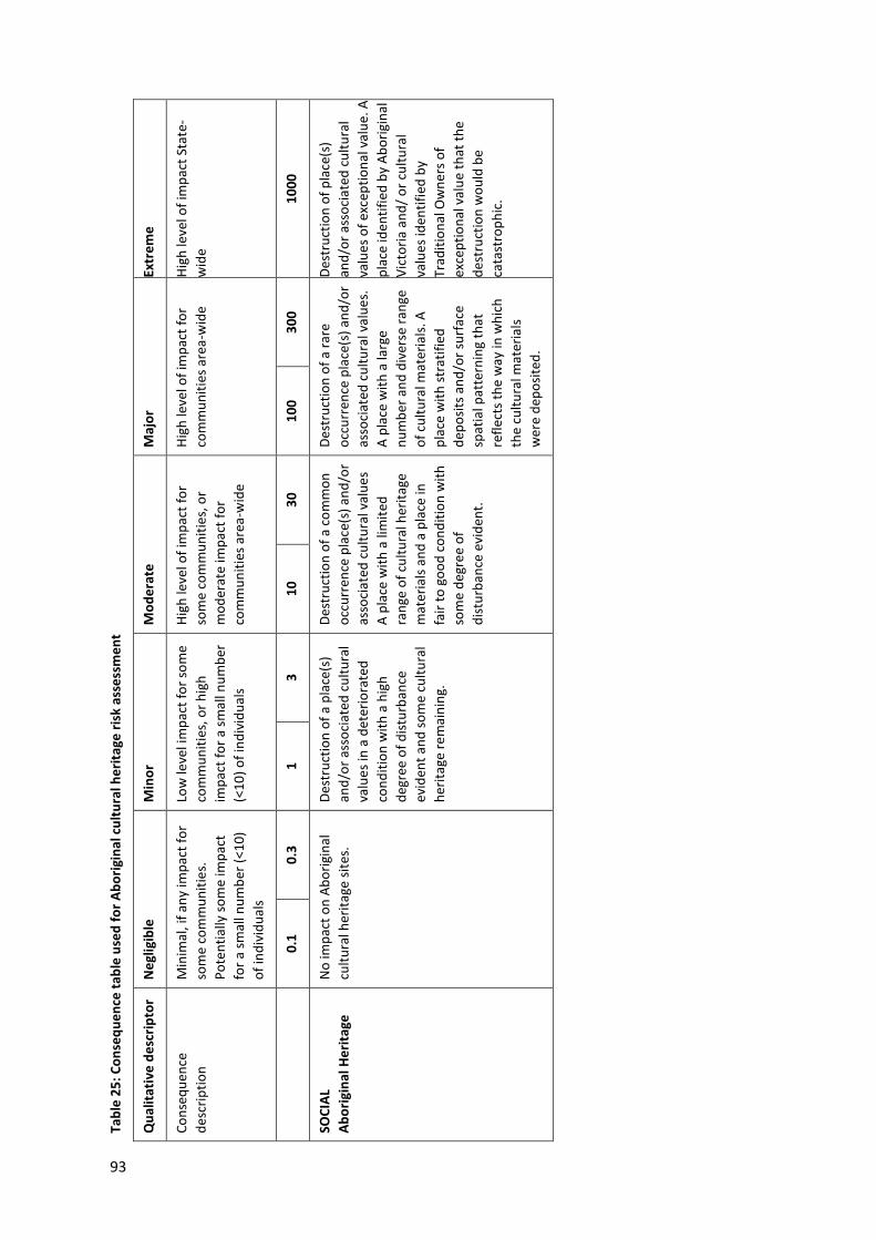
93
Tabl
e 25
: Con
sequ
ence
tabl
e us
ed fo
r Abo
rigin
al c
ultu
ral h
erita
ge ri
sk a
sses
smen
t
Qua
litat
ive
desc
ripto
r N
eglig
ible
M
inor
M
oder
ate
Maj
or
Extr
eme
Cons
eque
nce
desc
riptio
n M
inim
al, i
f any
impa
ct fo
r so
me
com
mun
ities
. Po
tent
ially
som
e im
pact
fo
r a sm
all n
umbe
r (<1
0)
of in
divi
dual
s
Low
leve
l im
pact
for s
ome
com
mun
ities
, or h
igh
impa
ct fo
r a sm
all n
umbe
r (<
10) o
f ind
ivid
uals
High
leve
l of i
mpa
ct fo
r so
me
com
mun
ities
, or
mod
erat
e im
pact
for
com
mun
ities
are
a-w
ide
High
leve
l of i
mpa
ct fo
r co
mm
uniti
es a
rea-
wid
e Hi
gh le
vel o
f im
pact
Sta
te-
wid
e
0.
1 0.
3 1
3 10
30
10
0 30
0 10
00
SOCI
AL
Abor
igin
al H
erita
ge
No
impa
ct o
n Ab
orig
inal
cu
ltura
l her
itage
site
s.
Dest
ruct
ion
of a
pla
ce(s
) an
d/or
ass
ocia
ted
cultu
ral
valu
es in
a d
eter
iora
ted
cond
ition
with
a h
igh
degr
ee o
f dist
urba
nce
evid
ent a
nd so
me
cultu
ral
herit
age
rem
aini
ng.
Dest
ruct
ion
of a
com
mon
o c
curr
ence
pla
ce(s
) and
/or
asso
ciat
ed c
ultu
ral v
alue
s A
plac
e w
ith a
lim
ited
rang
e of
cul
tura
l her
itage
m
ater
ials
and
a pl
ace
in
fair
to g
ood
cond
ition
with
so
me
degr
ee o
f di
stur
banc
e ev
iden
t.
Dest
ruct
ion
of a
rare
o c
curr
ence
pla
ce(s
) and
/or
asso
ciat
ed c
ultu
ral v
alue
s.
A pl
ace
with
a la
rge
num
ber a
nd d
iver
se ra
nge
of c
ultu
ral m
ater
ials.
A
plac
e w
ith st
ratif
ied
depo
sits a
nd/o
r sur
face
sp
atia
l pat
tern
ing
that
re
flect
s the
way
in w
hich
th
e cu
ltura
l mat
eria
ls w
ere
depo
sited
.
Dest
ruct
ion
of p
lace
(s)
and/
or a
ssoc
iate
d cu
ltura
l va
lues
of e
xcep
tiona
l val
ue. A
pl
ace
iden
tifie
d by
Abo
rigin
al
Vict
oria
and
/ or c
ultu
ral
valu
es id
entif
ied
by
Trad
ition
al O
wne
rs o
f ex
cept
iona
l val
ue th
at th
e de
stru
ctio
n w
ould
be
cata
stro
phic
.

94
Tabl
e 26
: Abo
rigin
al C
ultu
ral H
erita
ge ri
sks
Risk
ID
Risk
nam
e Ri
sk p
athw
ay
EPR
ID (i
nitia
l) In
itial
risk
EP
R ID
(fin
al)
Resi
dual
risk
Like
lihoo
d Co
nseq
uenc
e Ri
sk
Like
lihoo
d Co
nseq
uenc
e Ri
sk
Cons
truc
tion
risks
ACH
1
Dist
urba
nce
of
know
n AC
H Di
stur
banc
e of
pre
viou
sly re
gist
ered
Ab
orig
inal
cul
tura
l her
itage
pla
ces
resu
lting
in lo
ss o
f her
itage
val
ue
EPR
AH1
CHM
P
Highly improbable
Major
Negligible
As in
itial
EPR
Highly improbable
Major
Negligible
ACH
2
Dist
urba
nce
of
unkn
own
com
mon
ACH
Dist
urba
nce
of n
ot p
revi
ously
re
gist
ered
com
mon
Abo
rigin
al c
ultu
ral
herit
age
plac
es re
sulti
ng in
loss
of
herit
age
valu
e
EPR
AH1
CHM
P
Possible
Minor
Negligible
As in
itial
EPR
Possible
Minor
Negligible
ACH
3 Di
stur
banc
e of
un
know
n ra
re
ACH
Dist
urba
nce
of n
ot p
revi
ously
r e
gist
ered
rare
ACH
pla
ces r
esul
ting
in
loss
of h
erita
ge v
alue
.
EPR
AH1
CHM
P
Unlikely
Major
Negligible
As in
itial
EPR
Unlikely
Major
Negligible
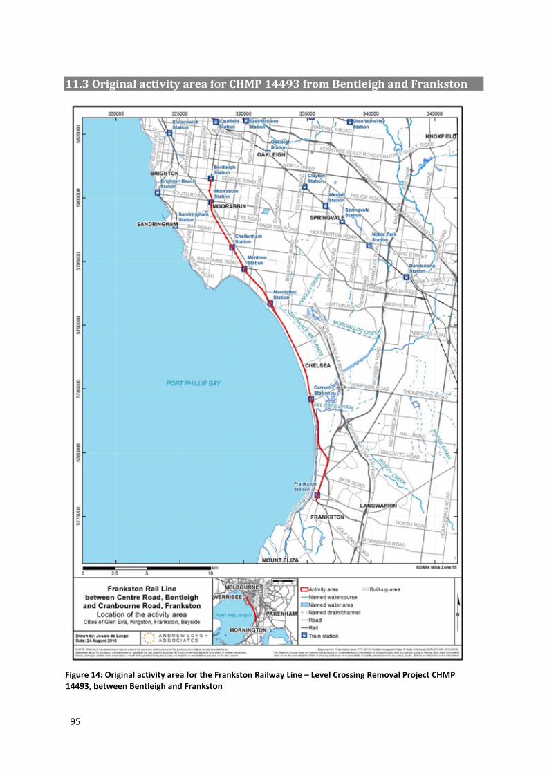
95
11.3 Original activity area for CHMP 14493 from Bentleigh and Frankston
Figure 14: Original activity area for the Frankston Railway Line – Level Crossing Removal Project CHMP 14493, between Bentleigh and Frankston